wria 8 3yr narrative 2009 final 5-21-09 · 100 programmatic actions in the wria 8 conservation plan...
TRANSCRIPT
Three-Year Implementation Plan Narrative for Lake Washington/Cedar/ Sammamish Watershed (WRIA 8)
May 2009
Page 1 WRIA 8 Narrative prepared for Puget Sound Partnership – 5-21-2009 1/5/2010
Introduction This document provides the narrative for the 2009 3-Year Work Plan update for WRIA 8. Both the capital and non-capital actions listed in the 3-Year Plan reflect the most important known priorities for Chinook conservation and recovery in the watershed. The 3-Year Work Plan worksheet was updated in 2007 to include new work plan categories, such as hatchery capital projects and monitoring support. This update does not cover Harvest Program Management support and Instream Flow protection (for which there is no WRIA 8 based 2514 planning process). The worksheet begins with site specific project recommendations on the Cedar River, then the migratory areas, and then the two subareas of the Sammamish population: North lake Washington and Issaquah. The worksheet is further organized by specific watershed strategies for the site specific actions. Each action in the worksheet identifies the primary limiting factor to be addressed by that action. This information has not changed from previous years. Attachment A: Limiting Factor Key lists and explains these limiting factors. The 3-Year Work Plan then covers the programmatic recommendations. Because there are over 100 programmatic actions in the WRIA 8 Conservation Plan and many are ongoing, they were summarized by major themes for the 3-Year Work Plan. For this level of detail for programmatic actions, refer to Attachment B: WRIA 8 Programmatic Actions. Adaptive management is a primary organizing framework for biological, practical, and policy implementation of the WRIA 8 Conservation Plan. Coordination is required to continue collaboration amongst the broad and diverse communities within WRIA 8 and to coordinate both adaptive management at the correct scale and implementation across jurisdictional boundaries. Estimated costs for each action in the 3-Year Work Plan are based on the 10-Year Start List cost estimates from the WRIA 8 Chinook Salmon Conservation Plan (2005) or other recent updates. The 3-Year Implementation Plan was developed in consultation with the WRIA 8 Salmon Recovery Council and Technical Committee. The conservation and practical rationale for the 3-Year Work Plan is essentially unchanged from last year’s narrative, except for minor editorial changes to promote clarity. Section I, Conservation Rationale, explains the biological imperatives that necessitate actions in particular areas and the improvement of landscape-level processes throughout WRIA 8. Section II, Practical Rationale, talks about the practical considerations and criteria that influence the development and yearly revision of the 3-Year Work Plan. Section III describes the ways in which the WRIA 8 3-Year Work Plan reflects TRT comments and
Three-Year Implementation Plan Narrative for Lake Washington/Cedar/ Sammamish Watershed (WRIA 8)
May 2009
Page 2 WRIA 8 Narrative prepared for Puget Sound Partnership – 5-21-2009 1/5/2010
guidance received since completion of the Puget Sound Recovery Plan. Section IV provides specific answers to questions asked as part of the 2009 3-Year Work Program guidance from the Puget Sound Partnership (PSP).
Note: In 2006, WRIA 8 adopted a 2-population conservation strategy that includes independent Cedar River and Sammamish River Chinook populations. The Sammamish population includes two sub-populations: the naturally spawning Bear Creek sub-population and a hatchery-driven Issaquah Creek sub-population (WRIA 8 Technical Memo 2006-01). The 2-population structure is consistent with TRT recommendations and guidance for salmon recovery in the Puget Sound Evolutionarily Significant Unit (ESU).
I. Conservation Rationale
The current risk of extinction posed to the Cedar River and Sammamish River Chinook populations is extreme and must be reduced through actions that create habitat conditions that support viability of each population. Due to the declining productivity trend of the Cedar population (overall trend since 1964, though productivity has increased in past couple of years) and the fact that the Sammamish River population is supported by a hatchery, the Technical Committee hypothesizes that a relatively higher priority should be placed on risk reduction for the Cedar River Chinook population. However, the Technical Committee also recommends that habitat protection and restoration actions are needed throughout WRIA 8 in order to provide habitat diversity that can support the genetic diversity of multiple salmon species over time. Cedar River Chinook The greatest source of risk comes from reduction in habitat productivity and the potential loss of the instream juvenile rearing life history strategy. In addition, hatchery influences pose a significant risk to the genetic diversity of the population. Rehabilitation of the Cedar River Chinook population requires conservation actions to protect and restore habitat in the Tier 1, Tier 2, and migratory subareas. The main source of productivity for this population is in the Tier 1 subareas along the mainstem of the Cedar River. Restoration of these subareas is important to increase productivity and create habitat conditions that support the instream juvenile rearing life history strategy (specifically the fry colonization life stage). Hypotheses about conservation actions are focused on the protection of water quality and high quality instream habitats used for spawning and juvenile rearing, such as intact pool habitats, riparian buffers, and LWD.

Three-Year Implementation Plan Narrative for Lake Washington/Cedar/ Sammamish Watershed (WRIA 8)
May 2009
Page 3 WRIA 8 Narrative prepared for Puget Sound Partnership – 5-21-2009 1/5/2010
Restoration hypotheses are focused on increasing the availability of pool habitats and off-channel areas for juvenile Chinook by reconnecting floodplain areas, adding LWD, and re-planting riparian vegetation. In addition to restoration actions in the mainstem Cedar, juvenile Chinook would benefit from shoreline restoration actions designed to improve rearing and refuge habitat and reduce predator efficiency in the south end of Lake Washington and in the Ship Canal. Shoreline restoration activities should focus on removal of bulkheads and rip-rap to create sandy, shallow habitat areas. These restoration actions should be focused on areas adjacent to the mouth of the Cedar River and in nearby areas of southern Lake Washington, along the south end of Mercer Island, at the mouths of small creeks, and in Union Bay. Migratory and Rearing Areas In order to create and maintain habitat conditions that support viable populations of Chinook, conservation actions should address habitats used at different stages of the Chinook life cycle. Restoration and enhancement of the migratory and rearing areas (including the nearshore, estuary, Lake Washington, the Ship Canal and Locks, the Sammamish River, and Lake Sammamish) have a high potential to benefit Chinook productivity and abundance, and in many cases could benefit multiple populations. In the lakes, actions should focus on creating habitat conditions that improve rearing and refuge opportunities, such as the restoration of sandy shallow water areas and restoration of stream deltas. In the Sammamish River, it is hypothesized that re-meandering the river will restore connections with cool groundwater while increasing habitat diversity, benefiting juvenile out-migrants as well as returning adults. High temperatures in the Ship Canal during the juvenile out-migration can become extremely stressful (>19 C) and affect the behavior and success of smolts in reaching Puget Sound. High temperatures may also increase predation rates in the Ship Canal, especially those of bass. Conservation actions should focus on providing habitat refuge for Chinook and reducing high temperatures that drive predation. Finally, the nearshore and estuary subareas are critical for migration and rearing of Chinook populations (as well as other species) from multiple WRIAs. While there are relatively greater uncertainties about nearshore habitat and Chinook use of that habitat, experimental approaches to the protection of functioning habitat and the restoration of ecosystem processes (particularly sediment supply) and habitats (particularly eelgrass beds and ‘pocket’ estuaries) should be implemented.
Three-Year Implementation Plan Narrative for Lake Washington/Cedar/ Sammamish Watershed (WRIA 8)
May 2009
Page 4 WRIA 8 Narrative prepared for Puget Sound Partnership – 5-21-2009 1/5/2010
Sammamish River Chinook: North Lake Washington (NLW) Sub-Population The low abundance and productivity of the NLW Chinook sub-population results from reduced habitat productivity and severe reduction in the hypothesized historical spatial distribution of the population from several stream systems (with approximately equal contribution to the population based on habitat suitability - Bear, Little Bear, North, Swamp and Kelsey Creeks) to one stream system (Bear Creek) that is the core of the breeding population. Although the inclusion of Issaquah Creek increases the overall spatial distribution of the Sammamish population, improved habitat productivity in the North Lake Washington tributaries is essential to increase the distribution and viability of the naturally-spawning component of the population. In order to rehabilitate this population and reduce the risk of extinction, conservation actions should be targeted at protecting the existing source of productivity in the Bear Creek system, restoring the habitat capacity of Tier 2 NLW tributary systems, and restoring the channel meanders and pool habitats that support juvenile rearing and adult migration in the Sammamish River corridor that benefit all rearing and migration life stages for Chinook salmon that are part of the Sammamish population complex. Sammamish River Chinook: Issaquah Creek Chinook Sub-Population The WRIA 8 Technical Committee is concerned about the risk to independent Chinook populations posed by straying of hatchery and naturally-produced hatchery-origin Chinook. The Technical Committee calls on NOAA Fisheries and the co-managers to implement the recommendations of the Hatchery Science Review Group (HSRG, 2004) and make any other appropriate adaptive management changes at the Issaquah and other Puget Sound hatcheries that are necessary to reduce risk to the Chinook populations in WRIA 8 and promote local adaptations. Within the Issaquah system, conservation actions for the Issaquah Chinook sub-population should focus on protection of existing high-quality habitat in the Issaquah system. Habitat restoration actions are intended to increase habitat diversity and enhance the juvenile rearing and egg incubation life stages. Increased habitat productivity in the Issaquah system is also intended to support hatchery objectives for supply of natural origin broodstock, as recommended by the HSRG. Production of excess Issaquah hatchery fish raises concerns about increased hatchery contribution to the Cedar River and Bear Creek populations. The contribution of hatchery origin spawners in the Cedar Basin was 9.5% in 2008, not accounting for 25 marked Chinook (of 146) passed above Landsburg Dam (17.1%), compared to the Bear/Cottage Basin which had 76.9% hatchery origin spawners in 2008. However, the overall stray rate of hatchery fish
Three-Year Implementation Plan Narrative for Lake Washington/Cedar/ Sammamish Watershed (WRIA 8)
May 2009
Page 5 WRIA 8 Narrative prepared for Puget Sound Partnership – 5-21-2009 1/5/2010
compared to the total number of Issaquah hatchery returns is generally very low (0.7% in the Cedar River Basin and 0.5% in the Bear/Cottage Basin in 2007). Ongoing H-integration work attempts to account for known effects of hatchery influence on the spawning ground, and to use this information to make recommendations consistent with an Adaptive Management framework. Additional work remains necessary to identify and agree on actions to reduce the percentage of hatchery-origin Chinook in the Cedar River and North Lake Washington tributaries to levels that are consistent with HSRG hatchery reform recommendations. H-Integration The discussion of H-integration in the July 2005 WRIA 8 Salmon Conservation Plan is limited to a discussion of the ramifications of potential Chinook population scenarios for hatchery and habitat management objectives. The Plan generally supports implementation of the Hatchery Science Review Group’s (HSRG) recommendations for WRIA 8, but does not make specific hatchery or harvest recommendations beyond noting the risk that increased hatchery contributions to the independent Cedar population could result in reduced genetic diversity. In the absence of explicit recommendations for how to sequence strategies for reducing H-effects on VSP parameters, there are clearly management alternatives that could be explored. Since ratification of the Plan, WRIA 8 has completed additional genetic analysis of WRIA 8 Chinook and adopted a two-population approach (described in WRIA 8 Plan Volume I, Chapter 4) that is consistent with the TRT’s population determination. The adoption of the two population scenario has led to the inclusion of restoration actions intended to benefit the hatchery component of the Sammamish Chinook population in Issaquah Creek. While this hatchery-supported sub-population faces the lowest risk relative to the Cedar population and the North Lake Washington sub-population, habitat restoration in Issaquah would support the shared objective of increasing natural-origin broodstock at the Issaquah hatchery as a by-product of presumed increased natural production from Issaquah Creek. The H-integration work group began meeting in 2007, and is currently working to develop integrated strategies among the H-sectors that are consistent with predictions of moving WRIA 8 Chinook populations toward recovery goals. The group has nearly completed the first four steps in the process, which include (1) identifying the key players, (2) gaining a common understanding of how each H affects fish population status in terms of the Viable Salmonid Parameters, 3) agreeing upon common goals and outcomes across the H sectors, and 4) selecting a suite of complementary actions across the H-s to achieve these outcomes. The next steps will include documentation of the steps taken, and
Three-Year Implementation Plan Narrative for Lake Washington/Cedar/ Sammamish Watershed (WRIA 8)
May 2009
Page 6 WRIA 8 Narrative prepared for Puget Sound Partnership – 5-21-2009 1/5/2010
devising a system to implement actions, monitor results and adaptively manage the process over time. This process is essential to ensure that our collective actions mutually support the conservation and recovery of Chinook and other listed salmonids in WRIA 8. II. Practical Rationale Practical Rationale Overview Given the high risk of extinction currently faced by the Cedar Chinook population and the naturally-spawning portion of the Sammamish Chinook population, WRIA 8’s 3-Year Work Plan focuses on programmatic and capital projects that will work toward reducing risk to these populations. In addition, habitat restoration actions are proposed to increase Chinook productivity. However, we recognize that in many cases habitat actions have a lag time before full benefits of the actions are seen, making it essential that we also address direct sources of mortality. These direct sources of mortality include passage at the Locks and predation in the Lakes. As described in the Conservation Strategy, the Cedar Chinook population has the highest certainty of being independent due to hatchery influence in the Sammamish population, and the highest risk of extinction due to the overall decline in productivity. However, the natural spawning component of the Sammamish population is also at high risk with low productivity and extremely low abundance. Due to the high risk faced by both the Cedar Chinook population and the naturally spawning component of the Sammamish Chinook population, and the fact that recovery of both populations will require a much longer timeframe than the 10-year Puget Sound Recovery Plan, we advocate implementing protection and restoration actions for both Chinook populations. Numerous entities (jurisdictions, state and local agencies, NGOS) throughout the watershed have, and will, implement protection and restoration actions based on fee areas, jurisdictional boundaries, permit authority, or other practical considerations that will expand the scope and footprint of plan implementation in supplementary ways to this 3-Year Work Plan. Given the above context, it is important to offer the best protection and restoration guidance within the context of watershed priorities. While the Cedar population is the higher priority, we cannot afford to lose functioning habitat for the Sammamish population. We also cannot afford to delay restoration efforts due to the time lag necessary for habitat restoration actions to begin to confer benefits for Chinook life stages. For these reasons actions are included for the North Lake Washington tributaries and the Sammamish River. Restoration actions are included for Issaquah Creek, as increased natural-origin broodstock
Three-Year Implementation Plan Narrative for Lake Washington/Cedar/ Sammamish Watershed (WRIA 8)
May 2009
Page 7 WRIA 8 Narrative prepared for Puget Sound Partnership – 5-21-2009 1/5/2010
will be needed to meet integrated hatchery management objectives and reduce the possibility that broodstock would be collected from Bear Creek or even the Cedar River. Hatchery and harvest management actions continue to be necessary to reduce the risk to genetic diversity, while habitat actions proceed to increase natural production. 2009 Criteria The original 2006 3-Year Work Plan was created with the highest priority projects from the WRIA 8 10-Year Start List. Most of the projects were ready to begin implementation (high feasibility) or were already underway in an earlier phase of a multi-phased project. Some projects were added that span more than three years but would begin within the three-year period. A few other projects were not ready to begin implementation within three years but were of such high priority that they merited being included with the intent to move them toward implementation. In 2008, the WRIA 8 Technical Committee agreed on a set of criteria to use when moving actions from the comprehensive list (over 300 projects) to the 10-Year Start List or into the 3-Year Work Plan. Comprehensive list actions may move onto the 10-Year Start list if (1) there is a science basis [EDT modeling, adaptive management, results of a research study, or H-Integration], (2) there is a change in feasibility and the project has a high benefit to Chinook, (3) the project had a high benefit/high feasibility rating but was not included in the Start List due to a limit on the total number of actions and is similar to a neighboring project included on the Start List, or (4) the number of projects added does not exceed the number of projects completed or removed from the Start List. 10-Year Start List Actions may move to the 3-Year Work Plan if (1) the action is high priority and ready for implementation within the next three years, or (2) the action is high priority and needs funding for feasibility and design to move it toward construction in the next three years. Practical Rationale for the Cedar River Chinook Population It is hypothesized that conservation actions for the Cedar River Chinook population should focus on increasing productivity of the fry colonization and 0-age active rearing life stages by improving rearing conditions in the Cedar River. Because we hypothesize restoration potential in the river is approximately equal to the potential in Lake Washington, actions should also reduce predator efficiency in Lake Washington by restoring shallow water habitat, overhanging vegetation, and creek mouths. In addition, direct mortality of juveniles and adult salmon should be reduced by improving passage and estuarine mixing at the Ballard Locks. Finally, nearshore habitat, particularly sediment supply processes

Three-Year Implementation Plan Narrative for Lake Washington/Cedar/ Sammamish Watershed (WRIA 8)
May 2009
Page 8 WRIA 8 Narrative prepared for Puget Sound Partnership – 5-21-2009 1/5/2010
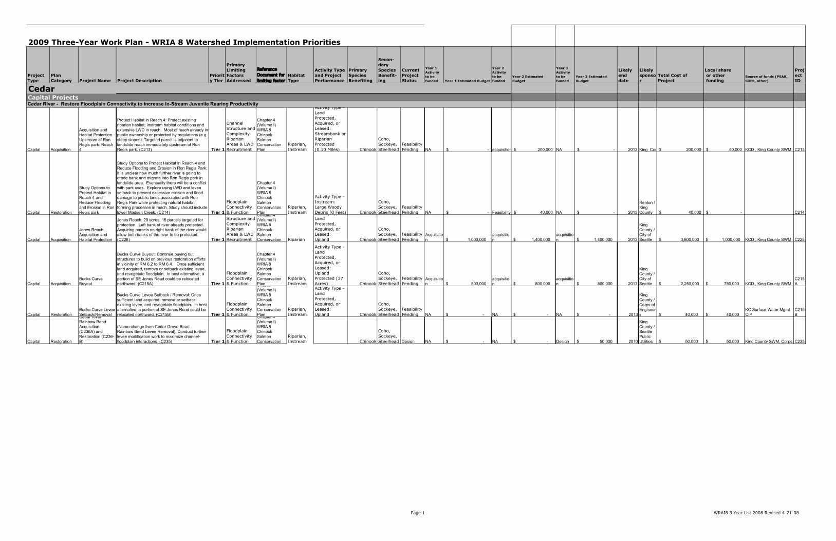
and pocket estuary connections should be restored to benefit Chinook salmon and forage fish from WRIA 8 and other watersheds in Puget Sound. Efforts to improve juvenile rearing habitat in the Cedar are focused around the ‘landslide reach’ (EDT Reach 4), site of a landslide during the 2001 Nisqually earthquake that altered the mainstem channel in and around Ron Regis park and deposited a considerable amount of LWD in the channel. This site is considered a ‘reference’ reach for restoration of the Cedar River. EDT modeling indicates that this reach has the highest protection potential in the Cedar River as a result of two things: (1) high levels of habitat diversity and (2) lower river reach dependence by most juvenile Chinook fry migrating downstream. Capital projects during the next three years of implementation continue to attempt to increase fry colonization and juvenile rearing success by protecting and restoring areas of floodplain connectivity in and around areas that have high Chinook spawning concentrations. These actions include: 1. Protect the last private parcel upstream of Ron Regis park within the
floodplain of the landslide ‘reference’ reach (C213). (This project code is the nomenclature used in the WRIA 8 Chinook Conservation Plan and can be used to reference more information in the Conservation Plan about this project.)
2. New in 2009: Pursue additional (1-2) home buyouts immediately upstream from Ron Regis park (old Elliot Bridge area) to leverage King County Flood District work in area and contribute to levee setback project. This will help protect the landslide reach and extend the influence of natural riverine processes (C216B).
3. Protect functioning floodplain habitat downstream of Chinook spawning concentrations and adjacent to existing and potential restoration sites (C228 Jones Reach, C232 Belmondo, C252*/253* Dorre Don Meanders). These protection actions are necessary to ensure that no further degradation of floodplain connectivity occurs, and to maximize the beneficial impacts of adjacent restoration projects.
4. Levee setbacks and/or removals to increase floodplain connectivity (C235* Rainbow Bend Levee Setback)
5. Floodplain buyouts to enable future floodplain reconnections (C244 218th Place Side-Channel, C245 Mouth of Taylor Creek)
The asterisk * denotes which actions have been modeled using EDT Within Lake Washington, restoration actions are focused on the southern end of the lake to benefit the fry-migrant life stage that rears in the lake, as well as migrating smolts. We hypothesize that restoration of shallow sandy habitat with overhanging vegetation will reduce predator efficiency through increased predator avoidance, and result in increased juvenile survival. Lake restoration projects have greater effectiveness uncertainty than the in-stream habitat projects, but the proposed projects build on pre- and post-project monitoring of
Three-Year Implementation Plan Narrative for Lake Washington/Cedar/ Sammamish Watershed (WRIA 8)
May 2009
Page 9 WRIA 8 Narrative prepared for Puget Sound Partnership – 5-21-2009 1/5/2010
recent restoration projects in Seward Park and the SRFB-funded Rainier Beach park restoration. The proposed 3-Year Work Plan anticipates funding one lake restoration project per year in the south end of the lake, with design modifications and improvements based on on-going monitoring of other similar projects. New to the 3-Year Work Plan in 2009 is the South Lake Washington DNR Shoreline Restoration project (C266), which will create shallow water habitat and plant riparian vegetation at the mouth of the Cedar River in Lake Washington. Lake restoration actions are focused on publicly owned park land, and attempt to leverage other actions such as master planning for the Mapes Creek neighborhood. Because approximately 95% of the lake shoreline is privately owned, programmatic actions promote shoreline and riparian restoration actions and reduction in over-water structures on private property. This includes demonstration sites intended to increase landowner willingness to adopt more environmentally-friendly practices. These programmatic actions are essential if we are to successfully restore lake shoreline habitats without buying out large areas of some of the most expensive real estate in the entire state of Washington. In the Ship Canal and Locks, considerable work has been completed with the Corps of Engineers to dramatically increase survival at the Ballard Locks through the installation of the smolt slides and other modifications. Over the next three years we anticipate continued improvements at the Locks to reduce direct mortality of both juveniles and adults by increasing fish use of either the smolt slides or the fish ladder, and operational changes to increase the area of fresh and saltwater mixing. In addition, the 3-Year Work Plan includes habitat restoration and removal of overwater structures immediately downstream of the Ballard Locks to benefit juvenile Chinook. In early 2008 WRIA 8 and Heron Habitat Helpers commissioned a project to synthesize existing information on Chinook use of the Salmon Bay Estuary west of the Locks, and to evaluate the potential benefits of restoration actions in that area. This forthcoming information will help guide future decisions on prioritizing and siting projects in this important location. The nearshore component of the WRIA 8 plan includes significant uncertainties. Actions are focused on identifying specific locations where feeder bluff connections to the nearshore environment can be restored, and restoring pocket estuaries where possible. The railroad severely constrains restoration opportunities in WRIA 8, making a feasibility study essential for WRIA 8 to implement feeder bluff projects throughout the 10-year plan horizon. Beach seining efforts along the WRIA 8 and WRIA 9 shoreline show that the nearshore area and Salmon Bay are used by juvenile Chinook from many WRIAs, and we therefore hypothesize that these nearshore restoration projects will increase juvenile rearing habitat for Chinook from multiple Puget Sound populations.
Three-Year Implementation Plan Narrative for Lake Washington/Cedar/ Sammamish Watershed (WRIA 8)
May 2009
Page 10 WRIA 8 Narrative prepared for Puget Sound Partnership – 5-21-2009 1/5/2010
Finally, it is hypothesized that increased effort to develop nearshore projects is necessary to support the viability of the WRIA 8 partnership, as a strengthened nearshore component of our conservation strategy is necessary to maintain participation. Sammamish River Chinook Population Practical Rationale As noted above, WRIA 8 has identified a relatively higher risk for the Cedar Chinook population due to the higher proportion of natural origin spawners. This does not mean, however, that actions are not necessary for the Sammamish population. The naturally spawning sub-population has low abundance and low productivity, and actions are necessary in the near-term to secure this population from any increase in extinction risk. Actions are also necessary to ensure that the habitat potential exists to support recovery in the future as population productivity increases and the distribution expands into the Tier 2 North Lake Washington tributaries (e.g. Little Bear and North Creeks). This requires programmatic actions to maintain and restore landscape level processes at risk from development as well as capital projects to acquire functioning habitat or restore degraded habitats. These acquisitions include headwater areas in Upper Bear Creek, Cottage/Cold Creek, Little Bear Creek, and North Creek to maintain forest cover, water quality, and hydrologic processes. Finally, WRIA 8’s proposed actions attempt to leverage existing efforts by the City of Redmond and the Army Corps of Engineers working with regional partners to protect and restore the Sammamish River and Bear Creek corridors. Specific actions include the Sammamish River Transition Zone restoration, which is intended to improve floodplain connectivity, groundwater connectivity, and riparian function at the head of the Sammamish River. We have also included a feasibility and design study to restore tributary confluences with the Sammamish River to provide areas of cold groundwater refuges for migrating adult Chinook. This feasibility study would result in specific restoration projects that could be supported by individual jurisdictions in the Sammamish River corridor for SRFB, Corps, and other funding. The City of Redmond is expanding previous channel restoration efforts in Bear Creek to include the lower 3000’ of Bear Creek at the confluence with the Sammamish River. The City is also working to protect approximately 120 acres at the confluence of Bear and Evans Creeks (the Keller Farm property) from development and establish a wetland mitigation bank, with restoration work likely beginning after 2009. Issaquah Creek Chinook are the hatchery-driven sub-population of the Sammamish River independent Chinook population. As described in the ‘Consistency with TRT Recommendations’ section below, WRIA 8 has recently adopted a two-population approach that is consistent with the TRT’s population determination. Our objectives for this sub-population are to secure functioning
Three-Year Implementation Plan Narrative for Lake Washington/Cedar/ Sammamish Watershed (WRIA 8)
May 2009
Page 11 WRIA 8 Narrative prepared for Puget Sound Partnership – 5-21-2009 1/5/2010
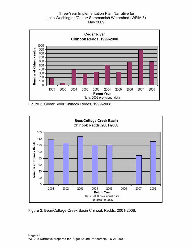
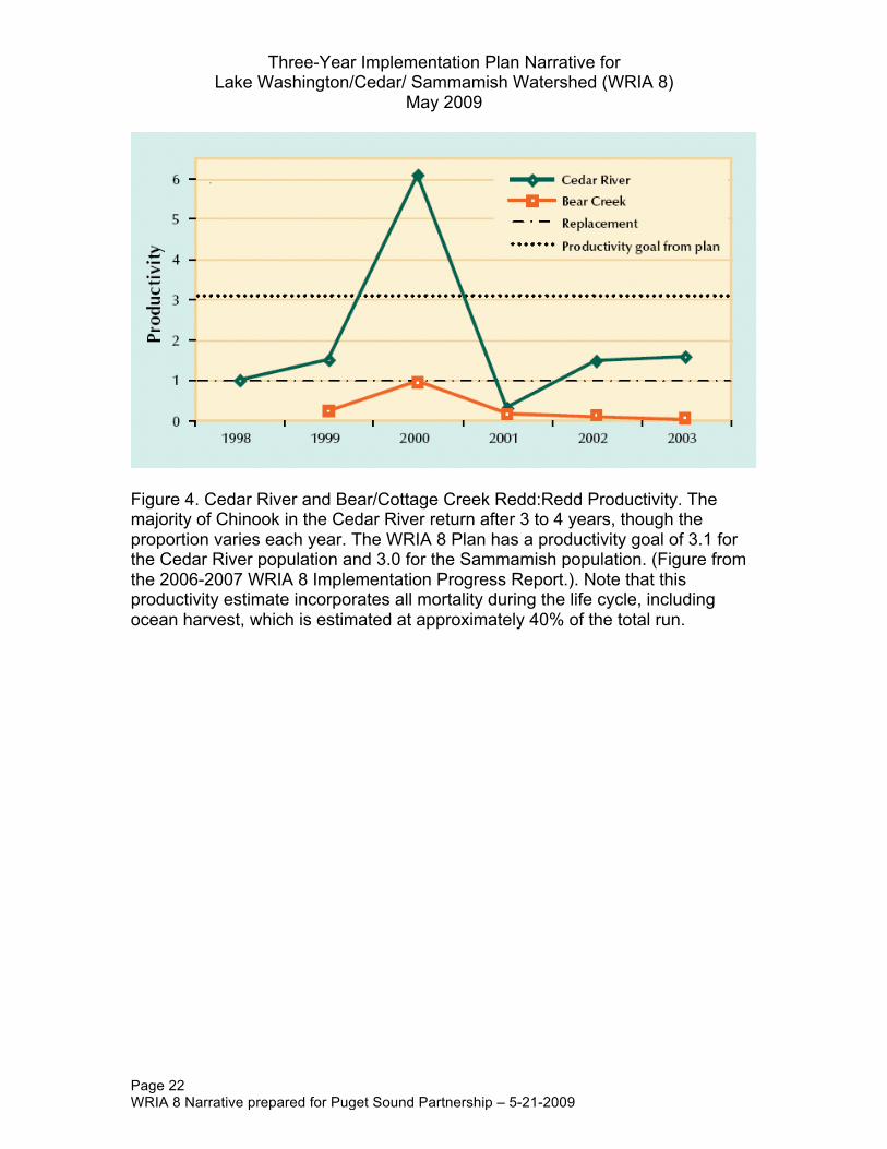
habitat and restore habitat productivity. Improved habitat productivity in Issaquah Creek would help the hatchery managers achieve hatchery reform objectives for increased natural-origin broodstock, and decrease the risk that broodstock would be collected from either Bear Creek or the Cedar River to supply the hatchery. Habitat protection and restoration actions in the Issaquah basin are also necessary to strengthen the WRIA partnership and enhance connections with stakeholders in this basin, and to support the hatchery management objectives of the co-managers. Much of the headwater area of Issaquah Creek is protected. Remaining actions include acquisition of floodplain parcels to enable restoration of floodplain connectivity, riparian function, and LWD along the mainstem of Issaquah Creek, particularly at tributary confluences. Program outreach to rural landowners to apply BMPs for riparian enhancement is also a basin-wide objective, given the highly erodible floodplain soils that are susceptible to erosion with even limited modified land use. Adaptive Management and Monitoring Practical Rationale We are working to incorporate Adaptive Management and Monitoring guidance from the Puget Sound Salmon Recovery Plan and awaiting additional regional guidance from the Puget Sound Partnership, while locally we act to organize for monitoring our actions. We will continue to fund actions that maintain and enhance the WRIA 8 partnership, as well as actions that support improvements to the plan as we learn more about how our actions impact Chinook populations and their habitat. Specific actions include cumulative effectiveness monitoring of Chinook populations via spawner surveys and outmigrant trapping, along with implementation of the EPA’s EMAP protocols to evaluate the status and trends of landscape level and instream habitat conditions. We will also include updates and revisions to the WRIA 8 plan in response to new information, and anticipate that these revisions will include increased coordination of habitat, harvest, and hatchery management actions as a result of the regional H-Integration effort during 2009. Monitoring of Chinook spawners has revealed an increase in adult escapement to the spawning grounds over the past few years in the Cedar basin, with Bear/Cottage basin escapement remaining low (Figure 1). The number of natural origin spawners returning to the Cedar River above Landsburg Dam has increased since passage was allowed in 2003. Chinook redd numbers in the Cedar basin are trending upward, though down from the record of 2007 (Figure 2). Redd numbers in the Bear/Cottage basin remain relatively steady (Figure 3), probably because the proportion of hatchery-origin spawners remains high. Estimates of redd:redd productivity have been variable, but generally above replacement (1.0) in the Cedar River Basin; redd:redd productivity in the

Three-Year Implementation Plan Narrative for Lake Washington/Cedar/ Sammamish Watershed (WRIA 8)
May 2009
Page 12 WRIA 8 Narrative prepared for Puget Sound Partnership – 5-21-2009 1/5/2010
Bear/Cottage Basin, however, has been far less than 1.0 for most years monitored (Figure 4). Outmigrant monitoring has revealed that the smolt life history is more prevalent in the Bear/Cottage Basin, as compared to the Cedar that has a higher prevalence of the fry life history strategy (which has also been highly variable among years – Table 1 and Table 2). Practical Considerations Regarding Costs and Timing The WRIA 8 Plan estimated approximately $17 million per year for habitat protection and restoration actions. This proposed 3-Year Work Plan is slightly higher than this estimate for two primary reasons: the need to acquire property now in order to secure it from potential future development, and the need to acquire sufficient Cedar floodplain area to design and construct floodplain restoration actions within the 10-year timeframe at the most biologically relevant and effective scale. A prime example of a floodplain restoration action at the right scale is the Rainbow Bend – Cedar Grove Road floodplain buyout and restoration. The upstream end of the meander bend is currently being acquired using SRFB and FEMA funds. The parcels in the downstream portion of the meander bend have been a top priority for acquisition since the 1993 Cedar River Basin Plan, but have not been acquired due to high cost and other feasibility issues. For this reason it was anticipated that the restoration action at the Cedar Grove levee would be a small scale setback that would restore connectivity but would still provide flood protection for the downstream parcels. Since completion of the WRIA 8 Plan the feasibility of acquiring the downstream parcels has changed. Major purchases are now underway that will allow a levee setback or removal that will provide significantly higher benefits by restoring connectivity in the entire meander bend. Costs within the 3-Year Work Plan primarily come from the “ballpark cost estimates” prepared for the WRIA 8 Plan. Some are updated when new information is provided, such as for the lower Bear Creek project in 2009. Generally costs are more accurate when implementation begins because of the refinement needed for budgeting. Costs vary from a single phase of a project to multi-phased projects. Programmatic actions were estimated at the time of the WRIA 8 Plan using Shared Strategy’s Primer. III. Consistency with Technical Recovery Team
Recommendations WRIA 8’s 3-Year Work Plan attempts to respond to comments received from the TRT in response to the July 2005 Plan and in response to comments on the

Three-Year Implementation Plan Narrative for Lake Washington/Cedar/ Sammamish Watershed (WRIA 8)
May 2009
Page 13 WRIA 8 Narrative prepared for Puget Sound Partnership – 5-21-2009 1/5/2010
previous 3-Year Work Plans. The Plan reflects TRT guidance in the following ways:
Future Development: The TRT correctly identified future development and land conversion as the most significant threat to the long-term conservation and recovery of Chinook in WRIA 8 as stated in the Plan, but actions to address these concerns relied on a menu of voluntary actions that did not provide certainty that this threat would be adequately addressed. The programmatic actions included in the Plan and described in this submittal are intended to support the efforts of local governments and individual citizens to reduce the impact of existing and proposed development on landscape processes and in-stream habitat. These programmatic activities are recognized by the WRIA partners as fundamental to the success of our Chinook conservation efforts. In addition, we recognize that our ability to implement capital projects in many areas of WRIA 8 is contingent upon landowner support that is generated by programmatic activities. Finally, regional investments in habitat protection and restoration capital projects will be insufficient to achieve our salmon conservation objectives in the absence of programmatic activities that protect and restore landscape-scale processes that create and maintain aquatic habitat. The 2006-2007 WRIA 8 Implementation Progress Report (available at http://www.govlink.org/watersheds/8/planning/progress_report.aspx) reports on basic information regarding jurisdictions and programmatic actions. More support for analyses of effectiveness of these actions will be necessary in the future. We recommend an agency or university take on these analyses, as they are beyond the capacity of the WRIA under present circumstances.
• Treatment phase of EDT: The July 2005 Plan includes habitat
conservation actions hypothesized to address the ‘diagnosis’ of habitat protection and restoration priorities from the EDT habitat model. Because the effectiveness of these proposed actions had not been evaluated, the TRT noted that WRIA 8 Plan did not include restoration actions. We have since completed an evaluation of the effectiveness of select protection and restoration actions identified on the Start List. These results indicate that instream restoration Start List actions alone will increase productivity, juvenile and adult abundance, and life history diversity, but that similar additional action (greater effort) beyond those evaluated so far will be necessary to achieve our objectives. For the Sammamish population, results indicate that our instream habitat restoration actions will improve VSP attributes, but that additional landscape-level restoration actions to restore sediment and hydrologic processes will be necessary to achieve our 10-year population objectives. For both populations, modeling results underscore the fundamental importance of programmatic actions that are
Three-Year Implementation Plan Narrative for Lake Washington/Cedar/ Sammamish Watershed (WRIA 8)
May 2009
Page 14 WRIA 8 Narrative prepared for Puget Sound Partnership – 5-21-2009 1/5/2010
intended to protect habitat functions. More detailed information describing these results is available upon request.
• Action timing and sequencing: Action prioritization is reflected in a
number of ways in the 3-Year Plan, by action type (Programmatic), by ESA-listed population (Cedar), by geographic area (Cedar, Migratory, North Lake Washington tributaries/Sammamish, then Issaquah), and by key limiting factors or EDT diagnosis of life stages (within areas). Actions supporting basin-wide protection of watershed processes and function (e.g., regulatory updates and capital actions intended to support the aim of regulatory goals) should not be delayed and could be timed with other jurisdictions to achieve convergence and consistency, where possible.
Regarding projects, although not rigidly proposed, general prioritization of larger, costlier, complex levee setback and floodplain restoration in the Cedar suggests these should start as soon as possible. In this respect many actions in the Cedar will commence before actions elsewhere. Although actions in mainstem and tributary areas will likely contribute benefits alone, actions in migratory areas should also be implemented, even given uncertainty about benefits from habitat-based actions in migratory areas (as opposed to direct predator control). In certain respects there are few habitat actions where timing is dependent upon timing of other actions (often due to the long lag time required before full benefits – 10-25 years). At the same time, in order to conserve and improve VSP diversity, the timing of benefits to VSP diversity may be dependent upon the kind of action taken, more than the timing of the action itself. For example, restoring habitat diversity and function now in such a way to support adaptations that naturally would arise would be one way to conserve long term VSP diversity. On the other hand, limiting high abundance of hatchery strays to the spawning ground (especially in the Cedar River Basin) would offer a more timely approach to limiting risk to VSP diversity. Both may be necessary.
Sequencing for VSP effects is challenging. We believe the natural spawning components of both populations are at high risk of extinction due to trends of low abundance, productivity, and diversity. Only spatial distribution is of less concern at this time, in part because of our uncertainty about the role of spatial distribution as it contributes to VSP. At this time, actions are spatially limited relative to the known spatial distribution of the populations, based on preserving the core (and more highly productive) breeding groups. As well, at low abundance, a spatially distributed population may be at greater risk. Productivity and diversity underpin abundance and resilience of the population. Actions to address diversity as related to risk from hatchery influence could be sequenced

Three-Year Implementation Plan Narrative for Lake Washington/Cedar/ Sammamish Watershed (WRIA 8)
May 2009
Page 15 WRIA 8 Narrative prepared for Puget Sound Partnership – 5-21-2009 1/5/2010
first because theoretically they are most dependent upon management of human actions not population response. These issues are being addressed as part of the ongoing H-Integration process (see H-integration). Improvements to productivity should be sequenced next and addressing direct sources of mortality is one way to capture early benefits, in the face of great community ecology uncertainties. A low risk approach to productivity improvement is embodied in this 3-Year Work Plan. Otherwise sequencing is largely depicted as a series of related actions, where acquisition must come first before restoration.
• H-Integration: The TRT noted that integration of hatchery and habitat
actions is a top priority for WRIA 8 and that Hatchery and Harvest actions were missing from the 2006 3-Year List. Since completion of the WRIA 8 Plan, several WRIA 8 partners are participating in H-integration efforts to increase certainty that actions across the Hs are complementary. In 2006, the Co-managers offered guidance to the WRIAs in the form of 6 steps to accomplish H-Integration. Part of the process to accomplish H-integration will include consideration of different management hypotheses using the All-H Analyzer (AHA) model. The WRIA 8 technical committee has received demonstration of the model and is prepared to work with the co-managers to explore a range of management alternatives to “achieve” VSP objectives based on hypothesized effects and interactions. Exploring alternatives to accomplish agreed-to VSP objectives will be a critical working step. One VSP goal is to conserve and enhance the VSP diversity of the Cedar River population. An objective might be to limit population introgression from hatchery strays or enhance habitat forming processes and structure and function in such a way to provide in-river habitat conditions to which Cedar River Chinook would have naturally adapted. The exploration of these alternatives and consideration of benefits will lead to proposed actions. In advance of this, enhancement of fish passage at the Issaquah Hatchery intake weir represents the sole Hatchery capital project included in this 3-Year Work Plan at this time.
• Cedar River HCP: The TRT also notes that the WRIA 8 plan does not
evaluate whether the flows identified in the Cedar River Habitat Conservation Plan are sufficient to support Chinook recovery. The WRIA partners are supportive of collaborative efforts to ensure that both Plans approved by NOAA are consistent and complementary.
• Landsburg Fish Passage: The TRT notes that the WRIA plan does not
specifically state whether the passage of ad-clipped fish at the Landsburg Diversion Dam is consistent with ESA conservation objectives. As previously noted, the WRIA 8 Plan identifies hatchery contributions to
Three-Year Implementation Plan Narrative for Lake Washington/Cedar/ Sammamish Watershed (WRIA 8)
May 2009
Page 16 WRIA 8 Narrative prepared for Puget Sound Partnership – 5-21-2009 1/5/2010
spawning in the Cedar River as a significant risk to the diversity of the population. This concern applies throughout the Cedar River system, and we hope the regional H-integration effort will help to identify potential solutions.
IV. 2009 Three-Year Work Program Questions 1. What are the actions and/or suites of actions needed for the next three years
to implement your salmon recovery chapter as part of the regional recovery effort?
A general presentation of the entire suite of actions is included in the body
of this narrative and the accompanying spreadsheet. Highlights of priority capital projects include • Cedar River – Rainbow Bend restoration (C236B) and flood buyouts
immediately upstream from the Elliot (landslide) reach (C216) • South Lake Washington DNR shoreline restoration (C266) • Issaquah Integrated Fish Passage (I221) • Lower Bear Creek restoration (N201)
Programmatic actions needed for the next three years include
• Complete the H-Integration process and work with co-managers to implement priority recommendations
• Continue work with co-sponsors on overcoming barriers to more salmon-friendly lake shorelines
• Continue to support efforts to encourage Low-Impact Development • Build on successful ‘Lakeside Living’ workshops and Green Shorelines
Guidebook outreach efforts and potentially extend this outreach model to streamside property owners
Research, monitoring and evaluation actions needed include
• Begin habitat status and trends monitoring for the Cedar River and for wadeable streams in Tier 1 and Tier 2 priority areas
• Complete an overall WRIA 8 Monitoring and Adaptive Management Framework – this framework will leverage effectiveness and implementation monitoring efforts already taking place and help strategically direct future effectiveness monitoring to focus on projects with greatest uncertainty, as well as incorporate H-Integration efforts
• Work with RITT and Puget Sound Partnership to devise methods for programmatic effectiveness monitoring
2. What is the status of actions underway per your recovery plan chapter? Is this
on pace with the goals of your recovery plan?

Three-Year Implementation Plan Narrative for Lake Washington/Cedar/ Sammamish Watershed (WRIA 8)
May 2009
Page 17 WRIA 8 Narrative prepared for Puget Sound Partnership – 5-21-2009 1/5/2010
Jurisdictions are advancing the WRIA 8 Conservation Plan with the limited funding available to implement the Plan. Programmatic and capital actions are in progress, as detailed in this narrative and in the 2006-2007 WRIA 8 Implementation Progress Report (pp 5-9): (http://www.govlink.org/watersheds/8/planning/progress_report.aspx). One half of the 10-year high-priority “Start List” capital projects are scheduled or proposed for the first five years of plan implementation; however, funding for these projects is not assured. Approximately one quarter of the Start List projects are proposed for the long term, while the status of one quarter either is unknown or the proposed project is no longer feasible. Programmatic actions are ongoing, though assessment of programmatic effectiveness is problematic.
3. What is the general status of implementation towards your habitat restoration,
habitat protection, harvest management, and hatchery management goals? Progress can be tracked in terms of ‘not started, little progress, some progress, or complete’ or in more detail if you choose.
See #2. As staff capacity allows we look forward to providing PSP more
feedback on their Excel spreadsheet. We recognize the benefits that will be derived from more explicitly mapping recovery goals to objectives, and have made a beginning in this effort through WRIA 8’s Habitat Work Schedule goals (we direct PSP and the RITT to our HWS page for more information). Capacity to interact more closely with PSP has been limited during the work plan update process. We suggest that efforts in this area should also be integrated with Technical Committee monitoring and assessment framework planning.
4. What are the top implementation priorities in your recovery plan in terms of
specific actions or theme/suites of actions? How are these top priorities being sequenced in the next three years? What do you need to be successful in implementing these priorities? A discussion of these priority actions is included in the body of this
narrative – see especially pages 7-12. In order to be successful the WRIA requires stable, predictable state and federal funding support, as well as continued state leadership on conservation messages at the regional level (e.g., STORM).
5. Do these top priorities reflect a change in any way from the previous three-
year work program? Have there been any significant changes in the strategy or approach for salmon recovery in your watershed? If so, how & why?
No change in priorities from the previous three year work program.
Three-Year Implementation Plan Narrative for Lake Washington/Cedar/ Sammamish Watershed (WRIA 8)
May 2009
Page 18 WRIA 8 Narrative prepared for Puget Sound Partnership – 5-21-2009 1/5/2010
6. What is the status or trends of habitat and salmon populations in your watershed?
a.) Habitat status and trends monitoring (wadeable streams and Cedar
River) is beginning in July 2009. This will include a random sample of approximately 50 Tier 1 and Tier 2 streams. An overall habitat status and trends framework, including wadeable streams and rivers, land cover, and hydrologic trends, is in preparation. Initial reporting will begin in late 2009.
b) WRIA 8 has been collecting salmon population status and trends data for 10 years. The figures and tables in Section VI summarize Chinook adult and juvenile trends for WRIA 8.
7. Are there new challenges associated with implementing salmon recovery
actions that need additional support? If so, what are they?
1. The H-Integration process has not resulted in consensus on the role of the hatchery-origin spawners on the Sammamish spawning grounds. The Technical Committee is working through the H-Integration process and will have more to report later in 2009. Adaptive management actions or actions to test alternate hypotheses, if any, will require co-manager approval and likely require input from the RITT and PSP.
2. Detailed analyses of programmatic effectiveness are likely beyond the
capacity of the WRIA to implement and would benefit from initiatives managed by an outside agency or university.
3. The stability of local funding for coordinating salmon recovery and the
WRIA 8 team has become a concern due to shrinking local government budgets. Also, the King Conservation District assessment, which has been a critical source of funding for salmon projects, monitoring and programs, is up for renewal this year with the possibility of changes in funding allocations. Stable, predictable state and federal funding helps to keep local governments at the table; messages and support for the importance of keeping the local effort going would be appreciated.
V. Conclusion and Policy Rationale The conservation rationale, the practical rationale, and the Technical Recovery Team recommendations focus the policy direction to address the entire watershed, and associated landscape-level processes, through programmatic actions, while continuing to invest in site specific protection and restoration projects in core geographic areas in WRIA 8. By carefully considering the
Three-Year Implementation Plan Narrative for Lake Washington/Cedar/ Sammamish Watershed (WRIA 8)
May 2009
Page 19 WRIA 8 Narrative prepared for Puget Sound Partnership – 5-21-2009 1/5/2010
biological, practical, and TRT review, the 3-Year Work Plan emphasizes the most efficient and effective known options towards conservation of Chinook populations within WRIA 8. The 3-Year Work Plan, as a derivative of the WRIA 8 Chinook Salmon Conservation Plan, rests on a solid scientific foundation. Implementation actions are developed from an understanding of the relationship between habitat and life-history expressions of Chinook salmon. Similar relationships exist between habitat and other salmon species. By implementing the actions on the 3-Year Work Plan, other salmon species should benefit from improvements in habitat. The level of certainty about the benefits to Chinook and other species if the recovery plan actions are implemented is relatively good if conditions were held constant. With constantly changing habitat conditions, the need to understand the value and efficacy of ongoing investments and to capitalize on future management and policy decisions requires a framework to monitor results and to translate that to effective policy and re-evaluation of current recovery actions.

Three-Year Implementation Plan Narrative for Lake Washington/Cedar/ Sammamish Watershed (WRIA 8)
May 2009
Page 20 WRIA 8 Narrative prepared for Puget Sound Partnership – 5-21-2009 1/5/2010
VI. Figures and Tables
Figure 1. WRIA 8 Adult Escapement (Area Under the Curve estimation method).
Three-Year Implementation Plan Narrative for Lake Washington/Cedar/ Sammamish Watershed (WRIA 8)
May 2009
Page 21 WRIA 8 Narrative prepared for Puget Sound Partnership – 5-21-2009 1/5/2010
Figure 2. Cedar River Chinook Redds, 1999-2008.
Figure 3. Bear/Cottage Creek Basin Chinook Redds, 2001-2008.
Three-Year Implementation Plan Narrative for Lake Washington/Cedar/ Sammamish Watershed (WRIA 8)
May 2009
Page 22 WRIA 8 Narrative prepared for Puget Sound Partnership – 5-21-2009 1/5/2010
Figure 4. Cedar River and Bear/Cottage Creek Redd:Redd Productivity. The majority of Chinook in the Cedar River return after 3 to 4 years, though the proportion varies each year. The WRIA 8 Plan has a productivity goal of 3.1 for the Cedar River population and 3.0 for the Sammamish population. (Figure from the 2006-2007 WRIA 8 Implementation Progress Report.). Note that this productivity estimate incorporates all mortality during the life cycle, including ocean harvest, which is estimated at approximately 40% of the total run.
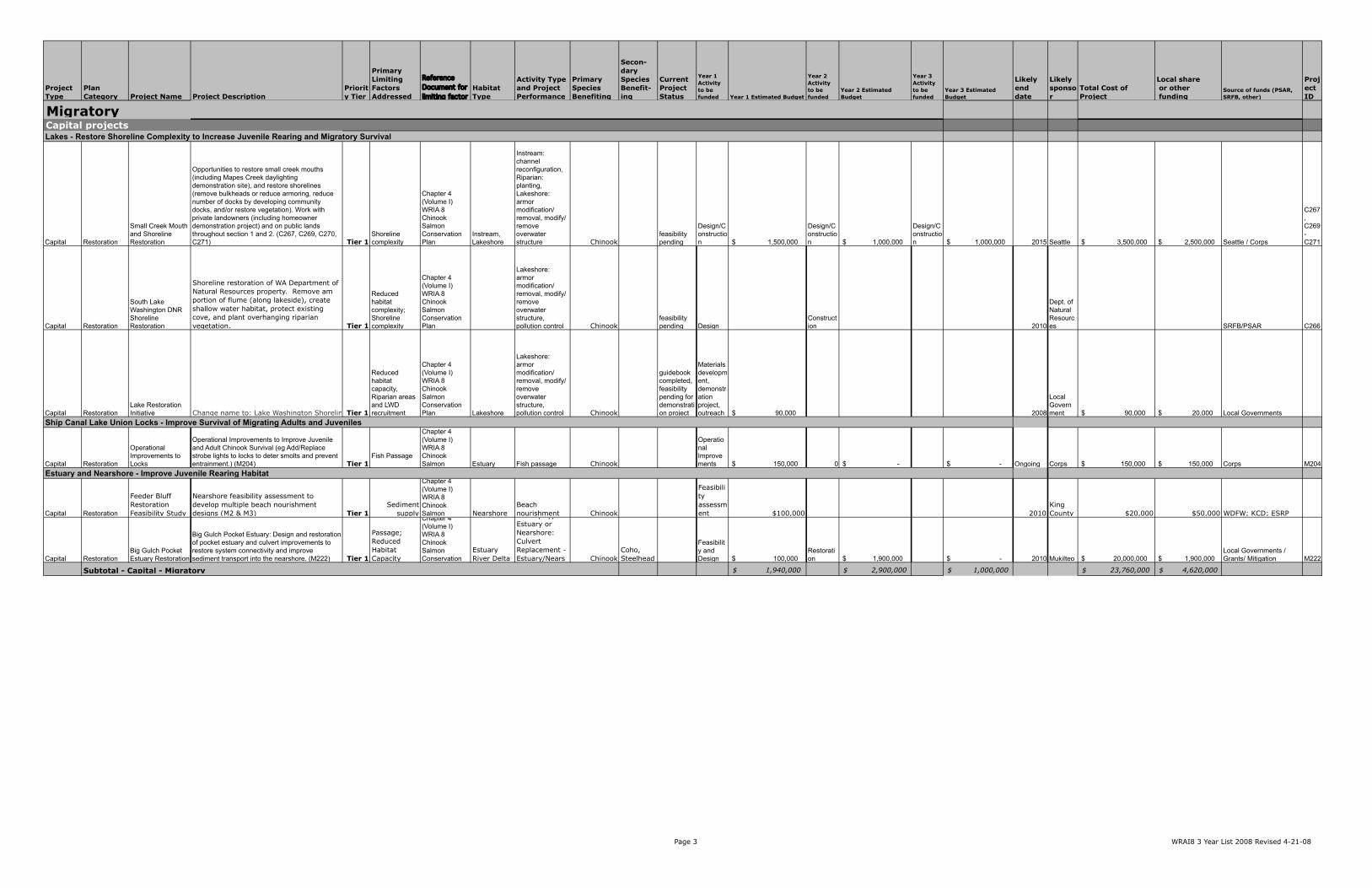
Page 1 WRAI8 3 Year List 2008 Revised 4-21-08
Project Type
Plan Category Project Name Project Description
Priority Tier
Primary Limiting Factors Addressed
Reference Document for limiting factor
Habitat Type
Activity Type and Project Performance
Primary Species Benefiting
Secon-dary Species Benefit-ing
Current Project Status
Year 1 Activity to be funded Year 1 Estimated Budget
Year 2 Activity to be funded
Year 2 Estimated Budget
Year 3 Activity to be funded
Year 3 Estimated Budget
Likely end date
Likely sponsor
Total Cost of Project
Local share or other funding
Source of funds (PSAR, SRFB, other)
Project ID
Capital Acquisition
Acquisition and Habitat Protection Upstream of Ron Regis park: Reach 4
Protect Habitat in Reach 4: Protect existing riparian habitat, instream habitat conditions and extensive LWD in reach. Most of reach already in public ownership or protected by regulations (e.g. steep slopes). Targeted parcel is adjacent to landslide reach immediately upstream of Ron Regis park. (C213) Tier 1
Channel Structure and Complexity, Riparian Areas & LWD Recruitment
Chapter 4 (Volume I) WRIA 8 Chinook Salmon Conservation Plan
Riparian, Instream
Activity Type - Land Protected, Acquired, or Leased: Streambank or Riparian Protected (0.10 Miles) Chinook
Coho, Sockeye, Steelhead
Feasibility Pending NA -$ acquisition 200,000$ NA -$ 2013 King County 200,000$ 50,000$ KCD , King County SWM C213
Capital Restoration
Study Options to Protect Habitat in Reach 4 and Reduce Flooding and Erosion in Ron Regis park
Study Options to Protect Habitat in Reach 4 and Reduce Flooding and Erosion in Ron Regis Park: It is unclear how much further river is going to erode bank and migrate into Ron Regis park in landslide area. Eventually there will be a conflict with park uses. Explore using LWD and levee setback to prevent excessive erosion and flood damage to public lands associated with Ron Regis Park while protecting natural habitat forming processes in reach. Study should include lower Madsen Creek. (C214) Tier 1
Floodplain Connectivity & Function
Chapter 4 (Volume I) WRIA 8 Chinook Salmon Conservation Plan
Riparian, Instream
Activity Type - Instream: Large Woody Debris (0 Feet) Chinook
Coho, Sockeye, Steelhead
Feasibility Pending NA -$ Feasibility study to evaluate options40,000$ NA -$ 2013
Renton / King County 40,000$ -$ C214
Capital Acquisition
Jones Reach Acquisition and Habitat Protection
Jones Reach: 29 acres, 16 parcels targeted for protection. Left bank of river already protected. Acquiring parcels on right bank of the river would allow both banks of the river to be protected. (C228) Tier 1
Channel Structure and Complexity, Riparian Areas & LWD Recruitment
Chapter 4 (Volume I) WRIA 8 Chinook Salmon Conservation Riparian
Activity Type - Land Protected, Acquired, or Leased: Upland Chinook
Coho, Sockeye, Steelhead
Feasibility Pending
Acquisition $ 1,000,000
acquisition $ 1,400,000
acquisition $ 1,400,000 2013
King County / City of Seattle $ 3,800,000 $ 1,000,000 KCD , King County SWM C228
Capital AcquisitionBucks Curve Buyout
Bucks Curve Buyout: Continue buying out structures to build on previous restoration efforts in vicinity of RM 6.2 to RM 6.4. Once sufficient land acquired, remove or setback existing levee, and revegetate floodplain. In best alternative, a portion of SE Jones Road could be relocated northward. (C215A) Tier 1
Floodplain Connectivity & Function
Chapter 4 (Volume I) WRIA 8 Chinook Salmon Conservation Plan
Riparian, Instream
Activity Type - Land Protected, Acquired, or Leased: Upland Protected (37 Acres) Chinook
Coho, Sockeye, Steelhead
Feasibility Pending
Acquisition $ 800,000
acquisition $ 800,000
acquisition $ 800,000 2013
King County / City of Seattle $ 2,250,000 $ 750,000 KCD , King County SWM
C215A
Capital RestorationBucks Curve Levee Setback/Removal
Bucks Curve Levee Setback / Removal: Once sufficient land acquired, remove or setback existing levee, and revegetate floodplain. In best alternative, a portion of SE Jones Road could be relocated northward. (C215B) Tier 1
Floodplain Connectivity & Function
Chapter 4 (Volume I) WRIA 8 Chinook Salmon Conservation Plan
Riparian, Instream
Activity Type - Land Protected, Acquired, or Leased: Upland Chinook
Coho, Sockeye, Steelhead
Feasibility Pending NA $ - NA $ - NA $ - 2013
King County / Corps of Engineers $ 40,000 $ 40,000
KC Surface Water Mgmt CIP
C215B
Capital Restoration
Cedar River Rainbow Bend Acquisition (C236A) and Restoration (C236-B)
(Name change from Cedar Grove Road - Rainbow Bend Levee Removal). Conduct further levee modification work to maximize channel-floodplain interactions. (C235) Tier 1
Floodplain Connectivity & Function
Chapter 4 (Volume I) WRIA 8 Chinook Salmon Conservation
Riparian, Instream Chinook
Coho, Sockeye, Steelhead Design NA $ - NA $ - Design $ 50,000 2010
King County / Seattle Public Utilities $ 50,000 $ 50,000 King County SWM, Corps C235
Capital Projects Cedar River - Restore Floodplain Connectivity to Increase In-Stream Juvenile Rearing Productivity
Cedar
2009 Three-Year Work Plan - WRIA 8 Watershed Implementation Priorities

Page 2 WRAI8 3 Year List 2008 Revised 4-21-08
Project Type
Plan Category Project Name Project Description
Priority Tier
Primary Limiting Factors Addressed
Reference Document for limiting factor
Habitat Type
Activity Type and Project Performance
Primary Species Benefiting
Secon-dary Species Benefit-ing
Current Project Status
Year 1 Activity to be funded Year 1 Estimated Budget
Year 2 Activity to be funded
Year 2 Estimated Budget
Year 3 Activity to be funded
Year 3 Estimated Budget
Likely end date
Likely sponsor
Total Cost of Project
Local share or other funding
Source of funds (PSAR, SRFB, other)
Project ID
Capital Acquisition
Lower Lions Stream Reach Acquisition
Lower Lions Stream Reach Acquisition. 30 acres (12 parcels) includes a large area of riparian forested floodplain between the Cedar River and SE 188th Street. Enhances side channel that was constructed in the area, allows expansion, and completion of side channel. (C239) Tier 1
Floodplain Connectivity & Function
Chapter 4 (Volume I) WRIA 8 Chinook Salmon Conservation Plan
Instream, Riparian
Activity Type - Land Protected, Acquired, or Leased: Upland Protected (39 Acres) Chinook
Coho, Sockeye, Steelhead underway
Acquisition $540,000
Acquisition $540,000
Acqusition $540,000 2010
King County $1,620,000
Conservation Futures, King County SWM
Capital Acquisition
218th Place Side Channel Protection and Enhancement
218th Place Side Channel: Protect 5 acres, 1 parcel, rural residential, riverfront. Once acquired there are opportunities for habitat enhancement in floodplain and off-channel areas. (Related to C242 to enhance 218th side channel once protected. C242 is not on start list.) (C244) Tier 1
Floodplain Connectivity & Function
Chapter 4 (Volume I) WRIA 8 Chinook Salmon Conservation Plan
Instream, Riparian
Activity Type - Land Protected, Acquired, or Leased: Upland Protected (5 Acres) Chinook
Coho, Sockeye, Steelhead NA $ - NA $ -
acquisition $ 500,000 2012
King County $500,000 $ - 0 C244
Capital Acquisition
Mouth of Taylor Creek Reach Acquisiton
Mouth of Taylor Creek Reach: Acquire approximately 40 acres of forested riparian floodplain associated with both the Cedar mainstem and the lower reach of Taylor Creek. The target parcels include approximately 1,000 feet of mainstem channel, nearly 1,300 feet of the lowermost reach and mouth of Taylor Creek, and one of the largest remaining floodplain wetlands adjacent to the mainstem. Some of the acquisitions will facilitate future levee removal and/or modification projects (Getchman and Rhode Levees). Completes acquisition by 2009, with restoration by 2012. (C245) Tier 1
Floodplain Connectivity & Function
Chapter 4 (Volume I) WRIA 8 Chinook Salmon Conservation Plan
Riparian, Wetland
Activity Type - Land Protected, Acquired, or Leased: Upland Protected (40 Acres) Chinook
Coho, Sockeye, Steelhead underway
Acquisition $ 1,000,000
acquisition $ 1,250,000
acquisition $ 1,250,000 2010
King County $ 3,500,000 $ 1,350,000
FEMA, Open Space Bond, King County SWM, Conservation Futures C245
Capital AcquisitionBelmondo Reach Acquisition
Belmondo Reach: 71 acres, 10 parcels, rural residential, riverfront. No levees in reach, numerous side channels, braided reach. Located between WPA and Cummings levees. Reach includes Trib 0316 confluence area. Area is just downstream of Cedar Grove Road / Rainbow Bend acquisition and meander bend restoration. (C232) Tier 1
Floodplain Connectivity & Function
Chapter 4 (Volume I) WRIA 8 Chinook Salmon Conservation Plan Riparian
Activity Type - Land Protected, Acquired, or Leased: Upland Protected (71 Acres) Chinook
Coho, Sockeye, Steelhead underway
Acquisition $ 500,000
acquisition $ 800,000
acquisition $ 1,800,000 2010
King County $ 3,100,000 $ 1,100,000
Seattle HCP, Conservation Futures, King County SWM C232
Capital AcquisitionElliot Bridge Habitat Acquisitions
Acquisiiton of high habitat value properties int eh Elliot Bridge reach. These acquisitions will supplement flood buy-outs in the reach and will facilitate early removal and setback of the levee. (C216-B) Tier 1
Floodplain Connectivity & Function
Chapter 4 (Volume I) WRIA 8 Chinook Salmon Conservation Plan Riparian
Activity Type - Land Protected, Acquired, or Leased: Upland Protected (71 Acres) Chinook
Coho, Sockeye, Steelhead underway
Acquisition $500,000
acquisition $500,000 2010
King County $1,676,000 $676,000 KCD , King County SWM
C216 B
Capital Acquisition
Dorre Don Meanders Reach Acquisition
Dorre Don Meanders Reach: Protect 71 acres, 14 parcels, rural residential, riverfront with flooding issues. Includes an extensive floodplain riparian forest, numerous valley floor spring-fed features including side channel, stream, and oxbow habitats. (C253) Tier 1
Floodplain Connectivity & Function
Chapter 4 (Volume I) WRIA 8 Chinook Salmon Conservation Plan Riparian
Activity Type - Land Protected, Acquired, or Leased: Upland Protected (71 Chinook
Coho, Sockeye, Steelhead underway
Acquisition $ 1,000,000
acquisition $ 1,500,000
Acquisition $ 1,500,000 2011
King County / City of Seattle $ 4,000,000 $ 1,000,000
Conservation Futures, King County SWM C253
Capital RestorationEnhance Flows at Lower Rock Creek
Lower Rock Creek Flows: Enhance Flows for Pre-Spawning Migrants: Work with the City of Kent in establishing instream flows that are protective of Chinook through their HCP process. (C351) Tier 2
Stream flow, Water quality, High water temperatures?
Chapter 4 (Volume I) WRIA 8 Chinook Salmon Conservation
Instream, Upland?
Instream flow: water flow returned to stream Chinook
feasibility pending $ - $ - $ - Kent $ - $ - C351
Capital RestorationLWD over Landsburg Dam
Explore feasibility of passing large woody debris over Landsburg Dam. (C260) Tier 1
Channel structure and complexity
Chapter 4 (Volume I) WRIA 8 Chinook Instream
Instream: large woody debris Chinook
feasibility pending 0 $ -
Feasibility Study $ 25,000 NA $ - ongoing
City of Seattle $ - $ - 0 C260
Capital Restoration
City of Renton Riparian Restoration
Riparian restoration in City of Renton-owned parkland upstream of I-405 bridge on left bank. (C209/C210) Tier 1
Riparian areas and LWD recruitment, Floodplain connectivity
Chapter 4 (Volume I) WRIA 8 Chinook Salmon Riparian Riparian Chinook
feasibility pending NA $ -
riparian restoration $ 81,000 NA $ - 2010 Renton $ 81,000 $ 21,000 Local Governments
C209 / C210
$ 5,340,000 $ 7,136,000 $ 7,840,000 $ 20,857,000 $ 6,037,000
Cedar River - Restore Riparian Function to Increase In-Stream Juvenile Rearing Productivity
Cedar River - Protect and Restore Hydrologic Processes to Support Egg Incubation and Pre-Spawning Migrant Life Stages
Cedar River - Restore LWD to Increase In-Stream Juvenile Rearing Productivity
Subtotal - Capital - Cedar
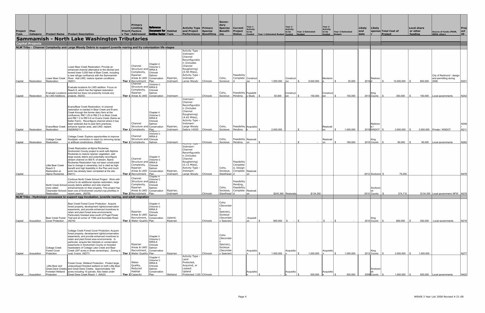
Page 3 WRAI8 3 Year List 2008 Revised 4-21-08
Project Type
Plan Category Project Name Project Description
Priority Tier
Primary Limiting Factors Addressed
Reference Document for limiting factor
Habitat Type
Activity Type and Project Performance
Primary Species Benefiting
Secon-dary Species Benefit-ing
Current Project Status
Year 1 Activity to be funded Year 1 Estimated Budget
Year 2 Activity to be funded
Year 2 Estimated Budget
Year 3 Activity to be funded
Year 3 Estimated Budget
Likely end date
Likely sponsor
Total Cost of Project
Local share or other funding
Source of funds (PSAR, SRFB, other)
Project ID
Capital Restoration
Small Creek Mouth and Shoreline Restoration
Opportunities to restore small creek mouths (including Mapes Creek daylighting demonstration site), and restore shorelines (remove bulkheads or reduce armoring, reduce number of docks by developing community docks, and/or restore vegetation). Work with private landowners (including homeowner demonstration project) and on public lands throughout section 1 and 2. (C267, C269, C270, C271) Tier 1
Shoreline complexity
Chapter 4 (Volume I) WRIA 8 Chinook Salmon Conservation Plan
Instream, Lakeshore
Instream: channel reconfiguration, Riparian: planting, Lakeshore: armor modification/ removal, modify/ remove overwater structure Chinook
feasibility pending
Design/Construction $ 1,500,000
Design/Construction $ 1,000,000
Design/Construction $ 1,000,000 2015 Seattle $ 3,500,000 $ 2,500,000 Seattle / Corps
C267, C269 - C271
Capital Restoration
South Lake Washington DNR Shoreline Restoration
Shoreline restoration of WA Department of Natural Resources property. Remove am portion of flume (along lakeside), create shallow water habitat, protect existing cove, and plant overhanging riparian vegetation. Tier 1
Reduced habitat complexity; Shoreline complexity
Chapter 4 (Volume I) WRIA 8 Chinook Salmon Conservation Plan
Lakeshore: armor modification/ removal, modify/ remove overwater structure, pollution control Chinook
feasibility pending Design
Construction 2010
Dept. of Natural Resources SRFB/PSAR C266
Capital RestorationLake Restoration Initiative Change name to: Lake Washington Shoreline Restoration at Cedar River delta.Tier 1
Reduced habitat capacity, Riparian areas and LWD recruitment
Chapter 4 (Volume I) WRIA 8 Chinook Salmon Conservation Plan Lakeshore
Lakeshore: armor modification/ removal, modify/ remove overwater structure, pollution control Chinook
guidebook completed, feasibility pending for demonstration project
Materials development, demonstration project, outreach $ 90,000 2008
Local Government $ 90,000 $ 20,000 Local Governments
Capital Restoration
Operational Improvements to Locks
Operational Improvements to Improve Juvenile and Adult Chinook Survival (eg Add/Replace strobe lights to locks to deter smolts and prevent entrainment.) (M204) Tier 1
Fish Passage
Chapter 4 (Volume I) WRIA 8 Chinook Salmon Estuary Fish passage Chinook
Operational Improvements $ 150,000 0 $ - $ - Ongoing Corps $ 150,000 $ 150,000 Corps M204
Capital Restoration
Feeder Bluff Restoration Feasibility Study
Nearshore feasibility assessment to develop multiple beach nourishment designs (M2 & M3) Tier 1
Sediment supply
Chapter 4 (Volume I) WRIA 8 Chinook Salmon Nearshore
Beach nourishment Chinook
Feasibility assessment $100,000 2010
King County $20,000 $50,000 WDFW; KCD; ESRP
Capital RestorationBig Gulch Pocket Estuary Restoration
Big Gulch Pocket Estuary: Design and restoration of pocket estuary and culvert improvements to restore system connectivity and improve sediment transport into the nearshore. (M222) Tier 1
Passage; Reduced Habitat Capacity
Chapter 4 (Volume I) WRIA 8 Chinook Salmon Conservation
Estuary River Delta
Activity Type - Estuary or Nearshore: Culvert Replacement - Estuary/Nears Chinook
Coho, Steelhead
Feasibility and Design $ 100,000
Restoration $ 1,900,000 $ - 2010 Mukilteo $ 20,000,000 $ 1,900,000
Local Governments / Grants/ Mitigation M222
$ 1,940,000 $ 2,900,000 $ 1,000,000 $ 23,760,000 $ 4,620,000
Capital projectsLakes - Restore Shoreline Complexity to Increase Juvenile Rearing and Migratory Survival
Ship Canal Lake Union Locks - Improve Survival of Migrating Adults and Juveniles
Estuary and Nearshore - Improve Juvenile Rearing Habitat
Migratory
Subtotal - Capital - Migratory
Page 4 WRAI8 3 Year List 2008 Revised 4-21-08
Project Type
Plan Category Project Name Project Description
Priority Tier
Primary Limiting Factors Addressed
Reference Document for limiting factor
Habitat Type
Activity Type and Project Performance
Primary Species Benefiting
Secon-dary Species Benefit-ing
Current Project Status
Year 1 Activity to be funded Year 1 Estimated Budget
Year 2 Activity to be funded
Year 2 Estimated Budget
Year 3 Activity to be funded
Year 3 Estimated Budget
Likely end date
Likely sponsor
Total Cost of Project
Local share or other funding
Source of funds (PSAR, SRFB, other)
Project ID
Capital RestorationLower Bear Creek Restoration
Lower Bear Creek Restoration: Provide an enhanced channel alternative to the ditched and leveed lower 3,000 feet of Bear Creek, including a new refuge confluence with the Sammamish River. Add LWD, restore riparian conditions. (N201) Tier 1
Channel Structure and Complexity, Riparian Areas & LWD Recruitment
Chapter 4 (Volume I) WRIA 8 Chinook Salmon Conservation Plan
Riparian, Instream
Activity Type - Instream: Channel Reconfiguration (Includes Channel Roughening) (0.50 Miles), Activity Type - Instream: Large Woody Chinook
Coho, Sockeye
Feasibility Completed
Construction $ 1,000,000
Construction $ 9,000,000
Monitoring $ 25,000 2010
Redmond $ 10,000,000 $ 850,000
City of Redmond - design and permitting during 2006 N201
Capital RestorationEvaluate Locations for LWD Additions
Evaluate locations for LWD addition. Focus on Reach 6, which has the highest restoration potential but does not presently include any projects. (N242) Tier 1
Channel Structure and Complexity, Riparian Areas & LWD
Chapter 4 (Volume I) WRIA 8 Chinook Salmon Conservation Instream Chinook
Coho, Sockeye
Feasibility Pending
Feasibility Study $ 50,000
Construction $ 150,000
Construction $ 150,000 2013
King County $ 350,000 $ 100,000 Local governments N242
Capital RestorationEvans/Bear Creek Restoration
Evans/Bear Creek Restoration: In-channel restoration is needed in Bear Creek and Evans Creak through the former dairy farm at the confluence; RM 1.25 to RM 2.5 on Bear Creek and RM 1.2 to RM 4.6 on Evans Creek (Same as Keller Farm). Reconfigure channel where it has been widened due to past farm practices, enhance riparian area, add LWD, replant. (N208/N211) Tier 1
Channel Structure and Complexity
Chapter 4 (Volume I) WRIA 8 Chinook Salmon Conservation Plan
Riparian, Instream
Activity Type - Instream: Channel Reconfiguration (Includes Channel Roughening) (4.65 Miles), Activity Type - Instream: Large Woody Debris (4500 Chinook
Coho, Sockeye
Feasibility Pending
Acquisition $ 2,000,000 $ -
Restoration $ 1,000,000 2010
Redmond / WSDOT $ 3,000,000 $ 3,000,000 Private / WSDOT
N208 / N211
Capital RestorationCottage Creek Restoration
Cottage Creek: Explore opportunities to improve floodplain connection in reach by removing riprap or artificial constrictions. (N282) Tier 1
Channel Structure and Complexity
Chapter 4 (Volume I) WRIA 8 Chinook Salmon Instream Chinook
Coho, Sockeye
Feasibility Pending
Restoration $ - $ -
Restoration $ 180,000 2010
King County $ 90,000 $ 90,000 Local governments N282
Capital
Little Bear Creek Reach 5 Restoration at Alpine Rockeries
Creek Restoration at Alpine Rockeries: Snohomish County project to work with Alphine Rockeries to restore riparian vegetation, add large woody debris and potentially reconfigure stream channel on 800 ft. of stream. Alpine Rockeries Restoration has not been constructed due to change in ownership, but is cited as high benefit and high feasibility in the Plan and much work has already been completed at the site. (N411) Tier 2
Channel Structure and Complexity, Riparian Areas & LWD Recruitment
Chapter 4 (Volume I) WRIA 8 Chinook Salmon Conservation Plan
Riparian, Instream
Activity Type - Instream: Channel Reconfiguration (Includes Channel Roughening) (0.15 Miles), Activity Type - Instream: Large Woody Chinook
Coho, Sockeye, Steelhead
Feasibility Completed, Design Completed
Restoration 2012 Snohomish County 75,000$ N478
Capital
North Creek School (now called Clearwater School) Restoration
Continue North Creek School Project: Work with school to do additional riparian restoration, large woody debris addition and side channel enhancements on their property. This project has been one of Snohomish county's top priorities in recent years. (N378) Tier 2
Channel Structure and Complexity, Riparian Areas & LWD Recruitment
Chapter 4 (Volume I) WRIA 8 Chinook Salmon Conservation Plan
Riparian, Instream Chinook
Coho, Sockeye, Steelhead
Feasibility Pending, Feasibility Completed
Restoration $240,360 Restoration $134,350 2010
Snohomish County 374,710$ $134,350 Local government; NFW N378
Capital AcquisitionBear Creek Forest Cover Protection
Bear Creek Forest Cover Protection: Acquire forest property, development rights/conservation easements, and provide enhanced incentives to retain and plant forest area environments. Particularly forested area south of Puget Power Trail and at corner of 116th and Avondale Road. (N216) Tier 1
Riparian Areas & LWD Recruitment, Water Quality
Chapter 4 (Volume I) WRIA 8 Chinook Salmon Conservation Plan
Upland, Riparian Chinook
Coho (Secondary Species), Sockeye (Secondary Species)
Acquisition $ 800,000 $ - $ - $ - $ - 2010
King County $ 800,000 $ 200,000 Local governments N216
Capital Acquisition
Cottage Creek Forest Cover Protection
Cottage Creek Forest Cover Protection: Acquire forest property, development rights/conservation easements, and provide enhanced incentives to retain and plant forest area environments. In particular, acquire fee interests or conservation easements in Snohomish County on forested headwaters of Cottage Lake Creek and Bear Creek (307 acres in three ownerships). Zoning is rural, 5-acre. (N277) Tier 1
Riparian Areas & LWD Recruitment, Water Quality
Chapter 4 (Volume I) WRIA 8 Chinook Salmon Conservation Plan Riparian Chinook
Coho (Secondary Species), Sockeye (Secondary Species)
Acquisition $ 1,000,000
Acquisition $ 1,000,000
Acquisition $ 1,000,000 2012
King County $ 3,000,000 $ 1,000,000 N277
Capital Acquisition
Little Bear and Great Dane Creeks Forested Wetland Protection
Forest Cover, Wetland Protection: Protect large, undeveloped forested wetland on both Little Bear and Great Dane Creeks. Approximately 100 acres including 10 parcels. Also listed under Great Dane Creek Reach 1. (N422) Tier 2
Water Quality, Reduced Habitat Capacity
Chapter 4 (Volume I) WRIA 8 Chinook Salmon Conservation Plan Wetland
Activity Type - Land Protected, Acquired, or Leased: Upland Protected (100 Chinook
Acquisition $ -
Acquisition $ 500,000
Acquisition $ 500,000 2009
Snohomish County $ 1,000,000 $ 500,000 Local governments N422
Capital ProjectsNLW Tribs - Channel Complexity and Large Woody Debris to support juvenile rearing and fry colonization life stages
NLW Tribs - Hydrologic processes to support egg incubation, juvenile rearing, and adult migration
Sammamish - North Lake Washington Tributaries
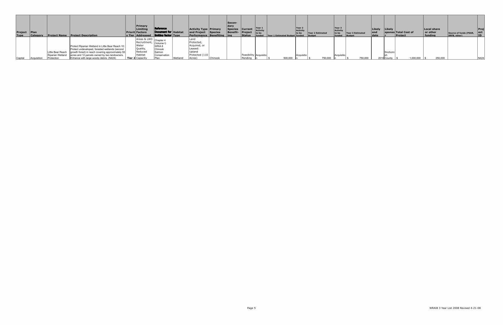
Page 5 WRAI8 3 Year List 2008 Revised 4-21-08
Project Type
Plan Category Project Name Project Description
Priority Tier
Primary Limiting Factors Addressed
Reference Document for limiting factor
Habitat Type
Activity Type and Project Performance
Primary Species Benefiting
Secon-dary Species Benefit-ing
Current Project Status
Year 1 Activity to be funded Year 1 Estimated Budget
Year 2 Activity to be funded
Year 2 Estimated Budget
Year 3 Activity to be funded
Year 3 Estimated Budget
Likely end date
Likely sponsor
Total Cost of Project
Local share or other funding
Source of funds (PSAR, SRFB, other)
Project ID
Capital Acquisition
Little Bear Reach Riparian Wetland Protection
Protect Riparian Wetland in Little Bear Reach 10: Protect undeveloped, forested wetlands (second growth forest) in reach covering approximately 55 acres and 12 parcels owned by two landowners. Enhance with large woody debris. (N424) Tier 2
Riparian Areas & LWD Recruitment, Water Quality, Reduced Habitat Capacity
Chapter 4 (Volume I) WRIA 8 Chinook Salmon Conservation Plan Wetland
Activity Type - Land Protected, Acquired, or Leased: Upland Protected (110 Acres) Chinook
Feasibility Pending
Acquisition $ 500,000
Acquisition $ 750,000
Acquisition $ 750,000 2010
Snohomish County $ 1,000,000 $ 250,000 N424
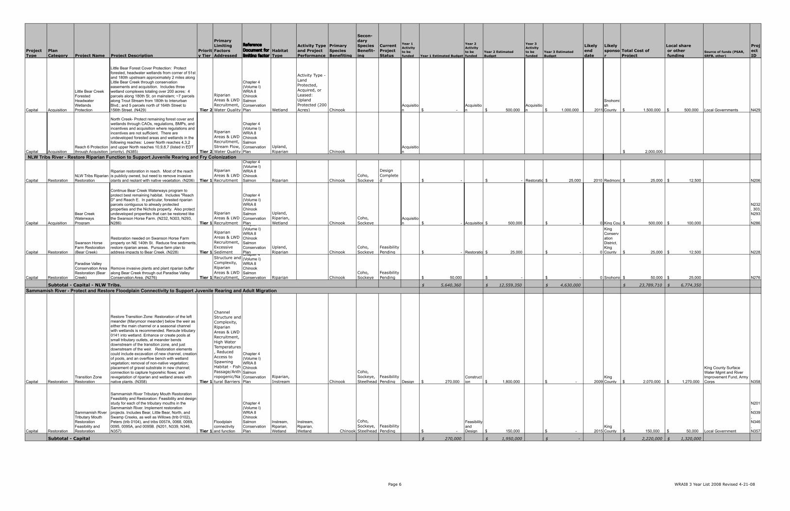
Page 6 WRAI8 3 Year List 2008 Revised 4-21-08
Project Type
Plan Category Project Name Project Description
Priority Tier
Primary Limiting Factors Addressed
Reference Document for limiting factor
Habitat Type
Activity Type and Project Performance
Primary Species Benefiting
Secon-dary Species Benefit-ing
Current Project Status
Year 1 Activity to be funded Year 1 Estimated Budget
Year 2 Activity to be funded
Year 2 Estimated Budget
Year 3 Activity to be funded
Year 3 Estimated Budget
Likely end date
Likely sponsor
Total Cost of Project
Local share or other funding
Source of funds (PSAR, SRFB, other)
Project ID
Capital Acquisition
Little Bear Creek Forested Headwater Wetlands Protection
Little Bear Forest Cover Protection: Protect forested, headwater wetlands from corner of 51st and 180th upstream approximately 2 miles along Little Bear Creek through conservation easements and acquisition. Includes three wetland complexes totaling over 200 acres: 4 parcels along 180th St. on mainstem; ~7 parcels along Trout Stream from 180th to Interurban Blvd.; and 5 parcels north of 164th Street to 156th Street. (N429) Tier 2
Riparian Areas & LWD Recruitment, Water Quality
Chapter 4 (Volume I) WRIA 8 Chinook Salmon Conservation Plan Wetland
Activity Type - Land Protected, Acquired, or Leased: Upland Protected (200 Acres) Chinook
Acquisition $ -
Acquisition $ 500,000
Acquisition $ 1,000,000 2011
Snohomish County $ 1,500,000 $ 500,000 Local Governments N429
Capital AcquisitionReach 6 Protection through Acquisition
North Creek- Protect remaining forest cover and wetlands through CAOs, regulations, BMPs, and incentives and acquisition where regulations and incentives are not sufficient. There are undeveloped forested areas and wetlands in the following reaches: Lower North reaches 4,3,2 and upper North reaches 10,9,8,7 (listed in EDT priority). (N385) Tier 2
Riparian Areas & LWD Recruitment, Stream Flow, Water Quality
Chapter 4 (Volume I) WRIA 8 Chinook Salmon Conservation Plan
Upland, Riparian Chinook
Acquisition 2,000,000$
Capital RestorationNLW Tribs Riparian Restoration
Riparian restoration in reach. Most of the reach is publicly owned, but need to remove invasive plants and replant with native vegetation. (N206) Tier 1
Riparian Areas & LWD Recruitment
Chapter 4 (Volume I) WRIA 8 Chinook Salmon Riparian Chinook
Coho, Sockeye
Design Completed -$ -$ Restoration 25,000$ 2010 Redmond 25,000$ 12,500$ N206
Capital Acquisition
Bear Creek Waterways Program
Continue Bear Creek Waterways program to protect best remaining habitat. Includes "Reach D" and Reach E. In particular, forested riparian parcels contiguous to already protected properties and the Nichols property. Also protect undeveloped properties that can be restored like the Swanson Horse Farm. (N232, N303, N293, N286) Tier 1
Riparian Areas & LWD Recruitment
Chapter 4 (Volume I) WRIA 8 Chinook Salmon Conservation Plan
Upland, Riparian, Wetland Chinook
Coho, Sockeye
Acquisition -$ Acquisition 500,000$ -$ 0 King County 500,000$ 100,000$
N232, 303, N293, N286
Capital Restoration
Swanson Horse Farm Restoration (Bear Creek)
Restoration needed on Swanson Horse Farm property on NE 140th St. Reduce fine sediments, restore riparian areas. Pursue farm plan to address impacts to Bear Creek. (N228) Tier 1
Riparian Areas & LWD Recruitment, Excessive Sediment
Chapter 4 (Volume I) WRIA 8 Chinook Salmon Conservation Plan
Upland, Riparian Chinook
Coho, Sockeye
Feasibility Pending -$ Restoration 25,000$ -$ 0
King Conservation District, King County 25,000$ 12,500$ N228
Capital Restoration
Paradise Valley Conservation Area Restoration (Bear Creek)
Remove invasive plants and plant riparian buffer along Bear Creek through out Paradise Valley Conservation Area. (N276) Tier 1
Channel Structure and Complexity, Riparian Areas & LWD Recruitment,
Chapter 4 (Volume I) WRIA 8 Chinook Salmon Conservation Riparian Chinook
Coho, Sockeye
Feasibility Pending 50,000$ -$ -$ 0 Snohomish County 50,000$ 25,000$ N276
$ 5,640,360 $ 12,559,350 $ 4,630,000 $ 23,789,710 $ 6,774,350
Capital RestorationTransition Zone Restoration
Restore Transition Zone: Restoration of the left meander (Marymoor meander) below the weir as either the main channel or a seasonal channel with wetlands is recommended. Reroute tributary 0141 into wetland. Enhance or create pools at small tributary outlets, at meander bends downstream of the transition zone, and just downstream of the weir. Restoration elements could include excavation of new channel, creation of pools, and an overflow bench with wetland vegetation; removal of non-native vegetation; placement of gravel substrate in new channel; connection to capture hyporehic flows; and revegetation of riparian and wetland areas with native plants. (N358) Tier 1
Channel Structure and Complexity, Riparian Areas & LWD Recruitment, High Water Temperatures, Reduced Access to Spawning Habitat - Fish Passage/Anthropogenic/Natural Barriers
Chapter 4 (Volume I) WRIA 8 Chinook Salmon Conservation Plan
Riparian, Instream Chinook
Coho, Sockeye, Steelhead
Feasibility Pending Design $ 270,000
Construction $ 1,800,000 $ - 2009
King County $ 2,070,000 $ 1,270,000
King County Surface Water Mgmt and River Improvement Fund, Army Corps N358
Capital Restoration
Sammamish River Tributary Mouth Restoration Feasibility and Restoration
Sammamish River Tributary Mouth Restoration Feasibility and Restoration: Feasibility and design study for each of the tributary mouths in the Sammamish River. Implement restoration projects. Includes Bear, Little Bear, North, and Swamp Creeks, as well as Willows (trib 0102), Peters (trib 0104), and tribs 0057A, 0068, 0069, 0095, 0095A, and 0095B. (N201, N339, N346, N357) Tier 1
Floodplain connectivity and function
Chapter 4 (Volume I) WRIA 8 Chinook Salmon Conservation Plan
Instream, Riparian, Wetland
Instream, Riparian, Wetland Chinook
Coho, Sockeye, Steelhead
Feasibility Pending $ -
Feasibility and Design $ 150,000 $ - 2015
King County $ 150,000 $ 50,000 Local Government
N201, N339, N346, N357
$ 270,000 $ 1,950,000 $ - $ 2,220,000 $ 1,320,000
NLW Tribs River - Restore Riparian Function to Support Juvenile Rearing and Fry Colonization
Sammamish River - Protect and Restore Floodplain Connectivity to Support Juvenile Rearing and Adult Migration
Subtotal - Capital
Subtotal - Capital - NLW Tribs.
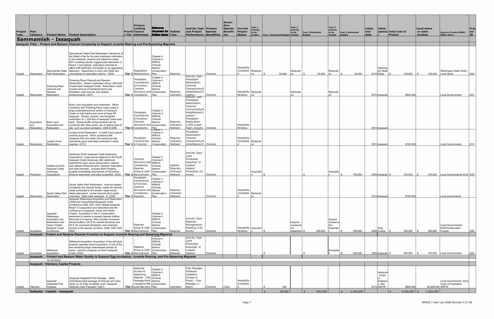
Page 7 WRAI8 3 Year List 2008 Revised 4-21-08
Project Type
Plan Category Project Name Project Description
Priority Tier
Primary Limiting Factors Addressed
Reference Document for limiting factor
Habitat Type
Activity Type and Project Performance
Primary Species Benefiting
Secon-dary Species Benefit-ing
Current Project Status
Year 1 Activity to be funded Year 1 Estimated Budget
Year 2 Activity to be funded
Year 2 Estimated Budget
Year 3 Activity to be funded
Year 3 Estimated Budget
Likely end date
Likely sponsor
Total Cost of Project
Local share or other funding
Source of funds (PSAR, SRFB, other)
Project ID
Capital RestorationSammamish State Park Restoration
Sammamish State Park Restoration: Revisions of the State's Plan for the park emphasis restoration of the wetlands, streams and lakeshore areas. EDT modeling results suggest park restoration in Reach 1 has highest restoration potential to affect VSP attributes, but baded on an aggressive approach. Opportunity to work with State and consultants on restoration actions. (I204) Tier 1
Regulatory Mechanisms
Chapter 4 (Volume I) WRIA 8 Chinook Salmon Conservation Plan Riparian Chinook
Feasibility Completed
Restoration $ 50,000
Restoration $ 50,000
Restoration $ 50,000 2010
Washington State Parks $ 150,000 $ 150,000
Washington State Parks / Local Govts I204
Capital Restoration
Pickering Place Channel and Riparian Restoration
Pickering Place Channel and Riparian Restoration, Stream restoration along 1,800 feet of west bank Issaquah Creek. Restoration could include removal of hardened banks and floodplain, side channel, and riparian enhancements. (I207) Tier 1
Floodplain Connectivity & Function, Channel Structure and Complexity
Chapter 4 (Volume I) WRIA 8 Chinook Salmon Conservation Plan
Riparian, Instream
Activity Type - Floodplain Restoration: Channel Connectivity/Rehabilitation/Creation - Chinook
Feasibility Pending
Restoration
Restoration
Restoration 2010 Issaquah $500,000 Local Governments I207
Capital
Acquisition and Restoration
Bush Lane Acquisition and Restoration
Bush Lane Acquisition and restoration. When combined with Pickering Place could create a large protected/restored section of Issaquah Creek on both banks and some of lower NF Issaquah. Stream, riparian, and floodplain restoration on 1,200 feet of Issaquah Creek east bank. Stream/buffer enhancements can be combined with other public use of upland area of site, such as active recreation. (I206 & I208) Tier I
Floodplain Connectivity & Function, Channel Structure and Complexity
Chapter 4 (Volume I) WRIA 8 Chinook Salmon Conservation Plan
Riparian, Instream, Wetland
Activity Type - Floodplain Restoration: Channel Connectivity/Rehabilitation/Creation - Floodplain Restoration (1200 Linear Feet), Activity Chinook
Feasibility Pending 2010 Issaquah
Capital RestorationJuniper Acres Restoration
Juniper Acres Restoration. A small 2-acre parcel recently acquired. When combined with Issaquah Park and other City owned parcels, represents good restoration potential in urban reaches. (I212) Tier 1
Floodplain Connectivity & Function
Chapter 4 (Volume I) WRIA 8 Chinook Salmon Conservation
Riparian, Instream, Wetland
Activity Type - Floodplain Restoration: Channel Connectivity/Rehabilitation/C Chinook
Feasibility Completed
Restoration 2010 Issaquah $150,000 Local Governments I212
Capital Protection
Additional South Issaquah Creek Greenway Acquisitions
Additional South Issaquah Creek Greenway Acquisitions: Large parcels adjacent to the South Issaquah Creek Greenway offer additional potential for open space preservation, riparian and wetland enhancements, instream restoration, and side channels. Includes Mohl Property, located immediately downstream of Sycamore Drive on west bank; and other properties. (I225) Tier 1
Channel Structure and Complexity, Riparian Areas & LWD Recruitment
Chapter 4 (Volume I) WRIA 8 Chinook Salmon Conservation Plan
Upland, Riparian, Instream, Wetland
Activity Type - Land Protected, Acquired, or Leased: Upland Protected (19 Acres) Chinook
Acquisition $ - $ -
Acquisition $ 750,000 2009 Issaquah $ 750,000 $ 375,000 Local Governments/ KCD I225
Capital RestorationSquak Valley Park Restoration
Squak Valley Park Restoration. Improve habitat complexity and riparian forest, create off-channel areas connected to the stream, large woody debris placement. Levee removal (all or parts - unknown). Right bank Issaquah - 8. (I226) Tier 1
Floodplain Connectivity & Function, Channel Structure and Complexity, Riparian
Chapter 4 (Volume I) WRIA 8 Chinook Salmon Conservation Plan
Riparian, Instream, Wetland Chinook
Feasibility Completed
Restoration 2010 Issaquah $700,000 Local governments
Capital Acquisition
Issaquah Waterways Acquisition and Restoration and Carey/ Holder/ Issaquah Creek Confluence
Issaquah Waterways Acquisition and Restoration (I249) and Carey/Holder/Issaquah Creek Confluence (I248. I250, I252): Middle Issaquah Reach 12 acquisition and restoration and the confluence of Issaquah, Carey and Holder Creeks. Acquisition in fee or conservation easement to restore or expand riparian buffers. Removal of invasives. Plan includes increased fenced buffers (100 ft for named tributaries and 50 ft. for unnamed tributaries), and restricted access to the riparian corridors. (I248. I249, I250, I252) Tier 1
Riparian Areas & LWD Recruitment
Chapter 4 (Volume I) WRIA 8 Chinook Salmon Conservation Plan Riparian
Activity Type - Riparian: Revegetation Planting (120 Acres) Chinook
Feasibility Pending
Acquisition $ -
Acquire conservation easement $ 350,000
Acquire Conservation Easement $ 350,000 2009
King County $ 700,000 $ 350,000
Local Governments/ KCD/Conservation Futures I250
Capital AcquisitionWildwood Acquisition
Wildwood Acquisition: Acquisition of the left bank property opposite recent acquisition of one of the few remaining large undeveloped parcels (8 acres - Johnson property) on lower Issaquah Creek. (I222) Tier 1
Riparian Areas & LWD Recruitment
Chapter 4 (Volume I) WRIA 8 Chinook Salmon Conservation Plan
Upland, Riparian
Activity Type - Land Protected, Acquired, or Leased: Upland Chinook $ - $ -
Acquisition $ 300,000 2009 Issaquah $ 300,000 $ 150,000 Local Governments I222
no projects
Capital Hatchery
Issaquah Integrated Fish Passage
Issaquah Integrated Fish Passage. Allow unhindered adult passage of Chinook and coho. Open up 10 miles of habitat. (was "Issaquah Hattchery Dam Passage") (I221) Tier I
Reduced Access to Spawning Habitat - Fish Passage/Anthropogenic/Natural Barriers
Chapter 4 (Volume I) WRIA 8 Chinook Salmon Conservation Plan Instream
Activity Type - Fish Passage: Fishways (Ladders, Chutes or Pools) - Fish Passage (1 Each) Chinook Coho
Feasibility Completed $ 400 2010
Issaquah, Corps of Engineers, and WDFW $800,000 $2,400,000
Local Governments, Army Corps of Engineers, WDFW
$ 50,400 $ 400,000 $ 1,450,000 $ 4,050,000 $ 3,425,000
Issaquah Tribs - Protect and Restore Channel Complexity to Support Juvenile Rearing and Pre-Spawning Migrants
Issaquah -Protect and Restore Riparian Function to Support Juvenile Rearing and Spawning Migrants
Sammamish - Issaquah
Subtotal - Capital - Issaquah
Issaquah - Protect and Restore Water Quality to Support Egg Incubation, Juvenile Rearing, and Pre-Spawning Migrants
Issaquah - Hatchery Capital Projects
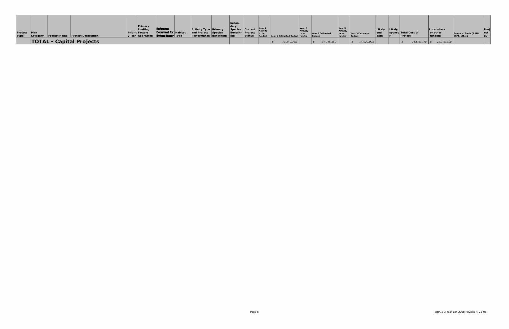
Page 8 WRAI8 3 Year List 2008 Revised 4-21-08
Project Type
Plan Category Project Name Project Description
Priority Tier
Primary Limiting Factors Addressed
Reference Document for limiting factor
Habitat Type
Activity Type and Project Performance
Primary Species Benefiting
Secon-dary Species Benefit-ing
Current Project Status
Year 1 Activity to be funded Year 1 Estimated Budget
Year 2 Activity to be funded
Year 2 Estimated Budget
Year 3 Activity to be funded
Year 3 Estimated Budget
Likely end date
Likely sponsor
Total Cost of Project
Local share or other funding
Source of funds (PSAR, SRFB, other)
Project ID
$ 13,240,760 $ 24,945,350 $ 14,920,000 $ 74,676,710 $ 22,176,350 TOTAL - Capital Projects
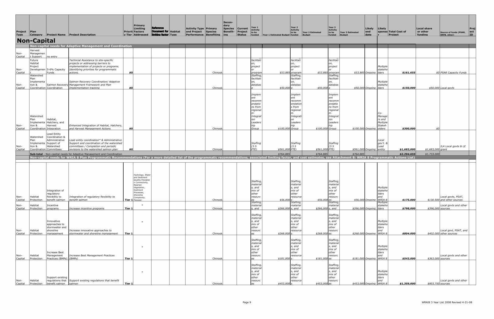
Page 9 WRAI8 3 Year List 2008 Revised 4-21-08
Project Type
Plan Category Project Name Project Description
Priority Tier
Primary Limiting Factors Addressed
Reference Document for limiting factor
Habitat Type
Activity Type and Project Performance
Primary Species Benefiting
Secon-dary Species Benefit-ing
Current Project Status
Year 1 Activity to be funded Year 1 Estimated Budget
Year 2 Activity to be funded
Year 2 Estimated Budget
Year 3 Activity to be funded
Year 3 Estimated Budget
Likely end date
Likely sponsor
Total Cost of Project
Local share or other funding
Source of funds (PSAR, SRFB, other)
Project ID
Non-Capital
Harvest Management Support no entry
Non-Capital
Future Habitat Project Development
5-6% Capacity Funds
Techncial Assistance to site-specific projects or addressing barriers to implementation of projects or programs. Identifying priorities for programmatic actions. All Chinook
Staffing, facilitation, project or program $53,885
Staffing, facilitation, project or program $53,885
Staffing, facilitation, project or program $53,885 Ongoing
Multiple stakeholders $161,655 $0 PSAR Capacity Funds
Non-Capital
Watershed Plan Implementation & Coordination
Salmon Recovery Coordination
Salmon Recovery Coordination/ Adaptive Management Framework and Plan Implementation tracking All Chinook
Staffing, facilitation, database $50,000
Staffing, facilitation, database $50,000
Staffing, facilitation, database $50,000 Ongoing
Multiple stakeholders $150,000 $50,000 Local govts
Non-Capital
Watershed Plan Implementation & Coordination
Habitat, Hatchery, and Harvest Integration
Enhanced Integration of Habitat, Hatchery, and Harvest Management Actions All Chinook
Implement recommendations from regional H-Integration Leadership Group $100,000
Implement recommendations from regional H-Integration Leadership Group $100,000
Implement recommendations from regional H-Integration Leadership Group $100,000 Ongoing
Co-Managers and Multiple Stakeholders $300,000 $0
Non-Capital
Watershed Plan Implementation & Coordination
Lead Entity Coordination & Administrative Support of Watershed Committees
Lead entity coordination* & Administrative Support and coordination of the watershed committees / Completion and periodic revisions to the watershed salmon plan All Chinook
Staffing (3.5 FTE) $561,000
Staffing (3.5 FTE) $561,000
Staffing (3.5 FTE) $561,000 Ongoing
Local gov't. & Lead entity $1,683,000 $1,683,000
ILA Local govts & LE grant
$764,885 $764,885 $764,885 $2,294,655 $1,733,000
Non-Capital
Habitat Protection
Integration of regulatory flexibility to benefit salmon
Integration of regulatory flexibility to benefit salmon Tier 1
Hydrology, Water and Sediment Quality,Floodplain Connectivity, Riparian Vegetation, Sediment Processes, Shoreline Complexity, Passage Chinook
Staffing, materials, and mix of other resources $56,000
Staffing, materials, and mix of other resources $56,000
Staffing, materials, and mix of other resources $56,000 Ongoing
Multiple stakeholders and WRIA 8 $175,000 $130,500
Local govts, PSAT, and other sources
Non-Capital
Habitat Protection
Incentive programs Increase incentive programs Tier 1
"Chinook
Staffing, materials, and $266,000
Staffing, materials, and $266,000
Staffing, materials, and $266,000 Ongoing
Multiple stakeholders $798,000 $396,000
Local govts and other sources
Non-Capital
Habitat Protection
Innovative approaches to stormwater and shoreline management
Increase innovative approaches to stormwater and shoreline management Tier 1
"
Chinook
Staffing, materials, and mix of other resources $268,000
Staffing, materials, and mix of other resources $268,000
Staffing, materials, and mix of other resources $268,000 Ongoing
Multiple stakeholders and WRIA 8 $804,000 $402,000
Local govt, PSAT, and other sources
Non-Capital
Habitat Protection
Increase Best Management Practices (BMPs)
Increase Best Management Practices (BMPs) Tier 1
"
Chinook
Staffing, materials, and mix of other resources $181,000
Staffing, materials, and mix of other resources $181,000
Staffing, materials, and mix of other resources $181,000 Ongoing
Multiple stakeholders and WRIA 8 $543,000 $363,000
Local govts and other sources
Non-Capital
Habitat Protection
Support existing regulations that benefit salmon
Support existing regulations that benefit salmon Tier 1
"
Chinook
Staffing, materials, and mix of other resources $453,000
Staffing, materials, and mix of other resources $453,000
Staffing, materials, and mix of other resources $453,000 Ongoing
Multiple stakeholders and WRIA 8 $1,359,000 $903,750
Local govts and other sources
Sub-total - Non-capital needs for Adaptive Management and CoordinationNon-capital needs for WRIA 8 Plan Programmatic Recommendations (For a more detailed list of the programmatic recommendations, associated limiting factor, and cost estimates, see Attachment B: WRIA 8 Programmatic Actions List)
Non-capital needs for Adaptive Management and CoordinationNon-Capital

Page 10 WRAI8 3 Year List 2008 Revised 4-21-08
Project Type
Plan Category Project Name Project Description
Priority Tier
Primary Limiting Factors Addressed
Reference Document for limiting factor
Habitat Type
Activity Type and Project Performance
Primary Species Benefiting
Secon-dary Species Benefit-ing
Current Project Status
Year 1 Activity to be funded Year 1 Estimated Budget
Year 2 Activity to be funded
Year 2 Estimated Budget
Year 3 Activity to be funded
Year 3 Estimated Budget
Likely end date
Likely sponsor
Total Cost of Project
Local share or other funding
Source of funds (PSAR, SRFB, other)
Project ID
Non-Capital
Outreach and education
Outreach and education Outreach and education Tier 1
"
Chinook
Staffing, materials, and mix of other resources $1,905,000
Staffing, materials, and mix of other resources $1,905,000
Staffing, materials, and mix of other resources $1,905,000 Ongoing
Multiple stakeholders and WRIA 8 $5,715,000 $476,250
Local govts, PSAT, and other sources
$3,129,000 $3,129,000 $3,129,000 $9,394,000 $2,671,500
Non-Capital
Habitat Project Monitoring
Evaluating Cumulative Effectiveness
Evaluating Cumulative Effectiveness of Actions All
Chapter 6 Volume I
WRIA 8 Plan Chinook
Staffing, site selection/ reconna $120,000
Staffing, data acquisition and material $370,000
Staffing, data acquisition and material $120,000 Ongoing
Multiple stakeholders $610,000 $300,000 Local govts
Non-Capital
Stock Monitoring Support
Stock Monitoring Support Stock monitoring support All
Chapter 6 Volume I
WRIA 8 Plan Chinook
Spawner surveys, smolt trapping $389,000
Spawner surveys, smolt trapping, PIT- $389,000
Spawner surveys, smolt trapping $389,000 Ongoing
Multiple stakeholders $1,167,000 $426,000 Local govts, WDFW
$509,000 $759,000 $509,000 $1,777,000 $726,000
Total year 1
need $3,638,000
Total year 2
need $3,888,000
Total year 3
need $3,638,000
Total Programmatic non-capital
need $11,171,000 $3,397,500
* In the recent past, WRIA 8 received $60,000/year for lead entity coordination. The $75,000 figure is an estimate received from Evergreen Funding.
Priority projects and programs benefitting non-listed species
Ebright Creek Enhancement and Acquisition
Ebright Creek: Enhance mouth and protect lower reaches of Ebright Creek on East shore of Lake Sammamish. If property on lower reaches of creek is acquired there could be educational outreach opportunities on the site. (M254) Tier 1
Loss of Habitat, Reduced Habitat Capacity
Riparian, Instream
Activity Type WRIA 8: Restore Creek Mouths/Pocket Estuaries (1 ) Chinook
Feasibility Pending
Acquisition $ 300,000 2010
City of Sammamish $ 300,000 $ 150,000 Local Governments
Monitoring
Sub-total - Non-capital needs for Monitoring
Total Non-Captial Need
Sub-total - Non-capital needs for Programmatic Recommendations
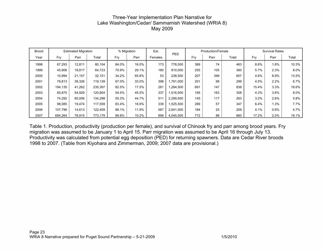
Three-Year Implementation Plan Narrative for Lake Washington/Cedar/ Sammamish Watershed (WRIA 8)
May 2009
Page 23 WRIA 8 Narrative prepared for Puget Sound Partnership – 5-21-2009 1/5/2010
Brood Estimated Migration % Migration Est. Production/Female Survival Rates
Year Fry Parr Total Fry Parr Females PED
Fry Parr Total Fry Parr Total
1998 67,293 12,811 80,104 84.0% 16.0% 173 778,500 389 74 463 8.6% 1.6% 10.3%
1999 45,906 18,817 64,723 70.9% 29.1% 180 810,000 255 105 360 5.7% 2.3% 8.0%
2000 10,994 21,157 32,151 34.2% 65.8% 53 238,500 207 399 607 4.6% 8.9% 13.5%
2001 79,813 39,326 119,139 67.0% 33.0% 398 1,791,000 201 99 299 4.5% 2.2% 6.7%
2002 194,135 41,262 235,397 82.5% 17.5% 281 1,264,500 691 147 838 15.4% 3.3% 18.6%
2003 65,875 54,929 120,804 54.5% 45.5% 337 1,516,500 195 163 358 4.3% 3.6% 8.0%
2004 74,292 60,006 134,298 55.3% 44.7% 511 2,299,500 145 117 263 3.2% 2.6% 5.8%
2005 98,085 19,474 117,559 83.4% 16.6% 339 1,525,500 289 57 347 6.4% 1.3% 7.7%
2006 107,796 14,613 122,409 88.1% 11.9% 587 2,641,500 184 25 209 4.1% 0.6% 4.7%
2007 694,264 78,915 773,179 89.8% 10.2% 899 4,045,500 772 88 860 17.2% 2.0% 19.1%
Table 1. Production, productivity (production per female), and survival of Chinook fry and parr among brood years. Fry migration was assumed to be January 1 to April 15. Parr migration was assumed to be April 16 through July 13. Productivity was calculated from potential egg deposition (PED) for returning spawners. Data are Cedar River broods 1998 to 2007. (Table from Kiyohara and Zimmerman, 2009; 2007 data are provisional.)
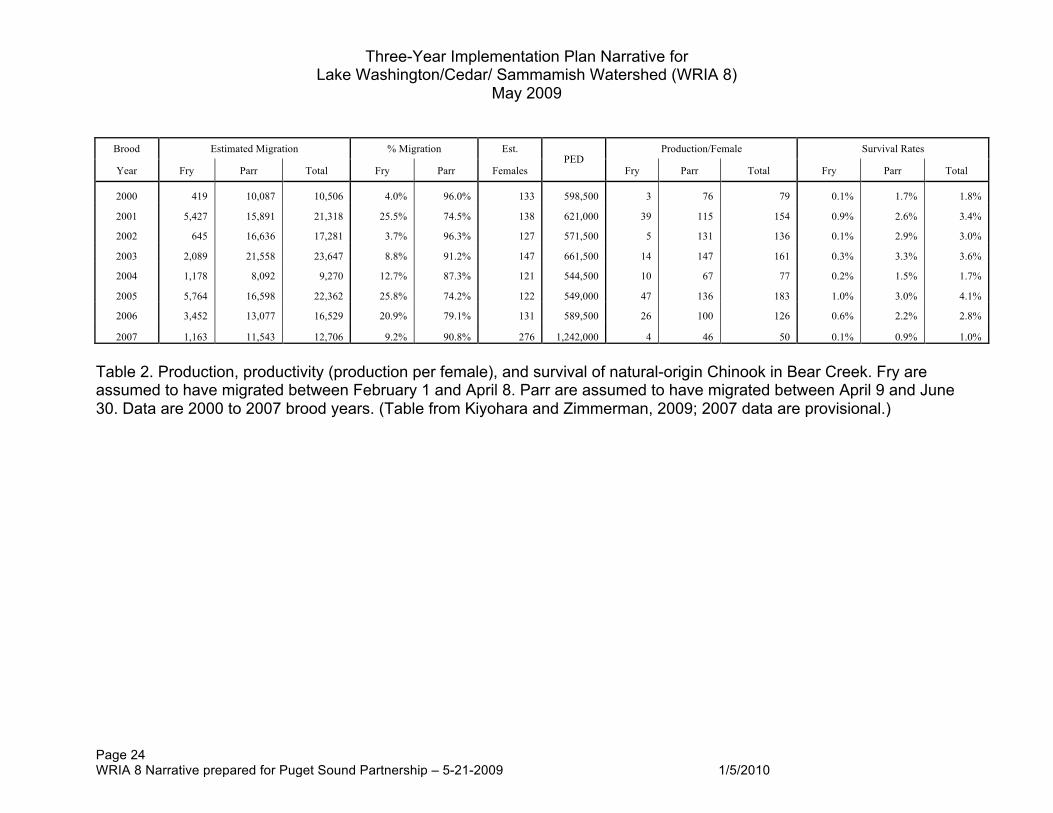
Three-Year Implementation Plan Narrative for Lake Washington/Cedar/ Sammamish Watershed (WRIA 8)
May 2009
Page 24 WRIA 8 Narrative prepared for Puget Sound Partnership – 5-21-2009 1/5/2010
Brood Estimated Migration % Migration Est. Production/Female Survival Rates
Year Fry Parr Total Fry Parr Females PED
Fry Parr Total Fry Parr Total
2000 419 10,087 10,506 4.0% 96.0% 133 598,500 3 76 79 0.1% 1.7% 1.8%
2001 5,427 15,891 21,318 25.5% 74.5% 138 621,000 39 115 154 0.9% 2.6% 3.4%
2002 645 16,636 17,281 3.7% 96.3% 127 571,500 5 131 136 0.1% 2.9% 3.0%
2003 2,089 21,558 23,647 8.8% 91.2% 147 661,500 14 147 161 0.3% 3.3% 3.6%
2004 1,178 8,092 9,270 12.7% 87.3% 121 544,500 10 67 77 0.2% 1.5% 1.7%
2005 5,764 16,598 22,362 25.8% 74.2% 122 549,000 47 136 183 1.0% 3.0% 4.1%
2006 3,452 13,077 16,529 20.9% 79.1% 131 589,500 26 100 126 0.6% 2.2% 2.8%
2007 1,163 11,543 12,706 9.2% 90.8% 276 1,242,000 4 46 50 0.1% 0.9% 1.0%
Table 2. Production, productivity (production per female), and survival of natural-origin Chinook in Bear Creek. Fry are assumed to have migrated between February 1 and April 8. Parr are assumed to have migrated between April 9 and June 30. Data are 2000 to 2007 brood years. (Table from Kiyohara and Zimmerman, 2009; 2007 data are provisional.)
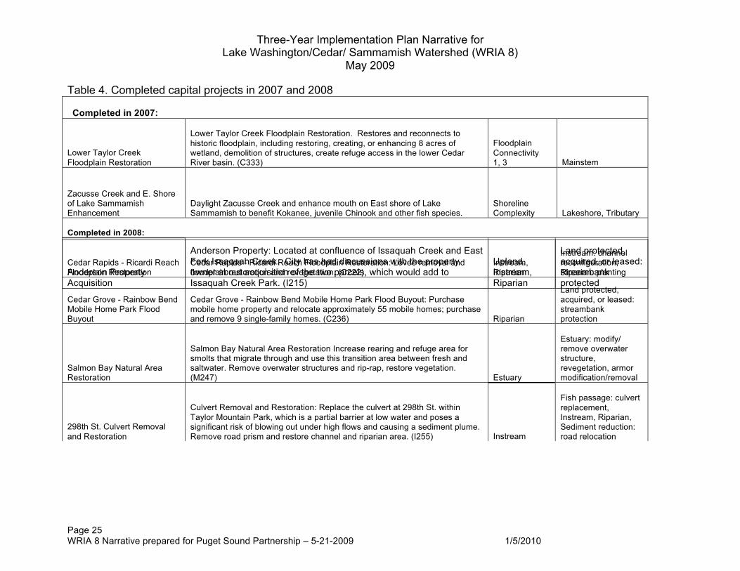
Three-Year Implementation Plan Narrative for Lake Washington/Cedar/ Sammamish Watershed (WRIA 8)
May 2009
Page 25 WRIA 8 Narrative prepared for Puget Sound Partnership – 5-21-2009 1/5/2010
Table 4. Completed capital projects in 2007 and 2008 Completed in 2007:
Lower Taylor Creek Floodplain Restoration
Lower Taylor Creek Floodplain Restoration. Restores and reconnects to historic floodplain, including restoring, creating, or enhancing 8 acres of wetland, demolition of structures, create refuge access in the lower Cedar River basin. (C333)
Floodplain Connectivity 1, 3 Mainstem
Zacusse Creek and E. Shore of Lake Sammamish Enhancement
Daylight Zacusse Creek and enhance mouth on East shore of Lake Sammamish to benefit Kokanee, juvenile Chinook and other fish species.
Shoreline Complexity Lakeshore, Tributary
Completed in 2008:
Cedar Rapids - Ricardi Reach Floodplain Restoration
Cedar Rapids - Ricardi Reach Floodplain Restoration: Levee removal and floodplain restoration and revegetation. (C222)
Instream, Riparian
Instream: channel reconfiguration, Riparian: planting
Cedar Grove - Rainbow Bend Mobile Home Park Flood Buyout
Cedar Grove - Rainbow Bend Mobile Home Park Flood Buyout: Purchase mobile home property and relocate approximately 55 mobile homes; purchase and remove 9 single-family homes. (C236) Riparian
Land protected, acquired, or leased: streambank protection
Salmon Bay Natural Area Restoration
Salmon Bay Natural Area Restoration Increase rearing and refuge area for smolts that migrate through and use this transition area between fresh and saltwater. Remove overwater structures and rip-rap, restore vegetation. (M247) Estuary
Estuary: modify/ remove overwater structure, revegetation, armor modification/removal
298th St. Culvert Removal and Restoration
Culvert Removal and Restoration: Replace the culvert at 298th St. within Taylor Mountain Park, which is a partial barrier at low water and poses a significant risk of blowing out under high flows and causing a sediment plume. Remove road prism and restore channel and riparian area. (I255) Instream
Fish passage: culvert replacement, Instream, Riparian, Sediment reduction: road relocation
Anderson Property Acquisition
Anderson Property: Located at confluence of Issaquah Creek and East Fork Issaquah Creek. City has had discussions with the property owner about acquisition of the two parcels, which would add to Issaquah Creek Park. (I215)
Upland, Instream, Riparian
Land protected, acquired, or leased: streambank protected

April 28, 2006 1
Three-Year Implementation Plan Narrative for WRIA 8 Attachments A & B
Attachment A: Limiting Factor Key. The following are the primary limiting factors to Chinook survival. This key is to be used with the 3-Year Implementation List and Attachment B: WRIA 8 Programmatic Actions List. Hydrology Urbanization within WRIA 8 has drastically altered upland, stream, and lake hydrology in most areas. Urbanization in upland areas (e.g., vegetation clearing, soil compaction, road and building construction) increases the amount of impervious surface within watersheds which, in turn, influences the infiltration of precipitation and increases the amount and rate at which surface water runoff reaches aquatic areas (Dunne and Leopold 1978; Poff et al. 1997). In river and creek habitats, the increase in flow can cause significant modifications to instream habitat and channels often respond to these flow regime changes through an overall enlargement, specifically channel incision and widening (Dunne and Leopold 1978). The increase in flow can have far reaching implications by displacing natural structure (e.g., coarse sediment and wood), increasing rates of erosion and decreasing overall bank stability. The effects of higher stream flows are further exacerbated by poor riparian conditions and disconnection of the stream channel from the floodplain, through bank armoring, channel incision and encroachment. Alternatively, stream hydrology can be altered by regulation of instream flows and water withdrawals (either surface water or groundwater), that typically reduce water levels. This can reduce the flows available to form habitat and connect with off-channel areas. Flow withdrawals, particularly in drier months, can reduce base flow levels and reduce available habitat areas for fish. Historic changes from lowering the level of lakes Washington and Sammamish, as well as regulating lake levels to vary only by 2 feet, reduces shoreline habitat complexity by limiting seasonal wetland formation and other habitat-forming interactions at the water-land interface. The amount of water available in Lake Washington also affects operations of the Locks and dictates how water is used at the smolt flumes and for boat lockages, affecting the outmigration route, and hence survival, of juveniles. Protection of hydrologic processes, including ground and surface water interactions, is hypothesized to directly support the survival of the egg incubation, fry colonization and prespawning migrant Chinook life stages. Other life stages are impacted by the role of hydrologic processes in maintaining cool stream temperatures, delivering spawning gravel, large woody debris, and nutrients, and providing access to off-channel habitat areas.
April 28, 2006 2
Water and Sediment Quality Human-induced changes to water quality (e.g., industrial effluent, sewer overflows, urban runoff) can alter water temperatures, turbidity, oxygen content and nutrient and contaminant concentrations (Karr 1995; Paul and Meyer 2001). Water and sediment quality are degraded in the Ship Canal, Lake Union, and the Sammamish River, primarily in relation to water temperatures, although sediment quality is of concern in the Ship Canal and Lake Union as well. In general, these changes can affect the kinds, amounts, and activity of all aquatic organisms in streams (Welch et al. 1998). For salmonids in particular, poor water quality can harm them directly or indirectly through oxygen depletions, lethal temperature levels, acute and chronic toxicity, or prey reductions (Karr 1995; Bjornn and Reiser 1991). Protection and restoration of water and sediment quality are hypothesized to primarily support the egg incubation life stage. Degradation of water quality (particularly increases in fine sediment and/or toxic chemicals) can significantly impact this life stage and drastically reduce productivity. Water quality improvements (particularly sediments) are also hypothesized to benefit the fry colonization and juvenile rearing life stages. In the Sammamish River, it is hypothesized that reduced temperatures would increase the survival of adult pre-spawning migrants. There is currently considerable uncertainty regarding the causes of pre-spawning mortality that has been observed in coho and Chinook. As the incidence of pre-spawning mortality appears to be correlated with urban conditions, it is possible that runoff from urbanization is a causal factor. The potential role of water quality in pre-spawning mortality increases the need for actions that reduce water quality degradation.
Floodplain Connectivity Streams and rivers are dynamic systems that constantly interact with their surrounding floodplain (Naiman and DeCamps 1990; May 1996; Morley 2000). Bank armoring, dredging, channel incision and urban encroachment effectively channelize the stream and severely limit interactions between the stream channel and the adjacent floodplain. This reduces the recruitment of coarse sediments and wood from floodplain areas, and limits materials available for habitat forming processes. Additionally, urban systems have lost riparian areas as a result of bank armoring, development of drainage infrastructure, and increased buildable area in the watershed (May 1996). Without the floodplain, streams and rivers lose habitat complexity, most notably off-channel and margin refuge habitats that provide resting areas for migrating fish and slow velocity areas during high-energy discharge events. The interactions of water bodies with their adjacent land is similarly important for the lakes and marine nearshore of
April 28, 2006 3
WRIA 8, which allows sediment and wood recruitment (discussed further under channel/shoreline complexity below). Channel confinement has reduced floodplain connectivity and reduced the amount of pools, small cobbles, and large woody debris. It is hypothesized that this reduced connectivity reduces the survival of the fry colonization and juvenile rearing life stages. It is also hypothesized that this confinement reduces the success of the pre-spawning holding life stage. Riparian Vegetation Land development and encroachment into areas adjacent to streams has reduced the extent, composition, and integrity of riparian vegetation along all water bodies of WRIA 8. Mature, native plant communities, dominated by deciduous and coniferous trees, have been replaced by pavement, commercial/ industrial activities, landscaped residential yards and invasive-dominated shrub communities (e.g., Japanese knotweed and Himalayan blackberries). In addition, riparian zones have been isolated from aquatic environments by bank armoring. As a result, riparian function has been altered. The riparian zone along stream banks, as well as lake and marine shorelines, has little woody debris to contribute to the habitat of the adjacent aquatic area. Other riparian inputs, such as leaf litter and terrestrial insects, are reduced as well (Gregory et al. 1991; Morley et al. 2003; Sobocinski 2003). In creeks and rivers, degraded riparian vegetation combined with increased high flow events reduces bank stability and increases bank erosion (May 1996). These riparian alterations, combined with other factors, have reduced aquatic habitat complexity and the availability of prey resources for salmonids. The protection and restoration of riparian function (including vegetation as well as overbank flows) is hypothesized to support the fry colonization and instream rearing life history stages. Other life stages (such as pre-spawning holding) are hypothesized to benefit from the connectivity of riparian areas with the mainstem channel, and sufficient flows to recruit wood and nutrients into the system. Sediment Processes Sediment recruitment, storage, and transport can be severely altered by altered hydrology, bank armoring, and reduced floodplain interactions. Depending on the flow dynamics, land uses, and underlying geology of the area, aquatic areas can suffer from either a lack of coarse sediments (e.g., gravel) or an abundance of fine sediments. Decreased gravel classes have been observed in urban streams as a result of altered sediment supplies and velocities (Finkenbine et al. 2000). Disconnecting stream, lake or marine nearshore areas from their adjacent floodplain/land interface has reduced sediment recruitment. Currents or flow velocities are responsible for distributing these substrates in the aquatic environment and without additional input, the system is left sediment deficient. In streams, increased stream gradients and flow velocities have further reduced retention of in-stream sediments (Pizzuto et al. 2000). These conditions reduce
April 28, 2006 4
the ability of aquatic habitats to create and maintain habitats. In freshwater areas, this reduces the amount of spawning substrates that are available for salmonids and the habitat complexity of the stream or lake area to benefit rearing juveniles. In salt water areas, there is a loss of shallow gravel substrate areas for juvenile refuge and feeding. While coarse sediment recruitment is a problem with floodplain isolation, increased fine sediment is often a problem as well, especially in urbanized streams (Wydzga 1997). Fine sediment can be supplied through either upland construction or erosion of the shoreline. Channel bank erosion, in particular, is a major source of fine sediment, which is exacerbated by increasing high flows (Paul and Meyer 2001). While habitat problems associated with find sediments are mostly limited to creeks and rivers, the introduction of fine sediment has implications for the food web. Most benthic invertebrates cannot forage effectively in areas dominated by fine sediments (Collier 1995). Sedimentation can also cause egg mortality by filling intragravel spaces in redds, which reduces water flow or traps developed fry in the substrate. Suspended sediments also affect salmonid behavior (Newcombe and Jensen 1996). Actions that protect and restore spawning gravels are hypothesized to benefit the spawning life stage, while actions that reduce fine sediments are hypothesized to benefit the egg incubation, fry colonization, and juvenile rearing life stages. Shoreline Complexity The combination of altered hydrology, loss of floodplain connection, degraded riparian communities, and altered sediment processes severely limits habitat forming processes and therefore, habitat complexity. This occurs in both lotic (streams and rivers) and lentic systems (lakes and the marine nearshore).. In lakes and the marine nearshore, there is an absence of high-quality, shallow water habitat with small substrates, in-water wood, overhanging vegetation, and variable edges at the land-water interface. Juveniles have poor rearing habitat that does not provide areas for foraging and refuge from predators, and the addition of over-water docks and piers may result in increased exposure to predators as migrating juveniles move to deeper water to go around these structures.. In addition, adult salmonids do not have areas to hold or rest while migrating. Passage Road crossings and other development activities have placed many creek channels in pipes and culverts (Finkenbine et al. 2000). Weirs and dams have also been installed in stream channels to reduce channel gradient and decrease stream velocity (May 1996). These structures were typically not designed to pass sediment or wood, and as a result, these materials are trapped in upstream areas, limiting their ability to contribute to downstream habitat formation. In addition, instream structures are often impassable to fish by creating outfall or velocity barriers (WDFW 1999), thereby restricting the amount of instream habitat

April 28, 2006 5
available to fish. Fish ladders and downstream flumes, such as at the Locks and Landsburg Dam (Cedar River), are passable to adults and juveniles but may have detrimental impacts through delayed migration or other sub-lethal effects (although none have been documented). Fish passage blockages are hypothesized to reduce the spatial distribution and diversity of Chinook populations, and to reduce the productivity of juvenile rearing life stages. In WRIA 8, culvert blockages are generally on smaller tributaries and have a larger impact on other salmonids such as coho. With the addition of fish passage facilities at Landsburg Diversion Dam, it is hypothesized that the most significant passage issues in WRIA 8 are at the Ballard Locks. Direct adult mortality has been observed in 2004 and 2005. It is further hypothesized that juvenile survival would increase through improved effectiveness of the smolt slides and infrastructure improvements to increase the use of the smolt slides by migrating juveniles and increase the area of freshwater – saltwater mixing in the Ship Canal and Salmon Bay. Finally, passage improvements in a number of direct Puget Sound drainages that flow under the Burlington Northern Sante Fe Railroad would are hypothesized to increase the productivity of juvenile rearing in the nearshore of WRIA 8.
April 28, 2006 6
Attachment B: WRIA 8 Programmatic Actions List. This list is from the start-list of the WRIA 8 Chinook Conservation Plan, Volume I, Chapter 9. The start-list recommends the top actions for the next 10 years for Chinook recovery. This list is organized in the same geographic order as the 3-Year Implementation Plan. These programmatic cost estimates are above and beyond current dollars expended for these actions.
Primary Limiting Factors
Addressed
Start-list Programmatic Recommendations High Cost
Estimate
WRIA 8 Plan List Code
Cedar
Hydrology Enlist help of builders practicing sustainable development to promote benefits of forest cover in protecting water quality. (C706, C707, C720, C722) 1 Basinwide
$5,000 C706, C707, C720, C722
Hydrology
Employ basinwide stewards to work with property owners, land trusts, and agencies in order to identify and secure forested, wetland, and riparian areas, and to encourage the best management practices for those held in private ownership. Encourage neighborhood and community protection associations to foster the ethic of voluntary stewardship and build bridges between property owners, agencies, and local governments. (C703, C716, C720, C721) 2 Basinwide
$15,000 C703, C716, C720, C721
Hydrology
Consistent with Growth Management Act, Renton and potential annexation areas should absorb most growth so that rural habitat resources can be protected; growth should be managed to minimize impacts on forest cover, water quality, and flows. (C1) 3 Within Urban Growth Area
$0 C1
Hydrology
In urban areas, protect remaining trees and encourage reforestation through street tree and urban forestry programs, tree protection regulations, landscaping incentives, and redevelopment. (C3) 4 Within Urban Growth Area
$10,000 C3
Hydrology
Protection of forest cover in Tier 1 and Tier 2 subareas is a high priority land use action, so that existing levels of forest cover are not further degraded. King County should strictly enforce the clearing restrictions for rural areas adopted in 10/04 as part of the critical areas ordinance update, pursue acquisition and incentives, and provide forest stewardship plans. Forest cover protections should account for site geology, soils, topography, and vegetation to maximize retention and infiltration. (C2) 5 Outside Urban Growth Area
$50,000 C2
Riparian Vegetation
Offer regulatory flexibility and incentives to encourage property owners to restore riparian function and remove impervious areas during redevelopment of public or private properties. (C6, C7) 6 Basinwide
$20,000 C6, C7
Riparian Vegetation
Expand outreach to streamside property owners about shoreline landscape design, maintenance, and streambank armoring alternatives. Convey through direct mailing of brochures (e.g., Streamside Savvy, Going Native); videos (Natural Lawn Care); shoreline
$15,000 C701, C702, C709, C714, C716, C722
April 28, 2006 7
Primary Limiting Factors
Addressed
Start-list Programmatic Recommendations High Cost
Estimate
WRIA 8 Plan List Code
homeowners kits given when home purchased; or, through workshops, including expansion of Natural Yard Care Program to include guidelines specific to shoreline residents. (C701, C702, C709, C714, C716, C722) 7 Basinwide
Riparian Vegetation
Offer educational opportunities to landscape designers/contractors on riparian design/installation, alternatives to invasive species, and use of compost. (C705, C706, C707) 8 Basinwide
$5,000 C705, C706, C707
Riparian Vegetation
Encourage neighborhood garden tours of salmon-friendly gardens to help residents visualize alternatives to traditional, less eco-friendly landscape treatments. Offer neighborhood organizers assistance with publicity, signage, and volunteer docents. (C722, C707) 9 Basinwide
$10,000 C722, C707
Riparian Vegetation
Protection of remaining riparian vegetation within Urban Growth Area is high priority; encourage replanting of riparian vegetation through incentives, and strictly enforce aquatic buffers and limit variances where vegetation still exists in sensitive areas. (C5) 10 Within Urban Growth Area
$30,000 C5
Riparian Vegetation
Protect intact riparian buffers in Tier 1 and Tier 2 subareas through strict enforcement of buffer regulations, and offer incentives to restore degraded habitat buffers, recognizing that majority of riparian corridor is privately owned. Support King County forestry and agriculture programs including technical and financial assistance to landowners. Protection and restoration of riparian buffer on publicly owned lands is also a priority. (C5, C7) 13 Outside Urban Growth Area
$30,000 C5, C7
Floodplain Connectivity
Limit new development in floodplains and channel migration zones; develop and apply standards which minimize impacts to salmon. State and local transportation plans should minimize new road crossings. (C17, C18) 15 Basinwide
$0 C17, C18
Floodplain Connectivity
Do a demonstration project in publicly accessible area with riverfront property owner(s) willing to replace bulkheads, levees, or stream bank armoring with more ecologically friendly design. Project should contain elements doable by average property owner and illustrate costs and benefits. (C715) 16 Basinwide
$15,000 C715
Floodplain Connectivity
Conduct study to identify locations where large woody debris should be added to Cedar mainstem and to explore feasibility of passing large woody debris over the Landsburg dam. (C601, C260) 17 Basinwide
$30,000 C601, C260
Floodplain Connectivity
Increase public awareness about the value of large woody debris and native vegetation for flood protection, salmon habitat, and healthy streams. Convey through media (e.g., local papers, community newsletters); signage along publicly accessible “model” shoreline; brochures such as King County’s Large Woody Debris and River Safety; and
$10,000 C716
April 28, 2006 8
Primary Limiting Factors
Addressed
Start-list Programmatic Recommendations High Cost
Estimate
WRIA 8 Plan List Code
other outreach venues such as festivals, local cable channels, and the Cedar River Naturalists program. (C716) 18 Basinwide
Water and Sediment Quality
Jurisdictions should adopt and enforce stormwater regulations and best management practices, consistent with Washington Department of Ecology’s 2001 Stormwater Management Manual (or beyond), as part of the NPDES Phase 1 and Phase 2 permit requirements. These regulations and BMPs should reduce sediment inputs from bed-scouring high flows and from non-point sources, including roads, development, agriculture, and other activities. Water quality problems should be addressed through stormwater programs (including low impact development BMPs), current and future TMDLs, livestock programs, and upgrade of stormwater facilities (where possible). (C12) 32 Basinwide
$30,000 C12
Water and Sediment Quality
Explore options to improve stormwater management in developed areas, e.g., through development of regional stormwater facilities and natural drainage systems (e.g., SEA Streets). Promote stormwater best management practices related to parking lot cleaning, storm drain maintenance and road cleaning. (C13) 33 Basinwide
$30,000 C13
Water and Sediment Quality
State/local transportation departments should address runoff from all roads and retrofit existing roads as part of major maintenance, expansion or upgrade projects; road maintenance actions should be consistent with Tri-County guidelines. Stormwater impacts from major transportation projects (for new and expanded roadways proposed during the next ten years) should be addressed. Washington Department of Transportation should improve stormwater management on SR 169. (C14, C15, C16) 34 Basinwide
$20,000 C14, C15, C16
Water and Sediment Quality
Coordinate with local business community and non-profits to encourage the use of commercial car washes and carwash kits. Reprint and distribute water quality poster series depicting impacts of everyday practices: washing car, driving car without maintenance, leaving pet wastes unattended, and improperly using lawn chemicals. (C710) 35 Basinwide
$5,000 C710
Water and Sediment Quality
Publicize emergency call numbers for public to report water quality and quantity problems, non-permitted vegetation clearing, and non-permitted in-stream grading and wood removal incidents. (C713) 36 Basinwide
$5,000 C713
Hydrology
Work with Washington Department of Ecology and local health departments on regulations, incentives, and education related to impact of surface and groundwater withdrawals, including illegal withdrawals and exempt wells. Determine where illegal surface water withdrawals are occurring and follow-up with enforcement to ensure withdrawals do not continue. (C22) 37 Basinwide
$80,000 C22
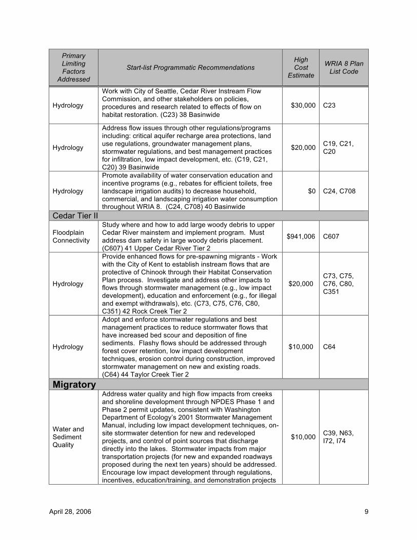
April 28, 2006 9
Primary Limiting Factors
Addressed
Start-list Programmatic Recommendations High Cost
Estimate
WRIA 8 Plan List Code
Hydrology
Work with City of Seattle, Cedar River Instream Flow Commission, and other stakeholders on policies, procedures and research related to effects of flow on habitat restoration. (C23) 38 Basinwide
$30,000 C23
Hydrology
Address flow issues through other regulations/programs including: critical aquifer recharge area protections, land use regulations, groundwater management plans, stormwater regulations, and best management practices for infiltration, low impact development, etc. (C19, C21, C20) 39 Basinwide
$20,000 C19, C21, C20
Hydrology
Promote availability of water conservation education and incentive programs (e.g., rebates for efficient toilets, free landscape irrigation audits) to decrease household, commercial, and landscaping irrigation water consumption throughout WRIA 8. (C24, C708) 40 Basinwide
$0 C24, C708
Cedar Tier II
Floodplain Connectivity
Study where and how to add large woody debris to upper Cedar River mainstem and implement program. Must address dam safety in large woody debris placement. (C607) 41 Upper Cedar River Tier 2
$941,006 C607
Hydrology
Provide enhanced flows for pre-spawning migrants - Work with the City of Kent to establish instream flows that are protective of Chinook through their Habitat Conservation Plan process. Investigate and address other impacts to flows through stormwater management (e.g., low impact development), education and enforcement (e.g., for illegal and exempt withdrawals), etc. (C73, C75, C76, C80, C351) 42 Rock Creek Tier 2
$20,000 C73, C75, C76, C80, C351
Hydrology
Adopt and enforce stormwater regulations and best management practices to reduce stormwater flows that have increased bed scour and deposition of fine sediments. Flashy flows should be addressed through forest cover retention, low impact development techniques, erosion control during construction, improved stormwater management on new and existing roads. (C64) 44 Taylor Creek Tier 2
$10,000 C64
Migratory
Water and Sediment Quality
Address water quality and high flow impacts from creeks and shoreline development through NPDES Phase 1 and Phase 2 permit updates, consistent with Washington Department of Ecology’s 2001 Stormwater Management Manual, including low impact development techniques, on-site stormwater detention for new and redeveloped projects, and control of point sources that discharge directly into the lakes. Stormwater impacts from major transportation projects (for new and expanded roadways proposed during the next ten years) should be addressed. Encourage low impact development through regulations, incentives, education/training, and demonstration projects
$10,000 C39, N63, I72, I74
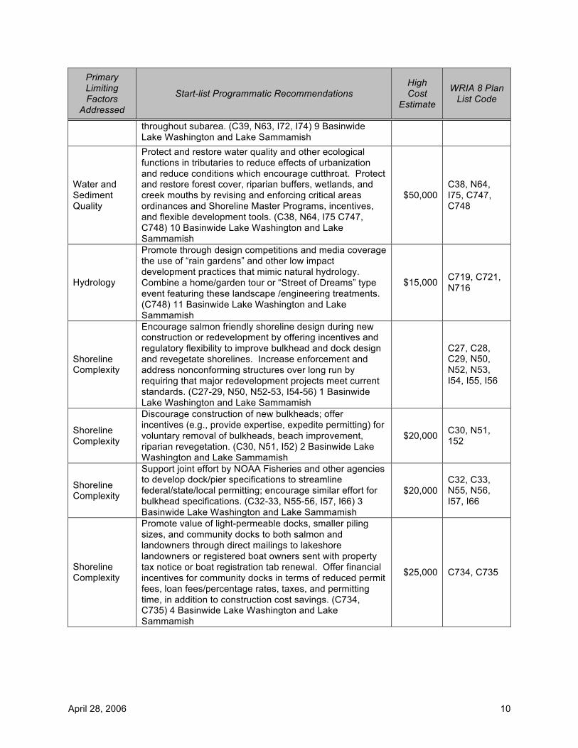
April 28, 2006 10
Primary Limiting Factors
Addressed
Start-list Programmatic Recommendations High Cost
Estimate
WRIA 8 Plan List Code
throughout subarea. (C39, N63, I72, I74) 9 Basinwide Lake Washington and Lake Sammamish
Water and Sediment Quality
Protect and restore water quality and other ecological functions in tributaries to reduce effects of urbanization and reduce conditions which encourage cutthroat. Protect and restore forest cover, riparian buffers, wetlands, and creek mouths by revising and enforcing critical areas ordinances and Shoreline Master Programs, incentives, and flexible development tools. (C38, N64, I75 C747, C748) 10 Basinwide Lake Washington and Lake Sammamish
$50,000 C38, N64, I75, C747, C748
Hydrology
Promote through design competitions and media coverage the use of “rain gardens” and other low impact development practices that mimic natural hydrology. Combine a home/garden tour or “Street of Dreams” type event featuring these landscape /engineering treatments. (C748) 11 Basinwide Lake Washington and Lake Sammamish
$15,000 C719, C721, N716
Shoreline Complexity
Encourage salmon friendly shoreline design during new construction or redevelopment by offering incentives and regulatory flexibility to improve bulkhead and dock design and revegetate shorelines. Increase enforcement and address nonconforming structures over long run by requiring that major redevelopment projects meet current standards. (C27-29, N50, N52-53, I54-56) 1 Basinwide Lake Washington and Lake Sammamish
C27, C28, C29, N50, N52, N53, I54, I55, I56
Shoreline Complexity
Discourage construction of new bulkheads; offer incentives (e.g., provide expertise, expedite permitting) for voluntary removal of bulkheads, beach improvement, riparian revegetation. (C30, N51, I52) 2 Basinwide Lake Washington and Lake Sammamish
$20,000 C30, N51, 152
Shoreline Complexity
Support joint effort by NOAA Fisheries and other agencies to develop dock/pier specifications to streamline federal/state/local permitting; encourage similar effort for bulkhead specifications. (C32-33, N55-56, I57, I66) 3 Basinwide Lake Washington and Lake Sammamish
$20,000 C32, C33, N55, N56, I57, I66
Shoreline Complexity
Promote value of light-permeable docks, smaller piling sizes, and community docks to both salmon and landowners through direct mailings to lakeshore landowners or registered boat owners sent with property tax notice or boat registration tab renewal. Offer financial incentives for community docks in terms of reduced permit fees, loan fees/percentage rates, taxes, and permitting time, in addition to construction cost savings. (C734, C735) 4 Basinwide Lake Washington and Lake Sammamish
$25,000 C734, C735
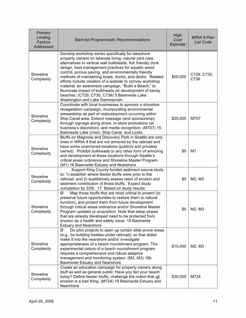
April 28, 2006 11
Primary Limiting Factors
Addressed
Start-list Programmatic Recommendations High Cost
Estimate
WRIA 8 Plan List Code
Shoreline Complexity
Develop workshop series specifically for lakeshore property owners on lakeside living: natural yard care, alternatives to vertical wall bulkheads, fish friendly dock design, best management practices for aquatic weed control, porous paving, and environmentally friendly methods of maintaining boats, docks, and decks. Related efforts include creation of a website to convey workshop material, an awareness campaign, “Build a Beach,” to illuminate impact of bulkheads on development of sandy beaches. (C729, C730, C736) 5 Basinwide Lake Washington and Lake Sammamish
$50,000 C729, C730, C736
Shoreline Complexity
Coordinate with local businesses to sponsor a shoreline revegetation campaign, incorporating environmental stewardship as part of redevelopment occurring within Ship Canal area. Extend message (and sponsorship) through signage along shore, in-store promotions (at business’s discretion), and media recognition. (M707) 15 Basinwide Lake Union, Ship Canal, and Locks
$20,000 M707
Shoreline Complexity
Bluffs on Magnolia and Discovery Park in Seattle are only ones in WRIA 8 that are not armored by the railroad and have some unarmored locations (publicly and privately owned). Prohibit bulkheads or any other form of armoring and development at these locations through Seattle’s critical areas ordinance and Shoreline Master Program. (M1) 16 Basinwide Estuary and Nearshore
$0 M1
Shoreline Complexity
· Support King County-funded sediment source study to: 1) establish where feeder bluffs were prior to the railroad, and 2) qualitatively assess rates of erosion and sediment contribution of those bluffs. Expect study completion by 3/05. 17 Based on study results:
$0 M2, M3
Shoreline Complexity
Ø Map those bluffs that are most critical to protect (to preserve future opportunities to restore them to natural function), and protect them from future development through critical areas ordinance and/or Shoreline Master Program updates or acquisition. Note that steep slopes that are already developed need to be protected from erosion as a health and safety issue. 18 Basinwide Estuary and Nearshore
$0 M2, M3
Shoreline Complexity
Ø Do pilot projects to open up certain slide prone areas (e.g., by building trestles under railroad), so that slides make it into the nearshore and/or investigate appropriateness of a beach nourishment program. The experimental nature of a beach nourishment program requires a comprehensive and robust adaptive management and monitoring system. (M2, M3) 18b Basinwide Estuary and Nearshore
$10,000 M2, M3
Shoreline Complexity
Create an education campaign for property owners along bluff as well as general public: Have you fed your beach today? Define feeder bluffs, challenge the notion that all erosion is a bad thing. (M724) 19 Basinwide Estuary and Nearshore
$30,000 M724
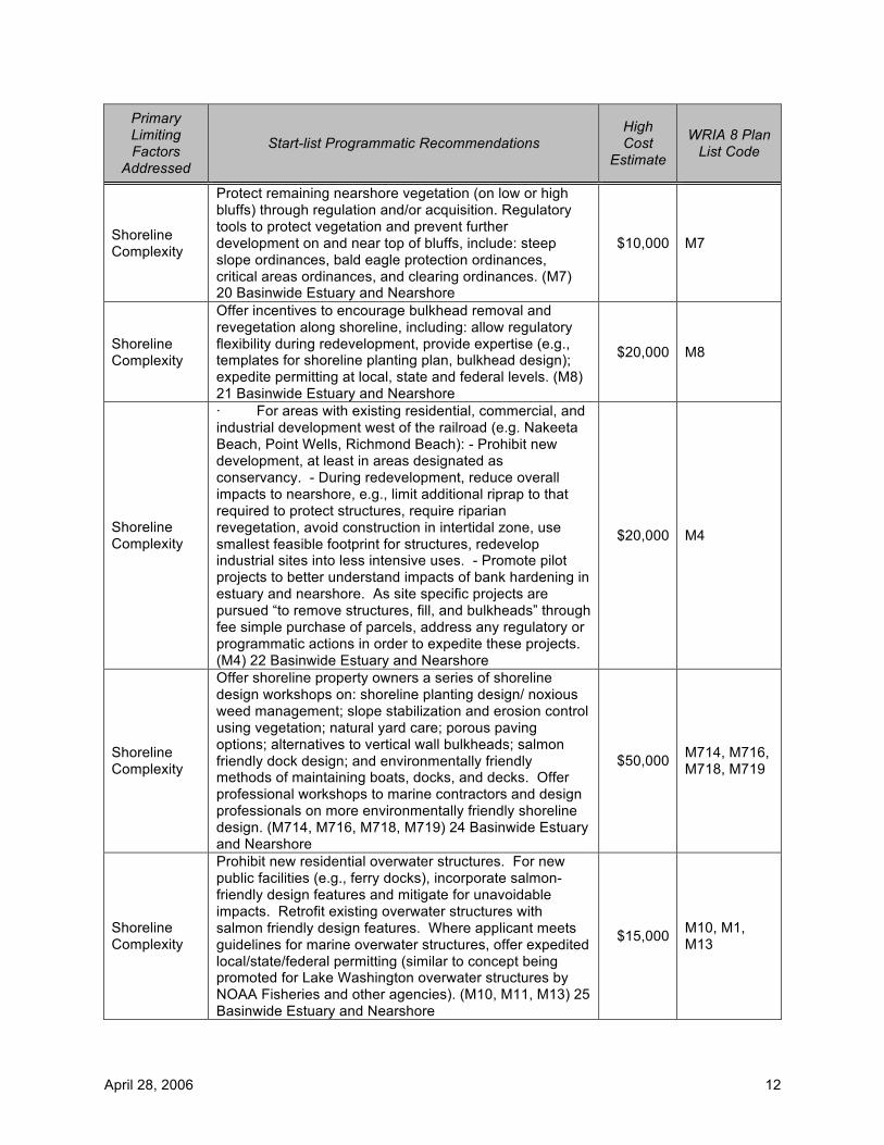
April 28, 2006 12
Primary Limiting Factors
Addressed
Start-list Programmatic Recommendations High Cost
Estimate
WRIA 8 Plan List Code
Shoreline Complexity
Protect remaining nearshore vegetation (on low or high bluffs) through regulation and/or acquisition. Regulatory tools to protect vegetation and prevent further development on and near top of bluffs, include: steep slope ordinances, bald eagle protection ordinances, critical areas ordinances, and clearing ordinances. (M7) 20 Basinwide Estuary and Nearshore
$10,000 M7
Shoreline Complexity
Offer incentives to encourage bulkhead removal and revegetation along shoreline, including: allow regulatory flexibility during redevelopment, provide expertise (e.g., templates for shoreline planting plan, bulkhead design); expedite permitting at local, state and federal levels. (M8) 21 Basinwide Estuary and Nearshore
$20,000 M8
Shoreline Complexity
· For areas with existing residential, commercial, and industrial development west of the railroad (e.g. Nakeeta Beach, Point Wells, Richmond Beach): - Prohibit new development, at least in areas designated as conservancy. - During redevelopment, reduce overall impacts to nearshore, e.g., limit additional riprap to that required to protect structures, require riparian revegetation, avoid construction in intertidal zone, use smallest feasible footprint for structures, redevelop industrial sites into less intensive uses. - Promote pilot projects to better understand impacts of bank hardening in estuary and nearshore. As site specific projects are pursued “to remove structures, fill, and bulkheads” through fee simple purchase of parcels, address any regulatory or programmatic actions in order to expedite these projects. (M4) 22 Basinwide Estuary and Nearshore
$20,000 M4
Shoreline Complexity
Offer shoreline property owners a series of shoreline design workshops on: shoreline planting design/ noxious weed management; slope stabilization and erosion control using vegetation; natural yard care; porous paving options; alternatives to vertical wall bulkheads; salmon friendly dock design; and environmentally friendly methods of maintaining boats, docks, and decks. Offer professional workshops to marine contractors and design professionals on more environmentally friendly shoreline design. (M714, M716, M718, M719) 24 Basinwide Estuary and Nearshore
$50,000 M714, M716, M718, M719
Shoreline Complexity
Prohibit new residential overwater structures. For new public facilities (e.g., ferry docks), incorporate salmon-friendly design features and mitigate for unavoidable impacts. Retrofit existing overwater structures with salmon friendly design features. Where applicant meets guidelines for marine overwater structures, offer expedited local/state/federal permitting (similar to concept being promoted for Lake Washington overwater structures by NOAA Fisheries and other agencies). (M10, M11, M13) 25 Basinwide Estuary and Nearshore
$15,000 M10, M1, M13

April 28, 2006 13
Primary Limiting Factors
Addressed
Start-list Programmatic Recommendations High Cost
Estimate
WRIA 8 Plan List Code
Shoreline Complexity
Remove overwater structures and pilings when possible; increase interpretive signage and media exposure at areas where structures are removed such as at Edmonds parks. Offer incentives to build community docks to replace individual docks in Salmon Bay. (M11) 26 Basinwide Estuary and Nearshore
$20,000 M11
Shoreline Complexity
Expand outreach about value of eelgrass beds as juvenile source of food and habitat – and the negative effects that docks, overwater structures, and bulkheads have on the eelgrass. Encourage combined docks or more salmon friendly designs that impede less sediment and let more light into water; involve community and youth in eelgrass replantings and monitoring studies. (M714, M716, M721) 27 Basinwide Estuary and Nearshore
$20,000 M714, M716, M721
Shoreline Complexity
Protect stream mouths and wetlands from further degradation through Shoreline Master Programs and critical areas ordinances. Once stream mouths and wetlands are restored, protect from impacts from development through buffer requirements and stormwater management programs. (M14, M17, M18) 28 Basinwide Estuary and Nearshore
$40,000 M14, M17, M18
Shoreline Complexity
Combine above restoration efforts with increased interpretive signage and video documentation for airing on government cable TV; make copies available to neighborhood and stewardship associations and encourage their participation in hands-on projects. 29e Basinwide Estuary and Nearshore
$20,000 MISSING
Shoreline Complexity
Work with real estate community to help promote value of creek mouths to both property owners, environment, and shoreline community; encourage property owners to help restore them. Enlist help of neighborhood stewardship associations and Seattle Public Utility’s Creek Stewardship program. (M720) 29f Basinwide Estuary and Nearshore
$30,000 M720
Shoreline Complexity
Address stormwater impacts (water quality and flows) throughout sub-area and from development near tops of bluffs, by: revising Phase 1 and 2 NPDES permits (consistent with Washington Department of Ecology’s 2001 Stormwater Management Manual), requiring or encouraging low impact development, retrofitting existing developments using natural drainage systems (e.g., SEAStreets). (M19) 30 Basinwide Estuary and Nearshore
$30,000 M19
Shoreline Complexity
Determine extent to which residential structures along nearshore are on septic systems; determine if these systems are operating properly and if not require that they be fixed. Require that septic systems be inspected at time of sale. (M20) 31 Basinwide Estuary and Nearshore
$10,000 M20
Shoreline Complexity
Discourage or prohibit any further filling and dredging in nearshore except for essential public facilities, and where associated with shoreline restoration projects. (M21) 32 Basinwide Estuary and Nearshore
$10,000 M21
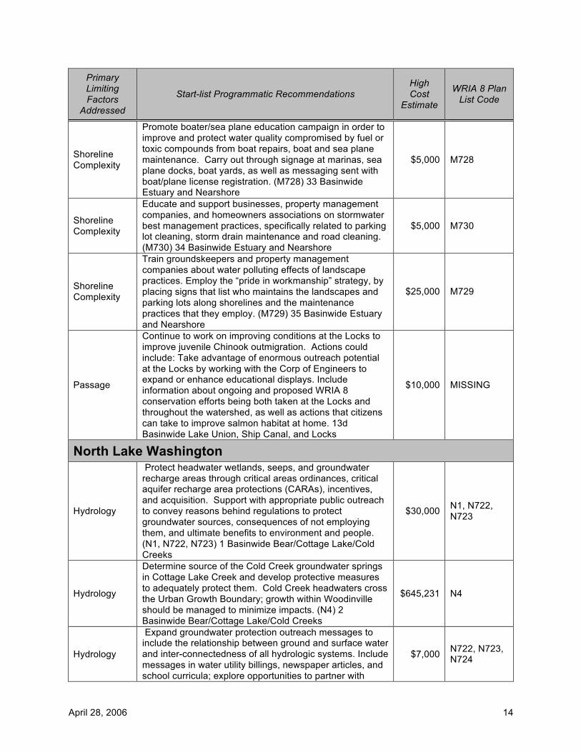
April 28, 2006 14
Primary Limiting Factors
Addressed
Start-list Programmatic Recommendations High Cost
Estimate
WRIA 8 Plan List Code
Shoreline Complexity
Promote boater/sea plane education campaign in order to improve and protect water quality compromised by fuel or toxic compounds from boat repairs, boat and sea plane maintenance. Carry out through signage at marinas, sea plane docks, boat yards, as well as messaging sent with boat/plane license registration. (M728) 33 Basinwide Estuary and Nearshore
$5,000 M728
Shoreline Complexity
Educate and support businesses, property management companies, and homeowners associations on stormwater best management practices, specifically related to parking lot cleaning, storm drain maintenance and road cleaning. (M730) 34 Basinwide Estuary and Nearshore
$5,000 M730
Shoreline Complexity
Train groundskeepers and property management companies about water polluting effects of landscape practices. Employ the “pride in workmanship” strategy, by placing signs that list who maintains the landscapes and parking lots along shorelines and the maintenance practices that they employ. (M729) 35 Basinwide Estuary and Nearshore
$25,000 M729
Passage
Continue to work on improving conditions at the Locks to improve juvenile Chinook outmigration. Actions could include: Take advantage of enormous outreach potential at the Locks by working with the Corp of Engineers to expand or enhance educational displays. Include information about ongoing and proposed WRIA 8 conservation efforts being both taken at the Locks and throughout the watershed, as well as actions that citizens can take to improve salmon habitat at home. 13d Basinwide Lake Union, Ship Canal, and Locks
$10,000 MISSING
North Lake Washington
Hydrology
Protect headwater wetlands, seeps, and groundwater recharge areas through critical areas ordinances, critical aquifer recharge area protections (CARAs), incentives, and acquisition. Support with appropriate public outreach to convey reasons behind regulations to protect groundwater sources, consequences of not employing them, and ultimate benefits to environment and people. (N1, N722, N723) 1 Basinwide Bear/Cottage Lake/Cold Creeks
$30,000 N1, N722, N723
Hydrology
Determine source of the Cold Creek groundwater springs in Cottage Lake Creek and develop protective measures to adequately protect them. Cold Creek headwaters cross the Urban Growth Boundary; growth within Woodinville should be managed to minimize impacts. (N4) 2 Basinwide Bear/Cottage Lake/Cold Creeks
$645,231 N4
Hydrology
Expand groundwater protection outreach messages to include the relationship between ground and surface water and inter-connectedness of all hydrologic systems. Include messages in water utility billings, newspaper articles, and school curricula; explore opportunities to partner with
$7,000 N722, N723, N724
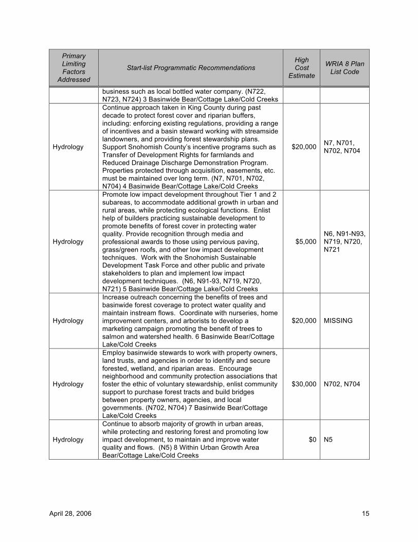
April 28, 2006 15
Primary Limiting Factors
Addressed
Start-list Programmatic Recommendations High Cost
Estimate
WRIA 8 Plan List Code
business such as local bottled water company. (N722, N723, N724) 3 Basinwide Bear/Cottage Lake/Cold Creeks
Hydrology
Continue approach taken in King County during past decade to protect forest cover and riparian buffers, including: enforcing existing regulations, providing a range of incentives and a basin steward working with streamside landowners, and providing forest stewardship plans. Support Snohomish County’s incentive programs such as Transfer of Development Rights for farmlands and Reduced Drainage Discharge Demonstration Program. Properties protected through acquisition, easements, etc. must be maintained over long term. (N7, N701, N702, N704) 4 Basinwide Bear/Cottage Lake/Cold Creeks
$20,000 N7, N701, N702, N704
Hydrology
Promote low impact development throughout Tier 1 and 2 subareas, to accommodate additional growth in urban and rural areas, while protecting ecological functions. Enlist help of builders practicing sustainable development to promote benefits of forest cover in protecting water quality. Provide recognition through media and professional awards to those using pervious paving, grass/green roofs, and other low impact development techniques. Work with the Snohomish Sustainable Development Task Force and other public and private stakeholders to plan and implement low impact development techniques. (N6, N91-93, N719, N720, N721) 5 Basinwide Bear/Cottage Lake/Cold Creeks
$5,000 N6, N91-N93, N719, N720, N721
Hydrology
Increase outreach concerning the benefits of trees and basinwide forest coverage to protect water quality and maintain instream flows. Coordinate with nurseries, home improvement centers, and arborists to develop a marketing campaign promoting the benefit of trees to salmon and watershed health. 6 Basinwide Bear/Cottage Lake/Cold Creeks
$20,000 MISSING
Hydrology
Employ basinwide stewards to work with property owners, land trusts, and agencies in order to identify and secure forested, wetland, and riparian areas. Encourage neighborhood and community protection associations that foster the ethic of voluntary stewardship, enlist community support to purchase forest tracts and build bridges between property owners, agencies, and local governments. (N702, N704) 7 Basinwide Bear/Cottage Lake/Cold Creeks
$30,000 N702, N704
Hydrology
Continue to absorb majority of growth in urban areas, while protecting and restoring forest and promoting low impact development, to maintain and improve water quality and flows. (N5) 8 Within Urban Growth Area Bear/Cottage Lake/Cold Creeks
$0 N5
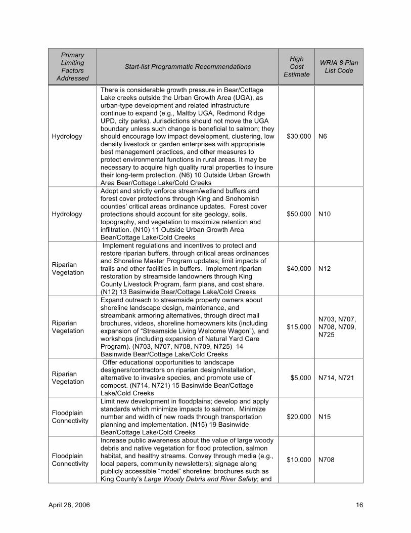
April 28, 2006 16
Primary Limiting Factors
Addressed
Start-list Programmatic Recommendations High Cost
Estimate
WRIA 8 Plan List Code
Hydrology
There is considerable growth pressure in Bear/Cottage Lake creeks outside the Urban Growth Area (UGA), as urban-type development and related infrastructure continue to expand (e.g., Maltby UGA, Redmond Ridge UPD, city parks). Jurisdictions should not move the UGA boundary unless such change is beneficial to salmon; they should encourage low impact development, clustering, low density livestock or garden enterprises with appropriate best management practices, and other measures to protect environmental functions in rural areas. It may be necessary to acquire high quality rural properties to insure their long-term protection. (N6) 10 Outside Urban Growth Area Bear/Cottage Lake/Cold Creeks
$30,000 N6
Hydrology
Adopt and strictly enforce stream/wetland buffers and forest cover protections through King and Snohomish counties’ critical areas ordinance updates. Forest cover protections should account for site geology, soils, topography, and vegetation to maximize retention and infiltration. (N10) 11 Outside Urban Growth Area Bear/Cottage Lake/Cold Creeks
$50,000 N10
Riparian Vegetation
Implement regulations and incentives to protect and restore riparian buffers, through critical areas ordinances and Shoreline Master Program updates; limit impacts of trails and other facilities in buffers. Implement riparian restoration by streamside landowners through King County Livestock Program, farm plans, and cost share. (N12) 13 Basinwide Bear/Cottage Lake/Cold Creeks
$40,000 N12
Riparian Vegetation
Expand outreach to streamside property owners about shoreline landscape design, maintenance, and streambank armoring alternatives, through direct mail brochures, videos, shoreline homeowners kits (including expansion of “Streamside Living Welcome Wagon”), and workshops (including expansion of Natural Yard Care Program). (N703, N707, N708, N709, N725) 14 Basinwide Bear/Cottage Lake/Cold Creeks
$15,000 N703, N707, N708, N709, N725
Riparian Vegetation
Offer educational opportunities to landscape designers/contractors on riparian design/installation, alternative to invasive species, and promote use of compost. (N714, N721) 15 Basinwide Bear/Cottage Lake/Cold Creeks
$5,000 N714, N721
Floodplain Connectivity
Limit new development in floodplains; develop and apply standards which minimize impacts to salmon. Minimize number and width of new roads through transportation planning and implementation. (N15) 19 Basinwide Bear/Cottage Lake/Cold Creeks
$20,000 N15
Floodplain Connectivity
Increase public awareness about the value of large woody debris and native vegetation for flood protection, salmon habitat, and healthy streams. Convey through media (e.g., local papers, community newsletters); signage along publicly accessible “model” shoreline; brochures such as King County’s Large Woody Debris and River Safety; and
$10,000 N708

April 28, 2006 17
Primary Limiting Factors
Addressed
Start-list Programmatic Recommendations High Cost
Estimate
WRIA 8 Plan List Code
other outreach venues such as festivals and local cable channels. (N708) 20 Basinwide Bear/Cottage Lake/Cold Creeks
Water and Sediment Quality
Identify sources and adopt source control of fine sediments and metals in mainstems and tributaries (e.g., from new construction, sand on roads, farms) through stormwater management and clearing and grading ordinances. Jurisdictions should adopt and enforce regulations and best management practices consistent with Washington Department of Ecology’s 2001 Stormwater Management Manual (or beyond), as part of the NPDES Phase 1 and Phase 2 permit requirements. Water quality problems should be addressed through stormwater programs (including low impact development BMPs), current and future TMDLs, livestock management programs, and upgrade of stormwater facilities (where possible). (N18) 27 Basinwide Bear/Cottage Lake/Cold Creeks
$20,000 N18
Water and Sediment Quality
Work with Washington Department of Transportation and local jurisdictions to pursue opportunities to retrofit existing roadways with stormwater best management practices to improve water quality and flows. Stormwater impacts from major transportation projects (for new and expanded roadways proposed during the next ten years) should also be addressed. (N21-22) 28 Basinwide Bear/Cottage Lake/Cold Creeks
$20,000 N21, N22
Water and Sediment Quality
Coordinate with local business community and non-profits to encourage the use of commercial car washes and carwash kits. Reprint and distribute water quality poster series depicting impacts of everyday practices: washing car, driving car without maintenance, leaving pet wastes unattended, and improperly using lawn chemicals. Promote stormwater best management practices related to parking lot cleaning, storm drain maintenance, and road cleaning. (N726, N727, N729, N731) 29 Basinwide Bear/Cottage Lake/Cold Creeks
$5,000 N726, N727, N729, N731
Water and Sediment Quality
Promote through design competitions and media coverage the use of “rain gardens” and other low impact development practices that mimic natural hydrology. Combine a home/garden tour or “Street of Dreams” type event featuring these landscape /engineering treatments. (N720, N721) 30 Basinwide Bear/Cottage Lake/Cold Creeks
$15,000 N720, N721
Water and Sediment Quality
Publicize emergency call numbers for public to report water quality and quantity problems, non-permitted vegetation clearing, and non-permitted in-stream grading, and wood removal incidents. (N731) 31 Basinwide Bear/Cottage Lake/Cold Creeks
$5,000 N731
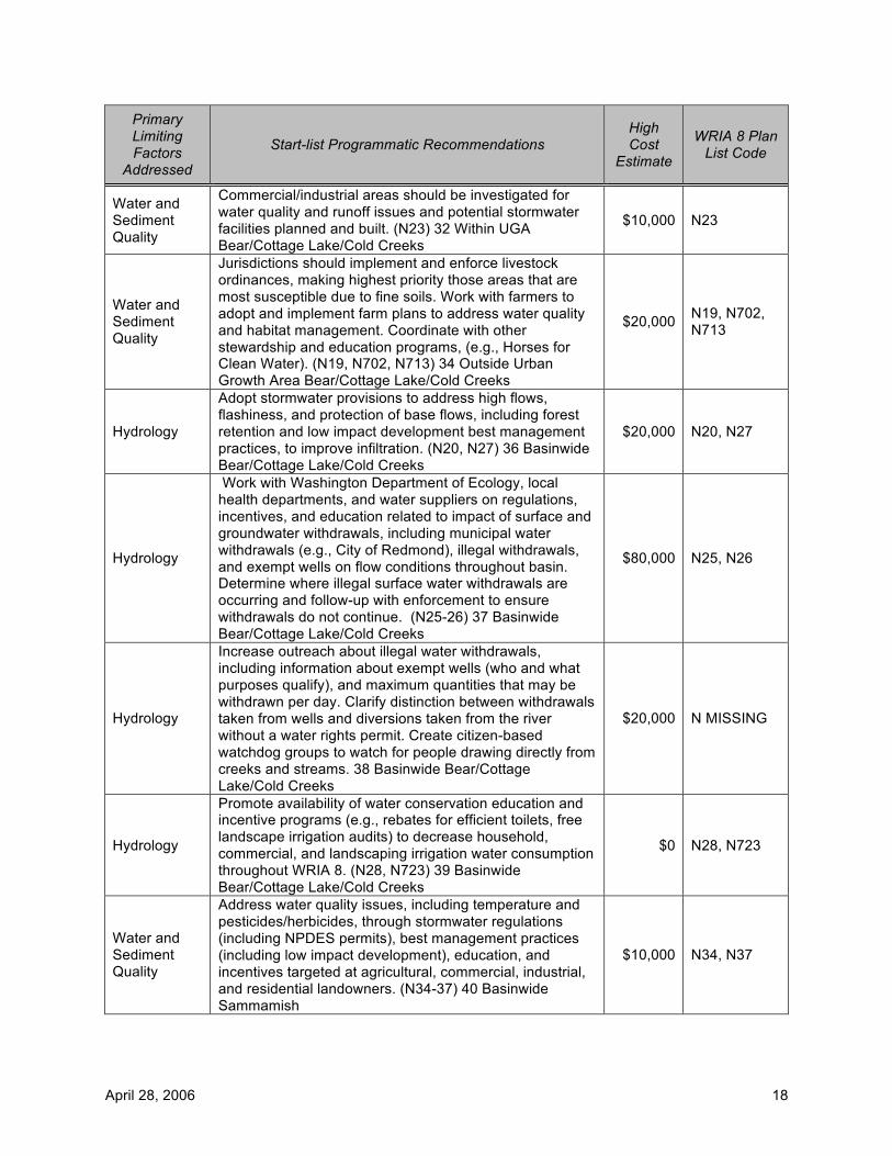
April 28, 2006 18
Primary Limiting Factors
Addressed
Start-list Programmatic Recommendations High Cost
Estimate
WRIA 8 Plan List Code
Water and Sediment Quality
Commercial/industrial areas should be investigated for water quality and runoff issues and potential stormwater facilities planned and built. (N23) 32 Within UGA Bear/Cottage Lake/Cold Creeks
$10,000 N23
Water and Sediment Quality
Jurisdictions should implement and enforce livestock ordinances, making highest priority those areas that are most susceptible due to fine soils. Work with farmers to adopt and implement farm plans to address water quality and habitat management. Coordinate with other stewardship and education programs, (e.g., Horses for Clean Water). (N19, N702, N713) 34 Outside Urban Growth Area Bear/Cottage Lake/Cold Creeks
$20,000 N19, N702, N713
Hydrology
Adopt stormwater provisions to address high flows, flashiness, and protection of base flows, including forest retention and low impact development best management practices, to improve infiltration. (N20, N27) 36 Basinwide Bear/Cottage Lake/Cold Creeks
$20,000 N20, N27
Hydrology
Work with Washington Department of Ecology, local health departments, and water suppliers on regulations, incentives, and education related to impact of surface and groundwater withdrawals, including municipal water withdrawals (e.g., City of Redmond), illegal withdrawals, and exempt wells on flow conditions throughout basin. Determine where illegal surface water withdrawals are occurring and follow-up with enforcement to ensure withdrawals do not continue. (N25-26) 37 Basinwide Bear/Cottage Lake/Cold Creeks
$80,000 N25, N26
Hydrology
Increase outreach about illegal water withdrawals, including information about exempt wells (who and what purposes qualify), and maximum quantities that may be withdrawn per day. Clarify distinction between withdrawals taken from wells and diversions taken from the river without a water rights permit. Create citizen-based watchdog groups to watch for people drawing directly from creeks and streams. 38 Basinwide Bear/Cottage Lake/Cold Creeks
$20,000 N MISSING
Hydrology
Promote availability of water conservation education and incentive programs (e.g., rebates for efficient toilets, free landscape irrigation audits) to decrease household, commercial, and landscaping irrigation water consumption throughout WRIA 8. (N28, N723) 39 Basinwide Bear/Cottage Lake/Cold Creeks
$0 N28, N723
Water and Sediment Quality
Address water quality issues, including temperature and pesticides/herbicides, through stormwater regulations (including NPDES permits), best management practices (including low impact development), education, and incentives targeted at agricultural, commercial, industrial, and residential landowners. (N34-37) 40 Basinwide Sammamish
$10,000 N34, N37
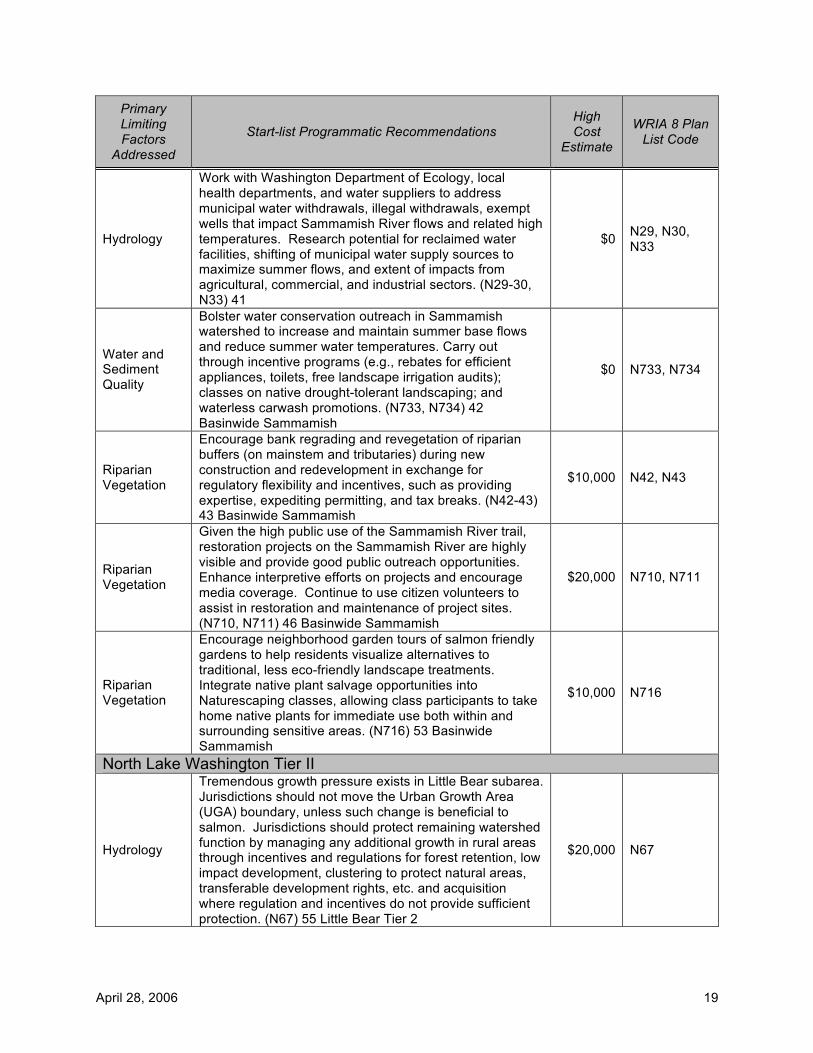
April 28, 2006 19
Primary Limiting Factors
Addressed
Start-list Programmatic Recommendations High Cost
Estimate
WRIA 8 Plan List Code
Hydrology
Work with Washington Department of Ecology, local health departments, and water suppliers to address municipal water withdrawals, illegal withdrawals, exempt wells that impact Sammamish River flows and related high temperatures. Research potential for reclaimed water facilities, shifting of municipal water supply sources to maximize summer flows, and extent of impacts from agricultural, commercial, and industrial sectors. (N29-30, N33) 41
$0 N29, N30, N33
Water and Sediment Quality
Bolster water conservation outreach in Sammamish watershed to increase and maintain summer base flows and reduce summer water temperatures. Carry out through incentive programs (e.g., rebates for efficient appliances, toilets, free landscape irrigation audits); classes on native drought-tolerant landscaping; and waterless carwash promotions. (N733, N734) 42 Basinwide Sammamish
$0 N733, N734
Riparian Vegetation
Encourage bank regrading and revegetation of riparian buffers (on mainstem and tributaries) during new construction and redevelopment in exchange for regulatory flexibility and incentives, such as providing expertise, expediting permitting, and tax breaks. (N42-43) 43 Basinwide Sammamish
$10,000 N42, N43
Riparian Vegetation
Given the high public use of the Sammamish River trail, restoration projects on the Sammamish River are highly visible and provide good public outreach opportunities. Enhance interpretive efforts on projects and encourage media coverage. Continue to use citizen volunteers to assist in restoration and maintenance of project sites. (N710, N711) 46 Basinwide Sammamish
$20,000 N710, N711
Riparian Vegetation
Encourage neighborhood garden tours of salmon friendly gardens to help residents visualize alternatives to traditional, less eco-friendly landscape treatments. Integrate native plant salvage opportunities into Naturescaping classes, allowing class participants to take home native plants for immediate use both within and surrounding sensitive areas. (N716) 53 Basinwide Sammamish
$10,000 N716
North Lake Washington Tier II
Hydrology
Tremendous growth pressure exists in Little Bear subarea. Jurisdictions should not move the Urban Growth Area (UGA) boundary, unless such change is beneficial to salmon. Jurisdictions should protect remaining watershed function by managing any additional growth in rural areas through incentives and regulations for forest retention, low impact development, clustering to protect natural areas, transferable development rights, etc. and acquisition where regulation and incentives do not provide sufficient protection. (N67) 55 Little Bear Tier 2
$20,000 N67
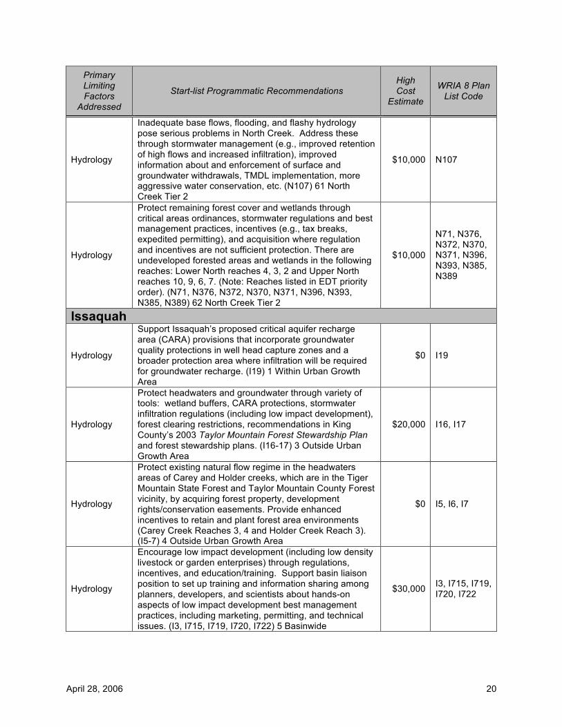
April 28, 2006 20
Primary Limiting Factors
Addressed
Start-list Programmatic Recommendations High Cost
Estimate
WRIA 8 Plan List Code
Hydrology
Inadequate base flows, flooding, and flashy hydrology pose serious problems in North Creek. Address these through stormwater management (e.g., improved retention of high flows and increased infiltration), improved information about and enforcement of surface and groundwater withdrawals, TMDL implementation, more aggressive water conservation, etc. (N107) 61 North Creek Tier 2
$10,000 N107
Hydrology
Protect remaining forest cover and wetlands through critical areas ordinances, stormwater regulations and best management practices, incentives (e.g., tax breaks, expedited permitting), and acquisition where regulation and incentives are not sufficient protection. There are undeveloped forested areas and wetlands in the following reaches: Lower North reaches 4, 3, 2 and Upper North reaches 10, 9, 6, 7. (Note: Reaches listed in EDT priority order). (N71, N376, N372, N370, N371, N396, N393, N385, N389) 62 North Creek Tier 2
$10,000
N71, N376, N372, N370, N371, N396, N393, N385, N389
Issaquah
Hydrology
Support Issaquah’s proposed critical aquifer recharge area (CARA) provisions that incorporate groundwater quality protections in well head capture zones and a broader protection area where infiltration will be required for groundwater recharge. (I19) 1 Within Urban Growth Area
$0 I19
Hydrology
Protect headwaters and groundwater through variety of tools: wetland buffers, CARA protections, stormwater infiltration regulations (including low impact development), forest clearing restrictions, recommendations in King County’s 2003 Taylor Mountain Forest Stewardship Plan and forest stewardship plans. (I16-17) 3 Outside Urban Growth Area
$20,000 I16, I17
Hydrology
Protect existing natural flow regime in the headwaters areas of Carey and Holder creeks, which are in the Tiger Mountain State Forest and Taylor Mountain County Forest vicinity, by acquiring forest property, development rights/conservation easements. Provide enhanced incentives to retain and plant forest area environments (Carey Creek Reaches 3, 4 and Holder Creek Reach 3). (I5-7) 4 Outside Urban Growth Area
$0 I5, I6, I7
Hydrology
Encourage low impact development (including low density livestock or garden enterprises) through regulations, incentives, and education/training. Support basin liaison position to set up training and information sharing among planners, developers, and scientists about hands-on aspects of low impact development best management practices, including marketing, permitting, and technical issues. (I3, I715, I719, I720, I722) 5 Basinwide
$30,000 I3, I715, I719, I720, I722
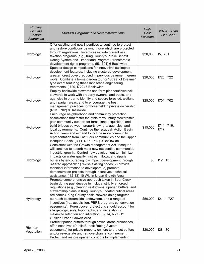
April 28, 2006 21
Primary Limiting Factors
Addressed
Start-list Programmatic Recommendations High Cost
Estimate
WRIA 8 Plan List Code
Hydrology
Offer existing and new incentives to continue to protect and restore conditions beyond those which are protected through regulations. Incentives include current use taxation programs (e.g., King County’s Public Benefit Rating System and Timberland Program), transferable development rights programs. (I5, I701) 6 Basinwide
$20,000 I5, I701
Hydrology
Sponsor design competitions for innovative low impact development features, including clustered development, greater forest cover, reduced impervious pavement, green roofs. Combine a home/garden tour or “Street of Dreams” type event featuring these landscape/engineering treatments. (I720, I722) 7 Basinwide
$20,000 I720, I722
Hydrology
Employ basinwide stewards and farm planners/livestock stewards to work with property owners, land trusts, and agencies in order to identify and secure forested, wetland, and riparian areas, and to encourage the best management practices for those held in private ownership. (I701, I702) 8 Basinwide
$25,000 I701, I702
Hydrology
Encourage neighborhood and community protection associations that foster the ethic of voluntary stewardship; gain community support for forest land acquisition; and build bridges between property owners, agencies, and local governments. Continue the Issaquah Action Basin Action Team and expand to include more community representation from East Fork communities and the Upper Issaquah Basin. (I711, I716, I717) 9 Basinwide
$15,000 I711, I716, I717
Hydrology
Consistent with the Growth Management Act, Issaquah will continue to absorb most new residential, commercial, industrial growth. Control new development to minimize impacts on water quality, instream flows, and riparian buffers by encouraging low impact development through 3-tiered approach: 1) revise existing codes; 2) provide technical information to developers; 3) promote demonstration projects through incentives, technical assistance. (I12-13) 10 Within Urban Growth Area
$0 I12, I13
Hydrology
Promote comprehensive approach taken in Bear Creek basin during past decade to include: strictly enforced regulations (e.g., clearing restrictions, riparian buffers, and stewardship plans in King County’s updated critical areas ordinance), King County basin steward doing targeted outreach to streamside landowners, and a range of incentives (i.e., acquisition, PBRS program, conservation easements). Forest cover protections should account for site geology, soils, topography, and vegetation to maximize retention and infiltration. (I2, I4, I727) 12 Outside Urban Growth Area
$50,000 I2, I4, I727
Riparian Vegetation
Protect riparian buffers through critical areas ordinances, offer incentives (Public Benefit Rating System, easements) for private property owners to protect buffers and/or revegetate and remove channel confinement. Protect and restore riparian corridors by implementing
$20,000 I28, I30

April 28, 2006 22
Primary Limiting Factors
Addressed
Start-list Programmatic Recommendations High Cost
Estimate
WRIA 8 Plan List Code
required fencing/set asides and options for planting and cost share provided by the King County Livestock Program. (I28, I30) 14 Basinwide
Riparian Vegetation
Continue and expand Creekside Landowner Assistance Program including classes, technical and financial assistance in shoreline landscape design, maintenance, and streambank armoring alternatives. In addition to workshops, convey through direct mailing of brochures, videos, and expansion of “Streamside Living Welcome Wagon” where residents welcome new home owners and provide information concerning salmon-friendly yard care, etc. (I702, I704, I709) 15 Basinwide
$15,000 I702, I704, I709
Riparian Vegetation
Offer educational opportunities to landscape designers/contractors on riparian design/installation, alternatives to invasive species, and use of compost. (I713) 16 Basinwide
$5,000 I713
Riparian Vegetation
Continue to tighten regulations affecting riparian buffers, including more restricted application of buffer averaging, fewer allowable uses in buffers. However, nonconforming uses will continue to be a great challenge; in order to decrease level of nonconformity over the long term, jurisdictions should encourage/require that development come into conformity, depending on degree of redevelopment. (I25-26) 17 Within Urban Growth Area
$0 I25, I26
Floodplain Connectivity
Limit new development and roads in floodplains; develop and apply standards which minimize impacts to salmon. Planning for new roads, and maintenance and retrofitting of existing roads, should minimize impacts on floodplains and water quality. (I38-40, I49) 18 Basinwide
$30,000 I38, I39, I40, I49
Floodplain Connectivity
Increase public awareness of the value of large woody debris and vegetated areas for flood protection, salmon protection and healthy streams in print (e.g., local papers, community newsletters, signage) and other means (e.g., Issaquah Salmon Days, Sammamish Watershed Festival activities, local cable channels, hatchery docent presentations). (I705) 19 Basinwide
$7,000 I705
Floodplain Connectivity
Consider flexibility in prescriptive buffer width standards in exchange for stream habitat and buffer enhancement during redevelopment. However, limit buffer width reductions for new development because a key issue for Issaquah Creek is encroachment into floodplain and channel confinement, and revegetation does not improve this riparian function. (I29) 20 Within Urban Growth Area
$0 I29
Water and Sediment Quality
Identify water quality problems and address through stormwater management programs (including low impact development best management practices), current and future TMDLs, livestock management programs, upgrade of stormwater facilities (where possible), and retrofit of existing roadways to improve water quality and flows (e.g., SR-18, I-90). Jurisdictions should adopt and enforce regulations and best management practices consistent
$20,000 I31, I32, I36, I41
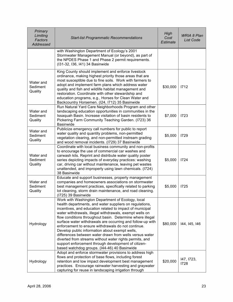
April 28, 2006 23
Primary Limiting Factors
Addressed
Start-list Programmatic Recommendations High Cost
Estimate
WRIA 8 Plan List Code
with Washington Department of Ecology’s 2001 Stormwater Management Manual (or beyond), as part of the NPDES Phase 1 and Phase 2 permit requirements. (I31-32, I36, I41) 34 Basinwide
Water and Sediment Quality
King County should implement and enforce livestock ordinance, making highest priority those areas that are most susceptible due to fine soils. Work with farmers to adopt and implement farm plans which address water quality and fish and wildlife habitat management and restoration. Coordinate with other stewardship and education programs, e.g., Horses for Clean Water and Backcountry Horsemen. (I24, I712) 35 Basinwide
$30,000 I712
Water and Sediment Quality
Run Natural Yard Care Neighborhoods Program and other landscaping education opportunities in communities in the Issaquah Basin. Increase visitation of basin residents to Pickering Farm Community Teaching Garden. (I723) 36 Basinwide
$7,000 I723
Water and Sediment Quality
Publicize emergency call numbers for public to report water quality and quantity problems, non-permitted vegetation clearing, and non-permitted instream grading and wood removal incidents. (I729) 37 Basinwide
$5,000 I729
Water and Sediment Quality
Coordinate with local business community and non-profits to encourage the use of commercial car washes and carwash kits. Reprint and distribute water quality poster series depicting impacts of everyday practices: washing car, driving car without maintenance, leaving pet wastes unattended, and improperly using lawn chemicals. (I724) 38 Basinwide
$5,000 I724
Water and Sediment Quality
Educate and support businesses, property management companies and homeowners associations on stormwater best management practices, specifically related to parking lot cleaning, storm drain maintenance, and road cleaning. (I725) 39 Basinwide
$5,000 I725
Hydrology
Work with Washington Department of Ecology, local health departments, and water suppliers on regulations, incentives, and education related to impact of municipal water withdrawals, illegal withdrawals, exempt wells on flow conditions throughout basin. Determine where illegal surface water withdrawals are occurring and follow-up with enforcement to ensure withdrawals do not continue. Develop public information about exempt wells, differences between water drawn from wells versus water diverted from streams without water rights permits, and support enforcement through development of citizen-based watchdog groups. (I44-46) 40 Basinwide
$80,000 I44, I45, I46
Hydrology
Adopt and enforce stormwater provisions to address high flows and protection of base flows, including forest retention and low impact development best management practices. Encourage rainwater harvesting and graywater capturing for reuse in landscaping irrigation through
$20,000 I47, I723, I728
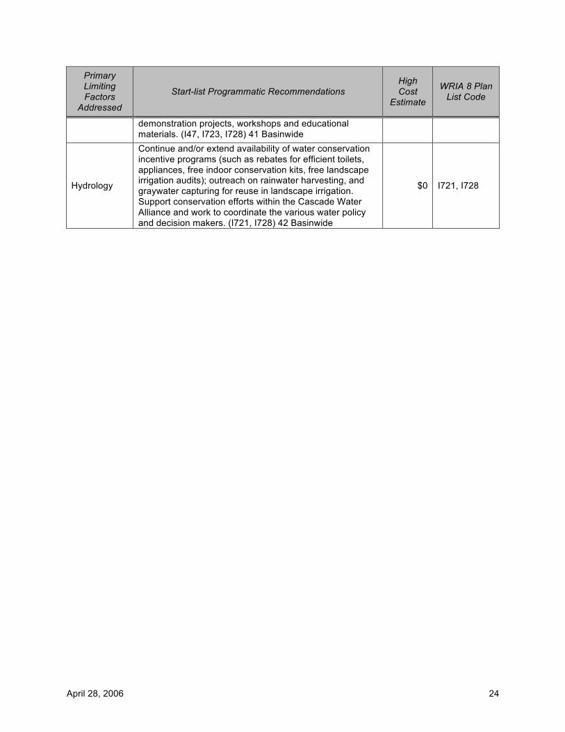
April 28, 2006 24
Primary Limiting Factors
Addressed
Start-list Programmatic Recommendations High Cost
Estimate
WRIA 8 Plan List Code
demonstration projects, workshops and educational materials. (I47, I723, I728) 41 Basinwide
Hydrology
Continue and/or extend availability of water conservation incentive programs (such as rebates for efficient toilets, appliances, free indoor conservation kits, free landscape irrigation audits); outreach on rainwater harvesting, and graywater capturing for reuse in landscape irrigation. Support conservation efforts within the Cascade Water Alliance and work to coordinate the various water policy and decision makers. (I721, I728) 42 Basinwide
$0 I721, I728