wwtp peer review memo draft updated by th 5-24-16
TRANSCRIPT

••••••••
••
•
•••••

•
•
•
•
20
Boston Post Road
mea
do
w w
alk
su
dbu
ry
526
and
528
Bost
on P
ost
Road
Red
evel
opm
ent
Figu
re 3
Exis
ting
Cond
ition
s Si
te P
lan
0 10
0 20
0 F
eet
Fire
Sta
tion
Beltr
an
Build
ing
Build
ing
2
Build
ing
1Bu
ildin
g5
Build
ing
4Bu
ildin
g3
Former Railroad ROW
Exis
ting
Rete
ntio
n Po
nd
Was
tew
ater
Tr
eatm
ent
Faci
lity
Figu
re 1
Exis
ting
Site
Con
ditio
n

11Fi
gure
2Pr
opos
ed S
ite C
ondi
tion
ATTACHM
ENT 1
Attachment 1

239 Causeway Street, Suite 105
Boston, MA 02114 Ms. Amanda Cavaliere Tata & Howard 67 Forest Street Marlborough, MA 01752
May 24, 2016 File No. 3888.03
Re: Time of Travel Analysis – Sanitary Wastewater System to Raymond Road Well Field 526 & 528 Boston Post Road Sudbury, Massachusetts
Dear Amanda: On behalf of Tata & Howard (Client), Sanborn, Head & Associates, Inc. (Sanborn Head) has prepared this letter to summarize our field exploration activities at the Site and our observations of subsurface conditions to perform a travel time analysis from the proposed sanitary wastewater discharge system to the Sudbury Water District drinking water wells on Raymond Road in Sudbury, Massachusetts. This information, along with historical information provided by Raytheon, the Town of Sudbury, and the Sudbury Water District has been used to create our conceptual hydrogeological model. Existing Conditions and Project Description
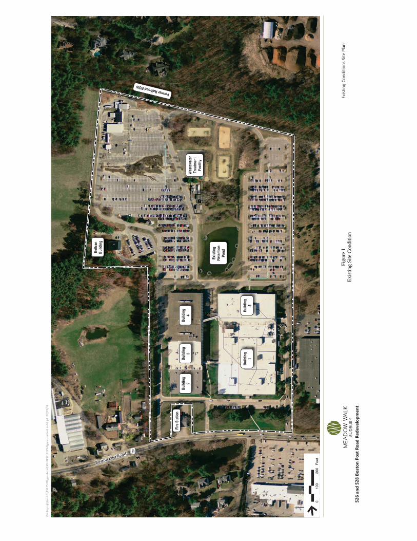
The Site is located at 526 & 528 Boston Post Road (Route 20) in southern central Sudbury, Massachusetts and consists of approximately 50 acres of land previously owned and operated by the Raytheon Company (Raytheon) since 1958. Up until January 2016, an active wastewater treatment plant (WWTP) consisting of treated wastewater discharging to three (3) open sand leaching beds has been in operation in the northern portion of the Site, as shown on Figure 1. The beds are approximately 9,800 square feet in area. It is our understanding that the former distribution system rotated the discharged wastewater to the two eastern beds, and the western bed served as a reserve field. The Site is located within the Zone II Public Water Supply Protection Area for the Sudbury Water District Raymond Road water supply well field. The nearest residential properties are located approximately 300 feet northwest of the Site and 1,000 feet southwest and southeast of the Site. The Raymond Road well field is located approximately 0.3 miles southeast of the Site as shown on Figure 1.
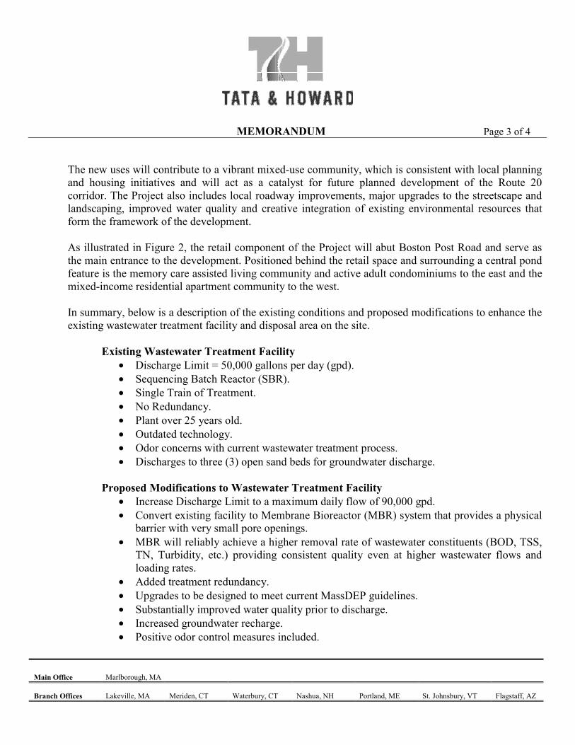
The WWTP is currently permitted to treat and discharge 50,000 gallons per day (gpd) under its current groundwater discharge permit. The redevelopment plans include a proposed upgrade of the current WWTP to support an increase of the maximum daily flow to 90,000 gpd. At this time, Sanborn Head is evaluating alternatives to support the increase in daily flow to 90,000 gpd. The proposed alternatives includes construction of subsurface leaching chambers, which is consistent with present-day construction practice. Figure 2 shows the existing sand bed configuration and Figure 3 shows the proposed system upgrade.

May 24, 2016 Page 2 20160524 Summary Memo.docx 3888.03
The following sections discuss subsurface conditions at the Site based on subsurface explorations and groundwater measurements by Sanborn Head and others. The subsurface explorations, groundwater gauging rounds, surficial geology, Custom Soil Resource Report for Middlesex County, Massachusetts1, and the Groundwater Model Documentation Supplement to Prolonged Pumping Test Report for New Well No. 9 Report2 (Sudbury Groundwater Model Supplement) have been used to create a conceptual hydrogeologic model to evaluate modifications to the wastewater discharge system and proposed additional flow. Official Deep Observation Hole Test Pits
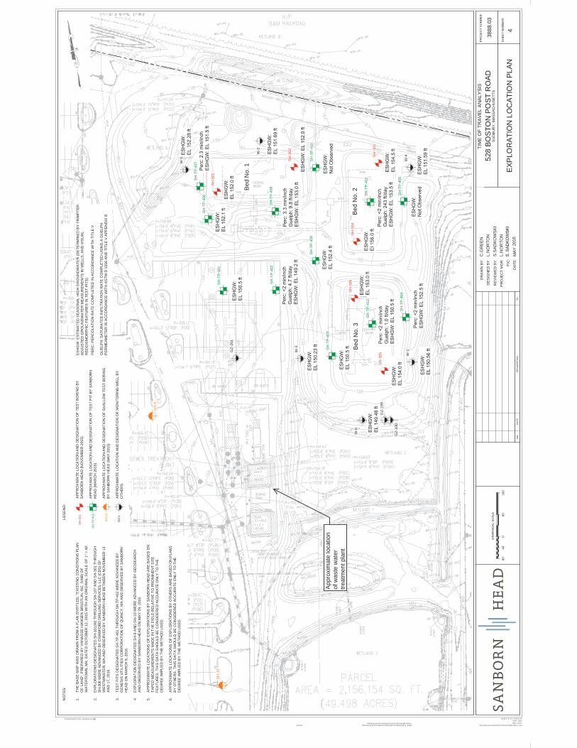
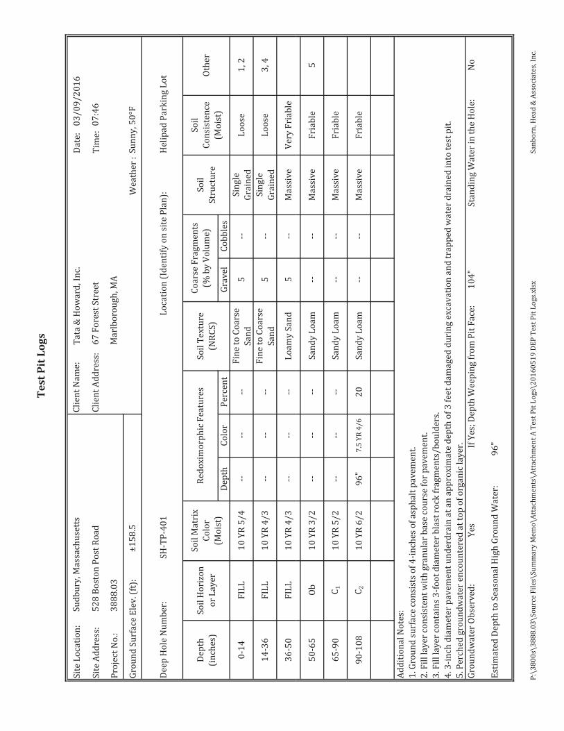
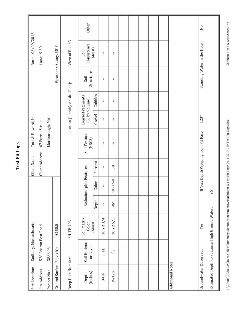
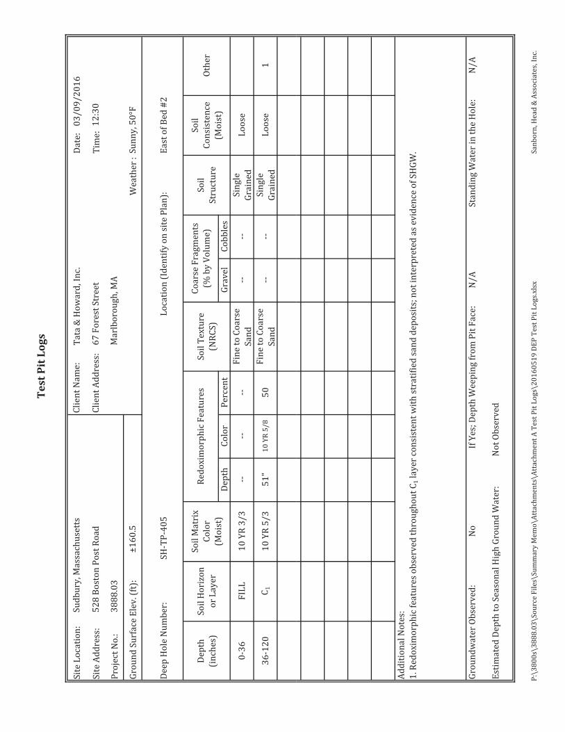
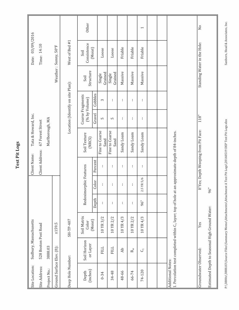
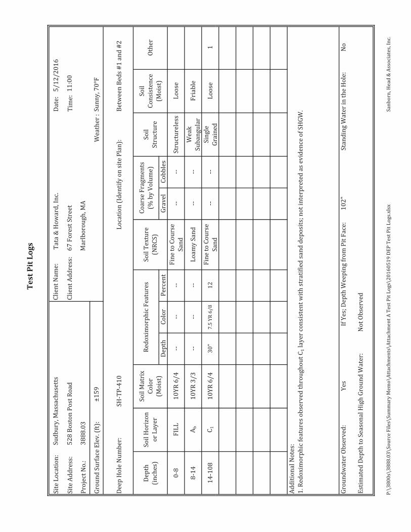
Seven (7) deep observation hole test pits (SH-TP-401 through SH-TP-407) were excavated to depths of approximately 10 feet below ground surface on March 9, 2016. In addition, five (5) deep observation hole test pits (SH-TP-408 through SH-TP-412) were excavated to depths of approximately 10 feet below ground surface on May 4, 2016. The test pits were observed and logged by a Sanborn Head Soil Evaluator and were performed under the observation of Mr. Stephen Hallem from the Northeast Regional Office (NERO) of the Massachusetts Department of Environmental Protection (DEP) and Mr. Bill Murphy of the Sudbury Board of the Health (BOH). The test pits were completed within the vicinity of the existing sand bed area and in areas where the proposed system is anticipated to be located. The deep observation hole test pit logs are included as Attachment A. The approximate test pit locations are shown on Figure 4. The estimated seasonal high groundwater elevations at the test pit locations were estimated based on observations made in the field and our ground surface elevations interpolated between the existing ground surface contours shown on the recent topographic plan prepared by Vanasse Hangen Brustlin Inc. (VHB), dated October 2015. Official Soil Percolation Tests and Infiltration Tests
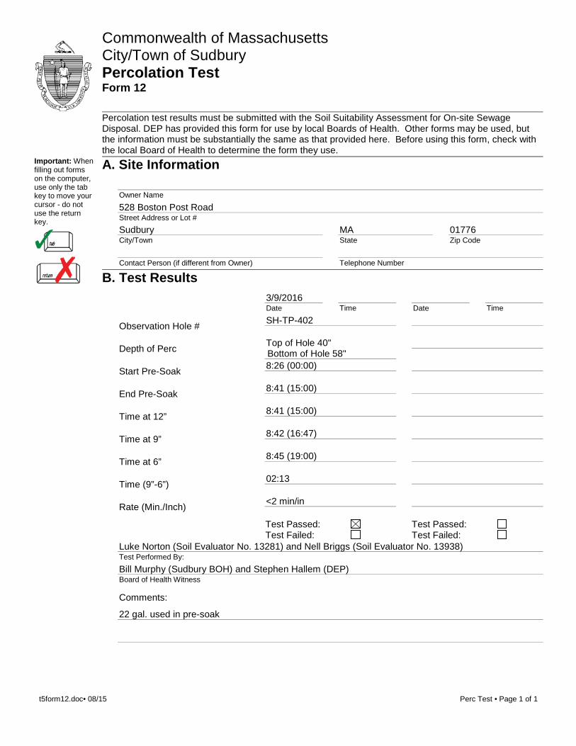
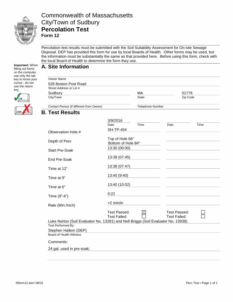
Three (3) percolation tests were completed by a Massachusetts Soil Evaluator from Sanborn Head during our field program on March 9, 2016, and witnessed by Mr. Stephen Hallem of DEP. Three (3) additional percolation tests and four (4) Guelph permeameter/infiltration tests were completed on May 4, 2016 and witnessed by Mr. Stephen Hallem of DEP. Mr. Bill Murphy of the Sudbury BOH witnessed the percolation tests completed at SH-TP-402 and SH-TP-407. Percolation tests were completed at SH-TP-402, SH-TP-404, SH-TP-407, SH-TP-408, SH-TP-411, and SH-TP-412 immediately adjacent to the deep observation hole test pits, at depths of approximately 38 to 102 inches below ground surface (bgs) – as noted on the attached logs. The observed soils generally consist of loamy sands, fine to coarse sands, and fine to medium sands without encountering a more restrictive layer; therefore, the sand layer was used for the percolation tests with the approval of Mr. Hallem. The measured percolation
1 Custom Soil Resource Report for Middlesex County, Massachusetts, United States Department of Agriculture, Natural Resources Conservation Services, December 2015.
2 Groundwater Model Documentation Supplement to Prolong Pumping Test Report for New Well No. 9, Sudbury, Massachusetts, H2O Engineering Consulting Associates, Inc., February 1993.
May 24, 2016 Page 3 20160524 Summary Memo.docx 3888.03
rates generally ranged from less than 2 minutes per inch to approximately 3.2 minutes per inch. Guelph permeameter/infiltration tests were performed by Sanborn Head at SH-TP-402, SH-TP-408, SH-TP-411, and SH-TP-412. Results from the Guelph permeameter/infiltration tests generally ranged from 1 foot per day to 243 feet per day. The percolation test and Guelph permeameter logs are included in Attachment B. The approximate locations of the field tests are provided on Figure 4. Estimated Depth to Seasonal High Groundwater
In accordance with the Sudbury Zoning Bylaw Article IX, Water Resource Protection Overly District (WRPOD) Section 4260, the maximum groundwater elevation throughout the entire area shall be determined by groundwater gauging from monitoring wells during the months of March, April, or May. Groundwater elevation data was collected by GZA GeoEnvironmental, Inc. in monitoring wells across the Site on September 13, 2007, September 29 and 30, 2008, April 30 and May 1, 2013, and March 19, 2015. In addition, Sanborn Head measured groundwater levels in a subset of these locations in the vicinity of the wastewater discharge system on November 12, 2015, December 11, 2015, January 7, 2016, and March 9, 2016. Groundwater measurements from gauging rounds are provided in Table 1. As noted in the logs, groundwater was observed in the deep hole observation test pits at: SH-TP-401 through SH-TP-403, SH-TP-407, and SH-TP-410 through SH-TP-412 at depths between 7 and 9 feet bgs (or approximately between El. 147.8 to El. 150.5 feet), which is consistent with the Site-wide groundwater measurements shown in Table 1. Based on the collected groundwater measurements, and in accordance with the DEP approved method for estimating seasonally high groundwater, a Frimpter (1981) analysis was completed by Sanborn Head. As shown on Table 1, the estimated seasonal high groundwater levels range between approximately El. 149.5 feet and El. 152.3 feet. Visual evidence of estimated seasonal high groundwater (i.e., soil mottling/redoximorphic features) was observed in 10 of the 12 official deep observation hole test pit excavations (SH-TP-401 through SH-TP-404, SH-TP-406 through SH-TP-409, and SH-TP-411 and SH-TP-412). Although redoximorphic features were noted on the logs in SH-TP-405 and SH-TP-410, these features were interpreted as an indication of influences from the existing open sand leaching beds. The visual observations of estimated seasonal high groundwater are consistent with the Frimpter-adjusted estimated seasonal high groundwater levels in nearby monitoring wells as shown in Table 1. Subsurface Soil Conditions
In landscaped areas, the surface topsoil is generally 6 to 24 inches thick. Below the topsoil, there is a combination of discontinuous layers of subsoil, fill materials, and buried topsoil on the order of 0 to 8 feet thick. The fill generally consists of sand with varying amounts of silt and trace amounts of gravel. Below the surface materials and fill material, the Site is underlain by natural glacial outwash deposits composed of sands and silts in discontinuous layers and strata. Based on
May 24, 2016 Page 4 20160524 Summary Memo.docx 3888.03
our understanding of subsurface conditions across the overall development from subsurface exploration logs by Sanborn Head and others, these deposits are greater than 25 feet thick. The materials vary from sand with trace to little amounts of silt and trace amounts of gravel to non-plastic silts and sand. At isolated locations near the top of the deposits, very few root particles and organic matter were encountered and are likely an indication of former grade and subsoil that was left in-place. The organic content is estimated to be less than 1 percent by weight. The material is typically very loose to medium dense. Based on Site-wide explorations (approximately 62 explorations of depths ranging between 15 and 108 feet below ground surface), we understand the sand and silty sand deposits are underlain by glacial till at depths greater than 35 feet bgs within the existing leaching field area. Subsurface information for the Raymond Road aquifer was obtained from the Sudbury Groundwater Model Supplement and surficial geology maps provided by the Massachusetts Office of Geographic Information (MassGIS). These reports indicate the Raymond Road aquifer consists of sand and gravel and fine-grained soil deposits approximately 25 to 110 feet thick and underlain by glacial till. Additionally, near surface organic soils can be found along depressions near streams within the Landham Brook watershed. For the purposes of creating a conceptual hydrogeologic model, we have assumed the subsurface conditions at the Raymond Road aquifer consist of loamy sand. Travel Time Analysis
Based on the subsurface conditions observed at the Site and our review of the Sudbury Groundwater Model Supplement for the Sudbury Water District Raymond Road drinking water well field, a conceptual hydrogeologic model was created using Visual MODFLOW to estimate the travel time from the proposed wastewater discharge area to the well field based on the current discharge of 50,000 gpd, and a proposed daily flow of 90,000 gpd. It should be noted that the DEP requires a minimum of 2 years of travel time from leaching fields to the nearest public water supply well in accordance with the DEP Guidelines for the Design, Construction, Operation, and Maintenance of Small Wastewater Treatment Facilities with Land Disposal, dated November 2014. As discussed previously, subsurface conditions at the Site were modeled in accordance with observed conditions during subsurface explorations at the open sand leaching bed area. Subsurface conditions at the Raymond Road aquifer were modeled as loamy sand in accordance with the Sudbury Groundwater Model Supplement and MassGIS. Well construction details and pumping rates were provided by Ms. Rebecca McEnroe, Superintendent at the Sudbury Water District, and were incorporated into the model. The travel time analysis was performed to estimate the length of time required for wastewater discharge from the leach fields to reach the Sudbury Water District Raymond Road drinking water well field. The travel time analysis was completed using the MODPATH package (with particle tracking) for Visual MODFLOW.

May 24, 2016 Page 5 20160524 Summary Memo.docx 3888.03
Based on the results of the hydrogeologic model, the estimated travel time it takes the wastewater discharge to reach the nearest Raymond Road drinking water supply well (Well No. 2) is as much as 20 years for both the existing and proposed design flow conditions for the deep groundwater flow regime. The groundwater discharge takes approximately 6 to 10 years to reach the nearest wellhead in the shallow groundwater flow regime. As indicated by the models, the travel time to the well head is not significantly altered by the increase in daily flow to 90,000 gpd, and significantly exceeds the minimum 2-year travel time required by DEP. The MODFLOW output for the travel time analysis is provided in Attachment C. Very truly yours, SANBORN, HEAD & ASSOCIATES, INC.
Luke Norton, P.E. Project Manager
Stan S. Sadkowski, P.E. Senior Associate/ Vice President
Danielle M. Volpe, P.E. Senior Project Engineer DMV/LDN/SSS/PMP: dmv Encl.
Table 1: Groundwater Elevation Data Figure 1: Locus Plan Figure 2: Existing Conditions Figure 3: Proposed Conceptual Subsurface Bed Figure 4: Exploration Location Plan Attachment A: Test Pit Logs Attachment B: Percolation Test Logs Attachment C: Time Travel Analysis MODFLOW OUTPUT
cc: Mr. Steve Senna & Mr. David Gillespie (BPR Sudbury Development LLC);
\\wesserv1\shdata\3800s\3888.03\Source Files\Summary Memo\20160524 Summary Memo.docx

TABLE

TABL
E 1
Grou
ndw
ater
Ele
vatio
n Su
mm
ary
Tabl
e52
8 Bo
ston
Pos
t Roa
d, S
udbu
ry, M
A
P:\3
800s
\388
8.00
\Wor
k\Gr
ound
wat
er E
lev\
2015
1021
GW
Ele
vatio
ns.x
lsxPa
ge 1
of 1
Sanb
orn,
Hea
d En
gine
erin
g, P
C
Dep
th to
Wat
er
(f
eet)
Grou
ndw
ater
El.
(f
eet N
AVD
88)
Dep
th to
Wat
er
(f
eet)
Grou
ndw
ater
El.
(f
eet N
AVD
88)
Dep
th to
Wat
er
(f
eet)
Grou
ndw
ater
El.
(f
eet N
AVD
88)
Dep
th to
Wat
er
(f
eet)
Grou
ndw
ater
El.
(f
eet N
AVD
88)
Dep
th to
Wat
er
(f
eet)
Grou
ndw
ater
El.
(f
eet N
AVD
88)
W-1
9
-19
158.
689.
8314
8.85
11.4
114
7.27
11.4
314
7.25
10.7
614
7.92
10.0
414
8.64
150.
56W
-2
9 -1
9 16
1.36
10.0
215
1.34
12.9
614
8.40
13.0
814
8.28
12.4
114
8.95
11.6
514
9.71
151.
69W
-3
9 -1
9 15
8.47
8.95
149.
5211
.53
146.
9411
.48
146.
9910
.47
148.
009.
9614
8.51
150.
23W
-4
9 -1
9 15
8.46
9.90
148.
5610
.16
148.
3010
.64
147.
8210
.24
148.
229.
4714
8.99
151.
59W
-5
9 -1
9 16
1.51
8.31
153.
2012
.52
148.
9912
.52
148.
9911
.42
150.
0910
.54
150.
9715
2.28
W-6
9
-19
157.
939.
3114
8.62
11.7
414
6.19
11.5
514
6.38
10.3
914
7.54
10.0
014
7.93
149.
48
Wel
l Scr
een
Inte
rval
(fee
t be
low
top
of
PVC)
Refe
renc
e Po
int
Elev
atio
n(f
eet N
AVD
88)
Mon
itori
ng
Wel
l ID
Frim
pter
Es
timat
ed
Seas
onal
Hig
h Gr
ound
wat
er E
l. (f
eet N
AVD
88)
Dep
th E
leva
tion
1/7/
2016
Dep
th E
leva
tion
3/19
/201
5D
epth
Ele
vatio
n 11
/12/
2015
Dep
th E
leva
tion
12/1
1/20
15D
epth
Ele
vatio
n 3/
9/20
16
Not
es:
1.Gr
ound
wat
er le
vels
mea
sure
d by
San
born
Hea
d pe
rson
nel o
n th
e da
tes i
ndic
ated
. 2.
Ref
eren
ce e
leva
tions
sur
veye
d by
BSC
Gro
up o
n Se
ptem
ber
14, 2
007
and
corr
ecte
d to
NAV
D88
with
a c
orre
ctio
n fa
ctor
of 0
.774
feet
. 3.
Fri
mpt
er e
stim
ated
sea
sona
l hig
h gr
ound
wat
er v
alue
s w
ere
calc
ulat
ed b
y ad
ding
3.3
feet
to th
e N
ovem
ber
12, 2
015
grou
ndw
ater
ele
vatio
n da
ta.

FIGURES

1/2 MILE
RADIUS
1 MILE
RADIUS
PWS NO. 2
PWS NO. 9
PWS NO. 7 PWS NO. 6
PWS NO. 4
File:P:\3800s\3888.03\Graphics Files\CAD\Time of Travel Analysis May16\TimeofTravel.dwg Plot Date: 5-19-16 c 2016 SANBORN, HEAD & ASSOCIATES, INC.
SITE
SCALE: 1" = 1,700'
Project No:Reviewed By:Designed By:
Drawn By:
Date:
Time of Travel Analysis528 Boston Post Road
Locus Plan
Sudbury, Massachusetts
D.DombrowskyD.VolpeL.Norton
May 20163888.03
Figure 1
SAN NBOR HEAD
NOTES:Base map was taken from the "Office ofGeographic and EnvironmentalInformation (MassGIS), Commonwealthof Massachusetts InformationTechnology Division"7.5 minute USGS Quadrangle Maps:Sudbury, Massachusetts, REV: 1987
Legend:
Community and Non-Community Public Water Supply Well (from MassGIS online database records)

NO
TES:
1.TH
E B
AS
E M
AP
WA
S T
AK
EN
FR
OM
AN
ELE
CTR
ON
IC P
LAN
EN
TITL
ED
,"E
XIS
TIN
G C
ON
DIT
ION
S S
ITE
PLA
N",
PR
EP
AR
ED
BY
VA
NA
SS
E H
AN
GE
NB
RU
STL
IN, I
NC
. (VH
B) O
F W
ATE
RTO
WN
, MA
, REC
EIV
ED
MAY
23,
201
6 W
ITH
AN
OR
IGIN
AL
SC
ALE
OF
1" =
100
'.
DE
SC
RIP
TIO
ND
ATE
BY
NO
.
c2016SANBORN,HEAD&ASSOCIATES,INC.
SAN
NBOR
HEAD
DE
SIG
NE
D B
Y:
REV
IEW
ED B
Y:
PR
OJE
CT
MG
R:
DR
AW
N B
Y:
PIC
:
DAT
E:
PR
OJE
CT
NU
MB
ER
:
SH
EE
T N
UM
BE
R:
528
BOST
ON
PO
ST R
OAD
TIM
E O
F TR
AV
EL A
NAL
YSIS
EXIS
TIN
G C
ON
DIT
ION
S PL
ANM
AY
2016
C.G
RE
ENL.
NO
RTO
NS
.SA
DK
OW
SK
IL.
NO
RTO
NS
.SA
DK
OW
SK
I
3888
.03
2
SU
DB
UR
Y, M
AS
SA
CH
US
ETT
S
IMAGES:P:\3800s\3888.03\GraphicsFiles\CAD\XRefs\Figure1-ExistingConditions.tiffP:\3800s\3888.03\GraphicsFiles\CAD\XRefs\Figure2.tiffP:\3800s\3888.03\GraphicsFiles\CAD\XRefs\Figure3.tif\\WESSERV1\Data\CADLibrary\USGIS-MAPS\MASS\SUDBURY\q205898.sid\\WESSERV1\Data\CADLibrary\USGIS-MAPS\MASS\SUDBURY\q205902.sid\\WESSERV1\Data\CADLibrary\USGIS-MAPS\MASS\SUDBURY\q209898.sid\\WESSERV1\Data\CADLibrary\USGIS-MAPS\MASS\SUDBURY\q209902.sid
XREFS:LAYOUT:FIG2FILE:P:\3800s\3888.03\GraphicsFiles\CAD\TimeofTravelAnalysisMay16\TimeofTravel.dwg
PLOTDATE:5-23-165:10PMUSER:cgreen
GR
AP
HIC
AL
SC
ALE
200'
100'
0'50
'10
0'

NO
TES:
1.TH
E B
AS
E M
AP
WA
S T
AK
EN
FR
OM
AN
ELE
CTR
ON
IC P
LAN
EN
TITL
ED
,"O
PTI
ON
NO
. 2 P
RO
PO
SE
D C
ON
CE
PTU
AL
SU
BS
UR
FAC
E B
ED
", P
RE
PA
RE
DB
Y V
AN
AS
SE
HA
NG
EN
BR
US
TLIN
, IN
C. (
VH
B) O
F W
ATE
RTO
WN
, MA
,R
EC
EIV
ED
MAY
23,
201
6 W
ITH
AN
OR
IGIN
AL
SC
ALE
OF
1" =
100
'.
DE
SC
RIP
TIO
ND
ATE
BY
NO
.
c2016SANBORN,HEAD&ASSOCIATES,INC.
SAN
NBOR
HEAD
DE
SIG
NE
D B
Y:
REV
IEW
ED B
Y:
PR
OJE
CT
MG
R:
DR
AW
N B
Y:
PIC
:
DAT
E:
PR
OJE
CT
NU
MB
ER
:
SH
EE
T N
UM
BE
R:
528
BOST
ON
PO
ST R
OAD
TIM
E O
F TR
AV
EL A
NAL
YSIS
OPT
ION
NO
. 2 P
RO
PO
SED
CO
NC
EPTU
AL S
UBS
UR
FAC
E BE
DM
AY
2016
C.G
REE
NL.
NO
RTO
NS
.SA
DK
OW
SK
IL.
NO
RTO
NS
.SA
DK
OW
SK
I
3888
.03
4
SU
DB
UR
Y, M
AS
SA
CH
US
ETT
S
IMAGES:P:\3800s\3888.03\GraphicsFiles\CAD\XRefs\Figure1-ExistingConditions.tiffP:\3800s\3888.03\GraphicsFiles\CAD\XRefs\Figure2.tiffP:\3800s\3888.03\GraphicsFiles\CAD\XRefs\Figure3.tif\\WESSERV1\Data\CADLibrary\USGIS-MAPS\MASS\SUDBURY\q205898.sid\\WESSERV1\Data\CADLibrary\USGIS-MAPS\MASS\SUDBURY\q205902.sid\\WESSERV1\Data\CADLibrary\USGIS-MAPS\MASS\SUDBURY\q209898.sid\\WESSERV1\Data\CADLibrary\USGIS-MAPS\MASS\SUDBURY\q209902.sid
XREFS:LAYOUT:FIG4FILE:P:\3800s\3888.03\GraphicsFiles\CAD\TimeofTravelAnalysisMay16\TimeofTravel.dwg
PLOTDATE:5-23-165:10PMUSER:cgreen
GR
AP
HIC
AL
SC
ALE
200'
100'
0'50
'10
0'
3P
RO
PO
SE
D C
ON
CE
PTU
AL
SU
BS
UR
FAC
E B
ED
1. T
HE
BA
SE
MA
P W
AS
TA
KE
N F
RO
M A
N E
LEC
TRO
NIC
PLA
N E
NTI
TLE
D,
"PR
OP
OS
ED
CO
NC
EP
TUA
L S
UB
SU
RFA
CE
BE
D,"
PR
EP
AR
ED
BY
VA
NA
SS
E
HA
NG
EN
BR
US
TLIN
, IN
C. (
VH
B) O
F W
ATE
RTO
WN
, MA
, RE
CE
IVE
D M
AY
23,
20
16 W
ITH
AN
OR
IGIN
AL
SC
ALE
OF
1"=1
00'.
GZ-
201
W-4
W-1
W-6
GZ-
10S
GZ-
10D
W-2
W-5
W-3
SH
-9
SH
-10
SH
-305
SH
-306
SH
-304
SH
-303
SH
-302
SH
-301
SH
-TP
-407
SH
-TP
-406
SH
-TP
-401
SH
-TP
-402
SH
-TP
-403
SH
-TP
-404
SH
-TP
-405
SH
-TP
-409
SH
-TP
-411
SH
-TP
-412
SH
-TP
-410
SH
-TP
-408
NO
TES:
1.TH
E BA
SE
MAP
WAS
DR
AWN
FR
OM
A P
LAN
EN
TITL
ED, "
EXIS
TIN
G C
ON
DIT
ION
S PL
ANO
F LA
ND
", P
RE
PAR
ED
BY
VAN
ASSE
HAN
GE
N B
RU
STLI
N, I
NC
. (VH
B) O
FW
ATE
RTO
WN
, MA
, DAT
ED
OC
TOBE
R 1
2, 2
015
WIT
H A
N O
RIG
INA
L S
CA
LE O
F 1"
= 4
0'.
2.E
XP
LOR
ATI
ON
S D
ES
IGN
ATE
D S
H-1
01(W
) TH
RO
UG
H S
H-1
07 A
ND
SH
-301
TH
RO
UG
HSH
- W
ERE
ADVA
NC
ED B
Y C
RAW
FOR
D D
RIL
LIN
G S
ERVI
CES
, LLC
(CD
S) O
FW
ES
TMIN
STE
R, M
A A
ND
OB
SE
RV
ED
BY
SA
NB
OR
N H
EA
D B
ETW
EE
N N
OV
EM
BE
R 1
3A
ND
17,
201
5.
3.TE
ST
PIT
S D
ES
IGN
ATE
D S
H-T
P-4
01 T
HR
OU
GH
SH
-TP
-412
WE
RE
AD
VA
NC
ED
BY
GEN
ESIS
UTI
LITI
ES C
OR
POR
ATI
ON
OF
QU
INC
Y, M
A A
ND
OBS
ERVE
D B
Y SA
NBO
RN
HE
AD
ON
MAR
CH
9, 2
016.
4.E
XP
LOR
ATI
ON
DE
SIG
NA
TED
SH
-9 A
ND
SH
-10
WE
RE
AD
VA
NC
ED
BY
GE
OS
EA
RC
HA
ND
OB
SE
RV
ED
BY
SA
NB
OR
N H
EA
D O
N M
AY
29,
201
5.
5.A
PP
RO
XIM
ATE
LO
CA
TIO
NS
OF
EX
PLO
RA
TIO
NS
BY
SA
NB
OR
N H
EA
D A
RE
BA
SE
D O
NTA
PE
D M
EA
SU
RE
ME
NTS
MA
DE
IN T
HE
FIE
LD R
ELA
TIV
E T
O P
RO
MIN
EN
T S
ITE
FEA
TUR
ES
. TH
IS D
ATA
SH
OU
LD B
E C
ON
SID
ER
ED
AC
CU
RA
TE O
NLY
TO
TH
ED
EG
RE
E IM
PLI
ED
BY
TH
E M
ETH
OD
US
ED
.
6.A
PP
RO
XIM
ATE
LO
CA
TIO
NS
OF
EX
PLO
RA
TIO
NS
BY
OTH
ER
S A
RE
BA
SE
D O
N P
LAN
SB
Y O
THE
RS
. TH
IS D
ATA
SH
OU
LD B
E C
ON
SID
ER
ED
AC
CU
RA
TE O
NLY
TO
TH
ED
EG
RE
E IM
PLI
ED
BY
TH
E M
ETH
OD
US
ED
.
LEG
EN
D:
AP
PR
OX
IMA
TE L
OC
ATI
ON
AN
D D
ES
IGN
ATI
ON
OF
TES
T B
OR
ING
BY
SA
NB
OR
N H
EA
D (N
OV
EM
BE
R 2
015)
AP
PR
OX
IMA
TE L
OC
ATI
ON
AN
D D
ES
IGN
ATI
ON
OF
TES
T P
IT B
Y S
AN
BO
RN
HE
AD
(MA
RC
H 2
016)
AP
PR
OX
IMA
TE L
OC
ATI
ON
AN
D D
ES
IGN
ATI
ON
OF
SH
ALL
OW
TE
ST
BO
RIN
GB
Y S
AN
BO
RN
HE
AD
(MA
Y 2
015)
APP
RO
XIM
ATE
LO
CAT
ION
AN
D D
ESI
GN
ATIO
N O
F M
ON
ITO
RIN
G W
ELL
BYO
THE
RS
DE
SC
RIP
TIO
ND
ATE
BY
NO
.
c2016SANBORN,HEAD&ASSOCIATES,INC.
SAN
NBOR
HEAD
DE
SIG
NE
D B
Y:
REV
IEW
ED B
Y:
PR
OJE
CT
MG
R:
DR
AW
N B
Y:
PIC
:
DAT
E:
PR
OJE
CT
NU
MB
ER
:
SH
EE
T N
UM
BE
R:
528
BOST
ON
PO
ST R
OAD
GE
OTE
CH
NIC
AL
CO
NS
ULT
ING
SE
RV
ICE
S
EXP
LOR
ATI
ON
LO
CAT
ION
PLA
NM
AY 2
016
C.G
RE
ENL.
NO
RTO
NS
.SA
DK
OW
SK
IL.
NO
RTO
N
3888
.03
1
SU
DB
UR
Y, M
AS
SA
CH
US
ETT
S
IMAGES: XREFS:P:\3800s\3888.00\GraphicsFiles\CAD\XRefs\X-13125.00-EXIST.dwgP:\3800s\3888.02\GraphicsFiles\CAD\XRefs\X-EXPLORATIONS.dwg LAYOUT:FIG1
FILE:P:\3800s\3888.03\GraphicsFiles\CAD\ELP-MAY16\ELP.dwg
PLOTDATE:5-17-168:28AMUSER:cgreen
GR
AP
HIC
AL
SC
ALE
160'
80'
0'40
'80
'
GZ-
4
SH
-10
SH
-301
SH
-TP
-401
Per
c: <
2 m
in/in
ch
Gue
lph:
4.7
ft/d
ay
ES
HG
W: E
L 14
9.2
ft
ES
HG
W:
EL
150.
5 ft
ES
HG
W:
EL
150.
5 ft
Per
c: <
2 m
in/in
ch
ES
HG
W: E
L 15
2.5
ftE
SH
GW
: N
ot O
bser
ved
ES
HG
W:
EL
152.
1 ft
Per
c: 2
.3 m
in/in
ch
ES
HG
W: E
L 15
1.5
ft
Per
c: 3
.3 m
in/in
ch
Gue
lph:
9.8
ft/d
ay
ES
HG
W: E
L 15
3.0
ft
ES
HG
W:
EL
152.
4 ft
ES
HG
W:
Not
Obs
erve
d
Per
c: <
2 m
in/in
ch
Gue
lph:
1.0
ft/d
ay
ES
HG
W: E
L 15
0.5
ft
Per
c: <
2 m
in/in
ch
Gue
lph:
243
ft/d
ay
ES
HG
W: E
L 15
3.5
ftE
SH
GW
: E
L 15
4.0
ft
ES
HG
W:
EL
153.
0 ft
ES
HG
W:
El 1
56.0
ft
ES
HG
W:
EL
154.
5 ft
ES
HG
W: E
L 15
2.0
ft
ES
HG
W:
EL
152.
0 ft
ES
HG
W:
EL
150.
23 ft
ES
HG
W:
EL
149.
48 ft
ES
HG
W:
EL
150.
56 ft
ES
HG
W:
EL
151.
59 ftES
HG
W:
EL
151.
69 ft
ES
HG
W:
EL
152.
28 ft
ES
HG
W: E
STI
MA
TED
SE
AS
ON
AL
HIG
H G
RO
UN
DW
ATE
R (D
ETE
RM
INE
D B
Y F
RIM
PTE
R-
AD
JUS
TED
GR
OU
ND
WA
TER
ME
AS
UR
EM
EN
TS IN
WE
LLS
, AN
D V
ISU
AL
RE
DO
XIM
OR
PH
IC F
EA
TUR
ES
IN T
ES
T P
ITS
)
GU
ELP
H: S
ATU
RA
TED
INFI
LTR
ATI
ON
RA
TE C
OM
PLE
TED
US
ING
A G
UE
LPH
P
ER
ME
AM
ETE
R IN
AC
CO
RD
AN
CE
WIT
H A
STM
D 1
556
AN
D T
ITLE
V A
PP
EN
DIX
B
PE
RC
: PE
RC
OLA
TIO
N R
ATE
CO
MP
LETE
D IN
AC
CO
RD
AN
CE
WIT
H T
ITLE
V
App
roxi
mat
e lo
catio
n of
was
te w
ater
tre
atm
ent p
lant
Bed
No.
1
Bed
No.
2B
ed N
o. 3
5
TIM
E O
F TR
AV
EL
AN
ALY
SIS
4

ATTACHMENT A
TEST PIT LOGS
Test
PitL
ogs

Test
PitL
ogs
Test
PitL
ogs

Test
PitL
ogs
Test
PitL
ogs

Test
PitL
ogs
Test
PitL
ogs

Test
PitL
ogs

Test
PitL
ogs
Test
PitL
ogs

Test
PitL
ogs

Test
PitL
ogs

ATTACHMENT B
PERCOLATION TEST LOGS
Commonwealth of MassachusettsCity/Town of Sudbury Percolation Test Form 12
Percolation test results must be submitted with the Soil Suitability Assessment for On-site Sewage Disposal. DEP has provided this form for use by local Boards of Health. Other forms may be used, but the information must be substantially the same as that provided here. Before using this form, check with the local Board of Health to determine the form they use.
Important: When filling out forms on the computer, use only the tab key to move your cursor - do not use the return key.
A. Site Information
Owner Name
528 Boston Post RoadStreet Address or Lot #
SudburyCity/Town
MAState
01776Zip Code
Contact Person (if different from Owner) Telephone Number
B. Test Results3/9/2016Date Time Date Time
Observation Hole # SH-TP-402
Depth of Perc Top of Hole 40"Bottom of Hole 58"
Start Pre-Soak 8:26 (00:00)
End Pre-Soak 8:41 (15:00)
Time at 12” 8:41 (15:00)
Time at 9” 8:42 (16:47)
Time at 6” 8:45 (19:00)
Time (9”-6”) 02:13
Rate (Min./Inch) <2 min/in
Test Passed: Test Failed:
Test Passed: Test Failed:
Luke Norton (Soil Evaluator No. 13281) and Nell Briggs (Soil Evaluator No. 13938)Test Performed By:
Bill Murphy (Sudbury BOH) and Stephen Hallem (DEP)Board of Health Witness
Comments:
22 gal. used in pre-soak
t5form12.doc• 08/15 Perc Test • Page 1 of 1
Commonwealth of MassachusettsCity/Town of Sudbury Percolation Test Form 12
Percolation test results must be submitted with the Soil Suitability Assessment for On-site Sewage Disposal. DEP has provided this form for use by local Boards of Health. Other forms may be used, but the information must be substantially the same as that provided here. Before using this form, check with the local Board of Health to determine the form they use.
Important: When filling out forms on the computer, use only the tab key to move your cursor - do not use the return key.
A. Site Information
Owner Name
528 Boston Post RoadStreet Address or Lot #
SudburyCity/Town
MAState
01776Zip Code
Contact Person (if different from Owner) Telephone Number
B. Test Results3/9/2016Date Time Date Time
Observation Hole # SH-TP-404
Depth of Perc Top of Hole 66"Bottom of Hole 84"
Start Pre-Soak 13:30 (00:00)
End Pre-Soak 13:38 (07:45)
Time at 12” 13:38 (07:47)
Time at 9” 13:40 (9:40)
Time at 6” 13:40 (10:02)
Time (9”-6”) 0:22
Rate (Min./Inch) <2 min/in
Test Passed: Test Failed:
Test Passed: Test Failed:
Luke Norton (Soil Evaluator No. 13281) and Nell Briggs (Soil Evaluator No. 13938)Test Performed By:
Stephen Hallem (DEP)Board of Health Witness
Comments:
24 gal. used in pre-soak;
t5form12.doc• 08/15 Perc Test • Page 1 of 1
Commonwealth of MassachusettsCity/Town of Sudbury Percolation Test Form 12
Percolation test results must be submitted with the Soil Suitability Assessment for On-site Sewage Disposal. DEP has provided this form for use by local Boards of Health. Other forms may be used, but the information must be substantially the same as that provided here. Before using this form, check with the local Board of Health to determine the form they use.
Important: When filling out forms on the computer, use only the tab key to move your cursor - do not use the return key.
A. Site Information
Owner Name
528 Boston Post RoadStreet Address or Lot #
SudburyCity/Town
MAState
01776Zip Code
Contact Person (if different from Owner) Telephone Number
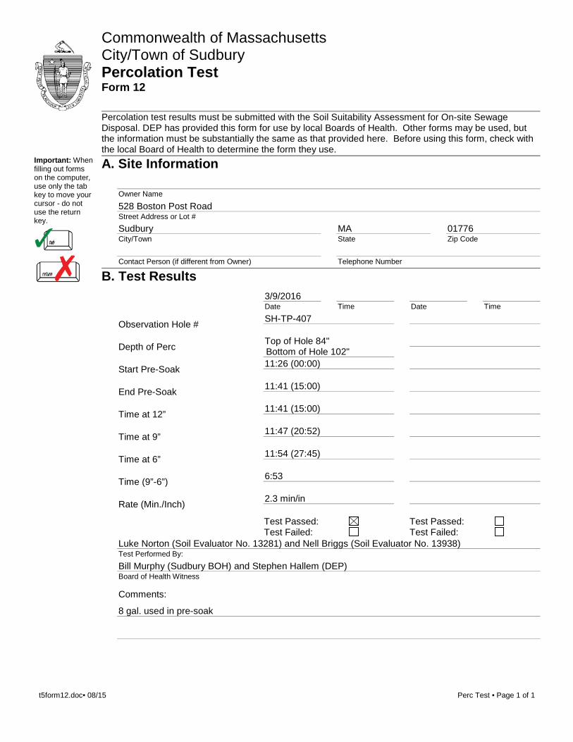
B. Test Results3/9/2016Date Time Date Time
Observation Hole # SH-TP-407
Depth of Perc Top of Hole 84"Bottom of Hole 102"
Start Pre-Soak 11:26 (00:00)
End Pre-Soak 11:41 (15:00)
Time at 12” 11:41 (15:00)
Time at 9” 11:47 (20:52)
Time at 6” 11:54 (27:45)
Time (9”-6”) 6:53
Rate (Min./Inch) 2.3 min/in
Test Passed: Test Failed:
Test Passed: Test Failed:
Luke Norton (Soil Evaluator No. 13281) and Nell Briggs (Soil Evaluator No. 13938)Test Performed By:
Bill Murphy (Sudbury BOH) and Stephen Hallem (DEP)Board of Health Witness
Comments:
8 gal. used in pre-soak
t5form12.doc• 08/15 Perc Test • Page 1 of 1
Commonwealth of MassachusettsCity/Town of Sudbury Percolation Test Form 12
Percolation test results must be submitted with the Soil Suitability Assessment for On-site Sewage Disposal. DEP has provided this form for use by local Boards of Health. Other forms may be used, but the information must be substantially the same as that provided here. Before using this form, check with the local Board of Health to determine the form they use.
Important: When filling out forms on the computer, use only the tab key to move your cursor - do not use the return key.
A. Site Information
Owner Name
528 Boston Post RoadStreet Address or Lot #
SudburyCity/Town
MAState
01776Zip Code
Contact Person (if different from Owner) Telephone Number
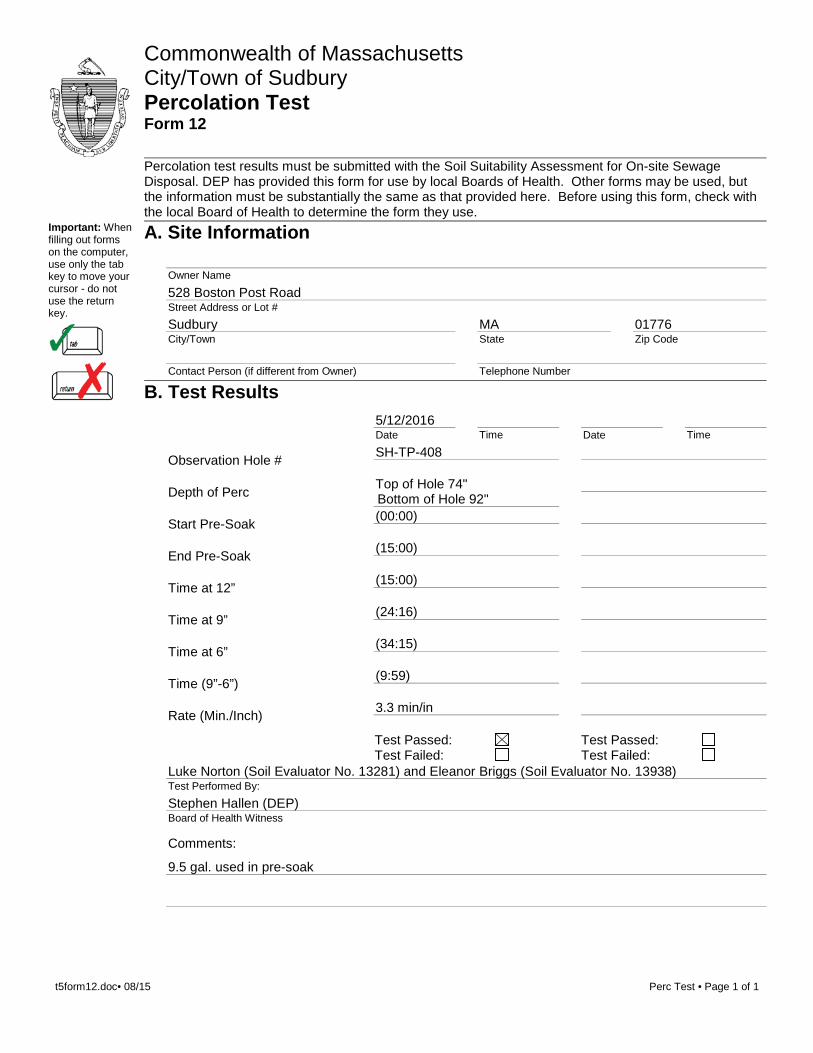
B. Test Results5/12/2016Date Time Date Time
Observation Hole # SH-TP-408
Depth of Perc Top of Hole 74"Bottom of Hole 92"
Start Pre-Soak (00:00)
End Pre-Soak (15:00)
Time at 12” (15:00)
Time at 9” (24:16)
Time at 6” (34:15)
Time (9”-6”) (9:59)
Rate (Min./Inch) 3.3 min/in
Test Passed: Test Failed:
Test Passed: Test Failed:
Luke Norton (Soil Evaluator No. 13281) and Eleanor Briggs (Soil Evaluator No. 13938)Test Performed By:
Stephen Hallen (DEP)Board of Health Witness
Comments:
9.5 gal. used in pre-soak
t5form12.doc• 08/15 Perc Test • Page 1 of 1
Commonwealth of MassachusettsCity/Town of Sudbury Percolation Test Form 12
Percolation test results must be submitted with the Soil Suitability Assessment for On-site Sewage Disposal. DEP has provided this form for use by local Boards of Health. Other forms may be used, but the information must be substantially the same as that provided here. Before using this form, check with the local Board of Health to determine the form they use.
Important: When filling out forms on the computer, use only the tab key to move your cursor - do not use the return key.
A. Site Information
Owner Name
528 Boston Post RoadStreet Address or Lot #
SudburyCity/Town
MAState
01776Zip Code
Contact Person (if different from Owner) Telephone Number
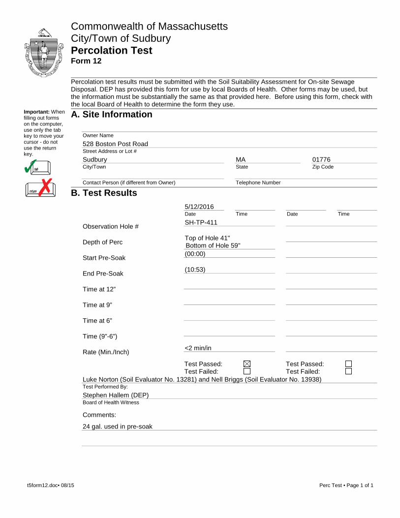
B. Test Results5/12/2016Date Time Date Time
Observation Hole # SH-TP-411
Depth of Perc Top of Hole 41"Bottom of Hole 59"
Start Pre-Soak (00:00)
End Pre-Soak (10:53)
Time at 12”
Time at 9”
Time at 6”
Time (9”-6”)
Rate (Min./Inch) <2 min/in
Test Passed: Test Failed:
Test Passed: Test Failed:
Luke Norton (Soil Evaluator No. 13281) and Nell Briggs (Soil Evaluator No. 13938)Test Performed By:
Stephen Hallem (DEP)Board of Health Witness
Comments:
24 gal. used in pre-soak
t5form12.doc• 08/15 Perc Test • Page 1 of 1

Commonwealth of MassachusettsCity/Town of Sudbury Percolation Test Form 12
Percolation test results must be submitted with the Soil Suitability Assessment for On-site Sewage Disposal. DEP has provided this form for use by local Boards of Health. Other forms may be used, but the information must be substantially the same as that provided here. Before using this form, check with the local Board of Health to determine the form they use.
Important: When filling out forms on the computer, use only the tab key to move your cursor - do not use the return key.
A. Site Information
Owner Name
528 Boston Post RoadStreet Address or Lot #
SudburyCity/Town
MAState
01776Zip Code
Contact Person (if different from Owner) Telephone Number
B. Test Results5/12/2016Date Time Date Time
Observation Hole # SH-TP-412
Depth of Perc Top of Hole 28"Bottom of Hole 46"
Start Pre-Soak (00:00)
End Pre-Soak (08:25)
Time at 12”
Time at 9”
Time at 6”
Time (9”-6”)
Rate (Min./Inch) <2 min/in
Test Passed: Test Failed:
Test Passed: Test Failed:
Luke Norton (Soil Evaluator No. 13281) and Nell Briggs (Soil Evaluator No. 13938)Test Performed By:
Stephen Hallem (DEP)Board of Health Witness
Comments:
24 gal. used in pre-soak
t5form12.doc• 08/15 Perc Test • Page 1 of 1

ATTACHMENT C
TIME TRAVEL ANALYSIS MODFLOW OUTPUT
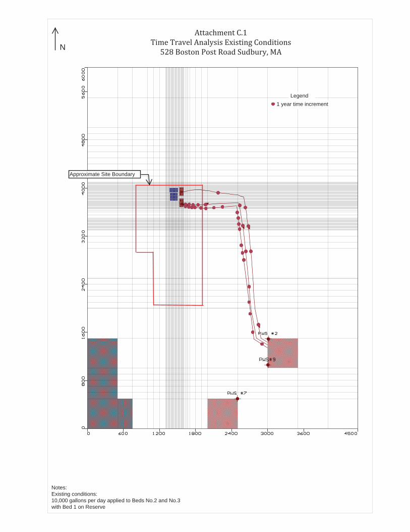
Attachment C.1 Time Travel Analysis Existing Conditions
528 Boston Post Road Sudbury, MA
Legend1 year time increment
Approximate Site Boundary
Notes:Existing conditions: 10,000 gallons per day applied to Beds No.2 and No.3 with Bed 1 on Reserve
N
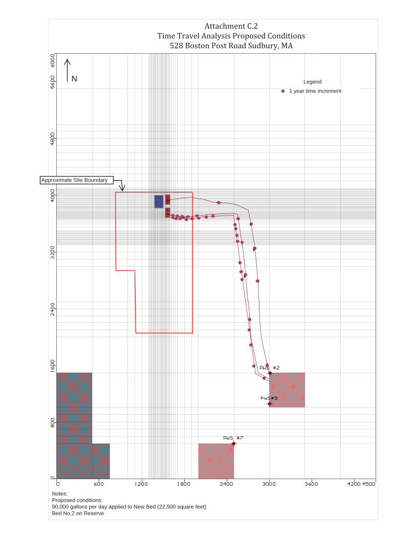
Attachment C.2 Time Travel Analysis Proposed Conditions
528 Boston Post Road Sudbury, MA
Legend
1 year time increment
Notes:Proposed conditions: 90,000 gallons per day applied to New Bed (22,500 square feet) Bed No.2 on Reserve
Approximate Site Boundary
N
ATTACHM
ENT 2
Attachment 2