wyoming game and fish department fish … flow... · wyoming game and fish department fish division...
TRANSCRIPT

WYOMING GAME AND FISH DEPARTMENT
FISH DIVISION
ADMINISTRATIVE REPORT
TITLE: Instream Flow Studies on Clear Creek
PROJECT: IF-3094-07-9301
AUTHOR: Paul D. Dey and Thomas C. Annear
DATE: August 1994
ABSTRACT
Data collected in earlier studies (Vogt 1989, Appendix 1) were used to determine instream flows needed to maintain the trout fishery in the Class 2 section of Clear Creek. The Class 2 reach was divided into two contiguous sections based on differences in the fishery, geomorphology and hydrology. Separate instream flow recommendations were developed for each section.
Physical Habitat Simulation (PHABSIM), the Habitat Quality Index (HQI), and a Habitat Retention method were used to derive flow recommendations. Recommendations for the reach from the North Fork Clear Creek confluence downstream to the City of Buffalo diversion are: April 1 - June 30 = 40 cfs, July 1 - September 30 = 30 cfs, October 1 - March 31 = 7.9 cfs. Recommendations for the reach from the Buffalo water diversion downstream to Johnson County Ditch a~e: April 1 to June 30 = 40 cfs, July 1 to September 30 = 25 cfs, October 1 to March 31 = 6.0 cfs.
INTRODUCTION
Since 1983, the City of Buffalo and Wyoming Water Development Commission (WWDC) have proposed several alternatives for developing an additional municipal water supply. Proposed construction alternatives involved reservoir'development in the Clear Creek drainage. Instream flow data were collected by the Wyoming Game and Fish Department (WGFD) at several locations in the Clear Creek drainage in 1987 through 1989 to evaluate potential habitat losses and fishery enhancement opportunities associated with water development plans (Appendix 1, Vogt 1989). These data indicated that the proposed Tie Hack dam would provide opportunities for providing instream flows per state water law for maintaining fishery values.
Trout stream classifications throughout Wyoming were developed by WGFD and range from Class 1 (highest quality) to Class 5 (lowest quality). Clear Creek from the confluence of the North Fork of Clear Creek to the Johnson County Ditch is classified as a Class 2 trout stream and is managed as a wild trout fishery. Less
1

Middle Fork Clear Cr. ---.-..
Tie Heck
City of Buffalo Water Supply
CC2 Ctty of Buff;!1o
Johnson County Ditch
South Fork Clear Cr.
I~---Proposed Lower Tie Hack Reservoir
~---SourdoU6h Cr.
Scale: 1 inch = approxi~atp.ly 2 miles
Figure 1. Clear r.reek Study Sites.
2

( )
than 7% of all Wyoming stream miles are classified as Class 2 or better. This section of Clear Creek contains naturally reproducing (wild) populations of rainbow, brown and brook trout and receives no fish from department hatcheries.
Coincident with the important fishery values represented in this reach of Clear Creek,. the public has expressed interest in ma~ntaining instream flows for this fishery. For these reasons, these stream segments are considered critical.
Specific objectives included 1) determine instream flows necessary to maintain hydraulic characteristics important for fish passage through riffle areas and survival of trout and aquatic insects at all times of the year, 2) determine instream flows necessary to maintain adult trout production during the late summer months, and 3) determine instream flows necessary to maintain juvenile trout production during the spring months.
DESCRIPTION OF THE STUDY AREA
Clear Creek from the confluence of the North Fork of Clear Creek to the City of Buffalo diversion has a steep gradient, and stream habitat is dominated by cascading riffles and pl~nge pools. Clear Creek below the city. diversion to 1-25 has a more gentle gradient and contains long sections of swift-moving water characteristic of run habitat. Substrates in both reaches consist mainly of cobble and boulder.
METHODS
Study Sites
Data collected in 1989 studies were used to develop instream flow recommendations (Appendix 1, Vogt 1989). Study sites were established on Clear Creek approximately 1/2 mile upstream from the City of Buffalo diversion structure (CCl; TsON, R83W, S10) and near the abandoned Pacific Power and Light (PPL) powerplant 4 miles west of Buffalo (CC2j TsON, R82W, S 6; Fig. 1). Results obtained at site CCl were applied to a 4.7 mile segment of Clear Creek from the confluence of the North Fork of Clear Creek to the City of Buffalo diversion structure. Results from site CC2 were applied to the 5.3 mile segment of Clear Creek between the City's diversion and the Johnson County Ditch. Based on the different fish habitat characteristics and hydrology above and below the Buffalo div~rsion, slightly different instream flow recommendations resulted for these reaches.
In the 1989 report (Appendix 1), the first major irrigation diversion structure below site CC2 was erroneously referred to as the Six Mile Ditch. This ditch is actually called the Johnson County Ditch and this terminology was used in this report.
Methodologies
A Habitat Retention Method (Nehring 1979) was used to identify fisheries maintenance flows for each of the two identified Clear Creek segments. A maintenance flow is defined as a continuous flow that will maintain minimum hydraulic criteria in riffle areas within a stream segment. These criteria are
3

important at all times of year to maintain passage between different habitat types for all life stages of trout. These criteria are also important for maintaining survival rates of fish and aquatic macroinvertebrates during the winter that approximate rates observed under natural stream flow conditions. Data from single transects placed across riffles at sites CC1 and CC2 were analyzed with the IFG-1 comput~r program (Milhous 1978). These data we~e collected at various stream discharges at each site (Table 1). Based on extensive research on instream flow methods on Wyoming streams by Annear and Conder (1983), the maintenance flow is identified as the discharge at which two of the three hydraulic criteria are met for all riffles in the study area (Table 2). Maintenance flows apply to all times of the year except when higher stream flows are required to meet other fishery management objectives.
Table 1. Dates and discharges when instream flow data were collected.
Site Date(s) Discharge (cfs)
CC1 6-27-89 147 8-09-89 84 9-12-89 43
CC2 5-24-89 120 8-08-89 79 9-14-89 33
Table 2. Hydraulic criteria used to obtain an instream flow recommendation using the Habitat Retention Method.
Category
Average Depth (feet) Average Velocity (feet per second) Wetted Perimeter (percent)2
1 - At average daily flow
Criteria
Top width1 x 0.01 1.00
60
2 - Compared to wetted perimeter at bank full conditions
The Habitat Quality Index (HQI) developed by the Wyoming Game and Fish Department (Binns and Eiserman 1979) was used to estimate potential changes in trout standing crops over a range of late summer flow conditions. This model was developed by the WGFD after several years of testing and model refinement. The model incorporates nine attributes that address chemical, physical, biological, and hydrological components of trout habitat. Results are expressed in trout habitat units (HU). One HU is defined as the amount of habitat quality which will support 1 pound of trout.
By measuring habitat attributes at various flow events as if associated habitat features were typical of average flow conditions, HU estimates can be made for a variety of stream flow scenarios (Conder and Annear 1987). Habitat attributes were measured at each site at several discharges (Table 1). To better define the potential impact of other flow scenarios on trout production, some attributes were
4

,1
derived mathematically or obtained from existing gage data. Gage data were obtained from USGS gage #6318500 located on Clear Creek near site CC2.
A physical habitat simulation model (PHABSIM) developed by the Instream Flow Service Group of the u.s. Fish and Wildlife Service (Bovee and Milhous 1978) was used to examine incremental changes in amount of physical habitat available for rainbow and brown trout spawning at various discharges. This model is widely considered to reflect state-of-the-art technology for evaluating fisheries physical habitat changes with changes in stream flows and is widely used throughout North America.
The amount of physical habitat at a given discharge is expressed in terms of weighted usable area (WUA) and reflects the composite suitability of depth, velocity and substrate at a given flow. Depth, velocity and substrate data were collected at sites CC1 and CC2 at several different flow levels (Table 1) in accordance with guidelines given by Bovee and Milhous (1978). Suitability curves for brown and rainbow trout juveniles are from Bovee 1978. Weighted Usable Area for rainbow and brown trout juveniles was simulated for a range of flows at each site with calibration and modeling techniques outlined by Milhous (1984) and Milhous et ale (1984). To standardize this analysis for both species, data were converted to percent of the maximum WUA using the following formula:
Where Q and MAX
% MUA = (WUAQ / WUAMAX) * 100
an individual flow level the maximum WUA for a particular analysis
Critical fish species and life stages in Clear Creek were identified (Table 3). Critical species are defined as those species identified by WGFD as the main fishery resource for a particular stream. In the case of Clear Creek, management efforts focus on maintaining both rainbow and brown trout populations but rainbow trout have a higher priority. Therefore, PHABSIM-derived flow recommendations were based on habitat requirements of rainbow trout. Analyses indicated that brown trout habitat would be maintained at flow levels recommended for maintaining rainbow trout habitat.
Critical life stages are those life stages most sensitive to environmental fluctuations. population integrity is sustained by providing adequate flow for critical life stages. In many cases, Rocky Mountain stream populations are constrained by spawning and young (fry and juvenile) life stage habitat bottlenecks (Nehring and Anderson 1993). On Clear Creek, observations indicate that juvenile habitat during the spring months is likely a critical factor influencing trout populations. The spring months can be stressful to trout because energy reserves are low following winter and food is not yet plentiful. Fish energy expenditures can be relatively high in association with high flows during spring runoff and limit their distribution, growth and survival. Therefore, instream flow recommendations for April, May and June were developed based on juvenile trout requirements (Table 3). The PHABSIM system was used to derive these recommendations.
During the summer months, trout production is most directly related to growth and survival of adult fish. The HQI model was developed to determine suitability of late summer habitat for adult fish production This model was used to determine the
5
instream flow necessary to maintain existing levels of trout production during the months of July, August and September (Table 3).
As in many Rocky Mountain streams, survival of all life stages during winter months is a key factor influencing trout populations in Clear Creek. Winter trout surviv~l is maintained at flow levels determined with the Habitat Retention model (see pg. 23, Appendix 1). Therefore, the Habitat Retention model was used during the low flow winter months (October through March) to determine instream flows necessary to maintain trout populations (Table 3).
Table 3. Critical species and life stages considered in development of instream flow recommendations for Clear Creek. Numbers indicate method used to determine flow requirements.
I I SPECIES
I I I I I I I I I Iii i I ILIFE STAGEIJANIFEBIMARIAPRIMAYIJUNIJULIAUGISEPIOCTINovlDECI
I I I IBrown trout I Adult I
I I I IRainbow trout I Adult I
I I I IBrown trout I Juvenile I
I I I IRainbow trout I Juvenile I
I I I IAll species IAIl stages I I I
1 - Habitat Quality Index 2 - PHABSIM 3 - Habitat Retention
3 3
I . I I I I I 2 2
I I 2 2
I 3 I
RESULTS AND DISCUSSION
1 1 1
1 1 1
2
2
3 3 3
Results were separated into two sections dealing with each of the identified reaches (North Fork Clear Creek confluence downstream to the City of Buffalo diversion and Buffalo diversion downstream to Johnson County Ditch). All results and recommendations for each stream section are included under the appropriate heading.
North Fork Clear Creek confluence downstream to Buffalo Diversion
Results from the Habitat Retention model showed that flows of 7.5, 4.5, and 7.9 cfs are necessary to maintain winter survival of trout, aquatic insect production and fish passage at riffles 1, 2, and 3, respectively (Table 4). The maintenance flow recommendation derived from this method is defined as the flow at which two of the three hydraulic criteria are met for all riffles in the study site, which in this case is 7.9 cfs. The City of Buffalo has agreed to provide a maintenance flow of 7.9 cfs (O'Grady 1992, Appendix 2) .
6

Table 4. Simulated hydraulic criteria for three riffles on Clear Creek at site CC1. Estimated bankfull discharge = 330 cfs; Estimated average daily dis-charge = 51 cfs.
Average Average Wetted Depth Velocity Perimeter Discharge (ft) (ft/sec) (ft) (cfs)
Riffle 1 1.68 3.94 53.3 330.0 1.50 3.23 51.9 237.6 1.33 2.65 50.8 169.1 1.16 2.14 48.9 116.3 1.09 1.69 43.7 76.8 0.98 1.33 40.5 51.0 0.88 1.001 36.9 32.1 0.83 0.86 35.3 24.4 0.52 0.43 32.01 7.52
0.391 0.24 26.5 2.7
Riffle 2 1.54 4.59 47.8 330.0 1.49 4.21 47.4 288.4 1.38 3.17 44.6 188.9 1.34 2.32 39.7 119.3 1.26 1.64 36.2 72.1 1.14 1.27 35.4 51.0 1.05 1.001 34.9 35.7 0.82 0.58 33.9 15.8 0.57 0.25 28.71 4.5 2
0.341 0.05 15.3 0.6
Riffle 3 1.78 4.71 41.1 330.0 1.67 4.30 40.2 275.3 1.47 3.65 38.9 199.2 1.28 3.16 38.3 149.4 1.10 2.72 37.7 108.4 0.78 1.95 34.9 51.0 0.59 1.60 33.4 30.8 0.40 1.12 24.7 1 11.3 0.36 1.001 22.1 7.92
0.341 0.92 20.3 6.5 1 - Minimum hydraulic criteria met 2 - Discharge at which 2 of 3 hydraulic criteria are met
7

HQI analyses at site CC1 indicate that at existing average late summer flow conditions (35 cfs; from data presented in Goodwin and Hickman 1993), Clear Creek from the confluence of the North Fork of Clear Creek to the City of Buffalo diversion supports approximately 135 HUs per acre (Fig. 2). The analysis indicates that this number of HUs is maintained at a range of average late summer flows of between 30 and 45 cfs. At flows less than 30 cfs and greater than 4S cfs, the number of HUs in this stream reach is reduced from existing levels.
-
t-
CC t-t--f
D::l a:: ::c
150
100
50
20 35 50 70 10 30 ~0 60 80 DISCHRRCE
90 110 130 150 100 120 140 (cfs)
Figure 2. Number of potential trout habitat units at several late summer flow levels in Clear Creek (eCl).
Based on the results from the HQI analysis, a late summer flow of 30 cfs is the minimum stream flow that will maintain existing levels of trout production between July 1 and September 30 and will meet or exceed the hydraulic criteria addressed by the Habitat Retention Method.
PHABSIM analyses were conducted at site CC1 to determine the relationship between discharge and WUA for rainbow and brown trout juveniles. WUA was simulated for flows ranging from 30 to 300 cfs. WUA for rainbow and brown trout juveniles is maximized at discharges of 40 cfs and 30 cfs, respectively (Fig. 3). Since rainbow trout have precedence over brown trout, the recommended instream flow for juveniles is 40 cfs. At this flow level, brown trout still have 98% of maximum WUA (Fig. 3).
8

Figure 3.
( ,
ICE CRVE JUVENILES
100.00 -------
80.00
60.00
~0.00
20.00
o . 0 0 -+--:....--r----r--~----r--_r_~~ ___ ,.---,-._r
0. 00 ~0. 0 30.0
6~.0 80.0 100. 150. 200. 30~. 50.0 70.0 90.0 125. 175. 250.
DISCHRRCE
BNT
RBT
Percent of maximum usable area (MUA) for brown trout (BNT) and rainbow trout (RBT) juveniles at site CC1 (Ice Cave) .
INSTREAM FLOW RECOMMENDATIONS
Based on the analyses and results outlined above, the instream flow recommendations in Table 5 will maintain the existing Clear Creek trout fishery. These recommendations apply to an approximately 4.7 mile segment of Clear Creek extending downstream from the confluence with North Fork Clear Creek (TSON, °R83W, S 7) to the City of Buffalo diversion (TSON, R83W, S10).
Table s. Summary of instream flow recommendations to maintain the existing trout fishery in Clear Creek from North Fork Clear Creek to .~he City of Buffalo diversion.
Time Period
April 1 to June 30 July 1 to September 30 October 1 to March 31
Instream Flow Recommendation (cfs)
40
30 7.9
This analysis does not consider instream flow needs for maintenance of channel geomorphology and trout habitat characteristics. Presently, channel maintenance flow needs are adequately met by natural runoff patterns. Following regulation, additional studies and recommendations may be appropriate for establishing instream flow needs for channel maintenance.
9

L.,,: ,
Buffalo Diversion downstream to Johnson County Ditch
Habitat Retention results indicate that flows of 6.2 and 6.8 cfs are necessary to maintain winter survival of trout, aquatic insect production and fish passage through riffles 1 and 2, respectively (Table 6). The maintenance flow recomm~ndation derived from this method is defined as the flow at which two of the three hydraulic criteria are met for all riffles in the study site, which in this case is 6.8 cfs. A third riffle, included in the original analysis (Vogt 1989), was excluded from this analysis. A flow of 23.6 cfs would be necessary to maintain hydraulic criteria at that riffle. Upon further review, however, it was concluded that this flow prediction was an anomaly and the stream flow requirement at that site would be excessive at all other riffles within this segment. A more accurate maintenance flow is the 6.B cfs defined by the other two riffles.
Table 6. Simulated hydraulic criteria for two riffles on Clear Creek at site CC2. Estimated bankfull discharge = 285 cfs; Estimated average daily discharge = 44 cfs.
Average Depth (ft)
1.68 1.57 1.47 1.32 1.1.7 0.93 0.77 0.62 0.42 0.291
1.72 1.59 1.41. 1..23 1.1.0 1..03 0.84 0.71. 0.55 0.301
Wetted Velocity (ft/sec)
Perimeter (ft)
4.62 3.96 3.31. 2.72 2.1.9 1.58 1.24 1.001
0.62 0.41
4.21 3.51 2.74 2.10 1.55 1.39 1.001 0.77 0.52 0.1.3
Riffle 1 39.5 37.7 35.2 33.9 32.6 31.3 30.7 29.9 23.71. 17.8
Riffle 2 42.4 40.8 38.8 36.0 33.2 32.6 30.6 28.7 25.4 1
10.4
1 - Minimum hydraulic criteria met
Discharge (cfs)
285.0 21.7.2 1.59.1 113.1
77.6 44.0 27.7 18.1 6.2 2
2.2
285.0 210.1. 1.39.0
88.0 52.6 44.0 24.6 14.8 6.82
O.S
2 - Discharge at which 2 of 3 hydraulic criteria are met
The City of Buffalo has agreed to maintain an instream flow of 6.0 cfs (O'Grady 1992, Appendix 2) below the diversion using storage water from the proposed Tie Hack Reservoir at times when natural flows are less than this amount. This flow
10

level was identified by Vogt (1989) (Appendix 1) as an amount that would mitigate trout habitat losses caused by reservoir development. Analysis of changes in long term annual streamflow variations via the HOI model was used as the basis for this determination. In this particular instance, our department has agreed that maintenance of this flow level during the winter months will not significantly compro~ise trout habitat requirements that were identified by the Habitat Retention method because this flow will effect an overall positive fishery response. The impacts associated with periodic reductions in natural flows to 6.0 cfs will be more than offset by the permanent assurance that instream flows will not fall below this same threshold. In this situation, the instream flow right would be junior to the project sponsor's right and would not negatively impact project feasibility; but, could be fulfilled on a strict priority basis.
Therefore, an instream flow filing of 6.0 cfs will be made for the winter period (rather than the 6.B cfs identified by Habitat Retention). If the Tie Hack project is not completed, the fishery should be allowed to benefit from all naturally av.ailable streamflows, as it does under existing, natural conditions, up to the 6.8 cfs identified by the Habitat Retention method. In such a case, a supplemental filing for 6.B cfs will be completed.
HQI analyses at Site CC2 indicate that at existing average late summer flow conditions (from Goodwin and Hickman 1993) Clear Creek from the Buffalo City diversion to the Johnson County Ditch supports approximately 59 HUs per acre (Figure 4). The analysis indicates that over the range of flows simulated, HUs are maximized at 59 HUs per acre at late summer flows of between 25 and 35 cfs. At flows less than 25 cfs and greater than 35 cfs, the number of HUs in this stream reach is reduced from existing levels.
en t-t---i
::z: ~
t-
c:c t-t---i
CO 0:: ::::I:
60
20
20 30 ~0 60 1a 25 35 50 70 DISCHRRCE
80 100 128 90 110 130
( c f s )
Figure 4. Number of potential trout habitat units at several late summer flow levels on Clear Creek (CC2).
11

'I '- ,
Based on the results from the HQI analysis, an instream flow of 25 cfs will maintain existing levels of trout production between July 1 and September 30 and will meet or exceed the hydraulic criteria addressed by the Habitat Retention Method.
The relationship between discharge and WUA,for rainbow and brown trout juveniles was analyzed at site CC2 using the PHABSIM model. Weighted Usable Area was simulated for flows ranging from 10 to 400 cfs. Weighted Usable Area for rainbow and brown trout juveniles is maximized at discharges of 40 cfs and 20 cfs, respectively (Fig. 5). Since rainbow trout have precedence over brown trout, the recommended instream flow for juveniles is 40 cfs. At this flow, brown trout still have 94% of maximum WUA (Fig. 5).
Figure 5.
100.00
80.00
60.00
~0.00
20.00
PPL JUVENILE
o . 0 0 -+--r---r----r-r----T""""--r-r----r-~.,...----,-__r___..,._____,_--, 0.00 20.0 Q0.0 79.0 120. 175. 250. 350.
18.033.060.0100. 150.200. 300 .. Q0~. DISCHRRCE
BNT R81
Percent of maximum usable area (MUA) for brown trout (BNT) "and rainbow trout (RBT) juveniles at site CC2 (PPL).
INSTREAM FLOW RECOMMENDATIONS
Based on the analyses and results outlined above, the instream flow recommendations in Table 7 will maintain the existing Clear Creek trout fishery. These recommendations apply to an approximately 5.3 mile segment of Clear Creek extending downstream from the City of Buffalo diversion (T50N, RB3W, SlO) to the Johnson County Ditch (T50N, RB2W, S 5) .
12
Table 7. Summary of instream flow recommendations to maintain the existing trout fishery in Clear Creek from the City of Buffalo diversion downstream to the Johnson County Ditch.
Time Period
April 1 to June 30 July 1 to September 30 October 1 to March 31
Instream Flow Recommendation (cfs)
40
25 6
This analysis does not consider instream flow needs for maintenance of channel geomorphology and trout habitat characteristics. Presently, channel maintenance flow needs are adequately met by natural runoff patterns. Following regulation, additional studies and recommendations may be appropriate for establishing instream flow needs for channel maintenance.
13

REFERENCES
Annear, T.C. and A.L. Conder. 1983. Relative bias of several fisheries instream flow methods. North American Journal of Fisheries Management 4:531-539.
Binns, N. and F. Eiserman. 1979. Quantification of fluvial trout habitat in Wyoming. Transactions of the American Fisheries Society 108:215-228.
Bovee, K. 1978. Probability-of-use criteria for the family Salmonidae. Instream Flow Information Paper No.4. FWS/OBS-78/07.
Bovee, K. and R. Milhous. 1978. Hydraulic simulation in instream flow studies: theory and technique. Instream Flow Information Paper 5, FWS/OBS-78/33, Cooperative Instream Flow Service Group, U.S. Fish and Wildlife Service. Fort Collins, Colorado.
Conder, A.L. and T.C. Annear. 1987. Test of weighted usable area estimates derived from a PHABSIM model for instream flow studies on trout streams. North American Journal of Fisheries Management. 7(3) :339-350.
Goodwin, C. and D. Hickman. 1993. Water resources technical report. and Reservoir EIS Bighorn National Forest, Wyoming. TR-28S-9.
Tie Hack Dam BIO/WEST, Inc.
Milhous, R. T., D. L. Wegner, and T. Waddle. 1984. User's guide to the Physical Habitat Simulation System. Instream Flow Paper 11, FWS/OBS-81/43, U.S. Fish and Wildlife Service, Fort Collins, Colorado.
Milhous, R.T. 1984. PHABSIM technical notes. Unpublished. U.S. Fish and Wildlife Service, Fort Collins, Colorado.
Milhous, R.T. 1978. A computer program for the determination of average hydraulic and shape parameters of a stream cross section. Washington State Dept of Ecology, Olympia.
Nehring, R. and R.M." Anderson. 1993. Determination of population limiting critical salmonid habitats in Colorado streams using the Physical Habitat Simulation System. Rivers 4: 1-19.
Nehring, R. 1979. Evaluation of instream flow methods and determination of water quantity needs for streams in the state of Colorado. Colorado Division of Wildlife, Fort Collins.
O'Grady, Michael T. 1992. Draft letter to Nels Lofgren, Mayor, City of Buffalo. December 15, 1992.
Vogt, G.F. 1989. Buffalo Municipal Reservoir Project, Lower Tie Hack Reservoir. Wyoming Game and Fish Department, Administrative Report.
14

r.. """ .•
~ , .
r, -,.- ~
~~.~: .~. r.: ;~~. -~: _f.-:,::"'" ','" (P • ~ I . ;~:'.:r;:_'.;., .. :
.... '.; ". 0/ '. '.~'-.!~[ r:.. . ,::.~:. i.::: :'!rr'f~i
,; ....
" . ..... .. "T ....... j '0 ...
,"~ : .... I': ,. ... ~ . -, , ' .. : ',';"" ~ ... _~_". ~._ 4··.~
APPENDIX ·1
15
.-~ ... ;. ~.!.; ;~: ,- .~.'
.... - "., -, -~ ...
..,:'" _-J • • --4 •• __ •
~ . ~~ .~ ............. .' .. .
. ......... -.

\VYOMING GAME AND FISH DEPARIMENT
FISH DIVISION
ArlIDITSTRATIVE REroRr
T!TI.E: Buffalo Municipal Reservoir Proj ect, Lower Tie Hack Reservoir
PROJEcr: IF-3089-09-8801
AUIHOR: Gerald F. Vogt, Jr.
DATE: December 1989
INTROOOCrION
The city of Buffalo has applied to the ~lyoming Water Development Conmrission It·:tVOC) for assistance in development of an additional municipal viater supply. In 1984, 15 locations were selected as possible sites for reservoirs; however, this list has been reduced to the Upper and Lower Tie Hack Sites. '!he Lower Tie Hack Site has been identified -as the preferred dam site. !he proposed reservoir ~vould be a multi -purpose reservoir, used for storage of municipal \Yater and for recreation. rrbe t'Vtvoc requested an analysis of the 2,500 acre-feet reservoir alternative for the purposes of this report.
construction of a dam at the lower Tie Hack site will inundate sections of the South Fork Clear Creek and Sourdough Creek (Figure 1). tvater stored in the reservoir ~ .. Jill be used to augment the City of Buffalo water supply and \-lill be delivered to the city's diversion on Clear Creek via the South and Middle Forks of Clear Creek.
In 1983, the Wyoming Game and Fish Deparonent (W3FD) began a basin-wide :-eccnnaissance sUldy to inves'Ciga'Ce the poten'Cial fisheries impacts of the proposed · ... at:er development proj act. D.lring that year, the WGFD conducted studies to inventory -:."e fisheries and aquatic habitat at the proposed dam site. In 1987, the WGFD c:::nciucted independent studies on Clear Creek in the Town of Buffalo to identify possible fisheries enhancemen'C opportunities in response to requests from the town. I!1 1988, data were collected to determine the potential habitat losses that might occur due to project construction. In 1989, additional instream flow studies and L":m.ct analyses were conducted to more precisely detennine potential fisheries i.~ct:S as a result of this project and to evaluate potential stream mitigation and enhancement alteznatives.
'!he specific objectives of this study were to 1) quantify t:rout habitat losses in 'the South Fork Clear creek and Sourdough Creek due to inundation by the proposed reservoir, 2) reccrranend a minimum fisheries pool volume for the proposed reservoir fer fisheries enhancement, J) determine instream flows necesscu:y to maintain hydraulic characteristics a1:. all times of year that are important for survival of ~roU't:, fish passage and aquat:ic insect production in the South and Middle Forks of Clear creek and Clear Creek, ~) determine instream flows necessary to maintain or
16

cc:: Ci:'; of Euffnio
Q-(lear Cr~eK
" -. jr::: ~::-K l 4~:!r '_:-. ,.... -------., ~
/.,~ ( ~iddle For~ ./1// ~ Clear Cr. ~l :~_
T ' H' ~ ~F2 le c::c}o: C • ..J. '
South Fork, 4 Pro?os~d L0~er Tie Hack Clear Cr ~ {,' Reservo 1 r
/ -;. Sourriou~h Cr.
CC3
C 4
Six ~Iile Ditcn
sou
!
( SFl
Sc~le: :~ch = ~p?roxlnat~ly ~ ~iles
?icure I '~.:!O :!10\;1:1':! ~t:J::i': =1.tes 0:1 .:::>urc'J'J"!n Cre,=~:. ';-cut.h ::-~rk C:e3f Cr~eK nnd =:e~r ·'::;-eei<..
17
1-
CCS

· '
improve adul t trcu~ prc:xiuct:ion during the late summer months in the South Fork Clear Creek and Clear Creek, 5) detennine inst:.ream flows necessary to maintain 'the exist:lng level of rainbow and brotm trout reproduction in the spring and fall, respeccively, in Clear Creek and the South Fork Clear Creek, and 6) evaluate mitigation alternatives to offset any habitat losses due to this project in accordance '.vith the VK;FD mitigation policy. This report does not include an analysis of potential impact:s that might occur during proj ect const:l:l.lction, since const:.nlction plans were not yet available. t"lhen construction plans are available, VX;FD will review them so that construction-related impacts can be avoided or quantified.
DESCRIPrION OF 'mE S'IUDY AREA
The propose::i water development project involves four streams located on the \olest side of the Bighom Mountains west of the City of Buffalo, Wyoming (Figu!'a 1). These streams include Sourdough Creek, South Fork Clear Creek, r1i.ddle Fork Clear Creek, and Clear Creek. studies have been conducted on each of these streams excluding the Middle Fork Clear creek. Sourdough and South Fork Clear Creeks are high mountain streams with rnoderal:ely s'teep gradients and stable channels containing combinations of pool, riffle and run habitats. Clear Creek from the confluence of the North and l1i.ddle Forks of Clear Creek to the City of Buffalo diversion has a steep gradient, and stream habi tal: is dominated by casca~ing riffles and plunge pools. Clear Creek below the city diversion to 1-25 has a more gentle gradient and contains long sections of swift-!!1OVing water characteristic of run habitat. Substrates in this reach consist mainly of cobble and boulder. Public access to the South Fork Clear Creek and Sourdough Creek is good, since the streams flow through the Bigham National Forest and aU. S. Forest Service campground is locate:! at the confluence of the two streams. Access to Clear Creek is somewhat limited, due to the rough terrain of the canyon section of the stream, and due to private ownership of the lower . sections of the scream. However, public access is available in the Town of Buffalo.
South Fork Clear creek, Middle Fork Clear Creek, Sourdough Creek, and Clear creek fram th~ Six Mile Ditch to I-25 are classified as Class 3 trout streams by the \VGFD. . Trout stream classifications throughout Wyoming range from Class 1 (highest quality) to Class 5 (lowest quality). Class 3 trout. streams are considered import:ant. crout vlaters with -: isheries of regional importance. These four streams are r:anaged by the WGFD under 't:he basic yield concept for rainbow trOUt: and receive hatchery plants of catchable rainbow trout. These streams also contain \·,ild populations of rainbow, brown and brook trout. Clear Creek from the confluence of the North and Middle Forks of Clear creek to the six Mile Ditch is classified as a Class 2 trout stream and is managed as a wild trout fishery. This section of Clear Creek contains naturally reprcx:iucing (wild) populations of rainbow, brown and brook trout: and receives no hatchery plants. .
'!he prcpose::i project: has the potential for impacting the stream fisheries in the South Fork Clear Creek and Sourdough Creek by inundating portions of those streams. Impacts could also result from reductions in stream flows in South and Middle Forks of Clear Creek and in Clear Creek wnen reset:Voirs are filling and by increasing stream flows during the summer. Cepending on the distance that releases are allowed to travel in the Clear Creek drainage, stream fisheries in Clear Creek from the City of Buffalo diversion to I -25 could also be affected by releases from the proposed reservoir.
18
The Wyoming Game and Fis..~ Commission I s Mitigation Policy (approved September 23, ~985) established Mitiga~icn categories, Designation Criter1a, and Mitigation :;bjecr.ives for habitat values wmen may be impaet:e::l by project development. !his 'OOlicv '.vas used to rate 'the \"31ue of habitats within the proposed project area (Table : ~. ~oJhenever possible, however, the policy states that avoidance of adverse habitat. i=.pacts is more desirable than compensation of losses due to those impacts.
Table 1. Mitigation categories, criteria, and mitigation objectives of the Wyoming Game and Fish canunission Mitigation Policy.
Mitigation categoty
Irreplaceable
High
Moderate
Cescription
Endangered species Class 1 streams critical habitat
state rare or 9rotect:ed. species Native game fish Class 2 streams Wild (native) or trophy management concept
Non-native game fish Class 3 streams wild (non-native) game fish and basic yield management concept
Nongame fish Class 4 and 5 streams Put-and-take managemen~ concept
ME:IHons
Study sites
Mitigation Object.ive
No loss of existing habitat value.
No net loss of in-Yind habitat value.
No net loss of habitat value while minimizing loss of in-kind habitat value.
Minimize loss of habitat value.
Nine study sites have been established on South Fork Clear Creek, Sourdough :r-eek and Clear creek since 1983 to evaluate 'the potential fisheries l..-rnpacts of t..'1is ~rojeC1: (Figure 1 and Table:::.:. The three study sites on South Fork Clear creek ',!ere locat.ed above the mouth cf Sourdough creek (SFl), at the dam site belo\-! the mouth cf Sourdough creek (SF2), and approxiInately 1/2 mile below the dam site (SF3). The scudy site on Sourdough creek (SOU) was located approximately 1/4 mile upstream f:-orn ti1e mouth cf Sourdough cree:. Study sites were also established on Clear Creek approxirna~ely 1/2 mile upstream from the City of Buffalo diversion scructure (Cel) .IDa near t..'1e abandoned PP&L powerplant ~ miles west of Buffalo (CC2). In the tovm cf
19
3Uffalo sites were lcx:ated a't. the Buffalo City Park (ceJ); jus't Upstream from the :·1ain Street Bridge in Buffalo (CC4); and at the Texaco Bulk Plant in Buffalo (CC5).
Table ::. Locations of study sites for Buffalo Municipal Reservoir project.
Site Stream Location
SFl South Fork Clear c.::-. above Sourdough Cr. S27, T50N, R84W SF2 South Fork Clear c.::-. below Sourdough Cr. S24, T50N, R84W SF3 South Fork Clear c:-. below dam site 524, T50N, R84W
SOU Sourdough Cr. 1/4 mi. upstream from mouth 526, T50N, R84W
CC1 Clear creek above the Buffalo city diversion 510, T50N, R83W CC2 Clear Creek near cld p:wer plant S 6, 'I5DN, R82W
ceJ Clear creek at Buffalo City Park S34, T5lN, R82W CC4 Clear Creek above Main street Bridge S35, T5IN, R82W CC5 Clear Creek at Texaco Bulk Plant S35, TSlN, R82W
For the purposes of this repert., results obtained at sites SF1, SF2, SF3 and SOU ',.!ere used to determine trout habitat losses due to inundation of sections of South Fork Clear creek and Sourdough Creek by the proposed reservoir. Results obtained at site SF3 were also applied to the sections of South Fork Clear Creek 'and Middle Fork Clear Creek from the proposed dam site to Clear creek. Results obtained at site CC1 were applied to a 4. 7 mile segment of Clear Creek from the confluence of the North and Middle Forks of Clear Creek to the City of Buffalo diversion structure. Results from site CC2 were applied to the 5.3 mile segment of Clear creek between the city's diversion and the six Mile Ditch. Sites ceJ', CC4 and CCS rep~esent the three major habitat types found in Clear Creek in the Town of Buffalo, and results from these three sites were averaged and applied to the section of Clear Creek between the six Mile Ditch and I-25.
Models
.; Habitat Retention Method (Nehring 1979) vIaS used to identify a fisheries maintenance flow for South Fork Clear Creek below the. proposed reservoir and for Clear Creek from the forks to the Six Mile Ditch. A maintenance flow is defined as a continuous flow that will maintain minimum hydraulic criteria in riffle areas within a stream segment. 'Ihese criteria are important at all times of year to maintain passage between different habitat types for all life stages of trout. These criteria are also important for maintaining survival rates of fish and aquatic macro invertebrates during the winter that approximate rates observed under natural stream flow conditions. Da.ta from single transect:S placed across riffles at sites SF3, cel, and CC2 were analyzed with the IFG-1 computer program (Milhou~ 1978). These data were collected at various scream discha:J:ges a't each site (Tal::.le 3). Based on ,ext.ensive resea.rc:h on inst:.ream flcrw' methcxis on Wvomina streams bv Annear and 20nder (1983) I the maintenance flow is identified as me-discharge ~t which two of tile t:.~ee hydraulic criteria are me't for all riffles in the study area (Table 4) . ;:!ain-cenance flews apply to all times of the year excep't. ;·;hen higher s-cream flows are required to meet other fishery management objectives.
20

- .
'I'able oJ " Dates and discharges when instteam flow data were collected.
site Date(s) Discharae (cfs)
SF1 8-24-83 25 8-15-88 a
SF2 8-15-88 9
SF3 6-28-89 65 8-10-89 31 9-13-89 14
SOU 8-25-83 1 (est. ) 8-15-88 1
CCI 6-27-89 147 8-09-89 84 9-12-89 43
CC2 5-24-89 120 8-08-89 79 9-14-89 33
CC3, CC4 6-16-87 108 & CC5 6-22-87 60
6-29-87 37 10-06-87 17
Table 4" Hydraulic criteria used to obtain an instream flow recormnendation using the Habitat Retention Methcxi.
category
Average Depth ( feet) Average Velocity (feet per ""second) Wetted Perimeter (percent) L.
1 - At average daily flow
Criteria
Top widthl x 0.01 1.00
60
2 - Compared to wetted perimet:er at bank full conditions
The Habitat Quality Index (HQI) developed by the Wyoming Game and Fish Ceparcnent (Binns and Eisennan 1979) was, used to estimate potential changes in trout standing creps over a range of late st..nmner flow conditions. '!his mOOel was developed by the VK;:rn after several years of testing and model refinement. '!he HQI has been reliably used on many Wyoming streams to assess HU gains or losses associated with proj eets that modify instream flow reg:i.rnes. The merlel incorporat:es seven attributes that: address chemical, physical and biolc:x:Jical component:s of trout habita't. Results are axpressed in habitat lU1its (HU). One HU is defined as 'the arnoun'C of habitat quality ",':hich ' . .;ill support 1 pound of trout.
21

•
BY measurina habitat attributes at various flow events as if associated habitat: features were typical of average flow conditions, HU est:l.mates can be made for a variety of stream flow scenarios (Conder and Armear 1987) • Habitat attributes were r.teasured at each site at several discharges (Table 3). To better define the potential impacc of other flow scenarios on troUt prcx:iuction, same attributes were derived mathematically or obtained from existing gage data. Gage data were obtained from t,JSGS gages located on Clear Creek near sites CC2 and CC3.
A physical habitat simulation model (PHABSIH) developed by the Instream Flow Service Group of the u.s. Fish and Wildlife Service (Bovee and Milhous 1978) was used to examine the incremental changes in the anDunt of physical habitat available for rainbow and brown trout spawning at various dischaJ:ge rates. '!his mexiel is generally considered to reflect state-of-the-art tedmology for evaluating fisheries physical habitat changes with changes in stream flows and is widely used throughout North America.
'!he amount of physical habitat available at a given discharge is expressed L'1 tenns of weighted usable area (\-JUA) and reflects 'the composite suitability of depth, velocity and substrate at a given flow. Depth, velocity and substrate data were ::ollected at sites SF3, eel ~ CC2 at several different flow levels (Table 3) in accordance with guidelines given by Bovee and Milhous (1978). WUA for rainbow and brown trout spawning was siInulated for a range of flows at each site with calibrat:ion and modeling techniques outlined by Milhous (1984) and Milhous et ale (1984).
Fishery miniInum pool recommendations were made from calculations based on area-capacity infor.mation for the proposed Tie Hack Reservoir. 'Ihree criteria commonly used in miniInum pool detennina.tions were used in these calculations. 'Ihese criteria are: 50% of the area which is greater than or equal to 20 feet deep: pool with at least 30% of the surface area a't:. the nonnal high water line: and pool with 20-25% of the volume of the normal maxilnum storage.
The Morphoedaphic Index (Ryder 1965; Facciani 1976) and stocking rates of similar sized reservoirs were used as a basis for calculations of potential angler-days supported by the proposed reservoir.
Population estimates were made at study site SF3 to characterize the existing fisheJ:Y in the part: of the South Fork Clear Creek. below the proposed dam s1te. Fish were collected by electrofishing a designate:i section of stream with a backpack electrofishing unit. All captured trout were measured and fish greater than 3 inches in length were weighed. Weights of fish smaller than 3 inches were back-calculated using condition factors of weighed fish. Population estilnates were calculated with a multiple-pass removal method (Zippin 1958) •
22

- 0
Fisheries Impact Avoidance
In addition to the ~~ut habitat losses that will occur due to inundation bv the crooosed reservoir, fisheries imoacts associated with reduced natural s'C.ream flo~,S ~e- ~ssible during tbnes of the~ year when the reservoir is filling. Trout losses can be especially high i: the reductions of natural stream flows occur during the ":linter. Avoidance of these losses can be accomplished by protecting natural stream flows up to the maintenance flo\v recommendations derived from the Habitat Retention Methoo.
South Fork Clear Creek
Resul ts from the Habi t:at Retention merlel showed that flows of 4. 5 , 5. 7 I and 6. 8 ~fs are necessary to mamt:ain winter sm:vival of trout, aqua'L.ic insect production and fish passage a'L. riffles 1, 2, and 3 I respectively (Table 5). '!he maintenance flo\v :recommendation derived f::-cm this method is defined as the flow at w'hich ~wo of the :.rrree hydraulic criter~a are met f:lr all ri.ffles in the study site, " .. ihich in this .:ase is 6.8 cis.
Table 5. Simulated hydraulic criteria for three riffles on South Fork Clear Creek at site SF3. Estimated bankfull discharge = 155 cis: Estimated average daily discharge = 24 cfs.
Average Average wetted Cepth Velocity Perlineter Discharge (ft) (ft/sec) (ft) (cfs)
Riffle 1 1.55 3.38 35.0 155.0 1.42 2.93 34.7 121.9 1.22 2.35 34.3 84.3 1.03 1.87 33.8 56.0 0.79 1.37 33.1 31.2 0.68 1.201 32.4 24.0 0.56 1.00 31.5 15.6 0.41 0.72 25.51
6.72 0.37, 0.60 21.0 4.5 0.29- 0.42 14.9 1.8
23
I'able 5. Continued.
Riffle 2 1.44 3.42 36.1 155.0 1.26 2.74 35.1 106.1 1.04 2.05 33.9 63.8 0.82 1.51 32.3 35.8 0.68 1.23 30.9 24.0 0.62 1.101
30.3 18.4 0.59 1.00 28.3 15.2 0.51 0.78 23.8
1 8.32 0.421
0.65 21.7 5.7 0.28 0.48 16.5 2.2
R!.ffle 3 1.26 3.32 40.6 155.0 1.02 2.74 39.9 101.7 0.78 2.25 39.1 63.3 0.67 2.00 37.4 45.7 0.58 1.85 36.5 36.0 0.49 1.62 31.8 24.0 0.44 1.51 29.41 17.9 0.361 1.34 24.4 11.5
2 0.29 1.211 20.5 6.8 0.05 1.00 8.6 1.7
1 - M.in.ilnum hydraulic criteria met 2 - Discharge at which 2 of 3 hydraulic criteria are met
Clear Creek above the Buffalo Diversion
Results from the Habitat Retention mcxiel showed that flows of 7.5, 4.5, and 7.9 cfs are necessary to maintain winter survival of trout, aquatic insect: prcx:iuction and fish passage at riffles 1, 2, and 3, respect:ively (Table 6). The main'Cenance flow ~eccr.menciation derived from this method is defined as the flow at: vlhich two of the :...-rree hydraulic criteria are met for all riffles in the s'Cudy si'Ce, ~ ... 'hich in this case is 7.9 cfs.
24
~able 6. Simulated hydraulic criteria for three riffles on Clear Creek at site CC:. EstL"':lated ~l discharge = 330 cis: Estir.ated average daily discharge = 51 cfs.
Average Average \vetted D9pth Velocity . Perimeter Dischal:ge (ft) (ft/sec) (ft) (cfs)
Riffle 1 1.68 3.94 53.3 330.0 1.50 3.23 51.9 237.6 1.33 2.65 50.8 169.1 1.16 2.14 48.9 116.3 1.09 1.69 43.7 76.8 0.98 1.331 40.5 51.0 0.88 1.00 36.9 32.1 0.83 0.86 35.31 24.4? 0.521 0.43 32.0 7.5-0.39 0.24 . 26.5 2.7
Riffle 2 1.54 4.59 47.8 330.0 1.49 4.21 47.4 288.4 1.38 3.17 44.6 188.9 1.34 2.32 39.7 119.3 1.26 1.64 36.2 72.1 1.14 1.271 35.4 51.0 1.05 1.00 34.9 35.7 0.82 0.58 33.9
1 15.82 0.571 0.25 28.7 4.5
0.34 0.05 15.3 0.6
Riffle 3 1.78 4.71 41.1 330.0 1.67 4.30 40.2 275.3 1.47 3.65 38.9 199.2 1.28 3.16 38.3 149.4 1.10 2.72 37.7 108.4 0.78 1.95 34.9 51.0 0.59 1.60 33.4
1 30.8
0.40 1.121 24.7 11.32 0.361 1.00 22.1 7.9
0.34 0.92 20.3 6.5
1 - Minimum hydraulic criteria met 2 - Discharge at which 2 of 3 hydraulic criteria are met
25

..
Clear creek below 'the Buffalo Diversion
Results from tl-}e Habitat Retention model showed that flows of 6.1, 6.8, and 23.6 cfs are necessary 'to maincain winter sw:vival of trout, aquatic insect production and fish passage at riffles 1,2, and 3, respectively (Table 7). '!he maintenance flow recommendation derived from this method is defined as the flow at v.'hich two of the three nydraulic criteria are met for all riffles in the s-:udy site, which in this case is 23.6 cfs.
Table 7. Simulated hydraulic criteria for three riffles on Clear Creek at site CC2. Estimated bankfull discharge = 285 cfs: Estilnated average daily discharge = 44 cfs.
Average Average Wetted Depth Velocity Perimeter Discharge (ft) (ft/sec) (ft) (cfs)
Riffle 1 1.68 4.62 39.5 285.0 :.57 3.96 37.7 217.2 :'.47 3.31 35.2 159.1 1..32 2.72 33.9 113.1 1~17 2.19 32.6 77.6 0.93 1.58 31.3 44.0 0.77 1.241 30.7 27.7 0.62 1.00 29.9
1 18.12 0.42
1 0.62 23.7 6.2
0.29 0.41 17.8 2.2
Riffle 2 1.72 4.21 42.4 285.0 1.59 3.51 40.8 210.1 1.41 2.74 38.8 139.0 1.23 2.10 36.0 88.0 :.10 1.55 33.2 52.6 :.03 1.39
1 32.6 ~4.0
0.84 1.00 30.6 24.6 0.71 0.77 28.7
1 14.8
2 0.551 0.52 25.4 6.8
0.30 0.13 10.4 0.5
26
< ••
:able ,. Continued.
Riffle 3 1.31 3.47 63.5 285.0 1.29 3.39 63.3 272.9 1.13 2.67 61.3 182.1 0.98 2.06 58.5 116.5 0.79 1.45 54.8 61.8 0.67 1.201
53.4 44.0 0.57, 1.00 52.3 29.42 0.53· 0.89 48.3
1 23.6
0.43 0.62 38.1 10.5 0.34 0.41 28.1 3.8
1 - t-1J.nimum hydraulic criteria met 2 - Discharge-at which 2 of 3 hydraulic criteria are met
Trout Habitat losses
HQI analyses were c::nduct:ed at sites SF1, SF2, SF3 and see to determine the :"lumber of trout HUs lost due to inundation of secr.ions of South Fork Clear creek and Sourdough creek by the proposed resezvoir. HUs measured at site SFI during 1983 and 1988 were averaged to determine the number of HUs supported in the South Fork Clear creek above the mouth. of Sourdough creek. '!he average number of HUs measured. at site Soo in 1983 and 1988 were used to detennine the nmnber of troUt HUs in Sourdough Creek. HUs measured at sites SF2 (1988) and SF3 (1989) were averaged to account for arr:/ spatial variation in trout HUs in South Fork Clear creek below the mouth of Sourdough creek.
Based on current proj ect information, the proposed reservoir will have a capacity of nearly 2,500 acre-feet, a no~l high-water line at an elevation of 7, ~47 feet, and an area of approximately 62.5 acres. When filled to capacity, the reservoir would inundate 1,500 feet of South Fork Clear Crea....k belot·J Sourdough Cree}:, 3pproximately 2,500 feet sf South Fork Clear Creek above Sourdough Creek, and 2,750 teet: of Sourdough Creek. 3ase:i on HQI analyses, a total of approximately 186 HUs · .. :ill be lost due to inundation of these streams by the proposed resel:Voir (Table 8).
!able 8. HQI scores for sections of Sourdough Creek and South Fork Clear Creek that will be inundated by the proposed resenroir.
Area of Stream Total No. HUs in Stream Section HUsIl\cre Inundated Inundated Section
Sduth Fork below Sourdough creek 90.0 0.69 ac. 62.1
South Fork above Sourdough Creek 132.5 0.86 ac. 114.0
Sourdough Creek. 15.5 0.63 ac. 9.8
Total HUs Los~: '35.9
27

Fishery Minimum Pool
calculations based on area-capacity data for the proposed reservoir indicate :hat :::inimum fishexy pool criteria are met at an elevation of 7410 feet. At this -alevat.ion the area of the reservoir ·,'iould be 29.3 acr-e5, the volume ~lould be 754.2 3cre-reet, and the mean depth woul_ .oe 25.7 feet. :::.:..: recommended minimum pool ::leet5 all three of the criteria Comr.iOnly used for fisnery minimum pool :ietennmations.
Potential trout biomass for the proposed resenroir was calculated with the :/lorphoe:iaphic Index (MEl). '!his represents the trout biomass that could be supported by the proposed reservoir without hatchery plants. '!hese calculations were made imder the assumption that the reservoir would f!llctua'Ce between the minimum pool level recommended in this relXlrt and the nonnal high water level each year. '!he ~roU"t:. biomass of the proposed resel:Voir based on the MEl is 1,151 pounds of trout {Table 9). Based on hal:vest rates of similar-sized high mountain reservoirs, this ~eservoir would provide approximately 658 angler-days per year if hatchery plants are :;:>~ r:-ade.
If catchable trout are planted. in the proposed reservoir at rates typical of similar high mountain reservoirs with good public access, the reservoir would support ~, 785 pounds of trout. '!his represents a fairly high stocking rate. At this stocking rate, the proposed reservoir would provide approximately 2, 700 angler-days per year (Table 9) •
Table 9. Potential trout standing crop and angler-days for the proposed reservoir based on MEl calculations and on stocking of catchable trout. Assumes resenroir fluctuates annually between the recommended m.inimum pool level arrl the nonnal high water level.
Trout Biomass (Ibs) Angler-Davs Per Year
MEl calculations 1,151 658
stocking catchable trout 4,785 2,734
Fish Population Estimate
South Fork Clear creek
Elect::-::lfishing results indicated that site SF3 supports an adult trout standing =rop of 90 pounds/acre (Table 10). Only rainl:xJw and brown trout were capt:u.red at ":his site and about 70% of the standing crop was made up of rainbow trout. All c: the fish captured were wild fish.
28

• (I)
Table 10'. Fish population statist:.ics for 'the South Fork Clear Creek. Estima-ceci number per mile, pounds per acre, and pounds };)er mile include fish larger than or equal to 6 inches in length. Station length: 520 feet~ Average stream width: 28. a feet.
species Brown Rainbow Trout Trout Total
Total No. Fish 69 197 266 captUred (All sizes)
Size range (in.) 2.4 - 10.3 1.6 - 8.9
Weight range (lbs.) 0.01 - 0.39 0.01 - 0.26
Estilnated No. /Mi. 489 1635 2124
Estimated lbs. /Mi. 92.9 212.3 305.2
Estilna~ed Lbs./Ac. 27.4 62.6 90.0
Fisheries Mitigation Alternatives"
South/Middle Fork Clear Creek Below the Proposed Reservoir
HQI analyses at site SF3 indicate that at existing average late stnmner flow conditions (estimated at 10 cfs) the South and Middle Forks of Clear Creek below the proposed reservoir support approxllnately 57 HUs per acre (Figure 2). '!he analysis indica-ces that trout HUs are maxintized at an average late summer flow of 20 cfs. At flows higher than 20 cfs, trout HUs begin to decrease. At flows greater than 35 cfs, the ntnnber of HUs in this stream reach is reduced from existing levels.
Should the proposed reservoir operational plans include const:.ant:. releases during t...~e Stm1IIter ' .. ihi.ch raise the average stnmner disc:h.al:ge of South Fork Clear creek to 20 cis, the stream reach would realiZe an increase of about 10 HUs per acre. Since this site applies to a 3.95 mile segment of the South and Middle Forks of Clear Creek, the HU gain for the entire segment would be 128 trout HUs (Table 11). Releases of between 25 arx:i 35 cfs during the stnmner would not appreciably change the number of HUs in this stream segment over existing conditions. Releases of greater than 35 cfs would result in a net loss of HUs. This analysis is based on the asstnnption that the temperature of releases will not significantly differ from existing summer stream temperatures. It also assumes that natural stream flows up to the recommended maintenance flow will be maintained at ~l times of the year.
29

DISCHRRCE ( c +' s )
Figure 2. Number of po'tential trout habitat units at several late summer flow levels in the South Fork Clear Creek (SFJ) below the proposed reservoir.
Table ll. EXisting trout HUs ana potential Ifl1 g-dins in South and Middle Forks of Clear Creek from the proposed dam site 'Co Clear Creek.
Existing HUs/ac (at 10 cfs) 56.7 t-lith constant: release of 20 cis from reservoir1
67 .0 HUjacre gain +10.3
Distance of stream affected = 3.95 miles Mean width = 26 feet Total acres = 12.4
Total HU gain = 127. 7
1 - Assumes that flows will be constant from July 1 to September 15 and natural flows up to the maintenance flow at all other times of year
Clear Creek from the Forks to the Buffalo City Diversion
HQI analyses at site CCI indicate that at existing average late summer flow =onditions (estiIna'Ced at 35 cfs) Clear Creek from the confluence of the North and :1iddle Forks of Clear Creek to the Buffalo city diversion supports approximately l:5 HUs per acre (Figure 3). '!he analysis indicates that this number of HUs is maintained at a range of average late summer flows of between 30 and 45 cfs. Because trout HUs are maximized in this section of Clear Creek under existing surmner flow conditions, HU gains due to enhancement of summer flows are not possible. At flows less than 30 cfs and greater than 45 cfs, the number of HUs in this stream reach is reduced from existing levels. Should the proposed project result in average stream flows during the summer (July 1 to September 15) which are lower than 30 cfs or greater than 45 cfs in this portion of Clear Creek, trout HU losses will occur. The actual number of losses will depend on the magnitude of the flow reduction or increase.
30

L,
-' 158 ---_.-... .l08 ----=--=. 50 -'-- 8 ,- a - 20 3S 50 70 90 llB 130 150
10 J0 40 6~ S0 100 .!.20 .i.40 -- O:SCHRRCE (·=";s.,
:igure _. Number of po~en~ial ~rout habitat tmits at several late surmner flow levels in Clear Creek (eel).
Since the number of Hr..:s L'1 this section of the stream are naximized under e..xisting late summer flow conditions, there are no opportUnities for habitat tu1it gains in this section of Clear Creek due to summer flow enhancement. However, this section of Clear Creek experiences fairly wide annual stream flotv fluctua~ions, ~·/i th very low stream flows occu....~ing duri.nq the winter. Should releases 1:e made from the ::rooosed reservoir that :.. '1crease winter flows, HU gains could be realized in this secricn of Clear Creek. ':;.age records for the past 30 years indicate that ~'linter s~ream flows in Clear Creek are ccmunonly very low. The HQI analysis indica~es that i.f ~'linter flows of 6 cfs cr greater are rnaint:ained, this section of Clear Creek would support: approximately 190 HUs per acre, an increase of 55 HUs per acre over existing levels. '!his assumes that summer flows (between July 1 and September 15) \oJill be ;:aintained between 30 and 45 cfs and that existing summer stream temperatures are ::aintained. Since this analysis applies to' a 4. 7 mile section of Clear creek, the total number of HUs gained for the reach is 1, 043 aver existing conditions (Table 12).
Table 12. Existing trout HUs and potential HU gains in Clear Creek from the confluence of the North and Middle Forks of Clear 'Creek to the Buffalo city diversion.
Existing HUs/ac (a't. surmner fla-v of 35 cfs and existing · ... ;inter- flow condi ~ions ,) With winter flow> 6 cis and summer flow of between 30 and ~5-cfs~
:'34.8
2.90.3 Total HU/acre gain +55.5
Distance of scream affected. = 4. 7 miles Mean width = 33 feet Total acres = 18.8
Total HU gain = 1,043.4
1 - Assumes w"1a~ flows will be const:ant from July 1 to September 15 and natural flows up to the maintenance flow at all other times cf year
31

Clear Creek. from the Buffalo City Diversl.on to the Six rule Ditch
HQI analyses at Site CC2 indicate that at existing average late summer . flow conditions (estimated at 25 cfs) Clear Creek from the Buffalo city diversion to the Six ~1ile Ditch sup:.:::rt:s approximately 59 HUs per acre (Figure 4). The analysis indicates that over the range of flows simulated, HUs are maximized at 59 HUs per acre at late summer flows of between 25 and 35 .cr3. At flows less than 25 cfs and great:er than 35 cfs, the number of HUs in this stream reach is reduced from existing levels. Should the proposed project: result in average stream flows during the summe.r (July 1 to September 30) which are lower than 25 cfs or great:er 'Chan 35 cfs in this port:ion of Clear Creek, trout HU losses will occur. '!he actual number of losses will depend on the magnitude of the flow reduction or increase.
.=
sa] 40 I 20 -I
i '.' 'X n o----~~~~~~~~--~--~~~~~~
.2 a 3 (3 4-'13 6 0 gel" e ! 2 0 18 25 3; 50 7e 98 110 130 DISCHRRGE (c-t='S)
Figure 4. Number of potential trout habitat units at several late stmtmer flow levels in Clear Creek (CC2).
Because trout HUs are maximized in this section of Clear Creek under existing summer flow conditions, HU gains due to enhancement of summe.r flows are not possible. However, as with the section of Clear Creek above the City of Buffalo diversion, enhancement of winter flows to reduce annual stream flew variation could result in HU gains in this section of Clear Creek. If summer flCMS are maintained between 25 and 35 cfs (between July 1 and September 30) and winter stream flows are maintained at 6 cis or greater, the HQI analysis indicates that HUs would increase .in Clear Creek telc·.·: the city diversion by 26 HUs per acre. Since this study site applies to the ::.3 ::tile section of Clear Creek from me Buffalo ci-c'.l diversion 1:0 the six Mile ~itct, the total HU gain for the reach is 484 HUs (Table 13).
32

Table j' _.J' ExiS'tL~ trout HUs and potential HU gains in Clear Creek from the Buffalo ci~y diversion to the Six Mile Ditch.
Exis-cing HUs/ac (at 25 cfs) 55.8 With winter flow ~ 6 Ifs and summer flow of between 25 and 35 cfs. 81.8
Tbtal HU/acre gain +26.0 Distance of stream affected = 5.3 miles Mean width = 29 feet Total acres = 18.6
Total HU gain = 483.6
1 - Assumes that flows will be constant from July 1 to September 15 and natural stream flows up to the maintenance flow at all other times of year
:lear Creek from the Six Mile Ditch to 1-25
Results of HQI analyses at sites CC3, CC4 and CC5 were averaged and applied t:J Clear Creek from the Six Mile Ditch to I -25. 'Ihese analyses indicate that at existing average late summer flow conditions (estiInated at 5 cfs) this section of Clear Creek supports approximately 7 HUs per acre (Figure 5). HUs increase vii th increasing disc:haJ::ge up to 70 cfs, arx:i then begin to decrease. Trout HUs are higher at every discharge from 10 to 130 cfs than at existing late summer flow conditions, indicating that enhancement of summer flows in Clear creek below the Six Mile Ditch \vill increase HUs in this stream segment. Small HU gains occur at flows between 10 and 30 cfs, while flows higher than 30 cfs result in large HU gains. The actual number of HUs gained in this segment depends on the amount summer flows (between July 1 and September 15) are increased. HUs are maximized at 40 HUs per acre at discharges between 50 and 70 cfs. If summer flows are maintained at this level for the entire summer (July 1 to September 15), the HQI analysis indicates that the largest gain in HUs would be about 33 HUs per acre over existing conditions. 3ince these data apply to a 5 mile sect:ion of stream, this would result in a total :"'1crease of about 642 HUs (Table 14). Enhancement of winter flows alone would not: !:"esul t in an increase in HUs, since the lowest flows during the year occur during me smmner.
33
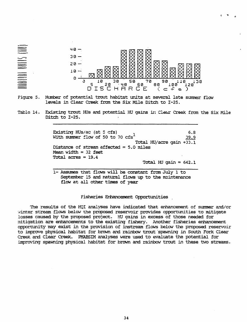
Figure 5.
Table 14.
40 ~
30 -
20 -
10 --:
0 10 30 50 70 90 110 130
5 20 '40 60 S0 1013 120 13
DISCHRRCE (C+5)
Number of potential trout habitat units at several late summer flow levels in Clear Creek from the six Mile Ditch to 1-25.
EXisting trout HUs and potential HtJ gains il: Cl=r Creek from the Six Mile Ditch to 1-25.
Existing HUs/ac (at 5 cfs) 1 6.8 With sununer :low of 50 to 70 cfs 39.9
Total HtJ/acre gain +33.1 Distance of stream affected = 5.0 miles Mean width = 32 feet TOtal acres = 19.4
TOtal HU gain = 642.1
1- Assmnes 'that flows will be constant from July 1 to September 15 and natural flows up to the reintenance flow at: all other times of year
Fisheries Enhancement Opportunities
TIle results of the HQI analyses have indicated that enhancement of smmner and/or ".vinter stream flows below the proposed reservoir provides opportUnities t:o mitigate losses caused by the proposed project. HU gains in excess of those needed for ~tigation are enhancements to the existing fishery. Another fisheries enhancement opport:unity may exist in the provision of instream flows below the proposed reservoir to in1prove physical habitat: for brown and rainbow trout 'spawning in South Fork Clear Creek and. Clear Creek. PHABSlN analyses were used to evaluate the potential for improving spawning physical habitat for brown and rainbow trout in these 'Ova streams.
34
.!'

:3ou-:.. ..... For}: Clear Creek
PHABSTI1 analyses were conducced at site SF3 to determine the relationship ::-ec·:een discharge and WUA for rainbow and bru.·.n trout spatming. ~ruA was silnulated :~r :lows ranging from 10 to 125 c:s. \'iUA fer both brm·,'l1 and rainbow trout spavming :s r.3XimiZed at a discharge of 125 cis grea~er than 125 cis (Figure 6). Flows higher ~.na'1 1~5 crs could not be accurately s~"mllated with these data. The analysis .!.ndicates that at as flo\·.'s decrease from 125 cis, tVUA for spawning for both species ':'s rapidly reduced. WUA essentially disappears for rainbow trout at discharges lO\'/er :..~ ~o cis and for brovln t:rout: at discharges less than 15 cis.
. -. - '.
- R _= :0 ;~ -. - .= .- . . - ::l ____ :-1H.· . ,- -. . 80 .:.00
- = ..
~ 8t~T _ R8T
:igure 6. Percent of maxL"7.llITt usable area (MUA) for brO"vm (BNT) and rainboVl (RBI') trout spawning at site SF3.
Although the PHABSIM analyses for tVUA for brown and ra.i.nbow trout spawning indicates that physical habita-c is maximized at 125 cis, the ral:.io of WUA to the total area in the stream reach does not differ greatly at any of the discharges silnulated. For example, at 50 cfs WUA for brown trout spawning makes up about 0.1% :>f the total area of the stream reach. At 125 cfs, \VUA for spawning makes up about :).5% of the tot:al area. ~e addition of 75 cis does not result in a substantial .=.~ge in NUA for spawning.
The reason that tVUA 1.S very low over the en-cire range cf ':2.o\-IS simulated is mat ==::a~,·.ninq subs-crate is e.>,Ire.'I'!lel'." l.:: .. ::d.ted in 't.h~s section c: Sou'C.'1 Fork Clear cree: . .;ravel substra-ces are a necess~' comp:::>nent c: trou-c spawning habitat, and this secrion of the stream is' dominated by cobble and boulder substrates. :!:t is possible :""1a'C tlle vlild fishery in this section of the scream is maintained prilnarily by . recr~ionent from other sections ef the stream or from tribucaries of the South Fork Clear Creek. Since suitable subs-crate appears ~o be the facccr limiting \VUA for spat·ming in this section of South Fork Clear Creek, enhancement of flows would do little to improve spawning \IDA for either species.
35

t ,-.
Clear Creek aoove the Buffalo Di vex:sion
FHABSlM analyses were conducted at site CCl to determine the relationship between discharge and WUA for rainbow and brown trout spawning. WUA was sirnulated for flows ranging from 30 to' 300 cfs. tVUA for both rainbow and brown trout spawning is maximized at a discharge of 300 cfs (Figure 7). Flows higher than 300 cfs could not be accurately simulated with these data. The analysis indicates that at as flows decrease from 300 cfs, WUA for spawrung is rapidly reduced for both species. This reduction is more rapid for rainbow trout.
100
90
S0
.... 0
20
0~--~~--~~~----~~--~~~~~~ 38 5'0 7'0 90 125 ! 75 250
.... 8 60 88 101a 150 208 300 DISCHRRCE (c+'s)
~8NT _ReT
:igure 7. Percent of max.inn.nn usable area (MUA) for brown trout (BNl') and rainbow trout (RBI') spawning at site CCl.
As with the ·South Fork Clear Creek site, this site is dominated by cobble and boulder substrates which are not suitable for trout spawning. As a result, WUA for spawning is extremely limited for both species at all discharges simulated. For exanple, at 80 cfs WUA for brown trout spawning is 0.04% of the total area of the stream reach. At 300 cfs, when physical habitat is maximized for both species, WlJA for brown trout spawning is 0.2% of the total area. Although the small amount of physical habitat available for both species may be intensively used, the . amolmt of suitable substrate appears to limit WUA for spawning in this section of Clear Creek. It is most likely that the majority of the recruitment for both species originates in upstream reaches of Clear creek and/or tributaries of Clear creek. Because of these factors, enhancement of. flows may do little to improve spawning WUA :md recruinnent for either species.
36

Clear cre~: below Buffalo Diversion
PHABSIM analyses were conducted at site CC2 to dete.nnine the relationship tetvleen discharoe and \UA for rainbow and brown t.~ut:. spawning. ~VUA was simulated for flot.vs ranguig frcr.1 10 to 400 cfs. ~VUA for both rainbow and brown trout spawning is maximized at:. a discharge of 200 cfs (Figure 8). '!he analysis indicates that at: as flOvlS decrease from 200 cfs, \'1UA for spawning is rapidly reduced. for both species. Reductions from the maxilm.nn wtJA for spawning for both species also occur at flows greater than 200 cfs.
o~--~~~~~~~~~~~~~~--~~-10 33 613 1013 150 200'· 300 4&30
20 "'8 79 12(:l 175 25a 350 OISC;-,FiRCC: '. ·=";s.'
EZ2J 8NT _R8T
~igure 8. Percent of maxllnum usable area (MUA) for brown trout (BNT) and rainbow trout (RBr) spawning at site CC2.
As with sites SF3 and cel, wtJA for rainbow and brown trout spawning appears to be limited by the lack of suitable spawning substrates in this section of Clear Creek. '!his site, like the others, is dominated by large cobble and boulder substrates. As a result, \VUA for spawning is low for all discharges simulate:i for both species. Therefore, ilIlprcvernent of rainbow and brown trout spawning habitat by enhancement of stream flows is not likely in this section of Clear Creek.
SUMMARY/DISCUSSION
At the ti.Tfle of t.'lls report, :nany of the project details including operational plans for each reservoir vlere unknown. As a resul t, several assumptions were made 1:0
detennine the fisheries impaccs associated with this project. Any change in these assumptions could result in changes in our findings and would involve reanalysis of our . data. Therefore, the recommendations in this report are not final and are subject to change as more detailed project infonnation becomes available. F\lture coordination between \v'WOC and ~FD is very important:. throughout the planning stages of this project.
37

'!he assumptions made in this report are:
1. All releases from the proposed reservoir will be discharged directly into the stream channel. All releases in excess of present stream flows will remain in the scream channel downstream to I-25.
2. Releases from the proposed reset:Voir will be made at a constant rate during each season. Wide fluctuations in releases could negate any HU gains that would occur from enhanced sununer stream flews.
3 • Releases from the proposed reset:Voir will not appreciably change the water temperatures in streams receiving those releases. Changes in existirx3' stream temperatures could result in different HU gains/losses.
4 • Natural stream flews up to the reccmmended maintenance flows for each stream will be maintained at all times of the year. If namral stream flows are reduced, HtJ gains described in the HQI analyses could be negated.
Electrofishing results indicated that the South Fork Clear Creek SUPpOrtS good ooculations of wild trout:. '!he two sections of Clear Creek above the Six Mile Ditcn 3150 support wild trout fisheries. Maintenance of wild trout populations is a high priori~ for the WGFD since they provide high quality fisheries with very little management ~e. Protection of these fisheries is therefore very important. Flows needed to protect these fisheries were identified with several methods
'!he Habitat Retention Method was used to provide maintenance flow reconunendations for each stream segment invcilved with the proposed project Crable 15). TIle maintenance flow is defined as a continuous flo\-1 that will maintain mini.nulm hydraulic criteria in riffle areas within a stream segment. These criteria are important at all times of year to maintain passage between different habitat types for all life stages of trout. 'lhese criteria are also important for maintaining SUl:Vival rates of fish and aquatic macro invertebrates during the winter that . approximate rates observed under natural stream flow conditions.
I.Dw flow conditions during winter months (October through March) naturally limit the survival and grcwthof many trout populations. '!he extent:. of these i.TtJpacts is dependent upon several faccors including but not lllnited to snow fall, cold int:.ensit:y and the duration of intense cold periods. 'lhese factors vary from year to year and affect fish populations depending on the amount of frazile ice ani anchor ice formation (which can plug the gills of fish), the extent of snow bank collapse (am stream damming) and increased metabolic demands on fish (ard increased stress) .
Kurtz (1980) found that the loss of winter habitat due to low flow conditions ',-laS an important factor affecting mortality rates of trout in the upper Green River, ',-lith mortality approaching 90% during some years. Needham et ale (1945) document:ed average overwinter brown trout mortality of 60% and extremes as high as 80% in a califo:rnia stream. Butler (1979) re};X)rted significant trout and aquatic insect losses caused by anchor ice fonnation. Reimers (1957) considered anchor ice, collapsing snow banks and fluctuating flews resul ting from the pericxtic fonnation and breakup of ice dams as the primary causes of win1:er trout mortality.
1he causes of winter nortality discussed above are all greatly influenced by the quant:ity of winter flow in tenns of its ability to minimize anchor ice fonnation
38
(increased velocity and temperature loading) and dilute and prevent snow bank cOllaoses and ice dam format:ion respeccively. Any reduction of na'tllral winter stream flows· would increase trout: morcality and effectively reduce the number of fish that the stream could supp::>rt. 'Iherefore prot:.ect:ion of natural winter stream flows up t:o the recommended maintenance flow for each stream segment is necessary to maintain existing sw::vi val rates of trout populations. Failure to maintain natural stream :lows .uP to the recommended maintenance flows for each stream will negate HU gains resulting from enhanced summer flows. In addition, HQI analyses have shown that enhancement of winter flows can actually increase HU gains by causing reductions in the annual variation of stream flows.
Table 15. SummaJ:Y of maintenance flow recornrnenciations derived from the Habitat Retention Method for the st:.ream segments affected by the proposed proj ect. These flows apply to all times of the year except men higher flows are required to meet other fishery management objectives.
Stream segment Maintenance Flow ( cfs)
South Fork Clear creek below the proposed dam 6.8
Clear creek above the Buffalo diversion 7.9
Clear Creek below the Buffalo diversion 23.6
'!he HQI model was used to detennine the number of trout HUs that will be lost in Sourdough Creek and South Fork Clear Creek as a result of inuniation of portions of those streams by the proposed resel:Voir. '!he total number of trout HUs lost in these streams is 186 HUs. In accordance with the rK;FD mitigation policy, these habitat losses should be mitigated in a manner that results in no net loss in habitat value \vhile minimizing loss of in-kind habitat value.
Results from additional HQI studies in South Fork Clear creek and Clear Creek ':lere used to evaluate the potential for mitigating habitat losses resulting from this 9roject:. Base:i on these st:Udies, HU losses in Sourdough creek and South Fork Clear Creek can l:e mitigated by HU gains in South Fork Clear Creek and in Clear creek.:he actUal ntnnber of HUs gained in these sueamS depends on the "timing and amount:.S of ','later released from the proposed reservoir (Table 16).
Existing mean summer flows in South Fork Clear Creek approxiInate 10 cfs. If a constant release of 20 cfs is made from the proposed reservoir during the July 1 to Sept:ember 15 peria::l and existin:j winter flows remain tUlchanged, this would increase st.mrmer flows in the downstream sections of South Fork Clear creek and Clear Creek by 10 cfs over existing conditions. A discharge of 20 cfs would rnaxi:mize the number of HUs in South Fork Clear Creek and would result in a total HU gain in these streams of 227 HUs, which would totall v ~i tioate the loss of 186 HUs that will cx:cur when the reservoir is bull t. HU gains _.' -both or these stream sections would be lower than 227 HUs if summer releases are lower than 20 cfs. '!here would be no change in HUs in South Fork Clear creek at stmaner flows of between 25 and. 35 cfs, and HU losses would occur in South Fork Clear creek if releases are greater than 35 cfs.
A const:ant release of 55 cfs during the Sl.lIlUl\e.I" (July 1 to September 15) from the proposed reservoir would have the effect of increasing summer stream flows by about
39
45 cfs in the downstream secrions of South Fork Clear CreeJe and Clear Creek. '!his increase would result in an HU gain of 642 HUs in Clear creek between the Six Mile Ditch and 1-25. Although a discharge of 55 cfs maxiJnizes HUs in this portion of Clear creek, this increase in discharge would have detrilnental effects on other portions of Clear Creek and South Fork Clear Creek. '!he result of these increased summer releases would be the net loss of 645 HUs in addition to the 186 HUs lost due t:J inundation by the proposed resenroir (Table. 16) .
Winter stream flows are commonly very law in Clear creek and this factor partially limits the number of HUs the stream can support. If a constant winter release (from September 16 to March 31) of 6 cfs is made from the proposed resm:voir, HU gains are realized even when summer stream flows remain unchanged from present conditions. This increase in winter flows would not affect HUs in South Fork Clear Creek and in Clear Creek below the six Mile Ditch, since this flow would not significantly change annual stream flow variation .in either section.
However, in both sections of Clear Creek abcwe the six r-tile Ditch, a winter flow of 6 cfs would increase HUs by over 1,500 HUs. If, in addition to winter releases of 15 cfs, sunnner flows are increased 10 cfs over existing conditions (with a release of :~ cfs at the dam), an additional 227 If~.: gain will be realized (Table 16).
Table 16. Summary of HU gains and losses due to enhanced stream flows resulting from the proposed water project. 'Ibis analysis includes the assumption that reservoir' releases will be made at a constant rate during the period of July 1 to September 15, that stream temperatures will not change appreciably, and that natural flows up to the recommended maintenance flow are mainta.ined at all other times of the year.
SUmmer Summer winter Release ~ winter Release ~ Release 1 Release 6 cfs; SUmmer 1 6 cfs; Summer 1
Stream of 20 cfs of 55 !=fs1 Release of 10 cfs Release of 20 cfs
Reservoir Site - 186 HUs - 186 HUs - 186 HUs - 186 HUs
South Fork Clear Creek + 128 HUs - 299 HUs 0 + 128 HUs
Clear creek above Buffalo diversion 0 - 400 HUs + 1,043 HUs + 1,043 HUs
Clear creek below 0 - 588 HUs + 484 HUs + 484 HUs Buffalo diversion
Clear creek from + 99 HUs + 642 HUs 0 + 99 HUs Six Mile Ditch to 1-25
Net HU + 41 - 831 ~ 1,341 "t" 1,568 HUs Gains/LDsses
1 - Assmnes that releases are allowed to reach I-25 and no ttanSportation losses.
40
, ,.. .~
A fishery nri.ninturn p:x:>l of 754.2 acre-feet will be adequate to protect a reservoir fishery from excessive drawdowns and is an appropriate feature for t."e proposed project. Based on calculations of potential trout biomass of the. proposed reservoir \'lith and without: stocking, the reservoir would support between 658 and 2, 734 angler-ciays per year. '!his assumes that the resenroir fluctuates between the reccmme.nded mininrum pool level and the nomal high water level each year. Analysis of the. operational plans for the proposed reservoir may change these estimates.
Imorovement of WUA for rainbow and brown trout spawning in South Fork Clear creek ailCl Clear creek by enhancing stream flows in the spring and fall does not appear to be possible. Olanges in stream flows do not appear to have much of an impact on WUA for spavming for either species, probably due to the lack of suitable spawning substl.-ates in these stream segments. 'Ihe PHABSIM analysis for South Fork Clear Creek indicates that WUA for rainbow trout spawning is essentially zero at discharges of less than 40 cfs. 'Iherefore, a discharge of 40 cfs during the rainbow trout spavming period (April 1 to June 30) will maintain the existing level of WUA for rainbow trout in South Fork Clear Creek. Similarly, WUA for brown trout: spavming approaches zero at flows less than 15 cfs. A discharge of 15 cfs during me brown troUt spawning period (Oct. 1 to Nov. 30) will therefore maintain existing levels of brown trout spawning in South Fork Clear creek. 'lhese releases will also be adequate to maint:ain existing levels of rainbow and brown trout spawning in Clear creek above the six Mile Ditch.
RECDMMENDATIONS
1. To protect natural stream flows up to the fisheries maintenance flows identified in Table 15, a year-round release of 6.8 cfs into South Fork Clear creek should be made except during t:ilres when higher flows are required to meet other fishery management objectives and mitigation
. requirements. \~en natural stream flows into the rese:rvoir from all sources are below 6.8 cfs, the amount of those natural flows should be released. By meeting the recommended maintenance flow in South Fork Clear Creek, maintenance flows recommended for the two Clear Creek sites will also be sat:isfied.
2. To mitigat:e stream HU losses due to inundation by the proposed reservoir, ... constant release of 20 cfs from, the proposed. reseJ:Voir during the summer (July 1 to September 15) is reccmmended. '!his release rate will increase summer stream flows in South Fork Clear Creek. arxi Clear Creek by 10 cfs over existing corxlitions, and will increase HUs by 227. 'Ihese gains will mitigate the 186 HUs lost due to reservoir construction. However, this increased stream flow must be allowed to pass to 1-25 for the HU gain to be realized.
3. When natural winter stream flaNS are below 6 cfs, augmentation of winter flows with releases of 6 cfs (from September 16 to March 31) from the proposed reservoir represent an additional fisheries enhancement opporcunity. If allowed to pass down Clear Creek to 1-25, these releases could increase HUs in Clear Creek above the Buffalo diversion by over 1,500 HOs. The net effect, considering HU losses at the reservoir site, ~'Jould be 1,341 HUs.
41

· "'t •
6.
I •
8.
9.
10.
11.
12.
13.
WGFD recommends a minimum pool of 754.2 acre-feet for fisheries enhancement:. We also request the opportunity to participate in the design of fish habitat struct:ureS in the reser/air that could be installed during the construction phase of this project. '!bese struct:ureS include, but are not limited to, placement: of boulders in the reservoir, leaving scattered timber in areas that will be inundated, and developing an irregularly shaped shoreline.
We recommend that a reseIVoir tenperature mcx:ieling study be conducted for the proposed reseIVoir. Feasibility studies should include consideration of penstocks capable of maintaining the temperature of releases between 51 and 70F.
Opportunities to improve physical habitat for rainbow and brown trout in South Fork Clear creek and Clear Creek by enhancing stream flows do not exist. To maintain existing levels of rainbow trout spawning in both streams, a continuous release of 40 cfs should be made from April 1 to June 30. To maintain existing levels of brown trout spawning, a continuous release of 15 cfs should be made from October 1 to November 30.
We recommend that reser/air releases be stepped up and down in stages to avoid releases of large pulses of water. The WGFD should be consulted regarding the rate at which releases are stepped up and down.
We reccmmend that a boat ramp be built to the minimum pool elevation as a project feature. We further recommend the project include development of a public access road and public parking area in conjunct"ion with the boat ramp.
We reccmmend that public access be made available, as a project feature to the entire shoreline of the reservoir, except in areas considered hazardous to public safety.
The large vertical drop in water level from the normal high water line to the recommended minimum pool elevation could limit access to the reservoir during drawdown. tve therefore recommend the stabilization of areas of the shoreline between the normal high \\rater line and the rninimtnn pool to allow access to the reservoir by bank fishermen during reservoir drawdown.
Additional project details, including reservoir operations schedules and results of the temperature modeling study should be made available to WGFD as they became available.
We recc:mu.tend that WWOC develop a detailed mitigation plan prior to proj ect authorization and construction that is accepted by w:;m and USFWS. '!he plan should include mitigation of construction and other impacts as well as habitat losses from project exiStence and operation, and should be included as part of the 404 permit application for the proj act.
We request the opportunity to review constnlction plans so that impacts due to project construction can be avoided or quantified. Should final project plans differ from those assumed in this report, reanalysis of the data will be necessary and recommendations in "this report may ~e.
42

Annear, T. C. am A. L. Conder. 1983. Relative bias of several fisheries instream flow rne'thods. North American Journal of Fisheries Management 4:531-539.
Binns, 11. am F. Eiseman. 1979. Quantification of fluvial trout habitat in Wyoming. ~ctions of the American Fisheries society 108: 215-228.
Bovee, K. and R. Milhous. 1978. Hydraulic simulation in instream flow studies: theory arx:l technique. Instream Flow Infonnation Paper 5, FWS/OBS-78/33, cooperative Instream Flow Service Group, U.S. Fish and Wildlife Sel:Vice. Fort Collins, Colorado.
Butler, R. 1979. Anchor ice, its fonnation am effects on aquatic life. Science in Agriculture, Vol XXVI, Number 2, Winter, 1979.
Conder, A.L. arx:i T.C. Annear. 1987. Test of weighted usable area estimates derived from a FHABSIM mcxiel for instream flow studies on trout streams. North American Jomnal of Fisheries Management. 7 (3) :339~350.
facciani, S. 1976. The morphoedaphic index, a fish yield estimator, as demonstrate:i by purse-seine catches in Wyoming, Appenclix VIII. In Binns, N.A. 1976. Evaluation of habitat quality in Wyoming trout streams. Annual Meeting of the American Fisheries Society, Cearbom, MI September 20, 1976. 33 pp.
Kurtz, J. 1980. Fishery management investigations - a study of the upper Green River fishery, Sublette County, Wyoming (1975 .... 1979). Completion Report. Wyoming Game and Fish Depart:Inent, Fish Division, Cbeyerme.
Milhous, R. T., D. L. Wegner, am T. Waddle. 1984. User's guide to the Physical Habitat Simulation System. Instream Flow Paper 11, FWS/OBS-81/43, U.S. Fish and ~-1ildlife Senrice, Fort Collins, Colorado.
r1ilhous, R. T • 1984. PHABSlM technical notes. Unpublished. U • s. Fish and Wildlife Service, Fort Collins, Colorado.
:·1ilhous, R. T. 1978. A computer program for the determination of average hydraulic and shape parameters of a stream cross sect:ion. ~oJashington State Dept of Ecology, Olympia.
Needham, P., J. Moffett, and D. Slater. 1945. populations in convict Creek, California. 9(1):9-25. .
Fluctuations in wild brown trout Journal of Wildlife Management
Nehring, R. 1979. Evaluation of instream flow methods and determination of water quantity needs for streams in the state of Colorado. Colorado Division of \\7ildlife, Fort Collins.
Reimers, N. 1957. Some aspects of the relation be1:Ween stream foods and trout survival. california Fish and Game 43(1) :43-69.
43

Ryde~. R.A. 1965. A memod of est:.ima-cing. the pot:en-cial fish prcducticn of north-t:.emperat:.e lakes. Transact:ions of the Amer~can Fisheries Society. 94:214-218.
~iPPlll, C. 1958. ?1anagemen't. •
The removal methc:x:i of populat:.ion estilnat:.icn. 22(1):82-90.
44
Joumal of \'Jildlife

. '. ;~
.:'.:,. .. -' ..
,4. _ •• '_ • .,..
.,.'.' ....
~': ·.r.~.
:,.)
. :, ... "
"I
~ :.: ..
' .....
,: ,':.;' .. ' r~ :.-. : .. -,'
" :::: ....... . "·1
_ .. : .. f ,,"
. -. . -
.~l.,
J
",
. ' .a.
=-.--:".'
: -:-.
APPENDIX
: ::-:..; ......... ,
,:.(
45
.,
.~ ' ..
! .
. ~.'. '. ,.
.. '.'
2
.,:::
••• •• i ,' •
... :. ~ .
_ ,I. '.6 ... ~. ' ...._. •
-::' '
","; ... ; . \.
, ~ .. " ..... '. '." " ,-t.';
.. :~ : t.
: .. :;., .
. :..:' ...... ,-., ... ,
' .... ::~. .,-
. ~ -' "
u ;-',:: •.•
..".' .;-",
~ ..
r .. ••• .- .-• '.,' "
'1 .. : '-
':-':' .. -. 'j., ,-,

December 15, 1992
Mr. Nels Lofgren, Mayor city of Buffalo 46 North Main Buffalo, Wyoming 82834
DRAFT
RE: Fish & Wildlife Coordination Act - Mitigation Plan - Tie Hack Dam.
Dear Nels:
As you may know, the city contacted the Wyoming Game and Fish Department and the US Fish and Wildlife Service on August 18, 1992 to assist the city in developing a Project Mitigation Plan as required under the Fish and Wildlife Coordination Act. As a result we met with WGFD and USFWS personnel on November 2, 1992 to discuss previous studies which had been completed by the WGFD concerning fisheries and terrestrial impacts and mitigation. The primary purpose for this meeting was to determine if the previous investigations would be adequate to serve as the basis for the Mitigation Plan or if additional studies would be required. It was the consensus at this meeting that the previous studies shou~d be sufficient.
In a study completed by the WGFD in January, 1989, it was determined that a total of 4 acres cf wetlands would be affected and a total of 23.7 acres of riparian habitat would be impacted by reservoir construction. The report went on to recommend that a mitigation site should contain approximately 7% of willow/wet meadow, 13% of bottomland grassland with the balance in native riparian vegetation. It was further recommended that the mitigation should be accomplished adjacent to the impacted site preferably along sourdough Creek immediately upstream from the high water line of the reservoir.
It was agreed at the 11-2-92 meeting that it would be best if we could mitigate on-site and that building small dikes at the upstream portions of the reservoir miqht be suitable for mitigation of the impacted veqetation. This will be confi=med during the 1993 field season and discussed with USFS personnel concerning the ability to mitigate on-site.
concerning fishery maintenance flows, SWWRC has met on numerous occasions with WGFD personnel regarding those minimum flows which
46

the project could provide without severely impacting the total storage requirement and available water supplies. The following main-r.enance and minimum flows have been agreed to with Fish Division personnel and the reservoi= operation hydrologic model reflects these flows:
Location Minimum Maintenance Flows
Below the Dam & Reservoir Above the city's Existing Diversion
6.B cfs 7.9 cfs
Guaranteed Minimum Flows
Below the City's Existing Diversion 6.0 cfs
If you or Ken should have any questions regarding this information, please contact me.
Sincerely,
Michael T. O'Grady, Vice President
cc: Ken Gross, City of Buffalo Steve Tessman, WGFD Tom Annear, WGFD Art Anderson, USFWS steve Brockman, USFWS Paul Beels, USFS
47