yavatmal district at a glance - welcome to...
TRANSCRIPT
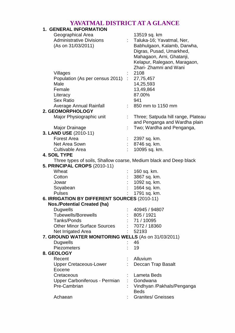
YAVATMAL DISTRICT AT A GLANCE 1. GENERAL INFORMATION Geographical Area 13519 sq. km Administrative Divisions
(As on 31/03/2011) : Taluka-16; Yavatmal, Ner,
Babhulgaon, Kalamb, Darwha, Digras, Pusad, Umarkhed, Mahagaon, Arni, Ghatanji, Kelapur, Ralegaon, Maragaon, Zhari- Zhamni and Wani
Villages : 2108 Population (As per census 2011) : 27,75,457 Male 14,25,593 Female 13,49,864 Literacy 87.00% Sex Ratio 941 Average Annual Rainfall : 850 mm to 1150 mm 2. GEOMORPHOLOGY Major Physiographic unit : Three; Satpuda hill range, Plateau
and Penganga and Wardha plain Major Drainage : Two; Wardha and Penganga, 3. LAND USE (2010-11) Forest Area : 2397 sq. km. Net Area Sown : 8746 sq. km. Cultivable Area : 10095 sq. km. 4. SOIL TYPE Three types of soils, Shallow coarse, Medium black and Deep black 5. PRINCIPAL CROPS (2010-11) Wheat : 160 sq. km. Cotton : 3867 sq. km. Jowar : 1092 sq. km. Soyabean : 1664 sq. km. Pulses : 1791 sq. km. 6. IRRIGATION BY DIFFERENT SOURCES (2010-11)
Nos./Potential Created (ha) Dugwells : 40945 / 94807 Tubewells/Borewells : 805 / 1921 Tanks/Ponds : 71 / 10095 Other Minor Surface Sources : 7072 / 18360 Net Irrigated Area : 52193 7. GROUND WATER MONITORING WELLS (As on 31/03/2011) Dugwells : 46 Piezometers : 19 8. GEOLOGY Recent : Alluvium Upper Cretaceous-Lower
Eocene : Deccan Trap Basalt
Cretaceous : Lameta Beds Upper Carboniferous - Permian : Gondwana Pre-Cambrian : Vindhyan /Pakhals/Penganga
Beds Achaean : Granites/ Gneisses
ii
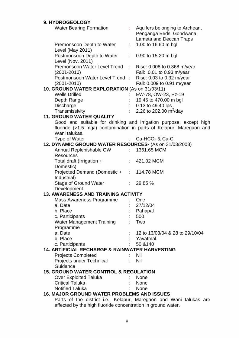
9. HYDROGEOLOGY Water Bearing Formation : Aquifers belonging to Archean,
Penganga Beds, Gondwana, Lameta and Deccan Traps
Premonsoon Depth to Water Level (May 2011)
: 1.00 to 16.60 m bgl
Postmonsoon Depth to Water Level (Nov. 2011)
: 0.90 to 15.20 m bgl
Premonsoon Water Level Trend (2001-2010)
: Rise: 0.008 to 0.368 m/year Fall: 0.01 to 0.93 m/year
Postmonsoon Water Level Trend (2001-2010)
: Rise: 0.03 to 0.32 m/year Fall: 0.009 to 0.91 m/year
10. GROUND WATER EXPLORATION (As on 31/03/11) Wells Drilled : EW-78, OW-23, Pz-19 Depth Range : 19.45 to 470.00 m bgl Discharge : 0.13 to 49.40 lps Transmissivity : 2.26 to 202.00 m2/day 11. GROUND WATER QUALITY Good and suitable for drinking and irrigation purpose, except high
fluoride (>1.5 mg/l) contamination in parts of Kelapur, Maregaon and Wani talukas.
Type of Water : Ca-HCO3 & Ca-Cl 12. DYNAMIC GROUND WATER RESOURCES- (As on 31/03/2008) Annual Replenishable GW
Resources : 1361.65 MCM
Total draft (Irrigation + Domestic)
: 421.02 MCM
Projected Demand (Domestic + Industrial)
: 114.78 MCM
Stage of Ground Water Development
: 29.85 %
13. AWARENESS AND TRAINING ACTIVITY Mass Awareness Programme : One a. Date : 27/12/04 b. Place : Pahapal c. Participants : 500 Water Management Training
Programme : Two
a. Date : 12 to 13/03/04 & 28 to 29/10/04 b. Place : Yavatmal. c. Participants : 50 &140 14. ARTIFICIAL RECHARGE & RAINWATER HARVESTING Projects Completed : Nil Projects under Technical
Guidance : Nil
15. GROUND WATER CONTROL & REGULATION Over Exploited Taluka : None Critical Taluka : None Notified Taluka : None 16. MAJOR GROUND WATER PROBLEMS AND ISSUES Parts of the district i.e., Kelapur, Maregaon and Wani talukas are
affected by the high fluoride concentration in ground water.

Ground Water Information
Yavatmal District
Contents 1.0 Introduction ...................................................................................... 1
2.0 Climate and Rainfall ........................................................................ 4
3.0 Geomorphology and Soil Types ...................................................... 5
4.0 Ground Water Scenario ................................................................... 6 4.1 Hydrogeology...................................................................................................... 6
4.2 Ground Water Resources ................................................................................ 12
4.3 Ground Water Quality .................................................................................... 16
4.4 Status of Ground Water Development ........................................................... 18
5.0 Ground Water Management Strategy .......................................... 18 5.1 Ground Water Development ........................................................................... 18
5.2 Water Conservation and Artificial Recharge................................................ 20
6.0 Ground Water Related Issues and Problems............................... 21
7.0 Mass Awareness and Training Activities ...................................... 22 7.1 M.A.P. and W.M.T.P. ...................................................................................... 22
7.2 Participation in Exhibition, Mela, Fair etc. ................................................... 22
8.0 Areas Notified by CGWA/SGWA ................................................. 22
9.0 Recommendations .......................................................................... 22
List of Figures 1. Location 2. Hydrogeology 3. Depth to Water Level (Premonsoon May-2011) 4. Depth to Water Level (Postmonsoon Nov.-2011) 5. Ground Water Resources 6. Yield Potential
List of Tables 1. Studies undertaken by CGWB. 2. Salient Features of Ground Water Exploration. 3. Annual Rainfall Data (2002-2011). 4. Water Level Data (2011) with Long Term Trend (2000-2009). 5. Taluka wise Ground Water Resources (March 2008). 6. Chemical analysis results of Yavatmal district (May-2010) 7. Classification of Ground Water Samples based on BIS Drinking
Water Standards (IS-10500-91, Revised 2003). 8. Classification of Ground Water for Irrigation based on SAR and
RSC. 9. Nature and Yield Potential of Aquifers. 10. Status of MAP and WMTP.

Ground Water Information
Yavatmal District 1.0 Introduction
Yavatmal district is one of the eleven districts of Vidarbha Region of
Maharashtra. It is bounded on east by Chandrapur district, on south by
Andhra Pradesh State and Nanded district on west by Washim and Hingoli
districts and on north by Amravati and Wardha districts. Wardha River forms
the northeastern boundary of the district. The district lies between 19°26’ and
20°42’ north latitudes and 77°18’ and 79°9’ east longitudes. It falls in parts of
the Survey of India Toposheets No. 55L, 55I, 56E, 56I, 56M, covering 13519
sq.km, area.
The district headquarters is located at Yavatmal Town. For
administrative convenience, the district is divided in 16 talukas viz. Yavatmal,
Wani, Maregaon, Pandharkawda, Ghatanji, Ralegaon, Babulgaon, Kalamb,
Darwha, Ner, Digras, Pusad, Mahagaon, Umarkhed, Zhari Zhamni and Arni. It
has a total population of 27,75,457 as per 2011 census. The district has 13
towns and 2108 villages. The district is well drained by Wardha and
Penganga rivers and their tributaries.
Central Ground Water Board has taken up several studies in the district.
A list of studies conducted in the district is presented in Table-1.
Table 1: Studies undertaken by CGWB.
S. No.
Officer AAP Type of Survey/Study
1. S/Shri V.V. Sable K.R. Shrinivasan
1967-68 Systematic Hydrogeological Survey
2. Shri V.A. Totre 1970-71 -do-
3. Shri V.V. Sable 1971-72 -do-
4. Shri V.V.S. Mani 1972-73 -do-
5. S/Shri A.B. Deshmukh, J.N. Rai and Miss P. Tripathi
1975-76 -do-
6. Shri N. Somasundaram 1981-82 -do-
7. Dr. J. N. Rai 1981-82 -do-
8. Shri S Sudarshana 1986-87 Reappraisal Hydrogeological Studies
9. Shri S.K. Jain 1992-93 -do-
10. Shri G Sudarshan 1992-93 -do-
11. Shri D. Venkateshwaran 1993-94 -do-
12. Shri S.Sudarshana 1993-94 -do-

2
13. Shri D.Y. Sirsikar 1994-95 -do-
14. Sh. B. R. Lamsoge 2005-06 -do-
15. Sh D. N. Mandal 2005-06 -do-
16. Sh P. Madhnure 2005-06 -do-
17. Sh B. N. Warke 2005-06 -do-
To explore the ground water potential and aquifer properties,
exploratory drilling was undertaken by the department during the year 1984
and the drilling programme was completed in the year 1995. Under this
programme 78 Exploratory Wells (EW), 23 Observation Wells (OW), and 12
Piezometers (PZ) were constructed. The details of ground water exploration
are presented in Table 2
Table 2: Salient Features of Ground Water Exploration.
S. No.
Taluka Formation /Aquifer
Wells Depth (mbgl)
SWL (mbgl)
Discharge (lps)
Zones (mbgl) E
W OW
PZ
1. Arni Basalt 1 – 2 30.00– 200.00
46.50–68.00
0.38 6.0-158.0
2. Babul- gaon
Basalt 3 1 1 30.00–128.10
5.45– 7.65
0.14–3.17 –
Sandstone 1 – – 85.40 – – –
3. Darwah Basalt 2 – 1 30.00– 201.30
3.45 0.14 –
4. Digras Basalt 4 – – 189.10– 201.30
2.70– 30.07
0.60 –
5. Ghatanji Basalt 3 – – 173.70–201.30
30.07 0.60– 3.77 46.0-87.0
Sandstone 1 1 – 201.30 4.00–4.75
1.37– 7.37 –
6. Jhari- Jhamni
Basalt 1 2 – 77.00– 190.55
6.43–6.50
12.18– 14.88
12.0-77.0
7. Kalamb Basalt 1 – 1 30.00–103.70
– – –
8. Kelapur Basalt 3 3 2 30.00–152.50
5.70–50.00
3.77–19.66 27.0-130.0
Limestone 1 – – 201.30 – 1.37 9.0-80.0
9. Maha- gaon
Basalt 3 1 – 123.25–200.00
1.90–9.80
1.05–7.76 10.0-138.5
10. Maregaon
Basalt 1 1 – 46.95– 48.00
13.36– 14.00
5.94– 14.50
40.8-87.0
Sandstone 1 – – 86.25 2.54 1.37 8.0-19.6
11. Ner Basalt 5 2 1 19.45– 201.30
2.20– 3.38
0.14– 17.90
–
12. Pusad Basalt 4 – – 201.30 3.00–23.80
0.14– 1.73 6.0-119.0

3
13. Ralegaon Basalt 1 1 – 130.0–158.0
– 3.17–7.76 15.0-75.0
Limestone 1 – – 201.30 – 1.05 136.0-140.0
14. Umarkhed Basalt 4 3 – 79.00–201.30
1.55–10.46
1.73–49.40 4.0-138.0
15. Wani Sandstone 31 7 4 31.80– 470.00
0.50– 19.00
0.13– 11.60
10.0-470.0
16. Yavatmal Basalt 4 1 – 103.70– 201.30
3.20– 64.00
0.38– 10.98
–
Sandstone 2 – – 34.30–43.95
6.85–7.39
1.37 24.0
Total 78 23 12 19.45–470.00
0.50–68.00
0.13–49.40 10.00-470.00
Ground Water exploration was aimed at delineating the productive
aquifers and ground water worthy areas down to the target depth of 470
metres below ground level (m bgl) in unconsolidated formations and up to 201
m bgl in consolidated formations. The yield ranges from 0.4 litres per second
(lps) to 8 lps for a maximum drawdown of 30 m in unconsolidated formations
and 0.14 lps to 49.48 lps for a maximum draw down of 49 m in consolidated
formation. Productive zones in Basalt are observed down to 138 m bgl,
whereas in Sandstone they are observed even down to 470 m bgl.
A map of the district showing the taluka boundaries, physical features
and location of exploratory and monitoring wells is presented as Figure-1.

4
Figure 1: Location
2.0 Climate and Rainfall
The Climate of the district is characterised by a hot summer and general
dryness throughout the year except during the south-west monsoon season,
i.e., June to September. The temperature rises rapidly after February till May,
which is the hottest month of the year. The mean daily maximum temperature
during May is 41.8°C and the mean daily minimum temperature during
December is 15.1°C
The normal annual rainfall varies from about 850 to 1150 mm and it
increases from NW to SE direction in the district and reaches maximum
around Pandharkawada. The average annual rainfall for the last ten years
2002-2011 ranges from 527.87 mm (Arni) to 985.35 mm (Ralegaon) and the
same is presented in Table-3. It is observed that the rainfall has decreased
during the last 10 years period.

5
Table 3: Annual Rainfall Data (2002-2011). (mm)
Taluka 2002 2003 2004 2005 2006 2007 2008 2009 2010 2011 Average
Yavatmal 1110.40 563.80 661.85 828.40 1288.30 865.86 684.00 540.20 1106.00 845.2 849.40
Babulgaon 761.00 762.00 462.00 612.00 897.30 772.00 456.54 438.50 1013.00 750.1 692.44
Kalamb 1212.00 1218.00 388.12 844.00 1336.00 888.10 483.00 338.40 841.00 578.3 812.69
Darwah 1063.00 594.00 423.66 522.00 1161.40 803.52 569.72 456.80 1209.50 701.4 750.50
Digras 986.30 472.00 462.00 656.00 1253.00 790.00 528.11 738.70 1246.00 864 799.61
Arni 939.00 408.00 282.05 402.00 736.60 468.05 495.00 342.10 708.50 497.4 527.87
Ner 424.00 345.00 329.00 361.00 1051.40 697.00 568.20 481.20 1109.00 911 627.68
Pusad 1325.10 734.80 477.74 687.00 1177.80 673.68 885.40 618.10 1335.80 818 873.34
Umarkhed 647.40 816.30 357.22 512.00 916.50 686.00 570.62 667.30 792.50 865 683.08
Mohagaon 1132.90 1081.00 463.48 1131.00 1051.50 932.50 690.61 638.00 1137.00 839.4 909.74
Wani 658.00 632.90 592.25 697.40 1173.90 958.50 850.80 566.00 1537.00 793 845.97
Maregaon 570.00 496.00 327.04 412.30 1257.00 1197.00 1207.18 631.00 1638.00 1062 879.75
Jhari Jamni 573.00 336.00 323.51 387.00 748.80 525.60 584.40 389.70 879.00 539 528.60
Kelapur 1053.00 742.00 830.00 624.00 1029.90 1007.02 631.13 725.50 1187.00 839.3 866.88
Ghatanji 1114.00 1130.00 438.00 712.00 1402.00 1027.00 853.00 547.20 541.00 774 853.82
Ralegaon 1044.00 1130.00 438.00 712.00 1263.10 1108.00 997.20 829.20 1472.00 860 985.35
District Avg. 913.3 716.36 453.5 631.3 1109 837.5 690.9 559.2 1109.5 783.59 780.41
3.0 Geomorphology and Soil Types
The northern fringe of the district is hilly and forms part of Satpura
range. South of these hill ranges, covering almost entire north-central parts,
constitutes the Alluvial plain. Southern part of the district is characterized by
hilly rugged terrain as a part of Deccan Plateau. Purna is the main river
flowing through the district. Other important rivers are Man, Murna and Kate.
Three types of soils are observed in the district i.e., (a) The shallow
coarse soil which is reddish brown and brownish in colour, occurring in
general at higher elevations along the ridges and also at the foothills zone of
the major hills (b) The medium black soil is developed along the tributary
drainage’s and also along the intermediate gradient area. (c) The deep black
soil, which is developed along the lower reaches of Wardha and Penganga
riverbeds. They differ from medium black soil in depth and fertility.
The soils in the district are slightly alkaline, clayey loamy in texture and
contain calcium carbonate.

6
4.0 Ground Water Scenario
4.1 Hydrogeology
Deccan Trap Basalt is the predominant water bearing formation,
followed by Gondwana formation having Sandstone and Shale sequence.
Penganga and Quaternary Alluvium aquifers are spread in limited areas.
Archean aquifers are limited and have less significance in the area. A map
depicting the hydrogeological features is shown in Figure-2.
Figure 2: Hydrogeology
4.1.1 Archean
Achaeans, which comprise granites, granitic gneisses and schists occur
in Umarkhed taluka. These rocks as such have limited ground water
potential. In these rocks only weathered portions and jointed zones possess
water-bearing capacity and ground water occurs under unconfined condition
in the area.

7
4.1.2 Vindhyan
In Vindhyans, Limestones are water bearing formation while Sandstone,
due to their hard and compact nature, have poor ground water potential and
occur in southeastern peripheral parts of Wani taluka. The limestones as
such are massive but wherever they are cavernous they are capable of
holding water. The ground water occurs under unconfined condition in the
area.
4.1.3 Gondwana
The Gondwana consists of Kamthi and Barakar Sandstone and Shale
and occupy north-south extending elongated stretch in parts of Maregaon and
Wani talukas. Sandstone is usually friable and possesses primary porosity
due to its granular nature. They are most productive water bearing formations
in the district. The ground water occurs under semi confined to confined
conditions in the area and water bearing zones have been encountered down
to depth of 470 m.
4.1.4 Deccan Trap Basalt
Deccan Trap Basalt is widely spread and forms important water bearing
formation, which occupies almost entire district except south eastern part. On
the whole, Deccan Trap Basalt exhibits a multi aquifer system. Based on the
lithologs of 51 exploratory wells and Piezometers, it is observed that
weathered Vesicular Basalt mainly forms the predominant shallow aquifer
down to the depth of 20 m bgl. Massive Basalt is also encountered at the top
thereby forming poor yielding aquifer and also restricting the ground water
recharge to the underlying porous Vesicular Basalt. Fractured Basalt is also
observed in certain places with limited to significant thickness. In Deccan Trap
Basalt phreatic aquifer generally occurs down to 25 m, however, fracture
zones have occurred within 80 m range except at few places where it occurs
down to 158 m also.
4.1.5 Alluvium
Alluvium occurs in patches along the banks of Wardha and Penganga
rivers and their major tributaries and consists of clay and silt with lenticular
bodies of sand and gravel. In Ralegaon area, it is observed that sand zones
are found in the depth range of 20-25 m bgl, while the top 15-16 m is full of
clay and silt. Ground water in Alluvium occurs both under unconfined and

8
semi-confined conditions.
4.1.6 Water Level Scenario
Central Ground Water Board periodically monitors 74 National
Hydrograph Network Stations (NHNS) stations in the Yavatmal district, four
times a year i.e. in January, May (Premonsoon), August and November
(Postmonsoon). The data on premonsoon and postmonsoon water levels
along with fluctuation during 2011 and long term water level trends (2001-
2010) are given in Table- 4.
Table 4: Water Level Data (2011) with Long Term Trend (2001-2010).
Sl. No.
Location Pre-monsoon
(m.bgl)
Post-monsoon
(m.bgl)
Fluctuation (m)
Premonsoon Trend (m/yr)
Postmonsoon Trend (m/yr)
Rise Fall Rise Fall
1 Pahur2 3.5 2.4 1.1 - - - -
2 Bori (Arab) 14.2 12.5 1.7 - - - -
3 Arni2 6 4.2 1.8 0.1447 - - 0.2370
4 Sakhra (P1) 8.92 11.1 -2.18 - 0.0769 - 0.1105
5 Sakhra (WT) - 6.2 - - 0.4263 - 0.2084
6 Punwat 2.7 1.8 0.9 0.3681 - 0.1518 -
7 New Waghdara 16.6 15.2 1.4 - - - -
8 Marwadi Khurd 6.1 1.5 4.6 0.1118 - 0.0521 -
9 Ladkhed 8.4 - - 0.0243 - - 0.3148
10 Parwa 3.5 2.5 1 - 0.1994 0.1620 -
11 Mohgaon Kasba 6.2 3.8 2.4 0.0974 - - 0.0214
12 Mahagaon 3.6 2.6 1 0.3484 - - 0.0509
13 Lonbhel 6.7 1.45 5.25 - 0.1375 - 0.0243
14 Pusad 5.2 4.1 1.1 - 0.2187 - 0.0992
15 Pahur 5.1 2.1 3 0.0219 - - 0.0644
16 Mardi 6.1 3.4 2.7 - 0.0406 - 0.0581
17 Jodmoha - 6.1 - 0.1038 - 0.1267 -
18 Ghatanji 10.2 4.8 5.4 - 0.0854 - 0.2264
19 Mandeo 12.6 1.8 10.8 0.2100 - 0.2048 -
20 Pahapal 6.15 2.75 3.4 0.0117 - - 0.1009
21 Injhala 13.1 10.6 2.5 - 0.0829 - 0.5894
22 Talegaon 3.8 1.1 2.7 - 0.0141 0.2725 -
23 Mangrule 4.1 3.3 0.8 - 0.5257 - 0.1502
24 Akolabazar 8.35 5.8 2.55 - 0.1603 - 0.3065
25 Madkona 12.1 10.2 1.9 0.0656 - - 0.0713
26 Jamwadi 2.58 2.7 -0.12 0.0086 - 0.1775 -
27 Vai (Lingi) 7.1 4.1 3 0.1959 - - 0.0529
28 Mojhar 2.75 1.4 1.35 - 0.1433 - 0.0915
29 Wadhona 5.75 4.3 1.45 - 0.0506 - 0.2023

9
30 Umarda (Nursary) 5.6 3.95 1.65 0.0489 - - 0.1114
31 Kotha 9.3 3.3 6 - 0.1205 - 0.1912
32 Savar 6.9 3.65 3.25 - 0.1918 - 0.3601
33 Chaparda 4.65 3.9 0.75 - 0.2130 - 0.0097
34 Dhanaj (Manekwada) 6.2 3.2 3 0.2266 - - 0.0622
35 Sawali 8.5 2.85 5.65 - 0.1219 0.0771 -
36 Kalamb 10.6 8.4 2.2 - 0.2089 - 0.1479
37 Babhulgaon 5.5 - - - 0.0499 - 0.2761
38 Pandharkawda 1.6 - - - - - -
39 Mojhar2 - 3.8 - - - - -
40 Ghatwadi - 3.6 - - 0.0529 - 0.1296
41 Pandharkawada 1 0.9 0.1 - 0.2809 0.0368 -
42 Arni 7 5 2 - - - -
43 Dhanoda 9.6 6.7 2.9 - 0.1513 - 0.1416
44 Digras 5.95 2.3 3.65 0.2628 - 0.3222 -
45 Selodi 4.6 2.45 2.15 - 0.0790 - 0.0652
46 Mohada 7.5 6.1 1.4 - 0.2722 - 0.0316
47 Harsi 7.55 1.4 6.15 - 0.1055 - 0.1079
48 Wadgaon 6.6 2.3 4.3 0.3385 - - 0.1206
49 Kolambi 5.25 1.75 3.5 - 0.2017 - 0.0958
50 Sindhi_PZ - 1.7 - - - - -
51 Sangwi RLy_Pz - 5.9
- - - - -
52 Darwha_Pz - 2.3
- - - - -
53 Ghatanji_Pz - 5.4
- - - - -
54 Kurli_Pz - 3.3
- - - - -
55 Shiroli_Pz - 12.1
- - - - -
56 Ner_Pz - 1.8
- - - - -
57 Dhanaj (Manekwada)_Pz - 2.9
- - - - -
58 Karanji_Pz - 5.6
- - - - -
59 Pandharkawada_Pz - 4.15
- - - - -
60 Saykheda_Pz - 4.9
- - 0.5022 - 0.4055
61 Ralegaon_Pz - 6
- - 0.0405 - 0.0779
62 Wadki_Pz - 11.2
- - - - -
63 Umarkhed_Pz - 3.85
- 0.0161 - - 0.3945
64 Akolabazar_Pz - 2.7
- - - - -
65 Bhari_Pz - 2.4
- - - - -
66 Yelbara_Pz - 2.8
- - - - -
67 Mukutban_Pz - 8.3
- - 0.8023 - -
68 Patan_Pz - 6.3
- - 0.1530 - 0.6898
69 Kayar - -
- - 0.1529 - 0.4286
70 Wani - -
- - 0.2865 - 0.9127
71 Maregaon - -
- - 0.9338 - 0.0249
72 Dhakni - -
- 0.2345 - - 0.2865
73 Phul Sawangi - -
- 0.0317 - 0.0357 -
74 Mudana - -
- - 0.0770 - 0.3154

10
4.1.6.1 Depth to Water Level – Premonsoon (May-2011)
The depth to water levels in the district ranges between 1.00
(Pandharkawada) and 16.60 (New Waghdara) m bgl during premonsoon.
Depth to water level during premonsoon has been depicted in Figure-3.
Shallow water levels within 10 m bgl are seen in almost entire district except
few isolated patches in parts of Wani, Kalamb, Ghatangi, Darwha and
Yavatmal talukas where water level ranges between 10-20 m bgl.
4.1.6.2 Depth to Water Level – Postmonsoon (Nov-2011)
The depth to water levels during postmonsoon ranges between 0.90 m
bgl (Pandharkawda) and 15.20 m bgl (New Waghdara). Spatial variation in
postmonsoon depth to water levels is shown in Figure-4. Shallow water
levels within 10 m bgl are observed in entire district with dominant range
being 2-5 m bgl. Very shallow water level of less than 2 m bgl is observed in
south western part of Pusad taluka, Northeastern corner of Babulgaon taluka,
central part of Ner and Yavatmal taluka. Water levels of 10-20 m bgl are
observed in Darwha, Ghatangi, Ralegaon and part of Wani taluka.
Figure 3: Depth to Water Level (Premonsoon- May 2011)

11
4.1.6.3 Seasonal Water Level Fluctuation– (May-Nov. 2011)
In major part of the district rise in water levels in the range of 0.75 m
(Chaparda) to 10.80 m (Mandeo) is observed. Fall in water levels is observed
only at Sakhra (-2.81 m) and Jamwadi (-0.12). In almost entire district rise in
water levels has been observed. Rise in water levels in the range of 2 to 5 m
is observed in major parts of the district. Rise of more than 5 m is observed in
Pusad and parts of Arni and Yavatmal, Umarkhed, Babulgaon, Gahtangi
Mahagaon talukas. Rise of 0 to 2 m is observed in isolated areas in,
Yavatmal, Pusad, Mahagaon, Digras, Arni, Darwah, Ner, Kelapur, Wani,
Maregaon, Kalamb and Ralegaon talukas.
Figure 4: Depth to Water Level (Postmonsoon- Nov. 2011)
4.1.6.4 Water Level Trend (2000-09)
Trend of water levels for premonsoon and postmonsoon periods for last
ten years (2001-2010) have been computed for 54 NHNS and are given in
Table-4. Analysis of trend indicates that during premonsoon period, rise in
water levels has been recorded at 19 stations and it ranges between
0.008(Jamwadi) and 0.368 m/year (Punwat). Fall in water levels has been

12
observed at 35 stations and ranges between 0.01(Talegaon) and 0.91 m/year
(Maregaon). During post monsoon period, rise in water levels has been
recorded at 11 stations and it ranges from 0.03(Pandharkawda) to 0.32
m/year (Digras), whereas at 43 stations, fall in water levels ranging between
0.009(Chaparda) and 0.91 m/year (Wani) is observed. Thus in major part of
the district, both during pre and postmonsoon periods declining trend of water
levels has been observed.
4.1.7 Aquifer Parameters
Pumping tests of shallow aquifers (down to 20 m depth), reveal that the
dugwells tapping weathered vesicular and weathered Massive Basalt have
higher specific capacity in the range of 13.95 to and 513 lpm/m. The wells
located in the Massive Basalt have the specific capacity in the range of 5 and
67 lpm/m. Jointed Basalt have specific capacity ranging from 14.53 to 83.85
lpm/m. Highly fractured and Jointed Basalt have specific capacity of 663.86
lpm/m. The wells tapping Limestone, Sandstone and Alluvial aquifers show
moderate to high specific capacity ranging between 20 and 511 lpm/m.
During the course of ground water exploration, pumping tests were
conducted at 11 exploratory wells. It was observed that in Deccan Traps the
transmissivity varies from 18.74 to 202 m2/day and storativity varies from
3.4x10⁻⁴ to 5.2x10⁻⁴. In Trap-covered Gondwanas/Vindhyans/Archeans,
transmissivity varies from 3.61 to 19.24 m2/day whereas storativity varies from
8.7x10⁻⁵ to 1.35 x10⁻⁴.
4.2 Ground Water Resources
Central Ground Water Board and Ground Water Survey and
Development Agency (GSDA) have jointly estimated the ground water
resources of Yavatmal district based on GEC-97 methodology. The same is
presented in Table-5. The net annual available ground water resources are
1361.65 MCM and the ground water draft is 421.02 MCM. The ground water
resources are shown in Figure-5.
Ground water development scenario varies in the district, while eastern
part consisting of Wani and Jhari-Jhamni talukas are the least developed
talukas with less than 15% of development. Pandharkawda, Kalamb,
Maregaon and Ghatanji are the next developed talukas with the stage of
development between 15 to 25%. Ground water development inYavatmal,

13
Ralegaon, Umarkhed, Ner, Mahagaon, Arni and Babulgaon talukas is 25 to
40%. Maximum ground water development is 45% in Pusad taluka. As per the
GEC norms all the talukas and 64 watersheds falls in “Safe” category. The
western part of the district covered by Deccan Trap Basalt have better ground
water development as compared to the eastern part where the Gondwana or
Trap covered Gondwana/Vindhyan/Penganga aquifers are observed. The
overall stage of ground water development in the district is 30.92%. No taluka
or watershed is categorised as “Over-Exploited”/”Critical”/”Semi-Critical” and
the area has not been notified by CGWA or SGWA.
Figure 5: Ground Water Resources


15
Table-5: Taluka wise Ground Water Resources (March 2008). Administrative Unit
Net Annual Ground Water Availability
Existing Gross Ground Water Draft for irrigation
Existing Gross Ground Water Draft for domestic and industrial water supply
Existing Gross Ground Water Draft for All uses (11+12)
Provision for domestic and industrial requirement supply to 2025
Net Ground Water Availability for future irrigation development (10-11-14)
Stage of Ground Water Development {13/10 * 100}%
Category
Arni 8500.38 2563.63 317.53 2881.16 652.53 5126.25 33.89 Safe
Babulgaon 6498.54 1781.04 581.51 2362.55 1130.59 3531.58 36.36 Safe
Daravha 9209.99 3307.55 498.68 3806.24 1002.74 4860.02 41.33 Safe
Digras 6008.47 2311.95 270.54 2582.48 538.74 3294.83 42.98 Safe
Ghatanji 8301.51 1549.17 328.06 1877.23 663.91 6084.11 22.61 Safe
Kalamb 7282.32 1297.72 355.14 1652.86 725.34 5290.78 22.70 Safe
Mahagaon 9384.42 3096.26 360.61 3456.87 719.04 5534.93 36.84 Safe
Maregaon 5009.50 747.72 153.71 901.43 307.24 3885.69 17.99 Safe
Ner 6991.69 1978.77 476.72 2455.49 938.46 4116.51 35.12 Safe
Umarkhed 14873.34 4416.75 342.52 4759.27 694.91 9719.75 32.00 Safe
Pandharkavada 8520.69 1654.85 213.47 1868.32 429.73 6415.63 21.93 Safe
Pusad 12583.09 5309.13 399.53 5708.65 786.01 6569.43 45.37 Safe
Ralegaon 7979.72 1711.25 411.16 2122.41 815.75 5457.43 26.60 Safe
Wani 8051.81 687.15 279.64 966.80 559.51 6861.53 12.01 Safe
Yeotmal 10804.74 3250.62 545.66 3796.27 1102.47 6484.55 35.14 Safe
Zara Zamani 6164.95 699.74 204.64 904.38 411.27 5090.63 14.67 Safe
Total 136165.16 36363.3 5739.12 42102.41 11478.24 88323.65 30.92 Safe

16
4.3 Ground Water Quality
In the district, 14 water samples were collected from dug wells (shallow
aquifers) during May 2010 and the results are given in Table 6.
Table 6. Chemical analysis results of Yavatmal district.
S.No. District Well No. Village pH EC TA TH NO3 F RSC
1 Yavatmal G/YT-004 Babhulgaon 8.1 1310 660 605 25 0.19 1.10
2 Yavatmal G/YT-005 Pandharkawada 8.0 980 320 285 22 0.93 0.70
3 Yavatmal G/YT-007 Arni 7.8 890 255 215 36 0.01 0.80
4 Yavatmal G/YT-010 Digras 8.2 1230 510 295 7 0.62 4.30
5 Yavatmal G/YT-014 Wadgaon 7.9 1220 275 255 48 0.60 0.40
6 Yavatmal G/YT-021 Ladkhed 7.6 1110 300 270 70 0.26 0.60
7 Yavatmal G/YT-038 Pahapal 7.6 1260 215 365 157 BDL -3.00
8 Yavatmal G/YT-040 Injhala 7.8 1070 285 265 115 0.45 0.40
9 Yavatmal G/YT-042 Mangrule 7.7 2000 485 410 33 0.72 1.50
10 Yavatmal G/YT-045 Jamwadi 7.5 2900 160 1075 17 0.55 -18.30
11 Yavatmal G/YT-051 Umarda (Nursary) 7.4 2900 175 990 1 0.49 -16.30
12 Yavatmal G/YT-053 Savar 7.6 1400 195 330 219 0.45 -2.70
13 Yavatmal G/YT-057 Chaparda 8.0 510 215 185 16 0.54 0.60
14 Yavatmal G/YT-058 Dhanaj (Manekwada) 7.4 1980 325 520 173 0.32 -3.90
4.3.1 Suitability of Ground Water for Drinking Purpose Shallow Aquifer)
The suitability of ground water for drinking purpose is determined
keeping in view the effects of various chemical constituents in water on the
biological system of human being. Though many ions are very essential for
the growth of human, but when present in excess, have an adverse effect on
human body. The standards proposed by the Bureau of Indian Standards
(BIS) for drinking water (IS-10500-91, Revised 2003) were used to decide the
suitability of ground water. The classification of ground water samples was
carried out based on the desirable and maximum permissible limits for the
parameters viz., pH, TDS, TH, and NO3 prescribed in the standards and is
given in Table-7.
The Table-7 shows that the concentrations of NO3 in six samples (43%)
are above maximum permissible limits. Fluoride concentration in all the
samples are below the maximum permissible limit of the standards, while 21%
of samples were found to have TH more than MPL.

17
Table-7 Classification of Ground Water Samples based on BIS Drinking
Water Standards (IS-10500-91, Revised 2003)
Parameters DL MPL Samples with conc.
< DL
Samples with conc. in DL-MPL
Samples with conc.
>MPL
pH 6.5 8.5 - 14 -
TDS (mg/L) 500 2000 - 12 2
TH (mg/L) 300 600 7 4 3
NO3 (mg/L) 45 No relaxation
8 6 -
F (mg/L) 1.0 1.5 14 - -
(Here, DL- Desirable Limit, MPL- Maximum Permissible Limit)
4.3.2 Suitability of Ground Water for Irrigation Purpose
The water used for irrigation is an important factor in productivity of
crop, its yield and quality of irrigated crops. The quality of irrigation water
depends primarily on the presence of dissolved salts and Residual Sodium
Carbonate (RSC) is the most important quality criteria for determining the
suitability of water for irrigation.
4.3.2.1 Residual Sodium Carbonate (RSC)
Residual Sodium Carbonate (RSC) is considered to be superior to SAR
as a measure of sodicity particularly at low salinity levels.The classification of
ground water samples based on RSC values for its suitability for irrigation
purpose is shown below in Table-8.
Table-8 Classification of Ground Water for Irrigation based on RSC.
RSC <1.25 1.25-2.50 >2.50
C Good Doubtful Unsuitable
Total Samples
No. of Samples
% No. of Samples
% No. of Samples %
14 12 86 1 7 1 7
The RSC values of ground water samples collected from the wells is
less than 1.25 except in 12 wells, which reflects that the overall quality of
ground water in the monitoring wells is good for irrigation purpose. The high
value of RSC (>2.50) was found in the ground water of monitoring well from
Digras village of the district and is unsuitable for irrigation purpose.

18
4.4 Status of Ground Water Development
The yields of wells are functions of the permeability and transmissivity of
aquifer encountered and varies with location, diameter and depth etc. There
are three type of ground water structures i.e. dugwells, borewells and tubes
wells in the area. Their yield characteristics are described below.
Dugwells tapping Alluvium along Penganga River in Kelapur, Maregaon
and Wani talukas have tremendous ground water yield. Yield of dugwells
tapping Limestone is rather poor except few dugwells in Wani taluka. The
average yield varies between 40 –150 m3/day in winter and 5-50 m3/day in
summer. Dugwells tapping Gondwana formation have poor yield except
around Kayar in Wani taluka. Dugwells tapping Basalt have shown drastic
variation in yield in time and space. They provide seasonal irrigation except
isolated patches in Ralegaon and Kelapur talukas where perennial irrigation
practices are noticed. Most of the dugwells are located in geomorphic
depressions and canal command area. The winter yield varies from 50 to 250
m3/day and 15 to 100 m3/day in summer season.
State Government has drilled large number of borewells fitted with hand
pumps and electric motors for rural drinking water purposes in Deccan Trap
area of the district. In all G.S.D.A, Government of Maharashtra, in the year
2003-04 were successfully operating 5082 borewells fitted with hand pumps
and 269 borewells fitted with electric pumps under use for water supply in the
district. Ground water development in the district is mostly through dugwells.
5.0 Ground Water Management Strategy
Ground water has special significance for agricultural development in
the State of Maharashtra. Ground water development in some parts of the
State has reached a critical stage resulting in declining of ground water levels.
Thus there is a need to adopt an integrated approach of development of
ground water resources dovetailed with ground water augmentation to provide
sustainability to ground water development.
5.1 Ground Water Development
Ground water development scenario of the district is favourable for
further ground water development in years to come. However, as the

19
development of ground water resources proceeds with increasing ground
water withdrawal, the depletion of water table will accelerate resulting into
drying or deepening of existing wells. There are many pockets in the district
where water levels have deepened and also certain areas lack adequate
natural replenishment. Therefore, artificial recharge measures would be
required simultaneously so as to augment the ground water resources of the
area. There is a need for assessing the scope and extent of artificial recharge
potential available at present in the area so as to make a comprehensive
management plans for the district.
The district is underlain by unconsolidated and consolidated formations,
therefore, Direct Rotary (DR) and down the Hole Hammer (DTH) rigs
respectively are suggested for deployment. The nature and yield potential of
the aquifers occurring in different areas is given below in Table-9, whereas
the map is presented as Figure-6.
Table 9: Nature and Yield Potential of Aquifers Sr. No.
Taluka Main Aquifers Yield Potential Type of wells Suitable
1 Arni Basalt Medium Dugwell, DCB
2 Babulgaon Alluvium/Basalt Medium to High Dugwell, DCB
3 Darwha Basalt Low to Medium Dugwell, DCB
4 Digras Basalt Low Dugwell, DCB
5 Ghatanji Basalt Medium Dugwell, DCB
6 Jhara Jhamani Basalt Medium Dugwell, DCB
7 Kalamb Basalt Medium Dugwell, DCB
8 Kelapur Basalt Medium Dugwell, DCB
9 Mahagaon Basalt Medium Dugwell, DCB
10 Maregaon Basalt Medium to High Dugwell, DCB
11 Ner Basalt Medium Dugwell, DCB
12 Pusad Basalt Low to Medium Dugwell, DCB
13 Ralegaon Basalt Medium Dugwell, DCB
14 Umarkhed Basalt Medium to High Dugwell, DCB
15 Wani Alluvium/Basalt Medium to High Dugwell, DCB, Tubewell
16 Yavatmal Basalt Medium Dugwell, DCB

20
Figure 6: Yield Potential
5.2 Water Conservation and Artificial Recharge
As the district receives moderate rainfall, therefore availability of surface
water is limited to monsoon period only. Small schemes of water
conservation have been completed in the district to augment the water supply
directly or indirectly. Total 221 percolation tanks have been constructed in the
district, which are helping in augmenting the ground water supply by artificial
recharge. 249 Kolhapur Type (KT) weirs provide additional storage for
domestic use beyond monsoon months with a potential to irrigate 6386 ha in
the district. Number of Under Ground Bandharas (UGB), Village Tanks and

21
Gabion structures have been constructed to check the ground and surface
water flow in the district. In addition to these, number of Fracture Cement
Sealing (FCS), bore hole blasting and hydro fracturing have been undertaken
in the district by GSDA, Government of Maharashtra, for sustainable water
supply.
The area having maximum potential for ground water recharge through
artificial measures lies in Wani, Kelapur, Umarkhed, Ghatanji, Ner, Yavatmal
and Darwha talukas. The suitable artificial structures recommended are
recharge shaft, cement plugs, percolation tanks in soft rock formations and
percolation tanks, cement plug, KT-weir, gabion structures in hard rock
formations.
The volume of water for recharging the unsaturated zone (dry) of
phreatic aquifers is estimated by multiplying the taluka wise area with the
available unsaturated thickness and the average specific yield of the particular
strata. Thus, the total storage potential of phreatic unsaturated aquifer varies
from 9.04 MCM in Digras and Arni talukas to 142.56 MCM in Wani taluka.
6.0 Ground Water Related Issues and Problems
A detailed study of 26 villages of Kelapur (Pandharkawda) taluka carried
out by CGWB has revealed that the high concentration of fluoride in ground
water is occurring in deeper zones. The concentration of fluoride varies from
place to place in different rock types vertically and laterally. High contents of
fluoride ranging from 0.91 (Pimpri) to 13.41 mg/L (Dharna) have been found
only in deeper zones whereas the shallow zone has not shown fluoride
content beyond 0.93 mg/L (Pandharkawda). The villages like Dharna, Sakhra,
Sonurli, Susuri, Wadhona (Bk.), Wadhona(Kh.), Runjha and Govarai have
been found affected by Fluorosis. Mottled teeth, stiff joints and muscular
pains are reported in these villages. The fluoride problems may be tackled by
providing safe drinking water, educating and creating awareness in public and
construction of hand pumps in phreatic zones and in the vicinities of surface
water bodies preferably. Artificial recharge techniques can be used to dilute
the fluoride concentration.

22
7.0 Mass Awareness and Training Activities
7.1 M.A.P. and W.M.T.P.
Till March 2011, one MAP and two WMTP had been organised in the
district. The details are given in Table-10.
Table-10: Status of MAP and WMTP.
S. No. Item AAP Venue Date No of Persons
Attended
1 WMTP 2003-04 Yavatmal 12 to 13/03/04 50
2 WMTP 2004-05 Yavatmal. 28 to 29/10/04 140
3 MAP 2004-05 Pahaphal 27/12/04 500
7.2 Participation in Exhibition, Mela, Fair etc.
During the MAP and WMTP at Pahapal and Yavatmal, an exhibition
depicting rainwater harvesting model, various ground water related posters,
leaflets, literature and technical reports were displayed along with maps of
Yavatmal district. The models, maps, posters were explained to the visitors in
details.
8.0 Areas Notified by CGWA/SGWA
As per ground water resource estimation all the talukas fall under “Safe”
category, hence till March 2008, the area has not been notified either by
CGWA or SGWA.
9.0 Recommendations
1. Ground Water development has to take place very judiciously in Deccan
Traps. Further ground water development should be taken up in difficult
and scarcity areas. Ground water augmentation efforts may also be made
by constructing percolation tanks, cement plugs and KT weirs at
appropriate and need based location on scientific lines.
2. The additional potential of the phreatic aquifers may be harnessed
appropriately considering the drinking water scarcity and irrigation needs
of the area. It will generate many fold benefits to ameliorate the suffering

23
of underprivileged regions and economic up-liftment of the local
populations.
3. Appropriate recharge schemes best suited in the area may be identified on
the basis of local and site-specific surveys and terrain conditions.
4. A multi-sectoral approach is needed to study the ground water
development, augmentation and management perspective. Therefore, all
the aspects related to conjunctive use, ground water legislation,
involvement of NGO, woman and community participation, mass
awareness campaign, selection of appropriate pump sets, adoption of new
irrigation methods, tissue culture technology will play an important role in
conserving and developing the precious ground water water resources.