y.j. shang1,2,3 c.g. yang w.j. jin1,2 y.w. cheng m. hasan1
TRANSCRIPT

1
Application of integrated geophysical methods for site suitability of Research
Infrastructures (RIs) in China
Y.J. Shang1,2,3 C.G. Yang4 W.J. Jin1,2 Y.W. Cheng4 M. Hasan1,2 Y. Wang5 K. Li6 D.M. Lin7 M.Zhou4
1. Institute of Geology and Geophysics, Chinese Academy of Sciences, Beijing 100029, P.R.China;
2. Innovation Academy for Earth Science, Chinese Academy of Sciences, Beijing 100029, P.R.China;
3. University of Chinese Academy of Sciences, Beijing 100049, P.R.China;
4. Institute of High Energy Physics, Chinese Academy of Sciences, Beijing 100049, P.R.China;
5. Institute of Modern Physics, Chinese Academy of Sciences, Lanzhou 730000, P.R.China;
6. General Institute of Water Resources and Hydropower Planning and Design, Beijing100120, P.R.China;
7. Research Institute of Highway Science, Ministry of Transportation, Beijing 100088, P.R.China
Abstract Research Infrastructures (RIs) are essential to achieve excellence in innovative scientific
research. However, because of limited land availability and specific geological requirements,
evaluating the viability of a site for a new RI can be a challenging task. Stringent safety construction
requirements include developing site-specific architectural and geoengineering solutions,
minimizing construction disturbances, and reinforcing rock and soil in a timely fashion. For
successful development of the RIs in China, such as the Daya Bay Neutrino Laboratory (DBNL),
and the China Spallation Neutron Source (CSNS), an integrated approach of joint geophysical
methods including the electrical resistivity tomography (ERT), controlled-source audio-frequency
magneto telluric (CSAMT)), gravity and seismic refraction methods, and geological mapping and
surveys were carried out. Geophysical parameters, such as electrical resistivity, density, and
seismic velocity show inverse proportion to the degree of rock fracturing or weathering. The results
show that the low values of geophysical parameters suggest the weathered/fractured rock, while
high values reveal the fresh bedrock. The Engineering Geological Suitability Index (EGSI) value
can represent the individual EGSI values at a constant and summed over varying depths. EGSI
methodology is an improvement on the existing siting process, and has been applied this to CSNS.
Our integrated approach provides clearer insight of the subsurface for site suitability of RIs in
Preprints (www.preprints.org) | NOT PEER-REVIEWED | Posted: 21 July 2021 doi:10.20944/preprints202107.0469.v1
© 2021 by the author(s). Distributed under a Creative Commons CC BY license.

2
challenging engineering geological conditions, and removes any ambiguity caused by a single
geophysical parameter. The obtained geological knowledge of the area not only provides engineers
with much-needed information about the construction conditions of a potential site, but also gives
scientists the opportunity to explore the local geology. In this study, we demonstrate our innovative
approach for siting RIs, as demonstrated by the synthetic evaluation of the site location and
utilization for two established RIs (DBNL and CSNS).
Keywords: Research Infrastructures (RIs); Engineering Geological conditions; Integrated
geophysical methods; Daya Bay Neutrino Laboratory (DBNL); China Spallation Neutron Source
(CSNS).
1. Introduction
Research Infrastructures (RIs) play an important role in exploring the unknown world and
represent an incomparable research asset. While some smaller RIs are built by individual
institutions, some instruments or facilities are large enough that they must be constructed and
maintained by one or more national organizations (Horvat, 2011).These large-scale RIs (for
distribution see Fig.1a) provide many countries and scientists with the opportunity to explore both
specialized and interdisciplinary topics (Pero, 2011; Florio and Sirtori, 2016; Qiao et al., 2016).
During the planning stages for RIs, such as Homestake (Kevin et al.,2007) and the Jinping
Underground Laboratory (CJPL)(Feng et al., 2016), one of the main issues engineers faced was
selecting a location site with the appropriate geological characteristics. Despite the fact that a lack
of local geological knowledge can be problematic for RI developers, few studies have analyzed
the siting of RIs from a geoengineering sustainability perspective (Li et al., 2017).
Preprints (www.preprints.org) | NOT PEER-REVIEWED | Posted: 21 July 2021 doi:10.20944/preprints202107.0469.v1

3
.
Figure 1. Distribution of the RIs worldwide and images of the DBNL and CSNS sites.
(a)Distribution of RIs worldwide (location data from MSTI, 2009), including the nine Chinese
sites discussed in this paper. (b) Geography of the DBNL site. (c)The far hall of the DBNL site
during construction. (d)The CSNS site during construction. (e) Geography of the CSNS site.
Given the complex and variable geological conditions observed throughout China, an RI site
assessment is not complete without subsurface geological data. The local subsurface geological
information is vital since it provides the site selection, which can, in turn, affect the ability of those
using the RI facilities to achieve their scientific objectives. In 1984 the results of the survey
conducted at the Babaoshan active fault zone (Gu, 2015) played a role in determining the site of the
Beijing Electron Positron Collider (BEPC), which opened in October of 1988 (Zhang, 2004). The
China initiative Accelerator Driven System (CiADS) core device location and the High Elevation
Cosmic Ray Observatory (LHAASO) site (see 5-2 in Table 1) were both moved to avoid fault zones
and the corresponding complex hydrological conditions.
Table1.The nine large scale RIs in various stages of completion in China. No Name Geological
characteristics
Location Site
selection
periods
Investigation result Evaluation
result
Construction period
and operation result
Ref.
1 Daya Bay Neutrino
Laboratory (DBNL)
Granite tunnel
and hall
Daya Bay,
Shenzhen
2005–
2006
South limb of
Paiyashan syncline,
granite contact with Devonian sandstones. 4
weathering troughs, 3
Site
suitability
2007–2011, 2013;
innovative scientific
outcomes
Wang et al.,
2016
Preprints (www.preprints.org) | NOT PEER-REVIEWED | Posted: 21 July 2021 doi:10.20944/preprints202107.0469.v1

4
faults
2 Jiangmen
Underground
Neutrino Observatory
(JUNO)
Sandstone
inclined shaft,
granite shaft
and hall
Kaiping,
Jiangmen
2011–
2013
Granite contact with
sandstone having
complex fold
Site
suitability
2014–2020, under
construction
Shang et al.,
2014
3 China Spallation
Neutron Source (CSNS)
Buried tunnel
and basement in
compound
gneiss and
granite
Dalang,
Dong’guan
2006–
2009
Weathering profile with
50m thickness troughs, and 4 faults
Site
suitability
2010–2016, in
operation
Shang et al.,
2014; Li et al., 2017
4 High Energy Photon
Source Test Facility
(HEPS)
Buried tunnel
and basement
in sandy
gravel layer
Huairou,
Beijing
2011–
2017
300m sandy gravels
over granite and
fractured pyroclastic
rocks in west of
Gaoliying active fault
Site
foundation
(medium
complex)
Abandoned due to
granite margin,
afterwards, a site was
selected 5 km north
ward with larger area of granite in 2018,
currently under
construction
Shang et al.,
2014; Shang
et al., 2018b
5-
1
High Altitude Cosmic
Ray Observatory
(LHAASO)
Mudstone,
limestone
basement and
slope
Zhongdian
, Yun’nan
2013 Over 118 sinkholes, 12
water-accumulating
depressions, landslides
and sand slopes, 4
uphill routes
unsuitable Abandoned due to
karst development
Shang et al.,
2018a
5-
2
High Altitude Cosmic
Ray Observatory (LHAASO)
Granite
basement and slope
Daocheng,
Sichuan
2013–
2014
Glacier remnants of
plateau ice cap, river side beach
Medium
suitable
2016, currently under
construction
Shang et al.,
2014
6-
1
HIAF and ADS Sandstone
basement
and slope
Dongshen
g, Inner
Mongolia
2012 Strong permeability of
rock mass, storage of
surface flood
unsuitable To consider other
places including
Shandong, Jiangsu
and Guangdong
Shang et al.,
2014
6-
2
HIAF and ADS Dacite,
Pyroclastic
rocks
basement
and slope
Huizhou,
Guangdon
g
2014 Strong permeability of
rock mass and 40m
weathering profile
Medium
suitable
Under construction Hasan et al.,
2018
7 Circular Electron-
Positron Collider (CPEC)
Granite tunnel Zhangjiak
ou, Chengde,
qinghuang
dao,
Guangdon
g
2013–
present
Soft Foundation,
Uneven Settlement and Moving Head
Treatment
Funing
granite in Qinhuangdao,
Huizhou
granite
Site selection Shang et al.,
2014
8 Five-hundred meters
Aperture Spherical
Telescope (FAST)
Limestone
basement
Pingtang,
Guizhou
2006–
2007
Karst depression with a
diameter of 500m
Basement
stability and
runoff
discharge
2008–2013, in
operation
Song et al.,
2007
9 Jinping underground laboratory(CJPL)
Marble tunnel Jinping, Sichuan
2008 High geostress and rock burst
2400m deep incomplete
marble
2009–2010, in operation
Feng et al., 2016
Because China is cognizant of social changes and developments, the country is investing
heavily in strategic long-term scientific programs (Marcelli, 2014).During the XI Five-Year period
(2006–2010), China built twelve major science and technology RIs. China has 32RIs that are either
being constructed or are fully operational (SCC, 2013).The XIII Five-Year Plan for the National
Major Science and Technology Infrastructure Construction(2016–2020) proposes that by
2020,55major science and technology infrastructures will be either be up and running or in the
process of being built (NDRC, 2017).
Land resources have become increasingly scarce because of China's rapid social and economic
development, behaving with a largest infrastructure system forming the backbone of the society
from current stock and forecast future needs to 2040 (Scott et al., 2019). As such, there are very few
Preprints (www.preprints.org) | NOT PEER-REVIEWED | Posted: 21 July 2021 doi:10.20944/preprints202107.0469.v1
5
ideal and full satisfied sites with simple geological conditions that can meet the RI engineering
requirements. During site selection of nine large-scale RIs in areas with relatively complex
geological conditions, planners had to decide how to most efficiently gather the local geological
data that would determine whether the site was an appropriate RI location (Table1). Placing the
efforts to change the perceived lack of science in the context of China’s turbulent modern history is
the key to understanding how the nation arrived at its current superpower state (Wu, 2019), the
approaches adopted are different from the definition of qualitative indicators serving as basis to map
the ecosystem service (Lisa et al., 2016).The quality of digital elevation models (DEMs) and spatial
resolution are important issues in geomorphic studies. But the highest accuracy was attained from
there sampled 30 m LiDAR DEM derivatives, indicating a fine-resolution topographic data does
not necessarily achieve the best performance (Chang et al., 2019).The introducing variable weight-
analytical hierarchy process-comprehensive index model for evaluation of the suitability of
agricultural land and construction land can provide some geological basis for the future regional
land utilization zoning (Gao et al., 2019).The simple random variable model might outperform the
complex random field model in predicting the geotechnical system, while considering the
uncertainty in the model parameters (Juang et al., 2018).
To visualize geological structures and identify harmful geological bodies in advance, engineers
often develop geological plane and section drawings in order to properly site the RIs. For capturing
some of the key risk factors for the purposes of a comparison of repository site, a brief commentary
highlighting contrasts between onshore and offshore locations in relation to multiple factors was a
primary issue (Stewart, 2002).With high quality geological site data, a crystalline rock mass for
hydraulic stimulation experiments can be describing (Hannes et al., 2018), RIs can be designed so
that the location of each facility and instrument is optimized.
2. RIs Requirements and approaches
Site selection for large RIs requires geotechnical analyses that ensure the long-term stability of
the area beneath and around the RI site. Prior to this study, no systematic RI site selection
methodology has been reported either in China or elsewhere. This new field of inquiry will require
comprehensive case studies at multiple locations before the methodology is robust enough for wider
application worldwide.
Preprints (www.preprints.org) | NOT PEER-REVIEWED | Posted: 21 July 2021 doi:10.20944/preprints202107.0469.v1

6
Our RI site selection investigation was applied at six Chinese RIs. They included the Daya Bay
Neutrino Laboratory (DBNL), the China Spallation Neutron Source (CSNS), the High Elevation
Cosmic Ray Observatory (LHAASO), the High Energy Photon Source Test Facility (HEPS), the
High Intensity heavy-ion Accelerator Facility (HIAF) and the China initiative Accelerator Driven
System (CiADS). These geoengineering studies revealed that the geological structure and the
structural plane of the rock mass can disturb the mechanical balance of the geological body, which
may result in weakening of the geological body and the stability of the engineered structures at the
sites.
From the approach called as jade carving in China (i.e., maximum utilization of a site with a
few of poor geological conditions) to deal with unfavorable constraints, we incorporated geological
surveys, geophysical exploration, and information system technologies into our analysis, and made
suggestions for the siting, construction, and running of six projects (Table 1). Furthermore, this
geological background information may affect the observational data collected in the course of RI
operating activities. These geotechnical analyses were undertaken for siting purposes prior to the
construction of the main facilities. Table 2 shows the time line for RI sites election and engineering.
Table2. Timeline for sites election and engineering of RIs.
Phase Name Evaluation Objectives Main problems
1 Site selection Suitability Geological model Discontinuity
2 Plan and design Feasibility Parameters Discrete layers
3 Construction Disturbance Materials Unfavorable geological body
4 Operation Reliability Rebalance Complex site evolution
3. Geological conditions
The geography of the six potential sites (CSNS, DBNL, JUNO, HIAF and ADS, HEPS, and
LHAASO) for large-scale RIs can be categorized as consisting of plains, hills, mountains, or
plateaus, with elevations ranging from tens of meters to more than 4,000 meters. The geology of
these sites is typically composed of sandy gravel soil, volcanic rocks, granite, gneiss, and marble.
Within these host rock we identified problematic geological bodies, such as saprolites (i.e. residual
soils and completely decomposed granites), fractured rocks, and mud layers. Additionally,
intermediate acidic dykes are susceptible to fracturing under weathering and rapid changes in the
Preprints (www.preprints.org) | NOT PEER-REVIEWED | Posted: 21 July 2021 doi:10.20944/preprints202107.0469.v1

7
amount and orientation of stress.
Granite, gneiss, and sandstone are the lithology most commonly found at the two RI sites
(DBNL and CSNS) we discuss in this study. In order to better understand these host rocks, we
conducted microscopic, textural (IGGCAS 2006; 2007), physical, mechanical, and hydrogeological
analyses on samples from the RIs sites. We also collected boreholes that sampled granites (DBNL
and CSNS) and gneisses (CSNS) to refine our understanding of the stratigraphy and structure of the
local geology. Long borehole cores, up to 1.7m in length, ensured that we were reliably capturing
the essential subsurface characteristics of each RI site(Fig. 2).
Fig. 2 Figure 2. Drilled cores in the RIs sites (DBNL and CSNS).
(a) Borehole core with a length greater than 2m in one drilling event at ZK2 at the DBNL site. (b)
Borehole cores with lengths greater than 2m in one drilling event at ZK3 at the DBNL site. (c)
Discussion between experts from an American national lab at ZK4 at the DBNL site. (d)
Discussion between scholars with expertise in high energy physics at the DBNL site. (e)
Borehole cores with lengths of about 1.7m in one drilling event at ZZK23 at the CSNS site. (f)
Drilled cores at ZZK23 used to locate the ring accelerator at the CSNS site.
(b)
Previous examples of encountering underlying adverse geological bodies during RI development
include karst caves (resulting in LHAASO moving from the Shikashan in Yun’nan Province to
Daocheng in Sichuan Province (Shang et al., 2018a); see 5-1 and 5-2 in Table 1, respectively), large
uneven subsidence(resulting in HEPS moving northward by nearly5km to the plain area at Huairou
(Shang et al., 2018b), see the 4 in Table 1), and water-rich fracture zones (Hasan et al.,
Preprints (www.preprints.org) | NOT PEER-REVIEWED | Posted: 21 July 2021 doi:10.20944/preprints202107.0469.v1

8
2018)(resulting in the ADS reactor moving tens of meters to the north and the LHAASO high
altitude cosmic ray instrument moving hundreds of kilometers to the north of Daocheng, according
to Luo(2012)). While the host rocks of the two sites (CSNS and DBNL) are mainly granite and
gneiss, the subsurface geology is more complicated. The case studies of these two sites were
undertaken in an effort to better understand these complex geological settings in order to facilitate
the RI siting process. We used integrated geophysical techniques at the DBNL site because
boreholes are unsuitable to assess the deep geologic structures in a steep slope area. Similarly, we
employed the EGSI index to analyze the shallow subsurface at the CSNS site. Our interpreted model
results show a strong correlation with the local geological conditions, and our recommendations
were implemented in the construction of these two sites. The results of the investigations at each
site are summarized below.
4. Integrated geophysical survey for the RIs sites
Engineering geologists deal with nature in its intrinsic variability and complexity, thus geologic
uncertainties should be recognized and quantified, and considered in the engineering design and
construction with helps of advanced technical tools (Juang et al., 2016). High-resolution 3D
geological models are crucial for underground development projects and corresponding numerical
simulations with applications (Hannes et al., 2018). In addition to using existing maps and remote
sensing data to investigate the topographic and geomorphological conditions of potential RI sites.
Throughout our study, we found that electrical resistivity tomography and seismic refraction
analyses are more suitable for near-surface investigations, while CSAMT and gravimetric analyses
are more suitable for investigating the geology at depth. We used electrical resistivity tomography
and seismic refraction techniques to define shallow subsurface formations, and the CSAMT and
gravity techniques to define geologic formations at depth. The joint of gravity and seismic reflection
method for the fast, large–scale characterization of hydrogeological potential have used in the Ain
El Beidha plain (central Tunisia) (Azaiez,H et al. 2021).The geophysical method of gravity and
magnetic as potential field is usually implemented by the 2D grid because these method are simply
equipment, and is cheapest as well. The inversion of potential field have developed in 3D framework
architecture (Sun S. et al ,2021).
4.1 Applied geophysical methods
Preprints (www.preprints.org) | NOT PEER-REVIEWED | Posted: 21 July 2021 doi:10.20944/preprints202107.0469.v1

9
Electrical resistivity is often employed to differentiate subsurface rocks from one
another because the electrical resistivity is sensitive to changes in the composition, clay
content, water content, porosity, and degree of fracturing in different rock samples.
Furthermore, our results reveal that low resistivity values are closely associated with weathering
troughs and fractured rocks, which may indicate the presence of significant groundwater resources
(IGGCAS, 2011;2013a; 2013b; 2014;2015).
Gravimetric data provides information about the rock densities (in g/cm3) and seismic
refraction provides insight into the seismic velocities (in m/s) of the rocks sampled by the seismic
waves. All these properties (electrical resistivity, density, and seismic velocity) are inversely
proportional to the degree of rock fracturing or weathering. The total lengths of the seismic
refraction section, the high-density resistivity section, the gravity section, and the CSAMT section
are 690m, 1900m, 1820m and 720m, respectively (Fig.3).
Compared to the traditional electrical methods, the ERT provides higher resolution results at
shallower depths. The ERT was conducted using a McOHM 21 (produced by the OYO Company
of Japan), and the data was processed with the Gauss Newton least squares method. The seismic
refraction data was acquired using a 24-channel McSeis-F170 (OYO Company of Japan) with 1024
sampling points, a sampling interval of 0.05 ms, a geophone interval of 5 m, and a shot point interval
of 30 m.
The high precision gravity survey was performed along the ERT profile using the CG-3 gravity
meter manufactured by Scintrex (Canada) to acquire gravitational data at seven repeated observation
checkpoints with a data point distance of 10m. The electrical resistivity tomography data and the
gravimetric data were collected along the center line of all tunnels with a horizontal position error
of less than 3m(mostly within 50cm) and an elevation error of less than5cm.
CSAMT is a frequency domain electromagnetic (EM) method that uses a grounded dipole or
loops to generate repetitive signals. CSAMT data were obtained from electric and magnetic fields
oriented along and perpendicular to the traverse line, respectively. Originally, we planned to use
CSAMT to capture data along the ERT profile; however, because of the sensitivity of the instrument
to the high voltage power lines (present in the southern region of our study area), we only conducted
the gravity survey along all of the tunnel lines. We assessed the surface and subsurface conditions
using geophysical exploration techniques before borehole drilling. With a variety of geophysical
Preprints (www.preprints.org) | NOT PEER-REVIEWED | Posted: 21 July 2021 doi:10.20944/preprints202107.0469.v1

10
exploration methods available, the feasibility, cost, and data quality must be considered prior to
beginning these geophysical surveys. To identify problematic geological bodies that could impact
the siting or engineering design of the DBNL site
4.2 The DBNL site
DBNL is an RI that focuses on neutrino research. The four laboratories (East Hall, Central
Hall, West Hall, and Far Hall) of the DBNL are connected by tunnels (Table 3). Because these
tunnels are located underground, it was vital to understand the subsurface geological structures prior
to tunnel design and construction.
Table 3. Location of observation laboratory halls and boreholes at DBNL
Lab
hall
Bottom/surface
elevation
(m)
Buried
thickness
(m)
Point distance-
DaYa/left central
point (m)
Line distance-
LingAo/left central
point (m)
Drilling
depth (m)
West -23.00/88 121 361.071/E41 — ZK4
133
Central -20.57/198 218 1155.604 871.340 ZK2
210.6
East -19.17/98 117 — 445.35 /W52 ZK3
130.3
Far -17.87/347 364 1985.697 1598.572 ZK1
213.1
The results obtained from the two seismic refraction profiles, the CSAMT profile and the
gravity profile, confirm the electrical resistivity tomography observations; low resistivity values are
found in the low velocity/density layer (Fig.3). The comparison between the quantitative inversion
gravity profile and the electrical resistivity tomography profile shows that the central section at the
location of the Kaishuiyan ditch (located at a distance of 1200 m on the profiles) includes a high-
angle fault (F6 in Fig.3); however, the ditch is revealed at depth by the electrical resistivity
tomography .The faults (F1, F5, and F6 in Fig. 3), weathering troughs (2, 3, and 4 in Fig. 3), and
rock contact locations constrained by ERT are consistent with those indicated by the Bouguer
anomalies on the gravity profile. The maximum depth of the weathering troughs is only 120m below
the surface. The rock mass passing through the tunnel at depth is generally slightly weathered or
Preprints (www.preprints.org) | NOT PEER-REVIEWED | Posted: 21 July 2021 doi:10.20944/preprints202107.0469.v1
11
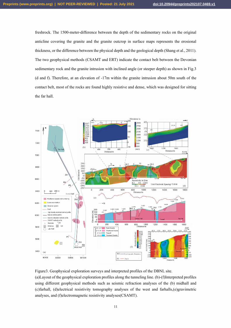
freshrock. The 1500-meter-difference between the depth of the sedimentary rocks on the original
anticline covering the granite and the granite outcrop in surface maps represents the erosional
thickness, or the difference between the physical depth and the geological depth (Shang et al., 2011).
The two geophysical methods (CSAMT and ERT) indicate the contact belt between the Devonian
sedimentary rock and the granite intrusion with inclined angle (or steeper depth) as shown in Fig.3
(d and f). Therefore, at an elevation of -17m within the granite intrusion about 50m south of the
contact belt, most of the rocks are found highly resistive and dense, which was designed for sitting
the far hall.
Figure3. Geophysical exploration surveys and interpreted profiles of the DBNL site.
(a)Layout of the geophysical exploration profiles along the tunneling line. (b)-(f)Interpreted profiles
using different geophysical methods such as seismic refraction analyses of the (b) midhall and
(c)farhall, (d)electrical resistivity tomography analyses of the west and farhalls,(e)gravimetric
analyses, and (f)electromagnetic resistivity analyses(CSAMT).
Preprints (www.preprints.org) | NOT PEER-REVIEWED | Posted: 21 July 2021 doi:10.20944/preprints202107.0469.v1

12
We also determined the geotechnical composition, and static and dynamic mechanical
parameters of the granite and gravel soil both in-situ and in the laboratory; knowing these parameters
can prove helpful when it comes to engineering designs and instrument debugging. After monitoring
the long-term deformation of the problematic geological body, our proposed engineering
countermeasures mitigated any possible deformation from the tunneling process to the point where
the safety and stability of the project is not threatened in the future. In order to avoid the fault zone
and its corresponding stress concentration zone, we recommended that the remote observation hall
(far hall) of the DBNL be located at least 50m away from the contact belt, leaving a section of the
tunnel terminal with a length of nearly 30m, where a slightly rockburst occurred during the
excavation (Fig. 3f).
5. Site suitability evaluation based on multi-factors
We can quantify the required engineering adaptability, as characterized by RI structural matching.
Ideally, we identify areas that can be built and reinforced efficiently with stable rock masses that are
minimally disturbed by problematic geological bodies. Using the timely reinforcement
countermeasure test (Huang, 2014) steers our analysis away from areas with a high likelihood of
irreversible deformation and failure and is vital in the planning and construction of large scientific
installations. By combining the data from the geological surveys, geophysical experiments, digital
drilling analyses, geological structural modeling, and problematic geological body mapping, as well
as engineering testing, we created a scaled 3D model of CSNS that demonstrates how the
engineering structural layout is affected by changes in geological conditions (Chen, 2011; Sun et al.,
2015) such as weathering and rock mass integrity.
5.1 Site suitability evaluation methods
In addition to calculating the RQD values for the rock masses in samples from the drilled cores,
we also employed the Rock Core Index (RCI) as a way to describe the integrity of the cored samples
(Xu and Wang, 2006).The RCI defines the continuity of the core sample (and the rock mass it
sampled):
RCI=1×Cr1+3×Cr3+10×Cr10+30×Cr30+50×Cr50+100×Cr100 (1)
Where, Cristhecoreacquisitionrate for differentdrilled core lengths(Lin, 2012).Cr1, Cr3, Cr10, Cr30,
Cr50and Cr100represent the proportion of the core sections with lengths that fall into intervals of
1~3cm, 3~10cm, 10~30cm, 30~50cm, 50~100cm, and greater than 100cm, respectively. For
example, if the total core length is 2.5m and 100 cm of that core is in sections with lengths that fall
Preprints (www.preprints.org) | NOT PEER-REVIEWED | Posted: 21 July 2021 doi:10.20944/preprints202107.0469.v1

13
in the 10~30cm interval, and the remaining 150 cm of the core has lengths that are greater than 100
cm (i.e. the remaining 150 cm of core is completely intact), then Cr30is 0.4 and Cr100is 0.6, and the
final, RCI value is 72. The numerical constants in the RCI equation are effectively weights, so that
cores with longer intact sections will have higher RCI values.
We tested the water sensitivity and dynamic disturbance response of some problematic
geological bodies (e.g. fault gouges, weathered rocks, etc.) at the CSNS site; both characteristics
can greatly affect the site stability, the construction quality control measures, and the engineering
reinforcement implementation. Each of these analyses represents a single factor in the calculation
of the Engineering Geological Suitability Index (EGSI):
(2)
Where wi is the weight ratio of influential factors, fi(x,y)is the normalized single factor influential
function value, which ranges from 0 to 1,and each factor is evaluated at geographical coordinates
(x,y). In plane map models, an EGSI value can represent the individual EGSI values at a constant (x,
y) and summed over varying depths.
We use the EGSI to comprehensively evaluate the geological conditions and determine how
they might affect the site engineering. The EGSI quantifies the suitability of the conditions for
construction and operation of the RI facility at a given site (Yang, 2018). Using the EGSI
methodology is an improvement on the existing siting process, which relies heavily on subjective
data and impressions. We can calculate the EGSI on large spatial scales (to identify RI locations)
and small spatial scales (to identify where certain instruments should be located within the RI site)
(Li, 2014). If the geotechnical parameters are sound, we can reasonably expect the long-term, stable,
and efficient operation of the RI facilities. The purpose of normalization is to eliminate the
unbalanced contributions of different factors to the ultimate result in order to make the data
statistically comparable.
5.2 The CSNS site
The rocks exposed at the surface of the 400-mu(266800m2) site, known as the SIA (Site
Installation Area), are mainly composed of unconsolidated Quaternary sediments, Cretaceous
granite, and Sinian gneiss. After dividing the 400-mu area (the SIA) of the CSNS site into 12086
sub-units, we calculated the EGSI value for each sub-unit. Using the standard mining method, we
used the EGSI value and the size of each sub-unit to divide the SIA into engineering geological
suitability zones per the natural breaks (Jenks) method in ArcGIS (Wu et al., 2004). An example of
this approach for CSNS is shown in Fig.4. Guided by the EGSI index.
1
( , )m
i i
i
EGSI w f x y=
=
Preprints (www.preprints.org) | NOT PEER-REVIEWED | Posted: 21 July 2021 doi:10.20944/preprints202107.0469.v1

14
Figure4.Geological suitability index zonation for the CSNS site at different depths.
Preprints (www.preprints.org) | NOT PEER-REVIEWED | Posted: 21 July 2021 doi:10.20944/preprints202107.0469.v1
15
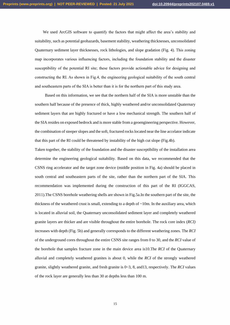
We used ArcGIS software to quantify the factors that might affect the area’s stability and
suitability, such as potential geohazards, basement stability, weathering thicknesses, unconsolidated
Quaternary sediment layer thicknesses, rock lithologies, and slope gradation (Fig. 4). This zoning
map incorporates various influencing factors, including the foundation stability and the disaster
susceptibility of the potential RI site; these factors provide actionable advice for designing and
constructing the RI. As shown in Fig.4, the engineering geological suitability of the south central
and southeastern parts of the SIA is better than it is for the northern part of this study area.
Based on this information, we see that the northern half of the SIA is more unstable than the
southern half because of the presence of thick, highly weathered and/or unconsolidated Quaternary
sediment layers that are highly fractured or have a low mechanical strength. The southern half of
the SIA resides on exposed bedrock and is more stable from a geoengineering perspective. However,
the combination of steeper slopes and the soft, fractured rocks located near the line accelator indicate
that this part of the RI could be threatened by instability of the high cut slope (Fig.4b).
Taken together, the stability of the foundation and the disaster susceptibility of the installation area
determine the engineering geological suitability. Based on this data, we recommended that the
CSNS ring accelerator and the target zone device (middle position in Fig. 4a) should be placed in
south central and southeastern parts of the site, rather than the northern part of the SIA. This
recommendation was implemented during the construction of this part of the RI (IGGCAS,
2011).The CSNS borehole weathering shells are shown in Fig.5a.In the southern part of the site, the
thickness of the weathered crust is small, extending to a depth of ~10m. In the auxiliary area, which
is located in alluvial soil, the Quaternary unconsolidated sediment layer and completely weathered
granite layers are thicker and are visible throughout the entire borehole. The rock core index (RCI)
increases with depth (Fig. 5b) and generally corresponds to the different weathering zones. The RCI
of the underground cores throughout the entire CSNS site ranges from 0 to 30, and the RCI value of
the borehole that samples fracture zone in the main device area is10.The RCI of the Quaternary
alluvial and completely weathered granites is about 0, while the RCI of the strongly weathered
granite, slightly weathered granite, and fresh granite is 0~3, 8, and13, respectively. The RCI values
of the rock layer are generally less than 30 at depths less than 100 m.
Preprints (www.preprints.org) | NOT PEER-REVIEWED | Posted: 21 July 2021 doi:10.20944/preprints202107.0469.v1

16
Figure 5.Geological modeling (using GOCAD software) of (a) weathering, (b)-(c) the RCI values,
and (d) the RQD values. Note: For the RCI,. The light blue layer represents a problematic geological
body (e.g. fractured rocks or displaced soils).
When determining the stability and suitability of an RI site, we often investigate problematic
geological bodies more thoroughly so that we can quantify both the horizontal and vertical extent
of the body, as well as the potential effects this body will have on the engineering and architectural
design of the RI. Our results were particularly instructive during the construction of CSNS; between
the potentials for slope failure and the desire to avoid the intrusive contact zone between the gneiss
and granite layers, the institute’s orientation was shifted by180°.The linear accelerator is located in
the sloped area, and the target station, which requires a safe and stable foundation, is located at the
top of a hill composed of slightly weathered granite from which 40m of weathered cover was
excavated.
Based on this analysis, the layout of the SIA at CSNS, including the layout of the main
instruments, was altered. The final position of the ring accelerator was moved~150m to the
southwest. While the original target site was located on a steep slope, the adjusted target station was
located at more stable granitic bedrock, a change that is conducive to the stable operation of the RIs
equipment.
5. discussion
Preprints (www.preprints.org) | NOT PEER-REVIEWED | Posted: 21 July 2021 doi:10.20944/preprints202107.0469.v1

17
There are clear advantages to investigating the geotechnical parameters of an RI site prior to
the design, construction, or operation process, as we have demonstrated with the DBNL and CSNS
RI sites in this current study. By conducting rigorous geological and geophysical analyses, we
submitted our recommendations to the engineers who design the RI sites and plan the RI
construction process. We investigated six RI sites in different parts of China. Currently, most of the
RI sites are being built according to our recommendations.
Our integrated geophysical exploration results indicate that several laboratories are located on
sites with favorable geological conditions, but that the conditions of the tunnels connecting the labs
fall along faults and weathering troughs and may experience a small amount of water seepage.
Compared to the known existing conditions at this RI, our assessment is more than 85% accurate,
demonstrating that our analyses can provide information relevant to laboratory design and tunnel
construction safety. The successful implementation of our suggestions was commemorated with
special ceremonies at DBNL in 2012 and CSNS in 2018.
6. Conclusions
It is vital to understand the impact that complex geological conditions will have on the planning
and designing of RI sites, as demonstrated by so many RIs that are currently in various stages of
completion in China.
Using jade carving technique composed of non-invasive, preliminary approaches, such as
geological surveys, geophysical surveys, and targeted borehole drilling, we identified problematic
geological bodies and quantitatively modeled the geotechnical parameters at two RI sites (DBNL
and CSNS) that provided valuable insight into the optimal construction and geoengineering
conditions during the RI site development. These techniques represent an affordable alternative to
more extensive (and expensive) borehole studies.
Author Contributions: Shang YJ is primate investigator of all RIs and writes original draft.
Yang CG was in charge of the DBNL. Jin WJ responds to the geophysical aspects of all RIs, and
revised the original manuscript. Chen YW and Zhou M are in charge of the CSNS. Hasan revised
the original manuscript. Y. Wang was in charge of the HIAF and ADS. Li K and D.M. Lin respond
to the fig.4 and fig.5. All authors have read and agreed to the manuscript.
Acknowledgements
We would like to thank the workers who participated in the surveying and design of the RIs, as well
Preprints (www.preprints.org) | NOT PEER-REVIEWED | Posted: 21 July 2021 doi:10.20944/preprints202107.0469.v1

18
as those who contributed to published papers and drafted reports on this topic. This research is
financially supported by National Basic Research Program of China under Grant No.
2014CB046901 and the Chinese National Scientific Foundation Committee (NSFC) (No.41772320)
References
Azaiez H., Gabtni H., Bédir M. 2021, Joint Gravity and Seismic Reflection Methods to Characterize
the Deep Aquifers in Arid Ain El Beidha Plain (Central Tunisia, North Africa). Water,13, 1310
Bukovskáa Zita,Soejono Igor, Vondrovi Lukáš, et al., 2019. Characterization and 3D visualization
of underground research facility fordeep geological repository experiments: A case study of
undergroundresearch facility Bukov, Czech Republic. Eng. Geol. 259,105-186.
Chang Kuan-Tsung, Abdelaziz Merghadi, Ali P. Yunus, et al., 2019. Evaluating scale effects of
topographic variables in landslide susceptibility models using GIS based machine learning
techniques. Scientific Reports. 9, 12296.
Chen Guoxing, Zhu Jiao, Qiang Mengyun, Gong Wenping, 2018. Three-dimensional site
characterization with borehole data – A case study of Suzhou area. Eng. Geol. 234, 65-82.
Chen Y., 2011. China Spallation Neutron Source (CSNS). 26(6), 725-728.
Feng X.T., Wu S.Y., Li S.J., Qiu S.L., Xiao Y.X., Feng G.L., Shen M.B., Zeng X.H., 2016.
Comprehensive field monitoring of deep tunnels at Jinping underground laboratory (CJPL–II)
in China. Chinese Journal of Rock Mechanics and Engineering. 35(4), 649-657 (in Chinese with
English abstract).
Florio M., Sirtori E., 2016. Social benefits and costs of large scale research infrastructures.
Technological Forecasting & Social Change, 112, 65-78.
Gao L., Ma C.M., Wang Q.X., et al., 2019. Sustainable use zoning of land resources considering
ecological and geological problems in Pearl River Delta Economic Zone, China. Scientific
Reports. 9, 16052.
Gu B.H., 2015. Commentary on typical cases of geotechnical engineering. Beijing: China
Construction Industry Publishing House (in Chinese).
Hannes Krietsch, Joseph Doetsch, Nathan Dutler, et al., 2018. Data Descriptor: Comprehensive
geological dataset describing a crystalline rock mass for hydraulic stimulation experiments.
Scientific Data. 5,180269.
Hasan M., Shang Y., &Jin W., 2018. Delineation of weathered/fracture zones for aquifer potential
using an integrated geophysical approach: A case study from South China. Journal of Applied
Geophysics. 157, 47-60.
Horvat M., 2011. The New Framework for EU Research and Innovation. Science.334 (6059),
1214295.
Huang Q.Y., 2014. Base zero subsidence control technology in multi boundary geological
conditions. Guangdong Architecture Civil Engineering. (8), 37-40.
Institute of Geology and Geophysics, Chinese Academy of Sciences (IGGCAS), 2006. Engineering
geological investigation report of Daya Bay neutrino experimental tunnel (feasibility study
phase& preliminary design phase). It includes 7 special reports. (1)Summary report of site
mapping engineering technology; (2) Engineering geological mapping report; (3)Geophysical
exploration report;(4)Engineering drilling report;(5)In situ stress test report;(6)Ultrasonic
imaging test report;(7)Laboratory test report.
Preprints (www.preprints.org) | NOT PEER-REVIEWED | Posted: 21 July 2021 doi:10.20944/preprints202107.0469.v1

19
Institute of Geology and Geophysics, Chinese Academy of Sciences (IGGCAS), 2007. General
report on engineering geological investigation of Dongguan Dalang site of China spallation
Neutron Source (feasibility study phase). It includes 2 special reports. (1)Engineering
geological mapping report; (2) Geophysical exploration report.
Institute of Geology and Geophysics, Chinese Academy of Sciences (IGGCAS), 2011. Engineering
geological investigation report of Beijing advanced light source (feasibility study phase).
Institute of Geology and Geophysics, Chinese Academy of Sciences (IGGCAS), 2013a. Engineering
geological investigation report of LHAASO (feasibility study phase).
Institute of Geology and Geophysics, Chinese Academy of Sciences (IGGCAS), 2013b.
Geophysical exploration report of LHAASO.
Institute of Geology and Geophysics, Chinese Academy of Sciences (IGGCAS),2014. Engineering
geology and geophysical exploration report on the Daocheng site of LHAASO(feasibility study
phase.
Institute of Geology and Geophysics, Chinese Academy of Sciences (IGGCAS),2015. General
report of engineering geological investigation at Huizhou for ADS and HIAF(feasibility study
phase). It includes 2 special reports. (1)Geological survey report; (2) Geophysical exploration
report.
Juang CharngHsein, Carranza-Torres Carlos, Crost Giovanni, et al., 2016. Engineering geology —
A fifty year perspective. Eng. Geol. 201, 67-70.
Juang CharngHsein, Gong Wenping, Martin II James R., Chen Qiushi, 2018. Model selection in
geological and geotechnical engineering in the face of uncertainty-Does a complex model
always outperform a simple model? Eng. Geol. 242, 184-196.
Kevin T., Lesko, William M. Roggenthen, William Chinowsky, et al., 2007. The Deep Underground
Science and Engineering Laboratory at Homestake: Conceptual Design Report. http://www-
nsd.lbl.gov/homestake.
Li K., 2014. Site suitability assessment on large research infrastructures and its application. Ph. D
Thesis, Institute of Geology and Geophysics, Chinese Academy of Sciences.
Li, K., Shang, Y.J., He, W.T., Lin, D.M., Hasan, M., Wang K.Y., 2017. An engineering site suitability
index (ESSI) for the evaluation of geological situations based on a multi-factor interaction
matrix. Bulletin of Engineering Geology and Environment. 18(2), 1-9.
Lin D.M., 2012. Study on rock mass structure and geophysics features for granite in shallow-take
CSNS for example. Ph. D thesis, Institute of Geology and Geophysics, Chinese Academy of
Sciences.
Lisa P. Sousa, Ana I. Sousa, Fátima L. Alves, et al., 2016. Ecosystem services provided by a complex
coastal region: challenges of classification and mapping. Scientific Reports. 6, 22782.
Major scientific and technological infrastructure of Chinese Academy of Sciences (MSTI), 2009.
Suppl.4: The development of large scientific devices in the world [EB/OL].
http://www.lssf.cas.cn/zlyj/zlyjk/ 200912/t20091220_2711889.html.
Marcelli A., 2014. The large research infrastructures of the People's Republic of China: An
investment for science and technology. Physica Status Solidi B. 251(6), 1158–1168.
National Development and Reform Commission of China (NDRC), 2017. National XIII Five-Year
Plan for Major Scientific and Technological Infrastructure Construction. Feb 03, 2017
Economic Reference. http://finance.sina.com.cn/roll/2017-02-03/ doc-ifyaexzn8737139.shtml.
Pero H., 2011. Research infrastructures of pan-European interest: the EU and global issues. Nuclear
Preprints (www.preprints.org) | NOT PEER-REVIEWED | Posted: 21 July 2021 doi:10.20944/preprints202107.0469.v1

20
Instruments and Methods in Physical Research A, 626-627.
Qiao L., Mu R., Chen K., 2016. Scientific effects of large research infrastructures in China.
Technological Forecasting & Social Change. 112, 102-112.
The State Council of China (SCC), 2013. Medium and Long Term Planning for Major National
Science and Technology Infrastructure Construction (2012—2030).https:// baike.sogou.com/
v85308089.htm.
Scott Thacker, Daniel Adshead, Marianne Fay, et al., 2019. Infrastructure for sustainable
development. Nature Sustainability, https://doi.org/10.1038/s41893-019-0256-8.
Shang Y.J., Shi Y.Y., Lin D., Wu FB., Zhang W., 2011. Analysis on relationship between buried
depth and variation of in-situ stress in granitic rocks. Rock and Soil Mechanics. 32(5), 1430-
1436.
Shang Y.J., Jin W.J., Chen Y.W., Li K., 2014. From the theory of rock mass structure controlling to
site selection and evaluation practice for large scale scientific facilities. Journal of Engineering
Geology. 22(4), 731-738.
Shang Y.J., Li K., Wang K.Y., et al., 2018a. Characteristics of karst development on the top of the
plateau mountain: Taking the Shika Mountain as one example. Carsologica Sinica. 37(5), 639-
649.
Shang Y.J., Jin W.J., Wang K.Y., et al., 2018b. Characteristics of rock depth and resistivity in the
alluvial-pluvial fan of Chaobai River: a case study of Mangniu River block in Yanqi
development zone. Sciences Technology and Engineering. 18(17), 14-21.
Song J.B., Liu H., Wang W.J., Xiang X.O., 2007. The introduction and proceeding on sitting SKA
and FAST radio telescope in Guizhou Province. Guizhou Science. 25(Suppl.), 86-97 (in Chinese
with English abstract).
Stewart S., 2002. Exploring the continental shelf for low geological risk nuclear waste repository
sites using petroleum industry databases: a UK case study. Eng. Geol. 67, 139-168.
Sun L., Liao X., Pan Z., 2015. Analysis of campus planning and architectural design of national
scientific device: a case study of China Spallation Neutron Source. New Architecture. (3), 68-
71.
Sun S., Yin C., Gao X. 2021, 3D Gravity Inversion on Unstructured Grids. Appl. Sci. 11, 722.
Wang Y.F., Cao J., Chen S., et al., 2016. The 2013 annual report of physical analysis for Daya Bay
Reactor Neutrino Experiment. Science and Technology Innovation Herald. (24), 184.
Wei S.Y., Jin W.J., et al., 2018. Discovery and explanation of muddy girdle under sharp turn of
one ridge- a case study at the CSNS site of Guangdong Province. Journal of Engineering
Geology. 26(3), 561-571. doi:10.13544/j.cnki.jeg.2017-045.
Wu L., Liu Y., Zhang J., et al., 2004. GIS-principle, approaches and application. Science Press.
Wu Shellen, 2019. How science saved China. Nature. 574, 25-28.
Xu J., Wang J., 2006. Assessment of rock mass quality based on rock quality designation and rock
block index —Taking the Borehole BS01 in Beishan HLW disposal repository as example.
Uranium Geology. 22(5), 295-299.
Yang P., 2018. Study on site selection and control for large research infrastructure under complicated
geological conditions: a case study of CIADS and HIAF. Ph. D Thesis, Institute of Geology and
Geophysics, Chinese Academy of Sciences.
Zhang C., 2004. The Beijing electron—positron collider and its second phase construction. Science
& Technology Review. (11), 23-27 (in Chinese with English abstract).
Preprints (www.preprints.org) | NOT PEER-REVIEWED | Posted: 21 July 2021 doi:10.20944/preprints202107.0469.v1

21
Preprints (www.preprints.org) | NOT PEER-REVIEWED | Posted: 21 July 2021 doi:10.20944/preprints202107.0469.v1