zoomcat14xs
DESCRIPTION
ÂTRANSCRIPT

ZOOMCAt 14
ZOOMCAt 12
On cites and seeing
The urban condition is active sediment. It is a precipitated convergence and par ticulate binding of flows in
time, both immediate, in reference to the layering of material constructions and infrastructural trajectories,
and abstractly as flows of social and technical networked connections, it is a production more than a
product, plasticity in the guise of the concreteness.
The contemporary city is becoming less about the definitive extensions of regularizing conventions and
planned programmability and more an existing site for a collection of populations associated by activity
and process, overlapping and inter twined through spatial paths that the itinerary discloses often in the
flash of a ring tone. Within the temporal flux of daily events, the unfolding spatial fabric of the city can be
understood through the development of the voided territory, or in-betweens. The lost spaces are the unclaimed publics and informational edges of an emerging urbanism that constitute the antithesis of the
planned element and/or event, found at the edges of express ways, parking lots, public parks, sidewalks,
and corporate master plans.
The unaccountable absences, gaps, and shears begin to operate more like a plane of consistency within the developed landscape forming countless seams and transitional boundaries across the urban field.
These boundary conditions are growth lines of territoriality and control within the urban ecology. The
materiality of a field transition constitutes a narrative of influences, capacities and desires within a given
location in relation to the greater development of the city as a directive agent with a grand lagging set of
customary reactions and channels of capital responsiveness . From the scale of micro infrastructural, such as paving techniques and street-curb-sidewalk construction, through lot modulations, block scale
developments, and the infrastructural construction of highways, rail lines and water systems, the urban
field is comprised of an infinite array of seams and transitions ingrained with environmental conditions
and developmental logics. The question of how these territorial lines are strategized and leveraged within
the urban stratum to activate and facilitate future growth and organization is largely overlooked and under utilized. The banality of the constructed edge holds within the potential of the translational third, with an
ability to accumulate program or ecological controls to enhance and extend the existing dialogue of bordering influences.
Understanding the formation, growth and, decay of these urban systems provides a novel and fundamental way of seeing place. Places are processes, embedded with organizational and developmental
logics of environmental flows and programmatic relationships. The critical connection is not only seeing the relationship of objects within given sites, or contexts, but tracking the productions and lives that flow
between the fixed points and material borders.
Working with the organizational and developmental logics of local environmental processes and
programmatic relationships, my research is an exploration to unear th prototypical architectures, grounded in the immediacy of existing sites and ingrained with the potential to inherently connect people and what
they do, to where they are.
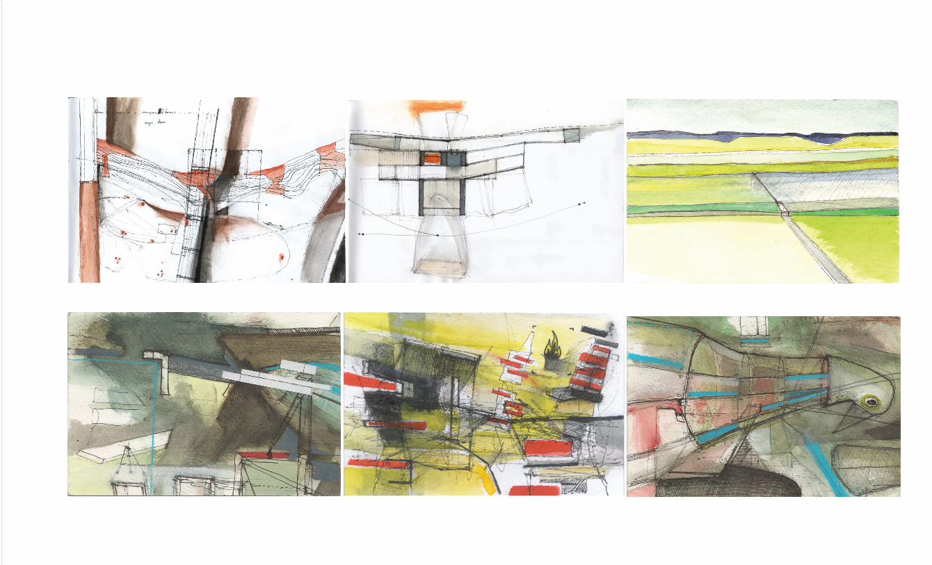
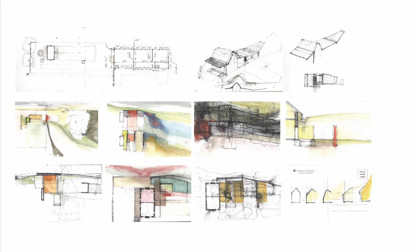
This section of work represents a continued development of research and practice spanning professional architectural projects, research projects, competitions, and
process.
The projects are grounded in an ongoing interest in the integration of architectural systems and specific places. They explore the utilization of cultural, environmental
and programmatic resources at effective material and temporal scales.
Henry Point
HW67Aeratorpark
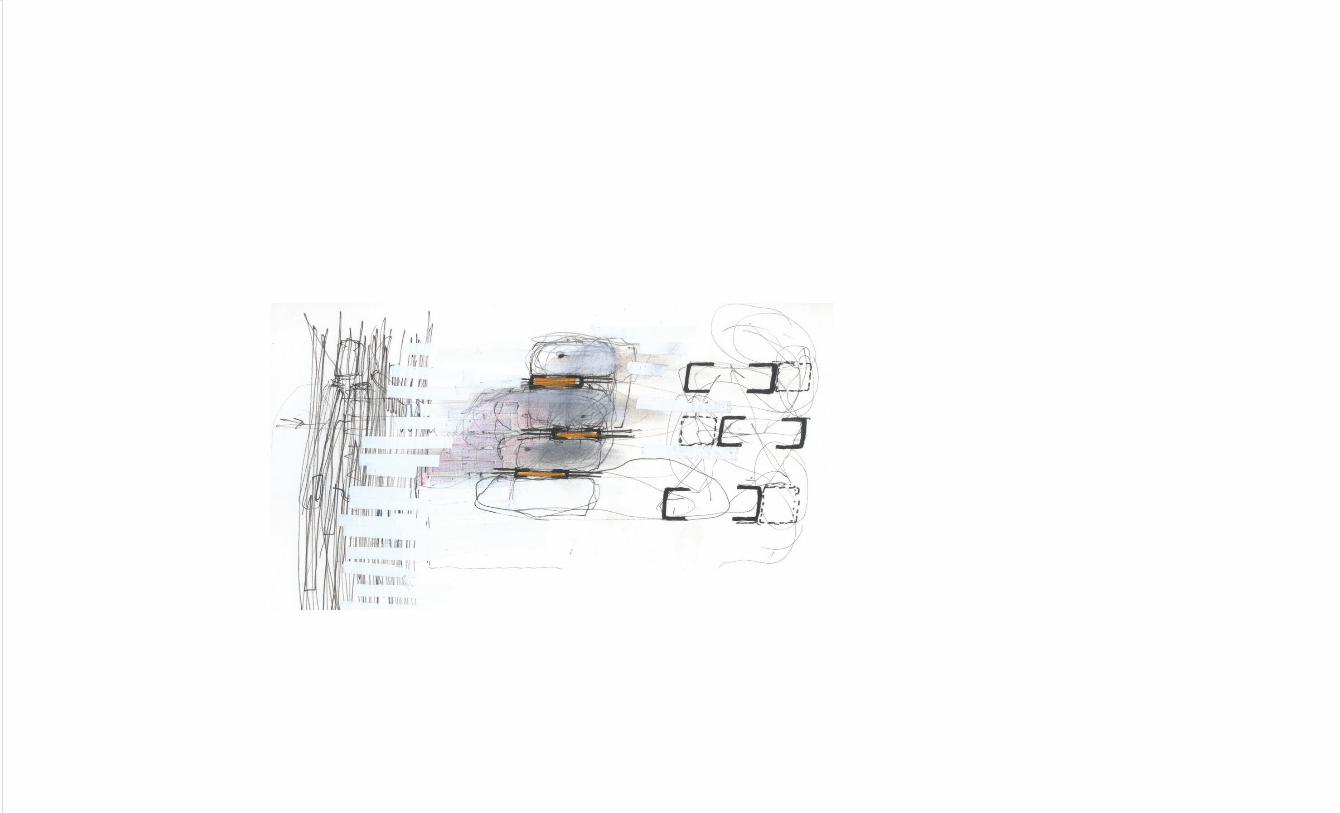
Big BayTactile Spectrum
Process
Judson Moore
ZOOMCAt 14selected work
selected work
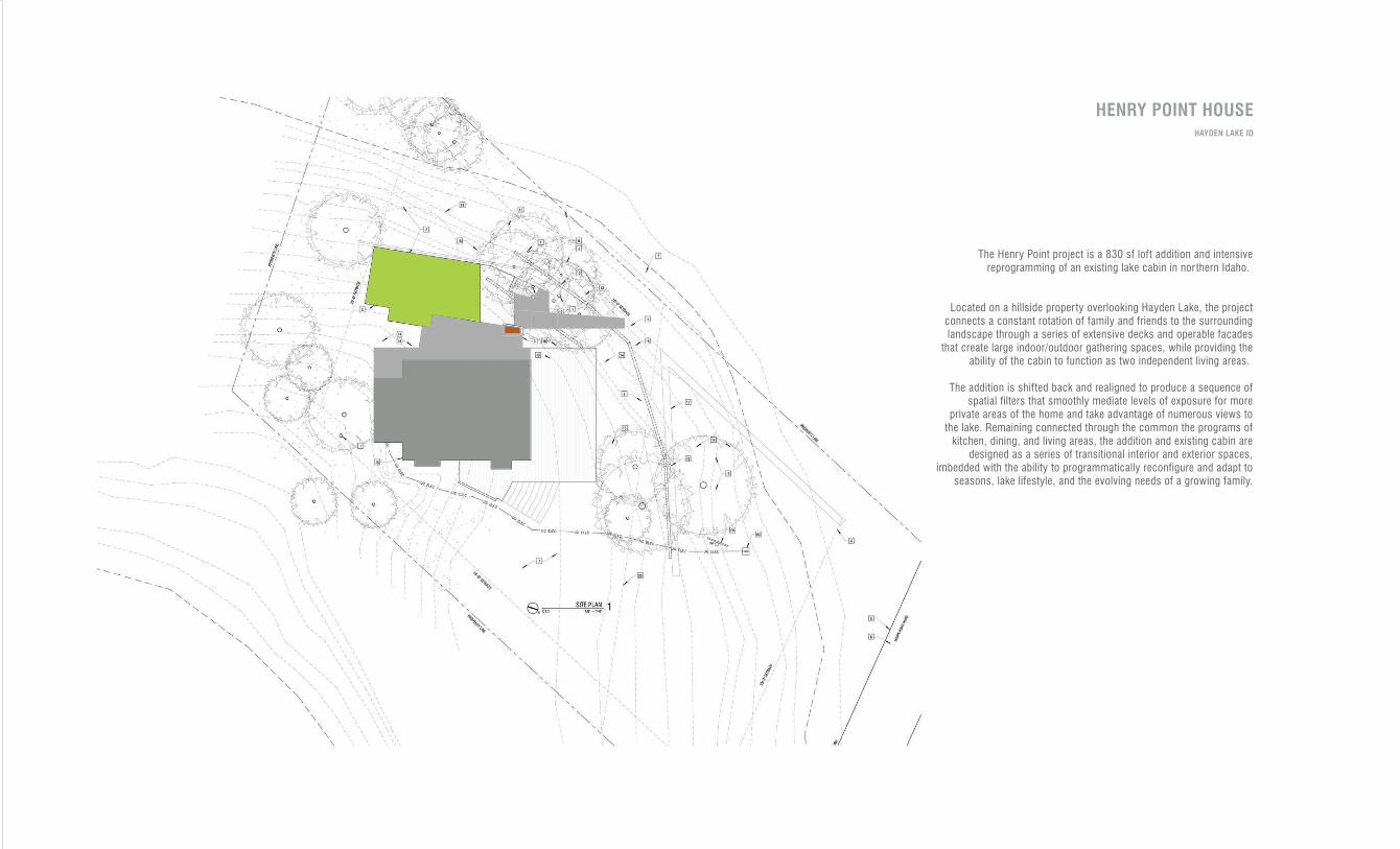
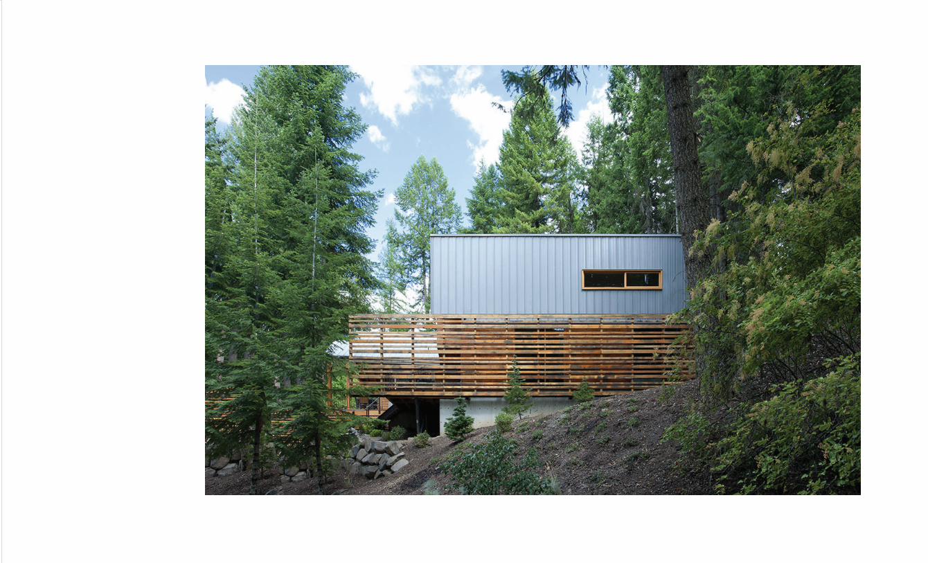
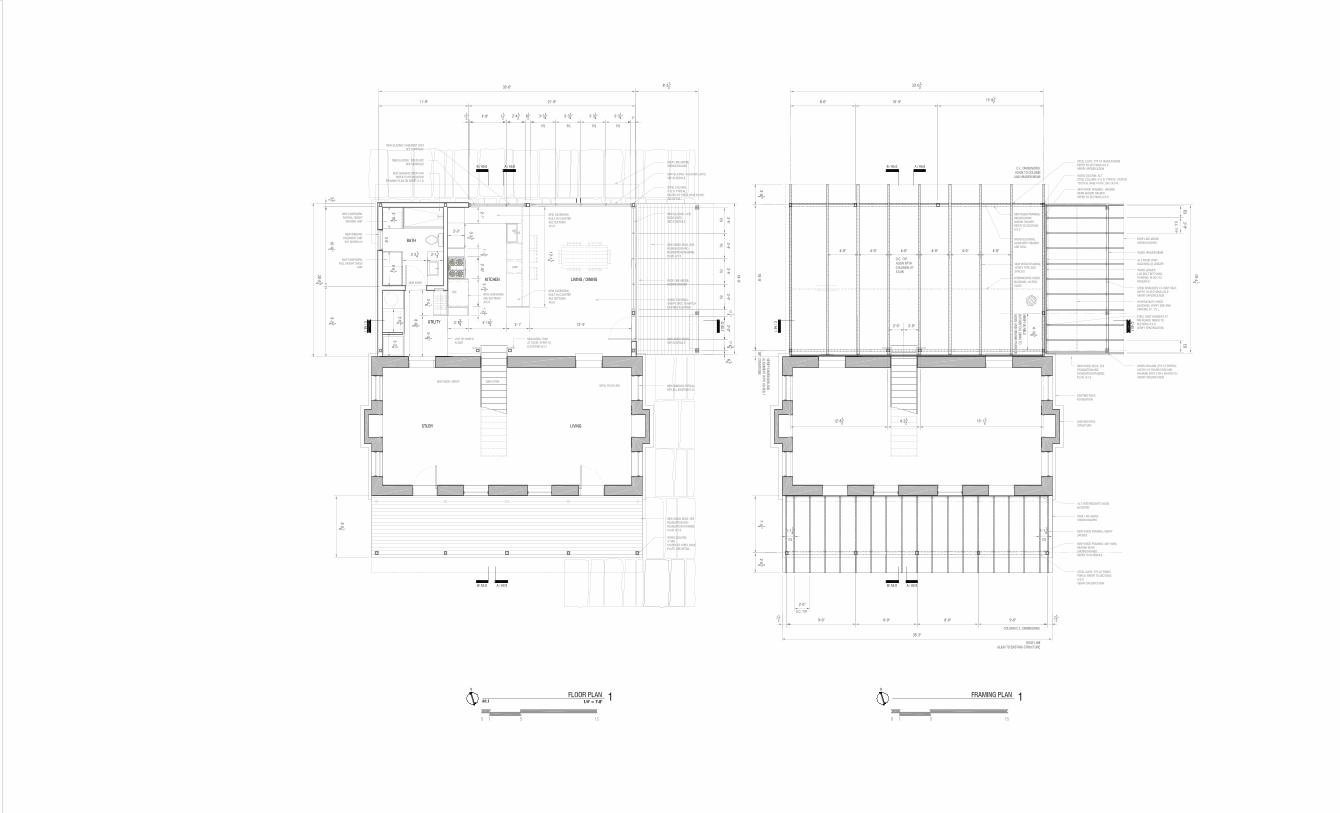
The Henry Point project is a 830 sf loft addition and intensive reprogramming of an existing lake cabin in nor thern Idaho.
Located on a hillside proper ty overlooking Hayden Lake, the project
connects a constant rotation of family and friends to the surrounding landscape through a series of extensive decks and operable facades
that create large indoor/outdoor gathering spaces, while providing the
ability of the cabin to function as two independent living areas.
The addition is shifted back and realigned to produce a sequence of spatial filters that smoothly mediate levels of exposure for more
private areas of the home and take advantage of numerous views to
the lake. Remaining connected through the common the programs of
kitchen, dining, and living areas, the addition and existing cabin are
designed as a series of transitional interior and exterior spaces,
imbedded with the ability to programmatically reconfigure and adapt to seasons, lake lifestyle, and the evolving needs of a growing family.
HENRY POINT HOUSEHAYDEN LAKE ID
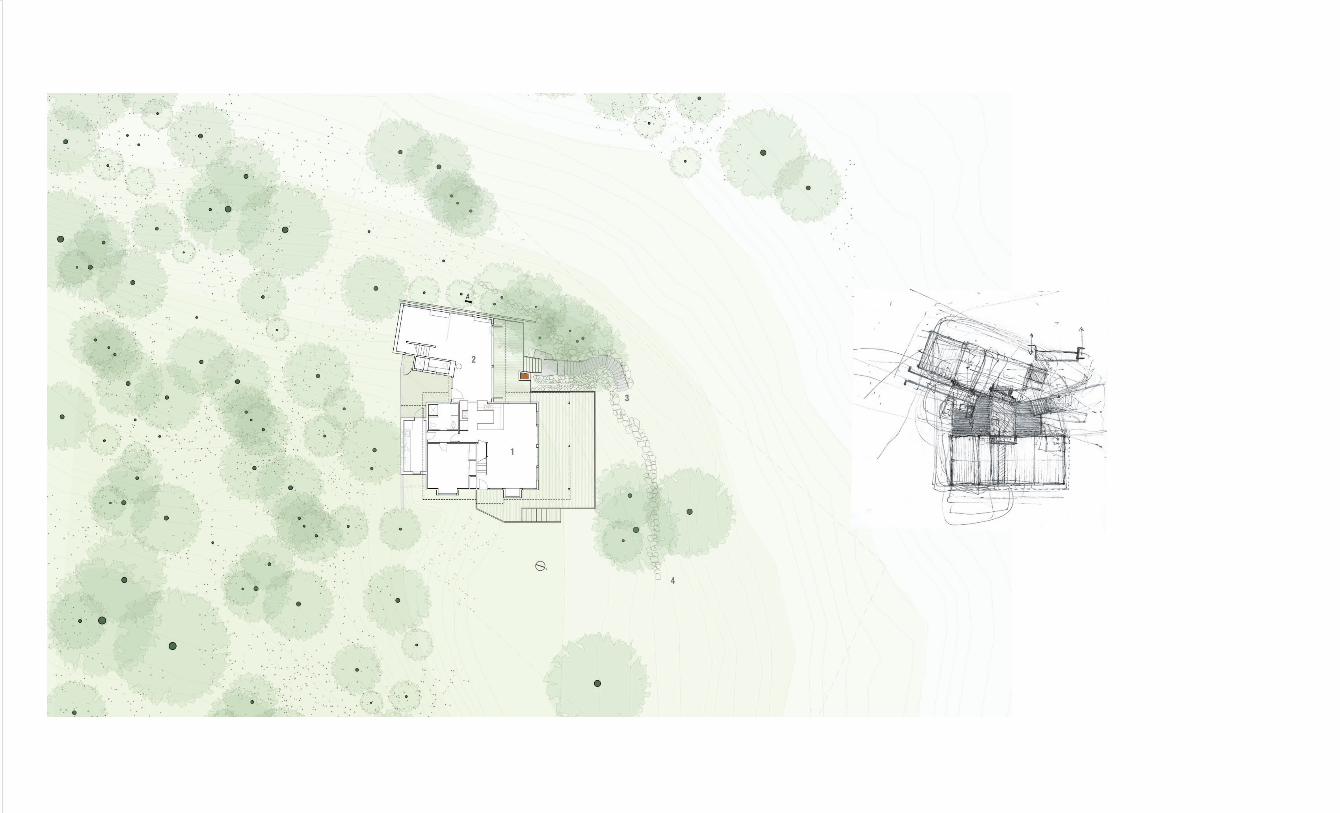
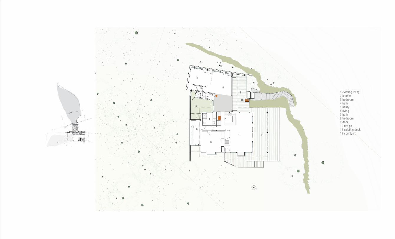
1 existing living
2 kitchen
3 bedroom
4 bath
5 utility
6 living
7 bath
8 bedroom
9 deck
10 fire pit
11 existing deck
12 cour tyard

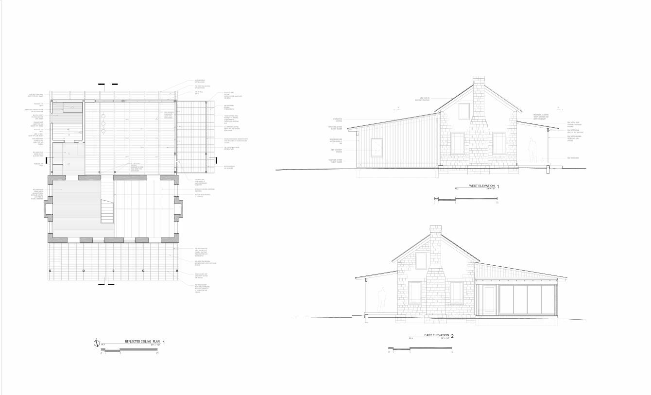
tree pattern studieslayering of screen and environment
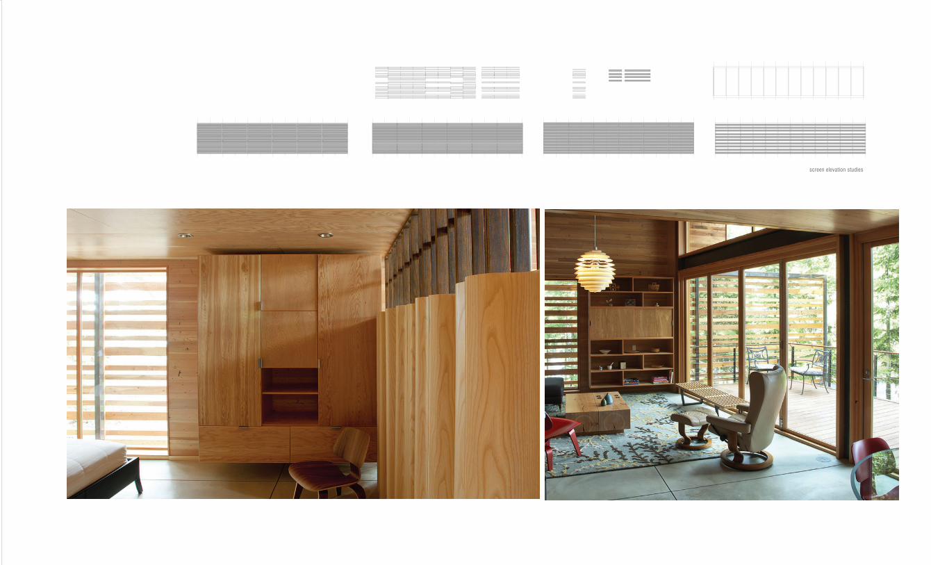
screen elevation studies
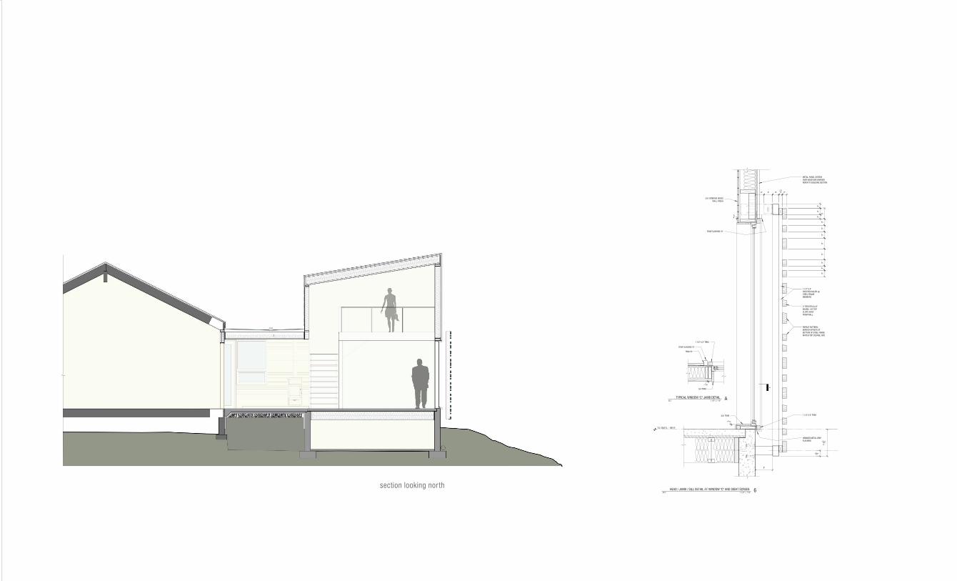
section looking nor th

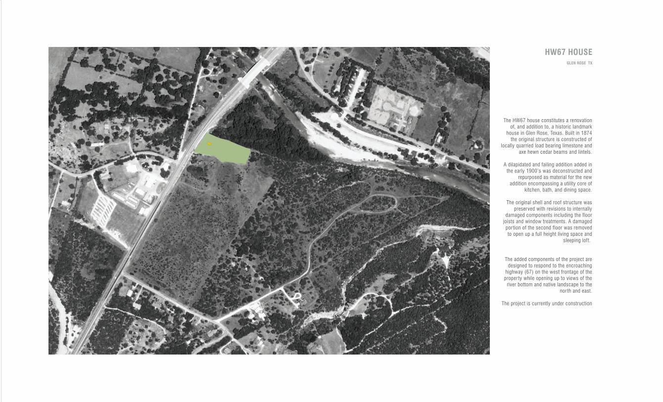
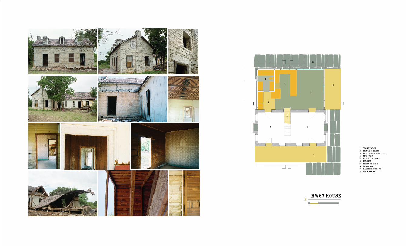
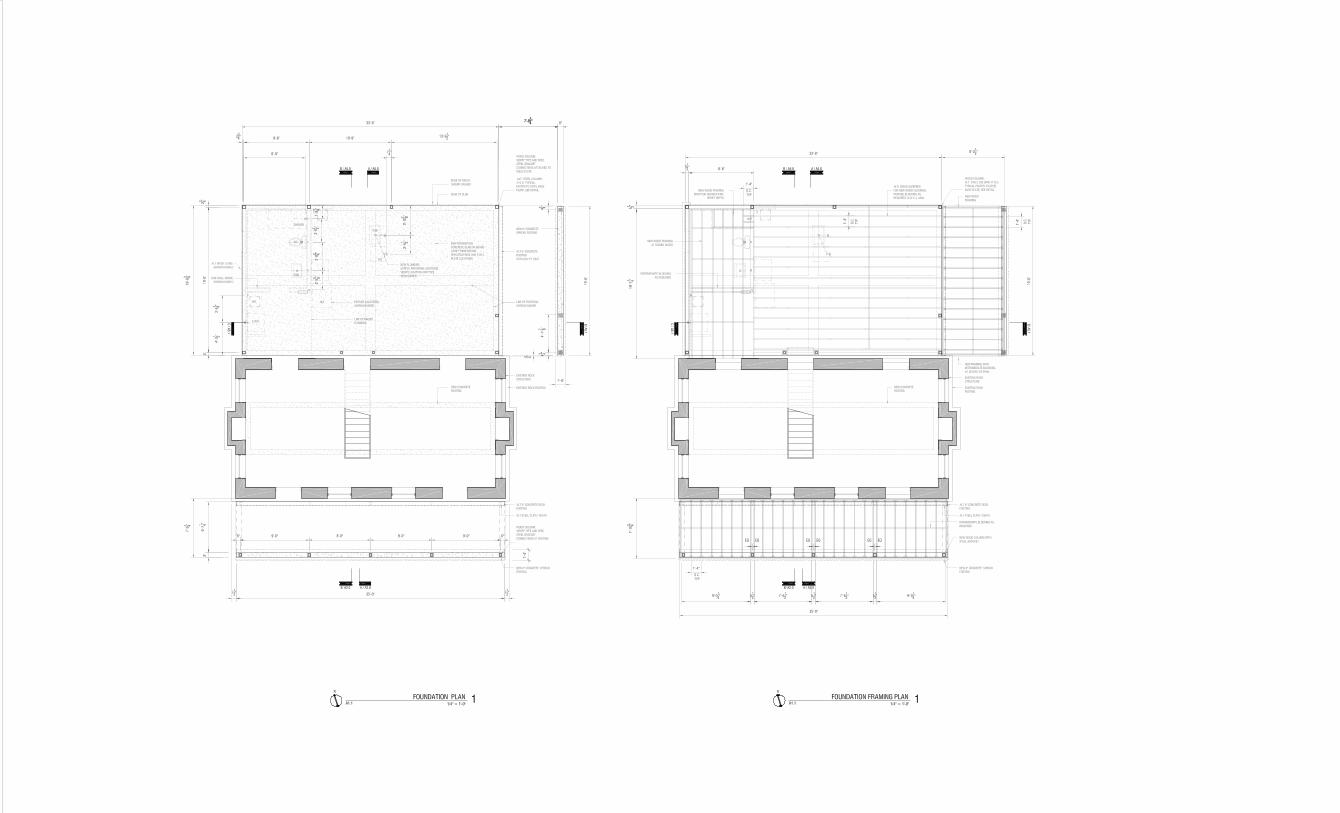
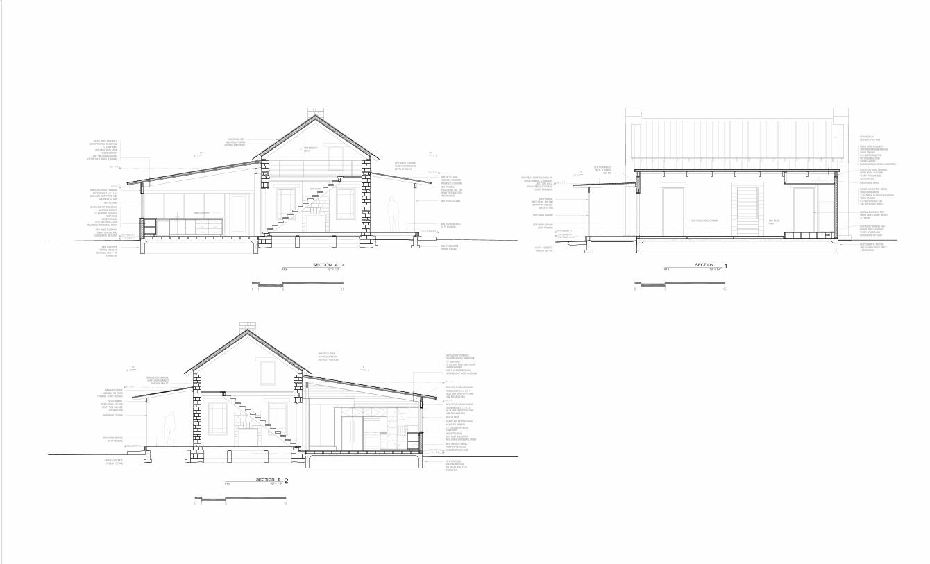
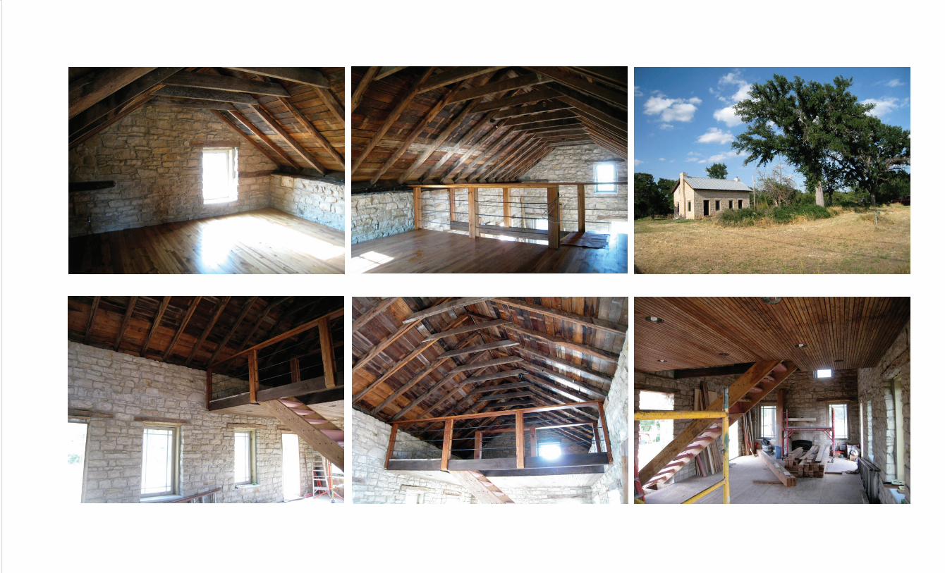
The HW67 house constitutes a renovation of, and addition to, a historic landmark
house in Glen Rose, Texas. Built in 1874 the original structure is constructed of
locally quarried load bearing limestone and axe hewn cedar beams and lintels.
A dilapidated and failing addition added in the early 1900’s was deconstructed and
repurposed as material for the new addition encompassing a utility core of
kitchen, bath, and dining space.
The original shell and roof structure was preserved with revisions to internally
damaged components including the floor joists and window treatments. A damaged por tion of the second floor was removed to open up a full height living space and
sleeping loft.
The added components of the project are designed to respond to the encroaching
highway (67) on the west frontage of the proper ty while opening up to views of the
river bottom and native landscape to the nor th and east.
The project is currently under construction
HW67 HOUSEGLEN ROSE TX
1
23
5
4
6
7
8
9
10
1 front porch2 existing: living3 existing:living / study4 new stair5 utility landing6 kitchen7 living / dining8 east porch9 master restroom10 rock apron
hw67 house
0 1 5 15
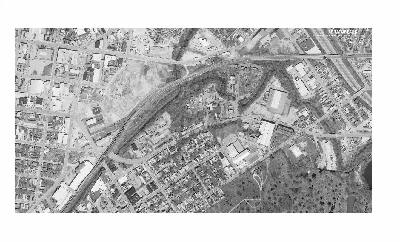
AERATORPARKMEDIATIVE URBANISMS COMPETITION
LOUISVILLE KY
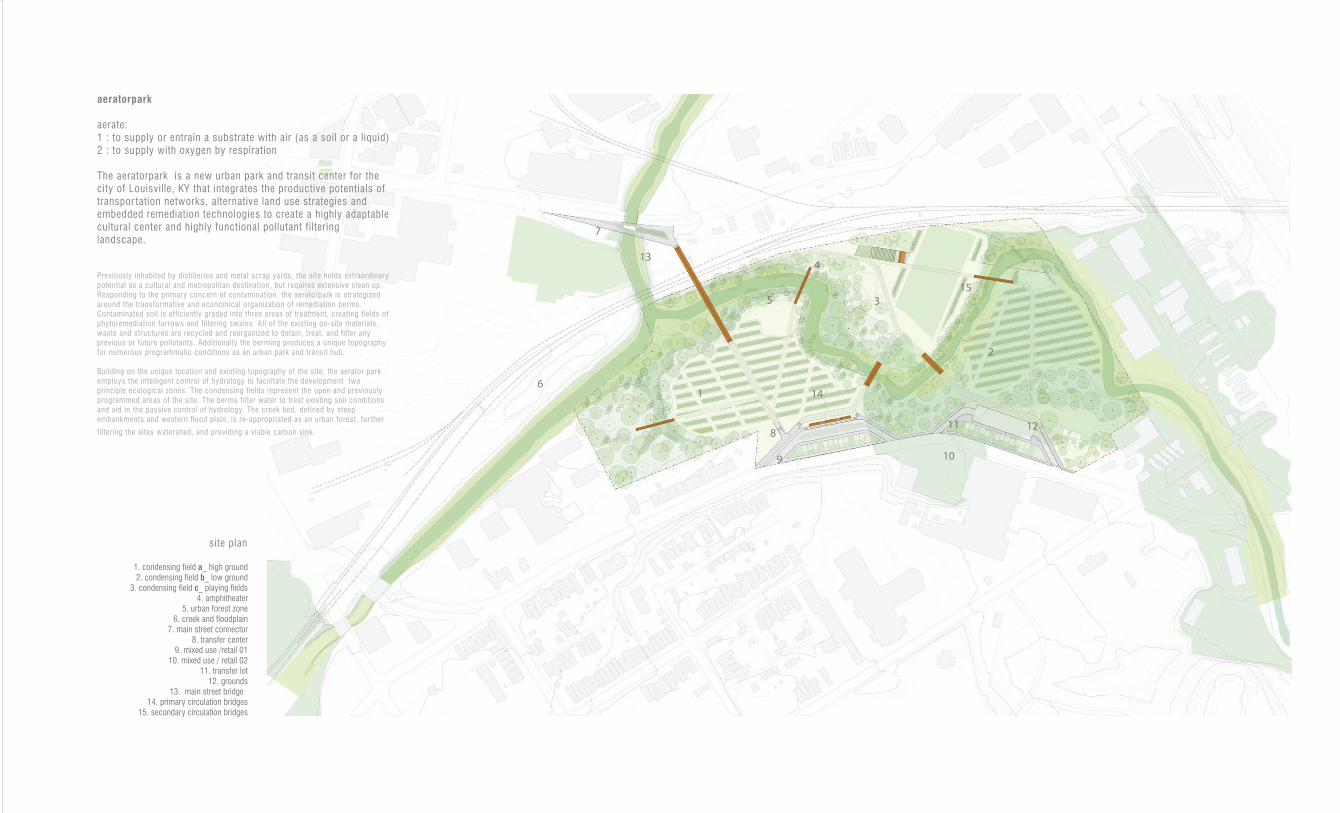
1
9 10
11
3
2
7
6
134
12
5
14
8
15
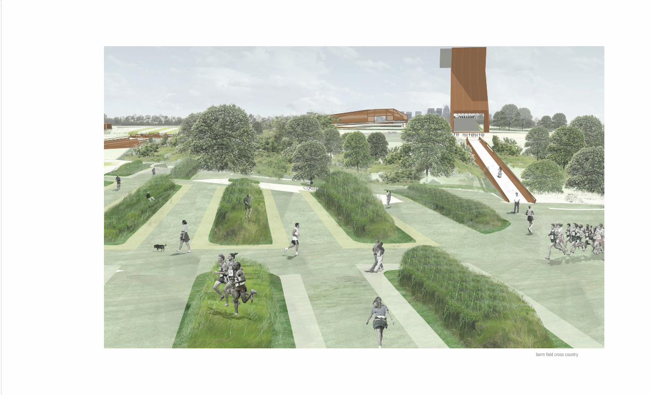
1. condensing field a_ high ground2. condensing field b_ low ground
3. condensing field c_ playing fields4. amphitheater
5. urban forest zone6. creek and floodplain
7. main street connector8. transfer center
9. mixed use /retail 0110. mixed use / retail 02
11. transfer lot12. grounds
13. main street bridge 14. primary circulation bridges
15. secondary circulation bridges
site plan
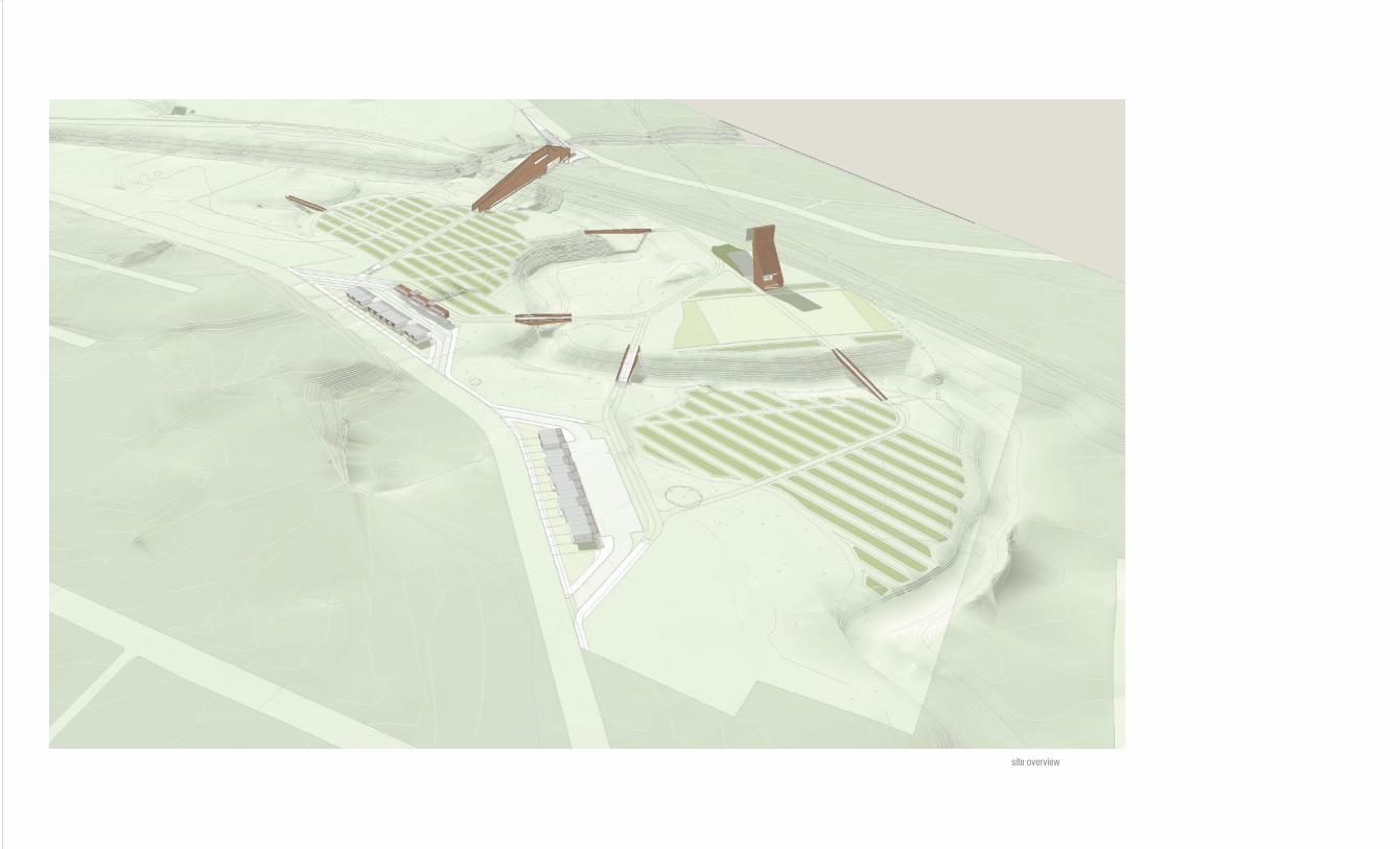
aeratorpark
aerate:1 : to supply or entrain a substrate with air (as a soil or a liquid)2 : to supply with oxygen by respiration
The aeratorpark is a new urban park and transit center for the city of Louisville, KY that integrates the productive potentials of transpor tation networks, alternative land use strategies and embedded remediation technologies to create a highly adaptable cultural center and highly functional pollutant filtering landscape.
Previously inhabited by distilleries and metal scrap yards, the site holds extraordinary potential as a cultural and metropolitan destination, but requires extensive clean up. Responding to the primary concern of contamination, the aeratorpark is strategized around the transformative and economical organization of remediation berms. Contaminated soil is efficiently graded into three areas of treatment, creating fields of phytoremediation furrows and filtering swales. All of the existing on-site materials, waste and structures are recycled and reorganized to detain, treat, and filter any previous or future pollutants. Additionally the berming produces a unique topography for numerous programmatic conditions as an urban park and transit hub.
Building on the unique location and existing topography of the site, the aerator park employs the intelligent control of hydrology to facilitate the development two principle ecological zones. The condensing fields represent the open and previously programmed areas of the site. The berms filter water to treat existing soil conditions and aid in the passive control of hydrology. The creek bed, defined by steep embankments and western flood plain, is re-appropriated as an urban forest, fur ther
filtering the sites watershed, and providing a viable carbon sink.
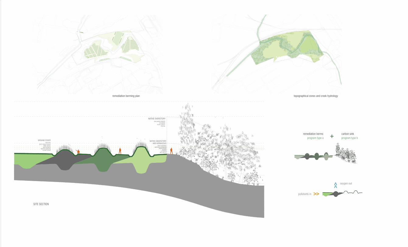
SITE SECTION
NATIVE OVERSTORY
PIN OAK
SHELLBACK HICKORY
SYCAMOREBLACK LOCUST
NATIVE UNDERSTORYAND HERBACOUS
GRAY DOGWOODAMERICAN HORNBEAM
ARROW WOODSEDGES
CUTGRASSWILD MILLET
GROUND COVERWILD RYE
DEER TONGUE GRASSPANIC GRASS
SWITCHGRASSREDTOP AGROSTIS
ALSIKE CLOVER
>>
>>pollutants in
oxygen out
remediation berms carbon sink
program type a program type b+
remediation berming plan topographical zones and creek hydrology

landscaping programming
1 main pedestrian bridge 2 playing field and pavilion
>
>
1
2
site overview
berm field cross country
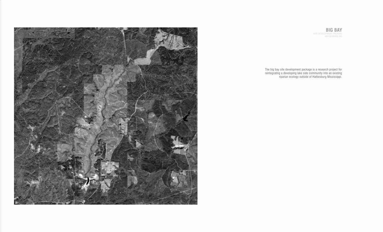
The big bay site development package is a research project for
reintegrating a developing lake side community into an existing
riparian ecology outside of Hattiesburg Mississippi.
BIG BAYSITE DEVELOPMENT PACKAGE
HATTIESBURG MS
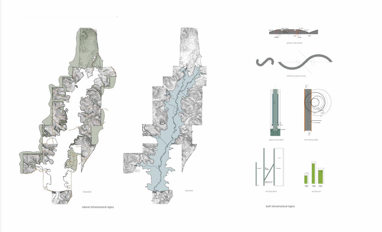
topographywatershed
built infrastructural logicsnatural infrastructural logics
generic road section
minimum reverse curves
local
collectorshoulder
berm 3:1
drain
4-5': 1/2”/ft
min 1’-6”
28-48': .4% grade
base layer
min w = 22’-26’
typical road widths min turning radius
64'
48'
20'
30'
20' min turn radius
35'
20'
34'
28'
48'
dead end
local
thoroughfare
collector
min/max lot
35' / 6500sf
min/max lot
50' / 6500sf
min/max lot
35' /3000sf
min setbacks
max
setback
1600’ /400’
1000'
min/max blockmax dead end1600' + max angle of intersection
min stopping site distance_ collector
min stopping site distance_ local
min/max lotmin/max block

2 acre strips
50’ 100’
871’
1742’
wildlife habitat allocations [ % ranges ]
min / max wildlife habitat allocations [ % ranges ]
native flora / fauna relationships by habitattypology and allocation
bq cr wt wtdr gssb glsb
20-80
5-505-20
20-50
2
% nws grass
row crop
mast hardwoods
brushy cover
cool season legumes / annual grains
10-80
5-50
10-40
20-50
2
10-30
5-50
30-60
10-30
2-5
5-30
5-50
30-60
20-40
2-530-70
50-70
<10
70-100
<10
<20
Blocks ! 2 acres or strips
! 50’ wide
Blocks ! 2acres
Blocks ! 2acres
Blocks or complexes ! 100 acres
Blocks ! 5 acres or strips
! 50’
Blocks 1 – 5 acres or strips
! 50’ wide
Grass/shrub songbirds
(field sparrow, blue
grosbeak, indigo bunting,
yellow- breasted chat)
Grassland songbirds
(grasshopper sparrow,
Henslow’s sparrow,
eastern meadowlark,
dickcissel)
Bobwhite Quail Cottontail Rabbit Wild Turkey White Tailed Deer
bq
min max min visibilitymax cover
max visibilitymin cover
min visibilitymax cover
max visibilitymin cover
nom min max nom
20
8
20
50
2
68
5
5
20
2
20
8
20
50
2
23
50
5
20
2
10
5
40
43
2 18
50
10
20
2
48
10
10
30
2
10
28
10
50
2
63
5
10
20
2
40
15
13
30
2
min visibilitymax cover
max visibilitymin cover
min max nom
10
5
60
23
2
5
50
30
10
510
28
30
30
2
30
25
30
10
5
20
40
17
20
3
min visibilitymax cover
max visibilitymin cover
min max nom
5
5
60
28
25
40
30
20
5
5
23
30
40
2
30
5
15
30
20
15
40
12
30
3
min visibilitymax cover
max visibilitymin cover
min max nom
30
1
69
10
50
40
30
10
60
49
1
50
5
60
35
min visibilitymax cover
max visibilitymin cover
min max nom
79
1
20
89
10
1
70
10
20
97
12
80
15
5
cr wt wtdr gssb glsb
wet swale generic cells
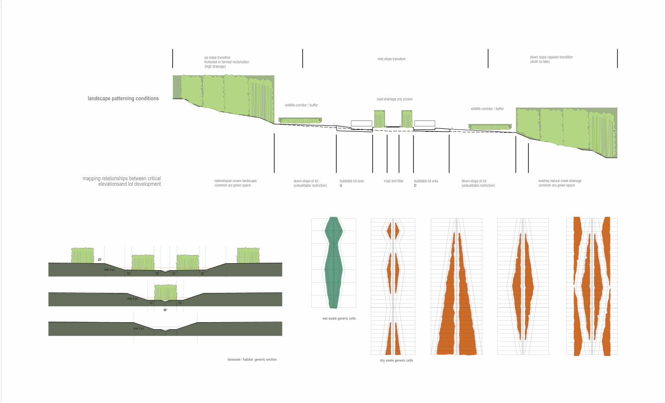
dry swale generic cellsbioswale / habitat generic section
landscape patterning conditions
mapping relationships between criticalelevationsand lot development
min 2 yr
25’
15’
15’ 15’
15’ 15’ 15’
50’
min 2 yr
min 2 yr
existing natural creek drainagecommon ara green space
redeveloped crown landscapecommon ara green space
down-slope of lot(unbuildable restriction)
down-slope of lot(unbuildable restriction)
buildable lot areaD
buildable lot areaU
road and filter
down slope raparian transition(drain to lake)
up slope transitionforrested or farmed reclamation(high drainage)
wildlife corridor / buffer
mid-slope transition
road drainage ans screen
wildlife corridor / buffer
bq
min max min visibilitymax cover
max visibilitymin cover
min visibilitymax cover
max visibilitymin cover
nom min max nom
20
8
20
50
2
68
5
5
20
2
20
8
20
50
2
23
50
5
20
2
10
5
40
43
2 18
50
10
20
2
48
10
10
30
2
10
28
10
50
2
63
5
10
20
2
40
15
13
30
2
min visibilitymax cover
max visibilitymin cover
min max nom
10
5
60
23
2
5
50
30
10
510
28
30
30
2
30
25
30
10
5
20
40
17
20
3
min visibilitymax cover
max visibilitymin cover
min max nom
5
5
60
28
25
40
30
20
5
5
23
30
40
2
30
5
15
30
20
15
40
12
30
3
min visibilitymax cover
max visibilitymin cover
min max nom
30
1
69
10
50
40
30
10
60
49
1
50
5
60
35
min visibilitymax cover
max visibilitymin cover
min max nom
79
1
20
89
10
1
70
10
20
97
12
80
15
5
cr wt wtdr gssb glsb
shallow marsh
pond_wetland system
extended detention wetland
pocket wetland
0510 1 01020304050151051010203040500.2 .1.5.81 020406080100020406080100
+ +
+ +
+ +
+ +
+ +
+ +
+
+
+
+
+
+
+
+
>
> minumum L / W
ratio
wetland/watershed
minimum ratio
minimum drainage
area
allocation
treatment volume
allocation
treatment area
cleanout
frequency
forebay micropool outlet
configuration
propogation
technique
buffer (ft) pondscaping
suggested
pollutant removal
capability
land factor
consumption
water
balance
tributary
watershed area
deep water
cells
native plant
diversity
wildlife habitat
potential
0.2
.01
.01
.01 target
1:1
1:1
1:1
1:1 target
25 ac
25 ac
10 ac
1-10 ac
40.60.0
70.30.0
20.30.50
20.80.0
40.60.0
70.30.0
20.30.50
20.80.0
20.40.40
45.25.30
20.35.45
10.40.50
020406080100
+ +
+ +
+ +
+ +
+
+
+
+
+
+
+
+
20.40.40
45.25.30
20.35.45
10.40.50
2-5 yrs
10 yrs
2-5 yrs
10 yrs
required
no
required
optional
required
required
required
optional
reverse slope
pipe
hooded broad
crest weir
reverse slope
pipe
hooded broad
crest weir
mulch
transplant
mulch
transplant
mulch
transplant
volunteer
emphasize
wildlife habitat
marsh
microtopography
buffer
high
shallow marsh
storage
moderate
verticle pools
substitute
marsh storage
moderate
verticle ED
substitute
marsh storage
moderate
malleable
in-site conditions
DA :25<+ ac
with dry weather
Q
DA :25<+ ac
with dry weather
Q
minimum 10 ac
required for
extended detention
1-10 ac
site specified
dry weather flow
normal
recommended
to maintain
water elevations
dry weather flow
normal
recommended
to maintain
water elevations
dry weather flow
normal
recommended
to maintain
water elevations
groundwater
supply
provided by
excavation
forebay
channels
micropool
pond
micropool
forebay
micropool
micropool
if possible
moderate
reliable
removal of
sediment and
nutrients
moderate > high
reliable
removal of
sediment and
nutrients
moderate
(-) reliable
removal of
sediment and
nutrients
moderate
subject to
resuspension
and groundwater
displacement
high
dependant on
microtopography
high
dependent on
sufficient wetland
complexity
moderate
fluctuating
with water levelsphysiological
low > moderate
small surface
areas
poor control
of water levels
high
complexity
buffers
high
buffer
(waterfowl)
moderate
buffer
low
small areas
low diversities
reverse slope
pipe
hooded broad
crest weir
hooded broad
crest weir
emphasize
wildlife habitat
hi marsh wedges
emphasize
stabilization of
extended detention
zones
optional
based on
capacity
01020304050
25-50
25-50
0-25
25-50
a
b
a
b
a
b
b
15.43.53
33.30.37
33.32.35
43.32.35
smooth asphalt
asphalt or concrete paving
packed clay
light turf
dense turf
dense shrubbery and forrest litter
concrete or asphalt
bare sand
graveled surface
bare clay-loam
range (natural)
bluegrass sod
short grass prairie
bermuda grass
.012
.014
.03
.2
.35
.4
.011 .01-.013
.01-.016
.012-.03
.012-.033
.01-.32
.39-.63
.01-.20
.03-.048
.01
.02
.02
.13
.45
.15
.41
.00 1.0
roughness coefficients > overland flow
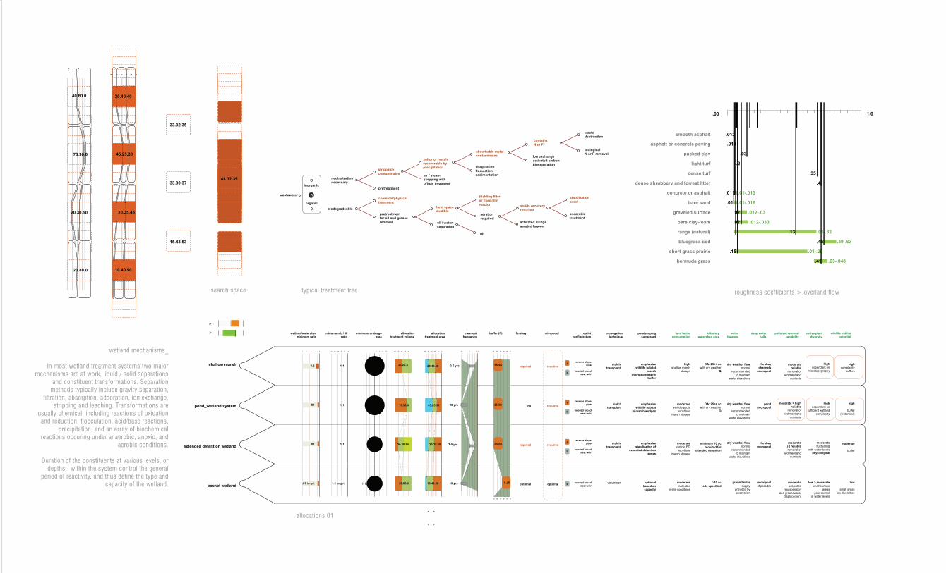
allocations 01
search space
wetland mechanisms_
In most wetland treatment systems two major mechanisms are at work, liquid / solid separations
and constituent transformations. Separation methods typically include gravity separation,
filtration, absorption, adsorption, ion exchange, stripping and leaching. Transformations are
usually chemical, including reactions of oxidation and reduction, flocculation, acid/base reactions,
precipitation, and an array of biochemical reactions occuring under anaerobic, anoxic, and
aerobic conditions.
Duration of the constituents at various levels, or depths, within the system control the general
period of reactivity, and thus define the type and capacity of the wetland.
wastewater n
inorganic
organic
neutralization
necessary
biodegradeable
pretreatment
for oil and grease
removal
chemical/physical
treatment
pretreatment
strippable
contaminatesair / steam
stripping with
offgas treatment
sulfur or metals
recoverable by
precipitation coagulation
floculation
sedimentation
absorbable metal
contaminates
contains
N or P
Ion exchange
activated carbon
bioseparation
waste
destruction
biological
N or P removal
land space
avalible
oil / water
separation
trickling filter
or fixed-film
reactor
aeration
required
oil
solids recovery
required
activated sludge
aerated lagoon
anaerobic
treatment
stabilization
pond
>
typical treatment tree
shallow marsh
pond_wetland system
extended detention wetland
pocket wetland
0510 1 01020304050151051010203040500.2 .1.5.81 020406080100020406080100
+ +
+ +
+ +
+ +
+ +
+ +
+
+
+
+
+
+
+
+
>
>minumum L / W
ratio
wetland/watershed
minimum ratio
minimum drainage
area
allocation
treatment volume
allocation
treatment area
cleanout
frequency
forebay micropool outlet
configuration
propogation
technique
buffer (ft) pondscaping
suggested
pollutant removal
capability
land factor
consumption
water
balance
tributary
watershed area
deep water
cells
native plant
diversity
wildlife habitat
potential
0.2
.01
.01
.01 target
1:1
1:1
1:1
1:1 target
25 ac
25 ac
10 ac
1-10 ac
40.60.0
70.30.0
20.30.50
20.80.0
40.60.0
70.30.0
20.30.50
20.80.0
20.40.40
45.25.30
20.35.45
10.40.50
020406080100
+ +
+ +
+ +
+ +
+
+
+
+
+
+
+
+
20.40.40
45.25.30
20.35.45
10.40.50
2-5 yrs
10 yrs
2-5 yrs
10 yrs
required
no
required
optional
required
required
required
optional
reverse slope
pipe
hooded broad
crest weir
reverse slope
pipe
hooded broad
crest weir
mulch
transplant
mulch
transplant
mulch
transplant
volunteer
emphasize
wildlife habitat
marsh
microtopography
buffer
high
shallow marsh
storage
moderate
verticle pools
substitute
marsh storage
moderate
verticle ED
substitute
marsh storage
moderate
malleable
in-site conditions
DA :25<+ ac
with dry weather
Q
DA :25<+ ac
with dry weather
Q
minimum 10 ac
required for
extended detention
1-10 ac
site specified
dry weather flow
normal
recommended
to maintain
water elevations
dry weather flow
normal
recommended
to maintain
water elevations
dry weather flow
normal
recommended
to maintain
water elevations
groundwater
supply
provided by
excavation
forebay
channels
micropool
pond
micropool
forebay
micropool
micropool
if possible
moderate
reliable
removal of
sediment and
nutrients
moderate > high
reliable
removal of
sediment and
nutrients
moderate
(-) reliable
removal of
sediment and
nutrients
moderate
subject to
resuspension
and groundwater
displacement
high
dependant on
microtopography
high
dependent on
sufficient wetland
complexity
moderate
fluctuating
with water levelsphysiological
low > moderate
small surface
areas
poor control
of water levels
high
complexity
buffers
high
buffer
(waterfowl)
moderate
buffer
low
small areas
low diversities
reverse slope
pipe
hooded broad
crest weir
hooded broad
crest weir
emphasize
wildlife habitat
hi marsh wedges
emphasize
stabilization of
extended detention
zones
optional
based on
capacity
01020304050
25-50
25-50
0-25
25-50
a
b
a
b
a
b
b
15.43.53
33.30.37
33.32.35
43.32.35
smooth asphalt
asphalt or concrete paving
packed clay
light turf
dense turf
dense shrubbery and forrest litter
concrete or asphalt
bare sand
graveled surface
bare clay-loam
range (natural)
bluegrass sod
short grass prairie
bermuda grass
.012
.014
.03
.2
.35
.4
.011 .01-.013
.01-.016
.012-.03
.012-.033
.01-.32
.39-.63
.01-.20
.03-.048
.01
.02
.02
.13
.45
.15
.41
.00 1.0
roughness coefficients > overland flow
ALLOCATIONS 01
search space
wetland mechanisms_
In most wetland treatment systems two major mechanisms are at work, liquid / solid separations and constituent transformations. Separation methods typically include gravity separation, filtration, absorption, adsorption, ion exchange, stripping and leaching. Transformations are usually chemical, including reactions of oxidation and reduction, flocculation, acid/base reactions, precipitation, and an array of biochemical reactions occuring under anaerobic, anoxic, and aerobic conditions.
Duration of the constituents at various levels, or depths, within the system control the general period of reactivity, and thus define the type and capacity of the wetland.
wastewater n
inorganic
organic
neutralization
necessary
biodegradeable
pretreatment
for oil and grease
removal
chemical/physical
treatment
pretreatment
strippable
contaminatesair / steam
stripping with
offgas treatment
sulfur or metals
recoverable by
precipitation coagulation
floculation
sedimentation
absorbable metal
contaminates
contains
N or P
Ion exchange
activated carbon
bioseparation
waste
destruction
biological
N or P removal
land space
avalible
oil / water
separation
trickling filter
or fixed-film
reactor
aeration
required
oil
solids recovery
required
activated sludge
aerated lagoon
anaerobic
treatment
stabilization
pond
>
typical treatment tree
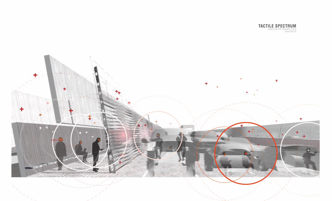
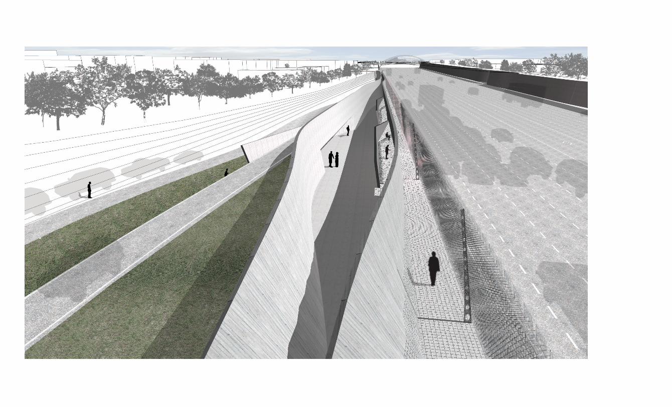
TACTILE SPECTRUMSAMPLING THE FREEWAY FIELD
HOUSTON TX
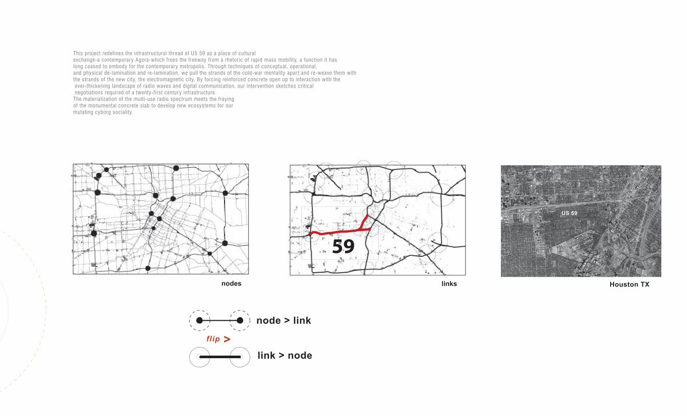
link > node
node > link
>flip
US 59
Houston TX
59
nodes links
This project redefines the infrastructural thread of US 59 as a place of cultural
exchange-a contemporary Agora-which frees the freeway from a rhetoric of rapid mass mobility, a function it haslong ceased to embody for the contemporary metropolis. Through techniques of conceptual, operational,
and physical de-lamination and re-lamination, we pull the strands of the cold-war mentality apar t and re-weave them with
the strands of the new city, the electromagnetic city. By forcing reinforced concrete open up to interaction with the
ever-thickening landscape of radio waves and digital communication, our intervention sketches critical negotiations required of a twenty-first century infrastructure.
The materialization of the multi-use radio spectrum meets the frayingof the monumental concrete slab to develop new ecosystems for our
mutating cyborg sociality.
TACTILE SPECTRUMSAMPLING THE FREEWAY FIELD
HOUSTON TX
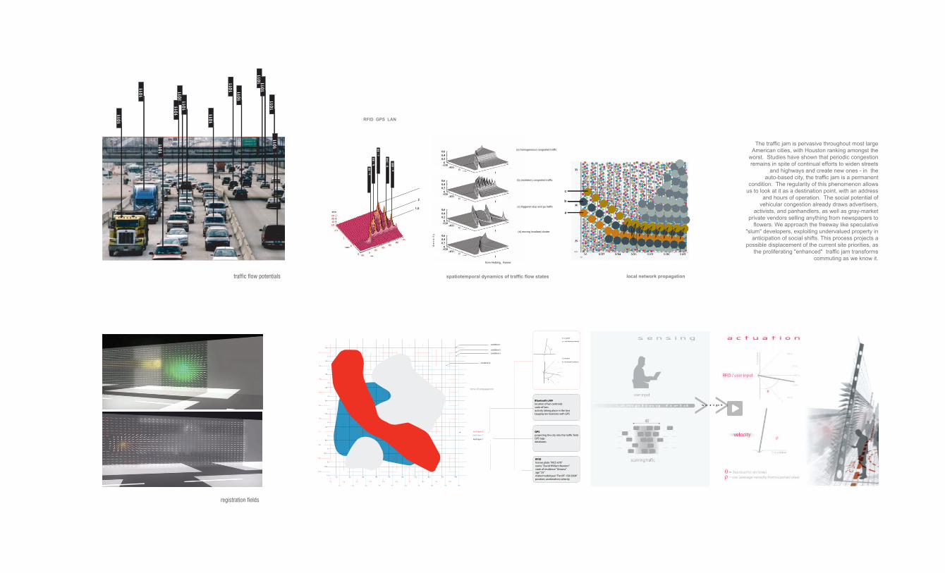
registration fields
spatiotemporal dynamics of traffic flow states
(c) triggered stop and go traffic
(d) moving localized cluster
local network propagation
a
b
c
a :
80
b :
80
c :
80
b :
240
a :
400
RFID GPS LAN
1,5
2,4
3
from Helbing_ Kerner
traffic flow potentials
d e
n s
i t y
(a) homogeneous congested traffic
(b) oscillatory congested traffic
The traffic jam is pervasive throughout most large
American cities, with Houston ranking amongst the
worst. Studies have shown that periodic congestion
remains in spite of continual efforts to widen streets
and highways and create new ones - in the
auto-based city, the traffic jam is a permanent
condition. The regularity of this phenomenon allows
us to look at it as a destination point, with an address
and hours of operation. The social potential of
vehicular congestion already draws advertisers,
activists, and panhandlers, as well as gray-market
private vendors selling anything from newspapers to
flowers. We approach the freeway like speculative
"slum" developers, exploiting undervalued property in
anticipation of social shifts. This process projects a
possible displacement of the current site priorities, as
the proliferating "enhanced" traffic jam transforms
commuting as we know it.
matt layer 3
matt layer 2
RFIDlicense plate "MCC-670"name "David William Newton"state of residence "Arizona"age "25"make/model/year "Ford/F-150/2004"position; acceleration; velocity
GPSprojecting the city into the traffic feildGPS tagsdatabases
Bluetooth LANlocation of lan centroidsscale of lansactivity taking place in the lanstagging lan locations with GPS
cos (average velocity)
= (boolean%) sin(time)
x-y plane
y-z plane
90 %
90 %
70 %
70 %
50 %
matt layer 1
condition 1
condition 2
condition 3
condition 4
zone of propagation
1 z
2 z
3 z
4 z
5 z
6 z
7 z
8 z
9 z
10 z
1 z
2 z
3 z
4 z
5 z
6 z
7 z
8 z
9 z
10 z
1 z
2 z
3 z
4 z
5 z
6 z
7 z
8 z
9 z
10 z1 x 2 x 3 x 4 x 5 x 6 x 7 x 8 x 9 x 10 x
1 x 2 x 3 x 4 x 5 x 6 x 7 x 8 x 9 x 10 x
1 x 2 x 3 x 4 x 5 x 6 x 7 x 8 x 9 x 10 x
1011
1011
1011
1011
1011
10111011
1011
1011
1011
1011
1011
1011
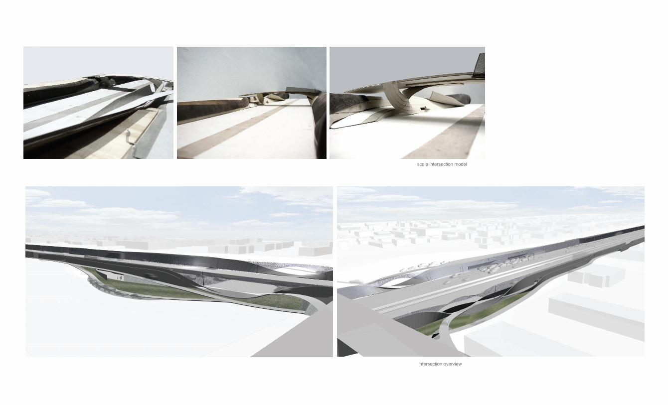
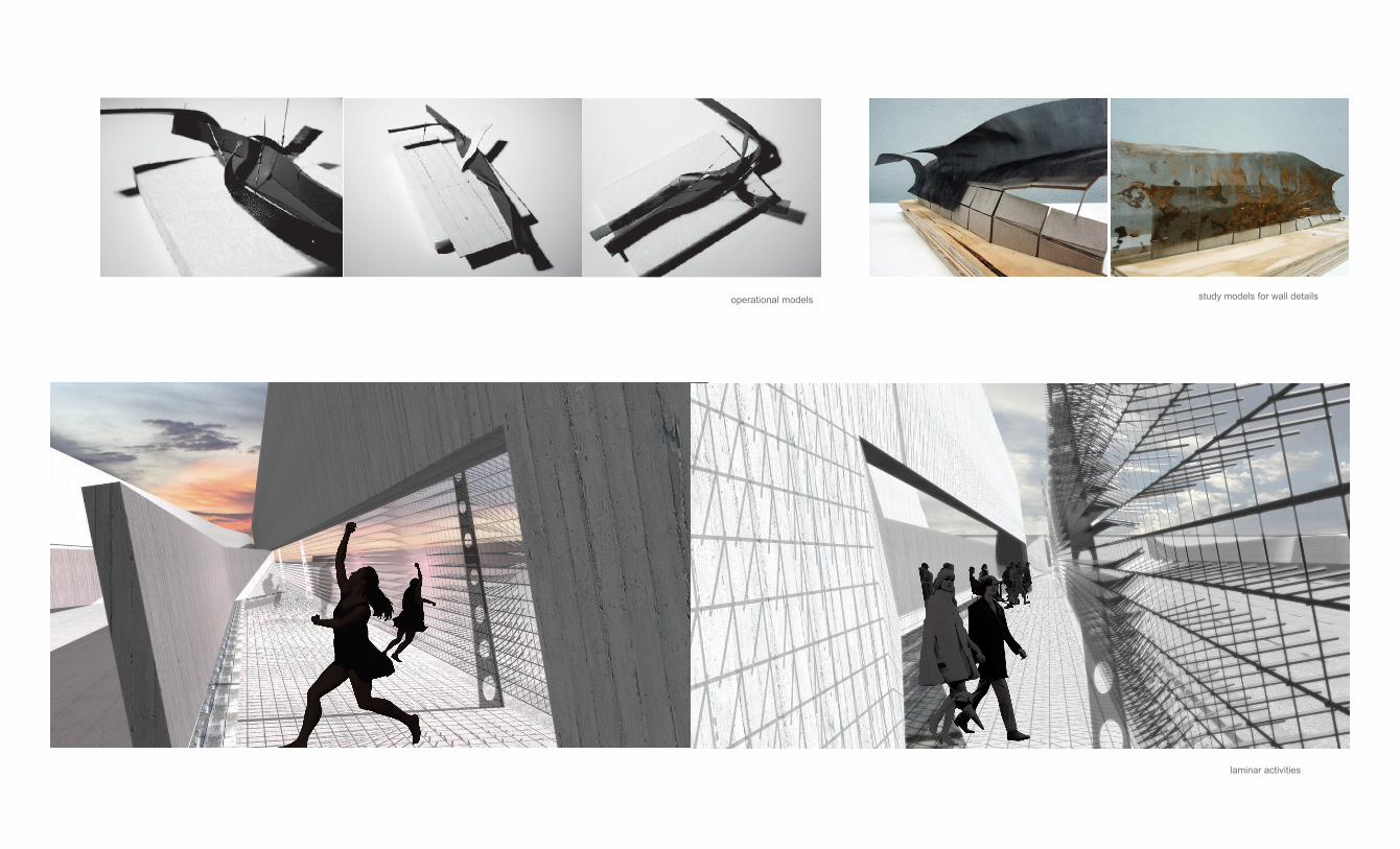
study models for wall detailsoperational models
scale intersection model
intersection overview
laminar activities
study models for wall detailsoperational models
scale intersection model
intersection overviewlaminar activities

PROCESSMIXED MEDIA FROM VARIOUS PROJECTS