welcome and introductions results of strategic planning survey updates from subcommittees tips...
TRANSCRIPT

Denver Regional Data Consortium
May 2012

Agenda Welcome and introductions
Results of Strategic Planning Survey
Updates from Subcommittees
Tips for Moving Forward
Guest Speaker: Greg Matthews (USGS)
Next Steps
Strategic Planning Survey

Survey Results 10 respondents
9 jurisdictions/business partners represented
Exercise your right to vote!

Survey Results
Two New Subcommittees!Boundaries
Census
Two New Teams!Standards and Policy
Technical

2012 Subcommittees and Teams
Common Space Built Environment Planimetrics DRAPP Streets Boundaries Census Tech Team Policy Team
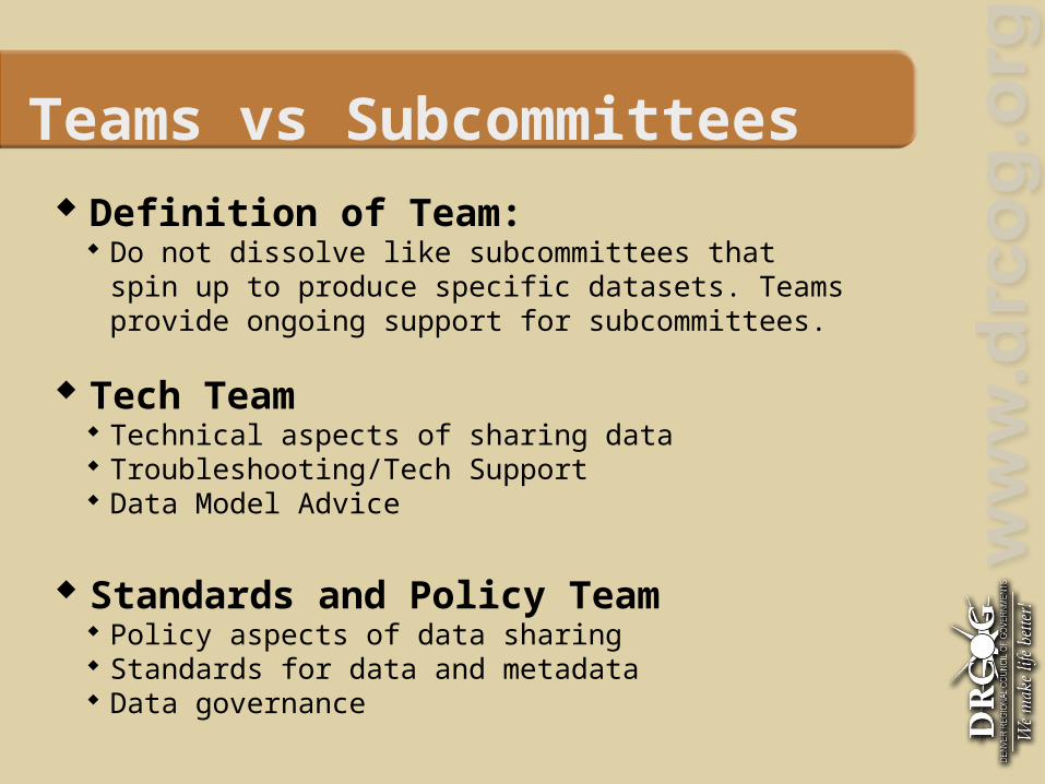
Teams vs Subcommittees
Definition of Team: Do not dissolve like subcommittees that spin up to
produce specific datasets. Teams provide ongoing support for subcommittees.
Tech Team Technical aspects of sharing data Troubleshooting/Tech Support Data Model Advice
Standards and Policy Team Policy aspects of data sharing Standards for data and metadata Data governance

Survey Results Time allotment
Most popular is 1-3 hours per week
Subcommittee size Nothing conclusive
Subcommittee Reports
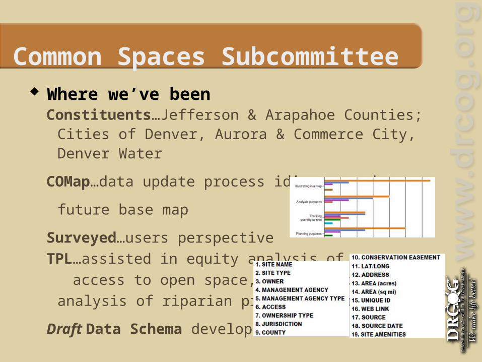
Common Spaces Subcommittee
Where we’ve beenConstituents…Jefferson & Arapahoe Counties; Cities of
Denver, Aurora & Commerce City, Denver Water
COMap…data update process idiosyncrasies, future base map
Surveyed…users perspective TPL…assisted in equity analysis of access to open space, trails and gap analysis of riparian
protection areas
Draft Data Schema developed
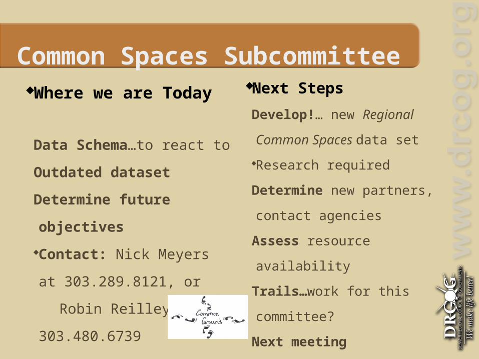
Common Spaces Subcommittee Where we are Today
Data Schema…to react to
Outdated dataset
Determine future objectives
Contact: Nick Meyers at
303.289.8121, or
Robin Reilley at
303.480.6739
Next Steps
Develop!… new Regional
Common Spaces data set
Research required
Determine new partners,
contact agencies
Assess resource availability
Trails…work for this
committee?
Next meeting
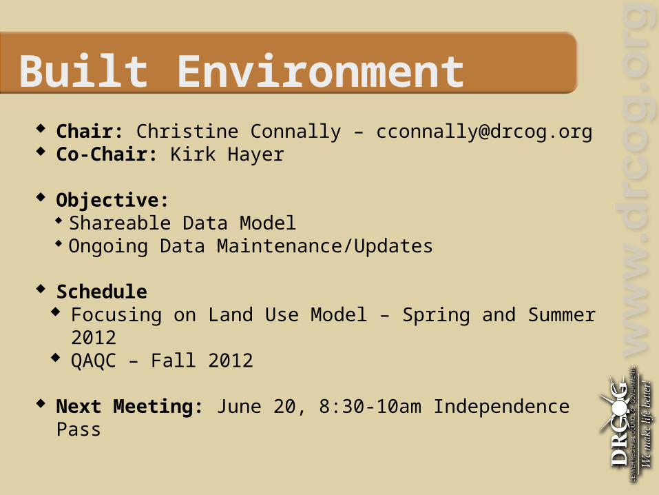
Built Environment Chair: Christine Connally – [email protected] Co-Chair: Kirk Hayer
Objective: Shareable Data Model Ongoing Data Maintenance/Updates
Schedule Focusing on Land Use Model – Spring and Summer 2012 QAQC – Fall 2012
Next Meeting: June 20, 8:30-10am Independence Pass
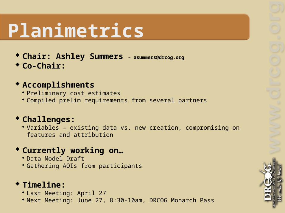
Planimetrics Chair: Ashley Summers – [email protected]
Co-Chair:
Accomplishments Preliminary cost estimates Compiled prelim requirements from several partners
Challenges: Variables – existing data vs. new creation, compromising on features and attribution
Currently working on… Data Model Draft Gathering AOIs from participants
Timeline: Last Meeting: April 27 Next Meeting: June 27, 8:30-10am, DRCOG Monarch Pass

DRAPP Chair: Ashley Summers – [email protected]
Accomplishments 3 Project Areas Flown successfully Interim Data Available in WMS 38 Partners
Schedule: Flying Mountainous Region in June
Meetings: Last Meeting: April 27 Next Meeting: June 27, 10:30-Noon, DRCOG Independence Pass
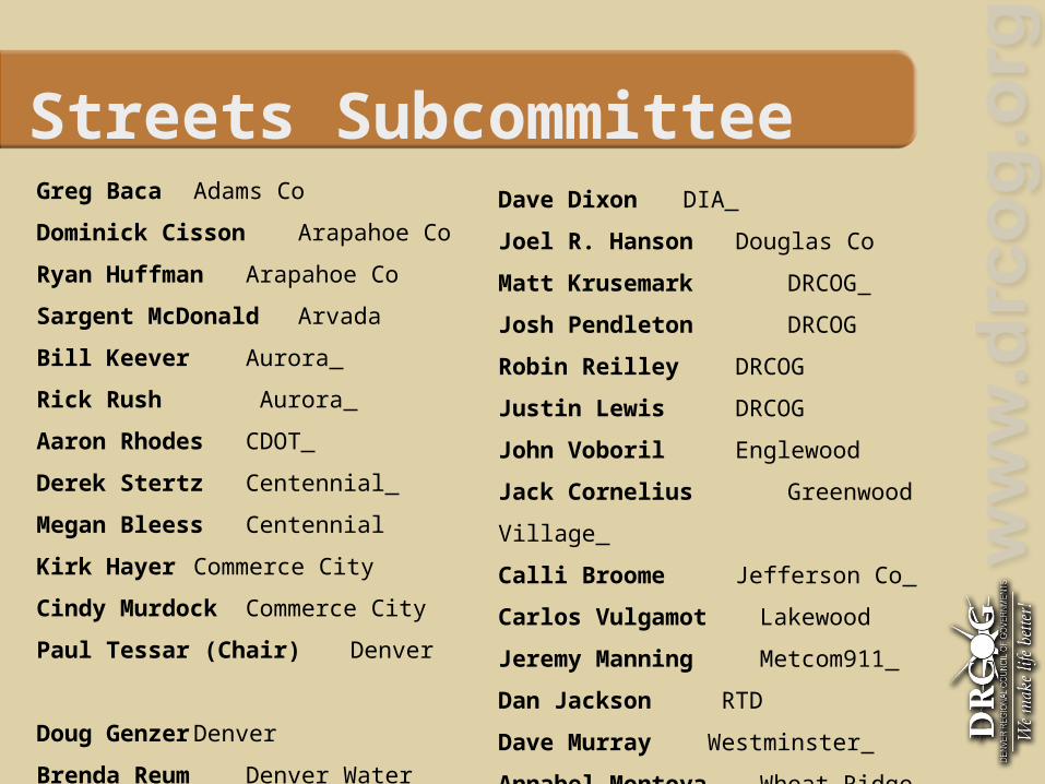
Streets Subcommittee Greg Baca Adams Co
Dominick Cisson
Arapahoe Co
Ryan Huffman Arapahoe Co
Sargent McDonald Arvada
Bill Keever Aurora
Rick Rush Aurora
Aaron Rhodes CDOT
Derek Stertz Centennial
Megan Bleess Centennial
Kirk Hayer Commerce City
Cindy Murdock Commerce City
Paul Tessar (Chair) Denver
Doug Genzer Denver
Brenda Reum Denver Water
Dave Dixon DIA
Joel R. Hanson Douglas Co
Matt Krusemark DRCOG
Josh Pendleton DRCOG
Robin Reilley DRCOG
Justin Lewis DRCOG
John Voboril Englewood
Jack Cornelius Greenwood Village
Calli Broome Jefferson Co
Carlos Vulgamot Lakewood
Jeremy Manning
Metcom911
Dan Jackson RTD
Dave Murray Westminster
Annabel Montoya Wheat
Ridge
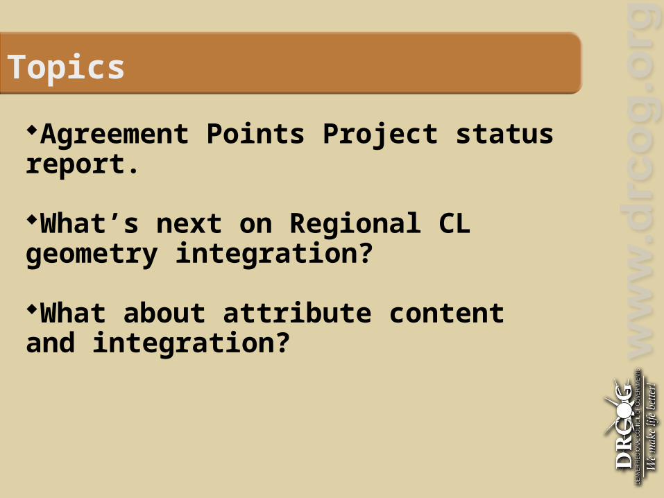
Topics
Agreement Points Project status report.
What’s next on Regional CL geometry integration?
What about attribute content and integration?

Agreement Points Project – Phase 1
Phase 1 Project is complete: N = 2351 points covering 750 County Border miles. 8/10 NCR Counties’ street layers will be snapped and
uploaded to NCR Repository by July. Adams and Gilpin Co. are lagging…
13 Counties collaborated: 10 NCR, Weld, Larimer & Park
11 Cities as well: Arvada, Aurora, Centennial, Commerce City Englewood, Greenwood Village, Lakewood Longmont, Thornton, Westminster, Wheat Ridge

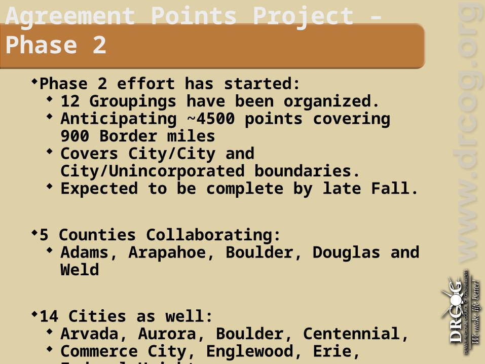
Agreement Points Project – Phase 2
Phase 2 effort has started: 12 Groupings have been organized. Anticipating ~4500 points covering 900 Border miles Covers City/City and City/Unincorporated
boundaries. Expected to be complete by late Fall.
5 Counties Collaborating: Adams, Arapahoe, Boulder, Douglas and Weld
14 Cities as well: Arvada, Aurora, Boulder, Centennial, Commerce City, Englewood, Erie, Federal Heights Greenwood Village, Longmont, Northglenn, Thornton Westminster, Wheat Ridge

Phase 2 Agreement Points Project Groupings
Grouping 1 – Meeting Date TBD Adams County - Greg Baca Adams County - Fran Valenta Arvada - Sargent McDonald Westminster - Dave Murray Wheat Ridge - Annabel Montoya
Grouping 2 - Meeting Date TBD Adams County - Greg Baca Adams County - Fran Valenta Commerce City - Rose Clawson
Grouping 3 – May 8, 2012 Aurora - Bill Keever Arapahoe County - Ryan Huffman
Grouping 4 – May 30, 2012 Arapahoe County - Ryan Huffman Englewood - John Voboril
Grouping 5 – May 17, 2012 Arapahoe County - Ryan Huffman Centennial - Megan Bleess
Grouping 6 – May 22, 2012 Boulder County - Mark Mullane City of Boulder - Kip White
Grouping 7 – Meeting Date TBD Longmont - Lisa Schertz Boulder County - Mark Mullane Erie - Deb Jenkins
Grouping 8 – Meeting Date TBD Commerce City - Rose Clawson Thornton - Liz Kienle Westminster - Dave Murray Federal Heights - Robert Smith Northglenn - Amy Ward
Grouping 9 – Meeting Date TBD Weld County - Dan Huerter Longmont - Lisa Schertz Erie - Deb Jenkins Northglenn - Amy Ward
Grouping 10 – June 21, 2012 Adams County - Greg Baca Adams County - Fran Valenta Aurora - Bill Keever
Grouping 11 – June 21, 2012 Adams County - Greg Baca Adams County - Fran Valenta Thornton - Liz Kienle
Grouping 12 – Meeting Date TBD Aurora - Bill Keever Centennial - Megan Bleess Greenwood Village - Jack Cornelius Douglas County - Joel Hanson


What’s next on the geometry front?
When Phase 2 is complete, we will have the geometric basis for a seamless, routable, regional centerline layer.
(Assuming all participants snap to agreement points.)
The integration infrastructure for County-wide data for the Metro area is in place @ gis.ncrcolorado.org – ETL
The next challenge is to develop process to incorporate City-maintained data:
City->County->NCR/DRDC? City->NCR/DRDC? Other?
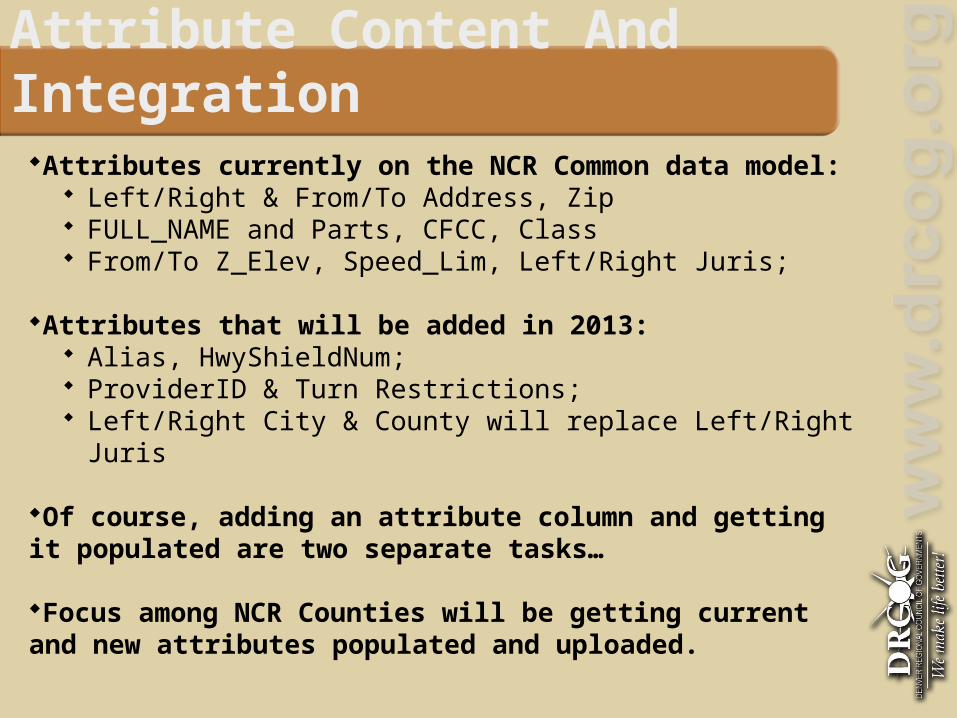
Attribute Content And Integration
Attributes currently on the NCR Common data model: Left/Right & From/To Address, Zip FULL_NAME and Parts, CFCC, Class From/To Z_Elev, Speed_Lim, Left/Right Juris;
Attributes that will be added in 2013: Alias, HwyShieldNum; ProviderID & Turn Restrictions; Left/Right City & County will replace Left/Right Juris
Of course, adding an attribute column and getting it populated are two separate tasks…
Focus among NCR Counties will be getting current and new attributes populated and uploaded.

Finis
Questions?
Contact Information: Paul Tessar 720-913-4882 [email protected] Frank Orr 303-885-4781 [email protected]

Boundaries Chair: Josh Pendleton – [email protected] Co-Chair: Greg Baca, Adams County
Prelim Objective: A regional jurisdiction boundary dataset with agreed upon boundaries that we can
consider official This dataset would serve as a template for future datasets, and from that point on
we would only have to worry about changes when specific annexations or de-annexations occur.
Accomplishments:
DRCOG Produces an annual Municipal Boundary Dataset we can reference. The Streets Subcommittee/NCR came up with agreement points we can use to
resolve discrepancies
Challenges: Coming to agreement on boundary discrepancies, whether we use NCR agreement points or not.
Next Meeting: Wed. Jun. 20th, 10am-12pm (Independence Pass, DRCOG)

Census Chair: Josh Pendleton – [email protected] Co-Chair: Dave Murray, City of Westminster
Prelim Objective: Producing a list of standardized, user friendly, Demographic Census products at all geographic levels
Accomplishments: DRCOG has some basic Census Demographic data up on the Regional Data Catalog, at 6 different levels of Geography: CBSA (Core Based Statistical Areas) Counties Census Designated Places Tracts Block Groups Blocks (Centroids)
Challenges: Dealing with the large amount of Census Data Census Data Formats vary Census Data accessibility/user friendliness varies by Census data types
Next Meeting: Wed. Jul. 11th, 10am-12pm (Independence Pass, DRCOG)

Tech Team Chair: Justin Lewis – [email protected] Co-Chair: Allan Glen – City and County of Denver
Prelim Objective: Support each sub-committee with technical solutions for sharing data
throughout the sub-committee life cycle.
Possible Areas of Support along the Sub-Committee Life Cycle: Initial Data Collection
Merge & format data into a common data model Re-distribute data back to the sub-committee members
Data Processing Collect and merge regular updates from sub-committee members
Data Sharing Make interim data products available to sub-committee members Make data available through the DRCOG Regional Data Catalog

Tech Team Challenges:
Every sub-committee has different needs and different technical limitations. We strive to create solutions that work for each sub-committee.
Next Steps: Work with each sub-committee to determine technical needs. Develop the strategy for supporting those needs.
Next Meeting: 3:30 – 4:30 pm June 13th @ DRCOG Red Mountain Pass

Policy Team Chair: Ashley Summers – [email protected]
Co-Chair:
Prelim Objective: address topics like data sharing, governance, and quality standards for our data and metadata.
Next Meeting:
June 26 from 3pm to 4:30pm @ DRCOG

Tips for Moving Forward

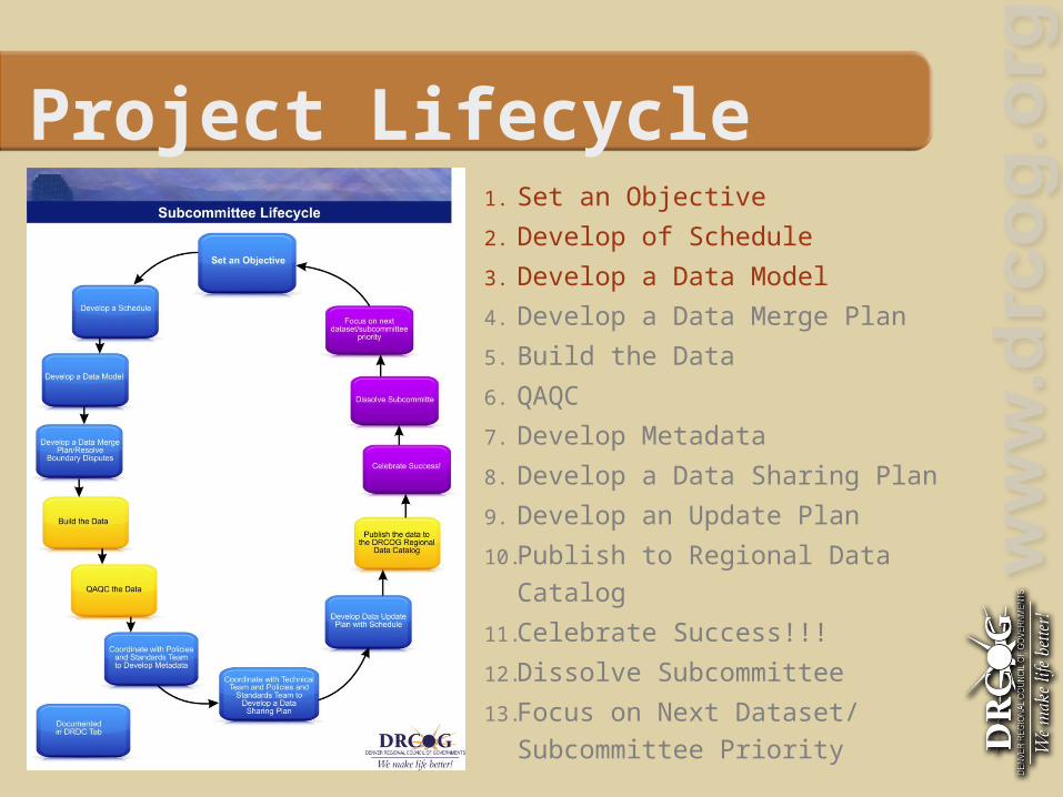
Project Lifecycle1. Set an Objective
2. Develop of Schedule
3. Develop a Data Model
4. Develop a Data Merge Plan
5. Build the Data
6. QAQC
7. Develop Metadata
8. Develop a Data Sharing Plan
9. Develop an Update Plan
10. Publish to Regional Data Catalog
11. Celebrate Success!!!
12. Dissolve Subcommittee
13. Focus on Next Dataset/ Subcommittee Priority

Project LifecycleStep 1: Set an Objective Guiding Questions:
Who are our customers? What gaps exist in our data that we need to fill? What problems exist that we need to solve?
Tip: Look for low-hanging-fruit, instead of pie-in-the-sky
>

Project LifecycleStep 2: Develop a Schedule Break your objective down into pieces
and make those into milestones.
Work backwards from the next meeting.
Divide and Conquer!

Project LifecycleStep 3: Develop a Data Model Start with a definition discussion.
Make sure everyone agrees on what Data Model means.
Don’t reinvent the wheel! Get some examples (past local projects, ESRI)

DRDC TabWhat can your Subcommittee contribute?
•Agendas and Meeting Minutes•Schedule•Upcoming Meetings•Data Products•Other?
Rollout = June/July

Guest Speaker
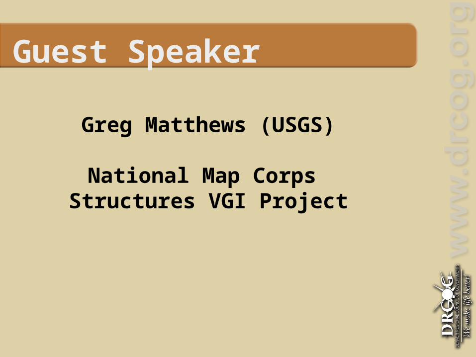
Guest Speaker
Greg Matthews (USGS)
National Map Corps Structures VGI Project

Next Steps

Next Meeting No meeting in July. Meet again in September (9/26/2012) Gives the subcommittee 4 months to
make progress! Meet with your subcommittees! Check in with DRCOG! Get advice from the teams! Check the website for information! Review the Project Lifecycle
Project Lifecycle1. Set an Objective
2. Develop of Schedule
3. Develop a Data Model
4. Develop a Data Merge Plan
5. Build the Data
6. QAQC
7. Develop Metadata
8. Develop a Data Sharing Plan
9. Develop an Update Plan
10. Publish to Regional Data Catalog
11. Celebrate Success!!!
12. Dissolve Subcommittee
13. Focus on Next Dataset/ Subcommittee Priority
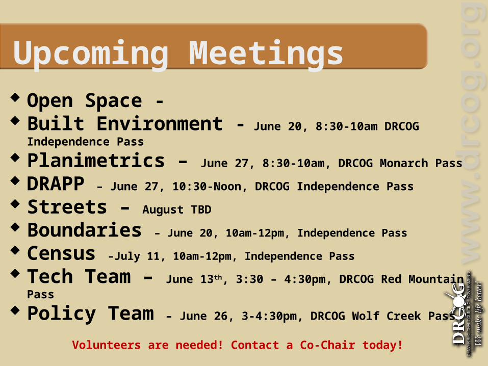
Upcoming Meetings Open Space - Built Environment - June 20, 8:30-10am DRCOG Independence Pass
Planimetrics – June 27, 8:30-10am, DRCOG Monarch Pass
DRAPP – June 27, 10:30-Noon, DRCOG Independence Pass
Streets – August TBD
Boundaries – June 20, 10am-12pm, Independence Pass
Census –July 11, 10am-12pm, Independence Pass
Tech Team – June 13th, 3:30 – 4:30pm, DRCOG Red Mountain Pass
Policy Team – June 26, 3-4:30pm, DRCOG Wolf Creek Pass
Volunteers are needed! Contact a Co-Chair today!
