11 surface water and flood risk - south cambridgeshire · pdf file11 surface water and flood...
TRANSCRIPT

Chapter 2
Site description and proposed development
August 2013
A new urban village for Cambridge
Environmental Statement
Land north of Newmarket Road, CambridgeOutline planning application to South Cambridgeshire District Council
Chapter 11Surface Water and Flood Risk
11
Land north of Newmarket Road Surface water and flood risk Environmental Statement
Marshall of Cambridge (Airport Properties) Limited December 2013
11 Surface water and flood risk
Introduction
11.1 This chapter has been prepared by Mott MacDonald and details the flood risk, surface water drainage and increased demands on potable water supply and wastewater treatment generated by the proposed development. It provides an overview of the existing flood risk and drainage conditions of the site, potential implications and aspects considered during the construction phase and the flood risk and surface water drainage strategy post-construction for the development. Additional consideration is given to Sustainable Urban Drainage Systems (SUDS) as part of the surface water drainage strategy and to residual effects, including maintenance and treatment of potential pollutants. Groundwater is covered in chapter 7 ground conditions and groundwater. The flood risk assessment (FRA) and surface water drainage strategy for the site are included in technical appendix H.
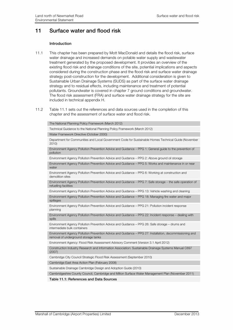
11.2 Table 11.1 sets out the references and data sources used in the completion of this chapter and the assessment of surface water and flood risk.
The National Planning Policy Framework (March 2012)
Technical Guidance to the National Planning Policy Framework (March 2012)
Water Framework Directive (October 2000)
Department for Communities and Local Government Code for Sustainable Homes Technical Guide (November 2010)
Environment Agency Pollution Prevention Advice and Guidance – PPG 1: General guide to the prevention of pollution
Environment Agency Pollution Prevention Advice and Guidance – PPG 2: Above ground oil storage
Environment Agency Pollution Prevention Advice and Guidance – PPG 5: Works and maintenance in or near water
Environment Agency Pollution Prevention Advice and Guidance – PPG 6: Working at construction and demolition sites
Environment Agency Pollution Prevention Advice and Guidance – PPG 7: Safe storage – the safe operation of refuelling facilities
Environment Agency Pollution Prevention Advice and Guidance – PPG 13: Vehicle washing and cleaning
Environment Agency Pollution Prevention Advice and Guidance – PPG 18: Managing fire water and major spillages
Environment Agency Pollution Prevention Advice and Guidance – PPG 21: Pollution incident response planning
Environment Agency Pollution Prevention Advice and Guidance – PPG 22: Incident response – dealing with spills
Environment Agency Pollution Prevention Advice and Guidance – PPG 26: Safe storage – drums and intermediate bulk containers
Environment Agency Pollution Prevention Advice and Guidance – PPG 27: Installation, decommissioning and removal of underground storage tanks
Environment Agency: Flood Risk Assessment Advisory Comment (Version 3.1 April 2012)
Construction Industry Research and Information Association: Sustainable Drainage Systems Manual C697 (2007)
Cambridge City Council Strategic Flood Risk Assessment (September 2010)
Cambridge East Area Action Plan (February 2008)
Sustainable Drainage Cambridge Design and Adoption Guide (2010)
Cambridgeshire County Council, Cambridge and Milton Surface Water Management Plan (November 2011)
Table 11.1: References and Data Sources

Land north of Newmarket Road Surface water and flood risk Environmental Statement
Marshall of Cambridge (Airport Properties) Limited December 2013
Legislation and policy
11.3 The existing water environment has been assessed in accordance with following legislation:
The National Planning Policy Framework (March 2010)
11.4 The National Planning Policy Framework (NPPF) set out the government’s planning policies for England and how these are expected to be applied. It sets out the government’s requirements for the planning system and provides a framework within which local people and their accountable councils can produce their own distinctive local and neighbourhood plans, which reflect the needs and priorities of their communities.
Technical Guidance to the National Planning Policy Framework (March 2012)
11.5 Technical Guidance provides additional guidance to local planning authorities to ensure the effective implementation of the planning policy set out in the NPPF on development in areas at risk of flooding. This guidance retains key elements of Planning Policy Statement 25 Development and Flood Risk Practice Guide.
Water Framework Directive (October 2000)
11.6 The Water Framework Directive (WFD) aims to establish a strategic framework (based on river basins) for managing surface water and groundwater through common objectives and principles. It also aims to improve the whole water environment and promote the sustainable use of water. It applies to groundwater and all surface water bodies, including lakes, streams, rivers, estuaries and coastal waters out to one mile from low water, and to artificial waters such as canals.
Department for Communities and Local Government (DCLG) Code for Sustainable Homes (CfSH) Technical Guide November 2010
11.7 Code for Sustainable Homes (CfSH) is an environmental assessment method for rating and certifying the performance of new homes. It is a national standard for the use in the design and construction of new homes with a view to encouraging continuous improvement in sustainable home building. Overall CfSH comprises nine categories, one of which concerns surface water runoff and includes SUDS, flood risk and treatment of surface water.
Environment Agency Pollution Prevention Advice and Guidance (PPG)
11.8 The Pollution Prevention Advice and Guidance (PPGs) comprise guidance notes to advise industry and the public on legal responsibilities and good environmental practice. Following the guidance helps to manage the environmental responsibilities to prevent pollution and comply with the law; causing pollution or allowing it to occur may constitute a criminal offence.
Environment Agency: Flood Risk Assessment Advisory Comment Version 3.1 (April 2012)
11.9 This Advisory Note outlines Environment Agency guidance on requirements for undertaking a FRA for the purpose of planning applications. The note principally relates to the commissioning and undertaking of FRA studies for development sites greater than 1ha in flood zone 1. It is designed to consider the principles of sustainable drainage of surface water, for use where works may affect watercourses or flood defences and for use where a critical drainage area has been identified by the Environment Agency (EA) or where the local planning authority has identified that a

Land north of Newmarket Road Surface water and flood risk Environmental Statement
Marshall of Cambridge (Airport Properties) Limited December 2013
drainage problem exists on which they would like assurance from the developer that flood risk has been addressed.
Construction Industry Research and Information Association (CIRIA) Sustainable Drainage Systems Manual C697 (2007)
11.10 This manual provides guidance on the planning, design, construction and maintenance of sustainable drainage systems to assist with their effective implementation within developments. The guidance addresses landscaping, biodiversity issues, public perception and community involvement as well as water quality treatment and flood risk management.
Cambridge City Council Strategic Flood Risk Assessment (September 2010)
11.11 A level 1 strategic flood risk assessment (SFRA) has been undertaken for the study area defined by the South Cambridgeshire District Council (SCDC) and Cambridge City Council boundaries. This provides a comprehensive and robust assessment of the extent and nature of the risk of flooding and its implications for land use planning. The SFRA evaluates the flood risk situation from 2010 to 2115 and incorporates the impacts of climate change.
Cambridge East Area Action Plan (February 2008)
11.12 The Cambridge East Area Action Plan establishes an overall vision and a set of development principles for the new urban quarter including its relationship with Cambridge and surrounding villages and its countryside setting. Chapter D11 of the area action plan provides guidance on flood risk, catchment areas, maintaining the character of the landscape, maintenance, water conservation and incorporation of sustainable drainage systems.
Sustainable Drainage Cambridge Design and Adoption Guide (2010)
11.13 The purpose of the guide is for use by developers and their consultants where they are seeking adoption of SUDS by Cambridge City Council within the public open space of new developments. It sets out the basis of successful SUDS schemes which aim to deliver benefits to the community, enhance the quality of life of the people living there, increase biodiversity, reduce flood risk and provide greater resistance to the impacts of climate change.
Cambridgeshire County Council, Cambridge and Milton Surface Water Management Plan (November 2011)
11.14 The surface water management plan outlines the preferred strategy for the management of surface water in a given location and the associated study is carried out in consultation with local partners having responsibility for surface water management and drainage in that area. The goal of the plan is to establish a long term action plan and to influence future strategy development for maintenance, investment, planning and engagement.
Methodology
11.15 Both a site visit and desk study work were carried out. The site visit was undertaken on 1st February 2013. An initial understanding of the site and constraints were developed. This was followed by a site visit to confirm existing constraints and ascertain any further considerations required for the purposes of the desk study work. Calculations were carried out to support the work where necessary. The supportive calculations include ascertaining the greenfield runoff for the existing site and simulating the 1 in 30 year rainfall event and the 1 in 100 year, plus an allowance for climate change of 30%, rainfall

Land north of Newmarket Road Surface water and flood risk Environmental Statement
Marshall of Cambridge (Airport Properties) Limited December 2013
event on the proposed surface water drainage network. The calculations can be found in technical appendix H. In addition, the local planning authority, Anglian Water, Ely Internal Drainage Board and the Environment Agency were consulted regarding the drainage strategy as the proposals were developed.
Scoping opinions
11.16 Table 11.2, summarises the scoping responses from consultees regarding the proposed development.
Consultee Response
Anglian Water With regard to surface water, Anglian Water Services (AWS) noted that they would accept surface water discharge from the site at the existing rate.
With regard to foul water, noted that the development lies with the catchment of Cambridge Sewage treatment works. Noted that the Treatment Works has the capacity to treat the flows from the proposed development. However, minor works would be required to the existing network outside of the site to cater for the additional flow. Provided options regarding the minor works. More detail regarding the foul water drainage for the proposed site can be found in the Mott MacDonald Utilities Report.
Local Planning Authority
SCDC and Cambridge City Council provided a positive response to the outline surface water drainage proposals and the basis of the design on best practice guidance. Cambridge City Council noted that there were existing localised flooding issues regarding Thorpe Way Ditch and the city and district council’s would like to see betterment of this situation.
Environment Agency
Provided a positive response regarding the development proposals comprising reducing surface water runoff rates to greenfield and incorporating SUDS in the drainage design. Noted that the proposals should seek to maximise the sustainability of the solution, inclusion of SUDS and ensure that it is practicably achievable. Noted that the accompanying calculations should include an appropriate allowance for climate change.
Ely Internal Drainage Board
Noted that part of the site discharges into a highland area which drains into the Swaffham Internal Drainage District and is eventually pumped into the Main River System at Upware Pumping Station. The Board stated that they would have no objections to the discharge of surface water from this site, as long as it is limited to the existing greenfield run-off rate.
Table 11.2 Summary of scoping responses from consultees
Cumulative effects
11.17 The relevant schemes for the assessment of cumulative effects are listed in chapter 3 of the ES and are shown on figure 3.2.
Flood risk
11.18 An FRA was prepared by Mott MacDonald for the proposed development site in August 2013 in accordance with EA and NPPF guidance. The FRA reviewed the existing flood risk and the existing surface water drainage in the context of the Cambridge Strategic Flood Risk Assessment and EA guidance and statistical mapping. The review ascertained the existing baseline flood risk conditions for the site.
11.19 The FRA includes an assessment of all sources of flooding in accordance with the NPPF Technical Guidance March 2012 which states that:
“As set out in the National Planning Policy Framework, local planning authorities should only consider development in flood risk area appropriate where informed by a site-specific flood risk assessment. This should identify and assess the risks of all forms of flooding to and from the development and demonstrate how these flood risks will be managed so that the

Land north of Newmarket Road Surface water and flood risk Environmental Statement
Marshall of Cambridge (Airport Properties) Limited December 2013
development remains safe throughout its lifetime taking climate change into account. Those proposing developments should take advice from the emergency services when producing an evacuation plan for the development as part of the flood risk assessment.”
11.20 All sources of flooding have been considered including fluvial, groundwater, surface water overland flow, pluvial surface water, sewer capacity, infrastructure failure and tidal and estuary flooding.
11.21 All developable land is designated as one of three flood zones on the basis of the probability of river or sea flooding. Flood zone 1 is defined as land assessed as having a less than 1 in 1,000 annual probability of river or sea flooding (<0.1%). All uses of land are appropriate in flood zone 1. Flood zone 2 is defined as land assessed as having between a 1 in 100 and 1 in 1,000 annual probability of river flooding (1% - 0.1%), or between a 1 in 200 and 1 in 1,000 annual probability of sea flooding (0.5% - 0.1%) in any year. Essential infrastructure and water compatible, less vulnerable and more vulnerable uses, as set out in the section below, are appropriate in flood zone 2. Highly vulnerable uses are only appropriate in this zone if the exception text is passed. Flood zone 3 is defined as land assessed as having a 1 in 100 or greater annual probability of river flooding (>1%), or a 1 in 200 or greater annual probability of flooding from the sea (>0.5%) in any year. Water compatible and less vulnerable uses of lad are appropriate in flood zone 3. Highly vulnerable land uses are not permitted in this zone.
11.22 The post development flood risk, vulnerability and flood zone compatibility has been considered on the basis of the technical guidance to the NPPF. The receptors of flood risk are classified into five groups for the purposes of flood risk vulnerability. The five groups are “essential infrastructure”, “highly vulnerable”, “more vulnerable”, “Less Vulnerable” and “Water-compatible development”. The receptors in these groups are detailed in table 11.3.
Essential infrastructure
• Essential transport infrastructure (including mass evacuation routes) which has to cross the area at risk
• Essential utility infrastructure which has to be located in a flood risk area for operational reasons, including electricity generating power stations and grid and primary substations; and water treatment works that need to remain operational in times of flood
• Wind turbines
Highly vulnerable
• Police stations, ambulance stations and fire stations and command centres and telecommunications installations required to be operational during flooding
• Emergency dispersal points
• Basement dwellings
• Caravans, mobile homes and park homes intended for permanent residential use
• Installations requiring hazardous substances consent. (Where there is a demonstrable need to locate such installations for bulk storage of materials with port or other similar facilities, or such installations with energy infrastructure or carbon capture and storage installations, that require coastal or water-side locations, or need to be located in other high flood risk areas, in these instances the facilities should be classified as “essential infrastructure”)
More vulnerable
• Hospitals
• Residential institutions such as residential care homes, children’s homes, social services homes, prisons and hostels
• Buildings used for dwelling houses, student halls of residence, drinking establishments, nightclubs and hotels
• Non–residential uses for health services, nurseries and educational establishments
• Landfill and sites used for waste management facilities for hazardous waste
• Sites used for holiday or short-let caravans and camping, subject to a specific warning and evacuation plan
Land north of Newmarket Road Surface water and flood risk Environmental Statement
Marshall of Cambridge (Airport Properties) Limited December 2013
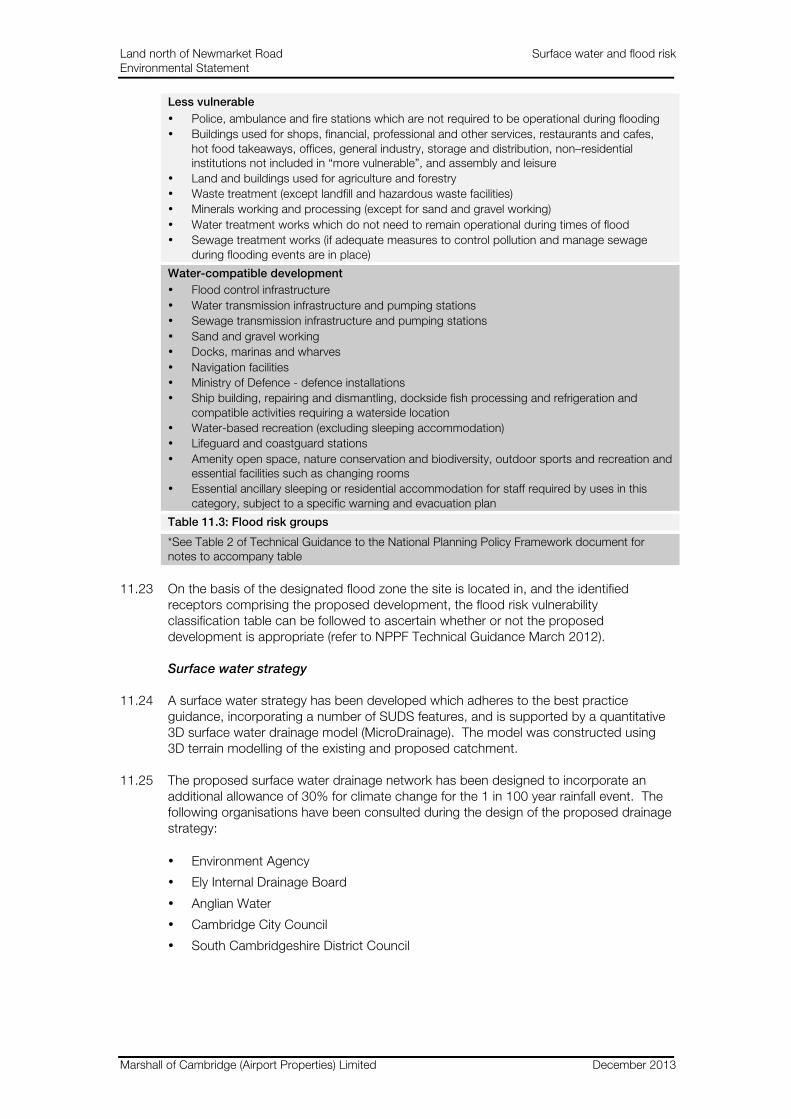
Less vulnerable
• Police, ambulance and fire stations which are not required to be operational during flooding
• Buildings used for shops, financial, professional and other services, restaurants and cafes, hot food takeaways, offices, general industry, storage and distribution, non–residential institutions not included in “more vulnerable”, and assembly and leisure
• Land and buildings used for agriculture and forestry
• Waste treatment (except landfill and hazardous waste facilities)
• Minerals working and processing (except for sand and gravel working)
• Water treatment works which do not need to remain operational during times of flood
• Sewage treatment works (if adequate measures to control pollution and manage sewage during flooding events are in place)
Water-compatible development
• Flood control infrastructure
• Water transmission infrastructure and pumping stations
• Sewage transmission infrastructure and pumping stations
• Sand and gravel working
• Docks, marinas and wharves
• Navigation facilities
• Ministry of Defence - defence installations
• Ship building, repairing and dismantling, dockside fish processing and refrigeration and compatible activities requiring a waterside location
• Water-based recreation (excluding sleeping accommodation)
• Lifeguard and coastguard stations
• Amenity open space, nature conservation and biodiversity, outdoor sports and recreation and essential facilities such as changing rooms
• Essential ancillary sleeping or residential accommodation for staff required by uses in this category, subject to a specific warning and evacuation plan
Table 11.3: Flood risk groups
*See Table 2 of Technical Guidance to the National Planning Policy Framework document for notes to accompany table
11.23 On the basis of the designated flood zone the site is located in, and the identified receptors comprising the proposed development, the flood risk vulnerability classification table can be followed to ascertain whether or not the proposed development is appropriate (refer to NPPF Technical Guidance March 2012).
Surface water strategy
11.24 A surface water strategy has been developed which adheres to the best practice guidance, incorporating a number of SUDS features, and is supported by a quantitative 3D surface water drainage model (MicroDrainage). The model was constructed using 3D terrain modelling of the existing and proposed catchment.
11.25 The proposed surface water drainage network has been designed to incorporate an additional allowance of 30% for climate change for the 1 in 100 year rainfall event. The following organisations have been consulted during the design of the proposed drainage strategy:
• Environment Agency
• Ely Internal Drainage Board
• Anglian Water
• Cambridge City Council
• South Cambridgeshire District Council

Land north of Newmarket Road Surface water and flood risk Environmental Statement
Marshall of Cambridge (Airport Properties) Limited December 2013
Wastewater
11.26 Anglian Water has been consulted regarding the proposed development. Anglian Water has carried out computer modelling of their existing network to service the predicted demands of the development. Anglian Water based their computer modelling on the number and type of proposed dwellings and quantum and type of proposed non-residential development.
Potable water supply
11.27 Cambridge Water has been consulted regarding the proposed development. Cambridge Water has carried out computer modelling of their existing network to service the predicted demands of the development. Cambridge Water based their computer modelling on the number and type of proposed dwellings and quantum and type of proposed non-residential development.
Assessment of significance
11.28 Sensitivity criteria used for the assessment include the following:
• Negligible – water body of ‘poor’ or ‘bad’ ecological status and of ‘poor/bad’ water quality, of no amenity value or in an inaccessible area
• Low – water body of ‘low’ amenity value, low ecological status, low water quality, water body of local cultural / social / educational interest
• Medium – water body of ‘moderate to good’ ecological status, moderate water quality, a surface water source in close proximity to a source protection zone or abstraction point, of moderate amenity value, water body of national or regional importance
• High – water body of ‘high’ ecological status, high amenity value and in a popular area, high water quality, designated abstraction or well source protection zone, within a protected / sensitive area
11.29 The following magnitude of change criteria have been used:
• Negligible: no discernible change to baseline conditions
• Small adverse / beneficial: slight change to baseline conditions
• Medium adverse / beneficial: moderate change to baseline conditions
• Large adverse / beneficial: major change to baseline conditions
11.30 On the basis of good practice guidance the following significance criteria have been identified (please also see the matrix in figure 3.1):
• Substantial benefit - such effects are large scale direct effects, for example dramatic improvements in water quality or relief from existing flooding. These effects would be of regional or national importance
• Moderate benefit - such effects involve small / medium scale direct effects, for example reduction in risk of pollution or flooding. The effects would be of local or regional importance
• Slight benefit - such effects would be localised, of low / small magnitude. For example there may be potential for a small improvement to water quality or reduction in flooding on the site
• Negligible - No discernible effect

Land north of Newmarket Road Surface water and flood risk Environmental Statement
Marshall of Cambridge (Airport Properties) Limited December 2013
• Slight adverse - such effects would be localised, of low / small magnitude and would be easy to mitigate. For example there may be potential for a small change to water quality during construction and/or use
• Moderate adverse - Such effects involve small / medium scale direct effects, for example increased risk of pollution or concentration of surface water discharge to cause localised flooding. The effects may require significant mitigation and would be of local or regional importance
• Substantial adverse - Such effects are large scale direct effects, for example dramatic changes in water quality or concentration of surface water flow resulting in major surface water flooding including the flooding of properties. The effects may be difficult to mitigate and would be of regional or national importance
Baseline
Surface water
11.31 The site is located approximately 1 km south east from the River Cam and 1.5 km west of Quy Water. Both the River Cam and Quy Water are designated as main rivers by the Environment Agency. Figure 11.1 illustrates the location of the site and the locations of the River Cam and Quy Water.
11.32 The existing site comprises “brownfield” land use in the south west and central south area (an area of approximately 17ha) and greenfield land use on the rest of the site. The existing surface water drainage on-site comprises a positive drainage network serving the brownfield part of the site and a network of field ditches serving the greenfield part.
11.33 Following a review of the existing catchment topography and drainage record drawings for the site it has been concluded that the site currently drains to two separate outfalls. The developed part of the south catchment of the site drains to Thorpe Way Ditch, which runs along the west boundary of the site before connecting to the Anglian Water surface water drainage network. The south surface water catchment (an area of approximately 34.8ha) includes run off from the existing North Works site. Approximately 8ha of the North Works drains directly to Thorpe Way Ditch unattenuated and approximately 8.2ha drains to an existing attenuation basin located on the site. The greenfield area of the south catchment (approximately 18.6ha) drains via field ditches into Thorpe Way Ditch.
11.34 The north surface water catchment (an area of approximately 8.88ha) of the site, comprising arable land, drains to the High Ditch Road Ditch, which runs adjacent to the east boundary of the site. Surface water from this arable land discharges to the ditch, which connects with the network of drains to the north of the site controlled by the Ely Internal Drainage Board.
11.35 The remaining 21.21ha of the total site area of 64.87ha comprises arable fields. This area of the site is proposed to comprise allotments and grass sports pitches. Figure 11.2 illustrates the north catchment and south catchment and site surface water outfalls as described above.
Flood risk
11.36 The site is located in flood zone 1 as designated by the EA. Flood zone 1 is defined as land assessed by the EA as having a less that 1 in 1,000 annual probability of river or sea flooding (<0.1%). On the basis of the existing flood risk on site (flood zone 1) and the development proposals (residential land use as noted above in Paragraph 11.24), the development has been assessed to be appropriate for the predicted level of flood risk on the basis of the technical guidance to the NPPF. Some localised flooding of

Land north of Newmarket Road Surface water and flood risk Environmental Statement
Marshall of Cambridge (Airport Properties) Limited December 2013
Thorpe Way Ditch has been reported, which is considered to be caused by debris and ‘fly tipping’ blocking the piped outfall, and poor access to maintain the ditch.
Surface water quality
11.37 No data exists for surface water quality in the ditches at the site. It is considered that the existing quality of the surface water draining from the brownfield part of the site is influenced by the lack of SUDS and existing activity on the site. Surface water draining from the greenfield part of the site is considered to be of better quality as it drains off fields. Chapter 7 Ground conditions and groundwater comments on groundwater quality.
Existing site discharge consents
11.38 An Envirocheck Report prepared for the site states that there are two existing discharge consents linked to the brownfield part of the site. These discharge consents comprise one surface water discharge consent and one treated effluent discharge consent. The receiving watercourse for the surface water discharge consent is a tributary to the River Cam and the receiving watercourse for the treated effluent discharge consent is a tributary of Quy Water. More information regarding ground conditions can be found in chapter 7 and technical appendix E.
Existing site water abstraction
11.39 The Envirocheck Report indicates there are no existing water abstraction licences for the site. More information regarding ground conditions can be found in technical appendix E.
Recorded pollution incidents
11.40 The Envirocheck Report indicates there has been one recorded pollution incident to a controlled water. More information regarding ground conditions can be found in technical appendix E.
Geology
11.41 The underlying geology of the site is clay and recent soakaway tests have yielded very poor infiltration results across the site. Detailed information regarding the geology of the site can be found in the Mott MacDonald Ground Investigation Report included in technical appendix E.
Foul water
11.42 The foul water from the North Works site currently drains to the 300mm diameter Anglian Water sewer located in Newmarket Road. Cambridge is considered to be one of the fastest growing areas with population predicted to increase by 50,000 over the next 25 years. In written correspondence, Anglian Water stated that foul drainage from the proposed development is in the catchment of Cambridge Sewage Treatment Works and that the works currently has capacity to treat flows from the proposed development.
Potable water
11.43 The existing North Works site is currently supplied with water by Cambridge Water via a connection to the 4 inch diameter water main in Newmarket Road. Cambridge is considered to be in one of the driest areas of the UK and Cambridge Water operates in one of the fastest growing areas with population predicted to increase by 50,000 over the next 25 years. Cambridge Water relies on winter rainfall to replenish the
Land north of Newmarket Road Surface water and flood risk Environmental Statement
Marshall of Cambridge (Airport Properties) Limited December 2013
underground aquifer from which it pumps water for supply. The possibility of hotter, drier summers combined with increases in population increases demands on water supply – particularly during the summer as customers choose to water gardens, take more showers and fill paddling pools etc., puts a strain on the local distribution network at peak times.
Assessment of the sensitivity of identified receptors
11.44 Identified receptors comprise the surface water drainage network and surface water quality. These receptors are both considered to be of medium sensitivity. The risk of flooding at the site is considered to be low, therefore the sensitivity of this issue is also considered to be low.
11.45 Given the availability of capacity in existing foul water infrastructure, this receptor is considered to be of low sensitivity.
11.46 Potable water in the area is considered to be of medium – high sensitivity given the demand on the existing supply and that Cambridge lies in the South East, one of the driest areas of the UK.
Future baseline
11.47 It is anticipated that should the proposed development not take place, the baseline surface water drainage and surface water quality conditions at the site would remain largely unchanged. However, future predictions of climate change for the UK suggest that in some areas there may be the potential for more intense rainfall events and thus increased magnitude of flood events, which is likely to create a demand for alteration of drainage requirements. In addition, it is anticipated that as the established expansion plans for Cambridge come to fruition that there will be an increased demand on potable water supply and wastewater infrastructure and treatment facilities.
Effects during construction
11.48 Minor localised ponding of pluvial surface water is likely to occur during construction as a result of excavations, soil compaction and less water being attenuated on site by vegetation in the greenfield areas of the site. In addition, the construction activities are likely to include the removal and infilling of some existing surface water drainage. It is considered that this potential effect is of negligible – small magnitude and of slight adverse significance.
11.49 Potential hazards during construction could include spillage of oil, or other hazardous substances into the existing surface water network, thereby polluting water. Construction activities that could give rise to potential contaminated runoff on-site including hydrocarbons, suspended solids and construction materials include:
• Operation and washing of construction vehicles
• Stockpile of spoil
• Potential increase in erosion of bare soil and material
• High volume movement of construction vehicles
• Storage of associated fuels, oils etc.
• The site construction compound and site access roads
11.50 It is considered that this potential effect is of negligible – small magnitude and of slight adverse significance.

Land north of Newmarket Road Surface water and flood risk Environmental Statement
Marshall of Cambridge (Airport Properties) Limited December 2013
Effects post-construction
11.51 There will be an increased demand for water supply in the area. It is considered that this increase in demand is of small - medium magnitude and of moderate adverse significance. The Sustainability Statement and Water Conservation Strategy details measures to minimise internal use of potable water throughout the proposed development.
11.52 There will be an increased demand on wastewater treatment in the area. It is considered that this increase in demand is of medium magnitude and of slight - moderate adverse significance.
11.53 There will be an increase in the number of people, vehicles and waste on site. This will result in an increase in potential pollution of surface water. Pollution could occur via oil leaks and petrochemical substances from vehicles on site being washed into the drainage network. Particular pollution ‘hotspots’ could include car parking areas. It is considered that this poses a potential effect of small – medium magnitude and moderate adverse significance.
11.54 Post-construction there will be an increase in impermeable area. This will increase surface water runoff from the site as there is reduced availability of greenfield land to reduce runoff through evapotranspiration and minor infiltration into the topsoil. It is considered that this increase in runoff is of medium – large magnitude and of moderate adverse significance. The SUDS proposals which have been integrated into the proposed landscape are designed to control the surface water runoff from the site to the greenfield rate.
Mitigation
Construction
11.55 During the construction process, materials will be stored and transported safely and in accordance with EA and Control of Substances Hazardous to Health (COSHH) guidelines to minimise the risk of spillage and potential pollution of surface water on site.
11.56 EA and COSHH guidance will be followed regarding the bunding of fuel tanks, wheel washing and storage of construction materials. EA Pollution Prevention Guidance (PPG) includes:
• PPG 1 General guide to the prevention of pollution
• PPG 2 Above ground oil storage
• PPG 5 Works and maintenance in or near water
• PPG 6 Working at construction and demolition sites
• PPG 7 Safe storage – the safe operation of refuelling facilities
• PPG 13 Vehicle washing and cleaning
• PPG 18 Managing fire water and major spillages
• PPG 21 Pollution incident response planning
• PPG 22 Incident response – dealing with spills
• PPG 26 Safe storage – drums and intermediate bulk containers
• PPG 27 Installation, decommissioning and removal of underground storage tanks
11.57 In addition to the above guidance, measures to control the accidental discharge of pollutants will be documented in the Construction Environmental Management Plan (CEMP) and are likely to include, but not be limited to, the following:
Land north of Newmarket Road Surface water and flood risk Environmental Statement
Marshall of Cambridge (Airport Properties) Limited December 2013
• Careful bunding and siting of any fuel storage
• The development and implementation of accident response procedures
• Provision of drain covers where appropriate
• Careful control of woks involving concrete, and ready-mix concrete wagons being washed out in a safe area
• Provision for the safe disposal of wastewaters
Flood risk and surface water drainage
11.58 The underlying geology of the site is clay and recent soakaway tests have yielded very poor infiltration results across the site. It is therefore considered that infiltration would be impracticable for the site. Detailed information on geology can be found in technical appendix E and chapter 7.
11.59 In order to manage flood risk the surface water strategy will include SUDS within the site, as shown in figure 11.3. The site shall benefit from SUDS features which shall control the surface water at source as far as practical, providing storage for surface water up to and including the 1 in 100 year plus an allowance of 30% for climate change event. SUDS situated within the residential blocks are proposed to comprise a number of features including rills, permeable paving and water butts. Attenuation and storage for the larger rainfall events will be contained within the public open and green spaces of the development.
11.60 For the south catchment it is proposed that the SUDS shall comprise a series of up to four attenuation basins within the proposed Gregory Park. Surface water will be drained via a piped network from the residential blocks. The series of basins shall provide attenuation and storage for the 1 in 30 year rainfall event. In conjunction with an additional offline storage basin, the Gregory Park basins shall provide attenuation for the 1 in 100 year plus an allowance of 30% for climate change event. The south catchment outfall shall connect to Thorpe Way Ditch. It is proposed to incorporate a ha – ha adjacent to the west boundary leading to Gregory Park. Discharge will be limited to the existing greenfield runoff rate. Controlling discharge of the surface water runoff to the greenfield rate provides betterment over the existing site.
11.61 The north catchment SUDS shall comprise a series of linear detention basins in the form of ha – ha’s which provide attenuation and storage. These ha – ha’s shall collect surface water via a piped network from the north catchment residential blocks. These shall provide attenuation and storage for the 1 in 30 year rainfall event. In conjunction with an additional offline storage basin, attenuation and storage shall be provided for the 1 in 100 year plus an allowance of 30% for climate change event. The north catchment outfall shall connect to High Ditch Road Ditch. Discharge shall be limited to the greenfield runoff rate. Controlling discharge of the surface water runoff to the greenfield rate maintains the existing status quo and adheres to the requirements of Ely Internal Drainage Board.
11.62 Appropriate care and consideration will be taken into account with regard to the existing water vole population located in High Ditch Road Ditch when connecting the north catchment surface water outfall to the ditch. In addition, it is noted that South Cambridgeshire District Council require a 5 metre wide strip of land adjacent to the western bank of High Ditch Road Ditch to facilitate maintenance. Therefore, the proposed sports field bund will not be located within 5m of the western bank of High Ditch Road Ditch in order to comply with maintenance requirements.
11.63 The proposed SUDS will mitigate the increase in impermeable area on site as part of the development proposals. Additionally the proposed SUDS mitigate the existing flooding

Land north of Newmarket Road Surface water and flood risk Environmental Statement
Marshall of Cambridge (Airport Properties) Limited December 2013
issue in Thorpe Way Ditch by providing storage for surface water and discharging at a reduced rate.
11.64 It is proposed to construct the surface water attenuation structures associated with the catchments and ensure that it is operational before any development takes place in the area.
Water quality
11.65 By following CIRIA C697 best practice guidance and implementing the proposed SUDS for the development, pollution removal treatment of surface water can be achieved. The series of SUDS will provide gradual filtering, removing pollution as surface water moves towards site outfalls via the SUDS management train. Parking areas will also drain via permeable paving which is effective in controlling pollutants from urban runoff.
Water supply
11.66 Cambridge Water has stated that it has the capacity to supply the required water to meet the demands of the development. This is based on the output of the computer modelling undertaken and pre development enquiry (information was provided on the number and type of dwellings, and the quantum and type of non-residential development proposed).
11.67 Cambridge Water has stated that to ensure the proposed development receives an adequate water supply and downstream customers suffer no detriment to their service, it will be necessary to alter the existing network. Detailed network modelling work has identified that it will be necessary to dual approximately 600m of 450mm diameter water main from the 24” main in Cherry Hinton Road along Yarrow Road parallel to an existing main, terminating just before the railway line.
11.68 It is a statutory requirement for water companies to produce a Water Resources Management Plan (WRMP). Cambridge Water’s WRMP sets out how the company will manage its resources to meet the needs of existing and future customers and those of the environment over the next 25 years.
11.69 Additionally, Cambridge Water has published a drought plan which details how Cambridge Water will continue, during a period of drought, to discharge its duties to supply adequate quantities of wholesome water, with as little recourse as reasonably possible to drought orders or drought permits.
11.70 While the WRMP takes a long term (25 year view) of how Cambridge Water plans to meet future demands, the drought plan sets out the short term operational steps that Cambridge Water will take before, during and after a drought. Cambridge Water published its first statutory drought plan in early 2008 and updates the plan in line with the latest legislation and published guidance regularly. The drought plan is updated to align with Cambridge Water’s latest business plan and the WRMP.
11.71 On the basis of the CfSH guidance and CIRIA best practice guidance a water conservation strategy has been written to identify minimum requirements, performance targets and implementation strategies to increase the efficiency of the water consumption of the development. The implementation strategy includes measures such as low volume flush toilets and water efficient showers. For more information regarding the implementation of sustainable features see the Sustainability Statement and Water Conservation Strategy submitted with the application.

Land north of Newmarket Road Surface water and flood risk Environmental Statement
Marshall of Cambridge (Airport Properties) Limited December 2013
Wastewater
11.72 Anglian Water has stated that it will accept the wastewater drainage demands of the development into its existing network development on the basis of the output of the computer modelling undertaken and information received regarding the development proposals including number and type of dwellings and quantum and type of non-residential proposed development.
11.73 Anglian Water has stated that the proposed connection point for the development is to a 300mm diameter pipe in Newmarket Road. The discharge regime for the site will be via a pumped system with a rising main to the proposed connection point. In order to accommodate the development Anglian Water has stated that one manhole shall need to be reconstructed to include a weir overflow and the overflow shall connect to 40m of new 225mm diameter pipe to an adjacent sewer branch to accommodate excess flow.
11.74 Between April 2010 and March 2015, the Asset Management Plan 5 (AMP5) period, Anglian Water is investing £150 million to increase the treatment capacity of sewerage treatment works in the Cambridge region. The increased capacity being produced in the AMP5 period will accommodate an increase in population of 200,000 people.
Future maintenance
11.75 An Estate Management Company or a Community Trust will carry out regular maintenance of all the proposed SUDS features on a scheduled basis. Maintenance of SUDS features includes regular inspection of inlets and outlets of control structures and rills, grass cutting, shrub/planting management, removal of arisings, litter removal and silt removal.
11.76 The slopes of the SUDS features, including Gregory Park and the additional offline storage, have been designed with a gradient of no greater than 1 in 8; this gentle slope facilitates the maintenance of the structures.
11.77 In accordance with the Cambridge Sustainable Drainage, Design and Adoption Guide the permeable paving will be cleaned every five years. The permeable paving will also include a granular sub base to provide water quality treatment. The surface water filtering through this medium and into the network via perforated pipes provides mitigation of peak discharge rates and pollution treatment.
11.78 The required easement corridors for Cambridge Water, Anglian Water and UKPN infrastructure will be adhered to, fulfilling the requirements for 24 hour access to essential infrastructure should a need for maintenance arise.
Residual effects
Construction
11.79 Adhering to the working methods set out by the EA and in COSHH guidance, during construction, will reduce the magnitude of effect on water quality from potential spillages to negligible, giving rise to a residual effect of negligible adverse significance.
Post-construction
11.80 With regard to potable water supply, the measures set out in the water conservation strategy will both assist in the reduction of water demand and enhance water efficiency. Therefore, it is considered that the magnitude of change will reduce to negligible - small, resulting in a residual effect of slight adverse significance.

Land north of Newmarket Road Surface water and flood risk Environmental Statement
Marshall of Cambridge (Airport Properties) Limited December 2013
11.81 Anglian Water has confirmed that there is sufficient existing capacity to treat the wastewater from the proposed development. In addition, the measures proposed in the water conservation strategy (e.g. low volume flush toilets) will also lower the demand level from the development. Therefore, it is considered that the magnitude of change will reduce to small, resulting in a residual effect of slight adverse significance.
11.82 The proposed SUDS measures, in conjunction with the proposed future maintenance regime for the site will reduce the potential for pollution from on-site activities into existing ditches. It is considered that the magnitude of change will reduce to negligible, resulting in a residual effect of negligible significance.
11.83 Following CIRIA C697 best practice guidance, regarding the maintenance of the SUDS features and development drainage network, the residual risks of flooding due to drainage network failure will be minimised. Additionally, discharging surface water off site at greenfield runoff rates provides considerable betterment over the existing drainage strategy and minimises the risk of off site flooding. As such, the magnitude of effect, following mitigation, is considered to be large, resulting in an effect of moderate beneficial significance.
11.84 Table 11.5 summarises the residual effects (i.e. moderate or above) predicted to remain after the application of mitigation measures.
Topic Significant residual effect
Receptor sensitivity
Impact magnitude
Nature Duration Degree of effect
Level of certainty
Surf
ace w
ate
r and
flo
od
ris
k Implementation of
SUDS post construction
Low Large Beneficial Long term Moderate Reasonable
Table 11.5: Significant residual effects
Cumulative effects
Construction effects
11.85 There is the possibility that more than one development may be constructed at the same time in the Cambridge region. Developments will be monitored carefully by the relevant local planning authorities during construction and will include requirements to be met during construction that conform with relevant legislation, including but not limited to, the Water Framework Directive and Pollution Prevention Guidance provided by the Environment Agency. This will include the establishment and implementation of management on site, controlling surface water discharge, foul drainage and pollution prevention measures; e.g. appropriate bunding of oil and fuel stores. No adverse cumulative effects are therefore considered to arise during construction.
Post construction effects
11.86 Post construction the other sites in the local area may have a cumulative effect in the Cambridgeshire region, in conjunction with Wing. However, surface water drainage, flood risk and water quality are site specific issues and fall under the authority of the relevant statutory consultees including, but not limited to the local planning authority and the Environment Agency. These site specific requirements will be addressed by each developer of each site in consultation with the relevant statutory consultees. Therefore, following the appropriate consultations the strategies put forward for the schemes (e.g. SUDS) are likely to result in negligible cumulative effect on all sites in relation to flood risk, surface water drainage and water quality.
Land north of Newmarket Road Surface water and flood risk Environmental Statement
Marshall of Cambridge (Airport Properties) Limited December 2013
11.87 Cumulative potable water and wastewater disposal demands from developments in Cambridgeshire fall under the authority of the statutory undertakers, in this case Cambridge Water and Anglian Water. Cambridge Water and Anglian Water consider the demands of future developments at higher strategic level over a future period of several years and include climate change considerations where appropriate. It is expected, that like Wing, other developments will be proposing water conservation measures that will reduce the overall effect on both potable water supply and wastewater treatment facilities. The overall cumulative effect is therefore considered to be of negligible – slight significance.

Land north of Newmarket Road, Cambridge Outline planning application to South Cambridgeshire District Council
Figure 11.1 An illustrative plan of the site surface water catchments and the existing site surface water outfalls (Ordnance Survey Open Data (2011) – Contains Ordnance Survey Data © Crown Copyright and Database Right 2013).
Figure 11.2 An illustrative plan of site location, including the locations of the River Cam and Quy Water (Ordnance Survey Open Data (2011) – Contains Ordnance Survey Data © Crown Copyright and Database Right 2013).
High Ditch Road Ditch
Thorpe Way Ditch
North Catchment
South Catchment
Site Quy Water
River Cam
Environmental Statement
A new urban village for Cambridge
Fig 11.1 Illustrative plan of site location, including the locations of the River Cam and Quy Water
Ord
nance Survey O
pen D
ata (2011). Co
ntains Ord
nance Survey D
ata © C
row
n Co
pyrig
ht and D
atabase R
ight 2013. O
S License num
ber 100026791. ©
Mo
tt MacD
onald
2013 Do
not scale fro
m this d
rawingnot to scale
Red line boundary Approximate Site Boundary

Land north of Newmarket Road, Cambridge Outline planning application to South Cambridgeshire District Council
Figure 11.1 An illustrative plan of the site surface water catchments and the existing site surface water outfalls (Ordnance Survey Open Data (2011) – Contains Ordnance Survey Data © Crown Copyright and Database Right 2013).
Figure 11.2 An illustrative plan of site location, including the locations of the River Cam and Quy Water (Ordnance Survey Open Data (2011) – Contains Ordnance Survey Data © Crown Copyright and Database Right 2013).
High Ditch Road Ditch
Thorpe Way Ditch
North Catchment
South Catchment
Site Quy Water
River Cam
Environmental Statement
A new urban village for Cambridge
Fig 11.2 Illustrative plan of the site surface water catchments and the existing site surface water outfalls
Ord
nance Survey O
pen D
ata (2011). Co
ntains Ord
nance Survey D
ata © C
row
n Co
pyrig
ht and D
atabase R
ight 2013. O
S License num
ber 100026791. ©
Mo
tt MacD
onald
2013 Do
not scale fro
m this d
rawingnot to scale
Red line boundary Approximate Site Boundary

Land north of Newmarket Road, Cambridge Outline planning application to South Cambridgeshire District Council
A new urban village for Cambridge
Environmental Statement
Fig 11.3 Proposed surface water drainage including SUDS and indicative pipe network
Contains Ordnance Survey data © Crown copyright and database right 2013. OS License number 100026791. © Mott MacDonald 2013 Do not scale from this drawing.
© Mott MacDonald Limited 2013 Do not scale from this drawing
Not to scale