189 eac (infra-1) mom final
TRANSCRIPT

1
Minutes of 189th meeting of Expert Appraisal Committee for Projects related to Infrastructure Development, Industrial estate/parks/complexes/areas, Export Processing Zones, Special Economic Zones, Biotech Parks, Leather Complexes and National Highways projects held on 7th May, 2018 at Indira Paryavaran Bhawan, Ministry of Environment, Forest and Climate Change, Jor Bagh Road, New Delhi 1. Opening remarks by the Chairman. 2. Confirmation of the minutes of the 187th meeting held on 12th April, 2018 at
New Delhi The EAC, having taken note that no comments were offered on the minutes of 187th
meeting held on 12th April, 2018 at New Delhi, confirmed the same. 3. Consideration of Proposals
3.1 Development of 8 lane access controlled Chennai-Salem Greenfield Corridor of 277.3 km Tambaram to Harur Section of NH-179B, Harur to Salem Section of NH-179A, Chengalpattu to Kancheepuram Section of NH-132B, Semmampadi to Chetpet Section of NH-179D and Polur to Tiruvannamalai Section of NH-38 by M/s National Highway (NHAI) Authority of India - Terms of Reference
[IA/TN/MIS/74037/2018] [10-30/2018-IA.III]
3.1.1 The project proponent along with EIA Consultant M/s Feedback Infra Private limited, Gurugram made a presentation and provided following information to the Committee:
The proposed project is a development of 8 lane Greenfield Corridor (Total Length of 277.300 km) for development of Tambaram to Harur Section of NH-179B, Harur to Salem Section of NH-179A and 3 nos. of Spurs namely; Chengalpattu to Kancheepuram Section of NH-132B, Semmampadi to Chetpet Section of NH-179D and Polur to Tiruvannamalai Section of NH-38.
Proposed Greenfield Corridor starts near Chennai ring road in Vandalur and ends at NH-544 bypassing Salem. Proposed alignment passes through Kanchipuram, Tiruvannamalai, Krishnagiri, Dharampuri and Salem Districts of Tamil Nadu State
The project envisages construction of 3 Spurs namely; Kanchipuram Spur (length-30.000 km) at km 24.050, Chetpet Spur (length- 4.700 km) at km 94.800, Thiruvannamalai Spur (length- 16.000 km) at km 122.700.
The major settlements along the alignment are Chennai, Kanchipuram, Tiruvannamali, Harur and Salem.
Four alignment options (3 existing routes improvement and one proposed Greenfield Corridor) were analysed for the project and comparison has been drawn based on Techno-Commercial characteristics. Major technical aspects for comparative

2
analysis were environment, social and design concepts. Efforts were made to avoid the forest and settlement areas to the maximum extent possible.
The land use pattern on 10 km either side of the project road is predominantly agriculture followed by habitation and Forest Area.
Tentative length of affected forest area along the proposed alignment is about 13.290 km with about 120 ha of affected forest area considering the RoW of 90 m. Chainage wise distribution of the forest area is given in Table below.
S. No.
Tentative Chainage
Tentative Length
(m) District Division Name
Reserved Forest Name
From To
1 13.000 13.560 460 Kancheepuram Chengalpattu Siruvanjur
2 81.000 81.340 340 Tiruvannamalai Tiruvannamalai(N) Nambedu
3 107.300 108.640 1340 Tiruvannamalai Tiruvannamalai(N) Alialamangalam
4 171.600 172.290 690 Tiruvannamalai Tiruvannamalai(S) Anandavadi
5 175.650 176.360 710 Tiruvannamalai Tiruvannamalai(S) Ravandavadi
6 180.900 182.700 1800 Tiruvannamalai Tiruvannamalai(S) Ravandavadi
7 38.580 35.800 2780 Salem Salem Manjavadi Ghat & Pallipatti Extn
8 14.600 13.240 1360 Salem Salem Jarugumalai
9 12.780 12.000 780 Salem Salem Jarugumalai
10 11.100 10.250 855 Salem Salem Jarugumalai
11 9.945 9.800 145 Salem Salem Jarugumalai
Tiruvannamali Spur
1 6.250 8.280 2030 Tiruvannamalai Tiruvannamalai(S) Sorakolathur
No wildlife sanctuary or national park is located within 10 km radius of the proposed alignment. However, Arignar Zoological Park, Chennai is located about 1.5 Km from the proposed start point of the project.
Total land acquisition for the proposed alignment is about 2560 ha. There are about 32 settlements along the proposed alignment.
Proposed RoW for the greenfield corridor is in the tune of 90 m except stretches between 0.000 to 25.600 (at start) and 21.800 to 0.000 (at end), where RoW is confined to 70 m to minimise the resettlement impacts.
23 Major bridges, 1 MJB cum ROB, 156 Minor bridges, 578 Culverts, 2 MNB cum VUP, 2 MNB cum VUP Grade-II, 9 Flyovers, 1 MJB cum Flyover, 22 VUP’s, 2 VOP’s, 33 VUP Grade-II and 3 tunnels are proposed along the project stretch for free passage to locals and avoid any impact on local hydrology.
8 nos. Toll Plaza and 10 nos. Bus & Truck Lay Bays shall be provided. Safety measures will be provided as per NHAI Safety Manual and IRC: SP 88 and
Expressway Manual IRC: SP 99. Safety Measures, as provided in NHAI Safety Manual i.e. Unit-3 (pertaining to Traffic Safety, such as traffic control zone, advance

3
warning zones, traffic control devices, regulatory & warning signs cylindrical cones, drums, flagman, Barricades, Pedestrian Safety, Speed control, etc.) and other safety guidelines and measures suggested in Unit-4 (Construction Zone Safety), Unit-5 (Temporary Structures Safety), Unit-6 (Workers & Work Zone Safety), Unit-7 (Electrical & Mechanical Safety) will be strictly implemented. All required illustrative plans for safety at construction sites keeping in view all situations highlighted IRC: SP 55 and in NHAI Safety Manual will be prepared and strictly implemented.
Materials requirement are about Aggregates- 54,00,800 cum, Sand- 14,54,200 cum, Cement - 11,09,800 MT, Bitumen- 1,63,000 MT, Steel- 1,28,500 MT, Earth Material- 93,16,900 cum.
Water Requirement: Total requirement of water for construction is estimated to 11,20,000 KL during the construction phase of the project which will be arranged from tanker supply.
Tree cutting, types, numbers, girth sixe etc.: About 6400 trees are likely to be affected due to proposed RoW of 90m. Efforts will be made to minimize the trees loss by restricting tree cutting with formation width. Avenue plantation shall be carried out as per IRC SP21:2009 on available RoW apart from statutory requirements of Compensatory Afforestation. The tree enumeration of total trees and affected trees will be prepared during detailed EIA Study and the preparation of Forest Clearance proposals. The inventory will include Tree species, girth and height.
Rehabilitation involved if any: The details of structure to be rehabilitated or resettled shall be provided in the EIA report.
Water bodies, diversion if any: The proposed stretch passes through 7 rivers and bridges shall be proposed at them.
Court cases if any: None Investment Cost: The total estimated project civil cost is approximately INR 10,000
Crores. Employment potential: 1800 (during construction phase only) Benefits of the project: Better connectivity of Chennai and Salem to Other parts of
the state and neighbor states.
3.1.2 During 189th meeting held on 7th April, 2018, EAC has following observations:
(i) Further analysis of three options of the possible routes is required for their suitability from environmental and R&R point of view.
(ii) Kalrayan Hill Forest between Chengram to Salem is important and is required to be conserved.
(iii) The water will be procured by the proponent from authorised tankers but source is unknown.
(iv) Two Zoological Parks and a Crocodile Farm are located more than 10 km away from the proposed alignment.

4
3.1.3 After detailed deliberation during 189th meeting on 7th May, 2018, EAC recommended to grant the ToR with following specific conditions in addition to standard ToR:
(i) Reanalyse options of possible routes in respect of their suitability from environmental point of view and issues related to R&R.
(ii) Possibility of re-alignment from Chengram to Salem to avoid Kalrayan Hill Forest. (iii) Thorough assessment of proposed road alignment on wetlands including tanks
and small reservoirs along the alignment and its mitigation strategy. (iv) The water should be procured from authorised tankers. Details of the authorised
agency be mentioned and also needs to submit the permission to use water from concerned department.
(v) No objection certificate to be obtained from the Chief Wildlife Warden that proposed alignment is not passing through any wildlife corridor and also that no wildlife sanctuary and Eco-Sensitive Area/Zone are within the 10 km of proposed alignment.
(vi) Comprehensive assessment of impact of road on local biodiversity, wildlife corridors and its mitigation strategy from a nationally recognized institute.
3.2 Construction of Ahmedabad - Dholera Expressway Road (110 km) (NHAI/BM/21) in the State of Gujarat by M/s National Highways Authority of India –Reconsideration for Terms of Reference
[IA/GJ/MIS/72899/2018] [F.No.10-9/2018-IA.III]
3.2.1 The project proponent along with EIA Consultant Enviro Infra Solutions Pvt. Ltd., GZB, made a presentation and provided following information to the Committee:
(i) The proposed Expressway from Ahmedabad to Dholera has a total length of 109.019 Km. Project road is entirely Greenfield alignment project and proposed for 6 lane expressway. The project road takes off from Sardar Patel Ring Road near Sarkhej, southwest of Ahmedabad, 2 Km east of National Highway NH-8A. The corridor runs southerly towards Dholera between NH-8 (in the west) and SH-4, SH-6, Sabarmati river course / Gulf of Khambat (on east side). It forms central spine of DSIR (Dholera Special Investment Region).
(ii) The proposed expressway corridor is sited between two existing road routes to Bhavnagar; Ahmedabad-Bagodara-Dhandhuka-Bhavnagar route at its west and Ahmedabad-Dholka-Vataman-Dholera-Bhavnagar route to its east. However, the proposed expressway merges with the later before Dholera and follows thereafter.
(iii) Justification of Selection of the site: The proposed expressway is part of an exclusive transport corridor being planned between Ahmedabad and Bhavnagar by the Government of Gujarat, keeping the development of SIR around Dholera in centre. The proposed road would act as the prime artery for the economic flow to this region. It will enhance economic development, provide employment opportunities to locals, strengthen tourist development, ensure road safety, and provide better transportation facilities and way side amenities.

5
(iv) Water requirement, source, status of clearance: The Peak water requirement is 450KLD during construction stage and will be extracted from local surface water sources.
(v) Connectivity to the site: The site is approachable by road from Ahmedabad district. The city is approx 5 km away from project site. The project starts at 0.00 km in Ahmedabad and ends at km 109.019 in Dholera, Bhavnagar.
(vi) Tree cutting, types, numbers, girth size etc.: The alignment will require cutting of approximately 4088 no. of trees.
(vii) Rehabilitation involved if any - The Project requires approx.1500 ha land. Total 103 no. of structures are coming in the proposed RoW of the expressway. The land will be acquired as per procedure laid down in RFCT LARR Act, 2013.
(viii) Investment/Cost: Rs. 7451.77721 Crores.
(ix) Court cases if any: Not Applicable.
(x) Employment Potential: There will be temporary influx of people to the area as other people who will be involved directly and indirectly during the construction will come for work. However, preference will be given to local people for employment.
(xi) Benefits of the project: The proposed road would act as the prime artery for the economic flow to this region. It will enhance economic development, provide employment opportunities to locals, strengthen tourist development, ensure road safety, and provide better transportation facilities and other facilities such as way side amenities. Vehicle operating cost will also be reduced due to improved road quality. The compensatory plantation and road side plantation shall further improve the air quality of the region.
3.2.2 During 185th meeting held on 26th March, 2018, EAC observed following:
(i) Wildlife Institute of India has developed Eco-friendly measures to mitigate impacts of linear infrastructure. It is accepted by MoEF&CC. Since, the Velavadar National Park is in close proximity to the alignment which provides habitat for Indian Blackbuck, Lesser Florican and roosting Harriers, it is very important and critical habitat to these rare and endangered species.
(ii) In view of critical nature of habitat and species the project proponent should also explore possibilities to find alternate alignment to avoid disturbance to the wildlife and Velavadar National Park .
(iii) Mapping of perennial and seasonal wetlands along the alignment should be done.
(iv) Impact of proposed project on Sarus Crane needs to be carried out.
(v) Detailed traffic study is required.
(vi) Proponent should furnish the integrated design for entire stretch on either side of Velavadar National Park.

6
(vii) Cumulative impact of proposed project on movement of wildlife up to at least 5 km radius of the park as per guidelines published by the Wildlife Institute of India for Linear projects.
(viii) Acoustic and light proofing measures shall adequately be provided at all the required places which needed to mitigate any disturbance to wild life movement.
(ix) The proposal requires the wildlife and forest clearances.
(x) Wildlife corridors mapped by the Wildlife Institute of India need to be taken into account in project planning and measures required.
3.2.3 After detailed deliberation during 185th meeting on 26th March, 2018, EAC recommended to grant the ToR with following specific conditions in addition to standard ToR:
(i) Proponent should incorporate the integrated eco-friendly design for entire stretch on either side of Velavadar National Park as per the WII guidelines. Impact of proposed project on movement of wildlife up to 10 km radius of the park should also be taken into account in the impact assessment study.
(ii) Proponent should explore the possibilities to find alternate alignment to avoid disturbance to the wildlife including Blackbuck and roosting and feeding sites for harriers and Lesser Florican.
(iii) Furnish the authentic maps of all perennial and seasonal wetlands (based on Survey of India toposheets) along the proposed and alternate alignment. Also state the size of each wetland and distance from proposed and alternate alignment.
(iv) Carry out the study of cumulative impact of proposed project on Sarus Crane, Harrier roosting and foraging sites, lesser florican and Blackbuck and other important wildlife species along the proposed and alternate alignment.
(v) Carry out detailed traffic study to assess inflow of traffic from adjoining areas like airport/urban cities.
(vi) Furnish report on Acoustic and Light Proofing measures considering the WII manual and if any, other such documents. It should be conducted by the reputed institute having adequate experience for such study.
(vii) Wildlife corridors mapped by the Wildlife Institute of India also need to be taken into account in project planning and requirement of suitable eco-friendly measures.
3.2.4 The project proponent has submitted representation and requested the Ministry to reconsider the specific ToR conditions (as mentioned above) imposed by EAC in its 185th meeting held on 26th March, 2018. The proponent has requested that their proposal may be reconsidered in next EAC meeting to further clarify the issues regarding CRZ clearance/transfer of the name of the project proponent for proposed expressway and review of the recommendation of EAC regarding forest/wildlife issues and different studies mentioned in the Minutes of the meeting held on 26.3.2018 as neither this project passes through any protected area nor falls in eco-sensitive zone of the protected area/reserve forest.

7
3.2.5 On request of NHAI, the proposal was reconsidered by the EAC in its 189th meeting held on 7th May, 2018 for further discussion. EAC has the following observations:
(i) The proposed alignment is passing through CRZ area and CRZ recommendation was obtained from GCZMA by Dholera Special Investment Region (DSIR). Proposed expressway is part of DSIR, out of total length of expressway (109.019 km), 38 km is part of DSIR. However, CRZ clearance was not obtained by DSIR.
(ii) The proposed alignment is marked on CRZ map wherein part of the project falls in CRZ-1B.
(iii) Proponent informed that 1.375 km of elevated road will be built over Velavadar National Park to avoid the National Park.
3.2.6 After detailed deliberations during its 189th meeting held on 7th May, 2018, EAC recommended to grant the ToR with specific conditions mentioned at 3.2.3 above along with the following specific conditions in addition to the standard ToR:
(i) CRZ clearance be obtained by DSIR for the part of proposed alignment within the specified CRZ area.
(ii) Beyond DSIR area, CRZ clearance is to be obtained by NHAI, if applicable.
3.3 Development of Smart Industrial Park at villages Ghutari and Baheta, Tehsil Kolaras, District Shivpuri (Madhya Pradesh) by M/s Industrial Infrastructure Development Corporation (IIDC) – Further consideration for Terms of Reference
[IA/MP/NCP/67681/2017] [F. No. 21-330/2017-IA.III ]
3.3.1 The details of the project, as per the documents submitted by the project proponent, and also as informed during the 177th EAC meeting on 16th October, 2017 along with EIA Consultant EQMS India Pvt. Ltd. are reported to be as under:
(i) The project involves development of Smart Industrial Park, near Padora Village, Shivpuri, Madhya Pradesh by Industrial Infrastructure Development Corporation (Gwalior) Limited, Madhya Pradesh. Total are of the proposed park is 881.69 ha.
(ii) Survey Plot no. 452, 454,457,475,484, 489, 491, 496, 505 (total 257.73 ha) of Village Ghutari and Baheta, survey plot No. 458, 459,463, 463, 464, 465, 466, 467, 468, 469, 470, 472, 485, 486. 495, 503 and 504 (Total 93.26 ha) of village Ghutari and survey plot No. 158/1510 (Total 540 ha) of Baheta village
(iii) The proposed Park will have multi product industries like Food & beverages, Textile and Wearing Apparel, Chemicals (including Pharma & Rubber), Construction Material, Fabrication & Engg., Electricals, Electronics and Jems & Jewellery, Logistics etc.
(iv) IIDC, Gwalior will develop common infrastructure facilities - roads, water, power, drainage, street lightening and green belt etc. and social infrastructure -

8
Bnaks, Post Office, canteen, primary health centre etc. in this project.
(v) The industrial park will also have non processing area (for commercial activities) and limited residential area.
(vi) Land use of the site and around the site up to 10 km radius: In general, the site is slightly almost flat and sloping towards north and north-eastern side. Total 881.89 ha land has been identified in village Ghutari and Baheta District Kolaras, Shivpuri, MP. The identified land for proposed smart Industrial park is located at survey Plot no. 452, 454,457,475,484, 489, 491, 496, 505 (total 257.73 ha) of Village Ghutari and Baheta, survey plot No. 458, 459,463, 463, 464, 465, 466, 467, 468, 469, 470, 472, 485, 486. 495, 503 and 504 (Total 93.26 ha) of village Ghutari and survey plot No. 158/1510 (Total 540 ha) of Baheta village. Presently site is un-cultivable Barren land. The land use will be changed into industrial and residential purpose. Proposed land has been allotted by Industry Center to Industrial Infrastructure Development Corporation (IIDC), Gwalior.
(vii) Water requirement: 150 KLD will be sourced from ground water. Water Requirement & Source during Operation Phase is anticipated to be 8MLD. Water will be sourced from Sindh River. Industrial Infrastructure Development Corporation (IIDC), Gwalior has already applied to Water Resource Department for drawl of 5 MGD water from Sindh river.
(viii) Power Requirement & Source: During construction phase power will be sourced from DG sets. During project operation power will be sourced from state grid.
(a) Source -1 Location - Kolaras (south of site) Type - 222/132KV Substation Line/ Distance - 9.2 Km 132KV Line
(b) Source -2 Location - Shivpuri (North of site) Type - 222/132KV Substation Line/ Distance - 23.2 Km 132KV Line
(ix) Man Power requirement:
(a) Construction Phase -2000
(b) Operation Phase - about 5,000 people in different industries.
(x) Investment/Cost: Total project cost is anticipated to be INR 667.06 Crore.
(xi) Whether the project is in Critically Polluted area: No
(xii) If the project involves diversion of forest land, extend of the forest land: No
(xiii) If the project falls within 10 km of eco- sensitive area, Name of eco- sensitive area and distance from the project site: There is no eco-sensitive area within the 10 km of project. Eco Sensitive Zone of Madhav National Park is located about 2.83 km, North from the proposed project site. As per Gazette Notification of India for Madhav National Park Dated 31 March 2016 (REGD NO. D.L. 33004/99) The Eco- sensitive zone ESZ) of Madhav National park is

9
spread over an area of 277.20 square kilometer with an extent of 100 meters on the notified urban and ‘Abadi’ area side and 2 kilometers on the rest of area from the boundary of the Madhav National Park. The proposed project site does not fall within the ESZ of Madhav National Park hence proposal does not involve approval/clearance under the wildlife (Protection).
(xiv) CETP/STP: During construction period the sewage generated from labor camps will be discharged in septic tanks with soak pits. These will be cleaned periodically.
During operation phase wastewater generated would be treated by individual industries and the treated water shall be used by them in their respective green area. Any excess treated water shall be used in the greenbelt being developed by Developer. There will be no treated effluent discharge outside the industrial area and the industrial area will function as "Zero Discharge".
Area has been earmarked for CETP, which may come up at the later stage of the project. As per the provisions of Developer, same shall be constructed and run by the industrial association after taking due approvals from the state and/or central regulatory authorities.
(xv) Terrain, level with respect o MSL, requirement of filling if any: The topography of the site is plain. The elevation of the site ranges between 424 a msl to 461 a msl. The northern part of the site has lowest elevation. Overall the site is sloping from south to north side.
(xvi) Tree cutting, types, numbers, girth size etc.: The identified land is barren and rocky land with scanty shrubby vegetation. Necessary Permission for tree cutting shall be obtained from the concerned department.
(xvii) Rehabilitation involved if any: No
(xviii) Water bodies, diversion if any if any: No Nala or stream is crossing the site hence not applicable.
(xix) Court cases if any: None.
(xx) Employment potential: There would be temporary influx of people during the construction phase of the project. Total employment generation during construction phase will be 2000. However, during the operation stage of the project, direct employment will be generated for about 5,000 people in different industries to be located in this industrial park and indirect employment will be generated for about 20,000 people.
(xxi) Benefits of the project: Proposed industrial area development at Padora, Shivpuri, Gwalior will be beneficial:
(a) To improve the Industrial Infrastructural facilities in Gwalior district
(b) Government’s positive attitude towards the industrialization
(c) There will positive impacts on the socio – economic status of the

10
surrounding areas
(d) More employment opportunities will be generated
(e) infrastructure development such as improvement to roads, UGD lines, street lights, parks, parking area etc will take place.
3.3.2 After detailed deliberation, the EAC, during the 177th EAC meeting on 16th October, 2017, advised the proponent to re-submit the revised Form-1 application for TOR due to following reasons:
(i) There is discrepancy in the project area.
(ii) No ground water to be used for the said project
(iii) National Highway is passing through the project area and proponent also agreed to exclude the Highway from the project area and re-submit the revised application as per advise of EAC.
(iv) Certification of Chief Wildlife Warden is required regarding distance of Madhav National Park from the proposed site.
(v) Certificate of Chief Wildlife Warden stating that the project will have no impact on Madhav National Park and that the project doesn’t fall within or near any wildlife corridor.
3.3.3 The project was considered in 189th meeting of EAC held on 7th May, 2018 proponent submitted following:
(i) The area of proposed Industrial area was reduced from 881.69 ha to 513.46 ha. He further informed that rest of 305.23 ha land shall be left open due to encroachment, Topography, Planning, Statutory and other constraints.
(ii) The present ToR proposal is for an area of 513.46 ha only. (iii) No ground water shall be used for the project operation. Water for the project
shall be sourced from Sindh River. IIDC has already applied to Water Resource Department for drawl of 5 MGD water from Sindh River. (about 8 km from site).
(iv) It was informed that the 500 m buffer between project area and NH-76 has been maintained.
(v) As per the letter of Chief Wildlife Conservator Madhav National Park, Shivpuri, MP, proposed site is about 3.24 km away from the proposed site.
(vi) The study on impact of proposed project on Madhav National Park will be incorporated along with EIA/EMP report.
3.3.4 EAC in its 189th meeting on 7th May, 2018 deferred the proposal for want of following information:
(i) Geographical coordinate of the boundary of proposed industrial area (513.46 ha). (ii) The type of industries (category A or B) to be established in proposed industrial
area. (iii) Detailed layout plan of proposed industries to be established within the industrial

11
area. (iv) Pollution from the proposed industries and their Mitigation plan be submitted.
3.4 Establishment of Bhal Industrial Park to be set up at villages Moti Boru and Bholad of taluka Dholka, District Ahmedabad, Gujarat by M/s. Gujarat (Bhal) Construction Ltd. – Further consideration for Terms of Reference
[IA/GJ/NCP/67353/2017] [F. No.21-329/2017-IA.III ]
3.4.1 The proposal was first considered by EAC in its 177th meeting on 16th October, 2018, but neither the proponent nor the authorised representative of the proponent, as per the MOEF&CC OM dated 25.02.2010, were present before EAC, hence project was not considered.
3.4.2 Proponent informed in writing that he is unable to attend the meeting due to health issues.
3.5 Development of aviation SEZ and additional facilities at Rajiv Gandhi International Airport at Hyderabad (Andhra Pradesh) by M/s Hyderabad International Airport Ltd. – Further consideration for Amendment of Environmental Clearance
[IA/TG/MIS/72152/2010] [F.No.11-1/2010-IA.III]
3.5.1 During the meeting, the project proponent made a presentation along with EIA Consultant Vimta Labs Limited, Hyderabad and provided the following information to the Committee:
(i) The project involves conversion of Aviation SEZ to Multi sector SEZ at Rajiv Gandhi International Airport in Shamshabad, District Rangareddy (Telangana) promoted by M/s Hyderabad International Airport Limited
(ii) Justification for selection of the site: GMR Aerospace & Industrial Park layout of 253.85 acres, was established within the airport premises abutting existing airside as the envisaged aviation related activities like MRO, aircraft assembly, etc. mandated airside access to facilitate corresponding processing activities. The said project is an upgradation of the existing sector specific SEZ to Multi sector SEZ to meet the business feasibility and industrial interests received from prospective SEZ customers.
(iii) Rajiv Gandhi International airport is serving the metropolis of Hyderabad located at Shamshabad, about 22 km south of Hyderabad. The airport is about 40 km from Secunderabad railway station. 11.6 km PV Narasimha Rao Expressway from Mehdipatnam to Rajendranagar provides dedicated high speed travel to the airport and Nehru outer ring road serves as a controlled access highway.
(iv) Cost of the project: No additional cost is involved. The project is in developed state as aviation SEZ which is now being converted to Multi sector SEZ. This change is not expected to generate requirement for any new infrastructure

12
creation as relating to newly envisaged activities within SEZ.
(v) Whether the project is in Critically Polluted area: No
(vi) If the project involves diversion of forest land, extend of the forest land: No.
(vii) If the project falls within 10 km of eco- sensitive area, Name of eco- sensitive area and distance from the project site: No.
(viii) Domestic water requirement is 672 KLD and the industrial water requirement is 4771 KLD, proposed to be met from the existing water supply. Source: Hyderabad Municipal Water Supply and Sewerage Board (HMWSSB).
(ix) Two Sewage Treatment Plants (STP) of 925 KL each capacity are existing to treat the wastewater. For the expansion, STP will be expanded in a modular way. Treated wastewater will be used for greenbelt and flushing activities. The units in the SEZ will have their own effluent treatment plant and will reuse the treated wastewater
(x) CETP: All units will be design as per the Zero discharge concept. For Domestic waste water treatment, state-of-the-art STP has been established.
(xi) Power requirement for the proposed multi sector SEZ would be 43 MW which will be met from Telangana Power Transmission Corporation Limited (TSTRANSCO).RGIA has commissioned a 5 MW solar power plant for its captive consumption and plans to gradually scale the capacity up to 30 MW,
(xii) RWH: GHIAL is harvesting rainwater on large scale within the premises of the airport with a built-up capacity of 0.185 million cubic metre. RGIA has recently initiated the development for development of water storage reservoir (r2), in a extent of about 80Acres, to Conserve the storm water for facilitating sustainable development
(xiii) Benefits of the project: GHIAL’s SEZ has seen limited growth during lasts 6 years and is presently operating at just 11% occupancy. With the revised sector focus & the business interests received from various related industry segments in the identified sectors, it is perceived that GHIAL would be able to capitalize upon the opportunities in next 3-5 years to make the SEZ fully operational with diverse but coherent industrial units, that will in long run will provide requisite impetus to develop the region as an economic hub of Hyderabad with airport city as it core.
(xiv) Employment potential: Project construction is expected to generate more than 16,000 direct employments and double the figure indirect employment, which will span across 5-6 years.
(xv) The Aviation SEZ spreads over 253.85 acres of land in Shamsabad, District Rangareddy (Telangana). The land was allocated to GMR Aerospace and Industrial Park, an Aviation sector specific SEZ to promote the export oriented aviation and aerospace related industrial development.
(xvi) The Ministry granted environmental clearance to the project vide letter no. F.No.

13
11-1/2010-IA-III dated 18th June, 2010 for the development of Aviation SEZ and additional facilities at Rajiv Gandhi International Airport, Hyderabad (Erstwhile Andhra Pradesh) by M/s. GMR Hyderabad International Airport Limited.
(xvii) The Ministry granted Extension of Validity of EC UPTO 17.06.2020, vide letter No. F.No. 11-1/2010-IA.III (pt.) dated 29th August, 2017.
(xviii) The activities proposed within the SEZ included Training Centres, Designing Aero Components, Maintenance Repair and Overhauling (MRO) Hangars, Assembly Units, Logistics Facility, Technical Support Services etc.
(xix) The present proposal is for the change of Aviation SEZ to Multi Sector SEZ that will have industrial units/activities relating to aviation for additional business activities such as Pharmaceutical formulation, Gems & Jewellery, electronic & commercial developments, etc. No addition land is required as part of the proposed conversion. Entire development will take place within the approved SEZ area of 253.85 acres. Land has already been in possession and converted to industrial use.
(xx) The new identified sector details are as given below:
Sectors Activities EC Status Category Aviation & Aerospace
Aircraft maintenance hangars including Engine MRO, Component MRO, and airframe MRO along with administrative building of 1500 sqm, training centers-5 nos each of 2500 sqm built up areas, assembly units, supply chain centers including the incubation center within the proposed SEZ
MRO (Maintenance, Repair & Overhaul)
Components manufacturing,
Testing & calibration
Approved activities under Current EC
Aviation SEZ. The area of entire SEZ is 253.85 acres. The area is thus less than 500 ha.
Pharmaceutical Formulations New Proposed Activity
Formulations are excluded in 5(F) category.

14
Does not attract EIA Notification.
Electronic Hardware and IT/ITeS
Manufacturing, Assembly and Testing facilities
Activities proposed have crossover/Similar functional characteristics relating to clusters under Aviation sector those are approved under current EC
The activity does not fall under any activity listed under EIA Notification. The built up area will be less than 20, 000 sqm.
Mechanical and electrical engineering
Defense Part, electrical & Medical component manufacturing
Activities proposed have crossover/Similar functional characteristics relating to clusters under Aviation sector those are approved under current EC
The activity does not fall under any activity listed under EIA Notification. The built up area will be less than 20, 000 sqm.
Gems & Jewellery
Cutting, polishing and selling precious gemstones and metals such as diamonds, other precious stones, gold, silver and platinum
New Proposed Activity
The activity is not covered in any notified activity under EIA Notification
Logistics
Trading, Distribution, Warehousing & Value added services such as Packing, Re-Packing, Labeling & minor assembly
Approved activities under Current EC
The built up area is less than 20,000 sqm.
Commercial
Commercial Building- Office, shopping, banking, retail, showroom Service Apartment, guest
New Proposed Activity, coming up within Non- Processing Zone
The built up area will be less than 20,000 sqm.

15
houses, hotel, residences, Dormitories Amusement & entertainment Parlours
(NPA)
Institution
Coaching & Training Facilities
Approved activities under Current EC
The built up area will be less than 20,000 sqm.
Common Use
Incubation Facility Approved activities under Current EC
The built up area will be less than 20,000 sqm.
(xxi) Proposed SEZ land use is given in the following table:
Sr. No. Land use Area (Ac) Area (Ha) %
1 Aerospace components manufacturing, maintenance, repair, testing & calibration
80.00 32.40 31.5%
2 Pharmaceutical formulations 40.00 16.20 15.8%
3 Electronic hardware and IT/ITeS 10.00 4.00 3.9%
4 Mechanical and electrical engineering
10.00 4.00 3.9%
5 Gems & Jewellery 2.00 0.80 0.8%
6
Logistics-trading, distribution, warehousing & value added services such as packing, re-packing, labelling & minor assembly
15.00 6.10 5.9%
7 Institution – training 2.00 0.80 0.8%
8
NPA commercial spaces for lodging, service apartments, banking, conveyances, conveniences, etc.
22.50 8.70 8.5%
9 Check Gates - including custom administrative facilities
0.50 0.20 0.2%
10 Amenities 1.50 0.60 0.6%
11 Common use - incubation facility 2.50 1.00 1.0%
12 Open space Water bodies 10.00 4.00 3.9%
Green 15.85 6.40 6.2%
13 Utilities 2.00 0.80 0.8%
14 Roads 38.00 15.40 15.0%

16
15 Heavy vehicle parking 2.00 1.20 1.2%
Total SEZ Land Area 253.85 102.70 100.0%
(xxii) The proponent informed that work order was issued to SACON to carry out Bird Hazard study at project site. The Director SACON informed that completion of Bird Hazard study will take at least six months.
3.5.2 During 183rd meeting held on 24th January, 2018, EAC observed following:
(i) The primary objective of SEZ is to allow commercial activities related to airport only. The committee was of the view not to reconsider the proposed amendment in the present form, which includes the establishment of pharmaceutical formulation units and amusement parks within the proposed multi-product SEZ, considering safety and security aspects.
(ii) There are incidences of aircraft accidents due to collision with Birds. Therefore EAC opined that report of Bird Hazard study is essential for further consideration of proposal.
3.5.3 After detailed deliberation EAC deferred the proposal for want of following information for taking further decision:
(i) Bird Hazard study report along with the mitigation plans to be submitted to the Ministry. The ongoing study, which is being carried out by SACON, has to be both spatial and temporal looking into the importance of safety of air traffic movement.
(ii) Revised plan of newly identified activities excluding formulation units (Pharmaceutical) and amusement park within proposed multi-product SEZ to be submitted.
3.5.4 During 189th meeting held on 7th May, 2018, the proponent presented following information:
(i) The Bird study by SACON concluded that proposed SEZ activities at Rajiv Gandhi International Airport was not expected to create any potential danger to the aircraft. Proponent will implement all the suggestions and mitigation measures mentioned in SACON report.
(ii) The proposal of Amusement Park development at the SEZ has been dropped and will not be considered further.
(iii) Revised landuse plan showing layout of proposed site was submitted.
(iv) Proposal is to manufacture Tablets, Capsules and Injectables from Active Pharma Ingredients (API), which are obtained from market and Packaging, Warehousing.
(v) Production of Bulk Drugs or Active Pharma Ingredients (API) are not considered in the proposal and also at the SEZ.
(vi) These Final Finished Dosage Forms products are formed by mixing of non-

17
reactive powders/solutions (called drug formulation).
(vii) These processes do not have any reactors & chemical reactions, do not generate any heat, emissions and no process waste water and will have a strictest Quality control measures approved by Indian Drug Control Authority, European and US FDA.
(viii) Drug formulation is also exempted under 5(f) Category A & B of EIA Notification 2006 schedule
(ix) At their Airport cargo terminals, they handle all types of Pharma Products and Goods (71% of total Exports) under stringent IATA, DGCA governed procedures.
(x) The Export Oriented Formulation manufacturing is in line with Govt. of India 'Make in India' initiative making our Country competitive w.r.t. countries like China and others.
(xi) All necessary systems will be implemented to enable safe, secure and environment friendly operations.
3.5.5 After detailed deliberation EAC during 189th meeting on 7th May, 2018, the EAC sought the following clarifications and deferred the proposal:
(i) Proponent has proposed for drug formulation on 40 acres of land for 14 therapeutic classes but has not provided quantity of production of tablets, capsules and injectables as well as not provided quantity of material (API and Excipient) to be used and stored. For the purpose of EIA assessment and appraisal PP was asked for providing API Chemicals and other material with quantities that will be handed and stored. Detailed impact assessment, along with the mitigation measures in respect of proposed drug formulation units in the proposed SEZ area needs to be carried out.
(ii) Risk assessment is also required to be done for storing of API chemicals, other raw material and chemicals, if any. PP is required to submit Risk Assessment Report for chemicals/raw materials to be used and stored.
(iii) Civil Aviation and Disaster Management Authorities are required to look in to safety of airport in light of storage of raw and processed material that is needed for pharma products in the proposed SEZ.
(iv) Proponent is required to furnish details about manufacturing/assembly of Defence part, electrical and mechanical components along with quantities and processes.
(v) Proponent is also required to submit the coordinates of the project site.

18
3.6 Hyderabad Pharma City (HPC) near Yacharam, Kandukur and Kadhal Mandal, Ranga Reddy District, Telangana by M/s Telangana State Industrial Infrastructure Corp. Ltd. - Further consideration for Environmental Clearance [IA/TG/NCP/59781/2016] [F.No.21-5/2016-IA.III]
3.6.1 The project proponent along with the EIA consultant Environment Protection Training and Research Institute (EPTRI), Hyderabad, made a presentation and provided the following information to the Committee:
(i) The project involves development of Hyderabad Pharma City (NIMZ) at Kandukur, Yacharam and Kadthal Mandals of Ranga Reddy District (Telangana).
(ii) The proposed project site is located between Latitudes 16°54′1.18”N to 17°04’12.12”N and Longitudes 78°29′55.99”E to 78°39′23.74”E.
(iii) The total plot Area of the proposed project site is 78.23 sq. km. The project will be developed in phase wise.
(iv) Total area of the proposed Hyderabad Pharma City is 19333 acres. 7414 acres of land is already acquired. About 3401.86 ha of project area will be developed in phase 1. No land shall be acquired without consent of the land owner.
(v) No forest land involved in this project.
(vi) Land Use Land Cover (LULC) in core zone is given as under:
LULC Areas in ha Area in % Cropped in 2 seasons 1026.69 12.48 Kharif Crop land 1937.23 22.44 Rabi Crop land 6.32 0.07 Agricultural Fallow 3002.47 34.4 Agricultural Plantation 3.78 0.04 Built Up area 6.93 0.08 Barren Rocky/Stony waste 46.41 8.25 Dense scrub land 736.88 13.37 Open scrub land 1151.75 6.76 Waterbodies-Reservoir/Tanks-Seasonal 170.08 2.11
(vii) The required quantity of water estimated during construction phase is about 2000 KLD, which will be met by RWS&S Department under Mission Bhagiratha scheme.
(viii) Gross Water Demand is 168.53 MLD (including losses) and Net Water Demand is 143.25 MLD.
(ix) About 164 TPD of municipal solid waste is estimated to be generated in the project. About 35% of total municipal solid waste of the project will be biodegradable waste. This waste is subjected to series of segregation methods

19
proposed to recover recyclable wastes like paper, plastic, glass, metal, etc., which will be 20-30% of total solid waste. These recyclable wastes shall be processed further before sending to recyclers as RDF or as raw material for other industries. Subsequent to this, organic portion of the solid waste will go through a composting process. Rejects from composting and from segregation section will go to waste to energy furnace unit. Ashes and remaining inert waste like silt shall be sent to landfill facility.
For disposal and treatment of collected solid wastes, an integrated solid waste treatment facility is proposed with components such as treatment/stabilization, recycling facility, sanitary and hazardous waste landfill, incinerator and waste to energy facility.
(x) The power during construction phase would be met from Meerkhanpet 400/220kV receiving station which located is within the HPC site.The total power requirement for the Proposed Hyderabad Pharma City for the ultimate phase is 985 MW.
(xi) Rain water harvesting within and outside the industrial, residential and other plots are proposed.
(xii) Shallow recharge pits along with storage tanks are proposed for collection of rain water from roof tops of buildings. Recharge pits proposed are of approximate dimensions of 1m X 1m X1.5m. Storage tanks suggested are of approximate dimensions of 10mX10mX4.5m.
(xiii) As per the requirement and guidelines, parking facilities will be provided.
(xiv) Proposed capacity of Solar PV for Ultimate phase would be 435 MW. Solar PV shall be installed at all building’s rooftop (Industries, Commercial buildings, Universities, residential buildings rooftop). Solar PV power supply will reduce the HPC peak power demand up to 10% and annual energy savings will be up to 15% of overall HPC energy consumption.
Cogeneration plant proposed in HPC will cater to the optimized use of resources and for reduction in peak energy demand.45,000 TR(cooling) savings by utilizing waste heat for cooling system which in turn results in water savings of about 4.5 MLD and annual energy savings of 262,800 MWhr.
(xv) There is no eco-sensitive area, National Park. Wildlife Sanctuary, Tiger/Elephant Reserve, Core Zone of Biosphere Reserve, habitat for Migratory birds etc. within the study area around the project site. Total 13 Reserved Forests are situated around the project site. Forest patches are fragmented and mostly degraded. No endemic and endangered faunal species are reported from the project site.
(xvi) Dominant tree species are Anogeissus latifolia, Boswellia serrata, Butea monosperma, Diospyros melanoxylon, Tectona grandis, Lannea coromandelica, Terminalia tornentosa, Terminalia bellerica, Chloroxylon swietenia, Dalbergia sisoo, Adina cordifolia, Cassia fistula, Semecarpus anacardium and Strychnos potatorum.
20
(xvii) Cost of the project: Rs.16784 Crores.
(xviii) ToR details: ToR was granted vide letter No.21-5/2016-IA.III dated 9.12.2016.
(xix) Public Hearing: The public hearing was conducted on October 11, 2017 at Medipally Site, Yacharam (M), Rangareddy District. The major issues raised during the public hearing and responses were:
Sl. No. Issues raised Responses of PP
(i) Land Acquisition issues
Adequate compensation to be paid to farmers.
(ii) Employment Related Due process shall be followed for Land acquisition as per State R&R rules.
(iii) Environmental Aspects
Effective pollution control measures will be maintained and latest technologies will be adopted.
(iv) Skill development Steps to be taken to prevent contamination of pollution into tanks. Skill development training will be imparted to the locals and all of them will be considered for employment.
(xx) Employment potential: Development of Hyderabad Pharma city will create 5.6 lakh of direct (1.7 lakh) and indirect employment.
(xxi) Benefits of the project:
Hyderabad Pharma city is an integrated facility being set up with every essential component like treatment facilities, solid waste management, secured landfill, use of natural gas for heating requirement thereby ensuring minimum air pollution, incinerators, testing facilities, online control center to monitor all the environmental parameters both inside the industrial units and at park level, research & development, residential areas, tapping renewal energy, layered development of green, orange, red industries & common facilities to have effective buffering, isolated residential development nearby, etc thereby facilitating sustainable and environment-friendly development.
The present project is mooted to bring to an end the adverse effects on the environment due to the existing industrial activity which will enable relocation of all the pharmaceutical industries without loosing on the GDP from this sector. It makes possible economy of scale with increased efficiency, incentivizes compliance of environmental regulations by implementing robust monitoring framework. Further it eliminates disadvantages of fragmented development.
Hyderabad Pharma city will ensure reduced reliance on imports and consequent threat of availability of medicines to needy through domestic

21
manufacturing.
3.6.2 During deliberations in 183rd meeting held on 24th January, 2018, EAC noted following:
(i) The proposed project is flagship project of the Government of Telangana.
(ii) National Health Policy 2017 issued by Government of India has special focus on production of Active Pharmaceutical Ingredients (API), and incentivising local manufacturing.
(iii) No new expansion of existing/establishment of new Pharma units in Hyderabad shall be permitted henceforth, excepting Pharma City. Existing units shall be relocated to Pharma City in a planned phased manner depending upon their present environmental footprint but not exceeding 7 years.
(iv) Natural Gas shall be used as fuel for Boilers to generate steam as well as for Co-generation power plant which will have negligible impact on surrounding environment.
(v) Skill development for locals at Government Cost and priority will be given to land losers.
(vi) Estimated investment in pharmaceutical manufacturing: Rs. 64,000 Cr (Proposed FDI - 30%).
(vii) Estimated exports: Rs. 58,000 Cr (Current exports - ~Rs. 32600 Cr).
(viii) 15 m green belt along the periphery and 33% at industrial units with provision of Rs. 80 cr. As mentioned in EMP.
(ix) 60m buffer all along the reserve forest area as against 15m prescribed in ToR.
(x) Mandatory CSR activities by industrial units including afforestation and conservation of adjoining Reserved Forest to the extent of 1200 acres.
(xi) No Extraction of Ground Water. Effective storm water management will be ensured and existing water bodies will be protected and used for storm water storage.
(xii) Effluents are not discharged on ground or natural water bodies or streams. It is proposed to ensure 100% wastewater treatment, effective Water Recycling and reduction in potable water demand substantially.
(xiii) The natural drainage in the area will not be disturbed by the project activity by ensuring that the drainage is not obstructed due to construction activity.
(xiv) Soil binding grass will be used to prevent soil erosion. Silt retention structures will be implemented along the drainage to prevent silting of water bodies.
(xv) About 10 m buffer along the periphery of water bodies will be used for greenery development for aesthetics and also to protect the boundary and prevent soil

22
erosion.
(xvi) Regarding groundwater quality, the parameters like PH, Sulphate, Nitrate, and Heavy Metals concentration at all the locations are within the prescribed limits, while TDS, Total Hardness, Calcium, Magnesium, Chloride & Iron concentrations were found exceeding the desirable limits but within the permissible limit for Drinking Water Quality in some of the samples.
(xvii) Regarding surface water quality, the water quality of all 7 ponds was found within the prescribed limits of IS-2296, Class C (Drinking water source with conventional treatment followed by disinfection), except for alkalinity, BOD and MPN in some of the cases.
(xviii) Regarding air quality, the values of all the pollutants at the respective locations were within the stipulated standards on all the occasions except for PM10, exceeding the limit on few occasions at 4 locations. This can be attributed mainly to the vehicular pollution in the area.
(xix) Government of Telangana has granted permission for 142 MLD water through Mission Bhagiratha.
(xx) It is proposed to retain parts of two settlements (Ganugamarla Tanda and Marripally) and integrate them with the proposed Pharma City.
(xxi) Around 40 lacs NTFP (esp fruit bearing) trees shall be planted under green belt development programme which apart from significantly mitigating the air environment due to the operation of the process unit will improve the aesthetic value of the area.
(xxii) The Ministry has received a few representations by local people regarding Public Hearing and bad effect of proposed project on environment. In this regards, a detailed reply was submitted by the Principal Secretary (Industry & Commerce), Government of Telangana. The Member Secretary, Telangana State Pollution Control Board (TSPCB) submitted detailed point wise clarifications in respect of issues mention in the representations by local people. During deliberation, Shri M. Raghunandan Rao, IAS, Collector & District Magistrate explained the entire process of conducting Public Hearing, which was organised under his Chairmanship on 11th December, 2017 in Medipally village, Yecharam Mandal, Rangareddy district. He also submitted the resolution of Gram Sabha, Medipally village, duly signed by Tahsildar, Yechram Mandal, stating that villagers are willing to give their land to the said project. In view of this, the EAC opined that the public hearing was conducted by TSPCB in accordance with EIA Notification, 2006 as amended from time to time.
3.6.3 After detailed deliberation during 183rd meeting held on 24th January, 2018, the EAC deferred the decision for want of additional information on following points:
(i) Detailed plan for treatment of effluent that will be generated from bulk drug units as well as formulations units to take care of treatment of Active Pharmaceutical

23
Ingredient (API), which may affect the environment (ground and surface waters and soil when treated effluent is applied). CETP may however take effluent requiring treatment in Multiple Effect Evaporator (MEE) through dedicated pipeline or tankers.
(ii) As far as ZLD at CETPs is concerned, it may cover formulation units and storm water when contaminated. The bulk drug units should have their own ETP with ZLD due to high volume of effluent generation including requirement of reuse of recovered water.
(iii) Plan to develop Hazardous waste disposal facility within the proposed Pharma City including pre-processing for disposal through cement plants (co-processing), if feasible.
(iv) Plan for conserving the existing water bodies (tanks and ponds) and prevention due to contamination of surface and ground water from effluent discharge.
(v) Natural drainage should be least affected. Plan should be prepared and submitted, which will not alter/interrupt original flow of streams passing through the project site.
(vi) Ground water quality monitoring with respect to Fluoride in ground water to be studied especially through sampling of dug well samples.
(vii) Plan for skill development training including suitable employment to locals.
(viii) Air modelling details to be furnished in tabular form like baseline values, incremental values on prediction due to various activities such as emissions from drugs and pharmaceutical productions, vehicular emission (particularly NOx and CO) resulting from tanker and truck movements to carry raw material and chemicals. The incremental values due to above activities should be presented for all air quality monitoring stations. Reasons should also be provided for exceeding PM10 and PM2.5 for four locations during baseline study.
(ix) Noise modelling details to be furnished in tabular form like baseline values, incremental values due to prediction and total values at all noise monitoring stations.
(x) Detailed post project monitoring plan along with fund provision for implementation shall be submitted.
(xi) Detailed environmental, biodiversity management and water conservation plan with fund provision for implementation shall be submitted.
(xii) Revised Risk Management study covering handling of chemicals and their storage including Emergency Preparedness Plan (establishment of Emergency Response Centre) should be submitted.
(xiii) Baseline information on the status of crops, cropping pattern and their yield in the nearby agricultural land shall be submitted.
(xiv) Study on traffic density, prediction of traffic generation, its impacts and mitigation

24
measures are required.
(xv) It is proposed to retain parts of two settlements (Ganugamarla Tanda and Marripally) and integrate them with the proposed Pharma City. In this regard, details to be submitted about safeguard measures proposed to protect the villagers from environmental pollution from the Pharma City.
3.6.4 Additionally, a site visit was made by EAC sub-committee on 8th and 9th March 2018 and report is submitted to the EAC (Annexure-II). After site visit, the proponent was directed to submit the required details as mentioned below:
(i) The subcommittee after having brief presentation by project proponent and EIA consultant visited the site and looked into the area map provided for environmental features in the area. After site visit and scrutinisation of all the documents and discussion with the project proponent and other relevant official, the project proponent has requested to provide following information:
a) Provide the present status of village wise land acquisition details.
b) Provide the zonal development plan for residential township with details of buildings, hospitals and other social infrastructure
c) Provide the pollution loads data of existing bulk drugs and formulation units situated in Hyderabad and that are proposed to be shifted to proposed Pharma city for the purpose of environmental impact assessment.
d) Provide the current status of water source for agriculture purposes in the project region including existing groundwater utilization details
(ii) PP was requested Explore the possibility of shifting of Ganugamarla thanda and provide the R&R details including number of structures, compensation as per the prevailing Land Acquisition Act.
(iii) Project proponent should revise the master plan of proposed Pharma city based on land under their possession and availability of agricultural land through acquisition in future in Kadthal Mandal.
(iv) PP was advised for shifting of location of proposed integrated solid waste management unit away from human habitation and CETP within the proposed project site in view of providing clean and safe environment.
(v) The reserve forest area is typical landscape of the region with arid feature supporting associated biodiversity. A special conservation plan along with implementation strategy will be necessary for the area
(vi) R&R of people surrounding the land and state of art pollution prevention technology is of prime importance of the said project considering the highly polluting nature of the sector. Thus provision of these should be clearly demonstrated.

25
3.6.5 During 189th meeting held on 7th May, 2018, the proponent presented following information:
(i) A detailed analysis of water requirement, waste water generation, estimation of raw material and finished product, emission rate, etc was made for 298 existing industries which were planned to be shifted to Hyderabad Parma City. These figures were used as factors to arrive at total load instead of using theoretical factors based on assumptions. The quantity of High TDS, Low TDS and toxic effluent streams were calculated. Based on these calculations, a detailed treatment plan was developed for HTDS, LTDS and toxic effluents. All primary treatments will be done by individual units to meet inlet standards of CETP before sending the waste-water to CETP. It has been planned to send toxic wastes by tankers while HTDS and LTDS effluents will be conveyed through pipelines.
(ii) For the waste-water generated in the entire HPC, 4 CETP have been proposed at critical locations. A meeting was held with the member industries to understand and address the issues related to CETPs and individual ETPs with reference to ZLD. Individual industries including bulk drugs units will be responsible for segregation of waste-water streams and pre-treatment at source to comply with the pre-defined CETP inlet characteristics. It was also told that better monitoring will be possible at a CETP than at several individual ETPs. The infrastructure in terms of laboratory facilities, specialized man power, specialized units etc., is more feasible at CETPs than at individual unit level.
(iii) An integrated Solid waste treatment plant site (40.47 hectares / 100 acres) for HPC had been initially selected near the northern boundary of Zone 3 of proposed HPC Site. However, due to proximity of the solid-waste treatment plant to the villages Nakkerta and Nanaknagar, it was suggested by the EAC to shift the facility towards the southern boundary of Zone 3. Accordingly, the solid waste treatment facility has been shifted towards the southern side, which is away from any settlements. Also a greenbelt has been planned around the facility to mitigate any form of pollution.
(iv) Hyderabad Pharma City and surroundings primarily consists of first and second order streams and about 22 small static water bodies (including 6 notified water-bodies), which forms the natural drainage of the area. The static water bodies, except the 6 notified water-bodies are actually depressions, where water collect during monsoon. All the existing water body will be provided with 10m buffer zone in the form of tree plantation for soil and moisture conservation and prevent siltation of the tanks. There will be a guard pond after every installed CETP and the water of the guard pond will be continuously monitored so as to check any contamination. Also guard ponds will be constructed at storm water discharge points and monitoring of downstream ponds will be done continuously.
(v) The site is divided by a ridge and maximum area is drained towards south and few first order streams are flowing towards north. Most of the natural drainage

26
originating in the site flow outwards towards south.
(vi) In the northern side first and second order drains flow through Yelimineti Vagu and Chinna Musi River to ultimately join Musi River. The Musi Project is 92km (aerial) from the project site. As the drainage flows from the area where mainly residential and institutional areas are located, there is no risk of contamination to the drainages flowing north. The drainage originating from rest of the project area are also network of first order and second order streams which ultimately flow into the Chinna Pedda Vagu at a distance of around 3.5km South from HPC site. The Chinna Pedda Vagu subsequently joins the Bhimanapalli Vaguand further downstream to Pedda Vagu, which drains to Nagarjuna Sagar, about 82km toward the south-east of the project site.
(vii) Measures will be taken so that the drainage is not disturbed. Natural Drainage level at inlet and outfall will be maintained with project site planned storm water drainage system so that there is no water-logging. Each industrial unit shall be installing their individual piezometers to check the ground water level and also shall be responsible for continuous monitoring of ground water quality. In addition to that, water monitoring stations will be installed all along the river towards the south to detect any contamination in the downstream of the site.
(viii) Four samples of ground water were collected from dug wells for analysis of Fluoride. The fluoride content in the dug-well samples were found to be higher (except one location) than the desirable limit as per IS:10500 but within the permissible limit. It needs a mention here that the 8 samples of bore-wells water analyzed shows that they are within the desirable limit for all samples.
(ix) It has been planned to set up four Skill Training Centres inside the HPC to provide training to the local population in trades required for the project. An amount of Rs 20.0 crores has been allotted for setting up and operation of the Skill Training Centres.
(x) The computation for predicting the Air Quality due to the project has been made applying ISCST3 of USEPA. Modelling exercise has been performed for 2 different cases:
(xi) Scenario A: 30 Gas based Boilers + 25 Gas fuelled Co-generation Plant + 1 Waste to Energy Plant + 10 DG sets of 2000 KVA each.
(xii) Scenario B: 30 Imported Coal based Boilers + 25 Gas fuelled Co-generation Plant + 1 Waste to Energy Plant + 10 DG sets of 2000 KVA each.
(xiii) For NO2, in Scenario A, the maximum GLC was calculated to be 32.5 µg/m3 at a distance of around 3.5 km in NW direction from the centre of the project site while for scenario B the GLC was 35.0 µg/m3 at the same location. Similarly, for SO2, the maximum GLC was calculated to be 6.2 µg/m3 at a distance of around 4.0 km in NW direction from the centre of the project site while for scenario B, the GLC for SO2 was 20.0 µg/m3 at the same location.

27
(xiv) Infinite Line source model has been run for emission calculation from transportation due to the project. It was observed from the 'with project' and 'without project' scenario, that there will be a marginal increase in the gaseous pollutants due to increased traffic. The highest incremental of 0.57 µg/m3 for SO2 was predicted while the incremental of 9.31 µg/m3 of HC+NO2 and 129µg/m3 of CO was also predicted. All the figures were found to be much below the NAAQ standard and thus the impact can be considered to be insignificant.
(xv) Noise modelling was done considering two sources, viz pumps and compressors. From the modelling it was found that the range of sound level during the operation phase will be from 45.6dB to 74.1dB. As the areas predicted to have higher noise levels are within the project, it will be classified as an industrial area. Thus the noise level will be within the prescribed standard.
(xvi) A detailed post-project monitoring plan has been drawn up and was submitted. TSIIC will have a full-fledged Environment Monitoring Cell with trained personnel to oversee all environment parameters/aspects. This Cell will look after all aspects such as solid waste management, waste water treatment and disposal/recycle, green-belt development, statutory compliance and monitoring. The total annual environment monitoring cost estimated for the project, excluding manpower, is Rs 395 lakhs.
(xvii) As per the requirement of the EAC, a detailed environmental, biodiversity management and water conservation plan was prepared. The plan gave details of the green belt development plan, water conservation measures, development and conservation of water bodies, rain water harvesting details and methods of conserving the nearby forest. A total capital cost of Rs. 3747.2 crores have been earmarked for activities related to environmental, biodiversity and water management.
(xviii) A comprehensive risk assessment was done with modelling conducted for chemicals such as Acetone, Ethanol, Ethyl Acetate, Hexane, Iso-Propyl Alcohol, Methanol, Toluene and Di Chloro Methane. Three situations viz Leaking tank, chemical is not burning and forms an evaporating puddle, leaking tank, chemical is burning and forms a pool fire and BLEVE, tank explodes and chemical burns in a fireball were modelled
(xix) The worst impact was found for Di Chloro Methane, which had impact till 1600m. Mitigation measures such as on-site and off-site disaster management plan, Mock drills have been suggested as part of the Disaster Management Plan.
(xx) Baseline production data for the last three years were collected from the Agriculture Department to understand the production trend and cropping pattern of the area. The major crops identified in the area includes paddy, jowar, bajra, maize, green gram, black gram, cotton, onion, groundnut and sunflower. A slight reduction in the production level was found in the area during the period.
(xxi) Traffic volume count survey was conducted in 5 strategic locations. As part of the

28
traffic flow plan, the proposed PCUs were equally distributed in 5 equal sections for estimation of LOS of surrounding roads. It was found that there is a need to widen the external arterial roads, i.e. SH-19 and NH-765 after initiation of the project. However, the internal roads have enough capacity and has been planned to sustain the predicted incremental traffic load. Proper mitigation measures such as disciplined traffic movement, proper maintenance of roads will be done.
(xxii) The two settlements, Ganugamarla Tanda and Marripally have been proposed to be shifted outside the boundary of the HPC. During the presentation on 189th meeting when this issue was discussed it was proposed to relocate the two habitations to the residential area of Hyderabad Pharma City where all the required common and social infrastructure will be developed. Further they will be compensated as per the provisions of Right to Fair Compensation and Transparency in Land Acquisition, Rehabilitation and Resettlement Act, 2013 and Right to Fair Compensation and Transparency in Land Acquisition, Rehabilitation and Resettlement (Telangana Amendment) Rules, 2016.
(xxiii) lt has been committed by TSIIC that jobs will be provided to the people as per their eligibility and skill sets. Local people also who have the required qualification and experience, will be provided appropriate jobs. To provide training and improve the employability of the local people who needs additional skill enrichment, Skill Development Centres have been proposed to be set up.
The following information was also presented by the proponent during meeting regarding queries raised by EAC Sub-Committee during Site Visit on 8th and 9th March, 2018:
(i) A total of 10 villages will be affected by the project. As on date 19,046 acres of land has been filed for requisition while 7424 acres is already under possession. The process of registration is under progress for 30 acres. Also informed that 12.5 Lakhs/acre compensation was paid for patta lands.
(ii) The total area designated for residential area is 1507 acres, which includes 1141 acres of residential space, 183 acres each for commercial and institutional space. Other than that 1111 acres of land is designated for public and semi-public use, 1042 acres for utilities and 1982 acres for roads and logistic hub. All designing has been done as per the URDPFI Provision standards. The details of the Zonal Development Plan for Residential Township with details of Buildings, Hospitals and other Infrastructure has been submitted.
(iii) A detailed analysis of water requirement, waste water generation, estimation of raw material and finished product, emission rate, etc was made for 298 existing industries which were planned to be shifted to Hyderabad Parma City. These figures were used as factors to arrive at total load instead of using theoretical factors based on assumptions. The quantity of High TDS, Low TDS and toxic effluent streams were calculated. The emission data from generators and stacks were also calculated and the details provided.
(iv) The details of the source of water for agriculture were collected through

29
secondary data from Chief Planning Officer, Rangareddy District. It was found that in all the three Mandals involved in the project, the only source of water for agriculture is deep tube wells.
(v) It has been planned to shift both villages falling under the project site, viz Gaugamarla Tanda and Maripally and provide R&R compensation as per existing national and state R&R provisions. The total number of displaced and affected families in Gaugamarla Tanda is 148 while it is 136 in Maripally village. As per the provisions of the LARR Act 2013 and LARR Telangana (Amendment) Rules 2016, the estimated cost of R&R for Gaugamarla Tanda is Rs 17,10,72,000 and for Maripally it is Rs.15,75,54,000.
(vi) Proponent submitted an undertaking that Orange, Green and White category industries only would be proposed for establishment in the Phase-III area of Hyderabad pharma city and land acquisition for the balance area is under progress
(vii) An integrated solid waste treatment plant site (40.47 hectares / 100 acres) for HPC had been initially selected near the northern boundary of Zone 3 of proposed HPC Site. However, due to proximity of the solid-waste treatment plant to the villages Nakkerta and Nanaknagar, it was suggested by the EAC to shift the facility towards the southern boundary of Zone 3. Accordingly, the solid waste treatment facility has been shifted towards the southern side, which is away from any settlements. Also a greenbelt has been planned around the facility to mitigate any form of pollution.
(viii) A conservation plan for protection of the adjacent Reserved Forest has been prepared by TSIIC. Various intervention strategies have been provided for reduction of degradation, creation of fire-lines, removal of invasive species, taking up plantation drives, implementing water and soil conservation measures, etc. The total cost estimated for the above-mentioned interventions amount to Rs 28.22 crores over a period of three years. This cost is in addition to the EMP cost proposed for the project.
3.6.6 The EAC, after detailed deliberations, recommended the project for grant of Environmental Clearance, with the following specific conditions in addition to all generic conditions applicable for such projects:
(i) TSIIC will be responsible for implementation of all EC conditions.
(ii) Remaining Land acquisition to be done with the consent of land owners only with suitable compensation.
(iii) PP may try to shift the existing settlements from the proposed project. If shifting of existing settlements is not possible, a buffer of 1 km shall be maintained between existing industrial units and existing settlements within pharma city.
(iv) 100 m buffer shall be maintained between forest and project development area.

30
(v) 100 m buffer all along the water bodies shall be maintained and water bodies shall be protected against any contamination due to discharge/leakage of effluents.
(vi) Annual health survey to be carried out with in 5 km of proposed pharma city and remedial measures to be taken for health problems of villagers.
(vii) Only natural gas to be used for boilers and methane emission to be monitored regularly.
(viii) Regular monitoring of surface water and ground water quality are to be carried out quarterly and report be submitted to concerned regional office, MoEF&CC and SPCB.
(ix) No ground water to be used.
(x) Online real time air and water quality monitoring system to be established in consultation with the Central/State Pollution Control Board.
(xi) It should be ensured that the Conservation Plan prepared for protection of Reserved Forests shall be implemented in consultation with the State Forest Department. The total cost estimated for the plan is Rs 28.22 crores over a period of three years. This cost shall be in addition to the EMP cost proposed for the project. A committee comprising of representatives of project proponent, forest dept and two nationally recognized NGOs having knowledge in the areas of wildlife and forests be established to oversee the same. Besides this a separate committee will be established to monitor general environment and pollution related matters. Both Committees will meet at least twice a year and report the proceedings to the regional office of MoEFCC
(xii) Piezometers to be constructed in consultation with state ground water department. Quarterly monitoring of ground water levels and quality be carried aout and report be submitted to concerned regional office of MoEF&CC/SPCB.
(xiii) Annual study to be carried out on status of crops and their yield within 5 km area of pharma city and report be submitted to concerned regional office, MoEF&CC
(xiv) Job opportunities to be provided to land losers after providing suitable training to them and enhancing their skills as per job requirements for various technical and non-technical positions in Pharma city and industries therein.
(xv) In Phase-III area only orange, green and white categories of industries to be established.
(xvi) In consultation with the individual industries and CETP controlling authority/owner, a mechanism to be developed for individual industries particularly Bulk drug and intermediate chemical manufacturing units required to set up their own ETPs including ZLD for better management and reducing load on CETP.
(xvii) An Emergency response Centre to be established to take care of

31
accidents, chemical spills etc. including that during transportation of chemicals with the arrangement of antidotes and necessary equipment. The trucks/tankers for transportation of chemicals should be equipped with the vehicle tracking system.
(xviii) Measures for risk mitigation as stipulated in EIA/EMP report (including addendum) should be implemented in letter and spirit.
3.7 Construction of New Road Math – Kudal - Pandur - Ghotage – Sonawade – Naikwadi –Gargoti Ghat Road, State Highway 120 and 121 in Sindhudurg and Kolhapur Districts of Maharashtra State (Math-kudal Pandur Ghotage Sonwade Shivdav Kadgaon Gargot Road SH-179 km 45/00 to 58/00 Taluk Kudal & Bhudargad,District Sindhudurga & Kolhapur) by M/s Public Works (South) Division Kolhapur – Further Consideration for Environmental Clearance [IA/MH/MIS/59665/2016] [F. No. 10-81/2016-IA.III]
3.7.1 The project proponent along with EIA Consultant MITCON Consultancy and Engineering Services Ltd. Pune, made a presentation and provided following information to the Committee:
(xii) The proposed Sonawade-Ghodge, Nardev-Shivdav Road passing through the Districts of Sindhudurg and Kolhapur, alignment starts from village Sonawade Tahsil Kudal, District Sindhudurg to Shivdav Tahsil Budargadh, District Kolhapur in between chainage 1/897 to chainage 11/499.5 as missing links on existing SH-120 and SH 121. The elevation difference between starting point and end is roughly 365m.
(xiii) The details of proposed alignment are:
Sr. No.
Particulars Value
1 Total Length 9.595 km a Length though Forest 9.292 km b Length through Non-Forest 0.300 km
2 Land Width
a From Ch. 1/897 to 7/400 30 m b From Ch. 7/400 to 11/499 24 m
3 Carriage way Two lane 4 Design Speed 40-60 km 5 H. P. Drains
a 900 mm - 3Rows 9 Nos. b 900 mm - 4 Rows 2 Nos. c 900 mm - 5 Rows 1 Nos. d 900 mm - 6 Rows 2 Nos.
e Box Culvert 2 Nos.
6 Slab Drain 21 Nos.

32
7 Bridges/Flyover
1 Flyover Bridge -1100 m
2 Major Bridge-300m 3 Major Bridge-100m 4 Major Bridge-80m
8 Estimated Cost Approximately Rs. 210 Crores
9 Category of Road S. H. – 120 and 121 (SH-179)
(xiv) Water requirement, source, status of clearance: For site activities 95 laths litres of water will be required. Drinking Water 3.51 lakhs litre (@ 60 litres per day/person). The water will be obtained from nearby surface water through tanker.
(xv) Eco-Sensitive Zone / National Park / Wildlife Sanctuary in 10 km radius area: The proposed alignment is located within within 5 km from external boundary of the Radhanagari Wildlife Sanctuary, the areal distance is 2.75 km along the length of the proposed road at various places.
(xvi) Details of Forest land involved, if any: The 9.292 Km of proposed alignment is passing through Reserved Forest area of 25.76 ha.
(xvii) Tree cutting, types, numbers, girth size etc.: The alignment will require cutting of approximately 8730 nos. of tress in Sindhudurg district and 9093 nos. of trees in Kolhapur district.
(xviii) Investment/Cost: Rs. 210Crores.
(xix) Court cases if any: Nil.
(xx) Date of ToR: Letter No. 10-81/2016-IA.III dated 09.12.2016
(xxi) Date of Public Hearing:
(a) The public hearing conducted on 27.10.2017 at Mahapurush Mandir Ghodage Bajar, Taluka Kudal District Sindhudurg.
(b) The public hearing conducted on 07.11.2017 at Grampanchayat Office, Shivadav, Taluka Bhudargad, District Kolhapur.
(xxii) Employment Potential: About 100 persons per day for 30 months.
(xxiii) Benefits of the project:
(a) Direct Benefit:
Fast and Safe Connectivity, Decongestion of traffic on Kurul and Phonda Ghat roads. Savings in fuel, travel time and total transportation road users, Reduction in road accidents, Reduction in air and noise pollution due to easy gradient and constant
flow

33
(b) Macro Level Benefit
Development of tourism in the region Development of local industry and handicrafts Quick transportation of agricultural produce and perishable goods like
Food grain, fruits, vegetables, etc. Improved quality of life for people
3.7.2 During the deliberation in its 187th meeting held on 12th April, 2018, the Committee noted that:
(i) The proposed alignment passes through ecologically fragile land of Western Ghats and Radhnagari Tiger corridor. In this regard report of Wildlife Institute of India (WII) was taken on record. Committee has noted the mitigation measures recommended by WII.
(ii) Status of Wildlife clearance. (iii) Details about source of water and permission to use water during construction to
be furnished. (iv) Measures for protection of water springs. (v) Measures for protection from soil erosion and land slide. (vi) Submission of seasonal wind rose diagram. (vii) Air modeling details to be furnished in tabular form like Baseline values,
incremental values and prediction (total) values at all air monitoring stations.
(viii) Details of public hearing issues raised, commitments made by project proponent during public hearing and also time bound action plan for implementation of same along with fund provision.
(ix) Status of Forest clearance. (x) Distance of proposed project from Songad fort, an archaeological and historical
monument. (xi) Chapter related to disclosure of EIA Consultant is not given in the EIA report.
3.7.3 Hence, the project was deferred during 187th meeting of EAC for want of additional information mentioned in previous para.
Since, the proposed alignment passes through ecologically fragile land of Western Ghats, the EAC suggested that a sub-committee to conduct a field inspection of the proposed project site and furnish its report to the EAC for any further decision regarding grant of environmental clearance.
3.7.4 Accordingly, a subcommittee was formed and field inspection was conducted. Report of field inspection by the subcommittee is enclosed as Annexure-II. The subcommittee after having brief presentation by project proponent and EIA consultant visited the site and made following observations
(i) Mitigation plan as provided by Wildlife Institute of India (WII), Dehradun was scrutinized. Select locations of over-passes and under-passes were noted.

34
Considering the possibility of movement of elephants in the region (though currently no movement of elephants is known in the area as confirmed by forest department), minimum height of under-passes and distance between columns need to be decided.
(ii) Considering that the area is ecologically sensitive, an afforestation plan needs to be developed.
(iii) Besides the measures recommended by WII, possibility of all season and good quality barriers along the road need to be examined to prevent the wildlife road kills.
(iv) The speed restriction on the vehicle needs to be defined.
(v) Current road width is less than 8m while the RoW requested is 30m. The current RoW should be reduced to minimum except for the areas with prevailing engineering constrains (like curvature, slope stabilization etc) and traffic safety. Project proponent was thus directed to produce chainage wise need of RoW and number of trees that will be saved with reduced RoW.
(vi) All the four villages (Ghotage, Sonavade Tarf Kalsuli, Pandur and Shivdav), situated along the propoposed alignment, appear to be part of Ecologically Sensitive Area (ESA) identified in the report of the High Level Working Group on Western Ghats. Thus any court orders, moratorium or any other provision on permissibility of developmental activities in the proposed ESA need to be examined by the Ministry.
(vii) In view of above, the project proponent was requested to provide following information/clarification:
a) Why this particular alignment was selected instead of strengthening of the existing links; and
b) Comparative statement of Chainage wise current RoW and loss of trees Vs reduced chainage at all possible locations with saving of trees.
3.7.5 During 189th meeting held on 7th May, 2018, the proponent presented following information:
(i) In the present circumstances the transportation from Kolhapur district to Sawantwadi, Vengurla, Kudal, Malvan, Kankawali and Devgad Tehsils of Sindhudurg district is operated through unsafe, inconvenient Ghat roads of longer length, which is time taking, troublesome and highly polluted due to carriage of heavy load.
(ii) Air Pollution Modelling details were provided by the Proponent.
(iii) Stage 1 Forest Clearance has been obtained.
(iv) There is no central or state protected archaeological monument within 300 m of the proposed alignment.

35
(v) Application for wildlife clearance is submitted.
(vi) Water permission is granted by Kolhapur Irrigation Division, Government of Maharashtra.
(vii) The project road is situated in Gad and Yedganga River Basin. Good natural drainage is available in the area. There are few small natural streams crossed by the project road. There is no water logging location along the project road. The seasonal and perennial nalas and streams facilitate runoff movement across the project road.
(viii) Following mitigation measures were proposed by the proponent:
Construction will be restricted to non-rainy seasons, this would reduce the impacts considerably.
The designing of culverts/bridges, over the natural streams/rivers/canals in such a manner that it does not hamper the natural course of water, does not give rise to waterlogging and also does not hamper existing seasonal streams.
Structures are proposed to ensure free flow of water across the alignment and which will not finally hamper water bodies/river/ streams etc.
Loose boulder structures are proposed on streams passing through project area, which will reduce sedimentation and siltation due to construction activity.
Keeping in view of efficient drainage Kerb and Channel drain has been proposed along hill side drains which shall be connected to adjoining culverts.
In addition to these structures, 31 no. of pipe culverts and Slab drains have been proposed.
Also catch water drains have been proposed on top of cut section to avoid flow of water through the cut slopes.
(ix) Provision of breast wall to protect slopes of cutting.
(x) Provision of reinforced earth retaining walls for supporting the downhill side unstable strata of fills.
(xi) Hard rock obtained from road cutting shall be reused for construction of breast wall. Crushing aggregate (if suitable) shall be used for road and bridge works. Soil and soft rock obtained from road cutting shall be reused in filling portion of project road. For use of surplus material, numbers of areas have been identified in the jurisdiction of Public Works Deportment.
(xii) Efficient drainage Kerb & Channel drain has been proposed along hill side drains which shall be connected to adjoining culverts. Additional 31 no. of new Pipe culverts and Slab drains have been proposed. Catch water drains have been

36
proposed on top of cut section to avoid flow of water through the cut slopes.
(xiii) Surplus material from hill cut is more than the earth required for filling. Maximum utilization of cut materials wherever feasible like use of hard rock for construction of breast wall, concreting of structures and road metal.
(xiv) Hill cut slopes prone to slide (other than rock strata) will be protected by Breast Wall. Catch water drain is proposed on top of cut portion to avoid flow of water in cut surface. Drains are connected to natural streams and culverts. Provision is made for utilization of cut materials to the extent possible. For use of surplus earth, Dumping Zones are identified along a highway, in the jurisdiction of Public Works Department. Cost of all proposed items is included in the Cost Estimate of Project Road.
The following information was also presented by the proponent during meeting regarding Queries raised by EAC Sub-Committee during Site Visit on 2nd May, 2018:
(i) Construction of proposed road will reduce the distance by 40 km and saving of one hour travel time.
(ii) By reducing the road width about 3.8 ha area and 1800 trees will be saved.
3.7.5 (i) During 189th meeting held on 7th May, 2018, the EAC observed the following:
(ii) The region of the proposed site/area along the proposed alignment supports good wildlife is rich in biodiversity. The proposed alignment will fragment the habitat. Therefore, it is necessary that proponent take necessary precaution and provide adequate corridor/space to wild animals for their smooth movement along and across the alignment.
(iii) The proposed road will provide good connectivity to remote villages in the region and reduce the travel time effectively.
(iv) The mitigation measures as proposed by the proponents will help in reducing the negative impact of proposed road on native biodiversity and environment of the area.
(v) The entire Sindhudurg district is a part of the Western Ghats, which is identified as fragile ecosystem and has been designated as the Eco-Sensitive Area (ESA). The Ministry, vide Circular No. F. No. 1-4/2012 - RE (Pt.) dated 13.11.2013, has issued directions under Section 5 of the Environment (Protection) Act, 1986 wherein certain activities are banned in the Western Ghat region. As per this circular, the following category of new and/or expansion projects/activities shall be prohibited in ESA and will not be considered for environmental clearance by the Ministry or any other regulatory authority of the Ministry.
(a) Mining, quarrying and sand mining
(b) Thermal Power Plants
(c) Building and construction projects of 20,000 sq m area and above

37
(d) Township and area development projects with an area of 50 ha and above and/or with built up area of 1,50,000 sq m and above
(e) Red category of industries·
Since, the Construction of road is an area falls within the prohibited categories as per the above ESA, the proposed project may be granted environmental clearance by the Ministry as per provisions contained in the EIA Notification (2006) and subsequent amendments thereto.
3.7.6 The EAC, after detailed deliberations, recommended the project for grant of Environmental Clearance, the following specific conditions in addition to the generic conditions applicable for such projects:
(i) Mitigation plan as provided by Wildlife Institute of India (WII), Dehradun should be implemented and the minimum height of over-passes should be 10 m. The minimum distance between columns of over-passes should be 20m.
(ii) Considering that the area is ecologically sensitive, an afforestation plan (within corridor region and with exclusive use of native species) needs to be developed over and above compensatory afforestation. A separate budget allocation be made based on the plan. In view of the proponent proposal the additional afforestation programme should be planned in blank areas upto 5 years of the maintenance cost as per the PCCF & Head of Forest Force of the Maharashtra’s project proposal. The project proponent should inform the Government of Maharshtra and State Forest Department for the matter.
(iii) Besides the measures recommended by WII, and considering PWD request for night traffic, Committee directed to develop and install all season and good quality barriers in consultation with forest department along the road to prevent the wildlife road kills.
(iv) The speed restriction on the vehicle needs to be defined and should not me more than 20km per hour. Accordingly, adequate speed regulating measures to be implemented as per WII guidelines in consultation with the concerned department of State Government.
(v) The RoW should be reduced to 15 m at several places and as committed by the proponent so as to save 3.8 ha area and 1800 trees.
(vi) Biodiversity Monitoring Committee must be established comprising of representatives of of project proponent, forest dept and two nationally recognized NGO having knowledge in the areas of wildlife and forests to oversee the same. The Committee will oversee the mitigation measures, afforestation and other biodiversity aspects. The Committee will meet at least twice a year and report the proceedings to the regional office of MoEF&CC.

38

39
Annexure-I
Site Inspection report of the Hyderabad Pharma City near Yacharam, Kandukur and Kadhal Mandal, Ranga Reddy District, Telangana by M/s Telangana State Industrial Infrastructure Corp. Ltd.
The project involves development of Hyderabad Pharma City (NIMZ) at Kandukur, Yacharam and Kadthal Mandals of Ranga Reddy District (Telangana). The proposed project site is located between Latitudes 16°54′1.18”N to 17°04’12.12”N and Longitudes 78°29′55.99”E to 78°39′23.74”E. Project Falls under Category “A” Schedule No. 7 (c) Industrial estates /Parks/ Complex/ areas, export processing Zone, Special Economic Zones (SEZs), Biotic Parks, Leather complex as per MoEFCC‟s EIA Notification 2006 and as Amended. ToR was granted vide letter No.21-5/2016-IA.III dated 9.12.2016. The public hearing was conducted on October 11, 2017 at Medipally Site, Yacharam (M), Rangareddy District.
In 183rd meeting of Expert Appraisal Committee for projects related to Infrastructure Development, Industrial Estate/ Parks/ Complexes/ Areas, Export Processing Zones /Special Economic Zones/Biotech Parks, Leather Complexes and National Highways was held on 24th January, 2018 at Indira Paryavaran Bhawan, Ministry of Environment, Forest and Climate Change, Jor Bagh Road, New Delhi. The EAC observations are as follow in this regard:
(i) Considering polluting nature of the proposed project, a site appraisal is necessary to understand the impacts on surrounding environment and communities.
(ii) Considering the scale of the project all clarification are not possible in the meeting and require to scrutinize all documents with relevant officials of project proponent.
Accordingly, it was decided that a subcommittee shall inspect the project site, verify the relevant document/reports and furnish its report, which would be placed before the EAC for further consideration of the proposal.
2.0 Site visit:
Subcommittee of EAC, MoEF&CC comprising of following members was constituted for the site visit. The subcommittee visited the site from 8th to 9th March 2018 and also discussed the issues with project proponent team and EIA consultant.

40
Subcommittee of MoEF&CC
1. Dr. Deepak Arun Apte (Chairman, EAC & Infra 1)
2. Dr. N.K. Verma (Member, EAC & Infra 1)
3. Dr. Anil Kumar Singh (Member, EAC & Infra 1)
4. Shri N.K. Gupta (Member, EAC & Infra 1)
5. Shri. Raghu Kumar Kodali (Member Secretary, EAC & Infra 1)
Project proponent team
1. Shri Jayesh Ranjan IAS, Prl. Secy & CIP, I & CD, Government of Telangana
2. Shri Venkat Narsimha Reddy, VC & MD,TSIDC
3. Shri Shakthi M Nagappan, Director Life Sciences and Pharma Government of Telangana
4. Shri K Shyamsunder, CGM (E), Projects, TSIDC
5. Dr. Uma Maheswaran, COO Surbana Jurong
EIA consultant team
1. Shri B. Kalyan Chakravarthy, IAS Director General EPTRI
2. Mrs. Reshma Thakur, EIA Coordinator EPTRI,
3. Shri Venkat Ramana Puranam, Advisor Technical EPTRI
4. Shri S R Murty Yandamuri, Asst. Vice President, IIDC Limited
5. Shri Rahul Singh, Director Greencindia Consulting Private Limited
6. Shri Nilanja Das, Director Greencindia Consulting Private Limited
3. 0 Observations
3.1 The subcommittee after having brief presentation by project proponent and EIA consultant visited the site and looked into the area map provided for environmental features in the area. After site visit and scrutinisation of all the documents and discussion with the project proponent and other relevant official, the project proponent has requested to provide following information:
i.Provide the present status of village wise land acquisition details.

41
ii.Provide the zonal development plan for residential township with details of buildings, hospitals and other social infrastructure
iii.Provide the pollution loads data of existing bulk drugs and formulation units situated in Hyderabad and that are proposed to be shifted to proposed Pharma city for the purpose of environmental impact assessment.
iv.Provide the current status of water source for agriculture purposes in the project region including existing groundwater utilization details
3.2 PP was requested Explore the possibility of shifting of Ganugamarla thanda and provide the R&R details including number of structures, compensation as per the prevailing Land Acquisition Act.
3.3 Project proponent should revise the master plan of proposed Pharma city based on land under their possession and availability of agricultural land through acquisition in future in Kadthal Mandal.
3.4 PP was advised for shifting of location of proposed integrated solid waste management unit away from human habitation and CETP within the proposed project site in view of providing clean and safe environment.
3.5. The reserve forest area is typical landscape of the region with arid feature supporting associated biodiversity. A special conservation plan along with implementation strategy will be necessary for the area
3.6 R&R of people surrounding the land and state of art pollution prevention technology is of prime importance of the said project considering the highly polluting nature of the sector. Thus provision of these should be clearly demonstrated.
4.0 The proponent is directed to submit the required details as mentioned above.
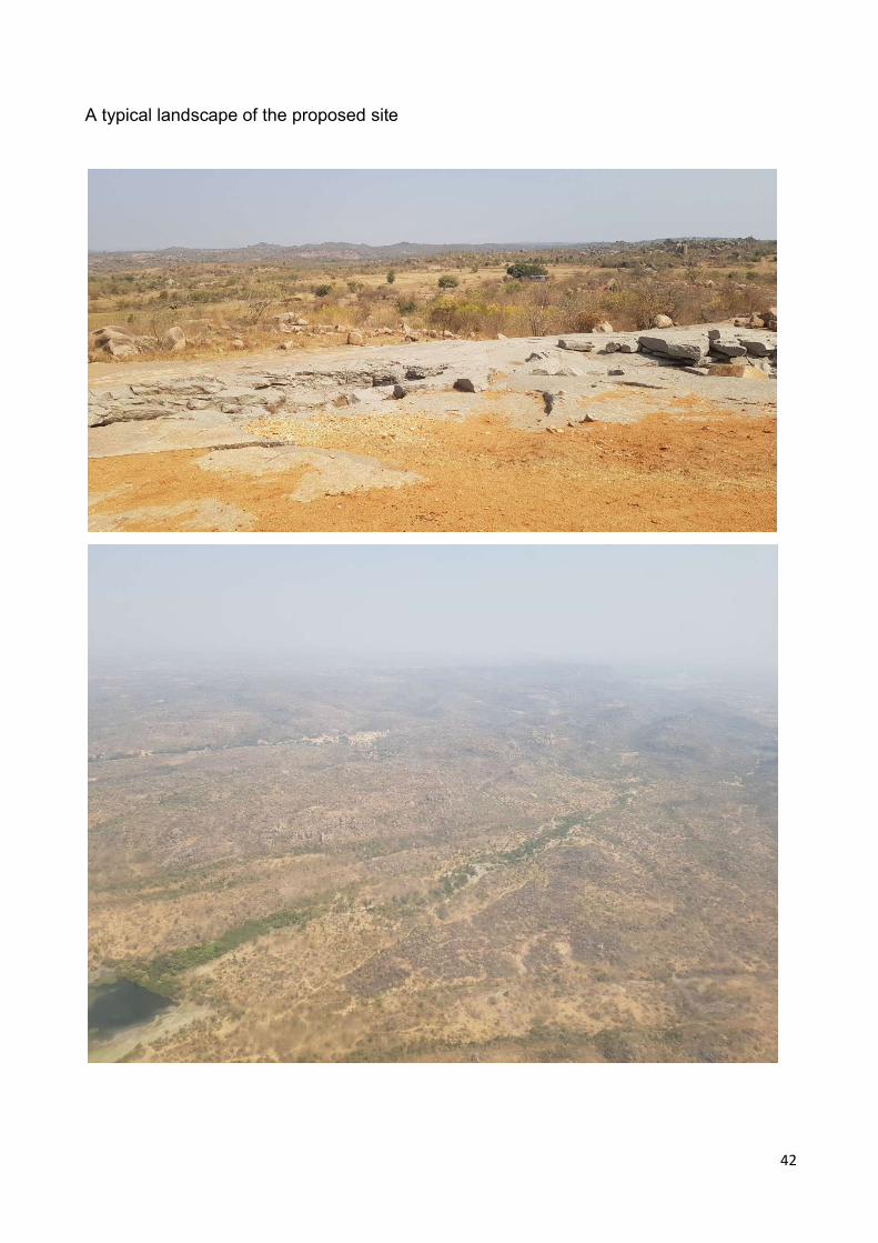
42
A typical landscape of the proposed site

43

44
45
Annexure-II
Site Inspection report of Sonawade-Ghodge, Nardev-Shivdav Road passing through the Districts of Sindhudurg and Kolhapur by the sub-committee of Expert Appraisal Committee (EAC), Infra-1 sector of Imapct Assessment Division, Ministry of Environment, Forest and Climate Change (MoEF&CC), Government of India
Project: Construction of New Road Math – Kudal –Pandur - Ghotage – Sonawade – Naikwadi –Gargoti Ghat Road, State Highway 120 and 121 in Sindhudurg and Kolhapur Districts of Maharashtra State (Math-kudal Pandur Ghotage Sonwade Shivdav Kadgaon Gargot Road SH-179 km 45/00 to 58/00 Taluk Kudal & Bhudargad, District Sindhudurga & Kolhapur) by M/s. Public Works (South) Division, Kolhapur.
Project Proponent: Executive Engineer, P.W. (South) Division, Kolhapur
Brief Description of Project
The Government of Maharashtra, Public Works Department, through the Executive Engineers of Kudal in Sindhudurg District and Kolhapur South Division in Kolhapur District has decided to construct the Math – Kudal – Pandur - Ghotage – Sonawade – Naikwadi – Gargoti Ghat Road, State Highway 120 and 121 in Sindhudurg and Kolhapur Districts of Maharashtra State. The proposed alignment starts from village Sonawade Tahsil Kudal, dist. Sindhudurg to Shivdav Tahsil Budargadh, dist. Kolhapur in between chainage 1/897 to chainage 11/499.5 as missing links on existing SH-120 and SH-121. The elevation difference between starting point and end is roughly 365m. This is a two lane standard State Highway connecting Malwan, Kudal, Vengurla in Sindhudurg Districts with Gargoti in Kolhapur District. The construction of this ghat road is proposed in the supplementary budget of 1981-82, under Integrated Development of Western Ghat Scheme and as per Road Development Programme 1981-2000, by the concerned implementing agencies. This project has been accorded administrative sanction by the Govt. of Maharashtra vide their letter nos. SHR 2996/case no. 821/planning-3, dated-16th March 1996 and SHR 2196/case no. 699/planning-3, dated- 15th March 1996.
Salient features of the proposed project
No. Particulars Details
1. Name and Location of the Project
Construction of New Road Math – Kudal –Pandur - Ghotage – Sonawade – Naikwadi –Gargoti Ghat Road, State Highway 120 and 121 in Sindhudurg and Kolhapur Districts of Maharashtra State (Math-
46
kudal Pandur Ghotage Sonwade Shivdav Kadgaon Gargot Road SH-179 km 45/00 to 58/00 Taluk Kudal & Bhudargad, District Sindhudurga & Kolhapur)
2. Plot/Survey/ Khasra No. Survey No-Sonavade -7 ,9/5 ; Durganagar-1,2,3, 50B, 77B, 75; Vinjole- 43, 41, 40, 38, 30, 37, 36, 35, 34, 33 Shivdav Khurd -30/1
3. Villages Vinjole , Shivdav and Ghotage
4. Tehsils Kudal and Bhudargad
5. Districts Sindhudurg and Kolhapur
6. State Maharashtra
7. Wildlife Sanctuary Radhanagari Wildlife Sanctuary is located at distance (aerial) of 2.75 km. Approximately, 3.7 km of proposed alignment passes through Radhanagari Tiger Corridor (Fig. 1). Forest cover (Fig.2) along proposed alignment provides good habitat to many wildlife species including tiger, common leopard, mouse deer, Indian Muntjac, Hanuman Langur, Indian Bison, wild pig and many other species.
8. Displacement of Population
Nil
9. Availability of Raw Material
Local
10. Land Required Reserved Forest Land 25.76 ha & Private Forest of 1.150 ha; Stage -1 approved; F. No. FC-II/MH-23/2015-NGP/900 Dated: 29th September, 2016
Need for the project and its importance
In the present circumstances the transportation from Kolhapur District to Sawantwadi, Vengurla, Kudal, Malwan, Kankawali and Devgad tahsils of Sindhudurg Districts is operated through existing ghat roads:

47
Karul Ghat, which takes off from Talere on Panwel-Mahad-Panaji, NH 17, at 393/00 km.
Amboli Ghat from Sawantwadi, which takes off on Panvel-Mahad-Panaji NH-17 at 460/00 km.
Phonda Ghat which takes off from Humrath and Kankawali, on Panvel–Mahad–Panaji NH-17 at 400/400 km.
Distance from Malvan to Kolhapur via route of Amboli Ghat is 195 Km. Similarly distance from Malvan to Kolhapur via route of Phonda Ghat is 190 Km. Distance from Malvan to Kolhapur via proposed route is 150 Km. Proposed Sonawade-Ghodge, Nardev-Shivdav Road will help reduce the travel distance by 40 km in the hilly terrain of Western Ghats. (Fig.3).
Since, the proposed alignment passes through ecologically fragile land of Western Ghats, the EAC (Infra-1) of MoEF&CC in its 187th meeting held on 12th April, 2018, suggested that a sub-committee may conduct a field inspection of the proposed project site and furnish its report to the EAC for any further decision regarding grant of environmental clearance. Accordingly, a subcommittee of EAC (Inra-1), MoEF&CC comprising of following members was constituted for the site visit. The subcommittee visited the site from 1st to 2nd May, 2018 and also discussed the issues with project proponent and EIA consultant teams.
Subcommittee of MoEF&CC
1. Dr. Deepak Arun Apte (Chairman, EAC & Infra-1) 2. Dr. Anuradha Shukla (Member, EAC & Infra-1) 3. Shri. Raghu Kumar Kodali (Director, MoEF&CC and Member Secretary, EAC &
Infra-1) 4. Dr. Ashish Kumar (Joint Director, MoEFCC and Special Invitee of EAC (Infra1)
Project proponent team
1. Shri. S. P. Rajbhoj, SE, PWD Circle, Ratnagiri 2. Shri. S. S. Salonkhe, SE, PWD, Kolhapur 3. Shri. N. M. Vedpathak, SE, PWD, Kolhapur 4. Shri. Bacche S. S., EE, PWD, Kolhapur 5. Shri. Samadhan Chavan, EE, PWD, Kudal 6. Shri. Anil Patil, DFO, Forest Department 7. Samadhan B. Chavan, Deputy Conservator of Forest, Sawantwadi, Sindhudurg. 8. Dr. Ajit Sajane, RFO, Forest Department, Wildlife-Kolhapur 9. Shri. Chirme, RFO, Forest Department 10. Shri. A. S. Chavan. RO, Forest Department 11. Shri. S. K. Galwe, Forest Officer 12. Shri. Amarjeet A. Ramashe, Asst. Engg. GRI, PWD, Kolhapur 13. Shri. S. B. Ingawale, Sectional Engg, PWD, Kolhapur 14. Shri. Manik Jadhav, Sectional Engg, PWD, Oras
EIA consultant team

48
1. Mrs. Anjali Singham, EIA Co-ordinator & FAE (AQ), MITCON 2. Dr. Sandeep Jadhav, Functional Area Expert – SC & EB, MITCON 3. Shri Shrikant Kakade, Functional Area Expert – EB, MITCON
Observations of the Subcommittee of EAC (Infra-1)
The subcommittee after having brief presentation by project proponent and EIA consultant visited the site and made following observations
1. Mitigation plan as provided by Wildlife Institute of India (WII), Dehradun was scrutinized. Select locations of over-passes and under-passes were noted. Considering the possibility of movement of elephants in the region (though currently no movement of elephants is known in the area as confirmed by forest department), minimum height of under-passes and distance between columns need to be decided.
2. Considering that the area is ecologically sensitive, an afforestation plan needs to be developed.
3. Besides the measures recommended by WII, possibility of all season and good quality barriers along the road need to be examined to prevent the wildlife road kills.
4. The speed restriction on the vehicle needs to be defined.
5. Current road width is less than 8m while the RoW requested is 30m. The current RoW should be reduced to minimum except for the areas with prevailing engineering constrains (like curvature, slope stabilization etc) and traffic safety. Project proponent was thus directed to produce chainage wise need of RoW and number of trees that will be saved with reduced RoW.
6. All the four villages (Ghotage, Sonavade Tarf Kalsuli, Pandur and Shivdav), situated along the propoposed alignment, appear to be part of Ecologically Sensitive Area (ESA) identified in the report of the High Level Working Group on Western Ghats. Thus any court orders, moratorium or any other provision on permissibility of developmental activities in the proposed ESA need to be examined by the Ministry.
7. In view of above, the project proponent was requested to provide following information/clarification:
(i) Why this particular alignment was selected instead of strengthening of the existing links; and
(ii) Comparative statement of Chainage wise current RoW and loss of trees Vs reduced chainage at all possible locations with saving of trees.

49
Fig.1: Proposed alignment vis-a-vis Radhanagari Wildlife Sanctuary and associated Tiger Reserve
Fig. 2: General Habitat at the proposed road site, start point and end point
Start Point
End Point

50
Fig. 3: Map showing existing links and proposed road

51