2. s ummary history of the ... - university of...
TRANSCRIPT

University of Sydney Grounds Conservation Plan — October 2002 Page 5
2. SUMMARY HISTORY OF THE DEVELOPMENT OF THE UNIVERSITY OF SYDNEY
A fuller history of the development of the university, upon which the analysis of significance in this report was based, is located at Appendix A. This summary provides a very brief overview of the history of the place. The maps and development charts or matrixes following (at 2.2 and 2.3) show the development sequence of the university and the major development areas within the university grounds. 2.1 SUMMARY HISTORY The University grounds are on part of a broad ridge system which forms the watershed between Port Jackson and Botany Bay. An arm of the ridge system extends north from the watershed down between Blackwattle Bay and Rozelle Bay and their respective tributaries. These broad ridge tops are capped with Wianamatta shales, underlain by Hawkesbury sandstone. However, there is no outcropping sandstone within the university campus. The geology of the University grounds is important as the absence of Hawkesbury sandstone means that Aboriginal sites that are most commonly found associated with sandstone formations would not have been present. There is potential for the presence of silcrete, one of the most commonly used rock types for making small flaked implements in the Sydney region, associated with the Wianamatta shales in the grounds, but this has not been demonstrated by finds identified in the grounds to date. The upper reaches of several creeks running into Port Jackson have their headwaters within the university grounds. Blackwattle Creek, which runs into Blackwattle Bay, began in a swampy area where Darlington School now stands, and another tributary began in Victoria Park. Both ran north-east through Glebe, Chippendale and Ultimo. On the western side of the University grounds were the upper reaches of Orphan School Creek which had tributaries starting near St Andrews and St Johns Colleges, which ran north then west into Johnstons Creek. The Camperdown and Darlington campuses of the University of Sydney were occupied by Aboriginal people of the Cadigal and/or Wanngal clans. The freshwater sources and swamps within or in close proximity to the university grounds, west and east of the Petersham Ridge, may have attracted occasional Aboriginal occupation. However, there are no sandstone outcrops (commonly utilised by Aborigines in the region) on the campus, no source of stone for tool manufacture have been found, and no Aboriginal sites have yet been located within the area of the grounds. About eighteen months after colonisation of Sydney by Europeans in 1788, part of the ‘Kanguroo Ground’ near the present-day junction of Parramatta and City Roads was set aside as reserves for Crown, church and school purposes and used for pasturage of stock. Aboriginal people were thus alienated from the lands that are within and around the University grounds very early in the history of British colonisation. In 1792, Lieutenant-Governor Grose was granted a lease of 30 acres out of the 400 acre Crown reserve on which to build a house, though he later changed the purpose of the lease to farming. Subsequently, leases were granted within and surrounding the reserve to several other

University of Sydney Grounds Conservation Plan — October 2002 Page 6
officers for cultivation (Campbell 1925:119, 1930:274-276). Grose sold his lease to another officer when he left the colony at the end of 1794, but the area that is now the University grounds became known as Grose Farm and is marked as such on maps until the mid-1800s. In 1801 land within the School and Crown reserves was granted to the Female Orphan Institution, who set up a farm on what became known as Orphan School Creek. Over the next thirty years the land was further subdivided, and a convict stockade was established on Orphan School Creek, possibly on the site of the Orphan School farm. This stockade, presumably for the development of Parramatta Road, was located at what is now the north west corner of the university grounds, and north east corner of St Johns College grounds, near Parramatta Road. The University of Sydney was founded in 1850, in a period characterised by increasing concern among the newly emerged middle classes for an education system which prepared the ‘higher grades’ of society for leadership and the professions. It began its teaching in 1852 utilising the premises of the former Sydney College, before obtaining a grant at Grose Farm, then used as grazing land for cattle destined for the Sydney meat market. The first University buildings (the Main building) formed the basis of what is now the Quadrangle, designed by Edmund Blacket between 1855 and 1862, and reflected the philosophy and aspirations of the newly established institution. It set a style which would inform the physical development of parts of the University over a long period. Their grand style in Gothic Revival architecture and their positioning on a ridge commanding a view over Sydney, with an impressive entrance drive, attested to the founders’ desire to establish the University within the tradition of the great ancient universities of Oxford and Cambridge as well as displaying the new colony’s commitment to the ideals of higher learning. This philosophy was echoed in the initially narrow curriculum focussing on classics in an undergraduate Arts program. The structure of the University as a non-denominational, non-residential institution with provision for residential colleges to be established around the main buildings by the four religious denominations represented a uniquely Australian approach to the institution’s design. Towards the end of the nineteenth century the University faced pressure to make its curriculum more relevant to the needs of an increasingly industrialised society. The development of the sciences led to the erection of functional, purpose-built facilities, hidden behind the main buildings so as not to impinge on the impressive view of them from the east. The buildings erected in this period formed the genesis of what became Science Road, a major scientific precinct. The Challis Bequest, received by the University in 1890, facilitated much physical and academic development. A significant new work was the establishment of a medical school (Anderson Stuart building) associated with a teaching hospital built within the University grounds (Royal Prince Alfred Hospital). The school’s design, workmanship and siting in harmony with the main building represented the prestigious and dominant role of Medicine within the University and in society generally. The early years of the twentieth century saw the continued growth of professional education, particularly in the fields of agriculture, veterinary science, engineering and commerce in response to the great pastoral and commercial expansion that had occurred in preceding decades. In turn, the experience of the 1890s depression brought on by drought highlighted the need for expertise in land management and pastoralism, on which the

University of Sydney Grounds Conservation Plan — October 2002 Page 7
Australian economy very much depended. In this period, facilities were constructed for Veterinary Science, Agriculture, Engineering, Geology and Applied Science. In the late nineteenth and early twentieth century sporting and leisure facilities for the growing student population began to develop. A major influence on the nature of that development was the admission of women to the University which had been sanctioned in 1881. The need for segregated common rooms and separate spaces for sporting activities reflected the social mores of the times and impacted upon the development of the Union Building, Manning House, women’s tennis courts and the Hockey Square. The University’s architecture in the period from 1900 to World War I was associated with the work of Government Architect Walter Liberty Vernon, and his successor, George McRae. Attempts were made to bring harmony to the campus by continuing the style of the main buildings in that area and, in the case of the Fisher Library (now McLaurin Hall), to advance the public’s appreciation of art. In the Science Road precinct, the Federation Arts and Crafts style, of which Vernon was a master, was utilised in an effort to provide a sense of order and harmony among the newly constructed buildings, in contrast to the earlier science facilities which had no architectural pretensions. In the period following World War I further attempts were made to bring a sense of unity, order and beauty to the campus through the work of Professor of Architecture and University Architect, Leslie Wilkinson. Wilkinson was perhaps the most influential architect in shaping the physical development of the University from the 1920s onwards. His plans involved the creation of vistas by carefully placed axes, open and closed courtyards and the creation of a harmonious architectural style, with a predominantly Mediterranean influence, which Wilkinson believed to be more suitable to the Australian environment than the earlier Gothic styles. Wilkinson’s work included the bringing together of previously disparate styles of architecture, particularly in the Quadrangle-eastern Science Road area; the re-alignment of buildings in Science Road and their treatment in the Mediterranean style; the re-use of historic materials such as the CBC Bank facade and Doric columns; the creation of the Vice-Chancellor’s Quadrangle and extension of the Union Building. Wilkinson also designed completely new buildings such as those for Physics and Tropical Medicine in a distinctive style and built in previously undeveloped parts of the campus. Integral to his plans was the maintenance of vistas from various parts of the campus, such as from St Paul’s College, across the Hockey Square to the Union Refectory; St Paul’s College and the main Quadrangle; and views down Science Road. From the late 1920s the University became involved in collaborative arrangements with various Commonwealth Government agencies, whereby facilities were established for research on matters of national importance. The School of Public Health and Tropical Medicine, the McMaster Laboratory and the Madsen Building are examples of such facilities. The first involved the Department of Health, while the other two buildings were established in collaboration with the Council for Scientific and Industrial Research for animal health research and a National Standards Laboratory respectively. The approach of World War II intensified the Commonwealth’s interest in scientific and industrial research and led to the development of aeronautical engineering at the University, and was of direct relevance to the defence industry. World War II had an enormous impact on the University. The immediate post-war period saw the construction of several hastily built ‘transient’ buildings to cope with the influx of ex-service personnel under the Commonwealth Reconstruction Training Scheme. The

University of Sydney Grounds Conservation Plan — October 2002 Page 8
post-war years marked the beginning of a new phase of expansion in student numbers, curriculum and facilities. The increased involvement of the Federal Government in funding universities paved the way for a massive building program and in the late 1950s the University extended its campus across City Road into Darlington. Darlington was a fully developed suburb, almost all of which was gradually acquired by the University (see the attached plan). The only sections of the original suburb not taken up for University use were a small portion bounded by Cleveland, Shepherd and Boundary Streets, and two half-blocks either side of Golden Grove Street. Darlington had its own development pattern, much of which was retained as University buildings and open space replaced suburban residential, public and industrial buildings. The majority of university buildings in this area represented a departure from previous construction in that for the first time the University built a large purpose-designed complex using state-of-the-art architecture. The campus underwent considerable reorganisation into precincts and with the building of the new Fisher Library at one end of Eastern Avenue and the creation of the footbridge across City Road, linking the two sides of the campus, Eastern Avenue became a major thoroughfare. This represented a reorientation of the hub of the campus away from Science Road towards Eastern Avenue and Darlington. The late 1970s to the present have represented a period of reduced Government funding and major structural reorganisation of the tertiary education system. With amalgamations of the Universities and former Colleges of Advanced Education the University of Sydney acquired several other campuses, necessitating the management and maintenance of a much enlarged physical resource. On the main University campus for some years physical development was concentrated on the modification of buildings for different purposes, reflecting the increasingly diverse curriculum. With tertiary education now a far more common prerequisite for many fields of employment than it was in the pre-war era, the student population is likely to continue to grow. The constantly changing international environment, global economy and the current emphasis on the development of new technologies is likely to result in further major physical and organisational changes at the University of Sydney. Table 2.1 University of Sydney buildings by date Building Number
Building/Place Name Date Built Extensions/Notes
A14 Main Quadrangle 1854-59, 1909, 1920s, 1963
Eastern range and tower first, completion in stages. Wilkinson additions along western wing and Admin building in 1920s. Organic Chemistry wing remodelled for Admin 1958. Western tower and cloisters 1963.
- Oval No.1 1866 Formally developed 1884-1890 as cricket ground. Spoil from City railway used for fill over Orphan School Creek flats.
H02 & H03 Institute building and residence (
1872 Acquired 1975. Renovated 1977.
G15 Darlington Public School
1878 Acquired 1975
F13 Medicine (Anderson Stuart)
1885 Wings 1909-10, 1910-12, 1922 infill completing the north side of building by Wilkinson. Refurbished 1992.

University of Sydney Grounds Conservation Plan — October 2002 Page 9
Building Number
Building/Place Name Date Built Extensions/Notes
A12 Macleay Building/ Botany
1887, botany 1925
Botany built on eastern side 1925. Science Road Bridge built 1958 by Wilkinson as memorial gate and gallery of fine arts.
A16 Electrical Engineering (Badham)
1888 Extended 1901 (as Trelfall’s Building—Physical laboratory), and 1918-19. Substantial additions in 1923-25 by Wilkinson, and 1945 and 1947. Extended 1974. Renovated 1984.
A15 Pharmacy and Bank Building
1888-1890 Formerly Chemistry Laboratory, and former milling and metallurgy (stack and furnace room survive in courtyard). Additions 1902, 1905. Remodelled by Wilkinson 1923-24, new lab in 1943. Adapted for Pharmacy in 1958, linked to Bank and Badham Buildings. Addition at south end 1978.
A11 Old Geology 1895 Connected to Macleay Museum by a bridge in 1915-18. Modified extensively in 1920 by Wilkinson. Replaced medical cottage. hipped roof restored 1981.
A08 Zoology (Heyden-Laurence)
1895-1912 Originally Federation Style, extensively modified 1923 and 1939-40 by Wilkinson in Mediterranean style. Extended 1992 in Wilkinson style.
F18 Gate Keeper’s Lodge 1898 Known as Medical School lodge as Anderson Stuart was the closest building. Extended c. 1925. Given the St Paul’s College in 1963, now leased back.
A10 Caretaker’s Cottage 1903 Described in 1903 plan A20 English (John Woolley
Building) 1908 Designed by Vernon. Workshops added 1906-
08 on west. Additions by Wilkinson 1921. South wing built 1939-42, housed vertical wind tunnels. Formerly Engineering (endowed by P.N. Russell), renovated for English 1974-75.
A09 Union (Holme) 1910-12 Replaced old Engineering building. tea room added 1913, Union Hall completed 1916 (Waterhouse and Vernon) Kitchens by Waterhouse and Wilkinson 1921, Refectory (Wilkinson & Waterhouse) 1923-24, extended 1940 with colonnade. 1934 addition to west. Re-worked several times since then.
B01 Veterinary Science (J.D. Stewart )
1910-12 Federation style. Addition at southern end 1939-40, north side 1957, and additions 1961-63 and 1971.
- Science Road 1910-31 Created c. 1910, remodelled, straightened and kerbed by Wilkinson by 1931.
F01 Pavilion, Womens tennis courts
1911 Women’s Sport Association founded 1910
A04 Agriculture (R.D. Watt)
1911-16 Federation style. Continuos use by Agriculture since 1916.
A07 Substation 54 1913 power substation leased to City Council. A22 Teachers College 1914-25 Construction commenced 1914, partly occupied
1920, completed 1924, opened 1925. A23 Manning House
(Women’s Union) 1917 Designed by Waterhouse and Vernon. Additions
1941, 1956-57, 1962-63, all additions demolished in 1999prior to major redevelopment.

University of Sydney Grounds Conservation Plan — October 2002 Page 10
Building Number
Building/Place Name Date Built Extensions/Notes
B03 Veterinary Sciences Lodge
1920-21 Built by Wilkinson
B11 Roundhouse 1920-21 Animal observation box designed by Wilkinson. A25 Sports Union tennis
courts pavilion. 1920s
- Hockey Square 1921 Permission given to Women’s Sports Union 1916 to use Square, but not built till 1921. Tennis Courts built 1911. Banks built 1925 with Physics Building. Use restricted to Women only 1926.
A28 Physics 1925 Designed by Wilkinson A13 Botany glasshouse 1925? Doric Columns,
Science Road 1926? Part of Wilkinson’s remodelling of Science
Road A27 Edward Ford Building 1930 School of Public Health and Tropical Medicine,
Wilkinson inspired design - Oval No. 2 1930 B14 F.D. McMaster Animal
Health Laboratory 1930-31 First permanent building added to Vet Sciences
since 1912, built in agreement between UoS and CSIR. Additional wing built 1956. CSIRO vacated 1995.
A29 Physics Annex 1930s? B04 McMaster Building 1931 CSIR research centre D06 Blackburn Building 1933 New Medical School built with Rockefeller
Fund donation. F02 Baxter’s Lodge 1939-40 On creation of University Avenue entrance after
exchange of original City Road entrance and lake. designed by Wilkinson. extended eastern side 1958
F09 Madsen Building 1940 Former CSIR National Standards Laboratory, western wing completed 1944. Renovated 1978 and handed over by CSIRO to university
A03 Transient Biology labs (Ross St Building)
1945
F12 Transient Biochemistry 1945 A21 Wallace Lecture
Theatre 1946
B02 McMaster Annex 1946 constructed across creek from McMaster Building (B14), added to in 1950.
A26 Economics (R.C. Mills)
1949 Government Architect design. Renovated 1980, wings added 1984 and 1988.
D08 H.K. Ward Gymnasium 1957 D02 Research Institute for
others and Children (Victor Coppleson)
1958 Extended 1976-77
A19 Griffith Taylor Building
1959
F11 Chemistry 1959 A17 Mungo MacCallum
Building 1960
F07 Carslaw Building 1960-65 Mathematics and Science G04 Architecture
(Wilkinson) 1960-76, 1984 (2nd stage)
D04 Bosch Building 1a 1960s D05 Bosch Building 1b 1960s

University of Sydney Grounds Conservation Plan — October 2002 Page 11
Building Number
Building/Place Name Date Built Extensions/Notes
J10 Shepherd St Parking Station
1960s?
J04 Rose St Building 1960s? G09 University Sports
Centre 1960s-70s
F05 Edgeworth David Building
1961
A05 J.R. McMillan Building (agricultural research)
1962
F03 Fisher Library 1962 F06 Stephen Roberts
Theatre 1962
J05 Civil and Mining Engineering
1963
J06 Civil Engineering Workshop
1963?
H01 Sydney University Regiment
1964
J01 Chemical Engineering 1964 A30 Women’s Sport centre 1965 Replaced 1923 clubhouse and dressing shed.
Extended 1972. J03 Electrical Engineering 1965 J07 Mechanical
Engineering 1965
J11 Aeronautical Engineering Building
1965
F16 Keith Murray Footbridge
1966
H04 Merewether Building 1966 J02 Peter Nicol Russel
Building 1966
A18 Christopher Brennan building
1967
B10 Evelyn Williams Building, hospital and clinic
1967
G06 International House 1967 F04 Fisher Stack 1971 G01 Wentworth Building 1972 K04 Parramatta Road
footbridge 1972
G08 Biochemistry 1973 B19 Veterinary Physiology
and Animal Husbandry (R.M.C. Gunn)
1974
J09 Seymour Centre 1975 D01 Bruce Williams
Pavilion 1976-78 Original No.1 Oval Grandstand destroyed by
fire B22 Veterinary Science
Conference Centre 1988
A35 Education Building 1990-91 A36 Education Annex 1990-91 J13 Engineering Link 1990s G10 Shepherd Centre 1990s?

University of Sydney Grounds Conservation Plan — October 2002 Page 12
Building Number
Building/Place Name Date Built Extensions/Notes
H09 Boundary Lane Child Care Centre
1990s?
H66 Darlington House 1990s? H67 Mandel Balin House 1990s? H68 Shepherd Childcare
centre 1990s?
G02 Art Workshed G03 Tin Shed Gallery G12 Services Building H05 Joiner’s Shop H08 Computing centre K01 Mackie Building K02 Selle House K07 Margaret Telfer
Building
- Palisade fences, City Road
2.2 DEVELOPMENT SEQUENCE PLANS The following set of plans shows the development of the Sydney University Campus from the 1790s through to 2000.

SOURCE: Campbell, J.F. 1930. ‘The early history of Sydney University grounds’, Royal Australian Historical Society Journal & Proceedings, Vol 16: 274-293.
Original reserve and land grants, 1789-1798. The future University grounds can be judged by the roads.
The general term ‘Grose Farm’ applied to the main campus area by the 1840s. Showing convict stockade and garden, and grants to the south.
Subdivision in the campus area: A. Episcopal residence 1865 A & B. St. Paul’s College 1856 C. St John’s College 1861 D. St Andrews College 1873 E. Prince Alfred Hospital 1873 F. Approach reserve 1863 G. Women’s College 1892 H. Site for Training College J. Victoria Park 1870 K. Dumb, Deaf & Blind Institute 2 – 6 Allotments for C, E and Roman Catholic Churches

Key
Laycock1798
Grose1792
Foveaux1794
CROWN RESERVE1789
Parramatta Road
Subdivision of Crown Reserve for grants, 1790s
SCHOOL RESERVE 1789
boundaries of reserves and grants
University grounds
Buildings and developments constructed during the period
Parramatta Road
Development 1800 -1854
Dam
Convict stockade
Watch House
Toll bar
Shepherd 1820s
Toll bar
lake
University grounds
garden
stock water hole
Watch House
lease boundaries

1855
1872
1856
1863
1876
Oval1866
Development of University 1854-1880
KeyBuildings and developments constructed during the period
1878
1876-82
Botanical Garden1859 fenced road,
1860s
old gatehouse
University grounds
Development of University 1880 - 1890
Buildings and features constructed earlier
1885
1887
18881888
1886

Development of University 1890 - 1900
1893 1895
1895
1890s
1898
18941898
Development of University 1901 - 1910
1909
1908
KeyBuildings and developments constructed during the period
University grounds
Buildings and features constructed earlier
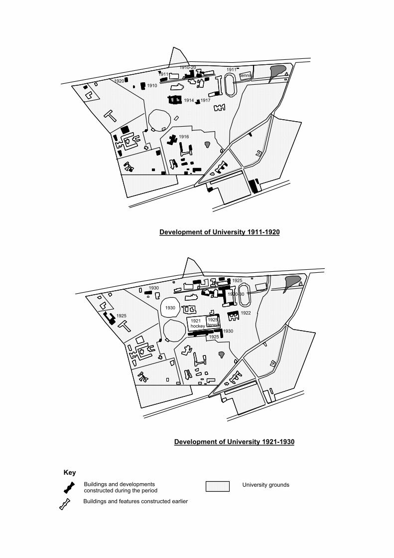
Development of University 1911-1920
1910-201911
1910
1914 1917
1920
1916
1911tennis
Development of University 1921-1930
1920-30
19251930
1930
1921hockey
1925 tennis
1925
1922
1930
1925
KeyBuildings and developments constructed during the period
University grounds
Buildings and features constructed earlier

Development of University 1930-1940
1939
1939
1933
1940
1931
Development of University 1941-1950
19461946
1949
1945
1945
KeyBuildings and developments constructed during the period
University grounds
Buildings and features constructed earlier

Development of University 1951-1960
1958
19601959
1959
1957
Development of University 1961-1970
1960-65
19611962
1962
1960-76
1963-19661966
1964
19671965
1967
1962
1967
KeyBuildings and developments constructed during the period
University grounds
Buildings and features constructed earlier

Development of University 1990-2000
1991
2000
1999
1999
1990s
KeyBuildings and developments constructed during the period
University grounds
Buildings and features constructed earlier

University of Sydney Grounds Conservation Plan — October 2002 Page 13
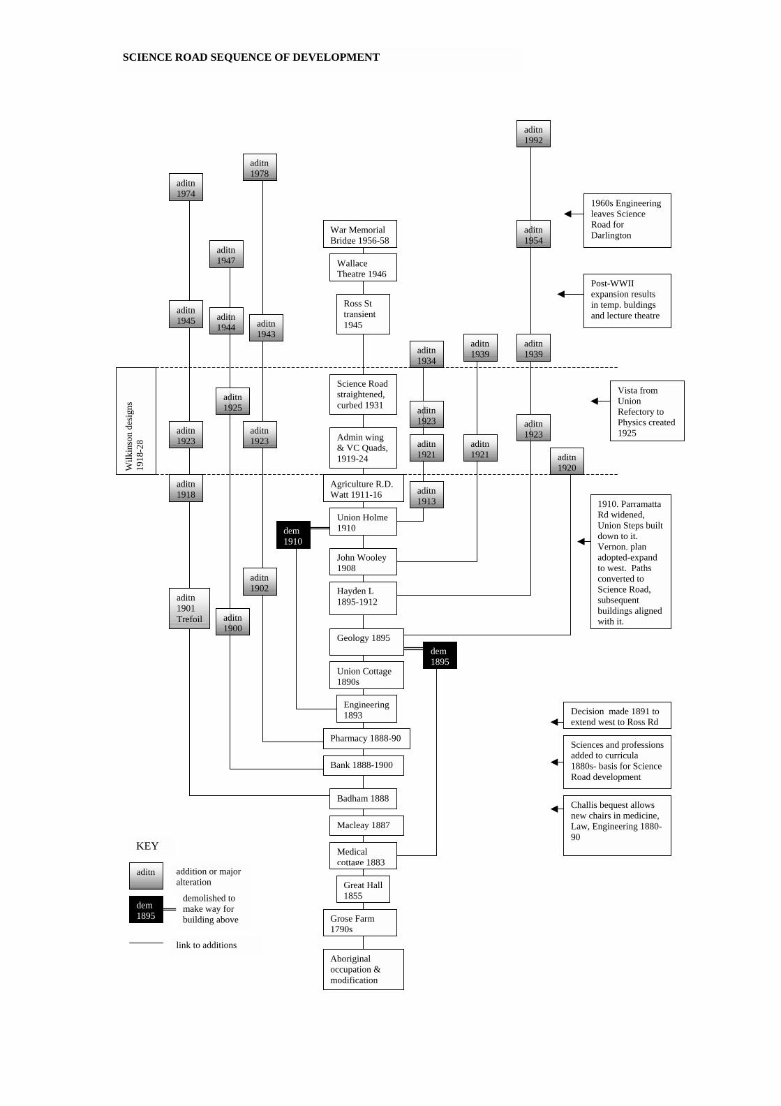
2.3 DEVELOPMENT SEQUENCE CHARTS The following sequence charts address important sections of the University grounds, and provide a graphic representation of growth and changes over time, keyed in to external events and developments as they impacted on the University. Each chart lists in plain boxes the key buildings or features in the area being presented. Major additions or changes to each building is linked by a line and a toned box showing aditn and date of change. The demolition of a building is shown in a black box. Historical developments stimulating changes or impacting on the area are listed as Context in plain boxes along the right hand side of the page. A date -line is provided in toned boxes on the right hand side as well. Where several areas are dealt with on the one chart, the name of each area is identified in a black box at the top of each line. The charts cover the following areas or themes of development: • Early changes in land tenure • Overall development of the University of Sydney (two charts) • Science Road sequence of development • Hockey Square / Physics Road sequence of development • Eastern Avenue sequence of development • Darlington Campus sequence of development • Sequence of development of sporting facilities.

Griffith Taylor 1959
Chemistry 1959
Mungo MacCallam 1960
Carslaw 1960
Aquisiton of Darlington starts 1958
Wilkinson Bld 1960-76
Bosch Blds 1960s
Edgeworth David 1961
Fisher 1962
Stephen Roberts 1962
Womens Sport 1965 Civil & Mining
Eng 1963
Electrical, Mechanical, Aeronaut. Eng. 1964
Keith Murray Footbridge 1966
Merewether 1966
P.N. Russell 1966
Christopher Brennan 1967 Evan Williams
1967
International House 1967
Fisher Stack 1971
Wentworth 1972
BioChemistry 1973
R.M.C. Gunn 1974
Seymour Centre 1975
Vet Sci. Conf centre 1988
Education & Annex 1991 Darlington
Eastern Av.
Hockey Square / Physics Road
Vet Sciences
Blackburn
Manning Rd
1950
1950s Enrolments still twice pre-war levels.
1960 Commonwealth Univ. Commission funding commences-Fisher, Eastern Av, start of Darlington
19701970s-80s, amalgamations and funding restrictions, increasing enrolments
OVERALL DEVELOPMENT OF THE UNIVERSITY OF SYDNEY—MATRIX 1
1980
1990
CONTEXT
Carlslaw exten sions
2000
HK Ward Gymnasium 1957
QEII Research Instit. 1958
1972. Men’s & Women’s Unions amalgamate
Engineering Link Bld, 1990s
(see first part of matrix on following page)

Natural environment
Aboriginal occupation & modification
Grose & Foveaux Farms 1792
Main Quad building 1854-58
1854St Paul’s 1854-58
St John’s 1857-62
St Andrews 1873
1788
Anderson Stewart 1885
1885
Macleay 1887
Lodges and gates 1885
Institute 1872Oval No 1 1866
Women’s 1894
1870
Badham 1888
Bank & phrarmacy 1888-90
Quad extended 1909
Geology 1895
Hayden L 1895-1912
Gatekeeper’s Lodge 1898
John Wooley 1908
Union 1910 Vet Sciences 1910
Wesley 1916
Agriculture 1911Teachers College 1914
Manning 1917
Hockey Square 1921
Physics 1925
Blackburn 1933
Baxter’s lodge entry 1939
Entry Lake & tree planting 1870s
Victoria Park exchanged 1924
Madsen 1940
Sancta Sophia 1925
Golden Grove 1819
Darlington subdivision 1879
Darlington high density suburb by 1891
McMaster 1931
Wallace Theatre 1946
Ross transient 1945
Transient F12 1945
WWII
WWI
1880s expansion of secondary education, and population boom in Sydney
1890 Challis bequest allows new chairs in medicine, law, enginering 1880-90
1900 University Act 1900. Reformed Senate. Changes in secondary education requiring more trained teachers.
1910Paramatta Road widened. 1910 Vernon’s plan for University acepted
1920Student number increase. Architecture and Economics added. Wilkinson era plan and buildings
1930 1930s tropical medicine and CSIRon campus
1940-1948 university expands from 4000 to 10000 students. Temporary buildings put up.
Science Road straightened, buildings upgraded
Oval No 2 1930
University established 1850, 1st in Australia Given land 1854
Colleges
Victoria Park & boundary
Science Road
Ford, Trop Med 1930
KEY
Science Road main zones of development
development diverging to new areas
R.C. Mills 1949
School Reserve 1789
Laycock Farm 1792
Crown Reserve 1789
1863 Football Club formed, 1865 Cricket Club—lead
OVERALL DEVELOPMENT OF THE UNIVERSITY OF SYDNEY—MATRIX 2
see second part of matrix on previous page

Macleay 1887
Badham 1888
Pharmacy 1888-90
Geology 1895
Hayden L 1895-1912
John Wooley 1908
Union Holme 1910
Agriculture R.D. Watt 1911-16
Wallace Theatre 1946
Ross St transient 1945
Science Road straightened, curbed 1931
Challis bequest allows new chairs in medicine, Law, Engineering 1880-90
Great Hall1855
Admin wing & VC Quads, 1919-24
Wilk
inso
n de
sign
s 19
18-2
8
Engineering 1893
dem 1895
dem 1910
aditn
aditn1902
aditn 1918
aditn 1901 Trefoil
aditn1978
aditn1923
aditn1943
aditn 1913
aditn 1945
aditn 1923
aditn 1974
War Memorial Bridge 1956-58
aditn 1934
aditn 1921
aditn1939
aditn 1921
aditn 1992
aditn1923
aditn1939
Medical cottage 1883
aditn 1923
aditn 1920
Decision made 1891 to extend west to Ross Rd
1910. Parramatta Rd widened, Union Steps built down to it. Vernon. plan adopted-expand to west. Paths converted to Science Road, subsequent buildings aligned with it.
demolished to make way for building above
dem 1895
addition or major alteration
KEY
SCIENCE ROAD SEQUENCE OF DEVELOPMENT
Post-WWII expansion results in temp. buldings and lecture theatre
Union Cottage 1890s
link to additions
Vista from Union Refectory to Physics created 1925
1960s Engineering leaves Science Road for Darlington
Sciences and professionsadded to curricula 1880s- basis for Science Road development
Bank 1888-1900
aditn1947
aditn1900
aditn1944
aditn1925
aditn1954
Aboriginal occupation & modification
Grose Farm 1790s

Womens Sport 1965
R.C. Mills, economics, 1949
Transient F12 1945
Education & Annex 1991
Teachers College 1914 1920
Manning Women’s Union 1917
Hockey Square 1921
Physics 1925
Ford. Health & Tropical Medicine. 1930
Addn 1952
Addn nth end 1984, nth end 1988
R.C.Mills & Transient a response to post WWII student increase.
Addn and part dem 1999
Addn 1956
Addn 1941
Addn 1972
Womens Clubhouse 1923
Dem 1964
Addn 1962
Vista from St Johns & Physics to Union Refrectory created
Hockey Square restricted to women’s use 1926
Changes towards trained teachers leads to inclusion in University
HOCKEY SQUARE / PHYSICS ROAD SEQUENCE OF DEVELOPMENT
Pe
riod
of W
ilkin
son-
influ
ence
d de
sign
s
addn
demolished dem 1895
addition or major alteration
KEY
Aboriginal occupation & modification
Grose Farm 1790s
link to additions
new Clubhouse Women’s Sport 1931
Men’s tennis courts 1932
relocated nth side 1931
Dem 1965
Hockey Squareterraces built 1925
1910- Women’s Sports Association founded. Tenns courts and club east of Main Building
Macleay 1887
Badham 1888
Pharmacy 1888-90
Geology 1895
Hayden L 1895-1912
John Wooley 1908
Union Holme 1910
Agriculture R.D. Watt 1911-16
Wallace Theatre 1946
Ross St transient 1945
Science Road straightened, curbed 1931
Challis bequest allows new chairs in medicine, Law, Engineering 1880-90
Great Hall1855
Admin wing & VC Quads, 1919-24
Wilk
inso
n de
sign
s 19
18-2
8
Engineering 1893
dem 1895
dem 1910
aditn
aditn1902
aditn 1918
aditn 1901 Trefoil
aditn1978
aditn1923
aditn1943
aditn 1913
aditn 1945
aditn 1923
aditn 1974
War Memorial Bridge 1956-58
aditn 1934
aditn 1921
aditn1939
aditn 1921
aditn 1992
aditn1923
aditn1939
Medical cottage 1883
aditn 1923
aditn 1920
Decision made 1891 to extend west to Ross Rd
1910. Parramatta Rd widened, Union Steps built down to it. Vernon. plan adopted-expand to west. Paths converted to Science Road, subsequent buildings aligned with it.
demolished to make way for building above
dem 1895
addition or major alteration
KEY
SCIENCE ROAD SEQUENCE OF DEVELOPMENT
Post-WWII expansion results in temp. buldings and lecture theatre
Union Cottage 1890s
link to additions
Vista from Union Refectory to Physics created 1925
1960s Engineering leaves Science Road for Darlington
Sciences and professionsadded to curricula 1880s- basis for Science Road development
Bank 1888-1900
aditn1947
aditn1900
aditn1944
aditn1925
aditn1954
Aboriginal occupation & modification
Grose Farm 1790s

Aquisition of Darlington starts 1958
Wilkinson Bld 1960-76
Civil & Mining Eng 1963
Electrical, Mechanical, Aeronaut. Eng. 1964
Keith Murray Footbridge 1966
Merewether 1965-66
P.N. Russell 1966
International House 1967
Wentworth 1972
BioChemistry 1973
Seymour Centre 1975
19501950s Enrolments still twice pre-war levels.
1960
Commonwealth funding commences development of Darlington
Death, Dumb & Blind Institute 1872
Golden Grove 1819
Golden Grove subdivision for housing 1879
Aboriginal occupation & modification
reserved for support of teacher 1790s, transferred to Female Orphan Institute for income 1801
Golden Grove Grant toWilliam Hutchinson, for grazing and timber.
Municipality of Darlington east of Codrington St, 1864
Everleigh railway Workshops commenced 1882, suburb boomed
1891 Darlington highest density of any suburb
1890 roads metalled
Darlington sewered 1885
County of Cumberland Plan 1958 zones for university expansion to east
addn 1883-83
addn 1878-79
addn1928
addn 1912
addn 1890-91Institute
residence (Press House) 1886-91
Institute acquired 1962
Grounds subdivided by University 1964
University Regiment 1964
addn 1975
addn 2000
1970
DARLINGTON CAMPUS SEQUENCE OF DEVELOPMENT
Darlington PublicSchool 1878
Transferred to University 1975. School re-established in Grove St.
Parts demolished
Darlington terrace housing built by 1890s
1860
1890
1880
1870
1819
2000
1788
Most housing demolished 1958-1999
Darlington Rd terraces still occupied
Sports Centre 1970s
Both block Darlington Road
Yu-Hoi Chiu Bld 1999
Child Care centre and tennis courts 1999
addn
demolished or major change
dem 1895
addition or major alteration
KEY
original building extended or altered, or start of parallel development
Engineering Link 1990s
addn 1984
Men’s and Women’s Unions amalgamate 1972

SEQUENCE OF DEVELOPMENT OF SPORTING FACILITIES
1863 Football Club formed (date disputed), 1865 Cricket Club—lead to oval
Oval No 1 1866
Hockey Square formed 1921
Oval No 2 1930
HK Ward Gymnasium 1957
1910- Women’s Sports Association founded. 3 Tennis courts and club east of Main Building
Womens Clubhouse eastern end of square 1923
Hockey Square restricted to women’s use 1926 Hockey Square
terraces built 1925
new Clubhouse Women’s Sport 1931
Men’s tennis courts 1932
Womens Sports Centre 1965-72
Womens tennis courts and club house, University Avenue, 1911
Sports Centre 1970s
Child Care centre and tennis courts 1999
Western campus
Darlington Hockey Square
Eastern campus
tennis courts in Quad 1880s-1912
Main Building
Tennis courts on Blackburn site, c. 1929
6 tennis courts east of Teachers College, 1921
1900-1910— competitive sport becomes common in girls’ secondary schools
Womens Hockey Club formed 1908
1916. Senate approve use of rough ground at hockey square for Women’s sports
By WWII there were 12 male sporting clubs. WWII US Army occupies Oval 2
1951. Compusory ports union fees introduced
1950s.squash courts and gym built near Manning House

Aboriginal occupation & modification
Grose Farm 1790s
Main Quad building 1854-62
Anderson Stewart 1885
Macleay 1887
Madsen 1940-44
Chemistry 1959
Carslaw 1960
Edgeworth David 1961
Fisher Library1962
Stephen Roberts 1962
Fisher Stack 1971
addn addition or major alteration
KEY
original building extended or altered
1940-1948 university expands from 4000 to 10000 students. Temporary buildings put up.
Challis bequest allows new chairs in medicine, law, engineering 1880-90
University established 1850, 1st in Australia Given land 1854
1960s Commonwealth funding commences-Fisher, Eastern Road, start of Darlington
addn Quad levelled 1927
addn Botany1924
addn 1918
addn 2000
Commonwealth builds Madsen for CSIR National Standards Laboratory (till 1979)
Macleay is the first substantial building added to university since Main Quad Building
addn War memorial links Botany to Quad 1952-58
addn 1910-12
addn 1909
addn 1902-9
addn 1921-24
addn 1913-18
addn 1922
addn 1963-66
addn 1926
souhern end Eastern Avenue realigned 1974
addn 1965
EASTERN AVENUE SEQUENCE OF DEVELOPMENT
1958-decision to extend along line of eastern Av.
1924- Victoria Park exchanged for land that became eastern Av
Gate lodge 1898
Womens tennis courts, 1911