2009 wild fish journal
DESCRIPTION
Annual newsletter for the Wild Fish Conservancy.TRANSCRIPT

S C I E N C E E D U C A T I O N A D V O C A C Y
W I L D F I S H
J O U R N A L
2009
Publication of the WILD FISH CONSERVANCY
20th Anniversary Edition
Restoring Puget Sound
Through The Use Of
Marine Protected Areas

BOARD OF DIRECTORSCandace BeardsleeStephen Conroy, PhDJoe Kelly, Recording SecretaryHugh Lewis, Secretary/TreasurerBill McMillan, President Dick Rieman, Vice PresidentBern Shanks, PhDVance Jennings STAFFKurt Beardslee, Executive DirectorCandace Beardslee, Retail ManagerThomas Buehrens, BiologistTyler Cluverius, Outreach & DevelopmentDavid Crabb, Field TechnicianJohn Crandall, EcologistJames Fletcher, BiologistNick Gayeski, Aquatic EcologistJamie Glasgow, Science & Research DirectorMark Hersh, Water Quality SpecialistWendy Marsh, Research EcologistAndrew McAninch, GIS/IT SpecialistBill McMillan, Field BiologistCasey Ralston, Education Coordinator/BiologistTerri Shell, Bookkeeper/Office ManagerFrank Staller, Field TechnicianArny Stonkus, Ecologist/EngineerAudrey Thompson, BiologistChau Tran, BiologistBrent Trim, BiologistMicah Wait, Conservation EcologistMary Lou White, Project Manager/BiologistArin Yeomans-Routeledge, Biologist
NEWSLETTERMark Hersh & Casey Ralston, EditorsCandace Beardslee, Layout & Design
Visit our web site at www.wildfishconservancy.org
Wild Fish Journal is a publication of the Wild Fish Conservancy. Comments and letters are encouraged and welcome.
Please send all correspondence to: Wild Fish Conservancy, P.O. Box 402, Duvall, WA. 98019
Office: 15629 Main Street NE, Duvall, WA. 98019email: [email protected]
phone: 425-788-1167, fax: 425-788-9634
W I L D F I S H J O U R N A L
2
Inside
3. Research/Project Map
4. A Twenty Year Ride With WFC
7. Science Updates
24. Restoring Puget Sound Through The Use of Marine Protected Areas
36. Advocacy Updates
43. Education / Outreach Updates
46. 2009 Wild Fish Soirée and Benefit Auction
47. Thank You to the 2008 Wild Fish Soirée Auction Donors
Cover photo: Alaska Department of Fish and Game, Groundfish Project.
24
2
3
4
19
2
7
1
6
11
3
4
8
23
21
9
25
10
13
14
15
18
20
26
12
22
16
5
17
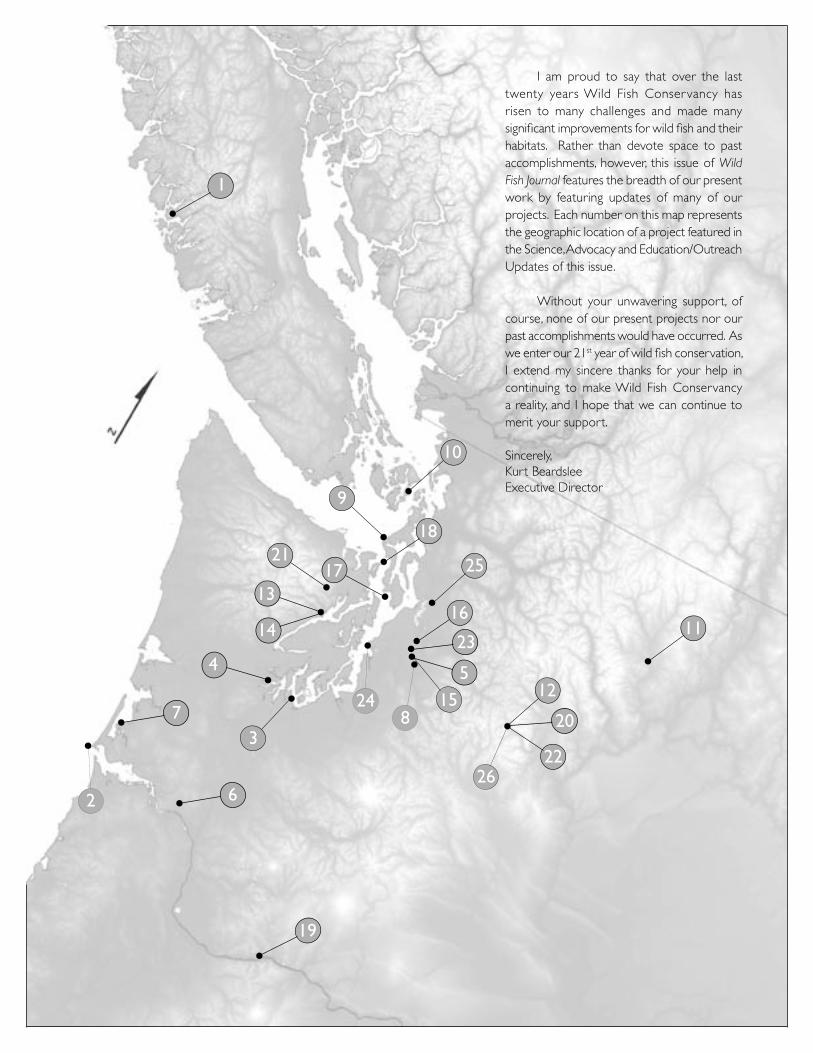
I am proud to say that over the last twenty years Wild Fish Conservancy has risen to many challenges and made many significant improvements for wild fish and their habitats. Rather than devote space to past accomplishments, however, this issue of Wild Fish Journal features the breadth of our present work by featuring updates of many of our projects. Each number on this map represents the geographic location of a project featured in the Science, Advocacy and Education/Outreach Updates of this issue.
Without your unwavering support, of course, none of our present projects nor our past accomplishments would have occurred. As we enter our 21st year of wild fish conservation, I extend my sincere thanks for your help in continuing to make Wild Fish Conservancy a reality, and I hope that we can continue to merit your support.
Sincerely,Kurt BeardsleeExecutive Director
A Twenty Year Ride with WFCby Bill McMillan
In the spring of 1988, several members of Bellingham’s 4th Corner Fly Fishers discussed the possibility of forming a fish conservation group in Washington patterned after Oregon Trout and Cal Trout. Bellingham was not alone. Discussions were occurring in other areas of Washington during the 1980s with a common wistful hope that a Washington Trout might one day emerge. Wild fish populations in the state had noticeably declined since the 1950s and 1960s. In fact, it was a continuous decline dating to the earliest years of the late 19th century. Oregon Trout and Cal Trout provided examples of fish conservation organizations on the West Coast with agendas dominated by science discussions rather than on fishing, or on a specific fishing method.
Dick Van Demark, the 4th Corner’s early conservation leader, had been concerned about the summer steelhead decline in the South Fork Nooksack River for more than a decade. He led a volunteer effort to recover summer steelhead using hatchboxes containing hatchery steelhead eggs placed in South Fork Nooksack tributary streams from 1975 to 1980. Although the emergent hatchery fry may have only increased the competition within already struggling wild fish populations in declining habitat, Dick followed good scientific principles by monitoring the volunteer effort with an impressively thorough report in 1981. With minimal evidence of adult summer steelhead returning to the hatchbox areas, in 1982 or 1983 he shifted the monitoring method from bank counts to snorkeling. There is no record the snorkel counts found more steelhead returning, but snorkel counts would become a trademark of Wild Fish Conservancy’s biological athleticism that might be termed today as “extreme biology.” In other words, “no means of getting at the biological truth of a matter is too difficult to pursue,” could easily be the WFC motto.
With his characteristic ability to get things moving, after the impromptu Bellingham discussion in the spring of 1988 Dick Van Demark contacted Rick Hafele, a professional aquatic entomologist who played a prominent role in the organization of Oregon Trout in the early 1980s. That summer Rick met with several of the 4th Corner Fly Fishers, including Dick Van Demark, Dan Homel, and Ralph Lloyd, in the idyllic setting of the Upper Skagit River in Southern British Columbia just across Washington’s North Cascade National Park border. Discussions around the evening campfire in that magnificent wild setting stimulated the beginning of Washington Trout. The location would prove prophetic. The vision of Washington Trout generated around a BC campfire has evolved into the larger ecosystem perspective of Wild Fish Conservancy. No longer limited by national, provincial, or state borders, the organization has geographically come full circle to those earliest origins. A WFC crew is presently in a 27-foot boat conducting research along one of the wildest and most majestic areas of the British Columbia coast.
On return to civilization, Ralph Lloyd’s Bellingham office became a WT rallying point where Ralph, Dan Homel, Dick Van Demark, Marc Hurlbert, and the added energy of Hugh Lewis became the eye of the storm that would increasingly expand in both vision and dimension rather than dissipate as so many campfire ideas do. Lists of names of potential members began to fill a thickening WT file in Ralph’s office drawers. A more formal meeting to test the waters for broader interest occurred in Ellensburg in May of 1989 after a mailing of invitations. A relatively small group attended, but a broadened consensus of interest to organize WT resulted. Rather than risk losing the formative energy, Cal Trout and Oregon
Wild Fish Conservancy Celebrates Twenty Years of Wild Fish Conservation
4
5
Trout were quickly contacted to see if they would provide representatives to help explain the process of getting a similar organization off the ground in Washington.
On June 3rd of 1989, Jim Hamilton of Cal Trout and Cal Cole of Oregon Trout, provided talks on how to organize and described their pathways to success at the Palace restaurant’s meeting room in Ellensburg. Of the 50-60 people who attended there were the necessary few whose interest was not passive, but rather had a long history of volunteer activism. They came for one reason: give me the tools; I want to go to work. This dated the beginning of Washington Trout as something more than a campfire flickering from the woods.
A mission statement and development of a logo were both discussed at that meeting. The movers and the shakers got to know each other and began to sort out where each might fit into the new team on the block. Hugh Lewis was particularly lit with the fire, figuratively and physically – ruddy hair standing on end in the eagerness to get going with the legal necessities of his profession. Just thirteen days later, he had WT registered as a legally incorporated organization; the complex process of becoming a tax exempt non-profit followed several months later. Ralph Lloyd and Marc Hurlbert became the original board of directors; Hugh Lewis was the original corporate secretary and general counsel, both of which he remains 20 years later. Over the coming six months, Ralph Lloyd was voted as the board of directors’ first president, and the board was enlarged with broader Washington regional representation that included Kurt and Candace Beardslee of Duvall, John Sowinski and Bill McMillan, both then of Washougal, Trey Combs of Port Townsend, Pat Trotter of Seattle, and Mike Harves of Yakima as well as the Bellingham group of Ralph, Marc, and Hugh.
Despite this legitimacy of existence there remained a pervasive unanswered question:
Now what?
It became apparent that a board of directors was insufficient. Activities were regionally occurring and were discussed, but they continued to have regional identities with individuals or local fishing organizations. There had to be one person in charge, full time, to accomplish the vision of habitat and wild fish protection, restoration, and conservation in the name of WT as a statewide powerhouse driven by science and freed from the limitations of being just one more fishing group.
Kurt Beardslee was a man driven by concern for a rugged little canyon river and its declining run of wild summer steelhead. While the fish managers were content with the status quo, Kurt was not. How alter the dilemma?
Kurt was aware of wild summer steelhead data collection occurring on the Wind and Washougal rivers through volunteer snorkel counts that had resulted in regional management changes to protect them. In May of 1989, just two weeks prior to the pivotal WT organizational meeting on June 3rd in Ellensburg, he met with Bill McMillan and John Sowinski on the upper Washougal River to learn the snorkel count methods that had been used to document the low numbers of wild summer steelhead in their local rivers. Those counts generated eventual agency participation and management changes based on actual monitoring of wild steelhead populations using snorkel data as indicators. Summer counts provide an opportunity for proactive decisions; spawning surveys 6-10 months later can only document an after-the-fact problem.
Armed with the new tools, throughout the summer
and fall of 1989 Kurt initiated one of the most intensive and thorough snorkel count regimes to ever occur on one river and continues to occur twenty years later. Just two years later Tolt River wild summer steelhead were on the radar of state fish managers, tribal managers, state-federal-private land owners, city and county governments and agencies, and in the newspapers of the political heart of Washington. By 1992, wild summer run steelhead had to be released by fishermen statewide, finally given protection their great vulnerability requires. The snorkel counts themselves increasingly included participation by a wide range of volunteers from college students to professional scientists.
Washington Trout had its leader. Living at the right place, at the right time, and with a combination of persistence, optimism, enthusiasm, and focused discipline, Kurt volunteered in 1991 to end his career as a gifted custom furniture maker to become Executive Director. Candace Beardslee, renowned artisan in silver, volunteered to help Kurt push WT forward by creating publications describing the science behind the organization’s conservation efforts and from which to publicize fund raising activities that the organization would initially depend on. Foolhardy as this seemed at the time, with less than $3,000 to draw from in the WT bank account, Kurt’s and Candace’s offers were quickly voted into approval by the board. It was time to sink or swim.

6
Washington Trout swam … but not without both Kurt and Candace stripping their lives down to the bare essentials. Both their lives were poured into WT. The economic crisis of today is old news to those whose lives have been dedicated to perpetuation of a non-profit conservation organization. Perpetual economic crisis, juggled year after year, is what the concept of non-profit is intended to be, and over the years there has been considerable pride in operating under that intent.
By 1994, Kurt took the risk of hiring his first field staff, two of whom, Mary Lou White and David Crabb, are still are still doing the good work of dedicated fish conservation for WFC. In those early years the emphasis was on employees capable of rugged field work in the analysis of culverts and determining fish extent up small tributaries. By 1996 there was a small office staff and a science director, Steve Conroy, with a PhD in protein chemistry and Scottish burr from his homeland. Steve planned the field work efforts and the collections and genetic analysis of Tolt River steelhead. From that point onward WFC increasingly found its niche on the playing field of conservation activism – objectively collected fish and habitat data by independent scientists with impressive credentials from universities throughout North America and Europe. The WFC team grew, each person strategically chosen for a particular field of expertise in a collective understanding of the fabric of ecosystems, how to teach it, or otherwise how to disperse and communicate it.
The past twenty years of Wild Fish Conservancy’s evolution could fill a Tolstoy novel with page after page of projects that have increasingly pushed the level of cutting edge science forward from an early 20th century building in Duvall. Located near the banks of the Snoqualmie River, the central office often vibrates with spur-of-the-moment frenzy demanded by some in depth technical response required within a few hours – the scene reminiscent of a NYC emergency room after a Saturday night gang fight. Walking through the building late at night, all in silence but for the hum of sleeping computers, there remains some sort of life to the place – giant “war” maps on the walls from throughout the Northwest where projects of fascinating breadth and complexity are occurring. The old building provides a feeling of continuity from the past into the future – books, tools, maps, machines, and equipment of modern science fill the century-old building to brimming juxtaposed against wide-planked floors scarred by calked boots when 15-foot diameter cedars were fallen by sawyers balanced on planks ten feet above the forest floor and steamboats puffed up and down the Snoqualmie.
The work of fish conservation has changed in twenty years and the organization has effectively changed with
it. The board of directors has wisely given the Beardslees the opportunity to apply the same creativity that shaped their previous lives as artists to the even more challenging creativity of shaping the science to drive fish conservation forward. From less than a $3,000 in 1989, in 2008 over $4 million fueled WFC’s conservation work. From a lone Executive Director with a desk and wet suit hanging on the wall in the vacuous spaciousness of an old building that had been Kurt’s furniture shop, the organization has grown to 21 employees – many of whom I have entrusted my life deep in wilderness woods, snorkeling the tumult of streams, or breasting the gray swells of Puget Sound in storm. From that one wetsuit hanging from a nail in 1990, the tools of operation now include a research vessel which is being used to study the health of the aquatic ecosystem of Vancouver Island’s Clayoquat Sound, including any effects Atlantic salmon netpen operations may have on native salmon and steelhead. The findings from this work may have implications coast-wide. From leading the science in the development of culvert passage assessments on small creeks between 1993 and 1996, in 2009 entire river sections are being measured in detail with resulting three-dimensional GIS maps that replicate the river channel on-screen in virtual reality.
Some of the tools to monitor fish populations remain the same. The “extreme biology” of snorkel surveys on high-gradient streams remains a hallmark niche the organization fills, but now it is complemented by compact underwater digital cameras and underwater video with images conveyed electronically from a lens to a sometimes distant camcorder. As so often, WFC has led the way in the development of the underwater video technology now used and from which more precise species identities can be made – inarguable evidence of species presence or absence, abundance or dearth.
With the twenty-year history of WFC, there has come the consideration of continuity. Those of us who built the organization’s foundations are no longer young. This weighed heavily on the board of directors in the early to mid 2000s, but it has increasingly resolved itself through recruitment of gifted young scientists as the organization has enlarged in budget and scale of work. There is now good reason to suggest the pendulum set into motion in 1989 is approaching self-sustaining equilibrium through employee diversity in age, experience, and range of human skills. This is the organization in which I have placed both my beliefs and hopes since that Ellensburg meeting in June of 1989. It has been a meteoric ride, like a small rocket that gets larger rather than smaller as each new stage lifts off, tracing its arc across the universe of West Coast fish conservation. @

1CLAYOQUOT, BC RESEARCH PROJECT AND A THANK YOU TO ITS SUPPORTERS Kurt Beardslee
5:00 AM, January 31st, 2009. After two years of planning, we are prepared for the first five-month field season of what is anticipated to be a five-year project. In the middle of a Northwest winter, packed to the brim, two WFC trucks pull out from our main office in Duvall with a nineteen-foot commercial skiff and a twenty-seven foot research vessel in tow. Our destination is one of the most beautiful places on earth, where some of the watersheds are still completely intact and ancient forests show signs of cultures that have endured the ages. These ecosystems have been shaped over thousands of years by the massive salmon and steelhead runs. Bringing nutrients back from the open ocean, these fish have fed not only whales, wolves, bears, and trees but also native peoples who grew strong and prosperous from the reliable bounty.
Until quite recently the story had changed very little. All the players are still there but one. Today, vast areas of British Columbia’s fjord-riddled coast are experiencing a collapse of their salmon and steelhead runs, one far more dramatic than their neighbors to the south. In Washington state, habitat degradation, over-harvest, and hatchery interactions have been identified as the major causes of salmon and steelhead declines. Lead agencies for salmon recovery have declared the loss of habitat as the single largest contributing factor for this decline.
Yet roughly eighty nautical miles north of Neah Bay, Washington, flowing deep into the fjords of Clayoquot Sound, rivers in pristine condition (for example, the Moyeha and the Megin rivers) have salmon and steelhead runs that are smaller than those that can be found in some of Washington’s urban streams. What is causing this problem is precisely the focus of this new research project.
WFC scientists will be looking at any potential impacts to wild salmon, including any impacts that may occur from a network of Atlantic salmon net-pens that dot the length of these fjords. In this regard, we will be looking for similar effects from Atlantic salmon net-pens documented by Alexandra Morton’s ground-breaking research in various locations along BC’s inside passage. Of the many questions that need answering regarding
Science Updates
salmon and steelhead decline, this is one of the most complex, fascinating, and most physically and logistically challenging projects we have ever tackled.
Now in late April 2009, WFC’s scientists have been hard at work for nearly three months. Despite the harsh coastal weather conditions they have endured, their spirits are high and the research is already producing valuable data that we will soon be sharing with other scientists, and you, our supporters.
Now that this project has successfully reached the half way point of the first field season, I want to step back and thank all those who gave their support and made this phase of the project possible. A special thank you to everyone who attended the 2008 Wild Fish Soirée and Benefit Auction. Your support during Fund-a-Dream was vital in helping WFC acquire Artemis, our twenty-seven foot research and live-aboard vessel that is proving invaluable in allowing us to work in remote locations. Also, a special thanks to Bruce McNae who donated a beautiful nineteen-foot commercial aluminum skiff, which is another vital tool in our daily fieldwork. And last but by no means least, a very special thank you to all of our new Canadian friends, particularly the owners of Clayoquot Wilderness Resort and Quait Bay Resort. They have truly rolled out the red carpet by generously donating four-star accommodations for our staff while they are sampling in southern Clayoquot Sound, including the use of a stunning longhouse that we are using as our land-based research station. This project would have been far more challenging without their generosity. If you are planning a trip to coastal BC, please consider supporting the businesses that are helping to fund this important research. You can learn about both resorts at www.wildretreat.com. @
Audrey Thompson, WFC project lead, pauses while we contemplate the challenging conditions of the pass leading to Tofino, BC.
7

2CAPE DISAPPOINTMENT NEARSHOREVIDEO MONITORING PROGRAMJamie Glasgow
Cape Disappointment is located near Ilwaco, Washington, where the Columbia River enters the Pacific Ocean. There, one of the state’s most dramatic parks provides an amazing interpretive center devoted to the area’s rich Lewis and Clark history, as well as a network of hiking trails that traverse a landscape ranging from wave-smashing, high-energy beaches to tranquil wetlands. A classic northwest lighthouse perched on a rocky head-land stands sentinel over the crashing waves. In addition to being a popular hiking and camping destination, Cape Disappointment State Park offers boaters easy access to the infamous Buoy 10 fishing area off the mouth of the Columbia as well as other sturgeon, salmon, bottomfish, halibut, and tuna fishing opportunities.
In 2003, Washington State Parks (WSP) improved the boat launch and breakwater facility at Cape Disappointment State Park; new ramps and docks were constructed, and the wave barrier, or breakwater, that protects the ramp and dock from the Columbia and Pacific currents was replaced with an improved structure. The new breakwater extends for approximately 220 feet into the Columbia, and consists of two sections separated by a three-foot wide gap, or window, to allow nearshore
3
8
fish passage. A permitting condition imposed by the Washington State Department of Fish and Wildlife requires WSP to evaluate the extent to which the new breakwater affects nearshore fish passage, and to monitor whether the fish passage window is being utilized by juvenile salmonids, forage fish, and other species that migrate through the area.
In early 2008, WSP advertised a competitive opportunity to design and implement a fish-use monitoring study at the Cape Disappointment breakwater, and Wild Fish Conservancy rose to the occasion. Considerable site constraints included significant tide swings, water clarity that changes dramatically with the tides and seasons, substantial currents, and significant amounts of flotsam in the water. Wild Fish Conservancy, building off of previous underwater video monitoring projects, designed a video monitoring system to answer the fish-use questions in this unique and challenging environment.
The monitoring system, which consists of a digital video recorder (DVR) and four underwater video cameras mounted in-line vertically, was first installed at the gap in the breakwater known as the fish window in March 2008. The cameras are capable of recording detected motion over twelve vertical feet of the water column, spanning the range of most tides at the site. In May, the cameras were moved to the end of the breakwater. The DVR was removed from the system in August 2008. Fish species documented at the breakwater included shiner perch (Cymatogaster aggregate), stickleback (Gasterosteus aculeatus), and gunnel (Pholidae). Unfortunately, no salmonids were observed on the limited pilot-study footage available for review. Several factors influenced the quality of the video footage, including turbidity associated with tide changes, time of day (amount of ambient light), the presence of flotsam and entrained debris, and growth of algae and barnacles on the cameras. Still, the quality of much of the footage was sufficient to allow identification of fish species and estimation of relative abundance. The results of this 2008 pilot study will guide 2009 equipment modifications and study design considerations. @
OLYMPIC MUDMINNOW DISTRIBUTION AND RECOMMENDATIONS FOR PROTECTION Jamie Glasgow
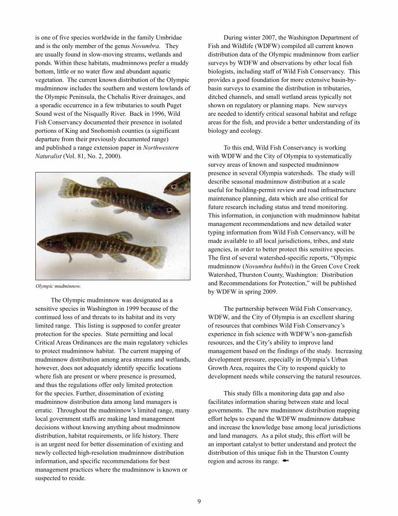
Imagine a fish that would look at home on a tropical reef in a Pixar/Disney film, with iridescent blue accents and a napoleon complex, living in the wetlands and ditches of southwest Washington and no where else in the world. The magnificent Olympic mudminnow (Novumbra hubbsi)
WFC’s Executive Director, Kurt Beardslee, installing an underwater camera array to monitor fish use in the Columbia River at Cape Disappointment State Park.
9
is one of five species worldwide in the family Umbridae and is the only member of the genus Novumbra. They are usually found in slow-moving streams, wetlands and ponds. Within these habitats, mudminnows prefer a muddy bottom, little or no water flow and abundant aquatic vegetation. The current known distribution of the Olympic mudminnow includes the southern and western lowlands of the Olympic Peninsula, the Chehalis River drainages, and a sporadic occurrence in a few tributaries to south Puget Sound west of the Nisqually River. Back in 1996, Wild Fish Conservancy documented their presence in isolated portions of King and Snohomish counties (a significant departure from their previously documented range) and published a range extension paper in Northwestern Naturalist (Vol. 81, No. 2, 2000).
The Olympic mudminnow was designated as a sensitive species in Washington in 1999 because of the continued loss of and threats to its habitat and its very limited range. This listing is supposed to confer greater protection for the species. State permitting and local Critical Areas Ordinances are the main regulatory vehicles to protect mudminnow habitat. The current mapping of mudminnow distribution among area streams and wetlands, however, does not adequately identify specific locations where fish are present or where presence is presumed, and thus the regulations offer only limited protection for the species. Further, dissemination of existing mudminnow distribution data among land managers is erratic. Throughout the mudminnow’s limited range, many local government staffs are making land management decisions without knowing anything about mudminnow distribution, habitat requirements, or life history. There is an urgent need for better dissemination of existing and newly collected high-resolution mudminnow distribution information, and specific recommendations for best management practices where the mudminnow is known or suspected to reside.
During winter 2007, the Washington Department of Fish and Wildlife (WDFW) compiled all current known distribution data of the Olympic mudminnow from earlier surveys by WDFW and observations by other local fish biologists, including staff of Wild Fish Conservancy. This provides a good foundation for more extensive basin-by-basin surveys to examine the distribution in tributaries, ditched channels, and small wetland areas typically not shown on regulatory or planning maps. New surveys are needed to identify critical seasonal habitat and refuge areas for the fish, and provide a better understanding of its biology and ecology.
To this end, Wild Fish Conservancy is working with WDFW and the City of Olympia to systematically survey areas of known and suspected mudminnow presence in several Olympia watersheds. The study will describe seasonal mudminnow distribution at a scale useful for building-permit review and road infrastructure maintenance planning, data which are also critical for future research including status and trend monitoring. This information, in conjunction with mudminnow habitat management recommendations and new detailed water typing information from Wild Fish Conservancy, will be made available to all local jurisdictions, tribes, and state agencies, in order to better protect this sensitive species. The first of several watershed-specific reports, “Olympic mudminnow (Novumbra hubbsi) in the Green Cove Creek Watershed, Thurston County, Washington: Distribution and Recommendations for Protection,” will be published by WDFW in spring 2009.
The partnership between Wild Fish Conservancy, WDFW, and the City of Olympia is an excellent sharing of resources that combines Wild Fish Conservancy’s experience in fish science with WDFW’s non-gamefish resources, and the City’s ability to improve land management based on the findings of the study. Increasing development pressure, especially in Olympia’s Urban Growth Area, requires the City to respond quickly to development needs while conserving the natural resources.
This study fills a monitoring data gap and also facilitates information sharing between state and local governments. The new mudminnow distribution mapping effort helps to expand the WDFW mudminnow database and increase the knowledge base among local jurisdictions and land managers. As a pilot study, this effort will be an important catalyst to better understand and protect the distribution of this unique fish in the Thurston County region and across its range. @
Olympic mudminnow.

4WFC HELPS THE EVERGREEN STATE COLLEGE GET A LITTLE GREENERJamie Glasgow
More wild salmon and trout will soon be making their home on the Evergreen State College campus and in Puget Sound with a bit of ingenuity applied to a culvert and bulkhead on the Evergreen State College campus.
With funding and assistance from partners including The Evergreen State College, the Washington State Salmon Recovery Funding Board, People For Puget Sound, and the Estuary and Salmon Restoration Program, Wild Fish Conservancy will remove an undersized 3-foot wide culvert at the mouth of Snyder Creek in Eld Inlet and replace it with a 14-foot wide box culvert. Construction will take place in Snyder Cove during summer 2009.
During a 2005 water type assessment, Wild Fish Conservancy mapped 1.4 miles of stream channel in Snyder Cove Creek; prior to the survey, the state’s regulatory maps showed only 0.2 miles of stream. During the survey, WFC documented the presence of resident cutthroat trout, sculpin, and lamprey in the small stream. No anadromous fish were observed, likely due to the presence of the undersized culvert at the stream’s mouth.
The watershed lies within a forest protected by the State College. The new culvert will restore passage for fish species including coho salmon (Oncorhynchus kisutch), chum salmon (O. keta), and cutthroat trout (O.clarki). These fish will once again gain access to almost one mile of spawning and rearing habitat. The project will also restore the natural processes of sediment, wood, and water transport.
In a related project, People for Puget Sound and Coastal Geologic Services will be performing a feasibility study to evaluate the potential removal of several hundred feet of concrete bulkhead adjacent to the Snyder Creek culvert in spring 2009. The rest of the Eld Inlet shoreline around the project is one of the largest remaining stretches of undeveloped shoreline in south Puget Sound.
Bulkheads, barrier culverts, and other shoreline obstructions represent threats to wild fish habitat throughout the Puget Sound, and this project represents a model for actions around the Sound to restore fish access to critical spawning and rearing habitat. Restoring these habitats also has wider ecosystem benefits beyond wild fish because it restores the ecological processes that create and maintain diverse habitat structures and the health of the nearshore environment. @
WILD FISH CONSERVANCY WATER TYPE ASSESSMENTSJamie Glasgow
State and local governments in Washington are charged with protecting Puget Sound’s streams from adverse impacts associated with adjacent land-use activities.
Most of the governmental agencies evaluating land-use permits are falling short in protecting our resources for a surprisingly simple reason: they are relying on inaccurate maps.
The responsible agencies depend on a process called water typing to identify and categorize streams, lakes, and wetlands for their importance, ecologically and for human uses. This basic inventory is the most fundamental step in conserving the health of streams, rivers, and ultimately, the larger waters which they feed, like Puget Sound. Where are the streams and where are the fish and fish habitats within them?
Unfortunately, there is no legal requirement for agencies to “ground-truth” their maps, so current water typing records and maps often underestimate the actual miles of fish-bearing waters by 50% or more. Wild Fish Conservancy has documented widespread error throughout Puget Sound in designating streams as “fish-bearing” or “non fish-bearing.” We have found that a significant number of streams in the Puget Sound watershed do not even appear on any maps. Hundreds of miles of productive aquatic habitats are being threatened and compromised because they have been misidentified and subsequently
An undersized culvert partially blocks fish access to one mile of stream on The Evergreen State College campus in Olympia, WA.
10

5
performed, regulatory maps updated, and critical areas adequately protected, progress towards salmon recovery and a healthy Puget Sound will continue to be significantly offset by the pervasive and in many cases unrecorded loss of habitat and water quality. When I think about the small streams of western Washington, I’m reminded of Aldo Leopold’s famous quote, “To keep every cog and wheel is the first precaution of intelligent tinkering.” To protect our watersheds and Puget Sound from a death by a thousand cuts, which is what the laws are intended to do, we need to do a much better job of keeping the remaining cogs and wheels.
In 2009 Wild Fish Conservancy will be continuing water type assessments in San Juan and Mason Counties, and beginning water type assessments in the counties of King, Pierce, Snohomish, and Grays Harbor. @
AN OLD FRIEND, WEISS CREEKJamie Glasgow
Wild Fish Conservancy is no stranger to Weiss Creek. A small watershed that flows under SR 203 into the Snoqualmie River east of Seattle, Weiss Creek supports coho, steelhead, resident and sea-run cutthroat trout, sculpins, and freshwater mussels. In 1999, WFC restored the lower one mile of the watershed where it flows through the Snoqualmie floodplain by restoring flow to a relict channel, adding large woody debris, and doing an extensive riparian planting. Since then, WFC has improved wetland habitats further upstream, and monitored the type and number of salmon returning to the creek annually.
In the headwaters of Weiss Creek near Big Rock Road, there are several undersized culverts that still compromise the upstream migration of coho, steelhead, and sea-run cutthroat trout. During the December 2007 storm, one of those culverts blew out, wrecking the road and stranding twelve households on the far side of the creek. The unfortunate homeowners had no power or phone service, no way to drive to town, and no way to receive propane to heat their houses for the week that passed before a temporary culvert was installed and the road temporarily repaired.
During summer 2008, WFC removed that temporary four-foot wide culvert and replaced it with a thirty-four foot long steel bridge. In summer 2009, WFC will remove a second barrier culvert just upstream and replace it with a wooden bridge. These two projects will allow fish to access important headwater spawning habitat and will
subjected to inappropriate land practices. In a recent water type assessment completed in north Thurston County, WFC documented 20% more stream miles than the regulatory water type maps had shown (162 miles vs. 135 miles, respectively).
Under its Habitat Lost & Found program, Wild Fish Conservancy physically surveys streams throughout Washington to correct misclassifications thus qualifying more streams for the protection warranted under existing laws. Since 1994, WFC has corrected the watertype classification of over 6000 stream reaches statewide using the state-sanctioned watertype survey protocol. The results of many of the WFC water type assessments are available via an interactive map on our website (see: www.wildfishconservancy.org) to facilitate the use of the data by local governments and the general public.
In addition to ensuring that the best available science is used to protect fish habitats, these assessments fill data gaps regarding non road-related fish passage issues (diversion dams, withdrawal systems, etc.) and provide fish species composition and distribution information needed to responsibly identify, prioritize, and implement effective and science-based restoration projects in the area. These assessments also continue to assist the region with the direct identification of restoration and protection opportunities within the study watersheds.
Many Washington streams face increasing threats from development. Unless the watersheds that feed Puget Sound are accurately identified and protected, cumulative effects from the development of these watersheds will continue to contribute to the compromised health downstream. And until systematic inventories are
Wild Fish Conservancy has corrected the classification of over 6,000 stream reaches in Washington by performing the state-sanctioned water type survey methodology.
11

6
reduce risk and maintenance for the citizens that currently own the culverts. Like these two projects, many of WFC’s fish habitat restoration projects benefit not only fish, but the landowners on whose properties the projects occur. The bridge projects are funded by the state’s Family Forest Fish Passage Program, which provides funds to improve fish passage on private forested property. If you are aware of privately-owned culverts that may impede fish passage, please contact Wild Fish Conservancy – we may be able to help restore fish passage and alleviate road maintenance concerns. @
GERMANY CREEK CONSERVATION/RESTORATION PROJECTJamie Glasgow
Germany Creek flows into the lower Columbia River in Cowlitz County, WA, near the city of Longview. The creek supports steelhead (Oncorhynchus mykiss), cutthroat trout (O. clarki), and coho (O. kisutch), pink (O. gorbuscha), chinook (O. tshawytscha) and a small run of Endangered Species Act-listed chum salmon (O. keta). The watershed also provides habitat for other wildlife including freshwater mussels, elk, black-tail and Columbian white-tail deer (also ESA-listed), bald eagle, osprey, and a variety of other waterfowl.
In 2003, Columbia Land Trust (www.columbialandtrust.org) secured funding through the Salmon Recovery Funding Board to purchase and protect in perpetuity 155 acres of riparian, floodplain, and associated upland habitat from the mouth of Germany Creek upstream for one mile. Columbia Land Trust also received funding to design and build a salmon habitat restoration project, tentatively identified as a chum spawning channel. The Land Trust partnered with Wild
Fish Conservancy to evaluate the feasibility of the chum spawning channel and to identify more appropriate restoration alternatives as warranted.
After several seasons of WFC data collection that included an extensive topographic survey, groundwater level monitoring, stream flow and temperature monitoring, and an alternatives evaluation, Wild Fish Conservancy advised against the chum spawning channel. The two locations that supported conditions suitable for the spawning channel were well within Germany Creek’s channel migration zone, and it was determined that there was a high likelihood that any artificial spawning channel constructed in those locations would not be sustained over time. In short, the watershed’s natural sediment and wood transport processes would within years undo any effort to construct a static chum spawning channel there.
As an alternative to the engineered chum spawning channel, the project partners turned their sights on stream process restoration and the addition of logjams within the project reach. Project objectives were to restore floodplain connectivity and habitats and to increase instream habitat complexity. To this end, in summer 2008 the project partners removed approximately 500 feet of derelict levees from within the floodplain, built two off-channel logjams within the floodplain, and constructed five complex log jams within the wetted channel. All floodplain areas disturbed during the project were replanted with native vegetation in winter 2009.
Within four months of the completion of the major project elements, Germany Creek experienced record flows that resulted in a major flood event across the project
In summer 2008, Wild Fish Conservancy and project partners removed levees along Germany Creek. In January 2009, flood flows deposited substantial amounts of sediment in the floodplain that had been isolated from the river for decades.
A new bridge improves fish passage and helps landowners in Weiss Creek.
12

7
site. The instream log jams were picked up and moved downstream, despite efforts to anchor them with cables and boulders; they are now adding to channel complexity further downstream. The off-channel floodplain jams worked as designed to split the flood flows and scour
new channels, and the removal of the levees allowed flood flows to spread and dissipate across the floodplain, possibly saving the county road that runs along the river downstream from the project site. Impressively, several feet of new floodplain soil deposits were left throughout the project site – a tabla rasa for the new floodplain understory. Post-construction surveys are underway to document the full extent of the re-shaping of lower Germany Creek.
Wild Fish Conservancy looks forward to watching lower Germany Creek evolve in the coming years, and we are excited to be an important component of this unique opportunity to protect and restore natural processes in critical lower Columbia tributary habitats. @
ELLSWORTH CREEK TROUT PART II: CUTTHROAT AND RAINBOW HYBRID GENETICSThomas Buehrens and Jamie Glasgow
Ellsworth Creek, a 5,000 acre watershed that drains into Willapa Bay in southwestern Washington, is owned and managed as a reserve by The Nature Conservancy (TNC). TNC purchased the watershed to protect the stands of old-growth forest, some more than 800 years old, and to combat fragmentation of the wildlife habitat. In the summer of 2007, Wild Fish Conservancy conducted a survey of fish distribution and abundance in order to provide TNC with baseline data on native fish populations.
One of many log jams WFC constructed on Germany Creek to build habitat complexity.
During the course of the study, we documented a variety of native fish species including coastal cutthroat trout, rainbow trout/steelhead, coho salmon, lampreys, and sculpins. Among the numerous rainbow and cutthroat trout we observed during the study, many displayed external characteristics of both species, leading us to suspect they were potentially rainbow/cutthroat trout hybrids.
Coastal cutthroat (Oncorhynchus clarki) and rainbow trout (O. mykiss) have coexisted in the Pacific Northwest for millennia, and as a result, natural reproductive-isolating mechanisms have evolved to prevent complete genetic mixing of the two species. Despite these isolating mechanisms, natural hybridization between coastal cutthroat trout and rainbow trout has been documented with varying frequency across the range of both species. It is thought, however, that human habitat alterations, such as the installation of fish passage-blocking culverts and dams, or stocking of hatchery-reared trout, may disrupt the natural reproductive isolating mechanisms between coastal cutthroat and rainbow trout, leading to an increased frequency of hybridization. Hybrids are typically fertile and can reproduce, leading to “hybrid swarms,” where pure rainbow and cutthroat trout are absent, and only hybrids remain. This phenomenon is correlated with extensive declines of native cutthroat populations in the inter-mountain west, where introduced rainbow trout have bred with native interior cutthroat subspecies which did not evolve in the presence of rainbows. In coastal systems like Ellsworth, where the two species co-evolved, the conservation consequences of hybridization are poorly understood and more research is needed to determine what factors drive whether or not and where hybridization occurs in a watershed.
Following the observation of putative hybrids in Ellsworth Creek, WFC, in collaboration with TNC, received funding from U.S. Fish and Wildlife Service to conduct a study on coastal cutthroat and rainbow trout hybridization in Ellsworth Creek. The primary goal of the study is to use molecular genetics to determine whether hybrids are actually present in the basin, and to determine the spatial distribution of hybrids and relate it to habitat characteristics. In June 2008, WFC returned to Ellsworth Creek and captured 120 juvenile trout for non-lethal genetic sample collection. In addition to clipping trout fins, we also measured and photographed each fish, and collected habitat data such as the stream channel width and gradient where each fish was captured.
Currently, the tissue samples are being genotyped at the Molecular Genetics Facility at University of Washington School of Aquatic and Fishery Sciences.
13

8
The molecular methods being used will allow us to determine the species identity of each individual trout sampled, and the degree of hybridization (if any). We will relate these data to the physical habitat data we collected during the field portion of the study in order to identify the habitat characteristics and locations within the watershed associated with hybrid presence. The results of this study will improve understanding of the poorly understood mechanisms governing hybridization between coastal cutthroat and rainbow trout, and may be considered by resource managers in the development of management and conservation plans. We will also be able to relate the genotypes of each trout to photographs and field identifications to determine the accuracy of field identification and assess the correlation between visual characteristics of individual fish and their known genotypes. In this way, the data will improve future field identification of coastal cutthroat, rainbow trout, and hybrids. @
A NEW (OLD) BRIDGE FOR INDIAN CREEKBrent Trim
A useful analogy for the ecology of a river system is to compare it to the body’s circulatory system – damage to the myriad small veins, arteries, and capillaries is ultimately just as threatening to the living system as a failing aortic valve, but much less apparent. Loss of function occurs slowly over time as the cumulative damage inevitably approaches, then surpasses a tolerance threshold beyond which the system becomes unstable and tips toward the breaking point. The end result is the same – failed health of the organism. Although it is one of the most productive salmonid streams in Puget Sound, the Snoqualmie River differs from most other rivers for one very tall reason - Snoqualmie Falls. Migrating salmon ascend well upstream on most Puget Sound rivers, passing through the areas of greatest human impact to relatively less-degraded headwater spawning grounds. But salmon migration abruptly stops at Snoqualmie Falls, and with the exceptions of the Tolt River and the Raging River, there are no other large forks upstream from the Skykomish confluence, making protection and restoration of the many small, spring-fed tributaries that descend from foothill spawning grounds (in other words, the capillaries) especially vital to the recovery of endangered stocks in the Snoqualmie basin.
Wild Fish Conservancy cut its teeth on restoration in our home river valley, and we continue to leverage our local expertise to restore habitats and ecological processes on Snoqualmie River tributaries. Some of these projects
are quite large scale (re-construction of the natural stream channel at Weiss Creek, for example), but there are many opportunities to restore damaged habitat through smaller projects that are no less significant in the overall recovery effort. This summer we will replace a failing culvert on lower Indian Creek, a Snoqualmie tributary just upstream from the Tolt River that has an unexpectedly strong coho run – so much so that (until recently) Washington Department of Fish and Wildlife conducted annual spawner abundance index surveys on a headwaters reach.
Located at the crossing of a field-access road, the culvert is representative of countless similar barriers that WFC personnel routinely document throughout Washington’s agricultural lands. But of course we can’t know of every such potential barrier, and this one was thankfully brought to our attention by landowners concerned about the welfare of their stream. Although adequate at the time it was installed, decades of rust and decay have taken their toll. The continued weight of heavy farm equipment is causing the culvert to sink deeper into the “Seattle muck” (that is, in fact, the technical term for a local valley bottomland soil type), eventually resulting in a barrier to upstream migration by spawning coho salmon
A failing culvert and road crossing at Indian Creek.
Plans for a bridge to be installed in Summer 2009.
14
rearing habitats. Research biologists Eric Beamer from SRSC and Kurt Fresh of NOAA-NWFSC are taking full advantage of the opportunities provided by these methods to collect chinook tissue samples from throughout their range in north Puget Sound. In order to cover such a wide geographic area in a timely manner, they also contracted several organizations with experience seining for juvenile salmon in marine waters, including WFC.
The dynamic environment of Admiralty Inlet and the Strait of Juan de Fuca creates challenges that field crews must contend with in order to successfully catch fish. Heavy swells generated by passing storms, daily wind waves, and strong tidal currents all test the mettle of bodies and equipment. Peak densities of juvenile chinook
and coho are typically encountered in July, but a cooler-than-average spring delayed the smolt out-migration from natal rivers, so we did not encounter as many early chinook as anticipated based on data from our 2005-2006 West Whidbey Nearshore Fish Use Assessment. We expected to intercept a flood of young chinook during the August 2008 sampling session, and were not disappointed. Our experience setting nets in these difficult conditions enabled WFC to contribute more than one-hundred tissue samples from wild chinook, netted from four widely-separated sampling zones encompassing the entire north-south span along the west coast of Whidbey and in nearby Possession Sound. We also collected eighty-five coded-wire tags from hatchery-raised fish to supplement data from the earlier study.
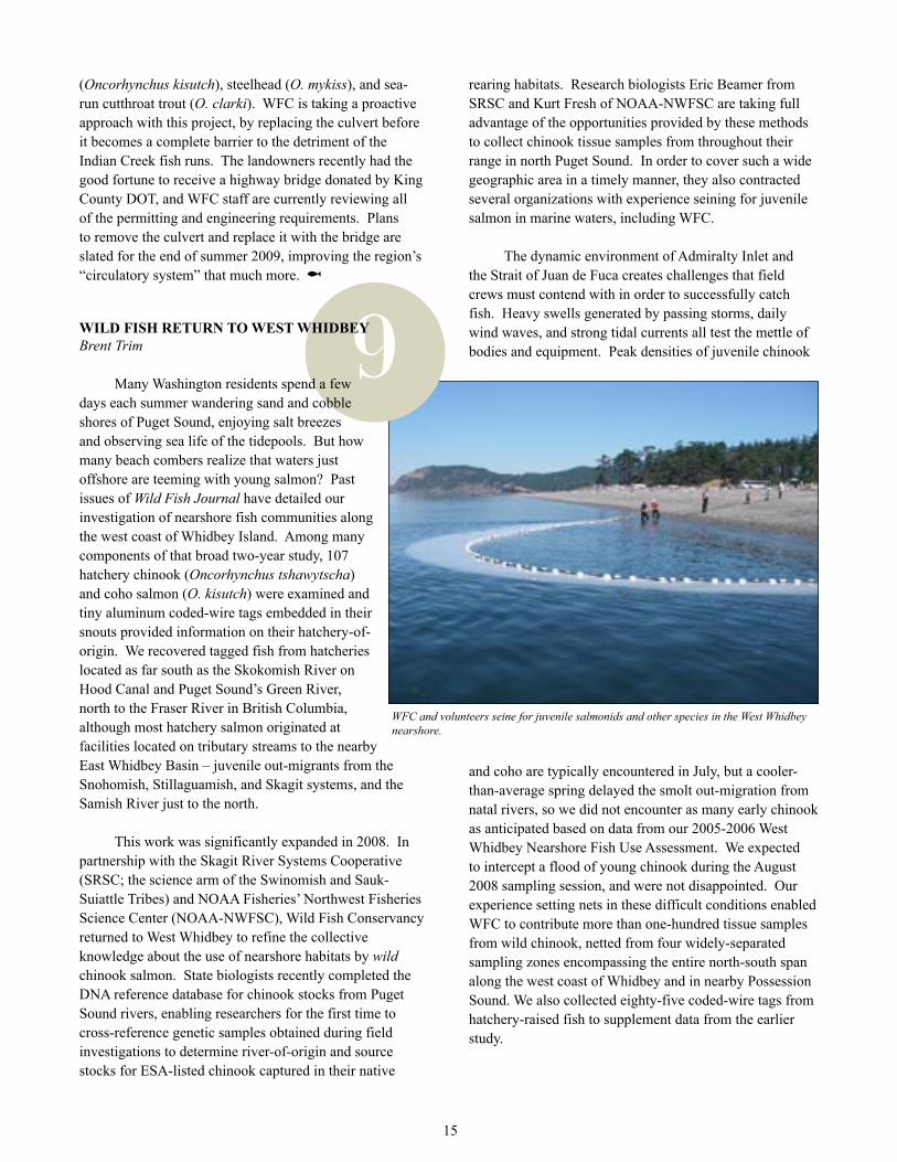
WFC and volunteers seine for juvenile salmonids and other species in the West Whidbey nearshore.
15
9
(Oncorhynchus kisutch), steelhead (O. mykiss), and sea-run cutthroat trout (O. clarki). WFC is taking a proactive approach with this project, by replacing the culvert before it becomes a complete barrier to the detriment of the Indian Creek fish runs. The landowners recently had the good fortune to receive a highway bridge donated by King County DOT, and WFC staff are currently reviewing all of the permitting and engineering requirements. Plans to remove the culvert and replace it with the bridge are slated for the end of summer 2009, improving the region’s “circulatory system” that much more. @
WILD FISH RETURN TO WEST WHIDBEYBrent Trim
Many Washington residents spend a few days each summer wandering sand and cobble shores of Puget Sound, enjoying salt breezes and observing sea life of the tidepools. But how many beach combers realize that waters just offshore are teeming with young salmon? Past issues of Wild Fish Journal have detailed our investigation of nearshore fish communities along the west coast of Whidbey Island. Among many components of that broad two-year study, 107 hatchery chinook (Oncorhynchus tshawytscha) and coho salmon (O. kisutch) were examined and tiny aluminum coded-wire tags embedded in their snouts provided information on their hatchery-of-origin. We recovered tagged fish from hatcheries located as far south as the Skokomish River on Hood Canal and Puget Sound’s Green River, north to the Fraser River in British Columbia, although most hatchery salmon originated at facilities located on tributary streams to the nearby East Whidbey Basin – juvenile out-migrants from the Snohomish, Stillaguamish, and Skagit systems, and the Samish River just to the north.
This work was significantly expanded in 2008. In partnership with the Skagit River Systems Cooperative (SRSC; the science arm of the Swinomish and Sauk-Suiattle Tribes) and NOAA Fisheries’ Northwest Fisheries Science Center (NOAA-NWFSC), Wild Fish Conservancy returned to West Whidbey to refine the collective knowledge about the use of nearshore habitats by wild chinook salmon. State biologists recently completed the DNA reference database for chinook stocks from Puget Sound rivers, enabling researchers for the first time to cross-reference genetic samples obtained during field investigations to determine river-of-origin and source stocks for ESA-listed chinook captured in their native
10
But we could not have accomplished this without help! Volunteers from Island County Beach Watchers braved weather and waves to assist WFC staff with setting nets, identifying and enumerating fish species, and collecting genetic samples. Among many Beach Watcher accomplishments, they’ve conducted juvenile salmon monitoring using hand-set beach seines in pocket estuaries along the east Whidbey shoreline. Although this was their first experience using the “big net” (the much larger, more cumbersome 120-foot seine that must be set with WFC’s 17-foot outboard research skiff), the Beach Watchers quickly acclimated, and provided muscle power and stamina to manage nets and capture fish throughout the daily tide cycle in the challenging conditions of the outer coast. Getting all field personnel to the right place at the right time on a sixty-mile-long island is no easy task, and we wish to extend particular thanks to Bob Buck, Jim Somers, and Ken Urstad for their immeasurable assistance in coordinating the schedules of the volunteers, and in providing storage for our boat and gear while we were on the island. Other Beach Watchers who volunteered to help during the course of this project include: Tom Albrecht, Monem Mahmound Abdel, Joe Beck, Stewart Congdon, Carol (Finn) Gatewood, Bob Gentz, Jill Hein, Doug Kollasch, Lenore Minstrell, and Melissa Merickel. The Island County Beach Watchers contributed more than 400 person-hours of volunteer labor to this multi-agency effort to elucidate the origins of wild chinook salmon utilizing nearshore habitats of northern Puget Sound. So next summer when you are at the beach and witness salmon leaping just offshore, tip your hat in gratitude to the dedicated volunteers who steward the unique and wondrous inland sea we all know as Puget Sound.
A powerpoint presentation of WFC’s West Whidbey nearshore work is now available on our website: www.wildfishconservancy.org. @
NEARSHORE NOTES: CYPRESS ISLANDBrent Trim
Wild Fish Conservancy continues to stretch our sea legs. You may have surmised from several related articles that nearshore habitat is currently an active sphere for regional fisheries research. Though apparently self-defining, the word “nearshore” has a working definition used by marine biologists that is based on ecological processes rather than a specific distance from shore. “Nearshore” means “the estuarine/delta, marine shoreline, and areas of shallow water from the top of the coastal bank or bluffs to the water at a depth of about 10 meters [the average depth of sunlight penetration in Puget Sound].
This zone incorporates those geological and ecological processes, such as sediment movement, freshwater inputs, and subtidal light penetration which are key to determining the distribution and condition of aquatic habitats. By this definition, the nearshore extends landward into tidally influenced freshwater heads of estuaries and coastal streams.”1 It is worth considering that everything flows downstream, and at the end of the line is the nearshore – vital habitat to ensure that native salmon smolts from our rivers have a healthy start to their ocean-going lives.
This year, WFC has expanded its investigation of marine fish communities by initiating a pilot project to assess the use of nearshore habitats by native species at Cypress Island, near Anacortes. Due in large part to state ownership, Cypress Island remains the least developed of the large islands of the San Juan archipelago, and habitat protection was recently extended to adjacent nearshore waters with the establishment of the Cypress Island State Aquatic Reserve (2007). Washington Department of Natural Resources staff contacted WFC to design and implement a “fish-use assessment” akin to our work on Whidbey Island in 2005-’06 (results from that study are available on our website: www.wildfishconservancy.org). The goal of this new project is to provide baseline data for all marine fish species in the Aquatic Reserve, with an emphasis on nearshore use by juvenile salmon. Although a great deal of research is taking place throughout north Puget Sound, there is currently a gap in the regional knowledge with respect to Cypress Island and vicinity. Its strategic location at the convergence of Rosario Strait and Bellingham Channel creates a natural focus for tidal currents and local upwelling; a hot spot for concentrating the prey-base upon which juvenile salmon feed and grow.
The opportunity to create new partnerships with other marine researchers is a natural out-growth of WFC’s involvement in nearshore research. Of particular interest to area biologists is the relationship between juvenile salmon (as predators) and their prey-base of marine invertebrates. Data collected at Cypress Island will expand upon this existing trophic study in the San Juan Islands. Cypress Island will also provide us with the opportunity to extend the geographic range for collection of genetic samples from wild juvenile chinook salmon (see “Wild Fish Return to West Whidbey”, also in this issue of Wild Fish Journal). It is anticipated that future funding will provide for long-term monitoring to assess population trends and species demographics for the marine fish assemblages in the Cypress nearshore. As one of the state’s premier Aquatic Reserves, the relatively pristine waters surrounding Cypress Island could become the litmus test for comparison to nearshore fish-use data collected throughout the region.
16

11
Footnote1 Puget Sound Nearshore Ecosystem Restoration
Program (PSNERP). 2003. “Guidance for Protection and Restoration of Nearshore Ecosystems of Puget Sound.” - Fact Sheet. Available at http://www.cev.washington.edu/lc/PSNERP/guidance.pdf. @
METHOW LAMPREY INVENTORY AND RESTORATION ASSESSMENTJohn Crandall
In the summer of 2008, WFC conducted an inventory of Pacific lamprey (Entosphenus tridentatus) in the Methow River watershed to determine the distribution and relative abundance of these ancient fish. This effort, made possible through a grant from the National Fish and Wildlife Foundation, was completed through a partnership with the USFS Methow Ranger District, University of Manitoba, Douglas County PUD, USGS and Western Fishes.
Pacific lamprey are jawless fish that lack many of the features commonly associated with most fish including scales, bones and paired fins. They are amongst the oldest living vertebrates with fossils dating back over 450 million years. This persistence is impressive considering the fact that many life forms, including the dinosaurs, have come and gone during their tenure on Earth. If this is not impressive enough, consider that salmon appeared in the fossil record “only” six million years ago.
Like salmon, Pacific lamprey are anadromous, so they can be counted as they pass the nine Columbia River dams they must navigate to make it back to the Methow River. Recent counts of Pacific Lamprey passing Bonneville Dam indicate that these fish are in steep decline in the Columbia River; counts in 2008 were the lowest ever. Even more alarming is the fact that fewer than 40 adults have passed Wells Dam in both 2007 and 2008. This assessment effort by WFC will address several critical uncertainties pertaining to lamprey in the upper Columbia and will help guide upcoming conservation efforts.
The 2008 inventory represented the first systematic survey for lamprey in the Methow and it focused on determining the distribution of larval lamprey, called ammocoetes, that inhabit the sand and silt habitats associated with stream margins, eddies and backwaters. Over 70 sites were sampled across the Methow River and tributaries such as the Twisp, Chewuch, and Lost Rivers. Interestingly, lamprey were found only in the Chewuch River and in the Methow River downstream of the
Chewuch. They were absent from the Twisp River and all other tributaries. The reasons for this are unclear, but will certainly be addressed with continuing data analysis and research.
Upon capture, ammocoetes were measured and weighed and a small tissue sample was taken for genetic analysis. The University of Manitoba is currently analyzing these samples. When completed, results from the Methow will be compared to other populations of Pacific lamprey from across the Pacific Northwest so we gain a better understanding of how Methow lamprey relate to the larger population. Unlike salmon, no specific run types appear to exist for lamprey and there are no known “spring” or “fall” run lamprey. Rather it appears there is a high degree of genetic mixing between groups. This lack of genetic distinction has been one factor that has prevented lamprey
from becoming listed under the Endangered Species Act.
WFC is also engaged in a restoration assessment for Methow lamprey. Distributional data obtained during the inventory will be used to determine potential restoration actions
that could benefit lamprey. Special attention will be given to the numerous salmonid-based restoration actions that are slated to occur in the Methow in the near future. By getting the habitat needs of lamprey “on the radar screen” of restoration planning, it is hoped that, to the fullest extent possible, that future restoration will consider the needs of lamprey in their design.
WRIA 07- BARRIER PRIORITIZATION MAPPING SYSTEMBy Mary Lou White
In September 2008, Wild Fish Conservancy received funding from the National Fish and Wildlife Foundation to implement the WRIA 07 – Barrier Prioritization Mapping System project (WRIA 07 – BPMS). WRIA 07 is the state’s designation for the Snohomish River watershed. The goal of the WRIA 07 – BPMS project is to create an interactive web-based mapping system that merges fish,
Pacific lamprey.
17

12
habitat, road, sub-basin priority indices, and fish passage barrier data. The system will be designed to make barrier prioritization easier and faster for federal, state, and tribal agencies as well as local biologists, municipalities, citizen groups and private landowners. Our objective is to consolidate current mapping data from all available sources and add new attributes (e.g. priority basin information, ownership and available habitat) that will make fish barrier prioritization more efficient. Where gaps exist, we will collect and document (as funds allow) the relevant information to improve the accuracy of existing barrier and habitat data.
Why do we need the WRIA 07 – BPMS?Washington Department of Fish and Game’s report
WA State Salmonid Stock Inventory Coastal Cutthroat Trout. (2000) describes how residential development and road building, “result in loss of riparian vegetation, increased sediment loads, high run-off rate, and blockages to migration…” (emphasis added). Similar comments can be found in nearly every salmonid recovery plan along the Pacific Coast. Reductions in these impacts will benefit many salmonid species, including chinook (Oncorhynchus tshawytscha), coho (O. kisutch), pink (O. gorbuscha) and chum (O. keta) salmon, steelhead (O. mykiss), bull trout (Salvelinus confluentus), and resident and anadromous rainbow (O. mykiss) and cutthroat (O. clarki) trout.
Currently, local jurisdictions and non-profits interested in replacing or removing existing culvert barriers in WRIA 7 are encumbered by the time-consuming prioritization process and are sometimes relying on incomplete, inaccurate or outdated information on stream classification or existing culvert barrier status. When data gaps exist, opportunities are lost and/or strategic planning efforts are undermined. Paradoxically, culverts are sometimes replaced upstream of another culvert impediment or barrier due to opportunity, or because the downstream barriers were not previously identified or were identified but not assessed. Consequently, funding opportunities are not being utilized to the maximum potential and there is no concerted effort to replace culverts in a systematic fashion.
How will this project help private landowners and small communities?Individual and small communities are often
overlooked in salmonid restoration opportunities because they are underrepresented and don’t have the funds or personnel to assess salmonid conditions, attend meetings, submit grants, or provide “match” (cash or an in-kind contribution is often required to be eligible for grant funds). Private landowners as well as small communities and municipalities are encumbered by their lack of knowledge on culvert replacement options. They also may not know who to turn to for advice and help. Thus, the restoration process is hampered by a lack of resources to assist willing landowners.
WFC would like to help build community support for salmon recovery in WRIA 7 by educating landowners and encouraging small communities and municipalities to get
involved in the process of recovery. Landowners in priority sub-basins of WRIA 7, who have existing culvert barriers or other impediments to fish passage on their properties, will be sent a brochure that describes which agencies and non-profits to contact for help and lists some local funding opportunities for land owners in Snohomish and King counties. These landowners will also be directed to a web site where fish passage and habitat problems associated with culverts will be documented. Consequently, local landowners will learn why barriers are a problem, they will become aware of funding opportunities and have the support and data necessary to become actively involved in the restoration process, thereby encouraging and setting an example for others. @
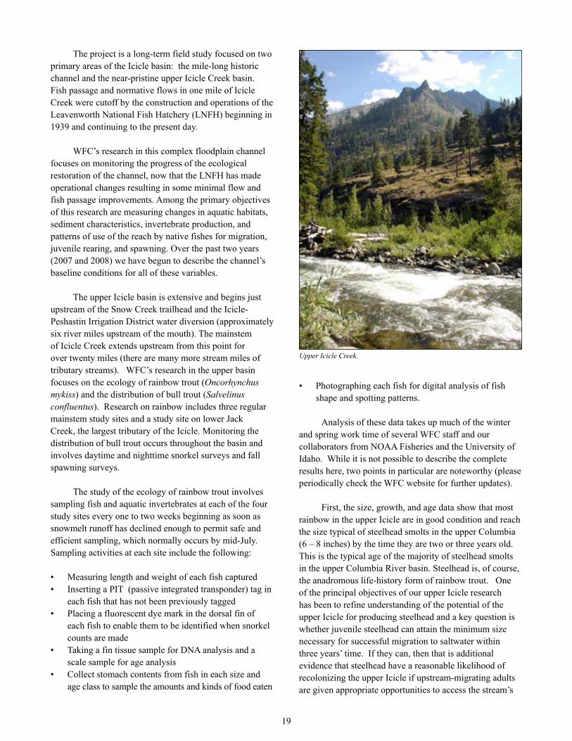
ICICLE RESEARCH PROJECT UPDATENick Gayeski
Wild Fish Conservancy’s Icicle Creek Research Project enters its third full year in 2009. The project is funded by the Icicle Fund of Leavenworth, WA, and receives additional support from collaboration with Dr. Gary Winans, geneticist at NOAA Fisheries’ Northwest Fisheries Science Center in Seattle, and Dr. Brian Kennedy, Assistant Professor in the College of Natural Resources at the University of Idaho.
David Crabb, WFC field technician, assessing a WRIA 7 stream.
14
18
14 The project is a long-term field study focused on two primary areas of the Icicle basin: the mile-long historic channel and the near-pristine upper Icicle Creek basin. Fish passage and normative flows in one mile of Icicle Creek were cutoff by the construction and operations of the Leavenworth National Fish Hatchery (LNFH) beginning in 1939 and continuing to the present day.
WFC’s research in this complex floodplain channel focuses on monitoring the progress of the ecological restoration of the channel, now that the LNFH has made operational changes resulting in some minimal flow and fish passage improvements. Among the primary objectives of this research are measuring changes in aquatic habitats, sediment characteristics, invertebrate production, and patterns of use of the reach by native fishes for migration, juvenile rearing, and spawning. Over the past two years (2007 and 2008) we have begun to describe the channel’s baseline conditions for all of these variables.
The upper Icicle basin is extensive and begins just upstream of the Snow Creek trailhead and the Icicle-Peshastin Irrigation District water diversion (approximately six river miles upstream of the mouth). The mainstem of Icicle Creek extends upstream from this point for over twenty miles (there are many more stream miles of tributary streams). WFC’s research in the upper basin focuses on the ecology of rainbow trout (Oncorhynchus mykiss) and the distribution of bull trout (Salvelinus confluentus). Research on rainbow includes three regular mainstem study sites and a study site on lower Jack Creek, the largest tributary of the Icicle. Monitoring the distribution of bull trout occurs throughout the basin and involves daytime and nighttime snorkel surveys and fall spawning surveys.
The study of the ecology of rainbow trout involves sampling fish and aquatic invertebrates at each of the four study sites every one to two weeks beginning as soon as snowmelt runoff has declined enough to permit safe and efficient sampling, which normally occurs by mid-July. Sampling activities at each site include the following:
Measuring length and weight of each fish capturedInserting a PIT (passive integrated transponder) tag in each fish that has not been previously taggedPlacing a fluorescent dye mark in the dorsal fin of each fish to enable them to be identified when snorkel counts are madeTaking a fin tissue sample for DNA analysis and a scale sample for age analysisCollect stomach contents from fish in each size and age class to sample the amounts and kinds of food eaten
••
•
•
•
Photographing each fish for digital analysis of fish shape and spotting patterns.
Analysis of these data takes up much of the winter and spring work time of several WFC staff and our collaborators from NOAA Fisheries and the University of Idaho. While it is not possible to describe the complete results here, two points in particular are noteworthy (please periodically check the WFC website for further updates).
First, the size, growth, and age data show that most rainbow in the upper Icicle are in good condition and reach the size typical of steelhead smolts in the upper Columbia (6 – 8 inches) by the time they are two or three years old. This is the typical age of the majority of steelhead smolts in the upper Columbia River basin. Steelhead is, of course, the anadromous life-history form of rainbow trout. One of the principal objectives of our upper Icicle research has been to refine understanding of the potential of the upper Icicle for producing steelhead and a key question is whether juvenile steelhead can attain the minimum size necessary for successful migration to saltwater within three years’ time. If they can, then that is additional evidence that steelhead have a reasonable likelihood of recolonizing the upper Icicle if upstream-migrating adults are given appropriate opportunities to access the stream’s
•
Upper Icicle Creek.
19

13
extensive, high-quality habitat. The data on rainbow size, age, and growth that we have acquired thus far supports our hypothesis that the upper Icicle can support a viable steelhead population.
Second, results from over 600 samples collected in 2007 (analyses of 2008 samples are not yet completed) indicate that Icicle Creek rainbow are native interior Columbia River basin rainbow and are distinct from Wenatchee River steelhead populations, including Chiwaukum Creek rainbow/steelhead. However, there does appear to be some steelhead genetic material (alleles) in some Icicle Creek individuals, especially those from our downstream-most study site. In addition, there appear to be at least three genetically distinct populations among the four study sites. This is a very dramatic result in that the level of differentiation between the three groups is as great as or greater than the differences between rainbow trout populations from different river basins. Research planned for 2009 will aim to further refine and expand the genetic data from Icicle and to investigate whether any of the genetic differences between populations might result from selection to different environmental conditions, especially annual temperatures and the length of the growing season.
By the end of the 2009 field season we will have collected and analyzed DNA from over 1500 upper Icicle Creek rainbow trout. The resulting intensive genetics baseline will give us the ability to detect the presence of steelhead in the upper Icicle basin if, as we expect, they succeed in beginning to re-colonize the upper Icicle as conditions affecting upstream migration in the vicinity of LNFH continue to improve.
The project continues to improve our knowledge of the distribution and abundance of bull trout in the Icicle. In 2007, we documented a handful of large migratory bull trout midway up the Icicle basin in September and later that October observed one several miles further upstream in an upper-basin tributary known to be important for bull trout spawning. In October 2008, we observed two bull trout redds in this same tributary and one redd in the mainstem of the Icicle three miles upstream of this tributary – the upstream-most location documented by anyone to date. Abundance of bull trout remains perilously low, however.
Finally, one of the goals of WFC research projects, like the Icicle, is to provide opportunities to further the academic education and training of conservation scientists. In 2007, through our collaboration with Dr. Kennedy at the University of Idaho, summer field work provided a research project for a senior undergraduate student funded
by the National Science Foundation’s Research Experience for Undergraduates (REU) program. In 2008, we provided a master’s degree project for a student volunteer from York University (England). That student, James Fletcher, successfully completed his degree program in the Fall 2008 and is now on staff with WFC. The project is also partially funding a Master’s degree for a student of Dr. Kennedy’s who is studying an aspect of the feeding ecology of rainbow trout in the upper Icicle. @
DOSEWALLIPS ELJ CONSTRUCTIONMicah Wait
Wild Fish Conservancy is excited to announce the completion of five engineered log jams (ELJs) and the removal of 800 feet of levee in the lower Dosewallips River. WFC worked with Dosewallips State Park, the Hood Canal Coordinating Council, the Washington Department of Fish and Wildlife, the Port Gamble S’Klallam Tribe, and Herrera Environmental to plan and design the project, which was constructed by Sea Level Bulkhead Builders. Construction occurred in August 2008.
Wild Fish Conservancy has been involved in the restoration of the lower Dosewallips River since 2002. Our previous work there has included a salt marsh levee removal, tree plantings, invasive blackberry removal, and a reach analysis of the lower-most mile of the river. The reach analysis was conducted by examining current and historic physical characteristics of the reach including topography, channel pattern, and sediment grain size. One of the findings in the reach analysis was that the lower reaches of the river are impacted by past management activities such as dredging, bank armament, and the removal of large woody debris (LWD), which has resulted in the formation of a simplified, plane-bed channel morphology, and the loss of estuarine and floodplain functions. Plane-bed channels are characterized by a homogenous bathymetry, a lack of sinuosity, and uniform sediment size distribution throughout the reach. One of the reasons this reach of the river has not been retaining LWD is due to the oversimplified morphology created by historic floodplain modifications, such as diking, as well as the loss of the old growth riparian forest that historically acted as source for the recruitment of LWD. Large woody debris is a critical component of instream and floodplain habitat in forested river reaches. Accumulations of large wood in a river are called log jams, and they contribute to the ecological function of a river in myriad ways. Some of the most important ecological functions established by LWD are the creation of habitat complexity and stability. The primary recommendations derived from our reach analysis
20
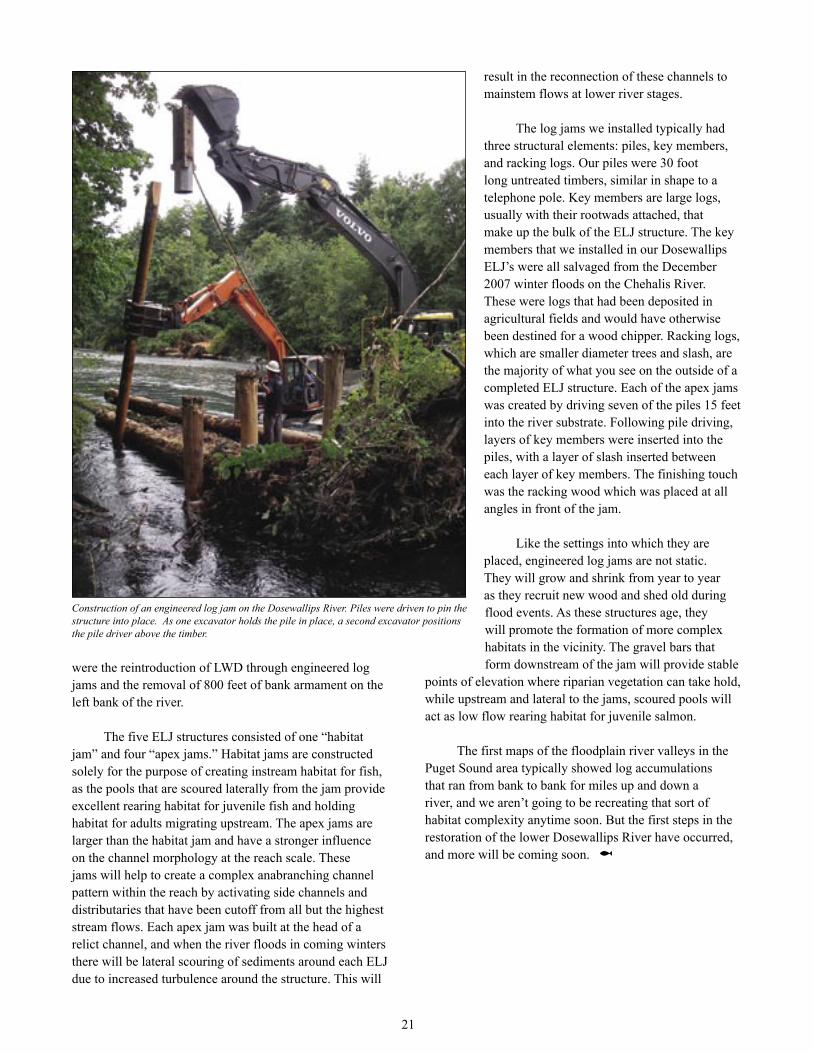
were the reintroduction of LWD through engineered log jams and the removal of 800 feet of bank armament on the left bank of the river.
The five ELJ structures consisted of one “habitat jam” and four “apex jams.” Habitat jams are constructed solely for the purpose of creating instream habitat for fish, as the pools that are scoured laterally from the jam provide excellent rearing habitat for juvenile fish and holding habitat for adults migrating upstream. The apex jams are larger than the habitat jam and have a stronger influence on the channel morphology at the reach scale. These jams will help to create a complex anabranching channel pattern within the reach by activating side channels and distributaries that have been cutoff from all but the highest stream flows. Each apex jam was built at the head of a relict channel, and when the river floods in coming winters there will be lateral scouring of sediments around each ELJ due to increased turbulence around the structure. This will
result in the reconnection of these channels to mainstem flows at lower river stages.
The log jams we installed typically had three structural elements: piles, key members, and racking logs. Our piles were 30 foot long untreated timbers, similar in shape to a telephone pole. Key members are large logs, usually with their rootwads attached, that make up the bulk of the ELJ structure. The key members that we installed in our Dosewallips ELJ’s were all salvaged from the December 2007 winter floods on the Chehalis River. These were logs that had been deposited in agricultural fields and would have otherwise been destined for a wood chipper. Racking logs, which are smaller diameter trees and slash, are the majority of what you see on the outside of a completed ELJ structure. Each of the apex jams was created by driving seven of the piles 15 feet into the river substrate. Following pile driving, layers of key members were inserted into the piles, with a layer of slash inserted between each layer of key members. The finishing touch was the racking wood which was placed at all angles in front of the jam.
Like the settings into which they are placed, engineered log jams are not static. They will grow and shrink from year to year as they recruit new wood and shed old during flood events. As these structures age, they will promote the formation of more complex habitats in the vicinity. The gravel bars that form downstream of the jam will provide stable
points of elevation where riparian vegetation can take hold, while upstream and lateral to the jams, scoured pools will act as low flow rearing habitat for juvenile salmon.
The first maps of the floodplain river valleys in the Puget Sound area typically showed log accumulations that ran from bank to bank for miles up and down a river, and we aren’t going to be recreating that sort of habitat complexity anytime soon. But the first steps in the restoration of the lower Dosewallips River have occurred, and more will be coming soon. @
Construction of an engineered log jam on the Dosewallips River. Piles were driven to pin the structure into place. As one excavator holds the pile in place, a second excavator positions the pile driver above the timber.
21
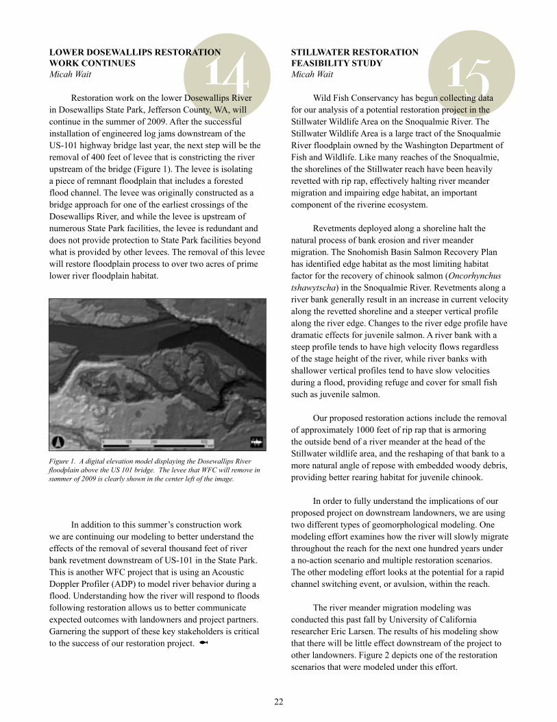
14 15LOWER DOSEWALLIPS RESTORATION WORK CONTINUESMicah Wait
Restoration work on the lower Dosewallips River in Dosewallips State Park, Jefferson County, WA, will continue in the summer of 2009. After the successful installation of engineered log jams downstream of the US-101 highway bridge last year, the next step will be the removal of 400 feet of levee that is constricting the river upstream of the bridge (Figure 1). The levee is isolating a piece of remnant floodplain that includes a forested flood channel. The levee was originally constructed as a bridge approach for one of the earliest crossings of the Dosewallips River, and while the levee is upstream of numerous State Park facilities, the levee is redundant and does not provide protection to State Park facilities beyond what is provided by other levees. The removal of this levee will restore floodplain process to over two acres of prime lower river floodplain habitat.
In addition to this summer’s construction work we are continuing our modeling to better understand the effects of the removal of several thousand feet of river bank revetment downstream of US-101 in the State Park. This is another WFC project that is using an Acoustic Doppler Profiler (ADP) to model river behavior during a flood. Understanding how the river will respond to floods following restoration allows us to better communicate expected outcomes with landowners and project partners. Garnering the support of these key stakeholders is critical to the success of our restoration project. @
STILLWATER RESTORATION FEASIBILITY STUDYMicah Wait
Wild Fish Conservancy has begun collecting data for our analysis of a potential restoration project in the Stillwater Wildlife Area on the Snoqualmie River. The Stillwater Wildlife Area is a large tract of the Snoqualmie River floodplain owned by the Washington Department of Fish and Wildlife. Like many reaches of the Snoqualmie, the shorelines of the Stillwater reach have been heavily revetted with rip rap, effectively halting river meander migration and impairing edge habitat, an important component of the riverine ecosystem.
Revetments deployed along a shoreline halt the natural process of bank erosion and river meander migration. The Snohomish Basin Salmon Recovery Plan has identified edge habitat as the most limiting habitat factor for the recovery of chinook salmon (Oncorhynchus tshawytscha) in the Snoqualmie River. Revetments along a river bank generally result in an increase in current velocity along the revetted shoreline and a steeper vertical profile along the river edge. Changes to the river edge profile have dramatic effects for juvenile salmon. A river bank with a steep profile tends to have high velocity flows regardless of the stage height of the river, while river banks with shallower vertical profiles tend to have slow velocities during a flood, providing refuge and cover for small fish such as juvenile salmon.
Our proposed restoration actions include the removal of approximately 1000 feet of rip rap that is armoring the outside bend of a river meander at the head of the Stillwater wildlife area, and the reshaping of that bank to a more natural angle of repose with embedded woody debris, providing better rearing habitat for juvenile chinook.
In order to fully understand the implications of our proposed project on downstream landowners, we are using two different types of geomorphological modeling. One modeling effort examines how the river will slowly migrate throughout the reach for the next one hundred years under a no-action scenario and multiple restoration scenarios. The other modeling effort looks at the potential for a rapid channel switching event, or avulsion, within the reach.
The river meander migration modeling was conducted this past fall by University of California researcher Eric Larsen. The results of his modeling show that there will be little effect downstream of the project to other landowners. Figure 2 depicts one of the restoration scenarios that were modeled under this effort.
Figure 1. A digital elevation model displaying the Dosewallips River floodplain above the US 101 bridge. The levee that WFC will remove in summer of 2009 is clearly shown in the center left of the image.
22
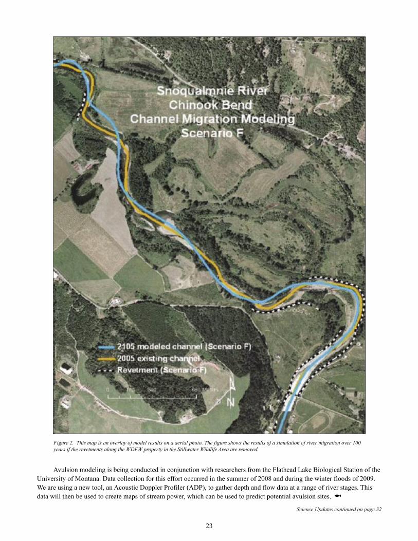
Avulsion modeling is being conducted in conjunction with researchers from the Flathead Lake Biological Station of the University of Montana. Data collection for this effort occurred in the summer of 2008 and during the winter floods of 2009. We are using a new tool, an Acoustic Doppler Profiler (ADP), to gather depth and flow data at a range of river stages. This data will then be used to create maps of stream power, which can be used to predict potential avulsion sites. @
Figure 2. This map is an overlay of model results on a aerial photo. The figure shows the results of a simulation of river migration over 100 years if the revetments along the WDFW property in the Stillwater Wildlife Area are removed.
Science Updates continued on page 32
23

Marine Protected Areasby James Fletcher,
WFC Biologist
Restoring Puget Sound through the use of
The Puget Sound fjord is a maritime jewel and the foundation for the Northwest’s culture, diverse economy and high quality of life. It is no secret however, that the health of this ecosystem is in peril. A broad range of land- and ocean-based activities combined with the growth in human population is causing unprecedented changes in the chemistry, biology and ecological function of the Sound. Moreover, these changes are undermining
the ocean’s capacity to support productive fisheries, recreation, water purification and other biological services, many of which we barely understand. Symptoms of this
deterioration are increasingly common not just in Puget Sound, but in oceans the world over, and include habitat degradation, dead zones of hypoxic or anoxic water (low or
absent dissolved oxygen), mass fish deaths, toxic algal blooms, marine epidemics, invasive species, changes in species diversity, and the collapse of fisheries.
Lingcod. Photo by Janna Nichols
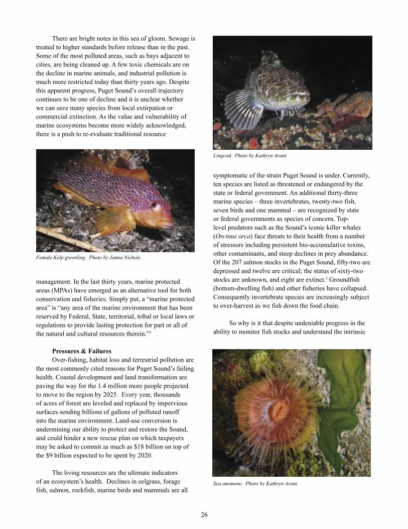
There are bright notes in this sea of gloom. Sewage is treated to higher standards before release than in the past. Some of the most polluted areas, such as bays adjacent to cities, are being cleaned up. A few toxic chemicals are on the decline in marine animals, and industrial pollution is much more restricted today than thirty years ago. Despite this apparent progress, Puget Sound’s overall trajectory continues to be one of decline and it is unclear whether we can save many species from local extirpation or commercial extinction. As the value and vulnerability of marine ecosystems become more widely acknowledged, there is a push to re-evaluate traditional resource
management. In the last thirty years, marine protected areas (MPAs) have emerged as an alternative tool for both conservation and fisheries. Simply put, a “marine protected area” is “any area of the marine environment that has been reserved by Federal, State, territorial, tribal or local laws or regulations to provide lasting protection for part or all of the natural and cultural resources therein.”1
Pressures & FailuresOver-fishing, habitat loss and terrestrial pollution are
the most commonly cited reasons for Puget Sound’s failing health. Coastal development and land transformation are paving the way for the 1.4 million more people projected to move to the region by 2025. Every year, thousands of acres of forest are leveled and replaced by impervious surfaces sending billions of gallons of polluted runoff into the marine environment. Land-use conversion is undermining our ability to protect and restore the Sound, and could hinder a new rescue plan on which taxpayers may be asked to commit as much as $18 billion on top of the $9 billion expected to be spent by 2020.
The living resources are the ultimate indicators of an ecosystem’s health. Declines in eelgrass, forage fish, salmon, rockfish, marine birds and mammals are all
symptomatic of the strain Puget Sound is under. Currently, ten species are listed as threatened or endangered by the state or federal government. An additional thirty-three marine species – three invertebrates, twenty-two fish, seven birds and one mammal – are recognized by state or federal governments as species of concern. Top-level predators such as the Sound’s iconic killer whales (Orcinus orca) face threats to their health from a number of stressors including persistent bio-accumulative toxins, other contaminants, and steep declines in prey abundance. Of the 207 salmon stocks in the Puget Sound, fifty-two are depressed and twelve are critical; the status of sixty-two stocks are unknown, and eight are extinct.2 Groundfish (bottom-dwelling fish) and other fisheries have collapsed. Consequently invertebrate species are increasingly subject to over-harvest as we fish down the food chain.
So why is it that despite undeniable progress in the ability to monitor fish stocks and understand the intrinsic
Sea anemone. Photo by Kathryn Arant.
Female Kelp greenling. Photo by Janna Nichols.
26
Lingcod. Photo by Kathryn Arant.
27
social and economic forces, fishery after fishery has collapsed? Serious deficiencies in the management process are as much to blame for the decline of fish populations as fisheries science itself. Landing quotas and harvest controls are regularly increased to make them politically expedient despite scientific recommendations. When excessive quotas are not matched by fish in the sea, as in the last days of cod on the Grand Banks, then you know that fish are in trouble.
It is gradually becoming clear that managing fisheries is as much about managing the people involved as it is about managing the resources. For the last hundred years, fisheries management has been conducted as an arms race between fishers and regulators. In most places fishers have kept one step ahead of the regulators and fish populations have suffered. If this remains the status quo then ultimately the fishing industry will self-destruct.
In a broader sense, the reason for failure is not simply a question of maintaining fishing within sustainable limits, but recognizing the ecosystems in which target species live. Fishery managers have treated fish “stocks” as separate entities, to be managed in isolation without regard for other species they interact with or their habitats. In their mathematical models, fish are represented as particles within homogeneous seas that are fished randomly by unthinking fishers. Even the most elaborate models used in fishery management are very poor at representing complex and inherently unpredictable systems.
There is a widely-recognized need to adopt less risky and more holistic approaches to the management of our oceans. In recent decades, marine protected areas have proven to be an effective tool for conservation and offer a distinct multi-species approach to fisheries management. By protecting geographical areas, MPAs operate on the ecosystem-level and reduce the most likely proximate causes of stress. Fully protected reserves, hereafter, simply “marine reserves”, are a special category of MPA that have explicit prohibitions against fishing and the removal or disturbance of any living or nonliving marine resource. As such, marine reserves offer greater protection than is currently afforded by most MPAs, many of which offer little or no protection to species or habitats.
Conservation of Biodiversity and HabitatThe benefits associated with marine reserves
are numerous and diverse, and include protection of habitat; conservation of biodiversity; protection of ecosystem processes; improved fishery yields and management; insurance against environmental or management uncertainty; socio-economic benefits for
coastal communities; and sites for enhanced scientific investigation, recreation and inspiration. Typically, MPAs and reserves are established to meet multiple goals, enhancing the efficiency of marine management and the overall value of the area.
No-take marine reserves offer an important means of protecting the full range of marine biodiversity – from gene pools to populations, to species and critical habitats. Reserves enhance biodiversity by giving depleted species a chance to recover and by providing vulnerable species with a genuine refuge from fishing. Over time they develop rich communities of animals and promote the recovery of habitat and structure. Many of Puget Sound’s marine populations have been severely depleted and several species are in serious jeopardy. Reserves could be established with the specific goal of protecting such species and preserving the ecosystems upon which they depend.
Conservation of biodiversity, fishery production and the full suite of marine goods and services depend on maintaining ecosystem structure, function and integrity. A collection of disparate initiatives are less likely to safeguard ecosystem processes than a fully interconnected network of MPAs and marine reserves situated across both Puget Sound and the Georgia Basin. Evidence suggests that a network of protected areas buffers against the vagaries of environmental variability – including catastrophic events such as oil spills – and provides much greater protection for marine communities than a single reserve. Networks are designed with an ecosystem perspective, which includes knowledge of the life history and behavior of the marine biota therein, and understanding of the human uses of and impacts upon the marine environment. Selection of areas for inclusion in a network must take into consideration inter-reserve connectivity generated by larval dispersal and adult migration patterns; complex food web relationships; as well as commercial and recreational activities. As such, an MPA network is not merely a collection of “hot spots” of abundance or diversity, but instead a carefully planned system of biologically representative areas with strong ecological linkage.
Fishery BenefitsMany managed fisheries in North America are
regulated by placing annual limits (catch quotas) on the total catch for a species, or by controlling the amount of fishing effort. These methods don’t always work partly because stock assessments tend to be inaccurate given the limitations of available data. No-take marine reserves have been proposed as a way to insure against stock collapse by providing a hedge against the risk and uncertainties of traditional fisheries management. Reserves regulate

Figure 3. Otter trawl fishing vessel effort off the northeast USA, 2003. Data were obtained from vessels using VMS (vessel monitoring systems) using satellite tracking. Medium blue areas (with no or little vessel hours) are marine reserves. Murawski, S. A. et al. ICES J. Mar. Sci. 2005 62:1150-1167; doi:10.1016/j.icesjms.2005.04.005
28
exploitation by directly protecting some fraction of the population from the effects of fishing and have the very real potential to benefit fisheries.
Marine reserves are predicted to maintain or improve adjacent fisheries through two basic mechanisms: (1) the “spillover effect”, whereby adults and juveniles emigrate out of reserves into adjacent fished areas, and (2) the “seeding effect” by which the export of pelagic eggs and larvae replenishes fish and shellfish populations outside reserves,. Forty years of comprehensive research has shown that within reserves species are more abundant regardless of where protected areas are located. Individuals live longer and grow larger which translates into increased reproductive potential. The enhanced production of eggs and larvae is expected to result in net export and greater settlement of juvenile animals outside the boundaries.
Case StudyIn 1994 large areas of Georges Bank in the Gulf of
Maine were closed in response to severe fishery depletion. Three areas totaling 6,500 square miles were closed to fishing for groundfish and to all gears that might catch or damage their habitats (e.g. scallop dredges). The protected areas combined with reductions in fishing effort have significantly reduced fish mortality. Within six years, there were five times more haddock (Melanogrammus aeglefinus), cod (Gadus morhua) were up 50%, and stocks of yellowtail flounder (Limanda ferruginea) and witch flounder (Glyptocephalus cynoglossus) had also increased. Nearly 75% of all U.S. haddock catch is now taken within three miles of the closed area boundaries. Fishers are beginning to report improvements in catches noting that they travel less distance and catch more fish than before the closures.
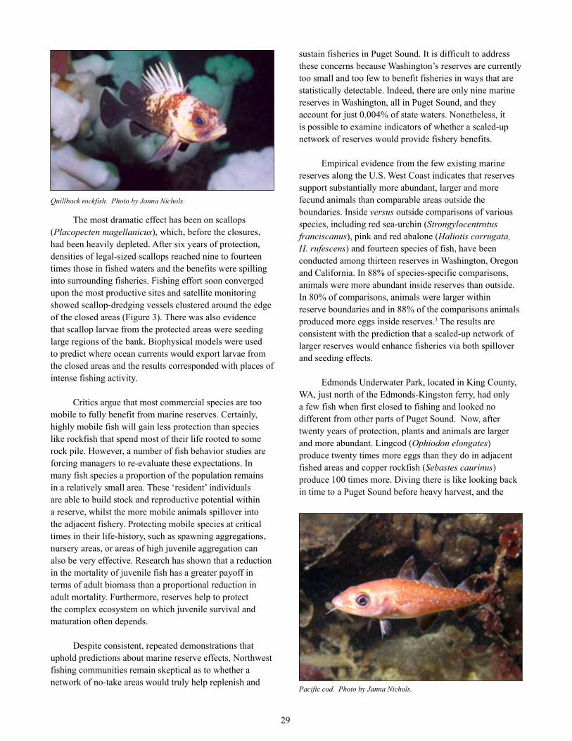
29
The most dramatic effect has been on scallops (Placopecten magellanicus), which, before the closures, had been heavily depleted. After six years of protection, densities of legal-sized scallops reached nine to fourteen times those in fished waters and the benefits were spilling into surrounding fisheries. Fishing effort soon converged upon the most productive sites and satellite monitoring showed scallop-dredging vessels clustered around the edge of the closed areas (Figure 3). There was also evidence that scallop larvae from the protected areas were seeding large regions of the bank. Biophysical models were used to predict where ocean currents would export larvae from the closed areas and the results corresponded with places of intense fishing activity.
Critics argue that most commercial species are too mobile to fully benefit from marine reserves. Certainly, highly mobile fish will gain less protection than species like rockfish that spend most of their life rooted to some rock pile. However, a number of fish behavior studies are forcing managers to re-evaluate these expectations. In many fish species a proportion of the population remains in a relatively small area. These ‘resident’ individuals are able to build stock and reproductive potential within a reserve, whilst the more mobile animals spillover into the adjacent fishery. Protecting mobile species at critical times in their life-history, such as spawning aggregations, nursery areas, or areas of high juvenile aggregation can also be very effective. Research has shown that a reduction in the mortality of juvenile fish has a greater payoff in terms of adult biomass than a proportional reduction in adult mortality. Furthermore, reserves help to protect the complex ecosystem on which juvenile survival and maturation often depends.
Despite consistent, repeated demonstrations that uphold predictions about marine reserve effects, Northwest fishing communities remain skeptical as to whether a network of no-take areas would truly help replenish and
sustain fisheries in Puget Sound. It is difficult to address these concerns because Washington’s reserves are currently too small and too few to benefit fisheries in ways that are statistically detectable. Indeed, there are only nine marine reserves in Washington, all in Puget Sound, and they account for just 0.004% of state waters. Nonetheless, it is possible to examine indicators of whether a scaled-up network of reserves would provide fishery benefits.
Empirical evidence from the few existing marine reserves along the U.S. West Coast indicates that reserves support substantially more abundant, larger and more fecund animals than comparable areas outside the boundaries. Inside versus outside comparisons of various species, including red sea-urchin (Strongylocentrotus franciscanus), pink and red abalone (Haliotis corrugata, H. rufescens) and fourteen species of fish, have been conducted among thirteen reserves in Washington, Oregon and California. In 88% of species-specific comparisons, animals were more abundant inside reserves than outside. In 80% of comparisons, animals were larger within reserve boundaries and in 88% of the comparisons animals produced more eggs inside reserves.3 The results are consistent with the prediction that a scaled-up network of larger reserves would enhance fisheries via both spillover and seeding effects.
Edmonds Underwater Park, located in King County, WA, just north of the Edmonds-Kingston ferry, had only a few fish when first closed to fishing and looked no different from other parts of Puget Sound. Now, after twenty years of protection, plants and animals are larger and more abundant. Lingcod (Ophiodon elongates) produce twenty times more eggs than they do in adjacent fished areas and copper rockfish (Sebastes caurinus) produce 100 times more. Diving there is like looking back in time to a Puget Sound before heavy harvest, and the
Pacific cod. Photo by Janna Nichols.
Quillback rockfish. Photo by Janna Nichols.
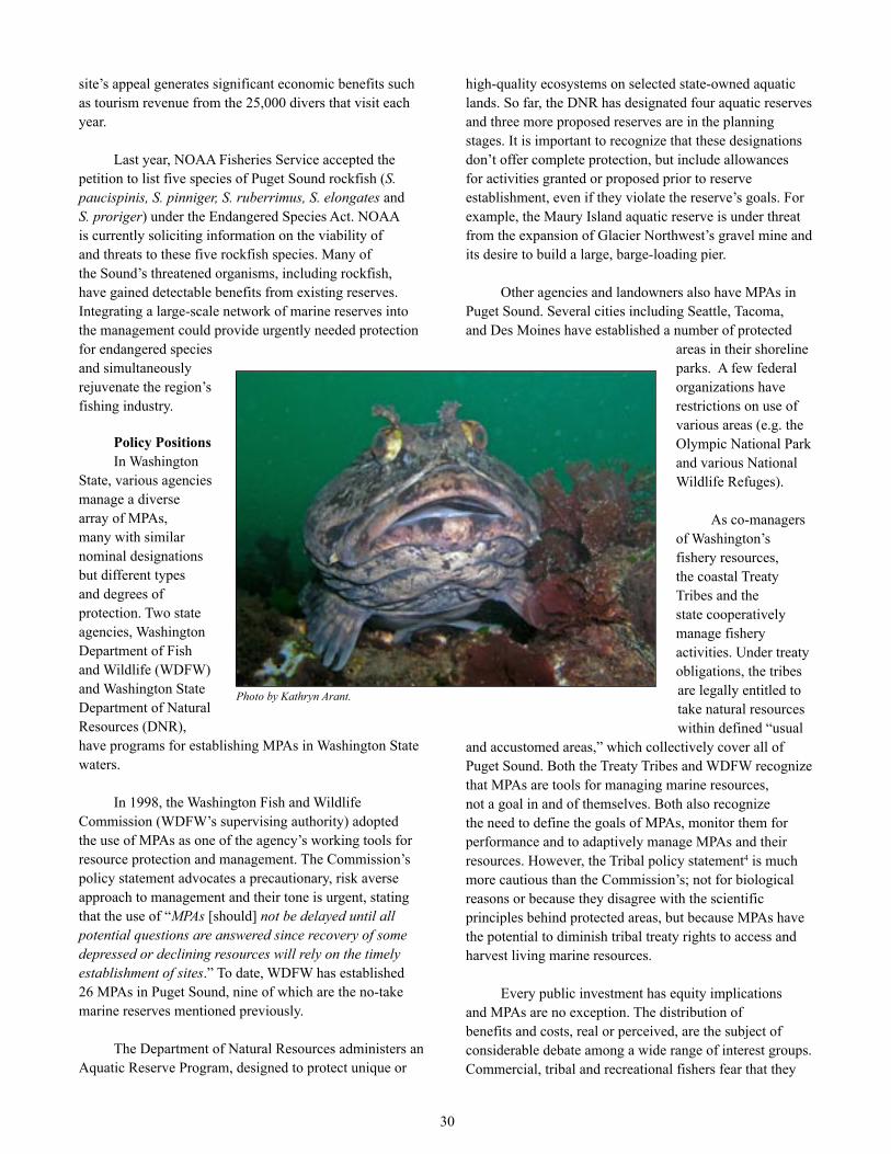
30
site’s appeal generates significant economic benefits such as tourism revenue from the 25,000 divers that visit each year.
Last year, NOAA Fisheries Service accepted the petition to list five species of Puget Sound rockfish (S. paucispinis, S. pinniger, S. ruberrimus, S. elongates and S. proriger) under the Endangered Species Act. NOAA is currently soliciting information on the viability of and threats to these five rockfish species. Many of the Sound’s threatened organisms, including rockfish, have gained detectable benefits from existing reserves. Integrating a large-scale network of marine reserves into the management could provide urgently needed protection for endangered species and simultaneously rejuvenate the region’s fishing industry.
Policy PositionsIn Washington
State, various agencies manage a diverse array of MPAs, many with similar nominal designations but different types and degrees of protection. Two state agencies, Washington Department of Fish and Wildlife (WDFW) and Washington State Department of Natural Resources (DNR), have programs for establishing MPAs in Washington State waters.
In 1998, the Washington Fish and Wildlife Commission (WDFW’s supervising authority) adopted the use of MPAs as one of the agency’s working tools for resource protection and management. The Commission’s policy statement advocates a precautionary, risk averse approach to management and their tone is urgent, stating that the use of “MPAs [should] not be delayed until all potential questions are answered since recovery of some depressed or declining resources will rely on the timely establishment of sites.” To date, WDFW has established 26 MPAs in Puget Sound, nine of which are the no-take marine reserves mentioned previously.
The Department of Natural Resources administers an Aquatic Reserve Program, designed to protect unique or
high-quality ecosystems on selected state-owned aquatic lands. So far, the DNR has designated four aquatic reserves and three more proposed reserves are in the planning stages. It is important to recognize that these designations don’t offer complete protection, but include allowances for activities granted or proposed prior to reserve establishment, even if they violate the reserve’s goals. For example, the Maury Island aquatic reserve is under threat from the expansion of Glacier Northwest’s gravel mine and its desire to build a large, barge-loading pier.
Other agencies and landowners also have MPAs in Puget Sound. Several cities including Seattle, Tacoma, and Des Moines have established a number of protected
areas in their shoreline parks. A few federal organizations have restrictions on use of various areas (e.g. the Olympic National Park and various National Wildlife Refuges).
As co-managers of Washington’s fishery resources, the coastal Treaty Tribes and the state cooperatively manage fishery activities. Under treaty obligations, the tribes are legally entitled to take natural resources within defined “usual
and accustomed areas,” which collectively cover all of Puget Sound. Both the Treaty Tribes and WDFW recognize that MPAs are tools for managing marine resources, not a goal in and of themselves. Both also recognize the need to define the goals of MPAs, monitor them for performance and to adaptively manage MPAs and their resources. However, the Tribal policy statement4 is much more cautious than the Commission’s; not for biological reasons or because they disagree with the scientific principles behind protected areas, but because MPAs have the potential to diminish tribal treaty rights to access and harvest living marine resources.
Every public investment has equity implications and MPAs are no exception. The distribution of benefits and costs, real or perceived, are the subject of considerable debate among a wide range of interest groups. Commercial, tribal and recreational fishers fear that they
Photo by Kathryn Arant.

31
will bear the immediate costs of closing fishing grounds while improvements in catch size and composition may not be realized for several years. Other groups, such as the Coastal Conservation Association (CCA) openly oppose the implementation of marine reserves. The CCA is a national group representing recreational fishermen that claims unfair exclusion by the creation of additional MPAs and marine reserves.
Even though fishing communities are likely to receive the most obvious benefits from marine reserves it is difficult to change their perception that access to marine resources is a right. Historically, coastal waters have been considered part of the public trust in the United States and any attempts to limit this freedom have been fought bitterly by users. The perverse truth is that these same common property rights and the failure of communities to limit exploitation of fish have led to the collapse of the industry.
Whatever the stakeholder’s position regarding MPAs, it is clear that the decision-making process needs to be transparent and equitable with information exchanged at the regional or local level. In this way, the values and beliefs of Puget Sound’s community can shape an inherently scientific endeavor. It may also strengthen accountability for implementation, promote local support, and increase the levels of compliance to closed-area regulations.
The FutureThe federal government has issued an order charging
government agencies to create a national system of MPAs of which Puget Sound’s aquatic reserves will be a part. In May 2007, Governor Christine Gregoire signed legislation to establish the Puget Sound Partnership, a promising and bold initiative to restore Puget Sound by 2020. In its Action Agenda released late in 2008, the Partnership recommended that the state’s “Marine Managed Areas Work Group” (chaired by WDFW) develop recommendations by the end of 2009 on improving the effectiveness of MPAs. Wild Fish Conservancy advocated the expansion of MPAs in line with the Partnership’s new approach. In a further step, new and existing MPAs, including fully protected marine reserves, need to be integrated into a network of protected areas whose conservation value exceeds that of individual, functionally
disconnected MPAs. As part of this, WFC believes that partnering with Canadian authorities is essential. We will be closely following what the state and Partnership accomplish on this issue.
Of course, marine protected areas are not a panacea; they cannot alleviate all problems such as pollution,
climate change, or overfishing. Marine reserves by themselves will not deliver sustainable fisheries. They must be complemented with reduced fishing effort, decreased reliance on destructive harvest methods and clearer allocations of fishing rights and responsibilities. But by protecting and restoring the productive capacity of the ecosystem, an integrated network of marine protected areas can provide a foundation on which other tools can build towards a healthy Puget Sound.
Footnotes1 This definition is from Presidential Executive Order
13158, published in 65 Federal Register 34909 (May 31, 2000).
2 State of the Sound 2007. Puget Sound Action Team, publication No. PSAT 07-01 (March 2007).
3 Fishery effects of existing west coast marine reserves: the scientific evidence. Compiled by Dr. Mark Hixon, Department of Zoology, Oregon State University. Report submitted to the Oregon Ocean Policy Advisory Council and the California Fish and Game Commission (2002).
4 Western Washington Treaty Tribes Policy Statement on Marine Protected Areas, Marine Reserves, Marine Sanctuaries, and Fishery Conservation Zones. Released through the Northwest Indian Fisheries Commission (June 26, 2003). @
Canary rockfish. Photo by Janna Nichols.
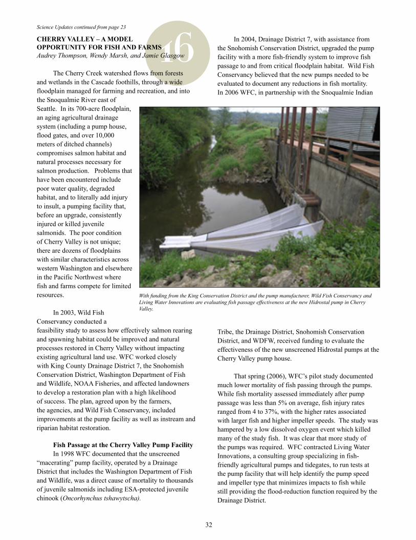
16Science Updates continued from page 23
CHERRY VALLEY – A MODEL OPPORTUNITY FOR FISH AND FARMSAudrey Thompson, Wendy Marsh, and Jamie Glasgow
The Cherry Creek watershed flows from forests and wetlands in the Cascade foothills, through a wide floodplain managed for farming and recreation, and into the Snoqualmie River east of Seattle. In its 700-acre floodplain, an aging agricultural drainage system (including a pump house, flood gates, and over 10,000 meters of ditched channels) compromises salmon habitat and natural processes necessary for salmon production. Problems that have been encountered include poor water quality, degraded habitat, and to literally add injury to insult, a pumping facility that, before an upgrade, consistently injured or killed juvenile salmonids. The poor condition of Cherry Valley is not unique; there are dozens of floodplains with similar characteristics across western Washington and elsewhere in the Pacific Northwest where fish and farms compete for limited resources.
In 2003, Wild Fish Conservancy conducted a feasibility study to assess how effectively salmon rearing and spawning habitat could be improved and natural processes restored in Cherry Valley without impacting existing agricultural land use. WFC worked closely with King County Drainage District 7, the Snohomish Conservation District, Washington Department of Fish and Wildlife, NOAA Fisheries, and affected landowners to develop a restoration plan with a high likelihood of success. The plan, agreed upon by the farmers, the agencies, and Wild Fish Conservancy, included improvements at the pump facility as well as instream and riparian habitat restoration.
Fish Passage at the Cherry Valley Pump FacilityIn 1998 WFC documented that the unscreened
“macerating” pump facility, operated by a Drainage District that includes the Washington Department of Fish and Wildlife, was a direct cause of mortality to thousands of juvenile salmonids including ESA-protected juvenile chinook (Oncorhynchus tshawytscha).
In 2004, Drainage District 7, with assistance from the Snohomish Conservation District, upgraded the pump facility with a more fish-friendly system to improve fish passage to and from critical floodplain habitat. Wild Fish Conservancy believed that the new pumps needed to be evaluated to document any reductions in fish mortality. In 2006 WFC, in partnership with the Snoqualmie Indian
Tribe, the Drainage District, Snohomish Conservation District, and WDFW, received funding to evaluate the effectiveness of the new unscreened Hidrostal pumps at the Cherry Valley pump house.
That spring (2006), WFC’s pilot study documented much lower mortality of fish passing through the pumps. While fish mortality assessed immediately after pump passage was less than 5% on average, fish injury rates ranged from 4 to 37%, with the higher rates associated with larger fish and higher impeller speeds. The study was hampered by a low dissolved oxygen event which killed many of the study fish. It was clear that more study of the pumps was required. WFC contracted Living Water Innovations, a consulting group specializing in fish-friendly agricultural pumps and tidegates, to run tests at the pump facility that will help identify the pump speed and impeller type that minimizes impacts to fish while still providing the flood-reduction function required by the Drainage District.
With funding from the King Conservation District and the pump manufacturer, Wild Fish Conservancy and Living Water Innovations are evaluating fish passage effectiveness at the new Hidrostal pump in Cherry Valley.
32
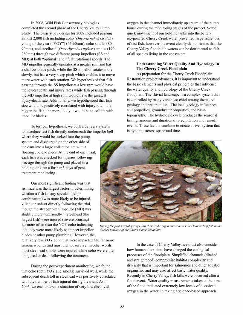
oxygen in the channel immediately upstream of the pump house during the monitoring stages of the project. Some quick movement of our holding tanks into the better-oxygenated Cherry Creek water prevented large-scale loss of test fish, however the event clearly demonstrates that the Cherry Valley floodplain waters can be detrimental to fish of all species living in the ecosystem.
Understanding Water Quality And Hydrology In The Cherry Creek FloodplainAs preparation for the Cherry Creek Floodplain
Restoration project advances, it is important to understand the basic elements and physical principles that influence the water quality and hydrology of the Cherry Creek floodplain. The fluvial landscape is a complex system that is controlled by many variables; chief among them are geology and precipitation. The local geology influences soil properties, groundwater properties, and basin topography. The hydrologic cycle produces the seasonal timing, amount and duration of precipitation and run-off events. These factors combine to create a river system that is dynamic across space and time.
In the case of Cherry Valley, we must also consider how human alterations have changed the ecological processes of the floodplain. Simplified channels (ditched and straightened) compromise habitat complexity and diversity that is important for salmonids and other aquatic organisms, and may also affect basic water quality. Recently in Cherry Valley, fish kills were observed after a flood event. Water quality measurements taken at the time of the flood indicated extremely low levels of dissolved oxygen in the water. In taking a science-based approach
In 2008, Wild Fish Conservancy biologists completed the second phase of the Cherry Valley Pump Study. The basic study design for 2008 included passing almost 2,000 fish including coho (Oncorhynchus kisutch) young of the year (“YOY”) (45-60mm), coho smolts (80-90mm), and steelhead (Oncorhynchus mykiss) smolts (190-230mm) through two different pump impellors (SS and MD) at both “optimal” and “full” rotational speeds. The MD impellor generally operates at a greater rpm and has a shallow blade pitch, while the SS impellor rotates more slowly, but has a very steep pitch which enables it to move more water with each rotation. We hypothesized that fish passing through the SS impellor at a low rpm would have the lowest death and injury rates while fish passing through the MD impellor at high rpm would have the greatest injury/death rate. Additionally, we hypothesized that fish size would be positively correlated with injury rate—the bigger the fish, the more likely it would be to collide with impellor blades.
To test our hypothesis, we built a delivery system to introduce test fish directly underneath the impellor bell where they would be sucked into the pump system and discharged on the other side of the dam into a large collection net with a floating cod end piece. At the end of each trial, each fish was checked for injuries following passage through the pump and placed in a holding tank for a further 5 days of post-treatment monitoring.
Our most significant finding was that fish size was the largest factor in determining whether a fish (in any speed/impellor combination) was more likely to be injured, killed, or unhurt directly following the trial, though the steeper pitch impellor (MD) was slightly more “unfriendly.” Steelhead (the largest fish) were injured (severe bruising) far more often than the YOY coho indicating that they were more likely to impact impellor blades or other pump plumbing. However, the relatively few YOY coho that were impacted had far more serious wounds and most did not survive. In other words, most steelhead smolts were injured while coho were either uninjured or dead following the treatment.
During the post-experiment monitoring, we found that coho (both YOY and smolts) survived well, while the subsequent death toll in steelhead was positively correlated with the number of fish injured during the trials. As in 2006, we encountered a situation of very low dissolved
During the past several springs, low dissolved-oxygen events have killed hundreds of fish in the ditched portions of the Cherry Creek floodplain.
33

to restoration planning in Cherry Valley, we must try to understand why this low oxygen condition is occurring.
The process of science involves making observations and developing and testing hypotheses to explain the observed phenomena. An important question we are asking in Cherry Valley is: “Why are dissolved oxygen levels decreasing after flood events?” To answer this question we first need to review the basic principles of oxygen in the water column. We know that as temperature increases, oxygen decreases. Therefore, we are collecting temperature data at regular intervals to see how these conditions change daily and seasonally. We must also consider interactions of other chemicals, such as metals, nitrates, sulfides and salts, which may be present and contributing to the observed low dissolved oxygen condition. The current monitoring efforts include conductivity measurements and sulfide testing to determine the presence and influence of these elements.
It is also necessary to determine what physical and anthropogenic factors could be influencing water quality in Cherry Valley. When we look at the historic geologic
formation of the valley, we see sediment (alluvium) deposited by fluvial processes. In more recent times, sediment transport processes have been altered by land use changes that involve draining water from the historic floodplain, channel dredging and straightening, removal of native floodplain vegetation, and introduction of non-native grasses for agriculture purposes. Channel form and sediment type control important processes such as surface water- groundwater exchange, an interaction which plays a key role in biogeochemical cycling and temperature moderation. To understand how groundwater influences water quality in the ditches across the historic floodplain, we need to consider factors such as soil types and ditch depths, and then monitor groundwater levels by using existing wells across the floodplain and installing mini- wells (called piezometers) into the sub-surface sediments in the ditches and the main stem river to determine the degree of groundwater flux.
Often, to understand what is happening at smaller scales, it is necessary to step back and consider the landscape as a whole. Only then can we see how different pieces of the landscape interact, and what particular elements may be compromising natural processes in the system. Science requires rigorous methods of observation or experimentation to produce reliable data that can be analyzed and interpreted. But the process of science also requires creativity. It entails looking at questions with an open mind, and then designing experiments to help support or disprove your theories. As we work toward restoring habitat complexity and improving water quality, we must look through many different landscape perspectives to create an inclusive picture of what constitutes attainable ecosystem function for a given geographic location. We can then apply what we have learned through scientific methods to develop an effective plan to meet goals, such as restoring habitat and ecological processes in Cherry Valley.
The low dissolved oxygen events in 2006 and 2008 led to a new effort to learn more about the water quality of Cherry Valley. In 2008, Wild Fish Conservancy partnered with the Tulalip Tribe and received a Clean Water Act Section 319 grant from the Washington Department of Ecology to better characterize water chemistry in Cherry Valley. The Tulalip Tribe devoted considerable staff time in 2008-2009 to sample basic field water chemistry, and to collect samples for laboratory analyses. Wild Fish Conservancy staff, along with the Washington Department of Ecology (Ecology), conducted a watershed survey to identify possible problem areas and is now planning to conduct more intensive sampling during the spring melt period when dissolved oxygen problems were observed in 2006 and 2008. Through all of this sampling, we hope
Wild Fish Conservancy has been working with resource agencies and landowners to develop a restoration plan for the Cherry Creek floodplain, where historical stream and wetland conditions have been significantly modified by agricultural practices.
34
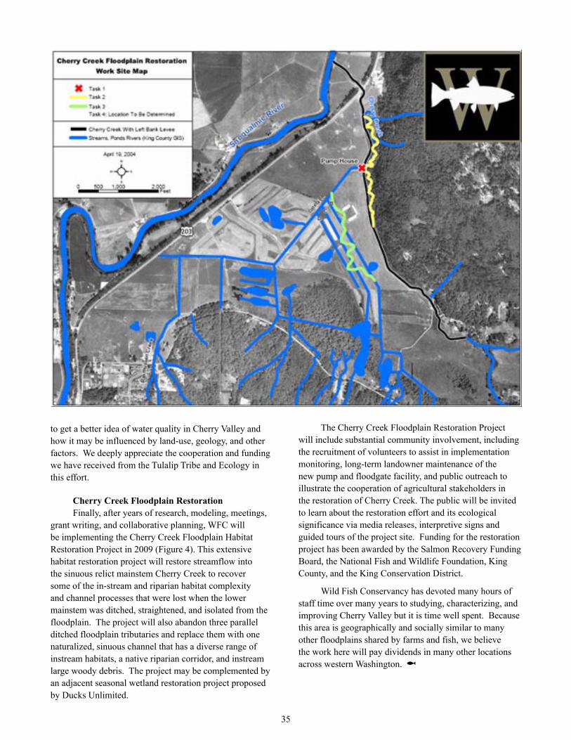
to get a better idea of water quality in Cherry Valley and how it may be influenced by land-use, geology, and other factors. We deeply appreciate the cooperation and funding we have received from the Tulalip Tribe and Ecology in this effort.
Cherry Creek Floodplain RestorationFinally, after years of research, modeling, meetings,
grant writing, and collaborative planning, WFC will be implementing the Cherry Creek Floodplain Habitat Restoration Project in 2009 (Figure 4). This extensive habitat restoration project will restore streamflow into the sinuous relict mainstem Cherry Creek to recover some of the in-stream and riparian habitat complexity and channel processes that were lost when the lower mainstem was ditched, straightened, and isolated from the floodplain. The project will also abandon three parallel ditched floodplain tributaries and replace them with one naturalized, sinuous channel that has a diverse range of instream habitats, a native riparian corridor, and instream large woody debris. The project may be complemented by an adjacent seasonal wetland restoration project proposed by Ducks Unlimited.
The Cherry Creek Floodplain Restoration Project will include substantial community involvement, including the recruitment of volunteers to assist in implementation monitoring, long-term landowner maintenance of the new pump and floodgate facility, and public outreach to illustrate the cooperation of agricultural stakeholders in the restoration of Cherry Creek. The public will be invited to learn about the restoration effort and its ecological significance via media releases, interpretive signs and guided tours of the project site. Funding for the restoration project has been awarded by the Salmon Recovery Funding Board, the National Fish and Wildlife Foundation, King
County, and the King Conservation District.
Wild Fish Conservancy has devoted many hours of staff time over many years to studying, characterizing, and improving Cherry Valley but it is time well spent. Because this area is geographically and socially similar to many other floodplains shared by farms and fish, we believe the work here will pay dividends in many other locations across western Washington. @
35

17THE CONTINUING SAGA OF PUGET SOUND CHINOOK HARVESTNick Gayeski
In October 2006, Wild Fish Conservancy, the Salmon Spawning & Recovery Alliance, the Native Fish Society, and the Clark-Skamania Flyfishers filed a complaint in the US District Court, Western District of Washington, against NOAA Fisheries, challenging the federal agency’s approval of the Puget Sound Comprehensive Chinook Management Plan, intended to guide salmon harvest activities that impact Puget Sound chinook (Oncorhynchus tshawytscha) until 2010. The Plan was developed jointly by WDFW and the PS Treaty Tribes as a joint resource management plan under the ESA 4(d) rule developed for the Puget Sound chinook Evolutionarily Significant Unit (ESU).
In the 2007 issue of Wild Fish Journal, attorney Svend Brandt-Erichsen described the details of this suit. Briefly, WFC and its co-plaintiff’s argued that the Plan permits illegal take of ESA- listed PS chinook during authorized tribal and non-tribal fisheries in Puget Sound and that NOAA Fisheries violated the ESA when it approved the Plan and when it concluded in its subsequent Biological Opinion that its approval of the Plan would not jeopardize the survival and recovery of the ESU. We further argued that in analyzing the likely impacts of the Plan, NOAA failed to follow appropriate criteria regarding the requirements for recovery of the ESU that were developed by the NOAA-appointed Puget Sound Technical Recovery Team (TRT). NOAA also subsequently ignored information regarding harvest impacts under the Plan that required NOAA to re-initiate consultation. The federal defendant’s were joined in their defense by amici (friends of the Court) WDFW and the PS Treaty Tribes, the Plan’s authors.
The case was assigned to Judge Robert Laznik of the US District Court in Seattle. Appropriate legal documents were filed in the spring of 2007 and oral arguments were heard in the fall of 2007. On March 20, 2008 the Court ruled in favor of the federal Defendants on all counts. The decision relied heavily on the judicial standard requiring
Advocacy Updates
courts to defer “substantially” to agency expertise in matters of scientific controversy, especially where federal Trust Responsibilities to Treaty Tribes are involved, as is the case in the Chinook Management Plan.
WFC and our co-plaintiff’s filed a timely notice of Intent to Appeal. The Appeal was filed with the Ninth Circuit Court of Appeals in September 2008 and is scheduled to be heard in 2009.
WFC believes that the District Court erred by extending deference to NOAA’s approval of the Plan based on little more than the mere assertion by NOAA officials that they conducted the appropriate analyses of the Plan, looked at the relevant data, and concluded to the best of their abilities that the Plan would not jeopardize
the survival or recovery of the ESU. This seems to us a far too broad interpretation of the
deference standard in that it amounts to little evaluation whatsoever of the quality
of an agency’s reasoning in reaching
controversial conclusions. We believe this error is particularly glaring in this case in view of the contradictions between the analyses of the TRT, which includes several of NOAA Fisheries’ own scientists, and the recovery standards established by its approval of the Puget Sound Salmon Recovery Plan that was based on the analyses of the TRT on the one hand, and the analyses in the documents approving the Plan on the other.
It is important to understand that this case does not involve a conflict between our analyses of the harvest plan, and NOAA and the co-managers’ analyses. This is not a battle of competing scientists. Rather it is a review of the administrative record in which we argue that NOAA has failed to analyze the plan in a way that is consistent with its own expert analyses of the survival and recovery needs of the ESU. In considering how to extend deference to federal agencies’ expertise, the Court cannot avoid assessing the quality and consistency of an agency’s applications of its own analyses. It is here where we believe the District Court failed. @
36

18RESTORING AND PROTECTING PUGET SOUNDMark Hersh
In late 2008, the Puget Sound Partnership, the new state agency charged with leading the recovery and protection of Puget Sound, released its first “Action Agenda.” The Action Agenda, which was mandated by the 2007 legislation that created the Partnership (see the 2008 Wild Fish Journal), is supposed to 1) identify work needed to protect and restore Puget Sound, 2) determine accountability for achieving results including performance, effectiveness, and the efficient use of money spent on
Puget Sound, and 3) promote public awareness and communication to build support for a long-term strategy. Also, the document is supposed to better coordinate the other existing restoration and protection measures.
The Action Agenda was developed with extensive public input, including technical input. Wild Fish Conservancy is a member of a coalition of public interest groups called the Puget Sound Environmental Caucus. The Caucus, which operates on a consensus basis made significant comments to the Partnership on a number of issues, while Wild Fish Conservancy made additional comments on topics of particular interest to us.
In regards to habitat protection, the Action Agenda calls for some important new measures, such as “regional ecosystem protection standards with a decision-making framework.” Wild Fish Conservancy supports this objective and submitted comments outlining a method to evaluate local protective and restoration efforts (including stormwater management) on a watershed basis, with
oversight from state and federal regulators to ensure compliance with the Clean Water Act and the Endangered Species Act. WFC also called for a greater effort to establish a network of Marine Protected Areas (including coordination with those administering MPAs in Georgia Basin) and to expand and improve water-typing efforts to ensure an accurate inventory of freshwater resources.
When it comes to harvest and hatcheries, two subjects very much of interest to Wild Fish Conservancy, the Action Agenda states that both are “threats” to a restored Puget Sound, but largely defers to the “co-
managers” (the tribes and the state) on these subjects and does not discuss either threat as comprehensively as the threats of habitat loss or water pollution. The Action Agenda does state, however, that harvest should be “based on ecosystem needs, in addition to tribal treaty rights, economic, and quality of life concerns.” WFC does not believe that ecosystem needs (or the particular species’ needs, for that matter) have ever been considered in harvest, so this will be a welcome development indeed -- if implemented. Hatchery recommendations do not go much farther than implementing “priority” hatchery reform recommendations including those of the Hatchery Scientific Reform Group. Wild Fish Conservancy called for “a comprehensive scientific review of Puget Sound hatchery programs to determine their compatibility with ecosystem recovery” but that recommendation was not accepted by the Partnership. In essence, the Action Agenda continues with the status quo in allowing harvest and hatchery policies to be set by the co-managers that have been setting these policies in the past, and in that respect it is disappointing. We hope that the emphasis on science
Seattle hugging the shores of Puget Sound.
37

19
and the needs of the ecosystem will finally result in an honest evaluation of both harvest and hatcheries.
The Puget Sound Partnership, as a new state agency, is not escaping the budget problems that will affect all state agencies this year. Wild Fish Conservancy will continue to advocate for the needs of wild fish ecosystems when opportunities present themselves. @
CALIFORNIA SEA LIONS AT BONNEVILLE DAMNick Gayeski
In the 2008 issue of Wild Fish Journal, I explained the reasons that WFC joined the lawsuit brought by the Humane Society of the US (HSUS) and two private citizens against NOAA Fisheries for approving the lethal removal of California sea lions (CSL) from the lower Columbia River in the vicinity of Bonneville Dam. The authorization of lethal removal resulted from NOAA Fisheries’ approval of an application by the states of Idaho, Oregon, and Washington under Section 120 of the Marine Mammal Protection Act (MMPA).
We determined that the cases made by the states in their application and by NOAA in the several documents that led to the authorization were woefully inadequate and unconvincing. Most important, Section 120 of the MMPA requires the applicants to demonstrate that there are “individually identifiable pinnipeds” that are having a “significant negative impact on the decline or recovery” of ESA-listed fish, in this case spring/summer chinook and steelhead from Snake River, spring chinook from the upper Columbia River and steelhead from the mid- and lower-Columbia. Neither the states nor NOAA provided an objective quantitative standard to show that the level of estimated CSL predation in the vicinity of Bonneville Dam was having a significant negative impact. We argued that, particularly without such a standard, NOAA could not justify why the CSL predation (estimated to range between 0.4 and 4.2 percent of the total above-Bonneville Dam run of spring chinook during 2002 – 2007) was determined to be unacceptable when Biological Opinions concerning hydropower operations and harvest in the Columbia River system determined that greater percentages of the same runs could be taken without harming the survival or recovery of the same populations.
The HSUS/WFC lawsuit was filed in the US District Court of Oregon on March 24, 2008 where it was assigned to Judge Michael W. Mosman. Prior to the hearing of the case, we sought a preliminary injunction to stop the states’ from removing any CSL under their Section 120
authorization until a judgment had been reached in the case. On April 16, the District Court heard and denied our motion for a preliminary injunction. We appealed the denial to the US Ninth Circuit Court of Appeals which, on April 23, granted an emergency stay of lethal removals but allowed non-lethal trapping and relocation to continue.
On May 4, 2008, four CSL and two Steller sea lions (listed as threatened under the ESA) were found dead in trap cages at the base of Bonneville Dam and the states temporarily suspended all trapping operations shortly thereafter. The states and NOAA Fisheries then entered into an agreement with us and HSUS to suspend all actions under the Section 120 authorization and to resume removal actions no earlier than March 1, 2009. Parties requested that the District Court reach a decision by September 15, 2008, so as to give the losing party time to file an appeal and to provide the Ninth Circuit a reasonable opportunity to decide the appeal before March 1, 2009. Both parties met all agreed upon deadlines and all relevant documents were before the District Court before the end of August 2008. Judge Mosman did not render his decision until November 26, ruling against us on all fundamental issues. We promptly appealed the decision to the Ninth Circuit but the court indicated it would be unable to decide the appeal before March 1, 2009. We then requested that that Ninth Circuit continue the suspension on killing until it can resolve the case. This request was rejected. While it is difficult to predict when the Ninth Circuit will decide the final merits, parties will brief the merits of case this spring.
As with our Puget Sound chinook salmon harvest suit (see page 36), the Court argued that substantial deference to the expertise of NOAA scientists was required. Nonetheless, we believe that both of these cases make very clear that there is a very fine line between showing appropriate deference to agency expertise and failing to hold agencies to minimal standards of consistency and scientific rigor. In both cases, we believe the Court inappropriately construed NOAA’s actions in too charitable a light in order to reach its decision.
In this case the Court held that the MMPA’s standard for establishing significant negative impact in the case of CSL predation on ESA-listed salmon and steelhead is different --and lower -- than the standard that is applied when making jeopardy decisions under the ESA or when deciding whether an action is “significant” under NEPA. Moreover, the standard was so much lower that approved levels of harvest or dam-passage mortality, which are several times greater than any estimated CSL predation, are judged compatible with the survival and recovery of the listed fish, while lesser levels of CSL predation can be
38

20
determined to warrant lethal action on grounds that appear to be independent of the requirements for the survival and recovery of the ESUs under the ESA. In other words, these different impacts on the same ESA-listed species are evaluated using measures and standards that cannot be compared to one another. This strikes us as surely wrong and we are confident that the Ninth Circuit will agree.
We believe that the public deserves and should expect greater rigor and consistency in the evaluation of impacts to ESA-listed salmon populations by federal agencies charged with recovery. Without more even-handed rigor in the assessment of all impacts it is hard to envision successful salmon recovery in the Columbia Basin. @
USING OLD TOOLS AND NEW TOOLS TO SAVE ICICLE CREEKMark Hersh
Wild Fish Conservancy continues with efforts to restore Icicle Creek, Chelan County, one of Washington’s largest wilderness watersheds (see page 18 for an article
on our research project on Icicle Creek). Operations at the Leavenworth National Fish Hatchery (LNFH), managed by the US Fish and Wildlife Service (USFWS) adversely affect bull trout (Salvelinus confluentus) and steelhead (Oncorhynchus mykiss), the former listed as “threatened”, and the latter as “endangered” under the Endangered Species Act (ESA). As described in the 2008 Wild Fish Journal, there are three direct paths to accomplish our goals, 1) lawsuits filed in federal court, 2) facilitated discussions with the USFWS and other parties, and 3) the Section 401 “certification” issued by the Washington Department of Ecology related to the discharge permit of the LNFH. We have also launched a new outreach campaign to increase awareness of the on-going effort to restore Icicle Creek.
Litigation Wild Fish Conservancy is continuing with a lawsuit
in federal court against the USFWS for violating the ESA through unacceptable adverse effects to bull trout, and by issuing a Biological Opinion that does not meet the requirements of the ESA. We also claim that the USFWS’s actions in this matter violate the National Environmental Policy Act (NEPA). In 2008, in a rare move, USFWS sought to voluntarily rewrite their 2006 Biological Opinion. Despite WFC’s concerns of ongoing harm to bull trout and undue delay, the Court allowed the remand, and USFWS issued a new Biological Opinion in early 2008.
While we hoped that the rewrite would result in
improvement in opportunities for wild fish passage past the LNFH, the 2008 Biological Opinion simply addressed some of the procedural flaws of the 2006 Biological Opinion. The document narrowly looks at only the short-term impacts of the LNFH on bull trout through 2011, while admitting that the downward trend of the Icicle Creek population will continue due to Hatchery operations. The document relies on future improvements in fish passage and thus disregards the significance of the harm to bull trout that is occurring. The problem is that those improvements may never occur, and without them the USFWS admits that the bull trout will continue to decline in the Icicle basin.
Some delays have taken place, but all the “briefs”
(written arguments) have been filed for some time now, and oral arguments before the judge are scheduled for mid-April, 2009 at the Federal Courthouse in Yakima. We hope to have a decision by this summer; a favorable decision would result in the USFWS again revising the Biological Opinion, but this time requiring that they take a closer look at the adverse affects caused by the LNFH, cease to minimize the level of harm by speculating on
The historical channel of Icicle Creek adjacent to the USFWS hatchery where fish passage has been intentionally blocked for over seventy years.
39

future conditions, and take a much longer-term look at the bull trout population of Icicle Creek. Ultimately, such a Biological Opinion should require LNFH to commit to improved fish passage opportunities in order to comply with the ESA.
Discussions We continue discussions with the USFWS and
other agency and tribal representatives to develop reasonable alternatives for the restoration of Icicle Creek and new infrastructure needs of the LNFH. These discussions, facilitated by the Bureau of Reclamation (they fund the operations at LNFH), are known as the “Project Alternative Solutions Study” or “PASS” (see the 2007 Wild Fish Journal for more history). Parties in the discussions include the USFWS, NOAA Fisheries, the Washington Department of Fish and Wildlife and Washington Department of Ecology, the Yakama Nation, the Confederated Tribes of the Colville Indian Reservation, and Wild Fish Conservancy.
The LNFH blocks fish passage in order to collect broodstock and enhance the tribal fishing experience. Unfortunately for the ESA-threatened bull trout of Icicle Creek, the blockage comes at the time of year when migratory bull trout are trying to reach the upper Icicle Creek watershed in the Alpine Lakes Wilderness area. The blockage of fish passage also results in significant flow reductions in the “historic channel” of Icicle Creek, trapping ESA-endangered Upper Columbia River steelhead in that reach, and allowing sedimentation of the habitat (and steelhead redds) in the historic channel.
This is the second round of PASS discussions. The first round focused on a new water intake structure for the LNFH. WFC is concerned about the current intake structure because it is unscreened, in violation of state law and federal regulation, and also because the intake dam is a fish passage impediment. The discussions were wide-ranging, and as they went on, it was clear that stream restoration should also be considered in conjunction with water intake issues.
The first round of PASS ended with consideration and rejection of a number of alternatives, and a tentative agreement on a proposed water intake structure, to be located much nearer the hatchery than the current intake. Significantly, one of the considered -- and rejected -- alternatives was to rebuild the current intake, an alternative which the USFWS desired in 2001.
The PASS process does not relieve any agency’s responsibilities under the National Environmental Policy
Act (NEPA) to evaluate alternatives, but it is clear that the PASS discussions have already generated more creative ideas than were presented in 1999-2001 when the USFWS first proposed alternatives for restoring Icicle Creek and rebuilding their water intake, and went through a NEPA process. Wild Fish Conservancy has invested considerable staff time and other resources in these discussions, and it appears that the investment is paying off in not only better alternatives, but also the building of collegial relationships with the various governmental representatives.
CertificationThere is another process occurring that involves the
Clean Water Act and yet another agency with regulatory authority over the LNFH’s activities- that agency would be the Washington Department of Ecology. Under Section 401 of the Clean Water Act, each applicant for a federal license or permit in Washington must apply to the state (that is, Ecology) for a “certification” that their activity will not violate the applicable “water quality standards.” The Clean Water Act discharge permit (known as an “NPDES” permit, short for “National Pollutant Discharge Elimination System”) for the LNFH is from the US Environmental Protection Agency which makes it a federal permit (this is unusual as Ecology issues most of the NPDES permits in the state). The purpose of Section 401 is to ensure that the state’s rights in keeping its waters clean are not overridden by someone who gets a federal permit or license. In Washington, the certification process, known as a “Section 401 cert,” is probably best known in regard to the larger hydroelectric projects that are licensed by the Federal Energy Regulatory Commission.
The state’s water quality standards set limits for pollutants and therefore protect water chemistry and some physical parameters like temperature and turbidity, which is very significant, but they also do more. In the standards, each waterbody of the state has designated “uses” which also must be protected, and associated with those uses are the typical attributes of healthy waters, such as conditions that allow basic life history functions to be carried out. When a basic life history function of a fish is to migrate upstream and spawn, then Ecology must ensure that sufficient opportunities for fish migration exist. Conditions that prescribe minimum stream flows and fish passage requirements are common in the certifications for the hydroelectric projects.
It may be clear now why Wild Fish Conservancy is interested in the Section 401 “cert” for the LNFH, as this is yet another avenue to ensure passage for wild fish. Not only should the Section 401 “cert” ensure that the discharge of pollutants from the LNFH be within the water
40

quality standards, but it should also require that all hatchery activities comply with the standards, and that means that the LNFH’s blockage of fish passage and the manipulation of flows in the historic channel are subject to Ecology’s oversight, with attainment of water quality standards as the threshold.
This is significant because the LNFH has been more or less “self-regulating” throughout its existence, almost seventy years. That is to say, the Hatchery’s managers have decided how much fish passage to allow and how much water could flow through the historical channel as opposed to the canal. In 2001, some conditions were placed on the LNFH through an ESA “consultation” with NOAA Fisheries, but that did not place any meaningful constraints on hatchery operations. The internal “consultation” that the USFWS conducted in regard to bull trout directed that some consideration be extended to fish passage during the “window” when bull trout need to ascend Icicle Creek. To their credit, in the last few years the managers of the LNFH have taken an active interest in improving fish passage and restoring the historical channel by increasing water flows.
Nonetheless, the new Section 401 “cert” will set a stricter Clean Water Act standard, one that should give more consideration to wild fish (see our website for a discussion of the difference in the thresholds established by the Endangered Species Act and Clean Water Act).
The latest indication from Ecology is that a draft Section 401 certification will be released in August 2009 for public comment. Wild Fish Conservancy has submitted extensive comments to Ecology over the last two years on this topic, and will continue to advocate that the LNFH complies with the Clean Water Act and provides sufficient fish passage opportunities.
Outreach CampaignAs our mission statement says, Wild Fish
Conservancy uses science, education, and advocacy to advance wild fish recovery, and we have used all three in our ten-year effort to restore Icicle Creek’s wild fish. Our research project in the Icicle Creek watershed uses both cutting-edge and tried-and-true methods. Educational efforts include instruction to elementary-school students as well as presentations to the general public.
Our advocacy efforts on behalf of Icicle Creek have recently increased thanks to a specific grant for this purpose from The Conservation Alliance (www.conservationalliance.com), a membership-based group of outdoor industry companies. The
Conservation Alliance provides funding for
“community-based campaigns to protect threatened wild habitat, preferably where outdoor enthusiasts recreate.” In order to receive a grant, an organization must first be sponsored by a member of the Conservation Alliance, and Wild Fish Conservancy was sponsored by Filson, a Seattle-based manufacturer and retailer of outdoor clothing and gear (www.filson.com).
Our grant funds an outreach campaign, the goal of which is to educate people on the issues facing Icicle Creek and develop a roster of interested people that are willing to comment during the various public comment periods that will occur (for example, the NEPA process on restoration plans, or the Section 401 certification). To that end we will be making presentations to conservation groups, angling groups, and any other group that may be interested in wilderness waters. Besides informing the audiences of our advocacy efforts, we will also be telling them about our research efforts on Icicle Creek and introducing them to Wild Fish Conservancy if they are not familiar with us.
Through this effort, we are hoping to go beyond the “usual suspects” and reach out to groups that may not be particularly interested in wild fish, but have other outdoor interests. For example, many people, such as climbers
Upper Icicle Creek during low flow summer conditions.
41

21
and hikers know and enjoy the Alpine Lakes Wilderness, but probably have little idea of how this near-pristine watershed is impaired by the human-caused fish passage impediments (anadromy is one way that nutrients and energy defy gravity and make their way upstream; the benefits go beyond the aquatic community, and even beyond the riparian zone).
We are grateful to the Conservation Alliance and Filson for this grant that will help us spread the word and increase the appreciation for wild fish and Icicle Creek. If you have a club or group that you believe may want to hear our presentation, please contact the Wild Fish Conservancy office and ask for Tyler Cluverius or Mark Hersh. @
ANOTHER USFWS HATCHERY BLOCKING FISH PASSAGEMark Hersh
The US Fish and Wildlife Service (FWS) is one of two federal resource agencies that are custodians of our aquatic resources (NOAA Fisheries being the other). Their website’s banner says “Conserving the Nature of America,” so you would expect that they might be fairly concerned about the plight of wild fish. They also operate seventy fish hatcheries across the US, and nine of those are in Washington. According to the FWS website, the National Fish Hatchery System has “a unique responsibility in helping to recover species listed under the Endangered Species Act restoring native aquatic populations, mitigating for fisheries lost as a result of federal water projects, and providing fish to benefit Tribes and National Wildlife Refuges.” Unfortunately, it appears that when there is the slightest conflict between these duties, it appears that “native aquatic populations” lose out over producing hatchery fish.
The Quilcene National Fish Hatchery (QNFH) in Jefferson County is one of Washington’s nine National Fish Hatcheries, and is located at the confluence of the Big Quilcene River and Penny Creek. The hatchery raises coho (Oncorhynchus kisutch) salmon for Pacific Ocean, Strait of Juan de Fuca, and Puget Sound fisheries. Approximately 428,000 smolts are released each year and fishery returns have averaged approximately 29,000 fish, with about 10% taken in tribal fisheries, 23 % in sport fisheries, and the remainder (about 2/3) taken by commercial fisherman. Returns to the hatchery average approximately 14,000 fish per year, and most of those are three-year olds. About 1,100 fish are needed for broodstock.
Like other federal fish hatcheries in Washington state, the QNFH operations come with environmental costs. The hatchery withdraws water from the upper watersheds of Big Quilcene and Penny Creek year-round, even during critical low flow periods. These withdrawals likely contribute to temperature violations in the Big Quilcene River because the lower flows upstream are more susceptible to warming and because the hatchery’s operations likely warm the water. Once the hatchery is through with the water, it discharges it into the Big Quilcene River, even though the hatchery’s National Pollutant Discharge Elimination Permit, required under the Clean Water Act, expired almost thirty years ago in August 1979.
The QNFH also blocks fish passage in Big Quilcene River with an electrified weir. There is a bypass for wild fish to avoid the weir, but it has not been functioning properly since 1996. The last few hundred feet of Penny Creek are routed through a culvert that actually spills into the hatchery fish ladder, so anadromous fish are completely cut off from this watershed. While the hatchery admits that they handle wild steelhead, there is no indication from government documents that the hatchery has undergone the requisite Endangered Species Act consultation with NOAA Fisheries.
In September 2008, Wild Fish Conservancy filed a complaint with the US District Court for Western Washington to order the hatchery to cease its illegal discharge of pollutants, and to conduct a study on the effect of their discharges into the Big Quilcene River. The government (your government, that is), is not giving in, claiming that a US Environmental Protection Agency regulation exempts the QNFH from needing a Clean Water Act permit in the first place. We are also investigating filing a suit under the Endangered Species Act claiming that the hatchery is “taking” steelhead without proper authorization from NOAA Fisheries.
Our goal in all of this litigation goes beyond getting government facilities to obey the same laws that Washingtonians obey every day. The more important goal is to force the US Fish and Wildlife Service to give more consideration to the needs of wild fish and wild fish ecosystems as it operates its facilities. The process of getting up-to-date permits triggers reviews and analyses by outside agencies and the needs of wild fish should receive regulatory consideration, something that has been lacking thus far. Wild Fish Conservancy will be involved in those reviews as well, ensuring that wild fish are given the consideration they deserve. @
42
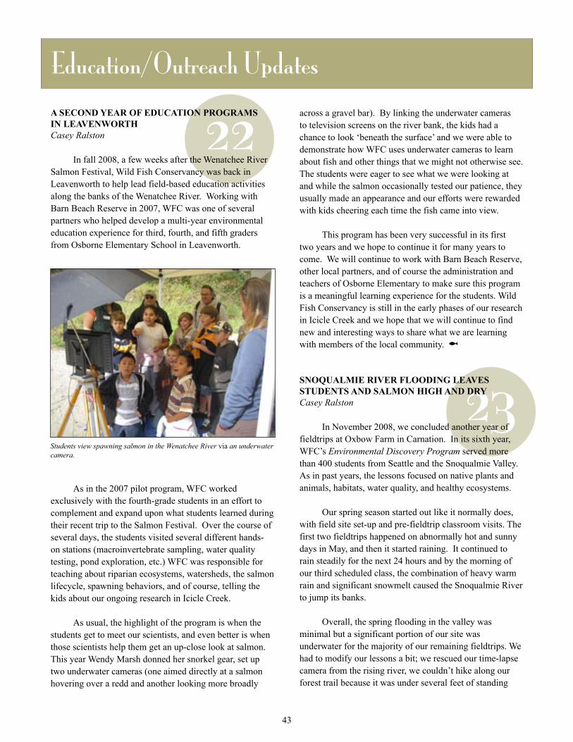
22A SECOND YEAR OF EDUCATION PROGRAMS IN LEAVENWORTH Casey Ralston
In fall 2008, a few weeks after the Wenatchee River Salmon Festival, Wild Fish Conservancy was back in Leavenworth to help lead field-based education activities along the banks of the Wenatchee River. Working with Barn Beach Reserve in 2007, WFC was one of several partners who helped develop a multi-year environmental education experience for third, fourth, and fifth graders from Osborne Elementary School in Leavenworth.
As in the 2007 pilot program, WFC worked exclusively with the fourth-grade students in an effort to complement and expand upon what students learned during their recent trip to the Salmon Festival. Over the course of several days, the students visited several different hands-on stations (macroinvertebrate sampling, water quality testing, pond exploration, etc.) WFC was responsible for teaching about riparian ecosystems, watersheds, the salmon lifecycle, spawning behaviors, and of course, telling the kids about our ongoing research in Icicle Creek.
As usual, the highlight of the program is when the students get to meet our scientists, and even better is when those scientists help them get an up-close look at salmon. This year Wendy Marsh donned her snorkel gear, set up two underwater cameras (one aimed directly at a salmon hovering over a redd and another looking more broadly
23
Education/Outreach Updates
across a gravel bar). By linking the underwater cameras to television screens on the river bank, the kids had a chance to look ‘beneath the surface’ and we were able to demonstrate how WFC uses underwater cameras to learn about fish and other things that we might not otherwise see. The students were eager to see what we were looking at and while the salmon occasionally tested our patience, they usually made an appearance and our efforts were rewarded with kids cheering each time the fish came into view.
This program has been very successful in its first two years and we hope to continue it for many years to come. We will continue to work with Barn Beach Reserve, other local partners, and of course the administration and teachers of Osborne Elementary to make sure this program is a meaningful learning experience for the students. Wild Fish Conservancy is still in the early phases of our research in Icicle Creek and we hope that we will continue to find new and interesting ways to share what we are learning with members of the local community. @
SNOQUALMIE RIVER FLOODING LEAVES STUDENTS AND SALMON HIGH AND DRYCasey Ralston
In November 2008, we concluded another year of fieldtrips at Oxbow Farm in Carnation. In its sixth year, WFC’s Environmental Discovery Program served more than 400 students from Seattle and the Snoqualmie Valley. As in past years, the lessons focused on native plants and animals, habitats, water quality, and healthy ecosystems.
Our spring season started out like it normally does, with field site set-up and pre-fieldtrip classroom visits. The first two fieldtrips happened on abnormally hot and sunny days in May, and then it started raining. It continued to rain steadily for the next 24 hours and by the morning of our third scheduled class, the combination of heavy warm rain and significant snowmelt caused the Snoqualmie River to jump its banks.
Overall, the spring flooding in the valley was minimal but a significant portion of our site was underwater for the majority of our remaining fieldtrips. We had to modify our lessons a bit; we rescued our time-lapse camera from the rising river, we couldn’t hike along our forest trail because it was under several feet of standing
Students view spawning salmon in the Wenatchee River via an underwater camera.
43

24
laid plans, we never know if we’ll capture anything on film. That being said, it turns out that nature almost always gives us something interesting to share with the students.
The success of this program depends on many people who help make it happen. Many thanks to our funder, Tom Alberg, to Stewardship Partners, to the folks at Oxbow Farm, and of course, to the teachers who make time to bring their classes outside. We hope to see you again next year! And also, thank you to our wonderful new and returning field instructors- Barb Bruell, Tysan Dutta, Andrea Faste, Mica Harasek, Katie Hart, Lee Hendrickson, Laura Hersh, Sarah Jackson, Pam Martin, Aileen Ponio, and Celina Steiger.
For more information about the Environmental Discovery
Program, visit www.wildfishconservancy.org/EDP.shtml or contact Education Coordinator Casey Ralston. @
SEARCHING FOR SALMON AT THE SEATTLE ART MUSEUMCasey Ralston
In September 2008, Wild Fish Conservancy participated in “The Salmon Return,” an event held at the Seattle Art Museum’s Olympic Sculpture Park on the Seattle Waterfront. This new community education event, held in conjunction with the 16th annual Salmon Homecoming, included activities, exhibits, and a walking tour of the Olympic Sculpture Park. Wild Fish Conservancy hosted a “Window to Discovery” station at the water’s edge so visitors could take a look above and below the surface of Puget Sound. We set up an underwater video system that provided the public with live images of local fish, other marine critters, and their
water, and our normal water sampling site was a few feet below the surface. We were confined to higher ground and the open field so we refocused our lessons on how rivers move around in a floodplain, why things on land influence water quality, the unpredictability of life in a floodplain, and how animals and plants do (or don’t) take advantage of the changing conditions.
When the river finally receded, we made a discovery that helped us answer that last question- we found dozens of dead juvenile salmon scattered along the trail, stranded in the dirt. We decided to document our discovery so the students could see what we found. We took pictures/video of the flooding and the dead fish and we created a short video to show students how scientists identify young salmon, (in our case, juvenile coho). This video is the latest product of our Window to Discovery project and we hope to post it to our website soon so more kids can view it in the future. Window to Discovery may always be one of our most challenging education activities. Even with the best
Elementary school students search for signs of animal activity at Oxbow Farm.
44
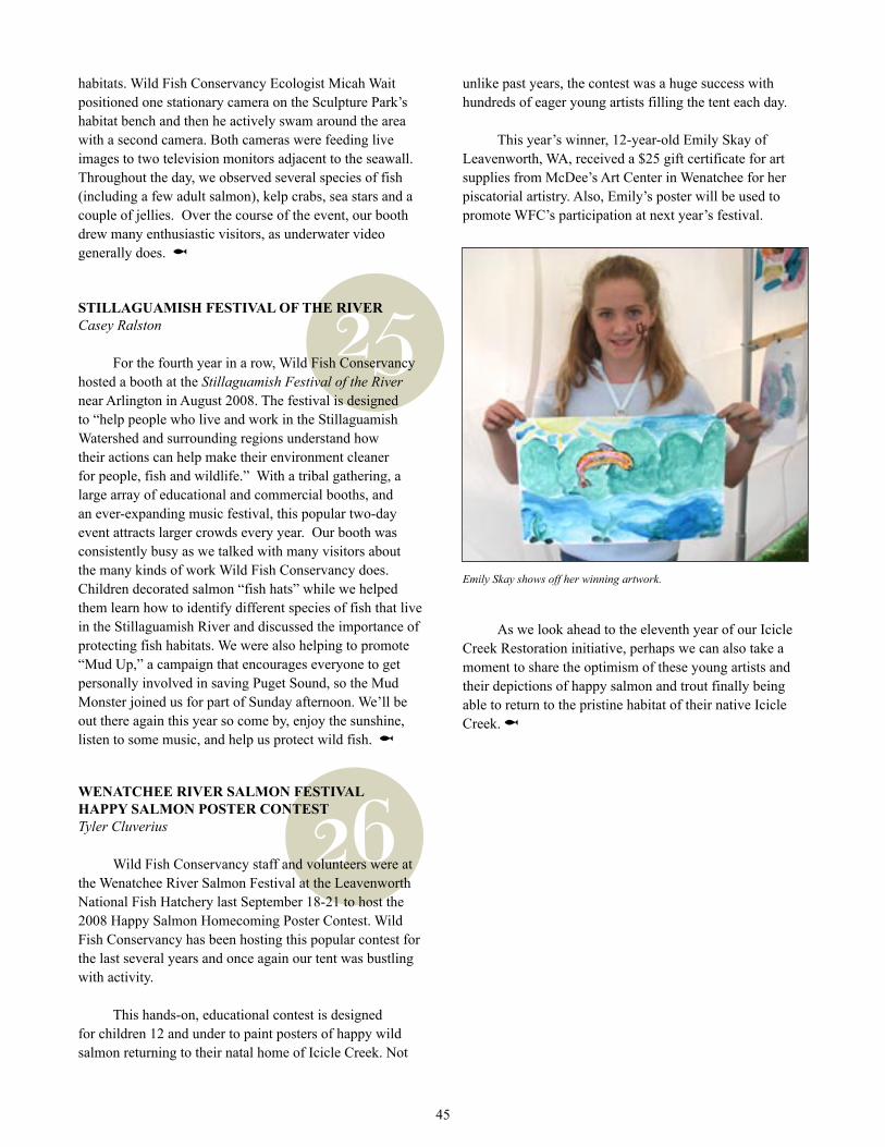
25
26
unlike past years, the contest was a huge success with hundreds of eager young artists filling the tent each day.
This year’s winner, 12-year-old Emily Skay of Leavenworth, WA, received a $25 gift certificate for art supplies from McDee’s Art Center in Wenatchee for her piscatorial artistry. Also, Emily’s poster will be used to promote WFC’s participation at next year’s festival.
As we look ahead to the eleventh year of our Icicle Creek Restoration initiative, perhaps we can also take a moment to share the optimism of these young artists and their depictions of happy salmon and trout finally being able to return to the pristine habitat of their native Icicle Creek. @
Emily Skay shows off her winning artwork.
45
habitats. Wild Fish Conservancy Ecologist Micah Wait positioned one stationary camera on the Sculpture Park’s habitat bench and then he actively swam around the area with a second camera. Both cameras were feeding live images to two television monitors adjacent to the seawall. Throughout the day, we observed several species of fish (including a few adult salmon), kelp crabs, sea stars and a couple of jellies. Over the course of the event, our booth drew many enthusiastic visitors, as underwater video generally does. @
STILLAGUAMISH FESTIVAL OF THE RIVERCasey Ralston
For the fourth year in a row, Wild Fish Conservancy hosted a booth at the Stillaguamish Festival of the River near Arlington in August 2008. The festival is designed to “help people who live and work in the Stillaguamish Watershed and surrounding regions understand how their actions can help make their environment cleaner for people, fish and wildlife.” With a tribal gathering, a large array of educational and commercial booths, and an ever-expanding music festival, this popular two-day event attracts larger crowds every year. Our booth was consistently busy as we talked with many visitors about the many kinds of work Wild Fish Conservancy does. Children decorated salmon “fish hats” while we helped them learn how to identify different species of fish that live in the Stillaguamish River and discussed the importance of protecting fish habitats. We were also helping to promote “Mud Up,” a campaign that encourages everyone to get personally involved in saving Puget Sound, so the Mud Monster joined us for part of Sunday afternoon. We’ll be out there again this year so come by, enjoy the sunshine, listen to some music, and help us protect wild fish. @
WENATCHEE RIVER SALMON FESTIVAL HAPPY SALMON POSTER CONTESTTyler Cluverius
Wild Fish Conservancy staff and volunteers were at the Wenatchee River Salmon Festival at the Leavenworth National Fish Hatchery last September 18-21 to host the 2008 Happy Salmon Homecoming Poster Contest. Wild Fish Conservancy has been hosting this popular contest for the last several years and once again our tent was bustling with activity.
This hands-on, educational contest is designed for children 12 and under to paint posters of happy wild salmon returning to their natal home of Icicle Creek. Not
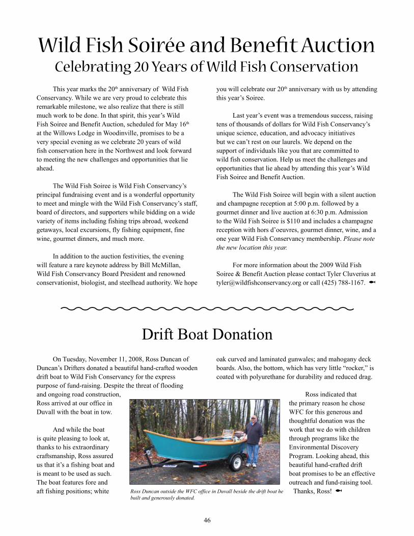
This year marks the 20th anniversary of Wild Fish Conservancy. While we are very proud to celebrate this remarkable milestone, we also realize that there is still much work to be done. In that spirit, this year’s Wild Fish Soiree and Benefit Auction, scheduled for May 16th at the Willows Lodge in Woodinville, promises to be a very special evening as we celebrate 20 years of wild fish conservation here in the Northwest and look forward to meeting the new challenges and opportunities that lie ahead.
The Wild Fish Soiree is Wild Fish Conservancy’s principal fundraising event and is a wonderful opportunity to meet and mingle with the Wild Fish Conservancy’s staff, board of directors, and supporters while bidding on a wide variety of items including fishing trips abroad, weekend getaways, local excursions, fly fishing equipment, fine wine, gourmet dinners, and much more.
In addition to the auction festivities, the evening will feature a rare keynote address by Bill McMillan, Wild Fish Conservancy Board President and renowned conservationist, biologist, and steelhead authority. We hope
Wild Fish Soirée and Benefit AuctionCelebrating 20 Years of Wild Fish Conservation
you will celebrate our 20th anniversary with us by attending this year’s Soiree.
Last year’s event was a tremendous success, raising tens of thousands of dollars for Wild Fish Conservancy’s unique science, education, and advocacy initiatives but we can’t rest on our laurels. We depend on the support of individuals like you that are committed to wild fish conservation. Help us meet the challenges and opportunities that lie ahead by attending this year’s Wild Fish Soiree and Benefit Auction.
The Wild Fish Soiree will begin with a silent auction and champagne reception at 5:00 p.m. followed by a gourmet dinner and live auction at 6:30 p.m. Admission to the Wild Fish Soiree is $110 and includes a champagne reception with hors d’oeuvres, gourmet dinner, wine, and a one year Wild Fish Conservancy membership. Please note the new location this year.
For more information about the 2009 Wild Fish Soiree & Benefit Auction please contact Tyler Cluverius at [email protected] or call (425) 788-1167. @
On Tuesday, November 11, 2008, Ross Duncan of Duncan’s Drifters donated a beautiful hand-crafted wooden drift boat to Wild Fish Conservancy for the express purpose of fund-raising. Despite the threat of flooding and ongoing road construction, Ross arrived at our office in Duvall with the boat in tow.
And while the boat is quite pleasing to look at, thanks to his extraordinary craftsmanship, Ross assured us that it’s a fishing boat and is meant to be used as such. The boat features fore and aft fishing positions; white
Drift Boat Donationoak curved and laminated gunwales; and mahogany deck boards. Also, the bottom, which has very little “rocker,” is coated with polyurethane for durability and reduced drag.
Ross indicated that the primary reason he chose WFC for this generous and thoughtful donation was the work that we do with children through programs like the Environmental Discovery Program. Looking ahead, this beautiful hand-crafted drift boat promises to be an effective outreach and fund-raising tool.
Thanks, Ross! @Ross Duncan outside the WFC office in Duvall beside the drift boat he built and generously donated.
46
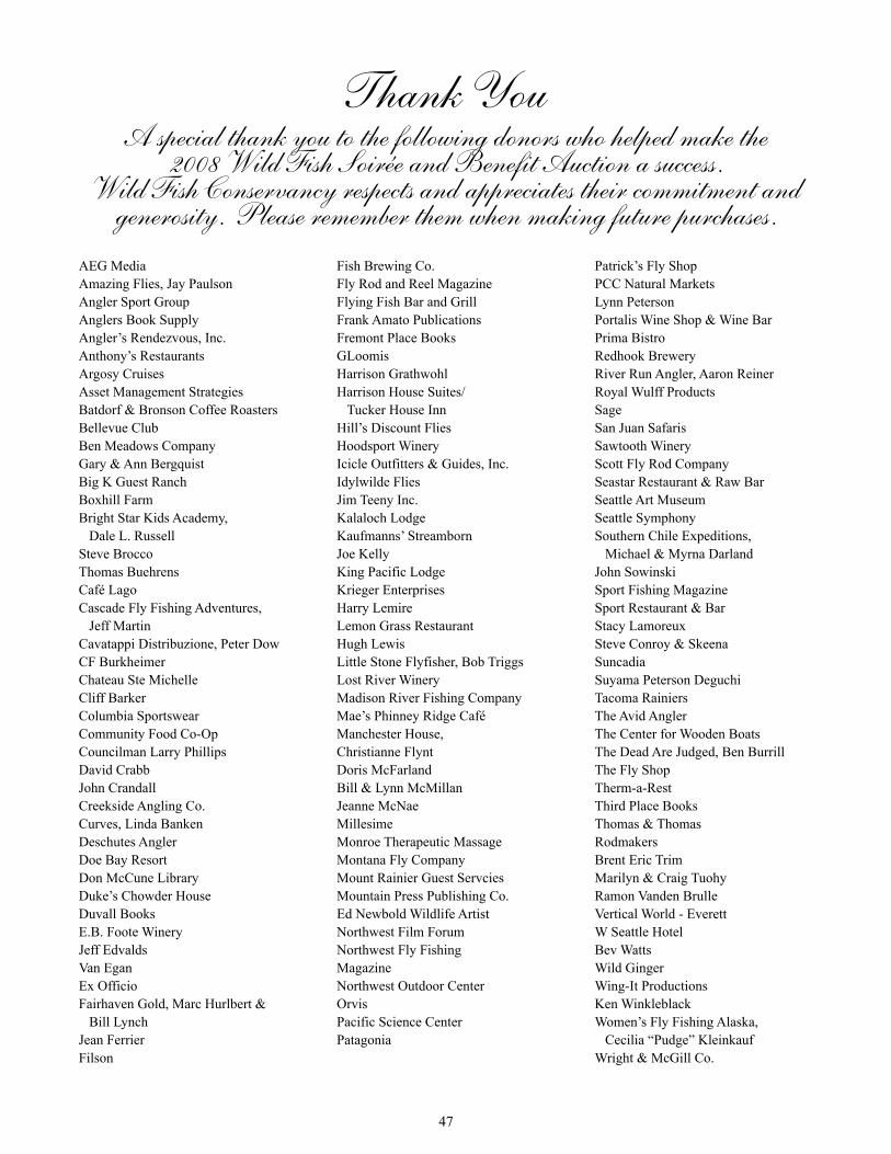
A special thank you to the following donors who helped make the 2008 Wild Fish Soirée and Benefit Auction a success.
Wild Fish Conservancy respects and appreciates their commitment and generosity. Please remember them when making future purchases.
Thank You
AEG MediaAmazing Flies, Jay PaulsonAngler Sport GroupAnglers Book SupplyAngler’s Rendezvous, Inc.Anthony’s RestaurantsArgosy CruisesAsset Management Strategies Batdorf & Bronson Coffee RoastersBellevue ClubBen Meadows CompanyGary & Ann BergquistBig K Guest RanchBoxhill FarmBright Star Kids Academy, Dale L. RussellSteve BroccoThomas BuehrensCafé LagoCascade Fly Fishing Adventures, Jeff MartinCavatappi Distribuzione, Peter DowCF BurkheimerChateau Ste MichelleCliff BarkerColumbia SportswearCommunity Food Co-OpCouncilman Larry PhillipsDavid CrabbJohn CrandallCreekside Angling Co.Curves, Linda BankenDeschutes AnglerDoe Bay ResortDon McCune LibraryDuke’s Chowder HouseDuvall BooksE.B. Foote WineryJeff EdvaldsVan EganEx OfficioFairhaven Gold, Marc Hurlbert & Bill LynchJean FerrierFilson
Fish Brewing Co.Fly Rod and Reel MagazineFlying Fish Bar and GrillFrank Amato PublicationsFremont Place BooksGLoomisHarrison GrathwohlHarrison House Suites/ Tucker House InnHill’s Discount FliesHoodsport WineryIcicle Outfitters & Guides, Inc.Idylwilde FliesJim Teeny Inc.Kalaloch LodgeKaufmanns’ StreambornJoe KellyKing Pacific LodgeKrieger EnterprisesHarry LemireLemon Grass RestaurantHugh LewisLittle Stone Flyfisher, Bob TriggsLost River WineryMadison River Fishing CompanyMae’s Phinney Ridge CaféManchester House, Christianne FlyntDoris McFarlandBill & Lynn McMillanJeanne McNaeMillesimeMonroe Therapeutic MassageMontana Fly CompanyMount Rainier Guest ServciesMountain Press Publishing Co.Ed Newbold Wildlife ArtistNorthwest Film ForumNorthwest Fly Fishing MagazineNorthwest Outdoor CenterOrvisPacific Science CenterPatagonia
Patrick’s Fly ShopPCC Natural MarketsLynn Peterson Portalis Wine Shop & Wine BarPrima BistroRedhook BreweryRiver Run Angler, Aaron ReinerRoyal Wulff ProductsSageSan Juan SafarisSawtooth WineryScott Fly Rod CompanySeastar Restaurant & Raw BarSeattle Art MuseumSeattle SymphonySouthern Chile Expeditions, Michael & Myrna DarlandJohn SowinskiSport Fishing MagazineSport Restaurant & BarStacy LamoreuxSteve Conroy & SkeenaSuncadiaSuyama Peterson DeguchiTacoma RainiersThe Avid AnglerThe Center for Wooden BoatsThe Dead Are Judged, Ben Burrill The Fly ShopTherm-a-RestThird Place BooksThomas & Thomas RodmakersBrent Eric TrimMarilyn & Craig TuohyRamon Vanden BrulleVertical World - EverettW Seattle HotelBev WattsWild GingerWing-It ProductionsKen WinkleblackWomen’s Fly Fishing Alaska, Cecilia “Pudge” KleinkaufWright & McGill Co.
47
Recycled paperPrinted with soy ink
NON-PROFIT ORG.U.S. POSTAGE PAIDPERMIT NO. 5544Seattle, WA.
S C I E N C E E D U C A T I O N A D V O C A C Y
Wild Fish ConservancyP. O . B o x 4 0 2 , D u v a l l , WA . 9 8 0 1 9
N O R T H W E S T
Wild Fish Soirée
17th Annual
& Benefit AuctionMay 17th, 5 to 9 pm
20 Years of Celebrating
Wild Fish Conservation
May 16, 2009, Willows Lodge, Woodinville, WA., 5 to 9 PM
www.wildfishconservancy.org
Wild Fish Soirée & Benefit Auction
20years
Celebrating
of Wild Fish Conservation
May 16th, Willows Lodge, Woodinville WA.
!