30.16 land use application processing - clark …30.16.020 general land use application processing....
TRANSCRIPT
Printed Chapter 30.16: Land Use Application Processing
30.16
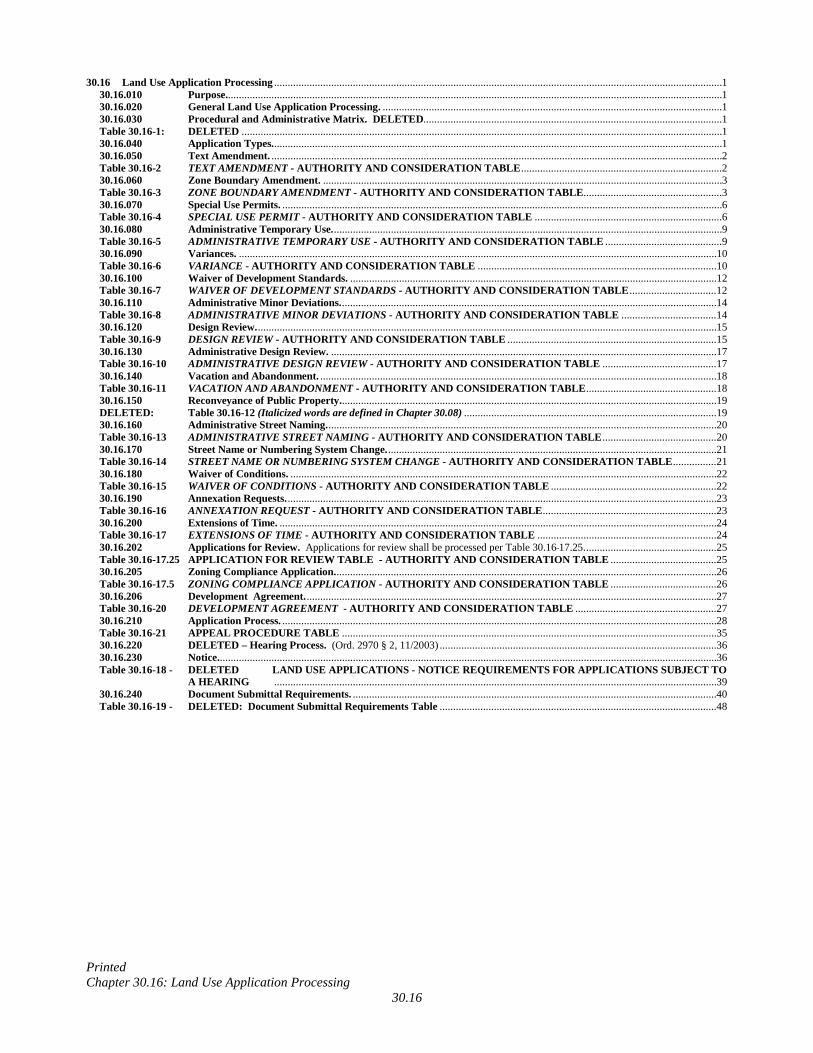
30.16 Land Use Application Processing ..................................................................................................................................................................... 1 30.16.010 Purpose....................................................................................................................................................................................... 1 30.16.020 General Land Use Application Processing. ............................................................................................................................. 1 30.16.030 Procedural and Administrative Matrix. DELETED.............................................................................................................. 1 Table 30.16-1: DELETED ................................................................................................................................................................................. 1 30.16.040 Application Types. ..................................................................................................................................................................... 1 30.16.050 Text Amendment. ...................................................................................................................................................................... 2 Table 30.16-2 TEXT AMENDMENT - AUTHORITY AND CONSIDERATION TABLE .......................................................................... 2 30.16.060 Zone Boundary Amendment. ................................................................................................................................................... 3 Table 30.16-3 ZONE BOUNDARY AMENDMENT - AUTHORITY AND CONSIDERATION TABLE ................................................... 3 30.16.070 Special Use Permits. .................................................................................................................................................................. 6 Table 30.16-4 SPECIAL USE PERMIT - AUTHORITY AND CONSIDERATION TABLE ..................................................................... 6 30.16.080 Administrative Temporary Use. ............................................................................................................................................... 9 Table 30.16-5 ADMINISTRATIVE TEMPORARY USE - AUTHORITY AND CONSIDERATION TABLE ........................................... 9 30.16.090 Variances. ................................................................................................................................................................................ 10 Table 30.16-6 VARIANCE - AUTHORITY AND CONSIDERATION TABLE ........................................................................................ 10 30.16.100 Waiver of Development Standards. ....................................................................................................................................... 12 Table 30.16-7 WAIVER OF DEVELOPMENT STANDARDS - AUTHORITY AND CONSIDERATION TABLE ................................ 12 30.16.110 Administrative Minor Deviations. .......................................................................................................................................... 14 Table 30.16-8 ADMINISTRATIVE MINOR DEVIATIONS - AUTHORITY AND CONSIDERATION TABLE ................................... 14 30.16.120 Design Review. ......................................................................................................................................................................... 15 Table 30.16-9 DESIGN REVIEW - AUTHORITY AND CONSIDERATION TABLE ............................................................................. 15 30.16.130 Administrative Design Review. .............................................................................................................................................. 17 Table 30.16-10 ADMINISTRATIVE DESIGN REVIEW - AUTHORITY AND CONSIDERATION TABLE .......................................... 17 30.16.140 Vacation and Abandonment. .................................................................................................................................................. 18 Table 30.16-11 VACATION AND ABANDONMENT - AUTHORITY AND CONSIDERATION TABLE ................................................ 18 30.16.150 Reconveyance of Public Property. .......................................................................................................................................... 19 DELETED: Table 30.16-12 (Italicized words are defined in Chapter 30.08) ............................................................................................. 19 30.16.160 Administrative Street Naming. ............................................................................................................................................... 20 Table 30.16-13 ADMINISTRATIVE STREET NAMING - AUTHORITY AND CONSIDERATION TABLE .......................................... 20 30.16.170 Street Name or Numbering System Change. ......................................................................................................................... 21 Table 30.16-14 STREET NAME OR NUMBERING SYSTEM CHANGE - AUTHORITY AND CONSIDERATION TABLE ................ 21 30.16.180 Waiver of Conditions. ............................................................................................................................................................. 22 Table 30.16-15 WAIVER OF CONDITIONS - AUTHORITY AND CONSIDERATION TABLE ............................................................. 22 30.16.190 Annexation Requests. .............................................................................................................................................................. 23 Table 30.16-16 ANNEXATION REQUEST - AUTHORITY AND CONSIDERATION TABLE ................................................................ 23 30.16.200 Extensions of Time. ................................................................................................................................................................. 24 Table 30.16-17 EXTENSIONS OF TIME - AUTHORITY AND CONSIDERATION TABLE .................................................................. 24 30.16.202 Applications for Review. Applications for review shall be processed per Table 30.16 17.25. ................................................ 25 Table 30.16-17.25 APPLICATION FOR REVIEW TABLE - AUTHORITY AND CONSIDERATION TABLE ....................................... 25 30.16.205 Zoning Compliance Application. ............................................................................................................................................ 26 Table 30.16-17.5 ZONING COMPLIANCE APPLICATION - AUTHORITY AND CONSIDERATION TABLE ....................................... 26 30.16.206 Development Agreement. ....................................................................................................................................................... 27 Table 30.16-20 DEVELOPMENT AGREEMENT - AUTHORITY AND CONSIDERATION TABLE .................................................... 27 30.16.210 Application Process. ................................................................................................................................................................ 28 Table 30.16-21 APPEAL PROCEDURE TABLE .......................................................................................................................................... 35 30.16.220 DELETED – Hearing Process. (Ord. 2970 § 2, 11/2003) ...................................................................................................... 36 30.16.230 Notice. ....................................................................................................................................................................................... 36 Table 30.16-18 - DELETED LAND USE APPLICATIONS - NOTICE REQUIREMENTS FOR APPLICATIONS SUBJECT TO
A HEARING ................................................................................................................................................................... 39 30.16.240 Document Submittal Requirements. ...................................................................................................................................... 40 Table 30.16-19 - DELETED: Document Submittal Requirements Table ...................................................................................................... 48
Printed Chapter 30.16: Land Use Application Processing January 7, 2019
30.16-1
30.16 Land Use Application Processing 30.16.010 Purpose. The purpose of this Chapter is to provide standards and procedures for the acceptance,
processing, hearing and final action of Land Use Applications. To merit approval by the approval authority, an application, amendment, or map must demonstrate compatibility with all applicable community goals as follows:
1. Furthering the purpose of the Plan. 2. Contributing to the general prosperity, health, safety, and welfare of the community. 3. Avoiding or minimizing impacts on adjacent property. 4. Complementing or enhancing the character of the neighborhood and promoting logical and orderly
development patterns. 5. Minimizing negative impacts on traffic conditions. 6. Ensuring adequate parking is provided. 7. Minimizing negative environmental impacts, including but not limited to water, noise, dust, odor,
smoke, air quality, drainage, light, glare, wildlife, vegetation, wetlands, and the natural functioning of the environment.
8. Providing or contributing to required public improvements, facilities, or services to ensure that
adequate transportation, recreation, drainage, fire protection, utility, and other applicable needs are met.
9. Considering the impact on public schools.
30.16.020 General Land Use Application Processing. Land use applications may be initiated, accepted, processed, noticed, heard and acted upon in accordance with the provisions of this Chapter. Each application shall be processed as specified in this Chapter. Sections 30.16.040 through 30.16.206 establish specialized standards for processing and final action on various application types. Section 30.16.210 describes the general standards for processing and consideration of all applications. Section 30.16.230 details the notice requirements when a public hearing is required, and Section 30.16.240 lists document submittal requirements for each of the application types. (Ord. 4481 § 4 (part), 5/2017; Ord. 2970 § 2 (part), 11/2003)
30.16.030 Procedural and Administrative Matrix. DELETED
Table 30.16-1: DELETED (Ord. 2970 § 2 (part), 11/2003)
30.16.040 Application Types. Tables 30.16-2 through 30.16-17 describe the various Land Use Applications and the
initiation, consideration, and final approval authorities for each.
Printed Chapter 30.16: Land Use Application Processing January 7, 2019
30.16-2
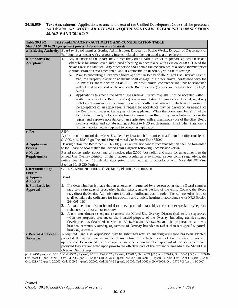
30.16.050 Text Amendment. Applications to amend the text of the Unified Development Code shall be processed per Table 30.16-2. NOTE: ADDITIONAL REQUIREMENTS ARE ESTABLISHED IN SECTIONS 30.16.210 AND 30.16.240.
Table 30.16-2 TEXT AMENDMENT - AUTHORITY AND CONSIDERATION TABLE SEE ALSO 30.16.210 for general process information and standards a. Initiating Authority Board or Board member, Zoning Administrator, Director of Public Works, Director of Department of
Building, or a person with a property interest related to the requested text amendment b. Standards for Acceptance
1. Any member of the Board may direct the Zoning Administrator to prepare an ordinance and schedule it for introduction and a public hearing in accordance with Section 244.095-115 of the Nevada Revised Statutes. Any other person shall obtain the concurrence of a Board member prior to submission of a text amendment and, if applicable, shall comply with the following: A. Prior to submitting a text amendment application to amend the Mixed Use Overlay District
map, the property owner or applicant shall engage in a pre-submittal conference with the County pursuant to Section 30.48.750. The pre-submittal conference shall not be scheduled without written consent of the applicable Board member(s) pursuant to subsection (b)(1)(B) below.
B. Applications to amend the Mixed Use Overlay District map shall not be accepted without written consent of the Board member(s) in whose district the property is located; or, if any such Board member is constrained by ethical conflicts of interest or declines to consent to the acceptance of an application, a request for acceptance may be placed on an agenda for the Board to consider at the request of the applicant. When the Board member(s) in whose district the property is located declines to consent, the Board may nevertheless consider the request and approve acceptance of an application with a unanimous vote of the other Board members voting and not abstaining, subject to NRS requirements. In all other instances, a simple majority vote is required to accept an application.
c. Fee $400 Applications to amend the Mixed Use Overlay District shall require an additional notification fee of $1,000, plus $200 Sign Fee and a Pre-submittal Conference Fee of $500
d. Application Process
Hearing before the Board per 30.16.210; plus Commission whose recommendation shall be forwarded to the Board no sooner than the second zoning agenda following Commission action
e. Notice Requirements
Posted notice, entity notice, and city notice; plus 2,500 foot radius and signs for amendments to the Mixed Use Overlay District. If the proposed regulation is to amend airport zoning regulations, the notice must be sent 15 calendar days prior to the hearing, in accordance with NRS 497.080 (See Section 30.16.230 Notice)
f. Recommending Entities
Cities, Government entities, Town Board, Planning Commission
g. Approval Authority
Board
h. Standards for Approval
1. If a determination is made that an amendment requested by a person other than a Board member may serve the general prosperity, health, safety, and/or welfare of the entire County, the Board may direct the Zoning Administrator to draft an ordinance accordingly. The Zoning Administrator shall schedule the ordinance for introduction and a public hearing in accordance with NRS Section 244.095-119
2. A text amendment is not intended to relieve particular hardships nor to confer special privileges or rights upon any person or property
3. A text amendment to expand or amend the Mixed Use Overlay District shall only be approved when the proposed area meets the intended purpose of the Overlay, including transit-oriented development as described in Sections 30.48.700 and 30.48.760, and the proposal constitutes a broader, community-serving adjustment of Overlay boundaries rather than site-specific, parcel-based adjustments
i. Related Application Submittal
A required Land Use Application may be submitted after an enabling ordinance has been adopted, provided the application is not acted on before the effective date of the ordinance; however, applications for a mixed use development may be submitted after approval of the text amendment provided they are not acted upon prior to the effective date of the ordinance amending the Mixed Use Overlay District map
(Ord. 4658 § 4 (part), 1/2019; Ord. 4562 § 2 (part), 2/2018; Ord 4152 § 2 (part), 12/2013; Ord. 4077 § 3 (part), 2/2013; Ord. 3848 § 3 (part), 2/2010; Ord. 3549 § 3(part), 9/2007; Ord. 3432 § 2(part), 10/2006; Ord. 3354 § 2 (part), 2/2006; Ord. 3296 § 3 (part), 10/2005; Ord. 3229 § 3 (part), 6/2005; Ord. 3219 § 2 (part), 5/2005; Ord. 3209 § 4 (part), 3/2005; Ord. 3174 § 2 (part), 1/2005; Ord. 3085 § 39, 6/2004; Ord. 2970 § 2 (part), 11/2003)
Printed Chapter 30.16: Land Use Application Processing January 7, 2019
30.16-3
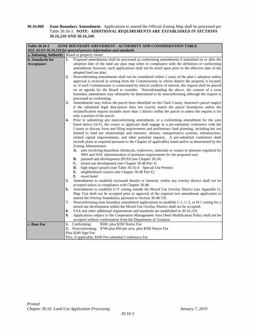
30.16.060 Zone Boundary Amendment. Applications to amend the Official Zoning Map shall be processed per Table 30.16-3. NOTE: ADDITIONAL REQUIREMENTS ARE ESTABLISHED IN SECTIONS 30.16.210 AND 30.16.240.
Table 30.16-3 ZONE BOUNDARY AMENDMENT - AUTHORITY AND CONSIDERATION TABLE SEE ALSO 30.16.210 for general process information and standards a. Initiating Authority Board or property owner b. Standards for Acceptance
1. Proposed amendments shall be processed as conforming amendments if submitted on or after the adoption date of the land use plan map when in compliance with the definition of conforming amendment; however, such applications shall not be acted upon prior to the effective date of the adopted land use plan.
2. Nonconforming amendments shall not be considered within 2 years of the plan’s adoption unless approval is received in writing from the Commissioner in whose district the property is located; or, if such Commissioner is constrained by ethical conflicts of interest, the request shall be placed on an agenda for the Board to consider. Notwithstanding the above, the content of a zone boundary amendment may ultimately be determined to be nonconforming although the request is processed as conforming.
3. Amendments may follow the parcel lines identified on the Clark County Assessor's parcel map(s) if the submitted legal description does not exactly match the parcel boundaries unless the reclassification request includes more than 1 district within the parcel or unless the request is for only a portion of the parcel.
4. Prior to submitting any nonconforming amendment, or a conforming amendment for the uses listed below (A-F), the owner or applicant shall engage in a pre-submittal conference with the County to discuss form and filing requirements and preliminary land planning, including but not limited to land use relationships and intensity, density, transportation systems, infrastructure, related capital improvements, and other potential impacts. A pre-submittal conference shall include plans as required pursuant to the Chapter (if applicable) noted and/or as determined by the Zoning Administrator.
A. uses involving hazardous chemicals, explosives, materials or wastes in amounts regulated by NRS and NAC (determination of pertinent requirements for the proposed use)
B. planned unit development (PUD) (see Chapter 30.24) C. mixed use development (see Chapter 30.48 Part J) D. high impact project (see Table 30.16-4 – Special Use Permit) E. neighborhood casinos (see Chapter 30.48 Part E) F. resort hotel 5. Amendments to establish increased density or intensity within any overlay district shall not be
accepted unless in compliance with Chapter 30.48. 6. Amendments to establish U-V zoning outside the Mixed Use Overlay District (see Appendix G,
Map 15a) shall not be accepted prior to approval of the required text amendment application to amend the Overlay boundaries, pursuant to Section 30.48.720.
7. Nonconforming zone boundary amendment applications to establish C-1, C-2, or H-1 zoning for a mixed use development within the Mixed Use Overlay District shall not be accepted.
8. FAA and other additional requirements and standards are established in 30.16.210. 9. Applications subject to the Cooperative Management Area Deed Modification Policy shall not be
accepted without confirmation from the Department of Aviation. c. Base Fee
1. Conforming: $500, plus $350 Notice Fee 2. Nonconforming: $700 plus $50 per acre, plus $500 Notice Fee Plus $200 Sign Fee Plus, if applicable, $500 Pre-submittal Conference Fee
Printed Chapter 30.16: Land Use Application Processing January 7, 2019
30.16-4
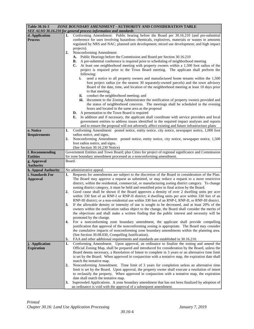
Table 30.16-3 ZONE BOUNDARY AMENDMENT - AUTHORITY AND CONSIDERATION TABLE SEE ALSO 30.16.210 for general process information and standards d. Application Process
1. Conforming Amendment: Public hearing before the Board per 30.16.210 (and pre-submittal conference for uses involving hazardous chemicals, explosives, materials or wastes in amounts regulated by NRS and NAC; planned unit development; mixed use development; and high impact projects).
2. Nonconforming Amendment: A. Public Hearings before the Commission and Board per Section 30.16.210 B. A pre-submittal conference is required prior to scheduling of neighborhood meeting C. At least one neighborhood meeting with property owners within a 1,500 foot radius of the
project is required prior to the Town Board meeting. The applicant shall perform the following:
i. send a notice to all property owners and manufactured home tenants within the 1,500 foot project radius (or the nearest 30 separately-owned parcels) and the town advisory Board of the date, time, and location of the neighborhood meeting at least 10 days prior to that meeting;
ii. conduct the neighborhood meeting; and iii. document to the Zoning Administrator the notification of property owners provided and
the status of neighborhood concerns. The meetings shall be scheduled in the evening hours and located in the same area as the proposal
D. A presentation to the Town Board is required E. In addition and if necessary, the applicant shall coordinate with service providers and local
government entities to address issues identified in the required impact analyses and reports and to ensure the proposal will not adversely affect existing and future infrastructure plans
e. Notice Requirements
1. Conforming Amendment: posted notice, entity notice, city notice, newspaper notice, 1,000 foot radius notice, and signs.
2. Nonconforming Amendment: posted notice, entity notice, city notice, newspaper notice, 1,500 foot radius notice, and signs.
(See Section 30.16.230 Notice) f. Recommending Entities
Government Entities and Town Board; plus Cities for project of regional significance and Commission for zone boundary amendment processed as a nonconforming amendment.
g. Approval Authority
Board.
h. Appeal Authority No administrative appeal. i. Standards For Approval
1. Requests for amendments are subject to the discretion of the Board in consideration of the Plan. The Board may approve a request as submitted, or may reduce a request to a more restrictive district, within the residential, commercial, or manufacturing zoning district category. To change zoning district category, it must be held and renotified prior to final action by the Board.
2. Good cause shall be shown if the Board approves a density of over 2 dwelling units per acre within 330 feet of an RNP-I or RNP-II district; 4 dwelling units per acre within 330 feet of an RNP-III district; or a non-residential use within 330 feet of an RNP-I, RNP-II, or RNP-III district.
3. If the allowable density or intensity of use is sought to be decreased, and at least 20% of the owners within the notification radius object to the change, the Board shall consider the merits of the objections and shall make a written finding that the public interest and necessity will be promoted by the change.
4. For a nonconforming zone boundary amendment, the applicant shall provide compelling justification that approval of the nonconforming zoning is appropriate. The Board may consider the cumulative impacts of nonconforming zone boundary amendments within the planning area. (See Section 30.08.030, Compelling Justification).
5. FAA and other additional requirements and standards are established in 30.16.210. j. Application Expiration
1. Conforming Amendment. Upon approval, an ordinance to finalize the zoning and amend the Official Zoning Map, shall be prepared and introduced for consideration by the Board, unless the Board deems necessary, a Resolution of Intent to complete in 3 years or an alternative time limit is set by the Board. When approved in conjunction with a tentative map, the expiration date shall match the tentative map.
2. Nonconforming Amendment. Time limit of 3 years for completion unless an alternative time limit is set by the Board. Upon approval, the property owner shall execute a resolution of intent to reclassify the property. When approved in conjunction with a tentative map, the expiration date shall match the tentative map.
3. Superseded Applications. A zone boundary amendment that has not been finalized by adoption of an ordinance is void with the approval of a subsequent amendment.
Printed Chapter 30.16: Land Use Application Processing January 7, 2019
30.16-5
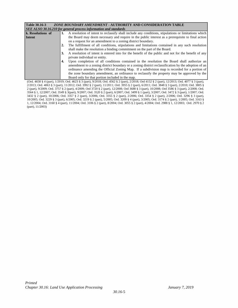
Table 30.16-3 ZONE BOUNDARY AMENDMENT - AUTHORITY AND CONSIDERATION TABLE SEE ALSO 30.16.210 for general process information and standards k. Resolutions of Intent
1. A resolution of intent to reclassify shall include any conditions, stipulations or limitations which the Board may deem necessary and require in the public interest as a prerequisite to final action on a request for an amendment to a zoning district boundary.
2. The fulfillment of all conditions, stipulations and limitations contained in any such resolution shall make the resolution a binding commitment on the part of the Board.
3. A resolution of intent is entered into for the benefit of the public and not for the benefit of any private individual or entity.
4. Upon completion of all conditions contained in the resolution the Board shall authorize an amendment to a zoning district boundary or a zoning district reclassification by the adoption of an ordinance amending the Official Zoning Map. If a subdivision map is recorded for a portion of the zone boundary amendment, an ordinance to reclassify the property may be approved by the Board only for that portion included in the map.
(Ord. 4658 § 4 (part), 1/2019; Ord. 4623 § 3 (part), 9/2018; Ord. 4562 § 2 (part), 2/2018; Ord 4152 § 2 (part), 12/2013; Ord. 4077 § 3 (part), 2/2013; Ord. 4063 § 3 (part), 11/2012; Ord. 3992 § 2 (part), 11/2011; Ord. 3955 § 2 (part), 6/2011; Ord. 3848 § 3 (part), 2/2010; Ord. 3805 § 2 (part), 9/2009; Ord. 3757 § 2 (part), 4/2009; Ord 3720 § 2 (part), 12/2008; Ord 3688 § 3 (part), 10/2008; Ord 3586 § 3 (part), 2/2008; Ord. 3564 § 1, 12/2007; Ord. 3549 § 3(part), 9/2007; Ord. 3520 § 2 (part), 6/2007; Ord. 3499 § 1 (part), 3/2007; Ord. 3472 § 3 (part), 1/2007; Ord. 3432 § 2 (part), 10/2006; Ord. 3357 § 2 (part), 3/2006; Ord. 3355 § 2 (part), 2/2006; Ord. 3354 § 2 (part), 2/2006; Ord. 3296 § 3 (part), 10/2005; Ord. 3229 § 3 (part), 6/2005; Ord. 3219 § 2 (part), 5/2005; Ord. 3209 § 4 (part), 3/2005; Ord. 3174 § 2 (part), 1/2005; Ord. 3163 § 1, 12/2004; Ord. 3160 § 4 (part), 11/2004; Ord. 3106 § 2 (part), 8/2004; Ord. 3055 § 2 (part), 4/2004; Ord. 2988 § 1, 12/2003; Ord. 2970 § 2 (part), 11/2003)
Printed Chapter 30.16: Land Use Application Processing January 7, 2019
30.16-6
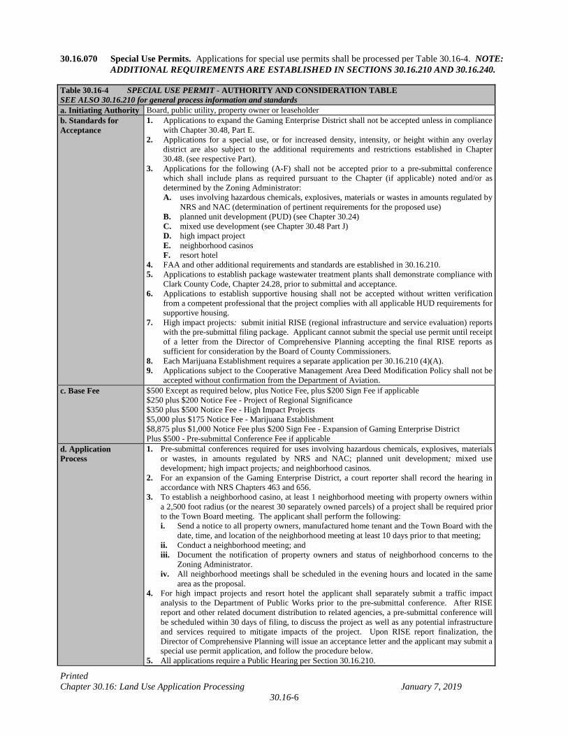
30.16.070 Special Use Permits. Applications for special use permits shall be processed per Table 30.16-4. NOTE: ADDITIONAL REQUIREMENTS ARE ESTABLISHED IN SECTIONS 30.16.210 AND 30.16.240.
Table 30.16-4 SPECIAL USE PERMIT - AUTHORITY AND CONSIDERATION TABLE SEE ALSO 30.16.210 for general process information and standards a. Initiating Authority Board, public utility, property owner or leaseholder b. Standards for Acceptance
1. Applications to expand the Gaming Enterprise District shall not be accepted unless in compliance with Chapter 30.48, Part E.
2. Applications for a special use, or for increased density, intensity, or height within any overlay district are also subject to the additional requirements and restrictions established in Chapter 30.48. (see respective Part).
3. Applications for the following (A-F) shall not be accepted prior to a pre-submittal conference which shall include plans as required pursuant to the Chapter (if applicable) noted and/or as determined by the Zoning Administrator:
A. uses involving hazardous chemicals, explosives, materials or wastes in amounts regulated by NRS and NAC (determination of pertinent requirements for the proposed use)
B. planned unit development (PUD) (see Chapter 30.24) C. mixed use development (see Chapter 30.48 Part J) D. high impact project E. neighborhood casinos F. resort hotel 4. FAA and other additional requirements and standards are established in 30.16.210. 5. Applications to establish package wastewater treatment plants shall demonstrate compliance with
Clark County Code, Chapter 24.28, prior to submittal and acceptance. 6. Applications to establish supportive housing shall not be accepted without written verification
from a competent professional that the project complies with all applicable HUD requirements for supportive housing.
7. High impact projects: submit initial RISE (regional infrastructure and service evaluation) reports with the pre-submittal filing package. Applicant cannot submit the special use permit until receipt of a letter from the Director of Comprehensive Planning accepting the final RISE reports as sufficient for consideration by the Board of County Commissioners.
8. Each Marijuana Establishment requires a separate application per 30.16.210 (4)(A). 9. Applications subject to the Cooperative Management Area Deed Modification Policy shall not be
accepted without confirmation from the Department of Aviation. c. Base Fee
$500 Except as required below, plus Notice Fee, plus $200 Sign Fee if applicable $250 plus $200 Notice Fee - Project of Regional Significance $350 plus $500 Notice Fee - High Impact Projects $5,000 plus $175 Notice Fee - Marijuana Establishment $8,875 plus $1,000 Notice Fee plus $200 Sign Fee - Expansion of Gaming Enterprise District Plus $500 - Pre-submittal Conference Fee if applicable
d. Application Process
1. Pre-submittal conferences required for uses involving hazardous chemicals, explosives, materials or wastes, in amounts regulated by NRS and NAC; planned unit development; mixed use development; high impact projects; and neighborhood casinos.
2. For an expansion of the Gaming Enterprise District, a court reporter shall record the hearing in accordance with NRS Chapters 463 and 656.
3. To establish a neighborhood casino, at least 1 neighborhood meeting with property owners within a 2,500 foot radius (or the nearest 30 separately owned parcels) of a project shall be required prior to the Town Board meeting. The applicant shall perform the following: i. Send a notice to all property owners, manufactured home tenant and the Town Board with the
date, time, and location of the neighborhood meeting at least 10 days prior to that meeting; ii. Conduct a neighborhood meeting; and iii. Document the notification of property owners and status of neighborhood concerns to the
Zoning Administrator. iv. All neighborhood meetings shall be scheduled in the evening hours and located in the same
area as the proposal. 4. For high impact projects and resort hotel the applicant shall separately submit a traffic impact
analysis to the Department of Public Works prior to the pre-submittal conference. After RISE report and other related document distribution to related agencies, a pre-submittal conference will be scheduled within 30 days of filing, to discuss the project as well as any potential infrastructure and services required to mitigate impacts of the project. Upon RISE report finalization, the Director of Comprehensive Planning will issue an acceptance letter and the applicant may submit a special use permit application, and follow the procedure below.
5. All applications require a Public Hearing per Section 30.16.210.
Printed Chapter 30.16: Land Use Application Processing January 7, 2019
30.16-7
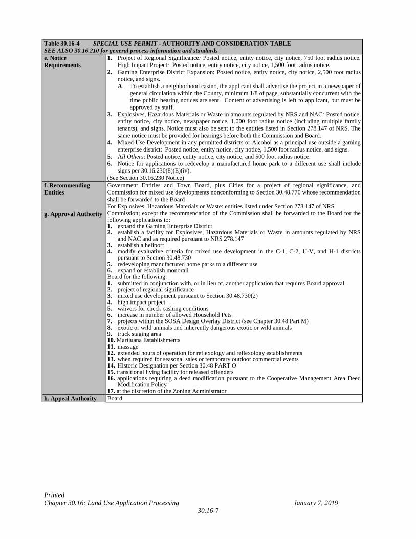
Table 30.16-4 SPECIAL USE PERMIT - AUTHORITY AND CONSIDERATION TABLE SEE ALSO 30.16.210 for general process information and standards e. Notice Requirements
1. Project of Regional Significance: Posted notice, entity notice, city notice, 750 foot radius notice. High Impact Project: Posted notice, entity notice, city notice, 1,500 foot radius notice.
2. Gaming Enterprise District Expansion: Posted notice, entity notice, city notice, 2,500 foot radius notice, and signs. A. To establish a neighborhood casino, the applicant shall advertise the project in a newspaper of
general circulation within the County, minimum 1/8 of page, substantially concurrent with the time public hearing notices are sent. Content of advertising is left to applicant, but must be approved by staff.
3. Explosives, Hazardous Materials or Waste in amounts regulated by NRS and NAC: Posted notice, entity notice, city notice, newspaper notice, 1,000 foot radius notice (including multiple family tenants), and signs. Notice must also be sent to the entities listed in Section 278.147 of NRS. The same notice must be provided for hearings before both the Commission and Board.
4. Mixed Use Development in any permitted districts or Alcohol as a principal use outside a gaming enterprise district: Posted notice, entity notice, city notice, 1,500 foot radius notice, and signs.
5. All Others: Posted notice, entity notice, city notice, and 500 foot radius notice. 6. Notice for applications to redevelop a manufactured home park to a different use shall include
signs per 30.16.230(8)(E)(iv). (See Section 30.16.230 Notice)
f. Recommending Entities
Government Entities and Town Board, plus Cities for a project of regional significance, and Commission for mixed use developments nonconforming to Section 30.48.770 whose recommendation shall be forwarded to the Board For Explosives, Hazardous Materials or Waste: entities listed under Section 278.147 of NRS
g. Approval Authority Commission; except the recommendation of the Commission shall be forwarded to the Board for the following applications to: 1. expand the Gaming Enterprise District 2. establish a facility for Explosives, Hazardous Materials or Waste in amounts regulated by NRS
and NAC and as required pursuant to NRS 278.147 3. establish a heliport 4. modify evaluative criteria for mixed use development in the C-1, C-2, U-V, and H-1 districts
pursuant to Section 30.48.730 5. redeveloping manufactured home parks to a different use 6. expand or establish monorail Board for the following: 1. submitted in conjunction with, or in lieu of, another application that requires Board approval 2. project of regional significance 3. mixed use development pursuant to Section 30.48.730(2) 4. high impact project 5. waivers for check cashing conditions 6. increase in number of allowed Household Pets 7. projects within the SOSA Design Overlay District (see Chapter 30.48 Part M) 8. exotic or wild animals and inherently dangerous exotic or wild animals 9. truck staging area 10. Marijuana Establishments 11. massage 12. extended hours of operation for reflexology and reflexology establishments 13. when required for seasonal sales or temporary outdoor commercial events 14. Historic Designation per Section 30.48 PART O 15. transitional living facility for released offenders 16. applications requiring a deed modification pursuant to the Cooperative Management Area Deed
Modification Policy 17. at the discretion of the Zoning Administrator
h. Appeal Authority Board
Printed Chapter 30.16: Land Use Application Processing January 7, 2019
30.16-8
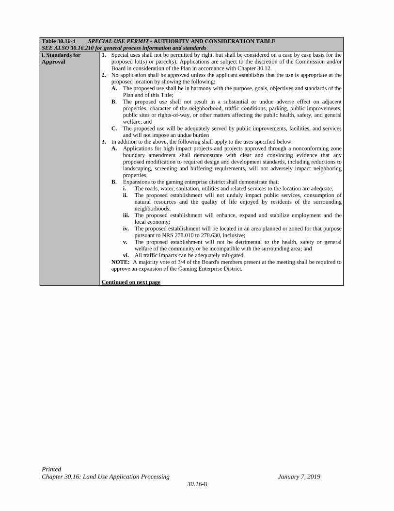
Table 30.16-4 SPECIAL USE PERMIT - AUTHORITY AND CONSIDERATION TABLE SEE ALSO 30.16.210 for general process information and standards i. Standards for Approval
1. Special uses shall not be permitted by right, but shall be considered on a case by case basis for the proposed lot(s) or parcel(s). Applications are subject to the discretion of the Commission and/or Board in consideration of the Plan in accordance with Chapter 30.12.
2. No application shall be approved unless the applicant establishes that the use is appropriate at the proposed location by showing the following: A. The proposed use shall be in harmony with the purpose, goals, objectives and standards of the
Plan and of this Title; B. The proposed use shall not result in a substantial or undue adverse effect on adjacent
properties, character of the neighborhood, traffic conditions, parking, public improvements, public sites or rights-of-way, or other matters affecting the public health, safety, and general welfare; and
C. The proposed use will be adequately served by public improvements, facilities, and services and will not impose an undue burden
3. In addition to the above, the following shall apply to the uses specified below: A. Applications for high impact projects and projects approved through a nonconforming zone
boundary amendment shall demonstrate with clear and convincing evidence that any proposed modification to required design and development standards, including reductions to landscaping, screening and buffering requirements, will not adversely impact neighboring properties.
B. Expansions to the gaming enterprise district shall demonstrate that: i. The roads, water, sanitation, utilities and related services to the location are adequate; ii. The proposed establishment will not unduly impact public services, consumption of
natural resources and the quality of life enjoyed by residents of the surrounding neighborhoods;
iii. The proposed establishment will enhance, expand and stabilize employment and the local economy;
iv. The proposed establishment will be located in an area planned or zoned for that purpose pursuant to NRS 278.010 to 278.630, inclusive;
v. The proposed establishment will not be detrimental to the health, safety or general welfare of the community or be incompatible with the surrounding area; and
vi. All traffic impacts can be adequately mitigated. NOTE: A majority vote of 3/4 of the Board's members present at the meeting shall be required to approve an expansion of the Gaming Enterprise District.
Continued on next page
Printed Chapter 30.16: Land Use Application Processing January 7, 2019
30.16-8a
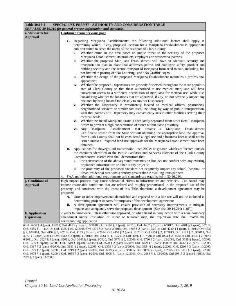
Table 30.16-4 SPECIAL USE PERMIT - AUTHORITY AND CONSIDERATION TABLE SEE ALSO 30.16.210 for general process information and standards i. Standards for Approval
Continued from previous page C. Regarding Marijuana Establishments: the following additional factors shall apply in
determining which, if any, proposed location for a Marijuana Establishment is appropriate and best suited to serve the needs of the residents of Clark County: i. Whether crime in the area poses an undue threat to the security of the proposed
Marijuana Establishment, its products, employees or prospective patrons; ii. Whether the proposed Marijuana Establishment will have an adequate security and
transportation plan in place that addresses patron and employee safety, product and building security and the secure transport of marijuana from seed to sale, including, but not limited to posting of “No Loitering” and “No Graffiti” signs.
iii. Whether the design of the proposed Marijuana Establishment maintains a professional appearance;
iv. Whether the proposed Dispensaries are properly dispersed throughout the more populous area of Clark County so that those authorized to use medical marijuana will have convenient access to a sufficient distribution of marijuana for medical use, while also considering whether the locations that are approved, if any, do not adversely impact any one area by being located too closely to another Dispensary.
v. Whether the Dispensary is proximately located to medical offices, pharmacies, neighborhood services or similar facilities, including by way of public transportation, such that patrons of a Dispensary may conveniently access other facilities serving their medical needs.
vi. Whether the Retail Marijuana Store is adequately separated from other Retail Marijuana Stores to prevent a high concentration of stores within close proximity.
vii. Any Marijuana Establishment that obtains a Marijuana Establishment Certificate/License from the State without obtaining the appropriate land use approval from Clark County shall not be considered a legal use and a business license shall not be issued unless all required land use approvals for the Marijuana Establishment have been obtained.
D. Applications for aboveground transmission lines 200kv or greater, which are located outside the corridors identified in the Public Facilities and Services Element of the Clark County Comprehensive Master Plan shall demonstrate that: i. the construction of the aboveground transmission line des not conflict with any existing
or planned infrastructure or other utility projects; ii. the proximity of the proposed site does not negatively impact any school, hospital, or
urban residential area with a density greater than 2 dwelling units per acre. 4. FAA and other additional requirements and standards are established in 30.16.210.
j. Conditions of Approval
High impact projects may cause substantial effects to infrastructure and services. The Board may impose reasonable conditions that are related and roughly proportional to the proposed use of the property, and consistent with the intent of this Title, therefore, a development agreement may be proposed.
A. Units or other improvements demolished and replaced with a like use will not be included in determining project impacts for purposes of the development agreement
B. A development agreement will ensure provision of necessary improvements to mitigate impacts and adequately serve the proposed development (See also 30.16.210(11)(F))
k. Application Expiration
2 years to commence, unless otherwise approved, or when heard in conjunction with a zone boundary amendment under Resolution of Intent or tentative map, the expiration date shall match the corresponding application
(Ord. 4658 § 4 (part), 1/2019; Ord. 4623 § 3 (part), 9/2018; Ord. 4562 § 2 (part), 2/2018; Ord. 4487 § 2 (part), 6/2017; Ord. 4481 § 4 (part), 5/2017; Ord. 4435 § 1, 11/2016; Ord. 4355 § 16, 12/2015; Ord 4275 § 2 (part), 3/2015; Ord. 4266 § 2 (part), 12/2014; Ord. 4240 § 1 (part), 11/2014; Ord 4239 § 2, 10/2014; Ord. 4194 § 2, 4/2014; Ord. 4193 § 3 (part), 4/2014; Ord 4152 § 2 (part), 12/2013; Ord 4154 § 2, 12/2013; Ord. 4123 § 2 , 9/2013; Ord. 4077 § 3 (part), 2/2013; Ord. 4063 § 3 (part), 11/2012; Ord. 4061 § 1, 10/2012; Ord. 4036 § 7, 7/2012; Ord 4004 § 2, 3/2012; Ord. 3955 § 2 (part), 6/2011; Ord. 3924 § 3 (part), 1/2011; Ord. 3848 § 3 (part), 2/2010; Ord. 3771 § 3, 6/2009; Ord. 3720 § 2 (part), 12/2008; Ord. 3659 § 1(part), 6/2008; Ord. 3635 § 3(part), 6/2008; Ord. 3549 § 3(part), 9/2007; Ord. 3520 § 2 (part), 6/2007; Ord. 3499 § 1 (part), 3/2007; Ord. 3432 § 2 (part), 10/2006; Ord. 3397 § 2 (part), 6/2006; Ord. 3357 § 2 (part), 3/2006; Ord. 3355 § 2 (part), 2/2006; Ord. 3354 § 2 (part), 2/2006; Ord. 3296 § 3 (part), 10/2005; Ord. 3229 § 3 (part), 6/2005; Ord. 3219 § 2 (part), 5/2005; Ord. 3209 § 4 (part), 3/2005; Ord. 3174 § 2 (part), 1/2005; Ord. 3113 § 2 (part), 8/2004; Ord. 3078 § 1 (part), 6/2004; Ord. 3055 § 2 (part), 4/2004; Ord. 3008 §1 (part), 12/2003; Ord. 2988 § 1, 12/2003; Ord 2981§ 2 (part) 11/2003; Ord. 2970 § 2 (part), 11/2003)
Printed Chapter 30.16: Land Use Application Processing January 7, 2019
30.16-9
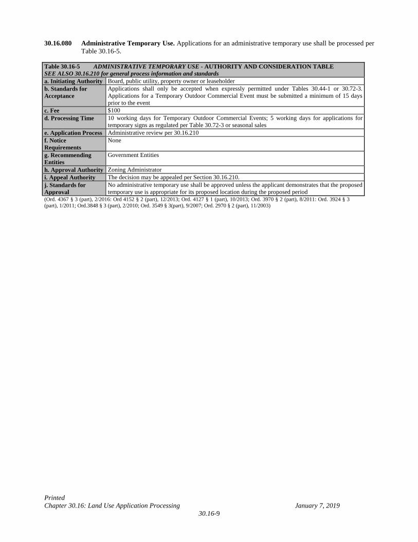
30.16.080 Administrative Temporary Use. Applications for an administrative temporary use shall be processed per Table 30.16-5.
Table 30.16-5 ADMINISTRATIVE TEMPORARY USE - AUTHORITY AND CONSIDERATION TABLE SEE ALSO 30.16.210 for general process information and standards a. Initiating Authority Board, public utility, property owner or leaseholder b. Standards for Acceptance
Applications shall only be accepted when expressly permitted under Tables 30.44-1 or 30.72-3. Applications for a Temporary Outdoor Commercial Event must be submitted a minimum of 15 days prior to the event
c. Fee $100 d. Processing Time 10 working days for Temporary Outdoor Commercial Events; 5 working days for applications for
temporary signs as regulated per Table 30.72-3 or seasonal sales e. Application Process Administrative review per 30.16.210 f. Notice Requirements
None
g. Recommending Entities
Government Entities
h. Approval Authority Zoning Administrator i. Appeal Authority The decision may be appealed per Section 30.16.210. j. Standards for Approval
No administrative temporary use shall be approved unless the applicant demonstrates that the proposed temporary use is appropriate for its proposed location during the proposed period
(Ord. 4367 § 3 (part), 2/2016: Ord 4152 § 2 (part), 12/2013; Ord. 4127 § 1 (part), 10/2013; Ord. 3970 § 2 (part), 8/2011: Ord. 3924 § 3 (part), 1/2011; Ord.3848 § 3 (part), 2/2010; Ord. 3549 § 3(part), 9/2007; Ord. 2970 § 2 (part), 11/2003)
Printed Chapter 30.16: Land Use Application Processing January 7, 2019
30.16-10
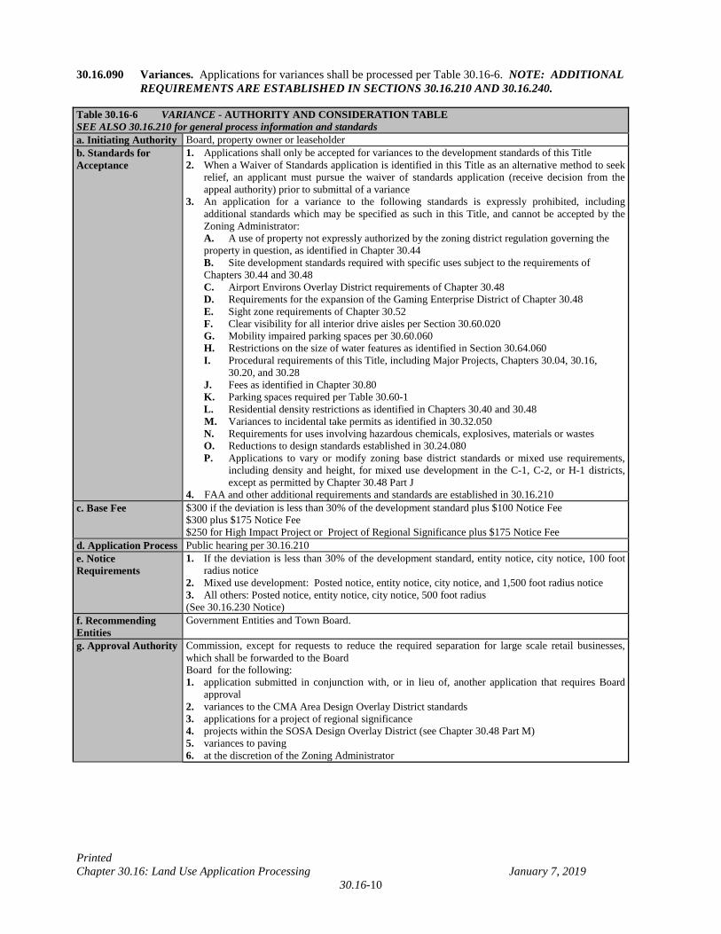
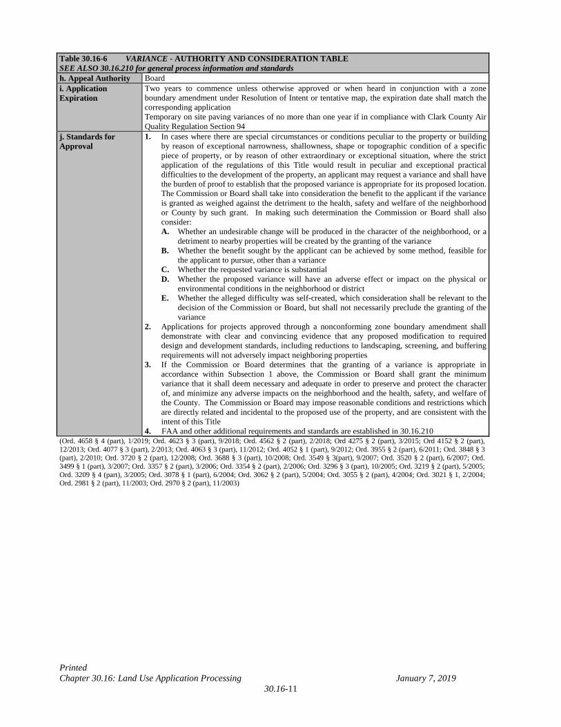
30.16.090 Variances. Applications for variances shall be processed per Table 30.16-6. NOTE: ADDITIONAL REQUIREMENTS ARE ESTABLISHED IN SECTIONS 30.16.210 AND 30.16.240.
Table 30.16-6 VARIANCE - AUTHORITY AND CONSIDERATION TABLE SEE ALSO 30.16.210 for general process information and standards a. Initiating Authority Board, property owner or leaseholder b. Standards for Acceptance
1. Applications shall only be accepted for variances to the development standards of this Title 2. When a Waiver of Standards application is identified in this Title as an alternative method to seek
relief, an applicant must pursue the waiver of standards application (receive decision from the appeal authority) prior to submittal of a variance
3. An application for a variance to the following standards is expressly prohibited, including additional standards which may be specified as such in this Title, and cannot be accepted by the Zoning Administrator:
A. A use of property not expressly authorized by the zoning district regulation governing the property in question, as identified in Chapter 30.44
B. Site development standards required with specific uses subject to the requirements of Chapters 30.44 and 30.48
C. Airport Environs Overlay District requirements of Chapter 30.48 D. Requirements for the expansion of the Gaming Enterprise District of Chapter 30.48 E. Sight zone requirements of Chapter 30.52 F. Clear visibility for all interior drive aisles per Section 30.60.020 G. Mobility impaired parking spaces per 30.60.060 H. Restrictions on the size of water features as identified in Section 30.64.060 I. Procedural requirements of this Title, including Major Projects, Chapters 30.04, 30.16,
30.20, and 30.28 J. Fees as identified in Chapter 30.80 K. Parking spaces required per Table 30.60-1 L. Residential density restrictions as identified in Chapters 30.40 and 30.48 M. Variances to incidental take permits as identified in 30.32.050 N. Requirements for uses involving hazardous chemicals, explosives, materials or wastes O. Reductions to design standards established in 30.24.080 P. Applications to vary or modify zoning base district standards or mixed use requirements,
including density and height, for mixed use development in the C-1, C-2, or H-1 districts, except as permitted by Chapter 30.48 Part J
4. FAA and other additional requirements and standards are established in 30.16.210 c. Base Fee $300 if the deviation is less than 30% of the development standard plus $100 Notice Fee
$300 plus $175 Notice Fee $250 for High Impact Project or Project of Regional Significance plus $175 Notice Fee
d. Application Process Public hearing per 30.16.210 e. Notice Requirements
1. If the deviation is less than 30% of the development standard, entity notice, city notice, 100 foot radius notice
2. Mixed use development: Posted notice, entity notice, city notice, and 1,500 foot radius notice 3. All others: Posted notice, entity notice, city notice, 500 foot radius (See 30.16.230 Notice)
f. Recommending Entities
Government Entities and Town Board.
g. Approval Authority Commission, except for requests to reduce the required separation for large scale retail businesses, which shall be forwarded to the Board Board for the following: 1. application submitted in conjunction with, or in lieu of, another application that requires Board
approval 2. variances to the CMA Area Design Overlay District standards 3. applications for a project of regional significance 4. projects within the SOSA Design Overlay District (see Chapter 30.48 Part M) 5. variances to paving 6. at the discretion of the Zoning Administrator
Printed Chapter 30.16: Land Use Application Processing January 7, 2019
30.16-11
Table 30.16-6 VARIANCE - AUTHORITY AND CONSIDERATION TABLE SEE ALSO 30.16.210 for general process information and standards h. Appeal Authority Board i. Application Expiration
Two years to commence unless otherwise approved or when heard in conjunction with a zone boundary amendment under Resolution of Intent or tentative map, the expiration date shall match the corresponding application Temporary on site paving variances of no more than one year if in compliance with Clark County Air Quality Regulation Section 94
j. Standards for Approval
1. In cases where there are special circumstances or conditions peculiar to the property or building by reason of exceptional narrowness, shallowness, shape or topographic condition of a specific piece of property, or by reason of other extraordinary or exceptional situation, where the strict application of the regulations of this Title would result in peculiar and exceptional practical difficulties to the development of the property, an applicant may request a variance and shall have the burden of proof to establish that the proposed variance is appropriate for its proposed location. The Commission or Board shall take into consideration the benefit to the applicant if the variance is granted as weighed against the detriment to the health, safety and welfare of the neighborhood or County by such grant. In making such determination the Commission or Board shall also consider: A. Whether an undesirable change will be produced in the character of the neighborhood, or a
detriment to nearby properties will be created by the granting of the variance B. Whether the benefit sought by the applicant can be achieved by some method, feasible for
the applicant to pursue, other than a variance C. Whether the requested variance is substantial D. Whether the proposed variance will have an adverse effect or impact on the physical or
environmental conditions in the neighborhood or district E. Whether the alleged difficulty was self-created, which consideration shall be relevant to the
decision of the Commission or Board, but shall not necessarily preclude the granting of the variance
2. Applications for projects approved through a nonconforming zone boundary amendment shall demonstrate with clear and convincing evidence that any proposed modification to required design and development standards, including reductions to landscaping, screening, and buffering requirements will not adversely impact neighboring properties
3. If the Commission or Board determines that the granting of a variance is appropriate in accordance within Subsection 1 above, the Commission or Board shall grant the minimum variance that it shall deem necessary and adequate in order to preserve and protect the character of, and minimize any adverse impacts on the neighborhood and the health, safety, and welfare of the County. The Commission or Board may impose reasonable conditions and restrictions which are directly related and incidental to the proposed use of the property, and are consistent with the intent of this Title
4. FAA and other additional requirements and standards are established in 30.16.210 (Ord. 4658 § 4 (part), 1/2019; Ord. 4623 § 3 (part), 9/2018; Ord. 4562 § 2 (part), 2/2018; Ord 4275 § 2 (part), 3/2015; Ord 4152 § 2 (part), 12/2013; Ord. 4077 § 3 (part), 2/2013; Ord. 4063 § 3 (part), 11/2012; Ord. 4052 § 1 (part), 9/2012; Ord. 3955 § 2 (part), 6/2011; Ord. 3848 § 3 (part), 2/2010; Ord. 3720 § 2 (part), 12/2008; Ord. 3688 § 3 (part), 10/2008; Ord. 3549 § 3(part), 9/2007; Ord. 3520 § 2 (part), 6/2007; Ord. 3499 § 1 (part), 3/2007; Ord. 3357 § 2 (part), 3/2006; Ord. 3354 § 2 (part), 2/2006; Ord. 3296 § 3 (part), 10/2005; Ord. 3219 § 2 (part), 5/2005; Ord. 3209 § 4 (part), 3/2005; Ord. 3078 § 1 (part), 6/2004; Ord. 3062 § 2 (part), 5/2004; Ord. 3055 § 2 (part), 4/2004; Ord. 3021 § 1, 2/2004; Ord. 2981 § 2 (part), 11/2003; Ord. 2970 § 2 (part), 11/2003)
Printed Chapter 30.16: Land Use Application Processing January 7, 2019
30.16-12
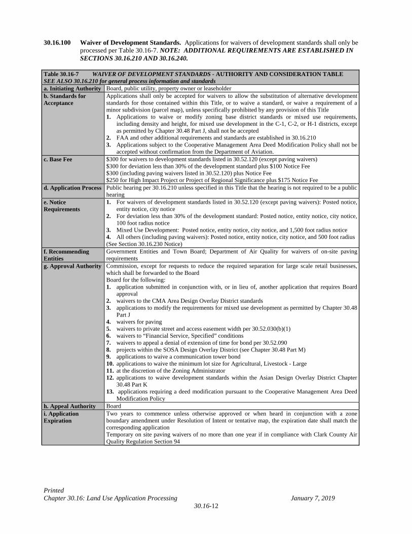
30.16.100 Waiver of Development Standards. Applications for waivers of development standards shall only be processed per Table 30.16-7. NOTE: ADDITIONAL REQUIREMENTS ARE ESTABLISHED IN SECTIONS 30.16.210 AND 30.16.240.
Table 30.16-7 WAIVER OF DEVELOPMENT STANDARDS - AUTHORITY AND CONSIDERATION TABLE SEE ALSO 30.16.210 for general process information and standards a. Initiating Authority Board, public utility, property owner or leaseholder b. Standards for Acceptance
Applications shall only be accepted for waivers to allow the substitution of alternative development standards for those contained within this Title, or to waive a standard, or waive a requirement of a minor subdivision (parcel map), unless specifically prohibited by any provision of this Title 1. Applications to waive or modify zoning base district standards or mixed use requirements,
including density and height, for mixed use development in the C-1, C-2, or H-1 districts, except as permitted by Chapter 30.48 Part J, shall not be accepted
2. FAA and other additional requirements and standards are established in 30.16.210 3. Applications subject to the Cooperative Management Area Deed Modification Policy shall not be
accepted without confirmation from the Department of Aviation. c. Base Fee
$300 for waivers to development standards listed in 30.52.120 (except paving waivers) $300 for deviation less than 30% of the development standard plus $100 Notice Fee $300 (including paving waivers listed in 30.52.120) plus Notice Fee $250 for High Impact Project or Project of Regional Significance plus $175 Notice Fee
d. Application Process Public hearing per 30.16.210 unless specified in this Title that the hearing is not required to be a public hearing
e. Notice Requirements
1. For waivers of development standards listed in 30.52.120 (except paving waivers): Posted notice, entity notice, city notice
2. For deviation less than 30% of the development standard: Posted notice, entity notice, city notice, 100 foot radius notice
3. Mixed Use Development: Posted notice, entity notice, city notice, and 1,500 foot radius notice 4. All others (including paving waivers): Posted notice, entity notice, city notice, and 500 foot radius (See Section 30.16.230 Notice)
f. Recommending Entities
Government Entities and Town Board; Department of Air Quality for waivers of on-site paving requirements
g. Approval Authority Commission, except for requests to reduce the required separation for large scale retail businesses, which shall be forwarded to the Board Board for the following: 1. application submitted in conjunction with, or in lieu of, another application that requires Board
approval 2. waivers to the CMA Area Design Overlay District standards 3. applications to modify the requirements for mixed use development as permitted by Chapter 30.48
Part J 4. waivers for paving 5. waivers to private street and access easement width per 30.52.030(b)(1) 6. waivers to “Financial Service, Specified” conditions 7. waivers to appeal a denial of extension of time for bond per 30.52.090 8. projects within the SOSA Design Overlay District (see Chapter 30.48 Part M) 9. applications to waive a communication tower bond 10. applications to waive the minimum lot size for Agricultural, Livestock - Large 11. at the discretion of the Zoning Administrator 12. applications to waive development standards within the Asian Design Overlay District Chapter
30.48 Part K 13. applications requiring a deed modification pursuant to the Cooperative Management Area Deed
Modification Policy h. Appeal Authority Board i. Application Expiration
Two years to commence unless otherwise approved or when heard in conjunction with a zone boundary amendment under Resolution of Intent or tentative map, the expiration date shall match the corresponding application Temporary on site paving waivers of no more than one year if in compliance with Clark County Air Quality Regulation Section 94
Printed Chapter 30.16: Land Use Application Processing January 7, 2019
30.16-13
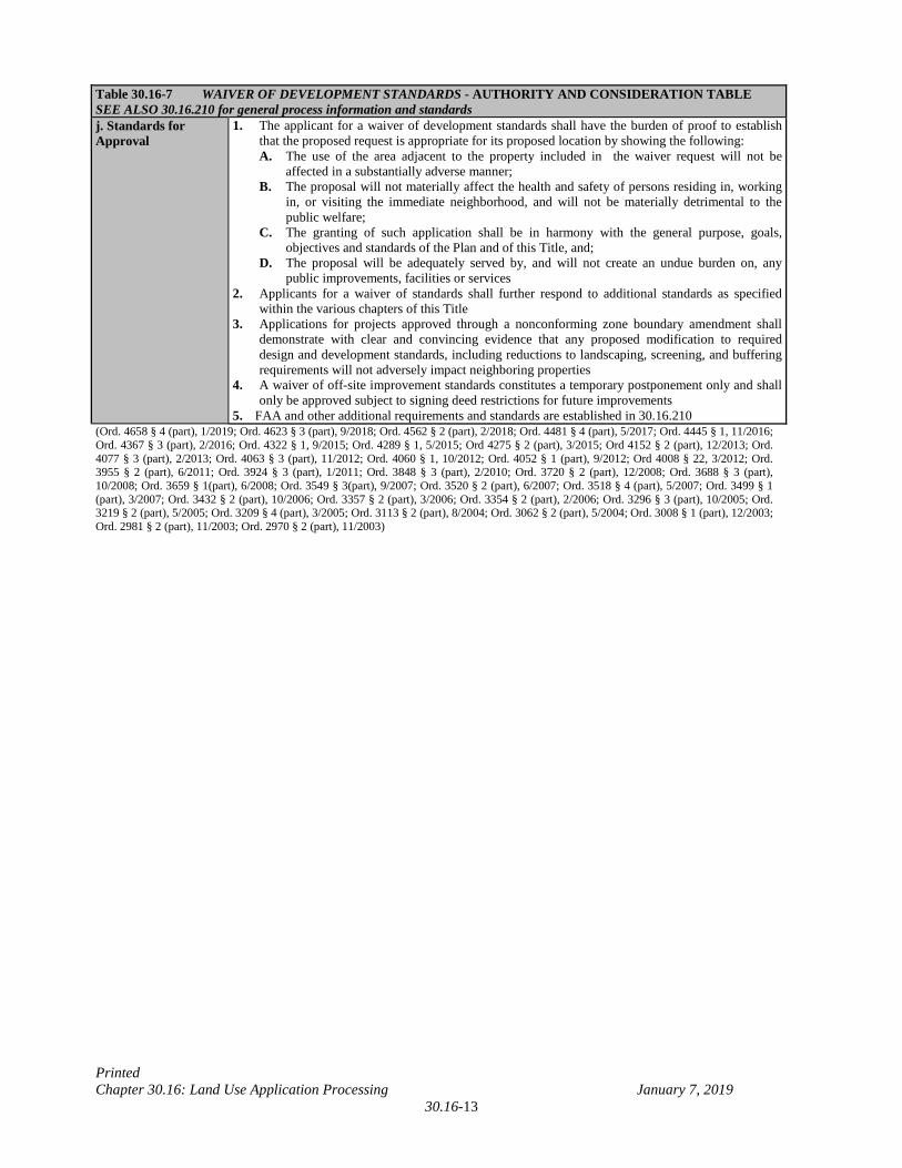
Table 30.16-7 WAIVER OF DEVELOPMENT STANDARDS - AUTHORITY AND CONSIDERATION TABLE SEE ALSO 30.16.210 for general process information and standards j. Standards for Approval
1. The applicant for a waiver of development standards shall have the burden of proof to establish that the proposed request is appropriate for its proposed location by showing the following: A. The use of the area adjacent to the property included in the waiver request will not be
affected in a substantially adverse manner; B. The proposal will not materially affect the health and safety of persons residing in, working
in, or visiting the immediate neighborhood, and will not be materially detrimental to the public welfare;
C. The granting of such application shall be in harmony with the general purpose, goals, objectives and standards of the Plan and of this Title, and;
D. The proposal will be adequately served by, and will not create an undue burden on, any public improvements, facilities or services
2. Applicants for a waiver of standards shall further respond to additional standards as specified within the various chapters of this Title
3. Applications for projects approved through a nonconforming zone boundary amendment shall demonstrate with clear and convincing evidence that any proposed modification to required design and development standards, including reductions to landscaping, screening, and buffering requirements will not adversely impact neighboring properties
4. A waiver of off-site improvement standards constitutes a temporary postponement only and shall only be approved subject to signing deed restrictions for future improvements
5. FAA and other additional requirements and standards are established in 30.16.210 (Ord. 4658 § 4 (part), 1/2019; Ord. 4623 § 3 (part), 9/2018; Ord. 4562 § 2 (part), 2/2018; Ord. 4481 § 4 (part), 5/2017; Ord. 4445 § 1, 11/2016; Ord. 4367 § 3 (part), 2/2016; Ord. 4322 § 1, 9/2015; Ord. 4289 § 1, 5/2015; Ord 4275 § 2 (part), 3/2015; Ord 4152 § 2 (part), 12/2013; Ord. 4077 § 3 (part), 2/2013; Ord. 4063 § 3 (part), 11/2012; Ord. 4060 § 1, 10/2012; Ord. 4052 § 1 (part), 9/2012; Ord 4008 § 22, 3/2012; Ord. 3955 § 2 (part), 6/2011; Ord. 3924 § 3 (part), 1/2011; Ord. 3848 § 3 (part), 2/2010; Ord. 3720 § 2 (part), 12/2008; Ord. 3688 § 3 (part), 10/2008; Ord. 3659 § 1(part), 6/2008; Ord. 3549 § 3(part), 9/2007; Ord. 3520 § 2 (part), 6/2007; Ord. 3518 § 4 (part), 5/2007; Ord. 3499 § 1 (part), 3/2007; Ord. 3432 § 2 (part), 10/2006; Ord. 3357 § 2 (part), 3/2006; Ord. 3354 § 2 (part), 2/2006; Ord. 3296 § 3 (part), 10/2005; Ord. 3219 § 2 (part), 5/2005; Ord. 3209 § 4 (part), 3/2005; Ord. 3113 § 2 (part), 8/2004; Ord. 3062 § 2 (part), 5/2004; Ord. 3008 § 1 (part), 12/2003; Ord. 2981 § 2 (part), 11/2003; Ord. 2970 § 2 (part), 11/2003)
Printed Chapter 30.16: Land Use Application Processing January 7, 2019
30.16-14
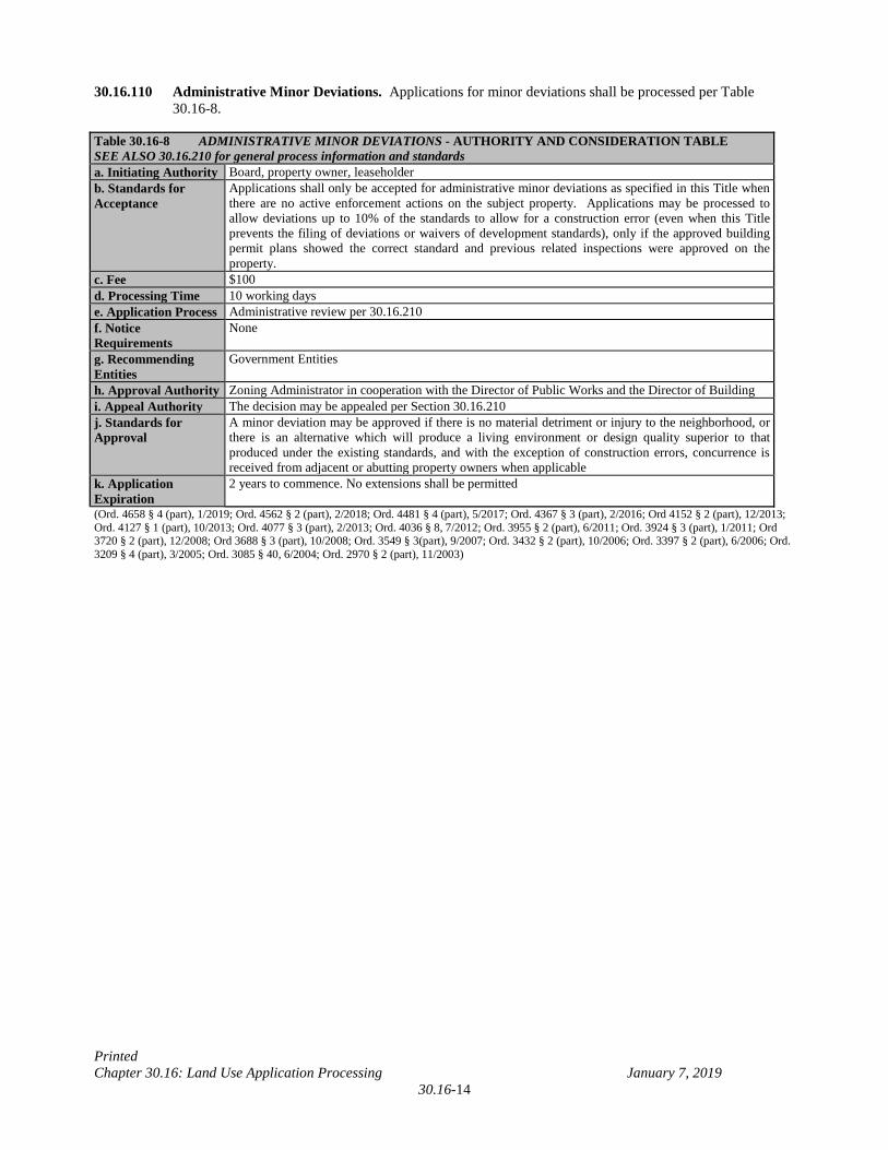
30.16.110 Administrative Minor Deviations. Applications for minor deviations shall be processed per Table 30.16-8.
Table 30.16-8 ADMINISTRATIVE MINOR DEVIATIONS - AUTHORITY AND CONSIDERATION TABLE SEE ALSO 30.16.210 for general process information and standards a. Initiating Authority Board, property owner, leaseholder b. Standards for Acceptance
Applications shall only be accepted for administrative minor deviations as specified in this Title when there are no active enforcement actions on the subject property. Applications may be processed to allow deviations up to 10% of the standards to allow for a construction error (even when this Title prevents the filing of deviations or waivers of development standards), only if the approved building permit plans showed the correct standard and previous related inspections were approved on the property.
c. Fee $100 d. Processing Time 10 working days e. Application Process Administrative review per 30.16.210 f. Notice Requirements
None
g. Recommending Entities
Government Entities
h. Approval Authority Zoning Administrator in cooperation with the Director of Public Works and the Director of Building i. Appeal Authority The decision may be appealed per Section 30.16.210 j. Standards for Approval
A minor deviation may be approved if there is no material detriment or injury to the neighborhood, or there is an alternative which will produce a living environment or design quality superior to that produced under the existing standards, and with the exception of construction errors, concurrence is received from adjacent or abutting property owners when applicable
k. Application Expiration
2 years to commence. No extensions shall be permitted
(Ord. 4658 § 4 (part), 1/2019; Ord. 4562 § 2 (part), 2/2018; Ord. 4481 § 4 (part), 5/2017; Ord. 4367 § 3 (part), 2/2016; Ord 4152 § 2 (part), 12/2013; Ord. 4127 § 1 (part), 10/2013; Ord. 4077 § 3 (part), 2/2013; Ord. 4036 § 8, 7/2012; Ord. 3955 § 2 (part), 6/2011; Ord. 3924 § 3 (part), 1/2011; Ord 3720 § 2 (part), 12/2008; Ord 3688 § 3 (part), 10/2008; Ord. 3549 § 3(part), 9/2007; Ord. 3432 § 2 (part), 10/2006; Ord. 3397 § 2 (part), 6/2006; Ord. 3209 § 4 (part), 3/2005; Ord. 3085 § 40, 6/2004; Ord. 2970 § 2 (part), 11/2003)
Printed Chapter 30.16: Land Use Application Processing January 7, 2019
30.16-15
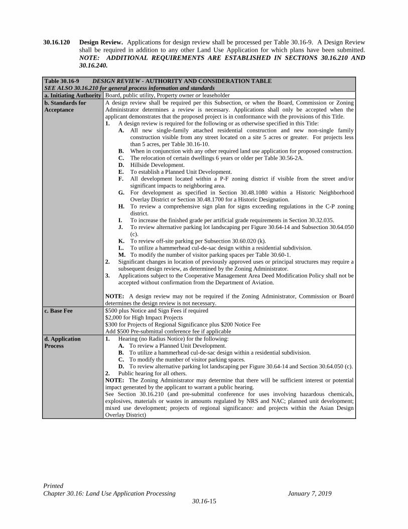
30.16.120 Design Review. Applications for design review shall be processed per Table 30.16-9. A Design Review shall be required in addition to any other Land Use Application for which plans have been submitted. NOTE: ADDITIONAL REQUIREMENTS ARE ESTABLISHED IN SECTIONS 30.16.210 AND 30.16.240.
Table 30.16-9 DESIGN REVIEW - AUTHORITY AND CONSIDERATION TABLE SEE ALSO 30.16.210 for general process information and standards a. Initiating Authority Board, public utility, Property owner or leaseholder b. Standards for Acceptance
A design review shall be required per this Subsection, or when the Board, Commission or Zoning Administrator determines a review is necessary. Applications shall only be accepted when the applicant demonstrates that the proposed project is in conformance with the provisions of this Title. 1. A design review is required for the following or as otherwise specified in this Title:
A. All new single-family attached residential construction and new non-single family construction visible from any street located on a site 5 acres or greater. For projects less than 5 acres, per Table 30.16-10.
B. When in conjunction with any other required land use application for proposed construction. C. The relocation of certain dwellings 6 years or older per Table 30.56-2A. D. Hillside Development. E. To establish a Planned Unit Development. F. All development located within a P-F zoning district if visible from the street and/or
significant impacts to neighboring area. G. For development as specified in Section 30.48.1080 within a Historic Neighborhood
Overlay District or Section 30.48.1700 for a Historic Designation. H. To review a comprehensive sign plan for signs exceeding regulations in the C-P zoning
district. I. To increase the finished grade per artificial grade requirements in Section 30.32.035. J. To review alternative parking lot landscaping per Figure 30.64-14 and Subsection 30.64.050
(c). K. To review off-site parking per Subsection 30.60.020 (k). L. To utilize a hammerhead cul-de-sac design within a residential subdivision. M. To modify the number of visitor parking spaces per Table 30.60-1.
2. Significant changes in location of previously approved uses or principal structures may require a subsequent design review, as determined by the Zoning Administrator.
3. Applications subject to the Cooperative Management Area Deed Modification Policy shall not be accepted without confirmation from the Department of Aviation.
NOTE: A design review may not be required if the Zoning Administrator, Commission or Board determines the design review is not necessary.
c. Base Fee $500 plus Notice and Sign Fees if required $2,000 for High Impact Projects $300 for Projects of Regional Significance plus $200 Notice Fee Add $500 Pre-submittal conference fee if applicable
d. Application Process
1. Hearing (no Radius Notice) for the following: A. To review a Planned Unit Development. B. To utilize a hammerhead cul-de-sac design within a residential subdivision. C. To modify the number of visitor parking spaces. D. To review alternative parking lot landscaping per Figure 30.64-14 and Section 30.64.050 (c). 2. Public hearing for all others. NOTE: The Zoning Administrator may determine that there will be sufficient interest or potential impact generated by the applicant to warrant a public hearing. See Section 30.16.210 (and pre-submittal conference for uses involving hazardous chemicals, explosives, materials or wastes in amounts regulated by NRS and NAC; planned unit development; mixed use development; projects of regional significance: and projects within the Asian Design Overlay District)
Printed Chapter 30.16: Land Use Application Processing January 7, 2019
30.16-16
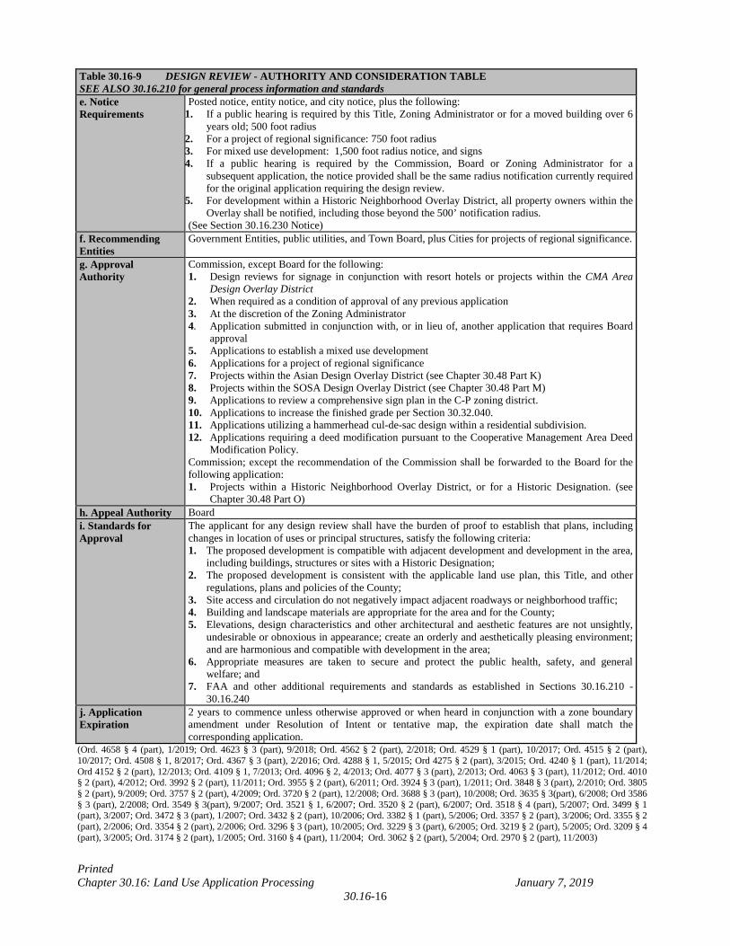
Table 30.16-9 DESIGN REVIEW - AUTHORITY AND CONSIDERATION TABLE SEE ALSO 30.16.210 for general process information and standards e. Notice Requirements
Posted notice, entity notice, and city notice, plus the following: 1. If a public hearing is required by this Title, Zoning Administrator or for a moved building over 6
years old; 500 foot radius 2. For a project of regional significance: 750 foot radius 3. For mixed use development: 1,500 foot radius notice, and signs 4. If a public hearing is required by the Commission, Board or Zoning Administrator for a
subsequent application, the notice provided shall be the same radius notification currently required for the original application requiring the design review.
5. For development within a Historic Neighborhood Overlay District, all property owners within the Overlay shall be notified, including those beyond the 500’ notification radius.
(See Section 30.16.230 Notice) f. Recommending Entities
Government Entities, public utilities, and Town Board, plus Cities for projects of regional significance.
g. Approval Authority
Commission, except Board for the following: 1. Design reviews for signage in conjunction with resort hotels or projects within the CMA Area
Design Overlay District 2. When required as a condition of approval of any previous application 3. At the discretion of the Zoning Administrator 4. Application submitted in conjunction with, or in lieu of, another application that requires Board
approval 5. Applications to establish a mixed use development 6. Applications for a project of regional significance 7. Projects within the Asian Design Overlay District (see Chapter 30.48 Part K) 8. Projects within the SOSA Design Overlay District (see Chapter 30.48 Part M) 9. Applications to review a comprehensive sign plan in the C-P zoning district. 10. Applications to increase the finished grade per Section 30.32.040. 11. Applications utilizing a hammerhead cul-de-sac design within a residential subdivision. 12. Applications requiring a deed modification pursuant to the Cooperative Management Area Deed
Modification Policy. Commission; except the recommendation of the Commission shall be forwarded to the Board for the following application: 1. Projects within a Historic Neighborhood Overlay District, or for a Historic Designation. (see
Chapter 30.48 Part O) h. Appeal Authority Board i. Standards for Approval
The applicant for any design review shall have the burden of proof to establish that plans, including changes in location of uses or principal structures, satisfy the following criteria: 1. The proposed development is compatible with adjacent development and development in the area,
including buildings, structures or sites with a Historic Designation; 2. The proposed development is consistent with the applicable land use plan, this Title, and other
regulations, plans and policies of the County; 3. Site access and circulation do not negatively impact adjacent roadways or neighborhood traffic; 4. Building and landscape materials are appropriate for the area and for the County; 5. Elevations, design characteristics and other architectural and aesthetic features are not unsightly,
undesirable or obnoxious in appearance; create an orderly and aesthetically pleasing environment; and are harmonious and compatible with development in the area;
6. Appropriate measures are taken to secure and protect the public health, safety, and general welfare; and
7. FAA and other additional requirements and standards as established in Sections 30.16.210 -30.16.240
j. Application Expiration
2 years to commence unless otherwise approved or when heard in conjunction with a zone boundary amendment under Resolution of Intent or tentative map, the expiration date shall match the corresponding application.
(Ord. 4658 § 4 (part), 1/2019; Ord. 4623 § 3 (part), 9/2018; Ord. 4562 § 2 (part), 2/2018; Ord. 4529 § 1 (part), 10/2017; Ord. 4515 § 2 (part), 10/2017; Ord. 4508 § 1, 8/2017; Ord. 4367 § 3 (part), 2/2016; Ord. 4288 § 1, 5/2015; Ord 4275 § 2 (part), 3/2015; Ord. 4240 § 1 (part), 11/2014; Ord 4152 § 2 (part), 12/2013; Ord. 4109 § 1, 7/2013; Ord. 4096 § 2, 4/2013; Ord. 4077 § 3 (part), 2/2013; Ord. 4063 § 3 (part), 11/2012; Ord. 4010 § 2 (part), 4/2012; Ord. 3992 § 2 (part), 11/2011; Ord. 3955 § 2 (part), 6/2011; Ord. 3924 § 3 (part), 1/2011; Ord. 3848 § 3 (part), 2/2010; Ord. 3805 § 2 (part), 9/2009; Ord. 3757 § 2 (part), 4/2009; Ord. 3720 § 2 (part), 12/2008; Ord. 3688 § 3 (part), 10/2008; Ord. 3635 § 3(part), 6/2008; Ord 3586 § 3 (part), 2/2008; Ord. 3549 § 3(part), 9/2007; Ord. 3521 § 1, 6/2007; Ord. 3520 § 2 (part), 6/2007; Ord. 3518 § 4 (part), 5/2007; Ord. 3499 § 1 (part), 3/2007; Ord. 3472 § 3 (part), 1/2007; Ord. 3432 § 2 (part), 10/2006; Ord. 3382 § 1 (part), 5/2006; Ord. 3357 § 2 (part), 3/2006; Ord. 3355 § 2 (part), 2/2006; Ord. 3354 § 2 (part), 2/2006; Ord. 3296 § 3 (part), 10/2005; Ord. 3229 § 3 (part), 6/2005; Ord. 3219 § 2 (part), 5/2005; Ord. 3209 § 4 (part), 3/2005; Ord. 3174 § 2 (part), 1/2005; Ord. 3160 § 4 (part), 11/2004; Ord. 3062 § 2 (part), 5/2004; Ord. 2970 § 2 (part), 11/2003)
Printed Chapter 30.16: Land Use Application Processing January 7, 2019
30.16-17
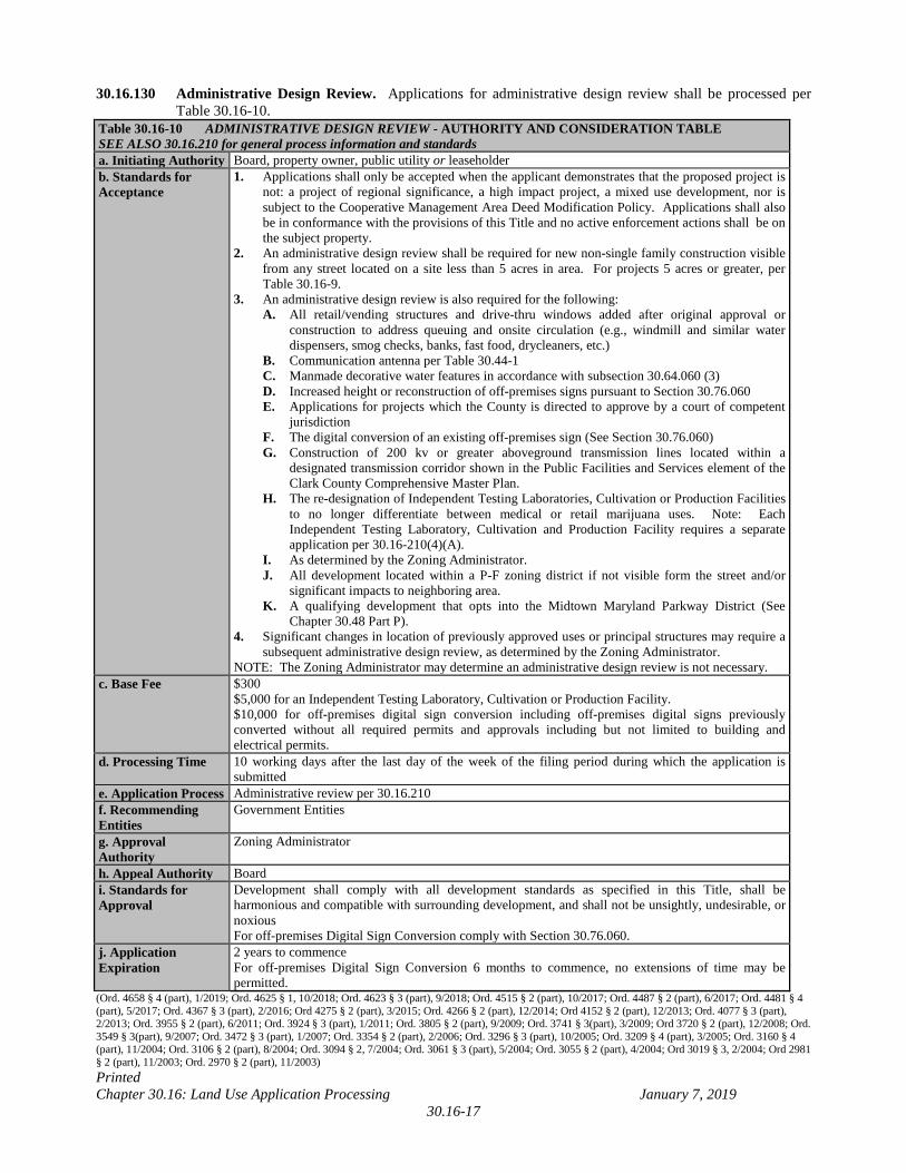
30.16.130 Administrative Design Review. Applications for administrative design review shall be processed per Table 30.16-10.
Table 30.16-10 ADMINISTRATIVE DESIGN REVIEW - AUTHORITY AND CONSIDERATION TABLE SEE ALSO 30.16.210 for general process information and standards a. Initiating Authority Board, property owner, public utility or leaseholder b. Standards for Acceptance
1. Applications shall only be accepted when the applicant demonstrates that the proposed project is not: a project of regional significance, a high impact project, a mixed use development, nor is subject to the Cooperative Management Area Deed Modification Policy. Applications shall also be in conformance with the provisions of this Title and no active enforcement actions shall be on the subject property.
2. An administrative design review shall be required for new non-single family construction visible from any street located on a site less than 5 acres in area. For projects 5 acres or greater, per Table 30.16-9.
3. An administrative design review is also required for the following: A. All retail/vending structures and drive-thru windows added after original approval or
construction to address queuing and onsite circulation (e.g., windmill and similar water dispensers, smog checks, banks, fast food, drycleaners, etc.)
B. Communication antenna per Table 30.44-1 C. Manmade decorative water features in accordance with subsection 30.64.060 (3) D. Increased height or reconstruction of off-premises signs pursuant to Section 30.76.060 E. Applications for projects which the County is directed to approve by a court of competent
jurisdiction F. The digital conversion of an existing off-premises sign (See Section 30.76.060) G. Construction of 200 kv or greater aboveground transmission lines located within a
designated transmission corridor shown in the Public Facilities and Services element of the Clark County Comprehensive Master Plan.
H. The re-designation of Independent Testing Laboratories, Cultivation or Production Facilities to no longer differentiate between medical or retail marijuana uses. Note: Each Independent Testing Laboratory, Cultivation and Production Facility requires a separate application per 30.16-210(4)(A).
I. As determined by the Zoning Administrator. J. All development located within a P-F zoning district if not visible form the street and/or
significant impacts to neighboring area. K. A qualifying development that opts into the Midtown Maryland Parkway District (See
Chapter 30.48 Part P). 4. Significant changes in location of previously approved uses or principal structures may require a
subsequent administrative design review, as determined by the Zoning Administrator. NOTE: The Zoning Administrator may determine an administrative design review is not necessary.
c. Base Fee $300 $5,000 for an Independent Testing Laboratory, Cultivation or Production Facility. $10,000 for off-premises digital sign conversion including off-premises digital signs previously converted without all required permits and approvals including but not limited to building and electrical permits.
d. Processing Time 10 working days after the last day of the week of the filing period during which the application is submitted
e. Application Process Administrative review per 30.16.210 f. Recommending Entities
Government Entities
g. Approval Authority
Zoning Administrator
h. Appeal Authority Board i. Standards for Approval
Development shall comply with all development standards as specified in this Title, shall be harmonious and compatible with surrounding development, and shall not be unsightly, undesirable, or noxious For off-premises Digital Sign Conversion comply with Section 30.76.060.
j. Application Expiration
2 years to commence For off-premises Digital Sign Conversion 6 months to commence, no extensions of time may be permitted.
(Ord. 4658 § 4 (part), 1/2019; Ord. 4625 § 1, 10/2018; Ord. 4623 § 3 (part), 9/2018; Ord. 4515 § 2 (part), 10/2017; Ord. 4487 § 2 (part), 6/2017; Ord. 4481 § 4 (part), 5/2017; Ord. 4367 § 3 (part), 2/2016; Ord 4275 § 2 (part), 3/2015; Ord. 4266 § 2 (part), 12/2014; Ord 4152 § 2 (part), 12/2013; Ord. 4077 § 3 (part), 2/2013; Ord. 3955 § 2 (part), 6/2011; Ord. 3924 § 3 (part), 1/2011; Ord. 3805 § 2 (part), 9/2009; Ord. 3741 § 3(part), 3/2009; Ord 3720 § 2 (part), 12/2008; Ord. 3549 § 3(part), 9/2007; Ord. 3472 § 3 (part), 1/2007; Ord. 3354 § 2 (part), 2/2006; Ord. 3296 § 3 (part), 10/2005; Ord. 3209 § 4 (part), 3/2005; Ord. 3160 § 4 (part), 11/2004; Ord. 3106 § 2 (part), 8/2004; Ord. 3094 § 2, 7/2004; Ord. 3061 § 3 (part), 5/2004; Ord. 3055 § 2 (part), 4/2004; Ord 3019 § 3, 2/2004; Ord 2981 § 2 (part), 11/2003; Ord. 2970 § 2 (part), 11/2003)
Printed Chapter 30.16: Land Use Application Processing January 7, 2019
30.16-18
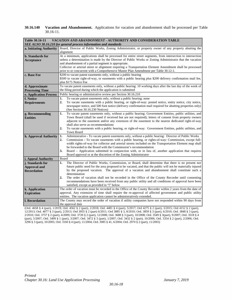
30.16.140 Vacation and Abandonment. Applications for vacation and abandonment shall be processed per Table
30.16-11. Table 30.16-11 VACATION AND ABANDONMENT - AUTHORITY AND CONSIDERATION TABLE SEE ALSO 30.16.210 for general process information and standards a. Initiating Authority Board, Director of Public Works, Zoning Administrator, or property owner of any property abutting the
alignment b. Standards for Acceptance
At a minimum, applications shall be processed for entire street segments, from intersection to intersection unless a determination is made by the Director of Public Works or Zoning Administrator that the vacation and abandonment of a partial segment is appropriate. Collector or arterial street or alignment requiring a Transportation Element Amendment shall be processed prior to or concurrent with a Comprehensive Master Plan Amendment per Table 30.12-1.
c. Base Fee
$200 to vacate patent easements only, without a public hearing $500 to vacate right-of-way, or easements with a public hearing plus $200 delivery confirmation mail fee, plus $175 Notice Fee
d. Approximate Processing Time
To vacate patent easements only, without a public hearing: 10 working days after the last day of the week of the filing period during which the application is submitted
e. Application Process Public hearing or administrative review per Section 30.16.210 f. Notice Requirements
1. To vacate patent easements only, without a public hearing: none 2. To vacate easements with a public hearing, or right-of-way: posted notice, entity notice, city notice,
newspaper notice, and 500 foot notice (delivery confirmation mail required for abutting properties only) (See Section 30.16.230 Notices)
g. Recommending Entities
1. To vacate patent easements only, without a public hearing: Government Entities, public utilities, and Town Board (shall be used if received but are not required); letters of consent from property owners adjacent to the easement and/or any extension of the easement to the nearest dedicated right-of-way shall also serve as recommendations
2. To vacate easements with a public hearing, or right-of-way: Government Entities, public utilities, and Town Board
h. Approval Authority 1. Administrative - To vacate patent easements only, without a public hearing: Director of Public Works 2. Commission - To vacate easements with a public hearing, or rights-of-way: Commission, except full-
width rights-of-way for collector and arterial streets included on the Transportation Element map shall be forwarded to the Board with the Commission’s recommendation
3. Board – Application submitted in conjunction with, or in lieu of, another application that requires Board approval or at the discretion of the Zoning Administrator
i. Appeal Authority Board j. Standards for Approval and Recordation
1. The Director of Public Works, Commission, or Board, shall determine that there is no present nor future public need for the area proposed to be vacated, and that the public will not be materially injured by the proposed vacation. The approval of a vacation and abandonment shall constitute such a determination
2. The order of vacation shall not be recorded in the Office of the County Recorder until consenting recommendations have been received from any public utility and all conditions of approval have been satisfied, except as provided in “l” below
k. Application Expiration
The order of vacation must be recorded in the Office of the County Recorder within 2 years from the date of approval. Any extension of time shall require the re-approval of affected government and public utility entities. The vacation application cannot be administratively extended.
l. Recordation The County may record the order of vacation if utility companies have not responded within 90 days from the approval date
(Ord. 4658 § 4 (part), 1/2019; Ord. 4562 § 2 (part), 2/2018; Ord. 4481 § 4 (part), 5/2017; Ord 4275 § 2 (part), 3/2015; Ord 4152 § 2 (part), 12/2013; Ord. 4077 § 3 (part), 2/2013; Ord 3955 § 2 (part) 6/2011; Ord 3885 § 3, 8/2010; Ord. 3859 § 3 (part), 6/2010; Ord. 3848 § 3 (part), 2/2010; Ord. 3757 § 2 (part), 4/2009; Ord. 3720 § 2 (part), 12/2008; Ord. 3688 § 3 (part), 10/2008; Ord. 3549 § 3(part), 9/2007; Ord. 3518 § 4 (part), 5/2007; Ord. 3499 § 1 (part), 3/2007; Ord. 3472 § 3 (part), 1/2007; Ord. 3432 § 2 (part), 10/2006; Ord. 3354 § 2 (part), 2/2006; Ord. 3296 § 3 (part), 10/2005; Ord. 3160 § 4 (part), 11/2004; Ord. 3085 § 41, 6/2004; Ord. 2970 § 2 (part), 11/2003)
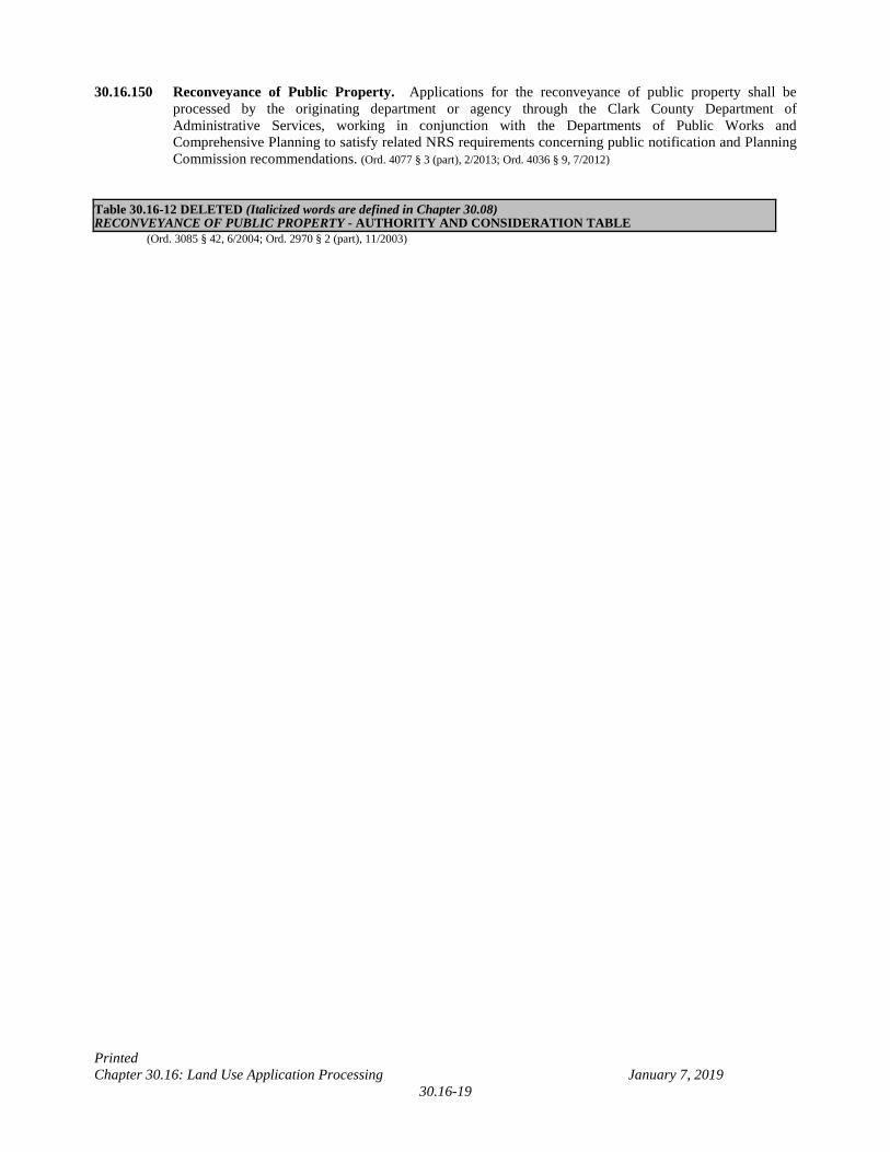
Printed Chapter 30.16: Land Use Application Processing January 7, 2019
30.16-19
30.16.150 Reconveyance of Public Property. Applications for the reconveyance of public property shall be processed by the originating department or agency through the Clark County Department of Administrative Services, working in conjunction with the Departments of Public Works and Comprehensive Planning to satisfy related NRS requirements concerning public notification and Planning Commission recommendations. (Ord. 4077 § 3 (part), 2/2013; Ord. 4036 § 9, 7/2012)
Table 30.16-12 DELETED (Italicized words are defined in Chapter 30.08) RECONVEYANCE OF PUBLIC PROPERTY - AUTHORITY AND CONSIDERATION TABLE
(Ord. 3085 § 42, 6/2004; Ord. 2970 § 2 (part), 11/2003)
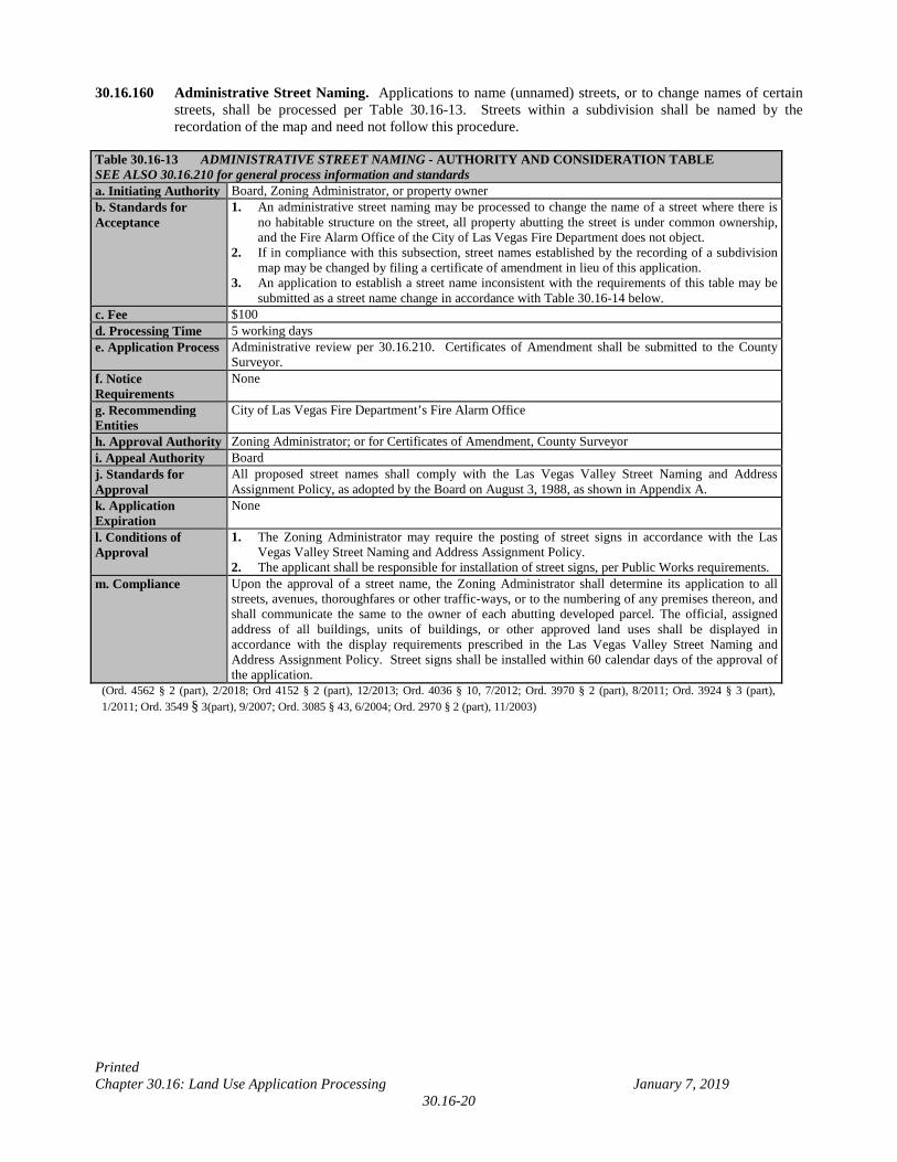
Printed Chapter 30.16: Land Use Application Processing January 7, 2019
30.16-20
30.16.160 Administrative Street Naming. Applications to name (unnamed) streets, or to change names of certain streets, shall be processed per Table 30.16-13. Streets within a subdivision shall be named by the recordation of the map and need not follow this procedure.
Table 30.16-13 ADMINISTRATIVE STREET NAMING - AUTHORITY AND CONSIDERATION TABLE SEE ALSO 30.16.210 for general process information and standards a. Initiating Authority Board, Zoning Administrator, or property owner b. Standards for Acceptance
1. An administrative street naming may be processed to change the name of a street where there is no habitable structure on the street, all property abutting the street is under common ownership, and the Fire Alarm Office of the City of Las Vegas Fire Department does not object.
2. If in compliance with this subsection, street names established by the recording of a subdivision map may be changed by filing a certificate of amendment in lieu of this application.
3. An application to establish a street name inconsistent with the requirements of this table may be submitted as a street name change in accordance with Table 30.16-14 below.
c. Fee $100 d. Processing Time 5 working days e. Application Process Administrative review per 30.16.210. Certificates of Amendment shall be submitted to the County
Surveyor. f. Notice Requirements
None
g. Recommending Entities
City of Las Vegas Fire Department’s Fire Alarm Office
h. Approval Authority Zoning Administrator; or for Certificates of Amendment, County Surveyor i. Appeal Authority Board j. Standards for Approval
All proposed street names shall comply with the Las Vegas Valley Street Naming and Address Assignment Policy, as adopted by the Board on August 3, 1988, as shown in Appendix A.
k. Application Expiration
None
l. Conditions of Approval
1. The Zoning Administrator may require the posting of street signs in accordance with the Las Vegas Valley Street Naming and Address Assignment Policy.
2. The applicant shall be responsible for installation of street signs, per Public Works requirements. m. Compliance Upon the approval of a street name, the Zoning Administrator shall determine its application to all
streets, avenues, thoroughfares or other traffic-ways, or to the numbering of any premises thereon, and shall communicate the same to the owner of each abutting developed parcel. The official, assigned address of all buildings, units of buildings, or other approved land uses shall be displayed in accordance with the display requirements prescribed in the Las Vegas Valley Street Naming and Address Assignment Policy. Street signs shall be installed within 60 calendar days of the approval of the application.
(Ord. 4562 § 2 (part), 2/2018; Ord 4152 § 2 (part), 12/2013; Ord. 4036 § 10, 7/2012; Ord. 3970 § 2 (part), 8/2011; Ord. 3924 § 3 (part), 1/2011; Ord. 3549 § 3(part), 9/2007; Ord. 3085 § 43, 6/2004; Ord. 2970 § 2 (part), 11/2003)
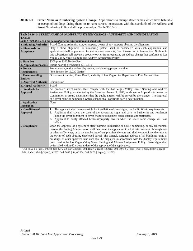
Printed Chapter 30.16: Land Use Application Processing January 7, 2019
30.16-21
30.16.170 Street Name or Numbering System Change. Applications to change street names which have habitable or occupied buildings facing them, or to name streets inconsistent with the standards of the Address and Street Numbering Policy shall be processed per Table 30.16-14.
Table 30.16-14 STREET NAME OR NUMBERING SYSTEM CHANGE - AUTHORITY AND CONSIDERATION TABLE SEE ALSO 30.16.210 for general process information and standards a. Initiating Authority Board, Zoning Administrator, or property owner of any property abutting the alignment b. Standards for Acceptance
Only 1 street alignment, or numbering system, shall be considered with each application, and applications shall be processed for entire street segments, from intersection to intersection. Nothing in this subsection shall prevent a property owner from requesting an address change that conforms to Las Vegas Valley Street Naming and Address Assignment Policy.
c. Base Fee $300 plus $100 Notice Fee d. Application Process Public hearing per Section 30.16.210 e. Notice Requirements
Posted notice, entity notice, city notice, and abutting property notice (See Section 30.16.230 Notice)
f. Recommending Entities
Government Entities, Town Board, and City of Las Vegas Fire Department’s Fire Alarm Office
g. Approval Authority Commission h. Appeal Authority Board i. Standards for Approval
All proposed street names shall comply with the Las Vegas Valley Street Naming and Address Assignment Policy, as adopted by the Board on August 3, 1988, as shown in Appendix A unless the Commission or Board determines that the public interest will be served by the change. The approval of a street name or numbering system change shall constitute such a determination.
j. Application Expiration
None
k. Conditions of Approval
1. The applicant shall be responsible for installation of street signs, per Public Works requirements. 2. Applicant shall cover the costs of the advertising signs and costs to businesses and residences
along the street alignment to cover changes to business cards, checks, and stationary. 3. Applicant to notify affected business/property owners when the street name change will take
effect. l. Compliance Upon the approval of a system of street naming, numbering or house numbering, or any amendment
thereto, the Zoning Administrator shall determine its application to all streets, avenues, thoroughfares or other traffic-ways, or to the numbering of any premises thereon, and shall communicate the same to the owner of each abutting developed parcel. The official, assigned address of all buildings, units of buildings, or other approved land uses shall be displayed in accordance with the display requirements prescribed in the Las Vegas Valley Street Naming and Address Assignment Policy. Street signs shall be installed within 60 calendar days of the approval of the application.
(Ord. 4562 § 2 (part), 2/2018; Ord 4275 § 2 (part), 3/2015; Ord 4152 § 2 (part), 12/2013; Ord. 3970 § 2 (part), 8/2011; Ord. 3848 § 3 (part), 2/2010; Ord. 3549 § 3(part), 9/2007; Ord. 3085 § 44, 6/2004; Ord. 2970 § 2 (part), 11/2003)
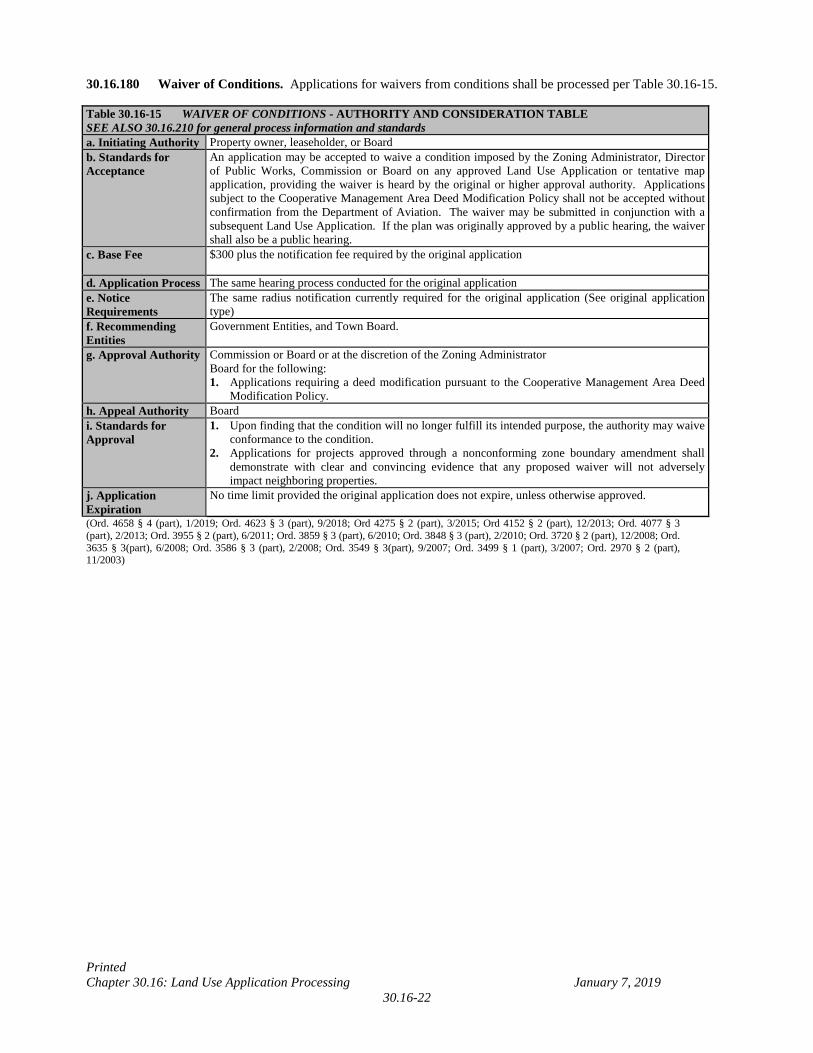
Printed Chapter 30.16: Land Use Application Processing January 7, 2019
30.16-22
30.16.180 Waiver of Conditions. Applications for waivers from conditions shall be processed per Table 30.16-15. Table 30.16-15 WAIVER OF CONDITIONS - AUTHORITY AND CONSIDERATION TABLE SEE ALSO 30.16.210 for general process information and standards a. Initiating Authority Property owner, leaseholder, or Board b. Standards for Acceptance
An application may be accepted to waive a condition imposed by the Zoning Administrator, Director of Public Works, Commission or Board on any approved Land Use Application or tentative map application, providing the waiver is heard by the original or higher approval authority. Applications subject to the Cooperative Management Area Deed Modification Policy shall not be accepted without confirmation from the Department of Aviation. The waiver may be submitted in conjunction with a subsequent Land Use Application. If the plan was originally approved by a public hearing, the waiver shall also be a public hearing.
c. Base Fee $300 plus the notification fee required by the original application
d. Application Process The same hearing process conducted for the original application e. Notice Requirements
The same radius notification currently required for the original application (See original application type)
f. Recommending Entities
Government Entities, and Town Board.
g. Approval Authority Commission or Board or at the discretion of the Zoning Administrator Board for the following: 1. Applications requiring a deed modification pursuant to the Cooperative Management Area Deed
Modification Policy. h. Appeal Authority Board i. Standards for Approval
1. Upon finding that the condition will no longer fulfill its intended purpose, the authority may waive conformance to the condition.
2. Applications for projects approved through a nonconforming zone boundary amendment shall demonstrate with clear and convincing evidence that any proposed waiver will not adversely impact neighboring properties.
j. Application Expiration
No time limit provided the original application does not expire, unless otherwise approved.
(Ord. 4658 § 4 (part), 1/2019; Ord. 4623 § 3 (part), 9/2018; Ord 4275 § 2 (part), 3/2015; Ord 4152 § 2 (part), 12/2013; Ord. 4077 § 3 (part), 2/2013; Ord. 3955 § 2 (part), 6/2011; Ord. 3859 § 3 (part), 6/2010; Ord. 3848 § 3 (part), 2/2010; Ord. 3720 § 2 (part), 12/2008; Ord. 3635 § 3(part), 6/2008; Ord. 3586 § 3 (part), 2/2008; Ord. 3549 § 3(part), 9/2007; Ord. 3499 § 1 (part), 3/2007; Ord. 2970 § 2 (part), 11/2003)
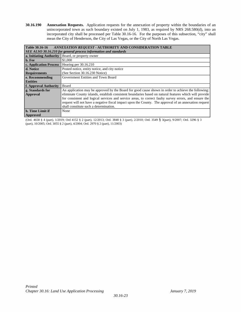
Printed Chapter 30.16: Land Use Application Processing January 7, 2019
30.16-23
30.16.190 Annexation Requests. Application requests for the annexation of property within the boundaries of an unincorporated town as such boundary existed on July 1, 1983, as required by NRS 268.580(d), into an incorporated city shall be processed per Table 30.16-16. For the purposes of this subsection, “city” shall mean the City of Henderson, the City of Las Vegas, or the City of North Las Vegas.
Table 30.16-16 ANNEXATION REQUEST - AUTHORITY AND CONSIDERATION TABLE SEE ALSO 30.16.210 for general process information and standards a. Initiating Authority Board, or property owner b. Fee $1,000 c. Application Process Hearing per 30.16.210 d. Notice Requirements
Posted notice, entity notice, and city notice (See Section 30.16.230 Notice)
e. Recommending Entities
Government Entities and Town Board
f. Approval Authority Board g. Standards for Approval
An application may be approved by the Board for good cause shown in order to achieve the following: eliminate County islands, establish consistent boundaries based on natural features which will provide for consistent and logical services and service areas, to correct faulty survey errors, and ensure the request will not have a negative fiscal impact upon the County. The approval of an annexation request shall constitute such a determination.
h. Time Limit if Approved
None
(Ord. 4658 § 4 (part), 1/2019; Ord 4152 § 2 (part), 12/2013; Ord. 3848 § 3 (part), 2/2010; Ord. 3549 § 3(part), 9/2007; Ord. 3296 § 3 (part), 10/2005; Ord. 3055 § 2 (part), 4/2004; Ord. 2970 § 2 (part), 11/2003)
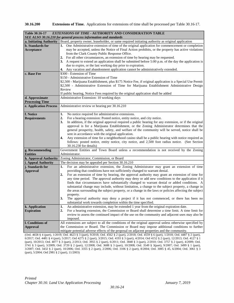
Printed Chapter 30.16: Land Use Application Processing January 7, 2019
30.16-24
30.16.200 Extensions of Time. Applications for extensions of time shall be processed per Table 30.16 17. Table 30.16-17 EXTENSIONS OF TIME - AUTHORITY AND CONSIDERATION TABLE SEE ALSO 30.16.210 for general process information and standards a. Initiating Authority Board, property owner, leaseholder, or same required initiating authority as original application b. Standards for Acceptance
1. One Administrative extension of time of the original application for commencement or completion may be accepted, unless the Notice of Final Action prohibits, or the property has active violations from the Clark County Public Response Office.
2. For all other circumstances, an extension of time by hearing may be requested. 3. A request to extend an application shall be submitted before 5:00 p.m. of the day the application is
due to expire, or the last working day prior to expiration. 4. Any vacation and abandonment application cannot be administratively extended.
c. Base Fee $300 - Extension of Time $150 - Administrative Extension of Time $2,500 - Marijuana Establishment, plus $175 Notice Fee, if original application is a Special Use Permit $2,500 - Administrative Extension of Time for Marijuana Establishment Administrative Design Review If public hearing, Notice Fees required by the original application shall be added
d. Approximate Processing Time
Administrative Extension: 10 working days
e. Application Process Administrative review or hearing per 30.16.210
f. Notice Requirements
1. No notice required for administrative extensions. 2. For a hearing extension: Posted notice, entity notice, and city notice. 3. In addition, if the original approval required a public hearing for any extension, or if the original
approval is for a Marijuana Establishment, or the Zoning Administrator determines that the general prosperity, health, safety, and welfare of the community will be served, notice shall be sent in accordance with the original application.
4. Any extension of time for a neighborhood casino shall be a public hearing with notice required as follows: posted notice, entity notice, city notice, and 2,500 foot radius notice. (See Section 30.16.230 for details)
g. Recommending Entities
Government Entities and Town Board unless a recommendation is not received by the Zoning Administrator.
h. Approval Authority Zoning Administrator, Commission, or Board i. Appeal Authority The decision may be appealed per Section 30.16.210 j. Standards for Approval
1. For an administrative extension, the Zoning Administrator may grant an extension of time providing that conditions have not sufficiently changed to warrant denial.
2. For an extension of time by hearing, the approval authority may grant an extension of time for any time period. The approval authority may deny or add new conditions to the application if it finds that circumstances have substantially changed to warrant denial or added conditions. A substantial change may include, without limitation, a change to the subject property, a change in the areas surrounding the subject property, or a change in the laws or policies affecting the subject property.
3. The approval authority may deny a project if it has not commenced, or there has been no substantial work towards completion within the time specified.
k. Application Expiration
1. An administrative extension, may be extended 1 year from the original expiration date. 2. For a hearing extension, the Commission or Board shall determine a time limit. A time limit for
review to assess the continued impact of the use on the community and adjacent uses may also be imposed.
l. Conditions of Approval
All extensions are subject to all the conditions of the original approval unless otherwise specified by the Commission or Board. The Commission or Board may impose additional conditions to further mitigate potential adverse effects of the proposal on adjacent properties and the community.
(Ord. 4658 § 4 (part), 1/2019; Ord. 4623 § 3 (part), 9/2018; Ord. 4562 § 2 (part), 2/2018; Ord. 4559 § 6 (part), 1/2018; Ord. 4487 § 2 (part), 6/2017; Ord. 4481 § 4 (part), 5/2017; Ord 4275 § 2 (part), 3/2015; Ord. 4193 § 3 (part), 4/2014; Ord 4152 § 2 (part), 12/2013; Ord. 4127 § 1 (part), 10/2013; Ord. 4077 § 3 (part), 2/2013; Ord. 3955 § 2 (part), 6/2011; Ord. 3848 § 3 (part), 2/2010; Ord. 3757 § 2 (part), 4/2009; Ord. 3741 § 3 (part), 3/2009; Ord. 3720 § 2 (part), 12/2008; Ord. 3688 § 3 (part), 10/2008; Ord. 3549 § 3(part), 9/2007; Ord. 3499 § 1 (part), 3/2007; Ord. 3432 § 2 (part), 10/2006; Ord. 3355 § 2 (part), 2/2006; Ord. 3106 § 2 (part), 8/2004; Ord. 3085 § 45, 6/2004; Ord. 3061 § 3 (part), 5/2004; Ord 2981 § 2 (part), 11/2003)
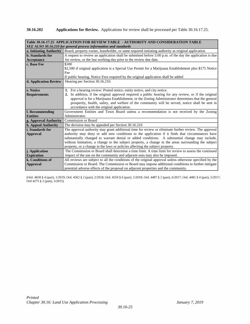
Printed Chapter 30.16: Land Use Application Processing January 7, 2019
30.16-25
30.16.202 Applications for Review. Applications for review shall be processed per Table 30.16 17.25. Table 30.16-17.25 APPLICATION FOR REVIEW TABLE - AUTHORITY AND CONSIDERATION TABLE SEE ALSO 30.16.210 for general process information and standards a. Initiating Authority Board, property owner, leaseholder, or same required initiating authority as original application b. Standards for Acceptance
A request to review an application shall be submitted before 5:00 p.m. of the day the application is due for review, or the last working day prior to the review due date.
c. Base Fee $300 $2,500 if original application is a Special Use Permit for a Marijuana Establishment plus $175 Notice Fee If public hearing, Notice Fees required by the original application shall be added
d. Application Review Hearing per Section 30.16.210.
e. Notice Requirements
1. For a hearing review: Posted notice, entity notice, and city notice. 2. In addition, if the original approval required a public hearing for any review, or if the original
approval is for a Marijuana Establishment, or the Zoning Administrator determines that the general prosperity, health, safety, and welfare of the community will be served, notice shall be sent in accordance with the original application.
f. Recommending Entities
Government Entities and Town Board unless a recommendation is not received by the Zoning Administrator.
g. Approval Authority Commission or Board h. Appeal Authority The decision may be appealed per Section 30.16.210 i. Standards for Approval
The approval authority may grant additional time for review or eliminate further review. The approval authority may deny or add new conditions to the application if it finds that circumstances have substantially changed to warrant denial or added conditions. A substantial change may include, without limitation, a change to the subject property, a change in the areas surrounding the subject property, or a change in the laws or policies affecting the subject property.
j. Application Expiration
The Commission or Board shall determine a time limit. A time limit for review to assess the continued impact of the use on the community and adjacent uses may also be imposed.
k. Conditions of Approval
All reviews are subject to all the conditions of the original approval unless otherwise specified by the Commission or Board. The Commission or Board may impose additional conditions to further mitigate potential adverse effects of the proposal on adjacent properties and the community.
(Ord. 4658 § 4 (part), 1/2019; Ord. 4562 § 2 (part), 2/2018; Ord. 4559 § 6 (part), 1/2018; Ord. 4487 § 2 (part), 6/2017; Ord. 4481 § 4 (part), 5/2017; Ord 4275 § 2 (part), 3/2015)
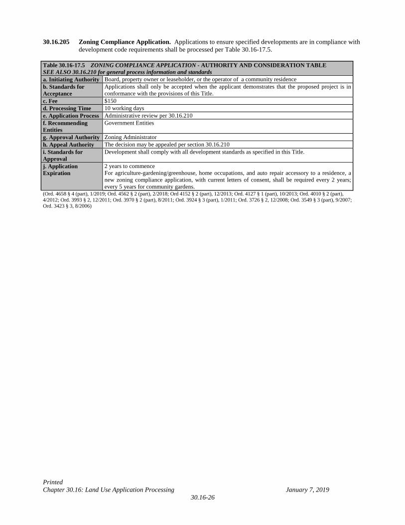
Printed Chapter 30.16: Land Use Application Processing January 7, 2019
30.16-26
30.16.205 Zoning Compliance Application. Applications to ensure specified developments are in compliance with development code requirements shall be processed per Table 30.16-17.5.
Table 30.16-17.5 ZONING COMPLIANCE APPLICATION - AUTHORITY AND CONSIDERATION TABLE SEE ALSO 30.16.210 for general process information and standards a. Initiating Authority Board, property owner or leaseholder, or the operator of a community residence b. Standards for Acceptance
Applications shall only be accepted when the applicant demonstrates that the proposed project is in conformance with the provisions of this Title.
c. Fee $150 d. Processing Time 10 working days e. Application Process Administrative review per 30.16.210 f. Recommending Entities
Government Entities
g. Approval Authority Zoning Administrator h. Appeal Authority The decision may be appealed per section 30.16.210 i. Standards for Approval
Development shall comply with all development standards as specified in this Title.
j. Application Expiration
2 years to commence For agriculture-gardening/greenhouse, home occupations, and auto repair accessory to a residence, a new zoning compliance application, with current letters of consent, shall be required every 2 years; every 5 years for community gardens.
(Ord. 4658 § 4 (part), 1/2019; Ord. 4562 § 2 (part), 2/2018; Ord 4152 § 2 (part), 12/2013; Ord. 4127 § 1 (part), 10/2013; Ord. 4010 § 2 (part), 4/2012; Ord. 3993 § 2, 12/2011; Ord. 3970 § 2 (part), 8/2011; Ord. 3924 § 3 (part), 1/2011; Ord. 3726 § 2, 12/2008; Ord. 3549 § 3 (part), 9/2007; Ord. 3423 § 3, 8/2006)
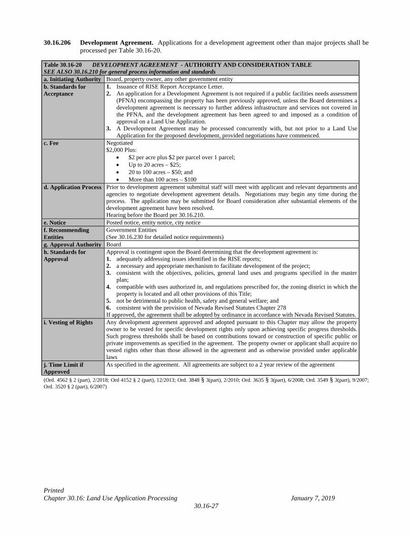
Printed Chapter 30.16: Land Use Application Processing January 7, 2019
30.16-27
30.16.206 Development Agreement. Applications for a development agreement other than major projects shall be processed per Table 30.16-20.
Table 30.16-20 DEVELOPMENT AGREEMENT - AUTHORITY AND CONSIDERATION TABLE SEE ALSO 30.16.210 for general process information and standards a. Initiating Authority Board, property owner, any other government entity b. Standards for Acceptance
1. Issuance of RISE Report Acceptance Letter. 2. An application for a Development Agreement is not required if a public facilities needs assessment
(PFNA) encompassing the property has been previously approved, unless the Board determines a development agreement is necessary to further address infrastructure and services not covered in the PFNA, and the development agreement has been agreed to and imposed as a condition of approval on a Land Use Application.
3. A Development Agreement may be processed concurrently with, but not prior to a Land Use Application for the proposed development, provided negotiations have commenced.
c. Fee Negotiated $2,000 Plus:
• $2 per acre plus $2 per parcel over 1 parcel; • Up to 20 acres – $25; • 20 to 100 acres – $50; and • More than 100 acres – $100
d. Application Process Prior to development agreement submittal staff will meet with applicant and relevant departments and agencies to negotiate development agreement details. Negotiations may begin any time during the process. The application may be submitted for Board consideration after substantial elements of the development agreement have been resolved. Hearing before the Board per 30.16.210.
e. Notice Posted notice, entity notice, city notice f. Recommending Entities
Government Entities (See 30.16.230 for detailed notice requirements)
g. Approval Authority Board h. Standards for Approval
Approval is contingent upon the Board determining that the development agreement is: 1. adequately addressing issues identified in the RISE reports; 2. a necessary and appropriate mechanism to facilitate development of the project; 3. consistent with the objectives, policies, general land uses and programs specified in the master
plan; 4. compatible with uses authorized in, and regulations prescribed for, the zoning district in which the
property is located and all other provisions of this Title; 5. not be detrimental to public health, safety and general welfare; and 6. consistent with the provision of Nevada Revised Statutes Chapter 278 If approved, the agreement shall be adopted by ordinance in accordance with Nevada Revised Statutes.
i. Vesting of Rights Any development agreement approved and adopted pursuant to this Chapter may allow the property owner to be vested for specific development rights only upon achieving specific progress thresholds. Such progress thresholds shall be based on contributions toward or construction of specific public or private improvements as specified in the agreement. The property owner or applicant shall acquire no vested rights other than those allowed in the agreement and as otherwise provided under applicable laws
j. Time Limit if Approved
As specified in the agreement. All agreements are subject to a 2 year review of the agreement
(Ord. 4562 § 2 (part), 2/2018; Ord 4152 § 2 (part), 12/2013; Ord. 3848 § 3(part), 2/2010; Ord. 3635 § 3(part), 6/2008; Ord. 3549 § 3(part), 9/2007; Ord. 3520 § 2 (part), 6/2007)
Printed Chapter 30.16: Land Use Application Processing September 17, 2018
30.16-28
30.16.210 Application Process. When specified within this Title that such an application is required or authorized, the approval authority shall consider applications in accordance with the following procedure in addition to the requirements listed in sections 30.16.040 through 30.16.206 above for specific application types:
1. Applications. Any application, amendment, or map requiring approval shall be filed with the Zoning
Administrator and shall be presented to the approval authority for review. Administrative applications shall be processed and acted upon without a formal hearing. Hearing applications shall be scheduled to a meeting before the approval authority; however, public hearing notices need not be sent to adjacent and nearby properties provided other required notice is given. Public hearing applications shall be scheduled to a meeting before the approval authority and shall be notified per the appropriate application requirement, including notice to adjacent and nearby properties.
2. Pre-submittal Conference. Any application, amendment, or map requiring a pre-submittal
conference shall include plans as required pursuant to this Title and/or as determined by the Zoning Administrator, and shall satisfy all pre-submittal requirements prior to the application’s submittal. Multiple applications for the same project may utilize one pre-submittal conference, subject to expiration as established in Section 30.16.210(19)(G). A pre-submittal conference, including any required document submitted thereto, shall not be considered a Land Use Application submittal. A pre-submittal conference shall be required for the following (A-G) and as otherwise determined by the Zoning Administrator:
A. uses involving hazardous chemicals, explosives, materials or wastes in amounts regulated by
NRS and NAC (determination of pertinent requirements for the proposed use) B. planned unit development (PUD) (see Chapter 30.24) C. mixed use development, including mixed use development in C-1, C-2 and H-1. (see Chapter
30.48 Part J) D. high impact project E. neighborhood casinos F. nonconforming zone boundary amendments G. Resort Hotel
3. Document Submittal Requirements. Land use pre-submittal forms and applications shall not be
acceptable without the required documents unless the Zoning Administrator determines a listed document is not required. If circumstances warrant, the Zoning Administrator may require additional documentation necessary to evaluate a particular application.
4. Standards for Acceptance.
A. All parcels of land included within a single petition or application must be contiguous; however, each Marijuana Establishment requires a separate application. Except for specific applications to waive standards, all plans shall show development that complies with the standards of this Title. If such an application is accepted and later found to not be in conformance with this Title, the application shall be considered to be withdrawn and the fees shall be refunded to the applicant or owner. In addition, standards for acceptance of specific applications are as listed with each application type.
B. Applications, amendments, or maps to establish uses involving hazardous chemicals, explosives,
materials or wastes shall not be accepted prior to submittal of the Clark County Fire Permit Survey Form to the Building Official. The owner or applicant shall also engage in a pre-submittal conference with County staff to discuss hazardous materials requirements pertinent to the proposed development prior to submitting an application for a chemical and/or hazardous material use.
C. Applications for increased density or intensity, or for exceptions to the special standards required,
within any overlay district shall not be accepted unless in compliance with Chapter 30.48.
Printed Chapter 30.16: Land Use Application Processing September 17, 2018
30.16-29
D. Annexation applications shall not be accepted without the required acknowledgement from the City into which a property is proposed to be annexed (See Annexation Letter, Section 30.16.240 (13).
E. Applications for waivers to defer temporarily on-site paving requirements shall not be accepted
without concurrence from the Department of Air Quality. A waiver to defer on-site paving shall not be required if paving is not required by Clark County Air Quality Regulations Section 92.
F. Applications for any land use that requires submittal of FAA Form 7460-1, Notification of
Proposed Construction, per Section 30.56.070 and Chapter 30.48 Part B shall not be accepted without written evidence (from FAA) of prior submittal to the FAA.
G. Applications for any land use that requires a pre-submittal conference shall not be accepted prior
to satisfying all pre-submittal conference requirements.
5. Fees. When applicable, the applicant shall pay a filing fee per Chapter 30.80 at the time of filing for a pre-submittal conference request, application, amendment, or map (fees are also listed in each application table).
6. Processing Time. Generally, action shall be taken approximately within the specified period as
measured from the date of acceptance of the application unless appealed, extended by the County, at the request by owner, or for good cause.
7. Review.
A. The Zoning Administrator may notify interested public utilities and governmental entities. The
Town Board whose jurisdiction includes the area of the petition shall be notified not less than 10 days prior to the hearing unless it is an administrative application.
B. If a hearing is required to be a public hearing, public notice as required shall be provided, and
interested parties shall have an opportunity to be heard.
C. The approval authority shall consider the submitted data and information, recommendations from public utilities, government entities including town boards, and interested parties in an endeavor to determine whether the application will help accomplish the purpose and intent of this Title.
D. For an expansion of the Gaming Enterprise District, a court reporter shall record the hearing in
accordance with Chapters 463 and 656 of NRS.
8. Approval Authority. The approval authority listed in Tables 30.16-2 through 30.16-17 shall have the authority to take final action on an application, amendment, or map, except that applications for which the Commission is the approval authority may instead, when submitted in conjunction with another application, amendment, or map requiring Board action, be acted on by the Board.
9. Request to Hold. The owner or applicant may request the approval authority to postpone
consideration of an application, amendment, or map from the scheduled date to a future date. The approval authority may hold the application, amendment, or map as requested, may hold it to a date other than requested, or may act on it if the approval authority determines action is appropriate. Per NRS 278.050 and 278.3195, the approval authority shall not grant more than 2 continuances on the same matter unless additional circumstances are warranted by the determination of good cause shown by the applicant.
10. Decision. Pursuant to Nevada Revised Statutes, the approval authority shall act upon the application
with consideration to recommendations from the Town Board and other government entities, providing all applicable requirements of this Title are met.
Printed Chapter 30.16: Land Use Application Processing September 17, 2018
30.16-30
11. Conditions of Approval. As a prerequisite to approval of an application, the approval authority may impose conditions on any application, amendment, or map necessary to accomplish the objectives of this Title and to mitigate potential adverse effects of an application on adjacent properties and the community which shall be binding on property owner(s) and their successors, including but not limited to the following:
A. All development or use of land is subject to the development standards listed in this Title unless
otherwise specified.
B. Compliance with all approved plans, conditions, restrictions and rules is required prior to permit issuance or map recordation, except that the approval authority may require revisions to plans.
C. The approval authority may require the property owner to grant to the County right-of-way,
easements, or other consideration necessary for the protection of the health and welfare of the community, including the signing of a resolution of intent in conjunction with an application for a zone boundary amendment.
D. Any condition imposed by the Board in conflict with any requirement of this Code which is
designed to mitigate the impact of an application, amendment, or map on adjacent property owners or the community shall be permitted without additional Land Use Application submittals unless the condition would create a health or safety hazard (including, without limitation, sight zone or airport environs hazards). Any condition imposed by the Commission in conflict with any requirement of this Code which is designed to mitigate the impact of an application, amendment, or map, the application shall be forwarded to the Board for final action.
E. Any condition imposed on a previously approved application may be waived on any subsequently
approved application if required notices show the waiver requested. The Commission may only waive conditions imposed by the Commission; however, the Board may waive conditions imposed by the Commission or Board.
F. The approval authority may consider a Development Agreement for high impact projects. The
agreement will address the need for the provision of adequate public facilities and/or infrastructure including but not limited to transportation, fire and police protection, flood control and drainage, parks, and open space, trails system, schools, water and sewer services, related to the proposed development, and as identified in the RISE reports submitted with special use permit application. In addition, the Development Agreement will evaluate phasing of additional facilities and services for the proposed development, and ensure existing services for established development will not be significantly affected. The approval authority may consider whether a less intense project is appropriate if the Development Agreement does not adequately address the impacts and related needs identified in the RISE reports.
G. For projects other than high impact projects or Major Projects, the approval authority may
propose a Development Agreement consistent with the needs identified by the Southwest Las Vegas Valley PFNA Report initiated and approved by the Board. Modifications to the formula for the Standard Agreement are not permitted except through a Negotiated Development Agreement.
Printed Chapter 30.16: Land Use Application Processing September 17, 2018
30.16-31
12. Standards for Approval. In addition to specific standards for approval for each application type listed in Sections 30.16.040 through 30.16.206 above, the following standards apply for the consideration of all application types:
A. An application, amendment, or map may be approved if it meets the following criteria:
i. It is generally consistent with the Plan, as amended, or reflects conditions that have changed
since the adoption or amendment to the Plan.
ii. There will be capacity to provide adequate public facilities and services, including but not limited to transportation, utility, sewer, water, police, and fire service, to accommodate development permitted under the proposal.
iii. It complies with and forwards the capital improvement planning efforts of the County.
iv. It will not significantly impact the natural environment, including but not limited to water,
air, noise, storm water management, wildlife, vegetation, wetlands, and the natural functioning of the environment.
v. It will result in a logical and orderly development pattern. vi. The proposal, including but not limited to the density, intensity, scale, height, and operations,
is harmonious and compatible with existing and planned development on adjacent properties and in the surrounding area or neighborhood; shall not be unsightly, undesirable, or noxious; and/or includes measures that will be taken to adequately buffer or otherwise mitigate any incompatibility.
B. The approval of an application, amendment, or map shall constitute a finding by the approval
authority that the application, amendment, or map is consistent with the standards and purposes enumerated in the Plan, this Title, and/or NRS. The approval of any application, amendment, or map will not waive building codes, fire codes, business license requirements, or any other requirement imposed by County, State, or Federal regulations or law.
C. Except for administrative minor deviations, special use permits, waivers, and variances to specific
development standards as approved, development shall comply with all development standards as specified in this Title.
D. Written evidence that the FAA has determined whether a proposed structure constitutes a hazard
to air navigation shall be submitted two weeks prior to final approval unless the Zoning Administrator concludes the FAA determination has been submitted early enough for action to occur, on any related Land Use Application for any proposed structure that intrudes into the Airport Airspace Overlay District that is not excepted (see Chapter 30.48 Part B); applications for which required FAA determinations have not been received shall be held or denied.
13. Denial. The denial of an application, amendment, or map shall constitute a finding by the approval
authority that the application, amendment, or map is inconsistent with the standards and purposes enumerated in the Plan, this Title, or the Nevada Revised Statutes. Unless denied without prejudice, an application, amendment, or map that is denied is subject to the re-petition period specified in this chapter.
Printed Chapter 30.16: Land Use Application Processing January 7, 2019
30.16-32
14. Finality of Decision. Except where an item has been appealed or forwarded to the Board for final action, a decision becomes final upon expiration of the appeal or reconsideration period. No permits or licenses shall be issued until the action becomes final.
A. For all administrative applications other than Administrative Temporary uses for seasonal sales,
or temporary signs per Table 30.72-3, Administrative Minor Deviations to development standards within Chapters 30.32 and 30.52, and Zoning Compliance applications, the applicant shall be sent a Notice of Administrative Decision following action on the application. Action shall be final and effective 5 working days from the date the letter was sent unless appealed to the Board. The applicant or correspondent notification must include delivery confirmation.
B. Action for Administrative Temporary Use applications for seasonal sales or temporary signs per
Table 30.72-3, Administrative Minor Deviations to development standards within Chapters 30.32 and 30.52, and Zoning Compliance Applications shall be final and effective on the date of action on the application.
C. For all applications acted on by the Commission or Board, the Notice of Final Action shall be
sent by first class mail following final action. 15. Appeal.
A. All appeals shall be in writing, except that no appeal is required if, at the hearing on an item, staff
announces that the item shall be forwarded to the Board for final action. B. For applications acted upon by the Planning Commission, the appeal must be physically received
by the Zoning Administrator by 5:00 p.m. on the fifth working day following action on the application, in which case the approval authority’s decision will serve as a recommendation to the Board.
C. For Administrative Minor Deviation applications to development standards within Chapters
30.32 and 30.52, the manner of appeal is to submit a Waiver of Development Standards. D. For Administrative Vacation and Abandonment applications, the manner of appeal is the
submittal of a Vacation and Abandonment application. E. For all other administrative applications or Zoning Administrator’s decisions, the manner of
appeal is to submit a written request to appeal the Zoning Administrator’s decision to the Board by 5:00 p.m. of the fifth working day from when the Notice of Administrative Decision or Zoning Administrator’s letter has been sent. The Zoning Administrator’s decision will serve as a recommendation to the Board.
F. For applications acted upon by the Board, see Section 30.16.210 (16) (Reconsideration). G. Once an appeal has been filed, it cannot be withdrawn. H. Any person may appeal the Board’s approval of an application to expand the Gaming Enterprise
District outside the Las Vegas Boulevard Gaming Corridor or the Rural Clark County Gaming Zone, per Chapter 463 of NRS, to the review panel of the Gaming Policy Committee within 10 working days of the decision of the Board.
I. A Planning Commissioner who voted on an application my not file an appeal. J. In the event of an appeal (does not include applications for which the manner of appeal is to
submit a land use application), the application shall be scheduled for a hearing by the Board on the date announced at the Commission meeting. Administrative applications shall be scheduled for the next available zoning agenda after the appeal is processed unless continued for good cause. The Board may limit its discussion to the issues raised in the appeal.
Printed Chapter 30.16: Land Use Application Processing January 7, 2019
30.16-33
16. Reconsideration.
A. Request. For any application, amendment, or map whereby final action is decided by the Board, any member of the Board who voted in favor of the motion which carried may request that the application, amendment, or map be reconsidered if made in writing and received by the Zoning Administrator within 5 working days of the decision, in which case the decision shall not become final. The request for reconsideration shall thereafter be scheduled for a hearing before the Board on the second zoning agenda after the request was made.
B. Rehearing. Should the Board approve reconsideration of the decision at the hearing, the
application, amendment, or map shall be scheduled for a public hearing at a subsequent meeting of the Board.
17. Withdrawal. An application, amendment, or map withdrawn by the property owner or applicant
shall cease its consideration. Thereafter, the only consideration shall be whether the application, amendment, or map is subject to the re-petition limits. An application, amendment, or map request withdrawn by the property owner or applicant shall be subject to the re-petition limits specified in this chapter unless accepted as withdrawn without prejudice by the Commission or Board. Any administrative application, application requested to be withdrawn by the County, application requested to be withdrawn prior to public notification, or application withdrawn after approval, will be considered withdrawn without prejudice. A property owner or applicant may not withdraw any portion of an application that is initiated by a government entity.
18. Re-petition. Unless initiated by a governmental entity, applications, amendments, and maps are
subject to the following re-petition limits:
A. Unless expressly denied or withdrawn without prejudice, the same application, amendment, or map, or a different application, amendment, or map for a more intense use or increase in density, shall not be accepted by the Zoning Administrator within 12 months of final action on the previous application, amendment, or map.
19. Expiration.
A. Unless otherwise specified in the approval of any amendment or application, the applicant or
owner shall have the time specified in Tables 30.16-2 through 30.16-17 to commence or complete the use as measured from the date of the approval.
B. The approval authority may also approve a special use permit, waiver of development standards,
or variance application with a review date to determine continued compatibility with adjacent properties and the community.
C. Any Land Use Application heard in conjunction with another application, amendment, or map
shall have the same time limit unless otherwise specified by the approval authority. D. If construction is commenced, work shall continue until completed. If permits for the
construction expire before completion and after the commencement date, the amendment or application shall expire unless an extension of time is submitted and approved.
E. An application, amendment, or map held shall expire if more than 6 months elapse from the last
scheduled meeting date without a request by the applicant for a hearing, in which case the re-petition limits shall apply. An application that has been placed on hold due to insufficient funds shall expire after 3 months from the submittal date if no replacement funds have been received. Administrative applications, or any application, amendment or map not scheduled to a meeting before the approval authority shall expire if 6 months lapse from acceptance date.
Printed Chapter 30.16: Land Use Application Processing January 7, 2019
30.16-34
F. A special use permit, waiver of standards, variance, design review, zoning compliance, or
administrative design review application that establishes any use, for which construction has been completed or the use commenced, shall expire if the building is destroyed and not reconstructed, or the use is discontinued and not reestablished, within 1 year if the use or structure has not otherwise become nonconforming. A use is considered to be discontinued if the required license or permit for the use has expired. When reconstruction is required, if reconstruction is commenced within 1 year, the application shall not expire, providing construction is continuous and building permits do not expire.
G. Satisfaction of pre-submittal conference requirements, including all documents submitted thereto,
shall be considered expired after 180 days from the date of the pre-submittal conference. (Ord. 4658 § 4 (part), 1/2019; Ord. 4623 § 3 (part), 9/2018; Ord. 4559 § 6 (part), 1/2018; Ord. 4487 § 2 (part), 6/2017;
Ord. 4481 § 4 (part), 5/2017; Ord. 4367 § 3 (part), 2/2016; Ord 4351 § 1, 11/2015; Ord 4275 § 2 (part), 3/2015; Ord. 4193 § 3 (part), 4/2014; Ord. 4127 § 1 (part), 10/2013; Ord. 4052 § 1 (part), 9/2012; Ord 4008 § 23, 3/2012; Ord. 3975 § 3 (part), 8/2011; Ord. 3955 § 2 (part), 6/2011; Ord. 3924 § 3 (part), 1/2011; Ord. 3848 § 3(part), 2/2010; Ord. 3757 § 2 (part), 4/2009; Ord 3720 § 2 (part), 12/2008; Ord 3688 § 3 (part), 10/2008; Ord 3586 § 3 (part), 2/2008; Ord. 3520 § 2 (part), 6/2007; Ord. 3518 § 4 (part), 5/2007; Ord. 3472 § 3 (part), 1/2007; Ord. 3432 § 2 (part), 10/2006; Ord. 3397 § 2 (part), 6/2006; Ord. 3382 § 1 (part), 5/2006; Ord. 3355 § 2 (part), 2/2006; Ord. 3296 § 3 (part), 10/2005; Ord. 3229 § 3 (part), 6/2005; Ord. 3219 § 2 (part), 5/2005; Ord. 3163 § 2, 12/2004; Ord. 3085 § 46, 6/2004; Ord. 3055 § 2 (part), 4/2004)
Printed Chapter 30.16: Land Use Application Processing March 23, 2015
30.16-35
DELETED - Table 30.16-21 APPEAL PROCEDURE TABLE (Ord 4275 § 2 (part), 3/2015; Ord 4152 § 2 (part), 12/2013; Ord. 4127 § 1 (part), 10/2013)
Printed Chapter 30.16: Land Use Application Processing March 23, 2015
30.16-36
30.16.220 DELETED – Hearing Process. (Ord. 2970 § 2, 11/2003) 30.16.230 Notice.
a. Before an application for which a hearing is required is acted upon, notice of the hearing shall be provided as required in Tables 30.16-2 through 30.16-17 above.
1. Any notice required shall be written in language which is easy to understand and shall give the
date, time, place, purpose of the hearing and, when applicable, give a physical description or map of the property in question.
2. The notice shall be sent by mail or by electronic means, when acceptable to the owner, tenant, or
entity to which the notice is sent, if receipt of the electronic notice can be verified.
3. All required public hearing notices must be sent prior to the first public hearing as stated below. If the date and time of any subsequent hearing is announced at the meeting, additional notice is not required, except for hazardous material or explosive requests.
4. Additional notice and fees apply when more than 85 calendar days have elapsed since the date of
the meeting from which the last notice was sent. If an application is held indefinitely, or a less restrictive request is made part of the application, renotification is required.
5. If the Commission or Board requires a subsequent application with public hearing as a condition
of approval for an application, the notice provided shall be the same radius notification currently required for the original application. Notices for design review applications may also include notice of proposed changes in location of uses or principal structures when applicable.
6. Special use permit applications for explosives, or hazardous materials or waste, shall include a
list of the substances and quantities that will be located at the facility.
Printed Chapter 30.16: Land Use Application Processing December 23, 2013
30.16-37
b. Pursuant to the notification requirements established in Tables 30.16-2 through 30.16-17, public notice consists of the following types:
1. Entity Notice. Where entity notice is required, an advisory notice of an application shall be sent
to interested governmental and public utility entities including the Town Board whose jurisdiction includes the area of the petition as requested, or as required by law, a minimum of 10 calendar days prior to the meeting. A courtesy notice shall also be sent to any Town Board whose jurisdiction is within 1/2 mile of the proposed project.
A. When the application is a special use permit for explosives or hazardous materials or waste,
notice shall be sent to:
i. The Administrator of the Division of Environmental Protection of the Department of Conservation and Natural Resources.
ii. The State Fire Marshal. iii. The Administrator of the Division of Industrial Relations of the Department of Business
and Industry. B. When the application is a zone boundary amendment to establish a Historic Neighborhood
Overlay District, an advisory notice shall be sent to the State Historic Preservation Office.
2. Posted Notice. All applications scheduled for a hearing before the Commission and/or Board shall be shown on an agenda, which shall be posted in various designated public locations within the community, in conformance with NRS 241.020 (Open Meeting), a minimum of 3 working days prior to the meeting. Note: all agendas are accessible on the Clark County internet web page (www.accessclarkcounty.com).
3. Newspaper Notice. Where newspaper notice is required, notice of the hearing shall be published
in a newspaper of general circulation within the County a minimum of 10 calendar days prior to the meeting.
4. City Notice. Where city notice is required, notice of the hearing shall be sent to the city when the
proposed site is completely surrounded by the city, affected by an interlocal agreement between the County and city, or when the proposed development is a project of regional significance.
5. Radius Notice. Where radius notice is required, notice of the hearing shall be sent a minimum of
10 calendar days prior to the meeting to:
A. Each owner of real property listed on the latest assessment rolls of the County within the radius specified to the exterior boundary of the land described in the petition, or the owners of the nearest 100 separately owned parcels, whichever provides notice to the greater number of property owners. The specified distance listed in Tables 30.16-2 through 30.16-17 for each application type or specific request shall be noticed.
B. Each tenant of a manufactured home park when the park is within the notice area specified
above, and including each tenant of a manufactured home park proposed for redevelopment to a different use.
C. The property owner or applicant. If a proposed amendment involves a change of the zoning
district that reduces the density or intensity of use, the notice must include a section that allows the property owner whose property’s density or intensity of use will be decreased to state his approval of or opposition to the proposed amendment.
Printed Chapter 30.16: Land Use Application Processing December 23, 2013
30.16-38
D. Where delivery confirmation notice is required, notice shall be sent by delivery confirmation
mail at least 10 calendar days prior to the meeting to the owners of all properties within the specified radius.
E. If the application is for a special use permit for explosives, hazardous materials or waste, the
tenants of multiple family dwelling units shall also be notified, and the notice shall be sent not less than 30 calendar days prior to the hearing before the Commission and the Board.
F. Any property or homeowner’s association registered with the County whose organization
boundaries are defined by a recorded subdivision and are located within the notification radius for the specified application type. When located within a Historic Neighborhood Overlay District, the site need not be within a recorded subdivision.
6. Abutting Properties. Where notice to abutting properties is required, notice shall be sent least 10
calendar days prior to the meeting to the owners of all properties abutting any segment of a street established by easement, dedication, or prescriptive right, the name of which is proposed to be changed, or to all properties within the area affected by any street numbering change.
7. Area Notice. For a major project initiated by a property owner, after a pre-application conference
and prior to the Board hearing on a Specific Plan, the developer shall notify property owners inside and within 2,500 feet of the proposed planning area, to provide information on the proposed project, to allow opportunity for public input, and to address the rights and obligations of the property owners within the planning area. The developer shall notify the County of the date, time and location of the meeting. If the proposed major project has been initiated by the Board, the Zoning Administrator shall schedule, notify and conduct the meeting. See Chapter 30.20.
8. Signs. When required, a sign, or signs, shall be posted by the County on the property describing
the time and place of the public hearing, existing and proposed land use categories, and the purpose of the request. Sign requirements include:
A. The sign shall be a minimum of 4 square feet (2' x 2') in size.
B. The letters indicating the time of the public hearing and the proposed application shall be a
minimum of 2 inches in height.
C. The sign shall remain on the property until final action is complete.
D. The sign must reasonably calculated to withstand the elements for 40 calendar days and must be consistent in the use of colors for the background and lettering of the sign.
E. Number of Signs.
i. For tracts of land less than 15 acres, 1 notification sign is required.
ii. For tracts which exceed 15 acres, an additional notification sign is required for each
improved street front within the petition which exceeds 1,320 feet.
iii. No single application shall be required to post more than 5 notification signs on the property.
iv. For manufactured home parks proposing redevelopment to a different use, one
additional sign shall be clearly posted at the entrance to the manufactured home park’s on-site manager’s Office. (Ord 4152 § 2 (part), 12/2013; Ord. 4077 § 3 (part), 2/2013; Ord. 3992 § 2 (part), 11/2011; Ord. 3848 § 3(part), 2/2010; Ord. 3780 § 1, 6/2009; Ord. 3757 § 2 (part), 4/2009; Ord. 3635 § 3(part), 6/2008; Ord. 3549 § 3(part), 9/2007; Ord. 3520 § 2 (part), 6/2007; Ord. 3354 § 2 (part), 2/2006; Ord. 3296 § 3 (part), 10/2005; Ord. 3229 § 3 (part), 6/2005)
Printed Chapter 30.16: Land Use Application Processing December 23, 2013 30.16-39
Table 30.16-18 - DELETED LAND USE APPLICATIONS - NOTICE REQUIREMENTS FOR APPLICATIONS SUBJECT TO A HEARING (Ord. 4063 § 3 (part), 11/2012; Ord. 3975 § 3 (part), 8/2011; Ord 3924 § 3 (part), 1/2011; Ord 3688 § 3 (part), 10/2008; Ord. 3520 § 2 (part), 6/2007; Ord. 3354 § 2 (part), 2/2006; Ord. 3296 § 3 (part), 10/2005; Ord. 3229 § 3 (part), 6/2005; Ord. 3219 § 2 (part), 5/2005; Ord. 3209 § 4 (part), 3/2005; Ord. 3174 § 2 (part), 1/2005)
Printed Chapter 30.16: Land Use Application Processing December 23, 2013
30.16-40
30.16.240 Document Submittal Requirements.
a. All documents accompanying applications shall be legible and suitable for microfilm and imaging reproduction. All documents submitted are available to the public for inspection and copying. All plans must be accurate, drawn to a standard scale not smaller than 1 inch equals 60 feet, or 1/8 inch equals 1 foot, dimensioned, and folded so they can be placed into a legal size file.
1. Application. A signed application, notarized when required by the Zoning Administrator,
detailing the nature and justification for the request. For signature of a corporation, or of someone other than the property owner, corporate declaration of authority or power of attorney must accompany the application. A leaseholder should consult with the property owner prior to the submission of an application.
2. Site Plans.
A. Site development plans showing the uses of the parcel of land, existing and proposed
structures, setbacks, yards and open space, maximum slope of property (if exceeds 12%), see Chapter 30.56 for hillside development), lot layout, the size and number of parking spaces, routes of vehicular access, the location of signs, the location of landscaping, trash enclosures, loading spaces, sight zones, and any other information that is necessary for the Zoning Administrator to evaluate the request. Proposed development shall be shown on the entire parcel or parcels included within the application. Plans accompanying applications other than a Design Review or Administrative Design Review shall be considered conceptual plans only, and will still require the submission of a Design Review or Administrative Design Review.
B. For an annexation request and vacation and abandonment, the plan shall show the property
proposed to be annexed or vacated, the adjacent parcels, and the political jurisdiction to which the adjacent parcels belong.
C. For planned unit development (PUD), the plan shall additionally show (or a separate plan
be submitted that shows):
i. All required open space areas in relation to property lines, buildings, pavement, streets, and pedestrian connections.
ii. All public parks, public recreational facilities, or other open space reserved for public
use with acreage equivalent to the open space requirements for the proposed project.
3. Floor Plans. Floor plans indicating the size of existing and proposed buildings, the use of space and total square footage of buildings. Plans accompanying applications other than a Design Review or Administrative Design Review shall be considered conceptual plans only, and will still require the submission of a Design Review or Administrative Design Review.
4. Elevation. Elevations indicating the architectural appearance, the types of building materials
proposed for the exterior, and the height of the existing and proposed buildings. At the discretion of the Zoning Administrator, photographs of existing structures may be substituted for required elevations. Plans accompanying applications other than a Design Review or Administrative Design Review shall be considered conceptual plans only, and will still require the submission of a Design Review or Administrative Design Review.
5. Landscape Plan. Plans accompanying applications other than a Design Review or
Administrative Design Review may be conceptual. All other plans shall address applicable
Printed Chapter 30.16: Land Use Application Processing May 15, 2017
30.16-41
sight visibility concerns, including adequate spatial considerations for the size (height and width) and foliage spread of plant materials at maturity, and shall show the following: A. Landscaped areas in relation to property lines, pavement, streets, buildings, traffic control
signs and devices, and sight visibility zones. B. The common name, botanical name, size, number and location of existing and proposed
plant materials and non-living ground cover (See Southern Nevada Regional Planning Coalition’s Regional Plant list).
C. Water features, fences, and retaining walls. D. Total landscape area in square feet, with amount of any permitted turf (in square feet)
separately listed. E. Grading to show retention of precipitation when possible. F. Location of overspray sprinklers.
6. Locator Map. A map which shows the location of residential developments, structures for
religious services, and public or private schools within 2,500 feet of the property upon which the establishment is to be located.
7. Assessor’s Map(s). The most recent official Assessor's plat map or maps, to scale, indicating
the subject parcels, together with a list of all of the parcel numbers included within the proposal if more than 1 parcel is involved. For street naming, street name or numbering change, and vacation and abandonment applications, Assessor’s maps for the entire alignment affected by the application shall be required.
8. Zone Boundary Map/Legal Description. When multiple zoning districts are requested with a
single application, the legal description for the area of each zone boundary shall be typed on a clean sheet of paper, together with maps showing the proposed district boundaries.
9. Deed. The most recent recorded deed is required. For any extension of time, the deed is
required only if ownership of the property has changed since the original application’s approval.
10. Legal Description. The legal description of the property shall be typed on a clean sheet of
paper. The legal description of an easement and/or right-of-way to be vacated or property to be reconveyed must be typed on the “Exhibit A” form provided by the Zoning Administrator.
11. Parking Analysis. An analysis of required parking for all existing and/or proposed uses at the
location shall demonstrate adequate parking based on Chapter 30.60. The analysis may be included on the site plan. For any waiver of standards which proposes to reduce required parking, a parking study justifying the reduction shall also be submitted.
12. Annexation Letter. A letter, memo, or standard form issued by the City into which a property
is proposed to be annexed acknowledging the property owner’s intent to be annexed and the City’s willingness to consider the request if approved by the County.
Printed Chapter 30.16: Land Use Application Processing May 15, 2017
30.16-42
13. Justification Letter. A letter stating justification(s) for the approval of a Land Use Application, including how the proposal will produce an environment of stable and desirable character consistent with the objectives of this Title and the Comprehensive Master Plan, an analysis of outstanding issues, the intended uses, the impact on adjacent properties, the need for any public utility or public services, actions to be taken to minimize any detrimental impacts of the proposal, an analysis of how the proposal is consistent with the standards of approval listed for the various applications and, if applicable, the time period for which any permit is sought. A justification letter submitted for a special use permit or waiver of development standards for a group home shall be considered a request for accommodation. A justification letter submitted for waiver or variance applications for projects approved through a nonconforming zone boundary amendment shall include clear and convincing evidence pursuant to Table 30.16-7(1)(3). Also see Compelling Justification in Section 30.08.030.
14. Letters from Fire Alarm Office. A letter from the Fire Alarm Office which specifies that the
proposed name is in accordance with the guidelines shown in Las Vegas Valley Street Naming and Address Assignment Policy, as adopted by the Board on August 3, 1988.
15. Regional Infrastructure and Services Evaluation (RISE) Reports. The RISE reports are an
integral part of the application process for high impact projects to identify additional necessary infrastructure and/or services. The Director of Comprehensive Planning shall provide a RISE Report handout for completion and submittal by the applicant. Separate unbound copies of the reports must include the name of the correspondent, telephone number, project location, Assessor's parcel number(s), project information including number of units and area for single-family, multi-family, commercial, industrial and hotel/casino uses, a development schedule (including demolition) and any phasing plans. The reports are to include relevant information for consideration by the reviewing authority. They are intended to evaluate existing infrastructure and services. The reports should indicate how services not planned in the Comprehensive Master Plan, or anticipated can be provided to accommodate any increased demand for services created by the proposed project such as a high impact project, non-conforming zone change or text amendment to modify the Mixed Use Overlay District. Except as provided below, they are not intended to be detailed engineering studies nor are they intended to substitute for detailed engineering studies required later in the development process, however, the reports must include accurate data representing the impact of the proposed project. The reports include:
A. Water Supply Report. Report indicating: 1) the quantity of water demanded during, and
after, its construction, estimated by applying a demand factor established by the provider of water service, or an equivalent calculation, to the number of units that will be created, and the gross acreage that will be occupied, by the project; and 2) that there is an adequate supply of water and that the necessary facilities exist to deliver the water to accommodate the project. The report should also include all fire flow requirements. If the existing water supply or service facilities are not adequate, the petitioner must indicate how the existing supply and service facilities will be augmented to accommodate the development. The report should also address the effect of any officially adopted plans and/or schedules for publicly provided improvements.
B. Wastewater Treatment Report. Report indicating: 1) raw sewage quantity discharged
for the entire project, estimated by applying a sewage generation factor established by the sewer service provider to the proposed number of units or area of indoor floor space; 2) raw sewage quantity discharged for each phase; 3) whether the project will generate any industrial waste; 4) a pre-treatment plan for industrial waste; 5) the existing wastewater treatment facilities and pipelines are adequate. If existing wastewater treatment capacity, equipment and pipelines are not adequate, indicate how existing facilities will be augmented to accommodate the proposed development. The report should address the
Printed Chapter 30.16: Land Use Application Processing December 23, 2013
30.16-43
effect of any officially adopted plans and/or schedules for publicly provided improvements.
C. Transportation Report. A report prepared by a professional engineer addressing overall
transportation impacts including pedestrian circulation, traffic, right-of-way, and mass transit, as outlined below. The report shall also include any required improvements such as pedestrian bridges, grade separated arterials, and any alternative transportation facilities or structures, such as bicycle racks. High impact projects should submit, a summary of the traffic impact analysis, highlighting the following:
Traffic. The report shall address both vehicular and pedestrian traffic generated at full build out. The analysis must estimate traffic volumes generated by the proposed development (estimated by applying to the proposed project, average trip rates for peak days and hours established by the Institute of Transportation Engineers or its successor), distribute, and assign these volumes to the study area streets and intersections. Effects of expected traffic must be included, mitigation measures proposed and recommend a network of arterial and collector streets to accommodate traffic volumes projected at project build out. The proposed arterial and collector network must be presented with estimated lane requirements, including required grade separations, and regional continuity and connectivity shall be demonstrated. A level of service analysis must be furnished for each study area intersection under estimated build out traffic volumes, and shall include proposed mitigation measures and attempt to improve level of service of any intersection within the study area projected to have a level of service “D” or lower due to the proposed development.
Right-of-way. The report should address impacts to the Clark County Transportation Element of the Regional Master Plan of Streets and Highways of the Regional Transportation Commission and any officially adopted plans and/or schedules for publicly provided improvements and provide preliminary information delineating public and private right-of-way dedication measures and the existing and planned, capacities of roads considered by the petitioner to be adequate to alleviate adverse access and traffic circulation impacts. The report shall also delineate proposed access controls and address the need for pedestrian bridges.
Mass Transit. The report must also provide the distance from the proposed site to the nearest existing mass transit loading point for both employees and visitors. The analysis must include projected demand of the project for mass transportation to/from the site even if the site is served or planned for service.
D. Geotechnical Report. Report delineating proposed impact mitigation measures
considered by the petitioner to be adequate to alleviate adverse geologic hazards and adverse subsurface soil and groundwater conditions. The development must comply with the currently adopted building code and local amendments.
E. Flood Control and Drainage Report. The report should indicate the project will comply
with Clark County Regional Flood District Hydrologic Criteria and Drainage Design Manual. The developer will be responsible for building adequate facilities in compliance with the flood control manual. The report must indicate how the existing site area drainage pattern will be altered; estimate quantity of storm water runoff increase, by using adopted hydrologic methods. The report should address if total water runoff quantity after construction exceeds the existing or planned storm water drainage system capacity; if the proposed project will require drainage mitigation to protect the development and downstream property owners from interim flows, and facilities needed to mitigate the flows should be incorporated into the overall site design.
Printed Chapter 30.16: Land Use Application Processing December 23, 2013
30.16-44
F. Fire Protection and Emergency Services Report. General project information inclusive of project square footage, acreage and average daily trips, as well as tourist accommodation information. For existing projects, include total square footage to be demolished, total rooms and or resort to be demolished. Project demand should be analyzed regarding Fire Department personnel, facilities and services in the following areas at a minimum: adequate water supply, location of project with respect to the existing service area, and any special hazards accompanying storage, use or processing of hazardous materials associated with the project. Finally the report should include the lowest occupied floor below grade and the estimated completion date of the project.
G. Police Service Report. The report shall indicate the following: 1) the number of calls for
police service in the vicinity and the average police response time; 2) identification of any security measures proposed to be provided for the project by the petitioner; 3) address the effect of any officially adopted plans and/or schedules for publicly provided improvements; and 4) the distance from the site to where the nearest police services are provided, including facilities that are planned but not yet constructed, and facilities which have been included in a plan for capital improvements prepared by the appropriate local government pursuant to NRS 278.0226.
H. Educational Services Report. An estimate of the number of school-age children
(elementary through high school) which will live in the proposed development and data regarding the current capacity of the public schools which provide educational services to the area and the existing and planned capacities of schools. The report should include infrastructure necessary to serve the development. The report should also address the effect of any officially adopted plans and/or schedules for publicly provided improvements.
I. Neighborhood Impact Report. A report estimating the impact on existing public services,
consumption of natural resources, housing and the quality of life enjoyed by the residents of surrounding neighborhoods, and also demonstrating that the proposal will not be detrimental to the health, safety, or general welfare of the community. Total proposed population generated by the project should be included. The report must list amenities within 1/4 mile of the proposed site including but not limited to open spaces, planned recreation areas, resort hotels, shopping centers, and theaters and in general, places open to the public. Each item should be accompanied by a description of each possible way the amenity could be accessed from the proposed site.
J. Economic and Employment Impact Report. A report estimating the economic benefit of
the proposal, including the number of potential jobs created by the proposal, direct and indirect impacts to the economy, job to income ratio and housing.
K. Parks/Trails/Federal Lands. A report estimating the effects to recreation and cultural
services as delivered by Clark County Parks and Recreation Department, specifically, effects on the County minimum standard of 2.5 acres of programmable recreation space and 1.5 acres of open space for a total of the minimum standard of 4 acres of open space per 1,000 residents, and aesthetic quality in public spaces. Specific projected population information must be included. Any proposed recreational facilities and parks must meet Clark County Parks and Recreation Department standards. The report must include any plans for facilities, artwork, and parks maintenance including estimates of how existing or proposed facilities may be affected by increased user visits, trips, or tourism. The applicant must provide the distance of the project to existing or proposed recreation and cultural facilities. Density, intensity, geographic or transportation barriers to facilities must be addressed and any other unusual conditions of access to public recreation and cultural facilities. The applicant should address any safety and security concerns
Printed Chapter 30.16: Land Use Application Processing June 20, 2017
30.16-45
or effects. The report should identify existing or planned trails and possible linkages to the Las Vegas Valley Pedestrian/Bicycle Trail System. Federal Lands. The report should include if the land is currently held in private or public ownership. If still in public ownership, information describing the status of the land acquisition process must be included. Trails. If the project borders a thoroughfare identified on the Regional Primary Trails Plan as a trail corridor, a description of how the project will implement the plan must be included.
L. Air Quality and Environmental Review. The report shall include the following
information:
Air Quality. The project shall comply with all applicable air quality regulations. The applicant shall complete and submit to the Department of Air Quality the air quality report (part of RISE report handout) containing all pertinent project information to determine projected air quality impacts and permit requirements.
Environmental. Habitat & Species Conservation. The project shall comply with all applicable requirements of the Multiple Species Habitat Conservation Plan pursuant to sections 30.32.050 and 30.80.080 of this code. The report shall include a description of how the project will demonstrate compliance before beginning land disturbing activities.
M. Water Quality. The project shall conform with the applicable water quality standards and
regulations including conformity with the most current Clark County Area-Wide Water Quality Management Plan.
N. Storm Water. The report shall include a description of how the project design will
prevent illicit and foreign substances from entering the storm water conveyance system, including materials from roads and parking surfaces.
O. Analysis Summary. A summary report of the analysis, issues, improvements, and
proposed phasing of improvements concurrent with development. P. Additional Reports. The Zoning Administrator, Planning Commission or Board may
require the submittal of any other reports and/or information they feel is necessary to make an informed decision on the application.
16. Ownership/Applicant Disclosure. A disclosure form provided by Clark County that requires
applicants to list the names of individuals holding more than 5% ownership or financial interest in the business entity appearing before the Board of County Commissioners, except as provided below, shall be submitted with an application as required. "Business entities" include all business associations organized under or governed by Title 7 of the Nevada Revised Statutes, including but not limited to private corporations, close corporations, foreign corporations, limited liability companies, partnerships, limited partnerships, and professional corporations. Publicly traded corporations shall list all Corporate Officers and Board of Directors in lieu of disclosing the names of individuals with ownership or financial interest. The disclosure requirement, as applied to land-use transactions, extends to the applicant and the landowner.
Printed Chapter 30.16: Land Use Application Processing June 20, 2017
30.16-46
17. Fire Permit Survey Form. A disclosure form provided by Clark County that requires applicants to identify the presence of hazardous chemicals, explosives, hazardous chemical waste, or other hazardous materials or substances involved in the storage, manufacturing, or use of such materials at a business site.
18. Project Description. A brief summary description of the proposed development, including
total acreage, zoning or amendment requested, significant site characteristics (if any), building designs, heights, and intended uses as shown on plans, previous and potential use permit or waiver requests, surrounding zoning and land uses, analysis of outstanding issues not covered by the compelling justification letter, and any other information necessary for a preliminary evaluation of the project.
19. Easements/Right-of-Way Documents. These shall include 1 copy of each document, which
created an encumbrance or easement on the property as shown on the title report. For right-of-way dedication purposes, the applicant shall perform a record of survey to determine underlying title rights in relationship to “as built” improvements on Las Vegas Boulevard. For all projects along Las Vegas Boulevard, a transportation study shall identify the necessary improvements in relation to the determination of necessary right-of-way. (See also 30.52.030 (a)(1)(J))
20. Vicinity Map. A map showing the location of a proposed project in relation to the surrounding
area (vicinity) which shall include, at a minimum, the notification radius required for a given application type and identify all major streets, highways, and railway lines within the vicinity and all the land uses proposed for the project. Additional information shall also be included as required per Title 30 for various application types.
21. FAA Submittal. Written evidence from FAA of prior submittal of Form 7460-1, Notification
of Proposed Construction, pursuant to Section 30.56.070 and Chapter 30.48 Part B. 22. Pedestrian Circulation Plan. A plan showing the functional integration and layout of all
public and private pedestrian connections to adjacent projects, properties, and public rights-of-way. The plan shall clearly show pedestrian connections to all existing and proposed sidewalks, pedestrian bridges, trails, transit stops, parking areas (public and private), park and ride facilities, and public (open space) areas such as, but not limited to, pedestrian arcades and plazas. The plan shall also include the following: A. Cross section and elevation details for all proposed pedestrian connections, including
sidewalks on both sides of all streets whether public or private. B. The location and design details of all amenity zone features within the pedestrian realm.
23. Development Agreement.
A. A development agreement shall:
i. Describe the land subject to the development agreement;
ii. Specify permitted property uses, density or intensity of the uses, and maximum height, size and setbacks of proposed buildings;
iii. Provide, where appropriate, reservation or dedication of land for public purposes,
including, but not limited to rights-of-way, easements or public facilities, as may be required or permitted pursuant to laws, ordinances, resolutions, rules or plans adopted by the Board or the Regional Transportation Commission and in effect at the time of entering into the agreement;
Printed Chapter 30.16: Land Use Application Processing January 7, 2019
30.16-47
iv. Specify the duration of the agreement and, if desired, terms for modification and extension of the agreement; provide that the parties shall not be precluded from extending the termination date by mutual agreement or from entering into subsequent development agreements or supplements thereto;
v. Specify other conditions, terms, restrictions and requirements for other discretionary
actions; vi. Address all issues identified in the RISE reports submitted with a land use application
and the Public Facilities Needs Assessment (PFNA) relating to the project if a PFNA has been approved for the subject property in accordance with this Title; and
vii. Contain a description of the final resolution proposed for each issue identified, and
any other information identified and deemed necessary as a result of any action by the Board.
B. A development agreement may:
i. Provide for commencement and completion of various portions of the proposed
development. Each portion or phase of development or improvement contemplated should have the ability to stand alone, independent of proposed further phases or improvements. Subsequent phases of development may be added to completed phases to achieve independent status;
ii. Include conditions imposed by other land use and permit approvals related to the
proposed project; iii. If required by the Board, be accompanied by a bond, posted by the property owner, to
ensure provision of some or all public facilities; iv. Contain an indemnity or insurance clause requiring the developer, applicant and/or
property owner to indemnify the County against certain claims arising out of the development process; and
C. The development agreement also may cover any other matter not inconsistent with this
Chapter, nor prohibited by law.
24. Residential Impact Statement. A statement provided to the Planning Commission or the Board of County Commissioners with the addresses and corresponding manufactured home identification numbers of all tenants of the park proposed for closure or redevelopment; an analysis of replacement housing needs or requirements for the tenants; and an analysis of any sites to which the homes of the tenants may be moved per NRS 118B.
25. Letters of Consent. Letters of consent as required by this Title from abutting property owners
unless otherwise specified. 26. Cross sections shall be provided for all non-single family development and a subdivision map
pursuant to Section 30.32.040.
b. The Zoning Administrator may determine that any of the listed documents is not necessary for a particular application and may thereby waive the requirement for the submission of the document. Duplicate documents for multiple applications being considered at the same hearing are not required. If the nature of a particular application necessitates the submittal of additional documentation, such documentation may be required by the Zoning Administrator, Commission or Board.
(Ord. 4658 § 4 (part), 1/2019; Ord. 4487 § 2 (part), 6/2017; Ord. 4481 § 4 (part), 5/2017; Ord 4275 § 2 (part), 3/2015; Ord. 4193 § 3
(part), 4/2014; Ord. 4077 § 3 (part), 2/2013; Ord. 4010 § 2 (part), 4/2012; Ord 4008 § 24, 3/2012; Ord. 3987 § 2, 10/2011; Ord. 3955;
Printed Chapter 30.16: Land Use Application Processing January 7, 2019
30.16-48
§ 2 (part), 6/2011; Ord. 3924 § 3 (part), 1/2011; Ord. 3826 § 6, 11/30/09; Ord. 3757 § 2 (part), 4/2009; Ord 3720 § 2 (part), 12/2008; Ord 3586 § 3 (part), 2/2008; Ord. 3549 § 3(part), 9/2007; Ord. 3520 § 2 (part), 6/2007; Ord. 3518 § 4 (part), 5/2007; Ord. 3499 § 1 (part), 3/2007; Ord. 3432 § 2 (part), 10/2006; Ord. 3356 § 2, 2/2006; Ord. 3354 § 2 (part), 2/2006; Ord. 3296 § 3 (part), 10/2005; Ord. 3219 § 2 (part), 5/2005; Ord. 3174 § 2 (part), 1/2005; Ord. 3160 § 4 (part), 11/2004; Ord. 3106 § 2 (part), 8/2004; Ord. 3055 § 2 (part), 4/2004; Ord 3008 § 2, 12/2003; Ord. 2989 § 1, 12/2003; Ord. 2970 § 2 (part), 11/2003; Ord. 2865 § 4 (part), 4/2003; Ord. 2756 § 3 (part), 6/2002)
Table 30.16-19 - DELETED: Document Submittal Requirements Table
(Ord. 3354 § 3, 2/2006)