3.5 neighborhoods and environmental justice
TRANSCRIPT

Neighborhoods aNd eNviroNmeNtal Justice EXISTING CONDITIONS AND ENVIRONMENTAL CONSEQUENCES • 3-123
FiNal eNviroNmeNtal imPact statemeNt
3.5 Neighborhoods and Environmental Justice
Transportation infrastructure can influence neighborhoods and communities. Highways and transit lines connect people with their homes and daily destinations, while local streets and paths provide circulation for motorists, bicyclists, and pedestrians within their neighborhoods. Modifying or building new transportation infrastructure can improve these connections but can also change the character of a community. For example, a new road or transit station may improve commutes for nearby residents or attract investment in the community, but could also displace an important neighborhood resource. Likewise, highway improvements may reduce congestion and improve air quality, but could increase noise for residents adjacent to the highway.
Careful design of new transportation infrastructure can help increase benefits to surrounding communities and reduce unintended negative impacts. It is especially important to study issues that could affect Environmental Justice (EJ) populations in order to avoid disproportionate adverse impacts to low-income and minority populations. Executive Order (EO) 12898, Federal Actions to Address Environmental Justice in Minority Populations and Low-Income Populations (February 11, 1994) reinforces the considerations embodied in National Environmental Policy Act of 1969 and Title VI by requiring each federal agency to analyze the environmental impacts of federal actions, including impacts on minority populations and low-income populations.
This section evaluates the CRC project’s benefits and effects to neighborhoods and populations, including EJ populations. The following discussion is organized by topic and presented with the neighborhoods analysis first, followed by the EJ analysis. A comparison of impacts from the LPA and the DEIS alternatives is summarized in Exhibit 3.5-15. A more detailed description of the impacts of the DEIS alternatives on neighborhoods and environmental justice populations is in the DEIS starting on page 3-149.
The information in this section is based on the CRC Neighborhoods and Population Technical Report and the CRC Environmental Justice Technical Report, included as electronic appendices to this FEIS.
3.5.1 New Information Developed Since the Draft EISSince publication of the DEIS, the project team has refined the project area definition based on more detailed designs, and therefore, a better understanding of where direct long-term and temporary impacts would occur. The East Columbia neighborhood in Portland was added to the neighborhoods and EJ analysis for the FEIS because, since publication of the DEIS, the City of Portland expanded this neighborhood boundary westward. This neighborhood now includes the area formerly known as Multnomah County Unclaimed Number One, which is within the project
terms & deFiNitioNs
Environmental Justice Populations
“Environmental justice population” refers to any minority or low-income population. Minority populations include individuals listed in the census as considering themselves to be nonwhite, or to be Hispanic or Latino regardless of race. Low-income populations are defined as households with incomes below the federal poverty level.

columbia river crossiNg
3-124 • CHAPTER 3 Neighborhoods aNd eNviroNmeNtal Justice
area. Additional analysis was also conducted on the neighborhoods surrounding the Ruby Junction Light Rail Maintenance Facility and the proposed construction casting yards and major staging areas.
Several demographic attributes were explored in the DEIS, including disability rates, the minority and low-income status of the population, and the percentage of the population over age 65. This FEIS differs slightly in that it examines all age ranges of the population, including children, and not just populations age 65 and older.
Since the publication of the DEIS, and prior to the publication of this FEIS, a limited amount of 2010 Census data became available. 2010 Census data was not available at the Block Group level at the time of preparing the FEIS, and therefore a detailed comparison between 2000 and 2010 data was not possible. The only relevant 2010 Census data available at the Tract level was percentage of minority. These data were compared to the 2000 Census data for percentage minority to provide
a rough indication of how the population has changed. However, the census tract boundaries are not contiguous with the neighborhood boundaries. Therefore a direct comparison is not possible.
Since publication of the DEIS, several new surveys and analyses were developed to better understand populations living and working in the study area. These include residential and business surveys, and analyses of travel conditions and travelshed characteristics. Detailed information on the findings of these surveys is provided under Additional Data Gathering in Section 3.5.2, Existing Conditions.
With the selection of the LPA, alternatives with high-capacity transit north of Fourth Plain Boulevard were dropped from further analysis. The LPA would not directly affect the Northwest and Carter Park neighborhoods in Vancouver, as they are not expected to experience direct long-term or temporary impacts due to their distance from the LPA footprint. Therefore, although these two neighborhoods were discussed in the DEIS, they are not discussed in this FEIS. As stated above, new information was included to supplement the analyses of neighborhoods and EJ populations for the FEIS. New information and analyses that are specific to EJ populations are included with the EJ findings under the “Environmental Justice” headings throughout this section.
In addition to new information developed since the DEIS, the FEIS includes refinements in design, impacts and mitigation measures. Where new information or design changes could potentially create new significant environmental impacts not previously evaluated in the DEIS, or could be meaningful to the decision-making process, this information and these changes were applied to all alternatives, as appropriate. However, most of
Demographic data
A portion of the data used in this report is from the 2000 U.S. Census. (Fully updated information from the 2010 U.S. Census will not be available until late 2011 or 2012.) In addition to reviewing the limited data available from the 2010 U.S. Census, the CRC team also used supplemental data, public meetings, and outreach efforts to communities potentially affected by this project. This helped the team gain a better understanding of the character of each neighborhood and which concerns are most important to these communities.
Populations
Within this FEIS, “populations” refers to groups of people of a particular race, ethnicity, income level, etc. The term is used to refer to large groups (such as all those under the federal poverty threshold) or to smaller groups. The analyses reported on herein address large populations and very small populations as they may exist within the study area.

FiNal eNviroNmeNtal imPact statemeNt
EXISTING CONDITIONS AND ENVIRONMENTAL CONSEQUENCES • 3-125Neighborhoods aNd eNviroNmeNtal Justice
the new information did not warrant updating analysis of the non-preferred alternatives because it would not meaningfully change the impacts, would not result in new significant impacts, and would not change other factors that led to the choice of the LPA. Therefore, most of the refinements were applied only to the LPA. As allowed under Section 6002 of SAFETEA-LU [23 USC 139(f )(4)(D)], to facilitate development of mitigation measures and compliance with other environmental laws, the project has developed the LPA to a higher level of detail than the other alternatives. This detail has allowed the project to develop more specific mitigation measures and to facilitate compliance with other environmental laws and regulations, such as Section 4(f ) of the DOT Act, Section 106 of the National Historic Preservation Act, Section 7 of the Endangered Species Act, and Section 404 of the Clean Water Act. FTA and FHWA prepared NEPA re-evaluations and a documented categorical exclusion (DCE) to analyze changes in the project and project impacts that have occurred since the DEIS. Both agencies concluded from these evaluations that these changes and new information would not result in any new significant environmental impacts that were not previously considered in the DEIS. These changes in impacts are described in the re-evaluations and DCE included in Appendix O of this FEIS. Relevant refinements in information, design, impacts and mitigation are described in the following text.
3.5.2 Existing ConditionsThe CRC main project area runs along a 5-mile segment of I-5 between the West Minnehaha neighborhood in Vancouver, Washington, and the Kenton and East Columbia neighborhoods in Portland, Oregon. In total, 14 neighborhoods within the CRC project area (Exhibit 3.5-1) and one neighborhood in Gresham would be directly impacted by construction of the LPA. The Rockwood Neighborhood in Gresham would experience impacts from the expansion of the Ruby Junction Maintenance Facility. Furthermore, during construction, temporary easements would be required directly adjacent to infrastructure improvements, and staging area and casting yards could be located upstream and/or downstream of the I-5 bridge structures.

columbia river crossiNg
3-126 • CHAPTER 3 Neighborhoods aNd eNviroNmeNtal Justice
FOURTH PLAIN VILLAGE
FAIRGROUNDS
FELIDA
KENTON
OVERLOOK
NE HAZELDELL
NORTHSALMONCREEK
ELIOT
KING
KERNS
SHERWOOD
COLUMBIAWAY
BOISE
FRUITVALLEY
HAYDENISLAND
WEST HAZELDELL
EASTCOLUMBIA
SUNDERLAND
PLEASANTHIGHLANDS
PIEDMONT
NORTHWEST WEST MINNEHAHA
LINCOLN
HUDSONSBAY
WOODLAWN
IRVINGTON
ARBORLODGE
SABIN
HOUGH
ESTHER SHORT
ROSE VILLAGE
HUMBOLDT
HARNEYHEIGHTS
LLOYD DISTRICT
ARNADA
SHUMWAY
CARTER PARK
BRIDGETON
SABIN-IRVINGTON
RAMBLINCREEK
CENTRALPARK
LLOYD DISTRICT/SULLIVAN'S GULCH
SULLIVAN'SGULCH
205
5
84
Analysis by J. Koloszar; Analysis Date: 01 Jul 2011; File Name: F:\Transfer060811\NEI\NEI_Figure_063011.mxd
0 1
Miles
Main Project Area
Main Project Area Neighborhoods
Indirect Effects Study Area Neighborhoods
Ruby JunctionMaintenance Facility
GRESHAM -ROCKWOOD
GRESHAM -CENTENNIAL
GRESHAM -NORTHWEST
0 0.75
Miles
Exhibit 3.5-1Neighborhoods in the Project Study Area
Dimensions are approximate.
FOURTH PLAIN VILLAGE
FAIRGROUNDS
FELIDA
KENTON
OVERLOOK
NE HAZELDELL
NORTHSALMONCREEK
ELIOT
KING
KERNS
SHERWOOD
COLUMBIAWAY
BOISE
FRUITVALLEY
HAYDENISLAND
WEST HAZELDELL
EASTCOLUMBIA
SUNDERLAND
PLEASANTHIGHLANDS
PIEDMONT
NORTHWEST WEST MINNEHAHA
LINCOLN
HUDSONSBAY
WOODLAWN
IRVINGTON
ARBORLODGE
SABIN
HOUGH
ESTHER SHORT
ROSE VILLAGE
HUMBOLDT
HARNEYHEIGHTS
LLOYD DISTRICT
ARNADA
SHUMWAY
CARTER PARK
BRIDGETON
SABIN-IRVINGTON
RAMBLINCREEK
CENTRALPARK
LLOYD DISTRICT/SULLIVAN'S GULCH
SULLIVAN'SGULCH
205
5
84
Analysis by J. Koloszar; Analysis Date: 01 Jul 2011; File Name: F:\Transfer060811\NEI\NEI_Figure_063011.mxd
0 1
Miles
Main Project Area
Main Project Area Neighborhoods
Indirect Effects Study Area Neighborhoods
Ruby JunctionMaintenance Facility
GRESHAM -ROCKWOOD
GRESHAM -CENTENNIAL
GRESHAM -NORTHWEST
0 0.75
Miles

FiNal eNviroNmeNtal imPact statemeNt
EXISTING CONDITIONS AND ENVIRONMENTAL CONSEQUENCES • 3-127Neighborhoods aNd eNviroNmeNtal Justice
Existing Conditions for NeighborhoodsThe following discussions summarize the existing conditions for neighborhoods in the main project area. Please note that for purposes of federal reporting, age, automobile ownership, and disability status data are presented in the neighborhoods discussions, while low-income and minority status and population data are presented in the EJ discussions.
Neighborhood demograPhicsThe project team, in cooperation with participating agencies, identified a large demographic study area where indirect impacts, such as a change in development pattern or a rise in property values, could occur. This area includes the vicinity from the I-5/I-205 junction to the north and I-84 to the south, and extending 1 mile to the east and the west of the I-5 corridor. Demographic data from the 2000 U.S. Census reported for this area are used to summarize existing conditions of neighborhoods. The 2010 Census and American Community Survey data are used to update the analysis completed in 2008.
Each neighborhood has a unique character formed by the residents, community resources, businesses, and landmarks exclusive to its community. Exhibits 3.5-2 and 3.5-3 display the disability, age, and automobile demographic characteristics of the project area by city/county and by neighborhood, respectively. These data highlight the diversity among these neighborhoods. The following paragraphs are based on data from the 2000 U.S. Census and describe this diversity in terms of several important neighborhood characteristics. Only the full data set provided by the 2000 Census allows calculations by neighborhood. In all places where data is specific to a single neighborhood, those data are from the 2000 Census. Where possible, more recent data are provided to show the change since 2000.
Neighborhood impacts include impacts to social cohesion, neighborhood connectivity, and other issues which are not specific to any particular income, race or other group. It has been FHWA’s and FTA’s long-standing policy to actively ensure nondiscrimination under Title VI of the Civil Rights Act. Title VI-related impacts include those impacts which are specific to a protected population under the 1964 Civil Rights Act. Under Title VI and related statutes, each federal agency is required to ensure that no person is excluded from participation in, denied the benefit of, or subjected to discrimination under any program or activity receiving federal financial assistance on the basis of race, color or national origin,. Some of these populations are not covered by EO 12898, which specifically addresses disproportionately high and adverse effects to minorities and low-income populations.
People with disabilities. Overall, the CRC project area has a higher percentage of people with disabilities than the Portland-Vancouver metropolitan area. The disabled population rate varies widely between neighborhoods. The Esther Short neighborhood reports a 45 percent disability rate, likely due to the senior housing located in the area. All other neighborhood disability rates fall between 15 and 30 percent. The

columbia river crossiNg
3-128 • CHAPTER 3 Neighborhoods aNd eNviroNmeNtal Justice
Washington State School for the Blind and School for the Deaf are both located near the project area.
People over age 65 and children. The Columbia Way neighborhood has by far the largest rate of people over 65, with 35 percent. In all other project area neighborhoods, the rate of people over age 65 is between 6 and 18 percent, which is lower than the Portland-Vancouver metropolitan area average. The Hayden Island neighborhood has the lowest percentage of children (age 18 or younger), with 8 percent. The Rose Village neighborhood has the highest percentage of children, with 30 percent.
Car ownership. The project area neighborhoods vary widely in their reliance on auto transportation. Thirty-four percent of households in the Esther Short neighborhood report not owning a car. The Hough and Central Park neighborhoods also show relatively low rates of car ownership – 25 percent of the residents in these neighborhoods do not own a car. The rate of households without a car varies between 3 and 18 percent in all other neighborhoods.
Exhibit 3.5-2City and County Demographics
AreaPercent on Disabilitya
Percent 65 Years of Age
or Older 2000 Censusb
Percent 65 Years of Age or Older
2010 Census
Percent of Housing
Units with No Vehicle
2000 Censusc
Percent of Housing Units
with No Vehicle 2010 Census
Multnomah County 19 11 11 13 13
Portland 19 12 10 14 14
Clark County 18 10 11 6 4
Vancouver 19 11 12 8 7
a Updated data not yet available from 2005-2009 American Community Survey or 2010 Census.
b Sources: U.S. Census Bureau, 2000. Summary Tape File 3, Tables H85, P56, P88, P42, P8, H16, H7, and H44.
c Sources: Census 2010 Redistricting Data (PL 94-171) Summary File, American Community Survey 2005-2009 Table B25044.

FiNal eNviroNmeNtal imPact statemeNt
EXISTING CONDITIONS AND ENVIRONMENTAL CONSEQUENCES • 3-129Neighborhoods aNd eNviroNmeNtal Justice
Exhibit 3.5-3Census Demographics – Neighborhoods (1 of 2)
Shumway
Bridgeton
Arnada
Hudsons Bay
EstherShort
Hayden Island
WestMinnehaha
Hough
RoseVillage
CentralPark
Lincoln
Columbia Way
Kenton
East Columbia
O R E G O N
W A S H I N G T O N
Columbia River
11%
18%
7%
13%
35%
6%
9%
16%
13%
15%
12%
8%
8%
15%
Age 65 or Older6% - 7%
7% - 8%
8% - 9%
9% - 12%
12% - 13%
13% - 18%
18% - 35%
§̈¦5
Shumway
Bridgeton
Arnada
Hudsons Bay
EstherShort
Hayden Island
WestMinnehaha
Hough
RoseVillage
CentralPark
Lincoln
Columbia Way
Kenton
!
!
East Columbia
O R E G O N
W A S H I N G T O N
!
§̈¦5
Columbia River
26%
27%
23%
26%
22%
45%
15%
28%
27%
27%
30%
23%
18%
20%
With Disability<15%15% - 18%18% - 20%20% - 23%23% - 28%28% - 30%30% - 45%
With Disability
<15%
15% - 18%
18% - 20%
20% - 23%
23% - 28%
28% - 30%
30% - 45%
Ruby JunctionMaintenance Facility
GRESHAM -ROCKWOOD
GRESHAM -CENTENNIAL
GRESHAM -NORTHWEST
15%
21%
15%
Age 65 or Older
6% - 7%
7% - 8%
8% - 9%
9% - 12%
12% - 13%
13% - 18%
18% - 35%
Ruby JunctionMaintenance Facility
GRESHAM -ROCKWOOD
GRESHAM -CENTENNIAL
GRESHAM -NORTHWEST
9%
10%
9%
Source: U.S. Census Bureau, 2000.

columbia river crossiNg
3-130 • CHAPTER 3 Neighborhoods aNd eNviroNmeNtal Justice
Exhibit 3.5-3Census Demographics – Neighborhoods (2 of 2)
Shumway
Bridgeton
Arnada
Hudsons Bay
EstherShort
Hayden Island
WestMinnehaha
Hough
RoseVillage
CentralPark
Lincoln
Columbia Way
Kenton
!
!
East Columbia
O R E G O N
W A S H I N G T O N
!
§̈¦5
Columbia River
8%
25%
21%
25%
12%
12%
24%
15%
22%
30%
25%
21%
21%
17%
Age 18 or Younger<8%8% - 12%12% - 17%17% - 21%21% - 22%22% - 25%25% - 30%
Shumway
Bridgeton
Arnada
Hudsons Bay
EstherShort
Hayden Island
WestMinnehaha
Hough
RoseVillage
CentralPark
Lincoln
Columbia Way
Kenton
!
!
East Columbia
O R E G O N
W A S H I N G T O N
!
§̈¦5
Columbia River
14%
7%
3%
6%
10%
34%
11%
12%
25%
13%
25%
3%
18%
11%
Without Cars<3%3% - 6%6% - 12%12% - 18%18% - 25%25% - 34%
Age 18 or Younger
<8%
8% - 12%
12% - 17%
17% - 21%
21% - 22%
22% - 25%
25% - 30%
Ruby JunctionMaintenance Facility
GRESHAM -ROCKWOOD
GRESHAM -CENTENNIAL
GRESHAM -NORTHWEST
32%
30%
30%
Without Cars
<3%
3% - 7%
7% - 10%
10% - 13%
13% - 18%
18% - 25%
25%- 34%
Ruby JunctionMaintenance Facility
GRESHAM -ROCKWOOD
GRESHAM -CENTENNIAL
GRESHAM -NORTHWEST
17%
13%
4%
Source: U.S. Census Bureau, 2000.

FiNal eNviroNmeNtal imPact statemeNt
EXISTING CONDITIONS AND ENVIRONMENTAL CONSEQUENCES • 3-131Neighborhoods aNd eNviroNmeNtal Justice
Neighborhood PlaNsNeighborhoods often define themselves and strengthen their identities through the development of neighborhood plans. These plans are formally adopted by the City-supported neighborhood associations. The Cities of Vancouver and Portland also formally adopt these neighborhood plans, as part of each City’s Comprehensive Plan.
All neighborhoods in the study area have an adopted plan, except for Rose Village, Columbia Way, and East Columbia. In early 2009, the City of Portland Bureau of Planning and Sustainability published the Hayden Island Plan. The Hayden Island Plan includes goals, objectives, proposed comprehensive plan and zoning changes, and an implementation strategy.
While some plan goals may be unique to a certain neighborhood, other goals are common to many communities. Following are goals from neighborhood plans in the project area that are relevant to the potential benefits and impacts of the CRC project: • Minimize the adverse impacts of increased density; support density
adjacent to transit. • Preserve existing housing stock; preserve historic character. • Reduce transportation-related noises and odor; mitigate I-5 noise. • Reduce speeding within the neighborhood. • Enhance and maintain on-street parking, including bike parking. • Maintain adequate bus service; support development of light rail. • Improve bicycle and pedestrian facilities and connections. • Protect the Columbia River from contaminants.
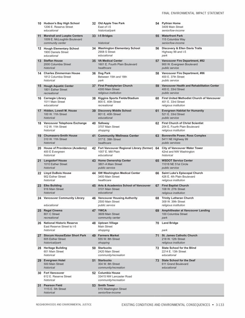
commuNitY resourcesAn inventory of Washington and Oregon community resources within each neighborhood was collected by the project team (Exhibits 3.5-4, 3.5-5, and 3.5-6). The project team met with members of each community who identified the resources that were important to them and the locations of these resources on a map. Project staff identified community resources within and near the study area that fit the following commonly accepted neighborhood resource categories: parks, schools, locally and nationally recognized historic structures, gathering areas, and public services.
Project staff created two draft maps based on these resources, one for Oregon and one for Washington. In the fall of 2006, the CRC Community and Environmental Justice Group (CEJG) reviewed the draft neighborhood resource maps and identified additional resources. These maps were further reviewed and modified at neighborhood meetings and open houses in 2007 and during the public comment period in the spring of 2008. Please refer to Section 3.5.3, Coordination, below for details on CEJG.

columbia river crossiNg
3-132 • CHAPTER 3 Neighborhoods aNd eNviroNmeNtal Justice
Exhibit 3.5-4Community Resources, Clark County, Washington
LINCOLN
WEST MINNEHAHA
HUDSONS BAY
HOUGH
ESTHER SHORT
ROSE VILLAGE
CENTRAL PARK
NORTHWEST
ARNADA
SHUMWAYCARTER PARK
COLUMBIA WAY
9
87 6 5
43
21
73
7271
70
69
68
6766
64
63
62
6160
59
58
57
56
55
54
53
52
51
50
49
48
47
36
42
44
43
41
39
37
35
34
26
24
33
32 3130
2825
23
29
27
22
21 2019
17
16
1514
1213
11
10
46
45
40
38
18
Analysis by J. Koloszar; Analysis Date: 01 Jul 2011; File Name: F:\Transfer060811\NEI\NEIResources_DC146_EJ.mxd
0 0.25 0.5
Miles
Main Project Area
Dimensions are approximate.Note: Location 65 is beyond map extent.
LINCOLN
WEST MINNEHAHA
HUDSONS BAY
HOUGH
ESTHER SHORT
ROSE VILLAGE
CENTRAL PARK
NORTHWEST
ARNADA
SHUMWAYCARTER PARK
COLUMBIA WAY
9
87 6 5
43
21
73
7271
70
69
68
6766
64
63
62
6160
59
58
57
56
55
54
53
52
51
50
49
48
47
36
42
44
43
41
39
37
35
34
26
24
33
32 3130
2825
23
29
27
22
21 2019
17
16
1514
1213
11
10
46
45
40
38
18
Analysis by J. Koloszar; Analysis Date: 01 Jul 2011; File Name: F:\Transfer060811\NEI\NEIResources_DC146_EJ.mxd
0 0.25 0.5
Miles
Main Project Area
1 Covington House4201 Main Streethistorical
4 Shumway Park3014 F Streetpark
7 Swan House714 E. 26th Streethistorical
2 Leverich Community Park39th and M Streetpark
5 Leach Park28th and K Streetpark
8 Arnada Neighborhood ParkW. 25th and G Streetpark
3 Carter Park33rd Streetpark
6 2613 “H” Street House2613 H Streethistorical
9 Clark College1800 E. McLoughlin Boulevardeducational
Exhibit 3.5-5Community Resources, Clark County, Washington
FiNal eNviroNmeNtal imPact statemeNt
EXISTING CONDITIONS AND ENVIRONMENTAL CONSEQUENCES • 3-133Neighborhoods aNd eNviroNmeNtal Justice
10 Hudson’s Bay High School1206 E. Reserve Streeteducational
32 Old Apple Tree ParkEast of I-5historical/park
54 Pythian Home3409 Main Streetsenior/low-income
11 Marshall and Luepke Centers1009 E. McLoughlin Boulevardcommunity center
33 I-5 Bridges
historical
55 Waterfront Park115 Columbia Waysenior/low-income
12 Hough Elementary School1900 Daniels Streeteducational
34 Washington Elementary School2908 S Streeteducational
56 Discovery & Ellen Davis TrailsHighway 99 and I-5park
13 Steffan House2000 Columbia Streethistorical
35 VA Medical Center1601 E. Fourth Plain Boulevardhealthcare
57 Vancouver Fire Department, #82900 W. Evergreen Boulevardpublic service
14 Charles Zimmerman House1812 Columbia Streethistorical
36 Dog ParkBetween 15th and 18thpark
58 Vancouver Fire Department, #86400 E. 37th Streetpublic service
15 Hough Aquatic Center1801 Esther Streetrecreational
37 First Presbyterian Church4300 Main Streetreligious institution
59 Vancouver Health and Rehabilitation Center400 E. 33rd Streetpublic service
16 Carnegie Library1511 Main Streeteducational
38 Kiggins Sports Fields/Stadium800 E. 40th Streetrecreational
60 First United Methodist Church of Vancouver401 E. 33rd Streetreligious institution
17 Hidden, Lowell M. House100 W. 11th Streethistorical
39 Discovery Middle School801 E. 40th Streeteducational
61 Evergreen Habitat for Humanity521 E. 33rd Streetpublic service
18 Vancouver Telephone Exchange112 W. 11th Streethistorical
40 Safeway3707 Main Streetshopping
62 First Church of Christ Scientist204 E. Fourth Plain Boulevardreligious institution
19 Chumasero-Smith House310 W. 11th Streethistorical
41 Community Wellness Center317 E. 39th Streethealthcare
63 Bonneville Power, Ross Complex5411 NE Highway 99public services
20 House of Providence (Academy)400 E Evergreenhistorical
42 Fort Vancouver Regional Library (former)1007 E. Mill Plaineducational
64 City of Vancouver Water Tower42nd and NW Washingtonhistorical
21 Langsdorf House1010 Esther Streethistorical
43 Home Ownership Center3801-A Main Streetpublic service
65 WSDOT Service Center11018 NE 51st Circlepublic service
22 Lloyd DuBois House902 Esther Streethistorical
44 SW Washington Medical Center3400 Main Streethealthcare
66 Saint Luke’s Episcopal Church426 E. 4th Plain Boulevardreligious institution
23 Elks Building916 Main Streethistorical
45 Arts & Academics School of Vancouver3101 Main Streeteducational
67 First Baptist Church108 W. 27th Streetreligious institution
24 Vancouver Community Library
educational
46 Vancouver Housing Authority2500 Main Streetpublic service
68 Trinity Lutheran Church309 W. 39th Streetreligious institution
25 Regal Cinema801 C Streetrecreational
47 YWCA3609 Main Streetcommunity center
69 Amphitheater at Vancouver Landing100 Columbia Streetpark
26 National Historic ReserveEast Reserve Street to I-5historical
48 Uptown VillageMain Streetshopping
70 Land Bridge
park
27 Slocum House/Ester Short Park605 Esther Streethistorical/park
49 Farmers Market555 W. 8th Streetshopping
71 St. James Catholic Church218 W. 12th Streetreligious institution
28 Heritage Building601 Main Streethistorical
50 Starbucks2420 Main Streetcommunity/recreation
72 State School for the Blind2214 E. 13th Streeteducational
29 Evergreen Hotel500 Main Streethistorical
51 Starbucks304 W. 8th Streetcommunity/recreation
73 State School for the Deaf611 Grand Boulevardeducational
30 Fort Vancouver612 E. Reserve Streethistorical
52 Columbia House33415 NW Lancaster Roadcommunity/recreation
31 Pearson Field1115 E. 5th Streethistorical
53 Smith Tower515 Washington Streetsenior/low-income

columbia river crossiNg
3-134 • CHAPTER 3 Neighborhoods aNd eNviroNmeNtal Justice
Exhibit 3.5-6Community Resources, Multnomah County, Oregon
KENTON
EAST COLUMBIA
BRIDGETON
COLUMBIA WAY
HAYDEN ISLAND
¬«7
¬«8
¬«9
¬«6
¬«4¬«5
¬«3 ¬«2
¬«1
¬«22
¬«21¬«20
¬«19
¬«17
¬«16¬«14
¬«13¬«12
¬«11
¬«10
¬«18
¬«15
Analysis by J. Koloszar; Analysis Date: July 14, 2010; File Name: NEIREsources_DC146_NEI.mxd
²0 0.25 0.5
Miles
Exhibit 3-1. Neighborhood Resources Clark County, Washington (1 of 2)Main Project Area
1 Private Community CenterN. Arbor Avenue and Alder Streetrecreational
2 Former Hayden Island Yacht Club120050 N. Jantzen Drivecommunity center
3 Safeway11919 N. Jantzen Driveshopping
4 Lotus Isle ParkN. Tomahawk and Island Drivepark
5 North Portland Harbor & Industrial Marinasnatural resource/housing
6 Vanport Wetlandsnatural resource
7 Off leash area
park8 East Delta Park
N. Martin Luther King Jr. Boulevard and Denver Avenuepark
9 Portland International Raceway1940 N. Victory Boulevardrecreational
10 Portland Meadows1001 N. Schmeer Roadrecreational
11 Columbia Slough
recreational
12 Columbia Cemetery1151 N. Columbia Boulevardhistorical
13 Paul Bunyan StatueN. Denver Avenue and Interstate Avenuehistorical
14 Christmas Lights House (NRHP)1441 N. McClellan Streethistorical
15 Kenton Commercial Historic DistrictDenver Avenuehistorical/shopping
16 Kenton Community Policing Office8134 N. Denver Avenuepublic service
17 Jantzen Beach SuperCenter and Commercial Area shopping
18 Portland Fire and Rescue, Station #17848 N. Tomahawk Drivepublic service
19 Historic Kenton Firehouse8105 N. Brandon Avenuecommunity center
20 Kenton Park8417 N. Brandon Avenuepark
21 Wells Fargo Bank8324 N. Denver Avenuefinancial services
22 Wells Fargo Bank12240 N. Jantzen Drivefinancial servicesDimensions are approximate.
KENTON
EAST COLUMBIA
BRIDGETON
COLUMBIA WAY
HAYDEN ISLAND
¬«7
¬«8
¬«9
¬«6
¬«4¬«5
¬«3 ¬«2
¬«1
¬«22
¬«21¬«20
¬«19
¬«17
¬«16¬«14
¬«13¬«12
¬«11
¬«10
¬«18
¬«15
Analysis by J. Koloszar; Analysis Date: July 14, 2010; File Name: NEIREsources_DC146_NEI.mxd
²0 0.25 0.5
Miles
Exhibit 3-1. Neighborhood Resources Clark County, Washington (1 of 2)Main Project Area
LINCOLN
WEST MINNEHAHA
HUDSONS BAY
HOUGH
ESTHER SHORT
ROSE VILLAGE
CENTRAL PARK
NORTHWEST
ARNADA
SHUMWAYCARTER PARK
COLUMBIA WAY
9
87 6 5
43
21
73
7271
70
69
68
6766
64
63
62
6160
59
58
57
56
55
54
53
52
51
50
49
48
47
36
42
44
43
41
39
37
35
34
26
24
33
32 3130
2825
23
29
27
22
21 2019
17
16
1514
1213
11
10
46
45
40
38
18
Analysis by J. Koloszar; Analysis Date: 01 Jul 2011; File Name: F:\Transfer060811\NEI\NEIResources_DC146_EJ.mxd
0 0.25 0.5
Miles
Main Project Area
KENTON
EAST COLUMBIA
BRIDGETON
COLUMBIA WAY
HAYDEN ISLAND
¬«7
¬«8
¬«9
¬«6
¬«4¬«5
¬«3 ¬«2
¬«1
¬«22
¬«21¬«20
¬«19
¬«17
¬«16¬«14
¬«13¬«12
¬«11
¬«10
¬«18
¬«15
Analysis by J. Koloszar; Analysis Date: July 14, 2010; File Name: NEIREsources_DC146_NEI.mxd
²0 0.25 0.5
Miles
Exhibit 3-1. Neighborhood Resources Clark County, Washington (1 of 2)Main Project Area

FiNal eNviroNmeNtal imPact statemeNt
EXISTING CONDITIONS AND ENVIRONMENTAL CONSEQUENCES • 3-135Neighborhoods aNd eNviroNmeNtal Justice
Existing Conditions for Environmental Justice
miNoritY PoPulatioNsAccording to the 2010 U.S. Census, 21 percent of the population in the study area is minority (Exhibit 3.5-7). Percent minority was calculated by adding all minority populations (including Caucasian populations that identified their ethnicity as Hispanic or Latino) and dividing by total population. Although minorities are located throughout the area, the percentage of minority populations is higher in the Oregon census tracts (27 percent) than in the Washington census tracts (20 percent). Census tracts are small, statistical subdivisions of counties used in collating U.S. Census Bureau data. A breakdown of minority populations by race and ethnicity for the study area is displayed in Exhibit 3.5-8.
In 2000, the study area neighborhood with the highest percentage of minorities was Rockwood with 40 percent minorities (Exhibit 3.5-10). Neighborhoods such as Arnada, with 4 percent minority residents, and Hayden Island, with 8 percent minority residents, were lower than the average within the project area. These wide variations illustrate the importance of understanding the diversity of minorities among the neighborhoods. Exhibit 3.5-10 shows the total percentage of minorities by combining the rate of racial and Hispanic minorities.
Particularly high concentrations of minority populations (70 percent or over) can be found in 10 block groups in the Boise, King, Humboldt, Piedmont, Eliot, Irvington, and Woodlawn neighborhoods of Portland. Block groups are smaller geographic units which together comprise a census tract. In 2000, Census Tract (CT) 33.01 Block Group (BG) 3 had the highest proportion of minority residents on the Oregon side of the Columbia River, in the Boise neighborhood of Portland. The highest concentration of minorities in Vancouver was in CT 8.04 BG 1 in the NE Hazel Dell neighborhood (41 percent minority). Because of rounding, exhibits in this section show some rates as 0, although there may be minority households in these areas. Please refer to the Environmental Justice Technical Report, included as an electronic appendix to this FEIS, for maps of the study area block groups and a table of the percentage of minority populations by census block group.
A review of the limited, available 2010 Census data shows increases in the percentage of minorities in all Oregon and Washington census tracts in the main project area. In Washington, the minority population increased the most in census tracts 421 and 418. Though these tracts are not contiguous with neighborhood boundaries, the data indicate a 10.5-percentage-point increase in minority persons in the Carter Park neighborhood and the southern portion
Exhibit 3.5-7Minority Populations Within Study Area
AreaTotal Population
2000 CensusTotal Population
2010 CensusPercent Minority
2000 CensusPercent Minority
2010 CensusOregon Study Area 4,081 4,849 15 27
Washington Study Area 34,460 35,799 17 20
Study Area Total 38,541 40,648 17 21
Sources: U.S. Census Bureau, 2000, Summary Tape File 3, Table P7. U.S. Census Bureau, 2010, Redistricting Data (PL 94-171) Summary File.

columbia river crossiNg
3-136 • CHAPTER 3 Neighborhoods aNd eNviroNmeNtal Justice
of the Lincoln Neighborhood and a 7.5-percentage-point increase in minority persons in the Rose Village neighborhood since 2000.
In Oregon, the minority population in the census tract containing Hayden Island increased 6.5 percentage points since 2000. The minority population in the census tract with the Marine Drive interchange (overlapping with the Kenton and East Columbia neighborhoods) increased 15.2 percentage points from 2000 to 2010. The changes in minority populations from the 2000 to the 2010 census are shown in Exhibits 3.5-11 and 3.5-12.
LOW-INCOME POPULATIONSPoverty rates for local jurisdictions, ranging from 10 to 16 percent, are shown in Exhibit 3.5-9 and are based on the 2005-2009 American Community Survey (ACS). Poverty rates were calculated by dividing the number of individuals who reported incomes below the poverty threshold within the last 12 months by total population (for whom poverty status was determined). Poverty rates for specific neighborhoods ranged (in 2000) from a low of 9 percent in the Hayden Island, Bridgeton, and East Columbia neighborhoods to a high of 35 percent in the Esther Short neighborhood. However, the poverty rate dropped dramatically in Esther Short since 2000. Other central Vancouver neighborhoods such as Central Park, Rose Village, Hough, and Hudson’s Bay also show higher than average poverty rates of between 19 and 25 percent (Exhibit 3.5-10).
Because the 2010 Census did not include questions regarding income, the ACS has been used to provide more recent income data than the 2000 Census. The 2005-2009 ACS 5-year estimate is the first data release available at the census tract-level since the survey’s inception in 2005. It reports population and housing characteristics based on data collected from 2005 to 2009. ACS data is not based on a population count like the census; rather, it provides estimates based on survey responses and is meant to replace the census long-form questionnaire.
Exhibit 3.5-8Race and Ethnicity of Minorities (Percent) Within the Study Area (2010)
Area
Race Ethnicity
White Alone
Black or African
American Alone
American Indian and
Alaska Native Alone
Asian Alone
Native Hawaiian and Other
Pacific Islander Alone
Some Other Race Alone
Two or More
RacesHispanic or Latino
Oregon Study Area 76 8 1 6 1 5 4 9
Washington Study Area 84 3 1 2 1 4 5 10
Study Area Total 83 3 1 3 1 5 4 10
Multnomah County 76 6 1 7 1 5 5 11
City of Portland 76 6 1 7 1 4 5 9
Clark County 85 2 1 4 1 3 4 8
Vancouver 81 3 1 5 1 4 5 10
Source: U.S. Census Bureau, 2010, Redistricting Data (PL 94-171) Summary File.

FiNal eNviroNmeNtal imPact statemeNt
EXISTING CONDITIONS AND ENVIRONMENTAL CONSEQUENCES • 3-137Neighborhoods aNd eNviroNmeNtal Justice
Hispanic or Latino
<1%
1% - 3%
3% - 6%
6% - 7%
7% - 10%
10% - 15%
15% - 27%
Ruby JunctionMaintenance Facility
GRESHAM -ROCKWOOD
GRESHAM -CENTENNIAL
GRESHAM -NORTHWEST
15%
27%
7%
Certain Washington census tracts featured a significant change in persons reporting incomes below the federal poverty thresholds. Those reporting incomes below the poverty threshold in CT 424, roughly the Esther Short neighborhood, dropped 23.8 percentage points since 2000 (Exhibit 3.5-11). In CT 421, it rose 23 percentage points. In Oregon there was much less change, with all study area census tracts showing reduced rates of poverty since 2000. The changes in low-income populations from the 2000 to the 2005-2009 ACS are shown in Exhibits 3.5-11 and 3.5-13.
Exhibit 3.5-9Poverty Rates for Local Jurisdictions
AreaMultnomah
County Portland Clark County VancouverPercent of Population Below Poverty Level (2000) 12 13 9 12
Percent of Population Below Poverty Level (2009) 16 16 10 15
Sources: U.S. Census Bureau, 2000, Summary Tape File 3, Table P88. ACS 2005-2009, Table B17001.
Exhibit 3.5-10Census Demographics – Environmental Justice (1 of 2)
Shumway
Bridgeton
Arnada
Hudsons Bay
EstherShort
Hayden Island
WestMinnehaha
Hough
RoseVillage
CentralPark
Lincoln
Columbia Way
Kenton
!
!
East Columbia
O R E G O N
W A S H I N G T O N
!
§̈¦5
Columbia River
8%
38%24%
17%
15%
11%
21%14%
19%
26%
17% 4%
24%
12%
Minorities (including Hispanic)<4%4% - 8%8% - 12%12% - 17%17% - 21%21% - 26%26% - 38%
Shumway
Bridgeton
Arnada
Hudsons Bay
EstherShort
Hayden Island
WestMinnehaha
Hough
RoseVillage
CentralPark
Lincoln
Columbia Way
Kenton
!
!
East Columbia
O R E G O N
W A S H I N G T O N
!
§̈¦5
Columbia River
9%
3%
1%
6%
2%
6%
9%
3%
10%
14%
7%
1%
6%
2%
Hispanic or Latino
<1%1% - 2%2%- 3%3% - 6%6% - 7%7% - 10%10% - 14%
Minorities(including Hispanic)
<4%
4% - 9%
8% - 12%
13% - 15%
18% - 21%
21% - 26%
26% - 40%
Ruby JunctionMaintenance Facility
GRESHAM -ROCKWOOD
GRESHAM -CENTENNIAL
GRESHAM -NORTHWEST
40%
25%
16%
Source: U.S. Census Bureau, 2000.

columbia river crossiNg
3-138 • CHAPTER 3 Neighborhoods aNd eNviroNmeNtal Justice
Source: U.S. Census Bureau, 2000.
Shumway
Bridgeton
Arnada
Hudsons Bay
EstherShort
Hayden Island
WestMinnehaha
Hough
RoseVillage
CentralPark
Lincoln
Columbia Way
Kenton
!
!
East Columbia
O R E G O N
W A S H I N G T O N
!
§̈¦5
Columbia River
9%
14%
9%
11%
14%
35%
10%
19%
25%
23%
20%
9%
14%
15%
Below Poverty<9%9% - 11%11% - 14%14% - 15%15% - 20%20% - 25%25% - 35%
Below Poverty
<9%
9% - 11%
11% - 14%
14% - 15%
15% - 20%
20% - 25%
25% - 35%
Ruby JunctionMaintenance Facility
GRESHAM -ROCKWOOD
GRESHAM -CENTENNIAL
GRESHAM -NORTHWEST
14%
25%
10%
Exhibit 3.5-10Census Demographics – Environmental Justice (2 of 2)

FiNal eNviroNmeNtal imPact statemeNt
EXISTING CONDITIONS AND ENVIRONMENTAL CONSEQUENCES • 3-139Neighborhoods aNd eNviroNmeNtal Justice
Exhibit 3.5-11Census Tract-level Comparisons for Minority and Low-income Populations
2000 Census Tract (2010 Tract)
Percent Minority (2000)
Percent Minority (2010)
Percentage Point
Change in Percent Minority
Percent Low-
income (2000)
Percent Low-
income (2009)
Percentage Point
Change in Percent
Low-income
Census Tract 72.01 8.08 14.54 6.46 8.51 7.86 -0.64
Census Tract 72.02a 22.76 37.92 15.16 9.19 5.32 -3.87
Census Tract 98.01b 48.33 50.33 2.00 29.48 34.07 4.59
Census Tract 410.02 (410.1)c 14.25 18.49 4.24 13.22 14.41 1.19
Census Tract 410.02 (410.11)c 14.25 16.53 2.28 13.22 14.41 1.19
Census Tract 410.03 12.47 15.90 3.44 8.35 14.20 5.86
Census Tract 417 32.90 33.22 0.32 22.99 27.66 4.67
Census Tract 418 19.97 27.47 7.50 22.35 20.79 -1.56
Census Tract 419 10.71 12.60 1.89 13.30 18.52 5.22
Census Tract 420 10.24 13.10 2.86 9.45 8.32 -1.13
Census Tract 421 12.21 22.69 10.48 9.10 32.08 22.97
Census Tract 423 16.28 19.07 2.79 19.55 22.12 2.57
Census Tract 424 15.19 16.64 1.45 47.59 23.77 -23.82
Census Tract 425 13.53 14.63 1.10 16.19 23.26 7.07
Census Tract 426 17.12 19.90 2.78 20.91 21.07 0.16
Sources: U.S. Census Bureau, 2000, Summary File 1 Tables P07 and P08, Summary File 3 Table P87. ACS 2005-2009, Table B17001. U.S. Census Bureau, 2010, Summary File 1 Tables P01 and P05.
Notes: Percent minority is calculated by tabulating the population of all minorities and Caucasians who identify their ethnicity as Hispanic and dividing this figure by total population. Percent low-income (below poverty level) is calculated by dividing the population that resides below the poverty level by total population (of individuals for whom poverty status is determined).
a There have been minor changes in the boundary of this census tract between 2000 and 2010. It has gained and lost territory to Census Tract 71 and lost territory to Census Tract 43. However, the boundary fluctuations are located directly over the Willamette River and are expected to have negligible impact on data comparisons.
b Census Tract 98.01 is located in the Rockwood neighborhood in Gresham, Oregon, and is not considered part of the primary area of project influence nor is it included in tabulations of the total study area.
c Census Tract 410.02 has been bisected into smaller census tracts for 2010 (410.1 and 410.11). Both tracts have been included for the purpose of maintaining consistency between 2000 Census and 2010 Census data. However, Census Tract 410.1 is located outside of the study area. American Community Survey uses 2000 Census geographies.

columbia river crossiNg
3-140 • CHAPTER 3 Neighborhoods aNd eNviroNmeNtal Justice
CT 4262.8%
CT 72.0215.2%
CT 72.016.5%
CT 410.112.3%
CT 410.033.4%
CT 4187.5%
CT 4241.5%
CT 42110.5%
CT 4232.8%
CT 4191.9%
CT 4170.3%
CT 4251.1%
CT 4202.9%
CT 410.104.2%
CLARK COUNTY
MULTNOMAH COUNTY
WASHINGTONOREGON
Appendix E. Change in Proportion ofMinority PopulationMain Project Area and Ruby Junction
0 0.25 0.5Miles
+10.6% and Above+4.3 to 10.5%+2.4 to +4.2%
+1.2 to +2.3%+1.1% and Below
Main Project Area
Change in Proportion of Minority Populationby 2010 Census Tracts
Va n c o u v e r
P o r t l a n d
Note: Changes for CT 410.1 and CT 410.11 measuredbetween 2010 counts for each tract and 2000 counts for CT 410.02.
CT 98.012%
Ruby Junction FacilityGresham, Oregon
0 0.50.25 Miles
CT 98.014.6%
Ruby Junction FacilityGresham, Oregon
0 0.50.25 Miles
+7.2% and Above
+2.7 to +7.1%
-0.5% to +2.6%
-0.6 to -23.7%
-23.8% and Below
Main Project Area
+10.6% and Above+4.3 to +10.5%+2.4 to +4.2%+1.2 to +2.3%+1.1% and Below
Main Project Area
Exhibit 3.5-12Percentage Point Changes in Minority Population of the Study Area
CT 4260.2%
CT 72.02-3.9%
CT 72.01-0.6%
CT 410.021.2%
CT 410.035.9%
CT 418-1.6%
CT 424-23.8%
CT 42123%
CT 4232.6%
CT 4195.2%
CT 4174.7%
CT 4257.1%
CT 420-1.1%
CLARK COUNTY
MULTNOMAH COUNTY
WASHINGTONOREGON
Appendix F. Change in Proportion ofLow-Income PopulationMain Project Area and Ruby Junction
0 0.25 0.5Miles
+7.2% and Above+2.7 to +7.1%-0.5% to +2.6%
-0.6 to -23.7%-23.8% and Below
Main Project Area
Change in Proportion of Low-Income Populationby 2000 Census Tracts
Va n c o u v e r
P o r t l a n d
Exhibit 3.5-13Percentage Point Changes in Low-Income Population of the Study Area
Sources: U.S. Census Bureau, 2000, 2010. Note: Changes for CT 410.1 and CT 410.11 measured between 2010 counts for each tract and 2000 counts for CT 410.02.
Sources: U.S. Census Bureau, 2000. ACS 2005-2009..

FiNal eNviroNmeNtal imPact statemeNt
EXISTING CONDITIONS AND ENVIRONMENTAL CONSEQUENCES • 3-141Neighborhoods aNd eNviroNmeNtal Justice
Additional Data GatheringThe CRC team used information collected from various sources and by various methods to supplement the earlier data-gathering efforts for the neighborhoods and environmental justice analyses.
other demograPhic dataThe additional data sources consulted by the CRC team included the 2004 American Community Survey (U.S. Census Bureau 2007), Section 8 Housing Assistance data (U.S. HUD 2007), and public school free and subsidized lunch program data (U.S. Education Statistics 2007). The team also contacted local social service agencies to identify recent development projects that serve low-income and/or minority populations.
These additional data were used to confirm or revise the understanding of neighborhoods and EJ populations that was based on 2000 U.S. Census data. The additional data (such as the location of subsidized housing sites) were also useful in planning public outreach activities, and are discussed in greater detail under Section 3.5.3, Coordination, below. The demographic surveys completed by the project were instrumental in determining the presence of low-income and minority households.
Information collected through field visits and public outreach events with community and stakeholder groups enabled the project team to further supplement and refine the above data by better understanding who lives in the project area and learning about their hopes for and concerns about the project. Activities included attendance at meetings and events such as AsiaFest, Good in the Hood, Alberta Co-op Farmers Market, Vietnamese New Year celebration, Say Hey! Partners in Diversity, Juneteenth Festival, and a Slavic Coalition meeting.
Prior to issuance of the CRC project Notice of Intent (NOI) to prepare an EIS, the project team identified limited-English proficiency populations by using geographic information systems (GIS) and 2000 U.S. Census data. The data used for limited-English proficiency were derived from responses to the Census question of “language spoken at home.” The smallest geographic unit for which “language spoken at home” data are available is the census block group. Because of data limitations and the importance of identifying those populations most likely to experience direct impacts, “language spoken at home” data were collected for all census block groups lying entirely or partially within the project study area. The data showed that those speaking Spanish, Russian, German, and Vietnamese at home represented at least 1 percent of the population in the study block groups. Because German speakers tended to also have high levels of English language fluency, Spanish, Russian, and Vietnamese were chosen as the focus languages.
Project information has been routinely translated into those focus languages, including project newsletters, some project documents, and portions of the project web site. Russian, Spanish, and Vietnamese interpreters have been provided upon request at numerous public open houses, along with deaf and blind translation services, also upon request. Russian and Spanish are the two most common non-English languages spoken at home in Portland, Vancouver, and Clark County. Vietnamese is the third most spoken non-English language in Portland and Vancouver, but not in Clark County.
disPlacemeNt surveYsThe CRC project team developed and conducted a series of location-specific surveys to further determine the characteristics of populations that could be directly impacted by

columbia river crossiNg
3-142 • CHAPTER 3 Neighborhoods aNd eNviroNmeNtal Justice
the project and whether the project would cause disproportionate impacts on environmental justice populations.
In Oregon, a demographic survey was delivered to all potentially displaced residents at four specific locations: Ruby Junction, Jantzen Beach Moorage Inc. ( JBMI), Columbia Crossings moorage, and a single-family home and floating home sites along the south shore of North Portland Harbor. In some cases, such as JBMI, the study area included all of the residents of the floating home community. In Washington, surveys were sent to residents along I-5 between 29th Street and SR 500, in two residential units in a displaced business in downtown Vancouver, and those at the west end of 17th Street. Many of the mailed surveys were followed by in-person visits, while in other cases the project team held group meetings following the mail-out. Approximately 300 surveys were distributed; nearly 100 were completed. Additionally, project staff interviewed dozens of residents in the survey areas. The survey and interview responses for residential displacements reveal that 81.8 percent of survey respondents are white and not of Hispanic or Latino ethnicity. One household, 3.1 percent, is American Indian or Alaskan Native and not of Hispanic or Latino ethnicity. Another one household, 3.1 percent, is some other race and not of Hispanic or Latino Ethnicity. Four additional households (12.5 percent) are Hispanic and of some other race. The percentage of minorities, among the residential displacements (18.8 percent) is lower than the percentage of minority households in the study area (27 percent).
Income data were collected in the residential surveys; respondents had an option to choose income in one of nine categories ranging from less than $10,000 to $80,000 or more, with a range of $10,000 each. Because the income range responses span the poverty thresholds, an exact determination of low-income status using the 2010 Census thresholds is not possible. Based on income and the number of people in their household, only two survey respondents are clearly below the poverty level. Two other households have the potential to be considered low-income, but without knowing their exact income level it cannot be determined if they are below the threshold or not. If all four of these respondents were included as low-income for the purposes of EJ analysis, that would total 13.3 percent of all respondents who indicated income levels. A low-income population of 13.3 percent is very similar to that of Vancouver and Portland, and slightly lower than the percentage for the larger study area.
In order to assess the impacts of commercial displacements more precisely, the businesses which are likely to be displaced were also surveyed during the summer of 2009. Many of the surveyed businesses stated that they employed high numbers of minority employees, with higher minority compositions than the region or local area. Some other businesses did not have many minority employees. Businesses with higher percentages stated that they employed “50 percent minorities,” “very high percentages of minorities,” or similar expressions.
Many of the surveyed businesses stated that they employed high numbers of low-income employees. Some of the businesses, such as Safeway, employ high numbers of part-time employees, many of which may be paid the state’s minimum wage. It is possible that households dependent on these part-time positions with minimum wage compensation may fall under the federal poverty level and would therefore be considered EJ households.

FiNal eNviroNmeNtal imPact statemeNt
EXISTING CONDITIONS AND ENVIRONMENTAL CONSEQUENCES • 3-143Neighborhoods aNd eNviroNmeNtal Justice
travelshed characteristicsFor the EJ analysis, the CRC project team conducted a study to determine whether the adverse project impacts would be predominately borne by low-income or minority populations. The team studied the travelshed of bridge users (the broad area from which river crossing trips originate), to evaluate whether the project benefits would disproportionately benefit higher income, non-EJ populations. The team started the study in September 2009 by assessing 39 counties in Oregon and Washington. The study looked at the number of trips across the I-5 bridges taken by households and the zip code of each trip’s origin. The results of this study were paired with 2000 Census data regarding race/ethnicity and household income to find the basic demographic makeup of the 39 zip codes in the travelshed. The project team reviewed these data and found that proposed improvements would not disproportionately benefit higher income populations.
3.5.3 CoordinationPublic involvement is important to provide correct information, build trust, and develop solutions that work. A variety of methods were used to engage neighborhoods and their communities during the development of the CRC project. Information was collected through field visits and public outreach events with community and stakeholder groups. Input was also received from attendance at meetings and events such as AsiaFest, Good in the Hood, Alberta Coop Farmers Market, Vietnamese New Year celebration, Say Hey! Partners in Diversity, Juneteenth Festival, and the Slavic Coalition, as stated earlier.
Exhibit 3.5-14 summarizes the number of meetings held with specific organizations or at specific sites, as well as the number of sites for which project staff developed and distributed outreach materials.
Environmental Justice CoordinationTwo key principles of Environmental Justice are the fair treatment and meaningful involvement of all people. Fair treatment means that no group of people, including racial, ethnic, and socioeconomic groups, should bear a disproportionate share of negative environmental consequences of the project. Meaningful involvement means that 1) the decision-makers seek out and facilitate the involvement of those potentially affected, 2) potentially affected community residents have an appropriate opportunity to participate in decisions about a proposed activity that
Exhibit 3.5-14Summary of Outreach Efforts
Event Categorya Number of Locations/Meetings AttendanceLow-income Housing Sites 10 154
Senior Citizens 10 454
Minority Populations 29 1304b
Transit-dependent Populations 6 58
Limited-English Proficiency Groups 15 N/Ac
Neighborhoods 167 Not fully documented
Other 33 1369
a As of 12-31-2009.
b Not including the numerous attendees at events such as National Night Out (a community event encouraging safe neighborhoods) and similar.
c This outreach consisted largely of distributed, translated outreach materials, although some meetings were also conducted.

columbia river crossiNg
3-144 • CHAPTER 3 Neighborhoods aNd eNviroNmeNtal Justice
will affect their environment or health, 3) the public’s contribution can influence the regulatory agency’s decision, and 4) the concerns of all participants involved will be considered in the decision-making process.
The following discussions summarize the methods used to ensure that EJ populations were provided fair treatment and an opportunity for meaningful project involvement. The number of outreach activities conducted with EJ populations is shown in Exhibit 3.5-15. A complete list of all related outreach activities and their locations can be found in the CRC Environmental Justice Technical Report, included as an electronic appendix to this FEIS.
LIMITED-ENGLISH PROFICIENCY STRATEGYAn important component of the public involvement strategy for this project is two-way communication with limited-English, low-income, and minority populations. To this end, the public involvement team coordinated with local communities, the established Community and Environmental Justice Group (CEJG; see discussion below), and community-based organizations to develop appropriate strategies for outreach to these communities.
Selected project documents were and continue to be translated into Spanish, Russian, and Vietnamese; posted on the project web site; and distributed in hard copy form at strategic locations in the community. Spanish, Russian, Vietnamese, and sign language interpreters were and continue to be made available at project open houses, upon request. Using the translated materials, project staff have hand-delivered information to businesses along Fourth Plain Boulevard in Vancouver, where many Latino businesses are located, and along Sandy Boulevard in Portland, where many Vietnamese businesses are located. Staff have also used door-to-door distribution to inform many businesses in north Portland that cater to low-income and minorities.
commuNitY aNd eNviroNmeNtal Justice grouPIn addition to direct communication with existing community groups, the project team formed the CEJG in August 2006 to further help achieve the goal of meaningful public involvement in the project development process. The 15 members of the CEJG represented neighborhoods in the project area and included environmental justice populations, two liaisons from the CRC Task Force, and five at-large members. Together, they reflected some of the diverse interests and perspectives of Vancouver and Portland neighborhoods potentially affected by the project.
The CEJG provided assistance to CRC project staff in identifying community concerns in the project development process; providing public outreach; presenting recommendations at key milestones; and raising relevant issues of interest (or concerns for potential impacts) such as air quality, noise, highway interchange alignments, and design features to help inform the project’s efforts to avoid, minimize, and/or mitigate potential community impacts.
Results of Outreach and CoordinationThis intensive outreach effort has informed and affected the project design and the Environmental Justice analysis. Through individual meetings with specific groups, the project team has gained vital information that has been used in the

FiNal eNviroNmeNtal imPact statemeNt
EXISTING CONDITIONS AND ENVIRONMENTAL CONSEQUENCES • 3-145Neighborhoods aNd eNviroNmeNtal Justice
design and planning processes. For example, the project team has been working to avoid and minimize specific impacts to: • The elderly and handicapped individuals who frequent the Clark County
Historic Museum and may depend on Americans with Disabilities Act (ADA)-compliant pathways. The selection of 17th Street for the transit alignment has removed the potential for impacts to the pathway.
• The low-income residents of Smith Tower, in Vancouver, who live next to the proposed construction area.
• The representatives of the Jantzen Beach Moorage who have asserted that they have residents who should be considered as part of the EJ population. Two separate surveys were conducted to gather additional demographic data. The survey data confirmed the relatively low minority and low-income composition reported in the U.S. Census for the island as a whole.
• The residents of the manufactured home community on Hayden Island, who have expressed concern regarding construction period impacts, including noise from pile driving and air quality impacts associated with construction equipment. The project has organized many meetings to hear and address these concerns.
• The residents of Vancouver’s Rose Village neighborhood, who were particularly concerned about construction equipment emissions and air quality. The project has since committed to low-sulfur diesel and other steps to reduce emissions.
• Community Resource Mapping, which has provided a list of resources to which the designers have paid particular attention in their efforts to avoid and minimize impacts.
• The Community Services Northwest Wellness Center in north Vancouver, which provides mental health services to low-income populations. The LPA would avoid this site, while other alternatives would have displaced the facility.
The CEJG has helped the project to address the right issues with the right groups of people, and has served as a sounding board for various analytical conclusions and for the development of proposed mitigation. The CEJG encouraged the project to provide additional outreach related to specific issues. In response, the project has provided additional presentations and materials related to air quality, environmental justice procedures, floating home relocations, and more.
3.5.4 Effects GuidelinesEffects Guidelines – Environmental JusticeImpacts to EJ populations are assessed based on EO 12898 and subsequent DOT and FHWA guidance that identify disproportionately high and adverse effects as those that: • Are predominantly borne by minority populations or low-income
households, or • Would be experienced by these populations in a way that is appreciably
more severe or greater in magnitude than would be experienced by non-minority or non-low-income populations.
terms & deFiNitioNs
Community resources and cohesion
Community resources typically include educational, religious, health care, cultural, and recreational facilities. Community cohesion measures how well residents can connect with one another within their community. These connections can occur at gathering places such as schools, community centers, parks, or transit stations. High home ownership rates and active neighborhood associations also contribute to cohesion.

columbia river crossiNg
3-146 • CHAPTER 3 Neighborhoods aNd eNviroNmeNtal Justice
For this analysis, “predominantly borne by minority populations or low-income households” means that more minority or low-income people are impacted than non-minority or non-low-income people. Environmental justice effects from transportation projects may include displacement of households and businesses, disruptions in community cohesion, restricted commercial access, noise impacts, air quality impacts, or other adverse impacts to low-income and minority populations. Whether any impact is “appreciably more severe or greater in magnitude” for EJ populations is determined by assessing whether EJ populations would be less able to respond or adapt to the impact than non-EJ populations.
The CRC Environmental Justice Technical Report (included as an electronic appendix to this FEIS) describes the Executive Order on Environmental Justice (EO 12898) and guidelines for assessing impacts to low-income and minority populations in detail. Important guidelines for avoiding disproportionately high and adverse effects to EJ populations include: • Avoid, minimize, or mitigate disproportionately high and adverse human
health and environmental effects, including social and economic effects, on minority and low-income populations.
• Ensure full and fair participation by all potentially affected communities in the decision-making process.
• Prevent the denial of, reduction in, or substantial delay in the receipt of benefits by minority and low-income populations.
In addition to the specific requirements above, the CRC project team followed these guidelines in identifying and analyzing the project’s potential effects on neighborhoods and EJ populations. The following questions were part of the criteria to help identify potential effects: • Does this project displace residents or community resources? • Does this project separate neighborhood residents from their community
resources or commercial services? • Does this project increase traffic through a neighborhood, or decrease
access to transit, bicycle, or pedestrian opportunities? • Does this project severely impact community cohesion? • Is this project consistent with adopted neighborhood plan goals?
3.5.5 Long-term EffectsThis section summarizes the long-term effects of the LPA. Many of the effects that are relevant to neighborhoods and EJ populations, including residential displacements, noise impacts, and air quality, are discussed in detail in their respective sections in this chapter. In addition to the project’s analysis of air quality impacts, the project worked to gather data on and assess potential effects to local asthma rates along the corridor. However, data and analytical methods could not be focused more narrowly than the county level, a scale at which project-related impacts could not be discerned. Exhibit 3.5-15 compares the impacts of the LPA to the No-Build Alternative and the other build alternatives discussed in the DEIS.

FiNal eNviroNmeNtal imPact statemeNt
EXISTING CONDITIONS AND ENVIRONMENTAL CONSEQUENCES • 3-147Neighborhoods aNd eNviroNmeNtal Justice
Exhi
bit 3
.5-1
5C
ompa
riso
n of
Dir
ect E
ffec
ts to
Nei
ghbo
rhoo
ds a
nd E
nviro
nmen
tal J
ustic
e Po
pula
tions
Envi
ronm
enta
l Met
ric
Loca
lly P
refe
rred
Alte
rnat
ive
No-
Bui
ld
Alt
2: R
epl
Cro
ssin
g w
ith
BR
T
Alt
3: R
epl
Cro
ssin
g w
ith
LRT
Alt
4: S
uppl
C
ross
ing
with
B
RT
Alt
5: S
uppl
C
ross
ing
with
LR
TLP
A
Opt
ion
Ab
LPA
O
ptio
n B
b
Res
iden
tial d
ispl
acem
ents
.59
Sam
e as
Opt
ion
A0
4552
4653
Bus
ines
s di
spla
cem
ents
.69
Sam
e as
Opt
ion
A0
5260
5361
Sep
arat
ion
from
com
mun
ity
reso
urce
s.D
ispl
acem
ent o
f S
afew
ay o
n H
ayde
n Is
land
(and
bot
tle
retu
rn c
ente
r).
Sam
e as
Opt
ion
AN
one
Pot
entia
l di
spla
cem
ent
of S
afew
ay o
n H
ayde
n Is
land
(a
nd b
ottle
retu
rn
cent
er).
Pot
entia
l di
spla
cem
ent
of S
afew
ay o
n H
ayde
n Is
land
(a
nd b
ottle
retu
rn
cent
er).
Dis
plac
emen
t of
Saf
eway
on
Hay
den
Isla
nd
(and
bot
tle re
turn
ce
nter
).
Dis
plac
emen
t of
Saf
eway
on
Hay
den
Isla
nd (a
nd b
ottle
re
turn
cen
ter)
.
Incr
ease
d lo
cal t
raffi
c or
de
crea
sed
acce
ss to
tran
sit,
bike
, or
ped
estri
an fa
cilit
ies.
Mor
e in
ters
ectio
ns
mee
t sta
ndar
ds
than
und
er N
o-B
uild
. Inc
reas
ed
acce
ss to
tran
sit,
bike
and
ped
estri
an
faci
litie
s. L
ocal
m
ultim
odal
br
idge
and
stre
et
impr
ovem
ents
im
prov
e ac
cess
to
Hay
den
Isla
nd.
Sam
e as
Opt
ion
A ex
cept
that
ther
e w
ould
be
no tr
affic
la
nes
on th
e lo
cal
mul
timod
al b
ridge
to
Hay
den
Isla
nd.
Incr
ease
d lo
cal t
raffi
c an
d no
impr
oved
ac
cess
to
trans
it, b
ike
or p
edes
trian
fa
cilit
ies.
Som
e im
prov
emen
ts o
n H
ayde
n Is
land
an
d D
ownt
own
Vanc
ouve
r.
Impr
ovem
ents
on
Hay
den
Isla
nd
and
Dow
ntow
n Va
ncou
ver.
Mor
e co
nges
tion
on H
ayde
n Is
land
an
d do
wnt
own
Vanc
ouve
r.
Mor
e co
nges
tion
on H
ayde
n Is
land
an
d do
wnt
own
Vanc
ouve
r.
Impa
cts
to c
omm
unity
coh
esio
n.Im
prov
ed c
ohes
ion
in n
eigh
borh
oods
w
ith li
ght r
ail
stat
ions
and
tra
nsit
orie
nted
de
velo
pmen
t.
Sam
e as
Opt
ion
AN
one
Offs
et H
CT
alig
nmen
t on
Hay
den
Isla
nd
coul
d se
para
te
float
ing
hom
e co
mm
unity
.
Offs
et H
CT
alig
nmen
t on
Hay
den
Isla
nd
coul
d se
para
te
float
ing
hom
e co
mm
unity
.
Offs
et H
CT
alig
nmen
t on
Hay
den
Isla
nd
coul
d se
para
te
float
ing
hom
e co
mm
unity
.
Offs
et H
CT
alig
nmen
t on
Hay
den
Isla
nd c
ould
se
para
te fl
oatin
g ho
me
com
mun
ity.
Con
sist
ency
with
nei
ghbo
rhoo
d pl
ans.
Hig
hly
cons
iste
ntS
ame
as O
ptio
n A
Inco
nsis
tent
with
pl
ans
that
cal
l fo
r inc
reas
ed
acce
ss to
tra
nsit.
Gen
eral
ly
cons
iste
nt, b
ut
som
e pl
ans
call
for l
ight
rail.
Hig
hly
cons
iste
nt.
Gen
eral
ly
cons
iste
nt, b
ut
som
e pl
ans
call
for
light
rail.
Hig
hly
cons
iste
nt.

columbia river crossiNg
3-148 • CHAPTER 3 Neighborhoods aNd eNviroNmeNtal Justice
Envi
ronm
enta
l Met
ric
Loca
lly P
refe
rred
Alte
rnat
ive
No-
Bui
ld
Alt
2: R
epl
Cro
ssin
g w
ith
BR
T
Alt
3: R
epl
Cro
ssin
g w
ith
LRT
Alt
4: S
uppl
C
ross
ing
with
B
RT
Alt
5: S
uppl
C
ross
ing
with
LR
TLP
A
Opt
ion
Ab
LPA
O
ptio
n B
b
Noi
se im
pact
s.56
(44)
resi
dent
ial
nois
e im
pact
s af
ter
miti
gatio
n.
56 (4
4) re
side
ntia
l no
ise
impa
cts
afte
r m
itiga
tion.
159
resi
denc
es
now
exc
eed
nois
e im
pact
cr
iteria
with
an
add
ition
al
15 im
pact
s in
th
e N
o-B
uild
be
caus
e no
ne
w s
ound
w
alls
wou
ld b
e co
nstru
cted
.
Mod
erat
e nu
mbe
r of
impa
cts
exce
edin
g Fe
dera
l cr
iteria
thou
gh
redu
ced
afte
r m
itiga
tion.
Few
er im
pact
s ex
ceed
ing
crite
ria,
redu
ced
afte
r m
itiga
tion.
Hig
h nu
mbe
r of
impa
cts
exce
edin
g cr
iteria
, red
uced
af
ter m
itiga
tion.
Few
impa
cts,
ex
ceed
ing
crite
ria,
redu
ced
afte
r m
itiga
tion.
Air
qual
itya
Em
issi
ons
25 to
90%
lo
wer
than
exi
stin
g.
No
viol
atio
ns.
Sam
e as
Opt
ion
AS
light
ly in
crea
sed
emis
sion
s as
co
nges
tion
dela
ys in
crea
se
over
tim
e.
Em
issi
ons
30
to 9
0% lo
wer
th
an e
xist
ing.
No
viol
atio
ns.
Em
issi
ons
30
to 9
0% lo
wer
th
an e
xist
ing.
No
viol
atio
ns.
Em
issi
ons
30
to 9
0% lo
wer
th
an e
xist
ing.
No
viol
atio
ns.
Em
issi
ons
30 to
90%
lo
wer
than
exi
stin
g.
No
viol
atio
ns.
Pot
entia
lly d
ispr
opor
tiona
te,
adve
rse
impa
cts
spec
ific
to lo
w-
inco
me
or m
inor
ity p
opul
atio
ns.
Min
ority
and
low
-in
com
e pe
rcen
tage
of
dis
plac
ed
hous
ehol
ds is
less
th
an o
r equ
al to
that
of
stu
dy a
rea.
No
disp
ropo
rtion
ate,
ad
vers
e im
pact
s to
low
-inco
me
or
min
ority
pop
ulat
ions
.
Sam
e as
Opt
ion
AN
o di
spla
ced
busi
ness
es,
but a
lso
no
cons
truct
ion-
rela
ted
econ
omic
st
imul
us. N
o im
prov
ed a
cces
s to
tran
sit,
bike
, or
ped
estri
an
faci
litie
s fo
r lo
w-in
com
e re
side
nts.
Dis
plac
ed
hous
ehol
ds n
ot
fully
ass
esse
d fo
r m
inor
ity a
nd lo
w
inco
me
prop
ortio
n.
Dis
plac
ed
hous
ehol
ds n
ot
fully
ass
esse
d fo
r m
inor
ity a
nd lo
w
inco
me
prop
ortio
n.
Dis
plac
ed
hous
ehol
ds n
ot
fully
ass
esse
d fo
r m
inor
ity a
nd lo
w
inco
me
prop
ortio
n.
Dis
plac
ed h
ouse
hold
s no
t ful
ly a
sses
sed
for m
inor
ity a
nd lo
w
inco
me
prop
ortio
n.
Tolli
ngTo
lls re
quire
hig
her
shar
e of
inco
me
for l
ow-in
com
e po
pula
tions
, but
im
pact
is o
ffset
by
oth
er fa
ctor
s.
Impa
cts
from
tra
nspo
nder
s w
ill b
e m
itiga
ted
for l
ow-
inco
me
indi
vidu
als.
Sam
e as
Opt
ion
AN
o to
lling
im
pact
s to
EJ
popu
latio
ns.
Tolls
requ
ire
high
er s
hare
of
inco
me
for
low
-inco
me
popu
latio
ns, b
ut
impa
ct is
offs
et b
y ot
her f
acto
rs.
Impa
cts
from
tra
nspo
nder
s w
ill b
e m
itiga
ted
for l
ow-in
com
e in
divi
dual
s.
Tolls
requ
ire h
ighe
r sh
are
of in
com
e fo
r low
-inco
me
popu
latio
ns, b
ut
impa
ct is
offs
et
by o
ther
fact
ors.
Im
pact
s fro
m
trans
pond
ers
will
be
miti
gate
d fo
r low
-in
com
e in
divi
dual
s.
Tolls
requ
ire h
ighe
r sh
are
of in
com
e fo
r low
-inco
me
popu
latio
ns, b
ut
impa
ct is
offs
et
by o
ther
fact
ors.
Im
pact
s fro
m
trans
pond
ers
will
be
miti
gate
d fo
r low
-in
com
e in
divi
dual
s.
Tolls
requ
ire h
ighe
r sh
are
of in
com
e fo
r low
-inco
me
popu
latio
ns, b
ut
impa
ct is
offs
et b
y ot
her f
acto
rs. I
mpa
cts
from
tran
spon
ders
will
be
miti
gate
d fo
r low
-in
com
e in
divi
dual
s.
Not
es: V
alue
s ar
e ca
lcul
ated
usi
ng in
form
atio
n pr
esen
ted
in th
e D
EIS
, ass
umin
g th
e “C
lark
Col
lege
MO
S” a
nd “S
tack
ed-T
rans
it H
ighw
ay B
ridge
” for
Alte
rnat
ives
2 a
nd 3
.
a A
ir qu
ality
dat
a is
for t
he y
ear 2
030.
b In
form
atio
n in
par
enth
eses
indi
cate
s im
pact
s if
the
LPA
Opt
ion
A or
B is
con
stru
cted
with
hig
hway
pha
sing
.

FiNal eNviroNmeNtal imPact statemeNt
EXISTING CONDITIONS AND ENVIRONMENTAL CONSEQUENCES • 3-149Neighborhoods aNd eNviroNmeNtal Justice
Where would acquisitions occur with the LPA?
Section 3.3, Acquisitions, includes maps showing where property would likely be acquired. More detailed maps and discussions of property acquisitions are included in the CRC Acquisitions Technical Report.
No-Build AlternativeThe No-Build Alternative would not require CRC-related displacements of residents, community resources, or businesses. Long-term indirect impacts for neighborhoods would include increased travel times for residents traveling within the I-5 corridor, due to increased congestion over time. The No-Build Alternative would not bring high-capacity transit to Hayden Island or Vancouver. The potential benefits of decreased congestion and improved reliability and mobility would not be realized. The new sound walls associated with the CRC improvements would not be built, and therefore many residents along I-5 would continue to be impacted by highway noise.
Long-term LPA Effects – Oregon Neighborhoods
HAYDEN ISLAND – LONG-TERM LPA EFFECTSThe largest direct neighborhood impacts from the LPA would occur on Hayden Island, where bridge construction would require the displacement of 32 floating homes in North Portland Harbor. In addition to these displacements, eight shelters for boat storage would be displaced, some of which contain seasonal apartments (Neighborhood displacements are shown graphically in Exhibit 3.5-16.)
Two businesses located on the on-land parcel associated with the JBMI would be displaced, and access at the east end of the property would be eliminated, with the remaining access being at the far west end of the property. The impacts to the JBMI moorage would include reduced access, loss of sections of their private road, and higher maintenance costs as, after construction, fewer home owners will share the costs to operate and maintain the moorage infrastructure.
Floating homes in North Portland Harbor would be impacted by noise from light rail transit. Based on an analysis of unmitigated light rail operations noise, 16 floating homes would be moderately impacted by LPA Option A and 24 floating homes would be moderately impacted by LPA Option B. However, these impacts are all mitigated. See Section 3.11, Noise and Vibration, for more details.
Construction of the LPA would displace the Safeway grocery store and pharmacy, which are the only grocery store and pharmacy on the island and are important community resources and employers. While ODOT can suggest replacement sites for the relocation of Safeway, it is up to the store owners to choose their replacement location, if any. While Safeway may not relocate on the island, it could be replaced by other grocery stores. Officials representing the Jantzen Beach SuperCenter initiated a site plan review with the City of Portland for a relocation and expansion of the Target store on the island. Plans submitted to the City of Portland’s Bureau of Development Review indicate that the Target store could include a grocery and a pharmacy.
Both Safeway and New Seasons groceries provide delivery service to the island. Other nearby groceries are listed below. Distances are measured from the existing Safeway store at 11919 N Jantzen Drive. The travel times provided are based on estimates for motor vehicles.
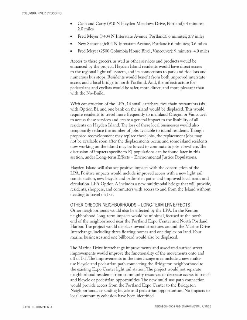
columbia river crossiNg
3-150 • CHAPTER 3 Neighborhoods aNd eNviroNmeNtal Justice
• Cash and Carry (910 N Hayden Meadows Drive, Portland): 4 minutes; 2.0 miles
• Fred Meyer (7404 N Interstate Avenue, Portland): 6 minutes; 3.9 miles • New Seasons (6404 N Interstate Avenue, Portland): 6 minutes; 3.6 miles • Fred Meyer (2500 Columbia House Blvd., Vancouver): 9 minutes; 4.0 miles
Access to these grocers, as well as other services and products would be enhanced by the project. Hayden Island residents would have direct access to the regional light rail system, and its connections to park and ride lots and numerous bus stops. Residents would benefit from both improved interstate access and a local bridge to north Portland. And, the infrastructure for pedestrians and cyclists would be safer, more direct, and more pleasant than with the No-Build.
With construction of the LPA, 14 small café/bars, five chain restaurants (six with Option B), and one bank on the island would be displaced. This would require residents to travel more frequently to mainland Oregon or Vancouver to access these services and create a general impact to the livability of all residents on Hayden Island. The loss of these local businesses would also temporarily reduce the number of jobs available to island residents. Though proposed redevelopment may replace these jobs, the replacement jobs may not be available soon after the displacements occur, and some island residents now working on the island may be forced to commute to jobs elsewhere. The discussion of impacts specific to EJ populations can be found later in this section, under Long-term Effects – Environmental Justice Populations.
Hayden Island will also see positive impacts with the construction of the LPA. Positive impacts would include improved access with a new light rail transit station, new bicycle and pedestrian paths and improved local roads and circulation. LPA Option A includes a new multimodal bridge that will provide, residents, shoppers, and commuters with access to and from the Island without needing to travel on I-5.
OTHER OREGON NEIGHBORHOODS – LONG-TERM LPA EFFECTS Other neighborhoods would also be affected by the LPA. In the Kenton neighborhood, long-term impacts would be minimal, focused at the north end of the neighborhood near the Portland Expo Center and North Portland Harbor. The project would displace several structures around the Marine Drive Interchange, including three floating homes and one duplex on land. Four marine businesses and one billboard would also be displaced.
The Marine Drive interchange improvements and associated surface street improvements would improve the functionality of the movements onto and off of I-5. The improvements in the interchange area include a new multi-use bicycle and pedestrian path connecting the Bridgeton neighborhood to the existing Expo Center light rail station. The project would not separate neighborhood residents from community resources or decrease access to transit and bicycle or pedestrian opportunities. The new multi-use path connection would provide access from the Portland Expo Center to the Bridgeton Neighborhood, expanding bicycle and pedestrian opportunities. No impacts to local community cohesion have been identified.

FiNal eNviroNmeNtal imPact statemeNt
EXISTING CONDITIONS AND ENVIRONMENTAL CONSEQUENCES • 3-151Neighborhoods aNd eNviroNmeNtal Justice
Analysis by J. Koloszar; Analysis Date: Tuesday, July 26, 2011; File Name: F:\Transfer071911\NEI\NEI_Displacements_KM242_11_Shum.mxd
Business
Public Use
Residence
Business and Residence
Vacant
Other
Project Footprint - LPA, Full Build
Neighborhood Boundary
Parcel Boundary
KENTON
HAYDENISLAND
ESTHERSHORT
ROSEVILLAGE
WEST MINNEHAHA
HOUGH
LIN
CO
LN
ARNADA
EASTCOLUMBIA
HUDSONSBAY
SHUMWAY
CENTRALPARK
COLUMBIA WAY
BRIDGETON
CARTERPARK
0 1,200
Feet
ROSEVILLAGE
SHUMWAY
I
K
H
LGF
M
I-5 S
B
I-5 N
B
33RD
31ST
32ND
34TH
35TH FR
ON
TA
GE
36TH
37TH
30TH
50
0 W
B
ON
TO
I-5 S
B
50
0 E
B
32ND
35TH
31ST
30TH
A. Shumway Neighborhood
A.
B.
E.
F.
D.
Project Area
C.
*LPA Full-Build and LPA Phase I result in the same displacements
0 300
Feet
N o r t h P o r t l a n d H a r b o r
KENTON
HAYDEN ISLAND
BRIDGETON
I 5I 5
Analysis by J. Koloszar; Analysis Date: Wednesday, June 29, 2011; File Name: F:\Transfer060811\NEI\NEI_Displacements_KM242_11.mxd
Business
Public Use
Residence
Business and Residence
Vacant
Other
Project Footprint - LPA, Full Build
Neighborhood Boundary
Parcel Boundary
KENTON
HAYDENISLAND
ESTHERSHORT
ROSEVILLAGE
WEST MINNEHAHA
HOUGH
LIN
CO
LN
ARNADA
EASTCOLUMBIA
HUDSONSBAY
SHUMWAY
CENTRALPARK
COLUMBIA WAY
BRIDGETON
CARTERPARK
0 1,200
Feet
N o r t h P o r t l a n d H a r b o r
C o l u m b i a R i v e r
HAYDEN ISLAND
I5
HAYDEN ISLAND
CE
NT
ER
FA
RR
JAN
TZENTOMAHAWK ISLAND
FLOWER
BE
GO
NIA
AL
DE
R
MAIN
AR
BO
R
DA
PH
NE
AZ
ALE
A
K MART
CA
ME
LL
IA
I5 F
WY
-MA
I N D
R
JANTZEN BEACH CENTER
HA
YD
EN
ISL
AN
D D
R-I5
FW
Y
JANTZEN
I5
C o l u m b i a R i v e rI-
5 S
B
I-5
NB
4TH
CO
LU
MB
IA
6TH
5TH
ON
TO
I-5
SB
3RD
WA
SH
ING
TO
N
TO
6T
H S
TES
TH
ER
I-5 N
B E
XIT
1A T
O SR-1
4 EB
4TH
ESTHER SHORT
CO
LU
MB
IA W
AY
F
G
I-5
SB
17TH
I-5
NB
MCLOUGHLIN
I-5
SB
EX
IT 1
C T
O M
ILL P
LA
IN
ARNADA
ROSEVILLAGE
SHUMWAY
I
L
K
H
G
F
M
33RD
34TH
35TH
I-5 S
B
I-5 N
B
31ST
32ND
36TH
FR
ON
TA
GE 32ND
E. Hayden Island
C. Esther Short Neighborhood D. Lower Downtown Vancouver
B. Arnada NeighborhoodA. Shumway Neighborhood
A.
B.
E.
F.
D.
Project Area
C
12TH
MA
IN
13TH
11TH
BR
OA
DW
AY
ESTHER SHORT
C.
F. North Portland Harbor
*LPA Full-Build and LPA Phase I result in the same displacements
0 300
Feet
0 300
Feet
0 300
Feet
0 300
Feet
0 600
Feet
0 600
Feet
N o r t h P o r t l a n d H a r b o r
KENTON
HAYDEN ISLAND
BRIDGETON
I 5I 5
Analysis by J. Koloszar; Analysis Date: Wednesday, June 29, 2011; File Name: F:\Transfer060811\NEI\NEI_Displacements_KM242_11.mxd
Business
Public Use
Residence
Business and Residence
Vacant
Other
Project Footprint - LPA, Full Build
Neighborhood Boundary
Parcel Boundary
KENTON
HAYDENISLAND
ESTHERSHORT
ROSEVILLAGE
WEST MINNEHAHA
HOUGH
LIN
CO
LN
ARNADA
EASTCOLUMBIA
HUDSONSBAY
SHUMWAY
CENTRALPARK
COLUMBIA WAY
BRIDGETON
CARTERPARK
0 1,200
Feet
N o r t h P o r t l a n d H a r b o r
C o l u m b i a R i v e r
HAYDEN ISLAND
I5
HAYDEN ISLAND
CE
NT
ER
FA
RR
JAN
TZENTOMAHAWK ISLAND
FLOWER
BE
GO
NIA
AL
DE
R
MAIN
AR
BO
R
DA
PH
NE
AZ
ALE
A
K MART
CA
ME
LL
IA
I5 F
WY
-MA
I N D
R
JANTZEN BEACH CENTER
HA
YD
EN
ISL
AN
D D
R-I5
FW
Y
JANTZEN
I5
C o l u m b i a R i v e r
I-5
SB
I-5
NB
4TH
CO
LU
MB
IA
6TH
5THO
NT
O I-5
SB
3RD
WA
SH
ING
TO
N
TO
6T
H S
TES
TH
ER
I-5 N
B E
XIT
1A T
O SR-1
4 EB
4TH
ESTHER SHORT
CO
LU
MB
IA W
AY
F
G
I-5
SB
17TH
I-5
NB
MCLOUGHLIN
I-5
SB
EX
IT 1
C T
O M
ILL P
LA
IN
ARNADA
ROSEVILLAGE
SHUMWAY
I
L
K
H
G
F
M
33RD
34TH
35TH
I-5 S
B
I-5 N
B
31ST
32ND
36TH
FR
ON
TA
GE 32ND
E. Hayden Island
C. Esther Short Neighborhood D. Lower Downtown Vancouver
B. Arnada NeighborhoodA. Shumway Neighborhood
A.
B.
E.
F.
D.
Project Area
C
12TH
MA
IN
13TH
11TH
BR
OA
DW
AY
ESTHER SHORT
C.
F. North Portland Harbor
*LPA Full-Build and LPA Phase I result in the same displacements
0 300
Feet
0 300
Feet
0 300
Feet
0 300
Feet
0 600
Feet
0 600
Feet
Exhibit 3.5-16Displacements Within Project Area Neighborhoods (1 of 2)
A. Shumway Neighborhood
C. Esther Short Neighborhood
B. Arnada Neighborhood
Note: LPA full build and LPA with highway phasing result in the same displacements.Dimensions are approximate.
Business
Public Use
Residence
Business and Residence
Vacant
Other
Exisiting
Project Footprint−LPA, Full Build
Neighborhood Boundary
Parcel Boundary
Business
Public Use
Residence
Business and Residence
Vacant
Other
Exisiting
Project Footprint−LPA, Full Build
Neighborhood Boundary
Parcel Boundary
N
N
N

columbia river crossiNg
3-152 • CHAPTER 3 Neighborhoods aNd eNviroNmeNtal Justice
N o r t h P o r t l a n d H a r b o r
C o l u m b i a R i v e r
I5
HAYDEN ISLAND
CE
NT
ER
FA
RR
JA
NT
ZE
N
RIVER
ARBOR
TOM
AHAWK ISLAND
HAYDEN BAY
FLOWER
AL
DE
R
BE
GO
NIA
BIR
CH
DA
PH
NE
MAIN
AZ
ALE
A
K MART
CA
ME
LL
IA
I5 F
WY
-MA
IN D
R
CY
PR
US
JANTZEN BEACH CENTER
HA
YD
EN
ISL
AN
D D
R-I5
FW
Y
JANTZEN
I5
E. Hayden Island
N o r t h P o r t l a n d H a r b o r
KENTON
HAYDEN ISLAND
BRIDGETON
I 5I 5
Analysis by J. Koloszar; Analysis Date: Wednesday, June 29, 2011; File Name: F:\Transfer060811\NEI\NEI_Displacements_KM242_11.mxd
Business
Public Use
Residence
Business and Residence
Vacant
Other
Project Footprint - LPA, Full Build
Neighborhood Boundary
Parcel Boundary
KENTON
HAYDENISLAND
ESTHERSHORT
ROSEVILLAGE
WEST MINNEHAHA
HOUGH
LIN
CO
LN
ARNADA
EASTCOLUMBIA
HUDSONSBAY
SHUMWAY
CENTRALPARK
COLUMBIA WAY
BRIDGETON
CARTERPARK
0 1,200
Feet
N o r t h P o r t l a n d H a r b o r
C o l u m b i a R i v e r
HAYDEN ISLAND
I5
HAYDEN ISLAND
CE
NT
ER
FA
RR
JAN
TZENTOMAHAWK ISLAND
FLOWER
BE
GO
NIA
AL
DE
R
MAIN
AR
BO
R
DA
PH
NE
AZ
ALE
A
K MART
CA
ME
LL
IA
I5 F
WY
-MA
I N D
R
JANTZEN BEACH CENTER
HA
YD
EN
ISL
AN
D D
R-I5
FW
Y
JANTZEN
I5
C o l u m b i a R i v e r
I-5
SB
I-5
NB
4TH
CO
LU
MB
IA
6TH
5TH
ON
TO
I-5
SB
3RD
WA
SH
ING
TO
N
TO
6T
H S
TES
TH
ER
I-5 N
B E
XIT
1A T
O SR-1
4 EB
4TH
ESTHER SHORT
CO
LU
MB
IA W
AY
F
G
I-5
SB
17TH
I-5
NB
MCLOUGHLIN
I-5
SB
EX
IT 1
C T
O M
ILL P
LA
IN
ARNADA
ROSEVILLAGE
SHUMWAY
I
L
K
H
G
F
M
33RD
34TH
35TH
I-5 S
B
I-5 N
B
31ST
32ND
36TH
FR
ON
TA
GE 32ND
E. Hayden Island
C. Esther Short Neighborhood D. Lower Downtown Vancouver
B. Arnada NeighborhoodA. Shumway Neighborhood
A.
B.
E.
F.
D.
Project Area
C
12TH
MA
IN
13TH
11TH
BR
OA
DW
AY
ESTHER SHORT
C.
F. North Portland Harbor
*LPA Full-Build and LPA Phase I result in the same displacements
0 300
Feet
0 300
Feet
0 300
Feet
0 300
Feet
0 600
Feet
0 600
Feet
Exhibit 3.5-16Displacements Within Project Area Neighborhoods (2 of 2)D. Lower Downtown Vancouver
E. Hayden Island
N o r t h P o r t l a n d H a r b o r
KENTON
HAYDEN ISLAND
BRIDGETON
I 5I 5
Analysis by J. Koloszar; Analysis Date: Wednesday, June 29, 2011; File Name: F:\Transfer060811\NEI\NEI_Displacements_KM242_11.mxd
Business
Public Use
Residence
Business and Residence
Vacant
Other
Project Footprint - LPA, Full Build
Neighborhood Boundary
Parcel Boundary
KENTON
HAYDENISLAND
ESTHERSHORT
ROSEVILLAGE
WEST MINNEHAHA
HOUGH
LIN
CO
LN
ARNADA
EASTCOLUMBIA
HUDSONSBAY
SHUMWAY
CENTRALPARK
COLUMBIA WAY
BRIDGETON
CARTERPARK
0 1,200
Feet
N o r t h P o r t l a n d H a r b o r
C o l u m b i a R i v e r
HAYDEN ISLAND
I5
HAYDEN ISLAND
CE
NT
ER
FA
RR
JAN
TZENTOMAHAWK ISLAND
FLOWER
BE
GO
NIA
AL
DE
R
MAIN
AR
BO
R
DA
PH
NE
AZ
ALE
A
K MART
CA
ME
LL
IA
I5 F
WY
-MA
I N D
R
JANTZEN BEACH CENTER
HA
YD
EN
ISL
AN
D D
R-I5
FW
Y
JANTZEN
I5
C o l u m b i a R i v e r
I-5
SB
I-5
NB
4TH
CO
LU
MB
IA
6TH
5TH
ON
TO
I-5
SB
3RD
WA
SH
ING
TO
N
TO
6T
H S
TES
TH
ER
I-5 N
B E
XIT
1A T
O SR-1
4 EB
4TH
ESTHER SHORT
CO
LU
MB
IA W
AY
F
G
I-5
SB
17TH
I-5
NB
MCLOUGHLIN
I-5
SB
EX
IT 1
C T
O M
ILL P
LA
IN
ARNADA
ROSEVILLAGE
SHUMWAY
I
L
K
H
G
F
M
33RD
34TH
35TH
I-5 S
B
I-5 N
B
31ST
32ND
36TH
FR
ON
TA
GE 32ND
E. Hayden Island
C. Esther Short Neighborhood D. Lower Downtown Vancouver
B. Arnada NeighborhoodA. Shumway Neighborhood
A.
B.
E.
F.
D.
Project Area
C
12TH
MA
IN
13TH
11TH
BR
OA
DW
AY
ESTHER SHORT
C.
F. North Portland Harbor
*LPA Full-Build and LPA Phase I result in the same displacements
0 300
Feet
0 300
Feet
0 300
Feet
0 300
Feet
0 600
Feet
0 600
Feet
F. North Portland Harbor
Note: LPA full build and LPA with highway phasing result in the same displacements. Dimensions are approximate.
Business
Public Use
Residence
Business and Residence
Vacant
Other
Exisiting
Project Footprint−LPA, Full Build
Neighborhood Boundary
Parcel Boundary
N
N
N

FiNal eNviroNmeNtal imPact statemeNt
EXISTING CONDITIONS AND ENVIRONMENTAL CONSEQUENCES • 3-153Neighborhoods aNd eNviroNmeNtal Justice
Fifteen parcels would be impacted by the expansion of the Ruby Junction Maintenance Facility, located in the Rockwood neighborhood. Within those 15 parcels, nine residences and eight businesses would be displaced; some parcels contain two buildings, a residence and a business. The project would displace these residences and businesses, essentially eliminating the residential occupancy in this corner of the neighborhood. Although displacements in the Rockwood neighborhood for the Ruby Junction expansion must follow the Uniform Relocation Act, the nature of some of the displaced residences and businesses require special consideration. Several of the impacted properties house both an industrial type of business and a residence. This unique setting allows for small industrial business owners to live and work at the same location, which may not be possible after standard relocation to a new neighborhood.
Despite these relocations, the impact will not have an adverse effect on the cohesion of the Rockwood Neighborhood. The neighborhood and these subject properties are divided by industrial properties that are large and have little connectivity. The Ruby Junction Maintenance Facility and impacts to the surrounding EJ populations are discussed in detail under Rockwood Neighborhood Long-term Impact heading of this section.
As reported in Section 3.3.2, there is a sufficient supply of comparable homes for sale and rental properties for all displaced residents to be relocated. In June 2009, the Portland area (including Oregon suburbs but excluding communities in Washington) had an 8.2-month supply of homes for sale and a year-to-date median home sale price of $250,000. In the Gresham/Troutdale subarea the average sale price is $174,900.
PortlaNd local streets – LONG-TERM LPA EFFECTSThe local street network on Hayden Island and on the adjacent Oregon mainland would be greatly improved. Substandard intersections would be redesigned to current standards, the Bridgeton Trail would be connected through to the west side of I-5, and with LPA Option A, a new local multimodal bridge would provide direct auto, bike and pedestrian connection to Hayden Island.
With the LPA, Portland’s local street operations would improve along the I-5 corridor relative to No-Build conditions. See Section 3.1, Transportation, for more details on local traffic, explanation of performance standards, and graphic representations of system performance. For example, at the I-5 interchange with Marine Drive, 2030 afternoon peak intersection performance would improve from a level-of-service (LOS) F with the No-Build Alternative to LOS B with the LPA. This indicates that the LPA would improve mobility and accessibility to this freight and employment corridor during the morning peak. Similar findings were observed during the afternoon peak.
In most locations, there are reductions in volumes on the local street system. This occurs as motorists switch routes to the previously congested I-5 corridor. During the morning peak, westbound traffic on both sides of the highway would decrease less than 10 percent compared to No-Build conditions. Eastbound traffic on both sides of I-5 would increase up to 10 percent, with the higher growth forecast for the eastside of I-5. During the morning peak,

columbia river crossiNg
3-154 • CHAPTER 3 Neighborhoods aNd eNviroNmeNtal Justice
southbound traffic in Portland would decrease by up to 5 percent over No-Build conditions. Northbound traffic in Portland would remain unchanged or decrease between 10 and 20 percent compared to No-Build conditions.
During the afternoon/evening peak, eastbound and westbound traffic on both sides of the highway would change by less than 10 percent compared to No-Build conditions. Northbound and southbound traffic in Portland would change by less than 10 percent during the afternoon/evening peak hour.
The total number of local intersections and ramps would increase from 25 to 38 primarily as a result of additional intersections associated with the local roads in the Hayden Island and Marine Drive interchange areas. During the 2030 morning peak hour, 37 of these 38 intersections and ramps would be expected to operate within acceptable standards, while one would fail to meet standards. The intersection of Interstate Avenue with Going Street is expected to fail to meet applicable performance standards (due to long delays at the intersection) and to require mitigation. See Section 3.1 for more information on this and other intersections within the project area. During the 2030 afternoon/evening peak hour, all intersections would operate within acceptable standards.
Pedestrian and bicycle travel demands are expected to increase substantially if a new I-5 bridge is constructed with sufficient multimodal facilities. Daily pedestrian travel across the bridge would be expected to increase from 80 pedestrians today to between 600 and 1,000 in 2030. The number of bicyclists predicted to use the crossing would increase from 370 per day today to between 900 and 6,400 riders per day in 2030. The project includes other improvements to the pedestrian and cycling network in Portland, in addition to those associated with the river crossing. Refer to Section 3.1, Transportation, for more details on these improvements.
The combination of improved traffic conditions and improved access would provide a positive impact for Portland neighborhoods in the project area.
oregoN Neighborhoods – iNdirect lPa eFFectsThe Hayden Island neighborhood would experience the most pronounced indirect effects as a result of the LPA because transit-oriented development would change the character of the dispersed, auto-oriented, large-scale retail developments that exist there today. The anticipated redevelopment of the Jantzen Beach shopping center into a transit-oriented neighborhood is perhaps the most significant change expected on the island, and is consistent with the 2009 Hayden Island Plan.
Transit-oriented development (TOD) would increase cohesion on the island in two ways: by providing new opportunities for high-density housing and by providing new opportunities for smaller-scale commercial services. Developing housing options in the center of the island close to transit would allow people to live closer to commercial services and would support walking, biking, or riding light rail to those services. Creating a less auto-oriented environment for residents to travel between home and services would provide more opportunities for residents to interact with one another and to easily access potential new community resources. Similarly, providing smaller-scale commercial services close to housing and transit would encourage residents to

FiNal eNviroNmeNtal imPact statemeNt
EXISTING CONDITIONS AND ENVIRONMENTAL CONSEQUENCES • 3-155Neighborhoods aNd eNviroNmeNtal Justice
use services provided in their neighborhood, rather than traveling off the island to access those same services.
On the Oregon mainland, indirect effects would include potential job creation resulting from improved freight mobility. These jobs may be created at the Port of Portland, along the Columbia Corridor, and elsewhere in various business sectors, such as manufacturing, wholesale trade, and distribution.
Long-term LPA Effects – Washington NeighborhoodsIn the Shumway neighborhood the LPA would require six residential displacements for permanent right-of-way.
The project would also displace five single-family residences in the Arnada neighborhood where the light rail would transition from E 17th Street to McLoughlin Boulevard. The light rail line on E 17th Street would also displace some off-street parking adjacent to retail and service establishments in the southeast corner of the neighborhood.
In March 2011, Clark County had a 8.3-month home supply and a year-to-date median home sale price of $190,000 (RMLS 2011a, b). In February 2011, industry reports showed a 3.8 percent multi-family residential vacancy rate for rentals in the Portland-Vancouver metropolitan area, with a rental rate averaging $0.94 per square foot per month (MMHA 2011). This rate equates to $940 per month for a 1,000-square-foot apartment and $1,410 per month for a 1,500-square-foot apartment. In addition to the market-rate units available, the Vancouver Housing Authority continues to develop workforce and subsidized units throughout the downtown and elsewhere in Clark County.
Single-family residences on 17th Street between C and G Streets in Vancouver would be impacted by noise from light rail transit. Based on an analysis of unmitigated light rail operations, 15 single-family residences that would be moderately impacted were identified. The analysis included noise from the warning bells at a proposed crossing gate where the alignment transitions to McLoughlin Boulevard before crossing under I-5. Residential sound insulation, which would be used on the impacted single-family residences along E 17th Street, would not reduce the exterior noise levels. These residences have back yards that are well shielded from the train by the structure of the house, so exterior noise levels in the back yards, which most people use as their primary outdoor use, are predicted to have noise levels below the FTA criteria. Only the front yards would continue to exceed the FTA criteria along E 17th Street.
In the Central Park neighborhood, long-term impacts at the Clark College Annex and Recreation Fields include the displacement of the structures and parking within the Annex area and displacement of some trees and landscaping to the south of the recreation fields near the Annex.
Across McLoughlin Boulevard to the south of the Clark College Athletic Annex, the Marshall Community Park and Center and the Luepke Senior Center would experience long-term impacts. Construction of a new retaining wall along the highway would displace parking spaces, horseshoe pits, landscaping, and trees that serve as a visual buffer between the community

columbia river crossiNg
3-156 • CHAPTER 3 Neighborhoods aNd eNviroNmeNtal Justice
center and I-5. In the far northeast corner of the park property, a new turning lane on McLoughlin would require permanent right-of-way acquisition that would displace more landscaping. The addition of a new light rail line and station adjacent to the centers would also represent a substantial access benefit, especially for citizens who are transit dependent or mobility impaired.
The Esther Short, Hough, Arnada, Central Park and Hudson Bay neighborhoods all would experience positive impacts from the access to the regional light rail system. Downtown Vancouver would be connected to the multi-use path that would provide connections to regional pedestrian and bicycle facilities throughout Vancouver. The Evergreen Community Connector would provide new public space, bicycle and pedestrian routes and improve the connection between downtown Vancouver and the Vancouver National Historic Reserve.
Though the LPA reduces overall noise impacts from both existing levels and those under the No-Build Alternative, there are numerous residences where noise levels would meet or exceed established WSDOT noise criteria. Three residential sites which provide low-income or lower-income housing units would experience noise impacts: the Normandy Apartments, Evergreen Inn, and the Fort Apartments. Noise levels improve for some units, under the LPA, though other units are impacted more greatly by the LPA. The noise level increases, as explained below, are slight.
The three-story Normandy Apartments are located at 318 East 7th Street, directly west of I-5. There are approximately 35 studio and one-bedroom apartments that rent for approximately $500 to $650 per month. Six units of the Normandy Apartments currently experience noise levels that exceed FHWA’s criteria. Proposed noise walls would greatly reduce noise levels for the lower three units (even from existing levels), while the impacts to the upper three units cannot be mitigated. The increase for these three units will only be 2 dBA over existing conditions and 1 dBA over the No-Build Alternative. Generally, increases of three or fewer dBA are not considered audible.
The Evergreen Inn is located at 500 Main Street. This property receives low-income housing tax credits in exchange for providing affordable housing to the area’s elderly population. There are 78 total units at Evergreen, 70 of which are low-income units. The LPA slightly elevates highway noise levels for 24 units at this historic property. The increase for these units will be 3 dBA over existing conditions and 2 dBA over the No-Build Alternative. Generally, increases of three or fewer dBA are not considered audible. Though a wall was evaluated, it would not provide any noticeable noise reduction for the elevated apartment homes and therefore is not recommended.
The Fort Apartments are located at 500 E 13th Street, Vancouver, directly west of I-5. There are 49 studio, one-bedroom, and two-bedroom units in the Fort Apartments; rent ranges from $450 to $500 per month. The LPA slightly elevates highway noise levels for 12 units at this historic property. The increase for these units will be 2 dBA over existing conditions the No-Build Alternative. Generally, increases of three or fewer dBA are not considered audible.

FiNal eNviroNmeNtal imPact statemeNt
EXISTING CONDITIONS AND ENVIRONMENTAL CONSEQUENCES • 3-157Neighborhoods aNd eNviroNmeNtal Justice
The western end of Waterfront Park, an identified community resource, is in the southeast corner of the Esther Short neighborhood, just to the west of the existing I-5 bridges. This portion of the park would be permanently acquired for the construction of the new bridges. However, in the Columbia Way neighborhood on the other side of the bridge, Waterfront Park would be improved, because removing the existing bridges that currently cover another portion of the park would create more open space. Users of the Waterfront Renaissance Trail would benefit from a safer and more direct route to and from the northbound I-5 bridge where the bicycle and pedestrian facilities would be provided.
All Vancouver neighborhoods and their residents would benefit from increased access to transit due to the introduction of light rail.
VANCOUVER LOCAL STREETS – LONG-TERM LPA EFFECTSDuring the morning peak, southbound traffic in Vancouver would decrease between 10 and 35 percent along most major streets with the exception of the downtown area. Southbound traffic in downtown is expected to increase over the No-Build by approximately 10 percent. The decrease in southbound traffic on local streets would be caused by the improvements to I-5, which would encourage arterial traffic to return to I-5.
During the morning peak, eastbound and westbound traffic west of I-5 would increase between 10 and 20 percent over No-Build conditions. With the LPA, eastbound and westbound traffic east of I-5 would increase by up to 5 percent over No-Build conditions. Under the LPA with highway phasing, eastbound traffic east of I-5 would increase by approximately 30 percent, and westbound traffic east of I-5 would remain relatively unchanged. The difference in eastbound traffic between the LPA and LPA with highway phasing would be due to the addition of the direct connect ramp from southbound I-5 to eastbound SR 500. Without the direct connect ramp, eastbound traffic would remain on 39th Street to access SR 500.
Northbound traffic south of Fourth Plain Boulevard would increase between 5 and 20 percent. Northbound traffic in the area of the 39th Street interchange area would increase by approximately 80 percent compared to No-Build. This increase is the result of the closure of the entrance to northbound I-5 at 39th Street. Instead motorists will enter at Main Street to the north.
During the afternoon/evening peak, traffic volumes along key east-west local streets west of I-5 would remain unchanged or increase by approximately 20 percent over No-Build conditions. This may increase the cut-through traffic in these neighborhoods. Under the LPA, westbound traffic just east of I-5 would increase by approximately 15 percent, and eastbound traffic just east of I-5 would decrease by approximately 25 percent compared to No-Build conditions. Under LPA with highway phasing, eastbound traffic would decrease by approximately 10 percent. The difference in eastbound traffic would be due to the addition of the direct connect ramp from southbound I-5 to eastbound SR 500.
During the afternoon/evening peak hour, southbound traffic in Vancouver, depending on location, would remain unchanged or could increase up to 20

columbia river crossiNg
3-158 • CHAPTER 3 Neighborhoods aNd eNviroNmeNtal Justice
percent. Under the LPA, the southbound off-ramp to 39th Street would be removed and replaced with the new southbound SR 500 off-ramp, which would cause traffic to shift from southbound I-5 to southbound Main Street to access the neighborhood.
Northbound traffic in Vancouver would decrease between 5 and 30 percent over No-Build conditions, with the highest decrease north of the Fourth Plain interchange area.
With 2030 No-Build conditions, local street congestion is most intense near the I-5 ramps and is influenced by the travel direction and length of time that I-5 is congested each day. When I-5 is congested, major arterials that provide east/west connectivity are also congested. Of the 89 intersections evaluated for the No-Build condition, seven would not meet acceptable operational standards during the morning peak and 24 would have unacceptable impacts associated with traffic queuing (back-ups). During the afternoon/evening peak period seven intersections would not meet acceptable operational standards, while 25 would have unacceptable impacts associated with traffic queuing.
With the LPA, the number of intersections analyzed increases from 89 to 92. During the 2030 morning peak, 91 of these 92 intersections would operate acceptably with improved, similar, or slightly degraded conditions. One intersection, 29th Street at Main/Broadway Street, would degrade from No-Build conditions and would operate unacceptably. With the LPA with highway phasing, 90 intersections would operate acceptably with improved, similar, or slightly degraded conditions. Two intersections would degrade from No-Build conditions and would operate unacceptably – the intersection identified under the LPA plus the intersection of 39th Street at H Street.
During the 2030 afternoon/evening peak with the LPA, 89 of the 92 intersections would operate acceptably with improved, similar, or slightly degraded conditions. Three of the local intersections would degrade from No-Build conditions and would operate unacceptably. These include the intersections of Mill Plain Boulevard at C Street, 15th Street at C Street, and 39th Street at the I-5 southbound ramps. With the LPA with highway phasing (Options A and B), 86 of the intersections would operate acceptably with improved, similar, or slightly degraded conditions. Six intersections would degrade from No-Build conditions and would operate unacceptably – the three intersections identified under the LPA plus the intersections of 33rd Street at Main Street, 39th Street at H Street, and 40th Street at Main Street. Overall, both the LPA and LPA with highway phasing would improve local street operations in Vancouver in comparison with 2030 No-Build conditions.
Overall, both the LPA and LPA with highway phasing would improve local street operations in Vancouver in comparison with 2030 No-Build conditions. Improvements are due to reconfiguration of some local streets to better match highway interchanges, new street extensions, improved connectivity, added travel lanes and extended turn pockets at key intersections. The project also includes improvements to the pedestrian and cycling network, as discussed in Section 3.1.

FiNal eNviroNmeNtal imPact statemeNt
EXISTING CONDITIONS AND ENVIRONMENTAL CONSEQUENCES • 3-159Neighborhoods aNd eNviroNmeNtal Justice
WashiNgtoN Neighborhoods – iNdirect lPa eFFectsIn the Vancouver neighborhoods of Esther Short, Arnada, Hough, and potentially Central Park, transit-oriented development would add to neighborhood cohesion in similar ways as it would on Hayden Island. New housing and commercial services along the transit alignment, particularly around transit stations, would give residents more opportunities to walk, bike, or take transit to services close to their homes, thereby providing more chances for residents to interact with one another and utilize community resources.
Long-term Effects – Environmental Justice Populations
NO-BUILD ALTERNATIVEAs stated above, the No-Build Alternative would not bring high-capacity transit to Hayden Island or Vancouver. Nationally, low-income populations use transit at a higher rate than other populations (FHWA 2001). TriMet and C-TRAN regional rider surveys provide similar findings. In 2005, 69 percent of all weekday Interstate MAX line rides were made by individuals in households earning less than $50,000 per year (TriMet 2009). In 2005, the Median Household Income in the Portland-Vancouver Metropolitan Statistic Area (MSA) was just under $50,000. Most C-TRAN riders (57 percent) reported earning under $30,000, 30 percent declined to state their income, 12 percent earned $30,000-$75,000, and the smallest percentage (1 percent) earned more than $75,000 (C-TRAN 2003). Both the TriMet and C-TRAN rider surveys were conducted across their service areas and not specifically within the CRC project area. With the No-Build Alternative, therefore, these lower income groups would be unable to benefit from high-capacity transit in the project area. There would be no toll, so potential adverse impacts on EJ populations from the expense of tolls would be avoided; however, the potential benefits associated with improved highway and transit infrastructure would not be realized. Furthermore, EJ residents would continue to be impacted by highway noise. The No-Build Alternative would not require CRC-related displacements of EJ population residents or EJ businesses.
haYdeN islaNd – LONG-TERM LPA EFFECTS oN eNviroNmeNtal Justice PoPulatioNsAlthough 32 displacements represent a substantial impact to the neighborhood and its residents on Hayden Island, this does not appear to constitute a disproportionate impact to EJ populations. According to the census and recently completed surveys of the displaced households, Hayden Island does not have a high rate of EJ residents compared to surrounding Portland neighborhoods or to most other neighborhoods in the project area. The 2009 demographic surveys conducted at the neighborhood’s request indicate that the floating home community has notably lower rates of EJ residents (based on those that responded) than surrounding neighborhoods; therefore, the CRC project is less likely to impact EJ residents in this community than in other communities in the project area.
Displacement of the Safeway grocery store and pharmacy may increase the travel time and travel costs of residents, including low-income and minority residents and residents who do not own cars. However, this impact would be largely offset by the presence of nearby grocery stores, the availability of delivery services, and the strong likelihood that a new grocer will soon open on

columbia river crossiNg
3-160 • CHAPTER 3 Neighborhoods aNd eNviroNmeNtal Justice
the island—as proposed in the SuperCenter redevelopment plans submitted to the City of Portland. In addition, this impact would be offset by the addition of light rail to Oregon and Vancouver. As stated above, data suggest that low-income populations use transit more frequently than other income groups. TriMet and C-TRAN rider surveys provide similar findings. The project would improve on-island traffic circulation and reduce the hours of congestion in this area along I-5. Additionally, the current substandard and difficult to navigate bicycle and pedestrian connection to the existing I-5 bridges would be improved, and a light rail transit station would be constructed to serve the island. As low-income individuals are more reliant on alternative modes of transportation, these improvements would provide potentially greater benefit to EJ populations. The existing paratransit services on the island, which provide door-to-door transit for disabled residents, would continue with the LPA and work in coordination with the light rail and bus routes.
As mentioned earlier, the displacement of the Safeway store, restaurants, and bank would affect all residents, and would not disproportionately affect EJ populations. The project team interviewed management staff from most of the displaced businesses on the island and have not identified any services specific to EJ communities. However, the displaced businesses do provide inexpensive dining, groceries, and a pharmacy.
SERVICE INDUSTRY JOBS – LONG-TERM LPA EFFECTS ON eNviroNmeNtal Justice PoPulatioNsThe property acquisitions on Hayden Island, and to a lesser extent in Vancouver, have the potential to affect wage-earning opportunities for those seeking service industry employment. An estimated 39 businesses would be displaced on Hayden Island, many of which are eateries, with 643 employees affected. Business displacements would include a variety of commercial, service, and retail establishments, including numerous restaurants, bars, an office supply store, a cellular services store, and the Safeway store.
All displaced businesses would be provided financial and administrative assistance to relocate rather than close. However, some of these displaced businesses may choose not to relocate locally. Some of the employees may be unable to retain their jobs. On the whole, food preparation and service-related employers often offer low-wage positions such as dishwashers, cooks, hosts, and counter attendants. According to the Oregon Employment Department, the average salaries of most food preparation and service workers within Multnomah and Washington Counties fall within the range of $18,000 to $23,000 per year (full-time equivalent). Wages within this range would lift all individuals and most small families above the federal poverty guidelines.
It is not possible to determine which businesses would not relocate locally, or to determine the income and minority status of employees who would be displaced from these businesses. In addition, the employee composition will change prior to the initiation of property acquisition and business relocations. However, the project team has surveyed these businesses in an attempt to gather such data. Many of the surveyed businesses stated that they employed high numbers of minority employees, with potentially higher minority compositions than the region or local area. Many of the surveyed businesses also stated that they employed high numbers of low-income employees.

FiNal eNviroNmeNtal imPact statemeNt
EXISTING CONDITIONS AND ENVIRONMENTAL CONSEQUENCES • 3-161Neighborhoods aNd eNviroNmeNtal Justice
However, low-income was not defined, during these interviews, to be exclusively those under the poverty level.
Impacts associated with the loss of these jobs may be offset by a combination of factors including the approximately 20,000 jobs (20,000 job-years) associated with constructing the LPA, some of which will be created to provide basic services (such as those displaced) to construction teams. Additionally, the Hayden Island Plan allows for and encourages future transit oriented development near the light rail station. The surrounding redevelopment will likely include retail and food service establishments providing similar jobs to those displaced by the LPA.
haYdeN islaNd saFeWaY BOTTLE RETURN CENTER – LONG-TERM LPA eFFects oN eNviroNmeNtal Justice PoPulatioNsIn addition to the displacement or relocation of many entry-level or relatively unskilled labor positions, the displacement of the Safeway store would also displace an active bottle return center. The store managers report over $10,000 each week paid out through the returns.
This bottle return center provides an opportunity for individuals to generate income, which may supplement other employment or may constitute some individuals’ sole means of making a living. Many of these individuals could be unemployed, underemployed, transient, and potentially homeless.
The return center at Safeway provides a service to economically disadvantaged citizens of the immediate neighborhoods. However, the return center limits each patron to only $7.20 in returns per day. The displacement of the center potentially constitutes an adverse and disproportionate effect to low-income EJ communities. There are other locations where bottles can be returned on the island and in north Portland. Many of these smaller establishments (such as convenience marts) also enforce limits on the number of bottle returns per visit. However, as long as these businesses continue to operate and proper access to them is maintained, displacement of the return center at Safeway would not result in a high degree of impact.
ROCKWOOD NEIGHBORHOOD – LONG-TERM LPA EFFECTS ON eNviroNmeNtal Justice PoPulatioNsThe Ruby Junction Light Rail Maintenance Facility is located in the southeast corner of the Rockwood Neighborhood in Gresham, Oregon. Census data from 2000 (Block Group 1, CT 98.01) for the area surrounding the Ruby Junction site indicates that 55 percent of the residents are minority and 35 percent have incomes below the poverty line. Census Tract 98.01 (which is not as specific to the impact area as the block group) suggests similar levels of minority and low-income households. Since 2010, the percentage of both has risen. When compared to the CRC main project area, these data indicate that the expansion of the Ruby Junction facility could result in a disproportionate impact to low-income or minority populations.
As a result, the project team surveyed the residents and business owners that would be displaced or partially displaced by the expansion at Ruby Junction to determine whether those impacted by the project match the demographic characteristics of population in the area. The survey shows that the nine

columbia river crossiNg
3-162 • CHAPTER 3 Neighborhoods aNd eNviroNmeNtal Justice
occupied residences that would be displaced differ somewhat from the characteristics of the surrounding Census Block Group as a whole. Four displaced households are minority (44 percent), with three of the four households being Hispanic. Five residences indicated Caucasian race and one indicated some other race alone. Additionally, two of the nine residences (or 22 percent) potentially earn incomes below the poverty level, based on the number of occupants in the household and the total annual income reported. These surveys indicate that fewer EJ populations would be impacted than would be expected from Census data. However, the minority composition of those who would be displaced is higher than the minority composition of the county and higher than the project area. The project would provide relocation assistance to these households. In many cases, the relocation package would include housing subsidies or other assistance. These efforts would greatly minimize the impact. These displacements do not represent a disproportionate impact when compared to the census data for the surrounding area. Also, when considered together with other project acquisitions, the displacement of these households does not result in an overall disproportionality among the project’s residential displacements.
For information regarding the availability of replacement housing near the Rockwood Neighborhood, please see Section 3.3 and the Acquisitions Technical Report, included as an electronic appendix to this FEIS.
Exhibit 3.5-17 shows displacements within the Rockwood neighborhood.
Note: LPA full build and LPA with highway phasing result in the same displacements. Dimensions are approximate.Analysis by J. Koloszar; Analysis Date: Jan. 26, 2010; File Name: Dispalcements_RubyJ_KM242.mxd
500
HWY
WASHINGTONOREGON
PortlandInternational
Airport
Hayden Island
Government Island
Portland
Vancouver
MaywoodPark
Wood Troutdale
Gresham
Camas
Village
Fairview
I-5I-4
05
I-84
US30
LEWIS & CLARK HWY
te
BridgeLacamas
Lake
SmithLake
River
Cree
k
BLVD
LOMBARD
SANDYBLVD
ST
DRMAR INE
182N
D
5 00
HW
Y
BURNSIDE ST
POWE LL BLVD
COLUMBIA
SANDY
STARK ST
STDIVISION
BLVD
ON RD
LLRD
BA RNESRD
AIRPORT
AVE
AVE
A VE
WAY
HW
Y99
E
82N
D
AVE
39TH
1 22 N
D
B IR
DS
DA
LE
EL E
VE
NM
ILE
16TH
WONDERVIE
W
GRESHAM - ROCKWOOD
GRESHAM - CENTENNIAL GR
ESH
AM
-NO
RTH
WES
T
¯
Residential, Business, and Public Use Displacements Caused by the LPA.*
A. Ruby Junction
0 600Feet
A.
*LPA Full-Build and LPA Phase 1 resulting in the same displacements
Business
Public Use
Residence
Business and Residence
Vacant
Parcel Boundary
Project Design
Existing
Major Streets
Neighborhood Boundary
Ruby Junction - Existing Facility
0 2.5Miles
Regional Area
Exhibit 3.5-17Displacements Within the Rockwood Neighborhood
Analysis by J. Koloszar; Analysis Date: Jan. 26, 2010; File Name: Dispalcements_RubyJ_KM242.mxd
500
HWY
WASHINGTONOREGON
PortlandInternational
Airport
Hayden Island
Government Island
Portland
Vancouver
MaywoodPark
Wood Troutdale
Gresham
Camas
Village
Fairview
I-5I-4
05
I-84
US30
LEWIS & CLARK HWY
te
BridgeLacamas
Lake
SmithLake
RiverCr
eek
BLVD
LOMBARD
SANDYBLVD
ST
DRMAR INE
182N
D
5 00
HW
Y
BURNSIDE ST
POWE LL BLVD
COLUMBIA
SANDY
STARK ST
STDIVISION
BLVD
ON RD
LLRD
BA RNESRD
AIRPORTAV
E
AVE
A VE
WAY
HW
Y99
E
82N
D
AVE
39TH
1 22 N
D
B IR
DS
DA
LE
EL E
VE
NM
ILE
16TH
WONDERVIE
W
GRESHAM - ROCKWOOD
GRESHAM - CENTENNIAL GR
ESH
AM
-NO
RTH
WES
T
¯
Residential, Business, and Public Use Displacements Caused by the LPA.*
A. Ruby Junction
0 600Feet
A.
*LPA Full-Build and LPA Phase 1 resulting in the same displacements
Business
Public Use
Residence
Business and Residence
Vacant
Parcel Boundary
Project Design
Existing
Major Streets
Neighborhood Boundary
Ruby Junction - Existing Facility
0 2.5Miles
Regional Area
W A
O R
Portland
Vancouver
845
205
Project Area
2 MILES

FiNal eNviroNmeNtal imPact statemeNt
EXISTING CONDITIONS AND ENVIRONMENTAL CONSEQUENCES • 3-163Neighborhoods aNd eNviroNmeNtal Justice
oregoN – iNdirect eFFects oF lPa oN eNviroNmeNtal Justice PoPulatioNsInvestment and redevelopment on Hayden Island could result in a rise in property values, increased rents, and demographic changes frequently characterized as “gentrification.” This could result in potential indirect effects to EJ populations. If low-income renters were forced to move because rents increased on Hayden Island, this could result in adverse effects.
The City of Portland has adopted goals and policies that are supportive of affordable housing and a mix of housing types. The Housing Authority of Portland works to maintain affordable units in the city through voucher programs and the development of new affordable housing units. Such policies and actions should act to diminish the potential for adverse indirect effects to low-income renters. As a result, EJ populations are not anticipated to experience disproportionately high and adverse effects from the project’s induced effects.
WASHINGTON – LONG-TERM LPA EFFECTS ON ENVIRONMENTAL Justice PoPulatioNsIn the Esther Short, Shumway, and Arnada neighborhoods, the project team surveyed the households that would be displaced from permanent right-of-way acquisition and by the light rail alignment. The Shumway neighborhood has similar race and ethnicity demographics as the county and city, with a slightly higher percentage of the population below the poverty level. A demographic survey of the homes to be displaced indicated that the residents do not qualify as EJ populations.
In the Arnada neighborhood, surveys were completed for four of the five households that would be displaced, and not all of the questions were answered on every survey. One household reported an income level below the federal poverty level. None of the households reported minority status. These displacements, when assessed apart from the project’s other displacements and based on available data, would not include disproportionate numbers of minority or low-income households. Given these characteristics, the residential displacements and partial acquisitions that would occur in Washington do not represent disproportionate adverse impacts to EJ populations.
WashiNgtoN – iNdirect lPa eFFects oN eNviroNmeNtal Justice PoPulatioNsSimilar to the potential on Hayden Island, investment and redevelopment in downtown Vancouver could result in a rise in property values, increased rents, and demographic changes frequently characterized as “gentrification.” This could result in potential indirect effects to EJ populations. If low-income renters were forced to move because rents increased in downtown, this could result in adverse effects.
The City of Vancouver and the Vancouver Housing Authority work to maintain affordable units in the city through voucher programs and the development of new affordable housing units.

columbia river crossiNg
3-164 • CHAPTER 3 Neighborhoods aNd eNviroNmeNtal Justice
Environmental Justice Effects of TollingPayment of the new highway toll would require a higher proportion of income for lower income drivers than for higher income drivers. However, when considered in combination with the other elements of the project, the impact would not be high and adverse. Benefits of the project include shorter highway travel times, less congestion, extended light rail transit service, more reliable commute trips, reduced crashes, no bridge lift interruptions, increased access to employment, housing, education and services, and improved biking and walking facilities. There would also be toll-free options for crossing the river, including transit, carpooling, biking or walking, and crossing on I-205. The toll rate is also reduced during the off-peak travel times.
The project team reviewed the available research to inform the environmental justice impact evaluation. Several academic studies have been conducted on equity and tolling. WSDOT also conducted research on tolling equity for various projects. This research included reviews of case studies of tolled facilities throughout the United States that employ a variety of tolling schemes. The LPA will be used by residents of both Oregon and Washington. Commuter patterns and tax structures between the states differ, making evaluation of equity issues challenging. Some of the common findings of previous studies on equity issues in tolling are highlighted below.
The University of Washington and the Washington State Transportation Center published in 2009 a research paper entitled “The Impacts Of Tolling On Low-Income Persons In The Puget Sound Region.” The paper starts with the assertion that “Tolls may be progressive, regressive, or neutral, depending on the social and geographic characteristics of the town or region and the structure of the tolling regime. The distributional effects must be evaluated on a site and project specific basis.”
Tolling schemes to provide needed improvements to infrastructure would supplant existing revenue generation methods, which are also largely regressive. The UW research agreed that the existing system of road financing is regressive. The report cited a research paper by Genevieve Giuliano which found five of the six taxes supporting the existing highway system are themselves regressive (Giuliano 1994).
In “International Experiences with Congestion Pricing” (May 1993), Anthony May considers the equity component of congestion pricing. He cites older studies which argue that congestion pricing is a regressive measure that has greater impacts on lower-income drivers, but indicates this population is more likely to travel by bus or foot. May concludes that the most inequitable effects are dependent on the pricing scheme implemented and would likely impact a small percentage of lower-income drivers. He suggests that the only way to address the issue of equity is to invest some of the toll revenue in public transport rather than solely to improve the road infrastructure. The LPA includes substantial improvements to transit as well as bicycle and pedestrian facilities.
It should be noted that the income from most jobs which require a five day week and typical business hours would lift a single person, or a small family, above the poverty level. In other words, few drivers who are commuting daily during peak hours are below the poverty level, and thereby addressed by Executive

FiNal eNviroNmeNtal imPact statemeNt
EXISTING CONDITIONS AND ENVIRONMENTAL CONSEQUENCES • 3-165Neighborhoods aNd eNviroNmeNtal Justice
Order 12898 on Environmental Justice. For example, an employee working even minimum wage ($8.55 in Washington State), full-time, has an annual income of $17,784. This income would raise an individual above the poverty line, even if that individual was the only wage earner and had a dependent child; with two children the poverty level is slightly higher, at $18,310.6
As stated above, tolling schemes would supplant existing revenue generation methods, which are also largely regressive (Giuliano 1994). However, revenue generation mechanisms, such as sales tax and gasoline tax, which have become commonplace, are less subject to popular criticism than a newly proposed toll. For large public projects, such as CRC, public opinion is important. The Washington State Comprehensive Tolling Study, Background Paper #4 states, “Public Opposition has been the overriding factor in tolling projects that have failed to come to implementation, rather than a technical evaluation of equity” (WSTC 2006). In a study prepared for the Washington State Transportation Commission, public opinion was found to be generally supportive of tolls, even when asked about equity issues. Respondents asked about fairness to lower income groups indicated that tolls were more fair than increased gas taxes (Lawrence 2006).
Existing electronic toll collection systems with transponders present various hurdles for low-income users. One must normally either pay a deposit or link the account to a credit card or bank account (Parknay 2004). Some low-income populations may not be able to purchase a transponder (Parknay 2004). Not being able to purchase a transponder due to large set-up fees or lack of a credit card and/or bank account would be an adverse impact on those low-income populations affected. In addition, tolls would be higher without a transponder, further increasing the burden. A similar barrier may exist when new tolls are instituted in areas where some groups and individuals lack the English language skills to understand the complex tolling system. These impacts would be mitigated through outreach in multiple languages, education campaigns and close coordination with social service and other agencies.
3.5.6 Temporary Effects On-site ConstructionNeighborhoods in the project area would experience temporary effects from construction of the CRC project. These effects would generally increase with proximity to construction, and could include: • Noise and vibration from construction • Dust and emissions from construction • Traffic delays, detours, and traffic spillover into neighborhoods • Property easements for temporary construction staging areas • Sidewalk disruptions and closures (which could impede access and
mobility for disabled persons)
Neighborhoods near the site of major bridge construction activity, such as Hayden Island and Esther Short, would experience some of these effects intermittently over several years. Roadway and transit construction effects in other areas would cause traffic disruption and noise intermittently for several months.6 According to 2009 Federal Poverty Guidelines.

columbia river crossiNg
3-166 • CHAPTER 3 Neighborhoods aNd eNviroNmeNtal Justice
Section 3.3, Acquisitions, details the numerous temporary easements that will be required to reconstruct sidewalks, build retaining walls, etc. None of these temporary easements would adversely affect neighborhood cohesion or livability, though individual residents will be impacted.
Off-site Staging Areas and Casting YardsThe following sites are proposed as staging areas or casting yards: • Port of Vancouver Parcel 1A site • Red Lion at the Quay Hotel site • Vacant Thunderbird Hotel site on Hayden Island • Port of Vancouver Alcoa/Evergreen West site • Sundial site between Fairview and Troutdale
Most neighborhoods would not experience impacts from the project’s use of these staging and casting yards. The Esther Short and Hayden Island neighborhoods would experience some temporary impacts due to the Red Lion and Thunderbird Hotels’ proximity to these more densely populated areas. The Esther Short and Hayden Island neighborhoods may experience temporary noise impacts from the movement of construction equipment and construction materials to and from the site. These neighborhoods may also experience a temporary increase in truck traffic traveling to and from these sites.
Temporary Effects on Environmental JusticeConstruction impacts that would impact EJ populations in the project area include congestion, reduced mobility, reduced transit service, air emissions, and increased noise. Temporary congestion during construction may also have an impact on EJ populations and the organizations that serve them. EJ populations rely more on transit, which could be affected by construction-related congestion.
3.5.7 Mitigation or Compensation for NeighborhoodsSeveral options have been considered to mitigate the project’s adverse effects for neighborhoods and EJ populations. The following discusses those measures which are included with the LPA.
Mitigation for DisplacementsAs the project moves into final design, the project team will continue to work to minimize displacement and relocation impacts to residences, businesses, and public facilities. Most aspects of mitigation for property acquisition, when displacement cannot be avoided, are addressed by federal and state regulations that require property to be purchased at fair market value and all residential displacements to be provided with replacement housing and relocation assistance (see Section 3.3, Property Acquisitions and Displacements, for details). Federal regulations and state statutes, such as the Uniform Relocation Act, determine the standards and procedures for providing such replacement housing, based on the characteristics of individual households. Relocation benefit packages usually include replacement housing for owners and renters, moving costs, and assistance in locating replacement housing.

FiNal eNviroNmeNtal imPact statemeNt
EXISTING CONDITIONS AND ENVIRONMENTAL CONSEQUENCES • 3-167Neighborhoods aNd eNviroNmeNtal Justice
Relocation benefits for businesses can include moving costs, site search expenses, and business re-establishment expenses. As with residential displacements, relocation packages are determined on an individual basis based on ownership or tenant status. Eligibility and terms of relocation assistance would be determined during future project planning. Displacement of residents and community resources would be mitigated by exploring relocation options within their neighborhoods to reduce impacts to residents and avoid the loss of these resources to their communities. The project will work closely with households that have limited English proficiency or any unique circumstances that could lead to disproportionate adverse effects from relocations.
Impacts to the floating home community on Hayden Island would be mitigated by relocating displaced homes and/or residents. Ideally, relocations would be near their original location, although this may not be possible in every case. Very few floating home slips in the metropolitan area are vacant, and there is no certainty of a future increase in the number of marinas. Even if there were sufficient spaces available, there could still be difficulties with relocation because the displaced floating homes may not physically fit in the available slips or may not meet architectural design standards at other marinas. Relocation assistance programs for floating home residents would include provisions for addressing inconsistencies with new slip sizes and standards. See Section 3.3, Property Acquisitions and Displacements, of this FEIS for more details on relocation assistance.
Mitigation for Loss of Community Resources and Neighborhood CohesionDuring construction, the DOTs would work with TriMet to maintain the existing bus service that regularly connects Hayden Island with nearby grocery and other retail services. This would include additional routing on the island to provide greater transit access during construction. DOTs would also work with TriMet to maintain paratransit service for qualifying, mobility-impaired Hayden Island residents.
In the Central Park neighborhood, long-term impacts to the Clark College Athletic Annex, which consists of meeting rooms, storage, and surface parking for the recreation fields, would be mitigated as follows: • Establishing a shared parking arrangement for use of the parking spaces in
the new park and ride facility to compensate for lost parking, including the replacement of any disabled parking.
• Constructing a pedestrian connection between the park and ride and the recreation fields.
• Planting tall landscaping to visually screen views of the parking structure from the fields.
The long-term impacts to the Marshall Community Park and Center and Luepke Senior center would be mitigated by aligning the access to the community center on either side of the light rail station with signalized intersections to facilitate safe traffic, bicycle, and pedestrian (including for disabled pedestrians) movements to and from the community center. Parking mitigation would include redesign of the existing lot to maximize the number
columbia river crossiNg
3-168 • CHAPTER 3 Neighborhoods aNd eNviroNmeNtal Justice
of spaces, replacement of any disabled parking and shared use of the park and ride facility across McLoughlin Boulevard.
In the Columbia Way neighborhood, mitigation for Waterfront Park would include the addition of open space under the new bridge, along with the extension of the waterfront trail to provide better connections from both the east and west sides of the bridge.
See Section 3.7, Parks and Recreation, for more information on mitigation for Leverich Park in the West Minnehaha neighborhood and for the Discovery Middle School/Kiggins Bowl in the Lincoln neighborhood.
Mitigation for Noise ImpactsWith noise mitigation, in the form of sound walls for highway noise, Residential Sound Insulation for light rail transit noise, and direction shrouds for light rail transit crossing warning bells, few properties would continue to be affected by increased noise levels (Section 3.11).
Mitigation for Temporary EffectsMeasures for minimizing and/or mitigating temporary effects on neighborhoods would include: • Providing effective detours that minimize out-of-direction travel and
delays for travelers, including pedestrian, bicyclists and persons with disabilities.
• Maintaining transit service where possible throughout the construction phase.
• Using best management practices (BMPs) to reduce noise, dust, and vehicle emissions during construction (Section 3.10, Air Quality).
• Using existing or newly acquired right-of-way for construction staging to minimize additional temporary property acquisitions.
• Communicating information and obtaining feedback about construction activities, impacts, and mitigation throughout neighborhoods.
3.5.8 Mitigation or Compensation for Environmental JusticeMitigation for Loss of Service Industry JobsMitigation for loss of service industry jobs would consist of programs developed prior to construction to promote the use of local workers by utilizing apprenticeships and job training programs. Federal funding does not allow for preferential treatment of local firms in contracting. However, the project will provide outreach to local contractors and job training programs. A monitoring and evaluation program would be necessary to track these measures through final design, construction, and operation for the facilities to ensure the benefits of promoting participation from minority-owned businesses are realized.
The project would provide written and posted guidance before the closure of the Safeway return center, including directions to other locations on the island that accept returns, and directions to larger, off-island bottle return centers.

FiNal eNviroNmeNtal imPact statemeNt
EXISTING CONDITIONS AND ENVIRONMENTAL CONSEQUENCES • 3-169Neighborhoods aNd eNviroNmeNtal Justice
Mitigation for TollingSeveral strategies would mitigate the potential impacts of tolling on low-income populations. Impacts would be greatly offset by the increased transit service and reliability, and the substantial improvements made in the bike and pedestrian network. Educational materials would be made available that explain how tolling and transponders work. All such communications would be made available in selected non-English languages, as appropriate. C-TRAN offers programs that assist low-income populations and people with disabilities to obtain a reduced transit fare. TriMet offers similar programs that assist senior and disabled populations using transit.
For the CRC project, mitigation for low-income and minority populations that need to purchase transponders would include: • Providing information about transponders in multiple languages. • Locating venues for acquiring transponders near to minority and lower
income neighborhoods. The project would partner with public agencies and public service providers to identify locations which are convenient to low or lower income neighborhoods and are accessible by multiple modes of travel. Public buildings near the I-5 corridor (such as the City of Vancouver offices) would provide transponders.
• Enabling people without credit cards or checking accounts to obtain transponders by paying with cash or with Electronic Benefit Transfer (EBT) cards, which are issued for federal program benefits. WSDOT has coordinated closely with other agencies in Washington State, and the EBT, Quest cards can be used for transponder acquisitions. ODOT will work to enable the Oregon Trail Cards to be used for transponder acquisition in Oregon.
• Sharing information with and through other public service providers. • Training social service workers with information about the tolling system
to aid social service workers in sharing accurate information with clients.
Mitigation for Temporary EffectsThe same measures for minimizing impacts of temporary effects to neighborhoods would be used to minimize impacts to EJ populations and the businesses that service them. These measures would also include communicating information and obtaining feedback about construction activities, impacts, and mitigation at low-income housing sites and through social service providers. The project will also focus outreach to populations with limited English proficiency and to those with health conditions or other special circumstances that may increase their susceptibility to construction-related impacts.
3.5.9 Environmental Justice – Final DeterminationSummary of Environmental Justice ImpactsThe preceding sections have documented impacts to neighborhoods and EJ populations and have summarized the outreach related to these impacts. As described in this section, and summarized below, the project will not have a high, adverse, and disproportionate effect on EJ populations.

columbia river crossiNg
3-170 • CHAPTER 3 Neighborhoods aNd eNviroNmeNtal Justice
• Residential Displacements – For the entirety of the residential displacements, data do not indicate disproportionate/discriminatory impacts to EJ populations: • Thirty-two floating homes in North Portland Harbor – Data do not
indicate disproportionate impacts to EJ populations. • Three floating homes off of the Oregon mainland and two residences on
land – Data do not indicate disproportionate impacts to EJ populations. • Nine residences adjacent to Ruby Junction Maintenance Facility –
Data indicate these households are 44 percent minority and 22 percent low-income, which is slightly lower than the percentage minority and the percentage low-income in the surrounding census tract. Therefore, data do not suggest disproportionate impacts for that area. Relocation packages would include housing subsidies or other assistance.
• Six residential displacements in the Shumway neighborhood – Data do not suggest disproportionate impacts to EJ populations.
• Two displacements in the Esther Short neighborhood – Census data indicate that this neighborhood has higher rates of low-income households than in the other study area neighborhoods. These two households did not return the demographic surveys, so a more specific conclusion cannot be made at this time.
• Five single-family residences in the Arnada neighborhood – Data do not indicate disproportionate impacts to EJ populations.
• Non-residential Displacements: • Safeway grocery store and pharmacy on Hayden Island – Data do not
indicate disproportionate impacts to EJ populations. However, people with disabilities or mobility limitations who live near the Safeway would be impacted as they would need to travel further for these services. Preliminary development plans submitted to the City of Portland indicate that another grocer may open as part of the SuperCenter redevelopment. And, regardless of proportionality, the loss of the Safeway would constitute an adverse impact at a neighborhood level. TriMet provides paratransit services, called the LIFT program, which is a shared-ride public transportation service for people who are unable to use regular buses or trains due to a disability or disabling health condition. The displaced bottle return center may impact individuals below the poverty level who use this resource to earn money, though alternate return locations exist on the island. The project would greatly improve mobility from the island for all modes of travel. The project will post directions to other bottle return centers on the island.
• Displacement of service industry jobs – Data indicate that these jobs may be held disproportionately by minorities. Though full-time employment raises most households above the poverty level, there may be part-time employees or employees who are heads of large households with incomes below the poverty level. It is also expected that many of these displaced employers will relocate rather than close, so there would be opportunities for current employers to retain jobs. These impacts may also be offset by the creation of construction jobs and the jobs created to provide meals and other services to construction contractors.

FiNal eNviroNmeNtal imPact statemeNt
EXISTING CONDITIONS AND ENVIRONMENTAL CONSEQUENCES • 3-171Neighborhoods aNd eNviroNmeNtal Justice
• Other Impacts: • Noise impacts at sites with subsidized and market-rate housing
– The LPA reduces the number of noise impacts throughout the project area. However, the following properties will have noise levels that meet or exceed the impact thresholds. At the Normandy Apartments, noise levels for six units will exceed the FHWA noise standard, The increase in noise is slight for three upper-story units and the noise levels are reduced at the other three units. At the Fort Apartments, 12 units currently exceed noise levels and would continue to exceed FHWA noise standards with the LPA. Noise levels at the Evergreen Retirement Inn would also exceed FHWA noise thresholds, but the increase is barely perceptible. Noise levels would exceed the standard at different locations and for households with varied demographics; and data do not indicate disproportionate impacts to EJ populations.
• Traffic – There would be numerous improvements to traffic operations, I-5 throughput, peak period congestion, travel times, and transit service. Data do not indicate disproportionate impacts to EJ populations.
• Air quality – Air quality would substantially improve compared to existing conditions, and would generally improve slightly more with the LPA than with the No-Build. Data do not indicate disproportionate impacts to EJ populations. Mobile source air toxics (MSATs) are discussed in detail in Section 3.10, Air Quality. As shown in that section, large declines in MSAT emissions are forecast over time for all build alternatives and for the No-Build Alternative. These declines will be primarily driven by advances in cleaner fuels and emission control technologies for vehicles, advances that are independent of the CRC project. Differences in 2030 MSAT emissions among the project’s build alternatives are extremely low—1 percent or less.For three of the four project subareas, all criteria pollutant and MSAT emissions would be lower under the LPA than the No-Build Alternative (Exhibit 3.5-18). Although Subarea 2 shows substantial emissions reductions in the future relative to existing conditions, the LPA would result in less reduction than the No-Build Alternative for some pollutants. Specifically, the LPA would result in higher carbon monoxide and nitrogen oxide emissions in Subarea 2 than the No-Build Alternative, although the difference is small (less than 5 percent). For VOCs, particulate matter, and MSATs in Subarea 2, LPA emissions tend to be slightly lower than or comparable to those under the No-Build Alternative.
• Payment of tolls – A toll, much like other common revenue-generating measures, including the federal and state gas taxes, is regressive, costing low-income commuters the same rates as commuters with moderate or high incomes. However, the toll would not constitute a disproportionately high and adverse impact to EJ populations. The project includes the extension of light rail transit and other transportation improvements that would substantially offset this impact.
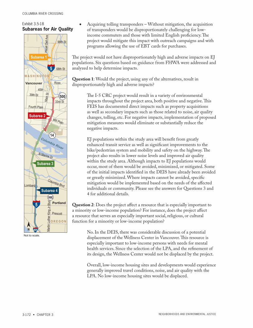
columbia river crossiNg
3-172 • CHAPTER 3 Neighborhoods aNd eNviroNmeNtal Justice
• Acquiring tolling transponders – Without mitigation, the acquisition of transponders would be disproportionately challenging for low-income commuters and those with limited English proficiency. The project would mitigate this impact with outreach campaigns and with programs allowing the use of EBT cards for purchases.
The project would not have disproportionately high and adverse impacts on EJ populations. Six questions based on guidance from FHWA were addressed and analyzed to help determine impacts.
Question 1: Would the project, using any of the alternatives, result in disproportionately high and adverse impacts?
The I-5 CRC project would result in a variety of environmental impacts throughout the project area, both positive and negative. This FEIS has documented direct impacts such as property acquisitions as well as secondary impacts such as those related to noise, air quality changes, tolling, etc. For negative impacts, implementation of proposed mitigation measures would eliminate or substantially reduce the negative impacts.
EJ populations within the study area will benefit from greatly enhanced transit service as well as significant improvements to the bike/pedestrian system and mobility and safety on the highway. The project also results in lower noise levels and improved air quality within the study area. Although impacts to EJ populations would occur, most of them would be avoided, minimized, or mitigated. Some of the initial impacts identified in the DEIS have already been avoided or greatly minimized. Where impacts cannot be avoided, specific mitigation would be implemented based on the needs of the affected individuals or community. Please see the answers for Questions 3 and 4 for additional details.
Question 2: Does the project affect a resource that is especially important to a minority or low-income population? For instance, does the project affect a resource that serves an especially important social, religious, or cultural function for a minority or low-income population?
No. In the DEIS, there was considerable discussion of a potential displacement of the Wellness Center in Vancouver. This resource is especially important to low-income persons with needs for mental health services. Since the selection of the LPA, and the refinement of its design, the Wellness Center would not be displaced by the project.
Overall, low-income housing sites and developments would experience generally improved travel conditions, noise, and air quality with the LPA. No low-income housing sites would be displaced.
99th St
68th St
Haze
l Dell
Ave
33rd St
39th St
Ross
45th
Fourth Plain
Mill Plain
Columbia Blvd
Martin
Luthe
r King
Jr B
lvdMa
in St
5
5
405
500
14
99E
Lombard
N Marine Dr
Prescott
Subarea 1
Subarea 2
Subarea 3
Subarea 4
O R E G O N
Vancouver
Portland
W A S H I N G T O N
Columbia River
Not to scale.
N
Exhibit 3.5-18Subareas for Air Quality
FiNal eNviroNmeNtal imPact statemeNt
EXISTING CONDITIONS AND ENVIRONMENTAL CONSEQUENCES • 3-173Neighborhoods aNd eNviroNmeNtal Justice
Question 3: Would the project result in disproportionately high and adverse impacts that would be predominately borne by a minority or low-income population?
If the project’s electronic toll collection method required users to pay large set-up fees or own a credit card or bank account, some low-income populations may not be able to purchase a transponder. Not being able to purchase a transponder would potentially be a disproportionately adverse impact on those low-income populations. The impacts would be mitigated with a program established specifically to provide assistance, enable use of EBT cards, and communicate regarding tolling system usage to Limited English Proficiency (LEP) populations.
The displacement of the Safeway store would also displace a very active bottle return center. This recycling center provides an opportunity for community members to generate a small amount of income, which may supplement other employment or may constitute some individuals’ sole means of income. But, there are other locations where bottles can be returned on the island and in North Portland.
Question 4: Would the project result in disproportionately high and adverse impacts on a minority or low-income population that would be appreciably more severe or greater in magnitude than the impact that would be suffered by the non-minority or non-low-income population?
No, there would not be disproportionately high and adverse impacts on an EJ population that would be appreciably more severe or greater in magnitude than would be suffered by the non-EJ population. Though the toll would constitute a proportionately higher percentage of a low-income household’s income, it has not been found that it would be “appreciably more severe.” The cost of the toll would be offset by other factors, as discussed in this section, and would replace other, similarly regressive revenue generation methods.
Question 5: Does the project propose mitigation?
Yes. As discussed above.
Question 6: Are there project benefits that would accrue to EJ populations?
Yes, benefits that would accrue to EJ populations include new and reliable high-capacity transit service, improved travel times on I-5, improved vehicle, bicycle and pedestrian travel, and improvements in air quality and noise levels (in most locations). The decrease in transit travel time and increase in transit reliability would be a key benefit for all the traveling public, but particularly for low-income people who ride transit proportionally more than those with higher incomes.

columbia river crossiNg
3-174 • CHAPTER 3 Neighborhoods aNd eNviroNmeNtal Justice
This page intentionally left blank.