a geologic history of the methow valleymethownaturalist.com/5-2014-methow geology.pdf · a geologic...
TRANSCRIPT

One could start a geologic history of the Methow Valley with the sto-ry of plate tectonics, because much of the drama written in the rocksis inscribed there due to the forces of moving plates. 200 millionyears ago (mya) most of what is now northern Washington existed asseveral large islands, each one a scrap of continent, lying somewhereout in the Pacific Ocean. One after the other they were pushed upagainst the existing continent and became a part of it.
The earth has at its center a metallic core, thought to be 85% iron, al-though no one has been there to check, and 5% nickel. The core isabout the size of the moon. Surrounding the core is the mantle, athick shell of dark green and black rocks called peridotite that com-prise the largest part of our planet. Peridotite is an iron-manganesesilicate, which means it is composed of iron, manganese, oxygen andsilicon. Any rock with iron will be heavier that those without iron,and will be drawn downward by gravity.
A thin outer skin called the crust covers the peridotite of the mantle nearly everywhere. Oceanic crust is composedmostly of the rock gabbro, which like peridotite is relatively dense. Continental crusts—and therefore the continents—are made of less dense rocks that literally float on the denser rock below. Continents can be thought of as rafts floatingon the much more dense gabbro of the oceanic crust and the peridotite of the mantle.
The earth’s solid crust that covers the mantle—known as the lithosphere—is a mosaic of about 12 plates, joined atseams. Plates are constantly moving, driven by heat from the nearly-molten mantle. Oceanic plates are pushed apartfrom each other by upwellings of molten rock at long ridges at the center of the Atlantic and the Pacific; they move apartat a rate of 2-3 inches per year.
Because plates are being pushed apart in the middle of the Atlantic and the Pacific, they are pushed into one anotherelsewhere. When two oceanic plates collide, one sinks—usually the one farthest from where it formed, because thatplate will be the colder and denser of the two. A deep oceanic trench will develop where the sinking plate turns down tostart its long dive into the earth’s mantle.
Oceanic crust that is forced against continents sinks beneath the continent, heating up from the extreme pressure, andtaking on water in the process. 50 miles inland from the ocean-continent boundary magma (liquid rock) and steam typi-cally erupt to form a chain of volcanoes. This is the reason there are five active volcanoes in the Washington Cascades,and that there is a ‘Ring of Fire’ (that is, a chain of volcanoes) all the way around the Pacific Ocean.
Sometimes there are fragments of continental crust embedded asislands in subducting (sinking) oceanic crust; these are known asterranes, or microcontinents. When they arrive at the edge of atrue continent, they are too light to sink with the ocean crust be-neath the larger continent; rather they are jammed onto the exist-ing coastline. There is plenty of heat and pressure involved, andthey are welded onto the coast and become an integral part of thecontinent.
Over the millions of years it takes for a microcontinent to ap-proach and reach a larger continent, sediment will be eroding offof both landmasses and accumulating in the sea between them.Over time this sediment will be cemented together into sedimenta-ry rock. As the two landmasses are pushed together, the sedimen-
A Geologic History of the Methow ValleyBy Dana Visalli
www.methownaturalist.com/[email protected]
Top: the oceanic plate on the left, sinks under a continental plate.The oceanic plate has a 'terrane' or microcontinent embedded in it.Bottom: the terrane is pushed onto the larger continent, deformingthe sediments between the two.
Methow sediments
This cartoonish map illustrates how the earth's crust is brokenup into 12 major plates, which are in slow but constant motion.The continents tend to be on different plates than the oceans.
terrane 'docks' against continent

tary rock that has accumulated between them will be deformed and crushed.This often results in this sedimentary rock, which is inevitably laid downhorizontally, but is often forced into upturned positions by plate tectonics.Much of the sedimentary rock in the Methow was laid down in a shallowsea, and then forced into various upturned positions between two collidingmasses of continental rock.
The subduction of oceanic trenches averages about 2-3” per year. Althoughthat is much slower than a snail’s pace, it is fast by geologic standards. Thiscan add up more than 32 miles of ocean floor every million years, and 320miles in ten million years. Ten million years doesn’t amount to much in geo-logical time.
For 800 million years the west coast of North America lay in eastern Wash-ington, in the area of Spokane. 200 million years ago (mya) the AtlanticOcean first appeared as a split in the supercontinent Pangaea (in fact the At-lantic is still growing at a rate of 3” per year). Since that time the Americashave been pushed westward against the Pacific Ocean plate, which in turn is subducting under the American conti-nents. So the Pacific shrinks precisely as the Atlantic grows.
The geologic history of the Methow proceeds neatly from east to west, largely because the land mass of our biore-gion, Cascadia, and much of the state of Washington, has been cobbled together from east to west. The first eventwritten in the rocks of the Methow is along the roadside south of Carlton and in our Sawtooth Mountains. These are300 million year old (myo) metamorphic rocks known as gneiss. Metamorphic means “changed form,” so theserocks must have been something different in the past. They were in fact sedimentary rocks previously, laid down in amarine environment, then buried in the earth and partially melted into the form they take today. The sedimentaryrock would have started as loose sediment, eroded from some archaic continent that existed perhaps 600 millionyears ago. Thus in our first rock outcrops we are faced with a vast depth of time and the astonishing cycling of thevery face of the earth’s crust. 600 mya is before the first life began to colonize dry land, while by 300 mya amphibi-ans had become the dominant animals. Reptiles were just beginning to appear, while among the plants conifers werejust emerging.
As the ocean floor slipped into the trench at the edge of the continent, island micro-continents (consisting of conti-nental rock, which is literally lighter, or less dense, than ocean crust) embedded in the oceanic crust collided withwestern North America one after the other.
The first major addition was the Quesnellia terrane (also known as Intermountain Terrane and the Okanogan High-lands), which joined North America about 180 mya. It now forms the highland region between the Columbia andOkanogan Rivers. The original rocks of Quesnellia appear to have been metamorphosed sedimentary rocks, whichpoints to a previous long tectonic cycle. Much later, after ‘docking’ (the term used by geologists), the terrane wasengulfed in an upwelling of granite magma; this was the origin of Tiffany Mountain and other granitic mountains onthe eastern border of the Methow and in the Okanogan Valley.
The first non-metamorphic rocks to appear in the Methow is a huge pile of terrestrial sandstone, marine shale andvolcanic rock laid down as sediment between 150 and 120 mya known as the Newby Group. This is further dividedinto the Twisp Formation and the Buck Mountain Formation. The Twisp Formation outcrops regularly from Look-out Mountain, across Poorman Creek to Moccasin Lake and Patterson Lake, and the across the Methow River toLewis Butte. The Buck Mountain Formation parallels it a few miles to the east, first showing up on McClure Moun-tain, forming the striking rock outcrops on the Eastside Road just north of Twisp, and extending north through Pear-rygin Lake and on to Buck Lake and Buck Mountain. The 120-150 mya time span of these formations bracket thetime when the first flowering plants show up in the fossil record; it is also early in the Age of Dinosaurs.
Two striking features of the Newby Group are 1) they account for an expanse of 30 million years, and 2) the totaldepth of the sediments is 18,500 feet; that’s a lot of deposition. Both formations consist of an interlayering of marinesediment, continental sand, volcanic tuff (which is welded volcanic ash), and volcanic breccia (welded angular piecesof volcanic rock). For an enormous period of time this area must have been a shallow sea, with sediment arrivingfrom both the continent and offshore volcanic islands. A few marine fossils have been found in the Twisp Forma-
2
Our understanding of plate tectonics and howdynamic the earth is is only about 40 years old.

tion, while both marine fossils and terrestrial plant fossils are com-mon in the Buck Mountain Formation.
At the end of the Newby Group deposition something dramaticallytectonic happened, because many of the Newby sediments are turnedstraight up in the air, and portions of the sediments are missing alto-gether, eroded away by some unknown force. Afterward this drama,a whole new period of sedimentation begins. Three somewhat dis-tinct layers of sediment, going by the names of the Goat Creek, Pan-ther Creek and Hart’s Pass Formations, accumulate another 18,000feet of sediment. Much of this is continental material, sand fromeroding granitic rock. But it is interbedded with fine marine shaleloaded with marine fossils, so many geologic chapters must havebeen written over this 10 million year period (120-110 mya).
The Panther Creek Formation is visible on Sweetgrass Butte andSunrise Mountain, the Goat Creek Formation outcrops on upperGoat Creek, and the Hart’s Pass Formation shows up on Tatie Peak in the Hart’s pass area, but not at the pass itself, noron Slate Peak nor Deadhorse Point. These locations record the next distinct layer of sediment to accumulate, VirginiaRidge.
The Virginia Ridge Formation, which was deposited approximately 100-110 mya, is quite extensive in the Methow, out-cropping continuously all the way from the high hills west of Moccasin Lake north to beyond Slate Peak. This 10,000feet thick deposition of sedimentary rock is primarily of marine origin and is loaded with marine fossils. The upper lay-ers contain chert pebbles—chert is a form of quartz that at times forms from the skeletons of diatoms and radiolarians,which when alive are photosynthetic forms of plankton (free-floating microscopic organisms).
On top of the Virginia Ridge Formation, and dating to 100 mya, is 10,000 feet of sediment called the Winthrop Sand-stone, containing numerous fossils of flowering plants, ferns and conifers that grew in a semitropical environment. Thisformation appears mostly on the west side of the valley north of Winthrop, and includes the summit of Lucky Jim Butteand most of Sandy Butte; there is an outcrop on the east side of Boesel Canyon that is rich with fossils. A recent doctoralthesis by Methow native Ian Miller identified 150 plant species in the Winthrop Formation, and supported previous evi-dence that this terrane originated on the Pacific coast of Baja California. Tectonic forces ripped it off of that land massand transported it 1500 miles north on the Pacific Plate before delivering it to the coast of the Pacific Northwest. It is notknown how many of the other Formations of the Methow are also terranes that originated further south.
Next up is one of the most striking rocks of the Methow Basin, known as the Ventura Member of the Midnight Peak For-mation. Ventura rock is sandstone, but it is deep red and purple in color. Such coloration is due to the oxidation of ironin the rock, a reaction that takes place only on land. For the original rock from which the sediment came to be high iniron, it must have been from the ocean crust, but for it to erode on land it must have been push out of the sea and onto thecontinental margin. Oceanic crust usually sinks under continents, but sometimes if it gets shoved hard enough that it willride up on to the continental crust. This colorful rock can best be viewed near where the Hart’s Pass Road crosses LostRiver; it dates to about 90 mya.
Overlying the Ventura rock is an outpouring of volcanic rock from the Midnight Peak formation, which is laid down instrata up to 10,000 feet deep. There is no trouble finding this formation; Goat Wall is made up of it; as is Goat Peak andRobinson Mountain. If it doesn’t look volcanic, it is because it has been slightly altered (metamorphosed) in the millionsof years it was buried under ground, before erosion from the Methow River and rivers of ice bared it to the light of day.Midnight Peak dates to about 80 mya.The Methow was shut off from any further marine sediment accumulation when igneous terranes arrived from the westand accreted onto the continent. The first of these west of the Methow is the Black Peak Batholith (a batholith is verylarge amount of igneous rock that cooled deep underground, where it would tend to form rocks such as granite with largecrystals), which is dated at 98 myo, and then the Golden Horn Batholith, at 45 myo. The latter group includes GoldenHorn Mountain itself, as well as Liberty Bell and Cutthroat Peak.The minimum depth for the slow cooling of granitic rock such as that found in the Golden Horn Batholith is thought to bethree miles down in the crust. Thus the majestic mountains that protrude today were once buried under immeasurable
The Methow Naturalist/www.methownaturalist.com/[email protected]
A diagram of some of the Methow's sedimentary formations.
tons of overlying rock, which has been eroded away by the passage of enormous amounts of time since that rock cooled.This would have been accompanied by uplift of the batholith itself from continual pressure being applied by sinking oce-anic crust off to the west.The Methow Valley itself is a down-dropped block of sedimentary rock that lies between igneous terranes. This type ofdownward movement of a section of rock is called a graben, which is a German word for ‘grave.’ The Methow Valley isa graben.
There was one more large depositional event in the Methow at what is now Pipestone Canyon about 60 mya, where 2000feet of boulders, cobbles, sand and silt were deposited in a water environment, but apparently not in an ocean, as the in-terbedded sandstones contain only land plant fossils. Eight terrestrial plant fossils that would have grown in a semi-tropi-cal environment have been found in Pipestone sediments, including Metasequoia, the ‘dawn redwood.’ Because theMethow was largely sealed off from the Pacific Ocean and deliveries by the Pacific Plate, it is likely that Pipestone wasdeposited on site, in the location it currently occupies.The dawn redwood found in Pipestone grew in North America from the time of the dinosaurs to about 8 mya, when itmade its last stand in the swamps of what is now eastern Washington—possibly in the Methow Valley! Although wellknown as fossils, they were believed to be extinct globally until a small population—just 1200 trees—was located in asteep isolated valley in Hubei Province, south-central China, in 1941. Some seeds were brought to the United States in1946, and in 1952 Metasequoia produced cones on the North American continent for the first time in eight million years.The depositional time of Pipestone strata 60 mya was a pivotal one on earth. Evidence is now thought to be conclusivethat a large asteroid ten miles across slammed into the earth off the coast of the Yucatan Peninsula 65 mya, causing somuch smoke, dust and debris to be ejected into the atmosphere that a ‘volcanic winter’ ensued. This lead to the collapseof terrestrial ecosystems and the extinction of almost all large animals, including the dinosaurs. During the time that thePipestone sediments were being deposited the biosphere was still in a state of recovery from this mass extinction, andmammals were in the process of becoming the dominant animals on land.As if 100 million years of marine deposition and mountain uplift, volcanic eruptions and crashing terranes were notenough, nature enlisted another powerful force to continue to redesign the landscape—rivers of ice. The entire Pleisto-cene Epoch, which lasted from 2.4 million years ago to just 12,000 years ago, was an age of ice. There is some evidencethat there not one or two but 20 glacial advances in the Methow and throughout the northern portion of North America inthat period, reoccurring on an approximately 100,000 year cycle.Before the last glacial advance in the Methow, which began here about 18,000 years ago, the Methow Valley would havebeen easily recognizable, but also somehow very different. Many of the plant species that exist in the Methow todaywould have been present then, but they would be combined in different plant associations, as they have been scrambled inthe interim by major climatic shifts and glacial impacts. The physical topography of the Methow would be familiar butsubtly different, as the unimaginable impact the last glacial advance, which sent a mile thick river of ice grinding acrossthe Methow’s hills and valleys, would not yet be inscribed upon the land. Perhaps most notably, an entire suite of largemammals that existed in North America 24,000 years ago are absent today, having suddenly gone extinct about 12,000years ago. Many of these species have left fossil remains in eastern Washington and some would have been members ofthe Methow’s Pleistocene fauna. These rather recently extinct species include mammoths, mastodons, the American lion,giant sloths and giant beavers, and horses (which had also migrated to Asia over the Bering Land Bridge, and returned toNorth America in the early 1500s with the Spaniards. In the last glacial advance in North America, which occurred 70,000-14,000 years ago, this continent had considerablymore ice (18.5 million square kilometers) than Antarctica had then (13.8 million square kilometers) or now (12.6 millionsquare kilometers). At the maximum extent of the last glacial advance 80 million cubic kilometers of water was frozen inglaciers, lowering sea levels by about 350 feet. The land bridge between Asia and North America, known as Beringia,was 800 miles wide.
18,000 years ago the Methow’s alpine glaciers engaged in a major advance from the high mountains toward the valleyfloor. This was a thousand years before the continental glacier arrived from Canada. These glaciers extended severalmiles downstream from their source in the cirques of the high mountains, although some never reached the Methow prop-er. The evidence for this is in the fact that the upper portions of these drainages (e.g. Oval Creek and Libby Creek) areU-shaped— carved by glaciers—but the lower ends are V-shaped—indicating that these sections were carved by runningwater.
4
The continental glacier that flowed into the Methow 17,000 BP (before the present) from the north enveloped all but thehighest peaks in a river of ice. It of course destroyed all the existing vegetation in the watershed except those few speciesthat persisted on the protruding peaks.
When the climate warmed 14,000 BP, tributary valleys melted first, sending torrents of water toward the Methow Valleyproper, which was still plugged with the ice of the continental glacier. Water flowed over the surface and at the edges ofthis glacier, washing 3000 years of accumulated debris into the crevices along the ice boundary, forming the flat kameterraces on the hillsides of the mid and lower valley (kame is a Scottish word meaning ‘hill’).
Water blocked by the main valley glacier was shunted into side canyons, carving coulees such as Elbow Coulee and Pip-estone Canyon. Water impounded by ice walls formed glacial lakes, later draining and leaving broad, elevated benchessuch as Mills Flat (south of Carlton). Melting glaciers also left a large amount of glacial till (unsorted glacial sediment)in the primary drainages. Till in the Mazama area is as much as 1000 feet deep, while in the Twisp-Winthrop area it is200 feet deep in some places.
The Methow glacial ice left its last terminal moraine just south of the present position of Twin Lakes, where there areclassic kettles—large depressions in the landscape that were filled by enormous blocks of ice. The two Twin Lakes arekettles which were about 14,000 ya filled with ice left stranded as the continental lobe in the Methow melted. The thinstrip of sand and gravel separating the two lakes was a crevasse between the two blocks of ice, which filled with debris asthe blocks melted. There are hundreds of smaller kettles in the larger moraine complex near Twin Lakes known locally asthe ‘potholes.’
The large accumulation of glacial till in the Twin Lakes area is a ‘recessional moraine,’ a ridge of material that formed asthe last glacier in the area paused for a time as it melted, depositing additional debris. After this moraine formed, therewere apparently no more pauses in the melting, for there is not one more moraine up the length of the valley.
The smooth rounded hills of the Methow—what geologist Julian Barksdale referred to as ‘the ice cream cone topogra-phy’ of the valley—reflect the efficiency of a mile of flowing ice with its cutting tools frozen into its base.
As the western portion of the continental ice sheet melted between 14,000 and 13,000 years ago, dramatic floods of melt-water flowed through central Washington just east of the Methow Valley. These occurred because meltwater from a pri-mary lobe of the continental glacier was blocked from draining for years at a time due to the glacier itself. This blockageformed a lake in the area that is now Missoula, Montana that held as much water as Lake Erie (one of the Great Lakes)does today. When the lake water grew deep enough, it floated the impeding lobe of ice out of the way, and the entire‘Great Lake Missoula’ drained out through central Washington in a period of just two weeks. It is thought that as muchwater as flows in all the rivers of the world coarsed through the middle of the state for those few weeks when the ice damwas removed, resulting in the Missoula Floods (also known as the Spokane Floods and Bretz Floods). It is now thoughtthat this scenario played out repeatedly, with at least 40 separate floods over occurring. While they had minimal effect onthe Methow, they did send floodwaters into the lower portion of the valley.
There is one more important aspect of Methow geology, and that is the active volcanoes of the American west. The larg-est of these is the Yellowstone Supervolcano, which is estimated to have sent 600 cubic miles of ash and debris into theatmosphere 2.4 million years ago, with smaller eruptions 1.2 million years ago and 640,000 years ago. Closer to home,Glacier Peak, which is only 50 miles away, had a major eruption 12,000 years ago, depositing up to a foot of ash in theMethow. This was followed by Mt. Mazama in Oregon, which blew apart approximately 7000 years ago, creating CraterLake and deposited up to 2” of ash here in the Methow, and an eruption of Mt. St. Helens 3500 years ago that was tentimes larger than the 1980 eruption and deposited another 2” of ash in the Methow. White volcanic ash layers are visiblein undisturbed Methow soils.
The melting of the ice 14,000 years ago was not the last chapter in the shifting patterns of weather, climate, biology andgeology in the Methow. There was a sharp drop in temperature all over the planet between 13,000 and 12,000 years agoknown as ‘the Younger Dryas,’ during which time alpine glaciers advanced. This was followed by a notable warming10,000 years BP, a sharp cooling 8000 years BP, a very warm period called ‘the Hypsithermal’ 6000 years BP, a‘Neoglaciation’ 5000 years BP, a ‘Medieval Climatic Optimum’ 1000 years BP, and a ‘Little Ice Age’ 600 years BP.
The only constant in geology seems to be change.
The Methow Naturalist/www.methownaturalist.com/[email protected]

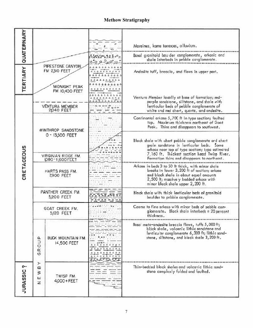
Methow Stratigraphy
7

8


Demystifying RocksElementsRocks are made up of minerals, and minerals are made up of elements. Elements, as you may remember arethose discrete little building blocks of the universe that fill the scary Periodic Table of Elements. There are 92naturally occurring elements on earth, but only 8 are major constituents of minerals, and those are aluminum(symbol for which is Al), calcium (Ca), iron (Fe, from the Latin word for iron, ferrum), magnesium (Mg), oxy-gen (O), potassium (K, from a Latin word for potassium ‘kalium’), silicon (Si) and sulfur (S). If you combinethese in different proportions you get different minerals and different rocks.
MineralsApparently there are over 4500 minerals on earth, but it is our good fortune that we only need to have a pass-ing familiarity with 6 of them: amphibole, biotite (which we are familiar with as ‘mica’), feldspar (whichcomes in two flavors, orthoclase feldspar and plagioclase feldspar), olivine, quartz (also known as silica) andpyroxene.
A mineral consists of one or more elements, chemically combined. To be classified as a true mineral, asubstance must be a solid and have a crystalline structure. It must also be naturally occurring, with a definedchemical composition. By comparison, a rock is an aggregate of minerals and does not have a specificchemical composition.
A particularly interesting aspect of minerals and rocks is this short series of facts: 1. The more silica that ispresent in a rock (silica is the same thing as quartz, its chemical formula is SiO2, which stands for 1 atom ofsilicon and 2 atoms of oxygen) relative to other minerals, the lighter (less dense) the rock will be. 2. Continen-tal rock—the stuff we stand around on—is made of high silica rock, like granite. Because it is less dense thanmost other rocks it actually floats on the denser rock below. 3. Silica has a much lower melting point thatmost of the other 7 minerals listed above. 4. If a mass of rock is only partially melted, the silica will melt firstand migrate out of the larger mass. 5. Separating out silica means that minerals and rocks evolve over time;more high silica rocks have appeared over time. 6. If more high silica rocks have evolved over time, then thecontinents have evolved over time as well.
Here’s our short list of important minerals, all made up of the 8 elements we listed above. I give a chemicalformula for each—don’t let it frighten you; at some point it’s helpful to know. Each mineral has its relativedensity listed at the end; the comparison is to the density of water. For example the first mineral below, am-phibole, has a density of 3.3. That indicates that a given volume of amphibole would be 3.3 times as dense asthe same volume of water. This factor is important because denser minerals tend to sink downward in theearth’s crust and less dense minerals tend to rise. The denser minerals tend to be darker in color, while thelighter minerals are also lighter in color.
1. Ampibole (Gr, ‘ambiguous’) (also known as hornblende)—A silicate (which usually means some combina-tion of silicon and oxygen, but not necessarily silica, which is SiO2) + iron or magnesium, sometimes with calci-um. A general formula is Mg and/or Fe2SiO4. Amphibole is chemically similar to olivine, which is listedbelow. One difference between the two is cleavage; amphibole cleaves in plates close to 180° while olivinecleaves at 90°. Density 3.33
2. Biotite (named after French physicist J. Biot d 1862)—Biotite is familiar to us as mica. It is composed of asheet silica with iron, magnesium, potassium, and aluminum; the sheets are weakly held together by potassi-um ions and cleave apart easily. K(Mg,Fe)3AlSiO10(OH)2. Density 3.1
3. Feldspar ((German, ‘field mineral’)—An aluminum silcate AlSi2O8. There’s a lot of feldspar out there; itmakes up as much as 60% of the earth’s crust. Density 2.6. Orthoclase feldspar adds potassium to the formu-la; plagioclase feldspar adds sodium (Na) or calcium.
10

4. Olivine (name comes from its typically olive-green color)—A magnesium iron silicate, with the formula Mgand/or Fe2SiO4. Density 3.3
5. Quartz (probably from an Old German word for ‘hard’)—the chemical formula is SiO2--silica. This is thesecond most abundant mineral in the earth’s continental crust after feldspar. Density 2.6
6. Pyroxene (Gr, ‘fire stranger,’ in reference to the fact that they show up it crystals embedded in glass or lavabecause of their high-temperature of solidification)—Calcium, iron, sodium and/or magnesium + SiO3.Density 3.4
RocksThere are three main types of rocks, igneous, sedimentary, and metamorphic. Each has a different historyand tells a different story. Learning to recognize these three rock types can tell you a lot about the environ-ment that you are in.
Igneous- The word igneous means ‘born by fire’; igneous rocks are those that have been melted completely(into magma) before solidifying. A useful rule of thumb is that the faster a magma or lava cools, the finer thegrain size of the rock will be. Thus volcanic rock, which is exposed to the air or at least close to the surface, isfine-grained. Rocks that cool deep underground, like granite, are made up of large crystals of different miner-als, which were able to form because the original molten material cooled very slowly.
There are two types of igneous rocks. Those that cool at or near the surface of the earth are known as extru-sive igneous rocks, and are generally associated with volcanic activity. Rocks that melt completely and thencool deep underground cool slowly—sometimes over a million years or more—are called intrusive igneousrocks. Their long period in a liquid or plastic state allows the molecules of any particular mineral in the rockto migrate to other molecules of the same type. This leads to the formation of distinct crystals of differentminerals within the rock. For example, if you look at granite closely, you will see that there are distinct whitecrystals in the rock structure—quartz—along with pinkish crystals, which are feldspar, and black flecks,which are mica.
Felsic rocks are lighter colored rocks that are rich in light-colored elements such as silicon, oxygen, potassiumand sodium. They are also relatively light-weight, with densities less than 3 (3 times the equivalent volume ofwater). The term "felsic" combines the words "feldspar" and "silica".
Mafic rocks are dark colored rocks that are rich in magnesium and iron; the word ‘mafic’ is constructed fromthe ma in magnesium and the fe in ferric (which means iron in Latin). They have a density of more than 3 andtend to feel heavy.
Below are some examples of common intrusive and extrusive igneous rocks. Both groups are arranged in or-der of decreasing quartz (SiO2, silica dioxide) content and increasing darker, heavier minerals.
The darker, heavier minerals solidify at higher temperatures than those with a greater silica (SiO2—which islight-colored) content. Thus olivine and pyroxene (see mineral section below) will precipitate out of a coolingmagma much earlier than will quartz. The surprising related point is that the first minerals to crystallize in amass of magma (those that crystallize at high temperature) are most unstable at the earth's surface and are thequickest to weather, because the surface is most different from the conditions under which they were created.On the other hand, the low temperature minerals are much more stable because the conditions at the earth’ssurface are much more similar to the conditions under which they formed. Therefore dark rocks such asgabbro, basalt and slate will quickly weather to fine, silt-like particles, whereas high-silica rocks such asrhyoliteand granite will weather to relatively large fragments. This is why they world’s beaches are coveredwith sand, and not mud or silt. The fine silt washes away to quiet water, while the larger quartz-feldsparsand resists deportation.
The Methow Naturalist/www.methownaturalist.com/[email protected]

Extrusive Igneous1. Rhyolite: Rhyolite is the extrusive chemical equivalent of granite, with 70% SiO2 (which is very high silicacontent). It aphanitic (fine-textured) or an aphanitic porphyry (fine matrix with some larger crystals mixedin), and is usually pale, in shades of white, gray, pale green, although it is (unfortunately) sometimes red orbrown. It is a very hard rock that break with a conchoidal fracture like glass; in fact obsidian is a glass ver-sion (noncrystalline) of rhyolite. An important thing to remember about these extrusive igneous rocks is thatthe lava viscosity (which can be defined as ‘resistance to flow,’ or ‘gooey-ness’) increases dramatically withsilica content. Molten rhyolite may be up to 1000 times more viscous than molten basalt—which means rhyo-lite rarely flows. The name comes from the Greek word for ‘flow’ (ironically). Density 2.5
2. Dacite: Dacite is intermediate between rhyolite and andesite, and is the volcanic equivalent of granodiorite,with a silica content of about 65%. It is aphanitic or an aphanitic porphyry, often medium gray, sometimesbrown or buff. Dacite contains more plagioclase feldspar and less orthoclase feldspar than rhyolite. Thisrock is common in Romania, which the Romans called Dacia, thus the name. Like rhyolite it is a viscous min-eral and will tend to plug volcanic vents rather than flowing, which leads to explosions. Much of GlacierPeak is composed of dacite, as are the lava domes on Mt. St. Helens. Density 2.6
3. Andesite: Andesite is the extrusive chemical equivalent of diorite, with a silica content of about 60%. . It isaphanitic or an aphanitic porphyry, typically gray, green or sometimes reddish brown. It is high in plagio-clase feldspar, which is sometimes found as white or gray phenocrysts or as tiny lath-like crystals in thegroundmass. This feldspar has a much higher melting point than the background minerals and came up withthe magma as a solid--, like marshmallows floating in cocoa. The majority of the rock in big Washington vol-canoes is andesite- whereas basalt predominates in the ‘High Cascades’ (in Oregon). Most of Goat Wall, GoatPeak and Robinson Mt. are composed of slightly altered andesite. The rock is named after the Andes. Density2.7
4. Basalt: Basalt is the extrusive chemical equivalent of gabbro, with a silica content of 50% SiO2. It is fine-tex-tured and usually dark, although it can be medium gray, greenish or reddish. In general the individual crys-tals within basalt are not visible with the naked eye or through a hand lens. Sometimes basalt is pepperedwith air holes (vesicles), which indicate that the rock congealed near the surface of a lava flow. The namecomes from a Latin word meaning ‘very hard stone.’ With its low silica content, basalt is very fluid, and itflowed out abundantly as the flood basalt of central Washington 16 million years ago—about 100,000 cubicmiles of it! Density 2.9
5. Pumice: A very light, airy rock which forms on the surface of a viscous, high-silica lava like rhyolite. Itmay also form in the air after rhyolite explodes. It is light-colored with abundant tiny vesicles (air holes).Some pumice is so full of air that it will float on water. The name derives from an old Latin word meaning ‘tofoam.’
6. Tuff: Consolidated volcanic ash. Ashfall can be cemented over decades from dissolved silica, or it can ce-ment itself from its own heat, a ‘welded tuff.’ Tuff creates the steep angle and smooth outline of stratovolca-noes (the classic steep-sided shape of our PNW volcanoes). The word comes from the Latin tufa, meaning‘porous rock.’
7. Obsidian: volcanic, rhyolitic glass (high silica by definition), usually black. Obsidian is lava that cooledvery quickly, without organizing into crystalline minerals. It is only found where volcanic activity has oc-curred in fairly recent times, for it tends to crystallize into fine-grained rock or decompose by taking on wa-ter. Named after an Old Roman rock hound, Obsius.
Intrusive Igneous1. Granite: 70% SiO2. The name derives from ‘granular’; and indeed the texture is granular, one of interlock-ing crystals. Granite has at least 10% visible quartz; in fact quartz crystals (which are SiO2) will only form
12

above 55% SiO2 content. It is usually pale overall, although it can be pink to red. Dark minerals are neverabundant but their presence gives granites a ‘speckled’ appearance. Quartz is the white to buff, translucentcomponent; feldspars are salmon to pale gray; and the black flakes are biotite mica, hornblendes and pyox-enes are dark gray. Granite forms by cooling over hundreds of thousands of years. Density 2.7
2. Granodiorite: 65% SiO2. Similar to granite but darker, with more plagioclase than orthoclase feldspar. Itusually contains abundant biotite mica and hornblende, giving it a darker appearance than true granite. Micamay be present in well-formed hexagonal crystals, and hornblende may appear as needle-like crystals.
3. Diorite: 60% SiO2. Diorite is usually speckled, dark but up to 50% light crystals. . It can also be black orbluish-grey, and frequently has a greenish cast. It is composed principally of plagioclase feldspar, biotite,hornblende, and/or pyroxene; it is relatively rare. Density 2.9.
4. Gabbro: The chemical equivalent to basalt, with 50% SiO2. It is coarse-grained and typically a dark salt andpepper appearance. It sometimes shows little contrast in color, making the crystals inconspicuous. It is rela-tively rare on the earth’s surface, the most commonly being found in dikes over 4” wide—with its low silicacontent and low viscosity it flows into openings with ease. The vast majority of the Earth's surface isunderlain by gabbro within the oceanic crust, produced by basalt magmatism at mid-ocean ridges. Namedafter a town in Italy. Density 3.1
5. Peridotite: Less than 45% SiO2. A dark, ultra-mafic rock, typically green, flecked with black crystals and agreasy looking luster. Weathers into serpentine soils. Peridotite contains a high proportion of the dense greenmineral olivine (40% or more; olivine contains iron, so it is a dense mineral), and is too heavy to reach theearth’s surface without exceptionally deep and rapid rock movement. Thus peridotite has no volcanic equiva-lent. Density 3.3
Sedimentary (from the Latin, sedimentum, ‘settling’)- Sedimentary rocks are most often formed from thebreakdown of older rocks. The final particle size from the older rock that is laid down as sediment and thencemented to other particles varies from microscopic to house-size boulders. It is the cementing that turns sed-iment into sedimentary rock.There are two other less-common types of sedimentary rock, organic and chemical. Organic sedimentary rockis formed from organic debris—the deposits or remains of once-living organisms (shells, corals, wood, plants,etc). Chemically formed sedimentary rocks consist of interlocking crystals that precipitated from a solution(which is where the old proverb comes from: ‘If you’re not part of the solution, you are part of the precipi-tate.’).1. Shale: a fine-grained, clastic (made up of fragments of pre-existing rock) sedimentary rock composed ofmud that is a mix of flakes of clay minerals and tiny fragments (silt-sized particles) of other minerals. Shaleusually will split or cleave into thin sheets along the lines it was laid down on. The fine components arebound by cement or by simple compaction. Shale tends to be composed of the low-silica, high-dark mineralrocks, which break down more easily into fine components than do high-silica rocks. Density 2.6
2. Sandstone: a rock composed of sand-sized particles cemented together. May be light or dark, dependingon the mineral composition. Tends to be composed of high-silica, hard rocks like decomposed granite. Den-sity 2.5
3. Conglomerate: sedimentary rocks composed of at least 50% erosion-rounded stones over 1/8 inch in diam-eter; most are pebble beaches and river bars turned to stone. There is over 1000’ of conglomerate in the Pipe-stone Formation.
4. Limestone: Organic or chemical sedimentary rocks with over 50% calcite (CaCO3)- will effervesce with vin-egar. Usually light, white to gray.
The Methow Naturalist/www.methownaturalist.com/[email protected]

5. Chert: a microcrystalline form of precipitated quartz, resembling porcelain. The main source is precipita-tion from sea water solution, initially from diatoms, a microscopic, hard-shelled algae. While most seashellsare made of calcite (limestone), there is also a large group of one-celled organisms that make a shell of silica,and these are them main source of chert.
Metamorphic Rocks (from the Greek words meta, ‘change’, morph, ‘form’)- Metamorphic rocks begin as ei-ther igneous or sedimentary rocks that have then undergone a combination of heat and pressure that changestheir form. Metamorphic rocks have been heated to the point where they become plastic, but they are notcompletely melted. They often have the appearance of having been stretched, with lines of different mineralsrunning through the rock.1. Slate: metamorphosed shale, and like shale it is very fine-grained and usually dark in color. Slate is com-posed mainly of clay minerals or micas depending upon the degree of metamorphism to which it has beensubjected. The original clay minerals in shale alter to micas with increasing levels of heat and pressure. Slatecan also contain abundant quartz and small amounts of feldspar, calcite, pyrite, hematite and other minerals.It may have a satiny luster. Foliation in slate is caused by the parallel orientation of platy minerals in the rocksuch as microscopic grains of clay minerals and mica during metamorphism. Thus the foliation is not alongsedimentary lines but is related to heat and pressure. These parallel mineral grain alignments give the rock anability to break smoothly along planes of foliation. Slate sometimes fractures into slender ‘pencils.’ Density2.8
2. Phyllite: A type of foliated metamorphic rock primarily composed of quartz and mica; the rock represents agradation in the degree of metamorphism between slate and mica schist. Minute crystals of graphite orchlorite impart a silky, sometimes golden sheen to the surfaces of cleavage. Phyllite often pale or dark green.From a Greek word meaning ‘leaf,’ referring to the cleavage planes.
3. Schist A rock with a texture consisting of fine layers of different minerals, often with layers of shiny blackmica. The word schist derives from a Greek word meaning ‘to split,’ but schist often does not split easily, inspite of the derivation of the name. Most schists have been derived from clays and muds which have passedthrough a series of metamorphic processes involving the production of shales, slates and phyllites asintermediate steps.
4. Gneiss: consists of foliated or banded light and dark minerals, intermediate between schist and granite inappearance and metamorphism. The parent rocks can be shale or granite. For the rock to be gneiss ratherthan schist, flaky minerals must be outweighed by fatter grains overall. The minimum depth for gneiss for-mation is 6 miles. Gneiss is a fairly hard rock, giving rise to the geologist’s dictum, ‘Gneiss bands don’t makepunk rock.’ The etymology of the word "gneiss" is disputed. Some sources say it comes from the Middle HighGerman verb gneist, to spark; so called because the rock glitters. Density 2.8
5. Quartzite: Metamorphosed arksose (feldspar- and quartz-rich) sandstone. Pure quartzite is white or gray,but it often occur in various shades of pink and red due to varying amounts of iron oxide (Fe2O3).
6. Migmatite: A rock at the frontier between igneous and metamorphic rocks. Migmatite is the same materialas gneiss, but brought closer to melting by regional metamorphism so that the veins and layers of mineralsbecame warped and swirled. Migmatites are composed of a new material crystallized from incipient melting,and old material that resisted melting. The word is derived from a Greek word migma, meaning ‘mixture.’
14
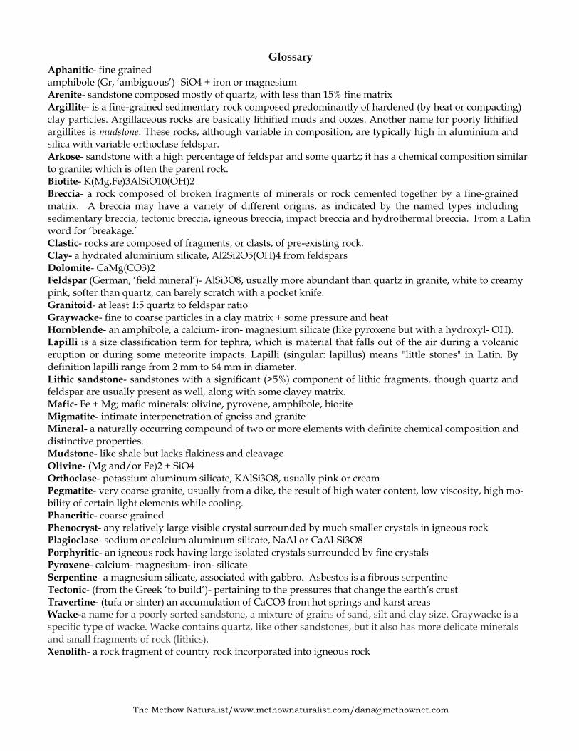
GlossaryAphanitic- fine grainedamphibole (Gr, ‘ambiguous’)- SiO4 + iron or magnesiumArenite- sandstone composed mostly of quartz, with less than 15% fine matrixArgillite- is a fine-grained sedimentary rock composed predominantly of hardened (by heat or compacting)clay particles. Argillaceous rocks are basically lithified muds and oozes. Another name for poorly lithifiedargillites is mudstone. These rocks, although variable in composition, are typically high in aluminium andsilica with variable orthoclase feldspar.Arkose- sandstone with a high percentage of feldspar and some quartz; it has a chemical composition similarto granite; which is often the parent rock.Biotite- K(Mg,Fe)3AlSiO10(OH)2Breccia- a rock composed of broken fragments of minerals or rock cemented together by a fine-grainedmatrix. A breccia may have a variety of different origins, as indicated by the named types includingsedimentary breccia, tectonic breccia, igneous breccia, impact breccia and hydrothermal breccia. From a Latinword for ‘breakage.’Clastic- rocks are composed of fragments, or clasts, of pre-existing rock.Clay- a hydrated aluminium silicate, Al2Si2O5(OH)4 from feldsparsDolomite- CaMg(CO3)2Feldspar (German, ‘field mineral’)- AlSi3O8, usually more abundant than quartz in granite, white to creamypink, softer than quartz, can barely scratch with a pocket knife.Granitoid- at least 1:5 quartz to feldspar ratioGraywacke- fine to coarse particles in a clay matrix + some pressure and heatHornblende- an amphibole, a calcium- iron- magnesium silicate (like pyroxene but with a hydroxyl- OH).Lapilli is a size classification term for tephra, which is material that falls out of the air during a volcaniceruption or during some meteorite impacts. Lapilli (singular: lapillus) means "little stones" in Latin. Bydefinition lapilli range from 2 mm to 64 mm in diameter.Lithic sandstone- sandstones with a significant (>5%) component of lithic fragments, though quartz andfeldspar are usually present as well, along with some clayey matrix.Mafic- Fe + Mg; mafic minerals: olivine, pyroxene, amphibole, biotiteMigmatite- intimate interpenetration of gneiss and graniteMineral- a naturally occurring compound of two or more elements with definite chemical composition anddistinctive properties.Mudstone- like shale but lacks flakiness and cleavageOlivine- (Mg and/or Fe)2 + SiO4Orthoclase- potassium aluminum silicate, KAlSi3O8, usually pink or creamPegmatite- very coarse granite, usually from a dike, the result of high water content, low viscosity, high mo-bility of certain light elements while cooling.Phaneritic- coarse grainedPhenocryst- any relatively large visible crystal surrounded by much smaller crystals in igneous rockPlagioclase- sodium or calcium aluminum silicate, NaAl or CaAl-Si3O8Porphyritic- an igneous rock having large isolated crystals surrounded by fine crystalsPyroxene- calcium- magnesium- iron- silicateSerpentine- a magnesium silicate, associated with gabbro. Asbestos is a fibrous serpentineTectonic- (from the Greek ‘to build’)- pertaining to the pressures that change the earth’s crustTravertine- (tufa or sinter) an accumulation of CaCO3 from hot springs and karst areasWacke-a name for a poorly sorted sandstone, a mixture of grains of sand, silt and clay size. Graywacke is aspecific type of wacke. Wacke contains quartz, like other sandstones, but it also has more delicate mineralsand small fragments of rock (lithics).Xenolith- a rock fragment of country rock incorporated into igneous rock
The Methow Naturalist/www.methownaturalist.com/[email protected]