abbreviations and acronyms - centre for ... · web viewtpc threshold of potential concern wma water...
TRANSCRIPT

FINAL MANAGEMENT PLAN FOR THE BUFFELS ESTUARY
.
May 2017
Prepared by: Pete Fielding - FieldWork57 Jarvis Rd
BereaEast London
5240
1

This document forms the second deliverable towards the development of an Estuary Management Plan for the Buffels Estuary, which falls within the Nama Khoi Local Municipal area. Nama Khoi LM is located within the Namakwa District Municipality. This is the Draft Estuary Management Plan which lays out the Vision, Objectives, Goals, and Management Actions required to achieve those Goals for the Buffels Estuary. Oversight and funding for the project was provided by the Department of Environmental Affairs (Oceans and Coast).
.
2

ContentsABBREVIATIONS AND ACRONYMS.....................................................................................................5
1. INTRODUCTION.............................................................................................................................8
1.1 BACKGROUND..........................................................................................................................8
1.2 PURPOSE AND SCOPE OF THE BUFFELS ESTUARY MANAGEMENT PLAN...............................10
1.3 STRUCTURE OF THE REPORT..................................................................................................11
2. SYNOPSIS OF SITUATION ASSESSMENT.......................................................................................12
2.1 SITUATION ASSESSMENT SUMMARY.....................................................................................12
2.2 PRESENT ECOLOGICAL STATE AND DESIRED ECOLOGICAL STATE..........................................14
2.3 ECOSYSTEM SERVICES............................................................................................................15
2.4 IMPACTS AND POTENTIAL IMPACTS......................................................................................16
2.5 SOCIO-ECONOMIC CONTEXT.................................................................................................17
2.6 OPPORTUNITIES AND CONSTRAINTS.....................................................................................18
2.7 MAJOR INFORMATION GAPS.................................................................................................19
3. BOUNDARIES OF THE BUFFELS ESTUARY.....................................................................................19
4. VISION FOR THE BUFFELS ESTUARY.............................................................................................20
5. KEY RESULT AREAS OR MANAGEMENT OBJECTIVES....................................................................22
6. ZONATION AND THE BUFFELS ESTUARY......................................................................................47
6.1 EXISTING PLANNING/ZONATION FRAMEWORKS...................................................................47
6.2 LOCAL ZONATION..................................................................................................................50
7.RESEARCH AND MONITORING......................................................................................................51
7.1 MONITORING PLAN FOR THE BUFFELS ESTUARY.............................................................51
1. INSTITUTIONAL CAPACITY AND ARRANGEMENTS...................................................................53
2. REFERENCES.............................................................................................................................54
ADDENDUM 1. STAKEHOLDERS – MOST IMPORTANT MANAGEMENT ACTIONS.
List of Tables
Table 5.1. Key Result Areas and strategies agreed by stakeholders for the Buffels Estuary.Table 5.2. Key to numbered areas in Figure 2.Table 5.3. Management Action Plan to improve Buffels Estuary health.Table 5.4. Details of the road infrastructure that obstructs water flow in the Buffels EFZ.Table 5.5 Management Action Plan to address water quantity and quality in the Buffels Estuary.Table 5.6. Management Action Plan for tourism and local livelihoods.Table 5.7. Management Action Plan for education and public awareness.Table 5.8. Management Action Plan for institutional arrangements and effective governance.Table 5.9. Management Action Plan for conservation of biodiversity.Table 7.1. Proposed monitoring programme for the Buffels estuary.
3

List of Figures
Figure 1. The Estuarine Functional Zone for the Buffels Estuary.Figure 2. Areas requiring management activity to improve health of the Buffels Estuary.Figure 3. Slimes dam upstream of the Buffels EFZ where salt leaches into the river bedFigure 4. Places where roads or tracks cross the Buffels Estuarine Functional ZoneFigure 5. Location of the underground membrane blocking the Kleinzee aquifer
4
ABBREVIATIONS AND ACRONYMS
Amsl Above mean sea level
AE Anchor Environmental
BID Background Information Document
CWDP Coastal Waters Discharge Permit
C.A.P.E. Cape Action Plan for People and the Environment
DAFF Department of Agriculture, Forestry and Fisheries
DEA Department of Environmental Affairs
DENC Department of Environment and Nature Conservation
DIN Dissolved Inorganic Nitrogen
DM District Municipality
DWA Department of Water Affairs
DWS Department of Water and Sanitation
EAF Estuary Advisory Forum
ECA Environmental Conservation Act (Act No. 73 of 1989 as amended)
EIA Environmental Impact Assessment
ERC Ecological Reserve Category
EHI Estuary Health Index
ETT Estuary Task Team
EWR Ecological Water Requirement
FW FieldWork
GDA General Discharge Authorisation
HIV/AIDS Human Immunodeficiency Virus/Acquired Immunodeficiency Disease Syndrome
IDP Integrated Development Planning
LM Local Municipality
MAR Mean Annual Runoff
Mbgl Metres below ground level
MEC Member of Provincial Executive Council
5

MLRA Marine Living Resources Act (Act No. 18 of 1998 as amended in 2014)
Mm3 Million cubic metres
MPRDA Mineral and Petroleum Resources Development Act (Act No. 28 of 2002)
NC Northern Cape
NCCMP Northern Cape Coastal Management Plan
NEMA National Environmental Management Act (Act 107 of 1998 as amended)
NEM:ICM Act Integrated Coastal Management Act (Act No. 24 of 2008 as amended in 2014)
NEM:BA National Environmental Management: Biodiversity Act (Act No. 10 of 2004 as amended in 2014)
NEMP National Estuarine Management Protocol
NEM:PAA National Environmental Management: Protected Areas Act (Act No. 57 of 2003 as amended in 2014)
NEM:WA National Environmental Management: Waste Act (Act No. 59 of 2008 as amended in 2014)
NWA National Water Act (Act No. 36 of 1998)
PES Present Ecological Status
PSDF Provincial Spatial Development Framework
RDM Resource Directed Measures
RSA Republic of South Africa
SAHRA South African Heritage Resources Agency
SANBI South African National Biodiversity Institute
SDF Spatial Development Framework
SPLUMA Spatial Planning and Land Use Management Act (Act No. 16 of 2013)
WCR West Coast Resources
TPC Threshold of Potential Concern
WMA Water Management Area
6

1. INTRODUCTION1.1 BACKGROUND
The Buffels Estuary is located in the Northern Cape Province on the Atlantic coast at the town of Kleinzee. The Buffels River that ultimately feeds the estuary is situated in the Lower Orange River Water Management Area (WMA 14). The Buffels River drains the western ridge of the Namaqualand plateau north of the Kamiesberg, as well as the western slopes of the Bushmanland/ Namaqualand escarpment inland of Kleinzee. It enters the sea on the west coast, opening into the Atlantic Ocean, approximately 151 km south of the Orange River mouth. The Buffels River mouth is situated at the settlement of Kleinzee, which was until quite recently controlled by De Beers Consolidated Diamond Mines (DBCDM). The 2 main tributaries of the Buffels River are the Brak (41 km) and the Riembreek rivers. These two tributaries join to form the Buffels River. From the junction of these two tributaries to the sea the Buffels river is approximately 149 km in length. Numerous other smaller tributaries join the Buffels River before it reaches the sea. Although the Buffels River has the eighth largest catchment in the Cape, it only flows into the sea at times of exceptionally high rainfall.
The estuary itself consists of a series of disconnected pools behind a dune barrier that appears to be seldom over-topped because of the height of the berm itself (up to 4 m above msl in places) and the fact that the mouth of the estuary is about 200 m inland of the seashore. The size of the open water pools probably varies somewhat depending on rainfall but they appear to be permanent features of the estuary. Seaward of the open water pools the estuary has a large, fan-shaped floodplain on the seashore, running almost parallel to the shore in a south-westerly direction and if water were to flow out of the estuary, it would currently enter the sea several hundred metres south of the estuary. However, historical imagery (Google Earth) shows that the shape of this floodplain varies substantially with time and under flood conditions the estuary opens directly into the sea. The width of the beach between the mouth of the estuary and the shoreline is over 200 m so it is unlikely that waves wash into the estuary at high tides. A lack of shoreline debris and wrack near the estuary mouth indicate over-topping seldom takes place. Van Niekerk & Turpie (2012) state that the total size of the estuary including all its various habitats is 240 ha but even making a very generous allowance for habitat inclusion Google imagery indicates that the total size of the Estuarine Functional Zone (EFZ) is about 95 ha.
The open water bodies that make up the estuary are separated from each other by completely dry areas of river bed but they are almost certainly connected by way of subsurface water flow. These water bodies or lagoons are permanent but are very seldom connected to the marine environment. Thus the estuary falls within that category of system that although recognised as a coastal water body in intermittent contact with the sea, the contacts are very irregular and widely spaced. These kinds of systems do not fulfil the normal functions of an estuary (Harrison et al. 1994; Harrison et al. 2000; Whitfield 2000). Estuaries have also traditionally been classified by key processes or features, or a combination thereof, e.g. tidal patterns, topographical, geomorphological or salinity characteristics or ecosystem energetics (Cameron & Prichard 1963; Kennish 1986) or by tidal range (Davies 1964) or tidal prism (Nichols & Biggs 1985). However, to classify an estuary under any of these systems, very detailed data are required and such data are generally not available for South African estuaries (Van Niekerk & Turpie 2012).
The Buffels fulfils the conditions of an estuary in that appears to be a permanent water body, it is sometimes open to the sea, has a freshwater input, and there is a clear difference in the salinity of the
7

estuarine water relative to fresh water inputs from higher up in the catchment. However, in the first assessments of South African estuaries the Buffels Estuary was not considered to be a proper estuary because it is very seldom connected to the sea and there is a very limited exchange of biological, chemical and physical elements with the sea (Harrison et al. 2000; Whitfield 2000). The Buffels was not considered as an estuary in the National Biodiversity Assessment (NBA) estuaries report in 2004 (Turpie 2004) and Turpie et al. (2004) did not rank the Buffels as an estuary in their report to the Water Research Commission on Improving the Biodiversity Importance Rating of South African estuaries. However, by 2012 and the NBA Estuaries update (Van Niekerk & Turpie 2012), the geomorphological estuaries classification (mouth condition {open or closed}, size, and the presence of a bar) used by Harrison et al. (2000) and the physiographic (tidal prism, size), hydrographic (mouth state and mixing process) and salinity classification characteristics defined by Whitfield (1992) were replaced by estuaries classification system in which four physical features (size, mouth state, salinity structure and catchment type) of South African estuaries were combined into 46 ecosystem types comprising permutations of the features for each of the biogeographical regions (Van Niekerk & Turpie 2012). The Buffels falls within the Cool Temperate Estuaries group and based on its characteristics it would be ranked as a Small Closed Mixed Clear system (Van Niekerk & Turpie 2012; Small estuaries have a total habitat area of between 10 and 100 ha). The actual open water body of the Buffels Estuary is probably of the order of 1.5 ha but this must vary depending on the rainfall in the catchment.
The Northern Cape Provincial Department of Environment and Nature Conservation (DENC) is the management authority responsible for management of the terrestrial and coastal environment of the Northern Cape. However, the National Estuarine Management Protocol (NEMP) identifies the Local Municipality (LM) within which an estuary is located as the agency responsible for the management of an estuary. The Buffels Estuary and the coastal portion of the Buffels River lie within a diamond mining concession formerly controlled by De Beers and now ceded to West Coast Resources which is a joint venture group partly owned (40%) by Trans Hex Group . Until 2011 De Beers controlled access to the town of Kleinzee and the entire coastal zone including the Buffels Estuary and the coastal part of its river. Thus there was little in the way of management control that Provincial, District or Local management agencies could accomplish within the diamond mining concession area since access to the area was strictly limited to diamond mining personnel. This lack of external oversight has had significant impacts on the estuary and surrounding environment.
Today the town of Kleinzee is open to the public and attempts have been made to stimulate tourism in the area because mining operations have been greatly scaled back and mining is no longer the principal economic driver in the area. The Buffels Estuary can now be freely accessed by the public and control of activities and the implementation of estuary and coastal zone management measures is a real possibility. Pressures on the estuary emanate mainly from mining activities and their impact on the geography, geology and geo-hydrology of the Northern Cape coastal zone. However, recreational activities and water supply structures in the town of Kleinzee, and agricultural activities in the catchment also impact on the freshwater flow and sediment regime of the estuary.
1.2 PURPOSE AND SCOPE OF THE BUFFELS ESTUARY MANAGEMENT PLAN
The requirement for Estuarine Management Planning is detailed in the National Environmental Management: Integrated Coastal Management Act (Act No. 24 of 2008 as amended by NEM: Integrated Coastal Management Act No. 36 of 2014). Chapter 4, Section 33 of the ICM Act outlines the requirement for an Estuarine Management Plan (EMP) to be developed in accordance with a National
8

Estuarine Management Protocol (NEMP; 2013). The NEMP provides a list of key management standards that must be adhered to in the management of any estuary. This document comprises the EMP as defined in the NEMP. The structure and purpose of the EMP is outlined in the Guidelines for the Development and Implementation of Estuary Management Plans (DEA, 2015). The NEMP sets out to promote the effective cooperative governance of estuaries by means of a legal and institutional framework that will provide broad alignment on a regional scale. The focus is on statutory provisions for cooperative governance, taking into account current principles, policy, legislation, regulations and practice. The NEMP and the Guidelines for the Development and Implementation of Estuary Management Plans provide guidance on the process, requirements and structure of EMPs. Key steps in the process are:
Develop a Situation Assessment of the estuary which incorporates all available information relating to the estuary.
Develop an EMP for the estuary that addresses management related issues outlined in the Situation Assessment.
Obtain formal approval of the EMP from the relevant approval authority (Minister or MEC).
Adoption of the EMP by the responsible management authority.
Incorporation of the EMP into a Municipal or Provincial Coastal Management Programme.
This document is the Draft EMP for the Buffels Estuary. The EMP is an adaptive document that will evolve over time according to the changing requirements of the estuary and its users. A monitoring programme and a review of the management plan every five years will guide such changes. In order to help implement the management plan, an advisory management institution comprising representatives of all stakeholder groups should be formed. Discussions with Northern Cape Provincial and Namakwa District government authorities have determined that the advisory management institution should be the Estuary Task Team (ETT) which currently functions under the leadership of the Northern Cape Provincial Coastal Committee (PCC). When a Local Municipal Coastal Committee has been formed, this too should play a role in the management of the estuary. The Nama Khoi LM is the mandated management authority. The ETT will help to coordinate management efforts and ensure that the government departments and individuals responsible for various management functions related to the estuary undertake their responsibilities. The EMP does not introduce any new legislation but serves to regulate and coordinate all activities within the boundaries of existing legislation.
1.3 STRUCTURE OF THE REPORT
The EMP conforms to the structure outlined in the Guidelines for the Development and Implementation of Estuary Management Plans (2015). The Buffels EMP first provides a summary of the Situation Assessment Report (SAR) for the estuary. The SAR documents all the known information relating to an estuary for which a management plan is being prepared. The SAR is designed to provide a sound understanding of the estuary, documenting existing bio-physical conditions and describing processes, drivers and responses of the estuarine system. The SAR is thus the principal reference document for the estuary and it is therefore important for the contextual information contained in it to be re-iterated at the start of the Management Planning process.
Thereafter the EMP outlines the boundaries of the estuary in so far as these boundaries define the jurisdictional and physical space within which the EMP must be applied.
9
The Buffels EMP then sets out the Local Vision and Management Objectives for the Buffels Estuary. It also identifies the main Actions required in the next five years in order to achieve the Objectives and concomitantly the overall vision. The EMP focuses on strategic priorities only. A set of management objectives have been identified for the estuary for the next five years. A management objective is a priority area of action for the estuary and addresses one or more of the values defined by the Vision. In order to address each management objective a series of management strategies are defined. Each strategy will require the undertaking of a set of actions within certain time frames and the completion of the action(s) will result in a deliverable or deliverables that measure the success of the implementation.
The EMP contains six Management Objectives under which 21 Strategies and a total of 64 Management Actions have been identified. The implementation of these management actions may start slowly because various Northern Cape Provincial Government Departments including DENC, the PCC and the Nama Khoi LM as well as all the other institutional stakeholders, will need to coordinate their responsibilities relating to the management of the estuary. There is may be residual conflict between mining interests and the local community interests and this may take some time to resolve. An initial lack of funding may also limit management activities.
It is important to recognize that this document is designed to focus management attention at a strategic level and does not provide guidance on the day-to-day management actions required for management of the estuary. Ideally an Annual Operational Plan (AOP) should be developed by the Northern Cape PCC in conjunction with the ETT. The AOP should be guided by this EMP in that major effort should be directed towards priority activities that support the strategic objectives of the EMP.
2. SYNOPSIS OF SITUATION ASSESSMENT2.1 SITUATION ASSESSMENT SUMMARY
The Buffels Estuary consists of a dry sandy/rocky river bed with shallow pans and channels in the lower reaches. The upstream end of the Buffels EFZ is marked by a road bridge that connects the diamond mining areas with the town of Kleinzee. The road bed is constructed over an embankment that has been developed in the river channel and effectively blocks much of the channel. Below the bridge, the Buffels river channel consists of coarse sand and stones and is completely dry. Downstream of the main road bridge two further crossings built on embankments that makes no allowance for river flow further block the river channel. Seaward of the main road bridge the river channel is densely overgrown by Acacia cyclops in many places and there is extensive cutting of the larger trees. Vehicle tracks are visible throughout the river channel. The Kleinzee Golf Course has been constructed on the southern bank of the Buffels River in the lower part of the estuary flood plain and an embankment has been constructed along the southern bank of the river to prevent flooding of the golf course during times of high rainfall. The entire area north of the river is closed to public access and is devoted to open cast mining operations. Abandoned and currently used haul roads criss-cross the landscape on the northern side and the area has clearly been severely impacted by mining operations.
At the lower end of the river channel the riverbed remains completely dry for most of its course and is densely overgrown with A. cyclops. Near the mouth of the estuary the river bed widens to about 180 m and the river flow appears to divide into two separate channels. On the northern bank two pools approximately 300 m and 180 m in length and 40 m wide develop. The pools are separated from each other by a narrow (10 m wide) sand berm that appears to be an old haul road. On the southern bank of the of the estuary a narrow (5-10 m wide) water filled channel densely enclosed by A. australis develops and continues seawards to the top of the beach. Under conditions of high flow the southern
10

and northern water bodies would join and form an estuarine area > 200 m wide at the mouth, but currently the area between them is densely vegetated with A. cyclops. The open water pools of the Buffels Estuary would appear to be fed by sub-surface water flow because the upstream river channel is completely dry most of the time.
Most of the area around the mouth of the estuary consists of low scrub covered dunes of windblown sand. At the top of the seashore the flood plain widens into a flat, fan-shaped, south-westerly trending dune slack. The estuary mouth is separated from the sea by a wide beach which forms a berm at least 2 - 3 m high abmsl and this prevents inflow and outflow. The gradient of the sea shore up towards the estuary mouth is relatively flat and there is much evidence of vehicle traffic on the beach despite a ban on beach driving. Outflow from the estuary to the sea is dependent on rainfall and does not often occur because generally there is very little rainfall (100 – 150 mm p.a.) along the Namaqualand coast. Formerly a haul road was constructed across the top of the beach but this has been removed as part of a coastal rehabilitation programme, and the beach is effectively re-established. A wooden bird watching hide has been built at the mouth of the estuary.
Sediments in the estuary are mainly made up of fine grained sands near the mouth and coarse sands, gravel and stone at the upper end of the EFZ. Fine organic silt underlies the sandy sediments of the water pools at the mouth of the estuary
The Buffels River and its tributaries have very limited water flow for much of the time as average annual precipitation in the seven quaternary catchments is only 140 mm per annum. Surface water does not reach the mouth very often, partly because it rapidly infiltrates the ground in the upper catchment and partly because the river channel is blocked by badly constructed road crossings in many places. There appears to subsurface movement of water down the escarpment and into the river channels in the quaternary catchments and this must feed the Buffels Estuary to some extent, but an underground membrane has been installed across the width of the river bed about 5 km upstream of the mouth to limit sub-surface downstream flow and to keep the aquifer upstream of the membrane charged for mining use. Interruption of sub-surface flow is an important management issue.
There is currently limited data for water quality in the Buffels Estuary. Salinities in the open water pools vary according to rainfall and ranges between 60/00 and 400/00. Even though there is very limited rainfall, hyper-saline conditions are probably avoided because there is seldom over-topping of the sandbar at the mouth and there appears to be a fairly constant supply of sub-surface fresh water to the pools at the mouth. The settlement of Kleinzee recycles waste water from the waste water treatment plant for the purposes of watering gardens and the golf course and sports fields of Kleinzee. Run-off resulting from water sprayed onto the golf course and town gardens will infiltrate the river bed and estuary and possibly also serves to re-charge the Kleinzee aquifer to some extent. Clearly, this is nutrient enriched water and will affect the water quality in the estuary. The nutrient enrichment from this source may account for the very dense growth of Phragmites australis reeds along the edges of all the water bodies of the estuary. It is possible that the Kleinzee Waste Water Treatment Works (WWTW) has occasional sewage spills that impact on the water quality of the estuary and a recent fish kill in the estuary was attributed to WWTW input into the system.
The coastal vegetation in the immediate area of the mouth of the estuary consists of Namaqualand Seashore Vegetation and Arid Estuarine Saltmarsh. Inland the dominant vegetation type is Namaqualand Coastal Duneveld on the coastal plains and Namaqualand Strandveld further inland. Namaqualand Strandveld only approaches the coast in the vicinity of Kleinzee and Hondeklip Bay. The
11

edges of the open water bodies and the channels adjacent to the golf course are very densely vegetated with P. australis. The vegetation in the EFZ has been badly impacted by mining operations, the construction and use of the golf course, and the extensive use of the river bed throughout its length by vehicles. These activities have resulted in habitat fragmentation, soil erosion and a heavy infestation of invasive aliens (mainly A. cyclops).
Generally low levels of phytoplankton are present in the open water of the Buffels Estuary and the submerged macrophytes Ruppia cirrhosa and Potamogeton pectinatus occur in the open standing water adjacent to the reeds. There are no data relating to zooplankton. Earlier surveys (1980) indicated the presence of a large number of aquatic organisms in the silt of the water bodies at the mouth of the estuary but sampling in 2016 indicated virtually no benthic invertebrate organisms.
There are extremely limited records of fish from the Buffels Estuary. It is almost certain that mullet and probably other fish species are present in the estuary since there are anecdotal references to fishing in the Buffels Estuary and the capture of large mullet. Recently there was a substantial fish kill in the estuary and available photographs indicate that the fish were mullet (probably Mugil cephalus). Apparently the estuary is not fished by local anglers. A number of bird species use the estuary as a feeding and breeding ground. A total of 58 bird species have been recorded around Kleinzee and the EFZ. The dense P. australis that lines the open water bodies provides a sheltered and protected habitat for a great number of birds. Tracks and droppings indicate the presence of a variety of small animals (rodents, porcupines, antelope, fox, cats and mongoose). Cape fur seals occur in large numbers immediately to the north of the Estuary.
2.2 PRESENT ECOLOGICAL STATE AND DESIRED ECOLOGICAL STATE
The Buffels Estuary has been situated within a strictly access controlled Kleinzee mining concession area for a long time and only relatively recently has public access to the town and its surrounds been allowed. During the time of controlled access, management of the estuary has been minimal and this pattern appears to have continued with the removal of access controls. In the past there appears to have been very little consideration for or understanding of estuarine function. The Buffels Estuary ecosystem health is partly dependent on episodic flood events that maintain biodiversity by flushing out the estuary and establishing access to the marine environment for limited periods. However, the estuary does not appear to have experienced a flood for a considerable period. Very significant vegetation (mainly the alien A. cyclops) has developed in the river channel and EFZ, which is indicative of a long period without a major flushing event. This vegetation interferes with the normal hydrodynamics of the river and estuary. Badly constructed road crossings block the river channel in the upper catchment and in the EFZ and greatly interfere with natural hydrological regime in the Buffels Estuary. Vehicle tracks throughout the EFZ and the river bed above the EFZ contribute to significant erosion and sediment input into the Buffels River and estuary.
Open cast mining operations on the northern side of the estuary and river have resulted in erosion and sediment input to the estuary. Fragmentation of the habitat within the EFZ has also resulted from the multiple roads that criss-cross the system. The development of the golf course across a large part of the lower flood plain has also seriously impacted the functioning of the Buffels Estuary by greatly reducing the extent of flood plain habitat, introducing alien vegetation species, fragmenting the
12

floodplain habitat, directing normal flow away from the southern floodplain and introducing nutrient rich water into the estuary and ground water.
In the latest NBA Estuaries Report a slightly different picture of the status of the Buffels Estuary is given compared with description of the estuary provided above. The NBA Estuaries Report of 2011 (van Niekerk and Turpie 2011) indicates that changes in flow patterns have only taken place to a small extent, pollution and habitat loss are moderate, and there are low levels of fishing and bait collection. All the physical features of the estuary (Hydrodynamics, water quality, physical habitats) are listed as fair and the hydrology is listed as good. The biological features of the estuary (microalgae, macroalgae, invertebrates, fish populations) are all listed as fair and the bird population is listed as good. The ecological health of the estuary is given as fair and the Present Ecological Status is rated as C. A category C estuary is one that has been moderately modified. Loss and change of natural habitat and biota have occurred but basic ecosystem functions and processes are still intact. The current assessment (Fielding 2016) seems to indicate that the Buffels Estuary is not in particularly good condition and the estuarine habitat and function have been modified to a considerable degree.
National priorities determined in the National Biodiversity Assessment (2011) provide recommendations regarding the extent of protection required for estuaries on the South African coast, the recommended extent of the estuary perimeter that should be free from development to an appropriate setback line, and the preliminary Recommended Ecological Category (or recommended future health class) as required under the National Water Act. The Buffels Estuary is not mentioned in the NBA assessment with regard to the extent of protection required and the extent of undeveloped margin that should be enforced. Currently the estuary is not protected in any way and there is no monitoring and minimal enforcement activity. However, rehabilitation of this estuary by restoring flow to the lower catchment and the sub-surface flow and rehabilitating the areas that have been damaged by mining activities would certainly benefit the conservation of biodiversity in the EFZ and would probably greatly improve the diversity of habitat available for birds. Regular flooding would also prevent the massive build-up of alien vegetation that has developed in the EFZ. It might also return some of the functionality of the estuary in terms of re-establishing populations of fish and benthic invertebrate organisms thereby improving the food supply for birds.
The Namakwa District Municipality Biodiversity Sector Plan lists the area of the Buffels EFZ and inland to Grootmis as a Type 2 Critical Biodiversity Area and the Buffels River and its tributaries are listed as Ecological Support Areas. The river and estuary are not rated as Aquatic Critical Biodiversity Areas. However, the river ecosystems of almost all the tributaries lying inside the Buffels River catchment are listed as Highest Biodiversity Risk for mining and there is clearly a need to manage the Buffels Estuary in an ecologically responsible manner.
2.3 ECOSYSTEM SERVICES
Ecosystem services are the goods, services (such as refugia and nursery areas for fish and invertebrates, waste processing, nutrient export into the sea) and attributes (cultural, recreational activities, genetic resources, products for science etc.) that an estuary or river might contribute to human welfare. The Buffels Estuary is small and very seldom open to the sea and the ecosystem services it provides are very modest.
13

The Buffels Estuary makes very little contribution as a nursery area for fish because it is so seldom open to the marine environment. Fish have very little chance to recruit into the estuary and once recruited, they have very little chance to regain the marine environment when their requirement for a nursery area is past. The estuary provides refuge areas and probably rich feeding grounds for fish present in the estuary, but there are unlikely to be a large-scale turnovers of fish to make use of these features. The estuary provides a feeding ground for waders and ducks and a roosting and nesting area for birds in general. Habitat diversity of the estuarine system would be higher if the episodic flooding events that allowed flushing of the estuary was re-established and the estuary might then play a bigger role as a nursery and feeding area for fish species.
The estuary and river also provide very little surface level nutrient input to the marine environment. Mean Annual Runoff is limited and very little of this reaches the marine environment because of the channel blockages caused by mining roads and the very wide berm that separates the estuary from the sea. However, it is possible that there is some nutrient input into the sea by percolation through sub-surface sands. The extensive reed beds provide some measure of water purification, particularly of the runoff from the golf course, and the reed beds undoubtedly help to retain sediment when there is any sediment bearing water flowing in the river. With a total surface area of about 95 ha, the Buffels Estuary plays a limited role in terms of gas and climate regulation.
Because of the closed nature of the system, biodiversity at species level is moderate to poor and the impacted ecological functioning of the estuary means that habitat diversity is lower than it could be. It is unlikely that the estuary will play an important role in terms of its genetic resources. The estuary itself and much of the surrounding area, both from the perspective of the vegetation and the topography, has been impacted by opencast mining activities and this has reduced the aesthetic attraction associated with the estuary. However, there are still significant opportunities for recreational and cultural activities particularly in terms of bird watching.
2.4 IMPACTS AND POTENTIAL IMPACTS
The ecological functioning of the estuary has been badly impacted by the construction of roads and road bearing embankments through the EFZ and further upstream throughout the Buffels River catchment. These structures effectively prevent much of the annual run-off from reaching the estuary and greatly reduce the flow rates in the river channel. This limits the extent to which the estuary can be flushed as well as reducing the extent of any allochthonous inputs into the estuary. Prior to mining activities in the area, the Buffels River came down in flood during episodic rainfalls, which flushed the system and allowed sporadic contact with the marine environment. Nutrients and waste from the estuary entered the marine environment, fish and invertebrate juveniles and larvae re-colonised the estuary, and habitat diversity in the EFZ was maintained by these flood events. Thus episodic flooding of the Buffels River is a key ecological process for maintaining full functionality of the estuary. The reduction of such flooding events has had severe negative impacts on the estuarine environment as a whole.
Groundwater percolates into the estuary from upstream aquifers and subsurface movement of water down the escarpment and into the river channels in the quaternary catchments after rains in the catchment. Water is abstracted from the aquifers to supply mining operations, and the town of Kleinzee, as well as inland towns. Approximately 5 km upstream of the mouth an underground membrane has been installed across the width of the river bed to limit sub-surface downstream flow and to keep the
14

aquifer upstream of the membrane charged for mining use. The level of abstraction from the aquifer is not known but the reduction of subterranean water flow will also have had an impact on estuarine function in terms the volume of water supplied to the system and the consequent reduction in open water habitats and the ability of the system to dilute salts, nutrients and pollutants.
The northern side of the Buffels Estuary and river to the extent of at least 5 km inland of the estuary is marked by large mine dumps consisting of spoil from the open-cast mining process. Mining activities have resulted in a very disturbed landscape. When rains do fall the soils in and around these mine dumps and mining areas are very susceptible to erosion and soils are likely to be deposited in the river channel, changing its morphology and modifying habitats in the system. The numerous roads that enter the upper parts of the EFZ and the river bed above the EFZ will also result in erosion and sediment deposition into the channel. Use of the road along the river bed for the purposes of cutting A. cyclops will have a negative impact on estuarine habitats and wildlife and the noise of chainsaw machinery has both a negative aesthetic impact and disturbs most forms of wildlife.
The golf course at Kleinzee has been sited on the estuarine floodplain thus greatly reducing the extent of the estuarine habitat as well as altering the hydrology of the system by the construction of the berm to protect the golf course from flood events. An additional impact of the golf course is the leaching of nutrients into the estuary from the golf course watering activities. Effluent from the Kleinzee WWTW is used to water the golf course (and gardens of Kleinzee) and such effluent is often high in nutrients. The effect of high nutrient loading on the estuary is to encourage eutrophication which has significant negative biodiversity impacts. It is also likely that high nutrient loading has encouraged the growth of the reed beds in the estuary. Reed beds provide a valuable habitat but uncontrolled growth in a hydraulically compromised system can often result in very significant reductions in open water habitats.
2.5 SOCIO-ECONOMIC CONTEXT
The Buffels Estuary falls within the Namakwa District Municipality and the Nama Khoi Local Municipality in the Northern Cape and the area is described as semi-desert. Thus living conditons are harsh and population density in the entire area is relatively low .Total population in the Nama Khoi LM is about 57 791 spread over 14 921 km2 (3.9 persons/km2). About 43% of the population of the Namakwa DM reside in the Nama Khoi LM. Only 7% have achieved an education to Grade 12 or higher but this figure increases to about 20% if only the urban environments in the municipality are considered. Population growth is 0.8%.
The coastal areas of the Nama Khoi LM have been primarily used for diamond mining by De Beers Consolidated Mines (Ltd). Until about 10 years ago the town of Kleinzee and the Buffels Estuary were not generally accessible to anyone other than diamond mining staff, since De Beers owned the town. De Beers have now sold a considerable portion of their mining interests to a joint venture called West Coast Resources. Trans Hex Group is part owner (40%) of West Coast Resources and undertakes the mining operations for the WCR joint venture. Trans Hex is a relatively small-scale operator with a proposed workforce of 500, and is currently re-establishing mining operations in the coastal zone and will mine the remaining accessible carats of diamonds. Trans Hex will accept part of the responsibility for rehabilitating the extensive environmental damage caused by decades of mining.
The town of Kleinzee has become de-populated since De Beers scaled back their mining operations in 2004 and now only a handful fo people live in the town. The town belonged in its entirety to De Beers
15
but its management is in the process of being taken over by the Nama Khoi Municipality. Kleinzee is currently populated by a mixture of retirees , small scale local tourism operators and seasonal holiday makers. A mariculture venture uses old mining dams and pumping equipment to farm oysters. Presumably the town population will increase somewhat when Transhex begins mining operations.
The inland areas of the Nama Khoi LM are utilised mainly for farming. However, because of the low rainfall and semi-desert conditions, agriculture is mainly limited to farming goats and sheep at low stock densities. Springbok is the largest town and is located 110 km east of Kleinzee and the Buffels Estuary.
The Nama Khoi LM is the largest contributor to the GDP of the Namakwa DM. Key sectors are mining and tourism. About 38% of the economically active segment of the population (15 – 65 years) of the Nama Khoi LM was unemployed in 2011. Unemployment is a major issue for the Municipality but unemployment has declined since 2001. The economy depends largely on seasonal tourism related to the Namaqualand spring flowers, and on mining but the contribution of mining has declined significantly over the last 10 years. The municipality is considered to have a low level of economic growth and a lack of economic diversification.
The sectors with the most potential to alleviate poverty include small scale manufacturing, the development of the marine and coastal environment specifically with relation to tourism and mariculture, and tourism related to an expansion of the Namaqua National Park and the Goegap Nature Reserve. There is very little in the way of tourism and recreation infrastructure in or near the Buffels EFZ. However, a bird hide has been built at the mouth of the estuary and the golf course provides visitors and local townspeople with a recreational outlet. There used to be a multitude of sporting facilities in the town of Kleinzee but they have all fallen into disrepair with the post-mining exit of much of the town’s population. Tourism related to the spring displays of Namaqualand wild flowers is an important economic generator in Kleinzee area and in the Namaqualand region in general. Tourism related infrastructure, largely in the form of rental accommodation and provisioning facilities, is available in the town of Kleinzee. The area is considered as archaeologically rich in terms of Late Stone Age shell middens near the shore but the palaeontology of the coast has not been studied in detail.
2.6 OPPORTUNITIES AND CONSTRAINTS
There are significant opportunities associated with the Buffels Estuary. There are good quality roads linking Kleinzee with Springbok, Port Nolloth and Koingnaas so the tourism potential of the town is good. The Atlantic Ocean and adjacent shoreline provides a wild and relatively pristine attraction even though the coast immediately inland of the shore itself has been heavily transformed. There is good angling in the sea and a very large seal colony immediately to the north of the town. There are several historic shipwrecks in the general area and a shipwreck tour has been developed around them. The terrestrial environment is unique in terms of being one of two arid region biodiversity hotspots in the world. Kleinzee itself is situated within the area that provides the spectacular spring flower displays of Namaqualand. The Namaqualand spring flowers draw tourists from all over the world. In Kleinzee itself there is good (if slightly run down) infrastructure left over from the mining days and an abundance of accommodation is available. De Beers is trying to get the Nama Khoi LM to take over the town, and the ongoing sale of property to private individuals is generating something of a renaissance. West Coast Resources are going to take over the De Beers mining leases and when mining re-starts there will be a minor re-population of the town. The Buffels Estuary provides a place of peace and quiet and the town,
16

seashore, coast and estuary provide excellent bird watching opportunities. The old mining operations have already provided a mariculture opportunity and this may be expanded.
The Chief constraint related to the Buffels Estuary can be summed up by the phrase “poor management of the environment”. Problem issues have been detailed above and include:
The interruptions to the natural hydrological regime of the Buffels River The large-scale habit disturbance for several kilometres along the northern bank and along the
coast The use of nutrient rich water to maintain the golf course constructed on the floodplain The overwhelming growth of alien vegetation (A. cyclops) in the EFZ Vehicle access to and use of the river bed and EFZ The dumping of A. cyclops off-cuts and trimmings into the estuary channel. General unemployment in the town and the lack of a dedicated town population.
2.7 MAJOR INFORMATION GAPS
Information relating to the functioning and state of the estuary before and in the early days of mining would be very useful in determining its ecological state and how the estuary should be managed. It has been noted above that the NBA (2011) description of the estuary differs considerably from what is actually there. It would be useful to undertake more detailed sediment sampling in the estuary and flood plain to assess benthic invertebrate populations in the estuary particularly at meio-faunal level. These invertebrates are a key link in the productivity of the estuarine system. Water quality information both from the estuary itself and further up the catchment would be useful in determining what catchment pressures need to be addressed in order to manage the estuary. Water quality monitoring is particularly important for the estuary open water bodies because such data would help to determine the role that run-off from the golf course is having on the estuarine ecology.
Reserve determinations have apparently recently been undertaken for both the Buffels Estuary and the Buffels River. These data are not currently available but attempts will be made to source the information. Once that information has been acquired it will be possible to determine the changes that need to be made to the road crossings and abstraction processes that impact on water flow. In view of the sub-surface membrane blocking groundwater flow into the EFZ 5 km upstream of the estuary, a groundwater reserve determination would appear to be particularly important.
3. BOUNDARIES OF THE BUFFELS ESTUARY
Unless there are habitats or ecological processes that clearly impact on an estuary and lying further afield, for South Africa’s estuaries, the Estuarine Functional Zone (EFZ) is defined by the 5 m contour above mean sea level (MSL), and includes the open water area, estuarine habitat and floodplain (Van Niekerk & Turpie 2012; SANBI GIS National Estuaries Layer). The EFZ of the Buffels Estuary is indicated in Figure 1. The downstream boundary is halfway between the open water and the sea. The upstream boundary of the Estuary is considered by SANBI to be the limit at which tidal action is evident at spring tides when the Estuary is open to the sea, or the point at which salinity is measurably higher as a result of the sea’s influence. It is not clear whether seawater would penetrate all the way to the road bridge in the Buffels River even if the estuary was open to the sea, but the bridge and the undercut apron below the bridge form a barrier that would prevent any salt water intrusion upstream (Figure 1). The lateral boundaries of the estuary include all the floodplain to the 5 m contour line. The
17
EFZ thus includes all of the golf course area to the south. To the north the topography is much steeper and the 5 m contour is close to the bank of the river course (Figure 1).
4. VISION FOR THE BUFFELS ESTUARY
The following vision was formalised for the Buffels Estuary, following stakeholders’ meetings held at Kleinzee in August and November 2016. The purpose and concept of a vision was explained to stakeholders and they were then asked to write down the three things they felt were most important in relation to the estuary in the context of the estuary in the next 10 years. Content of the stakeholders’ concerns and values was then distilled as far as possible into the following vision.
Our vision is to have healthy and functioning estuarine system which contributes to and conserves the biodiversity and ecosystem processes of a unique west coast arid estuarine system. The Kleinzee community must play a meaningful part in the management of the estuary and the estuary should be aesthetically pleasing as well as providing ecotourism opportunities focused on birds and the unique Namakwa coastal vegetation.
The Vision captures the need to restore the natural functioning and biodiversity of the Buffels Estuary as a representative of an unusual class of estuary in a unique Biome. It identifies the necessity to involve the local community in the management of the system and highlights the need for the estuary to feature as a potential tourism attraction particularly focused on bird life.
In order to achieve this vision for the Buffels Estuary seven main Management Objectives (MOs) were identified. These Management Objectives outline the major areas in which management should take place to achieve the long-term vision for the estuary. The Management Objectives are discussed in detail below and management strategies and actions necessary to implement those strategies are defined.
18

Figure 1. The estuarine functional zone for the Buffels Estuary (turquoise blue outline area). The boundaries are set at the 5 m contour line as defined by the SANBI GIS National Estuaries Layer for South Africa’s estuaries. The EFZ includes the entire golf course. Open water is indicated by the blue shaded area.
19
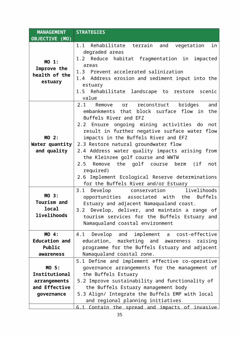
5. KEY MANAGEMENT OBJECTIVES
The following key Management Objectives for the Buffels estuary were agreed in the course of stakeholder meetings in 2016.
Table 5.1. Management Objectives agreed by stakeholders for the Buffels Estuary, and Strategies to achieve these Objectives.
MANAGEMENT OBJECTIVE (MO)
STRATEGIES
MO 1: Improve the health of
the estuary
1.1 Rehabilitate terrain and vegetation in degraded areas1.2 Reduce habitat fragmentation in impacted areas1.3 Prevent accelerated salinization1.4 Address erosion and sediment input into the estuary1.5 Rehabilitate landscape to restore scenic value
MO 2: Water quantity and
quality
2.1 Remove or reconstruct bridges and embankments that block surface flow in the Buffels River and EFZ
2.2 Ensure ongoing mining activities do not result in further negative surface water flow impacts in the Buffels River and EFZ
2.3 Restore natural groundwater flow 2.4 Address water quality impacts arising from the Kleinzee golf course and
WWTW 2.5 Remove the golf course berm (if not required)2.6 Implement Ecological Reserve determinations for the Buffels River and/or
Estuary
MO 3:Tourism and local
livelihoods
3.1 Develop conservation livelihoods opportunities associated with the Buffels Estuary and adjacent Namaqualand coast.
3.2 Develop, deliver, and maintain a range of tourism services for the Buffels Estuary and Namaqualand coastal environment
MO 4: Education and Public
awareness
4.1 Develop and implement a cost-effective education, marketing and awareness raising programme for the Buffels Estuary and adjacent Namaqualand coastal zone.
MO 5: Institutional
arrangements and Effective governance
5.1 Define and implement effective co-operative governance arrangements for the management of the Buffels Estuary
5.2 Improve sustainability and functionality of the Buffels Estuary management body
5.3 Align/ Integrate the Buffels EMP with local and regional planning initiatives
MO 6: Conservation of
biodiversity
6.1 Contain the spread and impacts of invasive alien vegetation 6.2 Update/collect key baseline information to guide management of biodiversity 6.3 Control mining activities in the immediate vicinity of the estuary and river6.4 Regulate further development of the golf course
20

Management actions are defined and prioritized for the five-year time horizon of this Strategic Plan. Each management action has been prioritised as follows:
Category Priorities
HIGH Critical to the effective management of the estuary. Funding and resources should be secured to implement these actions.
MEDIUM Important to the effective management of the estuary, but its implementation may be delayed because of limited funds or resources.
LOWConstitutes good management practice, but not necessarily critical or important to estuary management effectiveness. Implementation may be dependent on availability of external funding or support.
Management Objective 1: Improve the Health of the EstuaryThe health of the Buffels Estuary would be considerably improved by removing or rehabilitating those elements that currently negatively impact on the river and estuary. The vegetation in many places to the north of the estuary has been damaged by mining and mining related activities (Figure 2). Roads and tracks leading into both the EFZ and the river above the EFZ have also fragmented the habitat and damaged the vegetation in places (Figures 2 and 3). There are vehicle tracks along the river bed in the EFZ, and the river bed upstream of the EFZ is clearly also often used by vehicles (Figure 3). An old slimes dam upstream of the EFZ and to the north-west of the estuary probably also leaches salt into the riverbed and this will eventually wash down into the estuary itself (Figure 3). Areas that have been impacted in the vicinity of the EFZ are indicated in Figure 2. There are many places both in the EFZ and along the river above the EFZ where erosion occurs and sediment is washed into the river bed during episodic rainfall events (Figure 2). This process has resulted in sparser vegetation on the edges of the eroded areas. There is discarded mining equipment in both the EFZ and the river upstream of the EFZ.
Table 5.2. Key to numbered areas in Figure 2 below.
No. Details
1 Old haul roads that crossed the beach
2 Open water
3 Fan shaped floodplain across the beach
4 A. cyclops alien vegetation
5 Mining areas
6 Golf course
7 Collapsed road crossing in river channel
8 Road crossing river channel
9 Haul road and erosion into river channel. Vehicle tracks in the river channel
21
10 Main road bridge linking Kleinzee and mine
11 Kleinzee
12 Atlantic Ocean
13 Rehabilitated mining areas
22

Figure 2. Areas requiring management activity to improve the health of the Buffels Estuary. See Table 2 above for key to numbered areas. Damaged vegetation and fragmented habitat should be rehabilitated and the slimes dam upriver and to the northwest of the Estuarine Functional Zone should be removed to prevent further anthropogenic salinization of the estuary (leaching indicated by blue arrows- see Figure 3). Erosion areas should be re-habilitated (White arrows). Tracks in the river bed and along the banks upstream of the EFZ should be closed and rehabilitated.
23

Figure 3. Slimes dam upstream of Buffels Estuary EFZ that leaches salts into the river bed. EFZ is outlined in blue.
24

Management actions and targetsTable 5.3.MO 1: Improve the health of the Buffels Estuary (WRC = West Coast Resources, ETT = Estuary Task Team, NDM = Namakwa District Municipality, NKLM + Nama Khoi Local Municipality)
Budget
Strategy 1.1: Rehabilitate the terrain and vegetation in degraded areas.
Management action Priority Management targets Key performance indicators
Responsibility Time frame
R300 000
1 2 3 4 5(i) Map the extent of degraded vegetation in the Buffels EFZ and to the north of the EFZ.
Degraded areas rehabilitated with appropriate vegetation type to meet EMP specifications
Detailed map of areas with degraded vegetation
Extent, by area, of rehabilitated area meeting EMP specifications and persisting for 12 months
Reduction in total mapped degraded areas
ETT – LeadWCR, De Beers (de Beers until rehabilitation commitments end)
(ii) Rehabilitate mapped areas of degraded vegetation within the EFZ to meet the rehabilitated landscape specifications of the DMR mining permit EMP. If financially possible rehabilitate degraded area to the north of the estuary.(iii) On an annual basis update the maps of the extent of degraded areas in the Buffels EFZ.
Strategy 1.2: Reduce habitat fragmentation in impacted areas.
Management action Priority Management targets Key performance indicators
Responsibility Time frame1 2 3 4 5
(i) In conjunction with WCR, De Beers, Golf course management and the Kleinzee business community, map and demarcate roads and tracks within the EFZ that are necessary for current and future mining, golfing and A. cyclops cutting activities.
Reduction in fragmented habitat in and around the Buffels EFZ.
Map of necessary roads / tracks and clear signage demarcating necessary roads
Unused roads/tracks rehabilitated to EMP specifications and persisting for 12 months
ETT – LeadWCR, De Beers (de Beers until rehabilitation commitments end) (ii) Close and rehabilitate unnecessary roads and tracks that
contribute to fragmentation. Rehabilitate to meet the rehabilitated landscape specifications of the DMR mining permit EMP.
25

Signage and closure barriers at entrance to roads/tracks not required. No use of these roads.
R2 million
(iii) Ensure mining, golf and A. cyclops cutting field staff understand the necessity to only use demarcated roads – conduct local environmental education programme
Records of regular field staff education programme
ETT - LeadWCR, Golf course management
Strategy 1.3: Prevent accelerated salinization
Management action Priority Management targets Key performance indicators
Responsibility Time frame
R1 million
1 2 3 4 5(i) Close and rehabilitate the old slimes dam to the north-west of the EFZ (Figure 3). Rehabilitate the affected area between the Buffels River and the slimes dam. Rehabilitation to meet the rehabilitated landscape specifications of the DMR mining permit EMP.
Reduced anthropogenic salinization of estuary
Slimes dam rehabilitated to EMP specifications and persisting for 12 months
ETT - LeadWCR, De Beers (de Beers until rehabilitation commitments end)
(ii) Ensure future mining activities by WCR choose sites for slimes dams that will not impact on the EFZ and the Buffels River.
No slimes dams close to EFZ and Buffels River
ETT – LeadWCR
Strategy 1.4: Address erosion and sediment input into the estuary
(i) See Strategies 1.1 and 1.2. In addition, in conjunction with WCR engineers and Namakwa DM develop a comprehensive plan to rehabilitate the roads and tracks to the north, and north-west of the EFZ and along the southern bank of the Buffels River to at least the old Springbok road bridge to the north of Kleinzee.
Reduce sedimentation of the Buffels River and EFZ
Rehabilitation plan completed
ETT - LeadWCR, NDM, NKLM, De Beers (de Beers until rehabilitation commitments end)
R2 million(ii) Implement the rehabilitation plan to meet specifications of the of
the DMR mining permit EMP. Monitor success of rehabilitation.Eroded, damaged area rehabilitated to EMP specifications and persisting for 12 months
ETT - LeadWCR, De Beers De Beers (de Beers until rehabilitation commitments end)
Strategy 1.5: Rehabilitate landscape to restore scenic value
(i) Collect and remove old mining machinery, pipes and other equipment throughout the EFZ and in the river bed above the road bridge (#10 in Figure 2).
Improve safety and aesthetic appeal of the estuarine area
No old mining equipment in EFZ
ETT - LeadWCR, De Beers (de Beers until rehabilitation commitments end)
R100 000
26

Key Result Area 2: Water Quality and Quantity One of the key factors impacting on the health of the Buffels Estuary is the change in freshwater flow into the system that are the result of decades of poor environmental management. Although rainfall is historically low in Namaqualand, the river and estuarine ecology is adapted to sporadic freshwater input and occasional flash floods that flush systems, re-establish channels, clear floodplain vegetation, redistribute sediments and wash out accumulated nutrients and chemicals. The Buffels River is currently blocked or partially blocked by road bearing embankments in several places to the extent that these embankments do not allow any meaningful passage of water flowing down the river. The Situation Assessment describes the embankments in detail and they are indicated in Figure 4. The upstream end of the Buffels EFZ is marked by a road bridge that connects the diamond mining concession areas with the town of Kleinzee (Figure 4 #10) The road bed is constructed over an embankment that has been developed in the river channel. The road crossing makes allowance for downstream freshwater flow by way of two 2.5 x 2.5 m box culverts built alongside four high but very narrow culverts. All downstream surface freshwater movement must be by way of these culverts. The river channel is about 100 m wide at this point, but 80 m of the width is filled with impermeable road embankment and only 20 m of the width will allow the passage of water through the culverts. Under any flood conditions the narrow culverts will very rapidly become blocked, reducing flow to about a 5 m width of the river channel. Downstream of the bridge a concrete apron extends for 10 m to prevent undercutting of the bridge structure and the seaward end of this apron has become undercut effectively preventing any upstream movement in medium to low flow conditions.About 500 m below the road bridge the river channel of the EFZ is crossed by a second road that is built on an embankment that makes no allowance for river flow (Figure 4 #8). A further 70 m further downstream another unsurfaced road enters the river bed (Figure 4 #7) and the channel is again blocked by a collapsed embankment. What appear to be the original pipe culverts have been moved around by previous flood waters and lie haphazardly in the river bed (see Situation Assessment).
Table 5.4 Details of the road infrastructure that obstructs water flow into the Buffels EFZ. Obstructions are labelled 1, 7, 8 and 10, and their locations relative to the Buffels Estuary are shown in Error: Referencesource not found.
Obstruction Description GPS co-ordinate
1Old haul road and/or natural sand berm separating open water pools at the mouth 29° 40.465’S, 17° 3.164’E
7 Collapsed road crossing in river channel 29° 40.314’S, 17° 3.705’E
8 Road crossing river channel 29° 40.302’S, 17° 3.755’E
10 Currently used road connecting mining concession area with Kleinzee town 29° 40.306’S, 17° 4.057’E
The road crossings at points #7 and #8 in Figure 4 are no longer used and have fallen into disrepair. The embankments on which roads were constructed should be removed entirely, and the rubble and pipes lying in the river bed should be removed to landfill so that normal water flow is re-established. The river bed, the road surfaces approaching and exiting the river bed and banks of the river should be rehabilitated and re-vegetated so that erosion is prevented.A berm is located at the lower (seaward) end of the Buffels Estuary and appears to be the remains of an old haul road (Figure 4 #1). The berm divides the open water habitat of the Buffels Estuary and
27

should be removed in its entirety to unify the open water bodies. Historical imagery (Google Earth 2004, 2006 and 2012) shows that the two water bodies are often linked. When a pollution event caused a fish kill in the estuary a few years ago, fish deaths were limited by artificially breaching the berm to allow fish to access the seaward pool. However, the barrier was naturally restored shortly afterwards, perhaps because only a narrow channel was dredged through the berm. The water quality in the seaward pool is not as good as in the upper pool and the water appears stagnant and filamentous algae are present in large quantities in the former. Ecologically the estuary would benefit from having a larger continuous open water area and the berm and its associated fill should be removed entirely. The Kleinzee aquifer is a large sand filled aquifer of up to 12 m in depth in the lower section of the Buffels river. Approximately 5 km upstream of the Buffels Estuary mouth a subsurface membrane has been installed across the Kleinzee aquifer. The membrane extends almost from the surface of the river bed downwards to the bedrock. Although the membrane can be overtopped under conditions of high water flow, the purpose of the membrane is to prevent downstream flow of water from the aquifer in order to store water for distribution to Kleinzee and for the use of the mine. An alternative water supply to Kleinzee has been developed but water is still abstracted from the coastal aquifer to supply the mining operations adjacent to the town. The membrane has had a very significant impact on the vegetation of the river bed. Upstream of the membrane there is dense growth of J. kraussii while downstream there is practically no vegetation at all (Figure 5). In addition, the reduction of groundwater flow into the estuary must impact on estuarine function. Because surface fresh water flow into the estuary is minimal, the supply of groundwater to the system is particularly important. At a minimum a groundwater reserve determination should be undertaken to assess the estuary requirements. Ideally the membrane should be removed altogether and normal groundwater flow restored. The golf course and gardens of Kleinzee are watered with treated effluent from the WWTW. There appear to have been untreated effluent spills into the Buffels Estuary in the past. Nutrient rich water almost certainly filters into the surface and groundwater of the estuary from golf course watering. The very vigorous growth of P. australis around the edges of the open water in the estuary is probably a result of this nutrient input. The effluent released from the WWTW should conform strictly to DWS Water Quality Guidelines for the Marine Environment for physical/chemical variables, inorganic nutrients and toxic substances. Irrigation of the golf course effluent should comply with the requirements of the WWTW General Authorisation for irrigation with waste water. Regular effluent quality monitoring should be instituted at the WWTW. The Ecological Reserve for both the Buffels Estuary and the Buffels River have apparently been determined and should be implemented once DWS has approved the reports.
28
Figure 4. Places where roads or tracks cross the Buffels Estuarine Functional Zone. Crossings occur at points 1, 7, 8 and 10 (See Table 5.2) GPS coordinates are provided in Table 5.4.
29

30

Figure 5. Location of the underground membrane blocking the Kleinzee aquifer which has had a very significant impact on the vegetation downstream of the membrane. Upstream of the membrane the river bed is densely vegetated with J. kraussii while downstream there is almost no vegetation (Image: Google Earth Nov. 2016).
31

Management actions and targetsTable 5.5.MO 2: Water quality and quantity (WRC = West Coast Resources, NKLM = Nama Khoi Local Municipality, ETT = Estuary Task Team, SANRAL = South African National Roads Agency Ltd, NDM = Namakwa District Municipality, PCC = Provincial Coastal Committee)
Budget
Strategy 2.1: Remove or reconstruct bridges and embankments that block surface water flow in the Buffels River and EFZ. Management action Priority Management targets Key performance
indicatorsResponsibility Time frame
Rehab. R1 million Culverts R4 m
illion
1 2 3 4 5 (i) Remove all material deposited in river bed and flood plain at #1, #7 and #8 (Figure. 4). Remove spoil and old mining waste to landfill. Remove tracks/roads and rehabilitate roadway and river banks to eliminate erosion. Rehabilitation to meet the rehabilitated landscape specifications of the DMR mining permit EMP.
Surface fresh water flow pathways restored
Maintenance of or improvement in Present Ecological Status (PES) of estuary.
No blockages to flow of surface water throughout the length of the Buffels River within 15 km of the coast.
ETT - LeadWRC, De Beers (de Beers until rehabilitation commitments end)
(ii) Upgrade culverts of the mining concession - Kleinzee road crossing (Figure 4 #10) to allow passage of fresh water across the entire river bed.
ETT - Lead NDM, NKLM, SANRAL
(iii) Stabilise and vegetate all river banks disturbed by rehabilitation and bridge/crossing reconstruction. Rehabilitation to meet the rehabilitated landscape specifications of the DMR mining permit EMP.
No erosion at bridge/river crossings
ETT - Lead WCR, De Beers (de Beers until rehabilitation commitments end)
Strategy 2.2: Ensure ongoing mining activities do not result in further negative surface water flow impacts in the Buffels River and EFZManagement action Priority Management targets Key performance
indicatorsResponsibility Time frame
NA
1 2 3 4 5(i) With WCR, DENC, DWS and DMR formalise and implement processes for construction of any new river bed crossings including EIA, EMPr and required WUL/GA .
Maintenance of or improvement in Present Ecological Status (PES) of estuary.
Road bridge/crossing plan developed and formalised.
Compliance with NWA regulations.
ETT - Lead WCR, DWS, DENC
(ii) Enforce existing legislation in the catchment in terms of the National Water Act with respect to Water use and Licensing; Stream flow reductions; General authorisations, Catchment management and Prevention of pollution.
ETT - Lead DENC, DWS, DMR
Strategy 2.3: Restore natural groundwater flow.
Management action Priority Management targets Key performance Responsibility Time frame
32

indicatorsR400 000
2 3 4 5(i) Determine whether membrane is now necessary for Kleinzee and mining water supply
Maintenance of or improvement in Present Ecological Status (PES) of estuary.
Membrane removed. ETT – LeadWCR, DWS
(ii) Contract geo-hydrologist/engineer to determine requirements for membrane removal.(iii) Remove membrane and rehabilitate excavation.
Strategy 2.4: Evaluate and address water quality impacts arising from the Kleinzee golf course and WWTW.
Management action Priority Management targets Key performance indicators
Responsibility Time frame
R20 000
1 2 3 4 5(i) Assess functionality of Kleinzee WWTW. Address any problem issues
Maintenance of or improvement in Present Ecological Status (PES) of estuary.
All effluent meets DWS minimum standardsFormal programme for controlled regulated watering of golf course that meets minimum golf course requirements
ETT - LeadNDM, NKLM, Golf course management
(ii) Source, install and maintain effluent quality monitoring equipment(iii) Ensure compliance with WWTW General Authorisation for irrigation with waste water. (iv) Determine minimum watering requirements for golf course(v) Institute programme for controlled watering of golf course with effluent compliant with DWS standards
Strategy 2.5: Remove the golf course berm (if not required)
Management action Priority Management targets Key performance indicators
Responsibility Time frame
R400 000
1 2 3 4 5(i) Discuss the effectiveness and need for the golf course berm with golf course management, Kleinzee tourism interests, expert hydrologist, estuarine ecologist.
Maintenance of or improvement in Present Ecological Status (PES) of estuary.
Golf course berm removed
ETT - Lead NDM, NKLM, Golf course management(ii) Remove berm and rehabilitate the berm area if consensus is that
the berm is superfluous to golf course management requirements.
Strategy 2.6: Implement Ecological Reserve Determinations for Buffels River and/or Estuary
Management action Priority Management targets Key performance indicators
Responsibility Time frame
NA
1 2 3 4 5(i) Obtain the Ecological Reserve report(s) for the Buffels Estuary and/or River when report(s) have been completed by DWS (June)
Ecological Reserve implemented
Ecological Reserve implemented
ETT - Lead DWS, PCC
(ii)Implement Ecological Reserve(s)
33
Management Objective 3: Tourism and Local Livelihoods There is currently very little in the way of tourism and recreation infrastructure in or near the Buffels EFZ. However, the town and its surroundings have considerable tourism potential. There are good quality roads linking Kleinzee with Springbok, Port Nolloth and Koingnaas so the tourism potential of the town is good. The Atlantic Ocean and adjacent shoreline provides a wild and relatively pristine attraction even though the coast immediately inland of the shore itself has been heavily transformed. There is good angling in the sea and a very large seal colony immediately to the north of the town. There are several historic shipwrecks in the general area and a shipwreck tour has been developed around them. The terrestrial environment is unique in terms of being one of two arid region biodiversity hotspots in the world. Kleinzee itself is situated within the area that provides the spectacular spring flower displays of Namaqualand. The Namaqualand spring flowers draw tourists from all over the world. In Kleinzee itself there is good (if slightly run down) infrastructure left over from the mining days and an abundance of rental accommodation is available. The estuary itself provides a place of peace and quiet and the town, seashore, coast and estuary provide excellent bird watching opportunities. A bird hide has been built at the mouth of the estuary and the golf course provides visitors and local townspeople with a recreational outlet. There used to be a multitude of sporting facilities in the town of Kleinzee but they have all fallen into disrepair with the post-mining exit of much of the town’s population.
Historically De Beers Diamond Mining Company owned the town of Kleinzee and the town was classified as mining infrastructure. De Beers have closed mining operations in the Kleinzee area and are in the process of selling the assets represented by Kleinzee. Negotiations are under way to get the Nama Khoi LM to take over the management of the town itself. However, at present the town of Kleinzee is not formally incorporated into the Nama Khoi LM. Thus no by-laws can currently be promulgated for the town and this creates problems with regard to controlling visitor activities in the coastal environment. It will be necessary for the Nama Khoi LM to formally recognize the town as part of the LM governance mandate before this situation can be rectified.
34
Management actions and targetsTable 5.6.
MO 3: Tourism and Local Livelihoods. (WRC = West Coast Resources, ETT = Estuary Task Team, NDM = Namakwa District Municipality, PCC = Provincial Coastal Committee, NKLM = Nama Khoi Local Municipality).
Budget
Strategy 3.1: Develop conservation livelihoods opportunities associated with the Buffels Estuary and adjacent Namaqualand coast.
Management action Priority Management targets Key performance indicators
Responsibility Time frame
NA
1 2 3 4 5(i) Explore and where possible support the participation of local community members in conservation related job opportunities (Poverty Alleviation, EPWP, WfW, DEA/DAFF monitoring programmes) related to the Buffels Estuary and coastal environment.
Reduction in local unemployment
Improved levels of employment in Kleinzee community
ETT - LeadNDM, NKLM, WCR
Strategy 3.2: Develop, deliver, and maintain a range of tourism and recreational services to the Buffels Estuary and Namaqualand coastal environment.
Management action Priority Management targets Key performance indicators
Responsibility1 2 3 4 5
(i) Support business opportunities for local Kleinzee residents to participate in the provision and management of tourist and recreational products in and around Kleinzee (coastal hiking tours, shoreline information, sea, estuarine, terrestrial informative tours, birdwatching, fishing, wrecks, sea food collection, aquaculture tours). Promote sales of De Beers assets of potential value as tourism features.
Effectively managed and regularly maintained tourism and recreational services.
Improved levels of employment in Kleinzee communityIncreased public coastal access
Effectively managed and regularly maintained tourism and recreational services
ETT - Lead PCC, NDM, NKLM
(ii) Design, publish and distribute estuary, coastal and bird watching specific brochures and pamphlets for visitors and local users.
Information brochures available to visitors
(iii) Pursue improved public coastal access in terms of ICM Act. Increased public coastal access
(iii) Explore and pursue requirements necessary for incorporation of Kleinzee into Nama Khoi LM. Develop relevant municipal by-laws that
Kleinzee included as part of Nama Khoi LM. By-
35

control visitor activities in the coastal environment laws promulgated Brochures & Signage R30
(iv) Upgrade and maintain bird hide and maintain register of users. Records of numbers of users of the bird hide
(v) Develop and install effective and informative signage Signage erected(vi). Demarcate public access and sensitive areas and mark areas with suitable signage
Public access and sensitive areas marked
(vii) Rehabilitate mined landscape to meet specifications of the of the DMR mining permit EMP in order to restore scenic value
Scenic value of the landscape is restored
WCR – LeadETT
(viii)Ensure safety of the public. Erect warning signs explaining the danger of episodic flood events and other coastal hazards. Erect warning signs for any remaining mining hazards (until rehabilitation has been completed).
Warning signs have been erected
36
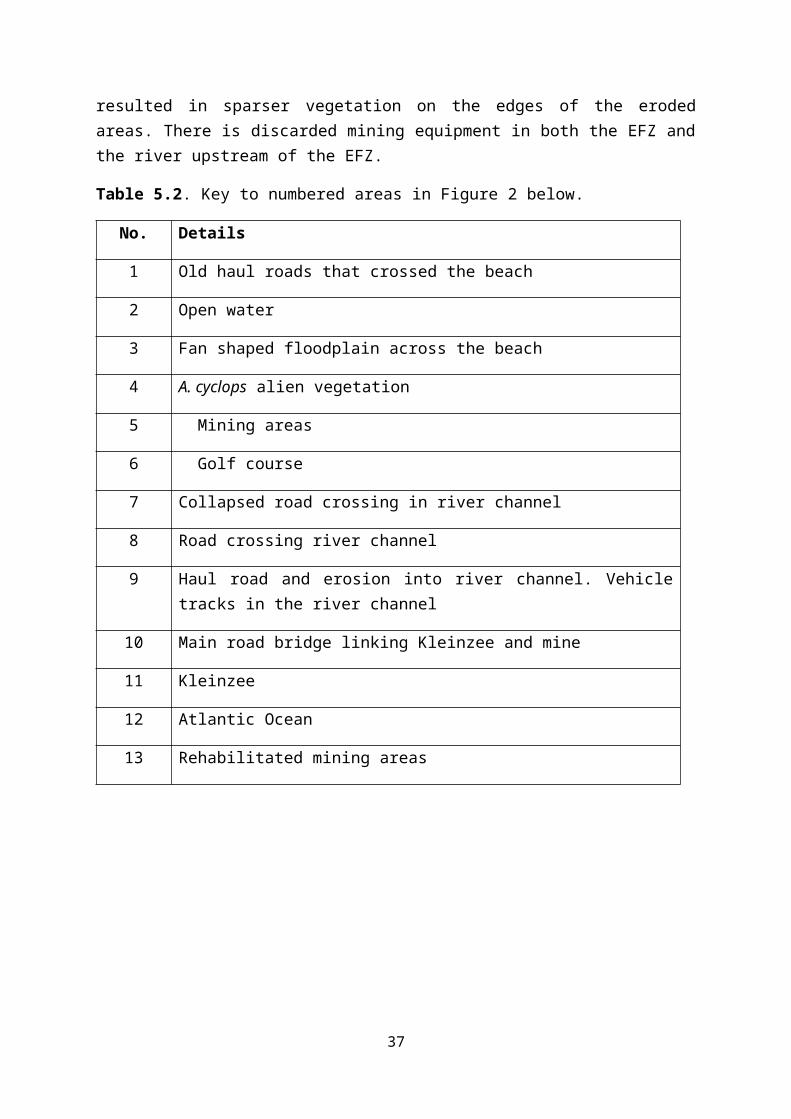
Key Result Area 4: Education and Public awareness Effective management of the Buffels Estuary will be dependent on stakeholder buy-in, which will in turn depend on an improved awareness and appreciation of the ecological importance and functioning of the estuary and of the management requirements to improve and maintain such functionality. The current state of the estuary is indicative of a complete lack of understanding of, and care for, estuarine function, probably coupled with a lack of incentive to direct resources to environmental management. Improved awareness of the environment, awareness of the importance of estuaries in general, and awareness of the unique features of the Buffels Estuary, should be used to help to instil an understanding into the general public, and particularly those involved in making mining decisions, about the needs of the environment. Education and greater ecological awareness will improve WCR staff’s and visitors’ appreciation of the management regulations and thus hopefully facilitate management.
Provision of interpretive and educational material can greatly enhance this learning experience as it draws attention to key aspects of the environment that are special or unique to the area, and can be used to highlight the impact of human activities on the environment. Furthermore, the better people understand the issues surrounding the rehabilitation of an ecosystem, the more they are likely to respect management requirements and regulations. The various agencies responsible for the management of the Buffels Estuary will need to provide state of the art service in this field.
37
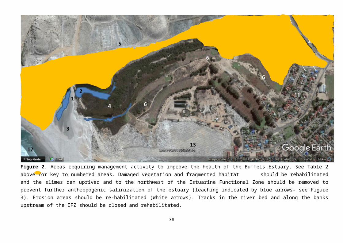
Management actions and targetsTable 5.7.
MO 4: Education and Public awareness. (NKLM = Nama Khoi Local Municipality, ETT = Estuary Task Team, PCC = Provincial Coastal Committee, NDM = Namakwa District Municipality).
Budget
Strategy 4.1: Develop and implement a cost-effective education, marketing and awareness-raising programme for the Buffels Estuary and adjacent Namakwa coastal zone.Management action Priority Management targets Key performance
indicators Responsibility Time frame Pam
phlets R10 000 Signage+ Maintenance R20 000
1 2 3 4 5(i) Source and commission educational and informative material, posters, pamphlets, and relevant literature that will be housed and displayed in appropriate localities in Kleinzee and will enhance visitor experience
Improved awareness of estuarine value and function
Improved visitor experience
Posters, pamphlets, literature developed and distributed/displayed
NKLM/NDM LeadETT
(ii) Standardise, source, install and maintain directional and informational signage in the Kleinzee coastal area and en route to the estuary and in the Molyneux Nature Reserve that will enhance visitor experience
Installed and maintained directional and informational signage in coastal area and around estuary
NKLM/NDM – Lead ETT
(iii) Devise and implement school education programme/field visits using local people. Encourage field excursions to the coast and estuary by local schools, community groups, and other stakeholder groupings.
No. of educational school visits and school field visits
ETT – LeadNKLM, NDM, PCC
(iv) Promote nature based tourism – see MO 3 Tourism and Local livelihoods
ETT - Lead NKLM, NDM
38

Management Objective 5: Institutional arrangements and Effective governance Owing to their position on the boundary between freshwater, terrestrial and marine environments, management of estuaries requires cooperation from a large number of separate national, provincial and local government agencies, each acting under a different legislative mandate. As a minimum the following national government agencies are implicated in management of the Buffels Estuary: Department of Environmental Affairs (DEA), Department of Mineral Resources, (DMR), Department of Water and Sanitation (DWS), Department of Public Works (DPW). Provincial and local government agencies implicated in management of the estuary include the Department of Environment and Nature Conservation (DENC), Namaqua District Municipality (NDM), and the Nama Khoi Local Municipality (NKLM). Because of the large number of agencies there is a strong requirement for the formation of clearly defined institutional arrangements and the facilitation of improved and ongoing coordination between the responsible institutions as well as other stakeholders. This coordination must address both management implementation and forward planning. A key long term issue is the need to integrate the Buffels EMP into other spatial planning initiatives of the Nama Khoi LM and the Kleinzee town. The Buffels EMP reflects many of the issues and management objectives of the Northern Cape Province Coastal Management Plan (NCPCMP) and should be integrated into this plan at the next NCPCMP update.
Recognising that the difficulties of ensuring a sufficiently high level of integration and cooperation amongst all of the different agencies involved in the management of the Buffels Estuary are likely to extend beyond the mandate and capacity of a single lead management agency, an Estuaries Task Team (ETT) constituted as a sub-committee of the PCC will oversee the implementation of the EMP. The ETT will ensure representation of all the principal national, provincial, and local government agencies as well as representatives of key stakeholder groups where these are appropriate in relation to particular management objectives, and the implementation of particular management actions required to achieve those objectives. It is important that the Kleinzee community has a means to provide input into the functioning of the ETT, particularly as the viability of the town is no longer dependent on mining. The purpose of the ETT will be to provide a platform through which stakeholders with responsibility for various aspects of the implementation of the EMP can exchange information and ideas, and reach agreement on the appropriate action for the effective management of the estuary. It is essential that the various agencies work co-operatively to ensure the vision and defined management objectives are realised. Individual agencies may also have to make provision for the funding required to fulfil their estuary management obligations in the medium and long-term and the option of applying for IDP funding once the EMP is incorporated into the IDP should be explored.
An ETT has already been constituted under the Northern Cape PCC established under Section 39 of the Integrated Coastal Management Act, 2008 (ICM Act). The ETT is recognised as a formal structure and has a formal Terms of Reference (TOR) which defines its status, aims and objectives, its composition, and its authority to liaise with key sector categories when necessary. The ETT should also make a commitment to transparency, and clearly define the process to be followed when decisions must be made.
Initially the management of the Buffels Estuary is going to be problematic because WCR have relatively recently taken over the mining leases from De Beers but De Beers is still involved in rehabilitation activities in the area. In addition, some current and future mining activities in the vicinity of the Buffels Estuary may not be beneficial to the estuary and it is critical that structures are in place to discuss these, and as far as possible arrive at mutually agreeable arrangements.
39

Management actions and targets Table 5.8.
MO 5: Institutional arrangements and Effective governance. (WCR = West Coast Resources, NKLM = Nama Khoi Local Municipality, ETT = Estuary Task Team, DENC = Department of Environment and Nature Conservation, PCC = Provincial Coastal Committee, DEA = Department of Environmental Affairs, DAFF = Department of Agriculture, Forestry and Fisheries, DMR = Department of Mineral Resources).
Budget
Strategy 5.1: Define and implement effective co-operative governance arrangements for management of the Buffels Estuary. Management action Priority Management targets Key performance
indicatorsResponsibility Time frame
Comm
unication R10 000
1 2 3 4 5(i) Expand the mandate of the ETT to include the implementation of the Buffels EMP. Use the aligned management objectives of the NCPCMP to help drive implementation of EMP.
Estuary managed by a fully functional ETT constituted and operating under PCC and in accordance with agreed formal TOR
Formal TOR for ETT ETT - Lead PCC
(ii) Ensure mechanisms are in place for cooperative management activities with representative members of stakeholders and government agencies. Ensure local the community is adequately represented.
ETT – Lead PCC
(iii) ETT to obtain agreement and formal commitment from participating agencies in respect of their roles and responsibilities in relation to the ETT and the management of the estuary (see TOR for PCC in NCPCMP).
Records of meetings with stakeholders including one-on-one meetings.
ETT - Lead
(iv) Elect a chair and secretary and conduct regular ETT meetings. Records of meetings, decisions and outcomes
ETT - Lead(v) Develop and maintain an effective communication mechanism for ongoing communication with stakeholders and taking into account that there are Kleinzee community members who did not engage in the EMP public participation process.
ETT - Lead
(vi). Maintain a stakeholder database. Up to date stakeholder database
ETT – Lead
40
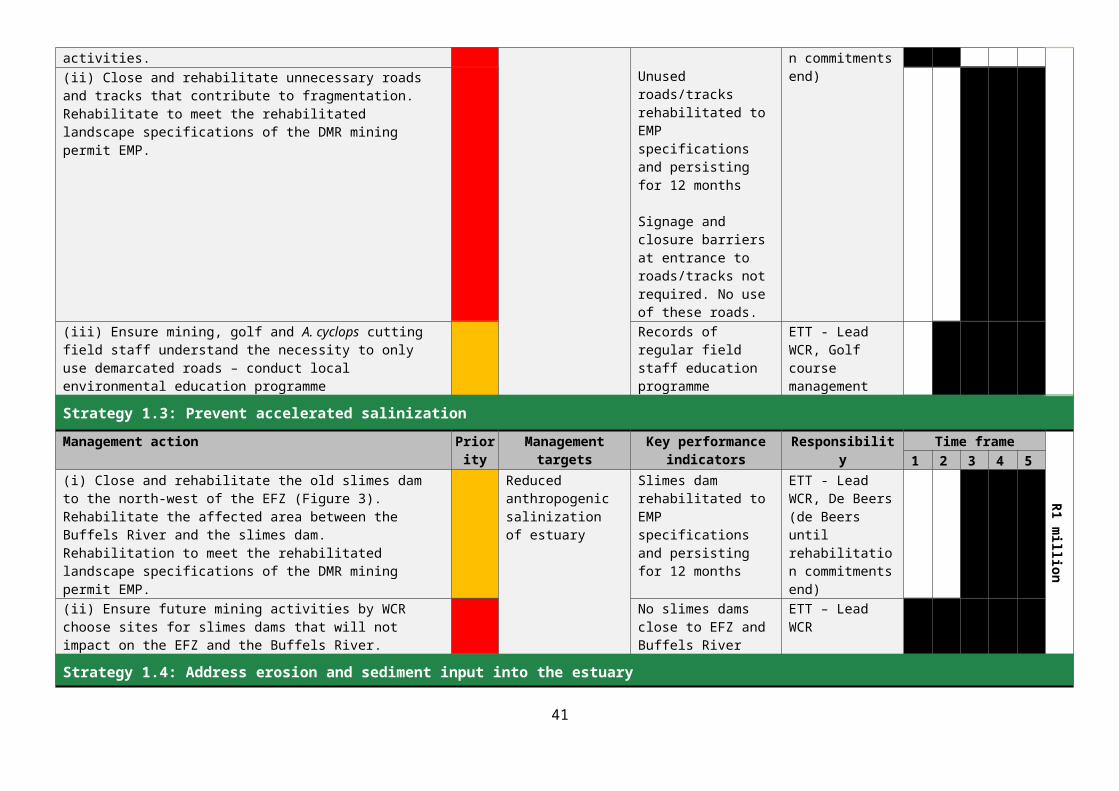
Strategy 5.2: Improve sustainability and functionality of the Buffels Estuary management body.
Management action Priority Management targets Key performance indicators
Responsibility Time frame
Meeting R20 000 Travel R20 000
1 2 3 4 5(i) Ensure that all government departments fulfil their obligations in terms of the TOR of the ETT and the relevant legislation pertaining to public participation, when any management interventions within the management area are being considered.
Estuary managed by a fully functional ETT constituted and operating under PCC and in accordance with agreed TOR.
Signed formal letters of mandate from various ETT sectors indicating responsible representative
ETT, DEA, DAFF, DMR, NKLM, NDM, PCC, DENC, WCR
(ii) Review (every two years) the ETT usefulness, structure, representation, TOR and on-going relevance. Amend or revise as required.
Functional ETT ETT, PCC
(iii) Individual government agencies to make provision for the necessary resources in their short, medium and long-term expenditure frameworks to create and fill posts, and acquire necessary infrastructure and resources to participate effectively in the management of the estuary (e.g. staff, office equipment, water quality meter, vehicle).
Sufficient ring-fenced agency budgets to conduct Buffels Estuary management activities
ETT – LeadNKLM, NDM, DENC, DAFF, DEA, DMR
(iv) Develop a long-term financing plan for the management of the estuary. Explore availability of funding from IDP for implementation of EMP (see 5.3 (i)).
Long term finance plan ETT - Lead PCC
(v) Build capacity by improving awareness and insight into legal context and obligations of all levels of government involved in the management of the coast and estuary.
Records of training initiatives
ETT – LeadPCC
(vi) Establish and maintain a law enforcement and compliance capacity that is effective in the oversight of both mining and non-mining activities.
No infringements of mining EMPr, estuary EMP, MLRA, NEMA and all its sub-Acts
Decrease in number of illegal activities occurring on Namakwa coastline
DENC – LeadETT, NKLM, NDM
41

Strategy 5.3: Align/Integrate Buffels Estuary management planning with local and regional planning initiatives.
Management action Priority Management targets Key performance indicators
Responsibility Time frame
Travel R15 000
1 2 3 4 5(i) Attend local municipal IDP meetings, with a specific focus on the provision of municipal infrastructure and services to assist in managing the estuary and support local economic development initiatives in the Kleinzee community.
Buffels Estuary and Kleinzee coastal environment specifically included in next update of NKLM IDP
Minutes and attendance registers of meetings2018 NKLM IDP includes estuary and coast as part of Sector Planning
ETT – LeadPCC, NKLM NDM
(ii) Participate in local and regional conservation and socio-economic development initiatives that may affect or benefit the Buffels Estuary and the immediate Kleinzee coastal area.
NKLM/NDM LeadETT, PCC
42

Management Objective 6: Conservation of biodiversity Although the Buffels Estuary has fairly limited relevance in terms of the standard goods and services provided by estuaries in general (See Section 2.3) it is one of a unique subset of arid coast estuaries that have a different functionality to estuaries on the other coasts of South Africa. Thus from a biodiversity perspective it is important to retain the functionality of the estuary as a representative of this class. In addition, there are unknown modifications to the estuary that are likely to result from climate change and it is important to have a benchmark by which the extent of those changes can be measured. The Buffels Estuary and River system also provide connectivity between the inland and coastal systems which is important in regional conservation terms. Effective conservation protection would allow spiritual, scientific, educational, recreational and tourism opportunities of the river and estuary to be fully explored and expanded.
The EFZ is very heavily infested with dense A. cyclops growth. The alien growth greatly reduces natural habitat and biodiversity within the EFZ, alters surface water flow patterns, and abstracts groundwater that would normally go to the estuary. Uncontrolled cutting of the A. cyclops stands is undertaken and results in much vehicle traffic in the EFZ, the dumping of offcuts that block the river channel, and the spread of seeds throughout the EFZ.
Base-line bio-physical data for the Buffels estuary is very limited and there is a much better chance that further management orientated research is undertaken if the estuary is embedded in a conservation framework. Development of the Kleinzee golf course took place on the southern part of the estuary flood plain and has greatly reduced the size of the natural flood plain. The golf course constitutes an artificially controlled low biodiversity environment that has had considerable impact on the Buffels Estuary in terms of habitat and biodiversity loss, eutrophication and pollution, and alteration of surface water flow dynamics. The golf course is an important facility for the Kleinzee community and should remain but any further development of the facility should be planned with the input of ecologists and hydrologists.
43

Management actions and targetsTable 5.9.KRA 6: Conservation of biodiversity. (WRC = West Coast Resources, ETT = Estuary Task Team, PCC = Provincial Coastal Committee, DEA = Department of Environmental Affairs, DMR = Department of Mineral Resources).
Budget
Strategy 6.1: Contain the spread and impacts of invasive alien vegetation
Management action Priority Management targets Key performance indicators
Responsibility Time frame
R500 000
1 2 3 4 5(i) Design survey and map the extent of A. cyclops in the EFZ No seeding invasive
alien plants within one km of estuary.
Maps and data from vegetation survey
ETT - LeadDEA, PCC, Kleinzee Business Forum(ii) Together with DEA (WfW) develop A. cyclops control programme
(combined biological control and cutting) Formal alien vegetation control plan
(iii) Secure funding through EPWP for ongoing A. cyclops control programme
Funded alien eradication programme
(iv) Implement A. cyclops controls Reduction in area infested by A. cyclops(v) Update maps of extent of A. cyclops infestation annually
(vi) Together with Kleinzee business forum, formalise conduct of current A. cyclops cutting programme to prevent further spread. Remove offcuts from EFZ
Strategy 6.2: Update/collect key baseline information to guide management of biodiversity Management action Priority Management targets Key performance
indicatorsResponsibility Time frame
Monitor R200 000
1 2 3 4 5(i) In conjunction with SANBI and CSIR (Estuaries) develop an appropriate baseline data collection programme for the Buffels Estuary to guide management of the estuary. Maintain programme as required.
Maintenance of or improvement in PES of estuary
Estuary related database of management-oriented biodiversity information.
Data from monitoring programme
ETT - Lead PCC, DENC
(ii) Institute and maintain monitoring programme as outlined in the EMP
44

45

Strategy 6.3: Limit mining activities in the immediate vicinity of the Buffels EFZ and Buffels River.
Management action Priority Management targets Key performance indicators
Responsibility Time frame
NA
1 2 3 4 5(i) Develop regulations to protect mouth and beach area from mining activities.(ii) Obtain MEC approval for EMP
Maintenance of or improvement in PES of estuary.
Approved EMPNo mining activities within 1 km either side of the estuary mouth.
ETT - Lead PCC, WCR
Strategy 6.4: Regulate further development of golf course.Management action Priority Management targets Key performance
indicatorsResponsibility Time frame
NA
1 2 3 4 5(i) Engage with management of the golf course to develop formal process to be followed if further golf course development is planned
Maintenance of or improvement in PES of estuary
Approved golf course development and maintenance plan
ETT LeadGolf course management
46

6. ZONATION AND THE BUFFELS ESTUARY 6.1 EXISTING PLANNING AND ZONATION FRAMEWORKS
Integrated Coastal Management Act
Further zoning issues relevant to the Buffels estuary relate to the Integrated Coastal Management Act (ICM Act). Under the Integrated Coastal Management Act the coastal protection zone extends 1 km from the coastal and estuarine high tide mark for all areas outside established townships, settlements and urban areas (i.e. for almost the entire Northern Cape Coast). The ICM Act also provides for the establishment of a coastal setback line, designed to protect the coastal protection zone. No new development (construction) is permitted within a coastal setback line. If future tourism activities are planned for Buffels estuary it is recommended that a coastal setback zone surrounding the estuary be declared (e.g. 50 m or 100 m beyond the limits of the EFZ). The motivation for the declaration of such a setback line would be a function of the ETT. Several coastal-related activities for which an EIA is required have been defined in relation to a 100 m set-back line (see EIA Regulations 2014; Listing Notice 1). In addition, the coastal buffer zone defined by the ICM Act (Section 16) is 100 m for certain land-uses. A development setback zone will serve to protect the vegetation along the edges of the EFZ, will protect the ecological functioning and integrity of the estuary, limit disturbances to estuarine flora and fauna, and will assist in retaining the wilderness character of the estuary and enhance its ecotourism appeal. It is also proposed that the setback line function as a rehabilitation priority area in places where previous mining activities have resulted in damage to the vegetation and habitat fragmentation.
EIA Regulations
Any proposed development activities within 32 m of the edge of a river, water course or wetland/salt marsh is regulated by the EIA regulations (2014) of NEMA. Any such development triggers a requirement to obtain environmental authorisation by way of an environmental impact assessment and a General Authorisation or a Water Use Licence from DWS. A development setback line of 100 m for estuary as suggested above would automatically exclude all activities that occur within 32 m of the edge of the estuary.
Northern Cape Provincial Spatial Development Framework
The approval of the PSDF in terms of the Local Government Municipal Systems Act 32 of 2000 and the Northern Cape Planning and Development Act 7 of 1998 means that the PSDF has statutory status as the common spatial vision and direction around which to align the PGDS, IDPs and SDFs of municipalities. The key objectives of the PSDF as it relates to spatial planning are to integrate and standardise planning at all spheres of government in the province with specific reference to supporting the district and local municipalities in the preparation of their SDFs prepared in terms of the Northern Cape Planning and Development Act 7 of 1998, the Local Government Municipal Systems Act 32 of 2000, and the Spatial Planning and Land-use Management Bill (2011). A principle of the NCPGDP is Sustainability – the promotion of economic and social development through the sustainable management and utilization of natural resources and the maintenance of the productive value of the physical environment.
47

There is much in the NCPSDF that applies broadly to the management of the Buffels Estuary. In compliance with the Northern Cape Planning and Development Act 7 of 1998 the PSDF aims to ensure that the use and allocation of the province's resources, both renewable and non-renewable, are informed by a set of integrated and coordinated policies, objectives, implementation strategies, programmes and, where appropriate, projects aimed at (among other things):(iii) ensuring the protection and sustainable utilisation of land, water and air where these are important for the maintenance of ecologically sensitive systems or processes, areas of biological diversity, public health or public amenities.With broad reference to the Buffels Estuary, Key Sectoral strategies in the NCPSDF are:Sectoral Strategy 3: Fishing and Mariculture Sector Development Strategy of the Department of Economic Development and TourismSectoral Strategy 6: Mineral Sector Strategy of the Department of Economic Development and Tourism.Sectoral Strategy 12: Tourism Strategy of the Department of Economic Development and Tourism
Of significance in the NCPSDF is the recognition that historically, the greatest value from marine and coastal resources is generated through the mining and fishing sectors. The diamond mining sector has become the dominant activity of the coastal zone. The long-term mining concessions have an impact on the growth of alternative economic activities in the area and there has been a great decline in the fishing industry along the West coast generally. Thus it is important to consider viable alternative economic opportunities for the long term and to create alternative livelihoods for people. Unique natural assets are the renowned spring flower displays, a high diversity of succulent plant species and the aesthetic quality of the region. The area also has considerable mariculture potential.
The NCPSDF outlines various Spatial Planning Categories which include Core conservation areas, Buffer areas .and Tourism areas and provides management guidelines for the different categories. Under the NCSPF the entire coastal zone is listed as a critical biodiversity area and should be managed as such i.e. protected from change or restored to its former level of ecological functioning.
Northern Cape Coastal Management Programme
The Coastal Management Programme (CMP) for the Northern Cape was developed in accordance with the requirements of ICM Act Chapter 6 (Sections 46 and 47). The Provincial Coastal Management Programme was developed by the three coastal Municipalities (Kamiesberg, Richtersveld and Nama Khoi). Currently this is the only CMP that has been developed in the province and it is necessarily strategic. The next step will be to develop District or Local Municipal CMPs which will be much more operationally orientated and context specific.
The vision for the NCCMP is: to promote sustainable coastal development and the realisation of livelihoods that reflect the true range of ecological and socio-economic opportunities in the Namaqualand coastal zone. This will be achieved by creating co-operative governance institutions and capacity to promote integrated coastal management, and by defining goals and strategies that attract investment, both financial and social, and promote environmental conservation and sectoral growth.
Significantly the NCCMP recognises that historically land use in the Northern Cape Province coastal zone has been dominated by diamond mining, which has largely excluded the development of other economic sectors. The NCCMP concludes that “over the next 30 years, it is likely that the current
48
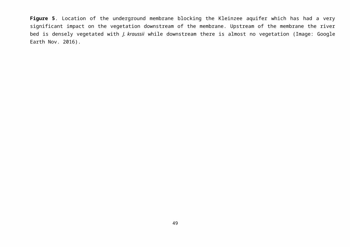
mining activities will be scaled down, and therefore, to ensure the socio-economic wellbeing of the populace, alternative economic opportunities will need to be developed”.
The Namakwa District Municipality IDP (2016 / 2017) and its reference to Spatial Development Frameworks
The IDP for the Namakwa District Municipality (NDM) is aligned with the National Development Plan, which has identified various central development challenges. Central challenges for government that are broadly relevant to the management of the Buffels Estuary are:
Ineffective economic infrastructure, poorly located, under-maintained and insufficient to support sustainable growth. Priority – Create jobs and livelihoods and expand infrastructure
Spatial Development patterns exclude the poor from benefitting from the fruits of development. Priority – Transform the NDM spatial reality
The economy needs transformation in terms of resource management and use. Priority – Transform society, fight corruption and improve accountability.
A key priority area identified in a nine point plan that is based on the national nine point coastal development plan is the need to Grow the Oceans Economy and Tourism in the NDM and specifically with reference to Small Harbour Development & Coastal and Marine Tourism and Mariculture. It should be noted that there is currently a mariculture initiative using abandoned mining dams immediately north of Kleinzee. With reference to the management of the Buffels Estuary, Strategic objectives include 1). Ensuring sustainable economic and social transformation in the District and 2). Ensuring the implementation of environmentally sustainable practices, along with an integrated approach to addressing climate change response, across all sectors.
The Nama Khoi LM IDP and its reference to Spatial Development Frameworks
There is no direct link to spatial planning frameworks in the Nama Khoi IDP. The IDP seeks to deliver outstanding service to the community and to stimulate economic development in the region with the focus on the previously disadvantaged. One of the objectives of the IDP is listed as the protection of environmental assets and natural resources. The IDP recognises that the Nama Khoi LM is a unique and diverse environment because it includes parts of both the Greater Richtersveld and Central Namaqualand Coast biodiversity priority areas within its boundaries, as well as being part of the Succulent Karoo Biome. Thus it is an important region for conservation activities. However, the natural environment is not mentioned in the description of Priorities and Key Performance Areas in the Nama Khoi IDP. Under the Operations and Programmes that fall under Environmental Health there are no specific activities relevant to the coastal zone other than ensuring a clean environment. Only the identified need for upgrading of tourism attractions has an indirect bearing on the Buffels Estuary. Needs identified by stakeholders in the IDP are more environmentally orientated and align with the Buffels EMP. They include the need to remove alien vegetation, enhance environmental management, improve institutional capacity, promote environmental awareness and prevent water pollution.
Nama Khoi Local Municipality SDF 2015 / 2016
One of the goals of the SDF is “to improve the management and conservation of the pristine natural environment for tourism, local opportunities and future generations”. The SDF notes the severe transformation of the coastal environment as a result of mining activities and recommends
49
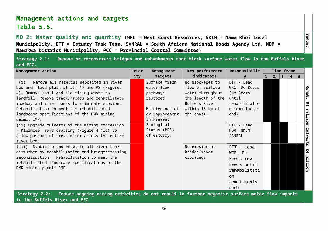
rehabilitation. The SDF notes the highly productive nature of the coastal waters and the potential for economic development. The down-scaling of mining operations has had a severe negative impact on the economy of the region and the Nama Khoi SDF recommends the expansion of the three Protected Areas in the region and the strengthening and marketing of the conservation and natural heritage resources of the area. It is not clear how the expansion of the Protected Areas relates to Kleinzee itself other than perhaps increasing the tourism potential of the area.
Kleinzee is identified as one of six “functional rural regions” in the IDP but the definition and purpose of a functional rural region relates to connectivity rather than environmental management. The spatial objectives of the SDF includes the requirement to protect the pristine and unique Nama Khoi LM natural environment with its four distinct bio-geographical regions by means of effective management and managed use. Under this objective are a number of activities that include the following:
The requirement to rehabilitate all mining areas and particularly those at Kleinzee To protect and manage the critical biodiversity areas identified in the Namakwa District
Biodiversity Sector Plan To eradicate alien vegetation along the coastal region To protect sensitive areas from development.
All of these activities are relevant to the management of the Buffels Estuary.
The broad development framework for Kleinzee itself recommends that the “small town coastal character” should be marketed and promoted as a holiday destination with coastal frontage holiday properties and investment opportunities, particularly catering for the wilderness tourism market. The management of the Buffels Estuary as a tourist attraction would fit well with this proposed plan of action.
6.2 LOCAL ZONATION
For the purposes of this EMP, the geographical boundary for the Buffels Estuary and the Estuarine Functional Zone are the same and are demarcated by the 5 m contour (5 m above mean sea level; NBA 2011; See Section 3 and Figure 1).
Zonation of an estuary is a mechanism to control natural resource use, or to separate conflicting activities within an estuary EFZ or to protect particularly sensitive areas. In the short to medium term it is unlikely that IDPs and their SDFs will be sufficiently estuary-specific to be relevant to the day-to day management of the Buffels Estuary. If the broad recommendations of the NCCMP and the Nama Khoi SDF and particularly the ICM Act guidelines are implemented there is little need for a fine scale zonation plan for the Buffels Estuary. Because of its small size and limited biodiversity there is no point in defining Sanctuary Zones or Conservation Zones. Areas of the EFZ that should be prioritized for rehabilitation related to vegetation, erosion and saline inputs have been discussed under Management Objectives 1 and 6 but these do not constitute zonation as outlined in the DEA Guidelines for the Development and Implementation of Estuarine Management Plans (2015).
7. RECOMMENDED MANAGEMENT PRIORITIES
Management priorities for the Buffels Estuary range across the six main management objectives listed in Tables 5.3 to 5.9. In some cases it is an entire management strategy with all the associated management activities that is a priority and in other cases priorities consist of one or two management
50

activities under a management strategy. The following management actions are considered priorities and are listed in order of importance.
1. Define and implement effective co-operative governance arrangements. All the management activities relating to this management strategy are key requirements for implementation of the Buffels EMP.
2. Obtain MEC approval of the Buffels EMP3. Evaluate and address estuary water quality impacts arising from the Kleinzee golf course and
WWTW – all management activities. 4. Contain the spread and impacts of alien vegetation – formalise and control the current A.
cyclops cutting programme and train harvesters to cut for effective control. 5. Explore and pursue requirements necessary for incorporation of Kleinzee into Nama Khoi LM.
Develop relevant municipal by-laws that control activities in the coastal environment.6. Restore natural groundwater flow – initiate preliminary activities necessary for the ultimate
removal of the Kleinzee aquifer membrane. 7. Reduce habitat fragmentation by closing (and rehabilitating if funding available) unnecessary
roads and tracks in the EFZ and the river bed upstream of the EFZ. 8. Align/Integrate Buffels EMP with local and regional planning initiatives.9. Develop conservation livelihoods opportunities associated with the Buffels Estuary and
adjacent Namaqualand coast – explore government funded opportunities such as EPWP, WfW, DEA/DAFF programmes.
The Strategies and Management Actions outlined in Tables 5.3 to 5.9 probably appear somewhat daunting for an implementing agency, particularly when it is apparent that for some of them considerable funding is required (e.g. rehabilitation of habitat, removal or reconstruction of bridges, removal of slimes dams). NDM officials at the stakeholder meeting to discuss the Objectives and Management Actions of the EMP indicated that costs likely to be incurred to implement the EMP in its entirety would be a major problem and would greatly slow down the process of implementation. They requested that low budget management activities that might be undertaken in the short term be identified while funding and cooperative engagement was sought for more costly activities. Careful consideration by the ETT will show that there are many management actions in Tables 5.3 – 5.9 that can be undertaken with the expenditure of some time and effort and very little money. In many cases low budget management actions are aligned with the management priorities outlined above. The undertaking of the management actions outlined below would make significant progress in the implementation of the Buffels EMP without incurring major expenses. (Note: These are not listed in order of priority)Management Objective 1: Improve the health of estuary - there are several activities that can be undertaken without major expense.
In conjunction with the relevant interest groups (WCR, De Beers, Golf course management and the Kleinzee business community), map and demarcate roads and tracks within the EFZ that are necessary for current and future mining, golfing and A. cyclops cutting activities. Close unwanted roads (barrels filled with earth or concrete are effective). Ensure mining, golf and A. cyclops cutting field staff understand the necessity to only use demarcated roads – conduct local environmental education programme for these road/track user groups.
Ensure future mining activities by WCR choose sites for slimes dams that will not impact on the EFZ and the Buffels River – participate in the EIA process for new mining developments and call for specialist assistance if necessary.
51

Collect and remove old mining machinery, pipes and other discarded equipment throughout the EFZ and in the river bed above the road bridge.
Management Objective 2: Water quality and quantity – activities that require a little time and some mobilisation of other stakeholders. Water Quality
Mobilise District Municipal Engineer to assist with assessing functionality of Kleinzee WWTW. Apply pressure to address any problem issues.
Insist on functional effluent quality monitoring equipment in the WWTW – such equipment should already be in place as part of design of WWTW but it needs to be working and records need to be kept.
Effluent released by the WWTW must comply with DWS standards. Determine minimum watering requirements for golf course. Institute programme for controlled watering of golf course with effluent compliant with DWS
standards.
The following are issues that the ETT should follow up with respect to the Kleinzee WWTW irrigation programme. Aspects of the General Authorisation are described in the following sections:SCHEDULE 2Engaging In A Controlled Activity, Identified As Such In Section 37(1): Irrigation Of Any Land With Waste Or Water Containing Waste Generated Through Any Industrial Activity Or By A Waterwork [Section 21(e)]This schedule describes the quality and management requirements when wastewater is irrigated. Points of importance include:
A person who irrigates with wastewater must submit to the Responsible authority (DWAF) a registration form or any other information requested in writing by the Responsible authority for the registration of the water use before commencement of irrigation.
As the wastewater quality requirements for irrigation are dependant on the quantity of wastewater to be irrigated, flow measurement is required.
The irrigation of wastewater may not impact on a water resource or any other person's water use, property or land and must not be detrimental to the health and safety of the public in the vicinity of the activity.
Wastewater irrigation is only permitted if the irrigation takes place above the 100 year flood line, more than 100 metres from the edge of a water resource or a borehole which is utilised for drinking water or stock watering, on land that is not, or does not, overlie a Major Aquifer.
Monitoring programmes to monitor the quantity (weekly) and quality (monthly) of the wastewater must be established.
A SANAS (South African National Accreditation System) Accredited Laboratory should preferably be used for sample analysis.
Written record of wastewater irrigation and related activities must be maintained. Precautionary practices must be followed to ensure prevention of waterlogging, pooling of
wastewater, nuisance conditions (flies or mosquitoes), contamination of stormwater/run-off, etc.
Water quantity
52

Determine whether the aquifer membrane is now necessary for Kleinzee and mining water supply.
Contract geo-hydrologist and/or engineer to determine requirements for membrane removal Start looking for funding to remove membrane if it is not required– joint venture with mining
companies who already have equipment that could undertake the removal? Obtain the Ecological Reserve report(s) for the Buffels Estuary and/or River when report(s)
have been completed by DWS (June 2017) Implement Ecological Reserve(s)
Management Objective 3: Tourism and Local livelihoods – activities that require minimal budget Explore and where possible support the participation of local community members in
conservation related job opportunities (Poverty Alleviation, EPWP, WfW, DEA/DAFF monitoring programmes) related to the Buffels Estuary and coastal environment.
Support business opportunities for local Kleinzee residents to participate in the provision and management of tourist and recreational products in and around Kleinzee (coastal hiking tours, shoreline information, sea, estuarine, terrestrial informative tours, birdwatching, fishing, wrecks, sea food collection, aquaculture tours). Promote sales of De Beers assets of potential value as tourism features.
Upgrade and maintain bird hide and maintain register of users.
Management Objective 4: Education and Public Awareness – low budget activities Standardise, source, install and maintain directional and informational signage in the Kleinzee
coastal area and en route to the estuary as well as in the Molyneux Nature Reserve. The signage should aim to enhance visitor experience and should not require a great deal of funding. Suggest plastic, aluminium and wood materials are used to reduce corrosion and maintenance.
Promote and support any nature based tourism ventures proposed by Kleinzee community (provided they fall within Provincial and National Regulatory requirements and are properly permitted. As part of a support programme the ETT could assist with permitting/authorisations if necessary).
Management Objective 5: Institutional and Governance arrangements Expand the mandate of the ETT to include the implementation of the Buffels EMP. Ensure mechanisms are in place for cooperative management activities with representative
members of stakeholders and government agencies. Ensure local the community is adequately represented.
ETT to obtain agreement and formal commitment from participating agencies in respect of their roles and responsibilities in relation to the ETT and the management of the estuary – initially in areas where the ETT can make some immediate progress without sourcing major funding.
Elect a chair and secretary and conduct regular ETT meetings. Develop and maintain an effective communication mechanism for ongoing communication with
stakeholders and taking into account that there are Kleinzee community members who did not engage in the EMP public participation process.
Maintain a stakeholder database. Investigate the appointment of voluntary Peace Officers or other compliance capacitated
officers as a first step towards establishing a law enforcement and compliance capacity that is effective in the oversight of both mining and non-mining activities.
53

In addition, the following should be undertaken Attend local municipal IDP meetings, with a specific focus on the provision of municipal
infrastructure and services to assist in managing the estuary and support local economic development initiatives in the Kleinzee community.
Participate in local and regional conservation and socio-economic development initiatives that may affect or benefit the Buffels Estuary and the immediate Kleinzee coastal area.
Management Objective 6: Conservation of Biodiversity – the following activities are achievable in the short term and require minimal budget:
Survey and map the extent of A. cyclops in the EFZ. This can be done with a basic GPS and a willingness to walk.
Together with Kleinzee business forum, formalise conduct of current A. cyclops cutting programme to control further spread. This includes educating cutters on the right way to cut A. cyclops – (i) cut big trees close to the ground to ensure no coppicing (ii) ringbark medium sized trees (iii) uproot juvenile plants. Ensure a defined area is cleared completely before starting on another area.
Remove A. cyclops offcuts from EFZ. This can be made a condition of ongoing access to the A. cyclops firewood business. There are a number of pressure points that can be used to facilitate cooperation e.g. the need for Off Road Vehicle Permits, EIA requirements etc. It is more important to continue with an A. cyclops cutting programme than it is to stifle the initiative with regulatory requirements but it needs to be a controlled cutting programme. ETT could facilitate compliance with regulatory issues.
Together with DEA (WfW) develop A. cyclops control programme (combined biological control and cutting). An approach for funding for implementation can be made to the WfW programme where the focus is the eradication of alien vegetation (Dr Guy Preston DDG Environmental Programmes DEA).
Obtain MEC approval for EMP Engage with management of the golf course to develop formal process to be followed if further
golf course development is planned.
8. RESEARCH AND MONITORING
Much of the existing bio-physical data relating to the Buffels estuary is very dated. In order to design and implement a focused and useful monitoring programme the following research should be initiated as soon as possible:
Detailed benthic survey and core sampling. This might provide some indication of the history and functionality of the Buffels before mining. Such research would provide valuable guidance to management. The activity should be combined with a dedicated and thorough search for historical information related to the estuary
From a management perspective it would be very useful to understand the link between the various open water bodies that constitute the Buffels Estuary. A hydro-geological investigation should be commissioned for this purpose.
Sampling programme to determine seasonality and types of organisms existing in the water column of the Buffels Estuary.
54
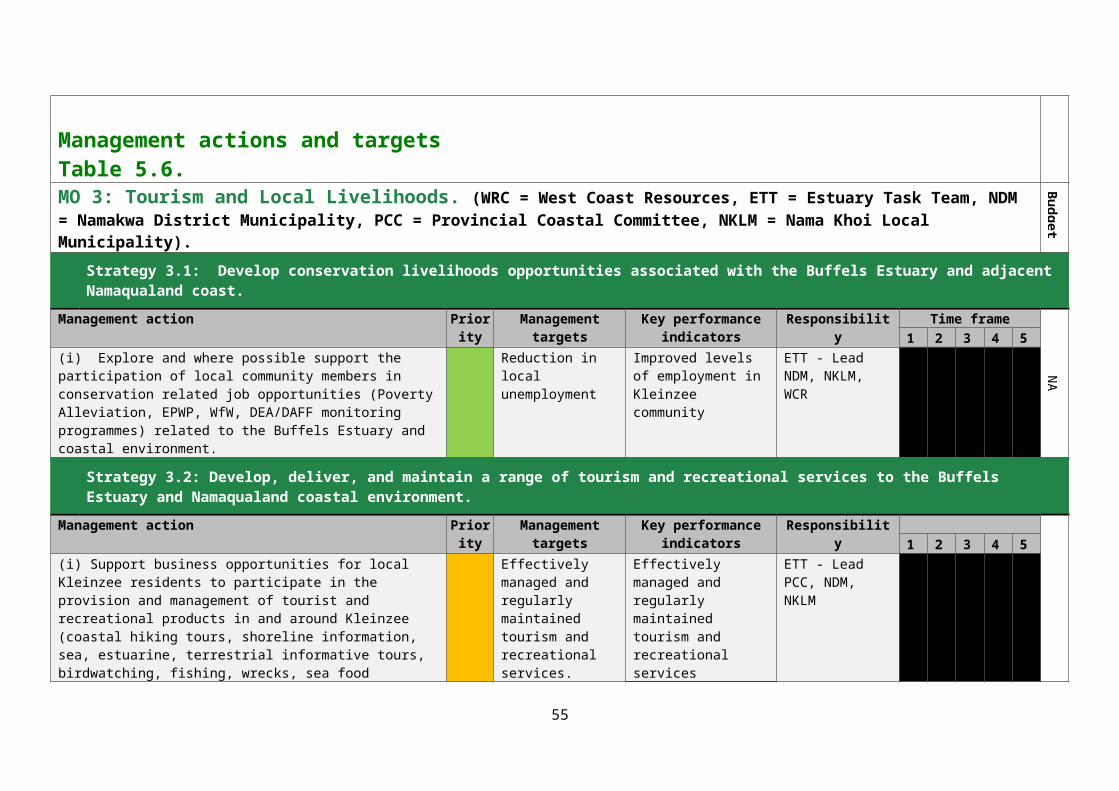
Detailed water quality sampling at regular intervals and specified sites to obtain an insight into salinity and nutrient fluctuations in the estuary. Such research would also provide insight into extent of anthropogenic salinization and the impact of WWTW effluent on the estuary.
8.1 MONITORING PLAN FOR THE BUFFELS ESTUARYMonitoring of the general implementation of the Estuarine Management Plan is outlined in Tables 5.3 to 5.9. Management targets and Key Performance Indicators are provided for each suite of management actions. The ETT should be responsible for evaluating the degree to which the Key Performance Indicators are attained.
Table 8.1 below provides an indication of basic monitoring programmes that should be implemented. These include the monitoring of tourist/recreational use as well as of rainfall, salinity and nutrients, freshwater inflow and avian species and numbers. It is also important to monitor the profile of the sand berm that isolates the estuary from the sea and record any breaching events.
55

Table 8.1. Proposed monitoring programme for the Buffels Estuary.
56
Aspect and Indicator Objective Frequency Location Staff required
Collection/Analytical method
Biological: Numbers and species of birds utilising the estuary. Number and species of birds in EFZ.
Fish sampling
Determine baselines and responses to season and management interventions
Monthly
Quarterly
Identification and count and of open water and shoreline bird spp. 3 x Fixed transect walk through of EFZ.
Open water cast netting programme for fish
1 Standardised sampling procedure (time, weather, routes etc) Counts in the course of shoreline patrols and transect walks.
Cast netting; species identification and length frequencies
Biological: Extent of A. cyclops growthExtent of P. australis growth
Monitor spread of alien invasive spp.
Monitor habitat change and extent of open water
Annual EFZ 1 GPS and digital mapping techniques and/or Remote sensing imagery
Physical: Rainfall Monitor climate changes Daily
Rainfall: Koingnaas Mining complex.
1 Standard Rain Gauge
Beach / sand berm profile and long term mouth sediment dynamics
Monitor mouth opening events and factors impacting on estuarine connectivity to the marine environment
Quarterly Sand banks: Strategic location to be determined
1 Aerial/standard shoreline photography.
Water Quality: Salinity, or conductivityNutrient levels – Ammonia, Nitrates, Nitrites, Silicates, Phosphates, E. coli bacteria and other pathogens
Determine changes in water quality as a result of rainfall, catchment and local activities, golf course watering etc.
Monthly Two sample sites in each open water body
1 According to laboratorySpecifications.
Water quantity: Fresh water flow into the estuary, depth of the estuary.
Detect changes in fresh water input into the estuary. Detect potential sedimentation problems
Water quantity: ContinuousDepth: Quarterly
Water quantity: Strategic location to be determined.Depth: Minimum of two fixed points in each open water body.
1 Methods for the Determination of the Ecological Water Reserve for Estuaries (DWA, 2010).
Standard marked depth gauge. Social: Use of the estuary. Determine types and number of
user groups visiting the estuary and coastal zone and their preferred activities
Daily preferably otherwise randomised sampling program
Bird hide. Road to beach or footpath to the estuary through the golf course.
1 Data collected by tourism booking agency/community guides.

9. INSTITUTIONAL CAPACITY AND ARRANGEMENTS
The Buffels Estuary is located within the Nama-Khoi LM. The Nama Khoi LM is the designated management authority for the estuary and technically should provide the lead in implementing the EMP. However, the LM is poorly capacitated to undertake this task and has not yet fully undertaken the oversight of the town of Kleinzee itself as part of its municipal management mandate. Thus the Namakwa DM will function as the responsible management authority for the EMP on behalf of the Nama Khoi LM. Meetings with Provincial and District authorities have confirmed that an Estuary Task Team (ETT) functioning as a sub-committee of the PCC will undertake the implementation of the Buffels EMP. An ETT has already been constituted under the Northern Cape PCC which was itself established under Section 39 of the ICM Act. The ETT is recognised as a formal structure and has a formal Terms of Reference (TOR) which defines its status, aims and objectives, its composition, and its authority to liaise with key sector categories when necessary.
The ETT must ensure representation of all the principal national, provincial, and local government agencies as well as representatives of key stakeholder groups where these are appropriate in relation to particular management objectives, and the implementation of particular management actions. Members of the Kleinzee community must be able to participate in the activities of the ETT, since they are a key local stakeholder. There are a number of active and concerned individuals from the local community and tourism interests in the area. The ETT must devise the mechanisms which will enable local community members to participate in the ETT. Essentially the ETT will provide a platform through which stakeholders with responsibility for, or interests in, various aspects of the implementation of the EMP can exchange information and ideas, and reach agreement on the appropriate action for the effective management of the estuary. This may prove difficult in some cases, and if necessary the ETT must meet in one-on-one engagements to secure the cooperation of individual agencies. The ETT should also make a commitment to transparency, and clearly define the process to be followed when decisions must be made. It is also useful to formalise the rules of communication, behavioural ground rules, and reporting structures.
The ETT will be critical factor in the effective management of the estuary. Ensuring a sufficiently high level of integration and cooperation amongst all of the different agencies involved in the management of the Buffels Estuary extends beyond the mandate and capacity of any other single resource management agency. Individual Government agencies would be expected to nominate and sign off on an individual (as well as an alternate) who is responsible for the agency’s attendance at ETT meetings where these are relevant to a particular component of the EMP. Each representative will be required to represent and articulate the views and interest of their sectors. Government agencies will be accountable for management activities that fall within their areas of governance. Nominated representatives will be responsible for reporting back to their agencies.
Funding needs to be set aside and ringfenced for the operation of the ETT. Funding allocated to other Government agencies to fulfil their role in the management of an estuary is often non-existent or insufficient and discussions need to take place to formalise the roles of Government agencies in the management of the estuary.
57
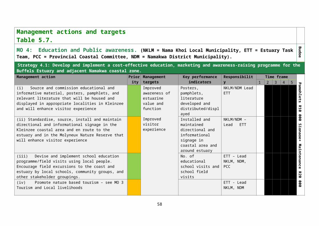
10. REFERENCES
Arcus Gibb 2008. Eskom Nuclear Power Station and Associated Infrastructure. Final Scoping Report Eskom Holdings Limited. Department of Environmental Affairs and Tourism Reference Number: 12/12/20/944.
Conservation of Agricultural Resources Act 43 of 1983.DEA (Department of Environmental Affairs) 2015. Guidelines for the Development and Implementation
of Estuarine Management Plans in terms of the National Estuarine Management Protocol. Cape Town.
DWAF (Department of Water Affairs and Forestry) 2004. Water Resource Protection and Assessment Policy Implementation Process. Resource Directed Measures for protection of water resource: Methodology for the Determination of the Ecological Water Requirements for Estuaries. Version 3, Pretoria.
DWAF (Department of Water Affairs and Forestry) 2005. A practical field procedure for identification and delineation of wetland and riparian areas. DWAF, Pretoria.
DWAF (Department of Water Affairs and Forestry) 2009. Development of an Integrated Water Quality Management Strategy for the Upper and Lower Orange WMAs. Desktop Catchment Assessment Study. Lower Orange Water Management Area (WMA 14). Report No. 2.2. (P RSA D000/00/7909/3). Edition 1. August 2009.
DWAF (Department of Water Affairs and Forestry) 1995. South African Water Quality Guidelines for Coastal Marine Waters. Volume 1: Natural Environment.
DWAF (Department of Water Affairs and Forestry) Reserve Database 2009. As supplied under agreement by the Resource Directed Measures Department, DWAF National.
DWAF (Department of Water Affairs and Forestry) 2007. Manual for the assessment of a Wetland Index of Habitat Integrity for South African floodplain and channelled valley bottom wetland types. Rountree M. (ed); Todd CP, Kleynhans CJ, Batchelor AL, Louw MD, Kotze D, Walters D, Schroeder S, Illgner P, Uys M, and Marneweck GC. Report no. N/0000/00/WEI/0407. Resource Quality Services, Department of Water Affairs and Forestry, Pretoria, South Africa.
Ekogaia Consulting. 2017. The Status Quo of Diamond Mining on the West Coast. Harrison TD, Cooper JAG, Ramm AEL, and Singh RA. 1994. Application of the Estuarine Health Index
to South African Estuaries, Orange River to Buffels (Oos). Unpublished Technical Report CSIR, Durban.
Harrison TD, Cooper JAG, Ramm AEL and Singh RA 2000. State of South African Estuaries: Geomorphology, Ichthyofauna, Water Quality and Aesthetics. Unpublished Report prepared for the Department of Environment Affairs, State of the Environment Series Report No. 2.
Kleynhans CJ, Louw MD and Graham M. 2007. Module G: Eco-Classification and Eco-Status determination in River Eco-Classification: Manual for the Index of Habitat Integrity. Joint Water Research Commission and Department of Water Affairs and Forestry Report. WRC Report No. TT 377-08.
Mucina L and Rutherford MC 2006. The vegetation of South Africa, Lesotho and Swaziland. Strelitzia 19, South African National Biodiversity Institute, Pretoria.
Nama Khoi Local Municipality. Integrated Development Plan 2014 – 2017.Nama Khoi Local Municipality. Spatial Development Framework 2015 – 2016.Namakwa District Municipality. Integrated Development Plan 2009.National Environmental Management Act 107 of 1998 (as amended).National Environmental Management: EIA Regulations of 2014.
58

National Environmental Management: Integrated Coastal Management Act 24 of 2008.National Environmental Management: National Estuarine Management Protocol. GN 341 of 2013.National Environmental Management: Protected Areas Act 57 of 2003.National Environmental Management: Protected Areas Amendment Act 15 of 2009.Northern Cape Provincial Coastal Management Plan 2005. Report prepared by Enviro Fish Africa. Northern Cape Provincial Spatial Development Framework. 2012. Department of Co-operative
Governance, Human Settlements and Traditional Affairs. Taljaard S 2007. C.A.P.E. Estuaries Guideline 1: Interpretation of Legislation pertaining to Management
of Environmental Threats within Estuaries. Report prepared by CSIR for C.A.P.E. Estuaries Programme, DEAT/Cape Nature.
The Benchmarks Foundation. 2009. Corporate Social Responsibility in the Diamond Mining Industry on the West Coast of South Africa.
Trans Hex Group Integrated Annual Report 2016.Turpie JK, Clark B, Knox D, Martin P, Pemberton C, and Savy C 2004. Contributions to information
requirements for the implementation of resource directed measures for estuaries. Volume 1. Improving the biodiversity importance rating of South African Estuaries. WRC Report No. 1247/1/04.
Turpie J and Clark B 2007. Development of a conservation plan for temperate South African estuaries on the basis of biodiversity importance, ecosystem health and economic costs and benefits. C.A.P.E. Regional Estuarine Management Programme. Final Report, August 2007.
Turpie JK 2004. Estuaries component of the National Spatial Biodiversity Assessment. Report to the National Botanical Institute.
Turpie JK, Adams JB, Joubert A, Harrison TD, Colloty BM, Maree RC, Whitfield AK, Wooldridge TH, Lamberth SJ, Taljaard S and van Niekerk L 2002. Assessment of the conservation priority status of South African estuaries for use in management and water allocation. Water SA. 28: (2) 191-206.
Van Niekerk L and Turpie JK (eds.) 2012. South African National Biodiversity Assessment 2011: Technical Report. Volume 3: Estuary Component. CSIR Report Number CSIR/NRE/ECOS/ER/2011/0045/B. Council for Scientific and Industrial Research, Stellenbosch.
Whitfield AK 2000. Available scientific information on individual South African estuarine systems. Updated WRC Report No. 577/1/95. 145 pp.
59
ADDENDUM 1. STAKEHOLDERS – MOST IMPORTANT MANAGEMENT ACTIONS.
1. Restore fresh water flow particularly with regard to the sub-surface membrane across the Kleinzee aquifer.
2. Rehabilitate degraded areas particularly in the EFZ3. Formalise and control cutting of A. cyclops
60

ADDENDUM 2. PUBLIC PARTICIAPTION REPORT.
The report describing the Public Participation process for the development of the Buffels EMP is presented as a separate document. It must be noted that public participation at all stages of the EMP development process was generally poor despite wide advertisement of the public meetings and the distribution for comment of all the relevant documents. In general, the level of involvement of communities is directly proportional to the potential of any activity to result in jobs.
61