about interstate 11 - i-11 & intermountain west corridor … · adot interstate 11 corridor...
TRANSCRIPT
ADOT Interstate 11 Corridor Tier 1 Environment Impact StatementNOGALES TO WICKENBURG
FACT SHEET | SPRING 2016
11ENVIRONMENTAL IMPACT STATEMENTT
IER
FOR MORE INFORMATION:1-844-544-8049
[email protected]/Arizona
Project No. M5180 01P / Federal Aid No. 999-M(161)S
!"̀$
Phoenix
CasaGrande
GilaBend
Wickenburg
Iv
Q¿
QÍ
Qó
Q̀
QÂ
QÐ
QðQÞ
Qÿ
QÐ
Scottsdale
Mesa
Eloy
!"a$
QÆ
Iv
Qí
Qå
Tohono O'odhamNation
Gila RiverIndian Community
Ak-ChinIndian
Community
Salt River PimaMaricopa Indian
Community
!"c$
!"a$
QÍ
Q̧
QÐ
Qü
QÑ
QÌ
Qe
Qì
Qj
I}
MA
RIC
OPA
CO
UN
TY
PIN
AL C
OU
NTY
YAVAPAI COUNTYMARICOPA COUNTY
BNSF Railway
Union Pacific Railroad
Tucson
Marana
Fort McDowellYavapai Nation
Sonoran DesertN.M.
Barry M. GoldwaterAir Force Range
Tonto N.F.
Nogales
PIMA COUNTY
PIMA COUNTYSANTA CRUZ COUNTY
!"a$
Sahuarita
SouthTucson
Oro Valley
Goodyear
Buckeye
Surprise
YAVAPAI COUNTYMARICOPA COUNTY
MARICOPA COUNTY
PIMA COUNTYPINAL COUNTY
Davis MonthanAir Force Base
Luke AirForce Base
Luke AirForce Base
San XavierDistrict
Pascua Yaqui Tribe
Saguaro N.P.
CoronadoN.F.
CoronadoN.F.
CoronadoN.F.
CoronadoN.F.
TumacacoriNat'l Historic Park
PINAL COUNTY
M E X I C OM E X I C O
U N I T E D S T A T E S O F A M E R I C A
U N I T E D S T A T E S O F A M E R I C A
!"d$
!"a$
Ironwood Forest N.M.
Tohono O'odham
(UPRR)
Tucson Int'lAirport
Phoenix-MesaGateway Airport
Sky HarborInt'l Airport
Cabeza PrietaN.W.R.
Buenos AiresN.W.R.
QÄ
QÏ
Qû
UPRR
QÏ
QÏQÍ Saguaro N.P.
Gila River
Has
saya
mpa
Riv
er
Organ Pipe N.M.
Santa Cruz River
F0 2010
Miles
LegendCorridor City/TownCounty LimitsFreewayState/US HighwayMajor StreetRailroadRiversLake
Bureau of Land ManagementReclamationNational Forest (N.F.)National Wildlife Refuge (N.W.R.)Park and Recreation AreaNational Park (N.P.)National Monument (N.M.)Tribal LandsPrivate (no color)State LandMilitary
I-11 Corridor
Map not to scale
LEGEND
Interstate 11 Corridor Tier I Environmental Impact StatementCORRIDOR STUDY AREA
FOR MORE INFORMATION:i11study.com
16-022
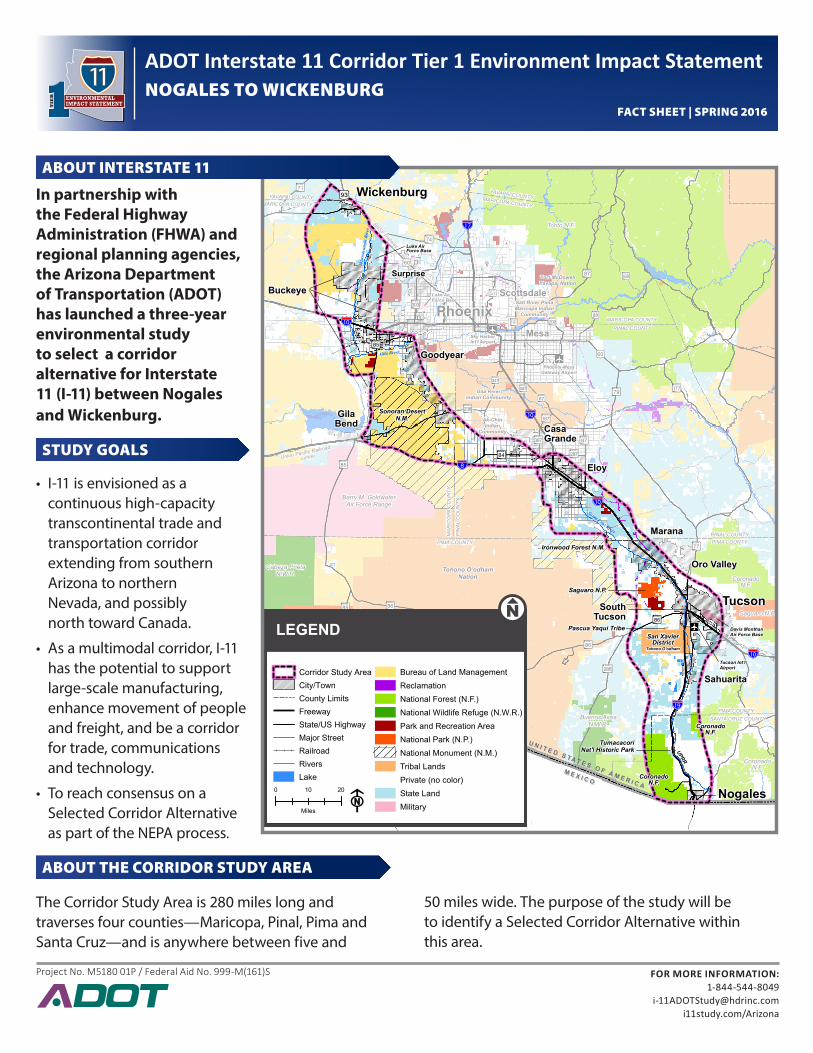
In partnership with the Federal Highway Administration (FHWA) and regional planning agencies, the Arizona Department of Transportation (ADOT) has launched a three‑year environmental study to select a corridor alternative for Interstate 11 (I‑11) between Nogales and Wickenburg.
STUDY GOALS
• I-11 is envisioned as a continuous high-capacity transcontinental trade and transportation corridor extending from southern Arizona to northern Nevada, and possibly north toward Canada.
• As a multimodal corridor, I-11 has the potential to support large-scale manufacturing, enhance movement of people and freight, and be a corridor for trade, communications and technology.
• To reach consensus on a Selected Corridor Alternative as part of the NEPA process.
ABOUT THE CORRIDOR STUDY AREA
The Corridor Study Area is 280 miles long and traverses four counties—Maricopa, Pinal, Pima and Santa Cruz—and is anywhere between five and
ABOUT INTERSTATE 11
50 miles wide. The purpose of the study will be to identify a Selected Corridor Alternative within this area.
ADOT Interstate 11 Corridor Tier 1 Environment Impact StatementNOGALES TO WICKENBURG
FACT SHEET | SPRING 2016
11ENVIRONMENTAL IMPACT STATEMENTT
IER
FOR MORE INFORMATION:1-844-544-8049
[email protected]/Arizona
Project No. M5180 01P / Federal Aid No. 999-M(161)S
i11study.com/Arizona
1‑844‑544‑8049 (Toll‑free/bilingual)
Interstate 11 Tier 1 EIS Study Team c/o ADOT Communications 1655 W. Jackson St. , Mail Drop 126F Phoenix, AZ 85007
To be added to the study notification list, or to provide comments at any point during the process, please contact us:
Year 1 Year 3Year 2
Noticeof Intent
DataCollection
WE AREHERE
Analysis
Reasonable Range of Corridor Alternatives
Draft Environmental
Impact Statement
Final Environmental
Impact Statement
Record of Decision
ALTERNATIVES SELECTION REPORT (ASR)
TIER 1 ENVIRONMENTAL IMPACT STATEMENT (EIS)
A G E N C Y A N D P U B L I C I N V O L V E M E N T P R O C E S S
Scoping Meetings
Information Meetings
Hearings
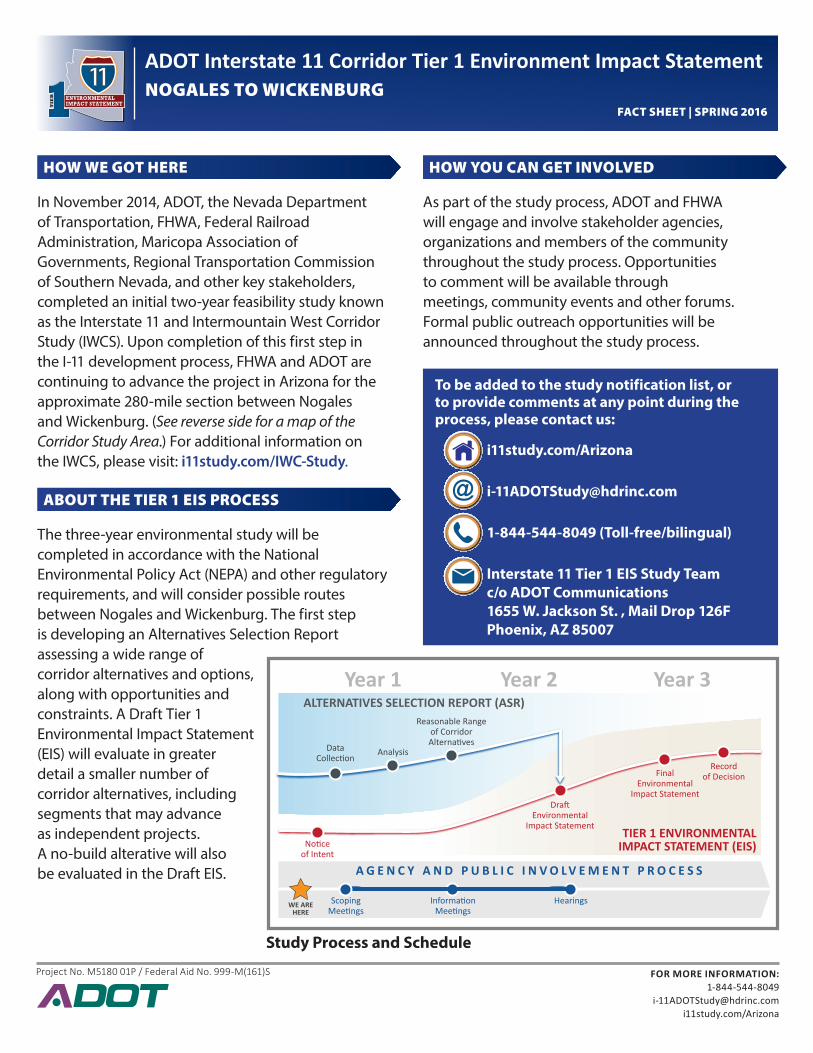
HOW WE GOT HERE
In November 2014, ADOT, the Nevada Department of Transportation, FHWA, Federal Railroad Administration, Maricopa Association of Governments, Regional Transportation Commission of Southern Nevada, and other key stakeholders, completed an initial two-year feasibility study known as the Interstate 11 and Intermountain West Corridor Study (IWCS). Upon completion of this first step in the I-11 development process, FHWA and ADOT are continuing to advance the project in Arizona for the approximate 280-mile section between Nogales and Wickenburg. (See reverse side for a map of the Corridor Study Area.) For additional information on the IWCS, please visit: i11study.com/IWC-Study.
ABOUT THE TIER 1 EIS PROCESS
The three-year environmental study will be completed in accordance with the National Environmental Policy Act (NEPA) and other regulatory requirements, and will consider possible routes between Nogales and Wickenburg. The first step is developing an Alternatives Selection Report assessing a wide range of corridor alternatives and options, along with opportunities and constraints. A Draft Tier 1 Environmental Impact Statement (EIS) will evaluate in greater detail a smaller number of corridor alternatives, including segments that may advance as independent projects. A no-build alterative will also be evaluated in the Draft EIS.
HOW YOU CAN GET INVOLVED
As part of the study process, ADOT and FHWA will engage and involve stakeholder agencies, organizations and members of the community throughout the study process. Opportunities to comment will be available through meetings, community events and other forums. Formal public outreach opportunities will be announced throughout the study process.
Study Process and Schedule