agenda 13 november 2013
DESCRIPTION
ÂTRANSCRIPT

PAGE 1
AGENDA
Ordinary Meeting of Council
6.00pm Wednesday 13 November 2013
*** Broadcast live on Phoenix FM 106.7 ***
VENUE:
Reception Room,
Bendigo Town Hall,
Hargreaves Street, Bendigo
NEXT MEETING:
Wednesday December 4, 2013
Bendigo Town Hall
Copies of the City of Greater Bendigo Council’s Agendas & Minutes can be obtained online at www.bendigo.vic.gov.au

PAGE 2
Council Vision
Our residents can live healthy and satisfying lives in our vibrant City and region, confident in its growth and future.
Council Purpose and Values Councillors have made a commitment in their Code of Conduct to working and leading together in:
Making informed, balanced and objective decisions
Acting honestly
Taking responsible financial decisions
Ensuring good governance
Being inclusive in their activities and sharing information with others
Learning from each other
Respecting each other's undertakings
Being respectful in their interactions with others
Communicating clearly about decisions that have been made
Fulfilling their undertakings and being clear when this is not possible
Working positively with the media to ensure community members are provided with accurate information
Themes
Planning for Growth
Liveability
Productivity
Sustainability
Good Governance and Decision-Making

PAGE 3
ORDINARY MEETING WEDNESDAY 13 NOVEMBER 2013 ORDER OF BUSINESS:
ITEM PRECIS PAGE
ACKNOWLEDGEMENT OF COUNTRY 6
PRAYER 6
CODE OF CONDUCT 6
PRESENT 6
APOLOGIES 6
SUSPENSION OF STANDING ORDERS 6
PUBLIC QUESTION TIME 6
RESUMPTION OF STANDING ORDERS 7
CR RUFFELL'S REPORT 7
DECLARATIONS OF CONFLICT OF INTEREST 8
CONFIRMATION OF MINUTES 9
1. PETITIONS AND JOINT LETTERS 11
2. PLANNING FOR GROWTH 12
2.1 Planning Scheme Amendment C197 - View Hill, 10-14 Mackenzie Street, Bendigo - Adoption of Amendment
12
2.2 Planning Scheme Amendment C189 - Apply Heritage Overlays to 52 Edward Street and 72 Queen Street, Bendigo and 27 Pallett Street, Golden Square - Consider Panel Report and Adoption of Amendment
18
2.3 Planning Scheme Amendment C159 Part 2 - Council Land, Public Land and Private Zone Corrections - For Adoption
25
2.4 Lot 2 Sth Costerfield-Graytown Rd, CA8 Mcnicols Lane, CA15c Sec 1 Parish Of Costerfield, Sth Costerfield-Graytown Rd
30
PAGE 4
Reserve, Costerfield 3523 - Use & Develop a Utility Installation (Evaporation Facility & Pipeline) in Association with Mineral Extraction
2.5 16 Graham Street, Quarry Hill 3550 - Partial Demolition of Existing Dwelling and Extension to Existing Dwelling
55
2.6 92 Vine Street, Bendigo 3550 - Partial Demolition to Dwelling, Demolition of Outbuildings, Alterations and Additions to Dwelling
65
2.7 CA 20 Derby Road, Woodvale 3556 - Use and Development of a Dwelling and Outbuildings in Conjunction with Agriculture (Mushroom Growing and Grazing)
78
2.8 48 and Lot 4 Queen Street, Mandurang South 3551 - Approval of Development Plan and 5 Lot Subdivision of Land and Development of 4 Dwellings and Removal of Native Vegetation
92
2.9 216 North Harley Street, Strathdale - Staged Subdivision of the Land into 6 Lots
108
2.10 1097-1099 Heathcote-North Costerfield Road, Costerfield 3523 - 2-Lot Subdivision
117
2.11 20 Hill Street, Kangaroo Flat 3555 - 3 Lot Subdivision of Land
127
3./4.
LIVEABILITY/PRODUCTIVITY 138
5. SUSTAINABILITY 139
5.1 Victorian Government's Response to the Inquiry into Flood Mitigation Infrastructure in Victoria
139
6. GOOD GOVERNANCE AND DECISION-MAKING 143
6.1 Council Plan 2013-2017 First Quarter Report, September 2013
143
6.2 Bendigo Stadium Annual Report 2012/13 150
6.3 Contracts Awarded Under Delegation 156
6.4 Record of Assemblies 157
6.5 Proposed Council Meeting Dates For 2013 161
7.
URGENT BUSINESS 163
8. NOTICES OF MOTION 163
PAGE 5
9. COUNCILLORS' REPORTS 163
10. MAYOR'S REPORT 163
11. CHIEF EXECUTIVE OFFICER'S REPORT 163
12. CONFIDENTIAL (SECTION 89) REPORTS 163
____________________________
CRAIG NIEMANN CHIEF EXECUTIVE OFFICER
Ordinary Meeting - 13 November 2013
PAGE 6
ACKNOWLEDGEMENT OF COUNTRY
PRAYER
CODE OF CONDUCT
PRESENT
APOLOGIES
SUSPENSION OF STANDING ORDERS
That Standing Orders be suspended to allow the conduct of Public Question Time.
PUBLIC QUESTION TIME
Public Question Time Guidelines Public Question Time – Purpose Council has provided the opportunity for members of the public to ask questions of broad interest to Council and the community. Matters relating to routine Council works should be taken up with Council’s Customer Service Officers through its Customer Request System. By the time planning matters have reached the council agenda, they have been through an extensive process as required by the Planning and Environment Act. In addition, in most instances mediation has been held between the parties involved. Throughout the process there are many opportunities for the people to ask questions. Therefore, no questions relating to planning matters on the Agenda will be accepted. Public Question Time – Where, When And Who The public question time is held at every Ordinary Meeting of Greater Bendigo City Council. Meetings of Council commence at 6.00pm in the Reception Room, Bendigo Town Hall, Hargreaves Street, Bendigo. The public question time is held at the start of the meeting as close as practical to 6:00pm. A maximum of 30 minutes has been provided for registered and unregistered questions. Residents are encouraged to lodge questions in advance so that a more complete response can be provided. Questions will be put to the Council by the individual posing the question; the question will be answered by the Mayor or CEO, or where appropriate, Councillors or Council Officers.

Ordinary Meeting - 13 November 2013
PAGE 7
Acceptance of Questions Each person asking a question of Council is required to stand, state their name, and address the Mayor. Public Question Time is not an opportunity for making of statements or other comments. Council’s Meeting Procedure Local Law does not allow for other questions or comments during the remainder of the meeting. 1. An individual may only ask one question per meeting, a follow-up question may be
permitted at the discretion of the Mayor. 2. In the event that the same or similar question is raised by more than one person, an
answer may be given as a combined response. 3. In the event that time does not permit all questions registered to be answered,
questions will be answered in writing or referred to the next meeting if appropriate. 4. The Mayor and or CEO have the right to decline registration on basis of:
Prosecution, summonses or any other litigation;
Most appropriately addressed by other means;
Vague, irrelevant, insulting or improper, defamatory;
Answer likely to compromise his / her position;
Confidential, commercial-in-confidence. 5. Each individual whose registration form has been accepted or declined will be
advised by the Friday of the week prior to the scheduled meeting. 6. In the event of a registration form being declined the registration form will be
circulated to the Mayor or Councillors for information.
RESUMPTION OF STANDING ORDERS
That Standing Orders be resumed.
CR RUFFELL'S REPORT
Ordinary Meeting - 13 November 2013
PAGE 8
DECLARATIONS OF CONFLICT OF INTEREST
Pursuant to Sections 77, 78 and 79 of the Local Government Act 1989 (as amended) direct and indirect conflict of interest must be declared prior to debate on specific items within the agenda; or in writing to the Chief Executive Officer before the meeting. Declaration of indirect interests must also include the classification of the interest (in circumstances where a Councillor has made a Declaration in writing, the classification of the interest must still be declared at the meeting), i.e. (a) direct financial interest (b) indirect interest by close association (c) indirect interest that is an indirect financial interest (d) indirect interest because of conflicting duties (e) indirect interest because of receipt of an applicable gift (f) indirect interest as a consequence of becoming an interested party (g) indirect interest as a result of impact on residential amenity (h) conflicting personal interest A Councillor who has declared a conflict of interest, must leave the meeting and remain outside the room while the matter is being considered, or any vote is taken. Councillors are also encouraged to declare circumstances where there may be a perceived conflict of interest.
Ordinary Meeting - 13 November 2013
PAGE 9
CONFIRMATION OF MINUTES
Minutes of the Ordinary Meeting of 23 October, 2013 and Minutes of the Special Meeting of 4 November, 2013 The following items were considered at the Ordinary Council meeting held on 23 October, 2013, at 7:15pm.
Petition: Lake Tom Thumb
Planning Scheme Amendment C204 - Rezoning 22-48 Chum Street, Golden Square (Fortuna) to Comprehensive Development Zone and Apply Environmental Audit Overlay, Consider Authorisation Request
Planning Scheme Amendment C130 - Heathcote Supermarket - Consider Authorisation Request
53 & 59 Cassinia Drive, Junortoun - Staged Subdivision of the Land into 56 Lots and the Removal of Native Vegetation
7 Glencoe Street, Kennington 3550 - 10 Lot Subdivision of Land and Construction of 10 Dwellings
1740 Heathcote-Redesdale Road, Mia Mia 3444 - Use Land For Animal Keeping (Dog Breeding) & Construction of Dog Runs and Associated Buildings
51 Goldie Street, Marong 3515 - Approval of Development Plan, Use of Land for Medical Centre, Alterations and Extensions to Existing Building, Development of Car Park, and Advertising Signage
2 Hunt Street & 10 Atkins Street, North Bendigo 3550 - Amended Plans to Allow the Construction of a Wall Fronting Atkins Street (Residential Village for Bendigo Hospital)
22 Norfolk Street, North Bendigo 3550 - Construction of 3 Dwellings
99 Booth Street, Golden Square 3555 - Construction of a Dwelling
5 Old Violet Street, Bendigo 3550 - Demolition of Dwelling, Outbuildings, Fences and Construction of Dwelling and Fences
635 Calder Highway, Maiden Gully 3551 - 3 Lot Subdivision and Removal of Vegetation
City of Greater Bendigo Heritage Advisory Committee Terms of Reference
Eastern Service Road - Calder Alternative Highway, Marong
Parking for Hospital Project
Traffic Management Infrastructure in the Long Gully Area
Greater Bendigo Public Health and Wellbeing Plan
Australian Bureau of Statistics SEIFA Data 2011
Community Grants Program Round 1 2013 - 2014
Amendment to Maiden Gully Land Sale
Annual Snapshot of Operations - Bendigo Art Gallery 2012/13
Annual Snapshot of Operations - Bendigo and Heathcote Visitor Information Centres 2012/2013
Goldfields Library Corporation Annual Report 2012/13
Bendigo Trust Annual Report 2012/13
Draft Waste and Resource Management Strategy
Flood Study Community Consultation Process
Asset Management Policy
Ordinary Meeting - 13 November 2013
PAGE 10
Independent Review Progress Report
Benchmarking of Statutory Planning Data
Record of Assemblies
Contracts Awarded Under Delegation
Section 89 Contractual Matter
Section 89 Contractual Matter
Section 89 Contractual Matter The following items were considered at the Special Council meeting held on 4 November, 2013, at 7.30pm.
Election of Mayor for 2013/2014
Congratulations to Newly Elected Mayor
Response by Mayor for 2013/2014
Election of Deputy Mayor for 2013/2014
Immediate Past Mayor’s Report
Response to the Immediate Past Mayor’s Report
Councillor Appointments on Committees The unconfirmed minutes have also been posted on the City of Greater Bendigo website pending confirmation at this meeting. RECOMMENDATION That the Minutes of the Ordinary Meeting of Council held on 23 October 2013 and the Minutes of the Special Meeting of Council held on 4 November 2013 as circulated, be taken as read and confirmed.

Ordinary Meeting - 13 November 2013
PAGE 11
1. PETITIONS AND JOINT LETTERS
Nil.

Planning for Growth - Reports Ordinary Meeting - 13 November 2013
PAGE 12
2. PLANNING FOR GROWTH
2.1 PLANNING SCHEME AMENDMENT C197 - VIEW HILL, 10-14 MACKENZIE STREET, BENDIGO - ADOPTION OF AMENDMENT
Document Information
Author Emma Bryant, Coordinator Policies and Processes Responsible Prue Mansfield, Director Planning & Development Director
Summary/Purpose
Amendment details: Rezone the All Saints’ Anglican Church, grounds, school and Master’s residence, known as the ‘View Hill’ Complex, at 10-14 Mackenzie Street, Bendigo, to Commercial 1 and apply a Design and Development Overlay and amend the current Heritage Overlays to encourage redevelopment.
Proponent: Anglican Diocese, Bendigo
No. submissions: 4 with 1 objection which has now been withdrawn.
Recommendation: Council adopt Planning Scheme Amendment C197 as exhibited and forward to the Minister for Planning for approval.
Policy Context
City of Greater Bendigo Council Plan 2013 – 2017 (2013)
Planning for Growth
Our quality of life is maintained as our City's population and economy grows.
Productivity
A diverse, strong and growing economy supports community resilience.
Sustainability
Strengthen the links between Greater Bendigo's past and future by protection and contemporary re-use of our heritage assets.
Background Information
The View Hill site is no longer required by the Anglican Diocese of Bendigo, therefore the Diocese wishes to sell the site so that it can be better utilised by the Bendigo community. Prior to selling, the Diocese wishes to establish planning controls that retain the existing historic buildings but also allow for sympathetic redevelopment and a flexibility of new uses.
Planning for Growth - Reports Ordinary Meeting - 13 November 2013
PAGE 13
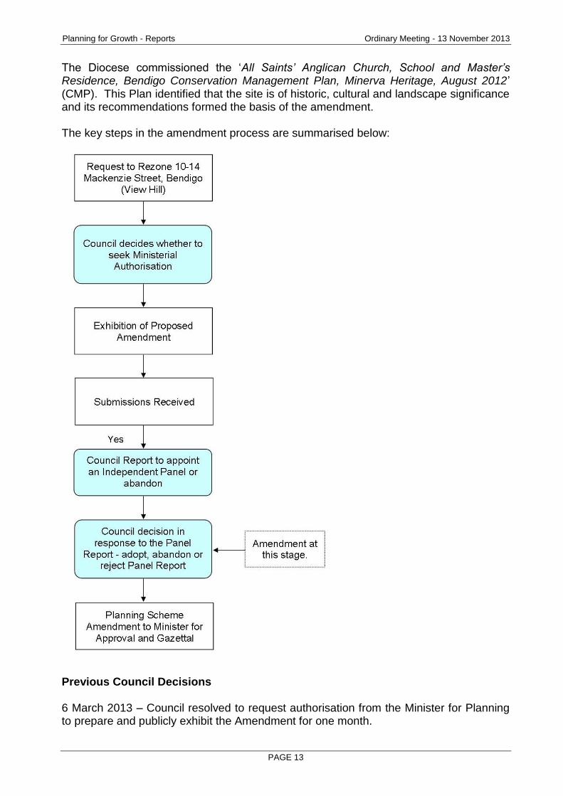
The Diocese commissioned the ‘All Saints’ Anglican Church, School and Master’s Residence, Bendigo Conservation Management Plan, Minerva Heritage, August 2012’ (CMP). This Plan identified that the site is of historic, cultural and landscape significance and its recommendations formed the basis of the amendment. The key steps in the amendment process are summarised below:
Previous Council Decisions 6 March 2013 – Council resolved to request authorisation from the Minister for Planning to prepare and publicly exhibit the Amendment for one month.

Planning for Growth - Reports Ordinary Meeting - 13 November 2013
PAGE 14
11 September 2013 – Council resolved to request the Minister for Planning to appoint an Independent Panel to consider the outstanding opposing submission to this Amendment. The request for a panel was not forwarded to the Minister as the only opposing submission was withdrawn soon after the Council decision.
Report
An Explanatory Report is attached and details the purpose, effect of the amendment and provides the strategic justification for the amendment as required. Key issues identified in the Explanatory Report are summarised below. Land Affected by the Amendment The land affected by the Amendment is 5,400 m2 in size and is currently zoned Special Use Zone Schedule 1 ‘Private Educational or Religious Institutions’ with a small section of Commercial 1 Zone adjoining View Lane (probable error) and a small area of Residential 1 along the access lane. The site is currently covered by Heritage Overlay 167 ‘All Saints’ Cathedral’ and Heritage Overlay 261 ‘Sunday School Residence’, Heritage Overlay 273 ‘Atkinson Building’ in part and Heritage Overlay 3 ‘Bendigo Civic Precinct’ in part (errors).
Figure 1. All Saints’ Anglican Church, School and Master’s Residence at 10 – 14 Mackenzie Street, Bendigo
Planning for Growth - Reports Ordinary Meeting - 13 November 2013
PAGE 15
What the Amendment Does The Amendment proposes to:
Rezone the site from Special Use Zone 1 ‘Private Educational or Religious Institutions’, Commercial 1 Zone and Residential 1 Zone to the Commercial 1 Zone. Apply the new Design & Development Overlay Schedule 12 ’View Hill Development Site’ to the Church and grounds (not the School and Master’s residence). Amend the Schedule to the Heritage Overlay for HO167 and HO261 to better align the boundaries with the properties and include recommendations from the Conservation Management Plan. Delete HO3 ‘Bendigo Civic Precinct’ and HO273 ‘Atkinson Building’ as errors. Include the ‘All Saints Anglican Church, School and Master’s Residence Conservation Management Plan’ as a reference document.
Consultation/Communication
Exhibition Procedures The Amendment was exhibited for one month from 30 May 2013 to 1 July 2013. Notice was provided in the following manner:
Individual notices to 239 owners and occupiers of land affected by the Amendment. Notices to prescribed Ministers under Section 19(1)(c) of the Planning and Environment Act 1987. Notices to all authorities materially affected under Section 19(1)(a) of the Act.
Public notice of the Amendment in the Bendigo Advertiser on 29 May and 1 June 2013.Publication of the notice of the Amendment in the Government Gazette on 30 May
2013. Drop in information session held on 9 June 2013.
Submissions Four submissions including one objection were originally received to the Amendment. The objection has now been withdrawn. Key Issues The key issues for this amendment are the change of use of the site, protection of heritage values and the impact of redevelopment on surrounding areas, including the CBD. Change of Use The Anglican Diocese has not used the site for worship for some years and now wants to dispose of the site so it can be used by more of the general community and provide resources to maintain its other assets. The decision to use the site for worship is one to be made by the Diocese and not the Council.
Planning for Growth - Reports Ordinary Meeting - 13 November 2013
PAGE 16
The Commercial 1 Zone allows for a range of uses. However, due to the constraints of location and the heritage buildings, the site is more suitable for accommodation uses, such as hotel or apartments, and office uses rather than retail. Any retail use would most likely be boutique in nature and located within the heritage buildings. Impact on Heritage Values and Neighbouring Properties The proposed Design and Development Overlay, amended Heritage Overlays that include internal controls, and the CMP will ensure that any proposed development on the site is well designed and sensitive to both the heritage assets and the neighbouring, historic precincts through any future planning permit process. An intensive development at the rear of the site could generate significant amounts of traffic but parking and access arrangements will be considered in more detail at the planning permit stage of any development. The site is covered by the Bendigo CBD Parking Overlay which encourages sustainable transport and reduced on-site car parking.
Conclusion
It is recommended that Council adopt the Amendment in its current form and seek approval from the Minister for Planning as the only opposing submission has now been withdrawn.
Options
Section 29(1) & (2) of the Planning and Environment Act 1987 states that a planning authority may adopt an amendment or part of an amendment with or without changes. If a planning authority adopts part of an amendment the amendment is then split into two parts. Section 23(1) of the Planning and Environment Act 1987 requires that in consideration of submissions received in relation to an amendment, the Council must either;
Change the amendment in the manner requested by the submitters and adopt the amendment with changes; or
Refer the submission(s) to an Independent Panel appointed by the Minister; or
Abandon the Amendment or part of the Amendment. There is no an outstanding opposing submission or submission that seek a change to the Amendment. It is therefore recommended that Council adopt the Amendment in its current form.
Resource Implications
The Amendment is not expected to have any significant adverse effects on the resources and administrative costs of the City of Greater Bendigo.
Attachments
Explanatory Report
Planning for Growth - Reports Ordinary Meeting - 13 November 2013
PAGE 17
RECOMMENDATION
That the Greater Bendigo City Council resolve to: 1. Adopt Greater Bendigo Planning Scheme Amendment C197 without changes.
2. Forward the adopted Amendment to the Minister for Planning for approval together
with the prescribed information pursuant to Section 31(1) of the Planning and Environment Act, 1987.
Planning for Growth - Reports Ordinary Meeting - 13 November 2013
PAGE 18
2.2 PLANNING SCHEME AMENDMENT C189 - APPLY HERITAGE OVERLAYS TO 52 EDWARD STREET AND 72 QUEEN STREET, BENDIGO AND 27 PALLETT STREET, GOLDEN SQUARE - CONSIDER PANEL REPORT AND ADOPTION OF AMENDMENT
Document Information
Author Emma Bryant, Coordinator Policies and Processes Responsible Prue Mansfield, Director Planning and Development Director
Summary/Purpose
Amendment details: This amendment proposes to apply Heritage Overlays to 52 Edward Street and the adjoining 72 Queen Street, Bendigo and 27 Pallett Street, Golden Square.
Proponent: City of Greater Bendigo
No. of submissions: 5
Key Issues: Heritage significance, condition of building, development opportunities.
Recommendation: Council adopt Amendment C189 to the Greater Bendigo Planning Scheme, with minor changes as recommended by the Panel, and request Approval from the Minister for Planning.
Policy Context
City of Greater Bendigo Council Plan 2013 – 2017 (2013)
Planning for Growth
Our quality of life is maintained as our City's population and economy grows.
Productivity
A diverse, strong and growing economy supports community resilience.
Sustainability
Strengthen the links between Greater Bendigo's past and future by protection and
contemporary re-use of our heritage assets.
Background Information
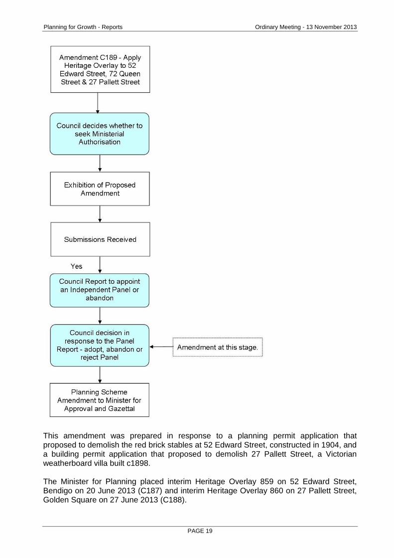
The key steps in the amendment process are summarised below:
Planning for Growth - Reports Ordinary Meeting - 13 November 2013
PAGE 19
This amendment was prepared in response to a planning permit application that proposed to demolish the red brick stables at 52 Edward Street, constructed in 1904, and a building permit application that proposed to demolish 27 Pallett Street, a Victorian weatherboard villa built c1898. The Minister for Planning placed interim Heritage Overlay 859 on 52 Edward Street, Bendigo on 20 June 2013 (C187) and interim Heritage Overlay 860 on 27 Pallett Street, Golden Square on 27 June 2013 (C188).
Planning for Growth - Reports Ordinary Meeting - 13 November 2013
PAGE 20
Previous Council Decisions 26 September 2012 - Council resolved to seek authorisation from the Minister for Planning to prepare and exhibit the amendment. It also resolved to request an interim Heritage Overlay from the Minister for Planning for 52 Edward Street and endorsed the Director’s request for an interim on 27 Pallett Street. 19 June 2013 - Council resolved to request the Minister to appoint an independent panel to consider the submissions made to the amendment. The Minister appointed the Panel on 13 August 2013.
Report
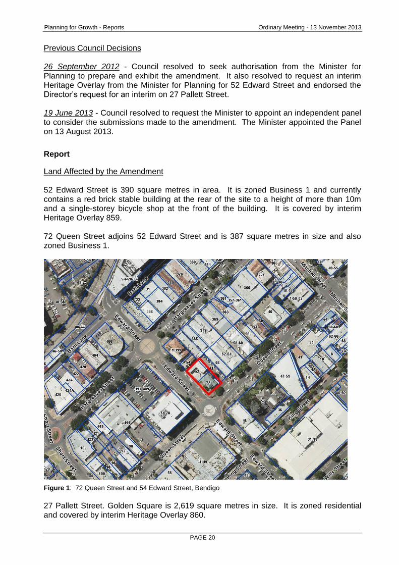
Land Affected by the Amendment 52 Edward Street is 390 square metres in area. It is zoned Business 1 and currently contains a red brick stable building at the rear of the site to a height of more than 10m and a single-storey bicycle shop at the front of the building. It is covered by interim Heritage Overlay 859. 72 Queen Street adjoins 52 Edward Street and is 387 square metres in size and also zoned Business 1.
Figure 1: 72 Queen Street and 54 Edward Street, Bendigo
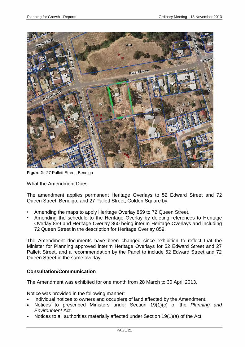
27 Pallett Street. Golden Square is 2,619 square metres in size. It is zoned residential and covered by interim Heritage Overlay 860.
Planning for Growth - Reports Ordinary Meeting - 13 November 2013
PAGE 21
Figure 2: 27 Pallett Street, Bendigo
What the Amendment Does The amendment applies permanent Heritage Overlays to 52 Edward Street and 72 Queen Street, Bendigo, and 27 Pallett Street, Golden Square by: • Amending the maps to apply Heritage Overlay 859 to 72 Queen Street. • Amending the schedule to the Heritage Overlay by deleting references to Heritage
Overlay 859 and Heritage Overlay 860 being interim Heritage Overlays and including 72 Queen Street in the description for Heritage Overlay 859.
The Amendment documents have been changed since exhibition to reflect that the Minister for Planning approved interim Heritage Overlays for 52 Edward Street and 27 Pallett Street, and a recommendation by the Panel to include 52 Edward Street and 72 Queen Street in the same overlay.
Consultation/Communication
The Amendment was exhibited for one month from 28 March to 30 April 2013. Notice was provided in the following manner:
Individual notices to owners and occupiers of land affected by the Amendment. Notices to prescribed Ministers under Section 19(1)(c) of the Planning and Environment Act. Notices to all authorities materially affected under Section 19(1)(a) of the Act.
Planning for Growth - Reports Ordinary Meeting - 13 November 2013
PAGE 22
Public notice of the Amendment in the Bendigo Advertiser on 20 March 2013. Publication of the notice of the Amendment in the Government Gazette on 28 March 2013.
Access on-line 5 submissions were received during the exhibition period, with 4 requesting changes to the amendment that could not be accommodated. These were therefore referred to the independent Panel. The key issues raised by the submitters included:
Disagreeing with the heritage significance assessment of the place;
Arguing alterations to building fabric had reduced significance;
Poor condition of the place and economics of restoration and retention;
Competing objectives in the Planning Scheme, including encouraging higher buildings in the CBD.
All submitters will be notified of Council’s decision resulting from this report. The Panel Hearing The Minister for Planning appointed an Independent Panel to consider the amendment. The Hearing was held on 4 September 2013. The Panel considered all written and oral submissions and material presented to it in connection with the amendment. The Panel Report and Recommendations The Panel Report was received on 1 October 2013. Under Section 26 of the Planning and Environment Act 1987, the Panel Report was automatically released to the public 28 days following its receipt on 28 October 2013. The Panel commended Council for initiating the amendment and preventing demolition of two heritage sites without heritage values being fully considered, but believed in the longer term Council should increase the level of policy support for heritage. Council is in the process of strengthening heritage policy in the MSS and local policies through the planning scheme review amendment. It is also undertaking more heritage studies. The Panel supported Council’s position on the amendment and recommended that Amendment C189 be adopted as exhibited subject to minor modifications to the Heritage Citations, as listed below: Recommendations on Citations: 1. The Citation for 72 Queen Street and 52 Edward Street, Bendigo to be amended to:
Remove references to Hunter House being part of a complex of residential properties adding to the significance of the above sites;
Review the references to Mary Donohue to clarify that her early occupation of the site does not contribute to the heritage value of the existing buildings.
2 The Citation for 27 Pallett Street to be amended to:
Remove references to ‘successful miners’ and ‘wealthy miners’ and review any other inconsistencies relating to the Hocking family and their status;
Remove references to ‘Boom Style’ or ‘Bendigo style’ and apply a consistent and appropriate description of the building throughout.
Planning for Growth - Reports Ordinary Meeting - 13 November 2013
PAGE 23
3 The format of a single Citation for 72 Queen Street and 52 Edward Street should be
retained. It is recommended that the Panel’s recommendation be accepted. The Panel also made some further recommendations as per below: 4. Council should consider whether separate Heritage Overlay numbers for 72 Queen
Street and 52 Edward Street need to be retained. 5. The Residential Character Policies should include reference where appropriate to the
heritage of an area and its importance as an element of character. It is recommended that the Panel’s recommendation 4 be accepted and that the amendment be changed to apply one Heritage Overlay across 72 Queen Street and 52 Edward Street, Bendigo due to their strong relationship. It is recommended that the Panel’s recommendation 5 be noted. Many of the Residential Character Policies do include reference to the heritage of an area and its importance as an element of character. The Residential Character Policies are not proposed for review in the short to medium term.
Conclusion
It is recommended that Council adopt Amendment C189 with changes to include the Panel’s recommendation and to accommodate the interim Heritage Overlays approved by the Minister for two of the properties since exhibition. The 3 properties included in the Amendment have been found by an independent panel to meet the test of being locally significant to the City. Applying heritage overlays does not preclude future development but will ensure that the heritage values of the sites are considered in any development application.
Options Council has the option of:
Adopting the amendment in accordance with the Panel’s recommendations and sending to the Minister for Planning for Approval.
Adopting the amendment in part
Abandoning the amendment under the Planning and Environment Act 1987, there is no right of review of a council's decision not to support the amendment. The planning authority must tell the Minister in writing if it decides to abandon an amendment or part of an amendment.
Resource Implications
There will be only a minor impact on future resources of the Council associated with this amendment in terms of assessing permit applications.
Planning for Growth - Reports Ordinary Meeting - 13 November 2013
PAGE 24
Attachments
Panel Report
Amended Citations
Explanatory Report
Map of Heritage Overlay
RECOMMENDATION
That the Greater Bendigo City Council resolves to: 1. Adopt Greater Bendigo Planning Scheme Amendment C189 with changes. 2. Forward the adopted Amendment to the Minister for Planning for Approval,
together with the prescribed information pursuant to Section 31(1) of the Planning and Environment Act, 1987.
Planning for Growth - Reports Ordinary Meeting - 13 November 2013
PAGE 25
2.3 PLANNING SCHEME AMENDMENT C159 PART 2 - COUNCIL LAND, PUBLIC LAND AND PRIVATE ZONE CORRECTIONS - FOR ADOPTION
Document Information
Author Alison Kiefel, Council Projects Planner Responsible Prue Mansfield, Director Planning & Development Director
Summary/Purpose
Amendment details: Part 2 of Amendment C159 rezones 21-25 Curtin St, Flora Hill, to Residential 1 Zone.
Proponent: Council sponsored Amendment. No. submissions: 1 - Environmental Protection Authority. Recommendation: Council adopt Planning Scheme Amendment C159 Part 2 as
exhibited and forward to the Minister for Planning for approval.
Policy Context
City of Greater Bendigo Council Plan 2013 – 2017 (2013)
Planning for Growth
Our quality of life is maintained as our City's population and economy grows.
Productivity
A diverse, strong and growing economy supports community resilience.
Background Information
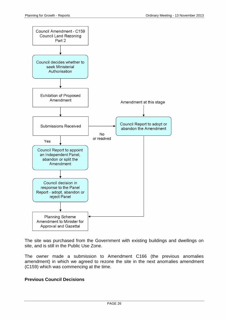
The key steps in the amendment process are summarised below:
Planning for Growth - Reports Ordinary Meeting - 13 November 2013
PAGE 26
The site was purchased from the Government with existing buildings and dwellings on site, and is still in the Public Use Zone. The owner made a submission to Amendment C166 (the previous anomalies amendment) in which we agreed to rezone the site in the next anomalies amendment (C159) which was commencing at the time.
Previous Council Decisions
Planning for Growth - Reports Ordinary Meeting - 13 November 2013
PAGE 27
6 March 2013 – Council resolved to request the Minister’s authorisation to prepare and exhibit Amendment C159. 21 August 2013 – Council resolved to split the amendment, and adopt Part 1 of Amendment C159.
Report
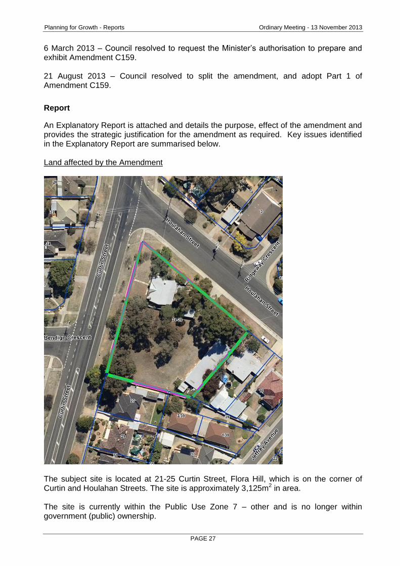
An Explanatory Report is attached and details the purpose, effect of the amendment and provides the strategic justification for the amendment as required. Key issues identified in the Explanatory Report are summarised below. Land affected by the Amendment
The subject site is located at 21-25 Curtin Street, Flora Hill, which is on the corner of Curtin and Houlahan Streets. The site is approximately 3,125m2 in area. The site is currently within the Public Use Zone 7 – other and is no longer within government (public) ownership.
Planning for Growth - Reports Ordinary Meeting - 13 November 2013
PAGE 28
What the Amendment does The amendment proposes to Rezone land at 21-25 Curtin Street, Flora Hill from Public Use Zone 7 (Other Public Use) to Residential 1 Zone.
Consultation/Communication
Amendment C159 was formally exhibited between 21 February – 22 March 2013. Submissions 6 submissions were received during the exhibition period and 1 late submission. These were discussed in the earlier Council report of 21 August 2013 when C159 Part 1 was adopted. The Environmental Protection Authority made a submission relating to properties being zoned for residential use, and recommended additional research to determine whether any contamination would make the land unsuitable. A copy of the conclusion of the Preliminary Environmental Site Assessment by Monarc Environmental, for 21-25 Curtin St, Flora Hill, September 2013 is attached, which advises:
‘In summary, assessment results were within recommended criteria in the NEPM [National Environment Protection Measures] for beneficial uses applicable to a residential setting with all fifteen locations analysed being within all criteria for NEPM A (Residential).’
Conclusion
Given that the issue of contamination has now been resolved, it is recommended that Council adopt Amendment C159 Part 2 without changes, and forward to the Minister for Planning for approval.
Options
Section 29(1) & (2) of the Planning and Environment Act 1987 states that a planning authority may adopt an amendment or part of an amendment with or without changes. If a planning authority adopts part of an amendment the amendment is then split into two parts. Section 23(1) of the Planning and Environment Act 1987 requires that in consideration of submissions received in relation to an amendment, the Council must either;
Change the amendment in the manner requested by the submitters and adopt the amendment with changes; or
Refer the submission(s) to an Independent Panel appointed by the Minister; or
Abandon the Amendment or part of the Amendment. As the amendment has considered all submissions, and no changes are required, it is recommended that Part 2 of C159 be adopted.
Planning for Growth - Reports Ordinary Meeting - 13 November 2013
PAGE 29
Resource Implications
There will be negligible impact on the City's planning permit activity given most residential uses will not trigger a planning permit. Officer time will be required to prepare the Amendment documentation for adoption and liaise with the Minister for Planning. The City is responsible for payment of statutory fees ($798) and costs incurred in the processing of the amendment.
Attachments
EPA submission
Explanatory report
Copy of conclusion of Monarc Environmental report
RECOMMENDATION
That the Greater Bendigo City Council resolve to: 1. Adopt Greater Bendigo Planning Scheme Amendment C159 Part 2 without changes. 2. Forward the adopted Amendment to the Minister for Planning for approval.
Planning for Growth - Reports Ordinary Meeting - 13 November 2013
PAGE 30
2.4 LOT 2 STH COSTERFIELD-GRAYTOWN RD, CA8 MCNICOLS LANE, CA15C SEC 1 PARISH OF COSTERFIELD, STH COSTERFIELD-GRAYTOWN RD RESERVE, COSTERFIELD 3523 - USE & DEVELOP A UTILITY INSTALLATION (EVAPORATION FACILITY & PIPELINE) IN ASSOCIATION WITH MINERAL EXTRACTION
Document Information
Author Peter Hargreaves, Statutory Planner Responsible Prue Mansfield, Director Planning & Development Director
Summary/Purpose
Application details: Use and develop a utility installation (evaporation facility and pipeline) in asociation with mineral extraction
Application No: DM/501/2013
Applicant: Mandalay Resources
Land: Lot 2 South Costerfield-Graytown Rd, CA 8 McNicols Lane, CA 15C Sec 1Parish of Costerfield, South Costerfield-Graytown Road Reserve, COSTERFIELD 3523
Zoning: Farming Zone Public Conservation & Resource Zone
Overlays: Wildfire Management Overlay Environmental Significance Overlay 1
No. of objections: 19 including some with multiple signatures
Consultation meeting held:
A community information session attended by approximately 85 people enabled residents to ask questions about the proposal and the planning assessment process.
Key considerations: Composition of the ground water and:
Impacts from an uncontrolled spill or leak;
Effect on and compatibility with surrounding agricultural uses;
Concern for potential health impacts;
Amenity impacts – visual, noise, dust, odour;
Concern over groundwater depletion and impact on local catchment;
Design concerns.
Conclusion: That on balance the goal of planning – to achieve a net community benefit - will best be achieved through the approval of the application subject to conditions.
Planning for Growth - Reports Ordinary Meeting - 13 November 2013
PAGE 31
Policy Context
City of Greater Bendigo Council Plan 2013 – 2017 (2013)
Planning for Growth
Our quality of life is maintained as our City's population and economy grows.
Productivity
A diverse, strong and growing economy supports community resilience.
Background Information
Mandalay Resources operates the Augusta mine at Costerfield and employs some 200 people. It is the only antimony mine in Australia and one of the four largest gold producers in Victoria. In 2012 the mine produced 18,036 ounces of gold and 2,481 tonnes of antimony. (Antimony is a metal used as an alloying material for lead and tin and the manufacture of lead-acid batteries.) This underground mine is located on either side of the Heathcote-Nagambie Road and includes an entrance or portal, existing evaporation ponds and waste rock stockpile located on the eastern side of the road and processing and tailings storage on the western side. The company plans to expand its operations into a new resource known as the Cuffley deposit. However, the existing Augusta evaporation facility is not sufficient to manage the current or future amount of groundwater discharged from underground workings. Short term contingency plans are in place by which excess water is trucked and pumped to an open pit on the south western side of Heathcote. Water is also treated and released into a nearby seasonal creek under a pollution abatement notice issued by EPA Victoria which is due to expire at the end of October. This application proposes the development of an additional evaporation facility as a longer term groundwater management solution. Based on current operating and production plans another evaporation facility in addition to the one assessed in this report may be needed in approximately four years.
Report
Subject Site and Surrounds
Four sites are associated with this application:
The site of the evaporation ponds, and
Three sites involved in the pipeline route – private land, Crown Land and a road reserve
Planning for Growth - Reports Ordinary Meeting - 13 November 2013
PAGE 32
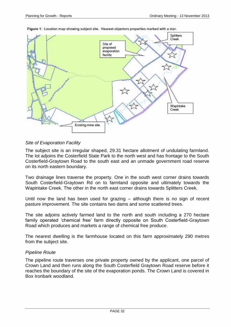
Site of Evaporation Facility
The subject site is an irregular shaped, 29.31 hectare allotment of undulating farmland. The lot adjoins the Costerfield State Park to the north west and has frontage to the South Costerfield-Graytown Road to the south east and an unmade government road reserve on its north eastern boundary. Two drainage lines traverse the property. One in the south west corner drains towards South Costerfield-Graytown Rd on to farmland opposite and ultimately towards the Wapintake Creek. The other in the north east corner drains towards Splitters Creek. Until now the land has been used for grazing – although there is no sign of recent pasture improvement. The site contains two dams and some scattered trees. The site adjoins actively farmed land to the north and south including a 270 hectare family operated ‘chemical free’ farm directly opposite on South Costerfield-Graytown Road which produces and markets a range of chemical free produce. The nearest dwelling is the farmhouse located on this farm approximately 290 metres from the subject site. Pipeline Route
The pipeline route traverses one private property owned by the applicant, one parcel of Crown Land and then runs along the South Costerfield Graytown Road reserve before it reaches the boundary of the site of the evaporation ponds. The Crown Land is covered in Box Ironbark woodland.
Planning for Growth - Reports Ordinary Meeting - 13 November 2013
PAGE 33
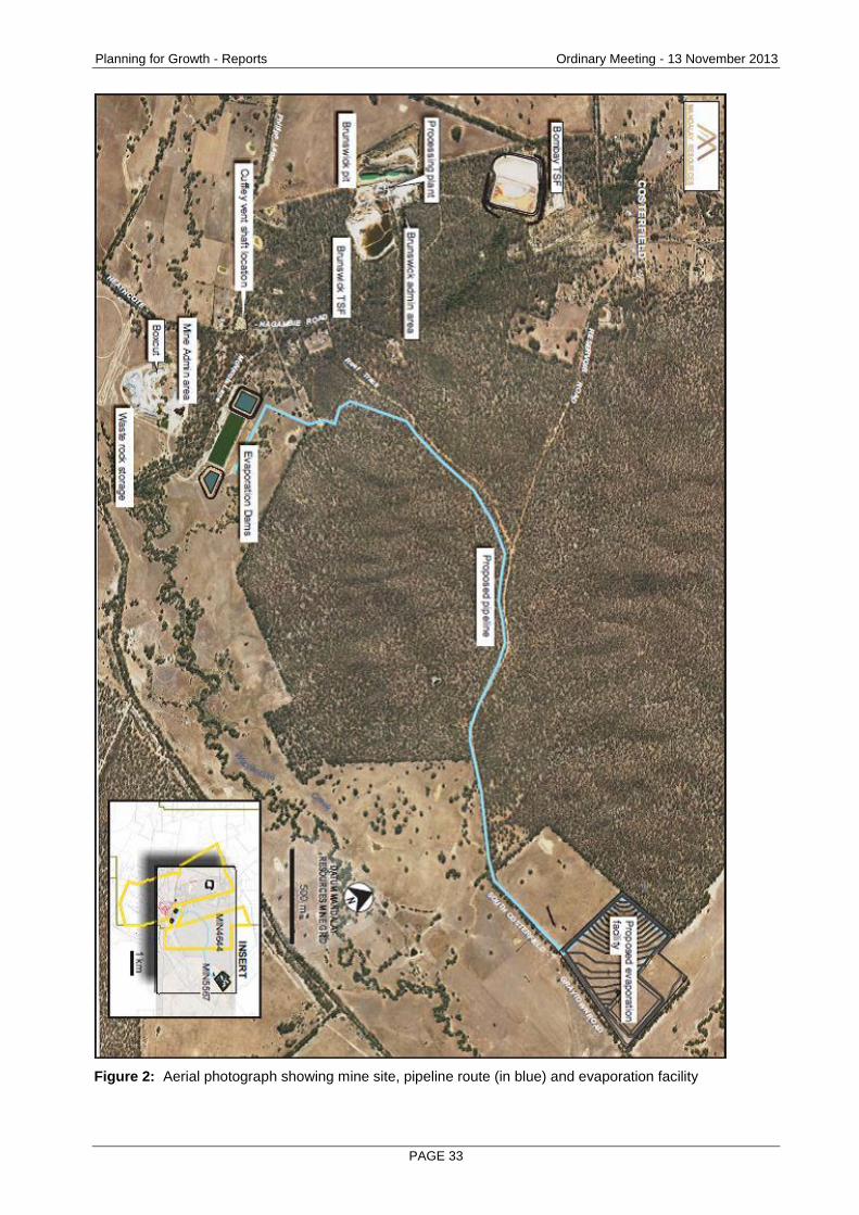
Figure 2: Aerial photograph showing mine site, pipeline route (in blue) and evaporation facility
Planning for Growth - Reports Ordinary Meeting - 13 November 2013
PAGE 34
Proposal
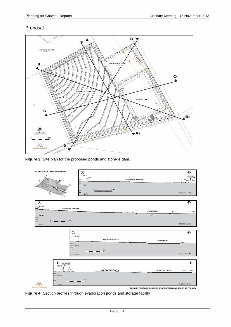
Figure 3: Site plan for the proposed ponds and storage dam.
Figure 4: Section profiles through evaporation ponds and storage facility
Planning for Growth - Reports Ordinary Meeting - 13 November 2013
PAGE 35
The applicant proposes the construction of a groundwater evaporation facility and a pipeline to carry water from the mine site to the new ponds – a distance of approximately five kms. Evaporation Facility
The evaporation facility will have a capacity of 190ML with the capability of evaporating 120ML per year under normal weather conditions. It will comprise a series of shallow terraces that follow the natural topographic contours and a storage dam. The terraces will be located on the western half of the property to make use of the natural topography beginning in the north west corner and running to a mid-point on the property. The terraces will be approximately 15m to 50m wide and designed to have an operating depth of between 0.15m to 0.3m. The terraces will have an earth fill liner comprising 300mm of clay compacted to achieve DSDBI’s standard for seepage resistance in tailings dams known as the permeability rate. This measure of how easily fluid can flow through the clay is expressed in metres per second. The standard is 1 x10⁻⁸ metres per second, which is a fraction of one metre per second. A rating of 1 X 10⁻⁸ or better is regarded as practically but not quite impervious. Water pumped from the mine site will be allowed to cascade down over the terraces via a series of spillways to a storage dam at the facility’s lowest point. The embankment crest will be approximately 3m to 4m above the natural surface. An overall depth of 6m will be achieved through excavation below the natural surface. The storage dam will have an earth fill line comprising 600mm of clay compacted to achieve DSDBI’s permeability standard. A pump will be installed to recirculate water from the storage dam up to either the middle or top point of the evaporation ponds as evaporation rates allow. Design and Construction
The ponds and storage dam will be designed in a ‘turkey’s nest’ fashion, where the dam walls sit above the surrounding natural surface level to prevent outside surface water run-off from entering the ponds. A drainage system will also be constructed to divert outside surface water around the facility and into existing downstream drainage lines. This means that surface water which falls upstream of the facility will not be blocked but will continue to flow around the facility and downstream. The terraces will be built using cut and fill methods, removing the top soil and silt layers to expose the clay material below. The applicant proposes to use the exposed clay to line the ponds rather than a plastic liner. The clay will have a specified thickness and be compacted to achieve the specified level of impermeability. A design report was submitted with the application. The facility has been designed in accordance with relevant national standards and departmental guidelines. These are detailed later in the report in addressing objections.
Planning for Growth - Reports Ordinary Meeting - 13 November 2013
PAGE 36
Transfer Pipeline
This high density polyethylene pipeline will be laid above ground except where it crosses roads, tracks or waterways within the Costerfield State Forest. Where this occurs the pipe will be buried in accordance with Department of Environment & Primary Industries (DEPI) requirements. A leak detection system will be installed to automatically shut down the supply pump as well as alert operator personnel on a 24/7 basis in the event that a different flow rate is measured between the suction and discharge ends of the pipe. Design Standards
Pipe specifications are based on the durability requirements for the project taking into account cyclic loading due to pump operation, sun exposure, operating pressure. The pipeline has been designed in accordance with the relevant standards as outlined later in the report. Noise
Noise emissions during construction and operation will be required to comply with EPA guidelines. The work plan will be conditioned accordingly. Odour
The applicant argues that the mine water does not have a noticeable odour. An amenity condition will be included regardless. Dust
Water will be maintained in the storage dam and on the terraces throughout the year to prevent dust emissions. The applicant proposes to install four gauges and to monitor dust levels during construction and for the first 12 months of operation. Dust levels should not exceed 4.0g/m2/month – a standard limit.
Visual Impact
The facility will be visible from neighbouring properties and from the South Costerfield-Graytown Road. The height of the wall facing this road will be four metres at its most prominent point. The company proposes additional mid storey screen planting along the road boundary to reduce the visual impact. Water Content
The ground water is naturally occurring and will be drawn from underground at the Augusta mine. The typical water quality is as follows: pH 8.7 TDS 5,530 mg/L Sodium 1,472 Chloride 2,910
Planning for Growth - Reports Ordinary Meeting - 13 November 2013
PAGE 37
Sulphate 471 Antimony 16.2 Arsenic 0.10 Cadmium <0.0001 Chromium 0.008 Copper 0.003 Lead <0.001 Nickel 0.018 Zinc 0.0011 Iron 0.7 The assessing officer has been advised the Australian Drinking Water Guidelines (2011) provide the following values for suitable drinking water (based on daily consumption of two litres) TDS 600mg/L , antimony 0.003mg/L, arsenic 0.01 and for stock watering: 13,000TDS, 0.500 mg/L arsenic. Seepage Detection
The application proposes to install a series of monitoring bores to collect both pre and post-commissioning data on ground water levels and quality. The aim of the bores is to monitor any changes in the ground water level and water chemistry that may indicate seepage. General Monitoring
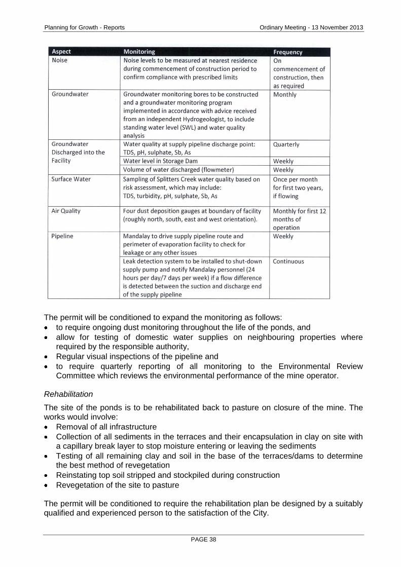
The proposed monitoring program includes the following:
Planning for Growth - Reports Ordinary Meeting - 13 November 2013
PAGE 38
The permit will be conditioned to expand the monitoring as follows:
to require ongoing dust monitoring throughout the life of the ponds, and
allow for testing of domestic water supplies on neighbouring properties where required by the responsible authority,
Regular visual inspections of the pipeline and
to require quarterly reporting of all monitoring to the Environmental Review Committee which reviews the environmental performance of the mine operator.
Rehabilitation
The site of the ponds is to be rehabilitated back to pasture on closure of the mine. The works would involve:
Removal of all infrastructure
Collection of all sediments in the terraces and their encapsulation in clay on site with a capillary break layer to stop moisture entering or leaving the sediments
Testing of all remaining clay and soil in the base of the terraces/dams to determine the best method of revegetation
Reinstating top soil stripped and stockpiled during construction
Revegetation of the site to pasture The permit will be conditioned to require the rehabilitation plan be designed by a suitably qualified and experienced person to the satisfaction of the City.
Planning for Growth - Reports Ordinary Meeting - 13 November 2013
PAGE 39
Planning Controls - Greater Bendigo Planning Scheme
The following clauses are relevant in the consideration of this proposal: State Planning Policy Framework
Noise abatement (13.04-1)
Protection of agricultural land (14.01-1)
Water quality (14.02-2)
Resource exploration and extraction (14.03)
Aboriginal cultural heritage (15.03-2) Municipal Strategic Statement
Economic development (21.07)
Environment (21.08) Local Planning Policies
Industrial Policy (22.05)
Heritage policy (22.06) Other Provisions
Farming Zone (35.07)
Public Conservation and Resource Zone (36.03)
Environmental Significance Overlay ESO 1 (42.01)
Earth and energy resources industry (52.08)
Decision guidelines (65)
Consultation/Communication
Referrals The proposal was referred to the following authorities under the statutory referral process that applies to mining related applications for planning permits and responses and conditions incorporated or attached to the proposed work plan. Under this process the DSDBI refers the proposal before the application for a planning permit is lodged. This process aims to ensure that all relevant issues are addressed in the work plan before the application for a planning permit is lodged. The DSDBI response arose from a direct referral from the City.
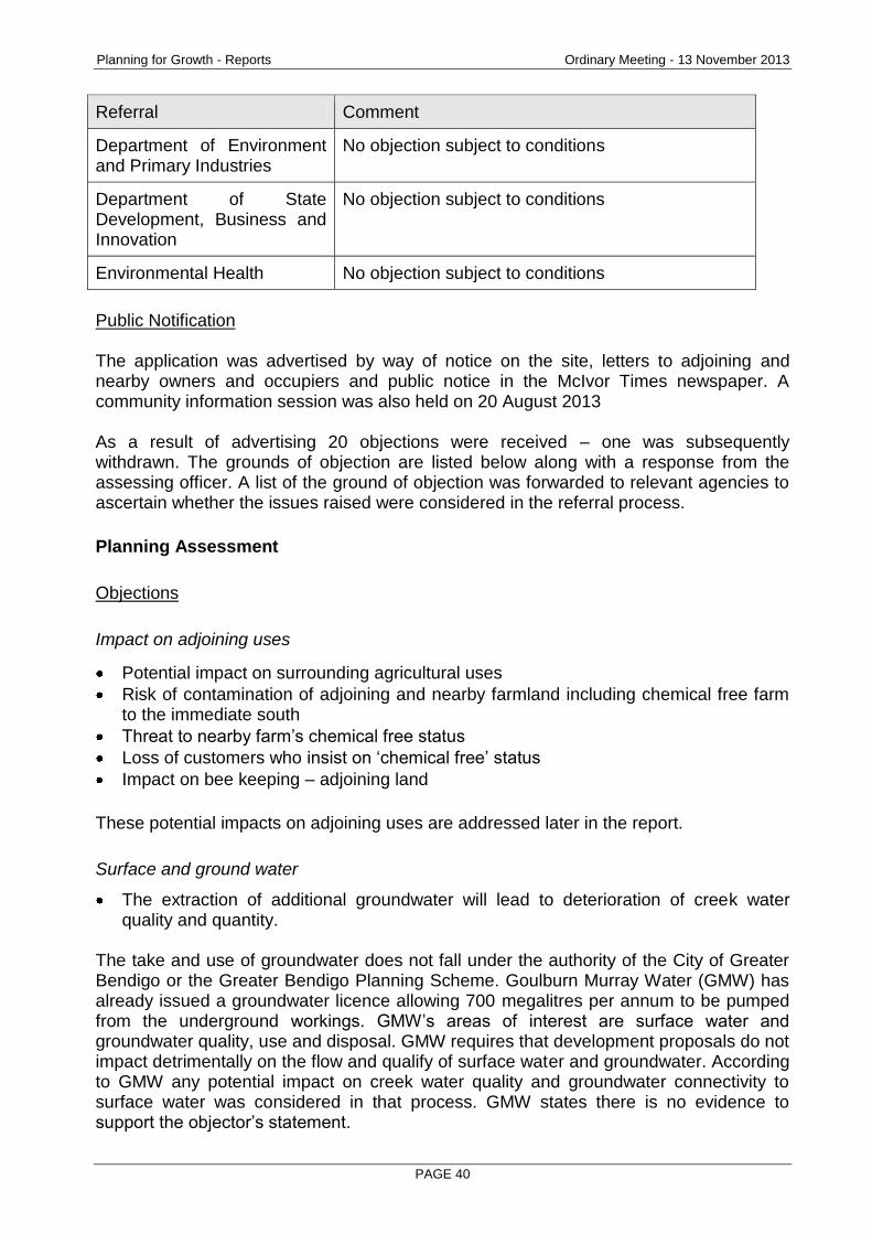
Referral Comment
Goulburn Murray Water No objection subject to conditions
Goulburn Broken Catchment Management Authority
No objection subject to conditions
EPA Victoria No objection subject to conditions which have already been written into the work plan
Planning for Growth - Reports Ordinary Meeting - 13 November 2013
PAGE 40
Referral Comment
Department of Environment and Primary Industries
No objection subject to conditions
Department of State Development, Business and Innovation
No objection subject to conditions
Environmental Health No objection subject to conditions
Public Notification The application was advertised by way of notice on the site, letters to adjoining and nearby owners and occupiers and public notice in the McIvor Times newspaper. A community information session was also held on 20 August 2013 As a result of advertising 20 objections were received – one was subsequently withdrawn. The grounds of objection are listed below along with a response from the assessing officer. A list of the ground of objection was forwarded to relevant agencies to ascertain whether the issues raised were considered in the referral process.
Planning Assessment
Objections
Impact on adjoining uses
Potential impact on surrounding agricultural uses
Risk of contamination of adjoining and nearby farmland including chemical free farm to the immediate south
Threat to nearby farm’s chemical free status
Loss of customers who insist on ‘chemical free’ status
Impact on bee keeping – adjoining land
These potential impacts on adjoining uses are addressed later in the report.
Surface and ground water
The extraction of additional groundwater will lead to deterioration of creek water quality and quantity.
The take and use of groundwater does not fall under the authority of the City of Greater Bendigo or the Greater Bendigo Planning Scheme. Goulburn Murray Water (GMW) has already issued a groundwater licence allowing 700 megalitres per annum to be pumped from the underground workings. GMW’s areas of interest are surface water and groundwater quality, use and disposal. GMW requires that development proposals do not impact detrimentally on the flow and qualify of surface water and groundwater. According to GMW any potential impact on creek water quality and groundwater connectivity to surface water was considered in that process. GMW states there is no evidence to support the objector’s statement.

Planning for Growth - Reports Ordinary Meeting - 13 November 2013
PAGE 41
Loss of surface run-off to local creeks and catchment GMW advised that the evaporation facility will cover a small area (29 hectares) of a larger catchment. All rainfall that occurs in the catchment above the facility will be routed around the ponds via the protected drainage lines and into Splitters Creek. GMW concluded that the impact on local creeks and the catchment would be minimal. In terms of loss of water run-off to adjoining properties the Goulburn Broken Catchment Authority (GBCMA) advised that the drainage lines are not designated waterways and therefore adjoining landholders have no guarantee of access to water that falls on the subject site. GBCMA did not oppose the proposal and recommended setbacks from the drainage lines to ensure that flows were not impeded.
Impact of the pipeline on creekways GBCMA found that the pipeline will cross two designated waterways and whilst it did not oppose the plans, permits will be required for such works. A more acceptable alternative is available
Some objections argue that a more environmentally acceptable option is available to the company; that is treating the water through reverse osmosis to a standard where it could be released into the local waterways. The applicant states that the reverse osmosis option carries low environmental risk for a seasonable or ephemeral creek when discharge occurs during periods of high natural flow e.g., winter rather than summer and is an acceptable solution for “temporary discharge”. However it has ruled out this option as a permanent solution due to the high costs associated with reverse osmosis treatment. While it is reasonable to canvass other options the City is obliged to assess the current proposal on its merits. The proposal should be reviewed through the Environment Effects Statement (EES) process
In Victoria, assessment of the potential environmental impacts or effects of a proposed development may be required under the Environment Effects Act 1978. The process under this Act is not an approval process itself, rather it enables decisions about whether a project with potentially significant environmental effects should proceed. The Minister for Planning decides whether an EES is required for a development. However, a review of the guidelines by the assessing officer concluded that the proposal would not meet the criteria to require an EES. Design and risk of failure
Choice of clay liner over a plastic liner
Concern over an uncontrolled spill/overflow or leak contaminating the catchment or surrounding agricultural land
Planning for Growth - Reports Ordinary Meeting - 13 November 2013
PAGE 42
Inclusion of spillway when the groundwater should not be allowed to ‘spill’ into environment under any circumstances
Risk of leak from pipeline either through failure or deliberate or accidental damage
Potential impact of having the base of the dams so close to water table
Absence of security fencing Advice was sought from the Department of State Development, Business and Innovation (DSDBI) as the mine regulator in Victoria and EPA Victoria on concerns relating to the design of the facility and the risk of a failure or spill. DSDBI confirmed that all matters listed above were assessed as part of the statutory endorsement process. The evaporation facility flood storage capacity requirements, free board (the minimum allowable distance between the water level and the top of the dam) and emergency spillways capacity will be designed in accordance with the following guidelines:
• Guidelines on selection of acceptable flood capacity for dams (ANCOLD, 2000) • Guidelines on the consequence category for dams (ANCOLD, 2012) • Environmental guidelines – Management of Tailings Storage Facilities (former
Department of Primary Industries, DPI, 2004). The DPI guidelines focus on the containment of contaminated water or in this case mine water expected to contain elevated levels of salt and heavy metals. The ANCOLD guidelines relate to large water storages where the design focus is on ensuring structural integrity. No liner can be guaranteed not to leak. The issue is ensuring that the liner is constructed to an appropriate standard of permeability regardless of whether it is clay as favoured by the applicant or plastic as favoured by objectors. The EPA and DSDBI have different standards for the permeability or seepage rate of liners. DSDBI requires a maximum rate for mining related storages of 1 X 10⁻⁸ m/sec whereas the EPA standard is a maximum of 1 X 10⁻⁹ m/sec for storages it licenses, usual associated with landfill operations. EPA Victoria has not set a requirement. However GMW, GBCMA and DSDBI have set conditions requiring a permeability standard of 1 X 10⁻⁸ m/sec.
Some objections state that salt will compromise the clay liner. An Emerson dispersive test on wet clay using both groundwater and normal surface water would provide some indication. The permit will be conditioned to require the testing. Some objections state that the on-site clay is inadequate for the task and is known by local farmers to fail as a liner. The suitability of the clay can be determined by geotechnical testing undertaken by a laboratory accredited by the National Association of Testing Authorities (NATA). The permit will be conditioned accordingly. In terms of the risk of overflow, the ponds are designed to contain a 1:1000 year storm event with an additional 600mm of freeboard in accordance with GWM requirements and guidelines set down by the Australian National Committee on Large Dams (ANCOLD) which sets national standards in relation to large dams. An exceptional storm event greater than this could result in an overflow.
Planning for Growth - Reports Ordinary Meeting - 13 November 2013
PAGE 43
If this was to occur the amount of regional flow over the area would be so extensive that the level of dilution such that the potential impact on local waterways and agriculture would be minimised. A spillway is necessary to allow for a controlled release point and to prevent failure of the dam wall in an extreme weather event. A groundwater monitoring plan is proposed involving five monitoring bores already installed on site. The permit will be conditioned to require appropriate security fencing of the evaporation facility not farm fencing. The pipeline has been designed in accordance with the relevant standard AS2033 – Installation of polyethylene pipe systems and WSA01-2004 – Polyethylene pipeline code. A leak detection system is included in the pipeline design to identify failure or vandalism and shut off the supply pump to minimise the amount of discharge. It is considered that the risk to flora and fauna from short term exposure is minimal. However the permit will be conditioned to require daily visual inspections of the pipeline as a further precaution. The plans for the pipeline did not attract an objection from any of the referral authorities. Choice of location
It is stated that the choice of location for the ponds is sub-optimal because the nearby forest will shelter the area from drying prevailing winds which would otherwise assist the evaporation process. The validity of this statement has not been tested. The distance from the mine has also been questioned. The company has previously stated that the site was chosen because it was suitable for the purpose and no closer land had become available. No other site has been proposed by the applicant and the City must assess this application on its merits. Composition of ground water
Concentration of salt and heavy metals on site
Risk to residents with allergies
Potential health impacts The facility is designed to contain salt and dissolved metals and ensure they do not leave the site, enter the groundwater or pose a risk to the broader environment. Whilst objections came from two medical practitioners, no evidence was presented that the facility poses a risk to public health, save for the statement that components such as arsenic are carcinogenic. Evaporation ponds are a standard means of managing groundwater in mining operations.

Planning for Growth - Reports Ordinary Meeting - 13 November 2013
PAGE 44
Bushfire hazard
Surface placement of pipeline will prevent or impair fuel reduction burns DEPI advised the location of the pipeline would not interfere with or cause significant issues with the operation of fuel reduction burns and had no objection on these grounds.
Dust
Dust during construction
Risk of ‘contaminated’ dust if evaporation ponds dry out through pump failure or human error
Dust has, at times, been a problem associated with the Woodvale Evaporation Facility in the past. The permit will be conditioned to require dust monitoring, control and suppression with specific performance targets combined with financial penalties if the operator fails to meet specified targets. The permit will be conditioned to require the company to ensure that the ponds are covered with water at all times. In the event of pump failure the company will be required to have a stand-by diesel power pumps available. Post mining concerns
Rehabilitation plan is inadequate
Risk of exposure or damage to capping
Concern that site will be permanently removed from agricultural production
Leaves area with permanent, contaminated/toxic site Rehabilitation of the site will be regulated by DSDBI and will be subject to a bond in favour of the relevant Minister. The permit will be conditioned to require EPA Victoria approval for any rehabilitation plan and that it be executed to the satisfaction of the responsible authority in consultation with EPA Victoria. The plan in the form of a Section 173 Agreement with the responsible authority will be required and must include measures to securely contain any residual sediments, to prevent erosion of the cap, to provide a stable land form and to ensure the land can be returned to an approved form of farming in the long term. Response to Planning Scheme / planning controls
Proposed use prohibited within the Farming Zone
Need for buffer between ponds and existing agricultural uses
No provision for parking or staff facilities
Planning for Growth - Reports Ordinary Meeting - 13 November 2013
PAGE 45
One of the purposes of the Planning Scheme is to prevent a ‘clash’ of incompatible land uses. The Greater Bendigo Planning Scheme allows for mining related uses in the Farming Zone. The eastern, northern and western property boundaries have a minimum buffer distance of at least 10 m from the outer edge of the evaporation terraces/storage dam. This buffer comprises of five metres for buffer/access track and a further five metres for drainage. The southern property boundary facing South Costerfield-Graytown Rd has a minimum buffer distance of at least 20 metres from the outer edge of the evaporation terraces/storage dam. This buffer comprises five metres for buffer/access track, five metres for drainage and a further 10 metres for screening vegetation. The permit will be conditioned to require off road parking. On-site staff facilities are not required. Woodvale experience
Design is modelled on Woodvale Evaporation Facility ponds where there has been leakage and dust issues
Woodvale dust generation prompted concerns and testing of domestic water supplies DSDBI confirmed that all matters listed were assessed as part of the statutory endorsement process. The applicant argues that the risk of dust will be less than at Woodvale because a larger pipeline and pumping capacity is planned which will ensure sufficient water is reaching the site to keep the ponds wet. The Woodvale Evaporation Facility was approved and constructed in the late 1980s following Ministerial assessment of an Environmental Effects Statement (EES) in 1989. A condition of the approval was that it be built to departmental standards applying at the time. The required permeability rate was 1 X 10⁻⁸ m/sec the current DSDBI standard. Other
Accumulative impact of evaporation ponds – more planned The applicant has indicated that further groundwater capacity may be required depending on future inflows of groundwater and whether other disposal methods such as treatment through reserve osmosis and then disposal can be implemented. However the current application must be assessed on its merits.
The proposal should be refused based on Principle 15 of the Rio Declaration on Environment and Development.
Principle 15 States that: “In order to protect the environment, the precautionary approach shall be widely applied by States according to their capabilities. Where there are threats of serious or irreversible damage, lack of full scientific certainty shall not be used as a reason for postponing cost-effective measures to prevent environmental degradation”.
Planning for Growth - Reports Ordinary Meeting - 13 November 2013
PAGE 46
Principle 15 has been incorporated into the Environment Protection Act 1970 (Clause 1C) which is administered by EPA Victoria. It requires that decision making be guided by:
A careful evaluation to avoid serious and irreversible damage to the environment where practicable and
An assessment of the risk-weighted consequences of various options. EPA Victoria, whose decision-making is bound by this Act has offered no objection to the proposal and provide advice to the City to assist the assessment and drafting of conditions.
Depreciation of land values VCAT has consistently held that property devaluation is not grounds for refusing an application. Planning Scheme
The proposed use and development is permitted within the two applicable land zonings - Public Conservation and Resources Zone (pipeline only) and Farming Zone (part pipeline and the evaporation facility). The Planning Scheme encourages mineral extraction (with acceptable environmental standards) (clauses 14.01 52.08); it is described in the Municipal Strategic Statement as a significant and growing industry and the Costerfield operation is particularly noted. The economic development policy (clause 21.07) aims to ensure that “resource exploitation” occurs where there is economic benefit and “the environment, health and amenity of the community is protected”. The industrial policy encourages the growth of existing industries that have demonstrated they are environmentally compatible and ecologically sustainable whilst ensuring development does not impact on the amenity and safety of adjoining land uses. This proposal will allow for the expansion and continued development of the Costerfield operation in accordance with a work plan which includes environmental and amenity mitigation measures that have been reviewed by relevant agencies who offered no objection subject to conditions. The planning scheme also emphasises the protection of productive agricultural land from unplanned, permanent removal or incompatible adjoining uses (Clause 14.01) and encouraging sustainable agriculture (clause 14.01-2). The economic development policy also lists agriculture as an important element of the economy and seeks to protect agricultural land from competing inappropriate land uses, to maintain the potential for agricultural production and to minimise fragmentation of productive land parcels.
Planning for Growth - Reports Ordinary Meeting - 13 November 2013
PAGE 47
In considering proposals to develop agricultural land, the city must also consider the desirability of removing land from primary production, the impacts on the continuation of primary production on existing adjacent land, the potential for the proposal to limit the operation and expansion of adjoining and nearby agricultural uses and the compatibility between the proposed development and existing uses of the surrounding land. The land appears to have been used for grazing prior to its acquisition by the applicant. It is not known how long since the land was stocked or the level of recent investment in pasture development. It cannot be assumed that the proposal will result in the permanent removal of the subject land from agricultural production. Whilst due care would be needed to ensure that any cultivation or ‘ripping’ did not breach the clay cap, its return to productive agricultural use of some acceptable form will depend largely on the design and quality and success of the rehabilitation works at the end of the proposed use. These issues are addressed in the proposed permit conditions. In terms of compatibility of land uses the author has seen no evidence that the existence of evaporation facility in itself would be incompatible with agricultural pursuits in general. However the concerns of the chemical free farm directly to the south warrant consideration. This farm has been ‘chemical free’ for 15-16 years and markets a range of chemical free products which the family state are in high demand including lamb, beef, hay, clover and lucerne and a fertiliser which is used by vineyards. The farming family argue that the presence of the evaporation facility containing ground water with elevated levels of salt and heavy metals would result in the loss of their chemical free status. Some of their customers are objectors. Whilst the chemical free bonafides of the farm are not in question, the statement is difficult to evaluate. According to an officer of the Organic Federation of Australia the chemical free classification does not currently have any regulatory recognition. The farm is not accredited through an organic certification organisation. This in itself is not unusual for smaller farms given the cost of accreditation and ongoing auditing. When seeking accreditation the risk of chemical contamination from neighbouring properties and other sources is also of interest. This is typically a consideration where neighbours might use herbicides or pesticides or other chemicals and there is a risk of cross boundary contamination. The owners have provided supporting letters from customers who state they will not buy product from the farm if the evaporation facility proceeds. The concern of this farming family and a number of objectors is that the stored ground water would contaminate surrounding farmland in the event of a leak, a spill arising from a breach or failure of the dams or an overflow caused by an extreme weather event. The key referral agencies including EPA Victoria have assessed the environmental risks and the monitoring and mitigation measures proposed by the company and offered no objection subject, in some cases, to conditions.

Planning for Growth - Reports Ordinary Meeting - 13 November 2013
PAGE 48
Design and siting issues
The design and siting of the facility will protect existing drainage lines and run off occurring upstream of the site, meets appropriate national standards and referral agency requirements required for structural integrity and to cope with extreme weather events. As mentioned, the ponds and storage will have a visual impact particularly when viewed from South Costerfield-Graytown Road where the height of the wall will reach four metres. This area between the dam wall and the road will include a landscape buffer to reduce the visual impact of the facility. The design and siting of the pipeline will accord with national standards and referral agency requirements to ensure minimal environment impact, and protection of declared watercourses.
Conclusion
In summary, the proposal accords with the objectives and decision guidelines of all relevant clauses of the Greater Bendigo Planning Scheme with one possible qualification, the potential impact on surrounding agricultural uses, particularly the ‘chemical free’ farm opposite. The Scheme’s goal is to ensure that the objectives of the Planning and Environment Act 1987 are fostered through decisions which integrate or balance the relevant environmental, social and economic factors in the interests of net community benefit and sustainable development. The key referral agencies have offered no objection to the proposal subject to guidelines and conditions requiring that the facility be constructed to standards that will minimise the risk of the ground water trespassing on to surrounding agricultural land. However impact at some level cannot be ruled out and in the case of the chemical free farm the impact may be one of market perception that the farm is no longer ‘chemical free’ rather than fact. Therefore whilst full mitigation of impacts cannot be guaranteed it is found that net community benefit is better served by allowing for the proposal to proceed subject to the conditions set down by the key referral agencies in order that the mine can continue to contribute to the regional economy as a significant employer and gold miner and the nation’s sole antimony producer.
Options
Council, acting as the responsible authority, may resolve to approve or refuse to grant a permit.
Attachments
Objections
Planning for Growth - Reports Ordinary Meeting - 13 November 2013
PAGE 49
RECOMMENDATION
Pursuant to section 61 of the Planning and Environment Act (1987), Greater Bendigo City Council resolve to issue a Notice of Decision to Grant a Permit for use and develop a utility installation (evaporation facility and pipeline) in asociation with mineral extraction at Lot 2 South Costerfield-Graytown Road, COSTERFIELD 3523 subject to the following conditions: 1. PLAN REQUIRED
Before the use and/or development start(s), an amended Work Plan for MIN 5567 Splitters Creek Evaporation Facility to the satisfaction of the responsible authority must be submitted to and approved by the responsible authority. When approved, the Work Plan will be endorsed and will then form part of the permit. The plan must be based on the Work Plan which received statutory endorsement dated 12 June 2012 and amended to include:
The Specific Work Plan Conditions set out in Conditions 2, 3, 4 and 5 of this permit,
All conditions contained in this permit,
The following additional monitoring measures:
o On-going dust monitoring throughout the life of the evaporation ponds,
o Testing of domestic water supplies as required by the ERC or the
responsible authority,
o Daily inspections of the pipeline along its entire route,
Final plans including design specifications for the pipeline and evaporation facility,
Final plans for the landscape buffer along the boundary with South Costerfield Graytown Road including species to be planted, total number of plantings and maintenance plan,
Perimeter chain mesh security fencing,
Four off road parking bays,
A Construction Management Plan in accordance with Condition 9
Provision of an alternative emergency power source in accordance with Condition 8.
The Work Plan must be approved by the Department of State Development, Business and Innovation.
2. ERRV/DSDBI CONDITIONS The facility is to have a level of containment/permeability that is at least equivalent to that specified in the approved work plans, and evidenced to this effect is to be included in an as-constructed report. This report, certified by an appropriately qualified and experienced person and including a statement that the facility is fit-for-purpose, is to be provided prior to the use of the facility Advice from an appropriately qualified and experienced person is to be sought as to the appropriateness and adequacy of the groundwater monitoring bores and the monitoring regime. This advice and any recommendations are to be provided to the DSDBI at least three months prior to the commencement of groundwater evaporation.
Planning for Growth - Reports Ordinary Meeting - 13 November 2013
PAGE 50
Details of monitoring results and outcomes from the Environmental Monitoring Plan are to be reported to DSDBI and Costerfield Environmental Review Committee (ERC) on a quarterly basis. Monitoring exceedances or unexpected results are to be reported to DSDBI as soon as possible after detection. Where necessary a works licence is to be obtained from Goulburn Murray Water to construct monitoring bores. Construction activities associated with the described works are to be undertaken with due consideration given to appropriate EPA SEPPs (Air Quality Management) dust and noise controls.
3. GOULBURN BROKEN CMA CONDITIONS A minimum setback of 10m is placed on all existing drainage lines. All storage ponds must have an impervious liner consisting of no less than 600mm clay of maximum hydraulic conductivity of 1 X 10⁻⁸ m/s. Works on Water approval must be sorted for each location where the pipeline alignment crosses a designated waterway.
4. GOULBURN MURRAY WATER CONDITIONS All construction and ongoing activities must be in accordance with sediment control principles outlined in ‘Construction Techniques for Sediment Pollution Control’ (EPA, 1991) and Environmental Guidelines for Major Construction Sites’ (EPA, 1996). Splitters Creek Evaporation Storage Damn must be lined with an impervious liner and if clay is used it must at least 0.6m thick and be compacted to a seepage rate of not greater than 1 X 10⁻⁸ m/sec. The Storage Dam must be operated to a minimum level of water to ensure the liner does not dry out and crack. The work plan must be amended to include a quantitative water balance to ascertain that the Splitters Creek Evaporation Storage Dam is adequately sized, and whether an emergency spillway, or overflow dam is required for normal operations. If an emergency spillway or overflow dam is not used the Splitters Creek Evaporation Storage Dam must be designed to store the inputs from a 1 X 10⁻⁴ annual exceedance probability (AEP) 72 hour rainfall event and retain a minimum additional freeboard of 0.6m. The Environmental Monitoring Plan outlined in Table 2 must be modified to include the following principles:
Groundwater and surface water monitoring should be undertaken prior to construction and operation of the storage facility (in order to obtain background water quality data for future comparison)
Surface water sampling of Splitters Creek to be targeted towards rain events if the Splitters Creek is ephemeral.
Planning for Growth - Reports Ordinary Meeting - 13 November 2013
PAGE 51
5. DEPI CONDITIONS In order to offset the removal of seven trees of Grassy Woodland Ecological Vegetation Class (EVC) of medium conservation significance approved for removal as part of this work plan, the applicant must provide for: a) The protection and management for conservation purposes of seven tree
>40cm (diameter at breast height) of Grassy Woodland EVC of medium conservation significance native vegetation, and
b) The planting and protecting of 55 trees of Grassy Woodland EVC or an alternative to the satisfaction of the responsible authority.
To provide the require offset within 12 months of the vegetation removal, the applicant or owner must either: a) Provide to the responsible authority, an Allocated Credit Extract issued by
the Department of Environment and Primary Industries (DEPI) Native Vegetation Credit Register which satisfied the requires offset, or
b) Have prepared an offset plan endorsed by the responsible authority. The offset plan must be prepared to the satisfaction of the responsible authority and submitted to and approved by the responsible authority.
The offset plan must include: a) A description of the site where the offset will be provided, including a site
plan, b) A schedule of the works required to achieve the offset over a 10 year
period, detailing the:
Management actions to be performed (e.g. fencing, weed control, pest control, vegetation),
Person(s) responsible for implementing the specified management actions,
Timeline for the implementation of the management actions,
Method by which the management actions will be undertaken,
Standard to which the management actions will be undertaken. When approved, the offset plan will be endorsed and will then form part of the work plan. Within 12 months of the vegetation removal: a) The endorsed offset site must be permanently protected to the satisfaction
of the responsible authority (e.g. encumbrance on title); and b) A copy of the endorsed offset plan and protection mechanism (e.g. title
showing encumbrance) must be lodged with DEPI.
6. TESTING OF CLAY Before construction can commence the applicant/operator must submit the following to the satisfaction of the responsible authority: a) The results of an Emerson dispersive test by a laboratory accredited by
the National Association of Testing Authorities (NATA) demonstrating that the clay to be used in lining the ponds and storage dam will not be compromised by the saline nature of the ground water
b) The results of geotechnical testing by a laboratory accredited by the National Association of Testing Authorities (NATA) to show that the clay to be used in living the ponds and storage dam is capable of achieving the maximum seepage rate required under this permit and Work Plan
Planning for Growth - Reports Ordinary Meeting - 13 November 2013
PAGE 52
7. TESTING OF CLAY LINER
Before the use can commence the applicant/operator must submit, to the satisfaction of the responsible authority, the results of an independent assessment by a suitably qualified and experienced person attesting that the clay liner applied to all evaporation ponds and storage dam has been constructed to the required thickness and has achieved the required permeability rate of 1 X 10⁻⁸ m/s on a consistent basis across the facility and to the satisfaction of the responsible authority.
8. COVERING OF CLAY LINER a) The clay liner(s) must be kept covered by water at all times to ensure it
does not dry and crack and to prevent dust emissions from the site. b) The applicant/operator must at all times have access to an alternative
power source, such as a generator, to operate the pumps in the event of a power failure.
9. CONSTRUCTION MANAGEMENT PLAN
Before construction can commence a Construction Management Plan must be submitted to the satisfaction of the responsible authority. Such plan must outline measures to be taken to minimise the generation and export of sediment and other pollutants including noise and dust emissions during construction activities.
10. HOURS OF CONSTRUCTION Hours of construction shall be as follows:
7am to 6pm Monday to Friday
8am to 4pm Saturday
11. APPROVED WORK PLAN The use and development of the subject land must at all times be in accordance with this permit and the relevant Mining Licence and Work Authority including approved Work Plan, issued pursuant to the Mineral Resources (Sustainable Development) Act 1990. The evaporation facility approved by this permit must only be used for the evaporation and storage of groundwater in accordance with the approved Work Plan.
12. ENVIRONMENTAL MONITORING AND REPORTING A record be kept of exceedances or unexpected results, including dates, duration, the cause(s) and remedial action taken and made available on request to relevant authorities and the Costerfield Environmental Review Committee. Any breach or exceedance of the conditions contained in this permit is to be reported to DSDBI and the responsible authority as soon as possible after detection.
Planning for Growth - Reports Ordinary Meeting - 13 November 2013
PAGE 53
13. AMENITY OF THE LOCALITY The use permitted by this permit must not, in the opinion of the responsible authority, adversely affect the amenity of the locality by reason of the processes carried on; the transportation of materials, goods or commodities to or from the subject land; the appearance of any buildings, works or materials; the emission of noise, artificial light, vibration, smell, fumes, smoke vapour, steam, soot, ash, dust, waste water, waste products, grit, or oil; the presence of vermin, or otherwise.
14. EVAPORATIVE SPRAYING No evaporative spraying can be deployed on the subject site without the written consent of the responsible authority.
15. MAINTENANCE OF PIPELINE & EVAPORATION FACILITY The pipeline and evaporation facility must be maintained in good order to the satisfaction of the responsible authority.
16. REGULAR ASSESSMENTS OF PIPELINE An independent evaluation of the structural integrity of the pipeline by an appropriately qualified and experienced person be undertaken every five years from the date of commissioning at the operator’s expense and to the satisfaction of the responsible authority. That the report arising from this evaluation be submitted to the ERC and DSDBI with a written response from the company to any issues, qualifications or concerns contained in the said report.
17. REHABILITATION PLAN Upon cessation of the permitted use and development a rehabilitation plan must be prepared by a suitably qualified engineer and must be prepared to the satisfaction of EPA Victoria and the responsible authority. Such plan must: a) include measures to securely contain any residual sediments, to prevent
erosion of the cap, to provide a stable land form and to ensure the land can be returned to an approved use(s) including approved form(s) of agricultural production in the long term, and
b) specify approved uses for the subject land. The rehabilitation plan cannot be endorsed until an agreement under Section 173 of the Planning and Environment Act 1987 has been executed to the satisfaction of the City of Greater Bendigo. Such agreement will be between the owner of the subject land and the Greater Bendigo City Council will: a) limit future uses of the land and agricultural practices to those approved in
the rehabilitation plan, and b) exclude activities that would have the potential to release or expose any
residential sediments. This agreement is to be registered on the title to Lot 2 South Costerfield-Graytown Road, Costerfield 3523 and any costs associated with its preparation and registration must be borne by the owner/operator.
Planning for Growth - Reports Ordinary Meeting - 13 November 2013
PAGE 54
18. ACCESS TO THE SITE All access to the site must be from South Costerfield Graytown Road must be through a single point of access to the satisfaction of the responsible authority.

Planning for Growth - Reports Ordinary Meeting - 13 November 2013
PAGE 55
2.5 16 GRAHAM STREET, QUARRY HILL 3550 - PARTIAL DEMOLITION OF EXISTING DWELLING AND EXTENSION TO EXISTING DWELLING
Document Information
Author Bryce Kilian, Statutory Planner Responsible Prue Mansfield, Director Planning & Development Director
Summary/Purpose
Application details: Partial demolition of existing dwelling and extension to existing dwelling
Application No: DR/532/2013
Applicant: Metropolitan & Regional Architecture Studio P/L
Land: 16 Graham Street, QUARRY HILL 3550
Zoning: Residential 1 Zone
Overlays: Heritage Overlay 30
No. of objections: 2
Consultation meeting held:
13 September 2013
Key considerations: Whether the proposal is in keeping with the heritage nature of the area and whether the proposal will comply with the heritage provisions of the Greater Bendigo Planning Scheme.
Conclusion: This report recommends that Council refuse the planning permit based on the following grounds.
1. The proposal would have an adverse impact on the significance of the heritage place, contrary to the heritage provisions of the Greater Bendigo Planning Scheme.
2. Impact on the streetscape.
Policy Context
City of Greater Bendigo Council Plan 2013 – 2017 (2013)
Planning for Growth
Our quality of life is maintained as our City's population and economy grows.
Productivity
A diverse, strong and growing economy supports community resilience.
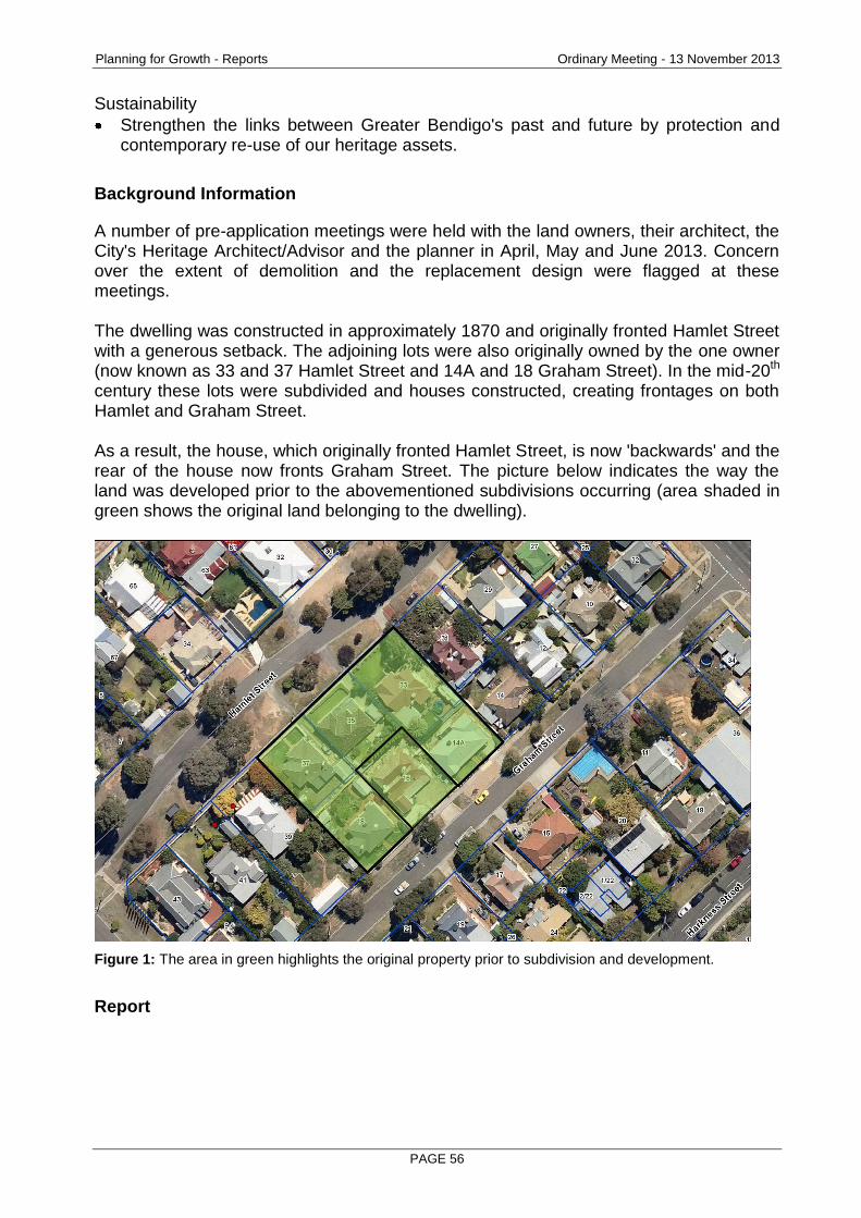
Planning for Growth - Reports Ordinary Meeting - 13 November 2013
PAGE 56
Sustainability
Strengthen the links between Greater Bendigo's past and future by protection and contemporary re-use of our heritage assets.
Background Information
A number of pre-application meetings were held with the land owners, their architect, the City's Heritage Architect/Advisor and the planner in April, May and June 2013. Concern over the extent of demolition and the replacement design were flagged at these meetings. The dwelling was constructed in approximately 1870 and originally fronted Hamlet Street with a generous setback. The adjoining lots were also originally owned by the one owner (now known as 33 and 37 Hamlet Street and 14A and 18 Graham Street). In the mid-20th century these lots were subdivided and houses constructed, creating frontages on both Hamlet and Graham Street. As a result, the house, which originally fronted Hamlet Street, is now 'backwards' and the rear of the house now fronts Graham Street. The picture below indicates the way the land was developed prior to the abovementioned subdivisions occurring (area shaded in green shows the original land belonging to the dwelling).
Figure 1: The area in green highlights the original property prior to subdivision and development.
Report
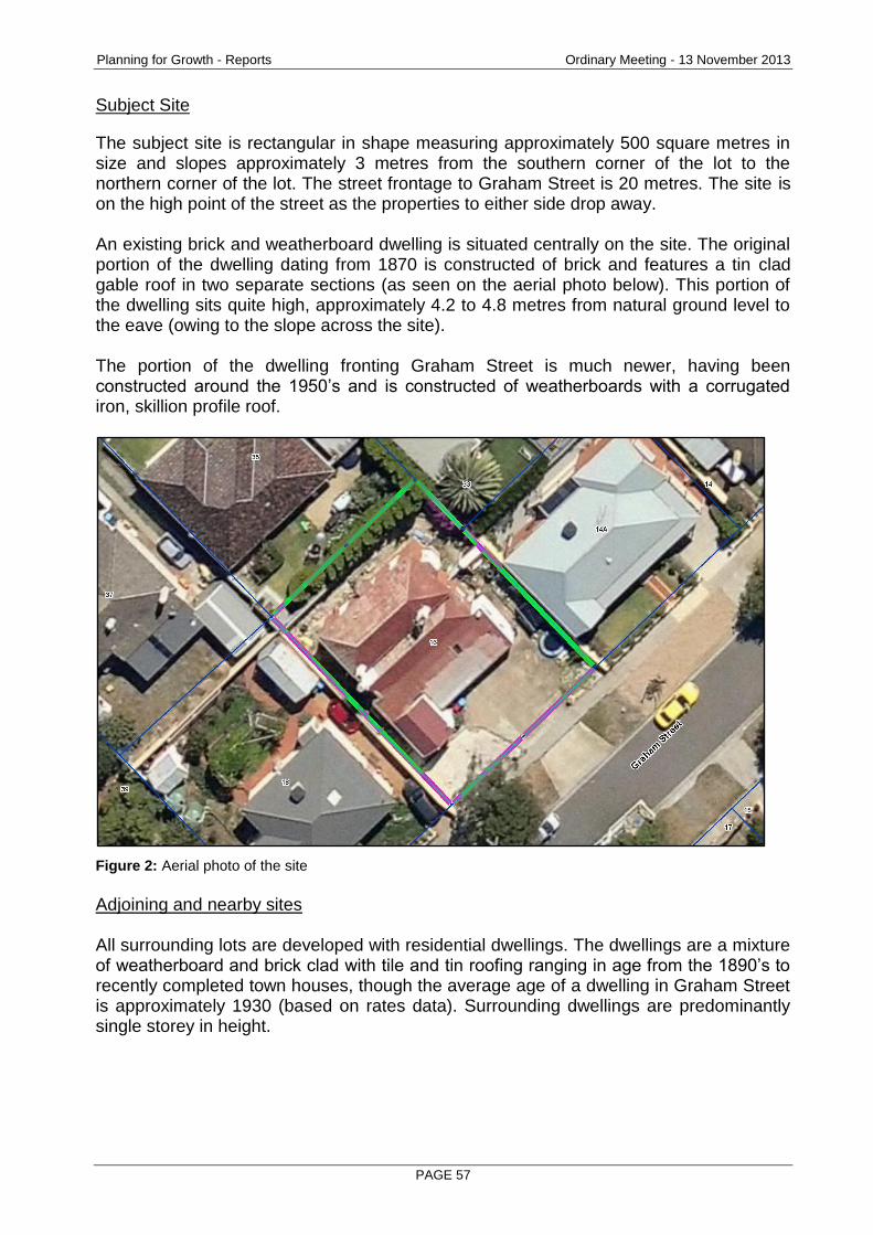
Planning for Growth - Reports Ordinary Meeting - 13 November 2013
PAGE 57
Subject Site
The subject site is rectangular in shape measuring approximately 500 square metres in size and slopes approximately 3 metres from the southern corner of the lot to the northern corner of the lot. The street frontage to Graham Street is 20 metres. The site is on the high point of the street as the properties to either side drop away. An existing brick and weatherboard dwelling is situated centrally on the site. The original portion of the dwelling dating from 1870 is constructed of brick and features a tin clad gable roof in two separate sections (as seen on the aerial photo below). This portion of the dwelling sits quite high, approximately 4.2 to 4.8 metres from natural ground level to the eave (owing to the slope across the site). The portion of the dwelling fronting Graham Street is much newer, having been constructed around the 1950’s and is constructed of weatherboards with a corrugated iron, skillion profile roof.
Figure 2: Aerial photo of the site
Adjoining and nearby sites All surrounding lots are developed with residential dwellings. The dwellings are a mixture of weatherboard and brick clad with tile and tin roofing ranging in age from the 1890’s to recently completed town houses, though the average age of a dwelling in Graham Street is approximately 1930 (based on rates data). Surrounding dwellings are predominantly single storey in height.
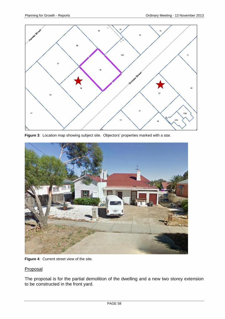
Planning for Growth - Reports Ordinary Meeting - 13 November 2013
PAGE 58
Figure 3: Location map showing subject site. Objectors’ properties marked with a star.
Figure 4: Current street view of the site.
Proposal
The proposal is for the partial demolition of the dwelling and a new two storey extension to be constructed in the front yard.
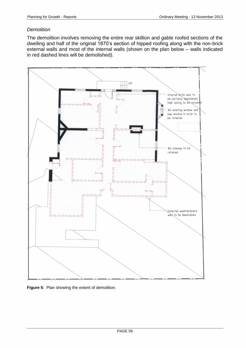
Planning for Growth - Reports Ordinary Meeting - 13 November 2013
PAGE 59
Demolition
The demolition involves removing the entire rear skillion and gable roofed sections of the dwelling and half of the original 1870’s section of hipped roofing along with the non-brick external walls and most of the internal walls (shown on the plan below – walls indicated in red dashed lines will be demolished).
Figure 5: Plan showing the extent of demolition.
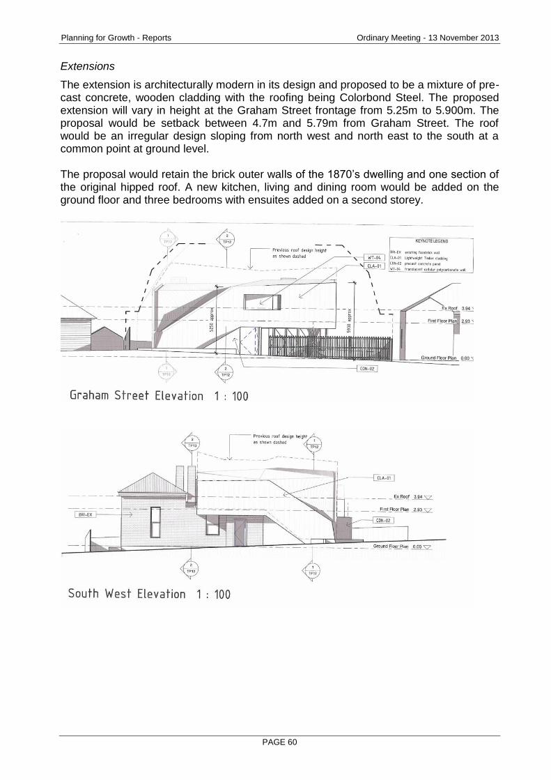
Planning for Growth - Reports Ordinary Meeting - 13 November 2013
PAGE 60
Extensions
The extension is architecturally modern in its design and proposed to be a mixture of pre-cast concrete, wooden cladding with the roofing being Colorbond Steel. The proposed extension will vary in height at the Graham Street frontage from 5.25m to 5.900m. The proposal would be setback between 4.7m and 5.79m from Graham Street. The roof would be an irregular design sloping from north west and north east to the south at a common point at ground level. The proposal would retain the brick outer walls of the 1870’s dwelling and one section of the original hipped roof. A new kitchen, living and dining room would be added on the ground floor and three bedrooms with ensuites added on a second storey.

Planning for Growth - Reports Ordinary Meeting - 13 November 2013
PAGE 61
\
Planning Controls – Greater Bendigo Planning Scheme
The following clauses are relevant in the consideration of this proposal:
Planning for Growth - Reports Ordinary Meeting - 13 November 2013
PAGE 62
State Planning Policy Framework
15 – Built Environment and Heritage Local Planning Policies
22.06 – Heritage Policy Other Provisions
43.01 – Heritage Overlay
Consultation/Communication
With the Applicant In addition to the pre-application meetings, the assessing officer had numerous discussions with the architect (applicant) about the City's concerns with the design and its impact on the streetscape. The need to modify the plans to reduce the visual bulk of the building was consistently emphasised. As noted below, the plans were modified after the consultation meeting, however, the changes were considered minor and didn't address the key issues of the building's dominance in the streetscape and compliance with the heritage controls in the Planning Scheme. Referrals The following internal department has been consulted on the proposal:
Referral Comment
Heritage Architect/Advisor The Heritage Architect/Advisor provided detail on the construction dates of the site and the historical significance of the existing building. Comment was also made stating that the proposal is not acceptable in its current form, due to the adverse effect of the extent of proposed demolition and external alterations and the adverse effect on the significance and character of the heritage place.
Public Notification The application was advertised by way of notice on the site and letters to adjoining and nearby owners and occupiers. As a result of advertising, four objections were originally received, with the grounds of objection being:
Impact the proposed design will have on the streetscape.
The proposal does not comply with the Heritage Overlay
The proposal does not enhance the existing building rather it will be dominant
Planning for Growth - Reports Ordinary Meeting - 13 November 2013
PAGE 63
A consultation meeting was held with the applicant, land owners, objectors and the Ward Councillors. Amended plans were submitted subsequent to this meeting which were sent to the objecting parties. Two objections were then withdrawn. The remaining two objections are discussed below.
Planning Assessment
ResCode Whilst the proposal is not required to be assessed under the provisions of ResCode a basic assessment of these provisions has been undertaken and the proposal is compliant. Why is the dwelling significant? Historical research has been undertaken by the Heritage Architect/Advisor which indicates that the dwelling (and land shown on the aerial photo above) was purchased by the Roberts family in 1865 and remained undeveloped until 1870 when the dwelling was constructed. The Roberts family established United Ironworks in Wills Street in 1866. The dwelling remained in the Roberts family for 57 years and had additions and improvements in 1872, 1886 and 1895. In summary the dwelling is significant due to its connection to one family, its construction date and its architectural merit. Is the proposal compliant with the heritage provisions of the Planning Scheme and will the proposed design be dominant? The proposal does not demonstrate compliance with the Planning Scheme. Clause 15 of the State Planning Policy Framework outlines that planning should achieve high quality urban design through positive contribution to urban character and sense of place, reflecting particular characteristics of the community and minimises detrimental impact on neighbouring properties (amongst others). It is acknowledged that, as a piece of architecture, the design is of high quality and could be an appropriate addition were it to the rear of the site. The difficulty with this design is that it presents to the street frontage. The design does not reflect any characteristic present in the street through design or material choice and would be imposing and dominant owing to the height, scale and proximity to the street. The City’s Heritage Policy and the Heritage Overlay go on to state that Bendigo’s heritage assets are to be maintained and protected and that new land uses and developments are sympathetic with the appearance and character of heritage places. Since the design has no link to the appearance of other heritage places in the area and is dominant owing to its size and shape the proposal does not comply with the City’s Heritage Policy or the Heritage Overlay. It is acknowledged that, where a new dwelling or extension to an existing dwelling is proposed that the design should clearly delineate the old and the new (paraphrased from the Burra Charter). This proposal is clearly new and modern, however, as the rear of the house fronts the street, the extension is to be in the front yard and would almost entirely obscure the existing 1870’s dwelling from view in Graham Street. This being the case the 1870’s dwelling would lose any remaining context and readability in the street.
Planning for Growth - Reports Ordinary Meeting - 13 November 2013
PAGE 64
Streetscape The proposal will be dominant and have a negative impact on the streetscape for a number of reasons. Firstly, the design of the proposal does not pick up on any built form from surrounding dwellings in so far as the proposal has a strong verticality owing to the overall height of the façade, is double story in height and has a large flat area of roof. Secondly, the overall height of the building is 5.9m at a 5.7m setback from the street and this height is maintained for a large portion of the frontage to Graham Street. In conclusion the design does not draw any inspirations from the existing dwelling nor any surrounding dwellings and would be visually dominant and intrusive on the streetscape.
Conclusion
The proposal does not comply with the heritage clauses of the State and Local Planning Policies as well as the Heritage Overlay. The design does not draw any inspirations from the existing dwelling nor any surrounding dwellings and would be visually dominant and intrusive on the streetscape. For these reason it is recommended Council refuse the application.
Options
Council, acting as the responsible authority for administering the planning scheme, may resolve to: grant a permit, grant a permit with conditions, or refuse to grant a permit.
Attachments
Objections.
Heritage Architect/Advisor’s Report
RECOMMENDATION
Pursuant to section 61 of the Planning and Environment Act (1987), Greater Bendigo City Council resolve to Refuse to Grant a Permit for the partial demolition of existing dwelling and extension to existing dwelling at 16 Graham Street, QUARRY HILL 3550 on the following grounds: 1. The proposal would have an adverse impact on the significance of the heritage
place contrary to the heritage provisions of the Greater Bendigo Planning Scheme.
2. Impact on the streetscape.
Planning for Growth - Reports Ordinary Meeting - 13 November 2013
PAGE 65
2.6 92 VINE STREET, BENDIGO 3550 - PARTIAL DEMOLITION TO DWELLING, DEMOLITION OF OUTBUILDINGS, ALTERATIONS AND ADDITIONS TO DWELLING
Document Information
Author Lachlan Forsyth, Statutory Planner Responsible Prue Mansfield, Director Planning & Development Director
Summary/Purpose
Application details: Partial demolition to dwelling, demolition of outbuildings, alterations and additions to dwelling
Application No: DR/582/2013
Applicant: Penno Drafting & Design
Land: 92 Vine Street, BENDIGO 3550
Zoning: Residential 1 Zone
Overlays: Heritage Overlay 11 Parking Overlay 1
No. of objections: 2
Consultation meeting held:
19 September 2013
Key considerations: Whether the proposal accords with the objectives of State and Local policies relating to heritage and the provisions of the Heritage Overlay.
Conclusion: Due to the extensive setback of the proposed double storey addition, the proposal is considered to be acceptable. The application is recommended for approval, with conditions, on the basis that it represents an acceptable planning outcome with regard to policy, Residential 1 Zone and the Heritage Overlay.
Policy Context
City of Greater Bendigo Council Plan 2013 – 2017 (2013)
Planning for Growth
Our quality of life is maintained as our City's population and economy grows.
Productivity
A diverse, strong and growing economy supports community resilience.
Sustainability
Planning for Growth - Reports Ordinary Meeting - 13 November 2013
PAGE 66
Strengthen the links between Greater Bendigo's past and future by protection and contemporary re-use of our heritage assets.
Background Information
No pre-application meetings were held with the applicant or owner before lodgement. Discussions and a meeting with the planning officer were held prior to advertising of the current application, which resulted in the applicant submitting amended plans. The main changes shown on the amended plans included a flat roofed link between the original dwelling and the second storey addition and an increased setback to the first floor south elevation wall from the common boundary. Other notable changes to the design included alterations to the roof form, lowered overall height, increased front setback and materials for the proposed garage.
Report
Subject Site and Surrounds
The subject site is a generally rectangular shaped parcel of land with an area of 589m² and a 16m frontage to Vine Street. A single storey, boom style house exists on the site which City records indicate was constructed in 1905. The house is clad in weatherboard and has a corrugated iron hipped roof featuring a small central gable and bullnose verandah. The dwelling sits within a mature garden, set back from all property boundaries. Two mature exotic trees are located in the rear yard, which are proposed to be removed to allow for the rear extension (no permit required). Vehicle access to the land is via an existing, unmade single lane crossover to Vine Street, adjacent to the northern property boundary. All adjoining land uses in the immediate vicinity are residential, with a large amount of dwellings constructed in the late Victorian and Edwardian eras. There is an abundance of single storey period homes which are mostly set in mature gardens with uniform front and side setbacks. This contributes to the strong heritage character of the precinct. The Eaglehawk and Bendigo Heritage Study describes the precinct as follows:
"This precinct contains some highly skillful designs and representative examples from the late nineteenth and early twentieth century, marking the continuous prosperity of gold in that period. Intermixed are the gold sites themselves, with public buildings such as the Lutheran Church, showing nodes of early settlement. Apart from the buildings associated with the important gold era, there are the individually important sites and groups of sites which arose from the 1920s-1930s. Many important figures also lived in the area such as Harkness, Paterson, Getzschmann and the safety fuse maker, Perry."
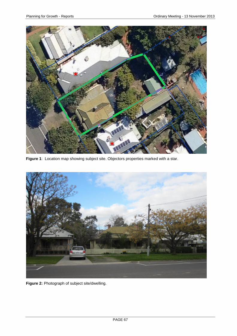
Planning for Growth - Reports Ordinary Meeting - 13 November 2013
PAGE 67
Figure 1: Location map showing subject site. Objectors properties marked with a star.
Figure 2: Photograph of subject site/dwelling.
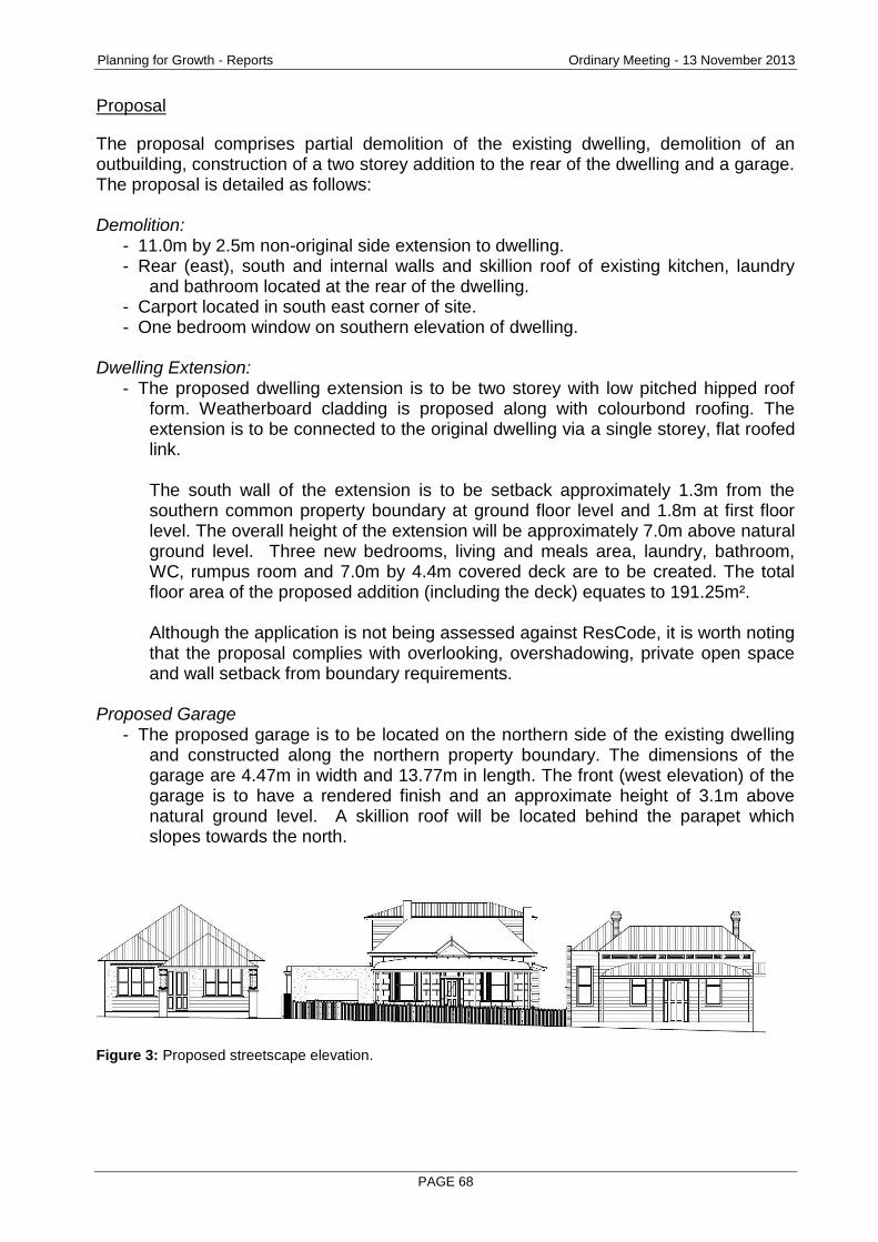
Planning for Growth - Reports Ordinary Meeting - 13 November 2013
PAGE 68
Proposal
The proposal comprises partial demolition of the existing dwelling, demolition of an outbuilding, construction of a two storey addition to the rear of the dwelling and a garage. The proposal is detailed as follows: Demolition:
- 11.0m by 2.5m non-original side extension to dwelling. - Rear (east), south and internal walls and skillion roof of existing kitchen, laundry
and bathroom located at the rear of the dwelling. - Carport located in south east corner of site. - One bedroom window on southern elevation of dwelling.
Dwelling Extension:
- The proposed dwelling extension is to be two storey with low pitched hipped roof form. Weatherboard cladding is proposed along with colourbond roofing. The extension is to be connected to the original dwelling via a single storey, flat roofed link. The south wall of the extension is to be setback approximately 1.3m from the southern common property boundary at ground floor level and 1.8m at first floor level. The overall height of the extension will be approximately 7.0m above natural ground level. Three new bedrooms, living and meals area, laundry, bathroom, WC, rumpus room and 7.0m by 4.4m covered deck are to be created. The total floor area of the proposed addition (including the deck) equates to 191.25m². Although the application is not being assessed against ResCode, it is worth noting that the proposal complies with overlooking, overshadowing, private open space and wall setback from boundary requirements.
Proposed Garage
- The proposed garage is to be located on the northern side of the existing dwelling and constructed along the northern property boundary. The dimensions of the garage are 4.47m in width and 13.77m in length. The front (west elevation) of the garage is to have a rendered finish and an approximate height of 3.1m above natural ground level. A skillion roof will be located behind the parapet which slopes towards the north.
Figure 3: Proposed streetscape elevation.
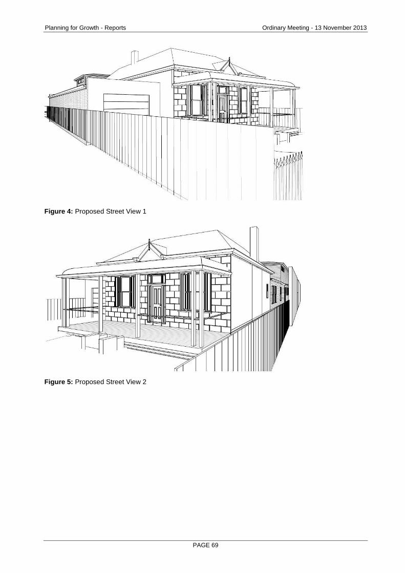
Planning for Growth - Reports Ordinary Meeting - 13 November 2013
PAGE 69
Figure 4: Proposed Street View 1
Figure 5: Proposed Street View 2
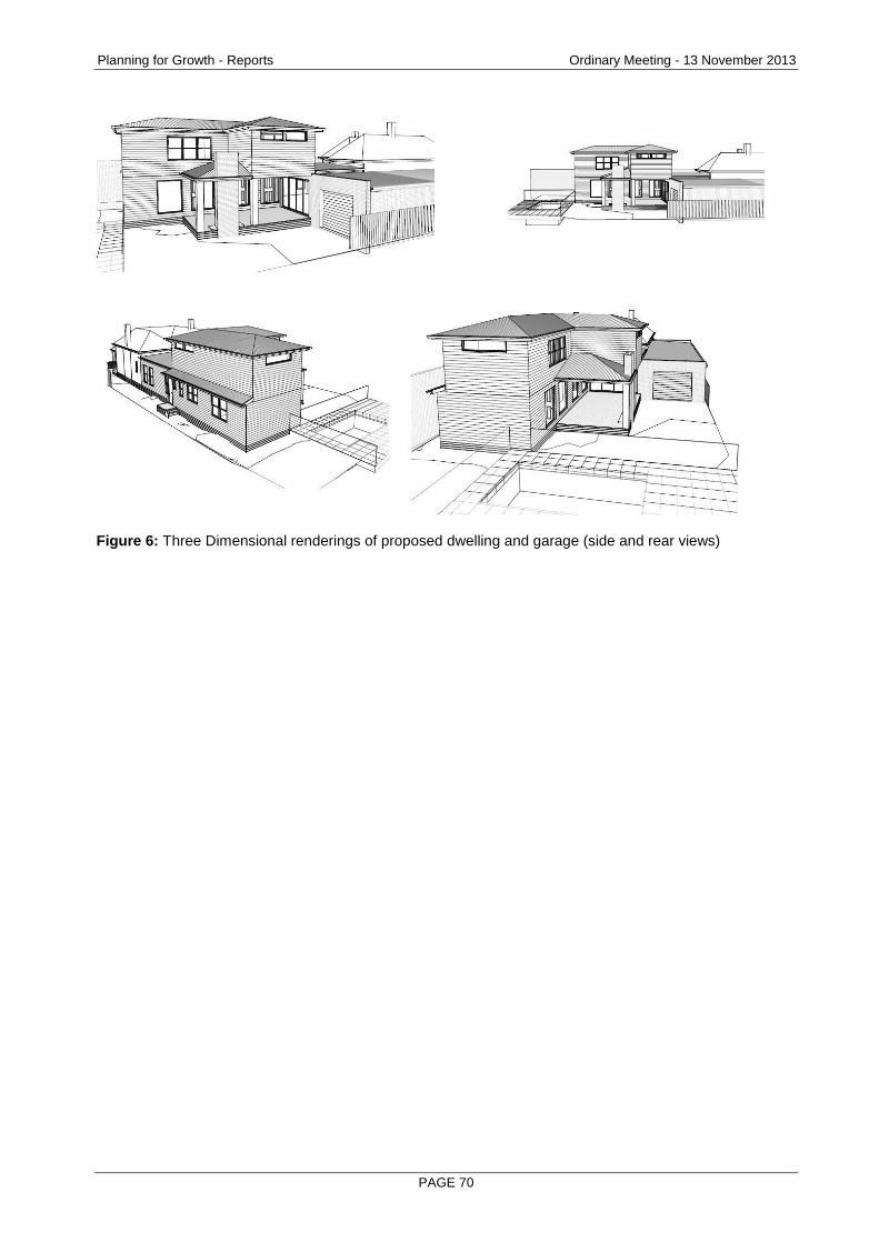
Planning for Growth - Reports Ordinary Meeting - 13 November 2013
PAGE 70
Figure 6: Three Dimensional renderings of proposed dwelling and garage (side and rear views)
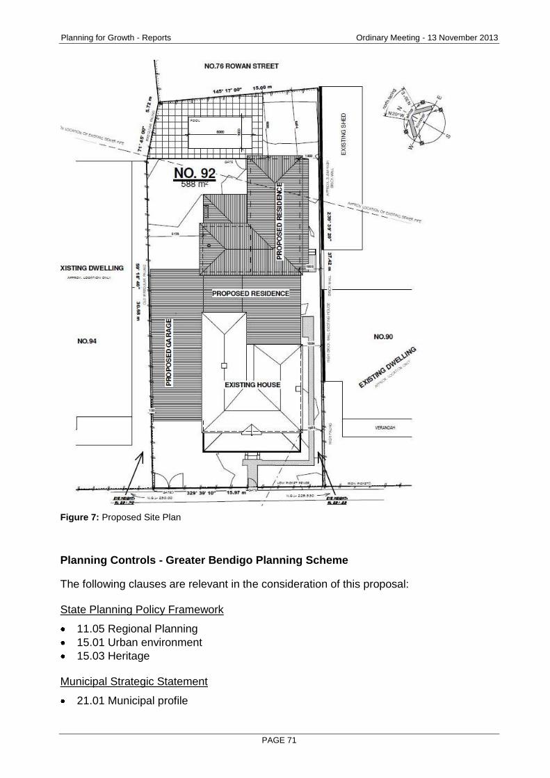
Planning for Growth - Reports Ordinary Meeting - 13 November 2013
PAGE 71
Figure 7: Proposed Site Plan
Planning Controls - Greater Bendigo Planning Scheme
The following clauses are relevant in the consideration of this proposal: State Planning Policy Framework
11.05 Regional Planning
15.01 Urban environment
15.03 Heritage Municipal Strategic Statement
21.01 Municipal profile
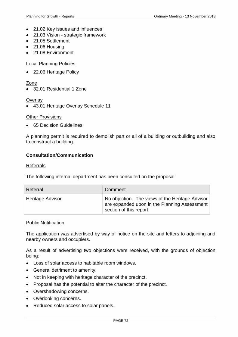
Planning for Growth - Reports Ordinary Meeting - 13 November 2013
PAGE 72
21.02 Key issues and influences
21.03 Vision - strategic framework
21.05 Settlement
21.06 Housing
21.08 Environment Local Planning Policies
22.06 Heritage Policy Zone
32.01 Residential 1 Zone Overlay
43.01 Heritage Overlay Schedule 11 Other Provisions
65 Decision Guidelines A planning permit is required to demolish part or all of a building or outbuilding and also to construct a building.
Consultation/Communication
Referrals The following internal department has been consulted on the proposal:
Referral Comment
Heritage Advisor No objection. The views of the Heritage Advisor are expanded upon in the Planning Assessment section of this report.
Public Notification The application was advertised by way of notice on the site and letters to adjoining and nearby owners and occupiers. As a result of advertising two objections were received, with the grounds of objection being:
Loss of solar access to habitable room windows.
General detriment to amenity.
Not in keeping with heritage character of the precinct.
Proposal has the potential to alter the character of the precinct.
Overshadowing concerns.
Overlooking concerns.
Reduced solar access to solar panels.

Planning for Growth - Reports Ordinary Meeting - 13 November 2013
PAGE 73
Negative impacts on property values.
Garage built to boundary is out of character with surrounding houses which are predominately detached, stand-alone dwellings.
A consultation meeting attended by both objecting parties, the owner and applicant, the planning officer and land use coordinator was conducted on 19 September. No objections were resolved. The objections are discussed below.
Planning Assessment
Does the proposal, accord with the objectives of State and Local policies relating to Heritage and the provisions of the Heritage Overlay? The Planning Scheme includes statewide policies which provide a framework to ensure decisions are made which provide appropriate heritage outcomes. Of particular relevance are the following strategies: Clause 15.01-2 Urban design principles - Heritage - New development should respect, but not simply copy, historic precedents and create a worthy legacy for future generations. Clause 15.03-1 Heritage Conservation - Ensure an appropriate setting and context for heritage places is maintained or enhanced and to encourage appropriate development that respects places with identified heritage values. At a local policy level Clause 21.08 Environment and Clause 22.06 Heritage Policy set out objectives which include the need to ensure that Greater Bendigo’s heritage assets are maintained and protected and to ensure developments are sympathetic with the appearance and character of heritage places. The majority of the objectives of the City’s Heritage Policy (Clause 22.06) are relevant to this proposal including:
To ensure that Greater Bendigo’s heritage assets are maintained and protected.
To ensure that new land uses and developments are sympathetic with the appearance and character of heritage places.
To retain heritage assets for the enjoyment and experience of residents, visitors and future generations of the municipality.
To encourage sympathetic reuse of heritage places so that such places are maintained and enhanced.
The purpose of Clause 43.01 Heritage Overlay, relevant to this proposal is to ensure that development does not adversely affect the significance of heritage places. The decision guidelines of the clause reflect this with the most relevant being the following:
Whether the location, bulk, form or appearance of the proposed building will adversely affect the significance of the heritage place.
Whether the location, bulk, form or appearance of the proposed building will adversely affect the significance of the heritage place and is in keeping with adjacent buildings.
Planning for Growth - Reports Ordinary Meeting - 13 November 2013
PAGE 74
The Eaglehawk and Bendigo Heritage Study identified the application site as containing a dwelling of individual significance as well as contributing to a broader heritage precinct, hence the presence of the Heritage Overlay which is the main reason why a permit is required. Heritage advice provided by the City’s Heritage Advisor is that the proposal will not have an adverse impact on the place or precinct. The heritage advice concluded that:
"The location, form and appearance of the proposed additions will not have a significant adverse effect on the significance of the heritage place because of the depth of set back of the two storey section from the street. The weatherboard walls and hipped roof form of the rear addition are in keeping with the heritage precinct. The overall bulk of the proposed additions will have some impact on the heritage precinct, but not a significant impact from the public realm. The proposed additions allow for continued prominence of the house due to the substantial setback. The proposed additions allow the original roof form to be read. The additions do not include any mock heritage details that could confuse an understanding of the development of the place. The form of the additions where visible from the public realm generally respects the existing building, except perhaps, in regard to bulk. However, the setback means that the impact of the increased bulk of the addition does not have a significant impact from the public realm." The assessing officer is in agreement with the expert opinion provided by the City’s Heritage Advisor. It is acknowledged that the proposed building will be visible from the public realm and that it will introduce a new two storey element to the streetscape, which is currently single storey. It is also acknowledged that the second storey form and bulk of the proposed building may have some impact on the heritage precinct. With consideration to this, the City’s assessment is that it will not unreasonably impact either the site or precinct due to the substantial setback of the proposed second storey. The original dwelling will retain its visual prominence within the streetscape and the proposed materials and general architectural style of the extension will not detract from the existing or adjoining dwellings. The proposed approval conditions include a requirement for the retention of the existing bedroom window on the southern elevation. The full recommendation of the City’s Heritage Advisor is included as an attachment to this report. Residents' Objection Issues raised by the objectors (the merit of the overall design response and ResCode) have been canvassed earlier in this report. Some further specific issues are responded to as follows:
Overlooking, overshadowing and solar access to solar panels concerns.
Planning for Growth - Reports Ordinary Meeting - 13 November 2013
PAGE 75
Whilst it is acknowledged that the proposed development has some potential to raise some amenity concerns, the application cannot be assessed against ResCode as the requirement for the planning permit is only triggered by the Heritage Overlay and as such, can only be assessed against the decision guidelines of the Heritage Overlay. Despite this, it is noted that all windows of the proposed development comply with ResCode as windows are either setback a minimum nine metres from adjoining habitable room windows and private open space areas or have minimum sill heights of 1.7m above finished floor level. Shadow diagrams submitted with the application show that the proposal complies with the overshadowing standard of ResCode and that solar panels on adjoining properties will not be blocked from the sun. The potential overshadowing caused by the proposed double storey extension will only be slightly increased on that already caused by the existing 3.8m high brick boundary wall. It is also noted that if a building permit were to be issued, the proposal would be required to meet these standards in accordance with the Building Regulations 2006.
Negative impacts on property values. Devaluation has been repeatedly tested at VCAT in the past. VCAT has determined that devaluation must be substantiated and therefore has rarely been successfully argued as a ground for appeal. It is uncertain whether the proposal will indeed affect the value of any adjoining property.
Garage built to boundary is out of character with surrounding houses which are predominately detached, stand-alone dwellings. It is considered that the proposed garage will not have a significant impact on the appearance or character of the precinct due to its setback behind the dwelling façade and its simple design. It is acknowledged that its siting may have some impact on dwelling spacing within the streetscape, however these effects are considered to be minor. The subject dwelling will remain detached from both abutting properties.
Garage built to boundary may reduce solar access to adjacent habitable room windows. It is noted that the subject habitable room windows are located on the southern elevation of the affected property (94 Vine Street). As such, the proposed development on the subject site will not reduce direct solar access to these windows. Following the consultation meeting the applicant amended the development plans to slightly reduce the overall abutting wall height of the garage to 2.9m.
Conclusion
In conclusion, the application is recommended for approval on the basis that it represents an acceptable planning outcome with regard to policy, Residential 1 Zone and the Heritage Overlay. It is considered that the proposal will not cause unreasonable and/or significant detriment to the established heritage values or character of the precinct.
Planning for Growth - Reports Ordinary Meeting - 13 November 2013
PAGE 76
It is recommended that a Notice of Decision to Grant a Permit be issued subject to conditions.
Options
Council, acting as the responsible authority, may resolve to approve or refuse to grant a permit.
Attachments
Objections
Heritage Advisor's Report
RECOMMENDATION
Pursuant to section 61 of the Planning and Environment Act (1987), Greater Bendigo City Council resolve to issue a Notice of Decision to Grant a Permit for Partial demolition to dwelling, demolition of outbuildings, alterations and additions to dwelling at 92 Vine Street, BENDIGO 3550 subject to the following conditions: 1. MODIFIED PLAN REQUIRED
Before the use and development starts, amended plans to the satisfaction of the responsible authority must be submitted to and approved by the responsible authority. When approved, the plans will be endorsed and will then form part of the permit. The plans must be drawn to scale with dimensions and two copies must be provided. The plans must be generally in accordance with the plans submitted with the application but modified to show: (a) The existing bedroom window on the southern elevation to be retained.
2. NO ALTERATION TO LAYOUT The use and development permitted by this permit as shown on the endorsed plans or described in the endorsed documents must not be altered or modified (for any reason) except with the prior written consent of the responsible authority.
3. GENERAL DRAINAGE – BUILDINGS AND HOUSES The development must be drained to the satisfaction of the City of Greater Bendigo as the responsible drainage authority.
4. CONSENT FOR WORK ON ROAD RESERVES A Works within Road Reserves permit must be obtained from the City of Greater Bendigo Asset Planning & Design Unit prior to any work commencing in the road reserve. The applicant must comply with;
The Road Management Act 2004,
Road Management (Works and Infrastructure) Regulations 2005, and
Road Management (General) Regulations 2005. with respect to any requirements to notify the Coordinating Authority and/or
Planning for Growth - Reports Ordinary Meeting - 13 November 2013
PAGE 77
seek consent from the Coordinating Authority to undertake “works” (as defined in the Act) in, over or under the road reserve. The responsible authority in the inclusion of this note on this planning permit is not deemed to have been notified of, or to have given consent, to undertake any works within the road reserve as proposed in this permit.
5. VEHICLE CROSSING Vehicular access to the subject land from any roadway or service lane (and vice versa) must be by way of a vehicle crossing(s) constructed at right angles to the road, to suit the proposed driveway(s) and vehicles that will use the crossing. A Works within Road Reserves permit must be obtained from the City of Greater Bendigo Asset Planning & Design Unit prior to any work commencing in the road reserve.
6. PAVING OF CROSSOVERS AND DRIVEWAYS Before the development starts, the materials and detailed design of all crossovers and driveways must be submitted to and approved by the responsible authority. The development of the crossovers and driveways must then accord with the approved materials and design.
Note: This development has been assessed and approved under the Planning Scheme provisions (Heritage Overlay) only. This approval does not indicate that requirements of Part 4 of the Building Regulations 2006 have been satisfied.
Planning for Growth - Reports Ordinary Meeting - 13 November 2013
PAGE 78
2.7 CA 20 DERBY ROAD, WOODVALE 3556 - USE AND DEVELOPMENT OF A DWELLING AND OUTBUILDINGS IN CONJUNCTION WITH AGRICULTURE (MUSHROOM GROWING AND GRAZING)
Document Information
Author Peter O'Brien, Senior Planner Responsible Prue Mansfield, Director Planning & Development Director
Summary/Purpose
Application details: Use and development of a dwelling and outbuildings in conjunction with agriculture (mushroom growing and grazing)
Application No: DR/604/2013
Applicant: D Sloan
Land: CA 20 Derby Road, WOODVALE 3556
Zoning: Farming Zone
Overlays: Bushfire Management Overlay (front 85 metres of the site only).
No. of objections: 1
Consultation meeting held:
No consultation meeting was conducted as the objectors did not want to participate. A written response to the objection received (prepared by the permit applicant) was forwarded to the objector.
Key consideration: Whether a dwelling is reasonably required on the land in support of the proposed agricultural use;
Whether the dwelling meets mandatory Planning Scheme requirements for dwellings in rural areas, including access, waste water disposal, water and electricity supply;
Offsite impacts and
Objector concerns.
Conclusion: The applicant concedes that the agricultural use will not be financially viable for the first three years after commencement and will rely upon an offsite income in this period. Despite this, the applicant has satisfactorily demonstrated that a dwelling will be a secondary use of the land with agriculture maintaining primacy which is the desired policy outcome for dwellings in most rural areas. The design and siting of the dwelling meets planning scheme defined standards and offsite impacts, particularly associated with mushroom production are proposed to be regulated by permit conditions.
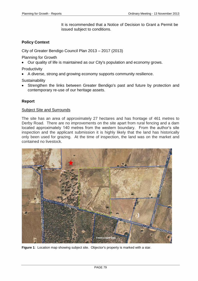
Planning for Growth - Reports Ordinary Meeting - 13 November 2013
PAGE 79
It is recommended that a Notice of Decision to Grant a Permit be issued subject to conditions.
Policy Context
City of Greater Bendigo Council Plan 2013 – 2017 (2013)
Planning for Growth
Our quality of life is maintained as our City's population and economy grows.
Productivity
A diverse, strong and growing economy supports community resilience.
Sustainability
Strengthen the links between Greater Bendigo's past and future by protection and contemporary re-use of our heritage assets.
Report
Subject Site and Surrounds
The site has an area of approximately 27 hectares and has frontage of 461 metres to Derby Road. There are no improvements on the site apart from rural fencing and a dam located approximately 140 metres from the western boundary. From the author’s site inspection and the applicant submission it is highly likely that the land has historically only been used for grazing. At the time of inspection, the land was on the market and contained no livestock.
Figure 1: Location map showing subject site. Objector's property is marked with a star.
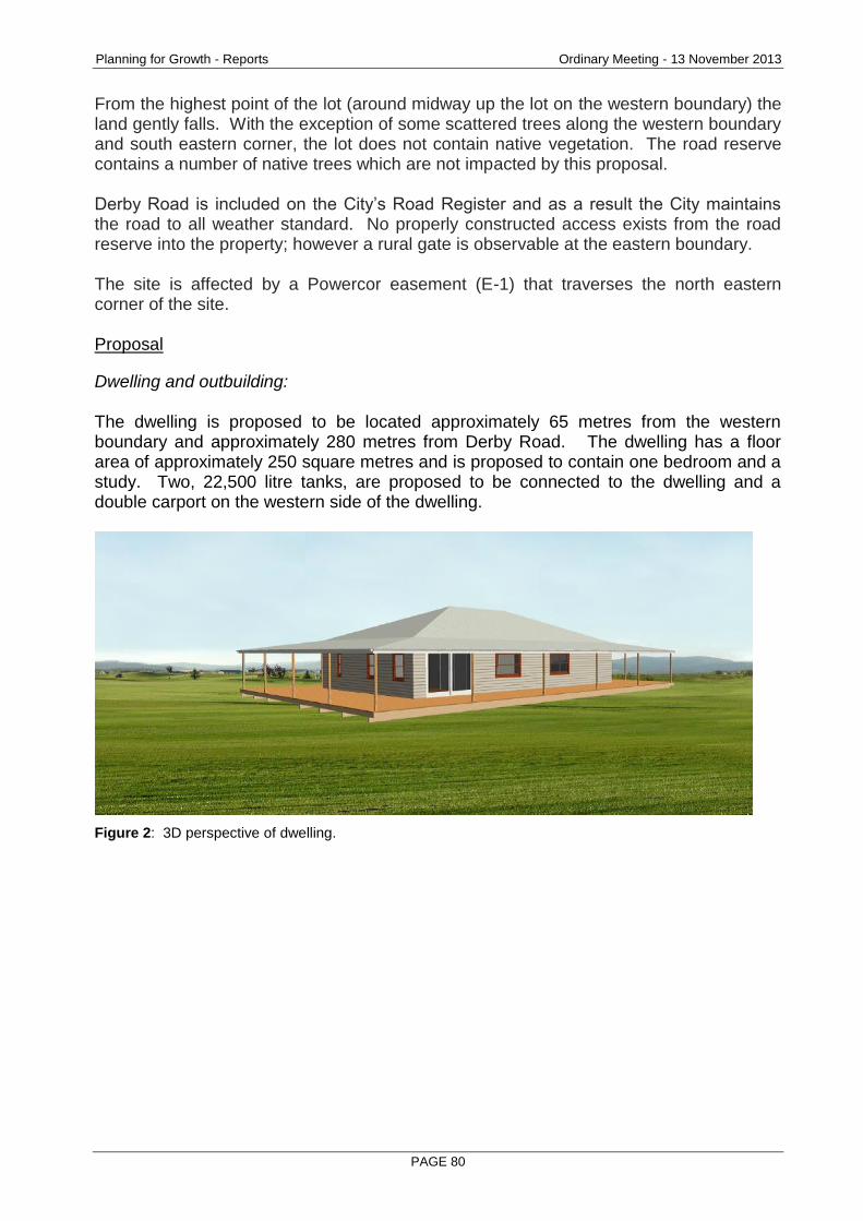
Planning for Growth - Reports Ordinary Meeting - 13 November 2013
PAGE 80
From the highest point of the lot (around midway up the lot on the western boundary) the land gently falls. With the exception of some scattered trees along the western boundary and south eastern corner, the lot does not contain native vegetation. The road reserve contains a number of native trees which are not impacted by this proposal. Derby Road is included on the City’s Road Register and as a result the City maintains the road to all weather standard. No properly constructed access exists from the road reserve into the property; however a rural gate is observable at the eastern boundary. The site is affected by a Powercor easement (E-1) that traverses the north eastern corner of the site. Proposal
Dwelling and outbuilding: The dwelling is proposed to be located approximately 65 metres from the western boundary and approximately 280 metres from Derby Road. The dwelling has a floor area of approximately 250 square metres and is proposed to contain one bedroom and a study. Two, 22,500 litre tanks, are proposed to be connected to the dwelling and a double carport on the western side of the dwelling.
Figure 2: 3D perspective of dwelling.
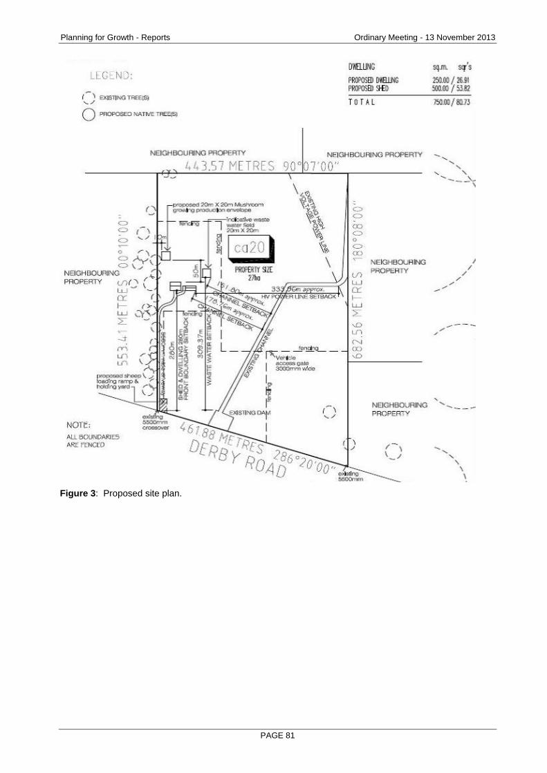
Planning for Growth - Reports Ordinary Meeting - 13 November 2013
PAGE 81
Figure 3: Proposed site plan.
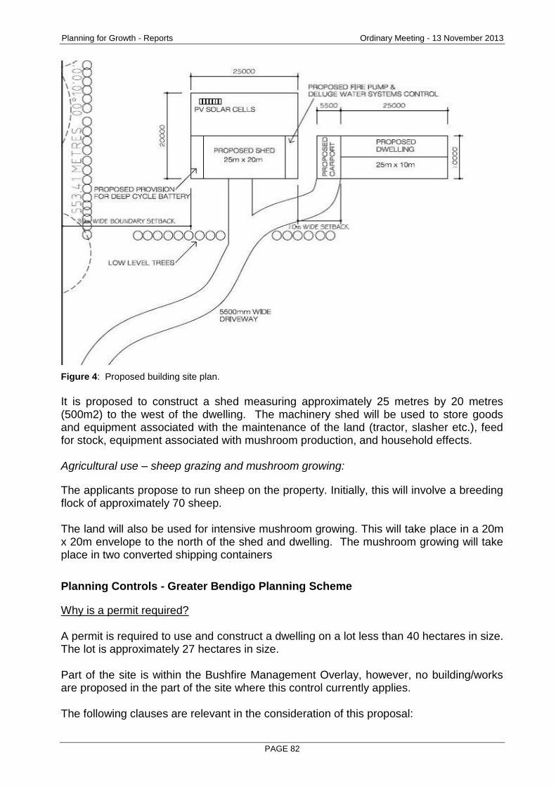
Planning for Growth - Reports Ordinary Meeting - 13 November 2013
PAGE 82
Figure 4: Proposed building site plan.
It is proposed to construct a shed measuring approximately 25 metres by 20 metres (500m2) to the west of the dwelling. The machinery shed will be used to store goods and equipment associated with the maintenance of the land (tractor, slasher etc.), feed for stock, equipment associated with mushroom production, and household effects. Agricultural use – sheep grazing and mushroom growing:
The applicants propose to run sheep on the property. Initially, this will involve a breeding flock of approximately 70 sheep. The land will also be used for intensive mushroom growing. This will take place in a 20m x 20m envelope to the north of the shed and dwelling. The mushroom growing will take place in two converted shipping containers
Planning Controls - Greater Bendigo Planning Scheme
Why is a permit required? A permit is required to use and construct a dwelling on a lot less than 40 hectares in size. The lot is approximately 27 hectares in size. Part of the site is within the Bushfire Management Overlay, however, no building/works are proposed in the part of the site where this control currently applies. The following clauses are relevant in the consideration of this proposal:
Planning for Growth - Reports Ordinary Meeting - 13 November 2013
PAGE 83
State Planning Policy Framework
11.05-3 Rural productivity
14.01 Agriculture
14.01-1 Protection of agricultural land
14.01-2 Sustainable agricultural land use Municipal Strategic Statement
21.05 Settlement
21.07 Agriculture Local Planning Policies
22.02 Rural Dwellings Policy Other Provisions
35.07 Farming Zone
44.06 Bushfire Management Overlay
65 General Provisions
Consultation/Communication
Referrals The following authorities and internal departments have been consulted on the proposal:
Referral Comment
Country Fire Authority No objection subject to conditions.
Environment Protection Authority
No objection subject to conditions relating to odour, noise and runoff.
Environmental Health No objection subject to an advisory note stating a septic tank permit is required.
Traffic and Design No objection subject to conditions regarding the standard that the all-weather driveway is required to be constructed to.
Public Notification The application was advertised by way of notice on the site and letters to adjoining and nearby owners and occupiers. As a result of advertising, 1 objection was received, with the grounds of objection being:
Concern that the size of the property cannot contain the number of sheep proposed, weeds requiring eradication exist on the property and sheep shearing, drenching and dipping facilities are not catered for in the proposal.

Planning for Growth - Reports Ordinary Meeting - 13 November 2013
PAGE 84
Applicant may not be able to contain fire risk on the property.
Development on the site will mean it is no longer attractive to native fauna which currently reside on the property. The loss of habitat may result in fauna becoming a danger to motorists.
Stone reef on the site has been subject to periodic lightning strikes.
Concern that the dwelling will only be a ‘weekender’. The objections are discussed below.
Planning Assessment
The Greater Bendigo Planning Scheme supports residential development within the urban growth boundary for Bendigo (and other appropriate zones such as Township, Low Density Residential and Rural Living). The subject site is neither within the urban growth boundary, nor in a zone where dwellings are encouraged. Dwellings under both State and local policies are only generally supported where there is associated infrastructure such as public transport, retailing, schools and open space. These elements are absent in the context of the subject site. State policy objectives at clause 11.05-3 Rural productivity seek to protect agriculture by having objectives to:
Prevent inappropriately dispersed urban activities in rural areas.
Limit new housing development in rural areas, including: Discouraging development of isolated small lots in the rural zones from use for
single dwellings, rural living or other incompatible uses. Clauses 14.01 Agriculture & 14.01-1 Protection of agricultural land have objectives to protect productive farmland. The local provisions of the Planning Scheme in the Municipal Strategic Statement clause 21.07 – Agriculture includes statements of policy relevant to this proposal as follows:
To identify and protect productive agricultural land from competing inappropriate land uses.
To ensure protection of productive rural assets including land and water.
To maintain potential for agricultural production.
To minimise the fragmentation of productive agricultural land units. Council’s Rural dwellings policy at clause 22.02 builds upon the Municipal Strategic Statement with objectives:
To discourage the fragmentation of rural land, or land with significant environmental values.
To ensure that existing agricultural enterprises in the Farming Zone are not placed under pressure from the encroachment of residential activities.
To limit the subdivision, use or development of land to that which is compatible with the utilisation of the land as a sustainable agricultural resource.
To discourage the construction of dwellings on existing small lots within the Farming Zone.
Planning for Growth - Reports Ordinary Meeting - 13 November 2013
PAGE 85
The City’s adopted Rural Area Strategy seeks to strengthen the position with respect to rural dwellings, noting that ‘the primary trend in broad acre agriculture (cropping and grazing) is expansion and growth, very few new dwellings are legitimately required for such properties’ & the ‘strategy proposes to minimise housing in Farming zoned areas as new housing development is considered the greatest threat to the viability of the local agricultural sector as they compromise the ability of local businesses to grow and operate relatively unhindered’. The context of this area is relevant and there are examples of dwellings on other lots along Derby Road, in particular those which are closer to the Loddon Valley Highway to the east of the subject site. Genardinis Lane in particular has a rural living character and there have been recent dwelling approvals along this lane. The lots in Genardis Lane, however, were actually created by a Planning Permit issued by the former Shire of Marong and this is highly relevant as one of the exceptions to the policy of discouraging dwellings is in cases where ‘subdivisions have been created since the introduction of planning controls’. In short, the thrust of the policy is that dwellings (in the absence of a bona fide genuine agricultural use) are not encouraged as residential use in particular runs counter to high level State and local policy objectives to retain and protect productive agricultural land. The decision for Council in this case is a difficult one. In coming to the view that a dwelling is acceptable on this land, Council must form a positive view on the following propositions:
Will a dwelling on this land, coupled with the proposed agricultural uses ensure the land is returned to being used in a productive way?
At the current time, the land is not used in any particular way and has only been used for grazing in the past. Grazing in itself on a lot as a small as this site is not, in itself, a productive agricultural use. The applicant’s Farming Business Plan submitted in the support of the application (covering the first 10 years of the farm) notes that the mushroom aspect of the proposal is the use which will ultimately provide the majority of the income generated by the farm. The applicant's submission does note that in the first 3 years of the farm, an offsite income will be required, however, after that time the farm will be profitable.
The author is satisfied that the proposal as outlined will see the land returned to being used in a productive way.
Is the intensity of the agricultural use on the land such that it warrants fulltime onsite management and justifies the dwelling?
Sheep grazing is not an activity that requires constant onsite management; however, the applicant has been able to demonstrate that to successfully grow mushrooms, active management is required. The author is satisfied that a dwelling on the land is genuinely required to support agriculture.
Whether the dwelling meets mandatory Planning Scheme requirements for dwellings in rural areas including access, waste water disposal, water and electricity supply?
Planning for Growth - Reports Ordinary Meeting - 13 November 2013
PAGE 86
The Planning Scheme requires that dwellings must meet all the requirements noted above; otherwise a dwelling becomes a prohibited use in the zone. The proposed dwelling meets the requirements as follows:
Access – Derby Road is in the City’s Road Register for its entire length. This means that the permit applicant is not required to upgrade Derby Road to ‘all weather standard’, however, the requirement is that all weather standard be to the actual dwelling. The recommended conditions include the specific means to achieve this standard as nominated by the City’s Transport Engineer.
Sewer - Reticulated sewer is not available in the area. Referral comment from the City of Greater Bendigo Environmental Health and Local Laws Unit was sought and they confirmed that the site is suitable for onsite disposal subject to a Septic Permit.
Water – Reticulated water is not available in the area. The applicant has nominated that two water tanks will be used to meet this requirement. This requirement is also included in the recommended conditions.
Electricity Supply – Power is available to the site and a power line easement traverse the site; however the applicant does not intend at this time to connect to this service. Instead, the proposal is to use of solar panels with battery storage which will be supplemented by wind generated power and back-up diesel generators.
Can the impacts, in particular offsite impacts, of the mushroom farming aspect of the proposal be appropriately managed?
Early in the process the application was referred to the Environment Protection Authority for comment as mushroom farming, if not appropriately managed has potential to cause off site impacts from odour and other risks to the environment in terms of concentrated nutrients finding their way into waterways. The applicant met with the Environment Protection Authority to discuss the proposal and sharing of information between the parties resulted in refinements to the methods proposed to be used. The Environment Protection Authority supports the application, subject to conditions which have been included in the recommended conditions.
Merits of the objection:
The objector and their ancestors have been farming the adjoining and nearby land since 1901 and as such have a unique insight and perspective into farming and land management issues more broadly in the area. There is a great deal that the applicant could learn from the objector in this regard which would be mutually beneficial to both parties. The objector is concerned essentially that the potential for inappropriate land management and farming practices on the land may impact upon them and as such have exercised their legal right to object to the application and have the application determined by Council. The objector indicated that they were concerned that the size of the property cannot contain the number of sheep proposed, weeds requiring eradication exist on the property and sheep shearing, drenching and dipping facilities are not catered for in the proposal.
Planning for Growth - Reports Ordinary Meeting - 13 November 2013
PAGE 87
The application plans do show a loading ramp and holding yard at the front of the site where some of the routine activities could occur, shearing could occur in the outbuilding proposed, however, the number of sheep proposed would not justify a shearing shed. With regard to the numbers, the applicant indicates that if the numbers proposed are not sustainable on the land area that a combination of supplementary feeding or reducing numbers would be employed to address this issue. As has been outlined previously, the sheep aspect of the use in itself does not justify the dwelling. With regard to the issue of fire risk, part of the site (the front 85 metres) is within a Bushfire Management Overlay. None of the development proposed is within the overlay affected area. The City sought advice from the CFA on the implications of this issue, however, despite several follow up requests for advice no response has been forthcoming at the time this report was written. The issue of risk is proposed to be addressed more broadly in that the dwelling is to be sited in an un-treed part of the site (providing defendable space around the dwelling) and will be constructed in accordance with building code requirements and the determined Bushfire Attack Level of the dwelling. Permit conditions propose that part of the static water for the site must be dedicated for firefighting purposes and the applicant's submission outlines that diesel generators on site would be able to power pumps for the purpose of firefighting. Concern about the site no longer being attractive to native fauna and lightning strike risk are difficult to address and fall outside the matters that a planning permit process can actively consider. With regard to the concern that the dwelling will only be a ‘weekender’, essentially if the submission and supporting information suggested this, the recommendation of the author would be that the application be refused. The Rural Living Zone exists for that that sort of occasional use. The applicant has sought to demonstrate that they are genuine in their intention to be good custodians of the land and were prepared to sign a statutory declaration that the dwelling will not be a ‘weekender’.
Conclusion
The applicant concedes that the agricultural use will not be financially viable for the first three years after commencement and will rely upon an offsite income in this period. Despite this, the applicant has demonstrated to the satisfaction of the author that a dwelling will be a secondary use of the land with agricultural maintaining primacy. Primacy of agriculture is the desired policy outcome for dwellings in most rural areas in our municipality. The design and siting of the dwelling meets planning scheme defined standards and offsite impacts, particularly associated with mushroom production are proposed to be regulated by permit conditions. It is recommended that a Notice of Decision to Grant a Permit be issued subject to conditions.

Planning for Growth - Reports Ordinary Meeting - 13 November 2013
PAGE 88
Options
Council, acting as the responsible authority for administering the planning scheme, may resolve to: grant a permit, grant a permit with conditions, or refuse to grant a permit.
Attachments
Objection and
Applicant response to objection.
Planning for Growth - Reports Ordinary Meeting - 13 November 2013
PAGE 89
RECOMMENDATION
Pursuant to section 61 of the Planning and Environment Act (1987), Greater Bendigo City Council resolve to issue a Notice of Decision to Grant a Permit for the Use and development of a dwelling and outbuildings in conjunction with agriculture (mushroom growing and grazing) at CA 20 Derby Road, WOODVALE 3556 subject to the following conditions:
1. MODIFIED PLANs REQUIRED Before the use and development starts, amended plans to the satisfaction of the responsible authority must be submitted to and approved by the responsible authority. When approved, the plans will be endorsed and will then form part of the permit. The plans must be drawn to scale with dimensions and three copies must be provided. The plans must be generally in accordance with the plans submitted with the application but modified to show: (a) Floor and elevation plans of the dwelling and sheds. (b) Plans noting that the outbuilding and proposed shipping containers will be
painted or coloured in muted, natural colours (greens and browns for example).
(c) A modified site plan in accordance with Environment Protection Authority Condition 4 (c).
(d) A modified site plan to show the access being constructed in accordance with the standards in conditions 6 and 8.
2. No Layout Alteration
The use development permitted by this permit as shown on the endorsed plans or described in the endorsed documents must not be altered or modified (for any reason) except with the prior written consent of the responsible authority.
3. FARM BUSINESS PLAN The Farm Business Plan dated July 2013 submitted with the application forms part of this approval. The agricultural uses (mushroom production and sheep farming) for which the dwelling is the ancillary use must not be modified or altered without the prior consent of the responsible authority.
4. ENVIRONMENT PROTECTION AUTHORTY CONDITIONS (a) Offensive odours must not be discharged beyond the boundaries of the
premises. (b) Noise emitted from the premises must not exceed the recommended levels
as set out in Noise from Industry in Regional Victoria (NIRV; EPA Publication 1411, 2011) or as amended.
(c) The applicant must install bunds and/or cut -off drains/interceptor traps around the boundary of operational area to prevent contaminated run-off entering into a waterway.
(d) A secondary containment system must be provided for liquids which if spilt are likely to cause pollution or pose an environmental hazard, in accordance with the EPA Publication 347 Bunding Guidelines 1992 or as amended.
(e) Deposit of animal or organic wastes to land must not adversely affect the land.
5. COUNTRY FIRE AUTHORITY CONDITONS – STATIC WATER SUPPLY

Planning for Growth - Reports Ordinary Meeting - 13 November 2013
PAGE 90
Prior to the initial occupation of the dwelling a static water supply must be provided on the land and must meet all of the following requirements: (a) The water supply must have a minimum capacity of 10,000 litres that is
maintained solely for fire fighting purposes. (b) The water supply must be stored in an above ground water tank constructed
of concrete, steel or corrugated iron. (c) The water supply must be located within 60 metres of the outer edge of the
dwelling (including any obstructions). (d) The water supply outlet/s must be attached to the water tank and must face
away from the building if located less than 20 metres from the building to enable access during emergencies.
(e) All pipework between the water supply and the outlet/s must be a minimum of 64 mm nominal bore.
(f) All fixed above-ground water pipelines and fittings must be of non-corrodible and non-combustible materials.
(g) The water supply must:
Be located so that fire brigade vehicles are able to get to within 4 metres of the water supply outlet.
Incorporate an additional 64 mm (minimum) gate or ball valve and 64 mm (fixed size), 3 threads per inch, male fitting to suit a CFA coupling.
Incorporate an additional ball or gate valve to provide access to the water by the resident of the dwelling.
The water supply outlet must not be obstructed by vegetation, buildings, fences or other structures.
The water supply must be readily identifiable from the building or appropriate signage to the satisfaction of CFA must be provided.
6. COUNTRY FIRE AUTHORITY CONDITONS – ACCESS
Before the occupation of the dwelling starts access to the static water supply outlet and the dwelling must be provided and must be designed to allow emergency vehicle access. The design of the access (including gates, bridges and culverts) must comply with the following minimum requirements: (a) Curves in driveway must have a minimum inner radius of 10 metres. (b) Designed, constructed and maintained for a load limit of at least 15 tonnes
and be of all-weather construction. (c) Have a minimum trafficable width of 3.5 metres and be substantially clear of
encroachments for at least 0.5 metres on each side. (d) Be clear of encroachments at least 4 metres vertically. (e) Incorporate a turning area for fire fighting vehicles close to the building must
be provided, by either:
A turning circle with a minimum radius of eight metres; or
The driveway encircling the dwelling; or
T head or Y head with a minimum formed surface of each leg being eight metres in length measured from the centre point of the head, and four metres trafficable width.
7. General Drainage – Buildings & Houses
The proposed building(s) and works must be drained to the satisfaction of the City of Greater Bendigo as the responsible drainage authority.
8. Construct a Gravel Driveway
Planning for Growth - Reports Ordinary Meeting - 13 November 2013
PAGE 91
Prior to the commencement of use, the owner must construct a gravelled driveway connecting the building envelope to Derby Road. The driveway must be constructed to the following standards: (a) 100mm of class 3 compacted crush rock, minimum 3.5m wide trafficable
width to provide all weather access for fire trucks. (b) Table drain required on the high side. (c) Passing area required every 200m and a turnaround area at the end.
9. Electricity Supply The dwelling must be connected to a reticulated electricity supply or have an alternative energy source to the satisfaction of the responsible authority.
Note – septic tank Before a building permit is issued for any works at the property, a permit to install a septic tank must be issued by the responsible authority.
Planning for Growth - Reports Ordinary Meeting - 13 November 2013
PAGE 92
2.8 48 AND LOT 4 QUEEN STREET, MANDURANG SOUTH 3551 - APPROVAL OF DEVELOPMENT PLAN AND 5 LOT SUBDIVISION OF LAND AND DEVELOPMENT OF 4 DWELLINGS AND REMOVAL OF NATIVE VEGETATION
Document Information
Author Peter O'Brien, Senior Planner Responsible Prue Mansfield, Director Planning & Development Director
Summary/Purpose
Application details: 5 lot subdivision of land and development of 4 dwellings and removal of native vegetation
Application No: DSD/743/2012
Applicant: M Floreani and P D Floreani
Land: 48 and Lot 4 Queen Street, MANDURANG SOUTH 3551
Zoning: Low Density Residential Zone
Overlays: Development Plan Overlay 4, Bushfire Management Overlay and Environmental Significance Overlay 1 (Part)
No. of submissions: 2 (plus 1 which was withdrawn)
Consultation meeting held:
17 May 2013
Key considerations: The merits of the Development Plan and planning application;
Bushfire risk associated with additional dwellings;
Effluent disposal considerations and
Submissions received.
Conclusion: The consultation process resulted in a positive change to the application resulting in all access to the dwellings now to be solely off Queen Street. The application has been assessed as appropriately addressing all the requirements of the Development Plan Overlay and all other Planning Scheme requirements. Approval of the Development Plan and the issuing of a Planning Permit are recommended.
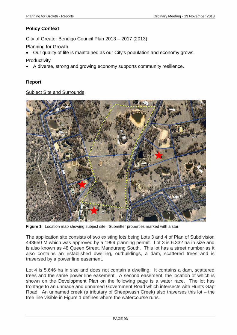
Planning for Growth - Reports Ordinary Meeting - 13 November 2013
PAGE 93
Policy Context
City of Greater Bendigo Council Plan 2013 – 2017 (2013)
Planning for Growth
Our quality of life is maintained as our City's population and economy grows.
Productivity
A diverse, strong and growing economy supports community resilience.
Report
Subject Site and Surrounds
Figure 1: Location map showing subject site. Submitter properties marked with a star.
The application site consists of two existing lots being Lots 3 and 4 of Plan of Subdivision 443650 M which was approved by a 1999 planning permit. Lot 3 is 6.332 ha in size and is also known as 48 Queen Street, Mandurang South. This lot has a street number as it also contains an established dwelling, outbuildings, a dam, scattered trees and is traversed by a power line easement. Lot 4 is 5.646 ha in size and does not contain a dwelling. It contains a dam, scattered trees and the same power line easement. A second easement, the location of which is shown on the Development Plan on the following page is a water race. The lot has frontage to an unmade and unnamed Government Road which intersects with Hunts Gap Road. An unnamed creek (a tributary of Sheepwash Creek) also traverses this lot – the tree line visible in Figure 1 defines where the watercourse runs.
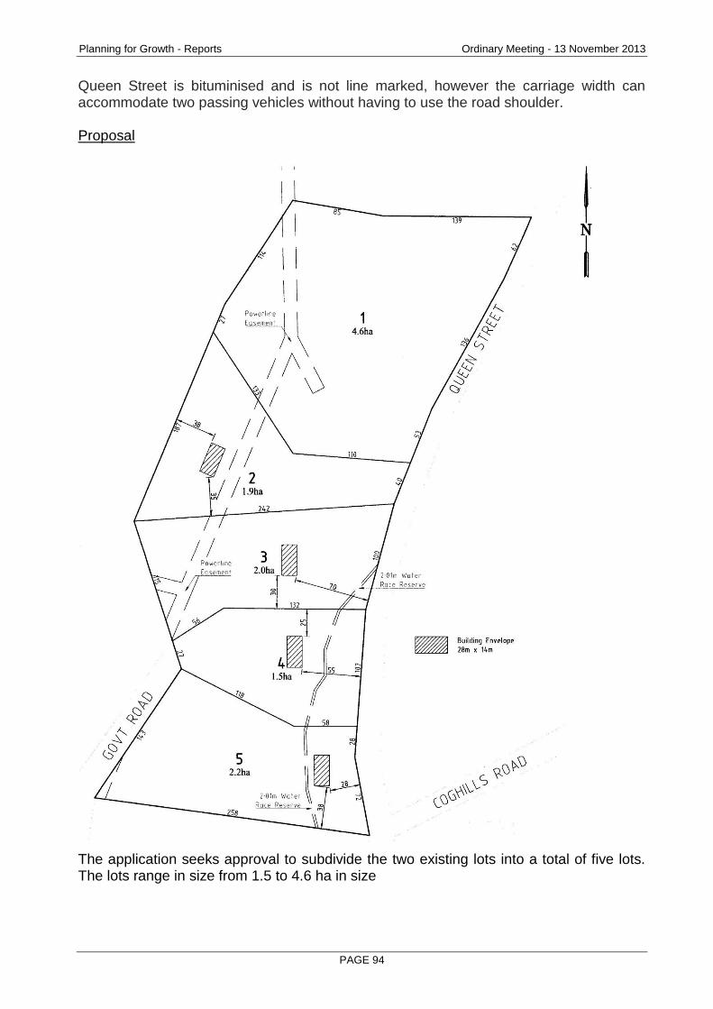
Planning for Growth - Reports Ordinary Meeting - 13 November 2013
PAGE 94
Queen Street is bituminised and is not line marked, however the carriage width can accommodate two passing vehicles without having to use the road shoulder. Proposal
The application seeks approval to subdivide the two existing lots into a total of five lots. The lots range in size from 1.5 to 4.6 ha in size
Planning for Growth - Reports Ordinary Meeting - 13 November 2013
PAGE 95
Four dwellings are proposed. The siting of the dwellings is within building envelopes which have been defined by considerations of:
bushfire management;
effluent disposal;
retention of vegetation and
access.
One of the lots (Lot 2) requires the removal of three trees in order to achieve an appropriate line of site in accordance with transport engineer advice and to meet Bushfire Attack Level (BAL) requirements.
Planning Controls - Greater Bendigo Planning Scheme
Schedule 4 (Low Density Residential Zone – Density Management Area) to the Development Plan Overlay applies to the land. Under the Development Plan Overlay a permit must not be granted to subdivide land within the development area until a Development Plan has been approved. Pursuant to the Low Density Residential Zone, Environmental Significance Overlay and Bushfire Management Overlay a planning permit is required to subdivide land. A permit to construct the dwellings is needed under the Bushfire Management Overlay. A planning permit is also required for the removal of native vegetation as per Clause 52.17 (Native Vegetation) in the Greater Bendigo Planning Scheme. The following clauses are relevant in the consideration of this proposal:
Regional development (clause 11.05).
Protection of habitat/ Native vegetation management (Clause 12.01)
Bushfire Planning (clause 13.05).
Catchment Planning and Water Management (Clause 14.02).
Housing (clause 16). Municipal Strategic Statement
Settlement (clause 21.05).
Housing (clause 21.06).
Environment (clause 21.08).
Reference documents (clause 21.10). Other Provisions
Low Density Residential Zone (clause 32.03).
Environmental Significance Overlay (clause 42.01).
Development Plan Overlay Schedule 4 (clause 43.04)
Bushfire Management Overlay (clause 44.06)
Native vegetation (clause 52.17).
Bushfire Management Statement (clause 52.47)
ResCode (clause 56)
Decision guidelines (clause 65).
Referral and notice provisions (clause 66).
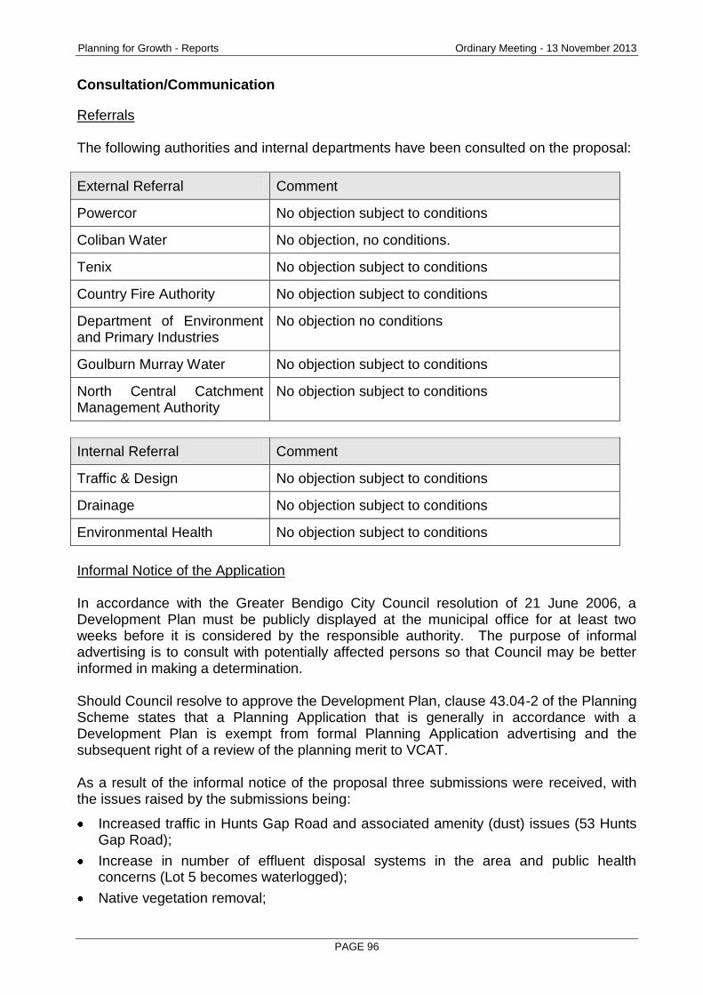
Planning for Growth - Reports Ordinary Meeting - 13 November 2013
PAGE 96
Consultation/Communication
Referrals The following authorities and internal departments have been consulted on the proposal:
External Referral Comment
Powercor No objection subject to conditions
Coliban Water No objection, no conditions.
Tenix No objection subject to conditions
Country Fire Authority No objection subject to conditions
Department of Environment and Primary Industries
No objection no conditions
Goulburn Murray Water No objection subject to conditions
North Central Catchment Management Authority
No objection subject to conditions
Internal Referral Comment
Traffic & Design No objection subject to conditions
Drainage No objection subject to conditions
Environmental Health No objection subject to conditions
Informal Notice of the Application In accordance with the Greater Bendigo City Council resolution of 21 June 2006, a Development Plan must be publicly displayed at the municipal office for at least two weeks before it is considered by the responsible authority. The purpose of informal advertising is to consult with potentially affected persons so that Council may be better informed in making a determination. Should Council resolve to approve the Development Plan, clause 43.04-2 of the Planning Scheme states that a Planning Application that is generally in accordance with a Development Plan is exempt from formal Planning Application advertising and the subsequent right of a review of the planning merit to VCAT. As a result of the informal notice of the proposal three submissions were received, with the issues raised by the submissions being:
Increased traffic in Hunts Gap Road and associated amenity (dust) issues (53 Hunts Gap Road);
Increase in number of effluent disposal systems in the area and public health concerns (Lot 5 becomes waterlogged);
Native vegetation removal;
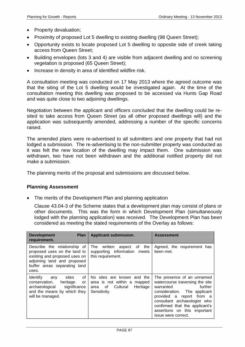
Planning for Growth - Reports Ordinary Meeting - 13 November 2013
PAGE 97
Property devaluation;
Proximity of proposed Lot 5 dwelling to existing dwelling (98 Queen Street);
Opportunity exists to locate proposed Lot 5 dwelling to opposite side of creek taking access from Queen Street;
Building envelopes (lots 3 and 4) are visible from adjacent dwelling and no screening vegetation is proposed (65 Queen Street);
Increase in density in area of identified wildfire risk. A consultation meeting was conducted on 17 May 2013 where the agreed outcome was that the siting of the Lot 5 dwelling would be investigated again. At the time of the consultation meeting this dwelling was proposed to be accessed via Hunts Gap Road and was quite close to two adjoining dwellings. Negotiation between the applicant and officers concluded that the dwelling could be re-sited to take access from Queen Street (as all other proposed dwellings will) and the application was subsequently amended, addressing a number of the specific concerns raised. The amended plans were re-advertised to all submitters and one property that had not lodged a submission. The re-advertising to the non-submitter property was conducted as it was felt the new location of the dwelling may impact them. One submission was withdrawn, two have not been withdrawn and the additional notified property did not make a submission. The planning merits of the proposal and submissions are discussed below.
Planning Assessment
The merits of the Development Plan and planning application
Clause 43.04-3 of the Scheme states that a development plan may consist of plans or other documents. This was the form in which Development Plan (simultaneously lodged with the planning application) was received. The Development Plan has been considered as meeting the stated requirements of the Overlay as follows:
Development Plan requirement.
Applicant submission. Assessment
Describe the relationship of proposed uses on the land to existing and proposed uses on adjoining land and proposed buffer areas separating land uses.
The written aspect of the supporting information meets this requirement.
Agreed, the requirement has been met.
Identify any sites of conservation, heritage or archaeological significance and the means by which they will be managed.
No sites are known and the area is not within a mapped area of Cultural Heritage Sensitivity.
The presence of an unnamed watercourse traversing the site warranted further consideration. The applicant provided a report from a consultant archaeologist who confirmed that the applicant’s assertions on this important issue were correct.
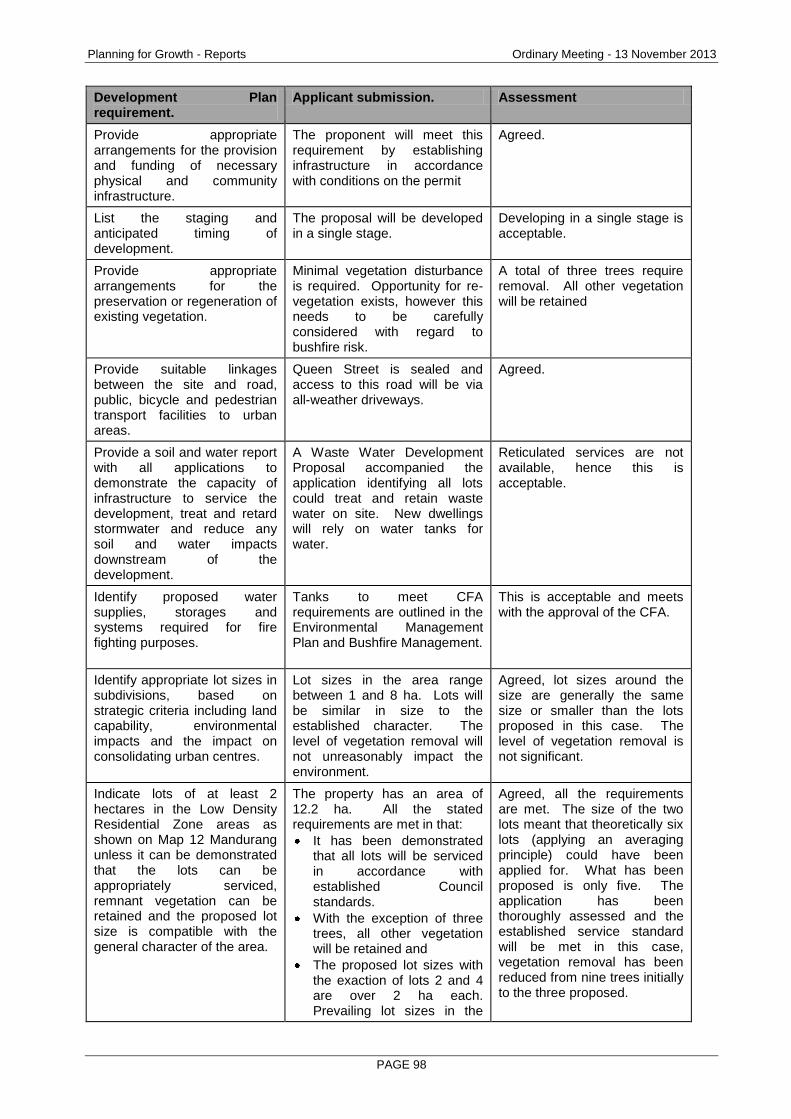
Planning for Growth - Reports Ordinary Meeting - 13 November 2013
PAGE 98
Development Plan requirement.
Applicant submission. Assessment
Provide appropriate arrangements for the provision and funding of necessary physical and community infrastructure.
The proponent will meet this requirement by establishing infrastructure in accordance with conditions on the permit
Agreed.
List the staging and anticipated timing of development.
The proposal will be developed in a single stage.
Developing in a single stage is acceptable.
Provide appropriate arrangements for the preservation or regeneration of existing vegetation.
Minimal vegetation disturbance is required. Opportunity for re-vegetation exists, however this needs to be carefully considered with regard to bushfire risk.
A total of three trees require removal. All other vegetation will be retained
Provide suitable linkages between the site and road, public, bicycle and pedestrian transport facilities to urban areas.
Queen Street is sealed and access to this road will be via all-weather driveways.
Agreed.
Provide a soil and water report with all applications to demonstrate the capacity of infrastructure to service the development, treat and retard stormwater and reduce any soil and water impacts downstream of the development.
A Waste Water Development Proposal accompanied the application identifying all lots could treat and retain waste water on site. New dwellings will rely on water tanks for water.
Reticulated services are not available, hence this is acceptable.
Identify proposed water supplies, storages and systems required for fire fighting purposes.
Tanks to meet CFA requirements are outlined in the Environmental Management Plan and Bushfire Management.
This is acceptable and meets with the approval of the CFA.
Identify appropriate lot sizes in subdivisions, based on strategic criteria including land capability, environmental impacts and the impact on consolidating urban centres.
Lot sizes in the area range between 1 and 8 ha. Lots will be similar in size to the established character. The level of vegetation removal will not unreasonably impact the environment.
Agreed, lot sizes around the size are generally the same size or smaller than the lots proposed in this case. The level of vegetation removal is not significant.
Indicate lots of at least 2 hectares in the Low Density Residential Zone areas as shown on Map 12 Mandurang unless it can be demonstrated that the lots can be appropriately serviced, remnant vegetation can be retained and the proposed lot size is compatible with the general character of the area.
The property has an area of 12.2 ha. All the stated requirements are met in that:
It has been demonstrated that all lots will be serviced in accordance with established Council standards.
With the exception of three trees, all other vegetation will be retained and
The proposed lot sizes with the exaction of lots 2 and 4 are over 2 ha each. Prevailing lot sizes in the
Agreed, all the requirements are met. The size of the two lots meant that theoretically six lots (applying an averaging principle) could have been applied for. What has been proposed is only five. The application has been thoroughly assessed and the established service standard will be met in this case, vegetation removal has been reduced from nine trees initially to the three proposed.
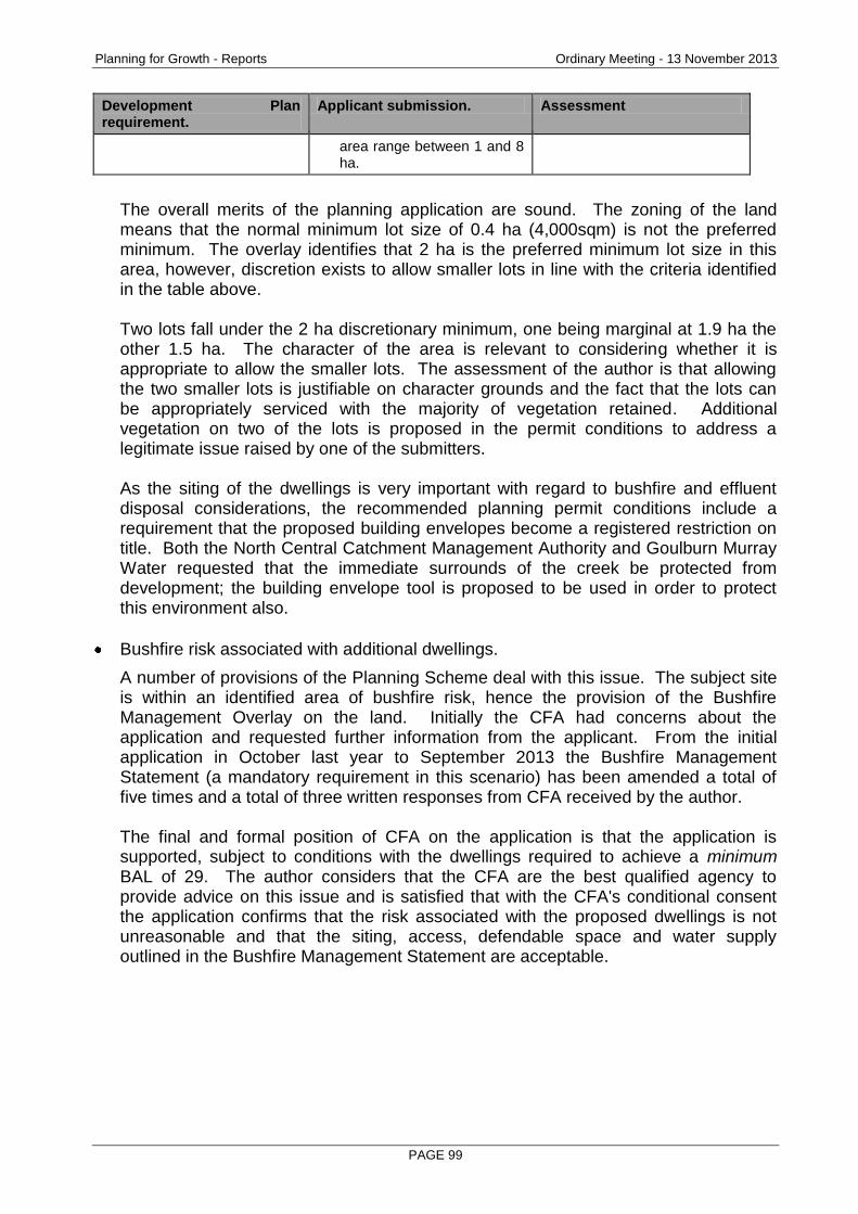
Planning for Growth - Reports Ordinary Meeting - 13 November 2013
PAGE 99
Development Plan requirement.
Applicant submission. Assessment
area range between 1 and 8 ha.
The overall merits of the planning application are sound. The zoning of the land means that the normal minimum lot size of 0.4 ha (4,000sqm) is not the preferred minimum. The overlay identifies that 2 ha is the preferred minimum lot size in this area, however, discretion exists to allow smaller lots in line with the criteria identified in the table above. Two lots fall under the 2 ha discretionary minimum, one being marginal at 1.9 ha the other 1.5 ha. The character of the area is relevant to considering whether it is appropriate to allow the smaller lots. The assessment of the author is that allowing the two smaller lots is justifiable on character grounds and the fact that the lots can be appropriately serviced with the majority of vegetation retained. Additional vegetation on two of the lots is proposed in the permit conditions to address a legitimate issue raised by one of the submitters. As the siting of the dwellings is very important with regard to bushfire and effluent disposal considerations, the recommended planning permit conditions include a requirement that the proposed building envelopes become a registered restriction on title. Both the North Central Catchment Management Authority and Goulburn Murray Water requested that the immediate surrounds of the creek be protected from development; the building envelope tool is proposed to be used in order to protect this environment also.
Bushfire risk associated with additional dwellings.
A number of provisions of the Planning Scheme deal with this issue. The subject site is within an identified area of bushfire risk, hence the provision of the Bushfire Management Overlay on the land. Initially the CFA had concerns about the application and requested further information from the applicant. From the initial application in October last year to September 2013 the Bushfire Management Statement (a mandatory requirement in this scenario) has been amended a total of five times and a total of three written responses from CFA received by the author. The final and formal position of CFA on the application is that the application is supported, subject to conditions with the dwellings required to achieve a minimum BAL of 29. The author considers that the CFA are the best qualified agency to provide advice on this issue and is satisfied that with the CFA's conditional consent the application confirms that the risk associated with the proposed dwellings is not unreasonable and that the siting, access, defendable space and water supply outlined in the Bushfire Management Statement are acceptable.
Planning for Growth - Reports Ordinary Meeting - 13 November 2013
PAGE 100
Effluent disposal considerations.
In an environment where reticulated services are not available, this issue is always an important consideration. In this case the City’s Environmental Health and Local Laws team have reviewed the proposal and also provided advice to the applicant regarding the re-siting of the contentious Lot 5 dwelling. The passage of time since the application was first lodged was advantageous to the applicant and submitters in this case as changes to Environment Protection Authority effluent rules meant that the re-siting became technically possible whereas previously the only location available was the location unacceptable to adjoining property owners. Goulburn Murray Water have also had input into the application. Both the City’s internal expert and Goulburn Murray Water are in agreement that the siting of the dwellings and their proposed effluent disposal systems meet established standards and will not adversely affect the environment.
Issues raised by the submissions
Many of the issues identified by the submitters relating to traffic, effluent and siting of the dwelling on Lot 5 have been addressed by the amended application which resulted in the proposed dwelling site being relocated to be close to Queen Street and taking it’s access from that street.
The concern about loss of native vegetation has also been addressed in the amended application in that nine trees were originally proposed for removal; this has been reduced to a total of three. Property devaluation was also raised as an issue and Council would be well aware that this ground of objection is not a valid planning ground upon which to refuse the Development Plan or Planning Permit. The issue of the building envelopes for lots 3 and 4 and their visibility from a submitter property at 65 Queen Street is a reasonable concern. Whilst the dwellings are proposed to be sited 70 and 55 metres from the road respectively there is an absence of vegetation in the road reserve or the proposed lots which would otherwise serve to screen their visibility. This issue is proposed to be addressed by the imposition of a planning permit condition requiring the submission of a landscape plan to require planting within the property along the fence line which, in time, will lessen the impact on the adjacent property.
Conclusion
The consultation process resulted in a positive change to the application resulting in all access to the dwellings now being solely off Queen Street.
The application has been assessed as appropriately addressing all the requirements of the Development Plan Overlay and all other Planning Scheme requirements. Approval of the Development Plan and the issuing of a Planning Permit are recommended.
Options
Council, acting as the responsible authority for administering the planning scheme, may resolve to:

Planning for Growth - Reports Ordinary Meeting - 13 November 2013
PAGE 101
Resolve to approve or refuse the Development Plan and
Grant a permit, grant a permit with conditions, or refuse to grant a permit.
Attachments
Submissions
RECOMMENDATION
That the Greater Bendigo City Council resolves to: a) Approve the amended Development Plan prepared by Terraco P/L Reference
number 11094 Version 3, City of Greater Bendigo date stamped 27 June 2013 and;
b) Pursuant to Section 61 of the Planning and Environment Act (1987) a planning permit be granted for a 5 lot subdivision of land and development of 4 dwellings and removal of native vegetation at 48 and Lot 4 Queen Street, MANDURANG SOUTH 3551 subject to the following conditions:
1. MODIFIED PLAN REQUIRED
Before the plan of subdivision is certified and dwelling construction starts, plans to the satisfaction of the responsible authority must be submitted to and approved by the responsible authority. When approved, the plans will be endorsed and will then form part of the permit. The plans must be drawn to scale with dimensions and two copies must be provided. The plans must be generally in accordance with the plans submitted with the application but modified to show: (a) Floor and elevation plans of each dwelling; (b) Site plans for each dwelling notated to include the access requirements
nominated in Conditions 6, 7 and 16; (c) The requirements of the Country Fire Authority nominated in Condition 12
and (d) Creation of a restriction on the plan of subdivision to reflect the building
envelopes nominated on the Development Plan prepared by Terraco P/L Reference number 11094 Version 3, City of Greater Bendigo date stamped 27 June 2013. The restriction should note that the dwelling must be constructed in the building envelope and reflect the creek setback requirements of the North Central Catchment Management Authority in Condition 9 and Goulburn Murray Water in Condition 10 (b).
2. LANDSCAPE PLAN REQUIRED Before the plan of subdivision is certified, a landscape plan to the satisfaction of the responsible authority must be submitted to and approved by the responsible authority. When approved, the plan will be endorsed and will then form part of the permit. The plan must be drawn to scale with dimensions and two copies must be provided. The plan must show: (a) Screening vegetation along the Queen Street boundaries of lots 3 and 4.
Planning for Growth - Reports Ordinary Meeting - 13 November 2013
PAGE 102
3. NO LAYOUT ALTERATION The subdivision, development and native vegetation removal permitted by this permit as shown on the endorsed plans and/or described in the endorsed documents must not be altered or modified (for any reason) except with the prior written consent of the Responsible Authority.
4. ENVIRONMENTAL MANAGEMENT PLAN The Environmental Management Plan and Addendum prepared by Peter Williamson, Environmental Consultant City of Greater Bendigo date stamped 27 June 2013 forms part of this approval.
5. COMPLETION OF LANDSCAPING Before the occupation of the development starts or by such later date as is approved by the responsible authority in writing, the landscaping works shown on the endorsed plans must be carried out and completed to the satisfaction of the responsible authority.
6. RURAL VEHICLE CROSSING LOCATION All proposed vehicular entrances to the subject land from the road shall be constructed at a location and of a size and standard satisfactory to the Responsible Authority. The vehicle crossings must be constructed at the applicant’s expense to provide ingress and egress to the site to the satisfaction of the Responsible Authority. The crossover shall be constructed in accordance with the Infrastructure Design Manual SD255 and include a pipe of a diameter suitable to accommodate the actual volume/flow (having a minimum diameter of 300 mm). Culverts located in the clear zone shall be installed with trafficable end walls (refer VicRoads standard drawing SD 1991). The final location of the crossing is to be approved by the responsible authority via a ‘Consent for Works on Road Reserves.
7. ALL WEATHER DRIVEWAY The standard of construction to achieve all weather standard for each proposed driveway is as follows. (a) From the edge of the existing seal to the proposed dwellings must be
constructed with 75mm of compacted crush rock, minimum 4m wide trafficable width to provide all weather access for fire trucks.
(b) Table drain is required on the high side of the driveway. (c) Vehicle driveways need to be at 90º to the road. (d) Any driveway must be a minimum 2.0m clear of tree trunks. For trunks
greater than 200mm wide, offset required is 1m per 100mm.
8. EFFLUENT DISPOSAL (a) Before a building permit is issued for any works at the proposed vacant
lots, a septic tank permit to install must be issued by the responsible authority.
(b) At the time when the existing septic tank system at proposed Lot 1 is upgraded, a septic tank permit must be obtained prior to the commencement of works from the Responsible Authority.
Planning for Growth - Reports Ordinary Meeting - 13 November 2013
PAGE 103
9. NORTH CENTRAL CATCHMENT MANAGEMENT AUTHORITY No building or works are permitted within 30 metres of the top of bank of the tributary of Sheepwash Creek.
10. GOULBURN MURRAY WATER (a) All existing native vegetation within 30 metres of a waterway must be
maintained and any removal must be to the satisfaction of the Responsible Authority and the Department of Sustainability and Environment.
(b) No buildings or works are to be constructed within 30m of any waterways. (c) All construction activities and on-going use of the site must follow sediment
control principles outlined in ‘Construction Techniques for Sediment Pollution Control’ (EPA, 1991).
(d) All wastewater from the dwellings on proposed lots 2, 3 & 4 must be treated and disposed of using an EPA approved system, installed, operated and maintained in compliance with the relevant EPA Code of Practice and Certificate of Approval.
(e) For proposed Lot 5, all wastewater from the proposed dwelling must be treated to a standard of at least 20mg/L BOD and 30mg/L suspended solids using a package treatment plant or equivalent. The system must be an EPA approved system, installed, operated and maintained in accordance with the relevant EPA Code of Practice and Certificate of Approval.
(f) The wastewater disposal areas on each lot must be located at least 60 metres from the nearest waterway or dam and at least 20m from any bore.
(g) The wastewater disposal area on each lot must be kept free of stock, buildings, driveways and service trenching and must be planted with appropriate vegetation to maximise its performance. Stormwater must be diverted away.
(h) On each lot a reserve wastewater disposal field of equivalent size to the primary disposal field must be provided for use in the event that the primary field requires resting or has failed.
(i) Prior to the Statement of Compliance being issued, new wastewater disposal trenches must be constructed for the septic tank system servicing the existing dwelling on proposed lot 1. The new trenches must be at least 60m from the nearest waterway and dam and at least 20m from any bores. Evidence that works have been completed must be provided to Goulburn-Murray Water in order for consent to be given to the issue of the Statement of Compliance.
(j) Stormwater run-off from buildings and other impervious surfaces must be dissipated as normal un-concentrated overland flow or directed to a storage tank or dam.
11. COUNTRY FIRE AUTHORITY: MANDATORY CONDITION – BUILDING AND
WORKS (AS PER CLAUSE 44.06-4) The bushfire mitigation measures forming part of this permit or shown on the endorsed plans, including those relating to construction standards, defendable space, water supply, and access, must be maintained to the satisfaction of the responsible authority and the relevant fire authority on a continuing basis. This condition continues to have force and effect after the development authorised by this permit has been completed.
Planning for Growth - Reports Ordinary Meeting - 13 November 2013
PAGE 104
12. COUNTRY FIRE AUTHORITY: AMENDED PLANS REQUIRED. Prior to certification, amended plans to the satisfaction of the CFA and the Responsible Authority must be submitted to and approved by the Responsible Authority. When approved, the plan will be endorsed and then form part of the permit. The plans must be appropriately scaled or accurately dimensioned and must be substantially in accordance with the plans submitted with application but modified to show: (a) A building envelope within each of the proposed lots (in the case of lot 1,
the existing building footprint should be used). (b) A defendable space envelope extending from the outer edge of the
identified building envelope within each lot. The defendable space envelope must contain an inner and outer zone for the following distances:
21 m (inner) & 12 m (outer) to the north, east and west within lot 1
22 m (inner) to the south within lot 1
21 m (inner) & 12 m (outer) in all directions within lots 2, 3, 4 & 5
The defendable space envelope must be wholly within the title boundary except where it includes land that does not require management or includes another lots defendable space envelope.
13. COUNTRY FIRE AUTHORITY – BUILDING CONSTRUCTION The construction of the dwelling within lots 2, 3, 4 & 5 must be to a minimum bushfire attack level of BAL-29 in accordance with the relevant sections to AS3959-2009.
14. COUNTRY FIRE AUTHORITY – DEFENDABLE SPACE (a) Within 10 metres of a building in any lot (or to the boundary if this distance
is less), flammable objects such as plants, mulches and combustible fences must not be located close to vulnerable parts of the building such as windows, decks and eaves.
(b) Trees must not overhang the roofline of any building or touch walls or other elements of any building.
(c) Areas of defendable space identified as innerzone and any area within the building envelope itself on the endorsed plans must be maintained to the following requirements:
Grass must be no more than 5 centimetres in height. All leaves and vegetation debris are to be removed at regular intervals.
Shrubs must not be planted under trees and must be separated by at least 1.5 times their mature height.
Plants greater than 10 centimetres in height at maturity must not be placed directly in front of a window or other glass feature.
Tree canopy separation of 2 metres and the overall canopy cover of no more than 15 percent at maturity.
Tree branches within 2 metres of ground level must be removed. (d) Areas of defendable space identified as outerzone on the endorsed plans
must be maintained to the following requirements:
Grass must be no more than 10 centimetres in height and leaf and other debris mowed, slashed or mulched at regular intervals.
Shrubs and or trees must not form a continuous canopy and must not have an overall canopy cover of greater than 30 percent.
Planning for Growth - Reports Ordinary Meeting - 13 November 2013
PAGE 105
Tree branches within 2 metres of ground level must be removed.
Trees may touch each other with an overall canopy cover of no more than 30 percent at maturity.
Shrubs must not be in clumps of greater than 10 square metres and clumps of shrubs must be separated from each other by at least 10 metres.
15. COUNTRY FIRE AUTHORITY – STATIC WATER SUPPLY
(a) Prior to the initial occupation of the dwelling within lots 2, 3, 4 & 5, a static water supply must be provided. The static water supply must:
Have a minimum capacity of 10,000 litres that is maintained solely for fire fighting purposes.
Be stored in an above ground water tank constructed of concrete, steel or corrugated iron.
Be located within 60 metres of the outer edge of the dwelling (including any obstructions).
Be located so that fire brigade vehicles are able to get to within 4 metres of the water supply outlet.
Incorporate a 64 mm, 3 threads per inch, male fitting to suit a CFA coupling.
be readily identifiable from the building or appropriate signage must be provided which to the satisfaction of CFA.
(b) The water supply outlet/s must be attached to the water tank and must face away from the building if located less than 20 metres from the building to enable access during emergencies.
(c) All pipework between the water supply and the outlet/s must be a minimum of 64 mm nominal bore.
(d) All fixed above-ground water pipelines and fittings must be of non-corrodible and non-combustible materials.
16. COUNTRY FIRE AUTHORITY – ACCESS
Access to any building and water supply for firefighting purposes in lots 2, 3, 4 & 5 must be designed and constructed to: (a) Provide a minimum trafficable width of 3.5 metres (b) Be clear of encroachments for 4 metres vertically and 0.5 metres each
side of the trafficable width. (c) Incorporate a turning area for fire fighting vehicles close to the dwelling by
either:
A turning circle with minimum radius of eight metres; or
The driveway encircling the dwelling; or
A T head or Y head with a minimum formed surface of each leg being eight metres in length measures from the centre point of the head, and four metres trafficable width.
17. COUNTRY FIRE AUTHORITY – STATIC WATER TANK AND ACCESS
WITHIN LOT 1 (a) Prior to statement of compliance being issued under the Subdivision Act
1988, a static water supply must be provided for the existing dwelling located on lot 1. The static water supply must comply with the same requirements for the other lots in the subdivision.
Planning for Growth - Reports Ordinary Meeting - 13 November 2013
PAGE 106
(b) Prior to statement of compliance being issued under the Subdivision Act 1988, access to the static water supply and dwelling within lot 1 must comply with the same requirements for the other lots in the subdivision.
18. TELECOMMUNICATIONS (a) The owner of the land must enter into an agreement with:
A telecommunications network or service provider for the provision of telecommunication services to each lot shown on the endorsed plan in accordance with the provider’s requirements and relevant legislation at the time.
A suitably qualified person for the provision of fibre ready telecommunication facilities to each lot shown on the endorsed plan in accordance with any industry specifications or any standards set by the Australian Communications and Media Authority, unless the applicant can demonstrate that the land is in an area where the National Broadband Network will not be provided by optical fibre.
(b) Before the issue of a Statement of Compliance for any stage of the subdivision under the Subdivision Act 1988, the owner of the land must provide written confirmation from:
A telecommunications network or service provider that all lots are connected to or are ready for connection to telecommunications services in accordance with the provider’s requirements and relevant legislation at the time.
A suitably qualified person that fibre ready telecommunication facilities have been provided in accordance with any industry specifications or any standards set by the Australian Communications and Media Authority, unless the applicant can demonstrate that the land is in an area where the National Broadband Network will not be provided by optical fibre.
19. TENIX
The plan of subdivision submitted for certification must be referred to SP AusNet (Gas) in accordance with section 8 of the Subdivision Act 1988.
20. POWERCOR (a) The plan of subdivision submitted for certification under the Subdivision
Act 1988 shall be referred to Powercor Australia Ltd in accordance with section 8 of that Act.
(b) The applicant shall provide an electricity supply to all lots in the subdivision in accordance with Powercor’s requirements and standards, including the extension, augmentation or re-arrangement of any existing electricity supply system, as required by Powercor.
(c) The applicant shall where buildings or other installations exist on the land to be subdivided and are connected to the electricity supply, they shall be brought into compliance with the Service and Installation Rules issued by the Victorian Electricity Supply Industry. The applicant shall arrange compliance through a registered electrical contractor and provide to Powercor Australia Ltd a completed Electrical Safety Certificate in accordance with Electricity Safe Victoria’s Electrical Safety System.
Planning for Growth - Reports Ordinary Meeting - 13 November 2013
PAGE 107
(d) The applicant shall provide to Powercor Australia Ltd, a copy of the version of the plan of subdivision submitted for certification, which shows any amendments that have been required.
(e) Any buildings must comply with the clearances required by the Electricity Safety (Network Assets) Regulations.
(f) Any construction work must comply with Energy Safe Victoria’s “No Go Zone” rules.
21. EXPIRY OF THE PERMIT - SUBDIVISION AND DWELLINGS
This permit will expire if: (a) The plan of subdivision is not certified within two years from the date of this
permit; or (b) The subdivision is not completed within five years from the date of
certification of the plan of subdivision; or (c) Construction of the approved dwellings is not completed within seven years
from the date of this permit. The responsible authority may extend the time for certification of the plan, or for the completion of the dwellings, if a request is made in writing before the permit expires or thereafter, within the period allowed by section 69 of the Planning and Environment Act 1987.
Telstra Note Approval does not cover alterations to existing Telstra plant or network. Locations of existing network can be obtained from Dial Before You Dig – Ph: 1100 For co-ordinated Telstra plant reticulation in this development, please refer to www.telstrasmartcommunity.com to register your development and apply for reticulation. City of Greater Bendigo Asset Planning & Design Note A Works within Road Reserves permit must be obtained from the City of Greater Bendigo Asset Planning & Design Unit prior to any work commencing in the road reserve.
Planning for Growth - Reports Ordinary Meeting - 13 November 2013
PAGE 108
2.9 216 NORTH HARLEY STREET, STRATHDALE - STAGED SUBDIVISION OF THE LAND INTO 6 LOTS
Document Information
Author Stephen Wainwright, Coordinator Subdivisions Responsible Prue Mansfield, Director Planning & Development Director
Summary/Purpose
Application details: Staged subdivision of the land into 6 lots
Application No: DS/372/2013
Applicant: Shaw Land Surveys Pty Ltd
Land: 216 North Harley Street, STRATHDALE 3550
Zoning: Residential 1 Zone
Overlays: Nil
No. of objections: 3
Consultation meeting held:
9 July 2013
Key considerations: Drainage.
Design of the common property driveway.
Boundary fencing.
Conclusion: The proposed subdivision design responds appropriately to the site and its context. In particular, the drainage features of the site have been properly considered and there is a suitable stormwater management system to cater for the subdivision. The proposed subdivision is consistent with the objectives of the Residential 1 Zone and overall the proposal complies with the Planning Scheme. It is recommended that a permit be granted subject to conditions.
Policy Context
City of Greater Bendigo Council Plan 2013 – 2017 (2013)
Planning for Growth
Our quality of life is maintained as our City's population and economy grows.
Productivity
A diverse, strong and growing economy supports community resilience.
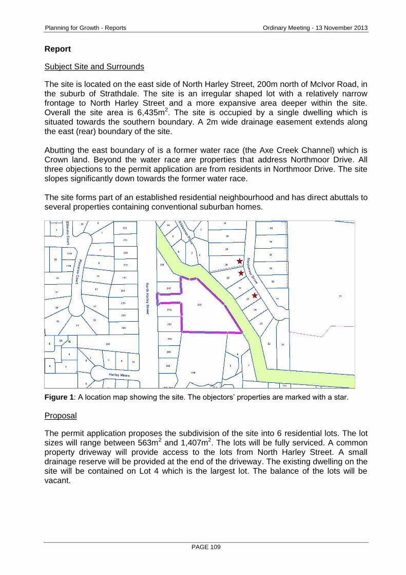
Planning for Growth - Reports Ordinary Meeting - 13 November 2013
PAGE 109
Report
Subject Site and Surrounds
The site is located on the east side of North Harley Street, 200m north of McIvor Road, in the suburb of Strathdale. The site is an irregular shaped lot with a relatively narrow frontage to North Harley Street and a more expansive area deeper within the site. Overall the site area is 6,435m2. The site is occupied by a single dwelling which is situated towards the southern boundary. A 2m wide drainage easement extends along the east (rear) boundary of the site. Abutting the east boundary of is a former water race (the Axe Creek Channel) which is Crown land. Beyond the water race are properties that address Northmoor Drive. All three objections to the permit application are from residents in Northmoor Drive. The site slopes significantly down towards the former water race. The site forms part of an established residential neighbourhood and has direct abuttals to several properties containing conventional suburban homes.
Figure 1: A location map showing the site. The objectors’ properties are marked with a star.
Proposal
The permit application proposes the subdivision of the site into 6 residential lots. The lot sizes will range between 563m2 and 1,407m2. The lots will be fully serviced. A common property driveway will provide access to the lots from North Harley Street. A small drainage reserve will be provided at the end of the driveway. The existing dwelling on the site will be contained on Lot 4 which is the largest lot. The balance of the lots will be vacant.
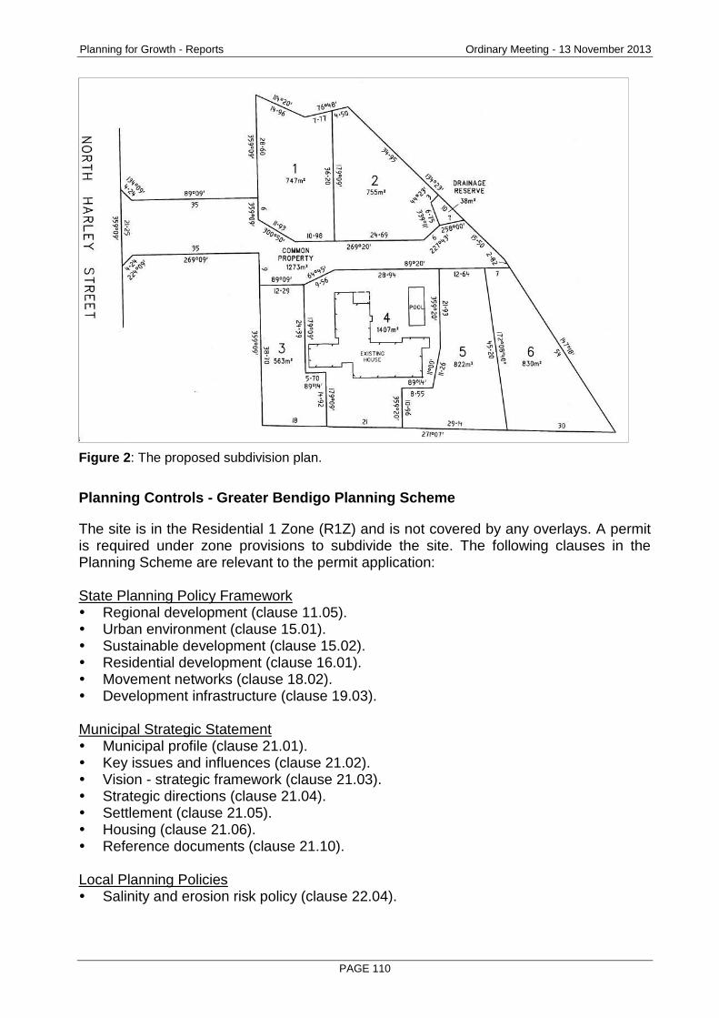
Planning for Growth - Reports Ordinary Meeting - 13 November 2013
PAGE 110
Figure 2: The proposed subdivision plan.
Planning Controls - Greater Bendigo Planning Scheme
The site is in the Residential 1 Zone (R1Z) and is not covered by any overlays. A permit is required under zone provisions to subdivide the site. The following clauses in the Planning Scheme are relevant to the permit application: State Planning Policy Framework Regional development (clause 11.05). Urban environment (clause 15.01). Sustainable development (clause 15.02). Residential development (clause 16.01). Movement networks (clause 18.02). Development infrastructure (clause 19.03). Municipal Strategic Statement Municipal profile (clause 21.01). Key issues and influences (clause 21.02). Vision - strategic framework (clause 21.03). Strategic directions (clause 21.04). Settlement (clause 21.05). Housing (clause 21.06). Reference documents (clause 21.10). Local Planning Policies Salinity and erosion risk policy (clause 22.04).
Planning for Growth - Reports Ordinary Meeting - 13 November 2013
PAGE 111
Other Provisions Residential 1 Zone (clause 32.01). Residential subdivision (clause 56). Decision guidelines (clause 65). Referral and notice provisions (clause 66).
Consultation/Communication
Referrals The following authorities and internal departments have been consulted on the proposal:
Referral Comment
Coliban Water No objection subject to conditions
Powercor No objection subject to conditions
Tenix No objection subject to conditions
Drainage engineer (internal) No objection subject to conditions
Public Notification The application was advertised to the public by mail and an on-site notice. Four objections to the application were originally received but one of the objections was later withdrawn. The three remaining objections focus on the issue of drainage insofar as it affects properties in Northmoor Drive to the east of the site. This issue is discussed later in this report.
Planning Assessment
Stormwater management for the subdivision The three objections to the proposed subdivision are from residents in Northmoor Drive. The subject site forms part of a stormwater catchment that encompasses Northmoor Drive. The site is a high point in the catchment with Northmoor Drive being lower relative to the site. Properties in Northmoor Drive have experienced drainage problems associated with various overland flows and infrastructure works have been carried out by the City to improve the management of stormwater in the area. In light of the fact that Northmoor Drive is at the bottom of the catchment the objectors want certainty that the proposed subdivision will not cause stormwater flooding of their properties.
Planning for Growth - Reports Ordinary Meeting - 13 November 2013
PAGE 112
The proposed subdivision includes an appropriate drainage system to cater for stormwater flows in accordance with the City’s engineering standards. Currently most stormwater from the site flows into the adjoining water channel reserve in an uncontrolled manner (a small volume of stormwater also flows towards North Harley Street). As part of the proposed subdivision the developer will be required to provide a formal drainage system. This will consist of directing the majority of flows to a retardation basin at the rear of the site and then discharging the stormwater at a controlled rate via underground pipes to Northmoor Drive. There is an existing drainage easement along the side boundary of No.28 Northmoor Drive suitable for this purpose. The stormwater management system will be designed to control up to a “1 in 100 year” flood event. The drainage infrastructure associated with the proposed subdivision is likely to improve conditions for properties in Northmoor Drive by replacing an uncontrolled arrangement with a formal underground drainage system capable of dealing with significant flood events. The design of the common property driveway The lots created by the subdivision will be accessible via an area of common property off North Harley Street. Owing to the irregular shape of the site the common property will be relatively wide in sections, much wider than is necessary to accommodate a driveway. A neighbour to the site originally had concerns that the width of the common property would result in vehicles moving too close to their property boundary. This issue has been addressed. While at its widest point the common property will be 20m wide, only 5.5m in width will be set aside as a driveway. The balance of the common property will be landscaped. Furthermore, the driveway will be set back from the neighbour’s boundary and the landscape design for the intervening space will feature boulders or some other physical treatment that would prevent vehicles from accessing the space. Preventing access to the adjoining water channel reserve Concern was expressed by a neighbour to the site that the subdivision may allow vehicles to access to the water channel reserve that adjoins the rear boundary of the site. To address this issue, bollards or a similar physical barrier will be installed at the end of the common property driveway. This will restrict vehicle access to the reserve. Raising the height of the boundary fence The developer has agreed to increase the height of the existing timber fence on the north boundary of the site by 0.5m in order to provide greater privacy to the neighbouring property. Compliance with clause 56 in the Planning Scheme The proposal complies with all the subdivision design objectives in clause 56 of the Planning Scheme. The lots in the subdivision will be fully serviced and they will enjoy a high standard of amenity owing to their generous size, solar orientation and access to recreational assets.
Planning for Growth - Reports Ordinary Meeting - 13 November 2013
PAGE 113
With the exception of Lot 4 which will contain an existing dwelling all the lots will be capable of accommodating a suburban house with generous space for a garden and backyard.
Conclusion
The proposed subdivision complies with the requirements of the Planning Scheme for the reasons discussed above. On this basis a permit should be granted for the proposal.
Options
Council, acting as the responsible authority for administering the planning scheme may resolve to: grant a permit, grant a permit subject to conditions, or refuse to grant a permit.
Attachments
Objections
RECOMMENDATION
Pursuant to section 61 of the Planning and Environment Act (1987), Greater Bendigo City Council resolves to issue a Notice of Decision to Grant a Permit which allows for the staged subdivision of the land at 216 North Harley Street, Strathdale, subject to the following conditions:
1. PLANS TO BE ENDORSED The plans to be endorsed and which will then form part of the permit are the plans submitted with the application.
2. LAYOUT MUST NOT BE ALTERED The layout of the subdivision as shown on the endorsed plans must not be altered without the written consent of the responsible authority.
3. LANDSCAPE PLAN Before a statement of compliance is issued for the subdivision a landscape plan to the satisfaction of the responsible authority must be submitted to and approved by the responsible authority. When approved, the plan will be endorsed and then form part of the permit. The plan must show: (a) A landscape strip contained within the common property, between the edge of
the carriageway and the boundary of No.218 North Harley Street. Boulders (minimum 0.5m height and 1.5m spacing) or a similar physical treatment must be incorporated within the landscape strip to separate the adjoining house from vehicle traffic.
(b) A 0.5m height extension to the existing timber fence located on the common boundary with No.218 North Harley Street.
(c) Bollards or a similar physical barrier at the end of the common property to prevent vehicle access to the adjoining reserve.
Planning for Growth - Reports Ordinary Meeting - 13 November 2013
PAGE 114
4. COMPLETION OF LANDSCAPING Before a statement of compliance is issued for the subdivision the landscaping works shown on the endorsed landscape plan must be carried out and completed to the satisfaction of the responsible authority.
5. LANDSCAPING MAINTENANCE The landscaping works shown on the endorsed plans must be maintained to the satisfaction of the responsible authority for 12 months after the works are completed, including that any dead, diseased or damaged plants are to be replaced.
6. DRIVEWAY CONSTRUCTION Before a statement of compliance is issued for the subdivision the common property driveway shown on the endorsed plans must be constructed, properly formed, drained and surfaced with an all-weather seal coat to the satisfaction of the responsible authority.
7. DETAILED DRAINAGE Prior to the certification of the plan of subdivision under the Subdivision Act 1988, plans to the satisfaction of the responsible authority must be submitted to and approved by the responsible authority. When approved, the plans will be endorsed and then will form part of the permit. The plans must be drawn to scale with dimensions. The plans must include: (a) Direction of stormwater run-off. (b) A point of discharge for each lot. (c) Independent drainage for each lot.
8. STORMWATER DETENTION Before a statement of compliance is issued for the subdivision the developer must provide onsite surface and stormwater detention to pre-development levels in accordance with plans and specifications to the satisfaction of the responsible authority. Allowable discharge: Q100 = 30 l/s to no. 124180 (race reserve); Q100 = 11 l/s to pit no. 108993 (North Harley Street).
9. STORMWATER QUALITY Before the subdivision starts the developer must provide a stormwater treatment system to achieve the Best Practice Environmental Guidelines storm water quality (Victoria Stormwater Committee 1999) in accordance with plans and specifications to the satisfaction of the responsible authority. The responsible authority may deem this condition satisfied by a development contribution towards the treatment of surface and stormwater discharge from the approved subdivision, building and/or works, whether or not such new stormwater treatment infrastructure has been or will be situated within the boundaries of the subject land or its immediate catchment. Such amount is assessed as $4200 or such amount applying at the time of payment.
10. CONSTRUCTION OF WORKS Road works, drainage and other civil works must be constructed in accordance with the Infrastructure Design Manual and plans and specifications approved by the responsible authority and must include: underground drainage.
Planning for Growth - Reports Ordinary Meeting - 13 November 2013
PAGE 115
11. SECTION 173 AGREEMENT
If a stormwater detention system or a water quality treatment system is installed on the site, the owner must enter into an agreement with the responsible authority under Section 173 of the Planning and Environment Act 1987 before a statement of compliance is issued. The agreement must provide for the following: (a) All systems must be designed by a qualified engineer and must be approved by
the responsible authority before construction. (b) All systems must be installed before, or concurrently with, the development of a
building on the site. (c) All systems must be completed before they are connected to Council's drainage
system. (d) All systems must be maintained by the owner and must not be modified without
the written approval of the responsible authority. (e) The owner must allow authorised Council officers to inspect any system on the
site from time to time. (f) The owner must pay all costs associated with the construction and maintenance
of any system on the site.
12. PUBLIC ASSETS Before the development starts, the owner or developer must submit to the responsible authority a written report and photos of any prior damage to public infrastructure. Listed in the report must be the condition of kerb and channel, footpath, seal, street lights, signs and other public infrastructure fronting the property and abutting at least two properties either side of the development. Unless identified with the written report, any damage to infrastructure post construction will be attributed to the development. The owner or developer of the subject land must pay for any damage caused to any public infrastructure caused as a result of the development or use permitted by this permit.
13. COLIBAN WATER (a) The owner is required to provide reticulated water and sewerage services to
each of the lots within the subdivision. Services are to be provided in accordance with Coliban Water’s specifications.
(b) All Coliban Water assets within the subdivision, both existing and proposed, are to be protected by an easement in favour of Coliban Region Water Corporation.
14. POWERCOR
(a) The plan of subdivision submitted for certification under the Subdivision Act 1988 shall be referred to Powercor Australia Ltd in accordance with Section 8 of that Act.
(b) The applicant shall: Provide an electricity supply to all lots in the subdivision in accordance with Powercor’s requirements and standards, including the extension, augmentation or re-arrangement of any existing electricity supply system, as required by Powercor (A payment to cover the cost of such work will be required). In the event that a supply is not provided the applicant shall provide a written undertaking to Powercor Australia Ltd that prospective purchasers will be so informed.
Planning for Growth - Reports Ordinary Meeting - 13 November 2013
PAGE 116
(c) The applicant shall: Where buildings or other installations exist on the land to be subdivided and are connected to the electricity supply, they shall be brought into compliance with the Service and Installation Rules issued by the Victorian Electricity Supply Industry. The applicant shall arrange compliance through a Registered Electrical Contractor.
(d) The applicant shall: Provide to Powercor Australia Ltd, a copy of the version of the plan of subdivision submitted for certification, which shows any amendments which have been required.
(e) Any buildings must comply with the clearances required by the Electricity Safety (Network Assets) Regulations.
(f) Any construction work must comply with the Officer of the Chief Electrical Inspector No Go Zone rules.
15. TENIX
The plan of subdivision submitted for certification must be referred to SP AusNet (Gas) in accordance with Section 8 of the Subdivision Act 1988.
16. TELECOMMUNICATIONS (a) The owner of the land must enter into an agreement with:
• A telecommunications network or service provider for the provision of telecommunication services to each lot shown on the endorsed plan in accordance with the provider’s requirements and relevant legislation at the time.
• A suitably qualified person for the provision of fibre ready telecommunication facilities to each lot shown on the endorsed plan in accordance with any industry specifications or any standards set by the Australian Communications and Media Authority, unless the applicant can demonstrate that the land is in an area where the National Broadband Network will not be provided by optical fibre.
(b) Before the issue of a statement of compliance for any stage of the subdivision under the Subdivision Act 1988, the owner of the land must provide written confirmation from: • A telecommunications network or service provider that all lots are connected
to or are ready for connection to telecommunications services in accordance with the provider’s requirements and relevant legislation at the time.
• A suitably qualified person that fibre ready telecommunication facilities have been provided in accordance with any industry specifications or any standards set by the Australian Communications and Media Authority, unless the applicant can demonstrate that the land is in an area where the National Broadband Network will not be provided by optical fibre.
17. EXPIRY OF THE PERMIT - SUBDIVISION
This permit will expire if: (a) The plan of subdivision is not certified within two years from the date of this
permit; or (b) The subdivision is not completed within five years from the date of certification of
the plan of subdivision. The responsible authority may extend the time for certification of the plan if a request is made in writing before the permit expires or within three months afterwards.
Planning for Growth - Reports Ordinary Meeting - 13 November 2013
PAGE 117
2.10 1097-1099 HEATHCOTE-NORTH COSTERFIELD ROAD, COSTERFIELD 3523 - 2-LOT SUBDIVISION
Document Information
Author Liz Commadeur, Subdivision Planner Responsible Prue Mansfield, Director Planning & Development Director
Summary/Purpose
Application details: 2 lot subdivision of land and removal of vegetation
Application No: DS/172/2013
Applicant: M J McAfee
Land: 1097-1099 Heathcote-North Costerfield Road, Costerfield 3523
Zoning: Farming Zone
Overlays: Environmental Significance Overlay 3 Heritage Overlay 722
No. of objections: One
Consultation meeting held:
A consultation meeting was not held.
Key considerations: Whether the subdivision will result in the fragmentation and loss of agricultural land.
The appropriateness of providing separate titles to the 2 existing homes on the site, given that the lots will be less than 40ha minimum specified in the zone.
Whether the proposal meets the requirements of the Farming Zone.
Conclusion: This report recommends that a permit be granted, subject to conditions. The subdivision meets the discretionary power of the Farming Zone, where a lot less than 40 hectares can be created for each dwelling on the site, so long as it is a two lot subdivision. The subdivision is a positive outcome for the site.
Policy Context
City of Greater Bendigo Council Plan 2013 – 2017 (2013)
Planning for Growth
Our quality of life is maintained as our City's population and economy grows.
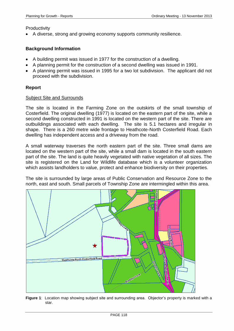
Planning for Growth - Reports Ordinary Meeting - 13 November 2013
PAGE 118
Productivity
A diverse, strong and growing economy supports community resilience.
Background Information
A building permit was issued in 1977 for the construction of a dwelling.
A planning permit for the construction of a second dwelling was issued in 1991.
A planning permit was issued in 1995 for a two lot subdivision. The applicant did not proceed with the subdivision.
Report
Subject Site and Surrounds
The site is located in the Farming Zone on the outskirts of the small township of Costerfield. The original dwelling (1977) is located on the eastern part of the site, while a second dwelling constructed in 1991 is located on the western part of the site. There are outbuildings associated with each dwelling. The site is 5.1 hectares and irregular in shape. There is a 260 metre wide frontage to Heathcote-North Costerfield Road. Each dwelling has independent access and a driveway from the road. A small waterway traverses the north eastern part of the site. Three small dams are located on the western part of the site, while a small dam is located in the south eastern part of the site. The land is quite heavily vegetated with native vegetation of all sizes. The site is registered on the Land for Wildlife database which is a volunteer organization which assists landholders to value, protect and enhance biodiversity on their properties. The site is surrounded by large areas of Public Conservation and Resource Zone to the north, east and south. Small parcels of Township Zone are intermingled within this area.
Figure 1: Location map showing subject site and surrounding area. Objector’s property is marked with a star.
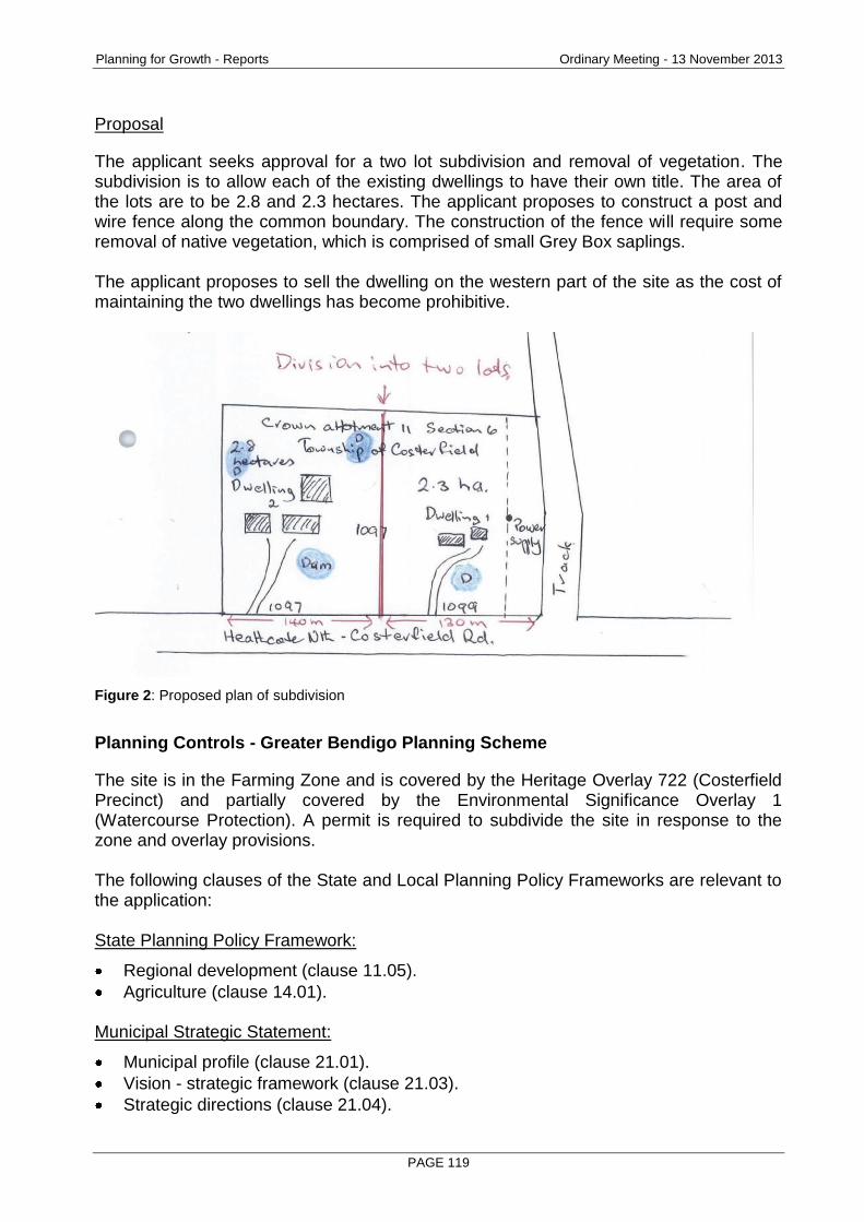
Planning for Growth - Reports Ordinary Meeting - 13 November 2013
PAGE 119
Proposal
The applicant seeks approval for a two lot subdivision and removal of vegetation. The subdivision is to allow each of the existing dwellings to have their own title. The area of the lots are to be 2.8 and 2.3 hectares. The applicant proposes to construct a post and wire fence along the common boundary. The construction of the fence will require some removal of native vegetation, which is comprised of small Grey Box saplings. The applicant proposes to sell the dwelling on the western part of the site as the cost of maintaining the two dwellings has become prohibitive.
Figure 2: Proposed plan of subdivision
Planning Controls - Greater Bendigo Planning Scheme
The site is in the Farming Zone and is covered by the Heritage Overlay 722 (Costerfield Precinct) and partially covered by the Environmental Significance Overlay 1 (Watercourse Protection). A permit is required to subdivide the site in response to the zone and overlay provisions. The following clauses of the State and Local Planning Policy Frameworks are relevant to the application: State Planning Policy Framework:
Regional development (clause 11.05).
Agriculture (clause 14.01). Municipal Strategic Statement:
Municipal profile (clause 21.01).
Vision - strategic framework (clause 21.03).
Strategic directions (clause 21.04).
Planning for Growth - Reports Ordinary Meeting - 13 November 2013
PAGE 120
Settlement (clause 21.05).
Environment (clause 21.08).
Reference documents (clause 21.10).
Monitoring and review (clause 21.11). Local Planning Policies:
Rural subdivision policy (clause 22.03).
Heritage Policy (clause 22.06). Other relevant provisions:
Decision guidelines (clause 65)
Referral and notice provisions (clause 66)
Consultation/Communication
Referrals The following authorities and internal departments have been consulted on the proposal:
Referral Comment
Department of Sustainability and Environment
No objection subject to conditions
Goulburn-Murray Water No objection subject to conditions
Goulburn Broken Catchment Management Authority
No objection, with no conditions
Traffic & Design No objection subject to conditions
Drainage No objection subject to conditions
Public Notification The application was advertised by way of notice on the site and letters to adjoining and nearby owners and occupiers. As a result of advertising one objection was received, with the grounds of objection being:
The land is too small for a 2 lot subdivision in the Farming Zone. The objection is discussed below.
Planning for Growth - Reports Ordinary Meeting - 13 November 2013
PAGE 121
Planning Assessment
Farming Zone
The land is zoned for farming purposes. The proposed subdivision will create two lots with an area of 2.8 and 2.3 hectares respectively. The Farming Zone specifies that the minimum lot size is 40 hectares. However, there is discretion to allow subdivisions less than 40 hectares, where the subdivision is to create a lot for an existing dwelling. The subdivision must be a two lot subdivision. This report argues that the proposed subdivision should be supported on five grounds:
1. The existence of the 2 dwellings on the site and the current lot size of only 5.1ha has already ensured that the agricultural value is minimal and is more suited to rural lifestyle use. The proposed subdivision is not going to change the existing circumstances to any great degree. The only physical change to the site will be the loss of a small number of saplings and the construction of a post and wire fence which will define the common boundary between the proposed lots.
2. The land is not suitable for undertaking viable farming activities, mainly due to the site being heavily vegetated and its small size. There has been no evidence of farming on the site since the dwellings have been constructed (approximately 35 years ago). Rather, the site has been operated under rural lifestyle conditions. Given the small size of the site, the owner has limited options in which to utilize the land.
3. The land has been managed in accordance with the guidelines of the “Land for Wildlife” organization. The owner has concentrated on encouraging a better environmental outcome for the land, rather than grazing stock or undertaking other agricultural pursuits. Over time the owner has contributed to the environmental significance of the site by planting native vegetation and implementing measures which prevent the spread of erosion. There is no reason why the proposed subdivision will change the current management style.
4. The Rural Area Strategy, adopted by Council in 2009, provides strategic direction for the range of farming areas across Greater Bendigo. The strategy acknowledges that some land in the Farming Zone is not commercially viable because of the small size of the lots. This statement in the strategy reflects the very nature of this site.
5. The owner has had difficulty in maintaining the upkeep of the two dwellings. There is potential for the proposed subdivision to allow two separate owners to better manage the lots. If the application was refused it is highly likely that one of the dwellings would fall into disrepair, which is not a positive outcome for the site.
Should a permit be granted, a condition will be placed on the permit that the land may not be further subdivided. This is a requirement of the Farming Zone provisions. Environmental Significance Overlay 1 (ESO1) The land is partially affected by the ESO1 to protect the health of the watercourse on the site. The diagram below shows the path of the ESO through the site, which is significantly vegetated. The site is prone to slight flooding through this ESO path, particularly on Lot 2. Over time the owner has contributed to the environmental significance of the site by planting native vegetation and implementing measures which prevent the spread of erosion.
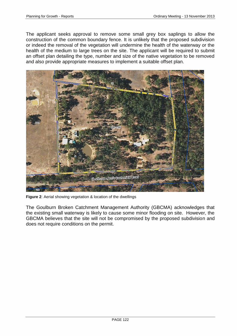
Planning for Growth - Reports Ordinary Meeting - 13 November 2013
PAGE 122
The applicant seeks approval to remove some small grey box saplings to allow the construction of the common boundary fence. It is unlikely that the proposed subdivision or indeed the removal of the vegetation will undermine the health of the waterway or the health of the medium to large trees on the site. The applicant will be required to submit an offset plan detailing the type, number and size of the native vegetation to be removed and also provide appropriate measures to implement a suitable offset plan.
Figure 2: Aerial showing vegetation & location of the dwellings
The Goulburn Broken Catchment Management Authority (GBCMA) acknowledges that the existing small waterway is likely to cause some minor flooding on site. However, the GBCMA believes that the site will not be compromised by the proposed subdivision and does not require conditions on the permit.
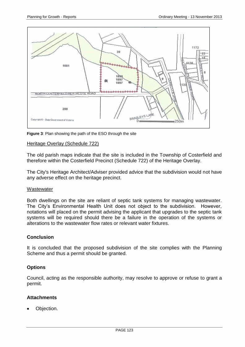
Planning for Growth - Reports Ordinary Meeting - 13 November 2013
PAGE 123
Figure 3: Plan showing the path of the ESO through the site
Heritage Overlay (Schedule 722) The old parish maps indicate that the site is included in the Township of Costerfield and therefore within the Costerfield Precinct (Schedule 722) of the Heritage Overlay. The City's Heritage Architect/Adviser provided advice that the subdivision would not have any adverse effect on the heritage precinct. Wastewater Both dwellings on the site are reliant of septic tank systems for managing wastewater. The City’s Environmental Health Unit does not object to the subdivision. However, notations will placed on the permit advising the applicant that upgrades to the septic tank systems will be required should there be a failure in the operation of the systems or alterations to the wastewater flow rates or relevant water fixtures.
Conclusion
It is concluded that the proposed subdivision of the site complies with the Planning Scheme and thus a permit should be granted.
Options
Council, acting as the responsible authority, may resolve to approve or refuse to grant a permit.
Attachments
Objection.
Planning for Growth - Reports Ordinary Meeting - 13 November 2013
PAGE 124
RECOMMENDATION
Pursuant to section 61 of the Planning and Environment Act (1987), Greater Bendigo City Council resolve to issue a Notice of Decision to Grant a Permit for a two lot subdivision at 1097-1099 Heathcote-North Costerfield Road, Costerfield, subject to the following conditions: 1. PLANS TO BE ENDORSED
The plans to be endorsed and which will then form part of the permit are the plans submitted with the application.
2. LAYOUT PLANS
The subdivision, as shown on the endorsed plans, must not be altered without the prior written consent of the responsible authority.
3. PROVISION OF SERVICES
The owner of the land must enter into agreements with the relevant authorities for the provision of electricity services to each lot shown on the endorsed plan in accordance with the authorities’ requirements and relevant legislation at the time.
4. EASEMENTS
All existing and proposed easements and sites for existing and required utility services and roads must be set aside in favour of the relevant authority for which the easement or site is to be created on the plan of subdivision submitted for certification under the Subdivision Act 1988.
5. REFERRAL OF PLAN
The plan of subdivision submitted for certification under the Subdivision Act 1988 must be referred to the relevant authority in accordance with section 8 of that Act.
6. SECTION 173 AGREEMENT
Prior to the issue of statement of compliance, the applicant/owner must enter into an agreement under section 173 of the Planning and Environment Act 1987. Such agreement must covenant that: (a) The lots must not be further subdivided. (b) If in the future any changes are made to either dwelling in regards to
increasing wastewater flow rates or alterations to the septic tank system or any water fixtures or fittings; the existing septic tank system must be upgraded to meet current standards set out in the EPA septic tank code of practice.
(c) If in the future the septic tank system at either dwelling shows any signs of failure, it must be upgraded to meet current standards set out in the EPA septic tank code of practice.
(d) A septic tank permit to install must be issued by the responsible authority prior to any upgrades taking place.
7. OFFSET PLAN
The offset plan must include details of the: (a) Vegetation to be removed, including details of:
The location of the vegetation including details of the Bioregion.
Planning for Growth - Reports Ordinary Meeting - 13 November 2013
PAGE 125
The Ecological Vegetation Class (EVC) of the vegetation.
The Bioregional Conservation Status of the EVC.
The area to be removed (in hectares).
The habitat hectare score (out of 1) of the vegetation.
The number of large and medium old trees to be removed.
The presence of any rare or threatened species.
Whether the site is potential habitat for any rare or threatened species.
Conservation significance.
Total vegetation loss calculated in habitat hectares. (b) Gain targets. (c) Offsets to compensate for the vegetation removal, including details of:
Type of offsets to be provided in each location.
Location of the offsets including details of the Bioregion.
Ecological Vegetation Class of the offset vegetation.
Habitat hectare score (out of 1) of the offsets.
Number of large and medium old trees to be protected.
Rare or threatened species habitat to be protected.
Conservation significance of the offset. (d) Gains in vegetation and habitat quality to be achieved by the offsets. (e) Details of any revegetation including number of trees, shrubs and other
plants, species mix, and density included in a Schedule of Works. (f) Methods of managing and restoring the existing vegetation to be retained
included in a Schedule of Works. (g) Methods of interim protection for newly established vegetation. (h) Methods of permanent protection for established offsets. (i) Persons responsible for implementing and monitoring the offset plan. (j) Time frame for implementing the offset plan. Vegetation removal and the provision of offsets must accord with the endorsed plan.
8. TELECOMMUNICATIONS
(a) The owner of the land must enter into an agreement with:
A telecommunications network or service provider for the provision of telecommunication services to each lot shown on the endorsed plan in accordance with the provider’s requirements and relevant legislation at the time.
A suitably qualified person for the provision of fibre ready telecommunication facilities to each lot shown on the endorsed plan in accordance with any industry specifications or any standards set by the Australian Communications and Media Authority, unless the applicant can demonstrate that the land is in an area where the National Broadband Network will not be provided by optical fibre.
(b) Before the issue of a Statement of Compliance for any stage of the subdivision under the Subdivision Act 1988, the owner of the land must provide written confirmation from:
A telecommunications network or service provider that all lots are connected to or are ready for connection to telecommunications services in accordance with the provider’s requirements and relevant legislation at the time.
Planning for Growth - Reports Ordinary Meeting - 13 November 2013
PAGE 126
A suitably qualified person that fibre ready telecommunication facilities have been provided in accordance with any industry specifications or any standards set by the Australian Communications and Media Authority, unless the applicant can demonstrate that the land is in an area where the National Broadband Network will not be provided by optical fibre.
9. EXPIRY OF THE PERMIT
The permit will expire if: (a) The plan of subdivision is not certified within two years from the date of this
permit; or (b) The subdivision is not completed within five years from the date of
certification of the plan of subdivision. The responsible authority may extend the time for certification of the plan if a request is made in writing before the permit expires or within six months afterwards.
NOTE: ENVIRONMENTAL HEALTH
If in future any changes are made to either dwelling in regards to increasing wastewater flow rates or alterations to the septic tank system or any water fixtures or fittings; the existing septic tank system must be upgraded to meet current standards set out in the EPA septic tank code of practice.
If in future the septic tank system at either dwelling shows any signs of failure, it must be upgraded to meet current standards set out in the EPA septic tank code of practice.
A septic tank permit to install must be issued by the responsible authority prior to any upgrades taking place.
Planning for Growth - Reports Ordinary Meeting - 13 November 2013
PAGE 127
2.11 20 HILL STREET, KANGAROO FLAT 3555 - 3 LOT SUBDIVISION OF LAND
Document Information
Author Liz Commadeur, Subdivision Planner Responsible Prue Mansfield, Director Planning & Development Director
Summary/Purpose
Application details: 3 lot subdivision of land
Application No: DS/483/2013
Applicant: Colin M Nankervis Consulting Engineers
Land: 20 Hill Street, KANGAROO FLAT 3555
Zoning: Residential 1 Zone
Overlays: There are no overlays
No. of objections: 2
Consultation meeting held:
22 August 2013
Key considerations: Pedestrian safety
Neighbourhood character
Amenity issues
Conclusion: The site is within Bendigo’s urban growth boundary and is zoned for residential purposes. It is considered that the subdivision meets the requirements of the Planning Scheme and a permit should be granted.
Policy Context
City of Greater Bendigo Council Plan 2013 – 2017 (2013)
Planning for Growth
Our quality of life is maintained as our City's population and economy grows.
Productivity
A diverse, strong and growing economy supports community resilience.
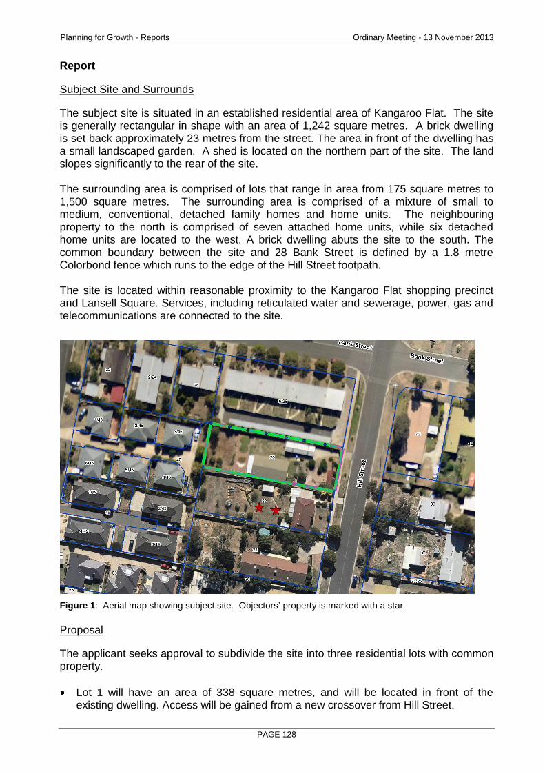
Planning for Growth - Reports Ordinary Meeting - 13 November 2013
PAGE 128
Report
Subject Site and Surrounds
The subject site is situated in an established residential area of Kangaroo Flat. The site is generally rectangular in shape with an area of 1,242 square metres. A brick dwelling is set back approximately 23 metres from the street. The area in front of the dwelling has a small landscaped garden. A shed is located on the northern part of the site. The land slopes significantly to the rear of the site. The surrounding area is comprised of lots that range in area from 175 square metres to 1,500 square metres. The surrounding area is comprised of a mixture of small to medium, conventional, detached family homes and home units. The neighbouring property to the north is comprised of seven attached home units, while six detached home units are located to the west. A brick dwelling abuts the site to the south. The common boundary between the site and 28 Bank Street is defined by a 1.8 metre Colorbond fence which runs to the edge of the Hill Street footpath. The site is located within reasonable proximity to the Kangaroo Flat shopping precinct and Lansell Square. Services, including reticulated water and sewerage, power, gas and telecommunications are connected to the site.
Figure 1: Aerial map showing subject site. Objectors’ property is marked with a star.
Proposal
The applicant seeks approval to subdivide the site into three residential lots with common property.
Lot 1 will have an area of 338 square metres, and will be located in front of the existing dwelling. Access will be gained from a new crossover from Hill Street.
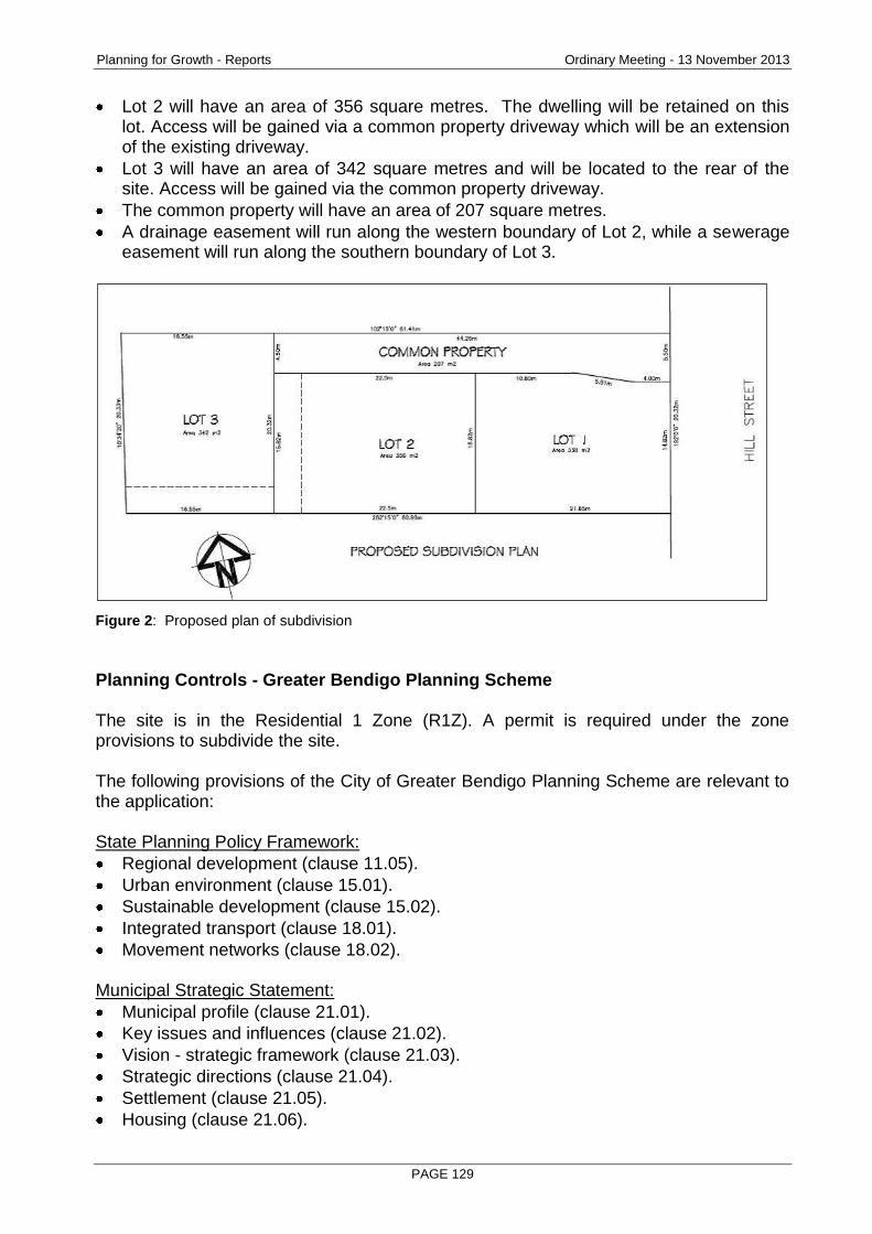
Planning for Growth - Reports Ordinary Meeting - 13 November 2013
PAGE 129
Lot 2 will have an area of 356 square metres. The dwelling will be retained on this lot. Access will be gained via a common property driveway which will be an extension of the existing driveway.
Lot 3 will have an area of 342 square metres and will be located to the rear of the site. Access will be gained via the common property driveway.
The common property will have an area of 207 square metres.
A drainage easement will run along the western boundary of Lot 2, while a sewerage easement will run along the southern boundary of Lot 3.
Figure 2: Proposed plan of subdivision
Planning Controls - Greater Bendigo Planning Scheme The site is in the Residential 1 Zone (R1Z). A permit is required under the zone provisions to subdivide the site. The following provisions of the City of Greater Bendigo Planning Scheme are relevant to the application: State Planning Policy Framework:
Regional development (clause 11.05).
Urban environment (clause 15.01).
Sustainable development (clause 15.02).
Integrated transport (clause 18.01).
Movement networks (clause 18.02). Municipal Strategic Statement:
Municipal profile (clause 21.01).
Key issues and influences (clause 21.02).
Vision - strategic framework (clause 21.03).
Strategic directions (clause 21.04).
Settlement (clause 21.05).
Housing (clause 21.06).
Planning for Growth - Reports Ordinary Meeting - 13 November 2013
PAGE 130
Environment (clause 21.08).
Infrastructure (clause 21.09).
Reference documents (clause 21.10). Local Planning Policies:
Salinity and erosion risk policy (clause 22.04).
Kangaroo Flat residential character policy (clause 22.18) Other relevant provisions:
Decision guidelines (clause 65).
Referral and notice provisions (clause 66).
Consultation/Communication
Referrals The following authorities and internal departments have been consulted on the proposal:
Referral Comment
Coliban Water No objection, subject to conditions
Powercor No objection, subject to conditions
Tenix No objection, subject to one condition
Traffic & Design No objection, subject to conditions
Drainage No objection, subject to conditions
Public Notification The application was advertised by way of notice on the site and letters to adjoining and nearby owners and occupiers. As a result of advertising two objections were received, with the grounds of objection being:
One of the objectors has significant visual impairment, and suggests that the proposed subdivision will cause extra traffic exiting from the site and will result in the site crossover becoming more hazardous to cross.
Proposed lot sizes are not in keeping with the surrounding area, and the guidelines of Precinct 3 of the Kangaroo Flat residential character policy.
Construction of a dwelling on Lot 3 will increase existing erosion problems at the rear of the site.
A consultation meeting was conducted. The applicant agreed to slightly widen the common property driveway entrance. The remaining issues were not resolved. The objections are discussed below.
Planning for Growth - Reports Ordinary Meeting - 13 November 2013
PAGE 131
Planning Assessment
Neighbourhood Character: The site is located within Precinct 3 of the Kangaroo Flat residential character policy (KF3). The precinct is described as: “An area of housing built since the 1950s, in which consistency of setbacks within streetscapes is important. Roof shapes are also important as they dominate streetscapes and provide a consistent theme. The horizontal emphasis of the dwelling form is also important, resulting from the long, low elevations of the buildings in relation to their height”. In achieving the desired future character of the precinct, the policy seeks to maintain the consistency of siting and horizontality of dwellings. Hill Street generally reflects the description of this character policy. In particular, this part of Hill Street is largely comprised of small to medium dwellings with small front setbacks and reasonable side setbacks. Gardens along Hill Street tend to be small in size. In nearby Bank and Church Streets, a number of unit-type dwellings on small lots have been constructed in recent times. The objectors are concerned that any future construction of a dwelling on Lot 1 will not respect the existing character of Hill Street and therefore not in keeping with the purpose of Precinct 3 of the Kangaroo Flat residential character policy.
Having regard to the site description and design response, it is considered that the proposed subdivision is in keeping with the neighbourhood character for the following reasons:
The streetscape of Hill Street is unlikely to be compromised as any future development on Lot 1 can meet relevant objectives of the KF3. The KF3 sets out a number of objectives, two of which relate to this application.
1. To maintain the consistency, where present, of building front setbacks.
2. To reflect the existing rhythm of dwelling spacing.
With regard to these objectives; any future dwelling constructed on Lot 1 is capable of meeting the average front setback of the adjoining two dwellings; and is able to be setback 2 metres from at least one side boundary.
Any future dwelling on Lot 3 will be concealed behind the dwelling on Lot 2, especially since the land slopes towards the rear of the site.
The proposed lots sizes of 338, 342 and 356 square metres are generally in accordance with the abutting lots to the north and west.
Overall, the three lot subdivision proposed will meet the objectives of the Kangaroo Flat residential character policy and won’t detract from the character of the existing streetscape.
Rescode
Planning for Growth - Reports Ordinary Meeting - 13 November 2013
PAGE 132
The objectors who reside on the adjoining property to the south are concerned that any future dwelling constructed on Lot 1 will impact on their privacy and that the dwelling will be located too close to the existing heating/cooling plant on their property. Whilst the proposal provides an increase in the number of dwellings on the site there is nothing to suggest that this would result in a loss of privacy or other adverse impact on residential amenity over and above what could be expected in a residential environment. The existing 1.8m fence will be retained along the southern boundary which should prevent direct views from the new dwellings into the private open space of the adjoining dwelling. The use of heating/cooling plants in residential areas is a normal practice of suburban living. The location of a dwelling on Lot 1 is unlikely to have any bearing on the heating/cooling plant at the abutting property. The application has been assessed as satisfactorily addressing the objectives and standards of ResCode as contained in Clause 56 of the Greater Bendigo Planning Scheme. Traffic exiting common property driveway One of the objectors, who lives in the abutting property, has significant visual impairment and relies on a cane to navigate around the area. The objector states that the high fence which runs to the edge of the Hill Street footpath, causes poor sight level for drivers of vehicles exiting out of the site to view southbound pedestrian traffic. The objector relies on hearing the sound of vehicles exiting the site. The objector believes that the proposed subdivision will cause extra traffic exiting from the site and will result in the site crossover becoming more hazardous to cross. The applicant amended the plan of subdivision to slightly widen the entrance of the proposed common property. The objector believed that widening the entrance would assist in hearing the noise of vehicles exiting the driveway towards the street. The issue of vehicles exiting properties can be hazardous for pedestrians walking over crossovers along footpaths. In this case, it is generally believed that the small increase in low speed traffic movements caused by the creation of another 2 lots will not have an unreasonable impact on pedestrians utilizing the footpath. Other Issues One objector is concerned that the rear of the site is constrained by the slope of the land, and any future construction of a dwelling on Lot 3 will cause erosion issues under the fence into 22 Hill Street. It is difficult to speculate whether a site cut will be required at the time of dwelling construction on Lot 3. Any dwelling construction will be monitored for the minimization of potential erosion at the Building Permit stage.

Planning for Growth - Reports Ordinary Meeting - 13 November 2013
PAGE 133
Should a permit be issued, the applicant will be required to submit a Construction Management Plan to Council, which will include a detailed plan to show proposed erosion and sedimentation control works on the site, during the subdivision process.
Conclusion
For the reasons above, it is considered that the proposed subdivision does comply with the Planning Scheme and a permit should be granted.
Options
Council, acting as the responsible authority, may resolve to approve or refuse to grant a permit.
Attachments
Objections
RECOMMENDATION
Pursuant to section 61 of the Planning and Environment Act (1987), Greater Bendigo City Council resolve to issue a Notice of Decision to Grant a Permit for a three lot subdivision at 20 Hill Street, Kangaroo Flat subject to the following conditions: 1. PLANS TO BE ENDORSED
The plans to be endorsed and which will then form part of the permit are the plans submitted with the application.
2. LAYOUT PLANS
The subdivision, as shown on the endorsed plans, must not be altered without the prior written consent of the responsible authority.
3. PUBLIC OPEN SPACE CONTRIBUTION
Before the statement of compliance is issued the applicant or owner must pay to the responsible authority a sum equivalent to 5% of the site value of all the land in the subdivision.
4. DETAILED DRAINAGE PLANS
Prior to the certification of the plan of subdivision under the Subdivision Act 1988, plans to the satisfaction of the responsible authority must be submitted to and approved by the responsible authority. When approved, the plans will be endorsed and then will form part of the permit. The plans must be drawn to scale with dimensions. The plans must include: (a) Direction of stormwater run-off. (b) A point of discharge for each lot. (c) Independent drainage for each lot.

Planning for Growth - Reports Ordinary Meeting - 13 November 2013
PAGE 134
5. STORMWATER DETENTION
Prior to the issue of a statement of compliance, the owner or applicant must provide onsite surface and stormwater detention to pre-development levels in accordance with plans and specifications to the satisfaction of the responsible authority.
Or
The responsible authority may deem this condition satisfied by a development contribution towards the acceptance of surface and stormwater discharge from the approved subdivision, building and/or works, whether or not such new drainage infrastructure has been or will be situated within the boundaries of the subject land. Such amount is assessed as $2000 or such amount applying at the time of payment.
6. STORMWATER QUALITY
Before the use or development is commenced, the owner or applicant must provide a stormwater treatment system to achieve the Best Practice Environmental Guidelines storm water quality (Victoria Stormwater Committee 1999) in accordance with plans and specifications to the satisfaction of the responsible authority. The responsible authority may deem this condition satisfied by a development contribution towards the treatment of surface and stormwater discharge from the approved subdivision, building and/or works, whether or not such new stormwater treatment infrastructure has been or will be situated within the boundaries of the subject land or its immediate catchment. Such amount is assessed as $750 or such amount applying at the time of payment.
7. DRAINAGE WORKS
Prior to the issue of the statement of compliance for the subdivision, drainage works must be constructed in accordance with plans approved by the responsible authority.
8. SECTION 173 AGREEMENT
If a stormwater detention system or a water quality treatment system is installed on the site, the owner must enter into an agreement with the responsible authority under section 173 of the Planning and Environment Act 1987 before a statement of compliance is issued. The agreement must provide for the following: (a) All systems must be designed by a qualified engineer and must be
approved by the responsible authority before construction. (b) All systems must be installed before, or concurrently with, the development
of a building on the site. (c) All systems must be completed before they are connected to Council's
drainage system. (d) All systems must be maintained by the owner and must not be modified
without the written approval of the responsible authority. (e) The owner must allow authorised Council officers to inspect any system on
the site from time to time. (f) The owner must pay all costs associated with the construction and
maintenance of any system on the site.

Planning for Growth - Reports Ordinary Meeting - 13 November 2013
PAGE 135
9. PUBLIC ASSETS
Before the development starts, the owner or developer must submit to the responsible authority a written report and photos of any prior damage to public infrastructure. Listed in the report must be the condition of kerb and channel, footpath, seal, street lights, signs and other public infrastructure fronting the property and abutting at least two properties either side of the development. Unless identified with the written report, any damage to infrastructure post construction will be attributed to the development. The owner or developer of the subject land must pay for any damage caused to any public infrastructure caused as a result of the development or use permitted by this permit.
10. CONSTRUCTION MANAGEMENT PLAN Prior to commencement of works the owner or applicant must submit a Construction Management Plan (CMP) for approval by the responsible authority. This plan must include, but not be limited to: (a) A site specific plan showing proposed erosion and sedimentation control
works. (b) Techniques and intervention levels to prevent a dust nuisance. (c) Techniques to prevent mud and dirt being transported from the site to
adjacent streets. (d) The protection measures taken to preserve any vegetation identified for
retention. During construction of works associated with the subdivision, the must employ and provide the protection methods contained in the CMP to the satisfaction of the responsible authority and the Environment Protection Agency.
11. COMMON PROPERTY DRIVEWAY
Prior to the issue of a statement of compliance, the common property driveway and parking areas must be sealed and maintained to the satisfaction of the Responsible Authority
12. REMOVAL OF EXISTING SHED Prior to the issue of a statement of compliance, the existing shed must be removed to the satisfaction of the responsible authority.
13. COLIBAN WATER
(a) The owner is required to provide reticulated water and sewerage services to each of the lots within the subdivision. Services are to be provided in accordance with our specifications.
(b) All Coliban Water assets within the subdivision, both existing and proposed, are to be protected by an easement in favour of Coliban Region Water Corporation.
14. POWERCOR
(a) The plan of subdivision submitted for certification under the Subdivision Act 1988 shall be referred to Powercor Australia Ltd in accordance with section 8 of that Act.

Planning for Growth - Reports Ordinary Meeting - 13 November 2013
PAGE 136
(b) The applicant shall: Provide an electricity supply to all lots in the subdivision in accordance with Powercor’s requirements and standards, including the extension, augmentation or re-arrangement of any existing electricity supply system, as required by Powercor.
(c) The applicant shall: Where buildings or other installations exist on the land to be subdivided and are connected to the electricity supply, they shall be brought into compliance with the Service and Installation Rules issued by the Victorian Electricity Supply Industry. The applicant shall arrange compliance through a Registered Electrical Contractor and provide to Powercor Australia Ltd a completed Electrical Safety Certificate in accordance with Electricity Safe Victoria’s Electrical Safety System.
(d) The applicant shall: Provide to Powercor Australia Ltd, a copy of the version of the plan of subdivision submitted for certification, which shows any amendments which have been required.
(e) Any buildings must comply with the clearances required by the Electricity Safety (Network Assets) Regulations.
(f) Any construction work must comply with the Officer of the Chief Electrical Inspector No Go Zone rules.
15. TELECOMMUNICATIONS
The owner of the land must enter into an agreement with:
A telecommunications network or service provider for the provision of telecommunication services to each lot shown on the endorsed plan in accordance with the provider’s requirements and relevant legislation at the time.
A suitably qualified person for the provision of fibre ready telecommunication facilities to each lot shown on the endorsed plan in accordance with any industry specifications or any standards set by the Australian Communications and Media Authority, unless the applicant can demonstrate that the land is in an area where the National Broadband Network will not be provided by optical fibre.
Before the issue of a Statement of Compliance for any stage of the subdivision under the Subdivision Act 1988, the owner of the land must provide written confirmation from:
A telecommunications network or service provider that all lots are connected to or are ready for connection to telecommunications services in accordance with the provider’s requirements and relevant legislation at the time.
A suitably qualified person that fibre ready telecommunication facilities have been provided in accordance with any industry specifications or any standards set by the Australian Communications and Media Authority, unless the applicant can demonstrate that the land is in an area where the National Broadband Network will not be provided by optical fibre.
16. TENIX
The plan of subdivision submitted for certification must be referred to SP AusNet (Gas) in accordance with section 8 of the Subdivision Act 1988.
17. EXPIRY OF THE PERMIT
(a) The plan of subdivision is not certified within two years from the date of this permit; or
Planning for Growth - Reports Ordinary Meeting - 13 November 2013
PAGE 137
(b) The subdivision is not completed within five years from the date of certification of the plan of subdivision.
The responsible authority may extend the time for certification of the plan if a request is made in writing before the permit expires or within six months afterwards.
NOTES CONSENT FOR WORK ON ROAD RESERVES The applicant must comply with: (a) The Road Management Act 2004. (b) Road Management (Works and Infrastructure) Regulations 2005. (c) Road Management (General) Regulations 2005. with respect to any requirements to notify the Coordinating Authority and/or seek consent from the Coordinating Authority to undertake “works” (as defined in the Act) in, over or under the road reserve. The responsible authority in the inclusion of this condition on this planning permit is not deemed to have been notified of, or to have given consent to undertake any works within the road reserve as proposed in this permit. COMMON PROPERTY DRIVEWAY All vehicles must enter and exit the common property driveway in a forwards direction.

Liveability / Productivity - Reports Ordinary Meeting - 13 November 2013
PAGE 138
3. LIVEABILITY
Nil.
4. PRODUCTIVITY
Nil.
Sustainability - Reports Ordinary Meeting - 13 November 2013
PAGE 139
5. SUSTAINABILITY
5.1 VICTORIAN GOVERNMENT'S RESPONSE TO THE INQUIRY INTO FLOOD MITIGATION INFRASTRUCTURE IN VICTORIA
Document Information
Author Brett Martini, Manager Engineering and Public Space Responsible Darren Fuzzard, Director Presentation and Assets Director
Summary/Purpose
The purpose of this report is: 1) To brief Council on the Victorian Parliamentary inquiry into flood mitigation
infrastructure and the potential implications for Bendigo’s ratepayers of the impending consequent legislation, and
2) To recommend writing to the Premier, Minister for Local Government and Minister for Environment and Climate Change to vehemently oppose the introduction of any legislation that shifts the burden of levee and waterway management onto local government.
Policy Context
Council Plan Reference:
City of Greater Bendigo Council Plan 2013–2017:
Theme: 5 Good Governance and Decision Making
Strategic Objective: 5.2 The financial and physical resources of the organisation are managed efficiently and well.
2013-2014 Action: 5.2.3 Thoroughly evaluate the potential long term impacts of any shift of responsibility or reduction in funding from the State Government, before agreeing to continue to fund service delivery or fund new services.
Background Information
Following the major flooding in Victoria in late 2010 and early 2011 the State's Environment and Natural Resources Committee commenced an inquiry into Victorian flood mitigation infrastructure.
Sustainability - Reports Ordinary Meeting - 13 November 2013
PAGE 140
In August 2012 the Committee’s report was tabled in Parliament and made 40 recommendations that the Committee says “would substantially improve the mitigation of floods in Victoria including the way levees and waterways are managed". In particular it identified a need to overcome uncertainty concerning responsibilities for levee ownership and maintenance and for the management and ongoing maintenance of waterways for flood mitigation and protection. In October 2013, the State Government supported either fully or in-principle all 40 of the recommendations. Under the definitions of the inquiry report, the City of Greater Bendigo has three ‘urban’ levees: 1) alongside the Bendigo Creek (running from White Hills to Huntly);
2) near the White Hills Cemetery;
3) near Bay Street Golden Square. Also within the municipality there is a 'rural' levee alongside the Bendigo Creek from Huntly to Goornong.
The municipality also contains a number of waterways that may require flood management plans. The State Government plans to implement the recommendations via the Victorian Water Act Review and the new Victorian Floodplain Management Strategy. A full public draft of the Bill is expected in November 2013.
Report
According to the Municipal Association of Victoria (MAV) the inquiry report and State Government response signals a significant intended shift of responsibility and cost from Catchment Management Authorities (CMAs) to councils for urban levees on the basis of a ‘beneficiary pays’ principle. The policy shift also includes a new responsibility to develop and implement local floodplain management plans. MAV describes the ‘beneficiary pays’ principle as "an emerging State Government direction that the beneficiaries of certain infrastructure should pay"; potentially through council rates or charges. Under the proposal, outside of Melbourne the ownership, management and maintenance responsibilities of urban levees would fall to Councils. However, the CMA’s would prioritise levees and then Government funding, wholly or in part, would be considered for an initial upgrade of ‘priority’ levees. No ongoing funding for maintenance would be provided.
Sustainability - Reports Ordinary Meeting - 13 November 2013
PAGE 141
Before being classified as a priority levee, an agreement would be required to clearly identify the beneficiaries and the managing entity along with its responsibilities. According to the Government response, reconstruction/upgrade funding would only be considered where:
There is an agreed standard;
The beneficiaries have made a commitment to meet the ongoing operating and maintenance costs through council rates or special charges;
A reasonable majority of property owners support the proposed works;
Provision is made for access inspection, maintenance and periodic third party review of the condition of the levee.
There is also a significant shift in the management of the waterways proposed. In line with the beneficiaries' pays principle, this would see local government responsible for works on waterways in urban areas. At this stage, it is unclear if this would impact on the long standing joint partnership agreement between the CMA and the City for cost sharing of works on the "constructed" section of Bendigo Creek. Equally, the impact of this proposed change on the opportunity for future State funding of stream management works, such as those currently occurring on the retaining walls in the Bendigo Creek at Golden Square, is not known.
Resource Implications
If enacted through legislation, the proposed changes signalled in the State Government’s response to the inquiry into flood mitigation infrastructure represents a significant responsibility and cost shift from State to Local Government. At this stage, the cost of the capital upgrade works required to meet the yet to be determined standard is unknown however, given the Bendigo Creek’s history, it is likely to be significant. So too, the level of State or Federal Government contribution to any required works is not known or guaranteed. Implications for the City and some or all of its rate payers under the ‘beneficiary pays’ principle suggested by the State could be very substantial and ongoing.
Conclusion
The State Government’s response to the inquiry into flood mitigation infrastructure signals an intention to shift a potentially immense responsibility and cost burden from the State to Local Government for levee and waterway management in Victoria.
Sustainability - Reports Ordinary Meeting - 13 November 2013
PAGE 142
Attachments
1. Victorian Government’s Response to the Environment and Natural Resources Committee. Inquiry into Flood Mitigation Infrastructure in Victoria.
RECOMMENDATION
That Council: 1. Write to the Premier, Minister for Local Government and Minister for Environment
and Climate Change expressing its vehement opposition to the proposed shift of responsibility from the State to Local Government for levees and waterways as outlined in the Government’s response to the inquiry into flood mitigation infrastructure.
2. Investigate forming a lobbying alliance with other councils that have similar concerns about the proposed shift of responsibility for levees from the State to Local Government.
Good Governance and Decision-Making - Reports Ordinary Meeting - 13 November 2013
PAGE 143
6. GOOD GOVERNANCE AND DECISION-MAKING
6.1 COUNCIL PLAN 2013-2017 FIRST QUARTER REPORT, SEPTEMBER 2013
Document Information
Author Dr Lyn Talbot Corporate and Community Planner Responsible Prue Mansfield, Director Planning and Development Director
Summary/Purpose
The purpose of this report is to provide a first quarter report on the 2013-2014 action plan from the new City of Greater Bendigo 2013-2017 Council Plan.
Policy Context
The Council Plan 2013-2017 was adopted by Council on 19 June 2013. The Council Plan identifies the key issues to be pursued by Council over the next four years to address the community’s needs and aspirations and its own organisational activities. The measurable commitments set out in the actions in the Council Plan are based on a yearly basis and generally relate to those activities which are above and beyond daily service provision. The Council Plan is based around five broad themes, each with a number of strategies. Each strategy has actions that are relevant for the current year. The five themes and strategic objectives are: 1: Planning for Growth 1.1 Our City undertakes successful lobbying and maintains its excellent reputation. 1.2 Significant projects that will transform the City over time are completed as planned. 1.3 Our quality of life is maintained as our City's population and economy grows. 1.4 Our communities have the space and facilities they need for future growth. 2: Liveability 2.1 People feel connected to their community 2.2 Our communities have active and vibrant places in which to meet. 2.3 Open space and recreation facilities are well designed, extensively used and well
maintained. 2.4 More people are confident to walk and cycle more often. 2.5 Our community's health and wellbeing improves over time. 2.6 Services and programs support all people to live in our community. 2.7 Greater Bendigo is known for its vibrant and diverse arts and culture scene. 3: Productivity 3.1 Our long-term planning enables the movement of people and freight that is efficient
and healthy for individuals and the environment

Good Governance and Decision-Making - Reports Ordinary Meeting - 13 November 2013
PAGE 144
3.2 A diverse, strong, and growing economy supports community resilience 3.3 Our City is known for creativity, innovation, and vitality 3.4 Tourism and major events are a significant contributor to our economy. 3.5 Employers can attract an appropriately skilled workforce and education leads to
employment. 4: Sustainability 4.1 Existing infrastructure and assets are well maintained and appropriately upgraded
to sustain them for future generations. 4.2 Reduce all waste to landfill 4.3 Continue to build the capacity of our community to reduce the impact of changing
weather on communities and individuals. 4.4. Strengthen the links between Greater Bendigo's past and future by protection and
contemporary re-use of our heritage assets. 5: Good Governance and Decision Making 5.1 Council demonstrates good governance and leadership 5.2 The financial and physical resources of the organisation are managed efficiently
and well 5.3 We engage effectively and often with our communities, through excellent customer
service and by providing information to enable people to take part in decisions about the changes
5.4 Organisational workforce & business system development is undertaken to support staff to be highly productive.
Background Information
In accordance with Section 125 of the Local Government Act 1989 regular reporting about service delivery and performance is an obligation to Council and community members.
Report
Highlights for this period include: 1: Planning for Growth
A number of lobbying and liaison activities have been undertaken by Councillors and senior staff designed to enhance the reputation and profile of Greater Bendigo and the region through effective promotion.
Regular meetings are held with State and Federal politicians as necessary to discuss specific issues or when the opportunity arises during visits by politicians to the City of Greater Bendigo.
The booklet "Snapshot of Priorities" which was developed prior to the Federal Election has proved a useful tool in promoting key priority projects for City of Greater Bendigo. Meetings have been held with numerous Federal and State politicians to present copies of the booklet and explain the projects in more detail.
Construction of the Art Gallery extension is progressing as planned and is on track for the end of the year completion.
Planning for the Marong Business Park has proceeded with the preparation of the Planning Scheme Amendment documentation that will ultimately be submitted to

Good Governance and Decision-Making - Reports Ordinary Meeting - 13 November 2013
PAGE 145
the State Government Department of Transport, Planning & Local Infrastructure. However two outstanding reports are still required and expected to be provided by external consulting companies within the coming weeks.
The Bendigo Library Redevelopment is well advanced and on schedule to be opened to the public in January 2014 with a formal opening planned for February 2014.
The process to name the new the Community Theatre is well under way. The project construction is 30% completed and concept planning for streetscape design is underway.
Planning for the Kangaroo Flat Aquatic Centre has progressed with the schematic design nearing completion. The planning permit application is currently being prepared, and advocacy for external funding is continuing.
A State Government funded position has been filled and an advisory committee established to help lever maximum economic and social benefits arising from the transitional new hospital development project.
Planning for the Bendigo Airport redevelopment is continuing, with the lodgement of Planning Scheme Amendment documentation and completion of a Stage 1 funding submission.
Playspace design at the Canterbury Gardens is almost complete, with construction to commence in October.
Drafting of the final revised Residential Development Strategy is well underway. When endorsed by Council it will be released for a further round of community consultation.
Discussions are occurring with the Loddon-Mallee Preschool Association as to the current status of preschool requirements to ensure access to 15 hours per week of pre-school.
Documents for the Eaglehawk Structure Plan Planning Scheme Amendment are being prepared and will be submitted to the Minister for Planning to seek authorisation to exhibit the amendment.
A draft Hospital Precinct Structure Plan has been prepared as the prelude to development of the detailed Structure Plan. Completion of the plan is expected for the end of March 2014.
Planning Scheme Amendment documents are being prepared for the Bendigo Landscape Project - Big Hill & Mandurang Valley to introduce among other things a Significant Landscape Overlay. The documents will then be submitted to the Minister for Planning to seek authorisation to exhibit the amendment.
Loddon Campaspe Councils group met with Minister Guy to discuss the Regional Growth Plan which provides for facilitation of the growth in central and northern Victoria and associated infrastructure requirements of the Region.
The draft Loddon Mallee South Regional Growth Plan was recently adopted unanimously by the Greater Bendigo Council. When the Plan is adopted by all Councils within the region it will provide a strategic framework for growth and land use planning. The CEO is a member of the Regional Growth Plan Steering Committee.
2: Liveability
The Domestic Animal Management Plan for 2012-2016 has been completed, along with an implementation plan; actions will be reported in the Annual report.
Draft findings of the review into Council's role in childcare and preschool support have been presented to Council for consideration.

Good Governance and Decision-Making - Reports Ordinary Meeting - 13 November 2013
PAGE 146
The draft findings of the review into Aged & Disability Services were presented to Councillors for comment and feedback.
The Capital Theatre program for the 2014 season is almost finalised and a season brochure will be prepared.
The second Bendigo Writers Festival was successfully held in August and the first Bendigo International Festival of Exploratory Music in September.
The revised Redesdale and District Community plan was completed and launched.
A Funding and Service Agreement has been finalised with the Volunteer Resource Centre designed to promote, recruit, build capacity, and celebrate the achievements of volunteers and committees.
Open space improvements are ongoing, including completion of the upgrade of the QEO audio equipment and significant progress in Epsom safety works.
Preparations are being finalised to commence construction of the splash park at Long Gully.
56% of schools and early childhood services registered for the Achievement Program (target 95% by end June 2015), a strategy in the statewide Healthy Together initiative.
Greater Bendigo young people are being consulted in prioritising the 2013-14 actions to be implemented from the Youth Strategy.
The Bendigo based Spring Campaign is currently in the market featuring the tulips and wine and food events.
Bendigo Regional Tourism has appointed a 3 day per week officer to assist with the development of the major marketing and development programs for the region.
The Regional Grow Your Business Program was completed in July with 10 graduates from across the region.
Funding is being sought for the development of a Tourism Destination Management Plan which will cover the whole region.
Council has approved an increased investment in renewal of swimming pools in the 2013-2014 budget.
The strategic framework for the Rosalind Park Masterplan has been completed, including site analysis, research and initial engagement. Masterplan concept options are currently being prepared.
Stage 2 of the development of the Integrated Transport & Land Use Plan is nearing completion. This was to identify the Vision, drawing on extensive community engagement. The first draft of the Stage 2 Report is currently under review by the Members of the Project Reference and Technical Working Groups and Steering Committee.
Letters have been sent from the Mayor to both State and Federal Ministers seeking funding to enable people with a disability and residents in outlying districts to access suitable transport options and/or services. A subsequent meeting occurred between disability clients and State Department Human Services to explore how people could use their funding packages for this purpose.
3: Productivity
Entries for the 2014 Bendigo Inventor Awards closed with around 100 applications. Numerous workshops and events have been undertaken to support applicants in this year's awards.
Business and education sectors in the City of Greater Bendigo are embracing the Horizons initiative. Work is currently underway to extend the project to Central Goldfields and Mount Alexander Shires.

Good Governance and Decision-Making - Reports Ordinary Meeting - 13 November 2013
PAGE 147
The City of Greater Bendigo in conjunction with LaTrobe University, Bendigo TAFE and Bendigo Senior Secondary College are collaborating on a marketing brochure to attract international students to Bendigo. The project is also aimed at retaining these students in Bendigo and then into the local workforce.
The Major Events team continues to help deliver major events that have all made positive economic impact and carried extensive promotional and social benefit for Greater Bendigo, including Groovin the Moo, ITTF Oceania Cup and World Snooker.
Council made a submission regarding changes to the Planning System proposed by the State Government, designed to facilitate better outcomes and speedier granting of planning permits.
A review of the Economic Development Strategy is progressing, which is expected to highlight the need for retail support.
Following a series of "business/leadership roundtables" the draft Economic Development Strategy is being prepared and is to be forwarded to Council in next 4-6 weeks.
The strategy to build community understanding of National Broadband Network’s potential, including in opportunities for knowledge based businesses in small towns is being supported with the allocation of Federal Government funds to undertake extensive training and awareness-raising activities.
4: Sustainability
Construction has commenced for the 2013-2014 program of renewal of existing infrastructure assets so they remain safe, sound and fit for purpose.
Design works for the East Bendigo Link Road (Roh’s Road) are almost complete and formalising the road reserve with DEPI is progressing. Construction is scheduled for early 2014.
Design works for the 2013-2014 drainage works are complete and the works have commenced.
On-site works have commenced for Mitchell Street streetscape works to improve facilities for pedestrians, public transport users and traders. Design of the proposed bus shelter is progressing well with significant input from user groups.
Federal funding has been secured for a bulk change of street lights to energy efficient globes as part of the Lighting the Regions project. A project plan is currently being prepared for its implementation.
As part of the "Creating a Climate Resilient Southern Loddon Mallee" project the consulting company Aecom have been engaged to work with the six partner councils to develop local vulnerability assessments for each LGA, and then a Regional Climate Adaptation Plan from the combined findings.
Tenders are currently being assessed for the implementation of a program of lighting retrofits on five of the City's highest energy consuming buildings and for pool blankets and pump retrofits.
A range of ongoing Environmental Health and Local Laws monitoring activities have been conducted in this quarter designed to build and maintain community safety. This includes completion of 65 health premise inspections, 50 public health nuisance complaints have been investigated, 27 food complaints investigated and 175 Local Law complaints investigated.
The consultants have begun Stage 2 of the White Hills and East Bendigo Heritage Study, compiling citations for North Bendigo places (in the Hospital Precinct
Good Governance and Decision-Making - Reports Ordinary Meeting - 13 November 2013
PAGE 148
Structure Plan study area) that have been identified in Stage 1 that are of potential heritage significance.
The background detail to inform a new Planning Scheme Amendment to implement the Bendigo Flood Study has yet to be completed and this is being conducted by the City's Engineering department and the NCCMA. It is expected that the Planning Scheme Amendment will not commence until at least July 2014.
5: Good Governance and Decision Making
The Surplus Property Disposal Plan is being implemented.
Annual Rate Notices were mailed out in August along with the State Government Fire Services Levy flyer and CoGB 'about your rates' brochure.
The draft Project Management Manual has been completed and is undergoing review prior to training and rollout.
Work has begun on the review of all user fees and charges designed to achieve transparent decision making in the setting of fees. The findings will be in place before the 2014/2015 budget process begins.
An electronic grants project management system has been implemented and staff members are using it to process the current round of grants.
The current Procurement Action Plan is to be updated, and a consultant is to be engaged to create the new plan.
Preparations have been completed and the Enterprise Agreement negotiation is due to commence in early October 2013.
Workforce Development Plans for each directorate are currently being finalised. Implementation of the completed plans will help to ensure that our workforce has the skills to meet organisation objectives.
The Municipal Emergency Management Plan was reviewed and an audit was completed by the Victorian State Emergency Service.
Priority/Importance: Reporting on progress towards completion of Council Plan actions is important for Councillors and community members because of the ongoing commitments to comprehensive reporting and the links to previous budget decisions. Regular reporting is also a legislative requirement of the Local Government Act. Timelines: This report is later than anticipated because of the transition to the new reporting software data management and reporting software, Interplan, and a temporary reporting procedure needed to be created. Progress: This is the first quarterly report for the new Council Plan. Risk Analysis: Risk analysis will be undertaken with regards specific projects, as a normal part of project planning.
Good Governance and Decision-Making - Reports Ordinary Meeting - 13 November 2013
PAGE 149
Consultation/Communication
No explicit consultation was conducted in relation to preparation of this report. In accordance with the Community Engagement Strategy consultation is undertaken in relation to specific projects as their timeline requires.
Resource Implications
Items that are included in the Council Plan are also considered in budget planning for the same period. Where external funds are sought or available this is documented.
Conclusion
This first quarter report for the financial year provides details of many new projects and activities that are in the planning phase or have recently commenced. A number of other initiatives outlined in the Council Plan have also yet to be commenced.
RECOMMENDATION
That the Greater Bendigo City Council acknowledges progress against the actions set out in the 2013-2014 City of Greater Bendigo Council Plan.
Good Governance and Decision-Making - Reports Ordinary Meeting - 13 November 2013
PAGE 150
6.2 BENDIGO STADIUM ANNUAL REPORT 2012/13
Document Information
Author Eric Pascoe, former Chief Executive Officer, Bendigo Stadium Ltd Travis Harling, Finance Manager Responsible Marg Allan, Director Organisation Support Director
Summary/Purpose
The purpose of this report is to provide Council and the community with a summary of 2012/13 achievements by the Bendigo Stadium Limited (BSL) and an outline of the future direction of the organisation.
Policy Context
Council Plan 2013 - 2017
2.3.4 Continue to support major recreational organisations to increase their financial independence.
Background Information
The Bendigo Stadium is a major asset of the City of Greater Bendigo, hosting weekly community sporting programmes along with major sporting and entertainment events. The facilities include seven indoor sports courts, major exhibition and function areas, licensed clubroom and associated administration facilities and is recognised as the best venue of its type in regional Australia. The Stadium attracts over 10,000 patrons each week for domestic basketball and volleyball, major sports events, concerts, dinners, conventions, trade shows and special events. It operates as a sports venue for regular domestic and regional volleyball and basketball competitions and as a licensed club catering for 6,000 members. The Bendigo Stadium Limited operates the Bendigo Stadium in Inglis Street, West Bendigo and the Borough Club in Eaglehawk. There are currently 40 electronic gaming machines at the Borough Club and 75 at the Bendigo Stadium, providing a significant source of income. Council previously agreed to provide bank loan guarantees totalling $3,031,987 on behalf of the BSL. The outstanding loan liability is currently $2,284,580. There is an agreement in place with BSL which enables financial oversight and provides for one COGB representative on the BSL Board, currently Cr Lyons, as well as representation on the BSL Finance Committee by the Director Organisation Support and the Manager Finance.
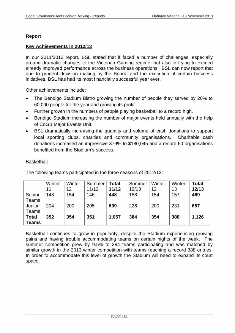
Good Governance and Decision-Making - Reports Ordinary Meeting - 13 November 2013
PAGE 151
Report
Key Achievements in 2012/13 In our 2011/2012 report, BSL stated that it faced a number of challenges, especially around dramatic changes to the Victorian Gaming regime, but also in trying to exceed already improved performance across the business operations. BSL can now report that due to prudent decision making by the Board, and the execution of certain business initiatives, BSL has had its most financially successful year ever. Other achievements include:
The Bendigo Stadium Bistro growing the number of people they served by 20% to
60,000 people for the year and growing its profit.
Further growth in the numbers of people playing basketball to a record high.
Bendigo Stadium increasing the number of major events held annually with the help
of CoGB Major Events Unit.
BSL dramatically increasing the quantity and volume of cash donations to support
local sporting clubs, charities and community organisations. Charitable cash
donations increased an impressive 379% to $180,045 and a record 60 organisations
benefited from the Stadium’s success.
Basketball The following teams participated in the three seasons of 2012/13:
Winter 11
Winter 12
Summer 11/12
Total 11/12
Summer 12/13
Winter 12
Winter 13
Total 12/13
Senior Teams
148 154 146 448 158 154 157 469
Junior Teams
204 200 205 609 226 200 231 657
Total Teams
352 354 351 1,057 384 354 388 1,126
Basketball continues to grow in popularity, despite the Stadium experiencing growing pains and having trouble accommodating teams on certain nights of the week. The summer competition grew by 9.5% to 384 teams participating and was matched by similar growth in the 2013 winter competition with teams reaching a record 388 entries. In order to accommodate this level of growth the Stadium will need to expand its court space.
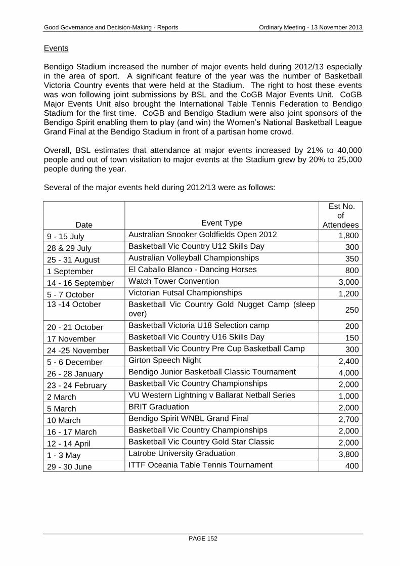
Good Governance and Decision-Making - Reports Ordinary Meeting - 13 November 2013
PAGE 152
Events Bendigo Stadium increased the number of major events held during 2012/13 especially in the area of sport. A significant feature of the year was the number of Basketball Victoria Country events that were held at the Stadium. The right to host these events was won following joint submissions by BSL and the CoGB Major Events Unit. CoGB Major Events Unit also brought the International Table Tennis Federation to Bendigo Stadium for the first time. CoGB and Bendigo Stadium were also joint sponsors of the Bendigo Spirit enabling them to play (and win) the Women’s National Basketball League Grand Final at the Bendigo Stadium in front of a partisan home crowd. Overall, BSL estimates that attendance at major events increased by 21% to 40,000 people and out of town visitation to major events at the Stadium grew by 20% to 25,000 people during the year. Several of the major events held during 2012/13 were as follows:
Date Event Type
Est No. of
Attendees
9 - 15 July Australian Snooker Goldfields Open 2012 1,800
28 & 29 July Basketball Vic Country U12 Skills Day 300
25 - 31 August Australian Volleyball Championships 350
1 September El Caballo Blanco - Dancing Horses 800
14 - 16 September Watch Tower Convention 3,000
5 - 7 October Victorian Futsal Championships 1,200
13 -14 October Basketball Vic Country Gold Nugget Camp (sleep over) 250
20 - 21 October Basketball Victoria U18 Selection camp 200
17 November Basketball Vic Country U16 Skills Day 150
24 -25 November Basketball Vic Country Pre Cup Basketball Camp 300
5 - 6 December Girton Speech Night 2,400
26 - 28 January Bendigo Junior Basketball Classic Tournament 4,000
23 - 24 February Basketball Vic Country Championships 2,000
2 March VU Western Lightning v Ballarat Netball Series 1,000
5 March BRIT Graduation 2,000
10 March Bendigo Spirit WNBL Grand Final 2,700
16 - 17 March Basketball Vic Country Championships 2,000
12 - 14 April Basketball Vic Country Gold Star Classic 2,000
1 - 3 May Latrobe University Graduation 3,800
29 - 30 June ITTF Oceania Table Tennis Tournament 400
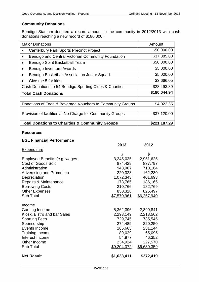
Good Governance and Decision-Making - Reports Ordinary Meeting - 13 November 2013
PAGE 153
Community Donations
Bendigo Stadium donated a record amount to the community in 2012/2013 with cash donations reaching a new record of $180,000.
Major Donations Amount
Canterbury Park Sports Precinct Project $50,000.00
Bendigo and Central Victorian Community Foundation $37,885.00
Bendigo Spirit Basketball Team $50,000.00
Bendigo Inventors Awards $5,000.00
Bendigo Basketball Association Junior Squad $5,000.00
Give me 5 for kids $3,666.05
Cash Donations to 54 Bendigo Sporting Clubs & Charities $28,493.89
Total Cash Donations $180,044.94
Donations of Food & Beverage Vouchers to Community Groups $4,022.35
Provision of facilities at No Charge for Community Groups $37,120.00
Total Donations to Charities & Community Groups $221,187.29
Resources
BSL Financial Performance 2013 2012 Expenditure $ $ Employee Benefits (e.g. wages 3,245,035 2,951,625 Cost of Goods Sold 874,429 837,797 Administration 943,967 710,164 Advertising and Promotion 220,328 162,230 Depreciation 1,072,343 401,693 Repairs & Maintenance 173,765 186,165 Borrowing Costs 210,766 182,769 Other Expenses 830,328 825,497 Sub Total $7,570,961 $6,257,940 Income Gaming Income 5,362,396 2,890,841 Kiosk, Bistro and bar Sales 2,293,149 2,213,562 Sporting Fees 729,745 735,545 Sponsorship 274,489 220,250 Events Income 165,663 231,144 Training Income 89,029 65,095 Interest Income 54,977 46,352 Other Income 234,924 227,570 Sub Total $9,204,372 $6,630,359 Net Result $1,633,411 $372,419
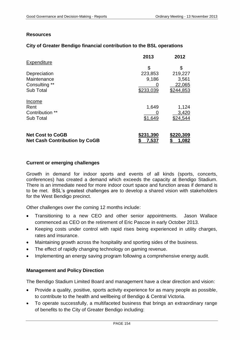
Good Governance and Decision-Making - Reports Ordinary Meeting - 13 November 2013
PAGE 154
Resources City of Greater Bendigo financial contribution to the BSL operations 2013 2012 Expenditure $ $ Depreciation 223,853 219,227 Maintenance 9,186 3,561 Consulting ** 0 22,065 Sub Total $233,039 $244,853 Income Rent 1,649 1,124 Contribution ** 0 3,420 Sub Total $1,649 $24,544 Net Cost to CoGB $231,390 $220,309 Net Cash Contribution by CoGB $ 7,537 $ 1,082 Current or emerging challenges Growth in demand for indoor sports and events of all kinds (sports, concerts, conferences) has created a demand which exceeds the capacity at Bendigo Stadium. There is an immediate need for more indoor court space and function areas if demand is to be met. BSL’s greatest challenges are to develop a shared vision with stakeholders for the West Bendigo precinct. Other challenges over the coming 12 months include:
Transitioning to a new CEO and other senior appointments. Jason Wallace
commenced as CEO on the retirement of Eric Pascoe in early October 2013.
Keeping costs under control with rapid rises being experienced in utility charges,
rates and insurance.
Maintaining growth across the hospitality and sporting sides of the business.
The effect of rapidly changing technology on gaming revenue.
Implementing an energy saving program following a comprehensive energy audit.
Management and Policy Direction The Bendigo Stadium Limited Board and management have a clear direction and vision:
Provide a quality, positive, sports activity experience for as many people as possible,
to contribute to the health and wellbeing of Bendigo & Central Victoria.
To operate successfully, a multifaceted business that brings an extraordinary range
of benefits to the City of Greater Bendigo including:

Good Governance and Decision-Making - Reports Ordinary Meeting - 13 November 2013
PAGE 155
o Multimillion dollar economic stimulus
o Broad ranging health and wellbeing benefits
o Substantially boosting annual tourist numbers
o Financial contributor to Council
o Charitable and community donations
o Public entertainment
o Multimillion dollar capital reinvestment in the City
To pursue the expansion of the Bendigo Stadium in a yet to be determined form.
The possible scope for capital works ranges from the addition of two extra indoor
basketball courts to the construction of a new 4,000 seat stadium incorporating
function and office space.
To run all parts of the operation, hospitality, sport, gaming and training at a
professional level so as to attract maximum participation in each aspect of the
stadium.
To maintain financial viability and strong governance processes.
Work in collaboration with the various entities that make up the Stadium, i.e. BSL
Board, Bendigo Basketball Association, Braves, Bendigo Volleyball Association and
Stadium Management.
RECOMMENDATION
That the Greater Bendigo City Council: a) Recognise the strong performance of Bendigo Stadium Limited and its contribution to
Bendigo through providing quality sporting and event facilities contributing to positive economic, tourism, health and fitness outcomes in the Bendigo community.
b) Request the Bendigo Stadium Limited to report annually on its performance.

Good Governance and Decision-Making - Reports Ordinary Meeting - 13 November 2013
PAGE 156
6.3 CONTRACTS AWARDED UNDER DELEGATION
Document Information
Author Leeanne Taig, Administration Assistant, Project Coordination Responsible Marg Allan, Director Organisation Support Director
Summary/Purpose
The purpose of this report is to provide information on contracts recently awarded under delegation.
Policy Context
Provide high quality professional services by undertaking responsible business planning to ensure long-term sustainability.
Report
The following contracts subject to public tender, have been issued under delegation by the officer as listed (Instrument of Delegation - August 5, 2009):
RECOMMENDATION
That the Contracts Award Under Delegation, as outlined in this report, be endorsed by Council.
Contract No
Project Successful Contractor Value (GST Excl)
Delegated Officer
Date Signed
CT000070
Supply of Various Reinforced Concrete Pipes and Box Culverts
Bendigo Precast Concrete Products Allstone Quarries Holcim (Australia) Pty Ltd
Schedule of Rates
Craig Niemann 14/10/13
CT000077 Fire Risk Removal
Northern Victorian
Enviro Control
Electrical Resource
Providers
Schedule of Rates
Prue Mansfield 22/10/13
CT000075 Fire Plug Maintenance
Urban Maintenance Systems Pty Ltd
Schedule of Rates
Prue Mansfield 29/1013
Good Governance and Decision-Making - Reports Ordinary Meeting - 13 November 2013
PAGE 157
6.4 RECORD OF ASSEMBLIES
Document Information
Author Peter Davies, Manager Executive Services Responsible Craig Niemann, Chief Executive Officer Officer
Summary/Purpose
The purpose of this report is to provide the record of any assembly of Councillors, which has been held since the last Council Meeting, so that it can be recorded in the Minutes of the formal Council Meeting.
Policy Context
The purpose of this report is to provide the record of any assembly of Councillors, which has been held since the last Council Meeting, so that it can be recorded in the Minutes of the formal Council Meeting.
Background Information
The Local Government Act provides a definition of an assembly of Councillors where conflicts of interest must be disclosed. A meeting will be an assembly of Councillors if it considers matters that are likely to be the subject of a Council decision, or, the exercise of a Council delegation and the meeting is: 1. A planned or scheduled meeting that includes at least half the Councillors (5) and a
member of Council staff; or 2. an advisory committee of the Council where one or more Councillors are present. The requirement for reporting provides increased transparency and the opportunity for Councillors to check the record, particularly the declarations of conflict of interest.
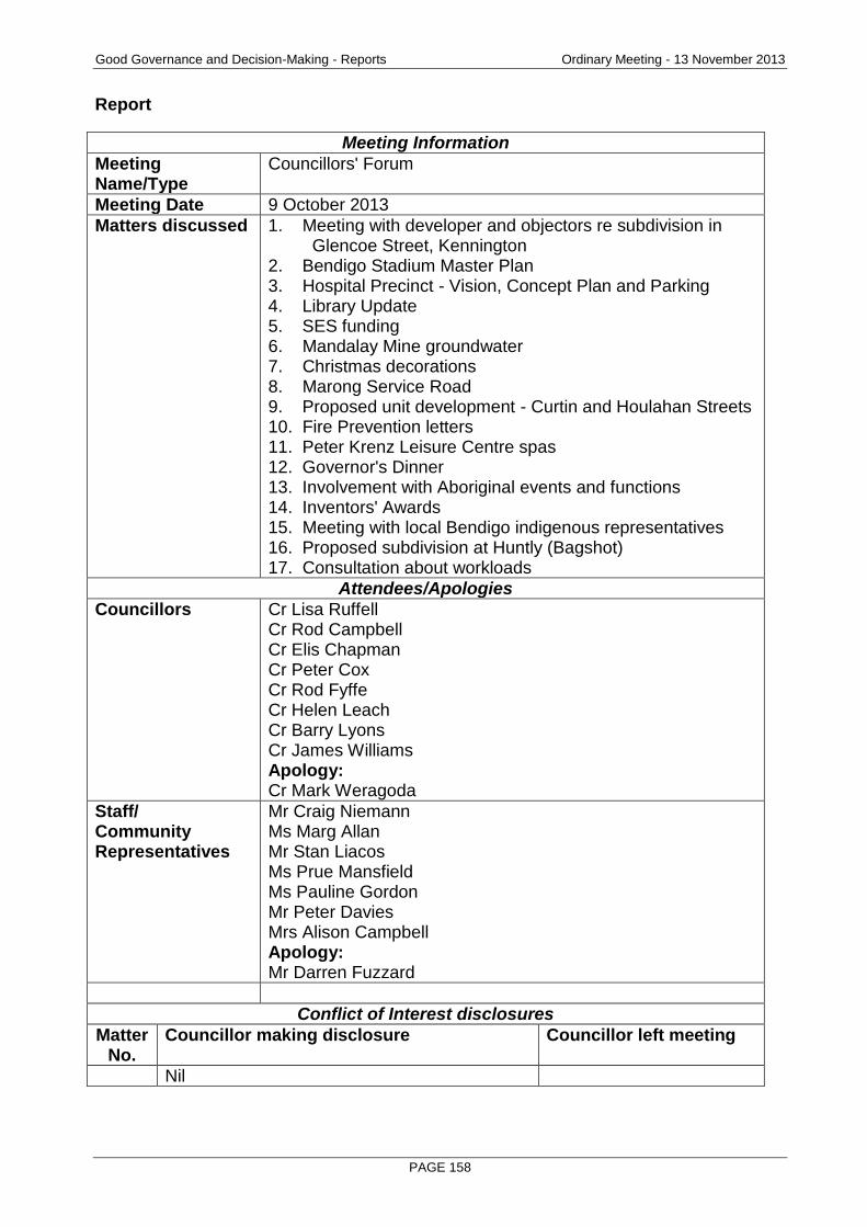
Good Governance and Decision-Making - Reports Ordinary Meeting - 13 November 2013
PAGE 158
Report
Meeting Information
Meeting Name/Type
Councillors' Forum
Meeting Date 9 October 2013
Matters discussed 1. Meeting with developer and objectors re subdivision in Glencoe Street, Kennington 2. Bendigo Stadium Master Plan 3. Hospital Precinct - Vision, Concept Plan and Parking 4. Library Update 5. SES funding 6. Mandalay Mine groundwater 7. Christmas decorations 8. Marong Service Road 9. Proposed unit development - Curtin and Houlahan Streets 10. Fire Prevention letters 11. Peter Krenz Leisure Centre spas 12. Governor's Dinner 13. Involvement with Aboriginal events and functions 14. Inventors' Awards 15. Meeting with local Bendigo indigenous representatives 16. Proposed subdivision at Huntly (Bagshot) 17. Consultation about workloads
Attendees/Apologies
Councillors Cr Lisa Ruffell Cr Rod Campbell Cr Elis Chapman Cr Peter Cox Cr Rod Fyffe Cr Helen Leach Cr Barry Lyons Cr James Williams Apology: Cr Mark Weragoda
Staff/ Community Representatives
Mr Craig Niemann Ms Marg Allan Mr Stan Liacos Ms Prue Mansfield Ms Pauline Gordon Mr Peter Davies Mrs Alison Campbell Apology: Mr Darren Fuzzard
Conflict of Interest disclosures
Matter No.
Councillor making disclosure Councillor left meeting
Nil
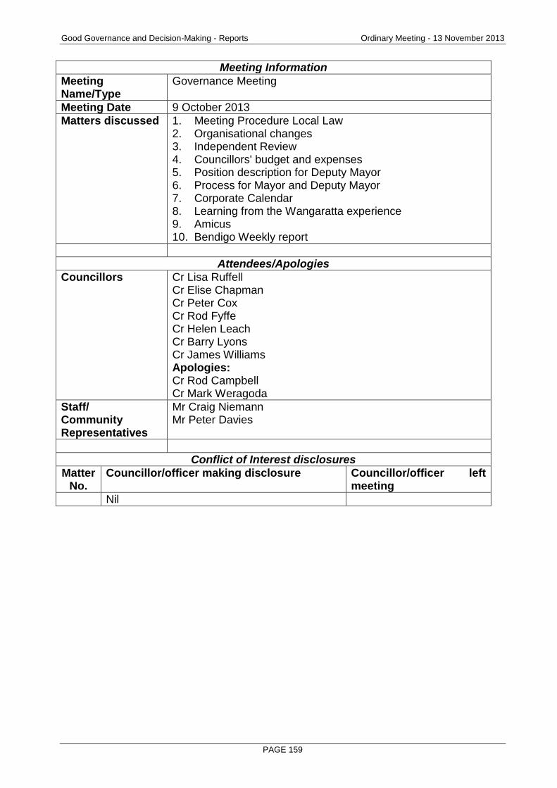
Good Governance and Decision-Making - Reports Ordinary Meeting - 13 November 2013
PAGE 159
Meeting Information
Meeting Name/Type
Governance Meeting
Meeting Date 9 October 2013
Matters discussed 1. Meeting Procedure Local Law 2. Organisational changes 3. Independent Review 4. Councillors' budget and expenses 5. Position description for Deputy Mayor 6. Process for Mayor and Deputy Mayor 7. Corporate Calendar 8. Learning from the Wangaratta experience 9. Amicus 10. Bendigo Weekly report
Attendees/Apologies
Councillors Cr Lisa Ruffell Cr Elise Chapman Cr Peter Cox Cr Rod Fyffe Cr Helen Leach Cr Barry Lyons Cr James Williams Apologies: Cr Rod Campbell Cr Mark Weragoda
Staff/ Community Representatives
Mr Craig Niemann Mr Peter Davies
Conflict of Interest disclosures
Matter No.
Councillor/officer making disclosure Councillor/officer left meeting
Nil

Good Governance and Decision-Making - Reports Ordinary Meeting - 13 November 2013
PAGE 160
Meeting Information
Meeting Name/Type
Councillors' Forum
Meeting Date 16 October 2013
Matters discussed 1. Planning matters and draft Ordinary Meeting agenda review 2. Maintenance of nature strips 3. Signage Policy 4. Huntly/Epsom Drainage Committee 5. Bendigo Creek Levy 6. Civic Events Officer 7. Aboriginal employment 8. Operations of trams during the Christmas period 9. Asset Management Policy 10. Progress on Canterbury Park 11. Section 89 Reports 12. Independent Review actions 13. Consultation about Councillor workloads
Attendees/Apologies
Councillors Cr Lisa Ruffell Cr Rod Campbell Cr Peter Cox Cr Rod Fyffe Cr Barry Lyons Cr James Williams Cr Helen Leach Apologies: Cr Elise Chapman Cr Mark Weragoda
Staff/ Community Representatives
Mr Craig Niemann Ms Marg Allan Ms Prue Mansfield Ms Pauline Gordon Mr Darren Fuzzard Mr Peter Davies Mrs Alison Campbell Apology: Mr Stan Liacos
Conflict of Interest disclosures
Matter No.
Councillor/officer making disclosure Councillor/officer left meeting
3. Cr Ruffell Yes
RECOMMENDATION
That Council endorse the record of assemblies of Councillors as outlined in this report.
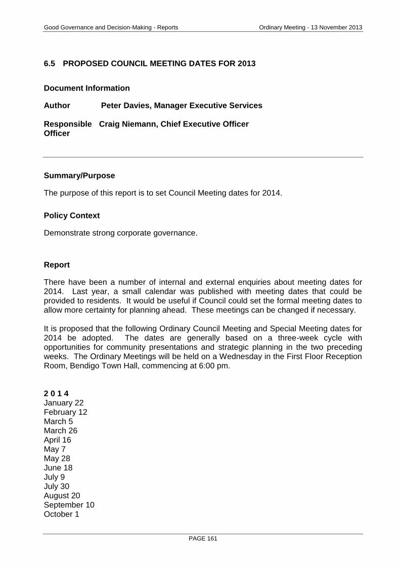
Good Governance and Decision-Making - Reports Ordinary Meeting - 13 November 2013
PAGE 161
6.5 PROPOSED COUNCIL MEETING DATES FOR 2013
Document Information
Author Peter Davies, Manager Executive Services Responsible Craig Niemann, Chief Executive Officer Officer
Summary/Purpose
The purpose of this report is to set Council Meeting dates for 2014.
Policy Context
Demonstrate strong corporate governance.
Report
There have been a number of internal and external enquiries about meeting dates for 2014. Last year, a small calendar was published with meeting dates that could be provided to residents. It would be useful if Council could set the formal meeting dates to allow more certainty for planning ahead. These meetings can be changed if necessary. It is proposed that the following Ordinary Council Meeting and Special Meeting dates for 2014 be adopted. The dates are generally based on a three-week cycle with opportunities for community presentations and strategic planning in the two preceding weeks. The Ordinary Meetings will be held on a Wednesday in the First Floor Reception Room, Bendigo Town Hall, commencing at 6:00 pm. 2 0 1 4 January 22 February 12 March 5 March 26 April 16 May 7 May 28 June 18 July 9 July 30 August 20 September 10 October 1
Good Governance and Decision-Making - Reports Ordinary Meeting - 13 November 2013
PAGE 162
October 22 November 11 (Tuesday) Special Meeting of Council to Elect the Mayor for 2014/2015; and consideration of Council and Community Committees November 12 December 3 December 17
Resource Implications
Statutory advertising of the meeting dates is accommodated within the budget.
RECOMMENDATION
That the Ordinary Meeting of Council dates for 2014 (and the Special Meeting for the Election of the Mayor for 2014/2015 and Consideration of Council and Community Committees), as outlined in this report be confirmed and advertised.
Ordinary Meeting - 13 November 2013
PAGE 163
7. URGENT BUSINESS
Nil.
8. NOTICES OF MOTION
Nil.
9. COUNCILLORS' REPORTS
10. MAYOR'S REPORT
11. CHIEF EXECUTIVE OFFICER'S REPORT
12. CONFIDENTIAL (SECTION 89) REPORTS
Nil.