agenda - shorelinecosweb.ci.shoreline.wa.us/uploads/attachments/cck/...agenda click here to comment...
TRANSCRIPT
AGENDA
CLICK HERE TO COMMENT ON AGENDA ITEMS
STAFF PRESENTATIONS
PUBLIC COMMENT
SHORELINE CITY COUNCIL WORKSHOP DINNER MEETING
Monday, May 13, 2013 Conference Room 104 · Shoreline City Hall5:45 p.m. 17500 Midvale Avenue North
TOPICS/GUESTS: Police Facility Feasibility Study; Potential 12 Year PTE Program; Celebrate
Shoreline
SHORELINE CITY COUNCIL BUSINESS MEETING
Monday, May 13, 2013 Council Chamber · Shoreline City Hall7:00 p.m. 17500 Midvale Avenue North
Page Estimated
Time1. CALL TO ORDER 7:00 2. FLAG SALUTE/ROLL CALL
(a) Proclamation of Armed Services Appreciation Week 1 3. REPORT OF THE CITY MANAGER 4. COUNCIL REPORTS 5. PUBLIC COMMENT Members of the public may address the City Council on agenda items or any other topic for three minutes or less, depending on the number of people wishing to speak. The total public comment period will be no more than 30 minutes. If more than 15 people are signed up to speak, each speaker will be allocated 2 minutes. When representing the official position of a State registered non-profit organization or agency or a City-recognized organization, a speaker will be given 5 minutes and it will be recorded as the official position of that organization. Each organization shall have only one, five-minute presentation. Speakers are asked to sign up prior to the start of the Public Comment period. Individuals wishing to speak to agenda items will be called to speak first, generally in the order in which they have signed. If time remains, the Presiding Officer will call individuals wishing to speak to topics not listed on the agenda generally in the order in which they have signed. If time is available, the Presiding Officer may call for additional unsigned speakers.
6. APPROVAL OF THE AGENDA 7:20 7. CONSENT CALENDAR
(a) Minutes of Special Meeting of April 29, 2013 3 7:20
Minutes of Business Meeting of April 29, 2013 5
(b) Approval of expenses and payroll as of May 3, 2013 in the amount of $796,405.66
9
8. ACTION ITEM
(a) Adoption of the 2013 Comprehensive Plan Docket 11 7:20
9. ADJOURNMENT 8:30 The Council meeting is wheelchair accessible. Any person requiring a disability accommodation should contact the City Clerk’s Office at 801-2231 in advance for more information. For TTY service, call 546-0457. For up-to-date information on future agendas, call 801-2236 or see the web page at www.shorelinewa.gov. Council meetings are shown on Comcast Cable Services Channel 21 and Verizon Cable Services Channel 37 on Tuesdays at 12 noon and 8 p.m., and Wednesday through Sunday at 6 a.m., 12 noon and 8 p.m. Online Council meetings can also be viewed on the City’s Web site at http://shorelinewa.gov.

Council Meeting Date: May 13, 2013 Agenda Item: 2(a)
CITY COUNCIL AGENDA ITEM
CITY OF SHORELINE, WASHINGTON
AGENDA TITLE: Proclamation of “Armed Services Appreciation Week” DEPARTMENT: CMO/CCK PRESENTED BY: Scott Passey, City Clerk
PROBLEM/ISSUE STATEMENT: In observance of Memorial Day on Monday, May 27, this proclamation recognizes the week of May 27-June 2 as “Armed Services Appreciation Week” in the City of Shoreline. This proclamation acknowledges the important sacrifices that members of the United States military and their families make to our City and nation. Representatives of the Veterans of the Viet Nam War (VVNW) Post 12 will be at the meeting to accept the proclamation.
RECOMMENDATION No action is required. This item is intended for information only and to bring awareness to a City-wide issue. Approved By: City Manager JU City Attorney ___
000001

P R O C L A M A T I O N
WHEREAS, the City of Shoreline desires to express appreciation to our fellow citizens who have been called upon to perform their military duties, wherever they may be; and
WHEREAS, the members of the United States Armed Services have carried out their
duties and missions with excellence, patriotism and bravery; and WHEREAS, thousands of United States troops have sacrificed their lives in service to
their country in current and recent military campaigns, and WHEREAS, the families of the United States military personnel have also sacrificed
while providing support for their loved ones engaged in military operations; and
WHEREAS, United States troops continue to serve by protecting the citizens of many nations throughout the world; and
WHEREAS, the Shoreline City Council urges Shoreline residents to recognize the
important sacrifice of members of the United States military and their families to our City and nation;
NOW, THEREFORE, I, Keith A. McGlashan, Mayor of the City of Shoreline, on behalf of
the Shoreline City Council, do hereby proclaim in the City of Shoreline the week of May 27 – June 2, 2013 as
ARMED SERVICES APPRECIATION WEEK
_______________________________
Keith A. McGlashan, Mayor
000002
April 29, 2013 Workshop Dinner Meeting DRAFT
CITY OF SHORELINE
SHORELINE CITY COUNCIL SUMMARY MINUTES OF WORKSHOP DINNER MEETING
Monday, April 29, 2013 Conference Room 104 - Shoreline City Hall 5:45 p.m. 17500 Midvale Avenue North PRESENT: Mayor McGlashan, Deputy Mayor Eggen, and Councilmembers Hall,
McConnell, and Roberts. Councilmember Salomon arrived at 6:21 p.m.
ABSENT: Councilmember Winstead STAFF: Julie Underwood, City Manager; Debbie Tarry, Assistant City Manager,
Mark Relph, Public Works Director; Ian Sievers, City Attorney; John Norris, Management Analyst; Scott Passey, City Clerk; Jessica Simulcik Smith, Deputy City Clerk
GUESTS: None At 5:51 p.m., the meeting was called to order by Mayor McGlashan, who presided. Upon motion by Deputy Mayor Eggen, seconded by Councilmember McConnell and carried 5-0, Councilmember Winstead was excused. Potential Dinner Meeting with Ronald Wastewater District Julie Underwood, City Manager, initiated the discussion regarding scheduling a dinner meeting with Ronald Wastewater and possible topics to put on the agenda, which she listed as: Point Wells, sewage treatment, transition planning, and issues of mutual interest. The Council briefly discussed each topic, asked questions, offered suggestions, and provided Ms. Underwood with direction to draft a final agenda. Council Rules of Procedure Ms. Underwood introduced the topic of workshop dinner meetings. She explained that Council has expressed a desire to be able to schedule dinner meetings as the need arises. Currently, dinner meetings are scheduled regularly on the second and fourth Mondays of each month and do not require a special meeting notice. Mr. Sievers reviewed the rules for noticing and trade-offs between keeping to a regular meeting schedule and having flexibility. A regular schedule offers predictability for the public. Calling dinner
000003

April 29, 2013 Workshop Dinner Meeting DRAFT
meetings as needed requires a special meeting notice and would not allow the Council to discuss anything other than the items listed in the notice. The Council agreed that the function of a dinner meeting is valuable in that it provides an informal time to meet with representatives from other agencies/organizations or to provide some preliminary feedback for staff as they plan future agenda items. The Council’s consensus was to continue with a regular workshop dinner meeting schedule and add additional meetings as needed. Next, Ms. Underwood recalled a previous discussion on the role of Mayor and Deputy Mayor acting as the spokesperson. Since this topic was requested to be discussed by Councilmember Winstead, Ms. Underwood suggested it be delayed to a future meeting so she could participate in the discussion. Council Communications with the Public Ms. Underwood reviewed that the outcome of recent legislation prompted Council to revisit the topic of communications with the public so they are aware of upcoming action items and are provided with an accurate recap of them afterwards. Councilmembers commented that information needs to be less technical and easy to understand. The Council discussed the nature of legislative projects: how the public is notified of these types of actions, and the function of the Planning Commission’s recommendation, and Council as the body to ultimately adopt legislation. The Council agreed that it strives to operate transparently and understands that sometimes decisions are made that appear like it did not. The Council agreed to have the City Manager or designee meet with SAN to see if they have any creative ideas for improving communication regarding City business. Council Candidate Orientation Ms. Underwood informed the Council that an orientation for candidates would be held June 3. At 6:53 p.m., Mayor McGlashan declared the meeting adjourned. ____________________________ Jessica Simulcik Smith, Deputy City Clerk
000004
April 29, 2013 Council Business Meeting DRAFT
CITY OF SHORELINE
SHORELINE CITY COUNCIL SUMMARY MINUTES OF BUSINESS MEETING
Monday, April 29, 2013 Council Chambers - Shoreline City Hall 7:00 p.m. 17500 Midvale Avenue North PRESENT: Mayor McGlashan, Deputy Mayor Eggen, and Councilmembers Hall, McConnell,
Salomon, and Roberts ABSENT: Councilmember Winstead
1. CALL TO ORDER At 7:00 p.m., the meeting was called to order by Mayor McGlashan, who presided. 2. FLAG SALUTE/ROLL CALL Mayor McGlashan led the flag salute. Upon roll call by the City Clerk, all Councilmembers were present with the exception of Councilmember Winstead. Upon motion by Councilmember McConnell, seconded by Councilmember Solomon and carried 6-0, Councilmember Winstead was excused. 3. REPORT OF THE CITY MANAGER Julie Underwood, City Manager, provided reports and updates on various City meetings, projects, and events. 4. COUNCIL REPORTS None 5. PUBLIC COMMENT a) Tom Jamieson, Shoreline, expressed opposition to the proposed ordinance banning plastic bags based on a lack of urgency and negative impacts on businesses. b) Emma Jornlin, Seattle, Environment Washington, outlined her outreach efforts at Shoreline Community College regarding support for the plastic bag ban. c) Amy Tower, Seattle, expressed support for the plastic bag ban, adding that Seattle is being more mindful of using resources.
000005

April 29, 2013 Council Business Meeting DRAFT
d) Katie Moore, Everett, spoke in favor of recycling and opposed the ordinance banning plastic bags due to the harmful unintended consequences on small businesses. e) Lois Harrison, Shoreline, expressed support for a bag ban due to environmental concerns, adding that Styrofoam containers are also a problem. f) Kathi Peterson, Shoreline, stated she and most of her neighbors oppose a plastic bag ban due to business impacts, adding that it should be voted on by residents. g) Craig Keller, Seattle, Save Our Choice, opposed the plastic bag ban due to the economic impacts on consumers, retailers, and Shoreline generally. He would like to see a better job of polling the community and mentioned a referendum if the ban passed. h) Dennis Heller, Shoreline, expressed support for the plastic bag ban because it is an important environmental issue everyone’s been waiting for. i) Charlotte Haines, Shoreline, opposed the plastic bag ban, adding that if the Council is going to do it, it must consider all plastic disposable products. 6. APPROVAL OF THE AGENDA Upon motion by Councilmember Hall, seconded by Councilmember McConnell and carried 6-0, the agenda was approved. 7. CONSENT CALENDAR Upon motion by Councilmember Hall, seconded by Councilmember Roberts and carried 6-0, the following Consent Calendar items were approved: (a) Minutes of Business Meeting of April 15, 2013 8. ACTION ITEMS (a) Adoption of Ordinance No. 660 Amending the Categorical Exemptions for Minor New
Construction Under the Environmental Policy Act; and Amending Section 20.30.560 of the Shoreline Municipal Code
Jeff Forry, Permit Services Manager, provided the staff report on proposed Ordinance No. 660 related to the City’s environmental review procedures. He advised that the proposed amendments would raise the thresholds for minor new construction and eliminate the automatic environmental review for activities in critical areas and their buffers. He explained that the amendments are intended to implement the Department of Ecology’s thresholds that were developed as a result of Senate Bill 6406 and the purpose of this meeting was to discuss any remaining issues prior to adoption.
000006

April 29, 2013 Council Business Meeting DRAFT
Mr. Forry responded to Council questions by providing information on how the State Environmental Policy Act rules apply to counties and cities not planning under the Growth Management Act, the rule making process, and expiration provisions in bill. He then recommended that the Council adopt Ordinance No. 660 as proposed and concluded by outlining the action alternatives available to Council. Councilmember Hall moved adoption of Ordinance No. 660. Councilmember Salomon seconded the motion. Councilmember Hall indicated his support for the amendments based on environmental regulations being put in place over the years resulting in a reduction of environmental impacts for development. Furthermore, the thresholds were debated at length both in the State Legislature and during the rule making process. Councilmember Salomon agreed that the environmental regulations in place, outside of the State Environmental Policy Act (SEPA), are sufficiently protecting the environment. He emphasized that reducing the thresholds will also be friendly for redevelopment within the City which is critical for economic wellbeing. Councilmember Roberts expressed that there is value in giving the public a venue to comment on the impacts a development will have. He reminded the Council of the steps the City has taken to make the SEPA process easier for developers through Planned Actions for commercial areas like Town Center and he hopes the same can be done for the Light Rail Station Areas and the Aurora Square Community Renewal Area. Councilmember Roberts expressed his belief that SEPA is not a burdensome obstacle for staff or developers and stressed that there does not seem to be any rush to make these amendments. He indicated he would support the thresholds recommended for non-GMA planning cities. Mayor McGlashan spoke in favor of the motion as he believes it will be a step towards achieving the Council’s goal of strengthening Shoreline’s economic base. A vote was taken on the motion to adopt Ordinance No. 660, which carried 5-1, with Councilmember Roberts dissenting. (b) Approval of Ordinance No. 653 Banning the Use of Plastic Carryout Bags John Norris, Management Analyst, provided the staff report on proposed Ordinance No. 653 related to the ban of plastic carryout bags. He highlighted the provisions of the Ordinance, including carryout bag regulations, effective date, definitions, exemptions from the charge, and penalties. He discussed the Ordinance implementation plan, including the citizen/consumer communication strategy, business communication strategy, enforcement strategy, and issues with increased rates of shoplifting. He concluded by outlining the action alternatives available to Council. Councilmember Roberts moved adoption of Ordinance No. 653. Councilmember Salomon seconded the motion.
000007

April 29, 2013 Council Business Meeting DRAFT
Councilmember Roberts questioned if the implementation strategy allowing retailers to use existing plastic bag stock after the ban is in effect would conflict with the Ordinance language. Mr. Norris clarified the intent of the enforcement provisions and Mr. Sievers indicated the City has prosecutorial discretion, adding that it would also be a hard case to make if the City has eight months to educate businesses about the regulations. Councilmember Roberts asked if staff had a recommendation on pushing the effective date back. Mr. Norris responded that February 1 would be acceptable. Deputy Mayor Eggen moved to amend the implementation date to February 1, 2014. Councilmember Salomon seconded the motion, which carried 6-0. Mayor McGlashan, Deputy Mayor Eggen, and Councilmembers Hall, Roberts, and Salomon each declared their support for the Ordinance. The general consensus was that even though a ban would not make a major impact in protecting the environment, and measuring benefits versus harm would be difficult, plastic is not good for the environment. Given that sustainability is the centerpiece of the City’s strategy, the ban would be a step in the right direction. The Council asked questions about particular exemptions and the paper bag charge and its applicable tax. There was agreement that the City should also consider Styrofoam and take a comprehensive look at what it can do to be more environmentally sustainable. A vote was taken on the motion to adopt Ordinance No. 653 as amended, which carried 5-1, with Councilmember McConnell dissenting. 9. ADJOURNMENT At 8:45 p.m., Mayor McGlashan declared the meeting adjourned. _____________________________ Scott Passey, City Clerk
000008

Council Meeting Date: May 13, 2013 Agenda Item: 7(b)
CITY COUNCIL AGENDA ITEMCITY OF SHORELINE, WASHINGTON
AGENDA TITLE: Approval of Expenses and Payroll as of May 3, 2013DEPARTMENT: Administrative ServicesPRESENTED BY: R. A. Hartwig, Administrative Services Director
EXECUTIVE / COUNCIL SUMMARY
It is necessary for the Council to formally approve expenses at the City Council meetings. Thefollowing claims/expenses have been reviewed pursuant to Chapter 42.24 RCW (RevisedCode of Washington) "Payment of claims for expenses, material, purchases-advancements."
RECOMMENDATION
Motion: I move to approve Payroll and Claims in the amount of $1,765,553.24 specified in the following detail:
*Payroll and Benefits:
Payroll Period
Payment Date
EFT Numbers
(EF)
Payroll Checks
(PR)
Benefit Checks
(AP)Amount
Paid3/31/13-4/13/13 4/19/2013 49918-50116 12451-12479 53306-53313 $553,287.284/14/13-4/27/13 5/3/2013 50117-50326 12480-12506 53417-53422 $413,190.66
$966,477.94
*Wire Transfers:Expense Register Dated
Wire Transfer Number
Amount Paid
4/26/2013 1067 $2,669.64$2,669.64
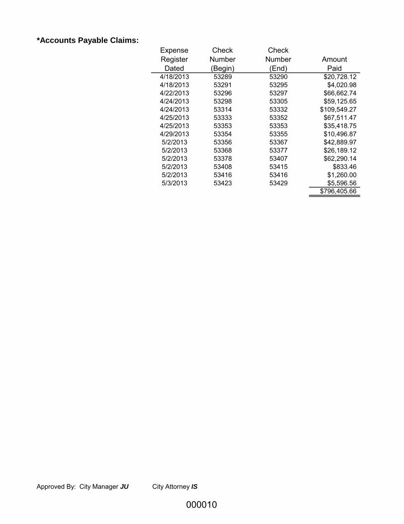
*Accounts Payable Claims: Expense Register Dated
Check Number (Begin)
Check Number (End)
Amount Paid
4/16/2013 53216 53227 $35,383.054/16/2013 53228 53240 $64,878.404/17/2013 53241 53248 $7,731.194/18/2013 53249 53257 $135,220.334/18/2013 53258 53282 $37,278.724/18/2013 53283 53288 $3,340.87
000009
*Accounts Payable Claims: Expense Register Dated
Check Number (Begin)
Check Number (End)
Amount Paid
4/18/2013 53289 53290 $20,728.124/18/2013 53291 53295 $4,020.984/22/2013 53296 53297 $66,662.744/24/2013 53298 53305 $59,125.654/24/2013 53314 53332 $109,549.274/25/2013 53333 53352 $67,511.474/25/2013 53353 53353 $35,418.754/29/2013 53354 53355 $10,496.875/2/2013 53356 53367 $42,889.975/2/2013 53368 53377 $26,189.125/2/2013 53378 53407 $62,290.145/2/2013 53408 53415 $833.465/2/2013 53416 53416 $1,260.005/3/2013 53423 53429 $5,596.56
$796,405.66
Approved By: City Manager JU City Attorney IS
000010

Page 1
Council Meeting Date: May 13, 2013 Agenda Item: 8(a)
CITY COUNCIL AGENDA ITEM
CITY OF SHORELINE, WASHINGTON
AGENDA TITLE: Adoption of the 2013 Comprehensive Plan Amendment Docket DEPARTMENT: Planning and Community Development PRESENTED BY: Rachael Markle, AICP, Director ACTION: ____ Ordinance ____ Resolution X Motion
____ Discussion ____ Public Hearing
PROBLEM/ISSUE STATEMENT: The City is limited by state law and the City’s adopted procedures, to processing Comprehensive Plan amendments once a year. Proposed amendments are collected throughout a given year with a deadline of the last business day in December for amendments to be considered in the following year. The “Docket” establishes the amendments that will be reviewed and studied during the year by staff and the Planning Commission prior to a recommendation to the City Council on amending the Comprehensive Plan. The only proposed amendments submitted for the 2013 Docket relate to the Point Wells development. The Planning Commission recommended approval of the 2013 Docket on February 7, 2013 with a vote of 6-0. On January 7, 2013 the Court of Appeals ruled that BSRE’s, the developer of the Point Wells site, permits are vested as an Urban Center in Snohomish County. Snohomish County is proceeding with processing these permits as an Urban Center development of 3,081 residential units, 100,000+ square feet of commercial/retail space, and public recreational uses. The Snohomish County environmental review process requires that BSRE complete a traffic study which will identify mitigation to address anticipated impacts from the development, but the City of Shoreline has determined that a more comprehensive analysis that includes extensive public participation is warranted. To obtain this detailed analysis and public involvement the City reached an agreement with the developer to fund and participate in a Transportation Corridor Study (TCS) in coordination with the Snohomish County permitting process. The anticipated completion of the TCS in 2013 is driving the need to potentially amend the Comprehensive Plan later this year. The TCS is one of several items that the City is seeking from BSRE. In addition to the TCS the City is seeking that BSRE agree to the following in the form of a Municipal Services Agreement:
• A specific level of mitigation improvements. • Developer funding for the specific mitigation within a specific timeframe to ensure
mitigation is in place prior to the impacts occurring.
000011

Page 2
• A maximum traffic volume or “cap” for the development, and the ability to assure the traffic projections for each phase of development are accurate over time.
• Future annexation as a tool to insure the development’s residents pay their share of long-term maintenance costs. This also requires an Interlocal Agreement (ILA) with Snohomish County.
If the TCS process is successful, and the City is able to negotiate a Municipal Services Agreement with BSRE then the City’s Comprehensive Plan will need to be amended to reflect the agreement. Proposed action to amend the City’s Comprehensive Plan will only occur following the satisfactory completion of the TCS and execution of a Municipal Services Agreement. RESOURCE/FINANCIAL IMPACT: The 2013 Comprehensive Plan Docket does not require additional financial resources. The City will hire a neutral facilitator for the TCS process and the cost for that service is projected to be $34,000. This will be paid from contingency funds in the adopted 2013 budget. Also Environmental Review will need to be performed on the Comprehensive Plan amendments at an estimated cost of $7,600.
RECOMMENDATION Staff recommends that the Council approve the 2013 Comprehensive Plan Amendment Docket (Attachment C) as recommended by the Planning Commission and updated by staff. Approved By: City Manager JU City Attorney IS
000012

Page 3
INTRODUCTION The State Growth Management Act limits review of proposed Comprehensive Plan amendments to no more than once a year. To ensure that the public can view the proposals within a citywide context, the Growth Management Act directs cities to create a docket that lists the amendments to be considered in this “once a year” review process.
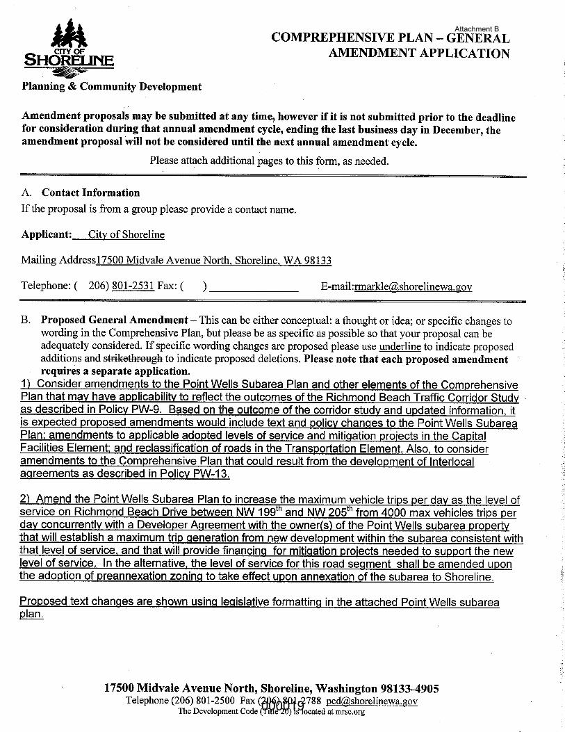
BACKGROUND Comprehensive plan amendments usually take two forms: Privately-initiated amendments and City-initiated amendments. Anyone can propose an amendment to the Comprehensive Plan. Comprehensive Plan amendments must be submitted by the last business day of the year to be considered in the following year and there is no fee for general text amendments. The process for accepting and reviewing Comprehensive Plan amendments for the annual docket is prescribed in SMC 20.30.340(C). Please see Attachment A: SMC 20.30.340(C). This year there were no privately-initiated amendments and one City-initiated amendment application. The City Council will review the proposed amendments as a package in order to consider the combined impacts of the proposals. If you have questions about the docket process or any item on the proposed docket, please contact Rachael Markle, AICP, at [email protected] or 206-801-2531.
DISCUSSION This year there was one City-initiated comprehensive plan amendment application (Attachment B). Point Wells Subarea Plan: As of April 2, 2013, the City has reached agreement with Blue Square Real Estate- Point Wells, LP (BSRE) to fund and participate in a Transportation Corridor Study (TCS). Following the successful completion of the TCS, the City will work on the execution of a Municipal Services Agreement (MSA) designed to obligate BSRE to fund the mitigation identified in the TCS. In anticipation of the TCS and the MSA, City staff submitted a proposal to amend the Point Wells Subarea Plan and the Capital Facilities and Transportation Elements of the Comprehensive Plan for consideration in 2013. These amendments may be needed to reflect the outcomes of the Traffic Corridor Study as described in Policy PW-9.
Policy PW-9 To enable appropriate traffic mitigation of future development at Point Wells, the developer should fund the preparation of a Transportation Corridor Study as the first phase of a Transportation Implementation Plan, under the direction of the City, with input and participation of Woodway, Edmonds, Snohomish County and WSDOT. The Study and Transportation Implementation Plan should identify, engineer, and provide schematic design and costs for intersection, roadway, walkway and other public investments needed to maintain or improve vehicular, transit, bicycle and pedestrian safety and flow on all road segments and intersections between SR 104, N 175th Street, and I-5 with
000013

Page 4
particular attention focused on Richmond Beach Drive and Richmond Beach Road. Road segments that would be impacted by an alternate secondary access through Woodway should also be analyzed, which would include 20th Avenue NW, 23rd Place NW and NW 204th Street. The Study and Transportation Plan should identify needed investments and services, including design and financing, for multimodal solutions to improving mobility and accessibility within the Richmond Beach neighborhood and adjacent communities, including but not limited to investments on Richmond Beach Drive and Richmond Beach Road.
The Snohomish County environmental review process requires that BSRE complete a traffic study which will identify mitigation to address anticipated impacts from the development, but the City of Shoreline determined that a more comprehensive analysis that includes extensive public participation is warranted. This will be accomplished through the TCS. The City’s memorandum of understanding with BSRE states that BSRE will fund and participate in a TCS in coordination with the Snohomish County permitting and environmental review process. Staff anticipates that the TCS will occur between June and August of 2013, but the timing is dependent on the Snohomish County environmental review process. The intent of the TCS is to further determine the impacts of future development at Point Wells and the level of improvements or mitigation required to reduce the impacts while staying within the City’s established traffic flow standards. The TCS will include establishing a traffic “cap” (e.g. Average Daily Traffic – ADT, or peak hour volume) of vehicles exiting and entering the development creating a mechanism where each phase of the project would be evaluated and required to remain within the traffic cap.
It is anticipated that the Point Wells Subarea Plan will need to be amended to allow for an increase above the current 4,000 maximum vehicle trips per day (traffic cap) on Richmond Beach Drive between NW 199th and NW 205th. Policy PW-12 anticipated that a higher vehicle trip per day would be considered with the completion of a TCS and mitigation plan.
Policy PW-12 In view of the fact that Richmond Beach Drive between NW 199th St. and NW 205th St. is a local road with no opportunities for alternative access to dozens of homes in Shoreline and Woodway, the City designates this as a local street with a maximum capacity of 4,000 vehicle trips per day. Unless and until 1)Snohomish County and/or the owner of the Point Wells Urban Center can provide to the City the Transportation Corridor Study and Mitigation Plan called for in Policy PW-9, and 2) sources of financing for necessary mitigation are committed, the City should not consider reclassifying this road segment.
The TCS will include a combination of workshops, meetings and a final presentation totaling six (6) public events over approximately two months. The workshops will be focused on the lower section of Richmond Beach Drive where individual property owners will be encouraged to participate in a process of deciding the level of improvements necessary along the right-of-way. Some examples are whether or not to include on-street parking, bike lanes, sidewalks or pathways and on which side of the street these facilities should be located and transit access. Other issues to assess
000014

Page 5
include the ease of left turning movements in relation to the traffic projections, driveway access and minimizing cut through traffic in the surrounding neighborhoods.
The meetings are intended to provide more general information and participation for the much larger area anticipated to be impacted from the development. This includes an area from Point Wells, up Richmond Beach Drive all the way through Aurora Avenue. More site specific improvements are anticipated to be required as the traffic impact is disbursed through the roadway network and could include such examples as widened and signalized intersection improvements along Richmond Beach Road at 20th, 15th, 8th and 3rd.
Based on the outcome of the TCS it is expected proposed Comprehensive Plan amendments would include text and policy changes to the Point Wells Subarea Plan; and possibly amendments to incorporate mitigation projects in the Capital Facilities Element. Staff Updates to the 2013 Docket Recommended by the Planning Commission Staff has had time to further consider the possible changes needed to document and implement the anticipated outcomes of the TCS. In an effort to identify all possible elements of the Comprehensive Plan that might be amended as a result of the TCS, staff originally included amending the Transportation Element. Upon further consideration, the Transportation Element of the Comprehensive Plan would not need to be amended to implement the outcomes of the TCS. Instead the Transportation Master Plan would need to be amended. There is no requirement to docket amendments to the Transportation Master Plan (TMP) and Council can update the TMP at anytime. Therefore, staff is recommending that the 2013 Docket be updated by Council to reflect this as shown in Attachment C - Updated Proposed 2013 Docket. Upon completion of the TCS and agreement by BSRE to fund the City approved mitigation measures, the Transportation Master Plan would need to be updated to reflect the increased traffic volumes on the following street segments: Richmond Beach Drive NW from NW 205th Street to NW 199th Street; Richmond Beach Drive NW from NW 196th Street to NW 195th Street; and NW 195th Street from Richmond Beach Drive NW to 24th Avenue NW. These street segments may need to be reclassified from local primary streets to a collector arterials. These reclassifications would be consistent with the rest of Richmond Beach Drive NW to the north, and with the corridor up to 20th Avenue NW. Also, there may be a need to consider amendments to the Comprehensive Plan that could result from the development of Interlocal agreements as described in Policy PW-13.
Policy PW-13 The City should work with the Town of Woodway, City of Edmonds and Snohomish County toward adoption of interlocal agreements to address the issues of land use, construction management of, urban service delivery to, and local governance of Point Wells. A joint SEPA lead-agency or other interlocal agreement with the County could assign to the City the responsibility for determining the scope, parameters, and technical review for the transportation
000015
Page 6
component of the County’s Environmental Impact Statement prepared for a future project at Point Wells. Under such agreement, this environmental analysis, funded by the permit applicant, could satisfy the policy objectives of the Transportation Corridor Study and Implementation Plan referenced at PW-10.
In summary, these amendments would be done concurrently with a Municipal Services Agreement with the owner(s) of the Point Wells property. This will establish a maximum trip count for new development within the subarea consistent with the City’s level of service and will provide financing for mitigation projects needed to support the level of service. The Planning Commission recommended approval of the 2013 Docket on February 7, 2013 with a vote of 6-0. Twelve (12) people provided public comment at the Planning Commission meeting. Attachment D includes written public comments and Attachment E contains the February 7, Planning Commission minutes. It is important to remember that by approving the 2013 Docket, the Council is simply agreeing that the amendments be included on the 2013 Docket. The amendments would then be studied, analyzed and considered for potential adoption at a later date in 2013.
STAKEHOLDER OUTREACH November 8, 2012: Press release and web notice announcing the City’s deadline for submitting Comprehensive Plan Amendments January 18, 2013: Press release and web notice summarizing the draft Docket February 7, 2013: Planning Commission Meeting February 11, 2013: City Council update on the Point Wells development February 12, 2013: Staff presentation at Richmond Beach Community Association regarding Point Wells April 2, 2013: Press release on Transportation Corridor Study MOU April 21, 2013: Staff met with residents along the Richmond Beach Drive corridor to discuss the TCS.
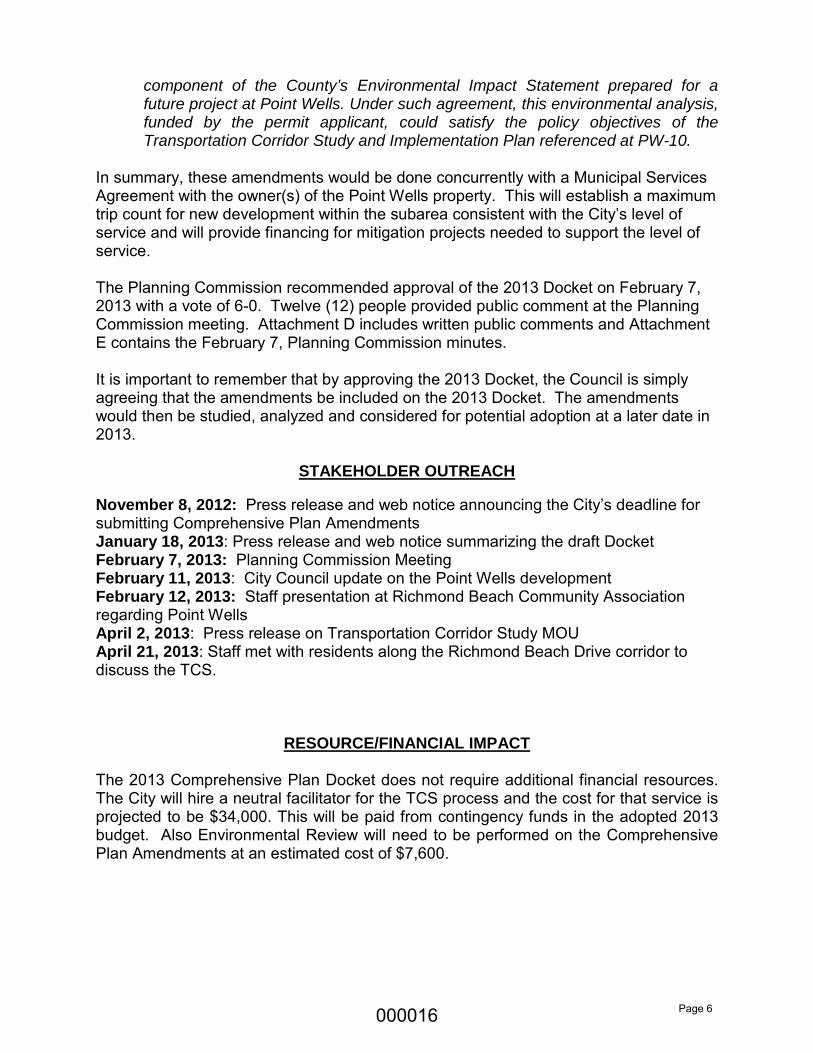
RESOURCE/FINANCIAL IMPACT
The 2013 Comprehensive Plan Docket does not require additional financial resources. The City will hire a neutral facilitator for the TCS process and the cost for that service is projected to be $34,000. This will be paid from contingency funds in the adopted 2013 budget. Also Environmental Review will need to be performed on the Comprehensive Plan Amendments at an estimated cost of $7,600.
000016
Page 7
RECOMMENDATION Staff recommends that the Council approve the 2013 Comprehensive Plan Amendment Docket (Attachment C) as recommended by the Planning Commission and updated by staff.
ATTACHMENTS
Attachment A SMC 20.30.340(C) Process for Accepting and Reviewing Comprehensive Plan Amendments
Attachment B Comprehensive Plan Amendment Application Attachment C Updated Proposed 2013 Docket
Exhibit 1 – Subarea Plan 2 – Point Wells proposed amendments Attachment D: Written public comments Attachment E: Planning Commission Minutes 2/7/13
000017

Attachment A
20.30.340 Amendment and review of the Comprehensive Plan (legislative action). .....
C. The City of Shoreline’s process for accepting and reviewing Comprehensive Plan amendments for the annual docket shall be as follows:
1. Amendment proposals will be accepted throughout the year. The closing date for the current year’s docket is the last business day in December.
2. Anyone can propose an amendment to the Comprehensive Plan.
• There is no fee for submitting a general text amendment to the Comprehensive Plan.
• An amendment to change the land use designation, also referred to as a site specific Comprehensive Plan amendment, requires the applicant to apply for a rezone application to be processed in conjunction with the Comprehensive Plan amendment. There are separate fees for a site specific CPA request and a rezone application.
3. At least three weeks prior to the closing date, there will be general public dissemination of the deadline for proposals for the current year’s docket. Information will include a staff contact, a re-statement of the deadline for accepting proposed amendments, and a general description of the amendment process. At a minimum, this information will be available on the City’s website and through a press release.
4. Amendment proposals will be posted on the City’s website and available at the Department of Planning and Development Services.
5. The draft docket will be comprised of all Comprehensive Plan amendment applications received prior to the deadline.
6. The Planning Commission will review the draft docket and forward recommendations to the City Council.
7. A summary of the amendment proposals will be made available, at a minimum, on the City website, in Currents, and through a press release.
8. The City Council will establish the final docket at a public meeting.
9. The City will be responsible for developing an environmental review of combined impacts of the proposals on the final docket. Applicants for site specific Comprehensive Plan amendments will be responsible for providing current accurate analysis of the impacts from their proposal.
10. The final docketed amendments will be reviewed by the Planning Commission in publicly noticed meetings.
11. The Commission’s recommendations will be forwarded to the City Council for adoption. (Ord. 591 § 1 (Exh. A), 2010; Ord. 238 Ch. III § 7(f), 2000).
000018
Attachment B
000019

Attachment B
000020

Attachment B
000021

Attachment B
000022

Attachment C
2013 Comprehensive Plan Amendment Docket, Adopted ?/??/????
2013 DRAFT COMPREHENSIVE PLAN AMENDMENT
DOCKET The State Growth Management Act generally limits the City to amending its Comprehensive Plan once a year and requires that it create a Docket (or list) of the amendments to be reviewed. The following item has been requested to be on the work plan for the Planning Commission’s review in 2013:
1. Consider amendments to the Point Wells Subarea Plan and other elements of the Comprehensive Plan that may have applicability to reflect the outcomes of the Richmond Beach Traffic Corridor Study as described in Policy PW-9. Based on the outcome of the corridor study, it is expected that proposed amendments would include text changes to the Subarea Plan discussing the study, increasing the vehicle trips per day from a 4,000 trip maximum as described in Policy PW-12 and adding identified mitigation projects and associated funding needed to raise the maximum daily trip count while maintaining adopted Levels of Service to the Capital Facilities Element, and reclassification of roads in the Transportation Element. Also, consider amendments to the Comprehensive Plan that could result from the development of Interlocal Agreements as described in Policy PW-13.
2. Change the Street Classification Map in the Transportation Master Plan. The request will reclassify Richmond Beach Drive from Local Streets to Collector Arterial.
Estimated timeframe for Council review/adoption: June September 2013.
City of Shoreline
000023

Attachment C; Exhibit 1
(Ord. 649; 596; 571)
Subarea Plan 2 – Point Wells
Geographic and Historical Context Point Wells is an unincorporated island of approximately 100 acres in the southwesternmost corner of Snohomish County. It is bordered on the west by Puget Sound, on the east by the Town of Woodway, and on the south by the town of Woodway and the City of Shoreline (see Fig. 1). It is an “island” of unincorporated Snohomish County because this land is not contiguous with any other portion of unincorporated Snohomish County. The island is bisected roughly north-south by the Burlington Northern Railroad (B.N.R.R.) right-of-way.
Figure 1 – Point Wells unincorporated island
000024

Attachment C; Exhibit 1
(Ord. 649; 596; 571)
The lowland area of this unincorporated island (see Fig. 2) is approximately 50 acres in size. The only vehicular access to the lowland portion is to Richmond Beach Road and the regional road network via the City of Shoreline.
Figure 2 – Upland and Lowland Areas at Point Wells The upland area of the Point Wells Island (see Fig. 2) is approximately 37 acres in size. The upland does not have access to Richmond Beach Drive due to very steep environmentally sensitive slopes that separate the upland portion from the lowland portion. However, the upland portion does have potential easterly access through the Town of Woodway via 238th St. SW. All of the Point Wells Island was previously designated by the City of Shoreline as a “Potential Annexation Area” (PAA). The Town of Woodway, and Snohomish County, have previously identified all of the Point Wells unincorporated island as within the Woodway “Municipal Urban Growth Area” (MUGA). The Washington State Court of Appeals, in a 2004 decision, determined that the overlap of Shoreline’s PAA and Woodway’s MUGA does not violate the provisions of the Growth Management Act.
000025

Attachment C; Exhibit 1
(Ord. 649; 596; 571)
Snohomish County’s designation of Point Wells as an “Urban Center” In April of 2009, the Shoreline City Council adopted Resolution 285 which opposed the pending Snohomish County designation of Point Wells as an “Urban Center.” The resolution cited the likely excessive impacts of up to 3,500 dwelling units on Shoreline streets, parks, schools, and libraries. The City submitted several comment letters to the County Council detailing the reasons for the City’s opposition, reiterating the City’s support for a mixed use development of a more reasonable scale at Point Wells, and pointed out that an “Urban Center” designation would be inconsistent with provisions of the County’s plan as well as the Growth Management Act.
Designation of a Future Service and Annexation Area (FSAA) at Point Wells After a review of the topography and access options for Point Wells, the City of Shoreline no longer wishes to include the upland portion of this unincorporated island within its designated urban growth area. Because of the upland portion’s geographic proximity and potential for direct vehicular access to the Town of Woodway, the City of Shoreline concludes that the upland portion should be exclusively within the Town of Woodway’s future urban growth area. Any people living in future developments in the upland portion of the Point Wells Island would feel a part of the Woodway community because they would share parks, schools, and other associations facilitated by a shared street grid. Applying the same rationale to the lowland portion of the Point Wells Island, the City of Shoreline wishes to reiterate and clarify its policies. These lands all presently connect to the regional road network only via Richmond Beach Drive and Richmond Beach Road in the City of Shoreline. Therefore future re-development of the lowland area would be most efficiently, effectively, and equitably provided by the City of Shoreline and its public safety partners, the Shoreline Fire Department and Shoreline Police Department. At such future time that the lowland portion of the Point Wells Island annexes to the City of Shoreline, the urban services and facilities necessary to support mixed use urban development would be provided in an efficient and equitable manner. These would include police from the Shoreline police department and emergency medical services and fire protection from the Shoreline Fire Department. In addition, the City would be responsible for development permit processing, code enforcement, parks, recreation and cultural services, and public works roads maintenance. Future residents of the lowland portion of Point Wells would become a part of the Richmond Beach community by virtue of the shared parks, schools, libraries, shopping districts and road grid. As citizens of the City of Shoreline, they would be able to participate in the civic life of this “community of shared interests,” including the City’s Parks Board, Library Board, Planning Commission, or other advisory committees, and City Council.
000026
Attachment C; Exhibit 1
(Ord. 649; 596; 571)
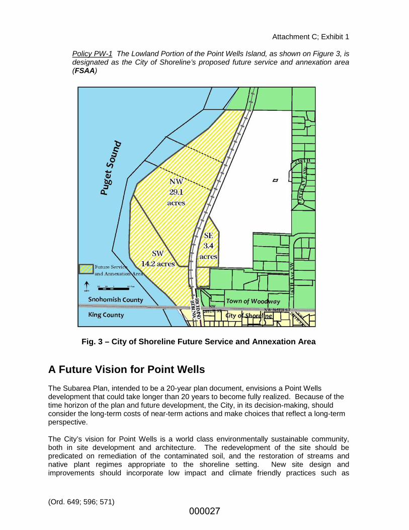
Policy PW-1 The Lowland Portion of the Point Wells Island, as shown on Figure 3, is designated as the City of Shoreline’s proposed future service and annexation area (FSAA)
Fig. 3 – City of Shoreline Future Service and Annexation Area A Future Vision for Point Wells The Subarea Plan, intended to be a 20-year plan document, envisions a Point Wells development that could take longer than 20 years to become fully realized. Because of the time horizon of the plan and future development, the City, in its decision-making, should consider the long-term costs of near-term actions and make choices that reflect a long-term perspective. The City’s vision for Point Wells is a world class environmentally sustainable community, both in site development and architecture. The redevelopment of the site should be predicated on remediation of the contaminated soil, and the restoration of streams and native plant regimes appropriate to the shoreline setting. New site design and improvements should incorporate low impact and climate friendly practices such as
000027
Attachment C; Exhibit 1
(Ord. 649; 596; 571)
alternative energy sources, vegetated roofs, rainwater harvesting, rain gardens, bioswales, solar and wind technologies. Development at Point Wells should exhibit the highest quality of sustainable architecture, striving for gold or platinum LEED (Leadership in Energy and Environmental Design) certification.
Policy PW-2 The Vision for Point Wells is an environmentally sustainable mixed-use community that is a model of environmental restoration, low-impact and climate-friendly sustainable development practices, and which provides extensive public access to the Puget Sound with a variety of trails, parks, public and semi-public spaces.
Point Wells also represents a major opportunity to create a new subarea consistent with City objectives for economic development, housing choice, and waterfront public access and recreation. With almost 3,000 linear feet of waterfront, and sweeping 180 degree public views from Admiralty Inlet off Whidbey Island to Rolling Bay on Bainbridge Island, this site has unparalleled opportunity for public access, environmental restoration, education, and recreation oriented to Puget Sound. The City’s vision for Point Wells includes a mix of land uses, including residential, commercial, and recreational. The City recognizes that the site may be suited to a wide range of residential uses (e.g., market rate housing, senior housing, special needs housing, hotels, extended stay, etc.) as well as a range of commercial uses (e.g., office, retail, restaurant). Rather than proscribe the number or type of residential units, or the floor area of various types of commercial uses, the City prefers that flexibility be left to the developer to respond to market realities. However, whatever use mix is proposed must demonstrate that it conforms to adopted parking requirements, site design and building form policies cited below. There are at least three distinct sub-areas within the FSAA, identified on Fig. 3 with the notations NW, SW, and SE. Because of their proximity to the single family neighborhoods to the east and south, maximum building heights in the SW and SE areas should be lower than in the NW subarea. Because of the large difference in elevation between the NW subarea and lands east of the railroad tracks, much taller buildings could be placed in this area without significantly impairing public views. Building placement in this area should avoid obstruction of the public view corridor shown on Fig. 2. The appropriate number, placement and size of taller buildings in NW subarea should be determined through the development permit and environmental review process. The portion of the Puget Sound shoreline in the SW subarea is the most environmentally sensitive area and a candidate for habitat restoration. This area has sandy substrate, supports some beach grass and other herbaceous vegetation, and contains a fair amount of driftwood. This area should be a priority for open space and restoration including elimination of invasive plants, re-establishing native riparian and backshore vegetation.
Policy PW-3 Use and development of and near the Puget Sound shoreline and aquatic lands at Point Wells should be carefully designed and implemented to minimize impacts and achieve long-term sustainable systems. New bulkheads or over-water structures should not be permitted and the detrimental effects of existing bulkheads should be reduced through removal of bulkheads or alternative, more natural stabilization techniques.
000028

Attachment C; Exhibit 1
(Ord. 649; 596; 571)
Any improvements in the westernmost 200 feet (within the jurisdiction of the Shoreline Management Act) of the NW and SW subareas should be limited to walkways and public use or park areas. Outside that shoreline area, buildings should be located and configured to maintain as much openness and public views across the site as possible, with taller structures limited to the central and easterly portions.
Policy PW-4 A public access trail should be provided and appropriate signage installed along the entire Puget Sound shoreline of the NW and SW subareas and secured with an appropriate public access easement document.
The relatively lowland area west of the tracks (between 10 and 20 feet above sea level) is abutted east of the tracks by a heavily forested slope. See Fig. 1. The slope rises steeply (15% to 25% grades) from the railroad tracks to the top of the slope, which is at approximately elevation 200. See Figure 2. The tree line at the top of the slope consists of mature trees from 50 to 100 feet in height, which further obscures public views of Point Wells from the portions of Woodway above elevation 200.
Policy PW-5 New structures in the NW subarea should rise no higher than elevation 200.
New buildings east of the railroad tracks would be much closer to existing single family homes in Woodway and Richmond Beach. To reflect this proximity, buildings of a smaller scale are appropriate.
Policy PW-6 New structures in the SE Subarea should rise no higher than six stories.
In order to promote maximum openness on the site and prevent bulky buildings, the City should consider innovative regulations such as design standards and guidelines, building floor plate maxima, requiring a minimum separation between taller structures and the protection of public view corridors. Public views from city rights-of-way in the Richmond Beach neighborhood are a major part of the area’s character, and provide a sense of place, openness, beauty and orientation. A prominent public view corridor across the lowland area, shown in Fig. 2, affords a public view from Richmond Beach Drive northwest to Admiralty Inlet and Whidbey Island. Placement and size of structures at Point Wells should be located and configured so as not obstruct this important public view corridor.
Policy PW-7 The public view from Richmond Beach Drive in Shoreline to Admiralty Inlet should be protected by a public view corridor across the southwest portion of the NW and SW subareas. Policy PW-8 New structures in the NW subarea should be developed in a series of slender towers separated by public view corridors.
Transportation Corridor Study and Mitigation A traffic and safety analysis performed by the City in the summer of 2009 evaluated the nature and magnitude of impacts likely to accrue from the development of Point Wells as an “Uurban Ccenter” under Snohomish County zoning, as well as development scenarios
000029
Attachment C; Exhibit 1
(Ord. 649; 596; 571)
assuming lesser orders of magnitude. This background information provided a basis for the City to conclude that, prior to the approval of any specific development project at Point Wells, the applicant for any development permit at Point Wells should fund, and the City oversee, the preparation of a detailed Transportation Corridor Study. Corridor Study The Transportation Corridor Study and Implementation Plan should include an evaluation of projected impacts on vehicular flow and levels of service at every intersection and road segment in the corridor. If a potential alternative access scenario is identified, it should be added to the corridor study. The Study should also evaluate and identify expanded bicycle and pedestrian safety and mobility investments, and identify “context sensitive design” treatments as appropriate for intersections, road segments, block faces, crosswalks and walkways in the study area with emphasis on Richmond Beach Road and Richmond Beach Drive and other routes such as 20th Ave. NW, 23rd Place NW, NW 204th Street and other streets that may be impacted if a secondary road is opened through Woodway. Implementation Plan The corridor study would be a step in the development of such a plan. The scope of the implementation plan should include a multimodal approach to mobility and accessibility to and from Point Wells, as well as detailed planning for investments and services to improve multimodal travel for adjacent communities between Point Wells and I-5. This could well include an integrated approach to accessing Point Wells, the Richmond Beach neighborhood, and Richmond Highlands with the Bus Rapid Transit system along Aurora Avenue, the I-5 corridor itself - focusing on the interchanges at N. 205th and N. 175th , as well as the Sound Transit light rail stations serving Shoreline. While the analysis of vehicle flows is appropriate as part of the study, the solutions should provide alternatives to vehicle travel to and from Point Wells - as well as more transportation choices than those that currently exist today for the Richmond Beach neighborhood and adjacent communities.
Policy PW-9 To enable appropriate traffic mitigation of future development at Point Wells, the developer should fund the preparation of a Transportation Corridor Study as the first phase of a Transportation Implementation Plan, under the direction of the City, with input and participation of Woodway, Edmonds, Snohomish County and WSDOT. The Study and Transportation Implementation Plan should identify, engineer, and provide schematic design and costs for intersection, roadway, walkway and other public investments needed to maintain or improve vehicular, transit, bicycle and pedestrian safety and flow on all road segments and intersections between SR 104, N 175th Street, and I-5 that may result in traffic impacts as a result of proposed development at Point Wells with particular attention focused on Richmond Beach Drive and Richmond Beach Road. Road segments that would be impacted by an alternate secondary access through Woodway should also be analyzed, which would include 20th Avenue NW, 23rd Place NW and NW 204th Street. The Study and Transportation Plan should identify needed investments and services, including design and financing, for multimodal solutions to improving mobility and accessibility within the Richmond Beach neighborhood and adjacent communities, including but not limited to investments on Richmond Beach Drive and Richmond Beach Road.
000030

Attachment C; Exhibit 1
(Ord. 649; 596; 571)
Policy PW-10 The needed mitigation improvements identified in the Transportation Corridor Study and Implementation Plan should be built and operational concurrent with the occupancy of the phases of development at Point Wells.
Richmond Beach Road and Richmond Beach Drive provide the only vehicular access to Point Wells at this time. Therefore, it is critical that identified impacts be effectively mitigated as a condition of development approval. It is also vital that the traffic generated from Point Wells be limited to preserve safety and the quality of residential neighborhoods along this road corridor. In the event that secondary vehicular access is obtained through Woodway to the Point Wells site, the mitigation and improvements of the impacts to those additional road segments must also occur concurrent with the phased development. Historically, mobility and accessibility in Richmond Beach and adjacent communities has been dominated by the single occupancy vehicle. Provision of bicycle and pedestrian facilities has been limited because retrofitting an existing road network with these facilities is an expensive undertaking. The Richmond Beach Road corridor is served by limited Metro bus service and is beyond a reasonable walking distance from potential development within Point Wells. Though rail service to a station in Richmond Beach was evaluated by Sound Transit, no service is envisioned in the transit agency’s adopted 20 year plan. Improved transit, bicycle and pedestrian mobility is a long-term policy objective, but the majority of trips in the area will likely continue to be by automobiles utilizing the road network. The City’s traffic study completed in 2009 shows that if more than 8,250 vehicle trips a day enter the City’s road network from Point Wells, it would result in a level of service “F” or worse at a number of City intersections. In December 2011, the City increased the level of service from “E” to “D” which means more intersections will fail to meet the adopted level of service as result of increased trips related to development at Point Wells. This would be an unacceptable impact.
Policy PW-11 The City should address opportunities to improve mobility, accessibility, and multimodal east-west movement in the Richmond Beach Road Corridor between Puget Sound and I-5 as part of the update of the city-wide Transportation Management Plan. The City should also work with neighboring jurisdictions Woodway and Edmonds to improve north-south mobility. These opportunities should be pursued in a manner that reduces existing single occupancy vehicle trips in the corridor. Policy PW-12 In view of the fact that Richmond Beach Drive between NW 199th St. and NW 205th St. is a local secondary street with no opportunities for alternative access to dozens of homes in Shoreline and the Town of Woodway. tThe City continues to designate this as a local secondary street road with a maximum capacity of 4,000 vehicle trips per day. Uunless and until, 1) Snohomish County and/or the owner of the Point Wells Urban Center can provide to the City the Transportation Corridor Study and Mitigation Plan called for in Policy PW-9, the City authorizes a development agreement between the owner(s)of property within the Point Wells subarea and the City of Shoreline that permits City enforcement of a maximum vehicle trip count on Richmond Beach Drive NW with financing of mitigation necessary to support the increased trip limits as determined by a Traffic Corridor Study...sources of financing for necessary mitigation are committed, the City should not consider reclassifying this road segment. In the event a development agreement is not authorized, the City should use the policies in this Subarea Plan as
000031
Attachment C; Exhibit 1
(Ord. 649; 596; 571)
a basis for approving, denying or conditioning Shoreline right- of- way permits proposed for mitigation projects under substantive SEPA authority.
Interjurisdictional Coordination The City should work with the Town of Woodway and Edmonds to identify ways in which potential future development in the lowland portion of Point Wells could be configured or mitigated to reduce potential impacts on Woodway. There is no practical primary vehicular access to the lowland part of Point Wells other than via Richmond Beach Road. However, the City should work with property owners and Woodway to provide a bicycle and pedestrian route between Woodway and Point Wells. The Growth Management Act states that cities, rather than county governments, are the preferred providers of urban governmental services. Because urban governmental services and facilities in Shoreline are much closer to Point Wells than are similar services and facilities located in Snohomish County, it is most efficient for the City to provide those services. Working with its public safety partners, Shoreline Fire Department and Shoreline Police Department, the City should invite Snohomish County to discuss an interlocal agreement to address the timing and methods to transition local governmental responsibilities for Point Wells from the County to the City. Included in these discussions should be responsibilities for permitting and inspection of future development at Point Wells, and possible sharing of permitting or other local government revenues to provide an orderly transition.
Policy PW-13 The City should work with the Town of Woodway, City of Edmonds and Snohomish County toward adoption of interlocal agreements to address the issues of land use, construction management of, urban service delivery to, and local governance of Point Wells. A joint SEPA lead-agency or other interlocal agreement with the County could assign to the City the responsibility for determining the scope, parameters, and technical review for the transportation component of the County’s Environmental Impact Statement prepared for a future project at Point Wells. Under such agreement, this environmental analysis, funded by the permit applicant, could satisfy the policy objectives of the Transportation Corridor Study and Implementation Plan referenced at PW-10. Policy PW-14 In the event that development permit applications are processed by Snohomish County, the City should use the policies in this Subarea Plan as guidance for identifying required mitigations through the SEPA process and for recommending changes or additional permit conditions to achieve greater consistency with the City’s adopted policies.
000032

Attachment D
000033
Attachment D
000034

Attachment D
000035

Attachment D
000036
Attachment D
000037
Attachment D
000038

Attachment D
000039

Attachment D
000040
Attachment D
000041

Attachment D
000042
Attachment D
000043
Attachment D
000044

Attachment D
000045

Attachment D
000046

Attachment D
000047

Attachment D
000048

Attachment D
000049
Attachment D
000050

Attachment D
000051

Attachment D
000052

Attachment D
000053

Attachment D
000054

Attachment D
000055

Attachment D
000056

Attachment D
000057
Attachment D
000058

Attachment D
000059
Attachment D
000060
Attachment D
000061

Attachment D
000062

Attachment D
000063

Attachment D
000064

Attachment D
000065
Attachment D
000066
Attachment D
000067

Attachment D
000068

Attachment D
000069
Attachment D
000070

Attachment D
000071

Attachment D
000072
Attachment D
000073

Attachment D
000074

Attachment D
000075

Attachment D
000076

Attachment D
000077
Attachment D
000078

Attachment D
000079

Attachment D
000080
Attachment D
000081

Attachment D
000082

Attachment D
000083

Attachment D
000084

Attachment D
000085

Attachment D
000086
Attachment D
000087

Attachment D
000088
Attachment D
000089
Attachment D
000090

Attachment D
000091

Attachment D
000092
Attachment D
000093

Attachment D
000094

Attachment D
000095

Attachment D
000096

Attachment D
000097

Attachment D
000098

Attachment D
000099

Attachment D
000100

Attachment D
000101

Attachment D
000102
Attachment D
000103

Attachment D
000104
Attachment D
000105

Attachment D
000106

Attachment D
000107

Attachment D
000108
Attachment D
000109
Attachment D
000110
Shoreline Planning Commission Minutes February 7, 2013 Page 2
Church. She explained that this event is related to the community renewal area (Sears/Central Market site) effort and will be led by the City’s Economic Development Manager. APPROVAL OF MINUTES The minutes of January 17, 2013 were approved as submitted. GENERAL PUBLIC COMMENT No one in the audience indicated a desire to participate in this portion of the agenda. Chair Moss arrived at 7:04 p.m. and assumed leadership of the meeting. NEW BUSINESS – 2013 COMPREHENSIVE PLAN AMENDMENT DOCKET Staff Presentation and Commission Discussion Director Markle reminded the Commission that the Growth Management Act (GMA) limits amendments to the Comprehensive Plan to once per year. As per the City’s adopted process for accepting and reviewing Comprehensive Plan amendments, applications are due by the last business day of the year to be processed in the following year. There is no application fee, and amendments can be either publicly or privately initiated. While no privately-initiated amendments were submitted, the City initiated amendments related to Point Wells. She emphasized that approval of the docket (list of amendments) does not approve the amendments; it merely provides direction from the City Council to the staff and public that a particular set of amendments will be analyzed during a given year and brought back later for consideration by the Commission and City Council. Director Markle referred the Commission to the docket of Comprehensive Plan amendments for 2013 and explained that the Point Wells Subarea Plan calls for the developer to prepare a Transportation Corridor Study (TCS) under the direction of the City. Policy PW-12 specifically states that “Richmond Beach Drive between Northwest 199th Street and Northwest 205th Street is a local street with a maximum capacity of 4,000 vehicle trips per day, UNLESS AND UNTIL the City is provided with a TCS and Mitigation Plan that includes sources of financing for said mitigation.” The City has been working with the developer (BSRE) to commit to funding a TCS and to agree upon the scope and timing of the study. In the event the TCS is completed in 2013, staff is recommending the following draft amendments be placed on the 2013 docket as “placeholders” for more specific amendments based on the analysis and outcomes derived from the TCS:
The first paragraph on Page 37 of the Staff Report, which details a past step the City has taken
during the long history with the Point Wells site, would be deleted. Because the Point Wells Subarea Plan does not detail other steps taken, staff is proposing that the language be deleted.
A capitalization correction would be made at the bottom of Page 40 of the Staff Report. “Urban Center” was changed to “urban center.”
Attachment E
000111

Shoreline Planning Commission Minutes February 7, 2013 Page 3
Policy PW9 on Page 41 of the Staff Report would be amended to clarify that not all road segments and intersections between State Route 104, North 175th Street and Interstate 5 will be studied, just those that may result in traffic impacts as a result of development proposed at Point Wells.
An additional sentence would be added at the bottom of Paragraph 2 on Page 42 of the Staff Report to incorporate Shoreline’s subsequent adoption of a citywide level of service (LOS) D instead of E.
Policy PW-12 on Page 42 of the Staff Report would be amended by replacing “maximum 4,000 vehicle trips per day” with a development agreement between the City and BSRE that establishes a new maximum trip cap, specific mitigation to achieve the new trip cap, and a specific funding and phasing plan to be determined as part of the TCS.
Staff anticipates that changes to the Capital Facilities Element may also be necessary to include the mitigation projects identified as part of the TCS.
As a result of the TCS, amendments may be needed to the Transportation Element, specifically the street classification, pedestrian and bike facilities maps.
Director Markle said it is anticipated that the City Council will review the Planning Commission’s recommendation and confirm the 2013 Comprehensive Plan Amendment Docket on February 25th. The TCS could begin in the spring of 2013. After the study has been completed, the Planning Commission will study the specific Comprehensive Plan amendments, hold public hearings, and forward a recommendation to the City Council in late 2013. The City Council will make the final decision. Director Markle advised that a number of questions have been raised since the Staff Report was published. She reviewed each of the questions as follows: Is staff recommending to change the road classification and remove the 4,000 average daily
trip (ADT) count on Richmond Beach Drive before the TCS has been completed? Director Markle clarified that no recommendation to amend the Comprehensive Plan will come forward until the TCS has been completed and an agreement has been negotiated to legally bind BSRE to the agreed upon outcomes of the TCS.
Why is staff recommending the amendments to the Comprehensive Plan this year? Director Markle explained that BSRE’s permits are vested as an Urban Center in Snohomish County following the January 7th ruling from the Court of Appeals. Snohomish County is processing the permits as an Urban Center development. The City’s legal analysis and outside legal opinions have concluded that further litigation regarding the vesting status of the permits will not yield successful results. Even if further appeals are successful, the end result will be Urban Village development in place of the Urban Center. She advised that the City’s ability to influence measures to reduce impacts on the City from the proposed development will soon be supplanted by Snohomish County’s permitting and environmental review process. If a development agreement is finalized in advance of the permits being issued, the City will have more leverage via assurance to BSRE that the City concurs with the analysis prepared for the Environmental Impact Statement (EIS) related to identification and mitigation of transportation impacts. This assurance would be based on a completed TCS that includes specific design of the mitigation, an agreement that results in fewer trips impacting Shoreline, and better mitigation than can be achieve through the State Environmental Policy Act (SEPA) process alone. She pointed out that the Snohomish County process does not include or require a TCS, which would allow for a greatly enhanced public process. In the next few
Attachment E
000112
Shoreline Planning Commission Minutes February 7, 2013 Page 4
months, Snohomish County will begin scoping for the EIS, so now is the time for the City to analyze the impacts and develop mitigation. She summarized that if the TCS process is successful and the City is able to negotiate an agreement with BSRE, the City’s Comprehensive Plan will need to be amended to reflect the agreement.
Can the City prevent the proposed Urban Center development at Point Wells by refusing to
cooperate with BSRE and leaving Richmond Beach Drive with a traffic limit of 4,000 vehicles a day? Director Markle answered that Snohomish County is not required to apply another jurisdiction’s policies to development in Snohomish County. As a practical matter, the City cannot stop people from driving on a public road just because the number of trips exceeds a defined street classification regardless of its policies and the adopted LOS for the street. The “unless and until” clause contained in the Point Wells Subarea Plan provides an avenue to raise the maximum trip count with the completion of a TCS and Mitigation Plan. The “4,000 trip maximum” was put in place to ensure the completion of a TCS. She explained that a prerequisite for making the changes to the Comprehensive Plan will be to concurrently approve a development agreement that legally binds the developer to the mutually agreed upon terms as determined by the TCS. Without the agreement, the City’s ability to apply its policies and local standards is not reliable.
Director Markle summarized that everyone in the City is disappointed that the collective attempts thus far to reduce the size of the development at Point Wells have been unsuccessful, and she agreed that the impacts will be significant and unsafe without proper mitigation. Since the permits are now being processed in Snohomish County as an Urban Center, the City must move towards a strategy to fully understand the realities of the impacts and to productively identify the best solutions using the TCS as the tool. The solutions need to be accompanied by a legally-binding agreement to ensure they are carried out. The first step is to docket the amendments in anticipation of the TCS reaching a successful conclusion in 2013. She said staff is recommending that the Planning Commission forward a recommendation to the City Council to approve Attachment 3: Proposed 2013 Docket as the list of amendments to be analyzed and considered in 2013. Commissioner Scully requested more information about the scope of the TCS, particularly who will do it and who decides what impacts are studied. Director Relph answered that the developer would perform the actual TCS, which is typical of most city requirements. However, the City has agreed it would facilitate the actual TCS discussion. He explained that the study would be done in two parts: Segment A for the lower portion of the corridor would include a more detailed and comprehensive approach of workshops, and the public would be invited to participate in the process. They would review each property foot-by-foot to identify the ultimate issues, problems and impacts; and then property owners would be invited to participate in a process to identify solutions. The impacts in Segment B (upper portion of the corridor) are more confined to the intersections, and the process would be broader to look at not only intersections, but other issues such as neighborhood cut-through traffic. He summarized that the TCS process is designed to be specific about the areas and the possible solutions that may come out of the discussion. Director Relph emphasized that Snohomish County has started the scoping process, and it is critical for the City of Shoreline to reach an agreement with BSRE and Snohomish County as soon as possible to maximize its opportunities. He said the City is ultimately looking for a traffic cap, which would not be
Attachment E
000113
Shoreline Planning Commission Minutes February 7, 2013 Page 5
possible via Snohomish County’s SEPA process. Through the City staff’s preliminary work, it is estimated that the street, with the existing 60-foot right-of-way, can exceed 17,000 cars per day with only modest improvements at some intersections. They are very concerned with this number, and the public should be, as well. This is the City’s opportunity to establish a cap that is much more manageable rather than relying on Snohomish County. Commissioner Wagner noted that Policy PW-9 was structured so that the City of Shoreline would be in the driver’s seat for the TCS. Now both the developer and Snohomish County will be involved in the process. She asked Director Relph to clarify what is currently on the table and what the options are for moving forward. Director Relph answered that they are currently in the negotiation process with the developer. Typically, the developer would be required to complete the technical work for which the City would approve the assumptions. The TCS process would allow the City and the developer to negotiate the assumptions and criteria upfront so there is a very clear understanding of which model would be used, how the trips would be distributed, what is the scope, what is the LOS, how would pass-through traffic and turning movements be treated, etc. It is the City’s hope that Snohomish County, who is ultimately responsible for the SEPA process, would accept the agreement. The TCS would be a much higher level of study than would ever be required in a SEPA process by Snohomish County. Commissioner Wagner asked if BSRE has indicated an interest in working out an agreement with the City. Director Relph answered that, in his opinion, there has been some very sincere effort on the part of BSRE to strike a reasonable agreement with the City. The staff has been working hard to protect the interest of the City, while at the same time, recognizing the City’s legal limitations and the ultimate goals that BSRE is trying to accomplish. He acknowledged that the negotiations would be very difficult. Commissioner Scully asked what the impact on the TCS would be if the City fails to put the proposed Comprehensive Plan amendments on the 2013 docket. Director Markle explained that the City must have the ability to amend the Comprehensive Plan in order to implement an agreement that is consistent with the City’s Comprehensive Plan. She explained that regardless of what the City does, Snohomish County will continue to process the permits. Without the TCS, the City will not have the technical expertise or appropriate level of public outreach to respond appropriately to the EIS. Commissioner Scully said he understands the need for the TCS, but he is unclear on the causal link between the TCS and the 2013 Comprehensive Plan docket. If it is the case that they will not have a TCS or the same TCS, that’s a different decision point than if the City is going to get the TCS no matter what. Director Markle explained that it is possible that BSRE would decide against an agreement if the City is not willing to entertain amendments to the Comprehensive Plan. Commissioner Scully summarized that having the TCS the City wants is dependent upon BSRE’s cooperation. Chair Moss referred to Director Relph’s earlier statement that Richmond Beach Drive and its existing right-of-way could accommodate up to 17,000 trips per day with minimal improvements and upgrades. She asked if the upgrades would require condemnation or imminent domain of land or if there is unimproved right-of-way available for this expansion. Director Relph answered that the expansion would occur largely within existing rights-of-way, with the exception of the intersections where there would not be enough right-of-way to accommodate the required street improvements. The TCS will help them understand the ultimate level of improvements necessary.
Attachment E
000114

Shoreline Planning Commission Minutes February 7, 2013 Page 6
Commissioner Wagner asked who would bear the cost of bringing the rights-of-way up to standard. She also asked if Snohomish County would identify which road segments would need improvements as part of their EIS. Director Relph said the developer would have the ultimate responsibility to mitigate the impacts of the additional traffic. Commissioner Wagner asked if a mitigation plan would be identified as part of the SEPA process, which is less rigorous than a comprehensive TCS would be. Director Relph answered that the normal SEPA process would be less than the proposed TCS. He emphasized that the City is trying to negotiate a much higher standard that involves greater public participation than what is required in a normal SEPA process. Chair Moss asked how the property’s development potential would change if the litigation prevails and the site is re-designated as an Urban Village. Director Markle answered that 2,640 units would be allowed instead of the 3,081 the developer has applied for. The maximum height would be substantially less, as well. In addition, Urban Village has a provision that development must be consistent with the City of Shoreline’s adopted LOS for infrastructure and services, and that is not required under the current Urban Center designation. Public Comment Nancy Morris, Shoreline, expressed concern that BSRE has not been bound by anything at this point and has been granted every request. She also expressed concern that the game seems to change frequently. She disagreed with the City Attorney’s advice that litigation to the State Supreme Court would be fruitless. She expressed her belief that the proposed development is totally absurd and ignores the basic and obvious geophysical data that in the event of a major earthquake, the ground beneath the tall buildings would liquefy. She voiced concern that a significant amount of time and money is being wasted on a TCS while completely ignoring the very relevant dangers for redeveloping the property in the manner proposed. She also commented that while some Snohomish County Council Members have integrity, the majority of them seem to support changing the rules to suit BSRE. Anyone with a sense of ethics and common sense would think there has been malfeasance involved. Lastly, Ms. Morris pointed out that last spring, traffic was backed up from 20th Avenue all the way past 15th Avenue on Richmond Beach Drive just from a basic community Easter egg hunt. She summarized that if Snohomish County wants to approve this development, they should provide access from their side rather than forcing traffic into an area that is unable to handle it. Jerry Gernes, Shoreline, referred to a seller disclosure form, which contains a list of things that must be disclosed when selling a house or condominium. While the environmental section only addresses such things as asbestos, radon, etc., it is also important to keep in mind the health hazards associated with the coal trains that run past the Point Wells site. He said he lives on 199th. Although it is the narrowest street in Shoreline, cars scream up and down it all the time. Because it is the closest road for getting from Point Wells to 20th Northwest, he anticipates that the problems will increase. He suggested he would put out a sign that points out the dangers of buying condominiums at Point Wells. Robert Flanigan, Shoreline, said the neighbors are present to unite against BSRE and their plans for Point Wells; specifically their impact on the Richmond Beach and Shoreline community. He said that, like all the neighbors on his street (Richmond Beach Drive), he will be greatly impacted by the Point Wells project. If the 80-foot delineation is adopted, he will lose his house. He has lived on the street for
Attachment E
000115

Shoreline Planning Commission Minutes February 7, 2013 Page 7
21 years, and he and his wife own their home and do not wish to sell it. He is a carpenter by trade, and he has had friends and neighbors refer to his house as a “little jewel box.” Rather than bulldozing the house, his plan has always been to leave it to his family as a legacy of a blue-collar worker. When his wife is gone it will go to his son so that he might be a middle-class person and be elevated above the working class as well. He said that two years ago, BSRE stated that they would pack up and leave if the community did not want their project. The neighbors all knew this was an idle promise, and he certainly doesn’t underestimate BSRE’s power and wealth. They have an entire team of lawyers working for them. If the 80-foot right-of-way happens, his home and many of his neighbors’ homes would be significantly impacted. They see that a lot of greed and corruption might have been going on as they sat waiting. He expressed his belief that this is an ancient problem where a group of individuals have beautiful homes and a group of powerful and wealthy individuals decide to seek the properties for their own. He feels that if they don’t stand up against these bullies, they are doomed to lose. Susan Chang, Shoreline, said she does not live on Richmond Beach Road, but she does live in the community. She expressed her belief that the City is accommodating the developer every step of the way. The current capacity of Richmond Beach Road is about 4,000 vehicles per day, and the current traffic is only an order of magnitude less than that. They are now looking at potential improvements to take it to 17,000. This is asking to go from what is currently LOS A to LOS D, which equates to an Aurora Avenue through the neighborhood. She said she does not understand why the City is not putting up more of a fight to keep this from happening. Why doesn’t the City join Save Richmond Beach and the City of Woodway in this effort? She clarified that she is not against development at Point Wells. It would be nice to have a beach and public access to the water and to remove the asphalt plant, but neither Urban Center nor Urban Village makes sense. The City should do more to keep the development from happening. Lynn-dee Schwarz, Shoreline, said she is a long-time Richmond Beach resident. While she works for Sound Transit, she made it clear that she was present to speak as a resident of Shoreline and not as a representative of Sound Transit. She reminded the Commission that light rail service is coming north. Not that long ago, the Sound Transit Board was discussing its EIS and where stations would be placed along the North Corridor. One option was a possible station at North 175th Street and Interstate 5 and North 185th Street and Interstate 5. Representatives from the City of Shoreline attended the board meeting and provided documents, statements, and comments about why Shoreline did not want a station at North 175th Street and why a station at North 185th Street would be more viable. By the time the meeting was over, the possible station at 175th was removed from further consideration, and Sound Transit Board is continuing with its investigation of a possible station at North 185th Street. She asked the Planning Commission and City staff to take into account the very residents who would be impacted by the Point Wells development and do their due diligence in protecting the residents as they did in front of the Sound Transit Board. This is not about a five-year decision, this is a legacy decision that is important to them all. Garry Horvitz, Shoreline, said he is a 26-year resident of Richmond Beach and a civil engineer. He said he has attended meetings for quite some time, and it seems that the white flag of surrender is up at every session. He said he understands that the City may not have a lot of legal leverage, but sometimes it is important to go down swinging. All he hears is strategies for accepting whatever crumbs BSRE is
Attachment E
000116
Shoreline Planning Commission Minutes February 7, 2013 Page 8
willing to throw the City’s direction. He would rather the City spend its energy fighting the proposed development as hard as it can as opposed to giving up. Jerry Patterson, Shoreline, thanked the Commissioners for listening to the public’s concerns. He also thanked the City Council, who has scheduled an update on Point Wells on February 11th. In addition, he thanked staff for scheduling an informal discussion with the community prior to the Richmond Beach Community Association’s meeting on February 12th. He summarized that there will be several opportunities for the public to share their thoughts. He said he and his wife own a home on Richmond Beach Drive. Mr. Patterson said he has carefully studied the proposed amendments. He recalled that in November and December of 2012, both the Planning Commission and City Council independently discussed amendments to the Comprehensive Plan. This process culminated in the City Council approving an updated plan on December 10, 2012. He said he is virtually sure that all members of the public present are clear on the fact that in 2011 the Planning Commission and the City Council approved the following recommendation: “In view of the fact that Richmond Beach Drive between Northwest 199th and Northwest 205th is a dead end, local-access road, with no opportunities for alternative access to dozens of homes in Shoreline and Woodway, the City designates this as a local access street with a maximum capacity of 4,000 vehicles per day. Unless and until either Snohomish County or the owner of Point Wells Urban Center can provide the City a Transportation Corridor Study and Mitigation Plan called for in Policy PW-9, as well as financial and other mitigation, the City should not consider reclassifying this project.” Now before the Commission is a staff recommendation to place on the 2013 Docket consideration to reverse the recommendation that was made several months ago. Mr. Patterson asked why the amendments were not discussed and recommended during the many deliberations by the City Council and Planning Commission throughout November and December at which they talked about an updated plan. He questioned what happened between the December 10th Council action and the last day in December to warrant the application. He asked the date the application was received by the Planning Commission. He also invited the Commission to discuss the implications for condemnation of property. He noted that one proposal is to reclassify Richmond Beach Drive to a corridor arterial, with a maximum width of 80 feet. He encouraged the Commission and staff to answer the questions posed by the public. (Note: Mr. Patterson submitted a copy of his remarks for the record.) Janet Way, Shoreline, also thanked the Commission and staff for their hard work and service. She said she sympathizes with the difficult position the City is in. However, she also sympathizes with the public’s position. They are counting on the City, as they must, to make the situation tolerable for everyone. She referred to the 2004 Stream and Wetland Inventory and Appendices, and noted that a new inventory was prepared for the recently approved Surface Water Master Plan. She said the inventory shows four creeks along Richmond Beach Road. Although they are not ideal in their current condition, they could be considered salmon habitat given their proximity to Puget Sound. These creeks should be considered as part of any EIS associated with Point Wells and she asked that the map be entered into the record. Ms. Way asked what criteria the City would put in place for the TCS. For example, what criteria would the consultants be required to analyze, and what qualifications would consultants have to meet. She asked what checks the City would put in place to ensure the study is unbiased. Because the developer is
Attachment E
000117
Shoreline Planning Commission Minutes February 7, 2013 Page 9
paying for the study, there must be some assurance the study is done quickly and correctly. Perhaps an independent consultant could be hired by Save Richmond Beach, the City, etc. to ensure the study contains accurate information. Dave Wight, Shoreline, said he has lived in Richmond Beach for 31 years. He pointed out that the Shoreline Municipal Code outlines criteria for reviewing Comprehensive Plan amendments. He noted that the Commission specifically referred to the criteria in their meeting of November 15, 2012. He reviewed the criteria as follows: 1. The amendment is consistent with the Growth Management Act (GMA) and not inconsistent with the
Countywide Planning Policies, and the other provisions of the Comprehensive Plan and City policies.
2. The amendment addresses changing circumstances, changing community values, incorporates a subarea plan consistent with the Comprehensive Plan vision or corrects information contained in the Comprehensive Plan.
3. The amendment will benefit the community as a whole, will not adversely affect community facilities, the public health, safety or general welfare.
Mr. Wight specifically referred to Criteria 3 and asked the Commission to carefully listen to the community. Carolyn Marian, Shoreline, said she also lives on Richmond Beach Drive and has spent the last three days reviewing laws and information from the City. It has made her sick and dizzy, and she is totally fed up. She read the following email, which she sent to the City prior to the meeting:
“There are some sticky issues regarding municipalities exercising the authority delegated to them, especially when it comes to imminent domain and public use. Point Wells is a private property, and somehow an Urban Center and/or Urban Village with facilities to be used for private use as retail establishments, restaurants, theaters, or whatever does not fall within the State guidelines of public use. Allowing the City staff to amend elements of the Comprehensive Plan will only expedite statutory authority to give them the power to imminent domain. We do not want this.”
Denis Casper, Seattle, said he owns a home on Richmond Beach Drive and it is his opinion that the City will never have any leverage over the development. While he respects the sincerity of the efforts of the Public Works Director and the Planning and Community Development staff, they appear to be wasting time and resources. They do not have, and will not ever have, any leverage. He questioned why they don’t resist more. He suggested the City could use ramp meters, toll stations and other options to limit the use of Richmond Beach Drive and make the Point Wells property less valuable. He summarized there are ways for the City to resist if it has the will and the interest to do so. Another option would be to route traffic up North 205th Street rather than Richmond Beach Drive, but he recognized this could be considered a selfish option. Tom Jamieson, Shoreline, said he lives on Richmond Beach Drive. He commented that if the Point Wells development moves forward as proposed, the traffic in front of his home would increase by about
Attachment E
000118

Shoreline Planning Commission Minutes February 7, 2013 Page 10
40 fold. He said the issue is not so much about traffic, but about how the whole City would fundamentally change. He pointed out that the City of Shoreline has not objected to the fact that BSRE has a sustainable dream to bring this new development about. In fact, the City has a set of goals to achieve economic development for the City and the proposed Point Wells development is a god send. However, they won’t admit this to the public. Instead, they say it is inevitable and they will try to mitigate the traffic. But that has nothing to do with it, and the City staff and Commission know it. He recalled that people were mad about the Point Wells proposal on August 31, 2011 and they are still mad for good reason. He said that over the past 18 months he has attended about 70 City Council meetings in an attempt to connect the dots. He said he has finally connected the dots to Proposition 1, the Community Renewal Area, and coal trains. He noted that the public was recently notified that there were only a few more days to comment on the coal train issue. However, they did not inform the public that the City Council decided at an August dinner meeting to not do anything about coal trains until they hear from the public. He suggested that the City Council orchestrated a plan of deception. He recalled that he attended meetings regarding Proposition 1, and the issue of Point Wells was never brought up by the staff-appointed advisory committee, and it was not included on the maps. He said he has raised this concern to the Commission and City Council repeatedly, but has been ignored and marginalized. He said this needs to stop, and the Commissioners and City Council all need to resign and get out. The Commission discussed Ms. Way’s comment that they should consider creeks when they discuss the proposed Comprehensive Plan amendments. They also discussed her request that the Commission incorporate a specific document into the record. Ms. Simulcik Smith clarified that the document Ms. Way referred to is identified as Figure 3 in the Stream and Wetlands Inventory and Assessment Appendices. This map is a City document. She advised that the public comments and the map referred to by Ms. Way will be numbered as part of the record and will come back to the Commission if and when the amendments are presented for consideration later in the year. Commissioner Scully said he also spoke to a citizen who shared some photographs that he would like included in the record. Chair Moss explained that the purpose of this meeting is to determine whether or not the proposed amendments will be docketed. Additional information can be submitted for the Commission consideration if and when the amendments are docketed and placed on the Commission’s 2013 Work Plan. Director Markle answered the following questions put forth by Mr. Patterson: Why were the amendments not discussed and recommended by the City Council and Planning
Commission throughout November and December as part of the major Comprehensive Plan update? She explained that amendments to the Comprehensive Plan must be submitted by the last business day of the prior year in order to be included on the next year’s docket. While staff worked on the specifics of the TCS concept in 2012, they were not far enough along at the end of 2011 to include the amendments on the 2012 docket.
When did the Planning Commission receive the proposed amendments? She said the Commission received the proposed amendments in their packet two weeks ago.
What is the rationale for consideration of reclassification of Richmond Beach Drive as a corridor arterial that has an approved maximum allowable right-of-way of 80 feet instead of the current maximum 60 feet at the south portion of Richmond Beach Drive and 45 feet in the north segment? The City’s intent is to maintain a 60-foot maximum right-of-way, which is what currently exists.
Attachment E
000119

Shoreline Planning Commission Minutes February 7, 2013 Page 11
What are the implications for condemnation of property if the proposed changes you consider tonight are enacted by the City Council? Again, she clarified that the City’s intent is to work within the existing 60-foot right-of-way, and not acquire additional right-of-way. However, she acknowledged that small amounts of right-of-way at intersections may be required.
Again, Chair Moss reminded the Commission that the purpose of their discussion is to decide whether or not to move the proposed amendments to the City Council with a recommendation that they be on the 2013 Comprehensive Plan Amendment Docket. The Commission will discuss the merits of the proposed amendments if and when they are docketed. Commissioner Wagner asked if it would be within the City’s purview to use creative approaches for limiting the access on Richmond Beach Drive, as suggested earlier by a citizen. Director Markle answered that the City has considered possible options for limiting access, but case law prohibits the City from closing down the road or denying access to properties. Director Relph added that staff has done an enormous amount of work trying to understand and pursue various alternatives, such as ramp meters, toll stations, etc. They will provide a more detailed report to the City Council on February 11th. Commissioner Montero asked what would happen if the City does nothing and Snohomish County approves the permits and the development moves forward. Ms. Markle said the development would occur without the City having the ability to craft mitigation and require road improvements. The City would be left with whatever Snohomish County decides is appropriate. Staff feels this mitigation will be inferior to what the City and developer could collective come up with via a TCS. Director Relph reminded the Commission that the ultimate capacity of a 60-foot right-of-way is tremendous, so it is important to negotiate a cap on the number of vehicles allowed on the roadway. If they rely on Snohomish County, there would be no cap. The developer would simply have to meet the City’s current LOS standard, which can likely accommodate over 17,000 vehicles per day. Vice Chair Esselman asked if the size of the development would be limited if the analysis that is done as part of the TCS indicates that the existing street cannot handle the increased level of vehicular traffic. Director Relph explained that not only is the proposed unit count and the amount of square footage for retail and commercial problematic, the internal capture rates suggested by the proposal were different than the City has ever seen before and staff is extremely uncomfortable. Internal capture rate refers to the tendency for trips to stay in place because the services are there. Staff is recommending the City move away from the number of units to a limitation on the average daily traffic. The TCS could identify a maximum cap that could be distributed to the different phases. The actual progress of each phase could be measured to determine if projections are being met. If not, the developer would be required to change a future phase. The only way they can get this type of requirement is through negotiation, and not the standard SEPA review. Vice Chair Esselman summarized that the TCS process would afford the City more leverage. Commissioner Scully said he is not convinced that cooperation is the only or even the right path forward. However, at this phase of the process, the City would not be giving up any rights going forward by putting the amendments on the docket. The proposed amendments would allow the City to collect more information. Whether it results in more mitigation or the City decides to be a party to a lawsuit to overturn Snohomish County’s permit, the City will be better off with more data.
Attachment E
000120

Shoreline Planning Commission Minutes February 7, 2013 Page 12
Commissioner Montero noted that words are only one part of the issue. The City must also be concerned about the rest of the infrastructure required for the development. Director Markle responded that the City would review the infrastructure needs through the EIS process. Staff will follow the permit process closely and work with their utility and service providers. They are starting to learn about the Interlocal agreement process with Snohomish County, which provides an avenue for ironing out these issues. COMMISSIONER WAGNER MOVED THAT THE COMMISSION FORWARD A RECOMMENDATION TO THE CITY COUNCIL THAT THEY DOCKET THE PROPOSED COMPREHENSIVE PLAN AMENDMENTS AS DRAFTED BY STAFF AND PLACE THEM ON THE COMMISSION’S 2013 WORK PLAN. COMMISSIONER SCULLY SECONDED THE MOTION. THE MOTION CARRIED UNANIMOUSLY. The Commission recessed the meeting at 8:25 p.m. to allow members of the audience to leave if desired. The meeting was reconvened at 8:34 p.m. NEW BUSINESS – UPDATE ON LIGHT RAIL STATION AREA PLANNING Commissioner Maul reported that the Light Rail Station Area Planning Subcommittee met to put together a plan for their tasks. It was determined that the Subcommittee would meet monthly with the staff to keep the project moving forward. They have started working to develop criteria for identifying the station area boundaries. Because the Subcommittee is scheduled to provide reports at regular Planning Commission meetings, there will be opportunities for the public to provide input as to what criteria should be included. Commissioner Scully added that several boundary discussions will take place, the first being the study area boundaries. He suggested that the process for eliciting comments on the study area boundaries will likely be less formal, but they are hoping for public input on how broad to draw the area of consideration. Commissioner Maul said the Subcommittee’s goal is to coordinate efforts with Sound Transit, the City’s consultant, and citizen groups. He reported that the City has already received proposals for the consultant work, and the scope of the Request for Proposals is available as public information. Commissioner Maul advised that potential criteria for determining station area boundaries could include a ½ to ¼ mile radius and direction from the Comprehensive Plan such as examining the corridors that connect different parts of the City to the potential stop locations. The criteria could also include topography, walk/bike sheds and homeowner preferences. The Subcommittee will work with the consultant and City staff to develop an appropriate process for soliciting public comments regarding the station area boundaries. They anticipate a full Commission discussion on April 18th, and the Subcommittee and staff will facilitate the discussion at the first City-hosted community meeting in May. It was noted that the community meeting would need to be advertised as an open meeting so that all interested Commissioners could attend. Commissioner Scully pointed out that a timeline for the Station Area Planning Process has been posted on the City’s website. He advised that the ball is currently in Sound Transit’s court as to what the next major step will be. The draft Environmental Impact Statement (EIS) will identify a preferred
Attachment E
000121