airborne altimetric lidar data processinghome.iitk.ac.in/~blohani/stc/course_report.pdf · airborne...
TRANSCRIPT

Report on
Short Term Course on
Airborne Altimetric LiDAR Data Processing
Indian Institute of Technology Kanpur
17 to 20 October 2005
Course Coordinator: Bharat Lohani, PhD Assistant Professor
Department of Civil Engineering IIT Kanpur, Kanpur 208016
Sponsored By: Department of Science and Technology, Govt. Of India
Short Term Course on Airborne Altimetric LiDAR Data Processing, 17-20 October 2005, IIT Kanpur
1
Prologue
This report briefly describes the activities conducted during the short term course on Airborne Altimetric LiDAR Data Processing. This course was sponsored by the Department of Science and Technology, Govt. Of India and was conduced at IIT Kanpur from 17 to 20 October 2005. Publicity for course was done through leaflets and internet and attracted a large number of applications. The participants were selected considering the diverse areas where this technology can be applied and also applicant’s background. The participants came from various government organizations representing education, scientific, military, operation, and user segments (Appendix II). A total of 25 participants attended the course of which four came from private organizations. A large number of applicants could not be selected considering the limited places. The main aim of this course was to provide strong theoretical knowledge of LiDAR technology, its applications and hands-on experience on LiDAR data processing. Considering this, half of the course was devoted to the discussion on LiDAR technology and its applications. The second half of the course mainly concentrated on laboratory exercises where LiDAR data were used. The flagship software of Terrasolid were used for this purpose. The faculty members for the course were invited from organizations in India and abroad. A major part of the course was covered by the faculty from IIT Kanpur. The laboratory exercises were benefited by the presence of Terrascan software developer, who conducted exercises and interacted with the participants. Furthermore, lectures were also organized to learn about the status of this technology in India and the modalities to procure data from national agencies when they begin flying LiDAR in India (For the list of faculty members please see Appendix I. For the detailed schedule of course please see Appendix III). The participants were provided the course material in CD and Xerox notes. At the end of the course feedbacks were invited from participants for further improvement in the course. For more information about the course and future activities of IIT Kanpur in the area of Airborne Altimetric LiDAR please contact the undersigned.
Bharat Lohani, PhD Course Coordinator
Department of Civil Engineering IIT Kanpur, Kanpur 208 016
Tel: +91-512-259 7413 O, +91-512-259 8719 R Fax: +91-512-259 7395 Email: [email protected] URL: http://home.iitk.ac.in/~blohani/
Short Term Course on Airborne Altimetric LiDAR Data Processing, 17-20 October 2005, IIT Kanpur
2
Introduction:
In last few years the Airborne Altimetric LiDAR (Light Detection and Ranging) has
established as an industry standard tool for collecting accurate and dense topographic data
at high speed. In view of their typical characteristics and several advantages, LiDAR data
are being applied to several applications where topographic data are of fundamental
significance. Furthermore, several new applications are being targeted which were not
feasible with conventional techniques of topographic data collection. The technology has
witnessed multi-fold growth world over. However, except a few developments, the
technology has yet not gained full momentum in India. Moreover, considering the needs
of India for infrastructure development, disaster management, urban management and
several others, there is an urgent need to give special thrust to training, research and
development in the area of LiDAR technology.
Objectives: Considering above the objectives for this course were: 1. To impart knowledge about theoretical concepts of LiDAR technology. 2. To provide hands-on training on LiDAR data processing.

Short Term Course on Airborne Altimetric LiDAR Data Processing, 17-20 October 2005, IIT Kanpur
3
Report on course activities:
Day 1 : 17 October 2005
At the beginning of inaugural function, Dr. Bharat Lohani, course coordinator introduced
the course. He begun with a brief introduction of the technology and emphasized the
utility of technology for a developing country like India. In view of her special needs to
manage disasters and leapfrog in the infrastructure development, India needs LiDAR
technology along with other complimentary technologies. Dr. Lohani presented an
outline of the course and the various lectures which were planned. He also gave details of
the participants, their organizations and their major responsibilities. Further, he outlined
that why this course had more emphasis on laboratory exercises. Dr. Lohani also
introduced the faculty members for the course.
Prof. Bithin Datta, Head, Department of Civil Engineering, IIT Kanpur gave a brief
introduction of the department and the Geoinformatics activities in the department. The
course was inaugurated by Prof. Gautum Biswas, Dean Academic Affairs, IIT Kanpur.
Prof. Biswas emphasized the utility of such courses being conducted at IIT Kanpur and
appealed to participants to make full use of the course. The inaugural function ended
with a vote of thanks by Professor Onkar Dikshit to all who contributed in conducting this
course.
Dr. Bharat Lohani initiated discussions by delivering first lecture of course on
introduction of LiDAR technology. The main aim was to provide necessary background
to the participants to make them ready for the further lectures. He described the principle
of technology and the different modes in which it works.
The Keynote address “Airborne mapping in India with special emphasis on LiDAR
mapping” was delivered by Mr. K. Kalyanraman, GM, Airborne Remote Sensing
Division, NRSA , Hyderabad. He briefly discussed the status of LiDAR technology in
India and specially the activities of NRSA . He provided the vision of NRSA in this area
and outlined the procedure to obtain data from NRSA. Mr. Kalyanram also presented the
results obtained in some experimental projects carried out by NRSA.
Short Term Course on Airborne Altimetric LiDAR Data Processing, 17-20 October 2005, IIT Kanpur
4
The afternoon session begun with a lecture on “LiDAR: Comparison with other
technologies and advantages and disadvantages” by Dr. Bharat Lohani. This lecture was
aimed at understanding the strengths and limitations of LiDAR technology vis-à-vis the
other technologies for topographic data collection. Participants, who had come from
diverse background, could relate the LiDAR technology with their area and also
understand its utility. Following this, Dr. Onkar Dikshit talked about the interaction of
laser with earth surface features, which forms the basis of remote sensing. He described
how under different conditions the laser will reflect or would not reflect. This is
important as the accuracy of LiDAR depends to some extent on the reflected intensity.
This information is also useful while interpreting LiDAR reflectance image. The last
lecture of the day was delivered by Dr. Bharat Lohani where he listed the various
applications which are employing LiDAR data. Several new applications are also
possible with LiDAR data which were not feasible earlier with low resolution topographic
data. Dr. Lohani outlined several such possibilities and prompted the participants to think
of further innovative applications.
The special presentation of the day was delivered from 6:00 PM to 7:00 PM by Dr. D. C.
Mason of University of Reading, UK. It was a detailed study on using LiDAR data for
urban flood modeling and the consequent improvement in model efficiency.
Day 2 : 18 October 2006 In the first two lectures of the day Dr. Bharat Lohani begin with the basic concepts of
LiDAR, which included the physics of laser pulse travel through atmosphere and its
interaction with the terrain and the final signal captured by receiver. The basic formulae
were derived. More formulae were derived and discussed which explain the
interdependence of flight parameters like swath, height, speed, return energy, required
peak power, effect of divergence, footprint size and within footprint variability etc. The
various methods of time of travel measurement and their effect on measured range were
also covered.
Dr. Onkar Dikshit very succinctly explained the concepts of Geodesy and in particular
various coordinate systems and their intra-transformations. This is important as one can
Short Term Course on Airborne Altimetric LiDAR Data Processing, 17-20 October 2005, IIT Kanpur
5
transform the WGS84 derived coordinates in their local system to relate LiDAR survey to
the other techniques of survey yielding local coordinates.
The laboratory exercises were planned on Terrascan which runs on Microstation. It was
required to educate the participants on Microstation prior to working with Terrascan. Mr.
Subro Basu from Bentley Systems India Pvt. Ltd. delivered an over-a-hour long
presentation on Microstation and its various functions.
The afternoon session begun by a lecture by Dr. Bharat Lohani which covered the concept
of geolocation of LiDAR footprint. It was explained that how the basic measurements of
range, scan angle, attitude parameters, GPS positions, and calibration measurements can
be combined through a series of coordinate transformations (rotation and translation) to
yield the final LiDAR coordinate in WGS84 of the point hit by laser pulse. This lecture
also provided an idea of various sources of errors in LiDAR data which are due to the
limitations of sensors and their integration at instrument level.
In next two lectures of the day Dr. Bharat Lohani discussed in detail the sources and types
of errors in LiDAR data. The moot points of discussion were that how the accuracy
should be reported, what are the acceptable standards and what are the methods of
determining vertical and horizontal accuracies of LiDAR data. The lecture further dealt
with a case study where in detail a procedure was explained to identify and minimize
systematic and random errors from LiDAR data.
Day3 : 19 October 2005 The first half of the day was totally dedicated for laboratory exercises. A laboratory
having 35 PCs (1 GB RAM and 100 GB HDD specification) in the computer center of IIT
Kanpur was especially reserved for this purpose. Dr. Bharat Lohani has developed a
facility in IIT Kanpur where unlimited licenses of Terrascan/ Terramodeller/ Terraphoto
and Microstation are available for any student across the institute. The funds for this
facility were arranged from MHRD. These licenses are installed in the computer center
and can be accessed by individuals across the institute. Mr. Arttu Soininen of Terrasolid,
who is the main developer of Terra software, conducted laboratory exercises for
participants. Mr. Soininen used LiDAR data collected from a helicopter using TopEye
Short Term Course on Airborne Altimetric LiDAR Data Processing, 17-20 October 2005, IIT Kanpur
6
instrument for an area in Finland. The data consisted of multiple return LiDAR,
orthophotographs and trajectory information.
Various aspects of data processing were covered, viz. coordinate system specification,
creating transformations, reading LiDAR point data, creating point classes, selecting area
of interests, defining a project, data visualization in different modes including by class, by
elevation, by flight line, as isometric view and in dynamic mode. Further visualizations
covered were profile, moving profile, active line profile. The participants understood
how visualization of data in different modes can help in understanding of data.
In the first lecture of afternoon Dr. Bharat Lohani explained the general concepts behind
data processing. In the second presentation, Mr. Arttu Soininen continued the discussion
and explained the algorithms which were inbuilt in the Terra software.
Dr. D. C. Mason presented an innovative application of LiDAR data. He explained that
how the terrain and objects on terrain can be modeled at micro level using LiDAR data.
He used this micro-model of environment to understand the behavior of skylark bird, i.e.,
how these birds are responding to changes in landscape at micro-scale. The LiDAR data
are very suitable for this purpose. In addition, Dr. Mason also detailed how LiDAR data
along with aerial photographs are being employed in automatic mapping of tidal
environments, specially the tidal channels.
Day 4 : 20 October 2005 Dr. Bharat Lohani begun the day with discussion on algorithms that are used for
generating bare earth model from LiDAR data. The concepts like canopy penetration,
multiple return etc. were revisited and it was shown that over ground objects can be
removed from LiDAR data thus leaving behind only the points on the ground which form
the bare earth model. Various conceptual algorithms were discussed along with their
limitations. In the following lecture Dr. Lohani touched upon the concepts of building
identification from LiDAR data. He presented several algorithms which have been
attempted by researchers and discussed in detail the approach of Hough Transform.

Short Term Course on Airborne Altimetric LiDAR Data Processing, 17-20 October 2005, IIT Kanpur
7
Dr. D C Mason made a special presentation which covered the various tools of remote
sensing and the method of spatial modeling. The genetically modified crops may pose a
danger to the ecology by a possibility of mutating the genes of vegetation in their
neighborhood. Dr. Mason showed how remote sensing methods were employed to carry
out investigation to test this hypothesis.
The second half of the last day was completely dedicated for laboratory exercises. Mr.
Arttu Soininen conducted exercises using Terra software which included, classifying
LiDAR data in ground, low and high vegetation, low points etc. The parameters used in
these methods and their effect on result were discussed. Participants carried out all these
exercises themselves on the machines provided to them. A major part of LiDAR
processing is still data editing. The various tools available in Terra software were
employed for this purpose. Further, the orthophotos were included in all above exercises
for validation and as an extra source of information.
Valedictory session: The valedictory session was organized at the end of the last day in which the course
coordinator, Dr. Bharat Lohani described the various activities performed during this
course. He also listed the achievements of this course. Professor Bithin Datta, the Head,
Department of Civil Engineering expressed pleasure in successful completion of the
course and wished that the participants would make use of what was learnt. Certificates
were distributed to the participants by Prof. Bithin Datta. Each participant was also
provided with a course CD and a group photograph of the course. At the end of the
session Dr. Bharat Lohani, put on record the support received for this course from
Department of Science and Technology and expressed gratitude to the officials (Dr. Shiv
Kumar and Dr. Bhoop Singh, in particular) for their support and encouragement for the
course. He also thanked the IIT Kanpur faculty and facilities for help in conducting the
course. Dr. Lohani further thanked the faculty members who contributed in this course
and the participants for their enthusiastic participation. He also acknowledged the help
provided by the M. Tech students and staff of Civil Engineering Department in
conducting this course.
Short Term Course on Airborne Altimetric LiDAR Data Processing, 17-20 October 2005, IIT Kanpur
8
Some other features of the course:
Interactive course: With the conscious efforts of coordinators, help from faculty members and proactive
participation of attendees it became an interactive course. This was remarkable as
several problems were discussed by all. Varied backgrounds of participants and their
expertise in one or other field further helped in these discussions.
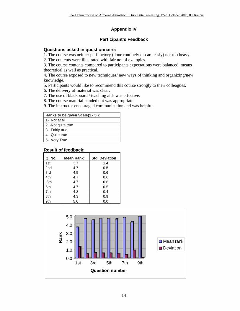
Feedback: Feedbacks were invited from the participants informally and formally at the end of
course. The formal feedbacks were in the form of a questionnaire which was completed
by the participants. The statistical evaluation of feedbacks revealed the following:
1. The course was neither too perfunctory nor too heavy. 2. The contents were illustrated with fair no. of examples. 3. The course contents compared to participants expectations were balanced, means
theoretical as well as experimental. 4. The course exposed to new techniques/ new ways of thinking and organizing/ new
knowledge. 5. Most participants would like to recommend this course strongly to their
colleagues. 6. The delivery of the material was clear. 7. The use of blackboard/ teaching aids was fairly effective. 8. The course material handed out was very appropriate. 9. The instructors encouraged communication and were helpful.
The results of course feedback are given in Appendix IV.
Course material: The course material was organized in the form a CD, which included the lectures notes
provided by faculty members, the power point presentation slides and other interesting
material about LiDAR technology. Some more material, including LiDAR data, Optech’s
manuals, instrument specifications, softcopies of lecture notes etc. were also included.
Short Term Course on Airborne Altimetric LiDAR Data Processing, 17-20 October 2005, IIT Kanpur
9
Besides this, from time to time the participants were given different material in the form
of Xerox copies.
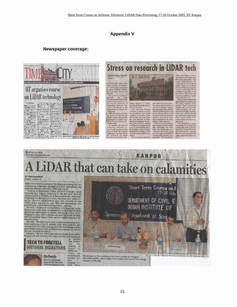
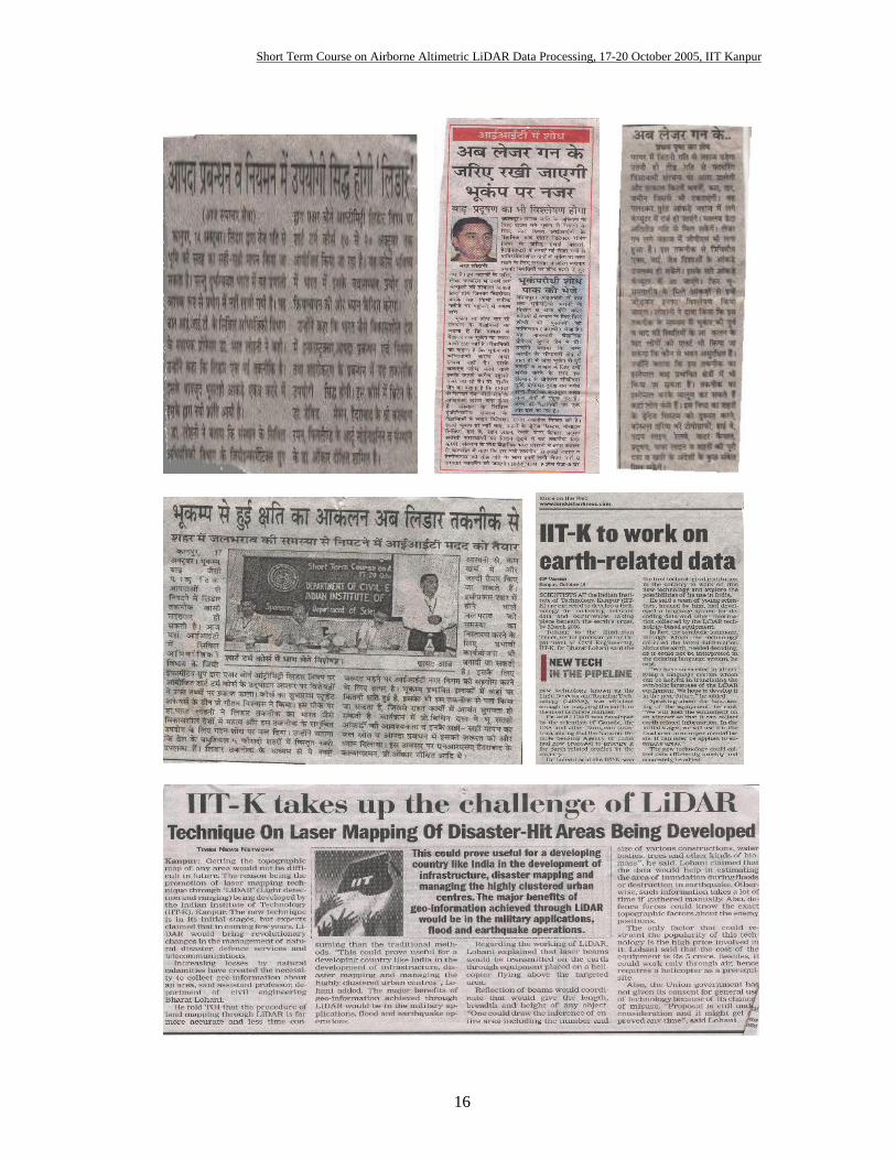
Public awareness: For the percolation of technology to grassroots it is important that more and more people
from general public and authorities in government and industry know about it. Keeping
this in mind the Information Cell of IIT Kanpur performed an excellent job of reporting
the activities of this course in the local and national media. Further, the media also
showed keen interest in the proceedings of the course and published theme articles on this
course and related area. Appendix V shows a few of these reports.
Short Term Course on Airborne Altimetric LiDAR Data Processing, 17-20 October 2005, IIT Kanpur
10
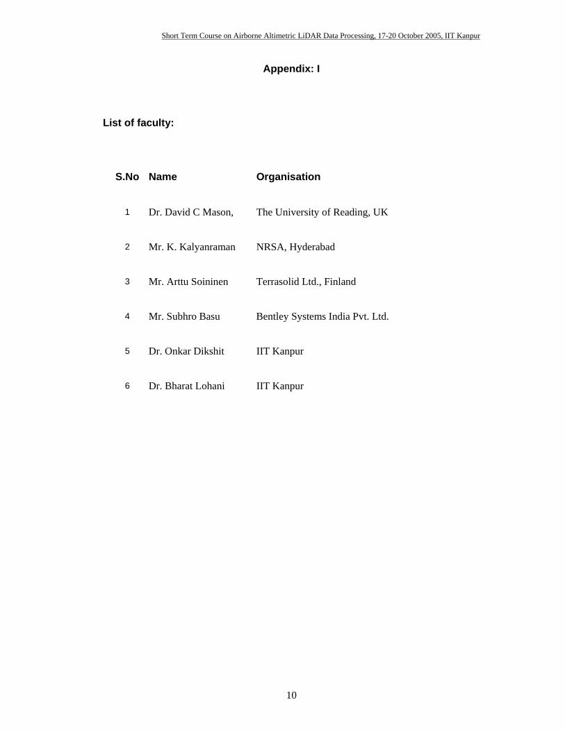
Appendix: I
List of faculty:
S.No Name Organisation
1 Dr. David C Mason, The University of Reading, UK
2 Mr. K. Kalyanraman NRSA, Hyderabad
3 Mr. Arttu Soininen Terrasolid Ltd., Finland
4 Mr. Subhro Basu Bentley Systems India Pvt. Ltd.
5 Dr. Onkar Dikshit IIT Kanpur
6 Dr. Bharat Lohani IIT Kanpur

Short Term Course on Airborne Altimetric LiDAR Data Processing, 17-20 October 2005, IIT Kanpur
11
Appendix II
List of participants:
S.No Name Designation Organisation
1 Dr. Y.S. Rao Senior Research Scientist I.I.T. Bombay
2 Mr. U.N. Mishra Superintending Surveyor Survey of India
3 Dr. Vazeer Mahammood Associate Professor G.I.T.A.M. College of Engineering
4 Mr. D.V.Satyanarayana Murthy Associate Professor Sri Venkateswara University College of Engineering, Tirupati
5 Mr. Anil Kumar, G Scientist/Engineer -SD NRSA
6 Mr. Jagannadha Rao. C.V.K.V.P. Scientist/Engineer -SD NRSA
7 Dr. Naved Ahasan Lecturer Jamia Millia Islamia, New Delhi
8 Dr. Biswajit Sarma Sr. Lecturer Jorhat Engineering College
9 Dr. Virendra Pathak Sr. Lecturer IET, Lucknow
10 Mr. Yogesh Singh Member Technical Staff C-DAC
11 Dr. D. Thirumalaivasan Assistant Professor Institute of Remote Sensing
12 Dr. Prakash Sinha Reader University of Allahabad
13 Mr. Chauhan Hasmukh Jinabhai Lecturer BVM Engineering College
14 Mr. Anurag Ohri Lecturer I.T., BHU,
15 Mr. V. Emayavaramban Lecturer Bharthidasan University, Department Of Geography
16 Mr. Durgesh Nandan Pathak Dep. Supdt. Surveyor Survey of India
17 Mr. D. Syama Rao Scientist/Engineer -SD NRSA
18 Sub. Maj. Satish Kumar Rana Subedar Major Army
19 Naib Sub. Naresh Pal Instructor Army ( Defence )
20 Wg. Cdr. R.N. Jayasimha Joint Director (Intelligence) Indian Air Force
21 Dr. A. K. Singh Scientist DST
22 Mr. Dhiraj Goel Team Leader (Development) ESRI India
23 Mr. Srikantha M. S. Sr. Product Executive PIXEL INFOTEK PVT LTD
24 Mr.Ravikumar C. B Product Executive PIXEL INFOTEK PVT LTD
25 Dr. Rudraraju Trinadha R Project Leader GeoRIST
Short Term Course on Airborne Altimetric LiDAR Data Processing, 17-20 October 2005, IIT Kanpur
12
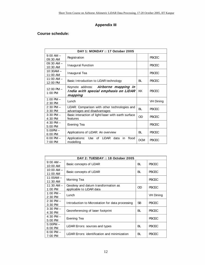
Appendix III Course schedule:
DAY 1: MONDAY :: 17 October 2005 9:00 AM – 09:30 AM Registration PBCEC 09:30 AM – 10:30 AM Inaugural Function PBCEC 10:30AM – 11:00 AM Inaugural Tea PBCEC 11:00 AM – 12:00 PM Basic Introduction to LiDAR technology BL PBCEC
12:00 PM – 1:00 PM
Keynote address: Airborne mapping in India with special emphasis on LiDAR mapping
KK PBCEC
1:00 PM – 2:30 PM Lunch VH Dining 2:30 PM – 3:30 PM
LiDAR: Comparison with other technologies and advantages and disadvantages BL PBCEC
3:30 PM – 4:30 PM
Basic interaction of light/laser with earth surface features OD PBCEC
4:30 PM – 5:00 PM Evening Tea PBCEC 5:00PM – 6:00 PM Applications of LiDAR: An overview BL PBCEC 6:00 PM – 7:00 PM
Applications: Use of LiDAR data in flood modelling DCM PBCEC
DAY 2: TUESDAY :: 18 October 2005 9:00 AM – 10:00 AM Basic concepts of LiDAR BL PBCEC 10:00 AM – 11:00 AM Basic concepts of LiDAR BL PBCEC 11:00AM – 11:30 AM Morning Tea PBCEC 11:30 AM – 1:00 PM
Geodesy and datum transformation as applicable to LiDAR data OD PBCEC
1:00 PM – 2:30 PM Lunch VH Dining 2:30 PM – 3:30 PM Introduction to Microstation for data processing SB PBCEC 3:30 PM – 4:30 PM Georeferencing of laser footprint BL PBCEC 4:30 PM – 5:00 PM Evening Tea PBCEC 5:00PM – 6:00 PM LiDAR Errors: sources and types BL PBCEC 6:00 PM – 7:00 PM LiDAR Errors: identification and minimization BL PBCEC
Short Term Course on Airborne Altimetric LiDAR Data Processing, 17-20 October 2005, IIT Kanpur
13
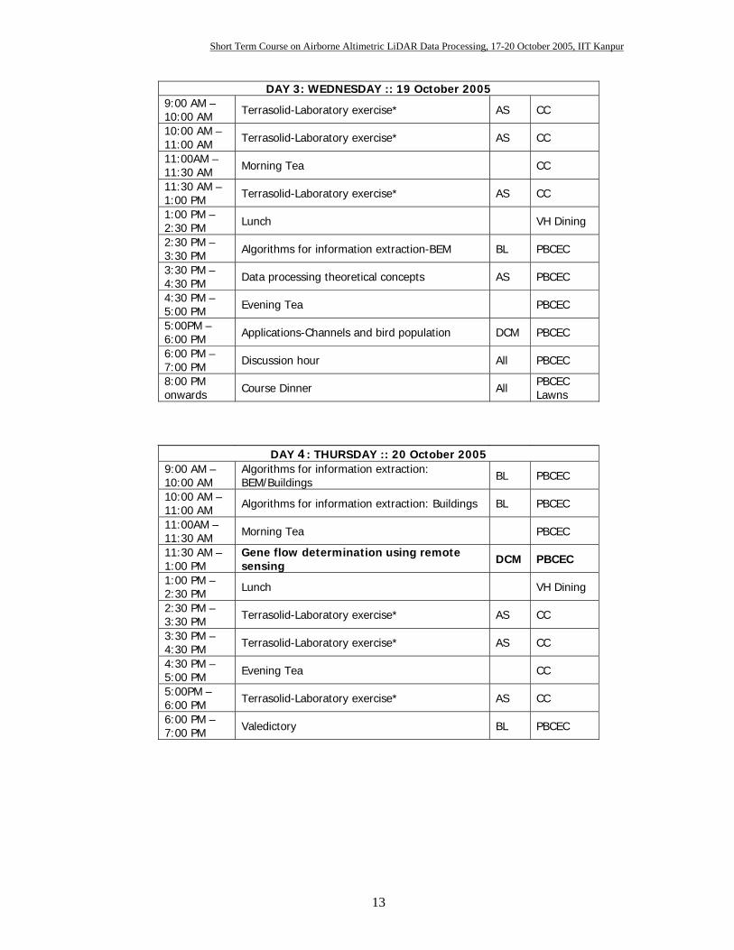
DAY 3: WEDNESDAY :: 19 October 2005 9:00 AM – 10:00 AM Terrasolid-Laboratory exercise* AS CC 10:00 AM – 11:00 AM Terrasolid-Laboratory exercise* AS CC 11:00AM – 11:30 AM Morning Tea CC 11:30 AM – 1:00 PM Terrasolid-Laboratory exercise* AS CC 1:00 PM – 2:30 PM Lunch VH Dining 2:30 PM – 3:30 PM Algorithms for information extraction-BEM BL PBCEC 3:30 PM – 4:30 PM Data processing theoretical concepts AS PBCEC 4:30 PM – 5:00 PM Evening Tea PBCEC 5:00PM – 6:00 PM Applications-Channels and bird population DCM PBCEC 6:00 PM – 7:00 PM Discussion hour All PBCEC 8:00 PM onwards Course Dinner All PBCEC
Lawns
DAY 4: THURSDAY :: 20 October 2005 9:00 AM – 10:00 AM
Algorithms for information extraction: BEM/Buildings BL PBCEC
10:00 AM – 11:00 AM Algorithms for information extraction: Buildings BL PBCEC 11:00AM – 11:30 AM Morning Tea PBCEC 11:30 AM – 1:00 PM
Gene flow determination using remote sensing DCM PBCEC
1:00 PM – 2:30 PM Lunch VH Dining 2:30 PM – 3:30 PM Terrasolid-Laboratory exercise* AS CC 3:30 PM – 4:30 PM Terrasolid-Laboratory exercise* AS CC 4:30 PM – 5:00 PM Evening Tea CC 5:00PM – 6:00 PM Terrasolid-Laboratory exercise* AS CC 6:00 PM – 7:00 PM Valedictory BL PBCEC
Short Term Course on Airborne Altimetric LiDAR Data Processing, 17-20 October 2005, IIT Kanpur
14
Appendix IV
Participant’s Feedback Questions asked in questionnaire: 1. The course was neither perfunctory (done routinely or carelessly) nor too heavy. 2. The contents were illustrated with fair no. of examples. 3. The course contents compared to participants expectations were balanced, means theoretical as well as practical. 4. The course exposed to new techniques/ new ways of thinking and organizing/new knowledge. 5. Participants would like to recommend this course strongly to their colleagues. 6. The delivery of material was clear. 7. The use of blackboard / teaching aids was effective. 8. The course material handed out was appropriate. 9. The instructor encouraged communication and was helpful. Ranks to be given Scale(1 - 5 ): 1- Not at all 2 -Not quite true 3- Fairly true 4- Quite true 5- Very True
Result of feedback:
Q. No. Mean Rank Std. Deviation 1st 3.7 1.4 2nd 4.7 0.5 3rd 4.5 0.6 4th 4.7 0.6 5th 4.7 0.6 6th 4.7 0.5 7th 4.8 0.4 8th 4.3 0.9 9th 5.0 0.0
0.0
1.0
2.0
3.0
4.0
5.0
Ran
k
1st 3rd 5th 7th 9th
Question number
Mean rankDeviation
Short Term Course on Airborne Altimetric LiDAR Data Processing, 17-20 October 2005, IIT Kanpur
15
Appendix V
Newspaper coverage:
Short Term Course on Airborne Altimetric LiDAR Data Processing, 17-20 October 2005, IIT Kanpur
16