all tankers and vessels carrying...
TRANSCRIPT
Page 1 of 14
LAGOS PILOTAGE DIRECTION
1. Pilotage is compulsory for all vessels except vessels below 500 GT with Pilotage
Exemption Certificate (PEC).
1.1. All Tankers and Vessels carrying classified substances (including mixtures and
solutions) as specified in International Maritime Dangerous Goods (IMDG)
Code MUST navigate with a Pilot on board while in the District.
2. Pilotage services are provided on request from the appointed Agent to the
Harbour Master, Lagos Pilotage District for 24hrs, 7days a week on these
contacts:
2.1. VHF Channels 12, 14 and 16 (Lagos Port Control).
2.2. Mobile Numbers:
2.3. E-mail: [email protected]
2.4. Website: www.nigerianports.org
3. All vessels arriving/departing Lagos Pilotage District must call Lagos Port Control
on VHF Channels 12, 14 and 16.
4. Estimated Time of Arrival (ETA) must be communicated 12 hours before arrival
of vessels unless directed otherwise by the Harbour Master/Lagos Port Control.
4.1. An amendment to ETA is accepted not later than 4 hours before arrival of
vessels.
5. A vessel issued with Pilotage Exemption Certificate may require Pilotage and
Towage services if:
5.1. The vessel equipment is substandard or defective.
5.2. The vessel is maneuvering with difficulty or has a history of difficulty in
maneuvering.
5.3. Adverse weather is prevailing or expected.
5.4. The Master of the vessel is incapacitated.
5.5. The vessel’s position is exposed to imminent danger or navigational
hazard.
5.6. It is apparent that the Master of the vessel is not performing to
international best practices and to the satisfaction of the Port Authority.
5.7. The service of a tug is required.
Page 2 of 14
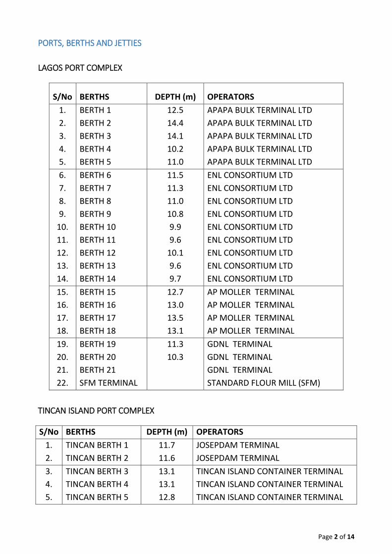
PORTS, BERTHS AND JETTIES
LAGOS PORT COMPLEX
S/No BERTHS DEPTH (m) OPERATORS
1.
2.
3.
4.
5.
BERTH 1
BERTH 2
BERTH 3
BERTH 4
BERTH 5
12.5
14.4
14.1
10.2
11.0
APAPA BULK TERMINAL LTD
APAPA BULK TERMINAL LTD
APAPA BULK TERMINAL LTD
APAPA BULK TERMINAL LTD
APAPA BULK TERMINAL LTD
6.
7.
8.
9.
10.
11.
12.
13.
14.
BERTH 6
BERTH 7
BERTH 8
BERTH 9
BERTH 10
BERTH 11
BERTH 12
BERTH 13
BERTH 14
11.5
11.3
11.0
10.8
9.9
9.6
10.1
9.6
9.7
ENL CONSORTIUM LTD
ENL CONSORTIUM LTD
ENL CONSORTIUM LTD
ENL CONSORTIUM LTD
ENL CONSORTIUM LTD
ENL CONSORTIUM LTD
ENL CONSORTIUM LTD
ENL CONSORTIUM LTD
ENL CONSORTIUM LTD
15.
16.
17.
18.
BERTH 15
BERTH 16
BERTH 17
BERTH 18
12.7
13.0
13.5
13.1
AP MOLLER TERMINAL
AP MOLLER TERMINAL
AP MOLLER TERMINAL
AP MOLLER TERMINAL
19.
20.
21.
22.
BERTH 19
BERTH 20
BERTH 21
SFM TERMINAL
11.3
10.3
GDNL TERMINAL
GDNL TERMINAL
GDNL TERMINAL
STANDARD FLOUR MILL (SFM)
TINCAN ISLAND PORT COMPLEX
S/No BERTHS DEPTH (m) OPERATORS
1.
2.
TINCAN BERTH 1
TINCAN BERTH 2
11.7
11.6
JOSEPDAM TERMINAL
JOSEPDAM TERMINAL
3.
4.
5.
TINCAN BERTH 3
TINCAN BERTH 4
TINCAN BERTH 5
13.1
13.1
12.8
TINCAN ISLAND CONTAINER TERMINAL
TINCAN ISLAND CONTAINER TERMINAL
TINCAN ISLAND CONTAINER TERMINAL
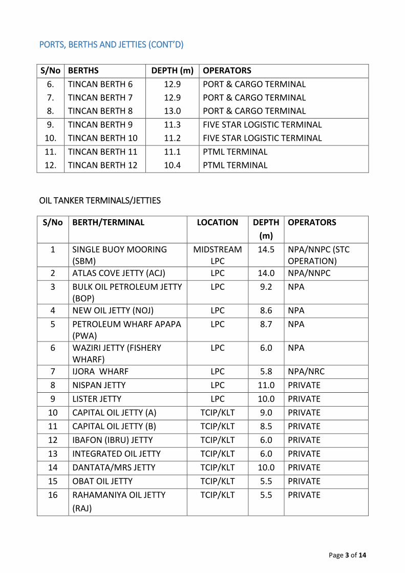
Page 3 of 14
PORTS, BERTHS AND JETTIES (CONT’D)
S/No BERTHS DEPTH (m) OPERATORS
6.
7.
8.
TINCAN BERTH 6
TINCAN BERTH 7
TINCAN BERTH 8
12.9
12.9
13.0
PORT & CARGO TERMINAL
PORT & CARGO TERMINAL
PORT & CARGO TERMINAL
9.
10.
TINCAN BERTH 9
TINCAN BERTH 10
11.3
11.2
FIVE STAR LOGISTIC TERMINAL
FIVE STAR LOGISTIC TERMINAL
11.
12.
TINCAN BERTH 11
TINCAN BERTH 12
11.1
10.4
PTML TERMINAL
PTML TERMINAL
OIL TANKER TERMINALS/JETTIES
S/No BERTH/TERMINAL LOCATION DEPTH
(m)
OPERATORS
1 SINGLE BUOY MOORING (SBM)
MIDSTREAM LPC
14.5 NPA/NNPC (STC OPERATION)
2 ATLAS COVE JETTY (ACJ) LPC 14.0 NPA/NNPC
3 BULK OIL PETROLEUM JETTY (BOP)
LPC 9.2 NPA
4 NEW OIL JETTY (NOJ) LPC 8.6 NPA
5 PETROLEUM WHARF APAPA (PWA)
LPC 8.7 NPA
6 WAZIRI JETTY (FISHERY WHARF)
LPC 6.0 NPA
7 IJORA WHARF LPC 5.8 NPA/NRC
8 NISPAN JETTY LPC 11.0 PRIVATE
9 LISTER JETTY LPC 10.0 PRIVATE
10 CAPITAL OIL JETTY (A) TCIP/KLT 9.0 PRIVATE
11 CAPITAL OIL JETTY (B) TCIP/KLT 8.5 PRIVATE
12 IBAFON (IBRU) JETTY TCIP/KLT 6.0 PRIVATE
13 INTEGRATED OIL JETTY TCIP/KLT 6.0 PRIVATE
14 DANTATA/MRS JETTY TCIP/KLT 10.0 PRIVATE
15 OBAT OIL JETTY TCIP/KLT 5.5 PRIVATE
16 RAHAMANIYA OIL JETTY
(RAJ)
TCIP/KLT 5.5 PRIVATE
Page 4 of 14
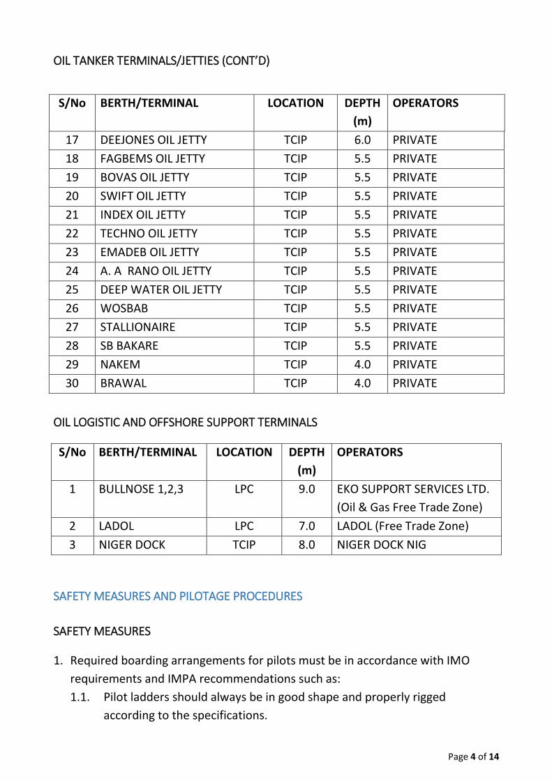
OIL TANKER TERMINALS/JETTIES (CONT’D)
S/No BERTH/TERMINAL LOCATION DEPTH
(m)
OPERATORS
17 DEEJONES OIL JETTY TCIP 6.0 PRIVATE
18 FAGBEMS OIL JETTY TCIP 5.5 PRIVATE
19 BOVAS OIL JETTY TCIP 5.5 PRIVATE
20 SWIFT OIL JETTY TCIP 5.5 PRIVATE
21 INDEX OIL JETTY TCIP 5.5 PRIVATE
22 TECHNO OIL JETTY TCIP 5.5 PRIVATE
23 EMADEB OIL JETTY TCIP 5.5 PRIVATE
24 A. A RANO OIL JETTY TCIP 5.5 PRIVATE
25 DEEP WATER OIL JETTY TCIP 5.5 PRIVATE
26 WOSBAB TCIP 5.5 PRIVATE
27 STALLIONAIRE TCIP 5.5 PRIVATE
28 SB BAKARE TCIP 5.5 PRIVATE
29 NAKEM TCIP 4.0 PRIVATE
30 BRAWAL TCIP 4.0 PRIVATE
OIL LOGISTIC AND OFFSHORE SUPPORT TERMINALS
S/No BERTH/TERMINAL LOCATION DEPTH
(m)
OPERATORS
1 BULLNOSE 1,2,3 LPC 9.0 EKO SUPPORT SERVICES LTD.
(Oil & Gas Free Trade Zone)
2 LADOL LPC 7.0 LADOL (Free Trade Zone)
3 NIGER DOCK TCIP 8.0 NIGER DOCK NIG
SAFETY MEASURES AND PILOTAGE PROCEDURES
SAFETY MEASURES
1. Required boarding arrangements for pilots must be in accordance with IMO
requirements and IMPA recommendations such as:
1.1. Pilot ladders should always be in good shape and properly rigged
according to the specifications.
Page 5 of 14
1.2. If freeboard is more than 9m, combination ladders should be properly
rigged and free of any obstruction.
1.3. A responsible officer should be stationed at the boarding point, and it
should be properly lighted at night.
1.4. Pilot may abort boarding a vessel if he carries out risk assessment of the
boarding arrangement/sea state and is proven to be unsafe.
2. The Pilot is advised to be fully kitted in safety gear (Life Jacket and Safety Shoes,
etc). Note: the Master reserves the right to refuse the Pilot boarding if in doubt of
the safety of the pilot.
3. Pilot/bridge team must adhere strictly to all collision avoidance regulation in all
situations.
4. Pilot should at all times avoid unsafe meeting points (Apapa 15, Buoy 18, Apapa
19/20, Sea School, Tincan 8/9). During ship to ship interaction, communication
should be fully established between ship and Port Control.
5. Pilot outward bound from Apapa Channel should always be the give-way vessel
to Pilot outward bound from Badagry Channel when approaching the Meridian
Point (Buoy 18) unless on exceptional circumstance as may be agreed by all
parties.
6. Pilots must make reports at every reporting point and avoid all prohibited
anchoring areas. Charts should always be consulted before anchoring.
7. All vessels must at all times proceed at a safe speed within the Lagos Channel,
putting into consideration all the navigational hazards within the port (e.g.
Fishing trawlers, Dredgers, Sand digger boats, Local fishing boats, Tidal situation,
Weather and Traffic situations).
8. Buoyage System: Lagos Pilotage District operates IALA Maritime buoyage system
region A (Red to Port and Green to starboard) and all the buoys are lighted. The
Fairway Buoy is lighted with a light characteristic of white light flashing Morse
Code “A”.
Page 6 of 14
PILOTAGE PROCEDURE
1. Pilot obtains vessel berthing/sailing clearance as per booking from the Harbour
Master before calling vessel for berthing and un-berthing prospects.
1.1. Pilot calls vessel on VHF Radio channel 14 to establish communication and
agree on the communication channel, boarding arrangement, boarding
position before proceeding to the vessel.
1.2. Pilots must always board vessels from a Pilot Cutter. NPA Pilot Cutters are
green–hull with a cream superstructure which is marked “PILOT” on both
sides.
2. Lagos Ports operate 24hours pilotage service, unless on exceptional cases as may
be directed by the Harbour Master.
2.1. With regard to night pilotage, all parties must comply with all regulations
governing night navigation such as exhibiting the appropriate
lights/signals.
3. The Tincan Turning Basin has a diameter of about 400m with a depth/sounding
range of 9.5m to 11m.
3.1. At ebb tide, the safest swinging draft of vessels less than 220m in length is
11m while for vessels more than 220m in length is 10m.
4. The Apapa Turning Basin has a diameter of about 360m with a depth/sounding
range of 8.5m to 10.8m.
4.1. At ebb tide, the safest swinging draft of vessels less than 220m in length is
10m while for vessels more than 220m in length, is 9.5m.
5. Vessels Booking/Pilotage Planning is as follows:
5.1. Booking time for vessel’s berthing/sailing within Lagos Pilotage District:
(a) 0800 – 1200 Booking for PM moves,
(b) 1300 Publication of PM moves
(c) 1200 – 1600 Booking for AM moves
(d) 17000 Publication for AM moves
5.2. All bookings stand cancelled after 3hrs if berthing/sailing is not carried out
and should be re-booked.
5.3 Pilot/Tug detention is charged hourly or part thereof.
Page 7 of 14
5.4. All Pilots, Shipping Agents, Owners and Terminal Operators must comply
strictly.
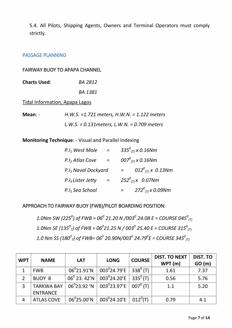
PASSAGE PLANNING
FAIRWAY BUOY TO APAPA CHANNEL
Charts Used: BA 2812
BA 1381
Tidal Information, Apapa Lagos
Mean: - H.W.S. =1.721 meters, H.W.N. = 1.122 meters
L.W.S. = 0.131meters, L.W.N. = 0.709 meters
Monitoring Technique: - Visual and Parallel Indexing
P.I1 West Mole = 3350(T) x 0.16Nm
P.I2 Atlas Cove = 0070(T) x 0.16Nm
P.I3 Naval Dockyard = 0120(T) x 0.13Nm
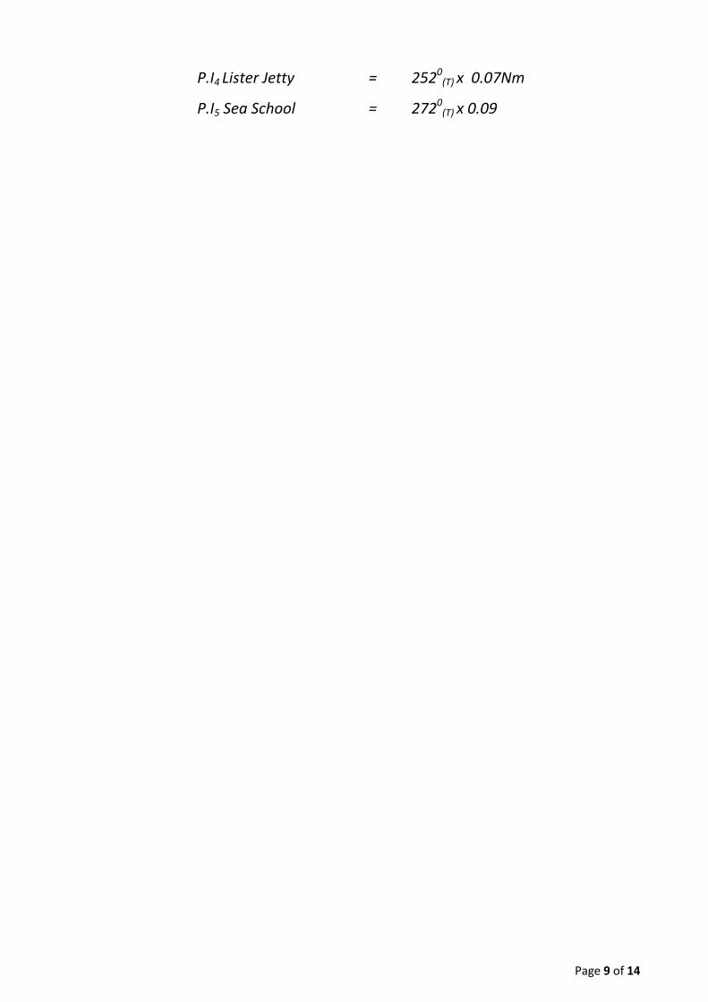
P.I4 Lister Jetty = 2520(T) x 0.07Nm
P.I5 Sea School = 2720(T) x 0.09Nm
APPROACH TO FAIRWAY BUOY (FWB)/PILOT BOARDING POSITION:
1.0Nm SW (2250) of FWB = 060 21.20 N /0030.24.08 E = COURSE 0450(T)
1.0Nm SE (1350T) of FWB = 06021.25 N / 0030 25.40 E = COURSE 3150
(T)
1.0 Nm SS (1800T) of FWB= 060 20.90N/0030 24.790E = COURSE 3450
(T)
WPT NAME LAT LONG COURSE DIST. TO NEXT
WPT (m) DIST. TO GO (m)
1 FWB 06021.91’N 003024.79’E 3380 (T) 1.61 7.37
2 BUOY 8 060 23. 42’N 003024.20’E 3350 (T) 0.56 5.76
3 TARKWA BAY ENTRANCE
06023.92 ‘N 003023.97’E 0070 (T) 1.1 5.20
4 ATLAS COVE 06025.00’N 003024.10’E 0120(T) 0.79 4.1

Page 8 of 14
5 MERIDIAN POINT
06025.74’N 0030 24.23’E 3300(T) 0.69 3.41
APPROACH TO FAIRWAY BUOY (FWB)/PILOT BOARDING POSITION (CONT’D):
WPT NAME LAT LONG COURSE DIST. TO NEXT
WPT (m) DIST. TO GO (m)
6 APAPA 14 06026.36’N 003023.91’E 2920(T) 1.40 2.01
7 APAPA 1 060 26.87’N 003022.60’E 3260(T) 0.4 1.61
8 BOP 06027.20’N 0030.21.81’E 272(T) 1.51 2.82
9 APAPA NAVAL BASE
06.27.59’N 003022.41’E 0510(T) 1.23 0.82
10 IJORA WHARF
06027.86’N 003022.75’E 0.00
Remarks - All vessels proceeding to Lagos Pilotage District should maintain a proper
look out at all times as per Rule 5
- Primary position fixing and monitoring technique = visual and parallel
indexing
- The rise and fall of the tide is in accordance with the prediction, but the
period of ebb and flood varies considerably throughout the year due to
local geographical and climatic conditions.
FAIRWAY BUOY TO BADAGRY CHANNEL (BUOY 44)
Chart Used: BA 2812
BA 1381
Tidal Information Lagos Bar
Mean: H.W.S. = 0.945meters, H.W.N = 0.701 meters
L.W.S. = 0.091meters, L.W.N. = 0.213 meters
Monitoring Technique: - Visual and Parallel Indexing
P.I1 West Mole = 3350(T) x 0.16Nm
P.I2 Atlas Cove Jetty = 0070(T) x 0.16Nm
P.I3 Naval Dockyard = 0120(T) x 0.13Nm
Page 9 of 14
P.I4 Lister Jetty = 2520(T) x 0.07Nm
P.I5 Sea School = 2720(T) x 0.09
Page 10 of 14
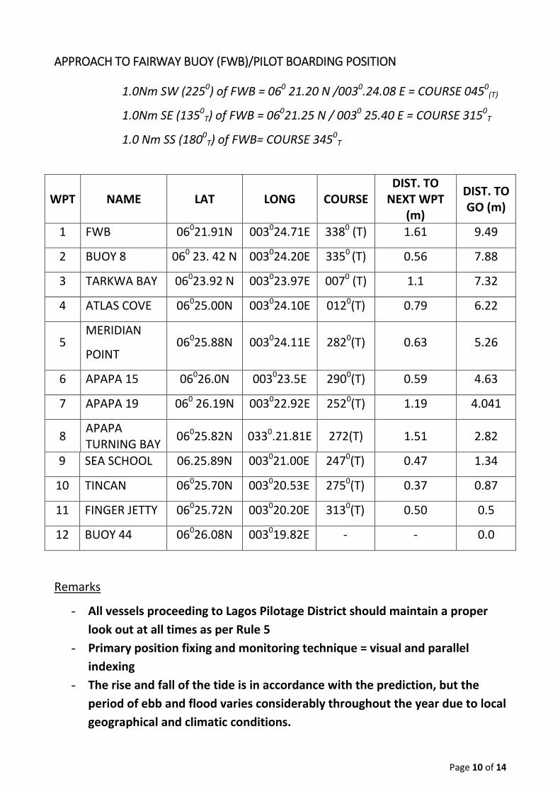
APPROACH TO FAIRWAY BUOY (FWB)/PILOT BOARDING POSITION
1.0Nm SW (2250) of FWB = 060 21.20 N /0030.24.08 E = COURSE 0450(T)
1.0Nm SE (1350T) of FWB = 06021.25 N / 0030 25.40 E = COURSE 3150
T
1.0 Nm SS (1800T) of FWB= COURSE 3450
T
WPT NAME LAT LONG COURSE DIST. TO
NEXT WPT (m)
DIST. TO GO (m)
1 FWB 06021.91N 003024.71E 3380 (T) 1.61 9.49
2 BUOY 8 060 23. 42 N 003024.20E 3350 (T) 0.56 7.88
3 TARKWA BAY 06023.92 N 003023.97E 0070 (T) 1.1 7.32
4 ATLAS COVE 06025.00N 003024.10E 0120(T) 0.79 6.22
5 MERIDIAN
POINT 06025.88N 003024.11E 2820(T) 0.63 5.26
6 APAPA 15 06026.0N 003023.5E 2900(T) 0.59 4.63
7 APAPA 19 060 26.19N 003022.92E 2520(T) 1.19 4.041
8 APAPA TURNING BAY
06025.82N 0330.21.81E 272(T) 1.51 2.82
9 SEA SCHOOL 06.25.89N 003021.00E 2470(T) 0.47 1.34
10 TINCAN 06025.70N 003020.53E 2750(T) 0.37 0.87
11 FINGER JETTY 06025.72N 003020.20E 3130(T) 0.50 0.5
12 BUOY 44 06026.08N 003019.82E - - 0.0
Remarks
- All vessels proceeding to Lagos Pilotage District should maintain a proper
look out at all times as per Rule 5
- Primary position fixing and monitoring technique = visual and parallel
indexing
- The rise and fall of the tide is in accordance with the prediction, but the
period of ebb and flood varies considerably throughout the year due to local
geographical and climatic conditions.

Page 11 of 14
PROCEDURES FOR COMMUNICATION, TRAFFIC CONTROL AND REPORTING VESSEL POSITION
The following should be strictly adhered to for effective maintenance of safety of
navigation on our channels:
1. All Pilots must report all movements to the Radio/Signal Station (Port
Control).
2. All Pilots afloat must keep positive communication flow with each other and
the Radio/Signal Station throughout the period of pilotage.
3. The Radio/Signal Station shall communicate and log all such communications.
4. The Radio/Signal Station must duly guide all vessels with Pilotage Exemption
Certificate.
5. All vessels within the channel must note the reporting points and strictly
comply.
6. Harbours Operation Radio Channels are:
i. Channel 11: Vessels movement traffic control.
ii. Channel 12: Arrival and departure details.
iii. Channel 13: Pilots/Tugs/Beach Masters.
iv. Channel 14: Harbour/Port Operation.
v. Channel 16: General Calling
The following reporting points should be used by Pilots/Masters to make regular
reports of their presence to/and within the channel:
a. Fairway Buoy
b. Entrance to the Channel
c. Naval Dockyard
d. Apapa 1
e. Apapa 14
f. Apapa 20
g. Sea School
Page 12 of 14
ISPS CODE, EMERGENCY PLAN PROCEDURES AND WASTE DISPOSAL PROCEDURES
1. ISPS Code: International Ship & Port Facility Security code.
1.1. The ports in Lagos are fully ISPS compliant
1.2. All vessels are advised to step up their security level if the need so arises.
1.3. All vessels are advised to have ship security plan as per ISPS code.
1.4. In case of any security threat, all vessels should contact the Harbour
Master, via Port Control on VHF Channels 12 or 16.
1.5. The Habour Master makes contact with the NPA ISPS code coordinator
who may contact the DA if necessary.
2. Emergency Plan Procedures (See Appendix A)
2.1. All Vessels should report any emergency situation to the Harbour Master,
via Port Operation/Port Control for immediate response and stating the
nature of emergency.
2.2. In case of Oil Spillage, Nigerian Ports Authority’s Pollution Control should
be contacted immediately, directly on VHF channels 12, 14 and 16 or via
Port Operation on VHF 14.
2.3. In case of any collision, loss of engine, steering problem, the pilot will
advise on a safe anchoring position within the channel or request the
assistance of Tugs.
2.4. In case of any fire incident, Port Operation should be contacted
immediately for necessary advice or action.
2.5. Vessels should always have their anchors on standby when transiting the
channels.
3. Waste Disposal Procedures (See Appendix A)
Pollution Control should be contacted immediately via Port Operation on VHF
Channels 12, 14 and 16.
TOWAGE OPERATIONS AND TUG ASSISTANCE
TOWING OPERATIONS
All stakeholders should please note that towing operations within port limit must be
booked and carried out under the supervision of a Nigerian Ports Authority Pilot.
The following should be declared when a booking is being made:
Page 13 of 14
i. The characteristics and nature of tow
ii. Displaying of appropriate day/night signal during towing operation
TUG BOAT ASSISTANCE
All tugboats and other crafts of the Authority are fully operated by the Harbour
Master, but they managed by Landfall Transport & Towage Nigeria Limited.
These vessels must adhere to the following conditions:
1. Fishing Trawlers
a. Must request permission from Harbour Master at least two (2) hours before
arrival/departure.
b. Report arrival/departure to Signal Station.
c. Report to Port Control at every reporting point.
2. Towing Operation
a. Must request permission from Harbour Master at least two (2) hours before
arrival/departure.
b. State if pilot services are required or not.
c. Comply with 1 (b) and (c) above
3. Other Vessels
Dredgers, Ferries, Private Tugs and other Crafts with pilotage exemption
certificates are required to:
a. Inform the Harbour Master of their movements at all times.
b. They should also adhere strictly to the reporting regime at each reporting
point.
c. Communicate with pilots performing pilotage operations on VHF channels 14,
13 and 11 for safe passage.
d. Naval ships, Customs, NDLEA, NIMASA, NPF and other registered vessels
belonging to Government Agencies deployed for official duty, are exempted
from compliance but have to inform the Habour Master for movements and
also for entry and exit procedures.
Page 14 of 14
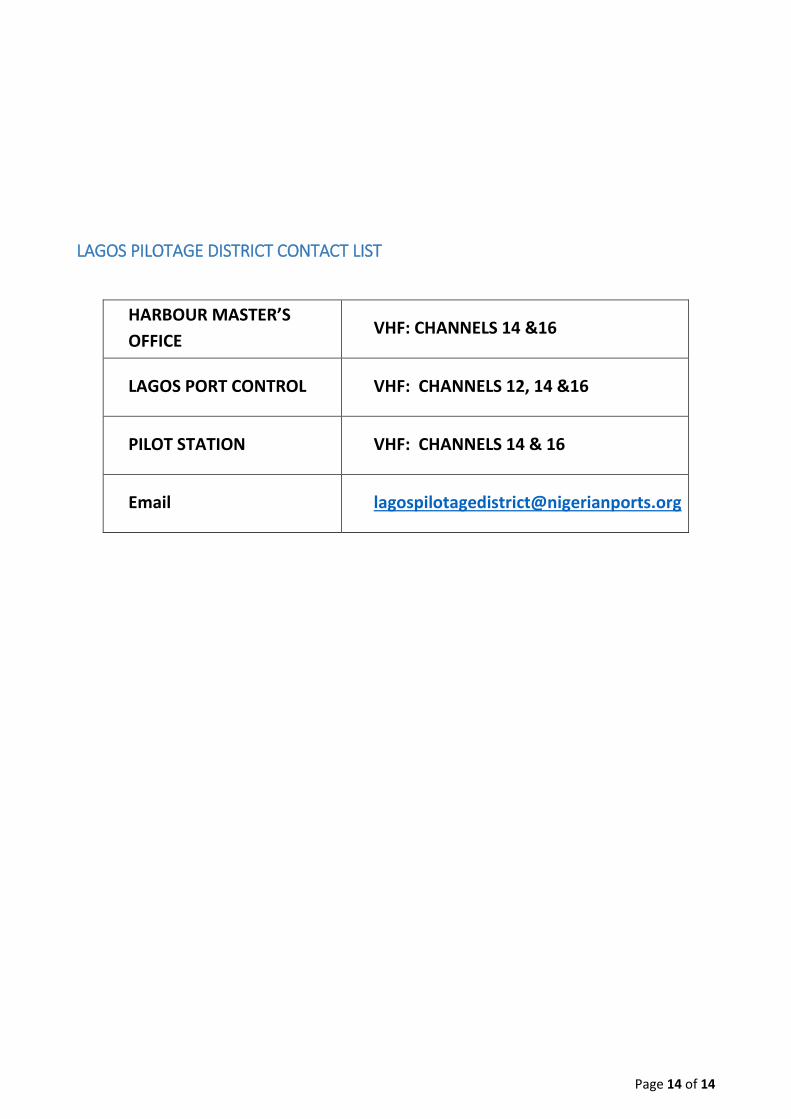
LAGOS PILOTAGE DISTRICT CONTACT LIST
HARBOUR MASTER’S
OFFICE VHF: CHANNELS 14 &16
LAGOS PORT CONTROL VHF: CHANNELS 12, 14 &16
PILOT STATION VHF: CHANNELS 14 & 16
Email [email protected]