anderson-dinaledi 400 kv transmission line - eskom 400 kv transmission ... anderson-dinaledi 400 kv...
TRANSCRIPT

Anderson-Dinaledi 400 kV Transmission Line
Draft EIA Report 61
o Western Route Alternative (Southern Deviation) - This deviation originates on Portion 70 of the
Farm Rietfontein 485 JQ where it links from the original Western Route Alternative and ends where
it joins the original Western Route Alternative on Portion 108 of the Farm Zilkaatsnekl 439 JQ.
A detailed route description of each alternative alignment is provided in Section 8.1 .

Anderson-Dinaledi 400 kV Transmission Line
Draft EIA Report 62
Figure 4: Municipal areas traversed by the corridor s
Anderson-Dinaledi 400 kV Transmission Line
Draft EIA Report 63
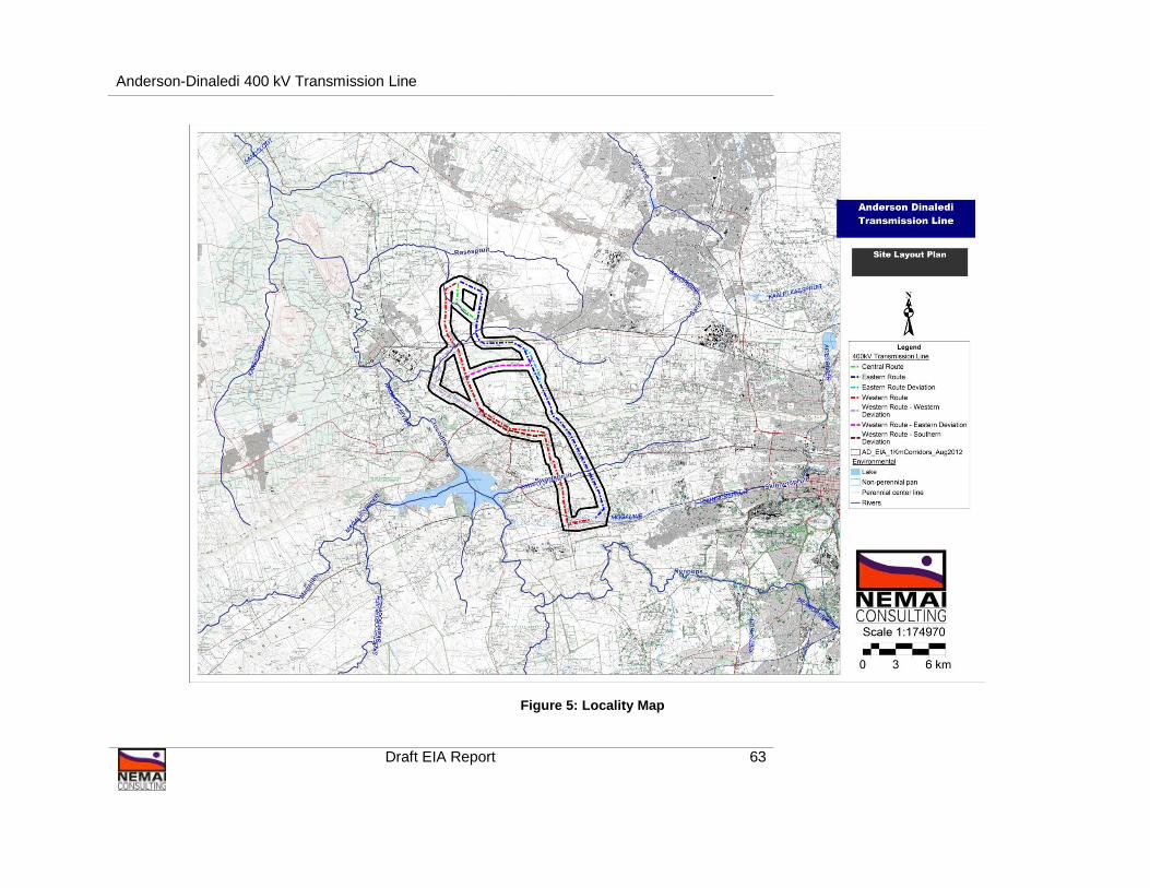
Figure 5: Locality Map

Anderson-Dinaledi 400 kV Transmission Line
Draft EIA Report 64
8 PROJECT DESCRIPTION
8.1 Power Line Routes
Refer to Appendix A for cadastral maps of the route alternatives.
Figure 6: Aerial Map Showing the Centre of Each Rou te Option
Western Route –
Eastern Deviation
Western Route –
Western Deviation
Western Route
Central Route
Eastern Route -
Eastern Deviation
Eastern Route
Western Route –
Southern Deviation
Dinaledi Substation
Preferred Anderson
Substation Site

Anderson-Dinaledi 400 kV Transmission Line
Draft EIA Report 65
An overview of the alternative transmission line routes as depicted in figure 6 follows below. All
distances provided should be regarded as approximates, as they are based on a desktop estimate
from a GIS. A 1 km corridor was investigated during the EIA to allow for any possible deviations of the
final route within this corridor, and the route description to follow is only for the centreline of each
alternative corridor.
Note that the alternative route descriptions are based on the 2006 Cadastral Information as obtained
from the Surveyor General in Pretoria. Any subdivision or consolidations which were undertaken after
2006 will therefore not be reflected in the route alternative descriptions.
As mentioned, the termination points of the Eastern and Western Route alternatives are dependent
on the location of the proposed Anderson Substation site.
8.1.1 Eastern Route Alternative
The Eastern Route alternative is approximately 30km in length and runs between the existing Dinaledi
Substation and the proposed new Anderson Substation (figure 7-9). A route description, from south to
north, follows.
The eastern route alternative originates from the proposed Anderson substation located on Portions
82, 83 and 76 of Farms Schurveberg 488 JQ. From here the route runs in an eastern direction and
traverse Portion 115 and 114 and 116 of the Farm Schurveberg 488 JQ.
On Portion 116 of the Farm Schurveberg the route turns in a north eastern direction, and runs in close
proximity to the boundaries of Portions 75 and 76 of the Farm Elandsfontein 352 JR for approximately
60m before turning in a northern direction on Portion 76. From here the route traverses Portions 77,
145, and 146 of the Farm Elandsfontein 352 JR. On Portion 146 the route turns slightly in a north
western direction and traverse Portions 142, 141, 143, 144, 145, and 78 of the Farm Uitzicht Alias
Rietvalei 314 JR. From here the route continues in a slight north western direction and traverse
Portions 65, 62, 270, and 268 of the Farm Kameeldrift 313 JR. From here the route turns further in a
north western direction and traverse Portions 324 and 50 of the Farm Rietfontein 485 JQ. From here
the route continues in a north western direction and traverse Portions 44 of the Farm Schietfontein
437 JQ and turns further in a north western direction where it traverses Portions 49 and 23 of the
Farm Zilkaatsnek 439 JQ. On Portion 23 the route turns in a north eastern direction and runs back to
Portion 44 of the Farm Schietfontein 437 JQ. From here the route runs in a slight north western
direction in close proximity to the boundary of Portion 44 and traverse Portions 71, 73, 74, 91, 16, and
13 of the Farm Schietfontein 437 JQ. From here the route turns further in a north eastern direction
and traverse Portion 15 of the Farm Elandsfontein 440 JQ.

Anderson-Dinaledi 400 kV Transmission Line
Draft EIA Report 66
On Portion 15 the route turns in a western direction and traverse Portions 58, 63, 59 and 61 of the
Farm Elandsfontein 440 JQ. On Portion 61 the route turns in a north western direction and traverse
Portions 18, and 19 of the Farm Elandsfontein 440 JQ. From here the route turns in a northern
direction and traverse Portions 44, 47, and 55 of the Farm Elandsfontein 440 JQ. On Portion 55 of
the Farm Elandsfontein 440 JQ (Portion 55 of the Farm Boekenhoutfontein 44-JQ) the route turns
slight north east and runs in close proximity to the boundary of Portion 55. On the northern boundary
of the Portion 55, the route turns in a north western direction and traverse Portions 855, 854, 853,
852, 851, 850, 849, 848, 847, 846, 845, 844 and 843 of the Farm Roodekopjes of Zwartkopjes 427
JQ. The route terminates on Portion 843 of the Farm Roodekopjes of Zwartkopjes 427 JQ where the
Dinaledi Substation is located.
The Eastern Route traverses the Madibeng Local Municipal area for approximately 21.68km and the
City of Tshwane Local Municipal area for approximately 5.6km. A total of 59 properties are currently
directly affected by this proposed route alternative.
The property of the Xsrata Eland Platinum Mine is located between the Eastern and Western route
alternatives. During the Eskom route selection process, one deviation was made to the Eastern
Route to accommodate the Eland Platinum Mine. Various deviations were made to the Western
Route Alternative which is discussed in detail in Section 1.4.4 below. These deviations were created
in order to avoid mining areas and to provide the mine with various options on how the route could
traverse their property should the routes not interfere with already approved future mine expansions
and to avoid traversing of surfaces earmarked for future open cast mining. The Eastern Route
Deviation is discussed in detail in the section to follow.
The coordinates for the approximate bend points along the Eastern Route Alternative corridor are
provided in Table 8 .
Table 8: Eastern Route Alternative bend points (sta rt and end points from south to north)
No. Latitude Longitude 1. 25°46'27.77"S 27°58'40.35"E
2. 25°45'57.093"S 27°59'7.308"E
3. 25°45'6.112"S 27°58'51.179"E
4. 25°42'16.146"S 27°57'18.19"E
5. 25°41'31.998"S 27°56'36.954"E
6. 25°41'25.128"S 27°56'23.931"E
7. 25°41'10.147"S 27°56'16.382"E
8. 25°41'3.897"S 27°56'18.317"E
9. 25°40'11.084"S 27°55'51.646"E
Start Point

Anderson-Dinaledi 400 kV Transmission Line
Draft EIA Report 67
No. Latitude Longitude 10. 25°39'28.579"S 27°55'29.8"E
11. 25°39'17.753"S 27°55'23.551"E
12. 25°38'6.038"S 27°54'47.47"E
13. 25°37'46.896"S 27°54'13.199"E
14. 25°37'50.342"S 27°52'37.294"E
15. 25°37'42.482"S 27°52'24.113"E
16. 25°37'24.503"S 27°52'13.688"E
17. 25°37'0.007"S 27°52'13.009"E
18. 25°36'44.788"S 27°52'16.068"E
19. 25°36'2.588"S 27°52'24.549"E
20. 25°35'22.126"S 27°52'32.526"E
21. 25°35'16.589"S 27°52'26.249"E
22. 25°34'48.472"S 27°51'20.382"E
End Point

Anderson-Dinaledi 400 kV Transmission Line
Draft EIA Report 68
Figure 7: View of the centre line of the Eastern Ro ute corridor in blue

Anderson-Dinaledi 400 kV Transmission Line
Draft EIA Report 69
Figure 8: Map showing the start point of the centre line of the eastern route corridor in blue at
the Anderson substation site
Figure 9: Map showing the end point of the centre l ine of the eastern route corridor in blue at
the Dinaledi substation

Anderson-Dinaledi 400 kV Transmission Line
Draft EIA Report 70
Figure 10: North-eastern view along Eastern Route A lternative
Figure 11: South-eastern view along the Eastern Rou te Alternative (crossing of R566,
Magaliesberg in background)

Anderson-Dinaledi 400 kV Transmission Line
Draft EIA Report 71
Figure 12: Southern view along the Eastern Route Al ternative (crossing of R513, Magaliesberg
in background)
Figure 13: South-eastern view along the Eastern Rou te Alternative (crossing of R514,
Witwatersberg in background)

Anderson-Dinaledi 400 kV Transmission Line
Draft EIA Report 72
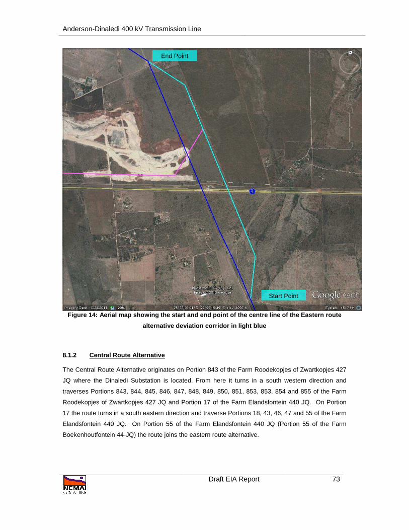
8.1.1.1 Eastern Route Alternative Deviation
The deviation to the eastern route originates on Portion 16 of the Farm Schietfontein 437 JQ where it
turns from the original eastern route alternative in a north eastern direction, and then in a northern
direction from where it traverses Portion 13 of the Farm Schietfontein 437 JQ. The route runs along
the eastern boundary of Portion 13 for approximately 1.4km before it turns in a north western direction
where it joins the original eastern route alternative on Portion 13.
The Eastern Route Alternative Deviation is located within the North West Province and the Madibeng
Local Municipal area. A total of 2 properties are currently directly affected by this proposed route
alternative.
The coordinates for the bend points along the Eastern Route Alternative Deviation are provided in
Table 9 .
Table 9: Eastern Route Alternative Deviation bend p oints (start and end points from south to
north)
No. Latitude Longitude
1. 25°39'44.761"S 27°55'38.325"E Start point
2. 25°39'27.21"S 27°55'40.105"E
3. 25°38'15.964"S 27°55'5.244"E
4. 25°38'6.038"S 27°54'47.47"E End point
Anderson-Dinaledi 400 kV Transmission Line
Draft EIA Report 73
Figure 14: Aerial map showing the start and end poi nt of the centre line of the Eastern route
alternative deviation corridor in light blue
8.1.2 Central Route Alternative
The Central Route Alternative originates on Portion 843 of the Farm Roodekopjes of Zwartkopjes 427
JQ where the Dinaledi Substation is located. From here it turns in a south western direction and
traverses Portions 843, 844, 845, 846, 847, 848, 849, 850, 851, 853, 853, 854 and 855 of the Farm
Roodekopjes of Zwartkopjes 427 JQ and Portion 17 of the Farm Elandsfontein 440 JQ. On Portion
17 the route turns in a south eastern direction and traverse Portions 18, 43, 46, 47 and 55 of the Farm
Elandsfontein 440 JQ. On Portion 55 of the Farm Elandsfontein 440 JQ (Portion 55 of the Farm
Boekenhoutfontein 44-JQ) the route joins the eastern route alternative.
Start Point
End Point

Anderson-Dinaledi 400 kV Transmission Line
Draft EIA Report 74
The Central Route Alternative is located within the North West Province and the Madibeng Local
Municipal area. A total of 19 properties are currently directly affected by this proposed route
alternative.
The coordinates for the bend points along the Central Route Alternative are provided in Table 10 .
Table 10: Central Route Alternative bend points (st art and end points from south to north)
No. Latitude Longitude
• 25°36'44.788"S 27°52'16.068"E Start point
• 25°35'53.327"S 27°51'9.219"E
• 25°34'53.662"S 27°51'14.256"E End point
Figure 15: Aerial map showing the start and end poi nt of the centre line of the central route
corridor in green
Start Point
End Point

Anderson-Dinaledi 400 kV Transmission Line
Draft EIA Report 75
8.1.3 Western Route Alternative
The Western Route Alternative is approximately 30km in length and originates at the same position as
the eastern route alternative, on the property earmarked for substation construction. The Western
Route Alternative runs between the proposed new Anderson Substation which is earmarked for
development north of Pelindaba and the existing Dinaledi Substation which is located approximately
8km north east of Brits. A route description, from south to north, follows.
Figure 16: Aerial map showing the start and end poi nt of the centre line of the western route
corridor in red
The Western Route Alternative originates from the proposed Anderson substation located on Portions
82, 83 and 76 of Farm Schurveberg 488 JQ. From portion 82 of Farm Schurveberg 488 JQ, the route
then traverses 118, 81 and 17 of Farm Schurveberg 488 JQ and then turns north to Portion 2 of the
Farm Welgedund 491 JQ. On Portion 2, the route turns in a northern direction and run in close
proximity to the boundaries of Portions 2, and 88 of the Farm Welgedund 491 JQ.