anthropogenic fires in indonesia: a view from sumatra
TRANSCRIPT

ANTHROPOGENIC FIRES IN
INDONESIA: A VIEW FROM SUMATRA
M. Roderick Bowen, Jean Marie Bompard, Ivan P. Anderson,
Philippe Guizol and Anne Gouyon
Reprinted from
FOREST FIRES AND REGIONAL HAZE IN SOUTH EAST ASIA
M. Radojevic and P. Eaton (Editors)
Nova Science, New York
European Union Ministry of Forestry And Estate Crops
Forest Fire Prevention and Control Project
Kanwil Kehutanan Dan Perkebunan, Palembang
i
Cover: Ferdinand Lubis
Produced through bilateral co-operation between
GOVERNMENT OF INDONESIA EUROPEAN UNION MINISTRY OF FORESTRY AND ESTATE CROPS EUROPEAN COMMISSION
Natural Resources International Limited BCEOM
CIRAD-Foret Scot Conseil
Financing Memorandum B7-5041/1/1992/12 (ALA/92/42) Contract Number IDN/B7-5041/92/644-01
This report was prepared with financial assistance from the Commission of the European Communities. The views expressed herein are those of the project and do not represent any official view of the Commission.

ii
This is one of a series of reports prepared during 1999 and 2000 by the Forest Fire Prevention and Control Project. Together they cover the field-level prevention, detection and control of vegetation fires in Sumatra. Titles are: Vegetation fires in Indonesia: operating procedures for the NOAA-GIS station in Palembang, Sumatra. I.P. Anderson, I.D. Imanda and Muhnandar. (January 1999) Vegetation fires in Indonesia: the interpretation of NOAA-derived hot-spot data. I.P. Anderson, I.D. Imanda and Muhnandar. (March 1999). Vegetation fires in Sumatra,Indonesia: the presentation and distribution of NOAA-derived data. I.P. Anderson, I.D. Imanda and Muhnandar. (January 1999)
Vegetation fires in Indonesia: the fire history of the Sumatra provinces 1996-1998 as a predictor of future areas at risk. I.P. Anderson, M.R. Bowen, I.D. Imanda and Muhnadar. (May 1999).
Vegetation fires in Sumatra, Indonesia: a first look at vegetation indices and fire danger in relation to fire occurrence. I.P. Anderson, I.D. Imanda and Muhnandar. (May 1999). The training of forest firefighters in Indonesia. M.V.J. Nicolas and G.S. Beebe (Joint publication with GTZ). (April 1999). Fire management in the logging concessions and plantation forests of Indonesia. M.V.J. Nicolas and G.S. Beebe (Joint publication with GTZ). (April 1999).
A field-level approach to coastal peat and coal-seam fires in South Sumatra province, Indonesia. M.V.J. Nicolas and M.R. Bowen. (April 1999).
Environmental education - with special reference to fire prevention - in primary schools in the province of South Sumatra, Indonesia. With, ‘Desa Ilalang’, a story for children in Bahasa Indonesia. M. Idris, S. Porte, J.M. Bompard, F. Agustono (illustrator) and staff of FFPCP and Kanwil Kehutanan dan Perkebunan, Palembang, in collaboration with Kanwil Departemen Pendidikan dan Kebudayaan Tk I, South Sumatra. (July 1999). The sustainable development of tree crops and the prevention of vegetation fires in South Sumatra Province, Indonesia. Jungle rubber. A. Gouyon. (August 1999). Land management in the province of South Sumatra. Fanning the flames: the institutional causes of vegetation fires. J.M Bompard and P. Guizol. (September 1999). Anthropogenic fires in Indonesia: a view from Sumatra. M.R. Bowen, J.M. Bompard, I.P. Anderson, P. Guizol and A. Gouyon. Reprint from ‘Forest Fires and Regional Haze in Southeast Asia. Editors, M. Radojevic and P. Eaton. Nova Science, New York, USA. (June 2000)

iii
FFPCP will also publish a report in 2000 that will expand on themes developed in earlier NOAA reports and that will also contain information on the 1999 fires. Copies of these reports are available in English and Bahasa Indonesia, and can be obtained from; The Project Leader, FFPCP, PO Box 1229, Palembang 30000, Indonesia. Fax number: +62 711 417 137 or The Counsellor (Development), Representation of the European Commission, PO. Box
6465 JKPDS, Jakarta 10220, Indonesia. Fax number: +62 21 570 6075 Summaries of the reports, together with a daily overview map of the locations of vegetation fires in Sumatra, can be found on the Project homepage: http://www.mdp.co.id/ffpcp.htm.
iv
Table of Contents INTRODUCTION 1 THE USE OF FIRE IN LAND MANAGEMENT 3 Commercial logging 3 Forest conversion and new plantations 4 The petroleum industry 5 Smallholders 5 Transmigration schemes 6 The invasion of the wetlands 6 Accidental fires 8 Arson 8 THE RECORD OF VEGETATION FIRES IN INDONESIA 9 An overview 9 The major fire years since 1980 9 The non-drought years in Sumatra 11 THE ECONOMIC IMPLICATIONS 17 LAND MANAGEMENT INSTITUTIONS AND LAWS 18 The institutions 18 The legal framework 19 AND THE FUTURE? 20 REFERENCES 22
1
INTRODUCTION It is safe to regard all vegetation fires that occur on the main forested islands of Indonesia – Kalimantan, Sumatra and Irian Jaya – as anthropogenic, i.e. they are started by man and it is man, not fire, that destroys the forests. Only vested interests in the logging and plantation industries suggest that lightning strikes are responsible, and the small number of vegetation fires in Sumatra and Kalimantan that are ignited by exposed burning coal seams is insignificant within the overall picture. We need to define our terms with care. The words ‘forest fire’ are emotive and may conjure up a picture of a tropical primary rain forest in flames. This was not the general case during the 1997-98 fires in Indonesia where it is unusual for fires to pass beyond the margin of virgin forest even in drought years. There are, however, exceptions such as forests growing on exposed up-hill sites, on ridge-tops with shallow soils, in heath forests (kerangas) and forests sited on desiccated swamp-land. Fire damage to relatively undisturbed primary forest is also uncommon not least because such forests are rare in the areas most affected by fires. However, the term is popular with both conservationists and donors as it attracts attention and with it, money. A second reason why the term is widely used is that areas that were governed under the Basic Forestry Law of 1967, and since September 1999 under the New Forestry Law, are known as Forest Land. Any fires that occur on them are thus classified by government as forest fires. (Fires that occur outside the forest estate are often referred to as land fires). As over 140 Mha, or nearly 75 percent of the entire land area of Indonesia, is under the jurisdiction of the Ministry of Forestry and Estate Crops, it is easy to see why the appellation forest fire has stuck. The main, and to us over-riding, objection to the use of the phrase, is that the great majority of fires burn grassland, scrub and stretches of logged-out forest that have been, or are about to be, felled, often for conversion to agriculture. In general, they do not burn forest in the commonly understood sense of, ‘large tracts of land covered with closed-canopy trees’. Thus while we recognise that heavily-logged forest, disturbed forest in nature reserves and national parks, and locally relatively untouched peat swamp forest and heath forest do suffer considerable fire damage during periods of drought, we prefer to apply the single term ‘vegetation fire’ irrespective of the main fuel or the location of the fire. The expression ‘wildfire’ is used only in the sense of, “Any fire that is not meeting its management objectives and thus requires suppression” (Nicolas and Beebe, 1999). In non-drought years we believe that there are few wildfires of any consequence in Indonesia. In 1999 in Sumatra only one was identified with certainty and one with high probability; both are strongly believed to have arisen from commercial land clearance. A similar situation is reported in Kalimantan with no evidence of wildfires during the year (Nicolas, pers. com.). In el nino years the picture is dramatically different and thousands of fires run way beyond their intended limits. No-one knows with certainty how much forest is left in Indonesia. Whitmore (1990) noted that more than 50 percent of the primary rainforest in Sumatra that existed in 1980 had been cleared using fire by 1985, and that by the end of the decade the dryland forests of the lowlands remained only as relicts. The National Forest Inventory

2
published in 1996, based on 1986 – 1991 satellite data and generally held to be reliable, suggests that 121 Mha were ‘forest covered’ at the time of the survey. Of these, 22 Mha were montane forest (on land over 1000 m), and 28 Mha were classed as conservation and protection forest, none of which is supposed to be commercially exploited. The remaining 71 Mha is open to selective logging. Of the 71 Mha of forest set aside for logging, 22.5 Mha is officially Conversion Forest and is liable to be ‘developed’. In the Indonesian context, development can be often equated to opening access to large tracts of sparsely populated Forest Land for other uses. This is particularly the case in the outer islands of Sumatra and Kalimantan where huge areas have already been unlocked by large-scale logging, by clear felling for agro-industrial crops, by oil and gas exploration, and in pursuit of the transmigration programme. Fraser (1999) suggests that conversion to agriculture could continue for 25 years at around 900 000 ha a year, and of this 600 000 ha a year is likely to be for oil palm estates (Wakker, 1999). Most will be cleared through the systematic burning of logged-forest. There is unlikely to be any primary lowland forest left in Indonesia within ten years.
Map 1. Sumatra showing the provincial boundaries: areas with peat swamp soils are shaded grey.
The examples we have chosen to illustrate the use of fire by man and the pattern of vegetation fires that their use produces come from Sumatra. Causes and effects, however, are similar throughout the country. References to field-based studies similar to our own in East Kalimantan include, amongst others, Schindler (1998) and Hoffmann et al. (1999). No similar assessments are known from Irian Jaya, although according to Ministry of Forestry and Estate Crops statistics, its Forest Land totals 41 Mha (Sumatra 31 Mha, Kalimantan 45 Mha) and its logging and estate industries are increasingly active. The gap in coverage needs filling.
3
THE USE OF FIRE IN LAND MANAGEMENT The agro-industrial development of Sumatra began at the turn of the twentieth century when the Dutch established plantations – mainly rubber – on the fertile, easily accessible coastal plains of what is now North Sumatra province (Fisher, 1964). Known as the culuurgebied, this was one of the first areas outside Java to be permanently settled by the Dutch and the use of fire to clear land for rubber estates around Medan in the twenties is vividly described by Laszlo Szekely (1936) in his semi-autobiographical novel Tropic Fever. Industrial logging followed by agro-industrial development and agriculture, next started in the seventies in Lampung province in the far south of the island, an expansion promoted by its proximity to land-hungry Java. From there, logging from the mid-seventies to mid-eighties followed by agro-industrial plantations in the late eighties, spread northwards through the province of South Sumatra. From there it reached Jambi and Riau in the eighties and early-nineties to meet up with the original development in North Sumatra. The transformation of much of the island took just twenty years and has been accompanied by fire throughout. Three provinces have so far escaped relatively lightly from the development process, and thus from fires. Bengkulu has a small west-coast plain but is mostly within the mountain spine of the Bukit Barisan which deters logging. West Sumatra province similarly lies partly within the mountains, although some logging and conversion to agriculture and estate crops has taken place on its coastal plain, most recently in wetlands. In Aceh, in the far north of the island, the loss of primary forest has been somewhat less than in other regions (“Only 30 percent between 1980 and 1985”, Whitmore, 1990), deterred by the more difficult terrain and perhaps also by political unrest. Aceh has also seen considerable local resistance to transmigration, particularly during the 1980s. We have mentioned that development is to all intents, synonymous with opening-up of land. The process leads to a rash of large fires until development is complete and a new ‘fire equilibrium’ is reached. The parts played by logging, forest conversion, the petroleum industry, smallholders, transmigration, the invasion of the wetlands, and arson provide convenient headings under which fire-use and fire-risk can be examined, although in reality all are closely inter-linked and the artificial separation can mislead. Commercial Logging Fire has followed the chain saw. Logging per se starts no fires but the indirect effects have been, and continue to be, devastating. As pointed out by Nicolas and Beebe (1999), “Where [logging] roads penetrate primary forest, fire danger is considerably increased. Humidity is lower, wind speeds are greater and there is always a ready supply of drier fuel available: both from the dumping of debris during road construction and from the grass, creeping vines and small shrubs that invade along the road line”. Wildfires started by carelessness or by neighbouring land clearance are frequent and spread readily over long distances adjacent to the road. But the degree of danger to the forest after logging depends largely on the felling regime and the time that has passed since the coup. A heavily logged forest – the great
4
majority in Indonesia – has some 50 percent of the ground flattened by bulldozer extraction and contains an ample load of light fuels from crown off-cuts, broken small trees and invading shrubs and herbs that dry easily under the opened canopy. In the few areas where low-impact logging is practiced, the immediate danger is considerably reduced but the fire risk remains well above that in undisturbed forest for three to five years. Regardless of the logging regime, a second fire, if sufficiently intense and following the first within a few years, will permanently destroy the forest and the area will revert to scrub and grassland. Forest Conversion and New Plantations The agro-industry arrives and takes over the area once the forests have been logged. It is this clearing of the remaining logged forest for oil palm estates, and at present to a much lesser extent for rubber and wood-crop plantations, that is unquestionably the prime cause of the great majority of the large vegetation fires that occur with regularity each year. The total area burnt is huge and smoke haze pollution can be severe when clearing wetland sites. In a typical conversion operation, all valuable timber is cut and extracted before the remainder of the trees is felled. Bulldozers are then used to pile (windrow) the debris that is left to dry before being set alight. Properly managed, although it rarely is, the burning is controllable. Ideally the new estate crop is established at the start of the next rainy season to allow it to gain a rapid control of the site and suppress weed growth. But often far greater areas are cleared at one time than are planted. This is partly poor planning and partly a desire by the company to demonstrate possession of the land. In either case the open ground encourages the rapid colonization by herbs particularly the grass Imperata cylindrica (alang-alang). The area then becomes highly vulnerable to repeat fires in the next dry period. Even where new crops are established promptly, they are often inadequately weeded and thus at high risk of fire for three to six years until canopy closure, which is itself delayed by weed competition. After canopy closure oil palm and rubber plantations become low fire risks. However some pulp and medium density fiberboard species may experience considerable leaf loss during long dry spells: leaf-litter accumulates in the somewhat open plantations, particularly in periods of drought, and invasive wildfires readily become destructive crown fires. There are 261 registered oil palm estates in Riau province alone, with concessions estimated to cover between one and two million hectares out of the total of five million within the province officially listed as Conversion Forest. A sizeable percentage of the one to two million hectares already has been, and eventually all will be, cleared by fire. Elsewhere in Sumatra, controlled burning on this scale is, fortunately, rare, although blocks of fire linked to commercial land clearance – mostly for oil palm - are occasionally seen in all Sumatra provinces except in the more settled agricultural regions in the north and the south of the island. The smoke haze which periodically affects Singapore and peninsular Malaysia (most recently in April and July 1999) derives from peat set on fire while clearing for new estates in Riau, and it is likely to recur for some time yet.

5
Indonesia is the second largest supplier of palm oil in the world - Malaysia is the largest - and in 1999 is expected to produce 5.4 Mt (World Bank, 1999). Current prices stand at $550 t-1 and the Bank forecast suggests that they will only decline slightly over the next ten years. A middle-of-the-road estate yields 4.8 t ha-1y-1 of oil, giving an income well above the break-even production cost of $150 t-1 of a company with average capitalisation costs (Vincent, pers. com.). It therefore appears that in simple economic terms, conversion to oil palm plantations will remain attractive in the foreseeable future. That a similar conclusion has been reached by government and the plantation industry is clear from the large tracts earmarked for conversion.
The Petroleum Industry Commercial logging is the main but not the only industry that opens-up the forest and makes it directly and indirectly vulnerable to fire. The oil and gas industry in both Kalimantan and Sumatra has developed an extensive network of all-weather roads that lead to numerous wells, storage areas and pumping stations and run alongside the inter-connecting pipework. Riau and South Sumatra are major gas and petroleum exploration provinces and the industry has had a profound effect on the landscape. In Riau these roads have greatly facilitated the influx of both illegal loggers and migrants into formerly remote areas. A similar instant response to new roads is also reported by estate crop companies who claim that illegal loggers frequently fell timber in anticipation of the road’s arrival, tipped-off by junior employees or government officials (Khoo, pers. com.). Smallholders Indigenous hunter-gatherers who live within the forest now form a tiny percentage of Indonesia’s population of over 200 million. Ethnically diverse, they are increasingly found only in the remotest regions of Sumatra, Kalimantan and Irian Jaya. Their use of fire to clear land is negligible - a practice new to their traditional hunter-gatherer activities, brought about by land shortage, economic pressure and coercion to participate in resettlement programmes. There is a tendency by the ignorant, however, to equate such peoples with slash-and-burn farmers, a broad grouping often painted in the past – less so now - by government and international agencies as the villains. To many people the phrase ‘slash-and burn farmer’ means one who wantonly fells an area of virgin forest, burns it, plants subsistence crops, harvests, and moves on to repeat the process, and thus destroys large areas of forest. It is now recognised that in Indonesia this is not the reality. In South Sumatra province, farmers live in settled rural communities. Individually they burn only limited areas within the known permanent boundaries of their farms to clear land on a cyclic basis to plant the food and the income-earning crops that they need to support their families. We thus prefer to use the less prejudicial and far more accurate term ‘smallholders’. While smallholders light the great majority of fires that occur in the province, Nicolas (1998) notes that, “Farmers have burnt land to clear it for centuries and have developed the skills to control the fires. They have an excellent knowledge of fire behaviour in their environment. Burning is usually carried out by small groups to control the fire within limited areas of

6
2 to [a rare maximum of] 25 ha, and the fires are set [in any one village] over only a few days.” Transmigration Schemes Indonesia’s Transmigration Programme is one of the largest resettlement schemes in the world and has been much criticized. Supporters point to the orderly movement as alleviating pressure on Java, Bali and Madura (the inner islands) and contributing significantly to the development of the outer islands; in this instance referring largely to Kalimantan and Sumatra. According to the World Bank (1994), more than 3.6 million people were resettled between 1903 and 1990, the great majority between 1968 and 1990. Government figures put the number at approximately 8.5 million between 1969 and 1990 (GoI, 1999). Detractors point to considerable resources wasted – World Bank support totaled $ 560 million up to 1994 – in settling people who have been unable to progress beyond subsistence levels, and also to the concomitant extensive damage to the environment, as well as to the great detriment of local people living in the transmigration areas. Sections of a World Bank report on the programme (World Bank, 1994) certainly provide ammunition for the detractors. “Probably no single transmigration site, treecrop area, logging concession, or industrial timber plantation has caused a loss of biodiversity that is significant at the national level [a contentious statement]. But when they are viewed in combination their serious impact can be appreciated.” The same report also observes that land clearing failed to comply with guidelines, and on a number of occasions commercial timber was left partly burned in the fields. There have been many widely varying ‘guesstimates’ but no agreement, on how much land has been directly cleared for transmigrants. If we assume as Dick (1991), that 2 ha per family were cleared for each family-farm plus an additional hectare for infrastructure, and also that a family is five people, then based on the GoI (1999) figure of transmigrant numbers, this equates to something over five million hectares cleared by bulldozer and fire. To add to the problem, many of the areas initially settled were totally unsuitable for farming and have by now been largely abandoned. They have subsequently been regularly re-burnt by wildfires and will remain a highly fire-susceptible reservoir for years ahead. Dense smoke haze can also be expected to continue as many of the schemes were in peat swamp areas. The Invasion of the Wetlands A substantial literature exists on the peatlands and swamps of Indonesia, and while their role in carbon sequestration remains under debate, there is unanimous agreement on their great ecological importance and on their fragility. Extensive coastal and inland wetlands are found in all three main forestry islands. Rieley and Page (1997) and Rieley et al. (1997) between them provide a comprehensive, nationwide overview of the geography, vegetation, forestry and land-use of these zones. The wetlands of Sumatra lie largely along the eastern coastal regions in the provinces of Riau, Jambi and South Sumatra (Map 1). There are also limited coastal areas in Lampung, and some inland peats in other provinces. Peat and swamps together cover

7
some 8.3 Mha (RePPProt, 1990) of which 4.3 Mha of peat soils up to 10 m deep lie in Riau and account for 27 percent of Indonesia’s total (PEMDA, 1999). These areas have never been ‘fire-proof’ and there is a limited history of fire occurrence before the eighties. Since then frequency, numbers and severity have risen steadily (Meijaard and Dennis, 1997), exacerbated by unsustainable land-use and exploitative forest management practices that began in the late sixties (Danielsen and Verheugt, 1990; Brinn, 1992). Legal and illegal logging, the transmigration programme and conversion to estate and pulpwood plantation crops have all fragmented the forest and the present vegetation is a mosaic of grassland, shrubland, open woodland and rare relicts of the natural closed forest cover. All are vulnerable to fire. South Sumatra province has received large influxes of transmigrants since 1969 and, around 30 000 ha of pristine coastal peat swamp forest were ‘reclaimed’ by chainsaw, drainage and fire to accommodate many of the new arrivals (Dis, 1986). At least 28 000 people were settled on tidal swamp schemes to the north and east of Palembang (Danielsen and Verheugt, 1990). Intended for tidal rice cultivation, the schemes were conspicuously unsuccessful and in many cases failed completely. The drainage has caused a marked reduction in the dry season watertable over large areas, and this, together with the grassland and shrub vegetation that replaced the forest, has substantially increased the fire risk that is low in the undisturbed ecosystem. Extensive legal and illegal logging have devastated widespread areas and increased fire risk in other parts of the swamps. Some of the most heavily exploited areas are now being planted to pulp and timber species. The use of fire to clear the land is standard, and in 1997 one logging company that had applied to government for authorization to convert to a pulpwood estate, systematically burnt 40 000 ha of peatland in anticipation of approval (Nicolas and Bowen, 1999). Areas that have previously burnt are particularly fire-vulnerable even in years of average rainfall: thus in 1999 a wildfire that lasted from June to September ranged over some 15 000 ha of the 40 000 ha first torched in 1997. Coastal peats in Sumatra and inland peats in Kalimantan are also increasingly being used to establish oil palm plantations as more suitable land becomes scarce. Maintenance costs are higher – regular applications of boron, zinc and copper are needed with heavy liming – but the land is cheap and with careful water management, profits remain high. Having cleared the land by fire, it is paradoxically necessary to maintain a high watertable for the palm during periods of drought (Khoo, pers. com.) and this may protect the peat from further fires, and its resultant dense smoke haze. The growing of sonor rice is a tradition of people living along rivers in the wetlands of South Sumatra and has now been taken-up by transmigrants. It is practiced only at the end of at least a three months drought when long-straw local rice varieties are direct-sown into a rising watertable. The crop is harvested by boat. The danger comes from the fires set to clear the land. The farmers ‘prospect’ to find the most fertile soils and clear up to five times more land than is sown; wildfires are an inevitable consequence. Ramon (pers. com.) suggests that a minimum of 75 000 ha were cleared for sonor in South Sumatra in 1997. The additional area burnt by the wildfires that resulted is impossible to quantify but is likely to be far higher. (Nicolas and Bowen (1999) estimated 500 000 ha of coastal wetland was damaged by fires from all sources). Sonor can not, and should not, be eliminated by authority but steps can be taken to limit the fire risks. Bompard and Guizol (1999) give a full description.
8
When access to the fire location is possible, surface fires in peat areas are extinguishable with hand tools and back-pack pumps although the fires are liable to spread quickly and overwhelm resources. Sub-surface fires are far more difficult to control and need to be isolated within trenches dug to the full depth of the peat that commonly exceeds two metres. An impossible task when such fires are numerous in drought years. Prevention is far preferable to failed suppression. Accidental fires Vayda (1999), cautious against the tendency to be dismissive of, “So-called accidental causes” of vegetation fires, and singles out Byron and Shepherd (1998) for their statement that fires from carelessly discarded cigarettes are rare. However, while correctly pointing out the lack of evidence one way or the other, Vayda then goes on to suggest, with no evidence presented, that probably much more common than cigarettes as a source of wildfires are small fires lit by hunters and collectors within the forest and by drivers repairing vehicles alongside roads! As we mentioned earlier, serious wildfires, in this sense synonymous with accidental fires, in non-drought years are rare. In el nino years there is indeed no evidence for or against accidents but it is undoubted the great preponderance have been deliberately lit and then escaped their intended limits. Arson Arson is often mentioned, with no supporting evidence, as a source of fire in commercial estates; official sympathy seems to lie with the companies rather than with the communities that feel they have lost their land-rights. Evidence is indeed, and understandably, hard to come by and the nearest that villagers come to admitting to the use of fire as a weapon is to talk of tangan liar (wild hands) (Bompard and Guizol, 1999). Companies are equally reluctant to draw attention to any question of arson as to do so also calls attention to their dubious claims to some lands. Even less frequently mentioned is that village communities in turn, strongly suspect the companies of arson and fireing smallholder plots as a way to reduce the compensation they need to pay when they eventually acquire the land. Reliable figures are impossible to obtain but Gouyon (1999) records that in 1998 in South Sumatra, 104 communities were in legal dispute with 40 oil palm estates who had reported 3 500 ha burnt – out of 79 000 ha they controlled – in the 1997 drought. The fires may have been arson or accident but the number of disputes gives an indication of the magnitude of the potential problem in one province. In Riau relationships between local residents and Javanese transmigrants and Batak spontaneous migrants have been embittered by the manipulation of funds and facilities designated for transmigration projects (Hoshour, 1995). And conflicts over land rights, to the point of five recent deaths (Suwandi, pers. com.), have further deteriorated with the arrival of the oil palm estates. The frequency of fires along the province border with North Sumatra may, in part, be a symptom of this tension. The stage of land allocation, however, varies greatly from province to province and thus the relative importance of arson within the overall ‘fire-scene’ will also be markedly different. But, even where tensions are high, arson is towards the bottom of the list of causes of vegetation fires.
9
THE RECORD OF VEGETATION FIRES IN INDONESIA An Overview The forests of the Far East can be broadly classified into three Formations – dryland rain forest, wetland rain forest and monsoon forest. The key differentiating factor being the availability of water, irrespective of whether this is controlled by climate or soil-water relations (Whitmore, 1990). All three forest types have been degraded by man over millennia through exploitation for forest products, cultivation, grazing, and by burning, the last of which has had the most profound effects. The history of vegetation fires in Indonesia is as old as the history of mankind. There is evidence from soil charcoal of major fires within the rain forest over the past several thousand years (Goldammer, 1993), although these were rare events that coincided with known climatic dry phases. Written records are, of course, few but it is said that one seventeenth century European explorer seeking Borneo was guided to the island by sailing up-wind into smoke smelt miles out to sea. Monsoon forests, with a seasonally dry climate, are the most prone to fire. As eloquently put by Steenis and Schippers-Lammertse (1965) when referring to Java that had by the 1870’s lost all its primary forest under pressure from a rapidly increasing population, “Fire for hunting, for pleasure, for pestering neighbours or neighbouring villages, by carelessness, for clearing land, for making land passable, for converting forest into pasture land, in short for innumerable purposes, has played havoc within the monsoon forest” [Quoted by Whitmore, 1975]. The Major Fire Years Since 1980 In Sumatra, Dutch colonists recorded a number of wildfires during prolonged droughts from the turn of the twentieth century until the nineteen forties. But since the early eighties more frequent and more severe droughts, coupled with the irresponsible use of land and natural resources, have greatly increased both the numbers and the severity of the fires throughout Indonesia. There have been five major fire events since 1980; in 1982-83, 1987, 1991, 1994 and 1997-98. These have coincided with el nino periods, and had their greatest influence in Kalimantan and the south-eastern regions of Sumatra, northwards as far as Jambi (Map 1). The double-year events, e.g. 1982-83, occur as the droughts, and thus the fires, began and ended in the one calendar year in Sumatra but reached Kalimantan later in that year and extended into the first months of the following year. All the fires are well recorded by time and island, although much of the data quoted on areas burnt is at best of dubious quality. Data originating from government agencies were particularly weak and in some cases seem to be deliberately designed to shield commercial companies from accusations of negligent fire prevention and suppression. The history of the fires and the figures for the areas burnt given in the next paragraphs are taken from a number of sources including ECE/FAO (1997), Dennis (1998), EUFREG (1998), Makarim et al. (1998), Chandrasekharan (1998) and Schweithelm (1999), who have, in turn, compiled data from many further secondary sources. As the
10
authors themselves often acknowledge, the figures must therefore be read with circumspection. Kalimantan, with Brunei Darussalam and the Malaysian states of Sabah and Sarawak that together make up the island of Borneo, bore the brunt of the 1982-83 fires. The more recently logged areas were particularly hard hit, as were forests not yet recovered after earlier timber extraction which began on a large scale in the mid-seventies. The fires also entered the inland and coastal peat swamps - areas as the name implies, previously felt to be far too wet to burn - and caused considerable damage. Some 3 Mha of forest land were affected in the province of East Kalimantan alone (Bertault, 1991). The 1987 fires were considerably less damaging in terms of area burnt - officially only 66 000 ha but probably ten times more - but this time stretched from Sumatra in the west, through Kalimantan to Timor in the east. Moderately and heavily disturbed forests are noted in a number of reports as the most seriously affected by fire. Widespread fires again broke out in 1991 on the same islands as in 1987. Official estimates showed 500 000 ha burned and there were reports of dense but fairly localized smoke haze. Indonesia was once more gripped by prolonged drought in 1994 with Sumatra and Kalimantan swept by fires. The resultant smoke haze – as before mainly from peat swamp areas - drifted over East and Peninsular Malaysia and reduced visibility to 500 m in Singapore by the end of September. It was this extensive trans-boundary pollution that finally alerted the international donor community and led to the setting up of three, province-based, forest fire prevention and management projects. The 1997-98 drought was the severest in the last twenty years and fire numbers in all 27 provinces from Aceh in the north west of Sumatra, to Merauke in the south east of Irian Jaya, suffered numerous fires. While many – perhaps the majority – of these were wildfires beyond the control of local resources, many others were set by commercial companies and smallholder farmers who took advantage of the exceptionally dry periods to clear more extensive estate land and farming plots than normal. This allowed them to plant larger areas than they had previously planned in the 1997 rainy season, and also to ‘bank’ pre-cleared land for planting in the 1998 rains. Estimates of areas burnt in 1997-98 by province and vegetation type vary sharply between institutions ( see amongst others EUFREG (1998), Stolle (1998), Schindler (1998a)). All authors acknowledge that they were greatly hampered by poor land-use maps and by conflicting figures from different government agencies when preparing their estimates. ADB (1999) combined data from a number of secondary sources and has suggested that 9 745 000 ha burnt between May 1997 and March 1998 (Table 1). Sub-divided by island, this equates to around 12 percent of the land in Kalimantan, 4 percent in Sumatra and 2.5 percent in Irian Jaya: figures which are probably a fair reflection of the scale of forestry and agro-industrial expansion in each of the islands.
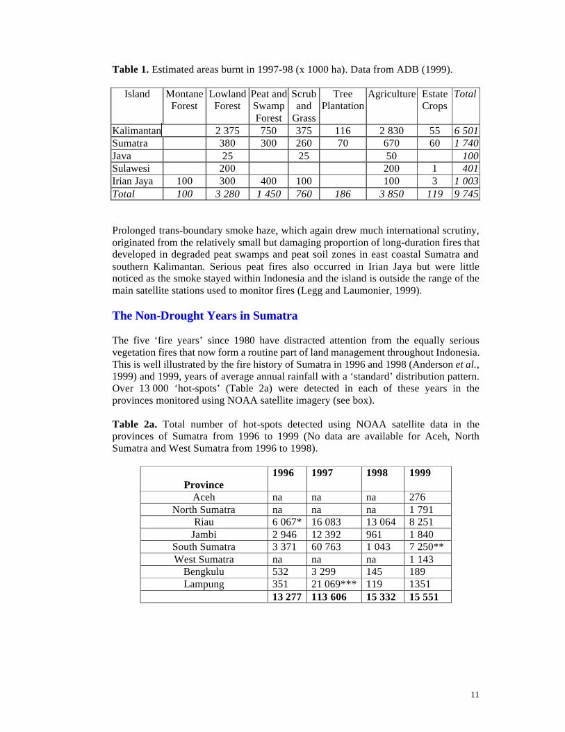
11
Table 1. Estimated areas burnt in 1997-98 (x 1000 ha). Data from ADB (1999).
Island Montane Forest
Lowland Forest
Peat and Swamp Forest
Scrub and
Grass
Tree Plantation
Agriculture Estate Crops
Total
Kalimantan 2 375 750 375 116 2 830 55 6 501 Sumatra 380 300 260 70 670 60 1 740 Java 25 25 50 100 Sulawesi 200 200 1 401 Irian Jaya 100 300 400 100 100 3 1 003 Total 100 3 280 1 450 760 186 3 850 119 9 745
Prolonged trans-boundary smoke haze, which again drew much international scrutiny, originated from the relatively small but damaging proportion of long-duration fires that developed in degraded peat swamps and peat soil zones in east coastal Sumatra and southern Kalimantan. Serious peat fires also occurred in Irian Jaya but were little noticed as the smoke stayed within Indonesia and the island is outside the range of the main satellite stations used to monitor fires (Legg and Laumonier, 1999). The Non-Drought Years in Sumatra The five ‘fire years’ since 1980 have distracted attention from the equally serious vegetation fires that now form a routine part of land management throughout Indonesia. This is well illustrated by the fire history of Sumatra in 1996 and 1998 (Anderson et al., 1999) and 1999, years of average annual rainfall with a ‘standard’ distribution pattern. Over 13 000 ‘hot-spots’ (Table 2a) were detected in each of these years in the provinces monitored using NOAA satellite imagery (see box). Table 2a. Total number of hot-spots detected using NOAA satellite data in the provinces of Sumatra from 1996 to 1999 (No data are available for Aceh, North Sumatra and West Sumatra from 1996 to 1998).
Province
1996 1997 1998 1999
Aceh na na na 276 North Sumatra na na na 1 791
Riau 6 067* 16 083 13 064 8 251 Jambi 2 946 12 392 961 1 840
South Sumatra 3 371 60 763 1 043 7 250** West Sumatra na na na 1 143
Bengkulu 532 3 299 145 189 Lampung 351 21 069*** 119 1351
13 277 113 606 15 332 15 551
12
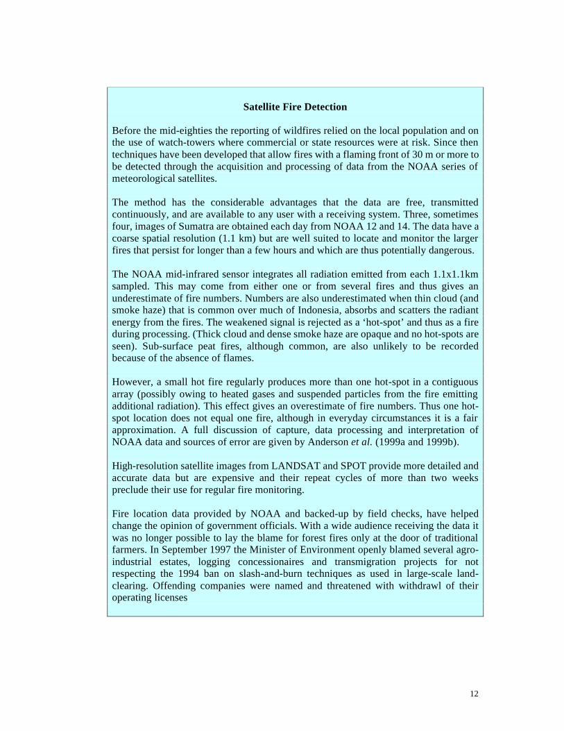
Satellite Fire Detection
Before the mid-eighties the reporting of wildfires relied on the local population and on the use of watch-towers where commercial or state resources were at risk. Since then techniques have been developed that allow fires with a flaming front of 30 m or more to be detected through the acquisition and processing of data from the NOAA series of meteorological satellites. The method has the considerable advantages that the data are free, transmitted continuously, and are available to any user with a receiving system. Three, sometimes four, images of Sumatra are obtained each day from NOAA 12 and 14. The data have a coarse spatial resolution (1.1 km) but are well suited to locate and monitor the larger fires that persist for longer than a few hours and which are thus potentially dangerous. The NOAA mid-infrared sensor integrates all radiation emitted from each 1.1x1.1km
sampled. This may come from either one or from several fires and thus gives an underestimate of fire numbers. Numbers are also underestimated when thin cloud (and smoke haze) that is common over much of Indonesia, absorbs and scatters the radiant energy from the fires. The weakened signal is rejected as a ‘hot-spot’ and thus as a fire during processing. (Thick cloud and dense smoke haze are opaque and no hot-spots are seen). Sub-surface peat fires, although common, are also unlikely to be recorded because of the absence of flames. However, a small hot fire regularly produces more than one hot-spot in a contiguous array (possibly owing to heated gases and suspended particles from the fire emitting additional radiation). This effect gives an overestimate of fire numbers. Thus one hot-spot location does not equal one fire, although in everyday circumstances it is a fair approximation. A full discussion of capture, data processing and interpretation of NOAA data and sources of error are given by Anderson et al. (1999a and 1999b). High-resolution satellite images from LANDSAT and SPOT provide more detailed and accurate data but are expensive and their repeat cycles of more than two weeks preclude their use for regular fire monitoring. Fire location data provided by NOAA and backed-up by field checks, have helped change the opinion of government officials. With a wide audience receiving the data it was no longer possible to lay the blame for forest fires only at the door of traditional farmers. In September 1997 the Minister of Environment openly blamed several agro-industrial estates, logging concessionaires and transmigration projects for not respecting the 1994 ban on slash-and-burn techniques as used in large-scale land-clearing. Offending companies were named and threatened with withdrawl of their operating licenses
13
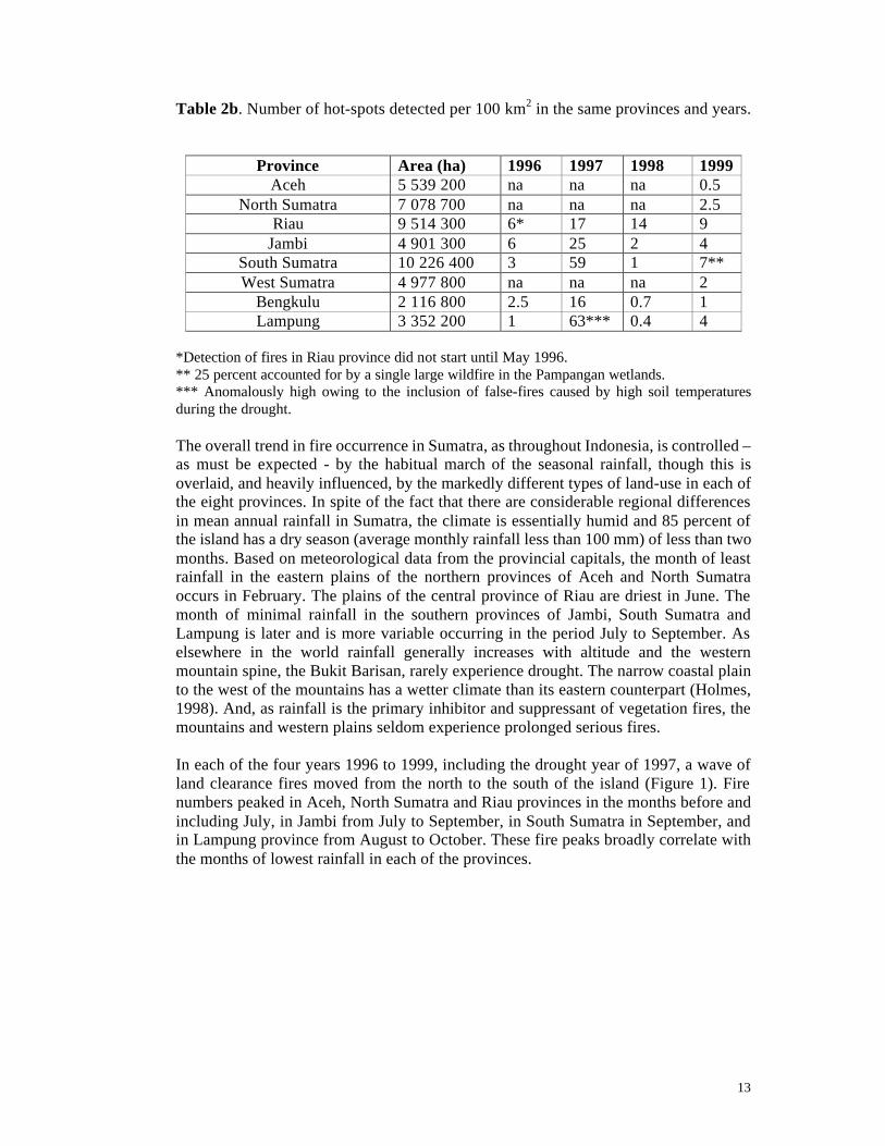
Table 2b. Number of hot-spots detected per 100 km2 in the same provinces and years.
Province Area (ha) 1996 1997 1998 1999
Aceh 5 539 200 na na na 0.5 North Sumatra 7 078 700 na na na 2.5
Riau 9 514 300 6* 17 14 9 Jambi 4 901 300 6 25 2 4
South Sumatra 10 226 400 3 59 1 7** West Sumatra 4 977 800 na na na 2
Bengkulu 2 116 800 2.5 16 0.7 1 Lampung 3 352 200 1 63*** 0.4 4
*Detection of fires in Riau province did not start until May 1996. ** 25 percent accounted for by a single large wildfire in the Pampangan wetlands. *** Anomalously high owing to the inclusion of false-fires caused by high soil temperatures during the drought. The overall trend in fire occurrence in Sumatra, as throughout Indonesia, is controlled – as must be expected - by the habitual march of the seasonal rainfall, though this is overlaid, and heavily influenced, by the markedly different types of land-use in each of the eight provinces. In spite of the fact that there are considerable regional differences in mean annual rainfall in Sumatra, the climate is essentially humid and 85 percent of the island has a dry season (average monthly rainfall less than 100 mm) of less than two months. Based on meteorological data from the provincial capitals, the month of least rainfall in the eastern plains of the northern provinces of Aceh and North Sumatra occurs in February. The plains of the central province of Riau are driest in June. The month of minimal rainfall in the southern provinces of Jambi, South Sumatra and Lampung is later and is more variable occurring in the period July to September. As elsewhere in the world rainfall generally increases with altitude and the western mountain spine, the Bukit Barisan, rarely experience drought. The narrow coastal plain to the west of the mountains has a wetter climate than its eastern counterpart (Holmes, 1998). And, as rainfall is the primary inhibitor and suppressant of vegetation fires, the mountains and western plains seldom experience prolonged serious fires. In each of the four years 1996 to 1999, including the drought year of 1997, a wave of land clearance fires moved from the north to the south of the island (Figure 1). Fire numbers peaked in Aceh, North Sumatra and Riau provinces in the months before and including July, in Jambi from July to September, in South Sumatra in September, and in Lampung province from August to October. These fire peaks broadly correlate with the months of lowest rainfall in each of the provinces.
14
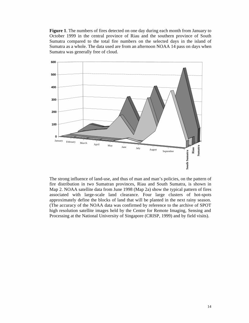
Figure 1. The numbers of fires detected on one day during each month from January to October 1999 in the central province of Riau and the southern province of South Sumatra compared to the total fire numbers on the selected days in the island of Sumatra as a whole. The data used are from an afternoon NOAA 14 pass on days when Sumatra was generally free of cloud.
The strong influence of land-use, and thus of man and man’s policies, on the pattern of fire distribution in two Sumatran provinces, Riau and South Sumatra, is shown in Map 2. NOAA satellite data from June 1998 (Map 2a) show the typical pattern of fires associated with large-scale land clearance. Four large clusters of hot-spots approximately define the blocks of land that will be planted in the next rainy season. (The accuracy of the NOAA data was confirmed by reference to the archive of SPOT high resolution satellite images held by the Centre for Remote Imaging, Sensing and Processing at the National University of Singapore (CRISP, 1999) and by field visits).
January February March April MayJune July August
September
Sout
h Su
mat
ra Ria
u
Sum
atra
0
100
200
300
400
500
600
15
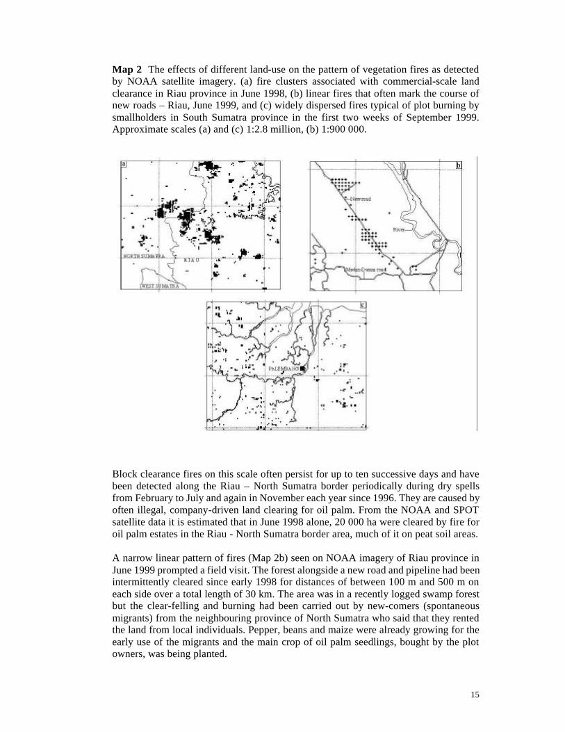
Map 2 The effects of different land-use on the pattern of vegetation fires as detected by NOAA satellite imagery. (a) fire clusters associated with commercial-scale land clearance in Riau province in June 1998, (b) linear fires that often mark the course of new roads – Riau, June 1999, and (c) widely dispersed fires typical of plot burning by smallholders in South Sumatra province in the first two weeks of September 1999. Approximate scales (a) and (c) 1:2.8 million, (b) 1:900 000.
Block clearance fires on this scale often persist for up to ten successive days and have been detected along the Riau – North Sumatra border periodically during dry spells from February to July and again in November each year since 1996. They are caused by often illegal, company-driven land clearing for oil palm. From the NOAA and SPOT satellite data it is estimated that in June 1998 alone, 20 000 ha were cleared by fire for oil palm estates in the Riau - North Sumatra border area, much of it on peat soil areas. A narrow linear pattern of fires (Map 2b) seen on NOAA imagery of Riau province in June 1999 prompted a field visit. The forest alongside a new road and pipeline had been intermittently cleared since early 1998 for distances of between 100 m and 500 m on each side over a total length of 30 km. The area was in a recently logged swamp forest but the clear-felling and burning had been carried out by new-comers (spontaneous migrants) from the neighbouring province of North Sumatra who said that they rented the land from local individuals. Pepper, beans and maize were already growing for the early use of the migrants and the main crop of oil palm seedlings, bought by the plot owners, was being planted.

16
In contrast to the large blocks of fire seen in Riau, the typical pattern of fires detected in the southern provinces of South Sumatra and Lampung (Map 2c), is random and ephemeral. The fires are lit mainly by smallholders clearing their farm plots in anticipation of the start of the rains. Fire numbers peak in August or September but field observations show that they are carefully controlled within their intended limit that seldom exceeds two hectares at any one time. Burning usually starts in the early afternoon and the fires last until dusk: satellite data show that the same fire is not often detected on two consecutive images captured two to three hours apart. This is by far the most frequent type of fire throughout Sumatra, and accounts for some 90 percent of all fires detected in a year of average rainfall. The pattern of fires now seen in Jambi with fairly frequent block fires combined with numerous transient small fires, reflects the transitional status of the province situated between the more or less settled agricultural economy in the south, with few large fires, and the rapid exploitation of large tracts of forest in Riau. It is interesting that far fewer large-scale fires connected with commercial land clearing, were detected in 1998 and 1999 than in 1996. This suggests that conversion of Jambi’s forests into estate crops is now largely complete.

17
THE ECONOMIC IMPLICATIONS There have been a number of studies on the direct and indirect costs of the 1997-98 fires. Some, such as Dieterle and Heil (1998) and Levine (1998), assessed the impact of the trans-boundary smoke haze pollution on the health of the region. Others attempted a much wider cost evaluation and to put figures on damage to agriculture and forestry and to assign monetary values to the loss of biodiversity, erosion and siltation, firefighting, etc., as well as on health. Of the latter studies, ADB (1999) placed a total value of $9.3 billion on the cost to Indonesia of the 1997-98 fires, while EEPSEA (1998) gives a figure of $4 billion for the 1997 fires alone. As the continuation of the fires into 1998 was severe in Kalimantan, these figures may not be so far apart as they first appear. Direct comparison between the two studies is difficult as they use different cost headings. There are however, some notable variations. For example the EEPSEA study that covers the shorter period, puts health damage at $924 million while the ADB figure, which may be expected to be higher, places loss of health at ‘only’ $145 million. Conversely losses to agriculture are estimated by ADB to be six-times higher than those by EEPSEA. Such comparisons, while they point out the difficulties of costing fires, should not be used to down-play their damaging effects. There appear to be no comparable studies for ‘routine’ fire years such as 1996 and 1998.
18
LAND MANAGEMENT INSTITUTIONS AND LAWS We have so far looked at the history and pattern of vegetation fires in Indonesia in general and Sumatra in particular and have attempted to identify the major sources of fires, their direct causes and their relative importance within the overall picture. It is, however, the national and provincial land-management policies and laws, and the way that these are implemented at field level, that shape the attitudes and the behaviour of individuals, communities, companies and government agencies in how they regard, and hence manage, their national resources. And it is these policies that have done much to indirectly encourage the use of fire as a tool in the management of land throughout the country, while the decrees and regulations that exist to control the use of fire have been ignored with impunity.
The Institutions Three institutions play a major part in national land management. Their overlapping functions, together with the diffusion of responsibility, contribute greatly to the fire problem. Over the last thirty years planning in all sectors has been strongly ‘Jakarta centred’ and directly and tightly controlled by the President. Despite much discussion since the movement for reformasi (comprehensive change) began in 1998, it remains to be seen if greater powers will be given in fact, not simply in theory, to the provinces. The Ministry of State for National Development Planning is responsible to the president, and formulates policy and coordinates the planning activities of all government institutions, in particular through the National Development Planning Agency (BAPPENAS) and its regional wing, BAPPEDA. Apart from the State Forest Land, land throughout the archipelago is by the National Land Agency (BPN) which is in a charge of land registration, land measurement, land-mapping, land certification and the granting of land: a powerful remit. The Ministry of Forestry and Estate Crops (MoFEC), controls the great majority of the country’s land and thus has considerable potential to influence the use of fire. The Ministry has two distinct roles in managing its huge territory. As the Forest Authority it is responsible for licensing forest exploitation and for policing the activities of the licencees. In this MoFEC has to enforce the Forestry Law (see below) and be relatively inflexible, operating straightforward procedures and enforcing regulations without favour or discrimination. But as the overseer of State-Owned Forest Enterprises (such as Inhutani I-VI), MoFEC finds itself responsible for commercial companies that carry out logging, reforestation, agroforestry and work with transmigrants. All these duties require flexible, efficient and accountable management. The two roles are in many ways incompatible as MoFEC is called upon to control and police itself. That it has not always done so, has had a strong negative impact in the quality of land management in Indonesia. Rumours suggest that MoFEC may see its powers sharply curtailed under the newly formed government with a separation of functions and greater autonomy given to the provinces. In theory, at least, this is a particularly positive move.

19
The Legal Framework Indonesian laws are based on the 1945 Constitution that specifies that all branches of production which are important to the state and which affect the lives of the majority are controlled by the state. Accordingly, the Basic Forestry Law of 1967 stipulated that, “The government determines the use of forests according to the interest and benefit of the state and population, the government determines the legal relationship between people and legal entities with forests”. However all the procedures specified under the law were ‘Jakarta centred’. And the administrative approach allowed little involvement of the local people and communities in whose, “interest and benefit” the forest was exploited. The people’s disinterest in fire prevention and suppression that followed is unsurprising. The lack of local involvement in forest management was partially recognised when drafting the New Basic Forest Law passed in September 1999, although the statute that enforces total state control over Forest Land is unmodified and the condescending paradigm towards local communities is maintained. For example, “Forestry extension shall be intended to increase the knowledge and skill and to change the mental attitude of the communities so they shall be capable to support the forestry development and be aware of the importance of forest resources to human life.” The new law does, however, allow that State Forest can be in the form of traditional (adat) forest, that long-standing community rights will prevail, and that management plans shall take into account the aspirations of the local communities. Nevertheless opportunities for genuine local management are restricted and likely to be tightly controlled by the government administration. In South Sumatra province, nineteen presidential, ministerial and gubernatorial decrees that deal directly with fire on forest land supplement the Basic Law. Most were passed during, or in the wake of, the 1994 and 1997-98 fires and many lay down strict regulations requiring forest logging and forest plantation concession-holders to set-up fire prevention and control teams. Others deal with the establishment of Local Fire Control Centres and Land and Forest Fire Control Task Force teams to be housed in provincial and district forestry offices. A number of forest plantation companies in Sumatra and Kalimantan have taken their responsibilities seriously and are well equipped to protect against fires and to control those which do occur. Many others, and most estate crop companies, are not so well prepared to protect their investments. Few of the official government local fire control centres exist in anything but name, and those that do are generally ill-funded, ill-equipped and ill-trained. It is ironic that so much effort has gone into laying down control mechanisms for the relatively few wildfires while, as a matter of policy, the routine use of fire to clear millions of hectares of land proceeds unchecked with almost no enforcement of burning permit requirements and even less enthusiasm to investigate, let alone prosecute, companies suspected of breaking fire regulations.
20
AND THE FUTURE? Shortcomings and outright failures in land resource policies over the last twenty years have contributed to the number and severity of the vegetation fires throughout Indonesia. If there is to be any improvement, then there must first be a genuine will to reform, followed by rapid and decisive action to integrate fire prevention and fire protection in to all land management decisions and activities (Bompard and Guizol, 1999). Cooperation between the various ministries and government agencies to find a joint approach to reduce the number of vegetation fires, and to suppress those that do occur, is at best weak and is often non-existent. The lack of clear responsibilities is well illustrated by the ‘conference round’: from mid-1998 to September 1999, fifteen national and international seminars, workshops and conferences took place in Indonesia and several more in Singapore, Malaysia and Brunei Darussalam, all aimed at solving Indonesia’s (and thus its ASEAN neighbours’) fire and smoke haze problems. Some twenty donor organisations were involved, with support being offered in fairly equal measure through MoFEC, BAPPENAS and BAPEDAL but also through the Ministry of Transmigration, through the State Ministry of Human Settlement and through the government Agency for the Assessment and Application of Technology. Clarification and rationalisation of responsibilities is clearly needed. Support must be given to the provincial, district and sub-district offices that are most closely involved in land management, rather than to the central, Jakarta-based institution. There is a need to strengthen local capacity to plan wisely and to foresee the likely effects of decisions both on the direct use of fire and on how these decisions may also increase or decrease the indirect fire-risks. BAPPEDA, working with BPN and MoFEC, need to upgrade staff skills within the provinces and districts. There is also a need to establish integrated land-management data-centres, as suggested by Scott and Lusli (1998), that should make particular efforts to identify and map areas known to be at high risk of fires (for example, peat-swamps) and thus to require careful and specific management. In Sumatra, priority must clearly be given to fire prevention – through appropriate land-use planning and strictly enforced regulations - in wetlands. At particular risk are those that lie along the east-coast but the inland peats and the wetlands along the west-coast are also under pressure. The very few areas that remain relatively undisturbed are in imminent danger of suffering irreversible damage: logging and conversion to estate crops should cease, not only to preserve these ecologically valuable areas but also to reduce the noxious smoke haze pollution that results when peat burns. Mature and open cooperation between village communities and government agencies, private companies and parastatal enterprises is essential if fire numbers and severity are to be reduced. Village communities must be fully recognised as the dominant partner when land management decisions are made. This is the only level at which there can be workable control and accountability for the use of natural resources. And sub-district and district are the only levels where fire prevention can be effective and fire suppression is physically possible.
21
The rash of land disputes between government and companies on the one side, and communities on the other, lead to the use of fire as a weapon. Mediation mechanisms need to be developed to help prevent new, and solve existing, conflicts. Only land in which local people have a close political and a financial interest will be protected from fire. As suggested by, amongst others, Potter and Lee (1998) and Gouyon (1999), NGOs may be best placed to act as intermediaries between the warring parties. Co-management of land by communities with companies and government would be a major step forward, although it will entail a detailed, village by village revision of the boundaries of state forest land, and consensus boundary setting with MoFEC and BAPPEDA. The mechanical clearance of land is widely promoted by many who see it as a preferable alternative to clearance by fire. Such a course is not without its own risks as contractors are paid by the hectare and pay scant heed to preserving topsoil, avoiding soil compaction and to not filling gullies with debris. And, whatever proponents of mechanical clearance would like to suggest, direct costs are far higher. Only if a subsidy, perhaps in the form of direct cash inputs from the reforestation fund or as tax incentive schemes, is put in place ‘to repay’ the indirect environmental costs of fire, will commercial companies cease to burn: and only then if stiff fire penalties are enforced. To expect smallholders not to use fire is both impracticable and unnecessary: they have neither the financial resources nor the manpower available to clean their plots by hand and their fires are usually well controlled and relatively non-polluting. The solution to Indonesia’s fire problem lies largely in much improved local level land-use planning and strengthened local management that together fosters local initiative and allow local autonomy. National control from the centre must, concomitantly, become weaker. Any continuation of a top-down, bureaucratic approach to fire management that focuses on fire suppression will fail in the field during the next el nino drought as it did in 1997. As things stand now, fire-prone areas continue to expand and the costs of fire damage and fire management will continue to increase over the years.
22
REFERENCES ADB (1999). Planning for fire prevention and drought management project. Report. Asian Development Bank, Manila, The Philippines. Unpublished. Anderson, I.P., Bowen, M.R., Imanda, I.D. and Muhnandar (1999). Vegetation fires in Indonesia: the fire history of the Sumatra provinces 1996 – 1998 as a predictor of future areas at risk. EU-Forest Fire Prevention and Control Project with Kanwil Kehutanan dan Perkebunan Palembang. European Union and Ministry of Forestry and Estate Crops, Jakarta. 22 pp plus 16 maps and tables. Anderson, I.P., Imanda, I.D. and Muhnandar (1999a). Vegetation fires in Indonesia the interpretation of NOAA derived hot spot data. EU-Forest Fire Prevention and Control Project with Kanwil Kehutanan dan Perkebunan Palembang. European Union and Ministry of Forestry and Estate Crops, Jakarta. 19 pp plus 3 maps. Anderson, I.P., Imanda I.D. and Muhnandar (1999b). Vegetation fires in Sumatra, Indonesia: the presentation and distribution of NOAA-derived data. EU-Forest Fire Prevention and Control Project with Kanwil Kehutanan dan Perkebunan Palembang. European Union and Ministry of Forestry and Estate Crops, Jakarta. 8 pp plus 6 maps. Bertault, J.G. (1991). Quand la forêt tropicale s’enflamme. Bois et Forêts des Tropiques, 230, 5-14 (English summary). Bompard, J.M. and Guizol, P. (1999). Land management in South Sumatra Province, Indonesia. Fanning the flames: the institutional cause of vegetation fires. EU-Forest Fire Prevention and Control Project with Kanwil Kehutanan dan Perkebunan Palembang. European Union and Ministry of Forestry and Estate Crops, Jakarta. 40 pp plus annexes. Brinn, P.J. (1992). Recommended Development Area 99, South Sumatra. Rapid appraisal report. Regional Physical Planning, Map Improvement and Training Project. Land Resource Planning Component. Ministry of Transmigration, P.T. Nasuma Putra Consulting Engineers and Natural Resources Institute, UK. 43 pp. Byron, N. and Shepherd, G. (1998). Indonesia and the 1997-98 El Nino: fire problems and long-term solutions. Natural Resources Perspectives Number 28, Overseas Development Institute, London. 1-4. Chandrasekharan, C. (1998). The mission on forest fire prevention and management to Indonesia and Malaysia (Sarawak). Paper, ‘International Cross Sectoral Forum on Forest Fire Management in South East Asia’. Indonesian National Planning Agency, Japan International Cooperation Agency and International Tropical Timber Organization. 7-8 December 1998. Jakarta, Indonesia. CRISP (1999). Centre for Remote Imaging, Sensing and Processing, National University of Singapore. http://www.crisp.nus.edu.sg/crisp.html Danielsen, F. and Verheugt, W.J.M. (1990). Integrating conservation and land-use planning in the coastal region of South Sumatra, Indonesia. The Directorate General of

23
Forest Protection and Nature Conservation, Ministry of Forestry and Estate Crops and Asian Wetland Bureau. Jakarta, Indonesia. Dennis, R. (1998). A review of fire projects in Indonesia. Prepared for International Center for Forestry Research, International Centre for Research in Agroforestry, UNESCO and EU. Bogor/Jakarta. (Unpublished) Dick, J. (1991). Forest land use, forest use zonation, and deforestation in Indonesia: a summary and interpretation of existing information. Background paper to United Nations Conference on Environment and Development for the Indonesian State Ministry for Population and Environment and the Environmental Impact Management Agency. (Unpublished). Dieterle, G. and Heil, A. (1998). Impacts of large scale forest and land fires in Indonesia in 1997 on regional air pollution. Paper, ‘International Cross Sectoral Forum on Forest Fire Management in South East Asia’. Indonesian National Planning Agency, Japan International Cooperation Agency and International Tropical Timber Organization. 7-8 December 1998. Jakarta, Indonesia. Dis, van M.M.U. (1986). The art of lowland development. Theme 1. Land and water management. In: ‘Symposium On Lowland Development in Indonesia’. Jakarta, Indonesia, 24-31 July 1986. International Institute for Land Reclamation and Improvement, Wageningen, The Netherlands. 34-53. ECE/FAO (1997). Forest fire statistics 1994-1996. Timber Bulletin Number 4. ECE/TIM/BULL/50/4. United Nations, New York, Geneva. 19 pp. EEPSEA (1998). The Indonesian fires and haze of 1997: the economic toll. Economy and Environment Programme for South East Asia and World Wide Fund for Nature. http://www.wwf.or.id/EEPSEARE.html 6pp. EUFREG (1998). Assessment of the 1997 fires in Indonesia. European Union Fire Response Group with the Ministry of Forestry and Estate Crops, Jakarta, Indonesia. 33 pp. Fraser, A.I. (1999). Skenario-skenario untuk masa depan sektor kehutanan dan kebun di Indonesia. [Possible scenarios for the future of forestry and estates in Indonesia.]. Seminar, ‘Sustainable Forest and Estate Crops Management for the Maximum Prosperity of People.’ Ministry of Forestry and Estate Crops, Department for International Development (UK) and Consultative Group for Indonesia Forestry. 8 September 1999, Jakarta, Indonesia. 6 pp. GoI (1999). National population program profile. Badan Koordinasi Keluarga Berencana Nasional. 17 pp. http://www.bkkn.go.id/english/b43.htm Goldammer, J.G. (1993). Historical biogeography of fire: tropical and subtropical. In, ‘Fire in the environment: the ecological, atmospheric, and climatical importance of vegetation fires’. Editors, P.J. Crutzen and J.G. Goldammer. John Wiley and Sons, Chichester, UK. 297-314. Gouyon, A. (1999). The sustainable development of tree crops and the prevention of vegetation fires in South Sumatra, Indonesia: jungle rubber. EU-Forest Fire Prevention

24
and Control Project with Kanwil Kehutanan dan Perkebunan Palembang. European Union and Ministry of Forestry and Estate Crops, Jakarta. 55 pp. plus annexes. Hoffmann, A.A., Siegert, F. and Hinrichs, A. (1999). Fire damage in East Kalimantan in 1997/98 related to land use and vegetation classes based on satellite analysis with ERS SAR-2 and NOAA-AVHRR.. GTZ Integrated Forest Fire Management Project, Samarinda, East Kalimantan. (In preparation). Holmes, D.A. (1998). Rainfall and droughts in Indonesia. A study for the World Bank. Volume 3A: Sumatra. World Bank, Jakarta, Indonesia. 77 pp. Hoshour, C. (1995). Resettlement and politicization of ethnicity in Indonesia. Conference; ‘Riau in Transition’. International Institute for Asian Studies, 4-6 October 1995, Leiden, The Netherlands. Khoo, L.L. (pers. com.). Oil palm plantations consultant. Legg, C. and Laumonier, Y. (1999). 1997 fires in Indonesia: a remote sensing perspective. Ambio, 28, 479-485. Levine, J. (1998). Gaseous and particulate emissions released to the atmosphere during forest fires: a case study of Kalimantan and Sumatra, Indonesia in 1997. Conference; ‘Health guidelines for forest fire episodic events’. World Health Organization, 6-9 October 1998, Lima, Peru. (Unpublished). Makarim, N., Arba’I, Y.A., Deddy, A. and Brady, M. (1998). Assessment of 1997 land and forest fires in Indonesia: national coordination. Environmental Impact Management Agency, Jakarta. 7 pp. Meijaard, E. and Dennis, R. (1997). Forest fires in Indonesia: bibliography and background information. World Wide Fund for Nature, Amsterdam, The Netherlands. Nicolas, M.V.J. (1998). Fighting the forest fires: the South Sumatra experience. EU-Forest Fire Prevention and Control Project, Palembang, Indonesia. Internal report. 22 pp. Nicolas, M.V.J. (pers. com.). Forest Fire Management Expert. GTZ Integrated Forest Fire Management Project, Samarinda, East Kalimantan, Indonesia. Nicolas, M.V.J. and Beebe, G.S. (1999). Fire management in the logging concessions and plantation forests of Indonesia. Forest Fire Prevention and Control Project (South Sumatra) and Integrated Forest Fire Management Project (East Kalimantan). European Union and GTZ with Kanwil Departemen Kehutanan dan Perkebunan, Propinsi Sumatera Selatan and Propinsi Kalimantan Timur. European Union, GTZ and Ministry of Forestry and Estate Crops, Jakarta, Indonesia. 38 pp. Nicolas, M.V.J. and Bowen, M.R. (1999). A field level approach to coastal peat and coal-seam fires in South Sumatra, Indonesia. Forest Fire Prevention and Control Project (South Sumatra). European Union with Kanwil Departemen Kehutanan dan Perkebunan, Propinsi Sumatera Selatan. European Union and Ministry of Forestry and Estate Crops, Jakarta, Indonesia. 39 pp.

25
PEMDA (1999). Pemerintah Daerah Riau. [The provincial government of Riau]. http://www.riau.go.id/pemda/index2.html Potter, L. and Lee, J. (1998). Oil palm in Indonesia: its role in forest conversion and the fires of 1997/98. Report for World Wide Fund for Nature-Indonesia programme. University of Adelaide, Adelaide, Australia. Ramon, J. (pers. com.). Social Forestry Expert, EU-Forest Fire Prevention and Control Project, Palembang, 1995 – 1998. RePPProt (1990). A national overview from the regional Physical Planning Programme for Transmigration. UK Overseas Development Administration and Directorate BINA Programme, Ministry of Transmigration and Forest Squatters Resettlement, Jakarta, Indonesia. 32 pp. Rieley, J.O. and Page, S.E. (editors) (1997). Biodiversity and sustainability of tropical peatlands. Proceedings, ‘International Symposium on Biodiversity, Environmental Importance and Sustainability of Tropical Peatlands’, Palangkaraya, Central Kalimantan, 4-8 September 1995. Samara Publishing Limited, Tresaith, Cardigan, UK. 369 pp. Rieley, J.O., Page, S.E., Limm, S.H. and Winarti, S. (1997). The peatland resources of Indonesia and the Kalimantan Peat Swamp Forest Research Project. In, Rieley, J.O. and Page, S.E. (editors). Biodiversity and sustainability of tropical peatlands. Samara Publishing Limited, Tresaith, Cardigan, UK. 37-45. Schindler, L. (1998). Fire management in Indonesia – quo vadis? Paper, ‘International Cross Sectoral Forum on Forest Fire Management in South East Asia’. Indonesian National Planning Agency, Japan International Cooperation Agency and International Tropical Timber Organization. 7-8 December 1998. Jakarta, Indonesia. Schindler, L. (1998a). The Indonesian fires and SE Asian haze 1997/98: review, damages, causes and necessary steps. Paper presented at the, Asia-Pacific Regional Workshop on Transboundary Atmospheric Pollution, 27-28 May 1998, Singapore. Schweithelm, J. (1999). The fire this time: an overview of Indonesia’s forest fires in 1997/1998. http://www.wwf.or.id 44pp. Scott, I. and Lusli, S. (1998). Land use planning and the IFRIS database. Forest Inventory and Monitoring Project, European Union and Ministry of Forestry and Estate Crops, Jakarta, Indonesia. (Draft, December 1998). 42 pp plus annex. Steenis, van C.G.G.J. and Schippers-Lammertse, A.F. (1965). Concise plant geography of Java. In, Flora of Java. (editors C.A. Backer and R.V. van der Brink Bakhuizen), Volume 2. Leiden. Stolle, F. (1998). The 1997 Sumatra fires. Paper presented at the, Workshop on Fire Hazards, Transboundary Haze and Sustainable Forestry in East Asia and the Pacific. Environment and Natural Resources Division-World Bank, Surabaya, Indonesia. 9-12 December 1998.
26
Suwandi, A. (pers. com). Head of Natural Resources Conservation, Provincial Forestry and Estate Crops Office, Pekanbaru, Riau province. Szekely, L. (1936). Tropic fever: the adventures of a planter in Sumatra. Hamish Hamilton, London. 352 pp. Vayda, A.P. (1999). Finding causes of the 1997-98 Indonesian forest fires: problems and possibilities. WWF Indonesia. http://www.wwf.or.id 51 pp. Vincent, A. (pers. com.). Oil palm plantations manager. Wakker, E. (1999). Forest fires and the expansion of Indonesia’s oil-palm industry. WWF Indonesia Forest Fire Project. World Wide Fund for Nature Indonesia. Jakarta, Indonesia. 19 pp. Whitmore, T.C. (1975). Tropical rain forests of the far east. Clarendon Press, Oxford. 282 pp. Whitmore, T.C. (1990). An introduction to tropical rain forests. ELBS with Oxford University Press. 226 pp. World Bank (1994). Transmigration in Indonesia. OED Precis Number 72, September 1994. 8 pp. http://www.worldbank.org/html/oed/pr0/2.htm World Bank (1999). Global commodity markets. World Bank Commodities Team, March 1999. 32 pp.