appendix 12.1 flood risk assessment and drainage strategy
TRANSCRIPT

Appendix 12.1
Flood Risk Assessment and Drainage Strategy,
February 2015 (ICIS Design Limited)


icis design limited ref. 10007.gc
SPEN HILL DEVELOPMENTS LIMITED
FORMER SHREDDED WHEAT FACTORY WELWYN GARDEN CITY
Flood Risk Assessment & Drainage Strategy
Feb 2015
Rev D

Former Shredded Wheat Factory, Welwyn Garden City
10007 – FRA
icis design limited 1
Contents
Summary ............................................................................................................................................... 2
1.0 Introduction .................................................................................................................................... 4
2.0 Flood Risk Assessment .................................................................................................................... 6
3.0 Drainage Strategy ......................................................................................................................... 13
4.0 Summary Conclusions and Recommendations ............................................................................. 19
5.0 Appendix A – Phase 1 Drainage Layout
6.0 Appendix B – Consultation Responses
7.0 Appendix C – MK Surveys
8.0 Appendix D – SFRA App 14
9.0 Appendix E – Extract from Arups Drainage Appraisal Report
10.0 Appendix F – WINDES Calculations
This report has been prepared for the private and confidential use of Spen Hill Developments Limited
and cannot be reproduced in whole or in part or relied upon by any third party for any use whatsoever
without the express written authorisation of Icis Design Limited. If any third party whatsoever comes
into possession of this report, they rely on it at their own risk and Icis Design Limited accepts no duty
or responsibility (including in negligence) to any such third party.
Authors: Gavin Clifford BEng CEng FICE [email protected]
Craig Taylor MSoPHE [email protected]
icis design limited Registered in England & Wales No. 8637234.
Barrington House, Heyes Lane, Alderley Edge, Cheshire SK9 7LA. tel 0161 883 1401

Former Shredded Wheat Factory, Welwyn Garden City
10007 – FRA
icis design limited 2
Summary
This Flood Risk Assessment (FRA) and Drainage Strategy report is supplementary information to an
Outline Planning Application for a proposed mixed use development located between the A1000
Broadwater Road and the East Coast Main Line railway in Welwyn Garden City, Hertfordshire.
DESCRIPTION OF DEVELOPMENT
O/L Application
Erection of up to 850 Class C3 dwellings to potentially include up to 80 Class C2 care dwellings,
Class A1 retail, Class A3/A4 restaurants/cafés/bars/pubs, Class D1 community use and healthcare
and Class D2 gym/dance/exercise studio floorspace. Demolition of all buildings and structures
except the original 1920's silos, production hall, grain store and boiler house. Refurbishment and
change of use of the retained listed buildings to provide 2 Class C3 residential units, a Class C1
boutique/budget hotel, Class B1(a) offices, a Class A4 pub/bar, a Class D1 crèche and a Class D2
gym/dance/exercise studio. Provision of external space for leisure and recreation to include a linear
park, external games/play area, allotments and a skate park. Creation of internal estate roads,
paths, vehicle and cycle parking. Highway works comprising the widening of footways and the
provision of cycle ways to Broadwater Road and Bridge Road, works to Hyde Way, works to nearby
junctions and the erection of a new footbridge from Bridge Road leading into the scheme. Phase 1
to include the highway works - no matters are reserved. Phase 2 - layout, scale and means of access
are submitted for consideration.
LB Application
Demolition of all buildings and structures except the original 1920's silos, production hall, grain store
and boiler house. Refurbishment and change of use of the retained listed buildings to provide 2
Class C3 residential units, a Class C1 boutique/budget hotel, Class B1(a) offices, a Class A4 pub/bar,
a Class D1 crèche and a Class D2 gym/dance/exercise studio.
The total site area is approximately 8.7 hectares. Phase 1 of the development forms the northern
part and is approximately 5 hectares of the total.
The FRA considers the impact of fluvial, pluvial, infrastructure and groundwater derived flooding of
the subject site, and the effects of the proposed development on the local neighbourhood. A
drainage strategy has been developed to accommodate the design parameters derived from the
FRA.
The residual flood risk resulting from the proposed development of the site is considered to be LOW.
The findings of the flood risk assessment are summarised below:

Former Shredded Wheat Factory, Welwyn Garden City
10007 – FRA
icis design limited 3
- The site lies within an area defined by the Environment Agency as Flood Zone 1 (<0.1% risk of
flooding in any one year). Although the site is in a Low Risk area, the size of the site at 8.7
hectares, triggers the requirement for a flood risk assessment in accordance with the National
Planning Policy Framework (NPPF).
- The site lies within the study area of the ‘Welwyn Hatfield Borough Council Strategic Flood
Risk Assessment’ (May 2009) undertaken by Scott Wilson Ltd for Welwyn Hatfield Borough
Council.
- The residual flood risks to the development site and the surrounding area as a result of the
proposed development are:
Fluvial Flooding from the River Mimram and River Lea - Low Risk
Pluvial Flooding – Low Risk on site. Improved off site.
From Sewers – Low Risk, although the impact of development on the sewer network
requires mitigation.
From Reservoirs, Canals and other artificial sources – Low Risk
Groundwater Flooding – Low Risk
Safe dry access and egress from the proposed development site to the public highway can
be achieved for a 1% (100 year) + Climate change and 0.1% (1000 year) + Climate Change
event.
The FRA and Drainage Strategy for the site have been developed taking in to account the Welwyn
Hatfield Borough Council SFRA (Strategic Flood Risk Assessment) and site specific FRA, in accordance
with the NPPF (National Planning Policy Framework).
The existing site drainage (both surface water and foul) discharges at an unrestricted rate in to
separate surface and foul water public sewers, via connections to the north and east of the site.
To maximize the benefit of redevelopment and reduce the impact of the site on the surrounding area,
the proposed surface water drainage design reduces discharge to ‘greenfield’ run-off rates, based on
rainfall of a 1 in 100 year event plus 30% for potential climate change. The reduction is to be achieved
by the wide-scale use of SuDS techniques to reduce and delay surface water flows. Methods used
include large areas of soft landscape at ground level together with brown and green roofs, providing
the facility for evapo-transpiration and infiltration. The podium levels are enhanced further by the
use of a geo-cell layer beneath planting for surface water detention, with remaining capacity
requirements catered for by deeper geo-cell systems under hard landscaping and attenuation tanks.
The ground conditions at the site are not suitable for soakaway, as the underlying chalk has been
found to suffer from at least two dissolution features (‘sink holes’). However, the systems
incorporated in to the design represent a sustainable approach, significantly better than the existing
condition.
Foul water drainage also incorporates attenuation via storage, in order to mitigate against restricted
capacity of the downstream sewer network. The drainage strategy allows for 24 hour storage
capacity, with controlled (timed and flow rate) discharge.

Former Shredded Wheat Factory, Welwyn Garden City
10007 – FRA
icis design limited 4
1.0 Introduction The following report describes the assessment of flood risk and a drainage strategy for a proposed
development by Spen Hill Developments Limited. The assessment is based on the review of historic
and contemporary published information, supplemented by topographical and on site drainage
survey.
The flood risk has been assessed in order to inform and influence the development of an Outline
Planning Application and Reserved Matters Application designed by EPR Architects.
The assessment has been carried out in accordance with the National Planning Policy Framework
(NPPF), Planning Practice Guidance (PPG), the Welwyn Hatfield Borough Council Strategic Flood Risk
Assessment and in consultation with relevant regulatory bodies including the Local Planning Authority
and the Environment Agency.
The site is centred at approximate OS Grid Reference TL24121 12870, ie 482970E, 213855N and lies
immediately west of the A1000 Broadwater Road, south of Bridge Road to the east of Welwyn Garden
City railway station.
Fig. 1 Site Location – Extract from EPR Architects drawing 2455-T-00-0002-ZXX

Former Shredded Wheat Factory, Welwyn Garden City
10007 – FRA
icis design limited 5
The site is broadly rectangular in plan, measuring approximately 8.7 hectares in total. In accordance
with the NPPF (Footnote 20) an assessment of flood risk is therefore required due to the size of the
site, irrespective of the Flood Zone in which the site lies.
The Outline Planning Application is for the full site and this FRA considers the full area. However,
Phase 1 for which a Reserved Matters application is being made in parallel, encompasses only the
northern end of the site, to an area of approximately 5 Hectares. Whilst the principles of the drainage
strategy will therefore apply to the whole site, the detail for only Phase 1 is presented in this report
and associated project drawings.
In this report where reference is made to the ‘project drawings’ or ‘development proposals’, the
relevant drawings, which should be read in conjunction with this report, are:
D-GA-XX-601, 602, 603, 604, 605, 606, 607 & 608. Copies are provided in Appendix A.
Full Site Boundary
Area of Phase 1
Listed Buildings to be Retained
Fig. 2 Site Phasing Diagram

Former Shredded Wheat Factory, Welwyn Garden City
10007 – FRA
icis design limited 6
2.0 Flood Risk Assessment
Background Information
The Welwyn Hatfield Borough Council Strategic Flood Risk Assessment (May 2009, Scott Wilson Ltd)
(‘SFRA’) identifies current and future flood risk in Welwyn Garden City and the wider area. The SFRA
outlines the identified risks within the borough and describes the preferred surface water
management strategy. In the context of national policy, it provides local policy recommendations and
guidance for the implementation of sustainable drainage.
Flood Risk maps published by the Environment Agency are referenced in the SFRA, indicating Flood
Zones defining probability of flooding. In accordance with the NPPF (Table 1), the identified Flood
Zone is one of the main triggers for the consideration of flood risk and is intended to provide a starting
point for the determination of Flood Risk Areas by the Local Planning Authority. The Flood Zone for
this site has been identified via the Environment Agency flood mapping as Flood Zone 1 – Low Risk.
Policy recommendations of the SFRA (Paragrpah 10.3.1) require surface water run off rates to be
restricted to the Greenfield run off rate and to attenuate all storm events up to 1 in 100 years plus a
30% allowance for climate change.
Consultation
Pre-application consultation has been undertaken with the Local Planning Authority, Environment
Agency (‘EA’) and Thames Water. Feedback from the Hertfordshire Flood Risk Management Team and
the Environment Agency Sustainable Places Planning Advisor has been consistent with national and
local policy, confirming the status of the site as a Zone 1 Flood Risk.
The EA states that their aspiration for the site would be to achieve a surface water run off rate
equivalent to Greenfield rates.
Feedback from Thames Water is that there has been no significant upgrade of sewer infrastructure
within the relevant network area since the publication of the SFRA.
Copies of consultation responses, where received in writing, are provided in Appendix B.
Topographical Setting
The site is located at OS Grid Reference TL24121 12870, to the east of Welwyn Garden City centre,
between the East Coast Main Line railway and Broadwater Road. A topographic and drainage survey
by MK Surveys, drawing L6080-2D, shows the site and immediate boundary conditions. It is included
as Appendix C.
The site itself is generally flat, having previously been developed with a range of industrial buildings
and warehouses. The external site area lies at an elevation of approximately 85.0m Above Ordnance
Datum (‘AOD’).

Former Shredded Wheat Factory, Welwyn Garden City
10007 – FRA
icis design limited 7
The northern boundary of the site is formed by an embankment forming the approach ramp to a rail
over-bridge (Bridge Road), rising to approximately 92.0mAOD. Other than Bridge Road, existing
buildings and highway kerbs, the site and its boundaries do not form any abrupt changes in level or
other topographical features that would channel water flow.
The surrounding geography continues to be near flat or gently undulating for considerable distance.
Urban commercial and residential estates exist to all sides of the site, with the railway separating these
to the west.
Approximately half of the site area has already been cleared by demolition to ground level. Derelict
buildings occupying the rest of the site are to be cleared or refurbished as part of the redevelopment.
Other than those disturbed by demolition, there are currently no significant areas of soft landscape or
permeable surface on the site.
Fluvial Flooding
Fluvial flooding is flooding from existing water courses. This occurs when water levels in a stream or
river channel rise beyond their capacity, causing floodwater to spill over the banks of the watercourse
on to adjacent land. The main reasons for water levels rising are:
Intense or prolonged rainfall within the catchment area of the watercourse and its tributaries.
This can be exacerbated by previously wet conditions and where there are significant
contributions from groundwater;
Constrictions within the channel causing flood water to back up;
Blockage of structures within the channel (bridges, culverts etc.) causing flood water to back
up and over-top the banks.
All watercourses in England and Wales are classified as either ‘Main Rivers’ or ‘Ordinary
Watercourses’. The difference between them is based largely on the perceived importance of the
watercourse and in particular the potential to cause significant and widespread flooding.
The two rivers closest to the site are the River Lee and River Mimram, although both are at least 2km
from the site and at a lower level. The flood risk maps published by the Environment Agency show
their maximum flood extents to be relatively narrow and of no significance to the site.
The site is identified by the EA as lying wholly within Flood Zone 1, with an annual probability of flood
risk of <0.1%. The site is therefore considered to be at Low Risk of flooding from these sources and
the EA have confirmed this in writing (see appendix B).

Former Shredded Wheat Factory, Welwyn Garden City
10007 – FRA
icis design limited 8
Pluvial Flooding
Pluvial Flooding or Surface Water Flooding is the term used to describe flooding that occurs due to
intense, often short duration rainfall, when it is unable to soak in to the ground or enter drainage
systems and therefore runs over the land surface before entering drainage or water courses. It is
most likely to occur when soils are already saturated so that they cannot accept further infiltration, or
in urban areas where buildings and hard landscaping prevent water soaking in to the ground. The
excess water can pond in low points and result in the development of flow pathways along roads or
through built up areas and open spaces.
The potential volume of surface run-off is directly related to the size and shape of the catchment to
that point and is a function of geology, slope, rainfall, saturation, soil type, urbanisation (hard
landscape) and vegetation.
The SFRA states that there are no records of pluvial flooding affecting the borough, although this may
be due to a lack of recording. The site owner is not aware of any records of significant flooding
affecting the site.
Inspection of the EA Surface Water Flood Risk Map shows that the majority of the site is unaffected
by ponding of surface water, although some small areas are shown. (It has not been possible to
reproduce the EA map in this report, but it can be viewed using this link: http://watermaps.environment-
agency.gov.uk/wiyby/wiyby.aspx?topic=ufmfsw&scale=8&ep=map&layerGroups=default&lang=_e&y=214140&x=526362#x=523971&y=212676&scale=11 ).
When comparing the EA map with the topographical survey, it can be seen that the ponding occurs in
localised, low lying areas of the site, where there is no effective drainage. As the site is generally flat,
any ponding water will flow at slow rates and is not a significant hazard. Design proposals should
reduce this effect further by providing positive drainage and designed falls to landscaping.
Site
Fig. 3 Extract From Environment Agency Flood Map for Planning (Rivers and Seas)

Former Shredded Wheat Factory, Welwyn Garden City
10007 – FRA
icis design limited 9
We therefore consider the risk associated with pre-development pluvial flooding to be low and
reduced further by development proposals that include landscape design to the full site area.
Proposals to boundaries do not include level or step changes that would significantly affect the flood
risk.
Flooding from Sewers
Flooding from sewers can occur due to lack of capacity within the system, or localized damage or
blockage.
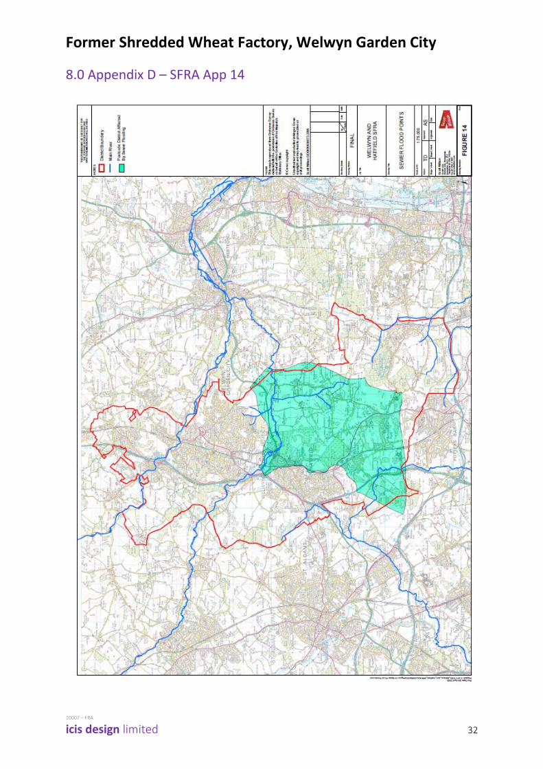
The SFRA indicates that the site and surrounding area is not affected by sewer flooding due to
surcharge. Appendix 14 of the SFRA is reproduced as Appendix D, showing that reported problem
areas exist only to the south of Welwyn Garden City. Consultation with regulatory authorities for this
site specific FRA has not revealed any change from this status.
A drainage survey of the site has been undertaken by MK Surveys (reproduced as Appendix C), which
confirms connectivity of the site for separate surface and foul drainage. Existing discharge is via gravity
at unrestricted rates.
Surface Water attenuation and SuDS applied to the site during redevelopment would therefore
significantly reduce the impact on the local Surface Water sewer network. We therefore consider the
risk of surface water sewer flooding to be low and reduced further by the proposed development.
Previous investigation and consultation with Thames Water on behalf of the client by ARUPS has
indicated that at times of peak flow, the Foul Sewer network downstream of the site may be at full
capacity. (An extract from the report is reproduced as Appendix E). It was reported by ARUPS that
the modelling of the sewer network at the time may be incorrect, or that improvements to the
network may change Thames Water’s view.
We have contacted Thames Water by telephone and in writing, to enquire whether this situation has
been resolved since the ARUPS investigation was undertaken, by further investigation or
improvements to the network. We have received verbal response that infrastructure improvement
has not been undertaken, but that further network analysis may have proved that this was not
necessary. We have been advised by Thames Water that they may require further network analysis
to be undertaken before they can confirm allowable discharge rates for the site, but that they are
willing for this to be subject to Planning Condition.
Development of the site will result in an increased foul water discharge and therefore the drainage
strategy should allow for appropriate control, so that the risk of sewer flooding is mitigated. This is
discussed further in the Drainage Strategy section of this report.

Former Shredded Wheat Factory, Welwyn Garden City
10007 – FRA
icis design limited 10
Flooding from Reservoirs, Canals and other Infrastructure
Structural failure of water retaining structures and infrastructure is a potential source of flooding. The
NPPF (Paragraph 14) and PPG require that site specific FRA considers the risk of such failure.
There are no reservoirs, canals or artificial water sources of any significance within at least 2 miles of
the site. The EA Flood Risk Map does not indicate risk of flooding from reservoirs within WGC and the
SFRA (Fig 21) concurs.
We therefore consider the risk of flooding to the site from reservoirs, canals and other built
infrastructure to be low.
Groundwater Flooding
Groundwater flooding is caused by the emergence of water originating from sub-surface permeable
strata, ie where the groundwater level rises such that the water table intersects with the ground
surface.
The groundwater regime in Welwyn Garden City is described in the SFRA (Chapter 5.6) as low risk. The
SFRA (Fig21) indicates that the site is not in an area of rising groundwater.
Ground Investigation undertaken by Delta Simons Environmental (report ‘Factual and Interpretive
Geotechnical Report 2342.18 Nov 2014’, submitted with planning application) indicates that standing
groundwater level varies between 20m and 26m below existing ground level. At this level the ground
water is of negligible influence on the site and we consider the risk of flooding to the site from
groundwater to be low.
Safe Site Access and Egress
The NPPF (Paragraph 39) and PPG require that Flood Risk Assessment include an assessment of
whether safe access is available to and from a site during a flood event.
The NPPF (Paragraph 40) requires only that ‘judgement be used’ but a joint DEFRA and Environment
Agency document “Flood Risks to People Phase 2, Guidance Document, FD2321/TR2 (March 2006)”
brings together information on flood depth and speed (velocity) of floodwater to create a rating of
hazard to people within each area that experiences flooding.
The hazard rating categorises flood risk in terms of Caution, Danger for Some, Danger for Most and
Danger for All, with the hazard becoming dangerous to more people as depths and velocities increase.

Former Shredded Wheat Factory, Welwyn Garden City
10007 – FRA
icis design limited 11
The DEFRA guidance defines the categories thus:
Velocity m/s
Depth (m)
0.25 0.50 0.75 1.00 1.25 1.50 1.75 2.00 2.25 2.50
0.0
0.5
1.0
1.5
2.0
2.5
3.0
3.5
4.0
4.5
5.0
Description of categories:
Degree of Flood Hazard
Colour Codes Description
Low Caution Flood zone with shallow flowing water or deep standing water
Moderate Dangerous for some (i.e. children) Danger: Flood zone with deep or fast flowing water
Significant Dangerous for most people Danger: Flood zone with deep fast flowing water
Extreme Dangerous for all Extreme danger: Flood Zone with deep fast flowing water
The guidance states that the maximum permissible hazard for safe access should correspond to the
depth-velocity combinations shown in blue (low hazard).
The safety of wading is affected by underwater hazards such as unevenness of the ground and
presence of depressions or unsecured manhole covers.
With respect to requirements for safe access and exit from new developments in flood risk areas, the
following should be provided (in decreasing order of preference):
- Safe dry route for people and vehicles;
- Safe dry route for people;
- A route where flood hazard is low and should not cause a risk to people; and
- A route for vehicles where the flood hazard is low to permit access for emergency vehicles.
Fig. 4 Flood Hazard Rating

Former Shredded Wheat Factory, Welwyn Garden City
10007 – FRA
icis design limited 12
Previous sections of the report have shown that the flood risk (from all forms of flooding) to the site
in the event of a 1 in 100 year storm is low. Even in an extreme event above the 1 in 100 year
threshold, the topography of the site and surrounding area is such that flood depths and velocities
would be below the threshold values for Low Risk.
Access routes on to the site are proposed from Broadwater Road and Bridge Road as well as via the
existing pedestrian access across the railway, providing multiple means of egress. We therefore
consider that the NPPF and PPG requirement for safe access and egress is satisfied by the proposed
development.

Former Shredded Wheat Factory, Welwyn Garden City
10007 – FRA
icis design limited 13
3.0 Drainage Strategy
The NPPF Core Planning Principles (Paragraph 17) encourage sustainable development, mitigation of
flood risk and adaptation for potential climate change. As outlined in Section 2 of this report, the
policy recommendations of the SFRA (Paragraph 10.3.1) and aspiration of the Environment Agency
are that surface water discharge from the site be limited to Greenfield runoff rates.
In order to meet these aspirations and recommendations, the proposed drainage strategy provides
for attenuation of discharge using a variety of SuDS.
Existing Drainage
An Existing Drainage survey has been undertaken by MK Surveys which confirms the connectivity of
the site. Their drawing No. L6080-2D is included in Appendix C.
Private on-site drainage has been identified, consisting of separate foul and surface water systems,
serving both the north and south of the site. No storage tanks or flow control devices were found,
indicating that the existing drainage discharges at unrestricted rates. Where buildings have been
demolished these drains are now redundant but elsewhere the drains remain live.
There are numerous existing lateral connections in to the Thames Water sewers, all of which connect
to the sewer network in Broadwater Road and Bridge Road. There do not appear to be any existing
lateral connections running to the west or south of the site.
Thames Water sewers pass across the north and east of site, located (in part) inside the site boundary.
For the purposes of the development proposals, 6m wide easements have been respected along the
full length of the Thames Water sewers and are indicated on the project drawings thus:
Fig 5. Extract from Drainage Plan D-GA-XX-603

Former Shredded Wheat Factory, Welwyn Garden City
10007 – FRA
icis design limited 14
Proposed Development Drainage Strategy
The foul and surface water drainage strategy for the whole site will be based on common principles.
However, for the purposes of providing detail for the Reserved Matters application for Phase 1 the
design has been developed based on separating the Phase 1 area in to four dedicated drainage cells.
The main reasons for this are:
- To provide resilience to the various buildings in terms of continuity of connection to the public
sewer network in case of phased occupation, maintenance or accident.
- To utilise existing lateral connections onto the foul and surface water public sewer network.
- To limit the depth of the drainage runs, thereby minimising associated excavations and
allowing discharge under gravity where possible.
Foul Water
Each of the four drainage cells will require a dedicated foul drainage system, as generally indicated on
the development proposal drawings listed in Section 1.0. The foul drainage will discharge to the
Thames Water sewer network via proposed and existing lateral connections.
The foul drainage system will be designed to convey foul water from all buildings, collecting discharge
from the following areas;
- Toilets
- Kitchens
- Bathrooms
- Plant areas
The foul water drainage system will collect the above ground drainage at both ground and basement
levels, discharging to the sewer infrastructure via a system of below ground drainage access chambers.
The location of the access chambers will be coordinated with the architectural layouts, foundations
and the above ground drainage proposals to ensure that they are located in positions that provide
sufficient access for maintenance and in locations which are aesthetically acceptable.
As reported in the FRA section of this report, it is understood that the existing Thames Water foul
sewer network may have insufficient capacity to accept unrestricted discharge. Therefore, for the
purposes of this drainage strategy report, it has been assumed that foul water will be discharged from
each cell at a restricted discharge rate. To allow for the necessary temporary storage, each of the four
drainage cell designs has been designed to incorporate a packaged foul water pumping station with a
24 hour storage capacity. 24 hour storage is in line with industry good practice but also allows for the
possibility of timed discharge, to further control the impact on the sewer network.

Former Shredded Wheat Factory, Welwyn Garden City
10007 – FRA
icis design limited 15
Based on EPR Architects’ area schedule, Table 3.1 summarises the pumping station requirements.
Discharge rates have not yet been agreed with Thames Water, however for the purposes of this report,
it is proposed that 5 l/s will be an acceptable rate from each drainage cell. This is a worst case scenario
and storage tank volumes could be reduced following agreement of discharge rates with Thames
Water.
Table 3.1 – Foul Water Pumping Station Schedule
Ref Cell Buildings Volume
(m³)
Discharge
(l/s)
Outfall Location
FWPS01 01 02 & 03 50 5 Via re-use of existing and/or
formation of new lateral
connections to 525 dia TW sewer
flowing east at the north of the
site adjacent to Bridge Road.
Exact locations tba with Thames
Water.
FWPS02 02 & 03 01, 04 & 05 35 5
FWPS03 04 06 36 5
FWPS04 04 07 30 5
Notes:
1. The storage volumes are approximate and subject to further design development during the next design stage.
2. The foul water discharge rates are subject to agreement with Thames Water.
Each pumped main will discharge in to a pressure break chamber and each foul water drainage cell
will discharge to the Thames Water sewer network via a disconnecting chamber on the boundary of
each cell.
Further consideration should be given to the location of storage tanks, ideally to place them at a level
where discharge can be achieved without pumping. However, this will need to be considered in
conjunction with options for timed discharge and discharge rates, so is dependent on input from
Thames Water at detailed design stage.
Grease Removal
Generally for retail units and buildings where it is proposed to incorporate a commercial kitchen, a
suitable method for removal of fats and grease must be considered during the next design stage.
Consultation with the kitchen specialist will be required to determine a suitable system which is sized
to allow for anticipated flows from the kitchen and food preparation areas and in accordance with BS
EN 1824 – Grease Separators.

Former Shredded Wheat Factory, Welwyn Garden City
10007 – FRA
icis design limited 16
Surface Water
The SFRA (Clause 10.3.1) and Environment Agency aspiration (see consultation letter in Appendix B)
require that surface water discharge from the site be reduced to greenfield runoff rates. There are
several alternative methods available for calculating greenfield run off rates, however we have based
the drainage design on a rate of 5.0 l/s per hectare, as a lower bound figure.
In accordance with the NPPF Core Planning Principles (Paragraph 17), Environment Agency guidance
(See appendix B) and SFRA policy recommendations (Chapter 10.3.1), attenuation should be provided
using Sustainable Drainage Systems (SuDS) where possible.
SuDS are based on drainage techniques that seek to mimic run off from the site in a natural state. The
aim of a SuDS based system is to manage rainwater on the surface, close to its source, with the
consequence that water is stored and released slowly, thus reducing flood risk and improving water
quality. Examples of SuDS tchniques include permeable paving, soakaways, green roofs, detention
basins and ponds. The accepted hierarchy of preferred methods is shown in Fig 6.
Fig. 6 Extract from EA Publication: SUDS – A Practical Guide

Former Shredded Wheat Factory, Welwyn Garden City
10007 – FRA
icis design limited 17
Good urban design is only possible where the design and management of water is integrated as an
important part of the whole concept. Therefore engagement with the multi-disciplinary team is
important, so that SuDS can be considered early to ensure that the water management features are
not disconnected with the character and aesthetics of the development.
Making SuDS attractive and integrating their design with other urban features (ie roads and public
open space) is vital to their acceptance, performance and longevity. Communities and stakeholders
are more likely to approve, operate and maintain SuDS when they are delivered using good urban
design principles.
Taking these considerations in to account, the design team have incorporated SuDS techniques in to
Phase 1 of the development by following the preferred hierarchy to include extensive areas of green
and brown roofs. These are illustrated on BMD Landscape Architects drawings and translate to the
following as a minimum:
Living (Green) roofs 11% of Phase 1 site area
Brown roofs 8% ‘’
Permeable soft landscaping / infiltration trenches/strips 13% ‘’
Permeable paving on podium and roofs linked to local geo-cell 14% ‘’
Stormwater attenuation (tanks)
Soakaways
The ground investigation undertaken by Delta Simons Environmental (‘Factual and Interpretive
Geotechnical Report 2342.18 Nov 2014’, submitted with planning application) has identified two
significant dissolution features (sink holes) within the chalk bedrock. These features typically form
over very long periods but are at risk of collapse where ground above them is subject to increased
water flow or inundation, such as that created by the use of soakaways. The geology of the site has
been found to consist of impermeable clays over gravels and chalk; a typical situation for these
circumstances to exist.
In the event of collapse, the sink holes are a danger to buildings and population and therefore
appropriate mitigation will need to be undertaken. In terms of flood risk and drainage strategy, the
site is therefore not suitable for the use of soakaways and surface water that is not disposed of via
evapo-transpiration and soft landscape will require discharge to the public surface water sewer.
Drainage Design
In a similar manner to the foul drainage, the proposed drainage design for the Phase 1 area is split in
to four drainage ‘cells’. Each of the four drainage cells will incorporate dedicated storm water
attenuation systems, so that each area is independent and self-sufficient. The stormwater attenuation
tanks will have a restricted discharge and be sized to accommodate 100 year storm events plus 30%
for Climate Change.

Former Shredded Wheat Factory, Welwyn Garden City
10007 – FRA
icis design limited 18
As a conservative approach for preliminary allocation of maximum storage volume, a calculation of
attenuation storage requirements has been undertaken using WINDES Quick Storage (see Appendix
F).
Based on a 1 in 100 year storm event plus 30% for climate change, the maximum storage requirement
for Phase 1 is calculated as 3,339m3. Table 3.2 summarises how this volume would be divided
between the four drainage cells, based on the site area of each. The drainage design proposals, as
shown on the project drawings, provide these volumes and total 3,370m3.
Table 3.2 – Stormwater Attenuation Tank Schedule
Cell Buildings Volume
(m³)
Discharge
(l/s)
Method of
discharge
Outfall Location
01 02 & 03 990 7.5 Hydro-
brake
Via existing or proposed new lateral onto TW 600mm dia
surface water sewer flowing
east at the north of site
adjacent to Bridge Road, tba
with Thames Water.
02 04 640 5.0 Hydro-
brake
03 05 720 5.0 Hydro-
brake
Via proposed 225mm dia.
lateral onto TW MH2802 in
Broadwater Road
04 06 & 07 1,020 7.5 Pumped Via existing 225mm dia. lateral
onto TW MH2802 in
Broadwater Road
Detailed design, incorporating the full beneficial effect of the SuDS techniques that have been
employed, will allow reduction of the above stated storage volumes. The opportunity should then be
taken to locate smaller tanks in areas and at levels where, ideally, all discharge can be achieved under
gravity. Ideally, pumped systems are to be avoided so that maintenance, energy use and running costs
are minimized.
Currently it is proposed that large diameter pipework or geo-cellular tanks wrapped in an
impermeable membrane will act as the attenuation tanks. The tanks will be located below the ground
floor car parks or externally below paving, as shown on the project drawings. Discharge rates will be
controlled by incorporating a flow control chamber downstream of the attenuation systems within
each cell.
Former Shredded Wheat Factory, Welwyn Garden City
10007 – FRA
icis design limited 19
4.0 Summary Conclusions and Recommendations
Flood risk of all types is considered to be LOW.
Proposed development includes surface water attenuation in accordance with the NPPF, SFRA and
Environment Agency guidance, to achieve discharge equivalent to greenfield run-off rates. The impact
of the site on the surrounding area is thereby reduced as a result of the proposed development.
This reduction is to be achieved by the implementation of SUDS techniques, prioritizing low
maintenance methods. Within Phase 1 this includes:
- Green and brown roofs to approximately 19% of the total Phase 1 site area.
- Soft landscaping at Ground Level to a minimum of 13% of the total Phase 1 site area.
- Permeable paving at podium and roof level linked to a geo-cell attenuation layer of an area
equivalent to 14% of the total Phase 1 site area.
Drainage is to be designed to discharge under gravity where possible, although invert levels are such
that some pumped systems are probable. Detailed design should seek to remove or reduce this where
possible.
Former Shredded Wheat Factory, Welwyn Garden City
10007 – FRA
icis design limited 20
5.0 Appendix A – Phase 1 Drainage Layout
Drawings:
D-GA-XX-601
D-GA-XX-602
D-GA-XX-603
D-GA-XX-604
D-GA-XX-605
D-GA-XX-606
D-GA-XX-607
D-GA-XX-608


Project
Client
ApprovedCheckedDrawn Date Scale @ A1 Drawing No. RevisionProject No.
Drawing Status
Drawing Title
icis design limitedCivil & Structural Consulting Engineers
Rev. Description Date
www.icis-design.co.ukt: +44 (0)161 883 1401Barrington House, Heyes Lane, Alderley Edge, Cheshire SK9 7LA
17.11.2014Stage C IssueP1P1D-GA-XX-60110007
Stage C
Below Ground Drainage, Basement
1:200Nov 14GCRSCT
Welwyn Garden City
Spen Hill Developments Limited

Project
Client
ApprovedCheckedDrawn Date Scale @ A1 Drawing No. RevisionProject No.
Drawing Status
Drawing Title
icis design limitedCivil & Structural Consulting Engineers
Rev. Description Date
www.icis-design.co.ukt: +44 (0)161 883 1401Barrington House, Heyes Lane, Alderley Edge, Cheshire SK9 7LA
17.11.2014Stage C IssueP1P1X-GA-60210007
Stage C
Below Ground Drainage, Basement
1:200Nov 14GCRSCT
Welwyn Garden City
Spen Hill Developments Limited

Project
Client
ApprovedCheckedDrawn Date Scale @ A1 Drawing No. RevisionProject No.
Drawing Status
Drawing Title
icis design limitedCivil & Structural Consulting Engineers
Rev. Description Date
www.icis-design.co.ukt: +44 (0)161 883 1401Barrington House, Heyes Lane, Alderley Edge, Cheshire SK9 7LA
17.11.2014Stage C IssueP1P1D-GA-XX-60310007
Stage C
Below Ground Drainage Layout
1:200Nov 14GCRSCT
Welwyn Garden City
Spen Hill Developments Limited

CL 84.96
CL 85.20
CL 85.05
CL 85.14
CL 83.88
CL 83.75
CL 84.96
CL 84.81
CL 84.75
CL 84.35
Project
Client
ApprovedCheckedDrawn Date Scale @ A1 Drawing No. RevisionProject No.
Drawing Status
Drawing Title
icis design limitedCivil & Structural Consulting Engineers
Rev. Description Date
www.icis-design.co.ukt: +44 (0)161 883 1401Barrington House, Heyes Lane, Alderley Edge, Cheshire SK9 7LA
17.11.2014Stage C IssueP1P1D-GA-XX-60410007
Stage C
Below Ground Drainage
1:200Nov 14GCRSCT
Welwyn Garden City
Spen Hill Developments Limited
Project
Client
ApprovedCheckedDrawn Date Scale @ A1 Drawing No. RevisionProject No.
Drawing Status
Drawing Title
icis design limitedCivil & Structural Consulting Engineers
Rev. Description Date
www.icis-design.co.ukt: +44 (0)161 883 1401Barrington House, Heyes Lane, Alderley Edge, Cheshire SK9 7LA
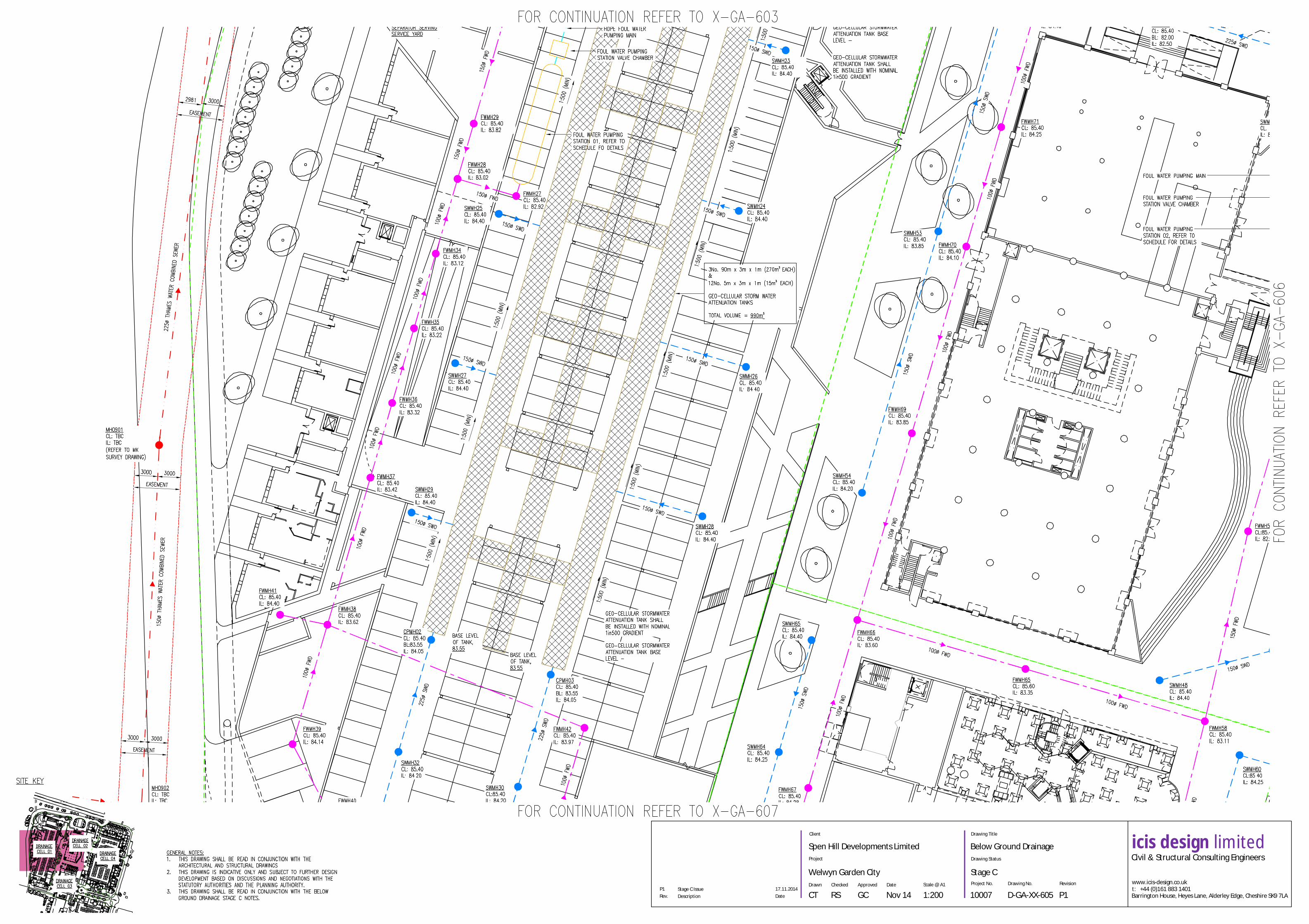
17.11.2014Stage C IssueP1P1D-GA-XX-60510007
Stage C
Below Ground Drainage
1:200Nov 14GCRSCT
Welwyn Garden City
Spen Hill Developments Limited

CL 85.56
CL 84.96
CL 85.20
CL 85.69
CL 85.60
CL 85.52
CL 85.05
CL 85.14
TLC
Project
Client
ApprovedCheckedDrawn Date Scale @ A1 Drawing No. RevisionProject No.
Drawing Status
Drawing Title
icis design limitedCivil & Structural Consulting Engineers
Rev. Description Date
www.icis-design.co.ukt: +44 (0)161 883 1401Barrington House, Heyes Lane, Alderley Edge, Cheshire SK9 7LA
17.11.2014Stage C IssueP1P1D-GA-XX-60610007
Stage C
Below Ground Drainage
1:200Nov 14GCRSCT
Welwyn Garden City
Spen Hill Developments Limited

Project
Client
ApprovedCheckedDrawn Date Scale @ A1 Drawing No. RevisionProject No.
Drawing Status
Drawing Title
icis design limitedCivil & Structural Consulting Engineers
Rev. Description Date
www.icis-design.co.ukt: +44 (0)161 883 1401Barrington House, Heyes Lane, Alderley Edge, Cheshire SK9 7LA
17.11.2014Stage C IssueP1P1D-GA-XX-60710007
Stage C
Below Ground Drainage
1:200Nov 14GCRSCT
Welwyn Garden City
Spen Hill Developments Limited

CL 85.73
CL 85.52
CL 85.46
CL 85.46
CL 85.47
CL 85.82
TLC
TLC
Project
Client
ApprovedCheckedDrawn Date Scale @ A1 Drawing No. RevisionProject No.
Drawing Status
Drawing Title
icis design limitedCivil & Structural Consulting Engineers
Rev. Description Date
www.icis-design.co.ukt: +44 (0)161 883 1401Barrington House, Heyes Lane, Alderley Edge, Cheshire SK9 7LA
17.11.2014Stage C IssueP1P1D-GA-XX-60810007
Stage C
Below Ground Drainage
1:200Nov 14GCRSCT
Welwyn Garden City
Spen Hill Developments Limited

Former Shredded Wheat Factory, Welwyn Garden City
10007 – FRA
icis design limited 21
6.0 Appendix B – Consultation Responses
Consultation Responses:
09 October 2014 Herts CC Flood Risk Management Team
31 December 2014 Environment Agency Sustainable Places Planning Officer
7 January 2015 Thames Water
HCC Flood Risk Management Team
-----Original Message----- From: Sophie Williamson [mailto:[email protected]] Sent: 09 October 2014 16:07 To: [email protected] Cc: Richard Aston Subject: FW: Consult Message: Former Shredded Wheat Factory, Broadwater Road, Welwyn Garden City {-13428-207215-}
Response to below consultation:
Thank you for consulting HCC Flood Management Team on this pre-application.
Apologies but there was diffculty adding comments to the Data Space consultation page. Please therefore find our comments attached.
If you have any questions relating to this response please contact me direct.
Should there be any further pre-application meetings and consultations HCC are able to provide further comment on an advisory basis.
Kind Regards
Sophie Williamson
Sophie Williamson Senior Flood Risk and SuDS Officer
Flood Management Team Environment and Resource Planning
Hertfordshire County Council County Hall Pegs Lane Hertford SG13 8DE
Tel: 01992 556492 Ext: 26492E-mail: [email protected]
HCC Flood Risk Management Team response
Pre-development application: Former Shredded Wheat Factory, Broadwater Road, Welwyn Garden

Former Shredded Wheat Factory, Welwyn Garden City
10007 – FRA
icis design limited 22
HCC Flood Risk Management Team response
Pre-development application: Former Shredded Wheat Factory, Broadwater Road, Welwyn Garden
City 13428-207215
Due to the limited information available we are not in a position to provide detailed comments at
this stage however we are able to provide the following principal advice and guidance:
Surface Water Flood Risk
Based on the EA surface water flood maps for areas susceptible to surface water which were
published and available on their website from December 2013, these maps show there are areas
within the site susceptible to surface water flood risk.
We would therefore recommend that any FRA carried out to support any future planning
application should assess this in more detail to determine the risk to the property and any impact
the development may have on this risk to the surrounding area i.e. if building takes place within an
existing surface water flow this could intercept and divert these flows and increase flood risk
elsewhere.
Management of surface water run-off from new development
Based on the location of this site and current use, this should be seen as an opportunity to improve
surface water run-off and water quality by incorporating a sustainable drainage scheme that
follows the SuDS philosophy of maintaining surface water flows on the surface utilising open green
spaces, innovative ways of using multi space use such as car parking, verges, play areas etc.
The location of this site is directly outside of the railway station and as Welwyn Garden City this
development could provide a green and blue space as commuters and the local community leave
the station.
HCC have recently published its interim guidance for the implementation of SuDS in Hertfordshire
http://www.hertsdirect.org/services/envplan/water/floods/suds/. This guidance document pulls
together references to all existing best practice technical guidance for SuDS and provides a vision of
how SuDS can be implemented across Hertfordshire. For examples of developments that have
incorporated SuDs schemes the applicant is advised to refer to the Susdrain website
http://www.susdrain.org/ . This website provides case studies, information on different SuDS
techniques and provides information on how the implementation of SuDS can be cheaper than
conventional drainage systems and provide other benefits to the development.
Water sensitive urban design
Water sensitive urban design promotes an integrated way of incorporating the water cycle within
new developments, towns and cities. More information on how this can be achieved can be found
on the CIRIA website;
‘Water Sensitive Urban Design is an opportunity to create beautiful, successful and resilient places.
It is undeniable that the relationship between water and our urban areas needs to be given a higher
priority to provide integrated solutions to flood risk management, sustainable water use and supply
and the improvement of water quality in our treasured watercourses. This priority needs to be
applied in an integrated way by the people and partners that plan and design the built
environment. In doing so, we can bring together the skills and creativity of practitioners who plan
and design the places we live in to bring much wider benefits to communities’

Former Shredded Wheat Factory, Welwyn Garden City
10007 – FRA
icis design limited 23
priority to provide integrated solutions to flood risk management, sustainable water use and supply
and the improvement of water quality in our treasured watercourses. This priority needs to be
applied in an integrated way by the people and partners that plan and design the built
environment. In doing so, we can bring together the skills and creativity of practitioners who plan
and design the places we live in to bring much wider benefits to communities’
http://www.ciria.org/Resources/Free_publications/Water_Sensitive_Urban_Design.aspx
Role of Lead Local Flood Authority
Whilst HCC are not a statutory consultee and not the SuDS Approval Body we have an invested
interest as having an overall view of flood risk within the county as the Lead Local Flood Authority
and are responsible for managing flood risk from all local sources. We therefore need to ensure
that any new development does not increase flood risk from existing sources and from any
increases in surface water run-off rates and volumes working with our Local Planning Authorities.
We also have to have due regard to the EU Water Framework Directive to ensure there is no
detriment to water quality within local watercourse and its ecology. SuDS are the best way to
manage and prevent pollution to watercourses when a treatment train approach is implemented.
This allows surface water run-off to pass through stages of drainage:
7. Source Control- catches first ‘flush’ of surface water which provides initial treatment
catching silt and diffuse pollution. This can be through permeable paving, infiltration
measures etc
8. Conveyance- this conveys surface water on the surface to the next stage of the drainage
system which further filters the surface water run-off. This can be through swales,
infiltration trenches etc
9. Regional storage- this is usually the last stage where water is stored for more extreme
rainfall events providing attenuation and the final treatment before discharging into the
nearest watercourse or local sewer network.
To learn more about our roles and responsibilities please refer to the Hertfordshire Local Flood Risk
Management Strategy
http://www.hertsdirect.org/services/envplan/water/floods/floodrisk/lfrmsherts/

Former Shredded Wheat Factory, Welwyn Garden City
10007 – FRA
icis design limited 24
Environment Agency Sustainable Places Planning Officer

Former Shredded Wheat Factory, Welwyn Garden City
10007 – FRA
icis design limited 25

Former Shredded Wheat Factory, Welwyn Garden City
10007 – FRA
icis design limited 26
Thames Water

Former Shredded Wheat Factory, Welwyn Garden City
10007 – FRA
icis design limited 27

Former Shredded Wheat Factory, Welwyn Garden City
10007 – FRA
icis design limited 28

Former Shredded Wheat Factory, Welwyn Garden City
10007 – FRA
icis design limited 29
7.0 Appendix C – MK Surveys Drg 19040

Former Shredded Wheat Factory, Welwyn Garden City
10007 – FRA
icis design limited 30

Former Shredded Wheat Factory, Welwyn Garden City
10007 – FRA
icis design limited 31
Former Shredded Wheat Factory, Welwyn Garden City
10007 – FRA
icis design limited 32
8.0 Appendix D – SFRA App 14

Former Shredded Wheat Factory, Welwyn Garden City
10007 – FRA
icis design limited 33
9.0 Appendix E – Arups Report
Extract from Arups Drainage Appraisal Report – Welwyn Garden City ref REP/207043/R001, Feb
2009

Former Shredded Wheat Factory, Welwyn Garden City
10007 – FRA
icis design limited 34
10.0 Appendix F – WINDES