flood risk appraisal and drainage study
TRANSCRIPT
Site Reference Client Name
CRM.1343.002.HY.R.001.A i Capital Land
March 2017
Flood Risk Appraisal and Drainage Study
Thames Farm, Shiplake
Taylor Wimpey (West London)
SHF.1850.001.HY.R.001.A

Taylor Wimpey (West London)
Contact Details:
Thames Farm, Shiplake
Project: Flood Risk Appraisal and Drainage Study
For: Taylor Wimpey (West London)
Status: Final
Date: February 2021
Author: Daniel Alstead BSc (Hons), MSc, MCIWEM, C.WEM - Associate Director
Approver: Matt Travis BSc (Hons), MSc, MCIWEM, C.WEM, CEnv, CSci - Director
Disclaimer:
This report has been produced by Enzygo Limited within the terms of the contract with the client and taking account of the resources devoted to it by agreement with the client.
We disclaim any responsibility to the client and others in respect of any matters outside the scope of the above.
This report is confidential to the client and we accept no responsibility of whatsoever nature to third parties to whom this report, or any part thereof, is made known. Any such party relies on the report at their own risk.
Enzygo Limited Registered in England No. 6525159 Registered Office Gresham House, 5-7 St. Pauls Street, Leeds, England, LS1 2JG
Samuel House
1st Floor
5 Fox Valley Way
Stocksbridge
Sheffield
S36 2AA
tel: 0114 321 5151 www: enzygo.com
Taylor Wimpey (West London)
SHF.1850.001.HY.R.001.A i Thames Farm, Shiplake
February 2021
Contents
Contents ..................................................................................................................................... i Executive Summary .................................................................................................................... iii 1.0 Introduction ......................................................................................................................1
1.1 Background ....................................................................................................................... 1
1.2 Purpose ............................................................................................................................. 1
1.3 Scope of Work ................................................................................................................... 1
1.4 Limitations ......................................................................................................................... 1
1.5 Report Structure ............................................................................................................... 1
2.0 Site Location and Description .............................................................................................3 2.1 Location ............................................................................................................................. 3
2.2 Land Use ............................................................................................................................ 3
2.3 Topographic Information .................................................................................................. 3
2.4 Soils and Geology .............................................................................................................. 4
2.5 Hydrogeology .................................................................................................................... 1
2.6 Catchment Hydrology ....................................................................................................... 1
2.7 Sewerage Assets.............................................................................................................. 10
2.8 Highway Drainage ........................................................................................................... 10
2.9 Designated Sites .............................................................................................................. 11
3.0 Baseline Flood Risk .......................................................................................................... 12 3.1 Fluvial Flooding ............................................................................................................... 12
3.2 Surface Water Flooding................................................................................................... 15
4.0 Constraints and Opportunities ......................................................................................... 18 4.1 Flood Guidance ............................................................................................................... 18
4.2 Flood Risk Assessment and Drainage Strategy ............................................................... 18
4.3 Mitigation Measures ....................................................................................................... 20
5.0 Summary and Conclusions ............................................................................................... 21 5.1 Introduction .................................................................................................................... 21
5.2 Flood Risk Appraisal and Drainage Study ........................................................................ 21

Taylor Wimpey (West London)
SHF.1850.001.HY.R.001.A ii Thames Farm, Shiplake
February 2021
Tables & Figures Figure 2.1: Aerial Imagery of the Site ..................................................................................................... 3
Figure 2.2: Flow Pathway Analysis .......................................................................................................... 4
Figure 2.3: Soils Mapping ........................................................................................................................ 1
Figure 2.4: Geology Mapping (continues over page) .............................................................................. 2
Figure 2.5: Map of Watercourses ........................................................................................................... 2
Figure 2.6: Lash Brook (LB) ...................................................................................................................... 2
Figure 2.7: Northern Watercourse (NW) ................................................................................................ 4
Figure 2.8: Map of Watercourses ........................................................................................................... 7
Figure 2.9: Catchment Data Explorer (continues over page) .................................................................. 7
Figure 2.10: FEH Webservice Catchment Boundary ............................................................................... 8
Figure 2.11: Thames Water Asset Plans ................................................................................................ 10
Figure 3.5: A4155 Highway Drainage .................................................................................................... 11
Figure 3.1: Environment Agency Flood Zones Map .............................................................................. 12
Figure 3.2: Henley Standard TV Fly Over .............................................................................................. 13
Figure 3.3: Modelled Flood Outline (Northern Watercourse) .............................................................. 15
Figure 3.4: Environment Agency Complex Surface Water Flood Map ................................................. 16
Figure 3.6: Environment Agency Online Surface Water Flood Mapping .............................................. 17
Taylor Wimpey (West London)
SHF.1850.001.HY.R.001.A iii Thames Farm, Shiplake
February 2021
Executive Summary
This report presents a Flood Risk Appraisal and Drainage Study for a proposed residential development (and associated surface water outfall), located on land at Thames Farm, Shiplake, Oxfordshire. This report is an addendum to previous flood risk and drainage works undertaken for the Site as part of a previous Outline Planning Application.
Existing surface water runoff currently sheds uncontrolled from the Site, which may enter and surcharging the local foul sewer/highways drainage networks, and potentially flood nearby properties.
It is proposed that a new S104 pumped outfall to a watercourse to the north of the Site (Northern Watercourse) would improve existing conditions, whereby runoff from the Site will be intercepted by the new onsite drainage, which will be directed to the River Thames downstream from Shiplake.
The purpose of this report is to outline the baseline fluvial and surface water flood risk, the proposed new S104 outfall point, an assessment of flood risk from the proposed new S104 outfall and identify opportunities to provide betterment to existing flooding issues.
Modelling shows that when a 30 l/s discharge is introduced upstream of the A4155, there is a negligible 1mm (0.001m) increase in flood levels with a very minor increase in flood extent during lower return periods. No flood extent increase in observed during higher/extreme events.
In summary, establishing a new S104 outfall to the Northern Watercourse would have a negligible risk of flooding to sports pitches and grass land, and remove uncontrolled surface water runoff from the Site which otherwise could impact nearby properties and the capacity of the foul/highway drainage networks.
Taylor Wimpey (West London)
SHF.1850.001.HY.R.001.A 1 Thames Farm, Shiplake
February 2021
1.0 Introduction
1.1 Background
1.1.1 Enzygo were appointed by Taylor Wimpey in November 2020 to establish an appropriate solution for the flood risk and drainage strategy for the extant planning consent at Thames Farm Shiplake for 95 units.
1.2 Purpose
1.2.1 The purpose of this report is to outline the baseline fluvial and surface water flood risk (see
Section 3), the proposed new surface water drainage outfall point (see Section 4.2), an
assessment of flood risk to and from the proposed new S104 outfall (see Section 3.1) and
identify opportunities to provide betterment to existing flooding issues (see Section 4.2 -
Option 4).
1.3 Scope of Work
1.3.1 The scope of work includes:
• First site walkover to confirm land use, topography and identify any drainage features.
• A desktop study of Ordnance Survey (OS) mapping, aerial photographs, soils and
geology mapping, borehole logs, and online flood risk/catchment mapping.
• Obtain detailed surface water flood mapping.
• Assessment of potential surface water outfall points and associated flood risk.
• Identify opportunities to provide betterment to existing flooding issues.
1.4 Limitations
1.4.1 The Flood Risk Appraisal and Drainage Study is limited to the assessment of fluvial flood risk
arising from the proposed surface water drainage outfall to watercourse, and opportunities
for betterment to existing surface water flooding issues arising from existing surface water
runoff from the Site.
1.4.2 This report is an addendum to previous flood risk and drainage works undertaken for the Site
as part of the previous Outline Planning Application (Reference. P20/S2808/DIS, further to
P16/S0970/O), which includes the full assessment of flooding to the Site from all sources and
proposed drainage arrangement.
1.5 Report Structure
1.5.1 This report is structured as follows:
• Section 2 describes the baseline conditions for the existing Site and wider study area.
• Section 3 outlines the baseline fluvial and surface water flood risk to the existing Site and wider study area.

Taylor Wimpey (West London)
SHF.1850.001.HY.R.001.A 2 Thames Farm, Shiplake
February 2021
• Section 4 provides an assessment of flood risk and drainage constraints and opportunities.
• Section 5 presents a summary and conclusions.

Taylor Wimpey (West London)
SHF.1850.001.HY.R.001.A 3 Thames Farm, Shiplake
February 2021
2.0 Site Location and Description
2.1 Location
2.1.1 The Site is located on land at Thames Farm, east of the A4155, Shiplake, Oxfordshire, RG9 3PH.
2.1.2 The Site is centred on National Grid Reference (NGR) 476872, 179903.
2.1.3 The Site location is shown in Figure 2.1, which shows the red line boundary enclosing an approximate 5.29ha parcel of land.
2.2 Land Use
2.2.1 The Site currently comprises an open grassed field within three barns (formerly used as poultry houses) in the northern extent (Figure 2.1). The Site forms part of Thames Farm’s land ownership.
2.2.2 The Site is bounded by the A4155 with residential dwellings beyond to the east; agricultural land with residential dwellings beyond to the south and west; a residential dwelling to the north-west; a track with nurseries and agricultural land beyond to the north.
2.2.3 The Site is accessed from the A4155 to the east.
Figure 2.1: Aerial Imagery of the Site
Image © 2021 Digital Globe.
2.3 Topographic Information
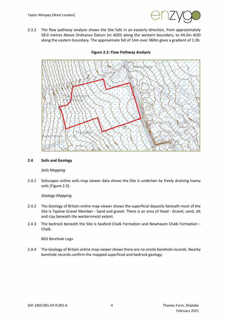
2.3.1 LiDAR data was used to create contour lines and flow pathways (using KeyTERRA-FIRMA [KTF] software) to understand the Site topography. The flow pathway drawing is included as Drawing 005 and an extract is included in Figure 2.2.
Taylor Wimpey (West London)
SHF.1850.001.HY.R.001.A 4 Thames Farm, Shiplake
February 2021
2.3.2 The flow pathway analysis shows the Site falls in an easterly direction, from approximately 58.0 metres Above Ordnance Datum (m AOD) along the western boundary, to 44.0m AOD along the eastern boundary. The approximate fall of 14m over 360m gives a gradient of 1:26.
Figure 2.2: Flow Pathway Analysis
2.4 Soils and Geology
Soils Mapping
2.4.1 Soilscapes online soils map viewer data shows the Site is underlain by freely draining loamy soils (Figure 2.3).
Geology Mapping
2.4.2 The Geology of Britain online map viewer shows the superficial deposits beneath most of the Site is Taplow Gravel Member - Sand and gravel. There is an area of Head - Gravel, sand, silt and clay beneath the westernmost extent.
2.4.3 The bedrock beneath the Site is Seaford Chalk Formation and Newhaven Chalk Formation – Chalk.
BGS Borehole Logs
2.4.4 The Geology of Britain online map viewer shows there are no onsite borehole records. Nearby borehole records confirm the mapped superficial and bedrock geology.

Taylor Wimpey (West London)
SHF.1850.001.HY.R.001.A 1 Thames Farm, Shiplake
February 2021
Figure 2.3: Soils Mapping
Soils Data © Cranfield University (NSRI) and for the Controller of HMSO [2021].

Taylor Wimpey (West London)
SHF.1850.001.HY.R.001.A 2 Thames Farm, Shiplake
February 2021
Figure 2.4: Geology Mapping (continues over page)

Taylor Wimpey (West London)
SHF.1850.001.HY.R.001.A 3 Thames Farm, Shiplake
February 2021
Top: Superficial Deposits. Bottom: Bedrock Geology. Contains British Geological Survey materials © NERC [2021].
Taylor Wimpey (West London)
SHF.1850.001.HY.R.001.A 1 Thames Farm, Shiplake
February 2021
2.5 Hydrogeology
2.5.1 Defra Magic Map online mapping shows the Site is in a groundwater Source Protection Zone (SPZ), which has a 50-day travel time ‘Inner Zone’ (Zone 1) of a groundwater abstraction. The Site is also located above a secondary A aquifer (sands and gravels) over a Principal Aquifer (Chalk).
2.5.2 The soils and geology mapping (Figures 2.3 and 2.4) indicate that the infiltration potential across the Site may be variable (moderate to high) subject to the depth of the weathered layer.
2.5.3 The nearby borehole records recorded resting groundwater levels between 12 to 16 metres below ground level (m bgl).
2.5.4 Intrusive investigations undertaken as part of the previous application encountered dissolution features across the Site, and investigations were abandoned.
2.6 Catchment Hydrology
OS Mapping / Site Walkover Observations
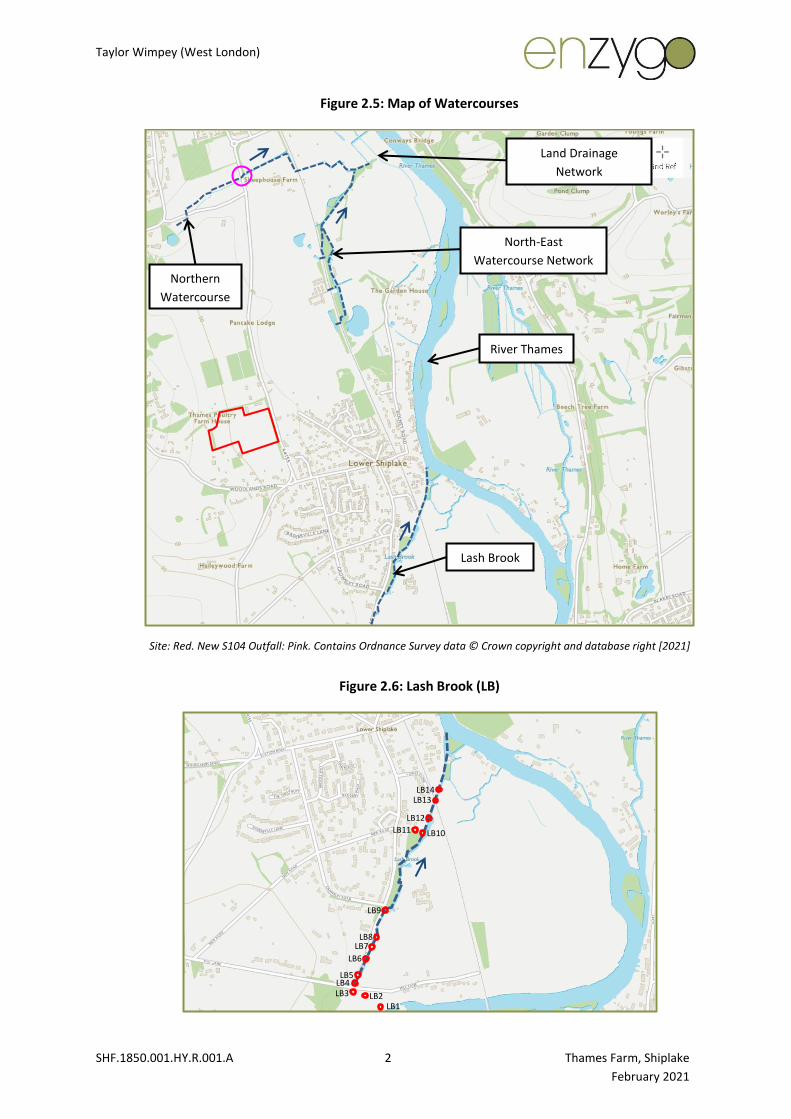
2.6.1 OS mapping (Figure 2.5) shows there are no watercourses located within or bounding the Site. This was confirmed during the walkover.
2.6.2 Lash Brook is orientated in a north-east direction, approximately 840m to the south-east of the Site. The walkover observed the watercourse to originate at Mill Lane. The watercourse is comprised of disconnected reaches along the upstream (southern) and middle reaches, including poorly defined and overgrown dry reaches, as well as reaches of standing water. The watercourse is considered to be a ‘relic watercourse’, which is likely to have been a former mill race (Figure 2.6). Connectivity and condition of the downstream (northern) reach could not be established due to access into third party land.
2.6.3 A network of watercourses (the ‘North-East Watercourse Network’) is located in land to the north-east of the Site. OS mapping indicated the network of watercourses are conveyed east beneath the railway line (presumably by culvert), before conveying flows north-east into a ‘Land Drainage Network’, which outfalls to the Thames (see below).
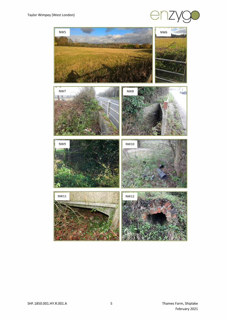
2.6.4 An unnamed watercourse (the ‘Northern Watercourse’) is orientated in a north-east direction, approximately 955m to the north of the Site. The walkover and subsequent channel survey confirmed connectivity to the Thames via a land drainage network at the downstream extent. The channel was observed to be dry along the upstream (western) and middle reaches (NW1 to 15), likely flowing when there is sufficient runoff generated in the permeable (Chalk) catchment, following prolonged and/or intense rainfall and the catchment is saturated (Figure 2.7). The dry channel was evident but poorly defined due to lack of flow, deposition of material, and vegetation growth. The twin culvert beneath the A4155 (NW7 and 8) was observed to be +90% blocked.
2.6.5 Both Lash Brook and the Northern Watercourse are classified as ‘ordinary watercourses’, which are watercourses where flood risk is managed by the local drainage authority/riparian landowners). Highways England or Oxfordshire County Council (to be confirmed) would be responsible for the A4155 culvert crossing. Both watercourses are tributaries of the River Thames.
Taylor Wimpey (West London)
SHF.1850.001.HY.R.001.A 2 Thames Farm, Shiplake
February 2021
Figure 2.5: Map of Watercourses
Site: Red. New S104 Outfall: Pink. Contains Ordnance Survey data © Crown copyright and database right [2021]
Figure 2.6: Lash Brook (LB)
LB7
LB4
LB1
LB3 LB2
LB5
LB6
LB8
LB9
LB10
LB12
LB11
LB14 LB13
Land Drainage
Network
Lash Brook
Northern
Watercourse
North-East
Watercourse Network
River Thames

Taylor Wimpey (West London)
SHF.1850.001.HY.R.001.A 3 Thames Farm, Shiplake
February 2021
LB1 LB2
LB5 LB6
LB7 LB8
LB9 LB10
LB11 LB12
LB3 LB4

Taylor Wimpey (West London)
SHF.1850.001.HY.R.001.A 4 Thames Farm, Shiplake
February 2021
Figure 2.7: Northern Watercourse (NW)
NW1 NW2
NW3 NW4
NW17
NW12
NW1 NW2
NW3 NW4
NW5
NW6 NW8
NW7
NW9 NW14
NW13
NW10 NW11
NW15 NW18
NW16
LB13 LB14
Taylor Wimpey (West London)
SHF.1850.001.HY.R.001.A 5 Thames Farm, Shiplake
February 2021
NW5 NW6
NW7 NW8
NW9 NW10
NW11 NW12

Taylor Wimpey (West London)
SHF.1850.001.HY.R.001.A 6 Thames Farm, Shiplake
February 2021
Main River Map
2.6.6 The Environment Agency main river map (Figure 2.8) shows the River Thames conveys flows in a northerly direction, approximately 725m to the east of the Site. A main river is a watercourse where flood risk is managed by the Environment Agency.
NW13 NW14
NW15 NW16
NW17 NW18
Taylor Wimpey (West London)
SHF.1850.001.HY.R.001.A 7 Thames Farm, Shiplake
February 2021
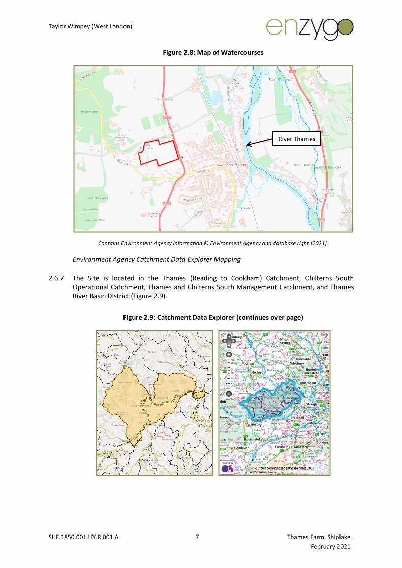
Figure 2.8: Map of Watercourses
Contains Environment Agency information © Environment Agency and database right [2021].
Environment Agency Catchment Data Explorer Mapping
2.6.7 The Site is located in the Thames (Reading to Cookham) Catchment, Chilterns South Operational Catchment, Thames and Chilterns South Management Catchment, and Thames River Basin District (Figure 2.9).
Figure 2.9: Catchment Data Explorer (continues over page)
River Thames

Taylor Wimpey (West London)
SHF.1850.001.HY.R.001.A 8 Thames Farm, Shiplake
February 2021
Top Left: Catchment. Top Right: Operational Catchment. Bottom Left: Management Catchment. Bottom Right: River
Basin District. Contains Environment Agency information © Environment Agency and database right [2021].
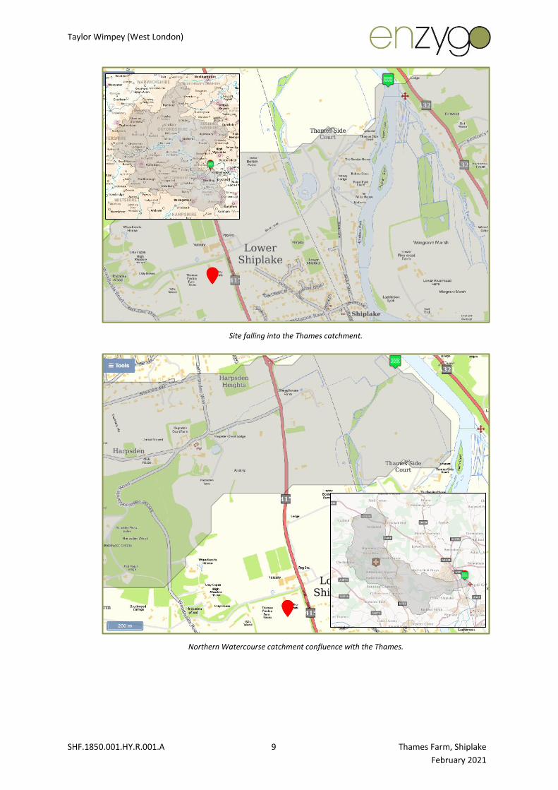
FEH Webservice
4.1.1 The FEH Webservice (Figure 2.10) shows the following:
• The Lash Brook catchment confluence with the Thames located is at NGR: 477800, 179750. As the Lash Brook is an artificial watercourse (i.e. mill race), it has a limited catchment, not represented accurately by the FEH Webservice. The Lash Brook catchment cannot be defined in isolation from the River Thames.
• The Site falls into the Thames catchment at NGR: 477900, 181050. The River Thames catchment to this point is 6,550km2 at this point.
• The Northern Watercourse catchment confluence with the Thames is at NGR: 477500, 181350. The Northern Watercourse catchment to this point is 41.46km2.
Figure 2.10: FEH Webservice Catchment Boundary
Lash Brook catchment confluence with the Thames.
Taylor Wimpey (West London)
SHF.1850.001.HY.R.001.A 9 Thames Farm, Shiplake
February 2021
Site falling into the Thames catchment.
Northern Watercourse catchment confluence with the Thames.
Taylor Wimpey (West London)
SHF.1850.001.HY.R.001.A 10 Thames Farm, Shiplake
February 2021
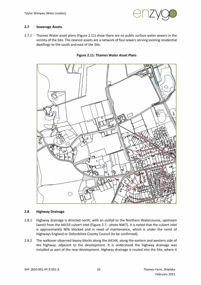
2.7 Sewerage Assets
2.7.1 Thames Water asset plans (Figure 2.11) show there are no public surface water sewers in the vicinity of the Site. The nearest assets are a network of foul sewers serving existing residential dwellings to the south and east of the Site.
Figure 2.11: Thames Water Asset Plans
2.8 Highway Drainage
2.8.1 Highway drainage is directed north, with an outfall to the Northern Watercourse, upstream (west) from the A4155 culvert inlet (Figure 2.7 - photo NW7). It is noted that the culvert inlet is approximately 90% blocked and in need of maintenance, which is under the remit of Highways England or Oxfordshire County Council (to be confirmed).
2.8.2 The walkover observed beany blocks along the A4144, along the eastern and western side of the highway, adjacent to the development. It is understood the highway drainage was installed as part of the new development. Highway drainage is routed into the Site, where it

Taylor Wimpey (West London)
SHF.1850.001.HY.R.001.A 11 Thames Farm, Shiplake
February 2021
is currently collected in an infiltration basin. Highway runoff is integrated into the surface water drainage strategy for the proposed development.
Figure 3.5: A4155 Highway Drainage
Beany blocks along eastern (top) and western (bottom) side of highway.
2.9 Designated Sites
2.9.1 The DEFRA Magic Map (England and Wales) (Figure 3.15) shows there are no designated sites either in or close to the Site (with hydrological connectivity) from a flood risk or drainage perspective.
Taylor Wimpey (West London)
SHF.1850.001.HY.R.001.A 12 Thames Farm, Shiplake
February 2021
3.0 Baseline Flood Risk
3.1 Fluvial Flooding
Environment Agency Flood Map for Planning
Site
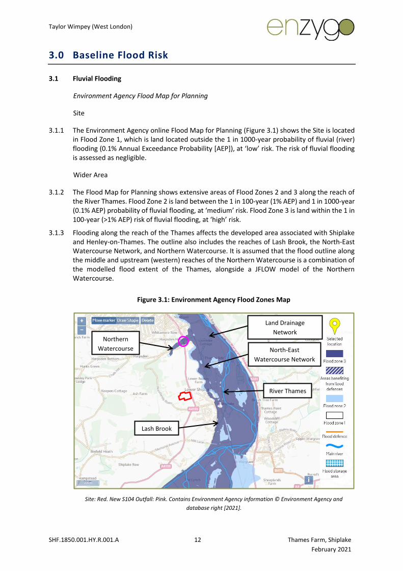
3.1.1 The Environment Agency online Flood Map for Planning (Figure 3.1) shows the Site is located in Flood Zone 1, which is land located outside the 1 in 1000-year probability of fluvial (river) flooding (0.1% Annual Exceedance Probability [AEP]), at ‘low’ risk. The risk of fluvial flooding is assessed as negligible.
Wider Area
3.1.2 The Flood Map for Planning shows extensive areas of Flood Zones 2 and 3 along the reach of the River Thames. Flood Zone 2 is land between the 1 in 100-year (1% AEP) and 1 in 1000-year (0.1% AEP) probability of fluvial flooding, at ‘medium’ risk. Flood Zone 3 is land within the 1 in 100-year (>1% AEP) risk of fluvial flooding, at ‘high’ risk.
3.1.3 Flooding along the reach of the Thames affects the developed area associated with Shiplake and Henley-on-Thames. The outline also includes the reaches of Lash Brook, the North-East Watercourse Network, and Northern Watercourse. It is assumed that the flood outline along the middle and upstream (western) reaches of the Northern Watercourse is a combination of the modelled flood extent of the Thames, alongside a JFLOW model of the Northern Watercourse.
Figure 3.1: Environment Agency Flood Zones Map
Site: Red. New S104 Outfall: Pink. Contains Environment Agency information © Environment Agency and
database right [2021].
Lash Brook
Northern
Watercourse North-East
Watercourse Network
Land Drainage
Network
River Thames
Taylor Wimpey (West London)
SHF.1850.001.HY.R.001.A 13 Thames Farm, Shiplake
February 2021
Historical Flooding
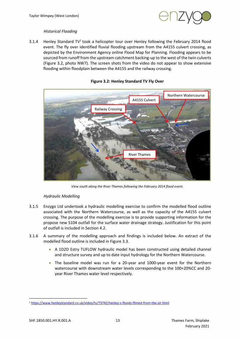
3.1.4 Henley Standard TV1 took a helicopter tour over Henley following the February 2014 flood event. The fly over identified fluvial flooding upstream from the A4155 culvert crossing, as depicted by the Environment Agency online Flood Map for Planning. Flooding appears to be sourced from runoff from the upstream catchment backing-up to the west of the twin culverts (Figure 3.2, photo NW7). The screen shots from the video do not appear to show extensive flooding within floodplain between the A4155 and the railway crossing.
Figure 3.2: Henley Standard TV Fly Over
View south along the River Thames following the February 2014 flood event.
Hydraulic Modelling
3.1.5 Enzygo Ltd undertook a hydraulic modelling exercise to confirm the modelled flood outline associated with the Northern Watercourse, as well as the capacity of the A4155 culvert crossing. The purpose of the modelling exercise is to provide supporting information for the propose new S104 outfall for the surface water drainage strategy. Justification for this point of outfall is included in Section 4.2.
3.1.6 A summary of the modelling approach and findings is included below. An extract of the modelled flood outline is included in Figure 3.3.
• A 1D2D Estry TUFLOW hydraulic model has been constructed using detailed channel and structure survey and up to date input hydrology for the Northern Watercourse.
• The baseline model was run for a 20-year and 1000-year event for the Northern watercourse with downstream water levels corresponding to the 100+20%CC and 20-year River Thames water level respectively.
1 https://www.henleystandard.co.uk/video/tv/73742/henley-s-floods-filmed-from-the-air.html
River Thames
Northern Watercourse A4155 Culvert
Railway Crossing

Taylor Wimpey (West London)
SHF.1850.001.HY.R.001.A 14 Thames Farm, Shiplake
February 2021
• It was noted that the Northern Watercourse channel was silted in places, especially in culverts that pass under the A4155. At this stage, the model has been run using surveyed hard bed only.
• The baseline results show that the main constraints to fluvial flows are the A4155 and raised railway which result in elevated upstream water level. The assessment has shown that water levels to the east (downstream) of the railway are dominated by the River Thames. As the Northern Watercourse bed elevation increases further to the west, fluvial flow becomes more influential on flood levels.
• The robustness of the baseline model has been assessed through a number sensitivity runs in order to assess the impact of subjective model parameters such as Mannings’s roughness and also hydrological inputs such as inflow and downstream boundary. The sensitivity runs demonstrate that model outlines and flood levels are largely insensitive, and the model behaves as expected, which increase confidence in the baseline results.
• A blockage assessment has also been undertaken which applied an 80% blockage to the A4155 and railway culverts as these structures were identified as being key during the baseline runs. The blockage runs shows that flood levels are increased upstream of the structures, as expected, but flood extents are insensitive to structure blockage.
• The results from the proposed modelling exercise show that when a 30 l/s discharge is introduced upstream of the A4155, there is a negligible 1mm (0.001m) increase in flood levels with a very minor increase in flood extent during the 20-year model run. No flood extent increase in observed during the 1000-year event. The application of a 30 l/s discharge is an initial assessment.
3.1.7 To date, the modelling works includes the baseline conditions and the initial assessment of the proposed outfall.
3.1.8 Furthermore, Enzygo Ltd attended a meeting with the Lead Local Flood Authority (LLFA) and Thames Water on 8th February 2021, where it was agreed that modelling would include an assessment of soft bed levels.

Taylor Wimpey (West London)
SHF.1850.001.HY.R.001.A 15 Thames Farm, Shiplake
February 2021
Figure 3.3: Modelled Flood Outline (Northern Watercourse)
Flood Risk Summary
3.2 Surface Water Flooding
Environment Agency Complex Surface Water Flood Mapping
3.2.1 Environment Agency Complex Surface Water Flood Mapping (Figure 3.4) shows a surface water flow pathway (‘Flow Pathway 1’) is orientated west to east through the middle of the Site. The surface water flood outline is mostly associated with the 1 in 1000-year event, however there is an area of ponding along the eastern boundary associated with the 1 in 30-year event, which would spill east across the highway during the higher 1 in 1000-year event. Flood depth along the flow pathway is mostly up to 0.15m, with a depth of 0.6m in the ponded area. The flood velocity is up to 2.00m/s, and the flood hazard is mostly ‘low’ (0.50-0.75), increasing to ‘significant’ (1.25-2.00) in the ponded area.
3.2.2 A surface water flow pathway (‘Flow Pathway 2’) is orientated west to east along/within the northern boundary of the Site. The surface water flood outline is associated with the 1 in 1000-year event. Flood depth along the flow pathway is up to 0.30m, the flood velocity is up to 2.00m/s, and the flood hazard is up to ‘moderate’ (0.75-1.25).

Taylor Wimpey (West London)
SHF.1850.001.HY.R.001.A 16 Thames Farm, Shiplake
February 2021
3.2.3 The surface water flow pathways are likely to be generated by the local topography when the soils are saturated following prolonged and/or intense rainfall events.
3.2.4 Current overland flows from the Site shed east towards the Thames, through land occupied by existing residential dwellings of Shiplake. Some runoff enters into the foul drainage network (see Figure 2.11) as well as the highway drainage network (Figure 2.12), which surcharges the drainage networks and cause sewer and highway drainage flooding.
Figure 3.4: Environment Agency Complex Surface Water Flood Map
Top Left: Return Period. Top Right: Depth. Bottom Left: Velocity. Bottom Right: Hazard.
Flow Pathway 1
Flow Pathway 2

Taylor Wimpey (West London)
SHF.1850.001.HY.R.001.A 17 Thames Farm, Shiplake
February 2021
Environment Agency Online Surface Water Flood Mapping
3.2.5 The Environment Agency online Surface Water Flood Mapping (Figure 3.6) shows the same onsite flood outline as the Complex Surface Water Flood Map.
3.2.6 The mapping is zoomed out to show the flow pathway outline associated with the Northern Watercourse. The flow pathway (‘Flow Pathway 3’) is indicative of fluvial flooding and should be superseded by the Enzygo Ltd modelled flood outline (Figure 3.3).
Figure 3.6: Environment Agency Online Surface Water Flood Mapping
Site: Red. New S104 Outfall: Pink. Contains Environment Agency information © Environment Agency and
database right [2021].
Flood Risk Summary
3.2.7 The risk of surface water flooding is assessed as negligible for most of the Site, with an area of low risk along the flow pathway, and medium in the ponded area.
3.2.8 Mitigation measures against surface water flooding are discussed in Section 4.
Flow Pathway 3

Taylor Wimpey (West London)
SHF.1850.001.HY.R.001.A 18 Thames Farm, Shiplake
February 2021
4.0 Constraints and Opportunities
4.1 Flood Guidance
4.1.1 A Flood Risk Assessment (FRA) is required where a development is:
• In Flood Zone 2 or 3 including minor development and change of use.
• More than 1 hectare (ha) in Flood Zone 1.
• Less than 1 ha in Flood Zone 1, including a change of use in development type to a more vulnerable class (for example from commercial to residential), where they could be affected by sources of flooding other than rivers and the sea (for example surface water drains, reservoirs).
• In an area within Flood Zone 1 which has critical drainage problems as notified by the Environment Agency.
• In land identified in a strategic flood risk assessment as being at increased flood risk in the future.
4.1.2 The proposal is for a proposed residential development. Table 2 of PPG ID: 7 (not included in this report) classifies the proposed use as ‘more vulnerable’.
4.1.3 The Site is located within fluvial Flood Zone 1 (low risk) but is within the mapped extent of surface water and groundwater flooding and is greater than 1ha in area. The development would only be compatible with NPPF and PPG ID: 7 after the completion of a satisfactory Flood Risk Assessment, inclusive of mitigation measures and a Drainage Strategy.
4.2 Flood Risk Assessment and Drainage Strategy
March 2016
4.2.1 An FRA was prepared during March 2016 to inform the previous Outline Planning Application (Reference. P20/S2808/DIS, further to P16/S0970/O), which includes the full assessment of flooding to the Site from all sources, and indicative outline drainage arrangement. Note, the March 2016 FRA was not commissioned by Taylor Wimpey.
4.2.2 At the time the 2016 FRA was produced, onsite intrusive works had not been completed. At outline stage it was proposed that infiltration-based SuDS would manage runoff from the proposed development.
March 2016 Onwards
4.2.3 In accordance with requirement H3 of the Building Regulations 2000 rainwater runoff must discharge to one of the following, listed in order of priority:
1. An adequate soakaway or some other adequate infiltration system; or, where that is
not reasonably practicable:
2. A watercourse; or where that is not reasonably practicable:
3. A sewer.
Taylor Wimpey (West London)
SHF.1850.001.HY.R.001.A 19 Thames Farm, Shiplake
February 2021
Option 1 - Infiltration to Ground via Infiltration-Based SuDS
4.2.4 When intrusive works were undertaken, dissolution features were encountered across the Site and investigations were abandoned. As such, the use of shallow infiltration-based SuDS is considered unfeasible as a drainage option.
4.2.5 Two cable percussive boreholes and standpipes were installed to monitor groundwater levels. However, through consultation with Thames Water, it was recommended that the use of borehole soakaways would be unfeasible due to the potential contamination of the public water supply within the groundwater abstraction/safeguard zone (Section 2.5).
Option 2 - Sewer Requisition to Lash Brook
4.2.6 Lash Brook is orientated in a north-east direction, approximately 840m to the south-east of the Site. As part of a development enquiry, Thames Water’s recommended outfall to Lash Brook via a sewer requisition.
4.2.7 We note the following with regards to discharging to Lash Brook:
• Lash Brook is considered to be a relic watercourse (see Section 2.6), which is likely to have been a former mill race.
• The Thames floodplain includes the Lash Brook (Figure 3.1). As such the outfall would be surcharged during a flood event and could exacerbate existing/known flooding issues associated with Lash Brook and adjacent properties.
• An outfall to Lash Brook would introduce additional flows to the Thames, upstream from Shiplake (Figure 2.10) and could exacerbate existing/known flooding issues.
Option 3 - Outfall to North-East Watercourse Network via Third-Party Land
4.2.8 A network of watercourses (the ‘North-East Watercourse Network’) is located in land to the north-east of the Site. OS mapping indicated the network of watercourses are conveyed east beneath the railway line (presumably by culvert), before conveying flows north-east into the Land Drainage Network (Figure 2.5).
4.2.9 A connection to the watercourse network would require the drainage to be circa 5m deep to provide a gravity fed connection. As such, the option of discharging to the North-East Watercourse Network is considered unfeasible.
Option 4 - Pumped Outfall (S104) to Northern Watercourse via A4155 (preferred)
4.2.10 The Northern Watercourse is orientated in a north-east direction, approximately 955m to the south-east of the Site. There is a twin culvert beneath the A4155 (Figure 2.7 - photos NW7 and 8). A new point of outfall, upstream (west) from the culvert crossing is proposed by the third-party drainage consultant.
4.2.11 The proposed outfall introduces an additional 30 l/s discharge to the Northern Watercourse, however hydraulic modelling (see summary in Section 3.1 and Figure 3.3) demonstrates that the discharge results in a negligible increase to flood levels and extent.
4.2.12 The formalised outfall would offer a betterment to existing conditions, whereby:
• The Northern Watercourse/Land Drainage Network would direct flows to the Thames at a point downstream from the current informal route, via overland flows (Flow Pathway 1 and 2) as described in Section 3.2.

Taylor Wimpey (West London)
SHF.1850.001.HY.R.001.A 20 Thames Farm, Shiplake
February 2021
• Runoff would be directed to watercourse rather than shedding overland through Shiplake and potentially flooding properties.
• Would reduce runoff entering and surcharging the local foul sewer and highways drainage networks.
• Land downstream from the A4155 is currently sports pitches and grass land, therefore the risk from flooding is considered low when compared to property flooding.
• The S104 pumped outfall would be adopted and maintained by Thames Water.
4.2.13 In summary, establishing a new S104 pumped outfall to the Northern Watercourse would remove uncontrolled surface water runoff from the Site which otherwise could impact nearby properties and the capacity of the foul/highway drainage networks.
4.2.14 Based on the above, the proposed option of discharging to the Northern Watercourse is considered the preferred option.
4.3 Mitigation Measures
4.3.1 Mitigation measures are summarised below.
Fluvial Flooding
• Formalise a point of outfall to watercourse, downstream from Shiplake (see Option 4 above).
• Undertake maintenance activities by clearing out the A4155 culvert and channel at the proposed new outfall point to improve capacity and reduce highway flooding for lower return period events.
• The outfall will be pumped, therefore surcharging would not be an issue.
Surface Water Flooding
• Adoption of a surface water management strategy (see standalone drainage report).
• Set finished floor levels+150mm above external levels, as per the 2016 FRA.
Taylor Wimpey (West London)
SHF.1850.001.HY.R.001.A 21 Thames Farm, Shiplake
February 2021
5.0 Summary and Conclusions
5.1 Introduction
5.1.1 This report presents a Flood Risk Appraisal and Drainage Study for a proposed residential development (and associated surface water outfall), located on land at Thames Farm, Shiplake, Oxfordshire.
5.1.2 The Flood Risk Appraisal and Drainage Study is limited to the assessment of fluvial flood risk arising from the proposed surface water drainage outfall to watercourse, and opportunities for betterment to existing surface water flooding issues arising from existing surface water runoff from the Site.
5.1.3 This report is an addendum to previous flood risk and drainage works undertaken for the Site as part of the previous Outline Planning Application.
5.2 Flood Risk Appraisal and Drainage Study
5.2.1 The Flood Risk Appraisal and Drainage Study has identified the following:
Fluvial Flooding
• A Site walkover observed two watercourses to the south (Lash Brook) and north (Northern Watercourse) of the Site for potential sewer requisition. Mapping also shows a network of watercourses in third-party land to the north-east of the Site (North-East Watercourse Network).
• Lash Brook is considered a relic watercourse, whereby the upper and middle reaches are not hydrologically connected to the Thames. The North-East Watercourse Network is located in third-party land and is not accessible. The Northern Watercourse is considered the most accessible.
• Flood mapping shows all three watercourses/networks to be located in Thames flood outline. Hydraulic modelling of the Northern Watercourse produced baseline (existing) flood outlines/levels and demonstrated that a proposed discharge rate from the development would have negligible impact on flood levels/extents.
• The risk of fluvial flooding to and from the proposed new S104 outfall will be mitigated by the following:
o Formalise a point of outfall to a watercourse to the north of the Site (upstream from the A4155 culvert), which discharges to the Thames downstream from Shiplake.
o Undertake maintenance activities by clearing out the A4155 culvert and downstream channel to improve capacity and reduce highway flooding for lower return period events.
o The outfall will be pumped, therefore surcharging would not be an issue.
Surface Water Flooding
• The risk of surface water flooding is assessed as negligible for most of the Site, with an area of low risk along the flow pathway, and medium in the ponded area.
• The risk of fluvial flooding will be mitigated through the following approach:

Taylor Wimpey (West London)
SHF.1850.001.HY.R.001.A 22 Thames Farm, Shiplake
February 2021
o Adoption of a surface water management strategy.
o Set finished floor levels above external levels.
o Formalising a point of outfall to a watercourse to the north of the Site (see above), which would reduce runoff entering and surcharging the local foul sewer and highways drainage networks.
5.2.2 Based on the above, the proposed option of discharging to the Northern Watercourse is considered the most feasible and preferred option.
5.2.3 Modelling shows that when a 30 l/s discharge is introduced upstream of the A4155, there is a negligible 1mm (0.001m) increase in flood levels with a very minor increase in flood extent during lower return periods. No flood extent increase in observed during higher/extreme events.
5.2.4 The formalised outfall would offer a betterment to existing conditions, whereby:
• It is proposed that a new S104 pumped outfall to a watercourse to the north of the Site (Northern Watercourse) would improve existing conditions, whereby runoff from the Site will be intercepted by the new onsite drainage, which will be directed to the River Thames downstream from Shiplake.
• Would reduce runoff entering and surcharging the local foul sewer and highways drainage networks.
5.2.5 In summary, establishing a new S104 outfall to the Northern Watercourse would have a negligible risk of flooding to sports pitches and grass land, and remove uncontrolled surface water runoff from the Site which otherwise could impact nearby properties and the capacity of the foul/highway drainage networks.
Taylor Wimpey (West London)
SHF.1850.001.HY.R.001.A 23 Thames Farm, Shiplake
February 2021