appendix i: conceptual mitigation plan
TRANSCRIPT

APPENDIX I: CONCEPTUAL MITIGATION PLAN

CONCEPTUAL MITIGATION PLAN
SR 7 EXTENSION
From SR 704 (Okeechobee Boulevard) to CR 809A (Northlake Boulevard)
FPID No.: 229664-2-22-01 ETDM No.: 8127
Federal Aid Project No. 4752-030-P Palm Beach County, Florida
June 2014
Prepared for:
Florida Department of Transportation, District Four 3400 West Commercial Boulevard
Fort Lauderdale, Florida 33309-3421
Prepared by:
Scheda Ecological Associates, Inc. 204 Dixie Boulevard
Delray Beach, Florida 33444

i
TABLE OF CONTENTS
Section Page
1.0 INTRODUCTION ............................................................................................... 1-1
1.1 PROJECT DESCRIPTION ...................................................................... 1-1
1.2 PROPOSED WETLAND IMPACTS ........................................................ 1-4
1.3 POTENTIAL WILDLIFE-RELATED IMPACTS ...................................... 1-15
1.3.1 Wood Stork Suitable Foraging Habitat (SFH) ............................ 1-19
1.3.2 Snail Kite Nesting and Foraging Habitat .................................... 1-19
1.3.2.1 Direct Impacts ...................................................................................1-22
1.3.2.2 Indirect Effects ..................................................................................1-25
1.4 PROJECT COMMITMENTS ................................................................. 1-26
2.0 AVOIDANCE & MINIMIZATION OF IMPACTS ................................................. 2-1
2.1 FEASIBLE OPTIONS INCORPORATED INTO THE PROJECT ............ 2-1
2.2 INCORPORATION OF THE LEAST DAMAGING PRACTICABLE ALTERNATIVE ....................................................................................... 2-3
3.0 MITIGATION OPTIONS CONSIDERED ........................................................... 3-1
3.1 FEASIBLE ON-SITE MITIGATION OPTIONS ........................................ 3-1
3.1.1 Wetland Creation & Restoration ................................................... 3-1
3.1.2 Wetland Enhancement ................................................................. 3-5
3.1.3 Wetland Preservation ................................................................... 3-9
3.2 FEASIBLE OFF-SITE MITIGATION OPTIONS ...................................... 3-9
3.2.1 Permittee Responsible Off-site Mitigation Areas (PROMAs) ........ 3-9
3.2.2 Enhancement and/or Preservation in the Rangelines ................ 3-12
3.2.3 Mitigation Banks ......................................................................... 3-15
3.3 OFF-SITE MITIGATION OPTIONS CONSIDERED BUT NOT PURSUED DUE TO LACK OF FEASIBILITY ....................................... 3-17
3.3.1 Gentle Ben Ranch ...................................................................... 3-17
3.3.2 Grassy Waters Preserve ............................................................ 3-18
3.3.3 Mecca Slough ............................................................................ 3-18
3.3.4 Parcel 20.04 ............................................................................... 3-18
3.3.5 Vavrus Ranch............................................................................. 3-19

ii
4.0 MITIGATION SELECTED/PROPOSED MITIGATION ...................................... 4-1
4.1 WETLANDS ............................................................................................ 4-1
4.1.1 Pine Glades North PROMA .......................................................... 4-1
4.1.2 On-Site Mitigation ......................................................................... 4-2
4.1.3 Dupuis PROMA ............................................................................ 4-5
4.1.4 Wetland Mitigation Summary ....................................................... 4-6
4.2 PROTECTED SPECIES ......................................................................... 4-8
4.2.1 Wood Stork .................................................................................. 4-8
4.2.2 Snail Kite ...................................................................................... 4-8
4.2.2.1 Habitat Compensation ............................................................... 4-9
4.2.2.2 Endowment for Future Maintenance of Conservation Lands ... 4-10
4.2.2.3 Snail Kite and Nest Protection During and Post-Construction . 4-10
4.3 SECTION 4(F) MITIGATION ................................................................ 4-11
LIST OF FIGURES Figure
Figure 1-1 Project Location Map .............................................................................. 1-2
Figure 1-2 Detailed Wetlands and Surface Waters within Existing ROW and 300-Foot Buffer of Limits of Construction ....................................................... 1-5
Figure 1-3 Comparison of Snail Kite Habitat Within Existing ROW and Reduced Typical Limits of Construction ............................................................... 1-21
Figure 2-1 Corridors Evaluated ................................................................................ 2-5
Figure 3-1 Potential Mitigation Sites for Both Wetland and Section 4(f) Impacts ..... 3-3
Figure 3-2 Location Map of Rangeline Segments and On-Site Mitigation Area ....... 3-4
Figure 3-3 Potential Creation, Enhancement and Restoration Areas Map ............... 3-6
LIST OF TABLES Table
Table 1-1 Approximate Direct Impact Acreages and Associated Functional Loss to Wetlands for Recommended Alternative ........................................... 1-10
Table 1-2 Approximate Direct Impact Acreages and Associated Functional Loss to Wetlands in County-Owned ROW..................................................... 1-11
iii
Table 1-3 Approximate Direct Impact Acreages and Associated Functional Loss to Wetlands in FDOT ROW ................................................................... 1-12
Table 1-4 Approximate Secondary Impact Acreages and Associated Functional Loss to Wetlands & Surface Waters Located 0-50 Feet from the Limits of Construction (Recommended Alternative) ........................................ 1-13
Table 1-5 Approximate Secondary Impact Acreages and Associated Functional Loss to Wetlands & Surface Waters Located 50-300 Feet from the Limits of Construction (Recommended Alternative) .............................. 1-14
Table 1-6 County-Responsible Secondary Wetland Impact Acreage and Functional Loss ..................................................................................... 1-16
Table 1-7 FDOT-Responsible Secondary Wetland Impact Acreage and Functional Loss ..................................................................................... 1-17
Table 1-8 Land Use / Land Cover (FLUCFCS) Within Project ROW Compared to Limits of Construction for Reduced Typical Section (Recommended Alternative) ............................................................................................ 1-18
Table 3-1 Mitigation Options Summary ................................................................... 3-2
Table 4-1 Proposed Wetland Mitigation Plan Summary .......................................... 4-7
Table 4-2 Proposed Wildlife Habitat Mitigation Plan Summary ............................. 4-12
LIST OF APPENDICES
Appendix
A Typical Sections Comparing the Recommended Design Alternative to the Design Proposed at the 2012 Public Hearing
B Meeting Minutes for Secondary Impact UMAM Coordination with Regulatory Agencies
C USFWS Wood Stork Biomass Foraging Assessment
D Assessment of Mitigation Potential within FDOT Rangeline Segments
E Pond Cypress Natural Area Management Plan
F Snail Kite Management Plan

1-1
1.0 INTRODUCTION
The Florida Department of Transportation (FDOT) is evaluating a corridor extension of
State Road (SR) 7 in Palm Beach County (County), from Okeechobee Boulevard (Blvd;
SR 704) to Northlake Blvd, a distance of approximately 8.5 miles (Figure 1-1). The
proposed project is located in the Village of Royal Palm Beach and the City of West
Palm Beach. It will provide a north-south linkage between Okeechobee Blvd and
Northlake Blvd west of Florida’s Turnpike. The SR 7 extension project will widen the
County’s existing/permitted roadway between Okeechobee Blvd and 60th Street from
two to four lanes and construct a new four-lane facility from 60th Street to Northlake
Blvd, including a bridge over the M-Canal. The FDOT and County will be co-permittees
for this project.
As part of on-going environmental coordination necessary to complete the Project
Development and Engineering (PD&E) process, this Conceptual Mitigation Plan
documents the elimination and reduction of wetland impacts, and mitigation options for
unavoidable wetland, wood stork suitable foraging habitat (SFH) and potential snail kite
habitat impacts associated with project construction. Mitigation of unavoidable direct,
secondary and cumulative impacts is required for the issuance of the South Florida
Water Management District’s (SFWMD) Environmental Resource Permit and U.S. Army
Corps of Engineers (USACE) Section 404 Dredge & Fill permit.
1.1 PROJECT DESCRIPTION
The project is divided into two segments. The first segment (Segment 1) extends from
Okeechobee Blvd to the intersection at 60th Street and the second segment (Segment
2) continues from the intersection at 60th Street up to Northlake Blvd. The proposed
work in Segment 1 includes the widening of the County’s existing facility from an
undivided two-lane roadway to a divided, four-lane roadway. All wetland and
stormwater permitting required for this expansion have been previously completed by
Palm Beach County (USACE Permit No. SAJ-2002-8273; SFWMD ERP No. 50-05422-
P). These permits will need to be modified to incorporate the additional two lanes. No
additional wetland impacts or mitigation will result from the proposed construction in
Segment 1. The existing Segment 1 project footprint (existing filled area) was
constructed to accommodate the ultimate typical section of a four-lane divided roadway
and the permitted mitigation compensated for the four-lane footprint. The permitted
mitigation for Segment 1 included 544.33 acres of the northern portion of the Pond
Cypress Natural Area known as Section 1, which was acquired in a 2006 land swap
with Minto Development, Inc. when Minto transferred 544.33 acres of Section 1 to the

Figure 1-1
Project Location MapSR 7 Corridor Extension PD&E Study
Palm Beach CountyFPID No. 229664-2-22-01
1-2

1-3
County for inclusion in the natural area and 69 acres on the northern and western
borders of Section 1 to the County for future road right-of-way (ROW). In 2008, 544.33
acres of Section 1 were set aside as preservation in order to provide mitigation for the
section of the SR 7 extension that begins at Okeechobee Blvd and ends at 60th Street.
Segment 2 extends from 60th Street to Northlake Blvd where a new four-lane divided
facility is proposed; new state and federal permits will be required for this extension.
The available ROW along the south bank of the M-Canal varies between 78 to 367 feet
and the ROW north of the M-Canal varies between 200 to 320 feet. The recommended
Build Alternative is a four-lane divided facility using the west alignment option. The west
alignment proceeds along the south bank of M-Canal as a new four-lane divided facility
within County-owned ROW. At the point where the FDOT’s Rangeline ROW crosses
over the M-Canal, the alignment turns north to cross over the M-Canal and continues
along the west side of the existing ROW located between the Ibis Golf and Country Club
and the Grassy Waters Preserve (also known as the Water Catchment Area). The
roadway will be located adjacent to the Ibis Golf and Country Club, and the drainage
treatment swale will be located between the roadway and the western boundary of the
Grassy Waters Preserve. Typical sections that compare the recommended design
alternative to that presented at the 2012 SR-7 Extension Public Hearing are included in
Appendix A.
The crossing over the M-Canal has been designed to be located within FDOT-owned
ROW across the canal. To maintain the bridge within FDOT ROW, the roadway
alignment leading to the bridge has to be shifted south into the Pond Cypress Natural
Area in order to incorporate a curve with a safe design speed. The curve along the
alignment leading up to the bridge will be super-elevated at five (5) percent. The curve
approach also encroaches on approximately 1.2 acres of a parcel owned by American
Tower Corporation (from here on referred to as the cell tower parcel) located south of
the County ROW (south of the M-Canal). The proposed crossing alignment includes
measures to minimize environmental and Section 4(f) impacts within the Pond Cypress
Natural Area to the greatest extent possible. The crossing has also been designed to
eliminate encroachments onto other ROWs and avoid the portion of the M-Canal owned
by the City of West Palm Beach and protected under Special Laws of the Florida
Legislature, Ch. 67-2169 (“the Special Act”). Crossing the canal at any other location
would require a permit from the City; the City has indicated that they will not issue a
permit for this project.
The portion of Segment 2 that is located south of the M-Canal is within County ROW.
County ROW also encompasses the western 120 feet of the total 320-foot ROW located
1-4
north of the M-Canal. FDOT owns the eastern 200 feet of ROW, known as the
Rangeline, located north of the M-Canal.
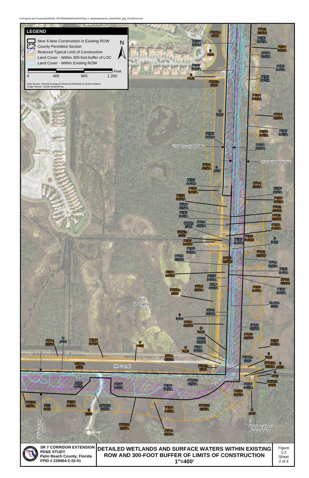
1.2 PROPOSED WETLAND IMPACTS
SFWMD, USACE, and the National Marine Fisheries Service (NMFS) approved all
wetland habitat delineation polygons, acreages, and the direct impact Uniform Mitigation
Assessment Method (UMAM) scores presented below for all habitats within the ROW
and 300-foot buffer on October 13, 2011. SFWMD approved the secondary impact
UMAM scores on July 9, 2013. USACE reviewed the secondary impact UMAM scores
on August 13, 2013, but would not approve them at that time. USACE noted that the
scores seemed reasonable and in accordance with other similar secondary wetland
impacts incurred in similar habitats, but indicated that scores would be formally
reviewed and approved during the permitting process. Meeting minutes for these two
agency coordination events are provided in Appendix B.
Wetland impacts were assessed within the Limits of Construction (LOC; direct impacts)
and within a 300-foot buffer zone of the LOC (secondary impacts). In order to properly
assess Functional Loss resulting from unavoidable wetland impacts, all wetlands within
the project LOC and 300-foot buffer area were categorized into two (2) wetland areas:
1) those occurring south of the M-Canal adjacent to the Pond Cypress Natural Area;
and 2) those occurring north of the M-Canal adjacent to Grassy Waters Preserve.
Secondary impact assessments were divided into two (2) distance increments (as
measured from the LOC): 1) a 0-50 feet increment; and 2) a 50-300 feet increment
within the buffer. These two increment distances were established with guidance from
the SFWMD and USACE based on a preliminary assessment of Functional Loss in a
300-foot buffer zone surrounding the existing two-lane roadway in Segment 1. As noted
above, SFWMD agreed to the increment categories. USACE stated that it was a
reasonable approach but would not formally approve it at this time.
The Recommended Alternative will result in approximately 52.9 acres of direct wetland
impact. An estimated 52.3 acres of wetland impact occurs within existing transportation
ROW. An additional approximate 0.6 acres occurs outside the ROW within the Pond
Cypress Natural Area (also referred to as Section 1 Mitigation Area). Approximately 70
percent of the proposed direct impact acreage will be to forested wetland habitats with
SFWMD Florida Land Use, Cover, and Forms Classification System (FLUCFCS) codes
6250A and 6250B. Figure 1-2 depicts the locations of all wetlands within the LOC and
300-foot buffer.

DETAILED WETLANDS AND SURFACE WATERS WITHIN EXISTINGROW AND 300-FOOT BUFFER OF LIMITS OF CONSTRUCTION
1"=400'
Figure1-2
Sheet1 of 4
G:\Projects and Proposals\000009_SR7\BG08\MitPlan\MXD\Fig1-2_detailedwetlands_withinROW_gda_20130510.mxd
SR 7 CORRIDOR EXTENSION PD&E STUDYPalm Beach County, FloridaFPID # 229664-2-22-01
60th Street
Pond CypressNatural Area
County Permitted SectionSFWMD: 50-05422-P
USACE: SAJ-2002-8273
M-Canal
264'
Co
unt
y R
OW
PFO3/46250A
U4110
PEM16410A
PFO36250B
PFO3/46250A
U4110
PEM16410A
U4110
PFO46250A
U4110
PEM16410A
PEM16410A
PFO36250A
U1210
U4110
U8100
PEM16410A
U4110
LEGEND
Data Source: Scheda Ecological Observed Wetlands & Surface WatersImage Source: Jacobs Engineering
±New 4-lane Construction in Existing ROW
County Permitted Section
Reduced Typical Limit of Construction
Land Cover - Within 300-foot buffer of LOC
Land Cover - Within Existing ROW
0 400 800 1,200Feet
DETAILED WETLANDS AND SURFACE WATERS WITHIN EXISTINGROW AND 300-FOOT BUFFER OF LIMITS OF CONSTRUCTION
1"=400'
Figure1-2
Sheet2 of 4
G:\Projects and Proposals\000009_SR7\BG08\MitPlan\MXD\Fig1-2_detailedwetlands_withinROW_gda_20130510.mxd
SR 7 CORRIDOR EXTENSION PD&E STUDYPalm Beach County, FloridaFPID # 229664-2-22-01
Pond CypressNatural Area
M-Canal
Ibis Preserve
120' County ROW
200' FDOT ROW
305'
Co
unt
y R
OW
PFO3/46250APEM1
6410APEM16410A
PEM16410A
PEM16410B
PFO46250A
U8100
PFO36250B
U7430
PABHx5100
PEM16410A
U7430
PEM16410B
PEM16410A
PEM16410A
PFO46250A
PUBHx5100
U4110
PEM16410A
PEM16410B
PEM16410A
PEM16410A
PEM16410A
PFO36250B
PABHx5100
PFO46250A
PEM16410A
U7430
PFO3/46250A
PFO36250B
PEM16410A
PFO46250A
PEM16410A
PEM16410A
PEM16410A
PEM16410A
PFO36250B
PEM16410A
PEM16410A
PFO46250A
PUBHx5100
PFO46250A
PFO46250A
PEM16410A
PFO36250B
PFO36250B
PEM16410A
PEM16410A
PUBHx5300
U8220
PFO3/46250A
PEM16410A
PEM16410A
PUBHx5300
PEM16410B
PEM16410A
PSS6172
U1210
PFO46250A
PEM16410A
PUBHx5300
U7440
PFO46250B
PFO36250B
PFO46250A
PUBHx5100
PEM16410A
PFO46250A
PEM16410A
PEM16410A
U4110
U7440
PFO3/46250A
PFO46250A
U8100
PFO46250A
PUBHx5100
PEM16410A
U7440
PFO3/46250A
PFO36250B
PFO36250B
U7440
PFO3/46250A
PEM16410A
PEM16410B
PFO36250B
U4110
PEM16410B
PABHx5100
U8100
PFO36250B
PEM16410B
LEGEND
Data Source: Scheda Ecological Observed Wetlands & Surface WatersImage Source: Jacobs Engineering
±New 4-lane Construction in Existing ROW
County Permitted Section
Reduced Typical Limit of Construction
Land Cover - Within 300-foot buffer of LOC
Land Cover - Within Existing ROW
0 400 800 1,200Feet

DETAILED WETLANDS AND SURFACE WATERS WITHIN EXISTINGROW AND 300-FOOT BUFFER OF LIMITS OF CONSTRUCTION
1"=400'
Figure1-2
Sheet3 of 4
G:\Projects and Proposals\000009_SR7\BG08\MitPlan\MXD\Fig1-2_detailedwetlands_withinROW_gda_20130510.mxd
SR 7 CORRIDOR EXTENSION PD&E STUDYPalm Beach County, FloridaFPID # 229664-2-22-01
Water Catchment Area(Grassy Waters Preserve)
120' County ROW
200' FDOT ROW
PFO36250B
U4110
PSS16172
U7430
PFO36250B
PABHx5100
PEM16410A
PFO46250A
PEM16410A
PFO46250A
PFO46250A
PEM16410A
PEM16410A
PEM16410A
PFO46250A
PFO46250A
U1330
U1310
PFO46250A
PFO36250B
PUBHx5300
PEM16410A
PEM16410A
PEM16410A
U4110
PFO46250A
PEM16410A
PUBHx5300
U7440
U1820
PEM16410A
PUBHx5300
U1820
U4110
PUBHx5300
PFO36250B
U4110
PFO36250B
PFO36250B
PEM16410A
PFO36250B
LEGEND
Data Source: Scheda Ecological Observed Wetlands & Surface WatersImage Source: Jacobs Engineering
±New 4-lane Construction in Existing ROW
County Permitted Section
Reduced Typical Limit of Construction
Land Cover - Within 300-foot buffer of LOC
Land Cover - Within Existing ROW
0 400 800 1,200Feet

DETAILED WETLANDS AND SURFACE WATERS WITHIN EXISTINGROW AND 300-FOOT BUFFER OF LIMITS OF CONSTRUCTION
1"=400'
Figure1-2
Sheet4 of 4
G:\Projects and Proposals\000009_SR7\BG08\MitPlan\MXD\Fig1-2_detailedwetlands_withinROW_gda_20130510.mxd
SR 7 CORRIDOR EXTENSION PD&E STUDYPalm Beach County, FloridaFPID # 229664-2-22-01
Northlake Boulevard (CR 809A)
Water Catchment Area(Grassy Waters Preserve)
120' County ROW
200' FDOT ROW
PFO46250A
U1330
PFO46250A
U8100
PSS16172
PABHx5100
PEM16410A
PSS16172
PSS16172
PSS16172
PSS16172
PSS16172
PEM16410A
PSS16172
PSS16172
U7430
PEM16410A
PSS16172
U7430
PFO46250A
PEM16410A
PEM16410A
PFO46250A
U7430
PEM16410A
PFO46250A
PEM16410A
U7430
U7430
U7430
PFO46250A
PEM16410A
U1820
U1330
PEM16410A
U4110
U1400
U8140
PFO1/34220
PFO46250A
U1820
PUBHx5300
PFO46250A
U1820
U8140
PFO46250A
PEM16410A
PEM16410A
U7440
U8330
PUBHx5300
PUBHx5300
U4110
U4110
U4110
PEM16410A
U4110
PUBHx5300
U7440
PSS6172
U7440
U7440
U1820
PSS16172
U7430
PSS16172
PSS16172
PSS16172
PEM16410A
U4110
PFO46250A
PEM16410A
PFO46250A
PEM16410A
U7440
U7440
PSS16250B
PFO46250A
PEM16410A
PFO46250A
LEGEND
Data Source: Scheda Ecological Observed Wetlands & Surface WatersImage Source: Jacobs Engineering
±New 4-lane Construction in Existing ROW
County Permitted Section
Reduced Typical Limit of Construction
Land Cover - Within 300-foot buffer of LOC
Land Cover - Within Existing ROW
0 400 800 1,200Feet
1-9
All the various wetland habitat types within the wetland areas were assessed for
compensatory mitigation requirements using UMAM (Chapter 62-345, F.A.C). All
observed habitats were grouped into the seven (7) categories listed in Table 1-1, shown
with their corresponding National Wetland Inventory (NWI) codes and FLUCFCS codes.
The herbaceous marsh and forested wetland habitats are further broken down by ‘A’
and ‘B’ subclassifications; ‘A’ represents wetlands with 0-25 percent exotics, while ‘B’
are wetlands dominated by exotics. Table 1-1 also lists the total wetland acreage within
the LOC south and north of the M-Canal, respectively, as well as the acreages and
UMAM Functional Loss resulting from proposed direct impacts to each wetland habitat
type. The recommended alternative’s direct wetland impact acreage and Functional
Loss within the Section 1 Mitigation Area, which encompasses the northernmost 544
acres of the Pond Cypress Natural Area, is also provided in Table 1-1.
Approximately 34.5 acres of direct wetland impact occur on County ROW (both north
and south of the M-Canal), and these impacts result in an estimated 22.6 units of
UMAM Functional Loss. Approximately 1.2 acres of direct wetland impact, resulting in
0.85 units of UMAM Functional Loss, occur on the cell tower parcel. The majority of the
cell tower parcel impacts occur in herbaceous marsh habitat (1.1 acres resulting in 0.8
UMAM Functional Loss units, compared to 0.1 acres of impact to forested wetlands
resulting in 0.05 UMAM Functional Loss units). Table 1-2 lists the total wetland impacts
and associated UMAM Functional Loss, by habitat type, within the County ROW. Note
that the wetland habitat acreage and corresponding FL occurring in the cell tower parcel
are included as County ROW in Table 1-2.
Approximately 16.6 acres of direct wetland impact occur on FDOT ROW, with an
estimated 10.1 units of corresponding UMAM Functional Loss. Table 1-3 lists the total
wetland impacts and associated UMAM Functional Loss, by habitat type, within the
FDOT ROW.
In addition, secondary impacts associated with the Recommended Alternative were
calculated and are estimated to be 21.6 units of Functional Loss. The results of the
secondary impact UMAM analysis for the 0-50 feet increment are presented in Table 1-
4; the secondary impact analysis results for the 50-300 feet increment are presented in
Table 1-5. Secondary impact UMAM Functional Loss for habitats in the 300-foot buffer
were approved by SFWMD and deemed reasonable by USACE during a meeting held
on August 13, 2013 (although USACE will not approve them until permit applications
are submitted).
The proposed roadway footprint that is located south of the M-Canal is within County
ROW. Therefore, all secondary wetland impacts associated with this portion of the

Current Condition
With Project
Current Condition
With Project
Current Condition
With Project
Freshwater Marshes - Native Dominated
PEM1 6410A 8.29 8 0 8 0 8 0 -0.80 6.63
Freshwater Marsh - Exotic Dominated
PEM1 6410B 0.00 - - - - - - - N/A
Mixed Shrubs - Exotic Dominated
PSS1 6172 0.00 - - - - - - - N/A
Hydric Pine - Native Dominated
PFO3/4 6250A 7.41 8 0 8 0 9 0 -0.83 6.18
Hydric Pine - Exotic Dominated
PFO3 6250B 0.96 5 0 7 0 7 0 -0.63 0.61
Vegetated Ditches PABHx 5100 0.00 - - - - - - - N/A
Channelized Canals - Unvegetated
PUBHx 5100 0.00 - - - - - - - N/A
Total 16.66 13.42
Current Condition
With Project
Current Condition
With Project
Current Condition
With Project
Freshwater Marshes - Native Dominated
PEM1 6410A 1.78 7 0 7 0 8 0 -0.73 1.31
Freshwater Marsh - Exotic Dominated
PEM1 6410B 1.08 7 0 6 0 5 0 -0.60 0.65
Mixed Shrubs - Exotic Dominated
PSS1 6172 14.31 5 0 5 0 4 0 -0.47 6.68
Hydric Pine - Native Dominated
PFO3/4 6250A 1.48 7 0 7 0 8 0 -0.73 1.09
Hydric Pine - Exotic Dominated
PFO3 6250B 12.24 7 0 6 0 4 0 -0.57 6.94
Vegetated Ditches PABHx 5100 4.77 8 0 7 0 7 0 -0.73 3.50
Channelized Canals - Unvegetated
PUBHx 5100 0.26 - - - - - - - N/A
Total 35.66 - 20.15
Current Condition
With Project
Current Condition
With Project
Current Condition
With Project
Freshwater Marshes - Native Dominated
PEM1 6410A 0.16 9 0 9 0 9 0 -0.90 0.14
Hydric Pine - Native Dominated
PFO3/4 6250A 0.43 9 0 9 0 9 0 -0.90 0.39
Total 0.59 0.53
34.10
* South of M‐Canal impacts include wetland acreage in the Cell Tower Parcel.** Total acreage north of M‐Canal represents only wetland impact acreage; impacts to channelized canal (M‐Canal) not included.A = habitats dominated by native vegetaton (less than 25% exotic coverage)B = Habitats dominated by exotic, nuisance vegetation.
Functional Loss (FL)
South of the M-Canal
Wetland TypeNWI
ClassificationFLUCFCS
CodeTotal Acres
Location and Landscape Support
Water EnvironmentCommunity Structure
DeltaFunctional Loss (FL)
North of the M-Canal
Wetland TypeNWI
ClassificationFLUCFCS
CodeTotal Acres
TOTAL DIRECT IMPACT FL =
Table 1-1. Approximate Direct Impact Acreages and Associated Functional Loss to Wetlands for Recommended Alternative
Within Section 1 Mitigation Area
Wetland TypeNWI
ClassificationFLUCFCS
CodeTotal Acres
Location and Landscape Support
Water EnvironmentCommunity Structure
DeltaFunctional Loss (FL)
Location and Landscape Support
Water EnvironmentCommunity Structure
Delta

South of the M-Canal
Current Condition
With Project
Current Condition
With Project
Current Condition
With Project
Freshwater Marshes - Native Dominated
PEM1 6410A 8.03 8 0 8 0 8 0 -0.80 6.42
Freshwater Marsh - Exotic Dominated
PEM1 6410B 0.00 - - - - - - - N/A
Mixed Shrubs - Exotic Dominated
PSS1 6172 0.00 - - - - - - - N/A
Hydric Pine - Native Dominated
PFO3/4 6250A 7.28 8 0 8 0 9 0 -0.83 6.07
Hydric Pine - Exotic Dominated
PFO3 6250B 0.96 5 0 7 0 7 0 -0.63 0.61
Vegetated Ditches PABHx 5100 0.00 - - - - - - - N/A
Channelized Canals - Unvegetated
PUBHx 5100 0.00 - - - - - - - N/A
Total 16.27 13.10
Current Condition
With Project
Current Condition
With Project
Current Condition
With Project
Freshwater Marshes - Native Dominated
PEM1 6410A 0.39 7 0 7 0 8 0 -0.73 0.29
Freshwater Marsh - Exotic Dominated
PEM1 6410B 0.17 7 0 6 0 5 0 -0.60 0.10
Mixed Shrubs - Exotic Dominated
PSS1 6172 9.93 5 0 5 0 4 0 -0.47 4.63
Hydric Pine - Native Dominated
PFO3/4 6250A 0.00 - - - - - - - N/A
Hydric Pine - Exotic Dominated
PFO3 6250B 7.42 7 0 6 0 4 0 -0.57 4.20
Vegetated Ditches PABHx 5100 1.52 8 0 7 0 7 0 -0.73 1.11
Channelized Canals - Unvegetated
PUBHx 5100 0.00 - - - - - - - N/A
Total 19.43 - 10.34
TOTAL DIRECT IMPACT FL = 23.44
* South of M-Canal impacts include wetland acreage in the Cell Tower Parcel. Does not include impacts outside County ROW in Section 1 Mitigation Area
Table 1-2. Approximate Direct Impact Acreages and Associated Functional Loss to Wetlands in County-Owned ROW
Wetland TypeNWI
ClassificationFLUCFCS
CodeTotal Acres
Location and Landscape Support
Water Environment
Community StructureDelta
Functional Loss (FL)
North of the M-Canal
Wetland TypeNWI
ClassificationFLUCFCS
CodeTotal Acres
Location and Landscape Support
Water Environment
Community StructureDelta
Functional Loss (FL)

South of the M-Canal
Current Condition
With Project
Current Condition
With Project
Current Condition
With Project
Freshwater Marshes - Native Dominated
PEM1 6410A 0.26 8 0 8 0 8 0 -0.80 0.21
Freshwater Marsh - Exotic Dominated
PEM1 6410B 0.00 - - - - - - - N/A
Mixed Shrubs - Exotic Dominated
PSS1 6172 0.00 - - - - - - - N/A
Hydric Pine - Native Dominated
PFO3/4 6250A 0.13 8 0 8 0 9 0 -0.83 0.11
Hydric Pine - Exotic Dominated
PFO3 6250B 0.00 - - - - - - - N/A
Vegetated Ditches PABHx 5100 0.00 - - - - - - - N/A
Channelized Canals - Unvegetated
PUBHx 5100 0.00 - - - - - - - N/A
Total 0.39 0.32
Current Condition
With Project
Current Condition
With Project
Current Condition
With Project
Freshwater Marshes - Native Dominated
PEM1 6410A 1.39 7 0 7 0 8 0 -0.73 1.02
Freshwater Marsh - Exotic Dominated
PEM1 6410B 0.91 7 0 6 0 5 0 -0.60 0.55
Mixed Shrubs - Exotic Dominated
PSS1 6172 4.38 5 0 5 0 4 0 -0.47 2.04
Hydric Pine - Native Dominated
PFO3/4 6250A 1.48 7 0 7 0 8 0 -0.73 1.09
Hydric Pine - Exotic Dominated
PFO3 6250B 4.82 7 0 6 0 4 0 -0.57 2.73
Vegetated Ditches PABHx 5100 3.25 8 0 7 0 7 0 -0.73 2.38
Channelized Canals - Unvegetated
PUBHx 5100 0.00 - - - - - - - N/A
Total 16.23 - 9.81
10.13
Location and Landscape Support
Water Environment
Community StructureDelta
Functional Loss (FL)
TOTAL DIRECT IMPACT FL =
Table 1-3. Approximate Direct Impact Acreages and Associated Functional Loss to Wetlands in FDOT ROW
Wetland TypeNWI
ClassificationFLUCFCS
CodeTotal Acres
Location and Landscape Support
Water Environment
Community StructureDelta
Functional Loss (FL)
North of the M-Canal
Wetland TypeNWI
ClassificationFLUCFCS
CodeTotal Acres

Current Condition
With Project
Current Condition
With Project
Current Condition
With Project
Freshwater Marshes - Native Dominated
PEM1 6410A 4.30 9 6 9 7 9 6 -0.27 1.15
Freshwater Marsh - Exotic Dominated
PEM1 6410B 0.00 - - - - - - - -
Mixed Shrubs - Exotic Dominated
PSS1 6172 0.00 - - - - - - - -
Hydric Pine - Native Dominated
PFO3/4 6250A 5.95 9 6 9 7 9 6 -0.27 1.59
Hydric Pine - Exotic Dominated
PFO3 6250B 0.19 5 0 7 0 7 0 -0.63 0.12
Vegetated Ditches PABHx 5100 0.00 - - - - - - - -
Total 10.44 2.85
Current Condition
With Project
Current Condition
With Project
Current Condition
With Project
Freshwater Marshes - Native Dominated
PEM1 6410A 1.22 7 4 7 5 8 5 -0.27 0.33
Freshwater Marsh - Exotic Dominated
PEM1 6410B 1.10 7 4 6 4 5 3 -0.23 0.26
Mixed Shrubs - Exotic Dominated
PSS1 6172 3.80 5 2 5 3 4 2 -0.23 0.89
Hydric Pine - Native Dominated
PFO3/4 6250A 2.25 7 4 7 5 8 5 -0.27 0.60
Hydric Pine - Exotic Dominated
PFO3 6250B 2.02 7 4 6 4 4 2 -0.23 0.47
Vegetated Ditches PABHx 5100 7.00 N/A N/A N/A N/A N/A N/A N/A -
Total 17.39 2.54
5.39TOTAL SECONDARY IMPACT FL (0-50 ft) =
North of the M-Canal
Wetland TypeNWI
ClassificationFLUCFCS
CodeTotal Acres
Location and Landscape Support
Water Environment Community Structure
DeltaFunctional Loss (FL)
N/A = The vegetated ditches will be filled and restored to herbaceous marsh as part of the on-site mitigation plan. Separate UMAMs will be conducted for all habitat types proposed for enhancement/restoration.
Table 1-4. Approximate Secondary Impact Acreages and Associated Functional Loss to Wetlands & Surface Waters Located 0-50 Feet from the Limits of Construction (Recommended Alternative)
South of the M-Canal
Wetland TypeNWI
ClassificationFLUCFCS
CodeTotal Acres
Location and Landscape Support
Water Environment Community Structure
DeltaFunctional Loss (FL)

Current Condition
With Project
Current Condition
With Project
Current Condition
With Project
Freshwater Marshes - Native Dominated
PEM1 6410A 13.86 9 7 9 8 9 7 -0.17 2.31
Freshwater Marsh - Exotic Dominated
PEM1 6410B 0.00 - - - - - - - -
Mixed Shrubs - Exotic Dominated
PSS1 6172 0.00 - - - - - - - -
Hydric Pine - Native Dominated
PFO3/4 6250A 13.47 9 8 9 8 9 8 -0.10 1.35
Hydric Pine - Exotic Dominated
PFO3 6250B 0.00 - - - - - - - -
Vegetated Ditches PABHx 5100 0.00 - - - - - - - -
Total 27.33 3.66
Current Condition
With Project
Current Condition
With Project
Current Condition
With Project
Freshwater Marshes - Native Dominated
PEM1 6410A 37.39 7 5 7 6 8 6 -0.17 6.23
Freshwater Marsh - Exotic Dominated
PEM1 6410B 3.60 7 5 6 5 5 4 -0.13 0.48
Mixed Shrubs - Exotic Dominated
PSS1 6172 5.85 5 4 5 4 4 3 -0.10 0.59
Hydric Pine - Native Dominated
PFO3/4 6250A 32.33 8 7 7 6 8 7 -0.10 3.23
Hydric Pine - Exotic Dominated
PFO3 6250B 12.85 7 6 6 5 4 3 -0.10 1.29
Vegetated Ditches PABHx 5100 1.58 N/A N/A N/A N/A N/A N/A N/A -
Total 93.60 11.81
Current Condition
With Project
Current Condition
With Project
Current Condition
With Project
Freshwater Marshes - Native Dominated
PEM1 6410A 2.14 9 7 9 8 9 7 -0.17 0.36
Hydric Pine - Native Dominated
PFO3/4 6250A 4.22 9 8 9 8 9 8 -0.10 0.42
Total 6.36 0.78
16.25
Table 1-5. Approximate Secondary Impact Acreages and Associated Functional Loss to Wetlands & Surface Waters Located 50-300 Feet from the Limits of Construction (Recommended Alternative)
TOTAL SECONDARY IMPACT FL (50-300 ft) =
North of the M-Canal
Wetland TypeNWI
ClassificationFLUCFCS
CodeTotal Acres
Location and Landscape Support
Water EnvironmentCommunity Structure
DeltaFunctional Loss (FL)
South of the M-Canal
Functional Loss (FL)
Total Acres
Location and Landscape Support
Water EnvironmentCommunity Structure
Delta
Water Environment
Wetland Type
Delta
FLUCFCS Code
NWI Classification
N/A = The vegetated ditches will be filled and restored to herbaceous marsh as part of the on-site mitigation plan. Separate UMAMs will be conducted for all habitat types proposed for enhancement/restoration.
Ibis Mitigation Area
Wetland TypeNWI
ClassificationFLUCFCS
CodeTotal Acres
Location and Landscape Support
Community Structure Functional
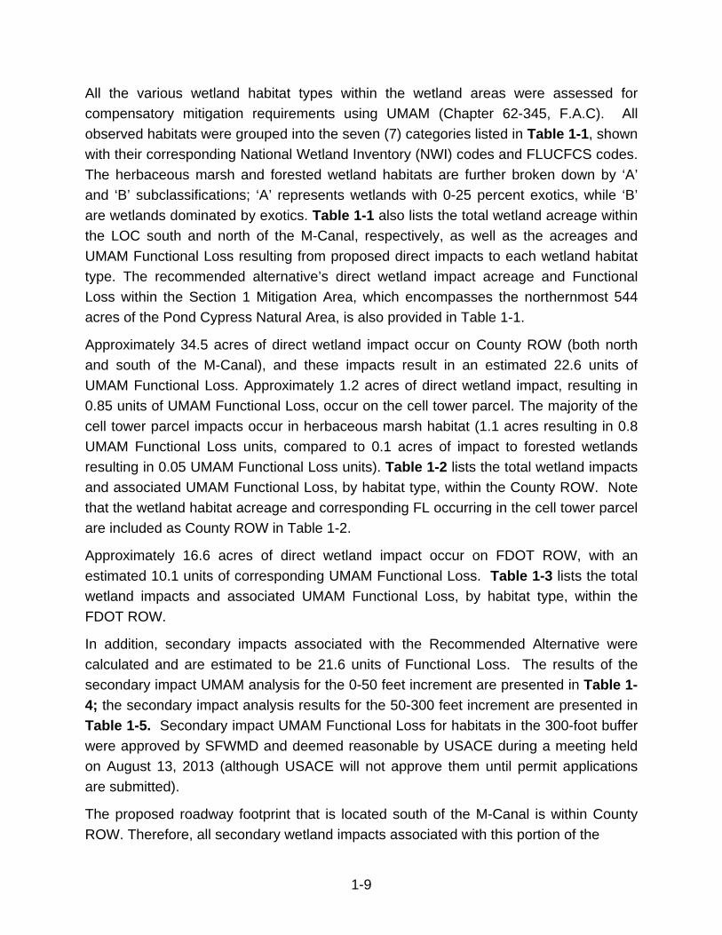
Loss (FL)

1-15
roadway corridor shall be attributed to the County. When the proposed roadway
footprint is completely within FDOT ROW, FDOT will be responsible for the secondary
wetland impacts. For the majority of the proposed roadway north of the M-Canal, the
proposed typical section shows a 150-foot wide LOC, with the westernmost 120 feet of
impact within the County ROW and the remaining 30 feet of impact within FDOT ROW.
This equates to 80 percent of the typical section width within County ROW, and 20
percent in FDOT ROW. Secondary wetland impacts associated with this portion of the
corridor will be divided accordingly, so that 80 percent of the impacts within the 300-foot
buffer are attributed to the County (0-240 feet from the LOC boundary) and 20 percent
are attributed to FDOT (240-300 feet from the LOC boundary). Both SFWMD and
USACE approved of this methodology for assigning responsibility to secondary wetland
impacts during a multi-agency meeting held on June 6, 2013. As shown in Table 1-6,
the County is responsible for 102.2 acres of secondary wetland impact equating to an
estimated 14.5 units of Functional Loss. FDOT will be responsible for 46.3 acres of
secondary wetland impact equating to an estimated 6.1 units of Functional Loss (Table
1-7). Mitigation scenarios that require a cumulative impact analysis are discussed in
more detail in Section 4.1.3. The NMFS has determined that none of the habitats
impacted by the project are within Essential Fish Habitat (EFH).
1.3 POTENTIAL WILDLIFE-RELATED IMPACTS
Potential impacts to general wildlife include direct loss of habitat, indirect effects to
remaining habitat, changes in patterns of movement, possible vehicle strikes, increases
in noise and nighttime light, and effects to food sources. Land use/land cover for areas
within the project ROW and LOC are shown in Table 1-8. Early project alternatives
utilized the entire available ROW and would have resulted in impacts to over 150 acres
of land area. Approximately 75.6 percent of this area consists of vegetated and
unvegetated wetlands (5000 and 6000 series), 15.6 percent of spoil mound (7000
series), 7.0 percent transportation (8000 series), and 2.1 percent upland forest (4000
series). The land area required for construction of the recommended alternative has
been reduced significantly, by approximately 50 percent. Impacts to native habitats
were also reduced substantially; upland forest impacts were reduced by 78 percent and
impacts to vegetated/unvegetated wetlands were reduced in excess of 50 percent.
Currently, the Ibis Mitigation Area is fenced and connectivity is limited for terrestrial
wildlife (such as medium to large mammals), and wetland species that commonly move
between wetlands (such as alligators). There is also a north-south fence along the
western County ROW north of the M-Canal. In addition, the existing water management
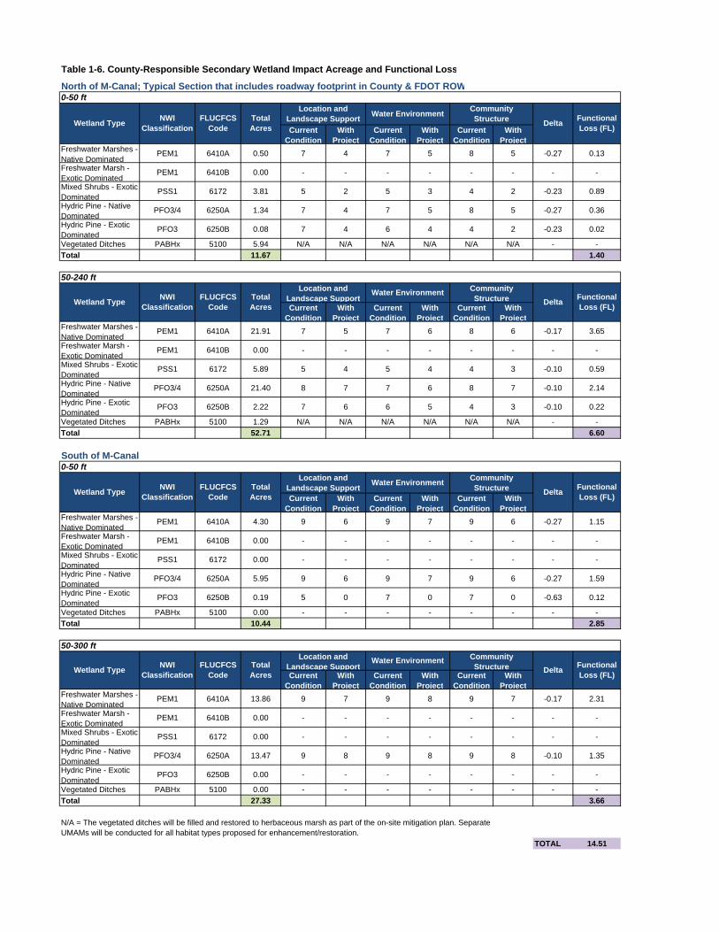
Table 1-6. County-Responsible Secondary Wetland Impact Acreage and Functional Loss
North of M-Canal; Typical Section that includes roadway footprint in County & FDOT ROW
Current Condition
With Project
Current Condition
With Project
Current Condition
With Project
Freshwater Marshes - Native Dominated
PEM1 6410A 0.50 7 4 7 5 8 5 -0.27 0.13
Freshwater Marsh - Exotic Dominated
PEM1 6410B 0.00 - - - - - - - -
Mixed Shrubs - Exotic Dominated
PSS1 6172 3.81 5 2 5 3 4 2 -0.23 0.89
Hydric Pine - Native Dominated
PFO3/4 6250A 1.34 7 4 7 5 8 5 -0.27 0.36
Hydric Pine - Exotic Dominated
PFO3 6250B 0.08 7 4 6 4 4 2 -0.23 0.02
Vegetated Ditches PABHx 5100 5.94 N/A N/A N/A N/A N/A N/A - -
Total 11.67 1.40
Current Condition
With Project
Current Condition
With Project
Current Condition
With Project
Freshwater Marshes - Native Dominated
PEM1 6410A 21.91 7 5 7 6 8 6 -0.17 3.65
Freshwater Marsh - Exotic Dominated
PEM1 6410B 0.00 - - - - - - - -
Mixed Shrubs - Exotic Dominated
PSS1 6172 5.89 5 4 5 4 4 3 -0.10 0.59
Hydric Pine - Native Dominated
PFO3/4 6250A 21.40 8 7 7 6 8 7 -0.10 2.14
Hydric Pine - Exotic Dominated
PFO3 6250B 2.22 7 6 6 5 4 3 -0.10 0.22
Vegetated Ditches PABHx 5100 1.29 N/A N/A N/A N/A N/A N/A - -
Total 52.71 6.60
South of M-Canal
Current Condition
With Project
Current Condition
With Project
Current Condition
With Project
Freshwater Marshes - Native Dominated
PEM1 6410A 4.30 9 6 9 7 9 6 -0.27 1.15
Freshwater Marsh - Exotic Dominated
PEM1 6410B 0.00 - - - - - - - -
Mixed Shrubs - Exotic Dominated
PSS1 6172 0.00 - - - - - - - -
Hydric Pine - Native Dominated
PFO3/4 6250A 5.95 9 6 9 7 9 6 -0.27 1.59
Hydric Pine - Exotic Dominated
PFO3 6250B 0.19 5 0 7 0 7 0 -0.63 0.12
Vegetated Ditches PABHx 5100 0.00 - - - - - - - -
Total 10.44 2.85
Current Condition
With Project
Current Condition
With Project
Current Condition
With Project
Freshwater Marshes - Native Dominated
PEM1 6410A 13.86 9 7 9 8 9 7 -0.17 2.31
Freshwater Marsh - Exotic Dominated
PEM1 6410B 0.00 - - - - - - - -
Mixed Shrubs - Exotic Dominated
PSS1 6172 0.00 - - - - - - - -
Hydric Pine - Native Dominated
PFO3/4 6250A 13.47 9 8 9 8 9 8 -0.10 1.35
Hydric Pine - Exotic Dominated
PFO3 6250B 0.00 - - - - - - - -
Vegetated Ditches PABHx 5100 0.00 - - - - - - - -
Total 27.33 3.66
TOTAL 14.51
Water Environment Community Structure Delta
Functional Loss (FL)
50-300 ft
0-50 ft
Wetland TypeNWI
ClassificationFLUCFCS
CodeTotal Acres
Location and Landscape Support
Water EnvironmentCommunity Structure Delta
Functional Loss (FL)
50-240 ft
Wetland TypeNWI
ClassificationFLUCFCS
CodeTotal Acres
Location and Landscape Support
Water Environment Community Structure Delta
Functional Loss (FL)
N/A = The vegetated ditches will be filled and restored to herbaceous marsh as part of the on-site mitigation plan. Separate UMAMs will be conducted for all habitat types proposed for enhancement/restoration.
0-50 ft
Wetland TypeNWI
ClassificationFLUCFCS
CodeTotal Acres
Location and Landscape Support
Water EnvironmentCommunity Structure Delta
Functional Loss (FL)
Wetland TypeNWI
ClassificationFLUCFCS
CodeTotal Acres
Location and Landscape Support
Table 1-7. FDOT-Responsible Secondary Wetland Impact Acreage and Functional Loss
Secondary Impacts for portion of roadway completely within FDOT ROW, North of M-Canal
Current Condition
With Project
Current Condition
With Project
Current Condition
With Project
Freshwater Marshes - Native Dominated
PEM1 6410A 0.48 7 4 7 5 8 5 -0.27 0.13
Freshwater Marsh - Exotic Dominated
PEM1 6410B 0.82 7 4 6 4 5 3 -0.23 0.19
Mixed Shrubs - Exotic Dominated
PSS1 6172 0.00 - - - - - - - -
Hydric Pine - Native Dominated
PFO3/4 6250A 0.48 7 4 7 5 8 5 -0.27 0.13
Hydric Pine - Exotic Dominated
PFO3 6250B 1.43 7 4 6 4 4 2 -0.23 0.33
Vegetated Ditches PABHx 5100 1.16 N/A N/A N/A N/A N/A N/A - -
Total 4.37 0.78
Current Condition
With Project
Current Condition
With Project
Current Condition
With Project
Freshwater Marshes - Native Dominated
PEM1 6410A 5.66 7 5 7 6 8 6 -0.17 0.94
Freshwater Marsh - Exotic Dominated
PEM1 6410B 3.58 7 5 6 5 5 4 -0.13 0.48
Mixed Shrubs - Exotic Dominated
PSS1 6172 0.00 - - - - - - - -
Hydric Pine - Native Dominated
PFO3/4 6250A 6.86 8 7 7 6 8 7 -0.10 0.69
Hydric Pine - Exotic Dominated
PFO3 6250B 8.45 7 6 6 5 4 3 -0.10 0.85
Vegetated Ditches PABHx 5100 0.29 N/A N/A N/A N/A N/A N/A - -
Total 24.84 2.95
Typical Section that includes roadway footprint in County & FDOT ROW
Current Condition
With Project
Current Condition
With Project
Current Condition
With Project
Freshwater Marshes - Native Dominated
PEM1 6410A 9.94 7 5 7 6 8 6 -0.17 1.66
Freshwater Marsh - Exotic Dominated
PEM1 6410B 0.00 - - - - - - - -
Mixed Shrubs - Exotic Dominated
PSS1 6172 0.00 - - - - - - - -
Hydric Pine - Native Dominated
PFO3/4 6250A 4.67 8 7 7 6 8 7 -0.10 0.47
Hydric Pine - Exotic Dominated
PFO3 6250B 2.21 7 6 6 5 4 3 -0.10 0.22
Vegetated Ditches PABHx 5100 0.29 N/A N/A N/A N/A N/A N/A - -
Total 17.11 2.34
TOTAL 6.08
DeltaFunctional Loss (FL)
50-300 ft
240-300 ft
Wetland TypeNWI
ClassificationFLUCFCS
CodeTotal Acres
Location and Landscape Support
Water Environment Community StructureDelta
Functional Loss (FL)
N/A = The vegetated ditches will be filled and restored to herbaceous marsh as part of the on-site mitigation plan. Separate UMAMs will be conducted for all habitat types proposed for enhancement/restoration.
Wetland TypeNWI
ClassificationFLUCFCS
CodeTotal Acres
Location and Landscape Support
Water Environment Community Structure
0-50 ft
Wetland TypeNWI
ClassificationFLUCFCS
CodeTotal Acres
Location and Landscape Support
Water Environment Community StructureDelta
Functional Loss (FL)

DESCRIPTION
NATIONAL WETLAND
INVENTORY CODE
AREA WITHIN EXISTING PROJECT ROW (Acres)
AREA WITHIN EXISTING
PROJECT ROW (%)
AREA WITHIN LOC OF REDUCED TYPICAL
SECTION (Acres)
AREA WITHIN LOC OF
REDUCED TYPICAL
SECTION (%)
PERCENT REDUCTION IN
AREA OF PROPOSED IMPACT
4110 Pine Flatwoods N/A 3.21 2.1 0.71 0.9 78%
Total 3.21 2.1 0.71 0.9 78%
5100Streams and Waterways (M Canal)
PUBHx 0.64 0.4 0.25 0.3 61%
5100Streams and Waterways (Vegetated Ditches)
PABHx 13.09 8.6 4.77 6.3 64%
Total 13.73 9.1 5.02 6.7 63%
6172 Mixed Wetland Shrub PSS1 23.85 15.7 14.31 19.0 40%
6250A Hydric Pine Flatwood PFO3/4 16.22 10.7 9.32 10.7 43%
6250B Hydric Pine Flatwood PFO3/4 14.26 9.4 13.20 17.5 7%
6250A Hydric Pine Flatwood PFO4 18.44 12.2 0.00 12.2 100%
6410A Freshwater Marsh PEM1 25.85 17.0 10.23 17.0 60%
6410B Freshwater Marsh PEM1 2.20 1.5 1.08 1.5 51%
Total 100.82 66.5 48.14 64.0 52%
7430 Spoil Mound N/A 23.15 15.7 13.56 15.7 41%
Total 23.15 15.3 13.56 18.0 41%
8100Utilities, Roads and Highways
N/A 10.74 7.0 7.84 7.0 27%
Total 10.74 7.0 7.84 7.0 27%
Totals 151.65 100.0 75.27 100.0 50%
PUBHx Palustrine, Unconsolidated Bottom with permanent hydrology, excavatedPABHx Palustrine, Aquatic Bed, permanently flooded, excavatedPSS1 Palustrine, scrub-shrub, with persistent vegetationPFO3 Palustrine, forested, with broad-leaved deciduous vegetationPFO3/4 Palustrine, forested, with broad-leaved/needle-leaved evergreen vegetationPFO4 Palustrine, forested, with needle-leaved evergreen vegetationPEM1 Palustrine, emergent marsh, with persistent vegetation
Table 1-8. Land Use / Land Cover (FLUCFCS) Within Project ROW Compared to Limits of Construction for Reduced Typical Section (Recommended Alternative)
80
00
: T
ran
spo
rta
tion
, C
om
mu
nic
atio
n,
Util
itie
s
70
00
: B
arr
en
L
an
d
FLUCFCS CODE
40
00
: U
pla
nd
F
ore
sts
50
00
: W
ate
r6
00
0:
We
tlan
ds
1-19
structure located just west of the corridor ROW provides the only M-Canal crossing
option for land-based wildlife. Wildlife utilization within the project LOC, particularly the
western alignment, is reduced due to the proliferation of exotic-dominated habitat that
provides minimal nesting and foraging habitat. In addition, upland berms inhibit aquatic
wildlife from moving between the project corridor and adjacent wetlands.
Impacts to specific wildlife species are discussed in the following sections.
1.3.1 Wood Stork Suitable Foraging Habitat (SFH)
The project occurs within the U.S. Fish and Wildlife Service (USFWS)-designated Core
Foraging Areas (CFA) of three wood stork colonies (Atlas #619220, 619315, and
Loxahatchee 1), all of which are considered to be currently active. During general
wildlife surveys, wood storks were observed foraging in wetlands within the project area.
The closest wood stork colony, #619220, is located approximately 2.9 miles east of the
project area. Using the USFWS wood stork biomass foraging assessment methodology,
it has been determined that an estimated 136.5 kilograms (kg) of long hydroperiod
wetland foraging biomass will be impacted by the proposed roadway (Appendix C). For
the analysis, all wetlands were considered habitat and were classified accordingly in the
spreadsheet. The hydroperiod of wetlands located north of the M-Canal was considered
Class 7, and wetland hydroperiod south of the M-Canal was considered Class 6. The
presence of nuisance and exotic species was accounted for in the analysis according to
the detailed wetland descriptions as presented in the Wetland Evaluation Report
prepared for this project.
1.3.2 Snail Kite Nesting and Foraging Habitat
Within the project area, herbaceous marsh (FLUCFCS 6410) provides the preferred
foraging habitat for the snail kite. Forested wetlands (FLUCFCS 6250) and wetland
shrub (FLUCFCS 6172) provide nesting, roosting, and perching habitat with some
foraging habitat (relatively lower quality compared to marshes). Upland forested habitat
(FLUCFCS 4110) and the vegetated berms (FLUCFCS 7430) also provide marginal
nesting, roosting, and perching habitat. Of the total herbaceous marsh acreage located
within the existing project ROW, 45 percent (or approximately 14.4 acres) occurs south
of the M-Canal. This habitat, which is adjacent to the Pond Cypress Natural Area, is
generally less suitable for snail kite foraging as compared to Grassy Waters Preserve.
Wetlands in the Pond Cypress Natural Area exhibit a more natural hydroperiod
fluctuation with extended periods of dry down during the dry season. During the wet
1-20
season, these marshes are shallower; the emergent vegetation within the marshes is
denser, and there is less open water. The remainder of the preferred marsh foraging
habitat (approximately 17.5 acres) occurs in the ROW north of the M-Canal, and is
situated to the west of known snail kite foraging and nesting areas within Grassy Waters
Preserve. Figure 1-3 shows the marsh habitats located within the existing ROW and
within the LOC for the recommended alternative.
The areas mapped as marsh vary in terms of vegetation type, vegetation density,
proliferation of exotics, water depth, and overall wetland size. Therefore, it is only a
subset of these marsh areas that meet appropriate depth, vegetation and size
characteristics as described in the published snail kite literature that should be deemed
‘optimal’ for snail kite foraging.
The marshes north of the M-Canal are intermixed with various-sized patches of forested
and shrub wetlands that are dominated by exotic/invasive species [including Brazilian
pepper (Schinus terebinthifolius), Australian pine (Casuarina equisetifolia), Carolina
willow (Salix caroliniana), and Melaleuca (Melaleuca quinquenervia), within former
hydric slash pine (Pinus elliottii)]. The forested and shrub wetlands north of the M-Canal
provide limited foraging habitat due to the dense coverage of exotics that inhibits flight
access by the snail kite. Linear ditches, berms, and some natural forested uplands also
occur north of the M-Canal. The linear ditches are too narrow and overgrown for snail
kite foraging, and too deep for the snail kite’s food source. The berms are infested with
exotic/nuisance vegetation and are typically not directly adjacent to the marshes,
therefore reducing their appropriateness as roosting, perching, and nesting habitat. The
forested and shrub wetlands and small area of forested uplands provide better perching,
roosting, and nesting habitat.
Snail kites have been previously documented over several years within natural areas
located to the east of the proposed project. The USFWS Draft Snail Kite Management
Guidelines (2006) outline Priority Management Areas for the snail kite; these areas are
located to the east of the project ROW, with the closest Priority Management Area being
approximately 4,605 feet to the east of the eastern FDOT rangeline ROW boundary.
These management areas coincide with long-term nesting locations.
The FDOT has conducted snail kite surveys during the nesting season in 2011, 2012,
2013 and 2014. In addition, the USFWS conducts its own annual snail kite surveys
throughout the Grassy Waters Preserve. In 2011, both FDOT and USFWS documented
three snail kite nests in an area of open marshes located between 332 feet and 744 feet
from the recommended alternative’s LOC (see table below). In 2010, USFWS surveys
identified one nest in this same area. The FDOT documented two snail kites in Grassy

Northlake Blvd
M-Canal
SR
-7
COMPARISON OF SNAIL KITE HABITAT WITHIN EXISTING ROW AND REDUCED TYPICAL LIMITS OF CONSTRUCTION
Figure1-3
G:\x\PROJECTS\000009_SR7\ESBA\2012\MXD\Fig6-6SnailKite_within_ROW_Comparison.mxd cs
SR 7 CORRIDOR EXTENSION PD&E STUDYPalm Beach County, FloridaFPID# 229664-2-22-01
Northlake Blvd
M-Canal
SR
-7
Small Habitat Fragments
LEGEND
Data Source: Scheda field-observed dataImage Source: 2009 black and white aerial 1ft
±
Existing ROW
6410A
6410B
0 1,250 2,500625Feet
1 in = 1,250 ft
LEGEND
Data Source: Scheda field-observed dataImage Source: 2009 black and white aerial 1ft
±0 1,250 2,500625Feet
1 in = 1,250 ft
Reduced Typical Limit of Construction
6410A
6410B

1-22
Waters Preserve to the east of the proposed construction corridor in 2012, however no
nests were observed. The closest nest observed by USWFS in 2012 was over a mile
away from the recommended alternative’s LOC. The FDOT documented no snail kites
or nests in the vicinity of the project during its 2013 survey. USFWS documented two
nests during 2013, each over a mile from the project corridor. During the 2014 FDOT
survey, snail kites were observed foraging and perching in marshes in the Ibis Mitigation
Area, Pond Cypress Natural Area, and in Grassy Waters Preserve; however no nests
were observed and no habitat utilization was documented within the project ROW. The
2014 nest data from USWS is not yet available.
Nest ID Year Feet From ROW Feet from LOC
GW 6 N10 2010 530 700
GW 2 N4 2011 162 332
GW 2 N5 2011 574 744
GW 2 N6 2011 530 700
Unknown 2012 7,000 7,170
GW 4 N1 2013 14,833 14,900
GW 5 N2 2013 7,140 7,310
The FDOT is seeking USFWS concurrence (through formal Section 7 Endangered
Species Act consultation) for an effects determination of “may affect, but not likely to
adversely affect” for the snail kite based on the above information and sufficiency of the
proposed mitigation plan. More detailed information on this assessment is located in the
Endangered Species Biological Assessment, prepared for this project under separate
cover.
1.3.2.1 Direct Impacts
Habitat
As shown previously in Table 1-1, impacts to marshes (FLUCFCS 6410) will occur as
follows:

1-23
8.45 acres of marsh (FLUCFCS 6410A) will be filled south of the M-Canal;
1.78 acres of marsh (FLUCFCS 6410A) will be filled north of the M-Canal; and
1.08 acres of exotic-dominated marsh (FLUCFCS 6410B) will be filled north of
the M-Canal.
These marsh areas total 11.31 acres.
Six years of biological field observations, along with anecdotal information from Palm
Beach County Environmental Resource Management (ERM) ecologists, indicate that
the marshes south of M-Canal are not favored by the snail kite. Observations of kites in
that area are rare, and the marshes dry down sooner in Pond Cypress Natural Area
than they do in Grassy Waters Preserve. In addition, they are shallower, and
occurrence of apple snails, the preferred food source, is only occasional. Therefore,
these marshes (8.45 acres) are considered suboptimal foraging habitat for the snail kite
at this time.
The marsh areas located within the LOC north of the M-Canal all have some level of
intrusion of exotic vegetation. Based upon field review of water depth and clarity and
vegetative condition, approximately 0.7 acres of the 2.86 acres located north of the M-
Canal are considered optimal snail kite foraging habitat. These areas have supported
healthy populations of apple snails during the course of the study, and are in the vicinity
of the area where snail kites have been known to nest east of the existing ROW. More
detailed information on known nesting locations is detailed within the Endangered
Species Biological Assessment prepared for this project.
Because open marshes are required for both foraging and nesting, they are considered
the primary habitat requirement for the snail kite. However, snail kites also use adjacent
and fringing habitats for perching/roosting, nesting, and some foraging. Approximately
13.72 acres of forested wetlands (FLUCFCS 6250) will be impacted north of the M-
Canal, and another 8.80 acres of forested wetlands south of the M-Canal. The majority
of the forested wetland habitat north of the M-Canal (12.24 acres, or 89 percent) is
exotic-dominated, which reduces its quality and desirability as nesting habitat. Only a
small proportion of the forested wetlands south of the M-Canal (0.96 acres, or 11
percent) are exotic-dominated. All of the forested wetland acreage can be considered
appropriate roosting/perching habitat.
Although 14.31 acres of exotic dominated mixed shrub (FLUCFCS 6172) will be filled
north of the M-Canal, this habitat is not conducive to either foraging or nesting due to
dense, nearly impenetrable coverage by exotic/nuisance species such as Brazilian
pepper. Roosting and perching can occur in this habitat. In addition, 4.77 acres of
1-24
vegetated ditches will be filled north of the M-Canal; however, these ditches are deep,
covered with aquatic vegetation, and overgrown to the point where they are not
accessible to the snail kite for foraging or nesting, with limited appropriateness for
roosting and perching.
The project team has worked to minimize impacts to wetlands throughout the course of
this study. To date, the following reductions have occurred through repeated refinement
of the project concepts and designs:
Impacts to marsh habitat reduced by 93%
Impacts to forested wetland reduced by 92%
Impacts to higher quality, native species dominated ‘A’ habitats reduced by 90%
Optimal versus suboptimal habitats for snail kite have been determined through:
Literature review;
Field review; and
Six (6) years of project-related observations.
Critical Habitat
There are no direct effects to any USFWS-designated snail kite critical habitat.
Priority Habitat
There are no direct impacts to USFWS-designated Priority Habitat Areas for the snail
kite.
Direct Injury and Mortality
In the existing condition, the potential for direct injury and mortality is relatively low,
although a two-lane County road (existing SR 7) does exist within the ROW north of the
M-Canal. Vehicular strikes could occur on this two-lane road, but they are unlikely
because there is no habitat to attract them to this portion of the existing ROW. Snail
kites have never been observed by project ecologists within the existing ROW or flying
over the existing ROW to access areas to the north of the County-owned ROW within
the Pond Cypress Natural Area, or to the west of the existing County and FDOT-owned
ROW north of the M-Canal; there is little suitable habitat nearby to attract them to the
existing ROW, or beyond it in these directions. In addition, substantial areas of habitat
located north of the M-Canal are dominated by thick stands of exotics, making them
virtually unusable to the snail kite. All in-flight snail kites have been observed within
Grassy Waters preserve, or flying to the east or north of Grassy Waters Preserve.

1-25
The proposed project does represent additional potential for direct injury and mortality,
or disturbance of nests, during both the construction and operation phases. During
construction, this potential will be minimized through use of the USFWS guidelines and
a project-specific construction protection plan that will prevent any direct effect to snail
kites and nests. According to the current USFWS Snail Kite Management Guidelines,
each time an active nest is discovered, two buffer zones are established: a no-entry
buffer zone (500-foot radius) and a limited activity buffer zone (1,640-foot radius).
Should nests be established within either of these buffer zones, the zones will be
established and demarcated in the field, and proper protocols will be followed by
construction personnel. The plan includes pre-construction nesting season surveys,
nesting season surveys during construction, daily monitoring of nests as required by the
guidelines, and implementation of a snail kite education plan for construction personnel.
In order to minimize the potential for vehicular strikes during the operation phase, the
following was considered:
Use of a vegetative buffer (tree/shrub combination) to force birds to fly up before
flying over the roadway; and
Designing roadside swales as dry swales so there will be no attraction for snail
kites to the roadway.
1.3.2.2 Indirect Effects
Degradation of Adjacent Wetlands
One potential indirect effect to the snail kite is degradation of the wetlands adjacent to
the direct impact area. For this project, wetland indirect impacts have been measured
by UMAM Functional Loss and are shown in Tables 1-4 and 1-5 within this document.
These wetland impacts will be mitigated appropriately. In addition, there will be no
change in hydrology in adjacent wetlands, as the stormwater design dictates that all
stormwater will be directed to the west and away from wetlands.
Indirect Effects to Water Quality and Apple Snails
Another potential indirect effect to the snail kite could result from negative effects to
water quality, which could affect both foraging success and the apple snail population.
As previously described, there will be no change in hydrology in adjacent wetlands. In
addition, the stormwater system has been designed to capture and contain all
contaminants that may be released from an accidental spill on the roadway. Within the
on-site mitigation area, indirect effects will be further prevented by lowering marsh areas

1-26
where appropriate to be more conducive to apple snails and controlling exotic and
nuisance plants.
Roadway Operation Potential Indirect Effects
The FDOT recognizes that roadway operation, resulting in additional lights and noise
may result in indirect effects to the snail kite. Therefore, the FDOT will coordinate the
final roadway lighting plan with USFWS. For vehicle headlights, the FDOT will consider
planning a vegetative buffer, using a higher screen on the bridge, and using fencing with
screening. With regard to vehicle noise, the criteria established in the Code of Federal
Regulations (23 CFR 772) applies only to areas of frequent human use and is not
intended for the application to wildlife impacts.
1.4 PROJECT COMMITMENTS
The FDOT agrees to make a commitment that construction of the project will not
commence until the USFWS is granted third party rights over the Rangeline properties
identified for conservation and mitigation from north of Okeechobee Blvd to the M-Canal
and from Northlake Blvd to Jupiter Farms. Further, the FDOT commits to establishing a
management endowment fund of $255,617.40 to the Palm Beach County ERM to cover
the costs associated with the long-term management of these Rangeline mitigation
properties. The funds will be placed in an escrow account during construction.
Coordination will continue between the FDOT, USFWS and ERM to finalize the limits of
jurisdiction between the environmental agencies.
For the Rangeline property from the M-canal to Northlake Blvd, a portion will be used for
transportation purposes and the remainder will be used for on-site wetland mitigation.
Further coordination will continue with the permitting agencies for future conservation.
We understand that the USFWS requested the establishment of the endowment fund
prior to issuance of the Biological Opinion. However, FDOT cannot release the
requested funds until environmental permits are issued. At this time, a commitment can
be made to update the work program to show proof of available funding.
Finally, the FDOT agrees to provide a post-construction report with details regarding
actual direct impacts to snail kite habitat. In addition, a five-year post-construction
monitoring program will be funded for the purpose of determining the extent of actual
indirect snail kite habitat impacts and if the project resulted in any harassment to kites.
The details of these post-construction actions will be determined during the permitting
phase of the project.

2-1
2.0 AVOIDANCE & MINIMIZATION OF IMPACTS
Both State and Federal regulatory requirements mandate consideration of the
elimination and reduction/avoidance and minimization of environmental impacts to the
maximum practicable extent. Remaining unavoidable impacts must be mitigated. The
FDOT has examined a variety of options to avoid and minimize impacts to wetlands,
surface waters, and protected species. The following sections detail wetland impact
avoidance and minimization options pursued in the selection of the current project
corridor, the recommended design alternative, and options that were determined to not
be feasible for incorporation into the project.
2.1 FEASIBLE OPTIONS INCORPORATED INTO THE PROJECT
Various opportunities for reducing wetland impacts have been considered during the
development of the recommended design alternative. Avoidance and minimization
measures to date include:
Reduction in the median width from 42 feet down to 22 feet from 60th Street to
Northlake Blvd (this is the minimum width allowed per FDOT design and safety
standards);
Reduction in the width of drainage treatment areas from 175 feet down to 38.5
feet;
Location of all stormwater outfalls to the west to existing stormwater systems,
rather than to the wetlands located within the Pond Cypress Natural Area or
Grassy Waters Preserve, to protect water quality in the natural areas;
Elimination of a proposed pond site located within the FDOT Rangeline ROW,
just south of the curve before the bridge over the M-Canal, due to the additional
associated wetland impacts and resulting bifurcation of the Pond Cypress Natural
Area and Grassy Waters Preserve;
Use of retained earth walls where feasible;
Removal of the shared used path on the east side of the roadway, replaced by
sidewalk;
Reduction of design speed and corresponding reduction in the bridge footprint
across the M-Canal resulting in less encroachment into the Pond Cypress
Natural Area (from 7.3 acres to approximately 0.6 acres);

2-2
Use of the existing SR 7 County road (between Northlake and the entrance to the
Ibis residential development) by placing the alignment as far west as possible;
Reduction of secondary impacts to wetlands in Grassy Waters Preserve by
placing the alignment as far west as possible;
Incorporation of on-site mitigation through enhancement, restoration, and
preservation of wetlands within the FDOT ROW north of the M-Canal that will
further reduce roadway-related secondary impacts on Grassy Waters Preserve;
Inclusion of wildlife fencing along the east and south sides of the corridor (north
and south of the M-canal, respectively) and wildlife crossings that will allow the
safe passage between Grassy Waters and the Ibis Mitigation Area; and
Incorporation of a minimal lighting scheme that will transition from the lights of
local residences east into the natural area.
Through these avoidance/minimization efforts, the following benefits will be realized:
Approximately 50% reduction in the typical section footprint (saves approximately
170 feet of ROW adjacent to the Grassy Waters Preserve that could be
designated as a conservation easement [the area within the ROW that would
remain untouched is approximately 56 acres]);
Approximately 56% reduction in impacts to total wetland impact acres;
Approximately 92% reduction in potential encroachment to the Pond Cypress
Natural Area;
Greatest reduction in wetland impact to occur within the native-dominated higher
quality marshes (approximately 87% impact reduction north of M-Canal) and
hydric pine (approximately 92% impact reduction north of M-Canal);
Reduced impact to preferred snail kite foraging habitat from nearly 10 acres to
approximately 0.7 acres (93% reduction);
Reduced median width to prevent widening to the inside, restricting the roadway
to only four lanes in the future. This represents an approximate 36% decrease in
direct wetland impacts, and therefore, eliminates impact to 40 acres of wetlands;
2-3
Part of FDOT’s mitigation plan is to enhance, restore, and preserve the
remaining Rangeline ROW adjacent to the Grassy Waters Preserve, an area
encompassing about 56 acres, and apply a conservation easement for the
unused portion of the ROW. This would prevent any future roadway widening to
the outside;
Reduced secondary impact acreage in Grassy Waters Preserve wetlands by
approximately 58% as a result of incorporating on-site mitigation (through
wetland restoration, enhancement, and preservation) on the easternmost
approximate 170-feet of FDOT ROW north of the M-Canal;
Minimized impacts to wildlife through sensitive structure design, use of
appropriate fencing (that includes slats installed at the bottom of the fence to
prevent small wildlife from passing through and reduce vehicular lighting
impacts), heightened barrier wall on the M-Canal bridge and approach, and
vegetated buffers to lessen the potential for vehicular strike impacts;
Construction of wildlife crossings at the M-Canal and the Ibis Mitigation Area
outfall structure that will allow wildlife connectivity between natural areas;
Improvement in the quality of wildlife foraging, roosting, and nesting habitat in 56-
acre on-site mitigation area, discussed in further detail is Section 3.1; and
Reduced unnecessary impact to wildlife through placement of the alignment as
far west as possible within the ROW, closest to existing development.
Secondary impacts to wetlands will also be reduced to the greatest extent practicable.
By shifting the alignment to the west, north of the M-Canal, the vast majority of
secondary impacts to wetlands now occur within FDOT ROW that will be used for
wetland creation and enhancement.
2.2 INCORPORATION OF THE LEAST DAMAGING PRACTICABLE ALTERNATIVE
Under the 40 CFR 230 Section 404(b)(1) guidelines, the USACE may only permit
discharges of dredged or fill material into waters of the United States that represent the
least environmentally damaging practicable alternative (LEDPA), so long as the
alternative does not have other significant adverse environmental consequences.
Furthermore, an alternative is considered practicable if it is available and capable of
being done after taking into consideration cost, existing technology, and logistics in light
of overall project purposes.

2-4
On the basis of the guidelines, all of the Build Alternatives dredge and fill sites are
specified as complying with the inclusion of appropriate and practical conditions to
minimize pollution or adverse effects to the aquatic ecosystem. The Recommended
Alternative is the LEDPA because it has the lowest overall environmental impact. The
proposed crossing alignment includes measures to minimize environmental and Section
4(f) impacts to the greatest extent possible. A complete description of the corridor
alternatives and selection process is provided in the Environmental Assessment,
prepared under separate cover. Figure 2-1 shows the locations of the four corridors
evaluated during the PD&E study.
The selection of the current corridor, Corridor 3, is a result of many years of study and
coordination with the environmental agencies and public. When the current PD&E
study began in 2005, the limits were confined to Northlake Blvd. The corridor selection
process involved considerable discussion from all stakeholders involved. The corridor
located to the west of Ibis (Corridor 1) would have resulted in significant impacts to the
community, including the potential for 107 residential property impacts and relocations
to Rustic Lakes and Ibis Golf & Country Club since the ROW along Corridor 1 would
need to be acquired. Corridors further to the west, such as Coconut Blvd, would have
resulted in even more community impacts with the potential for 192 residential property
impacts and relocations, and the division (or splitting) of neighborhoods within the
Acreage. Past suggestions have included locating the roadway within the canal
adjacent to 130th Avenue, including the use of a culvert to support the roadway.
However, culverts are typically used for perpendicular crossings for spans that range
from 3 to 12 feet. In this case, the culvert would be located underneath and parallel to
the roadway for a total distance of three miles. This distance is not practicable for a
culvert. In this case, a bridge structure would be more appropriate. However, the cost
for a three-mile bridge alone is approximately $183.9 million and not feasible. Corridors
further west, such as these, were previously evaluated in the past and discarded
through the coordination process. The benefit with Corridor 3 is that it minimizes
community impacts by avoiding ROW and relocation impacts and provides the best
alternative for avoiding adverse effects to wetlands and the natural environment by
wrapping around existing urban development. It also meets the project’s purpose and
need by enhancing the regional network given the proximity between the Florida’s
Turnpike and Seminole Pratt Whitney Road.
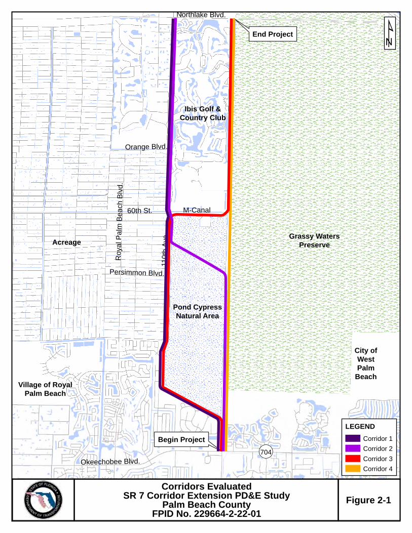
Village of RoyalPalm Beach
City ofWestPalm
Beach
End Project
Begin Project
Pond CypressNatural Area
M-Canal
Northlake Blvd.
110t
h A
ve.
Roy
al P
alm
Bea
ch B
lvd.
Persimmon Blvd.
60th St.
Okeechobee Blvd.
Grassy WatersPreserve
Orange Blvd.
¬«704
Acreage
Ibis Golf &Country Club
¹
LEGEND
Corridor 1
Corridor 2
Corridor 3
Corridor 4
Northlake Blvd.
110
thA
ve.
Roy
al P
alm
Bea
chB
lvd.
Persimmon Blvd.
60th St.
Okeechobee Blvd.
Sta
teR
oad
7
Southern Blvd.
Flo
rida
'sT
u rn p
ike
PGA Blvd.
Bee Line Hwy.
Sem
ino
l eP
ratt
Whi
tne y
Rd
.
Grassy WatersPreserve
Pond CypressNatural
Area
M-Canal
Orange Blvd.
¬«704
UV91
¬«80
¬«7
¬«710
Acreage
Ibis Golf &Country
Club
Village of RoyalPalm Beach
SR 7 Corridor Extension PD&E StudyProject Location Map
Figure 1
¹
Legend
Widen 2 to 4 lanes
New 4 lane construction
0 1 20.5Miles
Figure 2-1
Corridors EvaluatedSR 7 Corridor Extension PD&E Study
Palm Beach CountyFPID No. 229664-2-22-01
2-6
Previous studies, dating back to 1993, have been conducted that looked at broader
areas as far west as Seminole Pratt Whitney Road and as far north as Martin County.
Although these past studies were driven by the same purpose to improve system
linkage, the corridors were refined and modified as the limits changed. Ultimately, our
current study is focused on extending SR 7 to Northlake Blvd as directed by the Palm
Beach Metropolitan Planning Organization (MPO). In the past, corridors that went as
far west as Seminole Pratt Whitney Road and through the Acreage were analyzed and
discarded through agency workshops and input. Participants included federal and state
permitting agencies, Palm Beach County staff, and members from 1000 Friends of
Florida and the Audubon Society. The corridors that were further analyzed either went
along the western edge of the Ibis community or along the eastern edge between the
Ibis community and the Grassy Water Preserve.
The FDOT believes that significant steps and modifications have been made to the
proposed project within the selected corridor that minimizes adverse effects to the snail
kite. The proposed mitigation plan would benefit the snail kite by enhancing and
restoring 56 acres along the Grassy Waters Preserve (creating higher quality habitat for
the snail kite) and by converting lands currently identified for transportation purposes
into permanent conservation and habitat areas.
While the recommended Corridor Alternative does not have the least amount of wetland
impacts, the following still leads us to this alternative as the LEDPA because it:
best meets the project’s purpose and need, best complies with local government
plans, and minimizes impacts to other environmental resources resulting in the
least overall environmental impact;
avoids several environmental impacts which would occur with the selection of
other corridor alternatives;
avoids the bisection of natural areas which would occur with Corridors 2 and 4
(See EA document for locations of Corridors 2 & 4);
eliminates the risk of needing future connector roads through natural areas;
reduces the potential for relocations associated with Corridors 1 and 2;
• avoids crossing the M-Canal within the City of West Palm Beach’s ROW which is
protected under Special Laws of the Florida Legislature, Ch. 67-2169 (“the
Special Act”) associated with Corridor 1; and
• makes the best use of existing publicly owned ROW.
3-1
3.0 MITIGATION OPTIONS CONSIDERED
FDOT is committed to providing wetland mitigation to compensate for unavoidable
impacts and has evaluated various on- and off-site mitigation options that will provide
the best mitigation solution in terms of the complex wetland habitat assemblages being
proposed for impact. As shown in Table 3-1, fifteen (15) mitigation options were
considered for this project. Figure 3-1 shows the location of all mitigation options that
have been considered for this project. The following sections discuss the options
evaluated.
3.1 FEASIBLE ON-SITE MITIGATION OPTIONS
In this section, ‘on-site’ refers to the ROW available for the recommended alternative
between 60th Street and Northlake Blvd. The location of the on-site mitigation area is
shown in Figure 3-2.
3.1.1 Wetland Creation & Restoration
Within the easternmost 170 feet (typical) of FDOT ROW between Northlake Blvd and
the M-Canal (the unused portion of the ROW that encompasses approximately 56
acres), a previously excavated, linear vegetated ditch occurs that spans the majority of
the ROW (from north to south). Upland berms run parallel and adjacent to the ditch. The
ditch is relatively steep-sloped, typically 10-15 feet wide, and typically has over 4 feet of
water depth. It contains a mix of desirable native and exotic/nuisance vegetation
including maidencane (Panicum hemitomon), giant leather fern (Acrostichum
danaeifolium), and torpedograss (Panicum repens) transitioning to deeper water areas
of spadderdock (Nuphar luteum), floating heart (Nymphoides cristata), water lettuce
(Pistia stratiotes), and cattail (Typha spp.). Water flow is minimal, hence water quality is
relatively poor compared to surrounding wetlands. The berms consist of heavy
exotic/nuisance vegetation coverage. Brazilian pepper, Melaleuca, and Australian pine
are dominant. Wildlife utilization is limited and the exotic berm vegetation provides little
to no nesting habitat.
Approximately 8.3 acres of vegetated ditch habitat and 9.2 acres of upland berms occur
within the unused portion of the existing ROW. Wetland creation is planned through the
scrape down and removal of the berms to re-establish historic wetland elevation.
Similarly, wetland restoration will be accomplished by depositing the berm fill material
into the

SR 7 Extension PDE StudyFPID No. 229664-2-22-01Mitigation Options Table
5/15/2013
Table 3-1. Mitigation Options Summary (please print 11"x17")
Mitigation Site Project Description Owner Permit Nos.Cumulative Impact Analysis Needed Habitat Type
Potential Acreage Available
Potential Credits Available
SR 7 Di
SR 7 Di
SR 7 Es
SR 7 Estimated Total Functional Loss
Estimated Cost per Credit
USACE Credit Availability
Wood Stork Credit Availability
Snail Kite Habitat Suitability Comment
Herbaceous Marsh 100 22.32
Forested Wetlands 500 26.86
Herbaceous Unknown 501 22.32
Forested Wetlands Unknown 66 26.86
Herbaceous Marsh Unknown 22.32
Forested Wetlands Unknown 26.86
Herbaceous Marsh Unknown Unknown 22.32
Forested Wetlands Unknown Unknown 26.86
Herbaceous Marsh Unknown 58 22.32 $100,000
Forested Wetlands Unknown 24 26.86 $110,000
Herbaceous Marsh 154 51.3 22.32
Forested Wetlands 78* 26.0 26.86
Herbaceous Marsh TBD 2& 22.32
Forested Wetlands TBD 18& 26.86
Herbaceous Marsh 43.9 22.32
Forested Wetlands 23.6 26.86
Herbaceous Marsh 44.1 22.32
Forested Wetlands 52.0 26.86
Herbaceous Marsh 20.1a 8.6 22.32
Forested Wetlands 27.1a 5.2 26.86
Herbaceous Marsh 40.2 1.2 22.32
Herbaceous Marsh 28.8 0.0 22.32
Forested Wetlands 47.6 5.2 26.86
Herbaceous Marsh 20 22.32
Forested Wetlands 10 26.86
Herbaceous Marsh 22.32
Forested Wetlands 26.86
Herbaceous Marsh 2100** 667.0 22.32 Unknown
Wetland Restoration 2000# 280.0 26.86 Unknown
D = Direct impact acreage and functional loss includes impacts to the vegetated linear ditches (FLUCFCS 5100, NWI: PABHx)S = Estimated functional loss from secondary impacts is based on worst-case typical section impacts up to 300 ft from limit of construction line.
** = Existing wetland acreage available in the Vavrus-owned parcels per SFWMD FLUCCs data. The acreage will need to be ground-truthed for accuracy.# = Restoration acreage denotes the existing pasture land that is located in a corridor that could connect the JW Corbitt Management Area to the Loxahatchee Slough through Mecca Flowway.& = Approximate number of credits available. The exact number of credits for sale is currently being negotiated with the regulatory agencies.$ = Credits available once all phases of restoration are complete.a = Assumes that the existing ditches and uplands within the Rangeline will be restored to herbaceous marsh habitat. b = Parcel encompasses 337 acres. Approximately 77 acres are existing marsh, 100 acres existing forested wetlands that may have potential for enhancement. Approximately 25 acres of surface water ponds and 43 acres of upland pasture could be restored to wetland.
Treasure Coast Mitigation Bank
Rangeline (PGA Blvd to Jupiter Farms)
Transfer of land area to Palm Beach County for Preservation and Enhancement. Based on review of recent aerials, exotic control activites have routinely occured within the Rangeline. Therefore, the opportunity for enhancement activities may be limited. USACE does not view right-of-way preservation as mitigation.
FDOT N/A No Unknown TBD TBD Yes
YesSFWMD: 56-00004-M
ACOE: SAJ-2001-04445Private
Mitigation bank located in St. Lucie County. Bank is outside of service area and drainage basin. Credit availability listed as of October 2012. SFWMD recently froze the issuance of credits due to permit compliance issues.
Yes Yes Yes862500 Unknown
640 Unknown No TBDR.G. Reserve Mitigation
BankMitigation bank located in Martin County. Bank is outside of service area and drainage basin. Credit availability as of October 2012.
Private SFWMD: 43-00001-M
No ACOE PermitYes
No Unknown TBD TBD Yes
SFWMD: 50-08187-P ACOE permit pending
Palm Beach CountyPreviously constructed pine flatwood and wetland restoration area. As permitted, credits are to only be used for Palm Beach County projects. It is likely the site can only be used for impacts on Palm Beach County right-of-way. Credit availabity listed as of October 2012.
Pine Glades West PROMA
Rangeline (M-Canal to Northlake Blvd)
Preservation/enhancement of wetlands and restoration of uplands and ditches in the FDOT right-of-way directly adjacent to Grassy Waters Preserve that will not be impacted by the proposed roadway construction. A conservation easement can be placed over the area to ensure wetland persistence in perpetuity.
FDOT Not Yet Permitted
Yes
Yes; Approx 134.53 kg of wood stork
short hydroperiod credits and 1140.25 kg of long hydroperiod
credits.
Yes$86,250
Pine Glades North PROMA
Yes$86,250
Yes; following completion of earthwork in 2013, approx 15.87 kg
of short hydroperiod wood stork credits and 151.99 kg of long
hydroperiod credits.
Yes
TBD TBD Yes
615No
Yes
$32,500 Yes
Yes
NoTBDCity of West Palm
Beach
The City of West Palm Beach has previously conducted wetland restoration for mitigation credit in Grassy Waters. Additional restoration/enhancement is planned. The amount or acreage needing restoration/enhancement is currently unknown. Landowner currently seems unwilling to use site as mitigation for SR 7.
Grassy Waters Preserve
No; Pemitted prior to wood stork rule.
Mecca SloughPrevously permitted 353-acre wetland restoration site. The parcel contains approximately 2,000 acres of former agriculture land that can be restored to wetland.The permitted site plan can be modified to suit mitigation needs for SR 7 and may afford an opportunity for future FDOT projects.
Palm Beach CountySFWMD: 50-08699-P
ACOE: SAJ-2004-2859
Bluefield Ranch Mitigation Bank
Mitigation bank located in St. Lucie County. Bank is outside of service area and drainage basin. FDOT previously purchased 160 credits. Only 93.47 credits have been used, therefore 66.53 credits remain that are already paid for. Credit availability as of October 2012.
Private SFWMD: 56-00002-M
ACOE:SAJ-2000-02935Yes Unknown Yes
No; No certified wood stork credits.
Yes2600
Yes
Limited
Yes
Yes; Could be redesigned to create
more
Yes
Yes
Yes
Yes
* = The 78 acres of forested wetland acres available equals the permitted 28 acres of forest wetland restoration and the permitted 50-acre open water refugia that could be modified into a forested wetland restoration.
Loxahatchee Mitigation Bank
Mitigation bank located in Palm Beach County. Bank is within service area but outside of drainage basin. Bank may not have same assemblage of habitats as those being impacted. Mitigation credit availability listed as of October 2012.
SFWMD (operated by Tetra Tech)
FDEP: 140969-001 ACOE:SAJ-1997-07816
Preservation of existing wetland habitat within the Rangeline. Minor enhancement activities would enhance the overall wetland quality and landscape support of the surrounding wetland preserve areas. USACE does not view right-of-way preservation as mitigation.
FDOT N/A
No
No
No
No
No
SFWMD: 50-08231-P ACOE: SAJ-2007-04122
Palm Beach County
Previously constructed pine flatwood and wetland restoration area. As permitted, credits are to only be used for Palm Beach County projects. It is likely the site can only be used for impacts on Palm Beach County right-of-way. Credit availability is based on what is anticipated to be released following completion of earthwork in the 2013 dry season.
Vavrus Ranch
Large parcels that may be available for purchase. Restoration of pastureland or enhancement of existing wetlands are possible mitigation options. Utilization of northern portion may offer the most ecological benefit. All wetland jurisdictional lines on the property were previously established by USACE.
Private Not Yet Permitted N/A N/A
Parcel 20.04
Previously constructed wetland mitigation site owned by a private developer. Site is already built and functioning as a wetland; no lag time, no risk. Site directly abuts state-owned lands (Johnathan Dickinson State Park). The developer is looking for a sole-source buyer to purchase the portion of the site that is not needed as mitigation for previous impacts. Regulatory agencies are currently working on how to permit site bifurcation. Using this site may result in FDOT being the property owner which goes against FDOT's core missions. Donating the land to the State after purchase may be possible given its adjacency to state-owned lands.
Private SFWMD: 43-01374-P
ACOE: SAJ-2002-01929Unknown
TBDUnknown TBDRangeline (Okeechobee
Rd to M-Canal)Forested Wetlands 44.3 9.9 26.86
1872No
No; Pemitted prior to wood stork rule.
Yes
Dupuis
Nearly 22,000 acre management area. Serves as a FDOT ROMA for wetland impacts. As of October 2012, approximately 567 credits are available that FDOT previously funded. Site located outside of the project's drainage basin. May be more suitable to offset impacts associated with smaller projects that FDOT and the Turnpike Enterprise may have in the Work Program.
SFWMDAgreement between SFWMD and FDOT;
ACOE permit pendingYesUnknown
Unknown
Privately-owned parcels located on the southeast corner of PGA Blvd and SR 710. Mitigation through restoration of pasture land and borrow pits is possible. Site provides regional value given its location in relation to other protected areas. Using this site may result in FDOT being the property owner which goes against FDOT's core missions. FDOT would have to purchase land and arrange transfer of ownership to another entity (likely Palm Beach County).
Gentle Ben Ranch Unknown N/A N/A
May be Required (outside drainage basin)
337bNoNot Yet PermittedPrivate
Yes
Recent coordination between FDOT and Vavrus owners
resulted in no interest in the land owner's willingness to sell
all or portions of the land for mitigation purposes. This is no
longer a viable option.

Figure3-1
Pine GladesWest
Pine GladesNatural Area
TreeFarm
GentleBen Ranch
VavrusRanch
Mecca
PondCypressNatural
Area
GrassyWatersNatural
Preserve
LoxahatcheeMitigation Bank
Okeechobee Boulevard (SR 704)
Northlake Boulevard
Indiantown Road
PGABoulevard
Beeline Highway
Fede
ral H
ighw
ay
Flor
ida’
s Tu
rnpi
ke
Southern Boulevard (SR 80)
Inte
rsta
te 9
5
Atlantic Avenue
FDOT RangelinePGA Boulevard North
FDOT RangelineM-Canal to Northlake
FDOT RangelineOkeechobee to M-Canal
§̈95
DupuisReserve

Pine GladesNatural Area
Begin Project
End Project
Okeechobee Blvd. (SR 704)
PGA Blvd.
Bee Line Hwy.
Flo
rid
a's
Tu
rnp
ike
MARTIN COUNTY
PALM BEACH COUNTY
Pond CypressNatural
Area
Grassy WatersPreserve
!"#$95
Indiantown Rd.
Northlake Blvd.
Loxahatchee Slough
Natural Area
Sem
ino
le P
ratt
Wh
itn
ey R
d.
Approximately23 acres
Approximately67 acres
Approximately44 acres
Approximately56 acres
(on-site mitigation)
Approximately82 acres
Loxahatchee Slough
Natural Area
Loxahatchee Slough
Natural Area
Grassy WatersPreserve
J.W. Corbett Wildlife Management Area
Location map of Rangeline Segments and On-Site Mitigation Area Figure3-2
SR 7 CORRIDOR EXTENSION PD&E STUDYPalm Beach County, FloridaFPID # 229664-2-22-01
LEGEND
±NOT TO SCALE
SR 7 ExtensionPublic Conservation Land
Section 4(f) Mitigation
Snail Kite MitigationWetland MitigationPine Glades Natural Area
*Not Shown: Approximately 3 Credits potentially needed from Dupuis for wetland mitigation

3-5
adjacent vegetated ditch to restore historic wetland elevation. An estimated 9.0 acres of
exotic/nuisance species infested mixed shrub wetland (FLUCFCS 6172) occur near the
north end of the on-site restoration area. Restoration of forested wetland habitat is
proposed in this area through raising the ground elevation and planting native forest
wetland vegetation. The locations of all proposed wetland creation and restoration areas
are depicted in Figure 3-3. The target elevations shall match that of marshes and
forested wetlands in the adjacent Grassy Waters Preserve. With the exception of the
forested restoration areas which will be planted, the restored acreage would be allowed
to recolonize naturally with native vegetation and undergo exotic maintenance and
monitoring activities. UMAM Functional Gain, or ‘lift’, estimates resulting from the
proposed restoration activities will be coordinated with the regulatory agencies.
The wetland creation/restoration activities will not only provide an ecological benefit, but
will also benefit the functionality of the Grassy Waters Preserve as a source of, and filter
for, the City of West Palm Beach’s water supply. Removal of the upland berms will
increase the water storage capacity of Grassy Waters Preserve. By increasing wetland
habitat, more water will be filtered through the wetland vegetation, providing water
quality benefits to all water supply users.
3.1.2 Wetland Enhancement
The opportunity for wetland enhancement in the 170 feet (typical) of unused ROW
encompassing approximately 56 acres between the M-Canal and Northlake Blvd is
relatively great. Enhancement provides an ecological benefit by reducing and eventually
eliminating the exotic/nuisance vegetation seed source that is currently spreading into
the Grassy Waters Preserve. Enhancement efforts typically consist of the
mechanical/chemical removal of exotic/nuisance plant species occurring on-site, such
as Old World climbing fern (Lygodium microphyllum), air potato (Dioscorea bulbifera),
Brazilian pepper, Melaleuca, Australian pine, torpedo grass and numerous other
species listed by the Florida Exotic Pest Plant Council. Approximately 0.3 acres of
exotic-dominated marsh (FLUCFCS 6410B) and 0.7 acres of exotic-dominated forested
wetland (FLUCFCS 6250B) occur in the unused portion of the FDOT ROW. An
additional 11.5 acres of native-dominated marsh (FLUCFCS 6410A) and 16.9 acres of
native-dominated hydric pine (FLUCFCS 6250A) habitat are also present. The locations
of all proposed wetland enhancement areas are depicted in Figure 3-3. Enhancement
opportunity in the native dominated habitats is not as great as in the exotic-dominated
marshes/wetlands, but some ecological ‘lift’ potential is present. UMAM ‘lift’ estimates
resulting from the proposed enhancement activities will be coordinated with the
regulatory agencies.

Pond CypressNatural Area
M-Canal
Ibis Preserve
120' County ROW
200' FDOT ROW
305'
Co
unt
y R
OW
PFO3/46250APEM1
6410APEM16410A
PEM16410A
PEM16410B
PFO46250A
U8100
PFO36250B
U7430
PABHx5100
PEM16410A
U7430
PEM16410B
PEM16410A
PEM16410A
PFO46250A
PUBHx5100
U4110
PEM16410A
PEM16410B
PEM16410A
PEM16410A
PEM16410A
PFO36250B
PABHx5100
PFO46250A
PEM16410A
U7430
PFO3/46250A
PFO36250B
PEM16410A
PFO46250A
PEM16410A
PEM16410A
PEM16410A
PEM16410A
PFO36250B
PEM16410A
PEM16410A
PFO46250A
PUBHx5100
PFO46250A
PFO46250A
PFO46250A
PEM16410A
PFO36250B
PFO36250B
PEM16410A
PEM16410A
PUBHx5300
U8220
PFO3/46250A
PEM16410A
PEM16410A
PUBHx5300
PEM16410B
PEM16410A
PSS6172
U1210
PFO46250A
PEM16410A
U8100 PEM1
6410A
PUBHx5300
U7440
PFO46250B
PEM16410A
PFO36250B
PFO46250A
PUBHx5100
PEM16410A
PFO46250A
PFO46250A
PEM16410A
PEM16410A
PUBHx5300
U4110
PFO3/46250A
PEM16410A
U7440
PFO3/46250A
PFO46250A
PFO46250A
PFO46250A
PUBHx5100
PEM16410A
PFO46250A
PFO46250A
PFO46250A
U7440
PEM16410A
PFO3/46250A
PFO36250B
PFO36250B
U7440
PFO3/46250A
PEM16410A
PEM16410B
PFO36250B
U4110
PEM16410B
PABHx5100
U8100
PFO36250B
PEM16410B
POTENTIAL CREATION, ENHANCEMENT, AND RESTORATION AREAS MAP
1"=400'
Figure 3-2
Sheet1 of 3
G:\Projects and Proposals\002019\MXD\potential_enhance_restore_areas_B_gda_20130601.mxd GdA
SR 7 CORRIDOR EXTENSION PD&E STUDYPalm Beach County, FloridaFPID # 229664-2-22-01
LEGEND
Data Source: Scheda Ecological Observed Wetlands & Surface WatersImage Source: Jacobs Engineering
±
New 4-lane Construction in Existing ROW
County Permitted Section
Reduced Typical Limit of Construction
Land Cover - Within Existing ROW
Land Cover - Within 300-foot Buffer
Forested Enhancement Areas
Herbaceous Enhancement Areas
Restoration Areas
Wetland Creation
0 400 800 1,200Feet

Water Catchment Area(Grassy Waters Preserve)
120' County ROW
200' FDOT ROW
PSS16172
U7430
PFO36250B
PABHx5100
PEM16410A
PFO46250A
PEM16410A
PFO46250A
PFO46250A
PEM16410A
PEM16410A
PEM16410A
PFO46250A
PFO46250A
U1330
U1310
PFO46250A
PFO36250B
PUBHx5300
PEM16410A
PEM16410A
PEM16410A
U4110
PFO46250A
PEM16410A
PUBHx5300
U7440
U1820
PEM16410A
PUBHx5300
U1820
U4110
PUBHx5300
PFO36250B
U4110
PFO36250B
PFO36250B
PEM16410A
PFO36250B
POTENTIAL CREATION, ENHANCEMENT, AND RESTORATION AREAS MAP
1"=400'
Figure 3-2
Sheet2 of 3
G:\Projects and Proposals\002019\MXD\potential_enhance_restore_areas_B_gda_20130601.mxd GdA
SR 7 CORRIDOR EXTENSION PD&E STUDYPalm Beach County, FloridaFPID # 229664-2-22-01
LEGEND
Data Source: Scheda Ecological Observed Wetlands & Surface WatersImage Source: Jacobs Engineering
±
New 4-lane Construction in Existing ROW
County Permitted Section
Reduced Typical Limit of Construction
Land Cover - Within Existing ROW
Land Cover - Within 300-foot Buffer
Forested Enhancement Areas
Herbaceous Enhancement Areas
Restoration Areas
Wetland Creation
0 400 800 1,200Feet

Northlake Boulevard (CR 809A)
Water Catchment Area(Grassy Waters Preserve)
120' County ROW
200' FDOT ROW
PFO46250A
U8100
PSS16172
PABHx5100
PEM16410A
PSS16172
PSS16172
PSS16172
PSS16172
PSS16172
PEM16410A
PSS16172
PSS16172
U7430
PEM16410A
PSS16172
U7430
PFO46250A
PEM16410A
PEM16410A
PFO46250A
U7430
PEM16410A
PFO46250A
PEM16410A
U7430
U7430
U7430
PFO46250A
PEM16410A
U1820
U1330
PEM16410A
U4110
U1400
U8140
PFO1/34220
PFO46250A
U1820
U7400
PUBHx5300
PFO46250A
U1820
U8140
PFO46250A
PEM16410A
PEM16410A
U7440
U8330
PUBHx5300
PUBHx5300
U4110
U4110
U4110
PEM16410A
U4110
U7440
PSS6172
U7440
U4110
U7440
U1820
PSS16172
U7430
PSS16172
PSS16172
PSS16172
PEM16410A
U4110
PFO46250A
PEM16410A
PFO46250A
PEM16410A
U7440
U7440
PSS16250B
PFO46250A
PEM16410A
PFO46250A
POTENTIAL CREATION, ENHANCEMENT, AND RESTORATION AREAS MAP
1"=400'
Figure 3-2
Sheet3 of 3
G:\Projects and Proposals\002019\MXD\potential_enhance_restore_areas_B_gda_20130601.mxd GdA
SR 7 CORRIDOR EXTENSION PD&E STUDYPalm Beach County, FloridaFPID # 229664-2-22-01
LEGEND
Data Source: Scheda Ecological Observed Wetlands & Surface WatersImage Source: Jacobs Engineering
±
New 4-lane Construction in Existing ROWCounty Permitted SectionReduced Typical Limit of ConstructionLand Cover - Within Existing ROWLand Cover - Within 300-foot BufferForested Enhancement AreasHerbaceous Enhancement AreasRestoration AreasWetland Creation
0 400 800 1,200Feet

3-9
3.1.3 Wetland Preservation
Wetland preservation is usually best completed by placing the tract of wetlands under a
conservation easement, typically administered by a government entity such as the
Florida Department of Environmental Protection (FDEP) or Palm Beach County ERM,
which will preserve the land in its natural state in perpetuity. Preservation has limited
mitigation value in that it does not replace wetlands and wetland functions impacted or
lost. The USACE does not currently accept preservation as mitigation. SFWMD will
accept it, but with minimal ecological ‘lift’. Preservation is proposed at the request of
USFWS.
The swath of unused ROW, which totals an estimated 56 acres in the easternmost 170
feet (typical) of the corridor ROW between the M-Canal and Northlake Blvd, will be
placed under a conservation easement following completion of all restoration and
enhancement activities. The conservation easement serves two functions: 1) it ensures
that the wetlands are preserved in a ‘pristine’ (high quality, minimal coverage by
exotic/nuisance vegetation) state in perpetuity; and 2) provides assurance to the
regulatory agencies that no future expansion or widening of this SR 7 corridor will occur.
Third party rights will also be granted to the USFWS through a conservation easement.
FDOT will monitor/maintain the on-site mitigation area for five years per environmental
permit conditions. At that time (assuming that site is in compliance with permit
conditions), FDOT will pursue transfer of the area to another entity (potentially Palm
Beach County or the City of West Palm Beach).
3.2 FEASIBLE OFF-SITE MITIGATION OPTIONS
The following descriptions of off-site mitigation options are listed in order of preference
by the FDOT.
3.2.1 Permittee Responsible Off-site Mitigation Areas (PROMAs)
Three Permittee Responsible Off-site Mitigation Areas (PROMAs) are available for this
project: 1) Dupuis Reserve; 2) Pine Glades West; and 3) Pine Glades North. Through a
Joint Participation Agreement (JPA) executed in 1997, the FDOT contributed funds to
SFWMD for the purposes of ecological restoration of the Dupuis Reserve site in Martin
County. The FDOT is permitted to use this site for its wetland mitigation needs for all
FDOT projects that incur wetland impacts in Palm Beach and Martin Counties. Palm
Beach County owns and operates the Pine Glades West and North sites, where wetland
restoration activities have been completed and/or are planned across nearly 2500

3-10
acres. Both Pine Glades sites are permitted by the State and USACE. Mitigation is
reserved for County projects only. Because the County would be a co-applicant with
FDOT for this project, the FDOT would pursue mitigation for the wetland impacts that
occur within the County ROW at Pine Glades. Additional details about these PROMAs
are provided below.
Pine Glades
Palm Beach County has instituted a regionally significant mitigation plan for wetland
restoration within the Pine Glades West and Pine Glades North Mitigation Areas. Both
sites were permitted by the State (West: ERP No. 50-08187-P; North: ERP No. 50-
08231-P) and the USACE as PROMAs (West Permit No.:SAJ-2011-02278; North:
Permit No. SAJ-2007-04122). Both sites include extensive marsh wetlands, short and
long hydroperiod wetlands, forested wetlands (hydric pine and cypress stands) and
upland forests that provide foraging, roosting, nesting, feeding, and breeding habitat
necessary for wetland-dependent wildlife and listed species such as the wood stork and
snail kite. Both sites have approved wood stork foraging habitat mitigation credits. All
restoration activities at Pine Glades West have been completed and the wetland credit
ledger has been established. Restoration activities in Pine Glades North are still on-
going and current credit availability will not be finalized until restoration activities are
completed. Pine Glades North, in addition to having some natural depressions that are
deeper and contain deep water emergent marsh vegetation such as spatterdock and
water lily (Nymphaea odorata), contains a system of flow ways created during
restoration, and the littoral edges of the existing lakes have been greatly improved to
provide deep-water, emergent wetland habitats. As permitted, County projects resulting
in wetland impacts can mitigate for unavoidable impacts through the allocation of credits
at either Pine Glades site. The sites are only available for mitigation for County projects.
Therefore all direct wetland impacts on County ROW within the SR-7 project corridor
could be mitigated at Pine Glades. As described in Section 1.2, the majority of the
secondary wetland impacts could also be mitigated at Pine Glades because the majority
of the recommended alternative design footprint occurs on existing County-owned
ROW.
Both the SR 7 project corridor and the Pine Glades site are located within the SFWMD-
defined Loxahatchee River Cumulative Impact Basin. Therefore, because mitigation
would occur within the same basin under this option, the project would not result in
unacceptable adverse cumulative impacts to the basin in which the wetland impacts are
proposed (Rule 4.2.8, SFWMD Basis of Review). Both the project corridor and Pine

3-11
Glades are within the Loxahatchee watershed, therefore Pine Glades is a viable option
to offset project-derived wetland impacts.
Ecological ‘lift’ at both Pine Glades sites was calculated and permitted using UMAM.
Therefore the approved UMAM Functional Loss total at the impact site can be directly
compared to the credit ledgers of the Pine Glades sites to determine mitigation
quantities needed (1:1 ratio). A concurrent letter modification to deduct an estimated
37.9 functional units from the Pine Glades mitigation ledger would be submitted by the
applicant for wetland impacts associated with the County-owned portion of the project.
This accounts for an estimated 23.4 direct impact FL units and an estimated 14.5
secondary impact FL units. Federal herbaceous credit availability at Pine Glades West
is limited (only 0.19 credits remaining), therefore all mitigation would be directed to Pine
Glades North if possible. Herbaceous and forested wetland credit availability at the
North site far exceeds what is needed for the 37.9 UMAM Functional Loss units on the
County-owned portion of the project. Pine Glades currently has 287.96 kg of long
hydroperiod (Class 6) wood stork foraging habitat biomass ‘credits’ available. This value
is based on their current ledger (as of May 2014). The biomass credits available at Pine
Glades far exceed the proposed 136.5 kg of long hydroperiod (Class 6 and 7) impacts
to foraging biomass resulting from the project. Pine Glade’s federal permits required
that wood stork foraging habitat mitigation credits be deducted from a separate ledger
than wetland mitigation credits, therefore reducing the likelihood of “double-dipping”.
FDOT would seek to mitigate for direct and indirect wetland impacts at Pine Glades as
well as mitigate impacts to wood stork foraging habitat. Mitigation for impacts to snail
kite foraging, nesting, and roosting/perching habitat would be sought elsewhere,
however, the snail kite would benefit from the habitat restoration activities in the Pine
Glades PROMA sites.
Dupuis Reserve
The Dupuis Reserve PROMA site was established through a JPA between FDOT and
SFWMD in which FDOT contributed funds to SFWMD for ecological restoration. The
site is located in Martin County, however its service area includes all of Palm Beach
County. The SFWMD has completed activities necessary for the hydraulic and
hydrologic restoration of flows, to the ecological benefit of various freshwater wetland
habitat types including hydric pine flatwood, wet prairie, herbaceous marsh, shrub-scrub
and cypress domes. The application of either project-specific WRAP or UMAM to this
bank has proven difficult, and the SFWMD and USACE have allowed recent FDOT
projects to deduct acreage credits from the Dupuis Reserve bank ledger based on
acreage-based mitigation ratios. Originally 850 restoration acre-credits were
3-12
established. The FDOT currently has approximately 567 acre-credits available (66 for
forested wetlands and 501 for herbaceous marsh). Forested credits may be severely
limited or unavailable in the near future as a result of mitigation needs for other FDOT
projects. The site has approved wood stork foraging habitat credits. Dupuis is located
approximately 20 miles northwest of the project corridor and is outside the project’s
drainage basin. Therefore, if this site is pursued for compensatory mitigation, a
Cumulative Impact Analysis would be required to determine if adverse cumulative
impacts will result in the drainage basin. Additional details on this site are provided in
Section 4.4.
3.2.2 Enhancement and/or Preservation in the Rangelines
Rangeline from Okeechobee Blvd to the M-Canal
The SR 7 Rangeline located between Okeechobee Blvd and the M-Canal spans
approximately 3.4 miles and covers approximately 82 acres of predominantly wetland
habitat. As depicted in Figure 3-2, it is situated between the County owned and
operated Pond Cypress Natural Area (to the west) and Grassy Waters Preserve (to the
east; owned and operated by the City of West Palm Beach). The County has been
conducting exotic/nuisance species eradication and maintenance activities in the
Rangeline since 2008. Historically, thick concentrations of Melaleuca occurred in
patches, both in and adjacent to the Rangeline. These Melaleuca-infested areas have
since been treated, and maintained so that no area currently exhibits more than one
percent coverage by exotic/nuisance species.
Twelve areas, totaling approximately 22.4 acres, were identified within the Rangeline as
having contained extensive exotic/nuisance species coverage in the past (Appendix D).
Approximately 2.4 acres of thick exotic/nuisance cover occurred in historic herbaceous
marsh habitat, while 20.0 acres occurred in historic forested wetland. Relatively high
quality wetland habitat currently exists in these areas as a result of rigorous exotic
control activities.
FDOT would not intend to use this area for compensatory wetland mitigation. Instead,
FDOT would use this area to mitigate for the indirect impacts to snail kite foraging,
nesting, and roosting/perching habitat associated with the SR 7 Extension project.
Wetland habitats in this section of rangeline are native-dominated and consist of an
assemblage of forested wetlands intermixed with large expanses of relatively open
herbaceous marsh, providing both foraging and roosting/nesting habitat for the snail
kite. Hydroperiod is relatively longer (with greater water depths) on the east side of the

3-13
Pond Cypress Natural Area, including the Rangeline area, where surface water flow is
impeded by the upland berm and adjacent canal that separate Pond Cypress from the
Grassy Waters Preserve. Snail kites were repeatedly documented utilizing (foraging and
perching) wetland habitats within the Pond Cypress Natural Area during FDOT’s 2014
nesting season survey. Therefore, this area can be deemed appropriate compensation
for indirect impacts to snail kite habitat. As a condition of the environmental permits, the
FDOT would agree to transfer ownership of the Rangeline to the County. The County
would then preserve the Rangeline wetlands and continue its maintenance activities, in
perpetuity, ensuring the long-term proliferation of the wetland habitat.
Rangeline from Northlake Blvd to SR 710
Another portion of the SR 7 Rangeline spans approximately 1.9 miles from Northlake
Blvd north to SR 710 (See Figure 3-2). This section of Rangeline encompasses an
estimated 44 acres. Like the previous Rangeline section, a complex assemblage of
herbaceous marsh, forested wetland, and pine flatwoods is currently present. Large,
relatively open water marsh areas occur which is the preferred foraging habitat for snail
kites. Preliminary investigations of the area have shown that exotic vegetation is very
sparse (less than one percent cover) and the habitat within this section of Rangeline is
ideal for snail kite utilization (foraging, nesting, and roosting/perching). FDOT would not
use this area for compensatory wetland mitigation. Instead, FDOT would use this area
to mitigate for the direct impacts to snail kite foraging, nesting, and roosting/perching
habitat associated with the SR 7 Extension project. Permit conditions would be drafted
that will require the transfer of ownership from FDOT to the County for this section of
Rangeline. This would preserve the habitat in perpetuity and ensure that no roadway is
built connecting Northlake to SR 710 in this Rangeline segment.
Rangeline from PGA Blvd to Jupiter Farms
An additional portion of the SR 7 Rangeline spans from PGA Blvd north to 150th Court
North in Jupiter Farms, a distance of approximately 3.95 miles (See Figure 3-2). This
section of Rangeline contains 90.6 acres. The SFWMD C-18 Canal crosses the
Rangeline, effectively creating two sub-areas: a 23-acre portion located north of the
canal and a 67-acre portion located south of the canal. A complex assemblage of
herbaceous marsh, forested wetland, and pine flatwoods are currently present in both
sub-areas. Similar to the other section of Rangeline previously discussed, the County
has been conducting exotic/nuisance species eradication and control on this ROW,
without FDOT’s approval, since 2008. Current exotic coverage is less than one percent.
3-14
A total of 14 areas encompassing 10.3 acres were identified within the Rangeline as
having contained extensive exotic/nuisance species coverage in the past (Appendix D).
All the previous exotic/nuisance species infestation occurred within forested wetland
habitat. Relatively high quality forested habitat currently exists in these areas as a result
of rigorous exotic control activities.
The FDOT would not use this area for compensatory wetland mitigation. Instead, FDOT
would use the 67-acre sub-area located south of the C-18 Canal to mitigate for the
direct impacts to snail kite foraging, nesting, and perching/roosting habitat associated
with the SR 7 Extension project. The water levels, hydroperiod, and wetland habitat
assemblages in this area are optimal for snail kite utilization and would be ideal to
mitigate for snail kite habitat impacts.
The FDOT would use the 23-acre sub-area located north of the C-18 Canal to
compensate for the Section 4(f) impacts related to the 0.63 acres of direct wetland
impact in the Section 1 Mitigation Area. The FDOT understands that it would need to
demonstrate that the rationale for encroaching into the Pond Cypress Natural Area is in
the public’s interest and that all of the alternatives have been evaluated and all
avoidance and minimization efforts have been exhausted. Minimal encroachment is still
necessary to provide a safe crossing over the M-Canal. A sharper curve or T-
intersection could result in less encroachment but would be considered unsafe as these
options would not meet driver expectations by introducing a sudden change in
condition.
Prior to the Public Hearing, the amount of encroachment into the Pond Cypress Natural
Area was approximately 7.3 acres. Since the Public Hearing, the typical section has
been substantially reduced to the minimum acceptable FDOT standard for this type of
project. The design speed along the curve over the M-Canal was reduced from 45 MPH
to 40 MPH, also minimizing the project impact footprint. This reduced the amount of
encroachment into the Pond Cypress Natural Area by 92%. The new alternative now
only requires 0.63 acres of permanent structure. The proposed structure over the area
of encroachment will be elevated to minimize the amount of fill over existing wetlands
(consisting of freshwater marsh and hydric pine) and to allow for wildlife connectivity.
This vertical alignment will be reflected in the formal project commitments.
Encroaching into the Pond Cypress Natural Area is in the public’s interest as it would
provide for a roadway that meets the minimum safety standards and would have a
beneficial effect to existing conservation lands since FDOT is willing to transfer
ownership of the Rangeline ROW north of PGA Blvd. This strip of ROW bifurcates the
Loxahatchee Slough. Preserving this ROW for conservation purposes is in the public’s

3-15
interest as it would protect the Loxahatchee Slough by prohibiting any future extension
north of PGA Blvd. The wetland habitats in this area are of similar or better
quality/functionality compared to the impacted Section 1 Mitigation Area wetlands.
Permit conditions will be drafted that will require the transfer of ownership from FDOT to
the County for this section of Rangeline. This will preserve the wetlands in perpetuity
and ensure that no roadway is built.
For all these Rangeline sections, the FDOT would transfer ownership to the County and
create an agreement to establish site-specific management funds to ensure the
perpetual maintenance and preservation of the lands (as described in Section 1.4). The
County currently has approved management plans for many of its existing natural
areas. As an example, the management plan for the Pond Cypress Natural Area is
provided in Appendix E. New plans would either be drafted for the Rangeline areas or,
in the case of Pond Cypress, the approved management plan would likely be amended
to include the Rangeline section between Okeechobee Blvd and the M-Canal.
3.2.3 Mitigation Banks
Per Florida Statute (F.S.) Chapter 373.4136(6)(d)(2), linear transportation projects are
allowed to use a mitigation bank regardless of whether a specified project is within the
bank’s permitted service area, as long as the mitigation provided by the bank is
sufficient to offset all direct, secondary and cumulative effects to the applicable regional
watershed. This is the general preference of the Federal agencies
(USACE/NMFS/FHWA) as well.
Bluefield Ranch Mitigation Bank
The Bluefield Ranch Mitigation Bank (BRMB), located in St. Lucie County, has a service
area that does not extend into Palm Beach County. It was established by SFWMD
Permit No. 56-00002-M and USACE Permit No. SAJ-2000-02935 using Wetland Rapid
Assessment Procedure (WRAP) methodology. An estimated 100 herbaceous marsh
and 500 forested wetland credits are available. The FDOT previously purchased 165
credits, of which 71.53 are available for use. The bank is located outside of the project’s
drainage basin and outside of the CFAs for three wood stork nesting colonies that affect
the project. BRMB offers suitable habitat to offset impacts to snail kite nesting/foraging
habitat. Although the use of BRMB is potentially viable for this project, it was not
pursued further due to the availability of other mitigation banking options closer to the
project and type of mitigation required.
3-16
R.G. Reserve Mitigation Bank
The R.G. Reserve Mitigation Bank, in Martin County, was established by SFWMD
permit (Permit No. 43-00001-M). It was not permitted through the USACE. The bank
was permitted using WRAP methodology. The bank does not offer approved wood stork
foraging habitat credits but does have suitable habitat to offset impacts to snail kite
nesting/foraging habitat. The project is outside the bank’s service area and the bank is
outside of the C-18 drainage basin. Several constraints prohibit the use of this bank as
a mitigation option for this project. The bank currently has only 20 herbaceous marsh
and 10 forested wetland credits available for use. There are various regulatory
compliance issues (e.g., lack of completion of improvements necessary to facilitate
future credit release) which must be addressed prior to SFWMD authorizing their lease
of future credits. The FDOT has no previously purchased credits available for use.
Additionally, this bank does not have a Mitigation Banking Instrument, which would
allow it to sell federal (USACE) mitigation credits (i.e., only state mitigation credits were
previously sold). This bank is not a viable mitigation option for this project.
Treasure Coast Mitigation Bank
The Treasure Coast Mitigation Bank (TCMB) in St. Lucie County was permitted by the
SFWMD and USACE (Permit Nos. 56-00004-M and SAJ-2001-04445, respectively)
using WRAP methodology. Lands being restored to their historic condition include
mixed cypress forest, mixed forested wetlands and freshwater marshes. A total of 86
wetland credits are currently available. The FDOT previously purchased 30 freshwater
forested credits that have yet to be allocated to a project. The bank is outside the
project’s drainage basin and outside of the CFAs of the three wood stork nesting
colonies that affect the project. TCMB offers suitable habitat to offset impacts to snail
kite nesting/foraging habitat. Although the use of TCMB is potentially viable for this
project, it was not pursued further due to the availability of alternative mitigation bank
options closer to the project and type of mitigation required.
Loxahatchee Mitigation Bank
Loxahatchee Mitigation Bank (LMB), located in Palm Beach County, is an approved
wetland mitigation bank permitted by the FDEP (Permit No. 140969-001) and USACE
(Permit No. SAJ-1997-07816). The SR 7 Extension project corridor is within LMB’s
State and Federal service area boundaries. This bank was permitted using the Wetland
Rapid Assessment Protocol (WRAP). A minimum of 58 herbaceous and 24 forested
wetland credits are currently available. The FDOT previously purchased nine credits
(three forested and six herbaceous) that have yet to be allocated to a project. LMB has
been approved by USFWS to provide wood stork foraging habitat credits and is within

3-17
two of the CFAs for a wood stork nesting colonies that affect the project. LMB offers
suitable habitat to offset impacts to snail kite nesting/foraging habitat.
If used, a letter of credit reservation would be required from LMB prior to the regulatory
agencies issuing any final permits. The SFWMD has expressed concern that the bank
does not provide the habitat complexity or similar assemblages of wetland habitats as
those being impacted. Also, LMB does not offer hydric pine habitat credits. LMB offers
limited deep, open water herbaceous marsh habitat suitable to offset impacts to snail
kite foraging habitat. Of the four mitigation banking options explored, LMB is the most
viable due to its location and the project being within the service area.
3.3 OFF-SITE MITIGATION OPTIONS CONSIDERED BUT NOT PURSUED DUE TO LACK OF FEASIBILITY
Many of the off-site mitigation options deemed non-feasible by the FDOT involve the
purchase of private land in order to conduct wetland mitigation through restoration
and/or enhancement. It is not in the best interest of the FDOT, nor is it in their mission,
to acquire land solely for the purpose of mitigation. The FDOT has many legal
constraints in purchasing private property for public works projects. State statutes and
regulations, as well as federal laws and policies govern the process by which ROW can
be purchased or otherwise acquired from existing property owners. As part of
demonstrating public purpose and necessity under federal policies and F.S. Chapter
337.273(5), the FDOT cannot acquire more property than it needs for the construction
of roadway, stormwater management facilities and appurtenant transportation-related
facilities.
3.3.1 Gentle Ben Ranch
Gentle Ben Ranch consists of two privately-owned parcels totaling over 337 acres
located near the southeast quadrant of the intersection of PGA Blvd and SR 710. Site
parcels contain a complex mixture of upland pasture, marsh, forested wetland, and pine
flatwoods. Approximately 77 acres are existing marsh. Approximately 100 acres are
existing forested wetlands that have enhancement potential. Wetland restoration
opportunities are available through filling over 25 acres of existing ponds or scraping
down over 43 acres of existing upland pasture. The site provides regional value given
its location in relation to other protected areas (Loxahatchee Slough Natural Area,
Grassy Waters Preserve). The property owner did not respond to any of FDOT’s
attempts to make contact; therefore, it was determined that this site is not a viable
mitigation option.

3-18
3.3.2 Grassy Waters Preserve
The City of West Palm Beach has previously conducted wetland restoration and
enhancement activities for mitigation credit in the adjacent Grassy Waters Preserve. In
fact, recent restoration activities have encroached into the FDOT ROW. Additional
restoration/enhancement is planned but it is uncertain if these activities are funded.
Acreage targeted for restoration/enhancement is currently unknown. The Grassy
Waters Preserve is owned and operated by the City of West Palm Beach, which is
currently opposing the SR 7 Extension project. The Grassy Waters Preserve managers
have expressed no interest in using this site for mitigation for the SR 7 Extension
project. Hence, it is not currently a viable mitigation option.
3.3.3 Mecca Slough
The Mecca Slough site is a previously permitted 353-acre wetland restoration site (ERP
No. 50-08699-P, USACE Permit No. SAJ-2004-2859) owned by the County. The site
was never constructed due to lack of funds. The parcel contains approximately 2,000
acres of former agriculture land that can be restored to wetland. The permitted
restoration plan consisted of creation of forested wetland, marsh, and open water refuge
habitats. The permitted habitat assemblage did not meet this project’s mitigation needs,
but the restoration design could have been modified to include more suitable foraging
habitat for snail kites and wood storks. The FDOT explored the idea of either purchasing
the land or funding the restoration work through a partnering agreement with the
County. In 2012, the SFWMD announced that it planned to purchase the site. The
SFWMD is currently negotiating the terms of purchase for the site with the County and
has expressed no interest in using the site as mitigation. Therefore, the site is no longer
a viable mitigation option.
3.3.4 Parcel 20.04
Parcel 20.04 is a previously constructed wetland mitigation site owned and maintained
by a private developer. The site was permitted by SFWMD and USACE (ERP No. 43-
01374-P; USACE Permit No. SAJ-2002-01929) and is located in southern Martin
County within the Loxahatchee River Cumulative Impact Basin. It is currently resolving
some compliance issues with the regulatory agencies. It is anticipated that two
herbaceous marsh and 18 forested wetland credits would be available for FDOT to use.
The FDOT would be required to purchase the land and be responsible for the
maintenance in perpetuity. The private developer recently found another buyer/user for
the available credits. Therefore, the site is no longer a viable mitigation option.

3-19
3.3.5 Vavrus Ranch
The Vavrus site is a privately-owned, large tract of land encompassing thousands of
acres. It contains a complex assemblage of upland pasture, marsh, forested wetland,
and pine flatwood habitats. Wetland mitigation potential is possible through habitat
enhancement, restoration, and creating a greenway/flow way that would connect two
adjacent large County-owned conservation areas. The Vavrus land was sold in October
2012 to private developers. The new owners have not expressed interest in developing
the property as a mitigation bank.
4-1
4.0 MITIGATION SELECTED/PROPOSED MITIGATION
4.1 WETLANDS
4.1.1 Pine Glades North PROMA
The portion of Segment 2 located south of the M-Canal is completely within County
ROW. For most of the corridor located north of the M-Canal, County ROW
encompasses the western 120 feet of the total 320-foot wide ROW. The cell tower
parcel has also been included in the County ROW. The estimated 35.7 acres of
unavoidable direct wetland impacts in these areas, resulting in 23.4 units of UMAM
Functional Loss, will be mitigated at the Pine Glades North Site. Table 1-2 lists the total
wetland impacts and associated UMAM Functional Loss, by habitat type, within the
County-owned ROW.
Because the Pine Glades North site was permitted using UMAM, the amount of
mitigation credits required equals the Functional Loss units: 6.8 herbaceous marsh
credits, 15.5 forested wetland credits, and an additional 1.1 deep water herbaceous
marsh credits (in-kind mitigation for the vegetated ditch impacts) for direct impacts.
Functional Loss from secondary impacts was estimated at 7.2 units for herbaceous
marshes and 7.3 for forested wetlands (total of 14.5 units). Pine Glades North currently
has 43.9 Federal herbaceous marsh credits and 23.6 forested wetland credits available,
far exceeding the estimated need of this proposed project.
The Pine Glades North site currently provides long hydroperiod (Class 6) wood stork
biomass credits accommodating 287.96 kg of foraging biomass. This value is based on
their current ledger (up-to-date as of March 2014). An estimated 136.5 kg of long
hydroperiod (Class 6 and 7) wood stork foraging biomass will be impacted by the
proposed project. Therefore, the Pine Glades site has more than enough wood stork
foraging biomass credits to meet the needs of this project.
A concurrent letter modification to deduct the estimated 37.9 functional units from the
Pine Glades wetland mitigation ledger and 136.5 kg of foraging biomass from the wood
stork foraging habitat credit ledger will be submitted by the applicant for the impacts
associated with the County-owned portion of the project. Please note that no mitigation
for impacts to snail kite foraging, nesting, or roosting/perching habitat is being sought at
Pine Glades.

4-2
4.1.2 On-Site Mitigation
The easternmost 170 feet (typical) of the FDOT-owned ROW between the M-Canal and
Northlake Blvd is being set aside for mitigation, which will conducted in four phases: 1)
wetland creation and restoration through the removal and scrape down of berm and
filling of a ditch; 2) forested wetland restoration through the removal of dense
exotic/nuisance vegetation and modification of the existing mixed-shrub wetland’s
ground level elevation; 3) wetland enhancement through eradication and control of
exotic/nuisance species; and 4) preservation through placing the entire mitigation area
under a conservation easement ensuring wetland proliferation in perpetuity.
Wetland Creation & Restoration
Approximately 8.3 acres of vegetated ditch habitat and 9.2 acres of upland berms occur
within the unused portion of the ROW. Wetland creation is planned through the scrape
down and removal of the berms, and wetland restoration through depositing the fill
material into the adjacent vegetated ditch to restore historic wetland elevation. The
target elevation shall match that of marshes in the adjacent Grassy Waters Preserve.
The restored acreage would be allowed to recolonize naturally with desirable native
vegetation such as spikerush (Eleocharis spp.) arrowhead (Sagittaria latifolia) and
pickerelweed (Pontederia cordata).
An estimated 9.0 acres of exotic/nuisance-infested mixed-shrub wetland (FLUCFCS
6172) occur near the north end of the on-site mitigation area. Restoration of forested
wetland habitat is proposed in this area through removal of all existing undesirable
vegetation, raising the ground elevation, and planting native forest wetland vegetation.
The on-site mitigation design is currently being developed. The FDOT will coordinate
with the regulatory agencies (SFWMD, USACE, USFWS) during the design process,
specifically in regard to preferred habitat types and vegetative plantings. Construction
plans, as well as target elevations, fill quantities, and construction methodology, will be
finalized at a later date.
Success criteria of 80% native vegetation coverage after five years will be included as a
permit condition. In the herbaceous marsh restoration areas, planting of native,
desirable wetland vegetation will be considered if natural recruitment rates are slower
than anticipated. The restoration site will be monitored for five years and routine
maintenance events will occur to prevent the spread of exotic/nuisance vegetation.
Exotic coverage shall not exceed five percent at any time.
4-3
The wetland creation/restoration activities will not only provide an ecological benefit, but
will also benefit the functionality of the Grassy Waters Preserve as a source of, and filter
for, the City of West Palm Beach’s water supply. Removal of the upland berms will
increase the water storage capacity of Grassy Waters Preserve. By increasing wetland
habitat, more water will be filtered through the wetland vegetation, providing water
quality benefits to all water supply users.
The expected method and sequence of construction activities is expected to be as
follows:
1. Install erosion and turbidity control measures prior to the beginning of any
restoration activities. These measures shall include staked turbidity barrier
around the perimeter of the work area and floating turbidity barriers in deeper
water areas. Soil tracking mats shall be placed at the location of construction
equipment ingress/regress.
2. Perform berm excavation and site grading.
3. Add layer of organic muck topsoil to expedite native vegetation recruitment.
4. Disk/scarify any compacted substrate areas to enhance native vegetation
recruitment.
5. Site cleanup as needed.
6. Removal of erosion/turbidity control devices.
Construction equipment can vary depending on the contractor. Since both large-scale
and detailed excavation and grading will be required, a variety of equipment will be
needed, potentially including, but not limited to, the following:
Long-arm excavators, front-end loaders, bulldozers, dump trucks, Grade-alls (for
larger excavation/grading areas).
Hand/shovel, Bobcats and/or small-arm excavators (for detailed
excavation/grading areas).
In order to further eliminate and reduce potential adverse impacts to water quality, the
following General Notes will be added to the construction plans when finalized:
1. Construction equipment shall be pressure washed prior to entering the site to
avoid spreading exotic and invasive weed species.
2. Construction equipment shall be pressure washed upon leaving the site each day
to avoid sediment runoff into adjacent water bodies.
3. A 20-foot gap may be left in the staked fence on the western perimeter access
path to allow for ingress/regress of construction equipment.
4-4
UMAM ‘lift’ estimates resulting from the proposed restoration activities will be
coordinated with the regulatory agencies. An estimated 12.9 units of ‘lift’ will result from
the proposed restoration activities (forested = 7.8 Functional Gain units; herbaceous =
5.1 Functional Gain units).
Wetland Enhancement
Wetland enhancement via exotic/nuisance species eradication and control will be
conducted in all existing wetland habitats located within the unused portion of the FDOT
ROW. Enhancement provides an ecological benefit by reducing and eventually
eliminating the exotic/nuisance vegetation seed source that is currently spreading into
the Grassy Waters Preserve. Existing wetlands include approximately 0.3 acres of
exotic-dominated marsh (FLUCFCS 6410B), 0.7 acres of exotic-dominated forested
wetland (FLUCFCS 6250B), 11.5 acres of native-dominated marsh (FLUCFCS 6410A),
and 16.9 acres of native-dominated hydric pine (FLUCFCS 6250A) habitat.
Enhancement opportunity in the native dominated habitats is not as great as in the
exotic-dominated shrub wetland, but some ecological ‘lift’ potential is present. UMAM
‘lift’ estimates resulting from the proposed enhancement activities will be coordinated
with the regulatory agencies. An estimated 0.9 Functional Gain units will result from the
herbaceous marsh enhancement activities, and an estimated 1.3 Functional Gain units
will result from the shrub and forested wetland habitat enhancements.
The swath of unused ROW, which totals an estimated 56 acres, will be placed under a
conservation easement with third party rights granted to the USFWS. FDOT will
monitor/maintain the on-site mitigation area for five years per environmental permit
conditions. At that time (assuming that site is in compliance with permit conditions),
FDOT will pursue transfer of the area to another entity (potentially Palm Beach County
or the City of West Palm Beach).
Proposed direct wetland impacts on the FDOT ROW will result in an estimated 10.1
units of UMAM Functional Loss. An estimated 6.1 units of Functional Loss will result
from secondary wetland impacts attributed to construction within the FDOT ROW. It is
estimated that 15.1 Functional Gain units can be created by restoration and
enhancement activities in the unused portion of the FDOT ROW. Therefore, on-site
mitigation will not sufficiently compensate for all direct and secondary wetland impacts
associated with construction in the FDOT ROW. The current design activities for the on-
site mitigation area are attempting to maximize forested wetland mitigation acreage and
preliminary estimates show that available forested credits should be sufficient to offset

4-5
the 7.7 Functional Loss units of direct and indirect forested wetland impacts. Preliminary
UMAM assessments show that the on-site mitigation activities will not be able to fully
compensate for impacts to herbaceous wetlands. Therefore, additional herbaceous
wetland mitigation will be required. This mitigation will be sought off-site at the DuPuis
PROMA site.
4.1.3 Dupuis PROMA
An estimated 1.8 units of Functional Loss resulting from impacts to herbaceous wetland
habitat will be mitigated at Dupuis Reserve in accordance with the acreage ratio
schedules that have been approved for this option. All permitted wetland improvement
and enhancement activities have been previously completed for the Dupuis Reserve;
therefore, no time lag will result from using Dupuis Reserve. The SFWMD is responsible
for the ownership and management of Dupuis Reserve. This property is protected from
future development by conservation easement, and is subject to on-going/perpetual
maintenance (including removal of exotic/invasive vegetation).
Because Dupuis is outside of the SFWMD-designated drainage basin of the SR 7
Extension project, a cumulative impact analysis will need to be completed in order to
use the Dupuis PROMA as compensatory mitigation for herbaceous wetland impacts.
The analysis will determine if the herbaceous wetland impacts resulting from the project
will have a cumulative impact on herbaceous wetlands across the drainage basin as a
whole. The cumulative impacts are anticipated to be relatively minor, as large tracts of
protected herbaceous wetlands, preserved under conservation easements, occur on
public lands within the basin. The cumulative impacts are also lessened as a result of
the avoidance and minimization efforts incorporated into the project design and other
actions taken by FDOT, including:
Placing the 56 acres of unused ROW north of the M-Canal in a conservation
easement with third party rights given to the USFWS after permit conditions are
satisfied;
Reduction in the median width from 42 feet down to 22 feet (which eliminates the
possibility that SR 7 would be widened to six lanes the future); and
Conservation/preservation of large tracts of the Rangeline, including the segment
between Northlake Blvd and SR 710, eliminating the potential for additional
roadway in the vicinity.
It should be noted that Dupuis is the preferred PROMA option, over LMB, because the
assemblages of wetland habitats in LMB are not as complex as those at the impact site
or at Dupuis Reserve. Although preliminary calculations show that the on-site mitigation

4-6
area should sufficiently compensate for all forested wetland impacts, if needed, forested
credits at Dupuis, if available, may be used for this project.
4.1.4 Wetland Mitigation Summary
Table 4-1 summarizes the proposed wetland mitigation plan for the SR 7 Extension
Project. Key elements are described below:
The estimated 10.1 acres of direct herbaceous wetland impacts and 25.6 acres
of direct forested wetland impact located within the County ROW will be mitigated
at the Pine Glades North PROMA;
The estimated 14.5 units of Functional Loss resulting from secondary impacts
attributed to proposed construction within the County-owned ROW will be
mitigated at the Pine Glades North PROMA;
The estimated 5.8 acres of direct herbaceous wetland impacts and 10.8 acres of
direct forested wetland impact located within the FDOT ROW will be mitigated
through on-site mitigation via wetland restoration, enhancement, and
preservation within the easternmost 56 acres of un-used FDOT ROW between
the M-Canal and Northlake Blvd;
The estimated 3.4 units of Functional Loss resulting from secondary herbaceous
marsh impacts attributed to proposed construction within the FDOT ROW will be
mitigated at the DuPuis Reserve PROMA;
The estimated 2.7 units of Functional Loss resulting from secondary forested
wetland impacts attributed to proposed construction within the FDOT ROW will
be mitigated through on-site mitigation via wetland restoration, enhancement,
and preservation within the easternmost 56 acres of un-used FDOT ROW
between the M-Canal and Northlake Blvd; and
The estimated 0.16 acres of direct herbaceous marsh impacts and 0.43 acres of
direct forested wetland impact located within the Section 1 Mitigation Area will be
mitigated through on-site mitigation via wetland restoration, enhancement, and
preservation within the un-used FDOT ROW between the M-Canal and Northlake
Blvd.
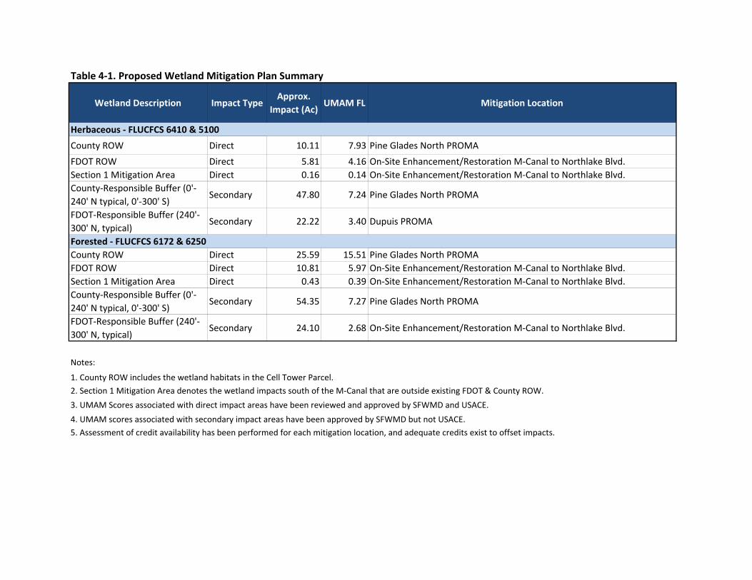
Table 4‐1. Proposed Wetland Mitigation Plan Summary
Wetland Description Impact TypeApprox.
Impact (Ac)UMAM FL Mitigation Location
County ROW Direct 10.11 7.93 Pine Glades North PROMA
FDOT ROW Direct 5.81 4.16 On‐Site Enhancement/Restoration M‐Canal to Northlake Blvd.Section 1 Mitigation Area Direct 0.16 0.14 On‐Site Enhancement/Restoration M‐Canal to Northlake Blvd. County‐Responsible Buffer (0'‐240' N typical, 0'‐300' S)
Secondary 47.80 7.24 Pine Glades North PROMA
FDOT‐Responsible Buffer (240'‐300' N, typical)
Secondary 22.22 3.40 Dupuis PROMA
County ROW Direct 25.59 15.51 Pine Glades North PROMAFDOT ROW Direct 10.81 5.97 On‐Site Enhancement/Restoration M‐Canal to Northlake Blvd.Section 1 Mitigation Area Direct 0.43 0.39 On‐Site Enhancement/Restoration M‐Canal to Northlake Blvd.County‐Responsible Buffer (0'‐240' N typical, 0'‐300' S)
Secondary 54.35 7.27 Pine Glades North PROMA
FDOT‐Responsible Buffer (240'‐300' N, typical)
Secondary 24.10 2.68 On‐Site Enhancement/Restoration M‐Canal to Northlake Blvd.
5. Assessment of credit availability has been performed for each mitigation location, and adequate credits exist to offset impacts.
Herbaceous ‐ FLUCFCS 6410 & 5100
Forested ‐ FLUCFCS 6172 & 6250
Notes:
3. UMAM Scores associated with direct impact areas have been reviewed and approved by SFWMD and USACE.4. UMAM scores associated with secondary impact areas have been approved by SFWMD but not USACE.
1. County ROW includes the wetland habitats in the Cell Tower Parcel.2. Section 1 Mitigation Area denotes the wetland impacts south of the M‐Canal that are outside existing FDOT & County ROW.
4-8
4.2 PROTECTED SPECIES
Wildlife crossings at the M-Canal and at the Ibis Mitigation Area outfall structure are
being incorporated into the roadway design that will increase wildlife connectivity
between the Ibis Mitigation Area and the surrounding natural areas. As discussed
previously, in the existing condition there is significant fencing and upland berms that
limit wildlife travel patterns between Ibis Mitigation Area, Pond Cypress Natural Area,
and Grassy Waters Preserve.
The proposed wetland restoration, creation, and enhancement activities in the on-site
mitigation area will enhance wildlife utilization by increasing foraging habitat for wading
birds and potentially increasing the amount of deep water refugia. In addition, wading
bird and snail kite foraging/nesting habitat will be enhanced by reducing the coverage of
thick exotic vegetation currently occurring on the berms and area designated as
FLUCFCS 6172. This habitat provides limited utilization for wildlife. Removing the
existing berms and creating wetlands in their place will improve connectivity for aquatic
wildlife.
Impacts to specific wildlife species are discussed in the following sections.
4.2.1 Wood Stork
Proposed wetland impacts as they relate to the wood stork have been analyzed. It has
been determined that credits equaling 136.5 kg of biomass within longer hydroperiod
wetlands (Class 6 and 7) will be required to adequately offset these impacts. Impacts to
all wood stork foraging habitat will be mitigated at the Pine Glades North PROMA. The
Pine Glades North site currently has 287.96 kg of long hydroperiod (Class 6) wood stork
biomass credits available. Therefore, the Pine Glades PROMA site has more than
enough wood stork foraging biomass credits to meet the needs of this project. In
addition, the restored wetland habitat at the Pine Glades North PROMA is ideal for
wood stork foraging. The site contains many deep water features with shallow-sloped
banks, which is the wood stork’s preferred foraging habitat. County biologists commonly
report sightings of wood storks utilizing the Pine Glades North PROMA site.
4.2.2 Snail Kite
The mitigation strategy for the snail kite is a multi-faceted approach including
compensation for direct and indirect habitat impacts, wetland preservation and
conservation, an endowment to ensure management of preserved lands, and nest/bird
protection during construction. The plan includes preservation and management of
FDOT-owned wetland habitats within three sections of the Rangeline.

4-9
4.2.2.1 Habitat Compensation
All direct and indirect impacts to snail kite foraging, nesting, and roosting/perching
habitat associated with the proposed SR 7 Extension project will be mitigated separately
from the proposed mitigation for wetland impacts. Therefore there will be no “double-
dipping” of wetland and snail kite habitat mitigation.
Conservation/Protection to Compensate for Direct Impacts
All direct impacts to snail kite foraging, nesting, and roosting/perching habitat will be
mitigated through the conservation and protection of habitat in the section of Rangeline
between Northlake Blvd and SR 710. This section of Rangeline totals 44 acres of
relatively pristine herbaceous marsh, forested wetland, and pine flatwoods habitat
occurring in a complex assemblage with minimal exotic/nuisance species coverage.
Large, relatively open water marsh areas are present that are the preferred foraging
habitat for snail kites. Pine flatwoods and forested wetlands surround the open
marshes, which are ideal for snail kite roosting, perching, and nesting.
Additional compensation for direct snail kite habitat impacts is proposed through the
conservation and protection of wetlands within the FDOT-owned Rangeline section
between PGA Blvd and Jupiter Farms. The estimated 67-acre sub-area of Rangeline
located south of the C-18 Canal will be preserved and maintained in perpetuity. It is
currently in excellent ecological condition. It contains a complex assemblage of
herbaceous marsh and forested wetland, interspersed with pine flatwoods. This area
has been previously described within Section 3.2.2 of this report. Conservation of these
sections of the Rangeline is being proposed as mitigation for direct snail kite habitat
impacts over and above what is statutorily required for wetland mitigation.
Conservation/Protection to Compensate for Indirect Affects
Indirect impacts to snail kite habitat will be offset by providing conservation and
protection of wetlands within existing FDOT-owned lands. The section of Rangeline
between Okeechobee Blvd and M-Canal is approximately 82 acres and is largely
wetland (refer to section 3.2.2 of this report). It includes approximately 22.4 acres of
herbaceous and wetland habitats which were previously dominated by exotics.
Extensive maintenance efforts to control exotics in this area have already been
completed using public dollars. Based on our UMAM assessment of both current and
previous conditions (assisted by Palm Beach County ERM personnel who are
knowledgeable of the prior condition), approximately 11.2 Functional Gain units have
already been created as a result of exotic/nuisance species eradication activities
conducted over several years within these areas. While not recognized from a

4-10
permitting sense, it should be noted that an estimated 1.2 Functional Gain units have
been created for existing freshwater marsh habitat, and 10.0 Functional Gain units have
been created for forested wetland habitat.
In addition, there is opportunity for additional ‘lift’ by conducting wetland enhancement
through exotic/nuisance species eradication and control over an estimated 2.5-acre
area near the southern limit of the Rangeline; this area is currently infested with torpedo
grass and spotted duckweed. Based on our preliminary UMAM assessment, this could
result in an estimated 0.8 Functional Gain units of mitigation credit.
Snail kites were repeatedly documented utilizing (foraging and perching) wetland
habitats within the Pond Cypress Natural Area during FDOT’s 2014 nesting season
survey. Therefore, this area can be deemed appropriate compensation for indirect
impacts to snail kite habitat. Conservation of this Rangeline section is being proposed
as mitigation for indirect snail kite habitat impacts over and above what is statutorily
required for wetland mitigation.
4.2.2.2 Endowment for Future Maintenance of Conservation Lands
The FDOT agrees to make a commitment that construction of the project will not
commence until the USFWS is granted third party rights over the Rangeline properties
identified for conservation and mitigation from north of Okeechobee Blvd to the M-Canal
and from Northlake Blvd to Jupiter Farms. Further, the FDOT commits to establishing a
management endowment fund of $255,617.40 to the Palm Beach County ERM to cover
the costs associated with the long-term management of these Rangeline mitigation
properties. The funds will be placed in an escrow account prior to construction.
Coordination will continue between the FDOT, USFWS and ERM to finalize the limits of
jurisdiction between the environmental agencies.
For the Rangeline property from the M-canal to Northlake Blvd, a portion will be used for
transportation purposes and the remainder will be used for on-site wetland mitigation.
Further coordination will continue with the permitting agencies for future conservation.
We understand that the USFWS requested the establishment of the endowment fund
prior to issuance of the Biological Opinion. However, FDOT cannot release the
requested funds until environmental permits are issued. At this time, a commitment can
be made to update the work program to show proof of available funding.

4-11
4.2.2.3 Snail Kite and Nest Protection During and Post-Construction
A management and protection plan has been prepared for the snail kite and will be
implemented in order to protect the snail kite and nests during and post-construction.
Snail Kite Management Guidelines published by the USFWS are incorporated into the
plan (Appendix F). In summary, this plan includes:
Conducting a pre-construction nesting season survey;
Conducting nesting season surveys during construction;
Establishing appropriate buffers around active nests;
Monitoring of any nest activity in accordance with the guidelines;
Implementing a snail kite education plan;
Routinely coordinating with USFWS regarding the results of the surveys, and
application of the buffers with regard to construction activities as appropriate;
Compiling a final report, detailing all activities undertaken related to protection of
the snail kite during construction, and as prescribed within this project-specific
Snail Kite Management Plan;
Mitigating for all wetland impacts; and
Conducting routine exotics control in the on-site mitigation/restoration area.
Table 4-2 summarizes the compensation that FDOT is proposing to mitigate for impacts
to wildlife foraging habitat that is over and above what is statutorily required for wetland
mitigation for the SR 7 Extension Project.
4.3 SECTION 4(f) MITIGATION
In order to compensate for Section 4(f) impacts within the Pond Cypress Natural Area,
an estimated 23-acre sub-area of the FDOT-owned Rangeline between PGA Blvd and
Jupiter Farms will be transferred to County ownership and managed in accordance with
their conservation lands ordinance. This minimal encroachment into the Pond Cypress
Natural Area is in the public interest as it would provide for a roadway that meets the
minimum safety standards. In exchange, the proposed land transfer will be made at a
ratio of nearly 40 to 1 (conservation/preservation acreage to impact acreage), and will
provide substantial benefit to the public in the form of conservation of wildlands in the
immediate project area. The wetlands in this area will be preserved in perpetuity and
ensure that no future roadway is constructed.

Table 4‐2. Proposed Wildlife Habitat Mitigation Plan Summary
Species
Site Action Site Action
Wood Stork Pine Glades North PROMA
Purchase of 136.5 kg of long hydroperiod (Class 6) wood stork foraging habitat biomass credits to compensate for unavoidable impacts to core foraging habitat.
On‐site: 56‐acres of unused ROW
between M‐Canal & Northlake Blvd.Wetland restoration and creation activities will create ideal wood stork foraging habitat.
Dupuis PROMA
Allocation of herbaceous wetland credits that are available as a result of previous wetland restoration activities. Wetland restoration activities increase potential for snail kite utilization.
Rangeline from Northlake Blvd to SR 710
As compensation for direct impacts to 11.3 acres of preferred snail kite foraging habitat and 22.5 acres of nesting/perching/roositng habitat, FDOT is preserving 44 acres of pristine wetlands in perpetuity. Conservation of this land will benefit snail kite proliferation/utilization in the long‐term and ensure that no new roadway is connected to SR 710 in this location.
On‐site: 56‐acres of unused ROW
between M‐Canal & Northlake Blvd.
Creation/Restoration of herbaceous marsh and forested wetland habitats which provide foraging, nesting, and roosting/perching habitat, increasing the potential for snail kite utilization.
Rangeline from PGA Blvd to Jupiter Farms (67‐acre sub‐area south of the C‐18 Canal)
As additional compensation for direct impacts to 11.3 acres of preferred snail kite foraging habitat and 22.5 acres of nesting/perching/roositng habitat, FDOT is preserving an estimated 67 acres of pristine wetlands in perpetuity. An estimated 10 acres of wetlands within the rangeline have been enhanced in the past eight years providing better snail kite foraging and roosting/nesting habitat.
On‐site
Wildlife crossings at the Ibis Mitigation Outfall and the M‐
Canal will be constructed to enhance wildlife connectivity. Fencing will be installed to reduce the potential for vehicle impacts on wildlife.
On‐site: 56‐acres of unused ROW
between M‐Canal & Northlake Blvd.
Wetland habitat creation and enhancement activities will enhance wildlife utilization and foraging/roosting/nesting habitat. Forested wetland creation will result in a habitat 'screen' (avian flight barrier) from the roadway, reducing the potential for vehicular strikes on avian species.
Proposed Mitigation Strategy per Statutory Requirements Additional Mitigation Proposed Above & Beyond Statutory Requirements
NoneNoneGeneral Wildlife
Snail Kite
Purchase of herbaceous and forested wetland credits available as a result of previous wetland restoration activities. Wetland restoration activities in the PROMA increase foraging, perching/roosting, and nesting habitat, increasing potential for snail kite utilization.
Pine Glades North PROMA Rangeline from Okeechobee Blvd to the M‐Canal
As compensation for indirect impacts to 11.3 acres of snail kite foraging habitat, FDOT is preserving 82 acres of pristine wetlands in perpetuity. An estimated 22 acres of wetlands within the rangeline have been enhanced in the past eight years providing better snail kite foraging and roosting/nesting habitat.

APPENDICES
A Typical Sections Comparing the Recommended Design Alternative to the Design Proposed at the 2012 Public Hearing
B Meeting Minutes for Secondary Impact UMAM Coordination with Regulatory Agencies
C USFWS Wood Stork Biomass Foraging Assessment
D Assessment of Mitigation Potential within FDOT Rangeline Segments
E Pond Cypress Natural Area Management Plan
F Snail Kite Management Plan

APPENDIX A
Typical Sections Comparing the Recommended Design Alternative to the Design
Proposed at the 2012 Public Hearing

5/15/2013USER: Wallacnh 10:37:06 AM
NO.
FIGURE
COUNTY
DEPARTMENT OF TRANSPORTATION
PROJECT ID
FINANCIAL
NO.
ROAD
PROJECT NO.
FEDERAL AID
P:\2006 Projects\060046.001\Cad\22966422201\roadway\PDE Typical.DGN
NO.
EDTM
120’ R/W 200’ R/W
IBIS GOLF
4’ 4’ 12’ 12’
0.02 0.020.04
21’ 21’
0.04
12’
0.02
12’ 4’ 4’
0.02
DRY
9’ 9’5’
1:3 1:3
53’53’23’
1:3
12’2’ 2’
0.02
23’ 16’103’
142’ WET DETENTION POND
7’3’
EXIST. GROUND
TYPE F
GUTTER
CURB &
TYPE F
GUTTER
CURB &
} SURVEY
{ CONST.R/W LINE
EXIST. FDOT
EXIST. GROUND
GUARDRAILFENCE
WATERS
GRASSY
PRESERVE
CLUB
& COUNTRY
SWALE
RETENTION
PATH
USE
SHARED
R/W LINECOUNTY
PALM BEACH
FDOT R/W LINE
SR 7 TYPICAL SECTION
ORIGINAL TYPICAL SECTION
NO.
FIGURE
0.02 0.02
NATURAL GROUND
NATURAL GROUND
TYPE FCURB AND GUTTER
0.04
TYPE FCURB AND GUTTER
24’
12’ 12’
0.02 0.02
12’12’
24’
{ CONST.
2’
0.04
3’4’
TYPE E C&G
6’
SWK
2’
1:2
MAX.
VARIE
S
R/W LINECOUNTY
PALM BEACH
FDOT R/W LINE
CONSTRUCTIONOF
LIMITS
CONSTRUCTIONOF
LIMITS
FDOT R/W LINE
WATERS
GRASSY
PRESERVE
22’
SWK
5’ 2’
120’ R/W 200’ R/W
8.75’
25’
8.75’ 4’ 6’5’5’5’
15.5’
13.84’ TO 17.44’
VARIES
SPILLAGE CONTAINMENT
VARIES (23.84’ TO 27.44’) 11’
IBIS GOLF & COUNTRY CLUB
1:4
1:21:2
REDUCED TYPICAL SECTION
WILDLIFE FENCE

APPENDIX B
Meeting Minutes for Secondary Impact UMAM Coordination with Regulatory Agencies
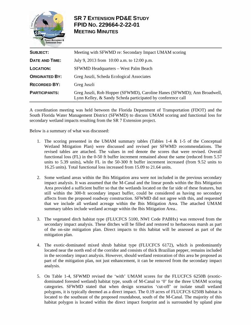
SR 7 EXTENSION PD&E STUDY FPID NO. 229664-2-22-01 MEETING MINUTES
SUBJECT: Meeting with SFWMD re: Secondary Impact UMAM scoring
DATE AND TIME: July 9, 2013 from 10:00 a.m. to 12:00 p.m.
LOCATION: SFWMD Headquarters – West Palm Beach
ORIGINATED BY: Greg Juszli, Scheda Ecological Associates
RECORDED BY: Greg Juszli
PARTICIPANTS: Greg Juszli, Rob Hopper (SFWMD), Caroline Hanes (SFWMD); Ann Broadwell, Lynn Kelley, & Sandy Scheda participated by conference call
A coordination meeting was held between the Florida Department of Transportation (FDOT) and the South Florida Water Management District (SFWMD) to discuss UMAM scoring and functional loss for secondary wetland impacts resulting from the SR 7 Extension project. Below is a summary of what was discussed:
1. The scoring presented in the UMAM summary tables (Tables 1-4 & 1-5 of the Conceptual Wetland Mitigation Plan) were discussed and revised per SFWMD recommendations. The revised tables are attached. The values in red denote the scores that were revised. Overall functional loss (FL) in the 0-50 ft buffer increment remained about the same (reduced from 5.57 units to 5.39 units), while FL in the 50-300 ft buffer increment increased (from 9.52 units to 16.25 units). Total functional loss increased from 15.09 to 21.64 units.
2. Some wetland areas within the Ibis Mitigation area were not included in the previous secondary
impact analysis. It was assumed that the M-Canal and the linear ponds within the Ibis Mitigation Area provided a sufficient buffer so that the wetlands located on the far side of these features, but still within the 300-ft secondary impact buffer, could be considered as having no secondary affects from the proposed roadway construction. SFWMD did not agree with this, and requested that we include all wetland acreage within the Ibis Mitigation Area. The attached UMAM summary tables include wetland acreage within the Ibis Mitigation Area..
3. The vegetated ditch habitat type (FLUCFCS 5100, NWI Code PABHx) was removed from the
secondary impact analysis. These ditches will be filled and restored to herbaceous marsh as part of the on-site mitigation plan. Direct impacts to this habitat will be assessed as part of the mitigation plan.
4. The exotic-dominated mixed shrub habitat type (FLUCFCS 6172), which is predominantly located near the north end of the corridor and consists of thick Brazilian pepper, remains included in the secondary impact analysis. However, should wetland restoration of this area be proposed as part of the mitigation plan, not just enhancement, it can be removed from the secondary impact analysis.
5. On Table 1-4, SFWMD revised the ‘with’ UMAM scores for the FLUCFCS 6250B (exotic-dominated forested wetland) habitat type, south of M-Canal to ‘0’ for the three UMAM scoring categories. SFWMD stated that when design scenarios ‘cut-off’ or isolate small wetland polygons, it is typically deemed as a direct impact. The 0.19 acres of FLUCFCS 6250B habitat is located to the southeast of the proposed roundabout, south of the M-Canal. The majority of this habitat polygon is located within the direct impact footprint and is surrounded by upland pine

Meeting Minutes
July 9, 2013
Page 2 of 2
flatwoods. Hence, the 0.19 acres of FLUCFCS 6250B outside of the direct impact footprint will become isolated.
6. Prior to this meeting, we had proposed no reduction in scores between the ‘current’ and ‘with’ conditions for the Water Environment category across all wetland habitat types. In Scheda’s opinion, because the proposed stormwater design prevents direct flow into the Pond Cypress or Grassy Waters wetlands, the project will have no effect on the water environment of these natural wetland areas. SFWMD suggested a two-point reduction for all wetland habitat types within the 0-50 ft buffer increment and a one-point reduction for all wetlands within the 50-300 ft buffer increment as a worst case scenario.
7. The revised UMAM scoring presented in the revised tables reflects a worst-case scenario. These
scores should be used for mitigation planning purposes. We can work to further reduce the secondary FL as part of the permit application preparation process, through further defining both the details of the typical section and the mitigation design.
8. SFWMD confirmed that the stormwater ponds located within the Ibis community did not need to be included in the secondary impact analysis.
9. SFWMD confirmed that the 300-ft buffer should start from the roadway limit of construction line, not from the limit of construction line for the on-site mitigation area.
10. In regards to determining how much of the secondary impacts the County shall be responsible for versus how much FDOT should be responsible for, SFWMD recommended that a percentage approach be used. The current typical section north of the M-Canal spans approximately 150 ft, of which 30 ft occur on FDOT right-of-way. This equates to 20%. Therefore, SFWMD recommended that FDOT shall be responsible for 20%, of secondary wetland impacts within the 300-ft buffer (or the outermost 60 ft). Palm Beach County will be responsible for secondary wetland impacts within the innermost 240 ft of the buffer, and these impacts can be mitigated at Pine Glades. Scheda shall calculate the wetland acreage, by habitat type, within the respective 0-240 ft increment (County) and the 240-300 ft increment (FDOT).
11. FDOT will be solely responsible for secondary wetland impacts where the proposed roadway alignment shifts so that is completely within the FDOT right-of-way, north of the M-Canal. Scheda will calculate the wetland acreage, by habitat type, in the 300-ft buffer surrounding this area.

Current Condition
With Project
Current Condition
With Project
Current Condition
With Project
Freshwater Marshes - Native Dominated
PEM1 6410A 4.30 9 6 9 7 9 6 -0.27 1.15
Freshwater Marsh - Exotic Dominated
PEM1 6410B 0.00 - - - - - - - -
Mixed Shrubs - Exotic Dominated
PSS1 6172 0.00 - - - - - - - -
Hydric Pine - Native Dominated
PFO3/4 6250A 5.95 9 6 9 7 9 6 -0.27 1.59
Hydric Pine - Exotic Dominated
PFO3 6250B 0.19 5 0 7 0 7 0 -0.63 0.12
Vegetated Ditches PABHx 5100 0.00 - - - - - - - -
Total 10.44 2.85
Current Condition
With Project
Current Condition
With Project
Current Condition
With Project
Freshwater Marshes - Native Dominated
PEM1 6410A 1.22 7 4 7 5 8 5 -0.27 0.33
Freshwater Marsh - Exotic Dominated
PEM1 6410B 1.10 7 4 6 4 5 3 -0.23 0.26
Mixed Shrubs - Exotic Dominated
PSS1 6172 3.80 5 2 5 3 4 2 -0.23 0.89
Hydric Pine - Native Dominated
PFO3/4 6250A 2.25 7 4 7 5 8 5 -0.27 0.60
Hydric Pine - Exotic Dominated
PFO3 6250B 2.02 7 4 6 4 4 2 -0.23 0.47
Vegetated Ditches PABHx 5100 7.00 N/A N/A N/A N/A N/A N/A N/A -
Total 17.39 2.54
5.39
Table 1-4. Approximate Secondary Impact Acreages and Associated Functional Loss to Wetlands & Surface Waters Located 0-50 Feet from the Limits of Construction (Recommended Alternative)
South of the M-Canal
Wetland TypeNWI
ClassificationFLUCFCS
CodeTotal Acres
Location and Landscape Support
Water EnvironmentCommunity Structure
DeltaFunctional Loss (FL)
TOTAL SECONDARY IMPACT FL (0-50 ft) =
North of the M-Canal
Wetland TypeNWI
ClassificationFLUCFCS
CodeTotal Acres
Location and Landscape Support
Water EnvironmentCommunity Structure
DeltaFunctional Loss (FL)
N/A = The vegetated ditches will be filled and restored to herbaaceous marsh as part of the on‐site mitigation plan. Separate UMAMs will be conducted for all habitat types proposed for enhancement/restoration.

Current Condition
With Project
Current Condition
With Project
Current Condition
With Project
Freshwater Marshes - Native Dominated
PEM1 6410A 13.86 9 7 9 8 9 7 -0.17 2.31
Freshwater Marsh - Exotic Dominated
PEM1 6410B 0.00 - - - - - - - -
Mixed Shrubs - Exotic Dominated
PSS1 6172 0.00 - - - - - - - -
Hydric Pine - Native Dominated
PFO3/4 6250A 13.47 9 8 9 8 9 8 -0.10 1.35
Hydric Pine - Exotic Dominated
PFO3 6250B 0.00 - - - - - - - -
Vegetated Ditches PABHx 5100 0.00 - - - - - - - -
Total 27.33 3.66
Current Condition
With Project
Current Condition
With Project
Current Condition
With Project
Freshwater Marshes - Native Dominated
PEM1 6410A 37.39 7 5 7 6 8 6 -0.17 6.23
Freshwater Marsh - Exotic Dominated
PEM1 6410B 3.60 7 5 6 5 5 4 -0.13 0.48
Mixed Shrubs - Exotic Dominated
PSS1 6172 5.85 5 4 5 4 4 3 -0.10 0.59
Hydric Pine - Native Dominated
PFO3/4 6250A 32.33 8 7 7 6 8 7 -0.10 3.23
Hydric Pine - Exotic Dominated
PFO3 6250B 12.85 7 6 6 5 4 3 -0.10 1.29
Vegetated Ditches PABHx 5100 1.58 N/A N/A N/A N/A N/A N/A N/A -
Total 93.60 11.81
Current Condition
With Project
Current Condition
With Project
Current Condition
With Project
Freshwater Marshes - Native Dominated
PEM1 6410A 2.14 9 7 9 8 9 7 -0.17 0.36
Hydric Pine - Native Dominated
PFO3/4 6250A 4.22 9 8 9 8 9 8 -0.10 0.42
Total 6.36 0.78
16.25
Water Environment
Wetland Type
Delta
FLUCFCS Code
N/A = The vegetated ditches will be filled and restored to herbaaceous marsh as part of the on‐site mitigation plan. Separate UMAMs will be conducted for all habitat types proposed for enhancement/restoration.
Functional Loss (FL)
Total Acres
Location and Landscape Support
Water EnvironmentCommunity Structure
Delta
Ibis Mitigation Area
Wetland TypeNWI
ClassificationFLUCFCS
CodeTotal Acres
Location and Landscape Support
NWI Classification
Community Structure Functional
Loss (FL)
Table 1-5. Approximate Secondary Impact Acreages and Associated Functional Loss to Wetlands & Surface Waters Located 50-300 Feet from the Limits of Construction (Recommended Alternative)
TOTAL SECONDARY IMPACT FL (50-300 ft) =
North of the M-Canal
Wetland TypeNWI
ClassificationFLUCFCS
CodeTotal Acres
Location and Landscape Support
Water EnvironmentCommunity Structure
DeltaFunctional Loss (FL)
South of the M-Canal

SR 7 EXTENSION PD&E STUDY FPID NO. 229664-2-22-01 MEETING MINUTES
SUBJECT: Meeting with U.S. Army Corps of Engineers
DATE AND TIME: August 13, 2013 from 10:00 a.m. to 11:00 a.m.
LOCATION: U.S. Army Corps of Engineers office – Palm Beach Gardens
ORIGINATED BY: Beatriz Caicedo-Maddison, PE
RECORDED BY: Michael Garau, PE
PARTICIPANTS: Garett Lips – USACOE Beatriz Caicedo-Maddison – FDOT Ann Broadwell – FDOT (via conference call) Richard Young – FDOT (via conference call) Kathleen Toolan – FDOT (via conference call) Ron Wallace – FDOT (via conference call) Greg Juszli – Scheda Ecological Michael Garau – Jacobs
A coordination meeting was held between the Florida Department of Transportation (FDOT) and the US Army Corps of Engineers (USACE) to discuss the corridor selection process and permitting. Below are the comments and discussion items made during the meeting:
1. An overview of the corridor selection process was provided. In 1993, the FDOT began preparing a series of planning reports to document the need for the project and identify alternative corridors. The series of reports prepared during the study examined the feasibility of extending SR 7 from Okeechobee Boulevard in Palm Beach County to parts of Martin County. Five corridors were considered and three were recommended for further evaluation through the PD&E process.
In June, 1998, the FDOT and Palm Beach County began a feasibility study for the extension of SR 7 with the limits confined to SR 710. Twenty five corridors were proposed. Several agency workshops were held to discuss the proposed corridors and narrow down the selection. Ultimately, eight were selected to advance forward in the evaluation. All of the alternatives that went west through the Acreage and towards Seminole Pratt Whitney Road were discarded through the agency participation process.
In January, 2000, the FDOT initiated a formal PD&E study of the remaining eight alternatives. However, the project was suspended in October, 2000, after the MPO approved a motion to the stop the on-going PD&E Study.
2. USACOE commented that FDOT needs to connect the purpose and need between the different
planning/feasibility studies that have occurred in the past.
3. USACOE commented that FDOT needs to address why improving local streets, such as 60th Street and Coconut Blvd, is not possible.
4. USACOE reiterated the desire to drop the segment from Northlake to SR 710 from future plans. FDOT responded that an extension beyond Northlake is not part of the MPO’s long range plan. It is shown on the County’s comprehensive plan and they will need to remove it. This process could take 1 to 2 years.
Meeting adjourned at 11:00 a.m.

APPENDIX C
USFWS Wood Stork Biomass Foraging Assessment

% Exotics F.S.V
Hydroperiods
Crayfish &
Fish g/m^2
0-25 1 Class 1 (0-60 days) 0.31
Acres Kgrams Acres Kgrams Acres Kgrams Acres Kgrams 25-50 0.64 Class 2 (60-120 days) 0.62
Class 1: 0 to 60 Days 0.00 0.00 0 0 50-75 0.37 Class 3 (120-180 days) 1.32
Class 2: 60 to 120 Days 0.00 0.0 0 0 75-90 0.03 Class 4 (180-240 days) 2.34
Class 3: 120 to 180 Days 0.00 0.0 0 0 >90 0.03 Class 5 (240-300 days) 2.93
Class 4: 180 to 240 Days 0.00 0.0 0 0 Class 6 (300-330 days) 3.36
Class 5: 240 to 300 Days 0.00 0.0 0 0 Class 7 (330-365 days) 3.63
Class 6: 300 to 330 Days 17.25 73.56 ‐17.25 -73.56
Class 7: 330 to 365 Days 35.92 62.96 ‐35.92 -62.96
TOTAL 53.17 136.52 0.00 0.00 0.00 0.00 -53.17 -136.52
IMPACT AREA
Hydroperiods Acres % exotics F.S.V m^2m^2
suitable
crayfish &
fish g/m^2
available biomass
32.5%consum.
Biomass (kg)
Class 7 (330-365 days) 1.78 0-25 1 7,203.43 7,203.43 3.63 26,148.47 8,498.25 8.50 Native dominated freshwater marsh (FLUCCS 6410A); north of M-Canal
Class 7 (330-365 days) 1.08 75-90 0.03 4,370.62 131.12 3.63 475.96 154.69 0.15 Exotic dominated feshwater marsh (FLUCCS 6410B); north of M-Canal
Class 7 (330-365 days) 4.77 0-25 1 19,303.58 19,303.58 3.63 70,072.01 22,773.40 22.77 Vegetated Linear Ditches (FLUCCS 5100); north of M-Canal
Class 7 (330-365 days) 14.31 75-90 0.03 57,910.75 1,737.32 3.63 6,306.48 2,049.61 2.05 Exotic-dominated mixed shrub wetlands (FLUCCS 6172); north of M-Canal
Class 7 (330-365 days) 1.48 0-25 1 5,989.37 5,989.37 3.63 21,741.42 7,065.96 7.07 Native dominated forested wetland (FLUCCS 6250A); north of M-Canal
Class 7 (330-365 days) 12.24 50-75 0.37 49,533.73 18,327.48 3.63 66,528.75 21,621.84 21.62 Exotic dominated forested wetland (FLUCCS 6250B); north of M-Canal
Class 7 (330-365 days) 0.26 25-50 0.64 1,052.19 673.40 3.63 2,444.44 794.44 0.79 M-Canal
Class 6 (300-330 days) 8.45 0-25 1 34,196.08 34,196.08 3.36 114,898.82 37,342.12 37.34 Native dominated freshwater marsh (FLUCCS 6410A); south of M-Canal
Class 6 (300-330 days) 7.84 0-25 1 31,727.48 31,727.48 3.36 106,604.35 34,646.41 34.65 Native dominated forested wetland (FLUCCS 6250A); south of M-Canal
Class 6 (300-330 days) 0.96 50-75 0.37 3,885.00 1,437.45 3.36 4,829.83 1,569.69 1.57 Exotic dominated forested wetland (FLUCCS 6250B); south of M-Canal
TOTAL 53.17 136.52
Total Biomass within Existing Footprint 136.5
Total Biomass within Preserve Area Pre-
Enhancement0.0 RECOMMENDED ALTERNATIVE
Total Biomass within Preserve Area Post-
Enhancement0.0
Net Change Per Hydroperiod Class
Pre Enhancement Post Enhancement
Net Change
-136.5
HydroperiodExisting Footprint
Preserve Areas

APPENDIX D
Assessment of Mitigation Potential within FDOT Rangeline Segments

M E M O R A N D U M
TO: Ann Broadwell, FDOT PLEMO FROM: Greg Juszli, Scheda Ecological Associates, Inc. CC: Michael Garau, PE, Jacobs Marty Workman, PE, Stantec RE: HABITAT ASSESSMENT – RANGELINE FROM OKEECHOBEE BLVD
TO M-CANAL SR 7 Extension Project
Palm Beach County, Florida Scheda Project No: 002019.20.C; BG 05 DATE: February 19, 2013
On December 21, 2012, biologists from Scheda Ecological Associates, Inc. (Scheda) conducted a wetland habitat assessment within the SR 7 Rangeline between Okeechobee Boulevard and the M-Canal. The SR 7 Rangeline spans a distance of approximately 3.40 miles covering approximately 103 acres (Figure 1). The following text includes a description of the habitats observed, methodology used to assess wetland restoration / enhancement (“lift”) potential, and recommendations for mitigation potential.
METHODOLOGY
Scheda biologists traversed the SR 7 Rangeline by foot, beginning at the northern limit and moving south. A multi-use trail is located adjacent to the eastern Rangeline boundary and runs the length of the Rangeline, The multi-use trail is a canal berm maintained by Palm Beach County.
Existing habitat types within and adjacent to the Rangeline were previously categorized through aerial photo-interpretation using the SFWMD Florida Land Use, Land Cover Classification System (FLUCCS). Upon entering each new habitat area, Scheda biologists closely examined the habitat on foot for the presence of exotic/nuisance vegetation, and for any man-made facilities or disturbances (dykes, berms, levees, fill pads, etc) that could be enhanced or restored to create wetland mitigation credit. Representative photographs of each FLUCCS habitat type were taken upon entering the habitat area (see attached photopages).
Using handheld GPS, Scheda biologists delineated the perimeter of any areas identified as being previously dominated by exotic/nuisance vegetation. These areas were plotted on aerial photographs. Scheda then coordinated with Palm Beach County
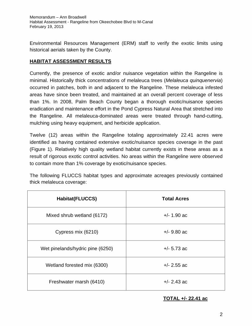
Memorandum – Ann Broadwell Habitat Assessment - Rangeline from Okeechobee Blvd to M-Canal February 19, 2013
2
Environmental Resources Management (ERM) staff to verify the exotic limits using historical aerials taken by the County.
HABITAT ASSESSMENT RESULTS
Currently, the presence of exotic and/or nuisance vegetation within the Rangeline is
minimal. Historically thick concentrations of melaleuca trees (Melaleuca quinquenervia)
occurred in patches, both in and adjacent to the Rangeline. These melaleuca infested
areas have since been treated, and maintained at an overall percent coverage of less
than 1%. In 2008, Palm Beach County began a thorough exotic/nuisance species
eradication and maintenance effort in the Pond Cypress Natural Area that stretched into
the Rangeline. All melaleuca-dominated areas were treated through hand-cutting,
mulching using heavy equipment, and herbicide application.
Twelve (12) areas within the Rangeline totaling approximately 22.41 acres were
identified as having contained extensive exotic/nuisance species coverage in the past
(Figure 1). Relatively high quality wetland habitat currently exists in these areas as a
result of rigorous exotic control activities. No areas within the Rangeline were observed
to contain more than 1% coverage by exotic/nuisance species.
The following FLUCCS habitat types and approximate acreages previously contained thick melaleuca coverage:
Habitat(FLUCCS) Total Acres
Mixed shrub wetland (6172) +/- 1.90 ac
Cypress mix (6210) +/- 9.80 ac
Wet pinelands/hydric pine (6250) +/- 5.73 ac
Wetland forested mix (6300) +/- 2.55 ac
Freshwater marsh (6410) +/- 2.43 ac
TOTAL +/- 22.41 ac
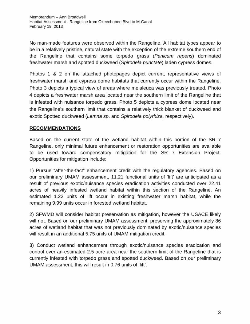
Memorandum – Ann Broadwell Habitat Assessment - Rangeline from Okeechobee Blvd to M-Canal February 19, 2013
3
No man-made features were observed within the Rangeline. All habitat types appear to be in a relatively pristine, natural state with the exception of the extreme southern end of the Rangeline that contains some torpedo grass (Panicum repens) dominated freshwater marsh and spotted duckweed (Spirodela punctate) laden cypress domes.
Photos 1 & 2 on the attached photopages depict current, representative views of
freshwater marsh and cypress dome habitats that currently occur within the Rangeline.
Photo 3 depicts a typical view of areas where melaleuca was previously treated. Photo
4 depicts a freshwater marsh area located near the southern limit of the Rangeline that
is infested with nuisance torpedo grass. Photo 5 depicts a cypress dome located near
the Rangeline’s southern limit that contains a relatively thick blanket of duckweed and
exotic Spotted duckweed (Lemna sp. and Spirodela polyrhiza, respectively).
RECOMMENDATIONS
Based on the current state of the wetland habitat within this portion of the SR 7 Rangeline, only minimal future enhancement or restoration opportunities are available to be used toward compensatory mitigation for the SR 7 Extension Project. Opportunities for mitigation include:
1) Pursue “after-the-fact” enhancement credit with the regulatory agencies. Based on our preliminary UMAM assessment, 11.21 functional units of ‘lift’ are anticipated as a result of previous exotic/nuisance species eradication activities conducted over 22.41 acres of heavily infested wetland habitat within this section of the Rangeline. An estimated 1.22 units of lift occur in existing freshwater marsh habitat, while the remaining 9.99 units occur in forested wetland habitat.
2) SFWMD will consider habitat preservation as mitigation, however the USACE likely will not. Based on our preliminary UMAM assessment, preserving the approximately 86 acres of wetland habitat that was not previously dominated by exotic/nuisance species will result in an additional 5.75 units of UMAM mitigation credit.
3) Conduct wetland enhancement through exotic/nuisance species eradication and control over an estimated 2.5-acre area near the southern limit of the Rangeline that is currently infested with torpedo grass and spotted duckweed. Based on our preliminary UMAM assessment, this will result in 0.76 units of ‘lift’.

Memorandum – Ann Broadwell Habitat Assessment - Rangeline from Okeechobee Blvd to M-Canal February 19, 2013
4
PRELIMINARY LIFT CALCULATIONS

Current With Current With Current WithCypress Mix 6210 9.80 2 9 7 8 2 9 0.50 1.00 1.00 4.90
Mixed Wetland Shrub 6172 1.90 2 9 7 8 2 9 0.50 1.00 1.00 0.95
Forested Wetland - Mixed 6300 2.55 2 9 7 8 2 9 0.50 1.00 1.00 1.28
Hydric Pine 6250 5.73 2 9 7 8 2 9 0.50 1.00 1.00 2.87Freshwater Marsh 6410 2.43 2 9 7 8 2 9 0.50 1.00 1.00 1.22Total 22.41 11.21
Comments:1) 'Current' scores represent the Melaleuca dominated habitat that existed prior to exotic treatment.2) "With" scores represent the existing state of the habitat as of December 2012, post-exotic eradication activities.3) 'With' scores match the agency approved native-dominated forested wetland UMAM scores for the SR-7 Extension project. and the fact that preservation of the Rangeline wetlands in perpetuity would assure long-term benefits to the surrounding natural area (compared to transportation land-use)4) Time Lag and Risk are both scored at 1.0 given that the exotic/nuisance species eradication has already occurred.
After-the-Fact 'Lift' from enhancing wetlands through exotic/nuisance species eradication within the Rangeline between Okeechobee Blvd and the M-Canal.
Wetland Type FLUCFCS CodeTotal Acres
Location and Landscape Support
Water Environment
Community Structure Delta
Relative Functional Gain ('Lift")
Time LagRisk
Factor

Current With Current With Current With
Herbaceous Marsh 6410 40.38 8 9 8 8 8 9 0.07 1.00 1.00 1.00 2.69
Forested Wetland6250 / 6172 / 6210 / 6215 /
630045.80 8 9 8 8 8 9 0.07 1.00 1.00 1.00 3.05
Total 86.18 5.75
Comments:1) Habitat acreage represents all wetland acreage that were not dominated by exotic/nuisance species, but have undergone exotic maintenance since 2008.2) Forested Wetland acreage does not include the 10.31 acres of Melaleuca-dominated wetlands that were treated in 2008.3) 'Current' scores represent the wetland habitat that existed prior to exotic treatment (pre-2008).4) "With" scores represent the existing state of the wetland habitats as of December 2012, following 4 years of exotic maintenance activities.5) 'With' scores match the agency approved native-dominated forested and herbaceous wetland UMAM scores for the SR-7 Extension project.6) Time Lag and Risk are both scored at 1.0 given that the exotic/nuisance species eradication has already occurred. 7) Preservation factor was scored at 1.0 given the location of the Rangeline within Loxahatchee Slough8) USACE does not consider preservation as mitigaton, hence this lift estimate may not be applicable to the Section 404 permit.
Relative Functional Gain ('Lift")
Time Lag Risk FactorPreservation
Factor
Potential 'Lift' through Preservation of wetland habitats within the Rangeline between Okeechobee Blvd and the M-Canal.
Wetland TypeFLUCFCS
CodeTotal Acres
Location and Landscape Support
Water EnvironmentCommunity Structure Delta

Current With Current With Current With
Freshwater Marsh 6410 0.79 5 7 6 7 2 8 0.30 1.03 1.00 0.24
Cypress Dome 6215 1.74 5 7 5 7 3 8 0.30 1.03 1.00 0.52
Total 2.53 0.76
Potential 'Lift' through exotic species eradication and control near the southern limit of the Rangeline between Okeechobee Blvd and the M-Canal.
Delta Time LagRisk
Factor
Relative Functional Gain
('Lift")
Wetland Type
FLUCFCS Code
Total Acres
Location and Landscape Support
Water EnvironmentCommunity Structure
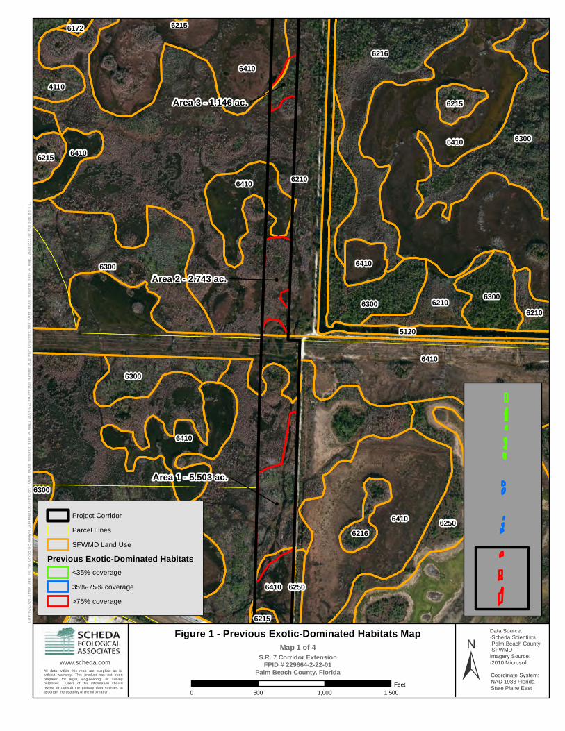
Area 1 - 5.503 ac.
Area 2 - 2.743 ac.
Area 3 - 1.146 ac.
6210
6210
6410
6410
6410
6410
6300
64106216
6300
6250
6300
1290
6410
6410
6300
6410
63006210
6410
4110
6410
6410
6216
6410
6210
6215
6215
6300
6215
5120
6250
6172 6215D
ate:
02/
22
/201
3 R
ev.
Da
te: n
/a P
M: C
H/S
S G
IS A
na
lyst
: G
dA M
ap
Doc
um
ent:
SR
7_O
kee
_exo
tic_
nuis
anc
e_h
abs
_A
_m
ap1_
201
302
22.m
xd P
roje
ct N
um
be
r: 2
019
PD
F D
ocu
men
t: S
R7_
Oke
e_
exo
tic_
nuis
anc
e_h
abs
_A
_m
ap1
_201
302
22.
pdf P
lot S
ize
: 8.5
x 1
1
www.scheda.com
Coordinate System:NAD 1983 Florida State Plane East
Figure 1 - Previous Exotic-Dominated Habitats MapS.R. 7 Corridor Extension
FPID # 229664-2-22-01Palm Beach County, Florida ±
0 500 1,000 1,500
Feet
All data within this map are supplied as is,without warranty. This product has not beenprepared for legal, engineering, or surveypurposes. Users of this information shouldreview or consult the primary data sources toascertain the usability of the information.
Data Source:-Scheda Scientists-Palm Beach County-SFWMDImagery Source:-2010 Microsoft
Project Corridor
Parcel Lines
SFWMD Land Use
Previous Exotic-Dominated Habitats<35% coverage
35%-75% coverage
>75% coverage
Map 1 of 4

Area 7 - 1.325 ac.
Area 8 - 1.175 ac.
Area 4 - 0.892 ac.
Area 5 - 0.671 ac.Area 5 - 0.671 ac.
6410
61726216
64106300
6300
6410
6250
6250
6210
64106410
6410
6410
6410
6410
6410
63006215
6215
6215
5120
4110
6250
Dat
e: 0
2/2
2/2
013
Re
v. D
ate
: n/a
PM
: CH
/SS
GIS
An
aly
st:
GdA
Ma
p D
ocu
men
t: S
R7_
Oke
e_e
xotic
_nu
isa
nce
_ha
bs_
A_
map
2_2
013
0222
.mxd
Pro
ject
Nu
mb
er:
20
19 P
DF
Do
cum
ent:
SR
7_O
kee
_ex
otic
_nu
isa
nce
_ha
bs_
A_
map
2_2
013
022
2.pd
f Plo
t Siz
e: 8
.5 x
11
www.scheda.com
Coordinate System:NAD 1983 Florida State Plane East
Figure 1 - Previous Exotic-Dominated Habitats MapS.R. 7 Corridor Extension
FPID # 229664-2-22-01Palm Beach County, Florida ±
0 500 1,000 1,500
Feet
All data within this map are supplied as is,without warranty. This product has not beenprepared for legal, engineering, or surveypurposes. Users of this information shouldreview or consult the primary data sources toascertain the usability of the information.
Data Source:-Scheda Scientists-Palm Beach County-SFWMDImagery Source:-2010 Microsoft
Project Corridor
Parcel Lines
SFWMD Land Use
Previous Exotic-Dominated Habitats<35% coverage
35%-75% coverage
>75% coverage
Map 2 of 4

Area 9 - 1.685 ac.
Area 7 - 1.325 ac.
Area 8 - 1.175 ac.
Area 10 - 1.526 ac.Area 10 - 1.526 ac.
6410
6410
6300
6250
6250
6300
4110
6172
6300
6410
4110
6300
6410
3210
6172
6410
5120
6300
6410D
ate:
02/
22
/201
3 R
ev.
Da
te: n
/a P
M: C
H/S
S G
IS A
na
lyst
: G
dA M
ap
Doc
um
ent:
SR
7_O
kee
_exo
tic_
nuis
anc
e_h
abs
_A
_m
ap3_
201
302
22.m
xd P
roje
ct N
um
be
r: 2
019
PD
F D
ocu
men
t: S
R7_
Oke
e_
exo
tic_
nuis
anc
e_h
abs
_A
_m
ap3
_201
302
22.
pdf P
lot S
ize
: 8.5
x 1
1
www.scheda.com
Coordinate System:NAD 1983 Florida State Plane East
Figure 1 - Previous Exotic-Dominated Habitats MapS.R. 7 Corridor Extension
FPID # 229664-2-22-01Palm Beach County, Florida ±
0 500 1,000 1,500
Feet
All data within this map are supplied as is,without warranty. This product has not beenprepared for legal, engineering, or surveypurposes. Users of this information shouldreview or consult the primary data sources toascertain the usability of the information.
Data Source:-Scheda Scientists-Palm Beach County-SFWMDImagery Source:-2010 Microsoft
Project Corridor
Parcel Lines
SFWMD Land Use
Previous Exotic-Dominated Habitats<35% coverage
35%-75% coverage
>75% coverage
Map 3 of 4
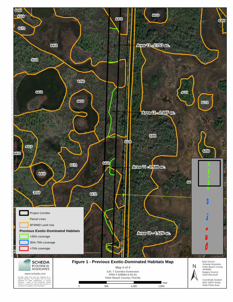
Area 13 - 2.753 ac.
Area 12 - 2.385 ac.
Area 10 - 1.526 ac.
Area 11 - 0.599 ac.
Area 10 - 1.526 ac.
6410
6300
6250
6410
6410
6410
6172
6410
4110
4110
3210
6172
6410
4110
6410
4110
6410
64104110
62506410
6172
6172
5120
6300
4110
8200D
ate:
02/
22
/201
3 R
ev.
Da
te: n
/a P
M: C
H/S
S G
IS A
na
lyst
: G
dA M
ap
Doc
um
ent:
SR
7_O
kee
_exo
tic_
nuis
anc
e_h
abs
_A
_m
ap4_
201
302
22.m
xd P
roje
ct N
um
be
r: 2
019
PD
F D
ocu
men
t: S
R7_
Oke
e_
exo
tic_
nuis
anc
e_h
abs
_A
_m
ap4
_201
302
22.
pdf P
lot S
ize
: 8.5
x 1
1
www.scheda.com
Coordinate System:NAD 1983 Florida State Plane East
Figure 1 - Previous Exotic-Dominated Habitats MapS.R. 7 Corridor Extension
FPID # 229664-2-22-01Palm Beach County, Florida ±
0 500 1,000 1,500
Feet
All data within this map are supplied as is,without warranty. This product has not beenprepared for legal, engineering, or surveypurposes. Users of this information shouldreview or consult the primary data sources toascertain the usability of the information.
Data Source:-Scheda Scientists-Palm Beach County-SFWMDImagery Source:-2010 Microsoft
Project Corridor
Parcel Lines
SFWMD Land Use
Previous Exotic-Dominated Habitats<35% coverage
35%-75% coverage
>75% coverage
Map 4 of 4

SR 7 Extension Mitigation Potential in Rangeline between Okeechobee Blvd and the M-Canal.
Photo 2: Typical view of Cypress dome habitat (6215).
PROJECT PHOTOS Page 1 of 3
Photo 1 Typical view of freshwater marsh habitat (6410).

PROJECT PHOTOS Page 2 of 3
SR 7 Extension Mitigation Potential in Rangeline between Okeechobee Blvd and the M-Canal.
Photo 3: Typical view of one of the previously-treated melaleuca areas located within the Rangeline.
Photo 4: Typical view of Torpedo grass occurring in a freshwater marsh (6410) located near the southern limit of the Rangeline.

SR 7 Extension Mitigation Potential north of OKEECHOBEE Blvd. Palm Beach County, Flrida
Photo 4: Typical view of dead melaleuca in freshwater marsh (6410).
PROJECT PHOTOS Page 3 of 3
Photo 5: Typical view of exotic/nuisance duckweed species occurring on the water surface in a Cypress dome near the south limit of the Rangeline.
SR 7 Extension Mitigation Potential in Rangeline between Okeechobee Blvd and the M-Canal.

M E M O R A N D U M
TO: Ann Broadwell, FDOT PLEMO FROM: Greg Juszli, Scheda Ecological Associates, Inc. CC: Michael Garau, PE, Jacobs Marty Workman, PE, Stantec RE: HABITAT ASSESSMENT – RANGELINE NORTH OF PGA BLVD.
SR 7 Extension Project Palm Beach County, Florida Scheda Project No: 002019.20.C; BG 04 DATE: January 21, 2013
On December 11, 2012, biologists from Scheda Ecological Associates, Inc. (Scheda) and Palm Beach County Environmental Resource Management (PBC ERM) conducted a wetland habitat assessment within the SR 7 Rangeline north of PGA Boulevard. The SR 7 Rangeline spans from PGA Boulevard north to the terminus at 150th Court N in Jupiter Farms, a distance of approximately 3.95 miles, and contains 90.64 acres (Figure 1). Scheda biologists also investigated the piece of FDOT-owned right-of-way between SR 710 (Beeline Highway) and PGA Blvd (approximately 4..6 acres). The following text includes a description of the habitats observed, methodology used to assess wetland restoration / enhancement (“lift”) potential, and recommendations for mitigation potential.
METHODOLOGY
Utilizing a swamp buggy, biologists from Scheda and Palm Beach ERM navigated the SR 7 Rangeline beginning near the southern limit and moving north. An access trail/road, which is used by PBC ERM exotic control contractors, runs the length of the Rangeline, either within the Rangeline boundary or directly adjacent to it.
Existing habitat types within and adjacent to the Rangeline were previously categorized through aerial photo-interpretation using the SFWMD Florida Land Use, Land Cover Classification System (FLUCCS). Upon entering each new habitat area, Scheda biologists closely examined the habitat on foot for the presence of exotic and nuisance vegetation, and for any man-made facilities or disturbances (dikes, berms, levees, fill pads, etc) that could be enhanced or restored to create wetland mitigation credit. Representative photographs of each FLUCCS habitat type were taken upon entering the habitat area (see attached photopages).
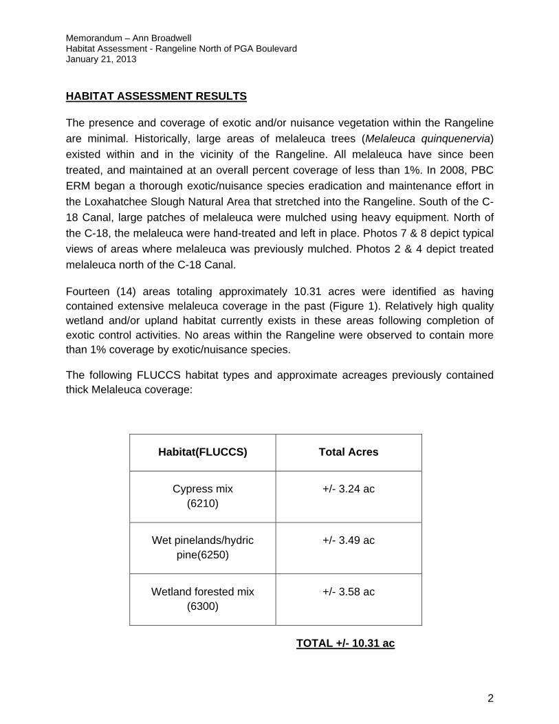
Memorandum – Ann Broadwell Habitat Assessment - Rangeline North of PGA Boulevard January 21, 2013
2
HABITAT ASSESSMENT RESULTS
The presence and coverage of exotic and/or nuisance vegetation within the Rangeline
are minimal. Historically, large areas of melaleuca trees (Melaleuca quinquenervia)
existed within and in the vicinity of the Rangeline. All melaleuca have since been
treated, and maintained at an overall percent coverage of less than 1%. In 2008, PBC
ERM began a thorough exotic/nuisance species eradication and maintenance effort in
the Loxahatchee Slough Natural Area that stretched into the Rangeline. South of the C-
18 Canal, large patches of melaleuca were mulched using heavy equipment. North of
the C-18, the melaleuca were hand-treated and left in place. Photos 7 & 8 depict typical
views of areas where melaleuca was previously mulched. Photos 2 & 4 depict treated
melaleuca north of the C-18 Canal.
Fourteen (14) areas totaling approximately 10.31 acres were identified as having contained extensive melaleuca coverage in the past (Figure 1). Relatively high quality wetland and/or upland habitat currently exists in these areas following completion of exotic control activities. No areas within the Rangeline were observed to contain more than 1% coverage by exotic/nuisance species.
The following FLUCCS habitat types and approximate acreages previously contained thick Melaleuca coverage:
Habitat(FLUCCS) Total Acres
Cypress mix (6210)
+/- 3.24 ac
Wet pinelands/hydric pine(6250)
+/- 3.49 ac
Wetland forested mix (6300)
+/- 3.58 ac
TOTAL +/- 10.31 ac
Memorandum – Ann Broadwell Habitat Assessment - Rangeline North of PGA Boulevard January 21, 2013
3
No man-made features were observed within the Rangeline. All habitat types appear to be in a relatively pristine, natural state.
An estimated 0.85-acre portion of FDOT right-of-way located between SR 710 (Beeline Highway) and PGA Boulevard contains a moderate coverage of exotic/nuisance species (Figure 1). The exotics were relatively more dominant along the edges of the roadway, with reduced coverage moving toward the interior of the area. PBC ERM has not conducted exotic and nuisance species control events in this area because the adjacent lands are privately owned. Typical exotic/nuisance vegetation includes: Brazilian pepper (Schinus terebinthifolius), melaleuca, primrose willow (Ludwigia peruviana), Carolina willow (Salix caroliniana), cattail (Typha sp.), and Japanese climbing fern (Lygodium japonicum). Other than the small drainage ditches located within the respective SR 710 and PGA Boulevard right-of-ways, no other man-made features were identified in the area.
RECOMMENDATIONS
Based on the current state of the wetland habitat within this portion of the SR 7 Rangeline, only minimal future enhancement or restoration opportunities are available to be used toward compensatory mitigation for the SR 7 Extension Project. Opportunities for mitigation include:
1) Pursue “after-the-fact” enhancement credit with the regulatory agencies. Based on our preliminary UMAM assessment, 5.16 functional units of ‘lift’ are anticipated as a result of previous exotic/nuisance species eradication activities conducted over 10.31 acres of heavily infested wetland habitat within the Rangeline.
2) Conduct wetland enhancement through exotic/nuisance species eradication and control over an estimated 0.85-acre portion of FDOT-owned right-of-way between SR 710 and PGA Boulevard that is currently dominated by exotic/nuisance species. Based on our preliminary UMAM assessment, this will result in 0.33 units of ‘lift’.
3) SFWMD will consider habitat preservation as mitigation, however the USACE likely will not. Based on our preliminary UMAM assessment, preserving the approximately 66 acres of wetland habitat that was not previously dominated by exotic/nuisance species will result in an additional 4.41 units of UMAM mitigation credit.

Memorandum – Ann Broadwell Habitat Assessment - Rangeline North of PGA Boulevard January 21, 2013
4
Total potential ‘lift’ through these mitigation options, if approved by the regulatory agencies, is estimated at 9.90 functional units.

Memorandum – Ann Broadwell Habitat Assessment - Rangeline North of PGA Boulevard January 21, 2013
5
PRELIMINARY LIFT CALCULATIONS

Cu
rren
tW
ith
Cu
rren
tW
ith
Cu
rren
tW
ith
Cyp
ress
Mix
6210
3.24
29
78
29
0.50
1.00
1.00
1.62
Hyd
ric P
ine
6250
3.49
29
78
29
0.50
1.00
1.00
1.75
For
este
d W
etla
nd -
M
ixed
6300
3.58
29
78
29
0.50
1.00
1.00
1.79
To
tal
10.3
15.
16
Com
men
ts:
1) 'C
urre
nt' s
core
s re
pres
ent t
he M
elal
euca
dom
inat
ed h
abita
t tha
t exi
sted
prio
r to
exo
tic tr
eatm
ent.
2) "
With
" sc
ores
rep
rese
nt th
e ex
istin
g st
ate
of th
e ha
bita
t as
of D
ecem
ber
2011
, pos
t-ex
otic
era
dica
tion
activ
ities
.
3) '
With
' sco
res
mat
ch th
e ag
ency
app
rove
d na
tive-
dom
inat
ed fo
rest
ed w
etla
nd U
MA
M s
core
s fo
r th
e S
R-7
Ext
ensi
on p
roje
ct.
a
nd th
e fa
ct th
at p
rese
rvat
ion
of th
e R
ange
line
wet
land
s in
per
petu
ity w
ould
ass
ure
long
-ter
m b
enef
its to
the
surr
ound
ing
natu
ral a
rea
(com
pare
d to
tran
spor
tatio
n la
nd-u
se)
4) T
ime
Lag
and
Ris
k ar
e bo
th s
core
d at
1.0
giv
en th
at th
e ex
otic
/nui
sanc
e sp
ecie
s er
adic
atio
n ha
s al
read
y oc
curr
ed.
Aft
er-t
he-
Fac
t 'L
ift'
fro
m e
nh
anci
ng
wet
lan
ds
thro
ug
h e
xoti
c/n
uis
ance
sp
ecie
s er
adic
atio
n w
ith
in t
he
Ran
gel
ine
no
rth
of
PG
A B
lvd
.
Wet
lan
d T
ype
FL
UC
FC
S C
od
eT
ota
l A
cres
Lo
cati
on
an
d
Lan
dsc
ape
Su
pp
ort
Wat
er
En
viro
nm
ent
Co
mm
un
ity
Str
uct
ure
Del
taR
elat
ive
Fu
nct
ion
al
Gai
n (
'Lif
t")
Tim
e L
agR
isk
Fac
tor

Cu
rren
tW
ith
Cu
rren
tW
ith
Cu
rren
tW
ith
Her
bace
ous
Mar
shes
64
10A
/ 64
30 /
6440
28.8
08
98
88
90.
071.
001.
001.
001.
92
For
este
d W
etla
nds
6250
A /
6170
/ 62
10 /
6215
/ 63
0037
.29
89
88
89
0.07
1.00
1.00
1.00
2.49
To
tal
66.0
94.
41
Com
men
ts:
1) H
abita
t acr
eage
rep
rese
nts
all w
etla
nd a
crea
ge th
at w
ere
not d
omin
ated
by
exot
ic/n
uisa
nce
spec
ies,
but
hav
e un
derg
one
exot
ic m
aint
enan
ce s
ince
200
8.
2) F
ores
ted
Wet
land
acr
eage
doe
s no
t inc
lude
the
10.3
1 ac
res
of M
elal
euca
-dom
inat
ed w
etla
nds
that
wer
e tr
eate
d in
200
8.
3) 'C
urre
nt' s
core
s re
pres
ent t
he w
etla
nd h
abita
t tha
t exi
sted
prio
r to
exo
tic tr
eatm
ent (
pre-
2008
).
4) "
With
" sc
ores
rep
rese
nt th
e ex
istin
g st
ate
of th
e w
etla
nd h
abita
ts a
s of
Dec
embe
r 20
11, f
ollo
win
g 4
year
s of
exo
tic m
aint
ena
nce
activ
ities
.
5) '
With
' sco
res
mat
ch th
e ag
ency
app
rove
d na
tive-
dom
inat
ed fo
rest
ed a
nd h
erba
ceou
s w
etla
nd U
MA
M s
core
s fo
r th
e S
R-7
Ext
ensi
on p
roje
ct.
6) T
ime
Lag
and
Ris
k ar
e bo
th s
core
d at
1.0
giv
en th
at th
e ex
otic
/nui
sanc
e sp
ecie
s er
adic
atio
n ha
s al
read
y oc
curr
ed.
7) P
rese
rvat
ion
fact
or w
as s
core
d at
1.0
giv
en th
e lo
catio
n of
the
Ran
gelin
e w
ithin
Lox
ahat
chee
Slo
ugh
8) U
SA
CE
doe
s no
t con
side
r pr
eser
vatio
n as
miti
gato
n, h
ence
this
lift
estim
ate
may
not
be
appl
icab
le to
the
Sec
tion
404
perm
it.
Rel
ativ
e F
un
ctio
nal
G
ain
('L
ift"
)T
ime
Lag
Ris
k F
acto
rP
rese
rvat
ion
F
acto
r
Po
ten
tial
'Lif
t' t
hro
ug
h P
rese
rvat
ion
of
wet
lan
d h
abit
ats
wit
hin
th
e R
ang
elin
e n
ort
h o
f P
GA
Blv
d.
Wet
lan
d T
ype
FL
UC
FC
S
Co
de
To
tal
Acr
es
Lo
cati
on
an
d
Lan
dsc
ape
Su
pp
ort
Wat
er
En
viro
nm
ent
Co
mm
un
ity
Str
uct
ure
Del
ta

Potential 'Lift' throu
gh exotic/nuisance species e
radicatio
n an
d control in the FD
OT Right‐of‐W
ay between SR
710
and
PGA Blvd.
Cu
rren
tW
ith
Cu
rren
tW
ith
Cu
rren
tW
ith
Fre
shw
ater
M
arsh
6410
0.26
27
67
28
0.40
1.03
1.00
0.10
Hyd
ric P
ine
6250
0.59
27
67
28
0.40
1.03
1.00
0.23
To
tal
0.85
0.33
Del
taT
ime
Lag
Ris
k F
acto
r
Rel
ativ
e F
un
ctio
nal
G
ain
('L
ift"
)
Wet
lan
d
Typ
eF
LU
CF
CS
C
od
eT
ota
l A
cres
Lo
cati
on
an
d
Lan
dsc
ape
Su
pp
ort
Wat
er
E
nvi
ron
men
tC
om
mu
nit
y S
tru
ctu
re
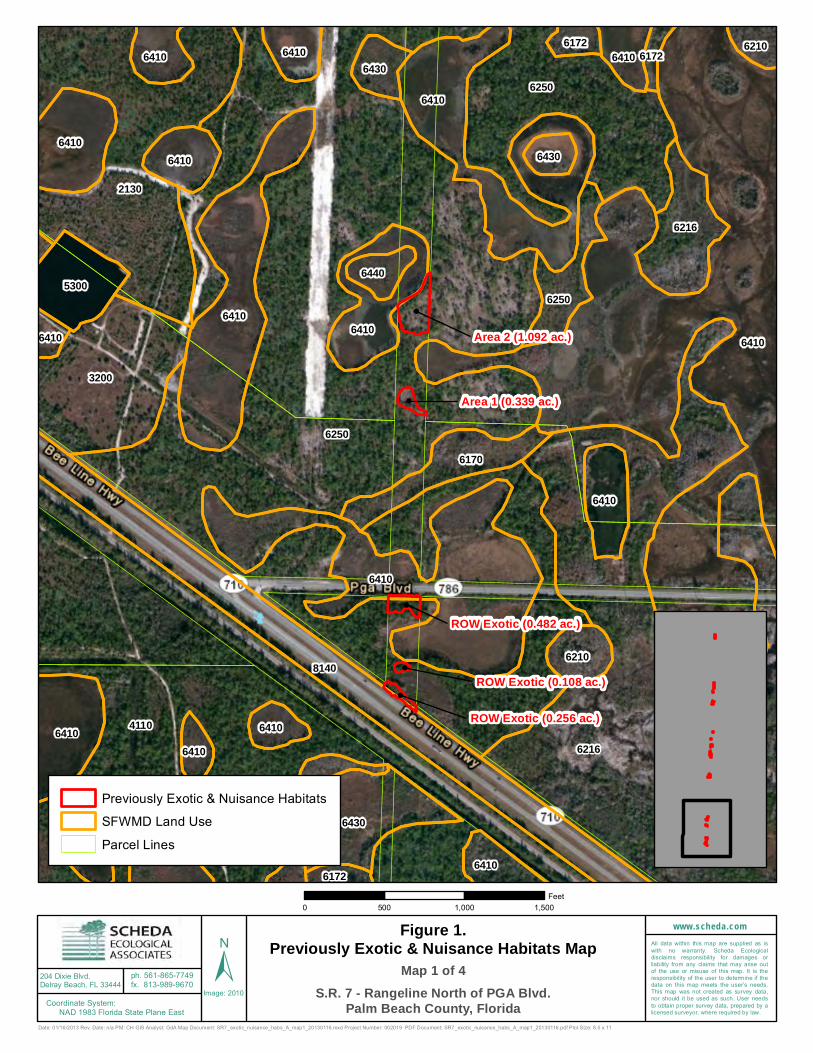
Area 2 (1.092 ac.)
ROW Exotic (0.482 ac.)
Area 1 (0.339 ac.)
ROW Exotic (0.256 ac.)
ROW Exotic (0.108 ac.)
6250
41106216
6410
2130
6410
8140
62506410
6410
3200
6430
6410
6216
6410
6410
6170
53006250
6430
6210
6410
6410
6410
6410
6210
6410 64106430
6410
6410
6440
6410
6430
6410
62106172
6172
6410
6172
Date: 01/16/2013 Rev. Date: n/a PM: CH GIS Analyst: GdA Map Document: SR7_exotic_nuisance_habs_A_map1_20130116.mxd Project Number: 002019 PDF Document: SR7_exotic_nuisance_habs_A_map1_20130116.pdf Plot Size: 8.5 x 11
204 Dixie Blvd.Delray Beach, FL 33444
ph. 561-865-7749fx. 813-989-9670
www.scheda.comAll data within this map are supplied as iswith no warranty. Scheda Ecologicaldisclaims responsibility for damages orliability from any claims that may arise outof the use or misuse of this map. It is theresponsibility of the user to determine if thedata on this map meets the user’s needs.This map was not created as survey data,nor should it be used as such. User needsto obtain proper survey data, prepared by alicensed surveyor, where required by law.
Image: 2010Coordinate System: NAD 1983 Florida State Plane East
Previously Exotic & Nuisance HabitatsSFWMD Land UseParcel Lines
Figure 1.Previously Exotic & Nuisance Habitats Map
S.R. 7 - Rangeline North of PGA Blvd.Palm Beach County, Florida
0 500 1,000 1,500Feet
± Map 1 of 4

Area 4 (1.792 ac.)
Area 3 (1.195 ac.)
Area 5 (1.099 ac.)
Area 7 (0.245 ac.)
Area 6 (0.106 ac.)
6410
6210
6250
6170
6172
6410
6170
4110
6300
2120
6172
41106410
6210
6410
62506410
6410
6170
6210
6215
6170
6215
6172
6410
6430
6215
6410
6410
6410
6410
6410
6300
6250
6410
6410 2130 6250 6250
64106300 6210
Date: 01/16/2013 Rev. Date: n/a PM: CH GIS Analyst: GdA Map Document: SR7_exotic_nuisance_habs_A_map2_20130116.mxd Project Number: 002019 PDF Document: SR7_exotic_nuisance_habs_A_map2_20130116.pdf Plot Size: 8.5 x 11
204 Dixie Blvd.Delray Beach, FL 33444
ph. 561-865-7749fx. 813-989-9670
www.scheda.comAll data within this map are supplied as iswith no warranty. Scheda Ecologicaldisclaims responsibility for damages orliability from any claims that may arise outof the use or misuse of this map. It is theresponsibility of the user to determine if thedata on this map meets the user’s needs.This map was not created as survey data,nor should it be used as such. User needsto obtain proper survey data, prepared by alicensed surveyor, where required by law.
Image: 2010Coordinate System: NAD 1983 Florida State Plane East
Previously Exotic & Nuisance HabitatsSFWMD Land UseParcel Lines
Figure 1.Previously Exotic & Nuisance Habitats Map
S.R. 7 - Rangeline North of PGA Blvd.Palm Beach County, Florida
0 500 1,000 1,500Feet
± Map 2 of 4

Area 8 (1.075 ac.)
Area 10 (0.870 ac.)
Area 9 (0.339 ac.)
6300
6210
4110
6410
41106410
6250
4110
6410
6172
4110
6250
6410
4110
4110
4110
6170
6250
7470
6250
6410
1180
6410
6172
6170
6410
6410
6172
6210
6210
1180
4110
6410
6172
6410
6250
64106410
6172
6410
6410
6410
6215
6410
6210
6215
6215
6410
5120
7470
6410
6410
6410
6410
6410
6410
6172
4110
6410
4110
6410
Date: 01/16/2013 Rev. Date: n/a PM: CH GIS Analyst: GdA Map Document: SR7_exotic_nuisance_habs_A_map3_20130116.mxd Project Number: 002019 PDF Document: SR7_exotic_nuisance_habs_A_map3_20130116.pdf Plot Size: 8.5 x 11
204 Dixie Blvd.Delray Beach, FL 33444
ph. 561-865-7749fx. 813-989-9670
www.scheda.comAll data within this map are supplied as iswith no warranty. Scheda Ecologicaldisclaims responsibility for damages orliability from any claims that may arise outof the use or misuse of this map. It is theresponsibility of the user to determine if thedata on this map meets the user’s needs.This map was not created as survey data,nor should it be used as such. User needsto obtain proper survey data, prepared by alicensed surveyor, where required by law.
Image: 2010Coordinate System: NAD 1983 Florida State Plane East
Previously Exotic & Nuisance HabitatsSFWMD Land UseParcel Lines
Figure 1.Previously Exotic & Nuisance Habitats Map
S.R. 7 - Rangeline North of PGA Blvd.Palm Beach County, Florida
0 500 1,000 1,500Feet
± Map 3 of 4

Area 11 (1.311 ac.)
6210
11101110
6410
4110
3200
4110
4110
6300
6410 41106410
4110
6210
4110
6172
4110
4110
4110
6410
61704110
6410
6172
6410
4110
6410
4110
4110
6410
6172
6410
4110
6410
4110
6172
6172
4110
6410
6210
64106410
6410 6210
Date: 01/16/2013 Rev. Date: n/a PM: CH GIS Analyst: GdA Map Document: SR7_exotic_nuisance_habs_A_map4_20130116.mxd Project Number: 002019 PDF Document: SR7_exotic_nuisance_habs_A_map4_20130116.pdf Plot Size: 8.5 x 11
204 Dixie Blvd.Delray Beach, FL 33444
ph. 561-865-7749fx. 813-989-9670
www.scheda.comAll data within this map are supplied as iswith no warranty. Scheda Ecologicaldisclaims responsibility for damages orliability from any claims that may arise outof the use or misuse of this map. It is theresponsibility of the user to determine if thedata on this map meets the user’s needs.This map was not created as survey data,nor should it be used as such. User needsto obtain proper survey data, prepared by alicensed surveyor, where required by law.
Image: 2010Coordinate System: NAD 1983 Florida State Plane East
Previously Exotic & Nuisance HabitatsSFWMD Land UseParcel Lines
Figure 1.Previously Exotic & Nuisance Habitats Map
S.R. 7 - Rangeline North of PGA Blvd.Palm Beach County, Florida
0 500 1,000 1,500Feet
± Map 4 of 4
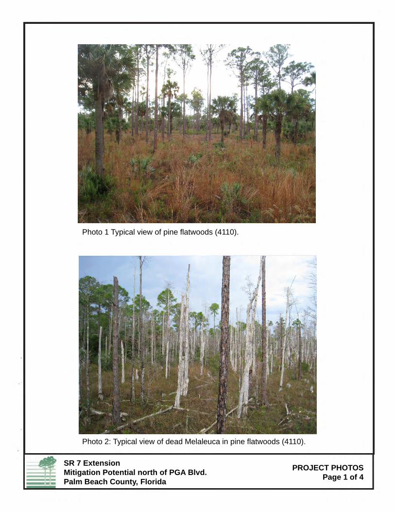
Photo 1 Typical view of pine flatwoods (4110).
Photo 2: Typical view of dead Melaleuca in pine flatwoods (4110).
SR 7 ExtensionMitigation Potential north of PGA Blvd.Palm Beach County, Florida
PROJECT PHOTOSPage 1 of 4
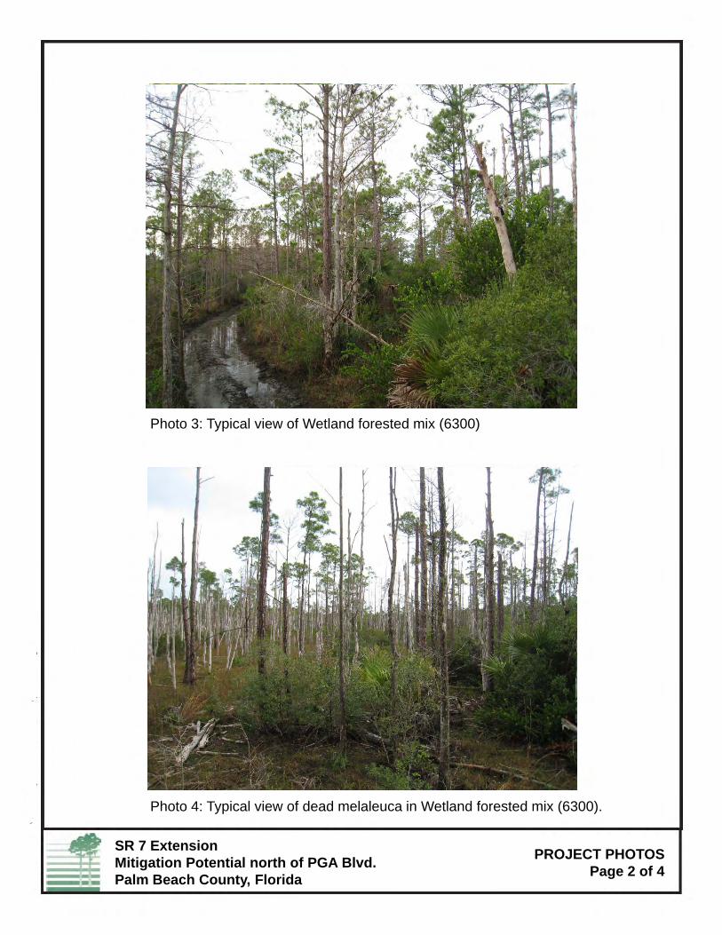
Photo 3: Typical view of Wetland forested mix (6300)
Photo 4: Typical view of dead melaleuca in Wetland forested mix (6300).
SR 7 ExtensionMitigation Potential north of PGA Blvd.Palm Beach County, Florida
PROJECT PHOTOSPage 2 of 4
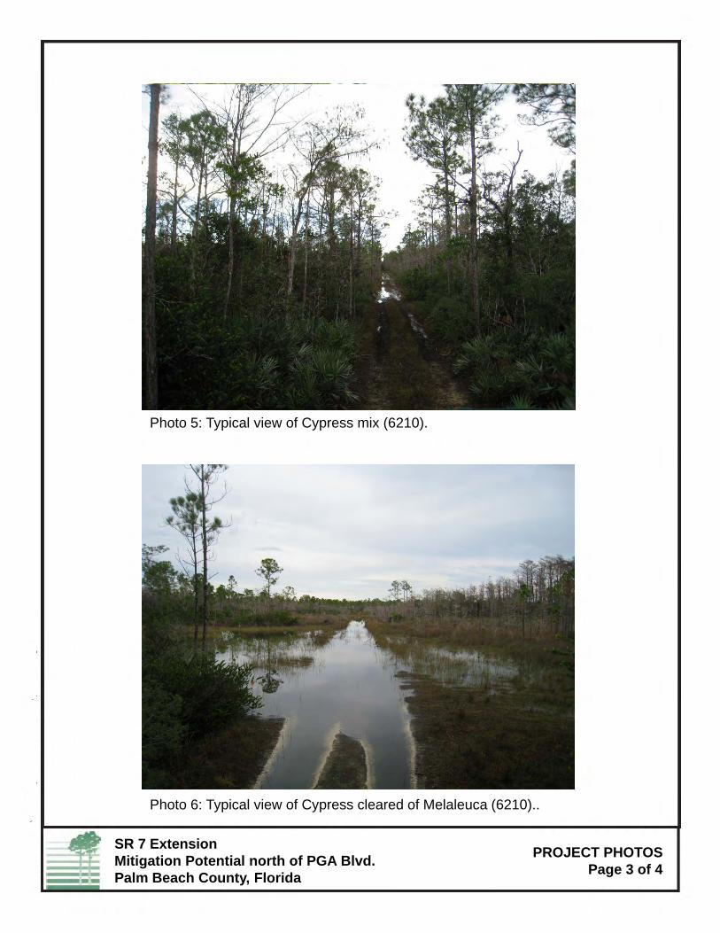
Photo 5: Typical view of Cypress mix (6210).
Photo 6: Typical view of Cypress cleared of Melaleuca (6210)..
SR 7 ExtensionMitigation Potential north of PGA Blvd.Palm Beach County, Florida
PROJECT PHOTOSPage 3 of 4

Photo 7: Typical views of areas where melaleuca was previously mulched(4110).
Photo 8:Typical views of areas where melaleuca was previously mulched(6210)
SR 7 ExtensionMitigation Potential north of PGA Blvd.Palm Beach County, Florida
(6210).
PROJECT PHOTOSPage 4 of 4

APPENDIX E
Pond Cypress Natural Area Management Plan
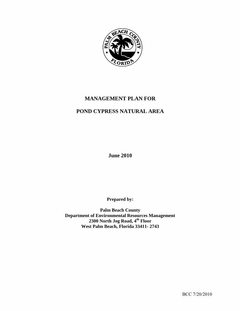
BCC 7/20/2010
MANAGEMENT PLAN FOR
POND CYPRESS NATURAL AREA
June 2010
Prepared by:
Palm Beach County
Department of Environmental Resources Management
2300 North Jog Road, 4th
Floor
West Palm Beach, Florida 33411- 2743

ii BCC 7/20/2010
THE PALM BEACH COUNTY NATURAL AREAS SYSTEM
MANAGEMENT STATEMENT
The Palm Beach County Natural Areas System is comprised of those environmentally sensitive
lands that are owned or leased by the County and managed as natural areas by the County's
Department of Environmental Resources Management. These natural areas were selected on the
basis of their biological characteristics and were acquired to preserve the rare and diverse
native ecosystems present on these sites and the endangered, threatened, and rare species of
plants and animals that live there.
Purpose and Goals of the Natural Areas System
! The purpose of the Natural Areas System is to protect historic native ecosystems
and their biological diversity throughout Palm Beach County. Examples of each
ecosystem shall be acquired and managed to preserve in perpetuity the full
complement of plants and animals characteristic of that ecosystem. The
management of each natural area shall be coordinated with that of the other
natural areas in the system to support existing populations and to reflect in
perpetuity the subtropical biological diversity characteristic of Palm Beach County
in pre-development times.
! The wilderness values of each natural area shall be preserved.
! Where a natural area currently is physically or biologically connected to another
publicly- or privately-owned natural area, attempts shall be made to maintain that
connection through additional land acquisitions, regulatory preserve set-asides,
conservation easements, interlocal agreements, and other appropriate actions.
Management Considerations
! The natural areas in the system shall be available to the public for passive,
resource-based recreation, environmental education, and scientific research.
Public use shall not take precedence over ecosystem protection. Proposed public
uses shall take into account the specific environmental conditions of each natural
area, and may be modified in response to changing environmental conditions.
! Facilities for passive public use shall be provided on each site. These facilities
shall be designed to have a minimal impact on native ecosystems and shall be
located in previously disturbed areas as much as possible.
! Facilities, structures, or roads other than management or access roads that would
cause fragmentation of a natural area shall not be permitted within a natural area.
v BCC 7/20/2010
! The establishment of compatible land uses and activities on lands adjacent to a
natural area shall be encouraged.
! To the extent possible, fire-maintained native ecosystems shall be burned at the
appropriate interval and season, as determined by historical data, to maintain those
ecosystems. Burns shall be conducted by trained personnel, using a prescribed
burn plan that addresses safety and smoke concerns. The seasonality of prescribed
burns may be adjusted for initial fuel reduction burns and site safety constraints.
! Where ecosystems within a natural area have been impacted by invasive, nonnative
plant infestations, land-clearing activities, drainage, or flooding, attempts shall be
made to restore those ecosystems to their previous condition or to a natural
ecosystem best suited to the existing conditions on the natural area.
! The special requirements of listed species shall be considered in developing
management strategies for each natural area, but management for an individual
species shall not take precedence over management of an entire ecosystem or be
allowed to have a detrimental impact on that ecosystem's complement of species.
Management Plan Development and Revision
! A specific management plan, based on biological, hydrological, and historical
information and interpretation of this information, shall be written for each natural
area that takes into account the environmental conditions found on that natural
area.
! Each management plan shall address the strategies and techniques that will be used
to manage and restore native ecosystems, to protect listed species, control the
occurrence of invasive, nonnative plants and animals, to allow for appropriate
public access, and to prevent unauthorized access and activities.
! Each plan shall be reviewed by the Palm Beach County Natural Areas Management
Advisory Committee (NAMAC), a citizens= advisory board, and the public shall be
invited to comment on the plan at a public hearing held by NAMAC in the
community in which the site is located.
! Following NAMAC review of the comments received, the plan shall be sent to the
Board of County Commissioners for approval.
! Each approved plan shall be subsequently reviewed at least every ten years by
NAMAC.

vi BCC 7/20/2010
EXECUTIVE SUMMARY
Palm Beach County’s Pond Cypress Natural Area contains an important remnant of the pine flatwoods and wet prairie mosaic that once surrounded the Loxahatchee Slough. The western edge of the slough lies in the eastern portion of the natural area and extends eastward into the adjacent City of West Palm Beach’s Water Catchment Area. The natural area is located within a portion of unincorporated Palm Beach County, just west of West Palm Beach and northeast of the Village of Royal Palm Beach. It lies within the boundaries of the Northeast Everglades Natural Area. The total County-owned portion of the site is 1,736.58 acres. The southern 1,192.25 acres, including 600.04 acres donated to the County by Fox Property Venture, were acquired by the County in 1994. Acquisition funds were provided from the County bond issue referendum of March 12, 1991. The northern 544.33 acres were acquired in 2006 as part of a real property exchange agreement with Minto Communities, Inc. The County expects to obtain another 80.1 acres of land within the now obsolete State Road 7 range-line alignment immediately east of the current natural area once the right of way has been released by the State. These lands will be managed by the County as part of the Pond Cypress Natural Area. The County expects to obtain a license and right of entry in, upon, and over approximately 60.5 acres of land located just west of the western perimeter berm surrounding the WCA as part of an Interlocal Agreement with the City. The primary purpose of the Pond Cypress acquisition is to preserve important remnants of mesic flatwoods, wet flatwoods, wet prairie, dome swamp, depression marsh, prairie hammock and strand swamp vegetation communities and their associated wildlife populations. The secondary purposes are to provide for passive recreation, environmental education, and scientific research consistent with protecting the natural resources of the natural area. The acquisition of the natural area and the related management activities will assist the County in implementing several policies within its comprehensive plan. Mesic flatwoods, wet prairie, wet flatwoods, and strand swamp are the predominant natural communities present on the site. Smaller areas of depression marsh, disturbed wet prairie, disturbed mesic flatwoods, dome swamp, disturbed wet flatwoods, disturbed strand swamp, prairie hammock, and disturbed depression marsh are also present. The acquisition and management of this site preserves important habitat for rare plant and animal species, including seventeen existing plant and nineteen animal species that have been listed by at least one government agency or nonprofit environmental organization. Fire exclusion and suppression, altering of wetland hydrology by direct and indirect connections to adjacent canals, stormwater drainage systems and levees, non-native pest plant invasion, illegal dumping, road construction, feral hogs, and off-road vehicle traffic have all impacted the site. In addition, the site faces special challenges unique to fragmented natural communities bordered by roads and residential environments. In recognition of the significance of the natural vegetation communities on the site, public use must remain limited to passive recreation, environmental education, and scientific study. Hiking trails, an accessible nature trail and wildlife observation shelter, and interpretive displays will provide valuable opportunities for the public to observe the site’s distinctive plant communities and associated animals, while also
vi BCC 7/20/2010
imparting an appreciation of their biological uniqueness. Parking facilities and educational materials will be developed to enable use of the site for environmental education. Scientific research will include monitoring of populations of rare and/or endemic species and evaluation of restoration and management activities. This management plan has been developed to collect and assemble the existing information on the site and to provide management recommendations so that current management activities can continue and expand to further improve the condition of the natural area. The management plan will be reviewed every ten years by the Palm Beach County Natural Areas Management Advisory Committee and revised as necessary on the basis of new information, improvements in management techniques, or other relevant factors.

vi BCC 7/20/2010
TABLE OF CONTENTS
PALM BEACH COUNTY NATURAL AREAS MANAGEMENT STATEMENT ii
EXECUTIVE SUMMARY iv
1. INTRODUCTION 1-1 1.1 SITE LOCATION 1-1 1.2 HISTORY 1-2
2. PURPOSE 2-1 2.1 SPECIAL FEATURES AND REASONS FOR ACQUISITION 2-1 2.2 PURPOSE OF ACQUISITION 2-1 2.3 MANAGEMENT OBJECTIVES 2-2
3. STRUCTURES AND IMPROVEMENTS 3-1 3.1 EXISTING AND PROPOSED PHYSICAL IMPROVEMENTS 3-1
3.1.1 Minimization of Site Disturbance 3-2 3.1.2 Fencing and Gates 3-2 3.1.3 Signs 3-3 3.1.4 Interpretive Facilities 3-4 3.1.5 Management Accessways and Firebreaks 3-4 3.1.6 Trails 3-5 3.1.7 Water Control Structures 3-6
3.2 EASEMENTS AND CONCESSIONS 3-7 3.3 PUBLIC ACCESS 3-8
4. KEY MANAGEMENT ACTIVITIES 4-1
4.1 MAINTENANCE 4-1 4.1.1 Removal of Debris and Litter 4-1 4.1.2 Trail Maintenance 4-1 4.1.3 Facilities Maintenance 4-2
4.2 SECURITY 4-2 4.3 STAFFING 4-3 4.4 NATURAL RESOURCE PROTECTION 4-3
4.4.1 Management of Natural Communities 4-4 4.4.2 Protection and Enhancement of Listed Species – Flora 4-9 4.4.3 Protection and Enhancement of Listed Species – Fauna 4-14
4.5 ARCHAEOLOGICAL AND HISTORICAL RESOURCES 4-18 4.6 COORDINATION WITH ADJACENT LAND USERS 4-19

vii
TABLE OF CONTENTS (concluded)
4.7 NATURAL AREAS MANAGEMENT ADVISORY COMMITTEE REVIEW 4-19 4.8 ENVIRONMENTAL EDUCATION AND SCIENTIFIC RESEARCH 4-20 4.9 GREENWAY CONNECTIONS 4-21
5. RESOURCE RESTORATION AND ENHANCEMENT 5-1 5.1 RESTORATION METHODS 5-1
5.1.1 Management Unit Design 5-2 5.1.2 Fire Management 5-3 5.1.3 Invasive Species Control 5-6 5.1.4 Hydrologic Restoration/Enhancement 5-13
5.2 COORDINATION WITH ADJACENT LAND USERS 5-15
6. COST ESTIMATES AND FUNDING SOURCES 6-1 6.1 DEVELOPMENT COSTS 6-1 6.2 KEY MANAGEMENT ACTIVITIES AND RESOURCE ENHANCEMENT COSTS 6-1
7. PRIORITY SCHEDULE 7-1
8. MONITORING 8-1 8.1 PHOTOMONITORING 8-1 8.2 HYDROLOGICAL 8-2 8.3 WILDLIFE SURVEYS 8-2 8.4 VEGETATION SURVEYS 8-2 8.5 ANNUAL REPORT 8-3
9. GLOSSARY 9-1
10. ACRONYMS 10-1
11. REFERENCES CITED 11-1
12. FIGURES 12-1
13. TABLES 13-1
APPENDIXES
BCC 7/20/2010 viii
LIST OF FIGURES
1. Pond Cypress Natural Area Location Map 12-1 2. Pond Cypress Natural Area Vegetation Map 12-2 3. Pond Cypress Natural Area Public Use Facilities Map 12-3 4. Pond Cypress Natural Area Soils Map 12-4 5. Pond Cypress Natural Area Management Facilities Map 12-5

BCC 7/20/2010 ix
LIST OF TABLES
1. Listed Plant Species Recorded at the Pond Cypress Natural Area 13-1 2. Listed Animal Species Recorded at the Pond Cypress Natural Area 13-2 3. Cost Estimates and Funding Sources for Site Preparation and Public Use Facilities 13-3 4. Estimated Annual Maintenance and Operation Costs 13-4 5. Priority Schedule for Preparation of the Pond Cypress Natural Area for Public Use 13-5

BCC 7/20/2010 x
LIST OF APPENDIXES A. NATURAL RESOURCES INVENTORY AND ASSESSMENT FOR THE POND
CYPRESS NATURAL AREA B. PLANT SPECIES OBSERVED AT THE POND CYPRESS NATURAL AREA C. ANIMAL SPECIES OBSERVED AT THE POND CYPRESS NATURAL AREA D. DEFINITIONS OF LEGAL STATUS AND RANK DESIGNATIONS FOR LISTED SPECIES AND NATURAL COMMUNITIES E. DEEDS F. EASEMENTS G. PALM BEACH COUNTY NATURAL AREAS ORDINANCE H. FIRE MANAGEMENT PLAN FOR THE POND CYPRESS NATURAL AREA I. FLORIDA NATURAL AREAS INVENTORY FIELD REPORT FORM J. FLORIDA EXOTIC PEST PLANT COUNCIL’S 2009 LIST OF INVASIVE PLANT
SPECIES K. MONITORING PROTOCOLS L. INTERLOCAL AGREEMENT

BCC 7/20/2010 1-1
1. INTRODUCTION
This management plan is intended to provide guidance in the future use and management of Palm Beach County’s (County) Pond Cypress Natural Area. The County-owned portion of the natural area contains approximately 1,736.58 acres. Tracts containing 1,538.40 acres were acquired from Fox Property Venture in November 1994 and included 600.04 acres that were donated to the County. Bond funds for the acquisition were authorized by the County’s Environmentally Sensitive Lands Referendum of March 12, 1991. Negotiations for the acquisition and other acquisition-related services were provided to the County through a contract with The Nature Conservancy (TNC). In August 2006, a three-way negotiation between the Palm Beach County Department of Environmental Resources Management (ERM), Minto Communities, Inc. and the Palm Beach County Department of Engineering and Public Works (E&PW) resulted in 250.59 acres in the southern portion of the property and 95.56 acres on the west boundary of the property being exchanged for approximately 544.33 acres of high-quality conservation land north of the original tract. The land exchange agreement also required E&PW to pay $4,359,824 to be used for the acquisition of additional environmentally sensitive lands and to donate 80.1 acres of land from the now obsolete State Road 7 range-line alignment once the right of way has been released by the State. These 80.1 acres will be managed by the County as part of the Pond Cypress Natural Area. The County expects to obtain a license and right of entry in, upon, and over approximately 60.5 acres of land (County-Access Parcel) located just west of the western perimeter berm surrounding the Water Catchment Area (WCA) as part of an Interlocal Agreement with the City of West Palm Beach (City). The acquisition of the Pond Cypress Natural Area represents part of a much larger effort to acquire the most important privately-held natural areas remaining in Palm Beach County. In 1986 the Board of County Commissioners (BCC) funded an inventory of the native ecosystems in Palm Beach County by two Florida Atlantic University professors - Dr. Grace Iverson and Dr. Daniel Austin (Iverson and Austin 1988). The study was completed in 1988, and additional work was done by the researchers in 1989. The Pond Cypress Natural Area (as part of the larger Loxahatchee Slough ecosite) was one of the 39 AA@ quality sites identified, 14 of which were given high priority for acquisition by the County's Environmentally Sensitive Lands Acquisition Advisory Committee (ESLAAC) in 1990. On March 12, 1991 the voters of Palm Beach County approved a $100 million bond referendum to purchase environmentally sensitive lands, with emphasis on the 14 high-priority sites. 1.1 SITE LOCATION The Pond Cypress Natural Area is located approximately ten miles inland from the Atlantic Ocean, in the east central portion of Palm Beach County (Figure 1). The natural area covers most of Sections 1, 12, and 13 and part of Section 24 in Township 43 South and Range 41 East. The County-owned natural area, together with the obsolete rangeline right of way, consists of approximately 1,816.68 acres of land and contains seven native Florida ecosystems. Both the natural area and obsolete right of way area within the unincorporated portion of Palm Beach
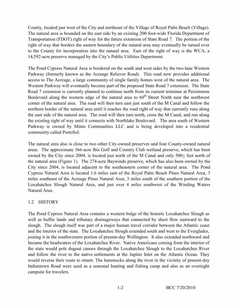
BCC 7/20/2010 1-2
County, located just west of the City and northeast of the Village of Royal Palm Beach (Village). The natural area is bounded on the east side by an existing 200-foot-wide Florida Department of Transportation (FDOT) right of way for the future extension of State Road 7. The portion of the right of way that borders the eastern boundary of the natural area may eventually be turned over to the County for incorporation into the natural area. East of the right of way is the WCA, a 14,592-acre preserve managed by the City’s Public Utilities Department. The Pond Cypress Natural Area is bordered on the south and west sides by the two-lane Western Parkway (formerly known as the Acreage Reliever Road). This road now provides additional access to The Acreage, a large community of single family homes west of the natural area. The Western Parkway will eventually become part of the proposed State Road 7 extension. The State Road 7 extension is currently planned to continue north from its current terminus at Persimmon Boulevard along the western edge of the natural area to 60th Street North near the northwest corner of the natural area. The road will then turn east just south of the M Canal and follow the northern border of the natural area until it reaches the road right of way that currently runs along the east side of the natural area. The road will then turn north, cross the M Canal, and run along the existing right of way until it connects with Northlake Boulevard. The area south of Western Parkway is owned by Minto Communities LLC and is being developed into a residential community called PortoSol. The natural area also is close to two other City-owned preserves and four County-owned natural areas. The approximate 366-acre Ibis Golf and Country Club wetland preserve, which has been owned by the City since 2004, is located just north of the M Canal and only 500+ feet north of the natural area (Figure 1). The 274-acre Baywinds preserve, which has also been owned by the City since 2004, is located adjacent to the southeastern corner of the natural area. The Pond Cypress Natural Area is located 1.6 miles east of the Royal Palm Beach Pines Natural Area, 3 miles southeast of the Acreage Pines Natural Area, 3 miles south of the southern portion of the Loxahatchee Slough Natural Area, and just over 4 miles southwest of the Winding Waters Natural Area. 1.2 HISTORY The Pond Cypress Natural Area contains a western bulge of the historic Loxahatchee Slough as well as buffer lands and tributary drainageways that connected by sheet flow eastward to the slough. The slough itself was part of a major human travel corridor between the Atlantic coast and the interior of the state. The Loxahatchee Slough extended south and west to the Everglades, joining it in the southwestern portion of present-day Wellington. It also extended northward and became the headwaters of the Loxahatchee River. Native Americans coming from the interior of the state would pole dugout canoes through the Loxahatchee Slough to the Loxahatchee River and follow the river to the native settlements at the Jupiter Inlet on the Atlantic Ocean. They would reverse their route to return. The hammocks along the river in the vicinity of present-day Indiantown Road were used as a seasonal hunting and fishing camp and also as an overnight campsite for travelers.
BCC 7/20/2010 1-3
It is unlikely that there were any Native American settlements in the Pond Cypress Natural Area. Most early Native American archeological sites in Florida are associated with hammocks next to significant water bodies. In this area, the hammocks are found to the east in low ridges in the present-day WCA. The natural area may have been utilized periodically for hunting and gathering activities, but it lacked the water transportation connectors, plentiful food supply, and shaded dwelling areas characteristic of most Paleo-American dwelling sites. 1.2.1 Early Settlers and Land Speculators - 1873 to 1912 As the Seminole Indian Wars ended and the turmoil of the Civil War receded, Palm Beach County became attractive to settlers. The first permanent settlers came to Palm Beach County in the mid-1870s, and settled on the shores of the Lake Worth Lagoon in the vicinity of the Town of Hypoluxo. They were followed by more pioneers, who settled farther north along the lagoon on the island of Palm Beach. As the area became more settled, and the economy moved beyond basic farming and hunting, the more enterprising settlers began to build small hotels to accommodate winter visitors. Henry Flagler, an oil and railroad magnate who owned a large winter resort hotel in St. Augustine, visited the Palm Beach area in 1893 and immediately recognized its potential. He bought large tracts of land, both on the island of Palm Beach and opposite his Palm Beach holdings on the mainland. By August 1893, he platted the new city of West Palm Beach (WPB) on the mainland as a place for his workers to live, while he built the huge Royal Poiniciana Hotel resort on Palm Beach. WPB was incorporated as a city in 1894 (Tuckwood 1999). Flagler extended his Jacksonville, St. Augustine and Halifax River Railroad (the present-day Florida East Coast Railroad) southward to reach Palm Beach in 1894 and Miami in 1896. Flagler received some of the land adjacent to the railroad from the State of Florida as an incentive to build the railroad. He also gained control of additional lands through an investment in the Florida Coast Line Canal and Transportation Company (FCLCTC), which was awarded large tracts of interior wetlands from the State in return for constructing the Florida East Coast Canal. The canal company lands included Section 12 and the eastern 2/3 of Section 24 in the natural area and other large portions of the Loxahatchee Slough. These lands were received from the State in the 1880s and 1890s, although the canal company’s title to the lands was not confirmed until the 1900s. In 1895, Sections 1 and 13 were given to the Disston Land Company by the State as partial compensation for the construction of drainage/transportation canals by the Disston-controlled Atlantic and Gulf Coast Canal and Okeechobee Land Company in central Florida. A Flagler-related land company would eventually acquire the FCLCTC lands containing the south-central portion of the Loxahatchee Slough north of present-day Okeechobee Boulevard from the successors of the FCLCTC. By the late 1910s, all four sections of land in the natural area were controlled by investors linked to the canal company.

BCC 7/20/2010 1-4
In the mid-1890s, Flagler built a water plant on the east shoreline of Clear Lake to provide drinking water for WPB and his Palm Beach resort. Clear Lake was replenished by water flowing in from wetlands to the west. This water flow connection would be improved over time. In 1902 a group of Louisiana investors, the Southern States Land and Timber Company (Southern States), purchased approximately two million acres of land around Lake Okeechobee from the State of Florida for twenty-five cents an acre (SSLTLLC undated). The purchase included large areas of western present-day Palm Beach and Martin Counties, including much of the land west of the natural area. If the natural area had not already been owned by the canal interests, it would most likely have been included in this purchase. Southern States was primarily a real estate investment company. When it started cutting the old growth pine trees on its purchase, the lumbering was usually done by timber companies that signed leases with Southern States (Hutchinson and Paige 1998). 1.2.2 Canals, Roads, Infrastructure and Speculators - 1913 to 1953 From 1913 to 1917, the WPB Canal (the present day C-51 and L-12 Canals) was dug from Canal Point, on the southeast side of Lake Okeechobee, to the Lake Worth Lagoon on the Atlantic coast. This canal is located approximately 2.5 miles south of the natural area. The section nearest the natural area was dug in 1914. The canal was dug as part of a plan to drain the Everglades that was funded by a 5-cent-an-acre annual levy by the now-defunct Everglades Drainage District. In 1915 the Lake Worth Drainage District (LWDD) was formed. LWDD began to dig a network of canals to drain the area west of the coastal ridge and east of State Road 7/U.S. Highway 441 and between Okeechobee Road and the Hillsboro Canal (the future Broward County line). Major north-south canals called equalizing canals were dug every 2 to 2.5 miles, and smaller east-west lateral canals were dug every half mile. Equalizing Canal 1 (also known as the E-1 Canal) was dug just east of the range line between Ranges 41 and 42, on the east side of present day State Road 7. Between 1918 and 1920, Lateral Canal 1 (L-1 Canal) was dug 0.5 miles south of the natural area starting in the northwest corner of Section 30, Township 43 South, Range 42 East; it ran to the east. The construction of the WPB Canal near the natural area in 1914, followed by the LWDD canal grid in the late 1910s, effectively severed the southern portion of the Loxahatchee Slough from the central and northern portions. Water from the natural area no longer had the option of flowing south to the Everglades, as that route was blocked by canal berms. Surface water could only flow north through the Loxahatchee Slough and eventually into the Loxahatchee River. However, neither the LWDD canal grid nor the WPB Canal seemed to have much of an impact on the natural area, as United States Geological Survey (USGS) aerial photographs (USGS 1940, 1953) show the wetlands as being full of water.

BCC 7/20/2010 1-5
As farming settlements sprang up in the Belle Glade area in the mid-1910s as a result of the drainage created by the canals of the Everglades Drainage District, there was increasing pressure to build a road to connect the area to WPB. In 1916 a County referendum was passed for the issuance of $150,000 in bonds to build roads, one of which was a road to the Belle Glade area. The road was originally planned as an extension of Okeechobee Road (Okeechobee Road became the present-day Okeechobee Boulevard in 1968) heading west from WPB, but ran into trouble when it hit the swampy soils of the Loxahatchee Slough. The first contractor went broke trying to construct the road through the slough. The second contractor was very happy when the road route was moved south to the solid bank of the WPB Canal (Will 1984). The new road ran west on present-day Old Okeechobee Road to Military Trail, then south to the north bank of the canal, and west along the north side of the canal to the present-day 20-mile bend area. The road continued westward to Belle Glade on the banks of the Ocean and Hillsboro Canals. This road (the present-day Southern Boulevard) reached Loxahatchee Groves (started as a dairy by Southern States in 1917 and platted as a development in 1920 and 1925) in 1919 and Belle Glade in 1921; it was completed with limestone surfacing and bridges in 1923. It appears that the L-1 Canal was dug after Okeechobee Road had been abandoned as a road route to the Glades. Otherwise, the canal bank would have served as a means of crossing the Loxahatchee Slough. During the construction of its drainage canals, the LWDD placed canal spoil on one side of the canal and then level it for use as a raised dirt road to access and maintain the canal system. These canal bank roads often provided the first road access to many areas. Some of these LWDD access roads gradually evolved into regular roads over time. The L-1 Canal road ultimately became an extension of Okeechobee Road, while the E-1 Canal road became present-day State Road 7/ U.S. Highway 441. The early road maps of the 1920s (Carr and McFadden, 1921; H.C Fugate Engineering Co. 1923; Associated Map Co. 1926) all show present-day Okeechobee Boulevard as being present. However, they show the road as extending all the way to the western edge of Loxahatchee Groves, while aerial photographs show the road ending at present-day State Road 7 until 1968. A dirt road has been present on most of the path of present-day Okeechobee Boulevard in Loxahatchee Groves since the early days. The road maps of the 1920s were made as much for promotional purposes as they were made to guide travelers. They would often show roads that had been proposed or platted but never built. In reality, Okeechobee Road appears to have been built as an improved road only as far as the present-day Florida’s Turnpike. Beyond that, it was little more than a canal bank trail. On the 1920s road maps the present-day Southern Boulevard is labeled as Okeechobee Road. Prior to 1940, Okeechobee Road was apparently passable enough to be used by logging trucks. A 1940 aerial photograph (USGS 1940) shows an unimproved logging trail extending from the western end of Okeechobee Road near present-day State Road 7 and heading northwest and then north through the middle of the natural area. The alignment of the logging trail avoided major wetlands. The trail is still present today, although it has been impacted by previous ORV use.

BCC 7/20/2010 1-6
Another logging trail ran just east of the natural area in the present-day WCA. Ecoimpact, Inc. (1978) observed that “…logging sign, although not recent, can be found throughout the property’s pineland association.” All marketable slash pines appear to have been removed from the natural area in the late 1930s. It is difficult to estimate the size and density of the harvested trees, as almost all of the stumps were removed for resin extraction in the 1970s. Three 10- to 20-acre cleared areas are present along the logging road near the end of Okeechobee Road in the 1940 photograph. Remnants of old fencing were found in one area and old furrows in another, so it appears that the clearings were for short-lived agricultural purposes. The clearings are revegetated in the 1953 aerial photograph (USGS 1953). All of these former agricultural areas lie south of the current border of the natural area. Okeechobee Road and State Road 7 in the vicinity of the natural area became improved paved roads in the early 1950s. Both roads appear to be little more than canal bank trails in the 1940 aerial photograph. A 1946 topographic map (USGS 1946) does not show these roads as being paved, but shows unimproved roads branching off from them with a few dwellings present. Present-day State Road 7 lying south of the WPB Canal is labeled “Range Line Road,” and it appears to be nonexistent north of the canal. It is believed that both roads were improved and paved in the early 1950s as part of the post-World War II boom, as they are present as paved roads in the 1953 aerial photograph (USGS 1953). The road on the north side of the WPB Canal had been extended eastward from Military Trail by this time to connect with Southern Boulevard in WPB, and the entire road was known by its present-day name of Southern Boulevard. State Road 7 was built from Southern Boulevard to Okeechobee Road in 1952-53. It is visible in the 1953 aerial photograph as a newly-built two-lane road, with additional cleared and filled land for an additional two lanes. It is believed that Okeechobee Road was improved and paved at the same time to connect to the new road. Both roads may have been improved because Okeechobee Road was planned as an interchange for Florida’s Turnpike, which was constructed in 1956. In 1919 and 1920, Harry Kelsey’s East Coast Finance Corporation bought large tracts of land in northeastern Palm Beach County, including a large swath of FCLCTC lands that contained all of the natural area. Mr. Kelsey began to develop a new town he called Kelsey City (present-day Lake Park), which was incorporated in 1923. Then a devastating hurricane hit Miami in 1926, scaring away many people who were considering moving to Florida. Investors stopped putting money in Florida ventures, and the land boom collapsed in the mid-1920s because there were no new buyers willing to pay higher prices. Another hurricane hit Palm Beach County in 1928, killing thousands around Lake Okeechobee and destroying most of the buildings in coastal areas. Harry Kelsey went bankrupt by 1931 and his namesake city lost its state charter in 1930. After the land boom crashed and the Depression hit, many landowners were unable to pay their taxes, especially those levied by the Everglades Drainage District, which had sold bonds to build the major canals in southeast Florida. A state law known as the Murphy Act was passed in 1937, which allowed the Trustees of the Internal Improvement Fund, now known as the Trustees of the Internal Improvement Trust Fund (TIITF), of the State of Florida to take title to properties with
BCC 7/20/2010 1-7
delinquent taxes and convey that title to others for the back taxes owed. Large portions of the Loxahatchee Slough reverted back to state ownership under this law. After Harry Kelsey’s 1931 bankruptcy (Gooding 1990), his landholdings underwent many ownership changes as they were liquidated to various companies and speculators, many of whom later defaulted on their taxes, mortgages, or other obligations. By the late 1930s, most of Kelsey’s former landholdings, including portions of the natural area and the lands to the east, were controlled by John Bills II. Mr. Bills is believed to have been the trustee for some of Kelsey’s creditors, but not the actual owner of the former Kelsey holdings, although he would later purchase some of the lands. Some of former Kelsey-owned lands in the natural area were claimed by the State for unpaid taxes. Between 1913 and the mid-1920s, WPB continued to grow, especially during the Florida land boom of the mid-1920s. As it grew, the surface waters of Clear Lake became inadequate to supply the City’s water plant, so a channel was dredged to connect it to Lake Mangonia to the north. Even more water was needed, so a canal was dug westward from the northwest corner of Lake Mangonia to the edge of the Loxahatchee Slough. This canal was designed to extract water from adjacent wetlands, and had periodic cuts in its banks to allow water to flow into the canal, as shown in the 1940 aerial photograph (USGS 1940). It is not known exactly when the two lakes were linked and the western canal was dug, but both features were present on a 1930 coastal chart (United States Coast and Geodetic Survey 1930) that was prepared from 1928 aerial photographs. The western canal was called the WPB Water Supply Canal until the late 1950s. The canal was apparently dug with the permission of Harry Kelsey, as the Flagler interests would not gain title to the wetlands where the water was extracted until 1940. During this time, Southern States had not been idle with its lands. It would sell land to anyone who met its price, and sold a large tract to the St. Lucie Land Company as early as 1904 (Hutchinson and Paige 1998). The secretary of Southern States, George Bensel, established an office in WPB and ran its south Florida operations for 48 years. Southern States is credited with laying the groundwork to drain the Everglades, pioneering the planting of sugar cane, cutting roads and trails on its lands, opening the area to ranchers, and introducing the first purebred cattle in Martin County. In the 1940s, Southern States sold a huge tract of land west and north of the natural area that became the Indian Trail Ranch. These lands extended as far north as present-day Northlake Boulevard, westward well into the Everglades, and as far south as Southern Boulevard. The repeal of the Florida open-range laws in 1948 (Robison and Andrews 1995) and the requirement that ranchers keep their cattle fenced in on their own property may have had something to do with the establishment of the ranch. The natural area may have had some sporadic cattle grazing during the open range era, but is not believed to have ever been part of any ranch operation. The only fencing documented on the site is a several-hundred-foot-long stretch of dilapidated fencing recorded in the northeast corner of Section 12 in 1978 (Ecoimpact, Inc. 1978).

BCC 7/20/2010 1-8
By 1940 John Bills II had gained ownership of the natural area and the lands to the east by either purchasing tax deeds from the State or buying the land from the Kelsey creditors. He then sold the entire natural area to the Tucson Corporation in 1941. The corporation deeded a 200-foot road right of way to Palm Beach County in 1948 along the eastern edge of the natural area. This right of way was subsequently transferred to the State in 1952 for the future extension of State Road 7 and additional right of way was obtained all the way to Jupiter Farms. An additional 89- to 103-foot-wide strip along the western edge of Section 19, adjacent to the State Road 7 right of way, was deeded to the State by the adjacent landowners in 1948. The Flagler-owned Model Land Company purchased the lands east of the natural area within the present-day WCA from John Bills II in 1940 for $33,500. The sale was a complicated transaction that was not completely finalized until 1942. The lands were already part of the water supply system for WPB and Palm Beach County. As the area boomed after World War II, the surface water collection system again had problems delivering enough water. In order to hold water within the Flagler lands and stop it from draining off, the West Palm Beach Water Company was formed in 1949 and constructed a dike on the east and south sides of the land it set aside to collect water. The southern part of the dike was constructed one mile north of Okeechobee Road and ended just east of the natural area. The eastern part of the dike was constructed from Lake Park West Road to 2 miles north of Okeechobee Road. There was a low dike labeled “dirt spillway” on a 1951 plat that was constructed east of Sections 12 and 13 in the natural area. Otherwise, there was no dike on the west side of the water collection lands, since the lands to the west were at a higher elevation and water from them flowed into the water collection lands. Another mile-long dike was constructed across the Loxahatchee Slough one mile north of present-day Northlake Boulevard at about the same time to block the northward flow of water. This dike was of questionable value, since the construction of the Drake Lumber Company Railroad in the 1920s had already partially blocked the northward flow. The abandoned railroad bed was converted to a private shellrock road in the 1930s and became the paved county Lake Park West Road in 1951. This road is now known as Northlake Boulevard. All of the dikes around the water collection lands were constructed in a similar manner. A borrow ditch was dug on the inside of the dike location and the spoil piled on the outside. Some spoil was moved from upland areas to wetland areas where more spoil was needed and less was available. The spoil piles were leveled to form a flat-topped dike with a one-lane unimproved road on top. The dikes held more water in the central portion of the Loxahatchee Slough, and made more water available for the West Palm Beach Water Company. The dikes may have reduced the amount of water that could drain from the natural area, a point that would be the source of much contention in the 1970s. In 1951 the West Palm Beach Water Company filed a plat for the lands dedicated for water collection, which led to this area being called the “Water Catchment Area.” Almost all of the land east of the natural area was in the WCA.
BCC 7/20/2010 1-9
The 1947 hurricane and other tropical storms caused widespread flooding in South Florida. In 1948 Congress authorized the U.S. Army Corps of Engineers’ Central and Southern Florida Project to provide flood control, water supply, and protection of fish and wildlife resources in the region. The project would lead to the construction of 1,000 miles of canals and levees, 150 water control structures, and 16 major pump stations. One of the goals of the project was to establish the Everglades Agricultural Area (EAA) and several water conservation areas. These areas were to be delineated by perimeter levees and canals. The WPB Canal was used primarily for project drainage purposes. It was renamed in 1948, the eastern part becoming the C-51 Canal and the western part becoming the L-12 and L-10 Canals. It had several structures and pump stations constructed within or near it. Near the natural area, the Levee 8 (or L-8) Canal was constructed to form the northeast border of the EAA. Many of the project canals incorporated segments of existing canals, and the L-8 Canal was no exception. The L-8 Canal included a canal that ran north from the WPB Canal for approximately four miles, several miles west of Loxahatchee Groves. This canal is present on a 1923 road map (H.C. Fugate Engineering Co. 1923); it became the southern end of the L-8 Canal. At the end of the existing canal, the L-8 Canal turned to the northwest and ran along the transitional boundary of the Everglades and the adjacent pine flatwoods until it eventually turned west and connected to Lake Okeechobee. The L-8 Canal was intended as a water supply canal to bring Lake Okeechobee irrigation water to supply the now-drained EAA, and to keep the EAA from being flooded by waters flowing in from the north and east. It also had the unintended effect of allowing the draining of the transitional wetlands along its northern banks, as many property owners connected ditch systems to the canal. The southern portion of the L-8 Canal was constructed by 1953 and is present in the 1953 aerial photograph (USGS 1953). The central portion of the canal was still under construction in 1954. Where the canal turns and angles to the northwest, a stub canal was also constructed in 1953 that angled to the northeast and ran for one mile. This canal, known as the L-8 Tieback Canal, was intended to connect to the west leg of the C-18 Canal. However, when the C-18 Canal was constructed in the late 1950s, it stopped well short of the L-8 Tieback Canal. In early 1953 the Tucson Corporation sold Section 1 in the natural area to the Black Point Corporation. It also sold Sections 12, 13, and 24 within the natural area and two other tracts of land to a group of investors known as the Acreage Investment Company, Inc. That same year, Acreage Investment Company granted a 160-foot-wide easement to the Florida Power and Light (FPL) Company for the construction of electrical transmission, telephone, and telegraph lines over the southern portions of Section 13. This easement lined up just south of the southern border of the WCA and crossed the entire natural area from east to west. Three sets of H-frame electric transmission lines were constructed shortly thereafter and are present in a November 1953 aerial photograph (USGS 1953). After crossing the natural area, the transmission lines turned south. The transmission lines connected the Rivera Beach power generation plant to other plants in Dade and Broward Counties and were part of a regional transmission grid. The 1953

BCC 7/20/2010 1-10
aerial photograph shows a cleared wet swathe underneath the transmission line. FPL has suppressed woody vegetation in and near the easement ever since. Because of the wetness of this site, large tracked swamp buggies and similar vehicles have been used for most of the FPL construction and maintenance activities within the natural area. When Pratt & Whitney built a testing and manufacturing complex in the late 1950s, additional transmission lines were extended north along the western border of Section 13, before turning northwest to bring electricity to a major user. 1.2.3 Maurice Fox and Royal Palm Beach Colony - 1954 to 1990 In 1954, Sections 12, 13, and 24 within the natural area and two other separate tracts northwest and southwest of the natural area were purchased from Acreage Investment Company, Inc. by New Jersey resident Maurice Fox. It is not known whether Mr. Fox was part of the original Acreage Investment Company and bought his partners out, or if he was an unrelated party. Mr. Fox was a land speculator who later tried his hand at being a developer. He would have a major impact on the natural area for several years following his purchase. In 1956 Samuel Friedland purchased a controlling interest in the Indian Trail Ranch for $3 million (Engelhardt 1997). At that time, the ranch held title to approximately 56,000 acres west and north of the natural area. Mr. Friedland founded the Food Fair grocery store chain which was the first national supermarket chain. Mr. Friedland moved fast to develop his landholdings. The Indian Trail Water Control District (ITWCD) was started in 1957 to provide drainage for the land. At the same time, Royal Palm Beach Colony, Inc. was set up as the development company. In 1959 the Village of Royal Palm Beach was incorporated under a new state law that allowed developers to set up their own municipalities as long as they turned them over to the residents at some future date. Palm Beach Gardens and the now-defunct City of University Park were similar developer municipalities incorporated at the same time. The Indian Trail Ranch was too big and irregular to be completely developed, so Mr. Friedland reshaped his landholdings to maximize their potential. He sold off 10,000 acres in the EAA to sugar cane interests and 13,500 acres to Pratt & Whitney, which the aircraft engine maker then swapped to FGFWC in exchange for a 6,750-acre tract that is Pratt’s current engine testing site (Snyder 2003). The 13,500 acres became part of the present J.W. Corbett Wildlife Management Area. Another 4,000 acres was sold for the Callery-Judge citrus grove and another 7,000 acres set aside for Indian Trail Groves, which was intended to supply citrus for Friedland’s grocery stores (Engelhardt 1997). At the same time, Mr. Friedland was buying up the old Flagler lands east of the Indian Trail Ranch, including some of the land on the western border of the natural area and some of Maurice Fox’s other landholdings. When all of the buying and selling was done, Friedland’s interests owned approximately 4,000 acres in the original portion of the Village of Royal Palm Beach and 17,000 acres that would become known as “The Acreage.”

BCC 7/20/2010 1-11
The City also became active in real estate acquisitions at this time. It bought the West Palm Beach Water Company and its 21.5-square-mile WCA and the City’s “westward expansion area” from the Flagler interests in 1955. The purchase included almost all of the land on the eastern border of the natural area. By this time, the WCA was once again inadequate to meet the growing water demands of the City’s service area. The new L-8 Canal to the west offered a direct connection to Lake Okeechobee. A right of way was obtained from Indian Trail Ranch for a canal to connect the WCA to the L-8 Tieback Canal. This canal ran along the section line on the northern border of the natural area and was completed in late 1956. A raised dike with a one-lane road on top was built with the excavated spoil between the natural area and the canal. The canal started at the western end of the old West Palm Beach Water Supply Canal, angled to the northwest until it reached the northeast corner of the natural area, then ran west along the section lines until almost the very end, where it angled southwest to join the L-8 Tieback Canal. The new canal section was designated the “M” Canal, after the naming system adopted for major canals in ITWCD. Eventually, the entire canal became known by that name. Initially, the water levels in this canal were controlled by those in the L-8 Canal, which had a control elevation of 15 feet. Water flow was by gravity, which meant that the WCA had to be below 15 feet before significant water flowed through the canal. The construction of the M Canal did not result in any significant reduction of the hydroperiod of the natural area, as evidenced in the 1965 aerial photograph (Palm Beach County Property Appraiser 1965). Seepage losses from the natural area were minimal, since the difference between canal and natural area water levels was not that significant. The Village started out as a retiree-oriented golf course community, with construction beginning near Southern Boulevard and proceeding northward along Royal Palm Beach Boulevard. By 1965 the Village had 475 residents. A drainage ditch is present on the entire perimeter of the initial development area in the 1965 aerial photograph (Palm Beach County Property Appraiser 1965), including the western border of Maurice Fox’s ownership in Section 24. The portion of the ditch bordering the Fox ownership was dug in 1964. The western leg of the drainage ditch emptied into the C-51 Canal and was dug in 1958 (CZR, Inc. 1988a). This north-south leg extended three miles north of Southern Boulevard, and was significantly wider than the rest of the ditch. It was the beginning of ITWCD’s M-1 Canal. The wetlands that the western perimeter drainage ditch cut through in Section 24 show reduced water levels, but otherwise no significant effects are seen on the natural area in the 1965 aerial photograph. The 1965 aerial photograph also shows that a dike had been built from the southern end of the WCA perimeter dike southward about 350 to 400 feet east of Sections 13 and 24 to Okeechobee Road. In the mid-1960s, the City was again having problems supplying its growing service area with water from the WCA. It received permission to install a pump station at the western end of the M Canal, and began pumping water in 1966 into the canal whenever water levels in the WCA were below 18 feet and water was available in the L-8 Tieback Canal (Mock, Roos, & Searcy, Inc. Consulting Engineers 1974). This pumping had a significant effect on the WCA. The WCA’s hydroperiod was now of longer duration, and over time wetland communities expanded

BCC 7/20/2010 1-12
as former upland communities experienced more persistent high water levels. The pumping raised the water levels in the M Canal to levels as high as or higher than those in the natural area and eliminated any seepage losses from the site to the canal. Maurice Fox, who always thought that the City was flooding his property, filed a lawsuit in 1965 to stop the pumping or force the City to build a dike to contain the pumped water on its property. Mr. Fox lost his lawsuit in 1969, but filed an appeal. When it became apparent that Mr. Fox was going to lose the initial lawsuit, he began to build a dike of sorts of his own on the eastern edge of Sections 12 and 13 that extended into the southern portion of Section 1. This barrier consisted of a meandering shallow ditch with the spoil piled into a low berm on one side or the other. It was located primarily in the State Road 7 right of way. There was some attempt to link upland areas and use them as part of the barrier. However, Mr. Fox’s barrier was too small and low, and was mostly ineffective at limiting water flows. It is visible on the 1973 aerial photograph (Palm Beach County Property Appraiser 1973), and is still present in an eroded state on the natural area today. While Mr. Fox’s appeal was pending, Mr. Fox and the City decided to negotiate and settle their differences. The City agreed to construct an earthen dike on the western boundary of Sections 6, 7, and 18 (approximately 350 to 400 feet east of the natural area) between April and November 1970. The dike would run from the southern dike of the M Canal to the existing southern boundary dike of the WCA, and the western edge of the dike would be located a minimum of 100 feet east of the section line. The dike would have a minimum elevation of 23 feet (one foot above the other perimeter dikes), a side slope of 33%, and a 10-foot-wide level top. Muck deposits were to be excavated and removed from the dike’s location and no muck or organic materials were to be included in the dike embankment. A borrow ditch was to be dug to the east side of the new dike and the excavated spoil was to be used to construct the dike. The dike was completed in late 1970 and has essentially remained unchanged since then, other than the installation of water lines in the berm in the late 1990s. The agreement to maintain the dike would be terminated if the City no longer impounded water in the WCA. The agreement also required both parties to relinquish any past claims against the other for flooding of properties, interference with drainage, and claims of easements and ownership on the other’s properties. The agreement was binding on successor owners. The City also agreed not to vote against or hinder Mr. Fox’s attempt to drain his property through the Northern Palm Beach County Water Control District (NPBWCD), now known as the Northern Palm Beach County Improvement District (NPBCID). Although Mr. Fox succeeded in stopping City water from backing up on his property, he also blocked his natural drainage path, and this decision would come back to haunt him. By 1968 the County had obtained a 106-foot-wide right of way across the southern portion of Section 24 from Maurice Fox and constructed a two-lane extension of Okeechobee Boulevard (formerly named Okeechobee Road) westward to connect to Royal Palm Beach Boulevard. At about the same time, Royal Palm Beach Colony started on the next phase of its development plan

BCC 7/20/2010 1-13
and began turning most of the area north of the Village of Royal Palm Beach into a rural residential development. Approximately 17,000 acres were divided into 1.25-acre parcels, and the development was dubbed “The Acreage” (Figure 1). ITWCD was tapped as the entity to construct the canal system and the dirt roads; it issued bonds that would be paid back by the property owners. The M-1 Canal was being widened and extended northward in 1968. By 1970, canals and dirt roads in the first three sections of The Acreage were completed, and Royal Palm Beach Boulevard had been extended to the M Canal as a dirt road. The completed sections included Sections 2 and 11 on the western border of the natural area. Other sections in The Acreage followed until the entire area was crisscrossed by dirt roads and canals by the late 1970s. Lots in the Acreage were priced at approximately $5,000 each and were sold via nationwide advertisements in mass-market magazines, radio, and television. For terms like $95 down and $25 a month, people were encouraged to buy their future home site in The Acreage. Initially, many of the sales were to out-of-state and even out-of-country buyers. However, only a few buyers actually built homes, and by 1977 there were only 78 houses present, mostly in the first sections adjacent the natural area. No houses are visible bordering the natural area in the 1973 aerial photograph, and only three are present in the 1978 aerial photograph (Palm Beach County Property Appraiser 1973, 1978). When ITWCD initially constructed The Acreage’s perimeter roads, including 110th Avenue North, which runs along the western border of the natural area, it put in one-lane roads with a ditch to the outside. The outside ditch connected to interior canals via culverts under the road. All of the ditch spoil was piled on the roadbed, and there was no barrier to prevent natural area waters from flowing into the ITWCD ditch. Nearly all of the site’s wetlands bordering 110th Avenue North showed signs of reduced hydroperiod in the 1973 aerial photograph, and the disturbed wetlands areas along the natural area’s western border were created at this time. Maurice Fox apparently tried to use the ditch to help drain his land, as a new short spur ditch is visible connecting a large natural area wetland to the perimeter ditch in the northwest corner of Section 12 in the 1973 aerial photograph. The effect of the ITWCD perimeter ditch diminished over time due to ITWCD maintenance activities. Every time 110th Avenue North was graded, a little more fill was pushed to the outside and into the ditch. By the late 1980s, 110th Avenue North had been expanded to a two-lane road and the perimeter ditch had all but disappeared. By this time the connecting culverts had become buried and plugged with dirt. However, the reduced hydroperiods in the disturbed wetlands still continued along the western edge of the natural area, primarily due to seepage losses under the road and into the ITWCD drainage system. In 1965, Section 1 in the natural area was purchased by P. Shaw Sprague from the Black Point Corporation. In 1972 Mr. Sprague signed an agreement with Hercules, Inc. to buy and remove the dead, resin-soaked “lighter” pine wood and stumps for $1.75 a ton. Although Maurice Fox did not record his stumpage agreement, it is known that he signed a similar agreement in 1975.

BCC 7/20/2010 1-14
All of the pine stumps remaining from the logging of the natural area in the late 1930s were removed at this time, leaving many small pits that eroded into depressions. Mr. Sprague died in 1977, and his estate sold Section 1 to the Hasam Realty Corporation in 1978. Corporate records indicate that the Hasam Realty Corporation was controlled by the Friedland family. By the early 1970s, the developers of Royal Palm Beach moved beyond their early retiree focus and expanded into more family-oriented housing. The Willows subdivision was platted in 1971 and the La Mancha subdivision was platted in 1972; both were developed by Royal Palm Beach Colony. Both subdivisions consisted of single family homes on large lots. The Willows subdivision was south of Okeechobee Boulevard; the La Mancha subdivision was north of the road and west of the natural area (Figure 1). Development of these subdivisions was slow to occur. The 1978 aerial photograph (Palm Beach County Property Appraiser 1978) shows that the roads and drainage canals had recently been constructed. The 1978 aerial also shows that the perimeter drainage canal bordering Section 24 of the Fox ownership had been filled in and replaced by a low perimeter berm with a drainage swale on the inside. In the mid-1970s, a perimeter berm was also constructed on the western edge of Section 13, where the Fox property was bordered by electrical transmission lines. The La Mancha subdivision was farther to the west. This berm completed the impoundment of the natural area on all sides by berms and raised roads. It would lead to the site being referred to as a “bathtub” in the future. The La Mancha subdivision was engineered to drain to the west into the ITWCD M-1 Canal basin, which was controlled at an elevation of 15 feet or less. However, the design did not take into account that the C-51 basin would become over capacity and prone to water backing up, or that the natural area contained wetlands at much higher elevations. The house elevations were set at relatively low levels, which would make them prone to flooding. In the early 1970s Maurice Fox was busy preparing his land for development. He gained approval from NPBWCD for a plan of reclamation (drainage) for his property and the other properties to the south of Okeechobee Boulevard. His property became NPBWCD’s Unit of Development 6a. The other properties between Okeechobee Boulevard and the C-51 Canal became NPBWCD Unit 6. By 1975 a new canal called the CPB-20 was constructed northward from the C-51 to the southern border of Section 24 in the Fox Property. Further work on the Unit 6a drainage system was halted when Mr. Fox’s development plans were legally challenged by the South Florida Regional Planning Council (SFRPC) in 1974. The CPB-20 Canal provided effective drainage to the Fox property for the first time. The 1978 aerial photograph (Palm Beach County Property Appraiser 1978) shows reduced hydroperiods in the southern portions of Section 24, and water levels continued to decline in successive aerial photographs. Melaleuca (Melaleuca quinquenervia) became visible for the first time in the 1973 aerial photograph (Palm Beach County Property Appraiser 1973) on the formerly farmed areas near Okeechobee Boulevard. Not all of the reduced hydroperiod can be attributed to the new canal, however, as increased pumping in the Village wellfields just southwest of the natural area was undoubtedly having a negative effect on natural area wetlands as well.

BCC 7/20/2010 1-15
In April 1974 Maurice Fox submitted an application for development approval to Palm Beach County for the three sections of land that he owned within the natural area (Mock, Roos & Searcy, Inc. Consulting Engineers 1974). The proposed project was large enough to be considered a Development of Regional Impact (DRI). It was for a high-density, low-income retirement community apparently modeled on the successful Century Village development located four miles to the east. It included 10,004 retiree dwellings, a town center and hotel, two golf courses, and a 600-bed geriatric center. Only 14.5 acres of wetlands would be preserved, but the application stated that the wetlands’ function would be replaced by 406 acres of created lakes. Mr. Fox’s consultants were very creative in preparing the application. They claimed that the site was being overrun by melaleuca and ORVs, and the site had become a haven for illegal dumping. They asked for 40% more units than allowed under County code, stating that retirees only generated 1.8 persons per unit, versus 2.54 for the general population, so the project could have more units while generating the same population and traffic as regular housing. The consultants stated that the wetlands were of low quality and not worthy of preservation, and that there were only 57 acres of wetlands present on the site. Mr. Fox insisted that his property was upland pine flatwoods originally and that it had been flooded by the construction of the first WCA dikes in 1949. Although he had no data from his site prior to 1970, his consultants cited water levels recorded in the WCA in 1939 to 1964 as being applicable to his site (Mock, Roos & Searcy, Inc. Consulting Engineers 1974; CZR, Inc. 1988a). The consultants ignored the fact that water was being actively drained from the WCA to supply WPB, and that water levels were likely depressed as a result. They claimed that only 13% of the site was wetlands prior to 1949, and that the wetland coverage increased to 40% after the initial dikes were constructed (CZR, Inc. 1988a). The consultants stressed the fact that the Fox property was largely a bathtub without a drainage outfall, without mentioning that Mr. Fox’s own actions were largely responsible for his property being surrounded by berms. Historic aerial photographs (USGS 1940, 1953) show the site’s wetlands coverage as being approximately the same as today, although hydroperiods may have been somewhat shorter. The berms effectively stopped surface waters from leaving and entering the site, leaving the natural area functioning more or less as it did historically, but as a rainfall-driven system. Although SFRPC, the Florida Game and Fresh Water Fish Commission (FGFWFC, which later became the Florida Fish and Wildlife Conservation Commission [FWC]) and the Central and Southern Florida Flood Control District (FCD) issued reports critical of the Fox project, the Palm Beach County Board of Commissioners (BCC) gave the project initial approval in July 1974 and issued a final Development Order (DO) in September 1974. It is not known whether the BCC believed Fox’s consultants, or did not share the concerns of other agencies. FCD pointed out that that property contained at least 900 acres of wetlands. In October 1974 SFRPC appealed the DO to the Florida Land and Water Adjudicatory Commission (FLWAC), which is made up of the Governor and members of the Cabinet. The basis for the appeal was that too much native habitat would be lost if the DO was upheld. Mr. Fox spent the next 15 months arguing that SFRPC did not submit its appeal in a timely manner,

BCC 7/20/2010 1-16
but ultimately lost in court in February 1976 when the First District Court of Appeals rejected his appeal. In May 1977 FLWAC asked the State Division of Administrative Hearings to appoint a hearing officer to hear SFRPC’s appeal (Searcy 1994). The Treasure Coast Regional Planning Council (TCRPC) was created through an interlocal agreement in 1976, and included Palm Beach County. It intervened in the SFRPC appeal in September 1977, and took over the case from SFRPC in February 1978. TCRPC commissioned its own study of the Fox property (Ecoimpact, Inc. 1978), which contained radically different findings than those presented by Fox’s consultants. Ecoimpact, Inc. found that the wetlands on the site were of high quality, and occupied between 1,000 and 1,400 acres of the 1,705-acre site. Illegal dumping was localized on the north side of Okeechobee Road and ORVs had caused limited adverse impacts to the site, but both could be controlled by means other than development. Impacts from farming, grazing, logging and stumping, and wildfires were deemed minimal. Melaleuca was found to be present in significant quantities on only 82 acres of the site, mostly in perimeter areas. Although the multi-day hearing took place in March 1978, the hearing officer didn’t issue his recommended order until November 1978. He found that while the proposed geriatric center would provide a positive benefit, the negative effect of the wetland impacts outweighed the positive benefit. The hearing officer found that the site contained 900 to 1,400 acres of high- to- moderate-quality wetlands. The wetlands had their highest value as wildlife habitat, which would be obliterated by digging the 400 acres of lakes. As a result, the hearing officer recommended that the DO be reversed (Searcy 1994). Jon Moyle became Mr. Fox’s attorney within a few weeks of the hearing officer’s decision. In February 1979 FLWAC remanded the case back to the hearing officer for more hearings, based on a state statute which required any governmental authority denying a DO to notify the developer of changes that could be made to the project which would make it permittable. As a result, TCRPC developed three alternative site plans that would have allowed for the development of about 654 acres of the Fox Property and would have preserved about 1,051 acres of wetlands. These alternatives were presented during a second hearing in August 1979. In January 1980, one month prior to announcing his decision on the remanded case, the hearing officer requested information on a 1979 First District Court of Appeals case. The appeals case overturned a previous FLWAC decision that supported local government’s right to limit or deny development that would adversely impact environmentally-important, privately-owned wetlands. In February 1980 the hearing officer reversed his previous decision and recommended that the original DO be approved. The hearing officer cited the 1979 First District Court of Appeals case as the basis for the reversal. The hearing officer also found that, although the site could be developed in a way that would protect most of the wetlands, such a plan would not be economically feasible. Sitting as FLWAC, the Governor and Cabinet generally upheld the hearing officer’s recommendation to approve the DO, but disagreed with some of the reasoning behind the appeals court’s decision. FLWAC issued a formal opinion that the preservation of

BCC 7/20/2010 1-17
certain wetlands for their wildlife habitat values offset some of the developer’s right to develop his land. As a result, FLWAC issued an order in May 1980 that increased the wetland preservation requirement to approximately 338 acres (Searcy 1994). Neither Mr. Fox nor TCRPC was satisfied with FLWAC’s May 1980 order. Both sides filed appeals, but agreed to postpone a hearing until the Florida Supreme Court ruled on the court case cited by the hearing officer. In April 1981 the high court reversed the portion of the cited case that equated wetland preservation with a taking. As a result, the appeals court reversed the FLWAC order in 1983. The case was sent back to FLWAC for further hearings. A new hearing officer was assigned in September 1984, and the parties attempted to reach a negotiated settlement. No progress on a settlement was made, so rulings establishing the scope of a third hearing were issued by the hearing officer in late 1985. The hearing officer ruled that the scope of the hearing would include various development plans that would preserve wetlands as part of the proposed development and that new information regarding current wetland and environmental conditions could be presented. Mr. Fox appealed the scope of the hearing as established by the hearing officer, saying that new information should not be allowed in as evidence. Mr. Fox lost his appeal in 1986 (Searcy 1994). In mid-1987 Mr. Fox and TCRPC again agreed to try and negotiate a settlement, but it would take until late 1992 to finally reach an agreement In late 1988 and early 1989 a preliminary compromise was reached to change the DRI proposal to a residential community with 5,000+ homes and apartments, parks and lakes, a 240-room hotel, a 1-million-square-foot shopping mall, a school, and 1.2 million square feet of office space, all packed at the south end of the property. The mall and school would be located south of Okeechobee Boulevard. The north end of the site would contain 641 acres of wetlands (a conservation area, a reservoir, and residential stormwater basins). State Road 7 would be rerouted through the property to separate the two areas. This plan was known as the Fox Towne project. The Fox Towne project was blocked by public opposition. Mr. Fox changed the legal status of his land several times during this period, mostly to avoid taxes. He transferred it to the Maurice Fox Corporation in 1982, and to an unrecorded land trust administered by his attorneys in 1984 and again in 1986. In 1988 Mr. Fox signed over control of his interest in the land trust to his daughter and son-in-law, Elizabeth and Arthur Franke, and they began to represent him at settlement meetings. Maurice Fox died in 1990. Jon Moyle (Mr. Fox’s attorney) and the Frankes subsequently took full control of the Fox property. Meanwhile, the fortunes of Sam Friedland and his business interests were declining. Mr. Friedland’s company went bankrupt in 1978, and Mr. Friedland was sued as a result. The lawsuit was settled for $2.5 million in 1980 (Engelhardt 1997). During the same time frame, lot sales in The Acreage slowed and Royal Palm Beach Colony had trouble paying off the loans and ITWCD assessments on the unsold lots. The firm tried to renegotiate its loans, but eventually had to liquidate most of the assets; it sold most of the undeveloped land in the Village of Royal Palm Beach to rival developers (Engelhardt 1997).

BCC 7/20/2010 1-18
As their Royal Palm Beach landholdings slipped away, so did the influence of the Friedland family and their business interests in Village politics. The Village began to chart a different course from The Acreage, where ITWCD was still controlled by Friedland family members and friends who held large blocks of votes from unsold lots and Indian Trail Groves. In the late 1980s the Village exercised its right to take over the ITWCD canals and facilities located within the Village, and ITWCD’s service area became limited to The Acreage and several adjacent rural residential developments. Meanwhile, the Village was growing. By 1987 the La Mancha subdivision west of the natural area was half built out. ORV activity started on the natural area with the construction of the Okeechobee Boulevard extension in 1968 and The Acreage in 1970, but exploded in the late 1980s. In the late 1980s the site became popular with Broward County ORV users who were displaced by the development of open areas in western Broward County. A ditch with spoil piles was dug north of Okeechobee Boulevard and east of the southern portion of the La Mancha development in 1989 to stop ORV access, but it had little effect. Within a short period of time, ORVs had ridden down the spoil piles, partially filling in the ditch and creating areas where ORVs could enter into the Fox property. In 1990 the County expanded the Okeechobee Boulevard right of way to 200 feet through an eminent domain action against the Fox land trust. Construction of a six–lane road began in 1990 and was completed in 1991. A drainage easement/ditch from the road to the CPR-20 Canal handled stormwater runoff from the expanded roadway. A drainage swale was established on the north side of Okeechobee Boulevard. It was separated from the Fox property by a low berm that kept natural area water from flowing into the road drainage system. Construction of the berm did not have much of an effect on the Fox Property, but significantly increased water levels on Section 19 to the east of the natural area. Although two 72-inch culverts were installed under Okeechobee Boulevard to convey drainage from the part of the Fox property lying north of the road to the part lying south of the road, water flows coming from the Fox property to these culverts were blocked by the northern swale berm. The ORV barrier ditch was leveled as part of road construction and became part of the road right of way. ORV use of the Fox property increased dramatically, and bumper-to-bumper vehicles parked along the expanded Okeechobee Boulevard shoulder became a common weekend sight. Other than the barrier ditch, the owners of the Fox property took little action to control ORV access and usage, even when it was accompanied by illegal dumping, discharge of firearms and underage drinking. In the mid- to late 1980s, development started on the Stonewal and Ibis Landing residential developments to the north of the natural area. Both developments would run into financial difficulties and completion of the projects would take a very long time. The La Mancha development on the western border of the Fox property was largely built out by 1990. A taxing district for drainage facilities for the Fox properties and lands to the south was established by NPBWCD in early 1990.

BCC 7/20/2010 1-19
In 1986 the BCC funded an inventory of native ecosystems in Palm Beach County by two Florida Atlantic University professors – Dr. Grace Iverson and Dr. Daniel Austin (Iverson and Austin 1988). The study was completed in 1988 and additional work was done by the researchers in 1989. The Pond Cypress Natural Area (as part of the larger Loxahatchee Slough Ecosite) was identified as one of 39 sites that were considered by the researchers to be “A” quality. In 1990 fourteen of these sites, including the larger Loxahatchee Slough Ecosite, were given high priority for acquisition by the County's Environmentally Sensitive Lands Acquisition Advisory Committee. On March 12, 1991 the voters of Palm Beach County approved a $100 million bond referendum to purchase environmentally sensitive lands, with emphasis on the 14 high-priority sites. At that time, the natural area was considered part of the Loxahatchee Slough high-priority site. 1.2.4 Lawsuit Settlement and Public Acquisition of Fox Property – 1991 to 2000 As the result of local opposition from merchants and residents, the BCC asked County staff in June 1990 to negotiate a reduction in the size of the Fox Towne project. Later that same year, the Fox trustees and TCRPC reached a tentative settlement agreement on a smaller development known as the Fox River project. Deutsch-Ireland Properties, doing business on the project as Fox River Associates, Inc., was the proposed developer. The settlement called for 926 acres of mostly wetland preserve at the north end of the project, 3,617 dwelling units in a traditional town, and an 800,000-square-foot mall along Okeechobee Boulevard, along with 30 development conditions. Neighboring property owners opposed the settlement because the mall would generate twice as much traffic as the previous project, while the state Department of Community Affairs opposed it because it was a new project that should go through a full DRI review. Members of the BCC were concerned that the County's transportation model showed that Okeechobee Boulevard would be overloaded with traffic, and threatened to join the lawsuit. The original DO approved by the BCC would generate an estimated 24,000 trips per day, but the revised plan would result in an estimated 48,000 trips per day. The BCC voted to oppose the proposed 1990 settlement agreement worked out with TCRPC and approved the County's joining the lawsuit. In March 1991 a state hearing officer ruled that the Fox interests had no authority to create what was essentially a new development proposal under the guise of a settlement agreement. They had to stick to the uses authorized in the 1974 development order, or undergo a new DRI review if they wanted to change those uses. If the property owners chose to resubmit the old plan, they had to do so within a specific time frame. The trustees decided to use the old plan and asked for a time extension. Deutsch-Ireland Properties was not interested in the project if it did not include a mall. As a result, they ended their involvement in the project and sued the Fox land trust. Maurice Fox repeatedly mortgaged his property to generate funds for his continuing legal fights. By 1991 Mr. Fox and the land trust had borrowed more than $5 million against the property, and were nearing the limits of what banks would loan. The land trust deeded over the property to Fox Property Venture (FPV) in April 1991 in return for the joint venture assuming $5.25 million

BCC 7/20/2010 1-20
in loans. At the time, FPV was controlled by developer William A. Meyer and the Frankes, although the Frankes would be bought out shortly thereafter. Meyer did not want to revise the Fox River project, and began to work on a settlement agreement that was more consistent with the 1974 development order. In July 1991 Meyer submitted a new plan to the state hearing officer for a geriatric center and residential community. The plan also identified 55 acres in the western portion of the FPV land south of Okeechobee Boulevard as a possible school site. He began working with TCRPC and the County on a settlement agreement. ERM staff was involved in the development of the preservation aspects of the settlement agreement because of the requirements under the County's Wetlands Protection Ordinance and the 25% upland set-aside requirement of the Environmentally Sensitive Lands Ordinance, both of which were enacted by the BCC in 1991. In November 1992 FPV and TCRPC reached a settlement agreement on the 1974 development order challenge, which included a revised development plan with some elements of both previous plans. The proposed project would contain 4,000 mostly retiree dwelling units, a golf course, a 400-bed nursing home, and 328,000 square feet of commercial development. As part of the settlement agreement, the County would receive a 600-acre wetland preservation area on the eastern portions of Sections 12 and 13, and have the option to buy a 326-acre low density residential area in the western portion of Section 12 for $2.5 million. FPV rejected an offer for the entire property, except for the 600-acre preservation area, that was made by TNC, the County's negotiator for environmentally sensitive land acquisitions. In December 1992 the Village of Royal Palm Beach threatened to file suit to block the project because of concerns regarding traffic, competition to local businesses, potential drainage problems for the La Mancha residential development located west of the proposed project, and potential impacts on Village parks. The Village also wanted the developer to comply with Village sign, architectural and landscape codes. The BCC approved a modified settlement agreement in late 1992 for a 4,000-home golf course community, a nursing home and commercial development with the Village's conditions included. A "constant companion" of the late Maurice Fox blocked the agreement for a while by claiming that she had an ownership interest in the land (Pritchard 1992). TCRPC approved the agreement but did not sign it until the companion’s claim was dismissed. In February 1993 the Village voted to challenge the settlement if the Village could not annex the property, but didn’t follow through on the challenge. In August 1993 the settlement agreement was approved by the Governor and Cabinet. Meanwhile, other events were taking place on the natural area site. A hot wildfire erupted in the mixed melaleuca/pine/cypress forest on the east side of the La Mancha subdivision in May 1992. The fire killed most of the native vegetation and triggered a massive melaleuca seed release. The native vegetation that resprouted after the fire was quickly overwhelmed by resprouting melaleuca and new melaleuca seedlings, and the area became largely a melaleuca monoculture. An ERM summer high school student program was established in 1996 to treat the melaleuca

BCC 7/20/2010 1-21
infestations on the natural area north of Okeechobee Boulevard by manual removal, but the treatments were largely unsuccessful and the melaleucas grew back quickly. The site was also damaged by ORV use, but for years the Fox trustees and FPV was not willing to appear in court if trespassers using ORVs were arrested on the site. Finally, after receiving the final development order in August 1993, FPV entered into an agreement with the County to post and enforce trespassing laws on the property. ERM staff posted "No Trespassing" signs on the site and worked with the Palm Beach County Sheriff's Office (PBSO) to provide increased patrols for enforcement of trespass laws on the site during that period. After the site was posted, PBSO deputies conducted weekend enforcement blitzes, using a helicopter and four-wheel-drive vehicles. ORV trespassers were first warned and then ticketed for a second offense. The law enforcement activity reduced, but did not eliminate, ORV activity on the natural area. It would decrease whenever a law enforcement blitz was scheduled, and slowly build back up again after the blitz was over. Some ORV users simply shifted to other, less-patrolled natural areas such as Royal Palm Beach Pines. Others used more stealth, sneaking in at night or through more concealed access points. However, the days of the large open ORV congregations along the north side of Okeechobee Boulevard were over. As residential development in Royal Palm Beach and The Acreage during the late 1980s and early 1990s increased, so did the need for a new high school in the Royal Palm Beach area. Nearby Wellington High School was overcrowded, and Acreage parents protested about their children being bused to Palm Beach Lakes High School. The western portion of the FPV property south of Okeechobee Boulevard became the preferred site. In 1994 the School District of Palm Beach County purchased 55 acres of land from FPV for a high school. In 1996-1997 the School District constructed Royal Palm Beach High School on that site. In December 1990 the Hasam Realty Corporation transferred ownership of Section 1, the area just north of the FPV property, to Friedco, L.C., which was controlled by members of the Friedland family. After its acquisition, Friedco, L.C. tried to find a use for Section 1. They proposed putting ITWCD drainage water into Section 1, where it would be filtered, cleaned up, and then flow into the WCA. The goal would be to provide more rapid drainage for The Acreage and a new water supply for the WCA. In 1992 the ITWCD changed its name to Indian Trail Improvement District (ITID). In 1993 the City commissioned CH2M Hill to do a feasibility study. The study results showed that water levels in Section 1 could be increased by 0.5 feet without harming the vegetation. However, the amount of water that could be diverted from ITID to the WCA without harming the vegetation was so low that the idea was dropped. In 1995 TNC contacted Friedco, L.C. about a possible sale of its Section 1 property, but TNC's negotiations ended when the owners insisted on a price higher than the appraised value. TNC obtained an option contract on behalf of the County for the purchase of the 326-acre FPV tract as part of the settlement agreement approval in August 1993. However, on August 23, 1993 the County’s Environmentally Sensitive Lands Acquisition Selection Committee (ESLASC) voted to not recommend acquisition of the 326-acre tract to the BCC. ESLASC

BCC 7/20/2010 1-22
turned down the option contract because FPV had not completed the permitting process and the committee members felt that additional land would need to be preserved as a result of the proposed development. FPV's consultant's calculations indicated that additional lands beyond the 600-acre wetland preserve would be needed for stormwater detention if the 326-acre tract was used for development. Also, Section 1 was hydrologically connected to the FPV property, and the ITWCD was proposing to use the section of land north of the Fox property for the detention of stormwater runoff from The Acreage. The increase in surface water levels on Section 1 and the 600-acre preserve left ESLASC members concerned about how that runoff might impact the adjacent 326-acre tract. In a letter to the BCC, ESLASC expressed these concerns and its members' desire to acquire the entire tract north of Okeechobee Boulevard. As the developer sought permits from the South Florida Water Management District (SFWMD) and the U.S. Army Corps of Engineers (USACE), the questions raised by these agencies indicated that the project might not be able to be permitted as approved due to wetland impacts. When the County suggested buying a larger portion of the property, FPV at first resisted and then became more willing as additional problems cropped up. Negotiations between TNC and FPV continued in 1993 and 1994, and a new option contract was proposed. The County would acquire all of the land north of Okeechobee Boulevard for just below appraised value, except for 58 acres in the northwest corner of the Okeechobee Boulevard/State Road 7 intersection that FPV wanted to retain for commercial development. The County would purchase 938 mostly upland acres, and the 600-acre wetland preserve would be donated at a later date to the County when certain conditions were met. Although ERM staff questioned the wisdom of buying the land south of the FPL powerline due to melaleuca infestations and reduced hydroperiod, the BCC and ESLASC insisted on the expanded purchase. The BCC also instructed staff to assume for appraisal purposes that the project would be permitted by wetland agencies, even though the agencies had already indicated that there were potential problems with wetlands impacts. ESLASC recommended the expanded purchase option, and the BCC accepted and exercised the option. The 938 acres were purchased for $14,035,588 in November 1994. At the same time, the County acquired an access and management easement over the 600-acre wetland preserve area. This easement allowed the County to manage, restore and maintain the preserve area until June 1997, when ownership of the 600-acre wetland preserve was conveyed by FPV to the County. Although it was part of the agenda item, the BCC declined at the time of the acquisition to set aside an expanded right of way for the northern extension of State Road 7 on either the east or west side of the natural area. The two options which were presented to the BCC included 1) the expansion of the 200-foot existing road right of way on the east side of the natural area to 300 feet; and 2) the establishment of a new 300-foot road right of way that would run mostly on the western edge of the site, similar to the recently-constructed road alignment. Environmentalists opposed the first option, and Acreage residents opposed the second. ERM staff recommended

BCC 7/20/2010 1-23
the second option. After receiving intense pressure from both sides, the BCC decided to take no action on the issue and left the decision to FDOT. When the County purchased the natural area in 1994, the site was being assessed by NPBCWCD for drainage facilities even though there were none currently existing on site. ERM approached NPBCWCD about de-annexing from the drainage district and abandoning Unit of Development 6. NPBCWCD agreed as long as another entity would take over the maintenance of the canals south of the natural area. After several years of negotiation, the Village agreed in April 1998 to take over the canal maintenance and the former NPBCWCD development unit was dissolved, along with the assessments. Prior to the dissolution, FPV paid most of the assessments against the natural area, as required by the acquisition contract. The natural area was extremely wet at the time of acquisition, and cleanup of the illegal dumping was deferred until the end of the dry season in June 1995. Two abandoned boats, numerous junk cars and auto parts, old appliances, furniture, tires, lumber, carpeting, and fencing were among the many items removed from the site. Initial melaleuca treatments began in the southwest corner of Section 12 along 110th Avenue North. ERM also began clearing the perimeter of the site along 110th Avenue, Okeechobee Boulevard and the Fox commercial outparcel. Field fencing was installed in these areas in February 1996. The fencing reduced ORV access to the natural area, but ORV trespassers could still get into the site, either through cuts in the fence or through unfenced areas like the northern border of Section 12. In 1995 Friedco, L.C. was approached by American Tower Systems, Inc., about constructing communications towers in the northern portion of Section 1. American Tower Systems, Inc. purchased 20 acres from Friedco, L.C. for $425,000 in January 1996 and then sought permits from the County for the construction of one large tower and four small towers on the tract. ERM opposed the tower requests, but since it didn’t own the land adjacent to the tower site or have any pending purchase agreements for the tract, ERM had to settle for making sure that the towers complied with all environmental regulations. An access road connecting the tower site to the south berm of the M Canal was constructed in 1996 and the towers were built in 1997. By the mid-1990s the City was again running into problems supplying enough water for its service area. City officials decided that widening the M Canal to bring in additional water from Lake Okeechobee was the best option, and pursued federal and state funding for the project. Although the project was primarily for increased municipal water supplies, the City tried to package it as an environmental project, saying that some of the water would be sent north to provide additional water for the Loxahatchee Slough and River. The project was criticized by some environmental interest groups, who said that it was deceptively packaged, would divert funding from 100% environmental projects, and that the Loxahatchee Slough had adequate sources of water. Although the canal widening project did not receive federal funds, SFWMD supported it as part of a new regional conveyance system. SFWMD planned to buy rock pits west of the L-8 Canal,
BCC 7/20/2010 1-24
fill them with excess water from the L-8 Canal basin, and pump the water out in periods of low water. The water would go through the expanded M Canal to replenish the WCA and coastal wellfields, with some water going north through the Loxahatchee Slough to provide base flows for the Loxahatchee River. SFWMD provided funding for the canal widening, and the City renamed the Water Catchment Area, along with several adjacent areas, as the “Grassy Waters Preserve”, possibly to enhance the marketing of the canal widening as an environmental project. The new name did not receive universal acceptance, as some people believed that the term “Water Catchment Area” more properly described the area’s function since the area was managed for water supply and not as a nature preserve. For the purposes of this management plan, the term Water Catchment Area will be used. The M Canal widening project began around 2000, and still continues in segments as funds become available for each segment. In the early 1990s Henry Rolfs lost the lands between the WCA and Okeechobee Boulevard as a result of bankruptcy proceedings. Lennar Homes, Inc. subsequently acquired nearly all of Section 19 east of the natural area and made plans to develop it for residential housing. Although the site was determined to be two-thirds wetlands after the widening of Okeechobee Boulevard in 1991 blocked the site’s ability to drain into the LWDD L-1 Canal, Lennar threatened regulatory agencies with lawsuits if they didn’t evaluate the site based on the wetlands present prior to road widening. The agencies agreed to evaluate the site at its pre-road-widening condition, when it was classified as being one-third wetlands. SFWMD published a notice to issue a surface water permit for the project in 1997. The permit allowed for housing and a shopping center on the southern portion of site and a wetland preserve on the northern portion. A right of way for the extension of Roebuck Road would separate the developed portion from the preserve, and the preserve would be used for water management purposes. The Audubon Society of the Everglades and the Loxahatchee Group of the Sierra Club challenged the permit issuance and filed for an administrative hearing. The County acted too late to became an intervener in the challenge, but ERM staff were authorized by the County Administrator to serve as expert witnesses for the environmental groups. One of the areas of contention was that the permit authorized a drainage lake to be dug within 300 feet of natural area wetlands, something that was contrary to SFWMD guidelines at that time. A negotiated settlement was reached in which SFWMD agreed to require Lennar to comply with lake-wetland separation requirements. SFWMD also required Lennar to install monitoring wells to determine if the project lakes were causing an adverse drawdown of natural area wetlands. If an adverse drawdown was documented, then Lennar had one year to take corrective action, which might include installation of a seepage barrier. Lennar also agreed to cease irrigation withdrawals from the westernmost lake when water levels were 12 feet or less and to contribute $40,000 to the County’s Unit 11 wetland restoration project. Lennar subsequently redesigned the project to move the disputed lakes farther away from the natural area wetlands, and the permit was issued by SFWMD. Construction on Lennar’s Baywinds development proceeded slowly; the portions near the natural area were developed last. The whole development was essentially complete in 2005 (Figure 1). In 2006, before it could

BCC 7/20/2010 1-25
be determined whether the Baywinds lakes were drawing down water levels within natural area wetlands, the portion of the natural area that was most likely to be affected by the lakes was traded by the County to Minto Communities, Inc. for Section 1 to the north. Conditions of the settlement agreement more or less became moot at that time. In 1998 the 58-acre FPV commercial outparcel next to the natural area was cleared. In 1999 an L-shaped lake was dug in the rear portion of the FPV outparcel to provide for stormwater retention. This lake was to discharge to the natural area once it exceeded its 18-foot control elevation, but this rarely happened. A gas station and drugstore were built on the FPV outparcel in 2002. A SuperTarget and related stores were constructed on the rest of the site in 2005. Work to widen SR 7 from four to six lanes just south of the commercial outparcel was begun in 1998 and completed in 1999. SR 7 was subsequently widened to eight lanes a few years later. The FPV outparcel remained a problem area for ORV access even after the County fenced the natural area in 1996. ORV trespassers would drive through the outparcel to locations where they couldn’t be seen from Okeechobee Boulevard and cut holes in the natural area fence. Although the USACE permit for the outparcel required FPV to fence its Okeechobee Boulevard frontage, FPV declined County requests to put in the fencing. ERM pressured USACE to enforce the permit conditions, but USACE replied that since there was no specific date for the fence to be installed, it could only require that the fence be installed before the permit expired. Finally, in 2000, after the retention lake was dug, FPV constructed a short fence from the corners of the lake to the natural area fence. This fencing used the lake as a natural barrier and stopped ORV access through the FPV outparcel. In 1999 ERM stepped up efforts to keep ORV trespassers out of the natural area. PBSO deputies were given special training, equipment and funding, and eventually became the Wildlands Task Force, a special unit exclusively patrolling the County natural areas. Concrete barriers were placed to block ORV access via the vacant SR 7 right of way north of Okeechobee Boulevard. Section 1 increasingly became a source of ORV access, and over 100 persons were arrested for ORV trespass during the 1999 spring and early summer dry season. Friedco, L.C. refused to fence the border along 110th Avenue North. ORV trespassers drove into Section 1 and then accessed the natural area to the south once they drove far enough into Section 1 that they could not be seen. ERM posted the northern border of Section 12, but this had little effect. In late 1999 the Section 12 boundary was cleared and fencing was installed in early 2000. Friedco, L.C. also signed a one-year representation agreement in July 1999 with the County to allow the County to enforce trespassing laws on Friedco, L.C.’s property. The fencing and the stepped-up law enforcement stopped most of the ORV trespassing from Section 1. In October 1999 Hurricane Irene dumped 10 inches of rain on the natural area and the surrounding areas. Other areas in the County received as much as 17 inches of rain as a result of the storm. The C-51 Canal basin was unable to handle the excess stormwater, which backed up in low places, including the portion of the La Mancha development on Bilbao Street that bordered Section 24 of the natural area. Water from the natural area overflowed the La Mancha

BCC 7/20/2010 1-26
berm, and, in conjunction with backed-up subdivision canals, flooded the low-lying homes west of the berm. A portion of the La Mancha berm washed out. The flooding was made worse when the berm on the east side of Section 24 between the natural area and the Baywinds development washed out. The northern portion of Baywinds was being used for stormwater storage, and excess water from the southern developed portion was being pumped into the northern preserve area. There were also unconfirmed reports of water flowing over the WCA dike on the east side of the natural area when strong easterly winds produced a small storm surge. The County repaired the La Mancha berm blowout, and Lennar Home repaired and strengthened the Baywinds berm. With a commitment for funding from the Federal Emergency Management Agency (FEMA), the County added fill to low spots in the La Mancha berm to bring it up to approximately 19 feet, completing the work in March 2000. At this time, the natural area had no drainage outfall and was essentially a bathtub that would fill up with water. During the summer of 2000, heavy rains caused excessive water to accumulate in the southern portion of the natural area and again pushed water levels to near the top of the La Mancha berm. Numerous complaints were made by adjacent homeowners, who feared more flooding. The County received approval from WPB to temporarily pump excess water from the natural area into the City’s WCA. The County began looking for a more permanent solution for the La Mancha flooding issues and commissioned a water resources plan (Camp, Dresser & McKee, Inc. 2001). Although the plan did not produce much in the way of useful information, it identified the two unused 72-inch culverts under Okeechobee Boulevard. A low berm had previously blocked natural area water from entering these culverts. The County obtained permission from SFWMD to convey excess stormwater from the natural area using these culverts. Water from the culverts was conveyed underground via pipes beneath the Royal Palm Beach High School football fields south of Okeechobee Boulevard and emptied into the former NPBCID CPB-20 Canal that connected to the C-51 Canal. In 2002 a water control structure was built into the berm on the north side of Okeechobee Boulevard to help alleviate high water levels within the natural area and regulate the flow of water entering the culverts. For the next several years, this outfall arrangement prevented water within the natural area from reaching elevations that could overtop the La Mancha berm and flood the residential development. Prior to its acquisition, the natural area was originally identified as part of the very large regional Loxahatchee Slough Ecosite. After it was purchased, it was referred to as the Fox tract. Many people objected to the Fox name being associated with a natural area, since Maurice Fox had tried many times to develop the site. In October 2000 the County’s Natural Areas Management Advisory Committee voted to rename the site “Pond Cypress Natural Area” in recognition of the large amounts of pond-cypress present on the site. Also in 2000, a walk-in maze gate was installed in the western fence line near the FPL easement to provide a pedestrian access point for the residents of the La Mancha subdivision.

BCC 7/20/2010 1-27
1.2.5 The Acreage Reliever Road, State Road 7 Extension and Natural Areas Land Swap – 2000 to Present
Between 1994 and 2000, the issue of the northern extension of SR 7 was brought up several times. All previously-proposed routings were blocked either by environmentalists and regulatory agencies, who opposed using the existing rangeline right of way that ran through high-quality wetlands, or by Acreage residents, who opposed any westward alignment that ran near their houses. In 1995 the Palm Beach Metropolitan Planning Organization (MPO), the local transportation planning board, asked FDOT to do an environmental study on the various extension alignments. In 2000 the MPO asked FDOT to stop work on the study as it was nearing completion. The BCC used its influence on the MPO to stop the study because some of the commissioners were promoting another plan. In 2000 the County, spearheaded by Commissioner Tony Masilotti, began floating plans for what was originally called the “Acreage Reliever Road” but is now known as the Western Parkway. This road would run from the eastern end of Persimmon Boulevard south along the western edge of the natural area, cut across the southern portion of the site north of the FPV commercial outparcel, and link up with SR 7 at the Okeechobee Boulevard interchange. The road, which would be built by the County, was depicted as a quick method to divert traffic from The Acreage off of Royal Palm Beach Boulevard. At the time, the northerly extension of SR 7 by FDOT was depicted as an uncertain event that was at least 12 to 15 years in the future. The first noticed public meeting on the road issue was in December 2000, and public response was generally positive. The four-mile, two-lane Western Parkway was put on the County’s five-year road plan at an estimated cost of $12 million. Acreage residents living on or near 110th Avenue North opposed the route, saying that it would adversely impact their quiet, rural lifestyle. Most Acreage residents preferred that the Western Parkway be built using the existing SR 7 rangeline alignment. Environmental interests subsequently opposed the plan, noting that it was the first time the County had proposed to build a road through a natural area, and that a 500-foot buffer between The Acreage and the road would cause major fragmentation of the site. A new issue arose about what prevented the County from developing natural areas after the bonds issued to purchase them were paid off. A movement was started by environmentalists to put a countywide charter amendment on the ballot for the next election that would prohibit the development or sale of natural areas and farmlands purchased with public money. The BCC ultimately decided not to back the charter amendment, but directed ERM to prepare conservation easements that the BCC would grant on all County-owned conservation lands to SFWMD, TNC and other environmental groups. In December 2002 the BCC approved seeking permits for a revised 3.6-mile road with an estimated cost of $19.5 million. The buffer between Acreage homes and the road was reduced to 300 feet as a result of negative comments from regulatory agencies. The road plan was again contested by both environmental interests and Acreage residents who lived near the proposed road right of way. E&PW was instructed to contact landowners bordering 110th Avenue North to

BCC 7/20/2010 1-28
see if they wanted to sell their properties for the road right of way. Both the Acreage residents living along Persimmon Boulevard and those living along 60th Street North insisted that the road terminate at each other’s street so that they wouldn’t get the majority of the traffic. The Village insisted that the road be built promptly, and discussed restricting traffic from The Acreage coming south on Royal Palm Beach Boulevard if it was not. Acreage residents and ITID threatened to prohibit the Western Parkway from connecting to roads within The Acreage unless it was extended all the way to Northlake Boulevard. In September 2003 the BCC approved going ahead with construction of the road, after a small realignment to spare 12 acres of the natural area. A motion to move the road onto 110th Avenue North in The Acreage failed on a tie vote. The BCC vote did not please the members of the public who were present at the meeting. Environmental interests still wanted the road out of the natural area, while Acreage residents still pushed for the rangeline alignment farther away from their houses. The County agreed to study a one-mile future extension to 60th Street North to appease the Acreage residents and ITID. The final permits were issued in 2006 and construction of the $21 million project began at the end of that year. A new group of supervisors was elected at ITID in 2006 and 2008. The new board members reconsidered ITID’s prior opposition to connecting Acreage roads to the new road, but the issue was not resolved until late 2008. At the end of 2006, FDOT announced its recommended route for the extension of SR 7. The state road would be built as a four- to six-lane road and would incorporate the route of the Western Parkway as far as the M Canal. Just before reaching the canal, SR 7 would make a sharp turn to the east and run along the northern border of the natural area until it reached the old rangeline right of way. The road would then turn north and run along the existing right of way until it reached Northlake Boulevard. A proposal to run SR 7 due north from the end of Western Parkway was dropped because it would have taken out 25 homes in The Acreage and Rustic Lakes developments and engendered massive opposition. The recommended route was not a surprise and was met with only scattered grumbling by the same people who opposed the road for various reasons in the past. Once certain terms have been met, the existing 200-foot-wide SR 7 right of way east of the natural area will be conveyed from FDOT to the County for incorporation into the natural area. During the construction of Western Parkway, surveyors made errors in staking out the road right of way. Approximately 1 acre of the natural area was accidentally cleared or otherwise altered. Mitigation for the excessive clearing included both the restoration of the natural ground elevations and implementation of non-native vegetation control activities within the cleared area. There were also problems with silt fences not being maintained by the contractor, and sediments washed into the natural area. Western Parkway was built on a raised berm and acts as a dike on the southern and western borders of the reconfigured natural area. During the two-year road construction project, this berm increased the “bathtub” effect by cutting off the natural area from the two 72-inch drainage culverts that run under Okeechobee Boulevard. Although Western Parkway was designed to
BCC 7/20/2010 1-29
have five water control structures, which would eventually allow excess water from the natural area to drain into the road’s drainage system, none of the structures were functional prior to 2009. As a result, water levels in the natural area remained elevated at or near 19 feet NGVD between September 2007 and April 2008, and vegetation in the mesic flatwoods community began to show signs of stress. In April 2008, with no other way to relieve the high water levels in the natural area, ERM negotiated with the City to obtain the City’s approval for ERM to pump water from the natural area into the WCA for two weeks, using two submersible pumps. This lowered water levels within the natural area by approximately 0.75 feet and helped avoid widespread damage to the natural area’s upland habitats. The five water control structures were placed on the east side of the road to help maintain a more natural hydroperiod within the natural area. They were supposed to allow the bleed down of excess water from the natural area under the road and into the road’s buffer area/drainage system. Excess water from the road’s buffer area was then supposed to flow into the Village’s drainage system via two additional water control structures constructed along the buffer area/La Mancha border. However, natural ground elevations inside the buffer located west of the natural area and north of 40th Street North are actually higher than those found in the adjacent natural area. As a result, waters from the buffer area would flow into the natural area if the structures were ever opened. This means that only three of the five water control structures will ever be functional, unless alterations are made to the topography within the buffer area. The portion of Western Parkway which lies between Okeechobee Boulevard and Persimmon Boulevard was opened to traffic on April 8, 2009, after a new connection at Madrid Street within the La Mancha subdivision mollified Acreage residents’ and ITID board members’ concerns. The road currently connects to the Village at Madrid Street, and to The Acreage at Orange Grove and Persimmon Boulevards. Because of the wildlife habitat present in the wooded buffer strip between Western Parkway and The Acreage, there has been significant wildlife movement between the buffer strip and the natural area. Western Parkway has experienced significant wildlife roadkill in the vicinity of the buffer strip. In 2004 Minto Communities, Inc. approached ERM about buying Section 1 north of the existing natural area and swapping it for the southern, mostly melaleuca-infested portions of the natural area that would be cut off by the proposed route of Western Parkway. ERM responded favorably, and Minto agreed to protect the site by installing fencing along the border with 110th Avenue North, which would shut off a major ORV access route into the natural area. Field fencing was installed by March 2005. Minto bought Section 1 from Friedco, L.C. for $8.86 million in April 2005. The price was well above any County appraisals for the site. By May 2005, the BCC tentatively approved the swap, which was covered under the provisions of the County’s new Conservation Lands Protection Ordinance (CLPO). The land exchange was the second to be considered by the BCC under the CLPO. The land swap became wrapped up with the purchase of land for the Western Parkway and SR 7 extension right of way and other permitting issues, and was not finalized until August 2006. As

BCC 7/20/2010 1-30
a result of the swap, Minto Communities, Inc. received 250.59 acres between Okeechobee Boulevard and Western Parkway and the rights to build 443 homes. In exchange, Minto transferred 544.33 acres of Section 1 to the County for inclusion in the natural area and 69 acres on the northern and western borders of Section 1 to the County for future road right of way. E&PW purchased 95.56 acres of the natural area for the Western Parkway right of way and buffer strips. Approximately $4.36 million was placed back into the land acquisition bond fund by Minto and E&PW for the right of way purchase and the difference in value of the lands swapped. E&PW retained the rights to all mitigation credits generated by the preservation of Section 1 and by the removal of non-native, pest plants and implementation of prescribed burns in that section, and was responsible for paying for mitigation activities. After the 2006 land swap, Minto took over the Okeechobee Boulevard culverts and used them as drainage for its development. Development of the Minto Communities parcel and the installation of the Western Parkway berm should end all flooding issues in the La Mancha development that occurred as a result of high water levels within the natural area. The Minto development also handles the stormwater from the Fox commercial parcel north of Okeechobee Boulevard that formerly flowed into the natural area. An equalizing culvert was constructed under the southern portion of Western Parkway to connect a preserved wetland on the Minto property with the natural area. In 2006 Okeechobee Boulevard was widened to eight lanes east of SR 7. As part of that work, new water and sewer lines were installed along the north side of the road. These lines were also installed along the southern edge of the natural area on the land that was swapped with Minto Communities. In 2008 FPL replaced the power line poles and installed an at-grade rock access road along its easement near the southern end of the natural area. This major construction project included the use of silt fencing to protect the natural area during the placement of rocks, the installation of the new, larger power line poles and the use of heavy equipment required for the construction activities. The project was permitted by the Florida Department of Environmental Protection (FDEP) and the construction was completed in August 2008. Also in 2008, SFWMD issued the Palm Beach County Water Utilities Department (WUD) a permit to operate a wellfield in Royal Palm Beach (Water Treatment Plant 10). The wellfield is located south of Pond Cypress Natural Area on the south side of Okeechobee Boulevard. Since Pond Cypress is located within the cone of influence of the wellfield, monitoring was required to see if wetlands within the natural area would be impacted as a result of wellfield operation. WUD hired ERM for the monitoring. To monitor the effect of the wellfield, ERM established two stations in the natural area in May of 2008 to monitor water table drawdown. The first station (Potential Impact Station) is located along the southern portion of the site adjacent to Western Parkway. The second station (Reference Station) is located in the interior of the natural area. Monitoring activities include biannual vegetation surveys and photomonitoring, biweekly hydrologic monitoring, and continuous rainfall measurements. An annual monitoring report will be compiled and submitted to the permitting agencies every December, beginning in 2009 and ending in 2013.

BCC 7/20/2010 1-31
Since its acquisition by the County, the natural area has experienced periodic wildfires caused by lightning strikes and careless people. Four small lightning-caused wildfires erupted in June and July in the drought year of 1998. Another small arson wildfire occurred in January 2004. A nearly 40-acre wildfire on July 28, 2004 came perilously close to homes in the neighboring La Mancha development. The fire was fueled by melaleuca, and Okeechobee Boulevard was shut down because of the thick black smoke. It took a water-dropping helicopter and a decrease in the winds to bring the fire under control after three hours. This fire and a subsequent small fire two days later were blamed on neighborhood children playing with fireworks. Melaleuca concentrations in the northern portion of the natural area have been treated several times since the beginning of 2000. Section 12 was treated in 2001, and portions of Section 13 north and south of the powerline were treated in 2004. Melaleuca treatments in newly-acquired Section 1 began in late 2006 and continued into 2007. An arsonist set fire to a contractor’s chemical storage trailer in July 2007. The trailer was parked in the future road right of way, and the minimal impacts left after site cleanup were confined to the right of way on the edge of the natural area. In November 2009, Indian Trail Groves, L.P. donated the 80-foot strip of land lying just south of the M-Canal right of way to the County for roadway purposes.

BCC 7/20/2010 2-1
2. PURPOSE
2.1 SPECIAL FEATURES AND REASONS FOR ACQUISITION
The Pond Cypress Natural Area contains a western bulge of the historic Loxahatchee Slough, while the rest of the site contains buffer lands and tributary drainageways that connected by sheet flow eastwards to the slough.
The Pond Cypress Natural Area contains a high quality mosaic of mesic flatwoods, wet prairie, wet flatwoods, strand swamp, depression marsh, prairie hammock, and dome swamp plant communities. Its location adjacent to the WCA benefits the natural communities within both properties by providing connected wildlife habitat and by buffering the native vegetation communities from development over at least a portion of each site’s boundaries.
The Pond Cypress Natural Area provides foraging and potential breeding habitat for the snail kite (Rostrhamus sociabilis plumbeus) which is a very rare animal species in the Palm Beach County Natural Areas System. Other endangered and threatened animal species documented on the site include crested caracara (Caracara cheriway), Florida sandhill crane (Grus canadensis pratensis), wood stork (Mycteria americana) and least tern (Sterna antillarum). Endangered plant species documented on the natural area include many-flowered grass-pink (Calopogon multiflorus), celestial lily (Nemastylis
floridana), common wild pine (Tillandsia fasciculata) and giant wild pine (Tillandsia
utriculata). 2.2 PURPOSE OF ACQUISITION The primary purpose for acquisition of the Pond Cypress Natural Area is to ensure the preservation of high-quality mesic flatwoods, wet prairie, wet flatwoods, strand swamp, depression marsh, dome swamp, and prairie hammock natural communities and their associated wildlife populations, together with their component rare plant and animal species (Appendixes A, B and C). Seventeen plant and nineteen animal species recorded for the site within the last 30 years have been listed by at least one government agency or nonprofit environmental organization (Tables 1 and 2). The preservation of this site will also help protect the quality and quantity of surface and groundwater resources. The natural area will be managed as a publicly-owned preserve and operated as a natural resource-based, passive outdoor recreational site. The site also will be available for environmental education and scientific research. Hiking trails and management accessways will be constructed, using existing trails where appropriate. An interpretive kiosk will be placed at the entrance to the accessible nature trail that will be constructed. Interpretive markers will be placed along the nature trail and will be keyed to a trail guide containing descriptions of the site’s resources and their significance.

BCC 7/20/2010 2-2
The Pond Cypress Natural Area consists largely of mesic flatwoods, wet prairie, wet flatwoods, strand swamp and depression marsh natural communities (Figure 2). The site also contains small areas of dome swamp and prairie hammock. These communities, most of which can be considered high-quality within the context of urbanized southeastern Florida, are in a somewhat degraded condition as a result of hydrological alterations, construction of adjacent roads, canals, and ditches, non-native pest plant invasions, fire exclusion, and other human-related disturbances. The present and future management of this site will focus on maintaining and improving the ecological quality of these communities. These management efforts will include implementation of an invasive vegetation control and feral hog (Sus scrofa) control programs throughout the site, and prescribed burning and hydrologic restoration programs in the appropriate natural communities. Management activities will be coordinated under the direction of ERM. In addition to County personnel, volunteers from the community will be recruited to assist in maintaining trails, removing invasive vegetation, and performing other site management activities that may be needed. The site will be managed under the “single-use” concept, which means that it will be managed to preserve and restore natural resource values. Scientific research, environmental education, and passive resource-based recreation will be encouraged as long as they do not jeopardize the protection of natural resources. In general, passive recreation will include such activities as nature appreciation and study, hiking, and photography. The acquisition of the natural area and the associated management activities will assist the County to implement several policies within its comprehensive plan. The Conservation Element directs the County to preserve native upland habitats, with priority given to environmentally sensitive land (Objective 2.1) and habitat of significant value to existing populations of listed species (Objective 2.4), and calls specifically for the acquisition and management of parcels identified as environmentally sensitive (Policy 2.1-f). 2.3 MANAGEMENT OBJECTIVES The Pond Cypress Natural Area will be managed to protect and maintain native biological diversity and ecosystem functions in perpetuity. The management of this site will be coordinated with the management of other County-managed sites as part of a countywide system of natural areas. The following objectives will guide the formulation of management policies:
1) Maintenance of ecological integrity by ensuring the long-term viability of native wetland and upland biological communities and the protection of listed plant and animal species on the natural area.
2) Provision of viable habitat for nonlisted wildlife species that use, or could potentially
use, the site.

BCC 7/20/2010 2-3
3) Implementation of a prescribed fire regime that maintains fire-dependent natural vegetative communities, assists in the restoration of disturbed areas, and adequately addresses safety and smoke concerns.
4) Management of disturbed areas so that they revert to natural communities and do not act
as conduits for non-native plant species to penetrate natural communities.
5) Reduction of non-native pest plant vegetation cover to no more than 1% of the total vegetation cover, and exclusion or removal of non-native animals having a detrimental effect.
6) Provision of facilities and development of policies for public use that allow for passive resource-based recreational uses, scientific research, and environmental education activities that do not have a detrimental effect on the natural area.
7) Adoption of appropriate security measures and access control measures to prevent
unauthorized activities such as use by ORVs, illegal dumping, collection of plants, poaching, and harassment of animals.
8) Restoration of historic hydroperiod and minimization of the effects of adjacent drainage
systems on the natural area.

BCC 7/20/2010 3-1
3. STRUCTURES AND IMPROVEMENTS
3.1 EXISTING AND PROPOSED PHYSICAL IMPROVEMENTS The natural area contains physical improvements typical for undeveloped parcels surrounded by growing urban development. Portions of an unimproved logging road, created prior to 1940, are still present today. It once extended northwest from Okeechobee Road then north through the middle of the natural area. Since 1953, FPL transmission lines have crossed the entire natural area along the east-west FPL easement in the southern portion of Section 13. In 1978 several hundred feet of dilapidated fence was documented in the northeast corner of Section 12. This fence has not been recorded since the County acquired the natural area in the mid-1990s. It is presumed to have disintegrated through wood decay and rust. A fence constructed between Section 1 and Section 12 in 2000 was removed after Section 1 was acquired by the County. Canals and dikes/berms have been constructed around the perimeter of the natural area. The M Canal near the north boundary was constructed in 1956. By 1965, a perimeter ditch surrounding the Village bordered the natural area on the west side in Sections 13 and 24. By 1965 a dike/berm had also been constructed from the southwestern corner of the WCA, south along the eastern edge of Sections 13 and 24 to Okeechobee Boulevard. Maurice Fox built his own berm between 1966 and 1969 that extended from the southern portion of the east side of Section 1 southward along the east side of Sections 12 and 13. While this berm was too small and low to be effective, portions of this eroded berm are still visible today. In 1970 the City constructed the large berm and associated canal near the eastern border of the natural area. This large berm currently provides access to the east side of the natural area. Between 2007 and 2008, five water control structures and one equalizer were installed at various elevations along the west boundary of the natural area. The water control structures were included in the design and construction of Western Parkway to allow bleed-down of excessive water from the natural area under the road and into the road’s drainage system. Two additional water control structures along the buffer area/La Mancha border were constructed so that excess water from the road’s drainage system could flow into the Village’s drainage system. The major proposed structures and improvements are described in the following sections and shown on the natural area public use facilities map (Figure 3). Construction of the public use facilities within this site is dependent on the availability of funding sources, and may be delayed by higher-priority activities such as invasive plant removal and maintenance. Only structures and improvements that will help to achieve the goals of preserving and restoring the natural resources of the Pond Cypress Natural Area and providing for compatible public uses are proposed. All proposed site improvements will be designed and located to minimize or eliminate the long-term risk of storm damage or flooding. Picnic facilities are not planned for this site at this time. A bicycle rack and informational kiosk will be constructed at the parking area.

BCC 7/20/2010 3-2
One planned accessible nature trail will begin near the parking area in the western portion of the site, across from Orange Grove Boulevard. The nature trail will lead to the northeast to a wildlife observation shelter located in an area of mesic flatwoods on the edge of a large wet prairie. The upland portions of the nature trail will be constructed as an approximate 5 foot wide concrete path, while those portions of the trail that cross wetlands will be constructed as an elevated boardwalk. The nature trail shall be constructed at an elevation of 19 feet NGVD or above to minimize the amount of time the trail has standing water on it. Hiking trails will connect to the parking area and form three large connecting loops through the natural area, using existing trails where feasible. Proposed public use facilities (i.e., the accessible nature trail, wildlife observation shelter and parking area) will comply with Americans with Disabilities Act (ADA) requirements. All improvements and major land alterations will comply with applicable local, state, regional, and federal laws and regulations. All required licenses and permits will be obtained prior to the commencement of any construction or major land alterations. A building permit will be needed for construction of the public use facilities. An environmental resource permit from SFWMD and USACE may be necessary for the nature trail boardwalk and wildlife observation shelter construction because of wetland impacts. 3.1.1 Minimization of Site Disturbance The proposed public use facilities will be designed to minimize their impacts on intact natural communities and will be limited to the minimum size needed to adequately perform their functions. The management accessways/firebreaks, nature trail, and hiking trail system will use existing trails wherever possible in order to avoid impacts on native vegetation. Prior to construction, all management accessway/firebreak locations will be surveyed for listed species. Any listed species present within these areas will be avoided if possible, or relocated on the site if necessary. Disking and usage of heavy equipment on the management accessways will be avoided as much as possible. A survey will be conducted within the proposed parking area to verify that the construction would not impact any listed species. Based upon previous listed species surveys of the site by County staff, it is unlikely that the construction of the parking areas will impact any listed species. If any listed species are present within the proposed parking area, the parking area location will be adjusted to avoid impacts. If impacts are unavoidable, then these species will be relocated on the site. All other public use facilities will be sited to minimize impacts to any listed species as much as possible, but listed species may have to be relocated elsewhere on the site in some circumstances. 3.1.2 Fencing and Gates Only a portion of the natural area is fenced. Approximately 13,000 feet of 10-foot-tall green chain-link fence has been installed along the south and west boundary of the natural area as part

BCC 7/20/2010 3-3
of the Western Parkway construction project. The fence has three strands of barbed wire along the top. E&PW is responsible for the maintenance of this fence. A wire field fence extends along the east side of 110th Ave. N, approximately 360 feet west of the natural area boundary. This field fence was constructed by Minto Communities, Inc. It begins just north of Western Parkway and extends along the rest of the length of the natural area to just south of the M Canal. The north and east sides of the natural area currently are not fenced. FDOT may extend State Road 7 along the west and north side of the natural area. As part of this construction, the north side and the remainder of the west side may be fenced. ERM has no plans to fence the rest of the natural area. Four existing chain-link gates provide access to the site along Western Parkway. A farm gate was constructed just east of where 110th Ave. N ends at the M Canal, near the northwest corner of the site. The farm gate helps to control access to the natural area from the north side of the site. The combination to the lock is shared with ERM, the City, Indian Trail Groves L.P., and American Tower Systems, Inc. The City has two other gates in the vicinity of the natural area that control access to the City’s berms. One gate is located near the southeast corner of the natural area and the second is just east of the tower property, south of the M Canal. Although the distance between the City’s berms and the natural area’s eastern boundary ranges from approximately 280 feet to just under 400 feet, these berms currently provide the only means of access to the eastern portion of the natural area. Currently, the M Canal berm provides the only access to the northern portion of the site. Two additional chain-link gates will be installed along Western Parkway/SR 7 extension - one when the road is extended north to 60th Street; and the other when the portion from 60th Street to Northlake Boulevard is constructed. Another two gates are proposed along the western boundary of WCA at points where proposed management accessways and trails connect to the WCA berm. These access gates are conditional upon approval by the City. Two steel swing gates will be constructed to control access to the natural area entrance and parking area off of Orange Grove Blvd. A two-hole post-and-rail fence will be installed around the perimeter of the parking area when the parking log is constructed. 3.1.3 Signs Three types of signs are proposed for the Pond Cypress Natural Area. An entrance sign will be located at the entrance to the parking area. A main gate sign will be installed at the entrance to the parking area to specify the hours of operation and provide general information about the site. Perimeter signs have been placed along the site’s southern and western boundaries at intervals of no greater than 500 feet. The northern and eastern boundaries will be posted as it becomes necessary. The perimeter signs state that the Pond Cypress Natural Area is a natural area and cite the County ordinance that provides protection to the natural area. Sign installations will not significantly disturb any natural communities on the site.

BCC 7/20/2010 3-4
3.1.4 Interpretive Facilities An educational kiosk will be constructed adjacent to the parking area, near the entrance to the accessible nature trail (Figure 3). This kiosk will provide general information about the Pond Cypress Natural Area, including the geologic origins of the site, its historic features, hydrology, natural communities, listed species, and other natural features of interpretive value. The kiosk will be constructed within a disturbed area as much as possible to minimize impacts to any intact natural communities. 3.1.5 Management Accessways and Firebreaks A management accessway and firebreak system will be established between each of the eight management units (Figure 5). Management accessways in the western and northern portions of the site will connect to management access gates located on Western Parkway and the future Western Parkway/SR 7 extension. Management accessways in the eastern portion of the site will connect to the existing shellrock access road along WCA’s western berm. All management accessways and firebreaks will be located in disturbed areas or on existing trails as much as possible. The location of management accessways will be adjusted to keep them in uplands as much as possible and to minimize impacts to wetlands. If a wetland crossing is unavoidable, at-grade crossings will be utilized to maintain natural water flow patterns. Management accessways will provide numerous benefits, including more rapid access in the event of a wildfire, protection of adjacent areas from wildfire, and facilitation of the monitoring of dumping and other illegal activities along the natural area’s edge. Management accessways are primarily used for resource management and on-site monitoring, although portions of these accessways will be incorporated into the hiking trail system. Initially, the management accessways will be cleared areas with an unimproved sand/dirt surface and will be approximately 15 to 20 feet wide. They will then be maintained at a standard maintenance width of 13 to 15 feet, except when used as a firebreak. This width efficiently and effectively provides safe passage for vehicles and equipment. Routine maintenance of the management accessways will be accomplished by periodic mowing. Disking of management accessways will occur only around management units where a prescribed burn is planned in the near future, or where a management accessway borders residential or commercial development and a disked firebreak is needed for safety reasons. Prior to a prescribed burn, management accessways that will be used as a firebreak will be widened on a case-by-case basis to facilitate safe prescribed burning conditions. These widths can range from 15 to 20 feet when fuels in the unit to be burned are low in height, to widths of up to 50 feet where the unit to be burned is adjacent to homes and other fire-sensitive structures, and/or where high fuel loads are present. Firebreaks which are greater than 20-feet wide may include a combination of areas that have been cleared of vegetation (bare soil), and areas where the vegetation has been mowed or cut/chopped to approximately 6 to 12 inches in height. Areas used as management accessways/firebreaks will be allowed to regenerate to the standard
BCC 7/20/2010 3-5
maintenance width once the burn is concluded. Areas used solely as firebreaks will be allowed to regenerate completely following a prescribed burn.
3.1.6 Trails The primary interpretive feature for public access will be an accessible nature trail. This trail will be approximately 1,435 feet long, and will originate at a kiosk adjacent to the parking area. It will extend north from the parking area, cross an area of wet flatwoods, and then head eastward through an area of mesic and wet flatwoods to a wildlife observation shelter located on the edge of a large wet prairie (Figure 3). The portions of this trail that cross wetlands will be constructed as an elevated boardwalk. The nature trail will consist of approximately 1,115 feet of 4-inch-thick poured and formed concrete with a non-slip finish, and approximately 320 feet of wood boardwalk with guardrails and handrails that extends across the wet flatwoods and wet prairie, and ramps down from the parking area to the natural grade. The concrete and wooden sections of the nature trail will be approximately 5 feet wide to accommodate wheelchairs. All ramped portions of the nature trail shall meet ADA requirements. All boardwalks will begin 10 feet from the edge of wetland areas to provide a 10-foot buffer between the paved portion of the trail and the wetlands. Construction of the nature trail and all other amenities planned for the Pond Cypress Natural Area are dependent on funding availability. ERM staff will prepare interpretive trail markers in conjunction with the construction of the nature trail. A printed nature trail guide will be developed for the entire site. The nature trail guide will be printed and the interpretive markers will be installed when construction of the nature trail is completed. Approximately 5.7 miles of unimproved, natural-surface hiking trails will be provided on the site. The hiking trail system will utilize new and existing trails, and portions of the management accessways/firebreaks. The trail system will consist of three large loop trails (Figure 3), all of which will originate at the parking area. The hiking trails will pass through or border mesic flatwoods, wet flatwoods, wet prairie and depression marsh natural communities. The three loops will interconnect, allowing a hiker to easily select the length of trail he or she wishes to walk. Only the 2.2-mile southern loop trail will connect directly to the parking area at both ends of the trail. The other two loop trails will require the use of an out-and-back access trail to reach the loop portion of the trail. The northwest portion of the southern loop will serve as the access trail for the 1.9-mile-long middle loop trail. Access to the 3.5-mile eastern loop trail will be along the northern portion of the southern loop and will overlap a portion of the middle loop trail. [Note: All trail distances shown are based on starting and ending at the designated parking lot and assume that hikers will use the shortest access route to reach the middle and eastern loops.] All hiking trail segments that are not part of a management accessway/firebreak will be maintained at a width of three feet by hand or at a width of six feet by periodic mowing with a small tractor with a bushhog mower. The hiking trail system will be available for public use, but will not be improved or marked for interpretive purposes. Because this is a fairly wet site, hikers

BCC 7/20/2010 3-6
will be advised that portions of the hiking trails may contain standing water following a dry season rain event and throughout the rainy season. All other management accessway/firebreaks also will be available for hiking, but will not be improved or marked for interpretive purposes. The hiking trail system will be constructed on existing paths, trails, and disturbed areas of the site whenever possible. Public use of existing secondary trails leading off of the nature trail, the hiking trails, and management accessways will be discouraged. These secondary trails will be allowed to revegetate naturally. No equestrian access to the natural area is provided at this time because the site is currently considered too wet for equestrian use. The northern portion of the Pond Cypress Natural Area – about 1/3 of the site - serves as mitigation for the construction of Western Parkway and very specific success criteria must be met in order to meet regulatory requirements for the road. As the entire natural area undergoes restortation associated with this mitigation effort and with normal natural areas management practices, it is expected that water levels within the site will become more stable. Management activities proposed for this site are intended to create longer, more stable hydroperiods which mimic the conditions that were present when the site was part of the greater Loxahatchee Slough. It is expected that water levels within the site will be slightly lower during the wet season (less flooded), and somewhat higher during the dry season (wetter). In addition, the extension (and widening) of Western Parkway northward to 60th Street, and the proposed construction of the SR 7 extension from the northern end of Western Parkway to Northlake Boulevard will greatly restrict access to the natural area. Because the future “normal” hydrologic conditions are unknown at this time, NAMAC has recommended that the site be re-evaluated for equestrian access prior to the construction of the public use facilities contemplated in this management plan. 3.1.7 Water Control Structures Five existing water control structures were constructed along the western and southern boundaries of the natural area as part of the Western Parkway construction project. The primary purpose of these structures was to help maintain a more natural hydroperiod within the natural area. The water control structures are supposed to allow the bleed down of excess water from the natural area under the road and into the road’s buffer area/drainage system. Excess water from the road’s buffer area is then supposed to flow into the Village’s drainage system via two additional water control structures constructed along the buffer area/La Mancha border. However, natural ground elevations inside the buffer located west of the natural area and north of 40th Street North are actually higher than those found in the adjacent natural area. As a result, waters from the buffer area would flow into the natural area if the structures were ever opened. This means that only three of the five water control structures will ever be functional, unless alterations are made to the topography within the buffer area. A new permanent, adjustable, gravity-fed water control structure will be designed, permitted, and constructed within the County-Access Parcel and through the adjacent Baywinds’ preserve area perimeter berm, contingent upon funding by the City. The water control structure will be

BCC 7/20/2010 3-7
designed to allow excess water from the natural area to flow into the preserve area where it will be used for environmental and water recharge purposes. The water control structure will be operated by the County. Once the structure is operable, the natural area’s other water control structures will be operated in a manner that promotes the discharge of surface waters into the preserve and significantly reduces the amount of water that goes to tide. The new control structure is expected to have a target control elevation of 18.5 feet NGVD. In the event that the County wishes to temporarily or permanently maintain higher water levels within the Natural Area, it will be able to raise the control elevation of the water control structure following written notification to the City. The County will also be able to lower the control elevation, with prior written permission from the City and in accordance with any South Florida Water Management District permit, prior to a storm or if the County needs to temporarily decrease water levels within the Natural Area during construction of the public use facilities and/or accessway ramps, or for environmental purposes. 3.2 EASEMENTS AND CONCESSIONS A 160-foot-wide FPL right of way easement extends east-west across the natural area in the southern portion of Section 13. The FPL easement contains large concrete poles, power lines, and an at-grade rock access road. This easement continues east of the natural area, just south of the southern boundary to the WCA. FDOT owns a 200-foot-wide road right of way along the entire eastern boundary of the natural area. This right of way was established in 1948 for the extension of S.R. 7. Palm Beach County will seek to acquire the parcel as FDOT finalizes plans to construct the S.R. 7 extension along the west side of the natural area. E&PW currently controls the right of way parcels along the western and northern boundaries of the natural area. Most of the western right of way has been used for the construction of Western Parkway. The Western Parkway will eventually become part of the proposed S.R. 7 extension. The S.R. 7 extension is currently planned to continue north from the current terminus of Western Parkway at Persimmon Boulevard along the western edge of the natural area to 60th Street North near the northwest corner of the natural area. The road will then turn east south of the M Canal and follow the northern border of the natural area until it reaches the road right of way that currently runs along the east side of the natural area. The road will then turn north, cross the M Canal, and run along the existing right of way until it connects with Northlake Boulevard. In September 2008, Palm Beach County granted a conservation easement to SFWMD over the entire Pond Cypress Natural Area. A deed of conservation easement over the northern 544.33 acres of the natural area (Section 1, Township 43 South, Range 41 East) was required pursuant to the SFWMD permit for the construction of Western Parkway. The remaining 1,192.25 acres of the Pond Cypress Natural Area were included in this deed of conservation easement in accordance with the BCC’s desire to grant conservation easements on all County-owned natural areas to other agencies or nonprofit organizations.

BCC 7/20/2010 3-8
As part of the negotiations between the County and FPV, the County obtained an access and management easement over the 600-acre Habitat Preserve established in the First Modification of the Amended and Restated Development Order for the Fox Property Development of Regional Impact. Once the County acquired the entire 1,538 acres, including the 600-acre Habitat Preserve, the access and management easement became moot. Deeds for the County-owned portion of the natural area are provided in Appendix E. A copy of each easement is provided in Appendix F. No additional acquisitions, easements, concessions, or leases are anticipated. 3.3 PUBLIC ACCESS Construction of the public use facilities identified in this management plan is dependent on the availability of funding sources, and may be delayed by higher-priority activities such as invasive plant removal and maintenance. The main public entrance to the site is planned for the area just east of the intersection of Western Parkway and Orange Grove Boulevard (Figure 3). A bicycle rack will be provided at the entrance to encourage the use of alternative transportation to the site. The existing sidewalk along Western Parkway will provide pedestrian access to the natural area. The Pond Cypress Natural Area will be open to the public during daylight hours. The hours of operation will be posted at the entrance to the site at the entrance to the parking area. A ten-car, two-bus parking area, including one accessible space, will be constructed in the public accessway across from the Orange Grove Boulevard intersection (Figure 3). This parking area will provide access to the nature trail and hiking trail system and will be the main access point for environmental education programs. A comprehensive landscape plan will be developed for the approximate one-acre parking area. The landscaping plan will utilize only native species known to be present on the natural area.

BCC 7/20/2010 4-1
4. KEY MANAGEMENT ACTIVITIES
4.1 MAINTENANCE ERM will assume primary responsibility for site management at the Pond Cypress Natural Area. Maintenance activities include litter cleanup, ongoing non-native/invasive vegetation control, trail maintenance, and public use facilities maintenance (i.e., fences, gates, kiosk, wildlife observation shelter and nature trail). Volunteers from environmental groups, schools, and citizens organizations will assist in trail maintenance and litter pickup activities under the direction of ERM staff. In the unlikely case that any unforeseen event, either natural or human-caused, severely alters the natural values of the natural area, ERM staff will assess the nature of the alteration and will take remedial action to secure and/or stabilize the site if necessary. Natural events such as fires, floods, and hurricanes may shift the ecology of the site from its present condition and cause damage to human-made structures (wildlife observation shelter, kiosk, signs, and fencing), but in no way would severely limit or eliminate the natural values of the site. The first priority following a natural or human-caused event will be to secure the site by repairing damaged fencing and gates to prevent dumping, vandalism, and unauthorized vehicular and equestrian use. The natural area may be closed to public use until the site is stabilized and repairs are made to the structures. The native communities on the site will be managed in a manner that encourages the natural regeneration of appropriate native vegetation following such an event. If the natural values of the site are severely altered, the County will discuss future plans for the site. All major events affecting the natural communities of the natural area will be included in the annual report. Management practices will be modified for the new condition of the site, and the management plan will be updated to reflect these changes. 4.1.1 Removal of Debris and Litter There is little significant debris located within the natural area. This debris will be removed in a timely manner, unless such removal would cause undesirable damage to natural communities or listed species. Debris removal may have to be delayed until perimeter and interior management accessways have been constructed, which would provide access to the debris locations. The installation of perimeter fencing and management gates in the areas accessible to the public will function to prevent the future dumping of trash and hazardous materials on the site. Periodic site cleanups to remove litter will be conducted as necessary by community volunteers under the direction of County staff. 4.1.2 Trail Maintenance
Periodic trail maintenance will be performed by County staff and community volunteers. All existing trails which are not necessary for site management will not be maintained to discourage
BCC 7/20/2010 4-2
access from public use trails. These unused trails will be allowed to regenerate with native vegetation. 4.1.3 Facilities Maintenance County staff will be responsible for the maintenance of the nature trail, hiking trails, wildlife observation shelter, interpretive kiosk, signs, fences, gates, parking area and management accessways/firebreaks. The County shall also be responsible for operating the new water control structure identified in section 3.1.7. 4.2 SECURITY PBSO will assume primary responsibility for public safety and law enforcement at the Pond Cypress Natural Area. Security activities include routine patrols of the boundaries and using PBSO’s best efforts to prevent vandalism, vehicular trespass, dumping, and damage to property and natural resources. The County also has contracted with the PBSO for extra patrols of the natural area as needed with a specially-trained and equipped unit, the Wildlands Task Force, in order to combat illegal ORV use and related activities. No on-site County manager or security guard is currently proposed for this site and no on-site residence of staff is proposed. The County will attempt to recruit a local steward for the site or to organize a neighborhood watch group. The County has adopted a Natural Areas Ordinance (No. 94-13) that regulates public use of all natural areas managed by ERM, including the Pond Cypress Natural Area (Appendix G). The ordinance provides for passive recreational activities such as hiking, nature study, and photography; for environmental education; and for scientific research. It prohibits destructive uses such as ORV use, dumping, and poaching of plants and animals. The ordinance gives law enforcement personnel the authority to arrest persons damaging a natural area. No dogs, cats, or other pets are permitted on the natural area. No vehicles (including ORVs and bicycles) will be permitted beyond the parking area, except during site maintenance, security, and prescribed burning activities conducted by staff or other authorized personnel. The Pond Cypress Natural Area will be open to the public during daylight hours only. Access hours will be posted at the main entrance to the parking area once this area has been constructed. If funds become available, staff will investigate the potential of installing solar-powered entrance and exit gates to regulate access to the Pond Cypress Natural Area parking area. If funds are not available for the solar-powered gates, County staff will be responsible for opening and closing the public access gates. Gate responsibility may be delegated to a local steward or stewardship group if approved by the County. Only the County, the PBSO Wildlands Task Force, and the local stewards will have keys for these gates.
BCC 7/20/2010 4-3
4.3 STAFFING Because of the remoteness and low management needs of the Pond Cypress Natural Area, there will be no on-site County staffing. ERM has designated a staff member to be the site manager for this natural area. This site manager and other ERM staff members have formed a management team that is responsible for management at this site and other County-managed natural areas. This management team has been trained to conduct all levels of management activities, including invasive vegetation control, prescribed burning, and monitoring. Volunteers from local citizens’ organizations will provide additional support where feasible and necessary. Volunteers are often recruited from nearby schools. Royal Palm Beach High School is located less than one mile south of the natural area and serves the local neighborhood to the west, south, and southeast. H.L. Johnson Elementary School is located less than one mile west of the natural area. Staff and students from both schools have participated in volunteer events at the nearby Royal Palm Beach Pines Natural Area. Staff at these two schools may be interested in helping to protect and manage the site and using it as an environmental education resource. It is hoped that individuals from these schools and from the surrounding residential communities will form the basis of a local stewardship group that will assist in the protection and management of the site. If there is interest by individuals from the community and local environmental groups, they will be trained by County staff to lead nature walks on the site. 4.4 NATURAL RESOURCE PROTECTION The primary goal of site management is to enhance and maintain the mesic flatwoods, wet prairie, wet flatwoods, strand swamp, depression marsh, dome swamp, and prairie hammock natural communities, so that they can continue to support their component plant and animal species. Habitats for listed species will be managed for the needs of individual species when such management would be compatible with the overall management of the ecosystems on the natural area. This site will be managed in coordination with SFWMD, FWC, FDEP and the City, which manage other publicly-owned conservation lands in the area, in order to provide synergistic benefits for resource conservation and to promote the recovery and maintenance of listed species. Long-term resource management of the site began with the baseline inventory and assessment of natural communities, and plant and animal species. Numerous day-long surveys of vegetative communities, and plant and animal species on this site were conducted by ERM staff from September 2006 through June 2007. Several other surveys have been conducted over the years, some as early as the 1970s, as part of the attempts to either develop or preserve the area. Information from these surveys serves as the basis for determining the management activities necessary to protect, restore, and preserve the natural resources of the site and for determining the location and type of passive public recreation use facilities best suited for the site. Information

BCC 7/20/2010 4-4
on all listed species described in the assessment and all new listed species observed will be reported to the Florida Natural Areas Inventory (FNAI) on the form provided in Appendix H. 4.4.1 Management of Natural Communities The Pond Cypress Natural Area will be managed under the “single use” concept, which means that it will be managed to perpetuate natural resource values. Twelve natural communities are or were present on the site (Figure 2), including intact and disturbed mesic flatwoods; intact and disturbed wet flatwoods; intact and disturbed wet prairie; dome swamp; intact and disturbed depression marsh; intact and disturbed strand swamp; and prairie hammock. Where past human activities have caused the degradation of natural communities, efforts will be made to restore these communities so that they resemble undisturbed natural communities. Prescribed burning, invasive vegetation control, and hydrologic restoration will be primary management techniques used. These management activities are discussed in Section 5.1.2, Fire Management; Section 5.1.3, Invasive Species Control; and Section 5.1.4, Hydrologic Restoration/Enhancement. A fire management plan for all communities found on this site is provided in Appendix I. The specific types of management and enhancement activities recommended for each natural community are described in the following sections. 4.4.1.1 Mesic Flatwoods The mesic flatwoods community will be enhanced and maintained through the implementation of prescribed burning and invasive vegetation control programs. Mesic flatwoods occur in all eight management units. The prescribed burning program will be implemented on one management unit within two years of the final approval of the management plan, unless a drought or other unfavorable weather conditions occur. The other seven management units will be burned within nine years of the approval of this plan at an average rate of one unit per year. After the initial management burn, each management unit will be burned once every eight years. Although fire has been mostly excluded since the 1960s, the natural area has experienced some wildfires. Due to infrequent fire, portions of the mesic flatwoods natural community have developed growths of coco plum and saw palmetto approximately 12 feet in height. It is expected that certain portions of this community will require cutting and chopping prior to the initial burn, in order to reduce flame height and fire intensity that could kill or damage the slash pine overstory. The invasive vegetation control program will involve mechanical removal when appropriate, hand-pulling, selective pruning, and/or selective herbicide treatments, as described in Section 5.1.3, Invasive Species Control. Of primary concern are nonnative invasive trees, shrubs, and vines, which may outcompete shade-intolerant native species. Melaleuca and earleaf acacia (Acacia auriculiformis) are the most serious invasive plant threats to mesic pine flatwoods.

BCC 7/20/2010 4-5
4.4.1.2 Disturbed Mesic Flatwoods The disturbed mesic flatwoods community occurs in upland areas that have been partially cleared or otherwise altered by human activities. In some cases, the disturbance resulted from the invasion and subsequent removal of melaleuca. In most areas, the overstory vegetation remained intact but the understory and groundcover vegetation was removed or disturbed. The disturbed mesic flatwoods will be managed to encourage the recruitment of the full range of flatwoods native plant species. It will be enhanced and restored through the implementation of prescribed burning and invasive vegetation control programs throughout the entire community. This community will be burned at the same intervals as intact mesic flatwoods. Prescribed burning may initially be difficult to establish in this community because of the lack of fuel in the groundcover and understory layers. The invasive vegetation control program will involve hand-pulling, selective pruning, and/or selective herbicide treatments, as described in Section 5.1.3, Invasive Species Control. Of primary concern are nonnative invasive trees, scrubs, and vines, which may outcompete native species. Melaleuca, Brazilian pepper (Schinus terebinthifolius), and small-leaved climbing fern (Lygodium microphyllum) are the most serious invasive plant threats to disturbed mesic pine flatwoods. 4.4.1.3 Wet Prairie The wet prairie community will be enhanced and maintained through the implementation of prescribed burning, invasive vegetation control, and hydrologic restoration programs. The wet prairie community is located within management units that also contain mesic flatwoods, and will be burned at the same time and frequency as the mesic flatwoods community. The invasive vegetation control program will involve hand-pulling, selective pruning, and/or selective herbicide treatments, as described in Section 5.1.3, Invasive Species Control. Of primary concern are nonnative invasive trees, shrubs, and vines, which may outcompete shade-intolerant native species. Melaleuca readily colonizes the edges of wet prairie and is the most serious non-native invasive plant threat to this community. Hydrologic restoration measures will include monitoring and managing the water levels within the natural area to restore seasonal hydroperiods that more closely approach historic levels. 4.4.1.4 Disturbed Wet Prairie Disturbed wet prairies are those wet prairies that have a reduced hydroperiod due to a direct or indirect connection to drainage ditches and canals, or those that have been partially severed by road/berm construction or maintained easements. Disturbed wet prairie communities are located adjacent to canals along the northern and eastern borders, and within and along the FPL easement. The disturbed wet prairie community within the FPL easement is sparsely vegetated due to regular vehicular use and ongoing maintenance of the easement. Disturbed wet prairies in other portions of the site have many of the same plants and animals as intact wet prairie, but may also have significant amounts of transitional vegetation such as bluestem grasses and wax myrtle

BCC 7/20/2010 4-6
(Myrica cerifera). These areas typically have been invaded by non-native plants such as melaleuca. This community has a hydroperiod that is much reduced from that of intact wet prairie because high water levels are quickly pulled down by drainage ditch connections and/or seepage losses to the adjacent canals. The disturbed wet prairies will be enhanced and restored through the implementation of prescribed burning, invasive vegetation control, and hydrologic restoration programs. The disturbed wet prairie community is located within management units that also contain mesic flatwoods, and will be burned at the same time and frequency as the mesic flatwoods community. The invasive vegetation control program will involve hand-pulling, selective pruning, and/or selective herbicide treatments, as described in Section 5.1.3, Invasive Species Control. Of primary concern are nonnative invasive trees, shrubs, and vines, which may outcompete shade-intolerant native species. Melaleuca and torpedo grass (Panicum repens) readily colonize disturbed wet prairie and are the most serious invasive plant threats to this community. Hydrologic restoration measures will include monitoring and managing the water levels within the natural area to restore seasonal hydroperiods that more closely approach historic levels. 4.4.1.5 Wet Flatwoods The wet flatwoods community will be enhanced and maintained through the implementation of prescribed burning and invasive vegetation control programs. Wet flatwoods are found throughout the site, and are very common in the southern and eastern portions of the site. Since the wet flatwoods are found within management units that also contain mesic flatwoods, they will be burned at the same time and frequency as the mesic flatwoods community. Excessive amounts of woody shrubs such as coco plum (Chrysobalanus icaco) and myrsine, which have colonized formerly drained portions of this community, should be reduced by prescribed burning. The invasive vegetation control program will involve hand-pulling, selective pruning, and/or selective herbicide treatments, as described in Section 5.1.3, Invasive Species Control. Of primary concern are nonnative invasive trees, shrubs, and vines, which may outcompete shade-intolerant native species. Melaleuca and small-leaved climbing fern readily colonize wet flatwoods and are the most serious invasive plant threats to this community. 4.4.1.6 Disturbed Wet Flatwoods Disturbed wet flatwoods occur where wet flatwoods have been altered by drainage and construction of roads or actively used easements. In some cases, the disturbance is the result of partial invasion by melaleuca. Disturbed wet flatwoods communities are located in the southeast portion of the site and along the FPL easement. The disturbed wet flatwoods in the southeast portion of the site have retained an overstory of slash pines and scattered pond cypresses, but have an unusually dense understory of coco plum, myrsine, and wax myrtle. These areas also contained significant amounts of melaleuca prior to the initial treatment of invasive nonnative plants. Groundcover vegetation is minimal in most areas of disturbed wet flatwoods, or consists

BCC 7/20/2010 4-7
largely of ferns. Much of the pine overstory within the FPL easement has been removed. This community has a hydroperiod that is often less than what is typical of intact wet flatwoods. The disturbed wet flatwoods will be enhanced and restored through the implementation of prescribed burning, invasive vegetation control, and hydrologic restoration programs. The disturbed wet flatwoods community is included within management units that also contain mesic flatwoods, and will be burned at the same time and frequency as the mesic flatwoods community. The invasive vegetation control program will involve hand-pulling, selective pruning, and/or selective herbicide treatments, as described in Section 5.1.3, Invasive Species Control. Of primary concern are nonnative invasive trees, shrubs, vines, and groundcovers such as wedelia (Sphagneticola trilobata), melaleuca, and Brazilian pepper, which may outcompete native species. Hydrologic restoration measures will include monitoring and managing the water levels within the natural area to restore seasonal hydroperiods that more closely approach historic levels. 4.4.1.7 Strand Swamp The strand swamp community is restricted to the southern third of the site. The strand swamp community will be enhanced and maintained through invasive vegetation control and hydrologic restoration programs, and the implementation of prescribed burning on the surrounding communities. Strand swamp has a natural burning frequency ranging from 30 years to 200 years (FNAI and FDNR 1990). Without fire, peat accumulation and hardwood invasion would significantly alter this community. The strand swamp community is included within management units that also contain mesic flatwoods. Prescribed fire will be allowed to burn into the strand swamp as far as available fuels and moisture levels allow it to go. No attempts will be made to relight a fire in the strand swamp after it has gone out. The invasive vegetation control program will involve hand-pulling, selective pruning, and/or selective herbicide treatments, as described in Section 5.1.3, Invasive Species Control. Of primary concern are nonnative invasive trees, shrubs, and vines, which may outcompete native plant species and cause the mortality of those species. Melaleuca and small-leaved climbing fern are the most serious invasive plant threats to this community. Hydrologic restoration measures will include monitoring and managing the water levels within the natural area to restore seasonal hydroperiods that more closely approach historic levels. 4.4.1.8 Disturbed Strand Swamp The only disturbed strand swamp communities found on the site are two small areas which lie within the FPL easement. These areas were created in the early 1950s when the FPL easement was cut through wet prairie systems and strand swamps in the southern portion of the site. In these areas, the overstory has been removed and much of the understory remains disturbed. While the connections between the disturbed strand swamp and the intact strand swamp remain obvious, true restoration of this community is unlikely. The FPL easement will continue to be
BCC 7/20/2010 4-8
maintained and the overstory will not be allowed to regenerate. The disturbed strand swamp community will continue to be managed as part of the natural area. Because of the presence of the power lines, this area will not be targeted for prescribed burning. The invasive vegetation control program will involve hand-pulling, selective pruning, and/or selective herbicide treatments, as described in Section 5.1.3, Invasive Species Control. Of primary concern are nonnative invasive trees, shrubs, and vines, which may outcompete native plant species and cause the mortality of those species. Melaleuca and small-leaved climbing fern are the most serious invasive plant threats to this community. 4.4.1.9 Depression Marsh The depression marsh community will be enhanced and maintained through the implementation of prescribed burning and invasive vegetation control and hydrologic restoration programs. The depression marsh community is included within management units that also contain mesic flatwoods, and will be burned at the same time and frequency as the mesic flatwoods community. The invasive vegetation control program will involve hand-pulling, selective pruning, and/or selection herbicide treatments, as described in Section 5.1.3, Invasive Species Control. Of primary concern are nonnative invasive trees, shrubs, and vines, which may outcompete native plant species and cause the mortality of those species. Melaleuca is the most serious invasive plant threat to this community. 4.4.1.10 Disturbed Depression Marsh Disturbed depression marshes typically are those depression marshes that have been bisected by a road, canal, or drainage ditch or have a reduced hydroperiod due to a direct or indirect connection to drainage canals. Three small disturbed depression marshes have been identified within the Pond Cypress Natural Area – one along the northeastern boundary, adjacent to the WCA berm and borrow canal; one within the eastern portion of the FPL easement; and one which lies just north of Western Parkway and west of disturbed wet flatwoods community. The disturbed depression marshes will be enhanced through the implementation of prescribed burning and invasive vegetation control programs. The disturbed depression marsh community is included within management units that also contain mesic flatwoods, and will be burned at the same time and frequency as the mesic flatwoods community. The invasive vegetation control program will involve hand-pulling, selective pruning, and/or selective herbicide treatments, as described in Section 5.1.3, Invasive Species Control. Of primary concern are nonnative invasive trees, shrubs, and vines, which may outcompete native plant species and cause the mortality of those species. Melaleuca and small-leaved climbing fern are the most serious invasive plant threats to this community. Hydrologic restoration of the two eastern disturbed depression marshes may not be possible due to their proximity to the WCA berm and canal, and seepage losses from the natural area and into the WCA. Hydrologic restoration of the area next to Western Parkway may not be feasible due to its proximity to the equalizer culvert under the road.
BCC 7/20/2010 4-9
4.4.1.11 Dome Swamp The dome swamp community will be enhanced and maintained through the implementation of prescribed burning and invasive vegetation control and hydrologic restoration programs. Fire frequency in dome swamp communities can be as short as 3 to 5 years along the outer edge and as long as 100 to 150 years in the center (FNAI and FDNR 1990). The dome swamp community is included within management units that also contain mesic flatwoods, and will be allowed to burn at the same time as the mesic flatwoods community. Much of the dome swamp community is densely vegetated with an understory of native shrubs such as coco plum and groundsel tree (Baccharis halimifolia). Prescribed fire will be allowed to burn into the dome swamp as far as available fuels and moisture levels allow it to go. No attempts will be made to relight a fire in the dome swamp after it has gone out. The invasive vegetation control program will involve hand-pulling, selective pruning, and/or selective herbicide treatments, as described in Section 5.1.3, Invasive Species Control. Of primary concern are nonnative invasive trees, shrubs, and vines, which may outcompete native plant species and cause the mortality of those species. Melaleuca and small-leaved climbing fern have infested portions of the dome swamp and are the most serious invasive plant threats to this community. Hydrologic restoration measures will include monitoring and managing the water levels within the natural area to restore seasonal hydroperiods that more closely approach historic levels. 4.4.1.12 Prairie Hammock The prairie hammock community will be enhanced and maintained through the implementation of prescribed burning and invasive vegetation control. The prairie hammock community is included within management units that also contain mesic flatwoods, and will be allowed to burn at the same time as the mesic flatwoods community. Prescribed fire will be allowed to burn into the prairie hammock as far as available fuels and moisture levels allow it to go. No attempts will be made to relight a fire in the prairie hammock after it has gone out. The invasive vegetation control program will involve hand-pulling, selective pruning, and/or selective herbicide treatments, as described in Section 5.1.3, Invasive Species Control. Of primary concern are nonnative invasive trees, shrubs, and vines, which may outcompete native plant species and cause the mortality of those species. Melaleuca, Brazilian pepper, and small-leaved climbing fern are the most serious invasive plant threats to this community. 4.4.2 Protection and Enhancement of Listed Species – Flora Seventeen plant species recorded at the Pond Cypress Natural Area within the last 30 years have been listed by at least one of the following governmental agencies or nonprofit environmental organization: United States Department of the Interior, Fish and Wildlife Service (USFWS); Florida Department of Agriculture and Consumer Affairs (FDACS); and FNAI (Table 1). These species and the rankings assigned to them by these entities are discussed in Appendix A. Definitions of the listing classifications are provided in Appendix D. The following sections contain a summary of the recommended procedures for management of these species.

BCC 7/20/2010 4-10
4.4.2.1 Priority A Priority A plant species are those that are considered by FNAI to be imperiled or critically imperiled in the state. These species should receive the highest level of management attention. Significant efforts should be made to maintain suitable habitat for these species and avoid extirpation of them from the natural area. When possible and appropriate, efforts should be made to increase the sizes of existing populations. Celestial lily (Nemastylis floridana) This short-lived perennial herb will be managed as a component of the wet flatwoods natural community, where it is believed to occur in several scattered locations. Formerly widespread in eastern Florida, this species now occurs in about 15 managed areas, where it may be locally abundant if its habitat is burned frequently (Chafin 2000). This species will be protected by restoring a more normal hydroperiod and fire frequency to the wet flatwoods natural community, by routing management accessways and trails away from known plants to avoid trampling and flower picking, and by performing annual surveys during the flowering season in the fall to monitor population trends. Cowhorn orchid (Cyrtopodium punctatum) This epiphytic orchid was recorded at the Pond Cypress Natural Area in 1973 in areas containing open pond cypress forests, such as the strand swamp, dome swamp and wet flatwoods natural communities (Mock, Roos & Searcy, Inc. Consulting Engineers 1974). However, it is believed that the cowhorn orchid population on this site was extirpated by collectors by 1980. If this orchid is found on the natural area in the future, it will be protected by enhancing and maintaining the dome swamp, strand swamp, and wet flatwoods natural communities on this site, and by protecting the site from plant collectors. Many-flowered grass-pink (Calopogon multiflorus) This terrestrial orchid was recorded at the Pond Cypress Natural Area in 1988 (CZR, 1988b). Population size and location were not reported, but it is assumed that a small population, if present, is located in the wet flatwoods natural community. Additional surveys of the natural area have not confirmed the presence of this species. No special needs for this species have been identified at this site. If it is found at the natural area in the future, it will be protected by enhancing and maintaining the wet flatwoods community on the site through implementing prescribed burning, invasive plant, and hog control programs, by minimizing activities that result in soil disturbances, and by protecting the site from plant collectors.

BCC 7/20/2010 4-11
4.4.2.2 Priority B Priority B plant species are those that are considered by FNAI to be rare in Florida. These species should receive significant management attention. Significant efforts should be made to maintain suitable habitat for these species and avoid extirpation of them from the natural area. When possible and appropriate, efforts should be made to increase the population of each these species, as long as this does not adversely impact natural community level management. Banded airplant (Tillandsia flexuosa) This epiphytic bromeliad has been found on isolated pond cypresses bordering the wet flatwoods and dome swamp natural communities in the southwestern and southeastern portions of the site. It is not fire-tolerant, but generally grows in areas where fires are of limited occurrence and intensity. It is threatened by habitat loss and a historically limited range in Florida (Ward 1978). It also may be susceptible to attack by an imported bromeliad weevil (Frank 1999). This species will be protected by maintaining potential habitats in the wet flatwoods, depression marsh, wet prairie and dome swamp communities, by mapping known populations, by monitoring any mortality caused by the bromeliad weevil, and by protecting this plant from plant collectors. 4.4.2.3 Priority C Priority C plant species are those that are listed as endangered, or threatened by FDACS, but are not listed by FNAI. These species should receive moderate management attention. When possible and appropriate, efforts should be made to increase the sizes of existing populations, so long as this does not adversely impact natural community level management. Blue-flowered butterwort (Pinguicula caerulea) This perennial herb has been observed at scattered locations in wet flatwoods on the edges of the depression marsh and wet prairie natural communities in the northern and western portions of the site. The blue-flowered butterwort is sensitive to changes in hydrology, and its population declines when ground water levels are lowered. It also can be shaded out by competing vegetation when fires are infrequent, and is sensitive to vehicular traffic. This plant will be protected by enhancing and maintaining the depression marsh, wet flatwoods, and wet prairie communities on this site, by implementing a prescribed burning program, by maintaining and restoring the historic hydrology of the site, by routing management accessways away from known populations, and by protecting this site from plant collectors. Catesby lily (Lilium catesbaei) This bulbous perennial herb occurs throughout the northern and western portions of the site in the wet flatwoods and mesic flatwoods natural communities. It is sensitive to changes in hydrology and its population declines when ground water levels are lowered. It also can be shaded out by
BCC 7/20/2010 4-12
competing vegetation when fires are infrequent. This lily will be protected by enhancing and maintaining the mesic flatwoods and wet flatwoods communities on this site, by implementing a prescribed burning program, by maintaining and restoring the historic hydrology of the site, and by protecting this site from plant collectors. Common wild pine (Tillandsia fasciculata) Giant wild pine (Tillandsia utriculata) Both of these epiphytic bromeliads occur in scattered locations throughout the Pond Cypress Natural Area in the dome swamp, strand swamp, wet flatwoods, mesic flatwoods and prairie hammock natural communities. The common wild pine has also been found in the strand swamp, prairie hammock, and disturbed wet flatwoods. It is endangered by the feeding activities of an imported bromeliad weevil that burrows through the central growing point of the plant, causing the growing point to die, which usually leads to the eventual death of the entire plant (Frank 1999). So far, this weevil has not been observed on the natural area. These bromeliads are not fire-tolerant, but grow mostly in habitats that burn infrequently. They quickly recolonize burned areas. They will be protected by enhancing and maintaining the native plant communities that they grow in, by monitoring any mortality caused by bromeliad weevil, and by protecting this site from plant collectors. Lace-lip ladies’ tresses (Spiranthes lacinata) Long-lip ladies’ tresses (Spiranthes longilabris) Pine-pink orchid (Bletia purpurea) Snowy orchid (Platanthera nivea) Each of these terrestrial orchids has been recorded in the site’s wet flatwoods on at least two separate occasions. Lace-lip ladies’ tresses has also been recorded in the wet prairie community; and snowy orchid has been recorded in the strand swap community. Pine-pink orchids were found near calcareous outcroppings or old roadbeds. No special needs for these species have been identified at this site. These species will be protected by enhancing and maintaining the wet flatwoods, wet prairie and strand swamp communities on the site and by protecting this site from plant collectors. Inflated & reflexed wild pine (Tillandsia balbisiana) This epiphytic bromeliad has been observed in numerous locations in the dome swamp, strand swamp, wet flatwoods, disturbed wet flatwoods and prairie hammock natural communities. This species is not fire-tolerant and grows in habitats that burn infrequently. It quickly recolonizes burned areas. This plant will be protected by enhancing and maintaining the native plant communities it grows in, by monitoring any mortality caused by the bromeliad weevil, and protecting this site from plant collectors.
BCC 7/20/2010 4-13
Soft-leaved wild pine (Tillandsia valenzuelana) This epiphytic bromeliad was recorded at the Pond Cypress Natural Area in 2007. It was observed growing on pond apple trees in a mucky depressional area within the strand swamp natural community. This species is not fire-tolerant and grows in habitats that burn infrequently. It quickly recolonizes burned areas. It also may be susceptible to attack by an imported bromeliad weevil (Frank 1999). This plant will be protected by enhancing and maintaining the native plant communities it grows in, by monitoring any mortality caused by the bromeliad weevil, and by protecting this site from plant collectors. 4.4.2.4 Priority D Priority D plant species are those that are listed as commercially exploited by FDACS. These species should receive some management attention. Butterfly orchid (Encyclia tampensis) This epiphytic orchid has been regularly recorded at the Pond Cypress Natural Area on pond cypress trees in scattered locations in the dome swamp, strand swamp, wet flatwoods, and wet prairie natural communities in the eastern portions of the site. This species is not fire-tolerant and grows in habitats that burn infrequently. No special needs for this species have been identified at this site. This orchid will be protected by enhancing and maintaining the dome swamp, wet prairie, strand swamp, and wet flatwoods communities on this site and by protecting the site from plant collectors. Cinnamon fern (Osmunda cinnamomea) Royal fern (Osmunda regalis) These terrestrial ferns have been recorded in scattered locations at the Pond Cypress Natural Area. The cinnamon fern has been observed in the wet flatwoods and prairie hammock natural communities. The royal fern has a large but scattered population in the dome swamp, strand swamp, wet prairie, depression marsh, and disturbed depression marsh natural communities at this site. Both species will be managed as a component of these communities. No special needs for these species have been identified at this site. These ferns will be protected by enhancing and maintaining the dome swamp, strand swamp, wet prairie, depression marsh, prairie hammock, and wet flatwoods communities on this site and by protecting this site from plant collectors. Nodding club-moss (Lycopodium cernuum) This terrestrial fern ally has been recorded at the Pond Cypress Natural Area in a few colonies in the wet flatwoods community. It will be managed as a component of this community. This plant will be protected by enhancing and maintaining the wet flatwoods community on this site, and by protecting this site from plant collectors.

BCC 7/20/2010 4-14
4.4.3 Protection and Enhancement of Listed Species - Fauna Nineteen animal species recorded at the Pond Cypress Natural Area have been listed by at least one of the following governmental agencies or nonprofit environmental organizations: FNAI, FWC and USFWS (Table 2). These species and the rankings assigned to them by these entities are discussed in Appendix A. Definitions of the ranking designations are presented in Appendix D. Recommended procedures for management of these species are described in the following sections. ERM will coordinate with FWC’s Office of Environmental Services for appropriate guidance, recommendations, and necessary permits to avoid impacts on listed animal species on the project site. 4.4.3.1 Priority A Priority A animal species are those that are considered by FNAI to be critically imperiled, imperiled, or rare in Florida and/or which are known to occur in viable numbers with a resident or breeding population at the Pond Cypress Natural Area. These species should receive the highest level of management attention. Significant efforts should be made to maintain suitable habitat for these species and avoid extirpation of them from the natural area. When possible and appropriate, efforts should be made to increase the sizes of existing populations. American alligator (Alligator mississippiensis) This large aquatic reptile was recorded at the Pond Cypress Natural Area on several occasions in the wet prairie, depression marsh, strand swamp, and dome swamp natural communities. This species will be protected by enhancing, maintaining, and restoring the native plant communities on this site and by strict enforcement of all anti-poaching regulations. Public use facilities and management accessways will be routed away from any known alligator nesting sites, both for public safety reasons and to avoid disturbance of the nest sites. Florida sandhill crane (Grus canadensis pratensis) This large wading bird has been recorded feeding and breeding at the Pond Cypress Natural Area. Florida sandhill cranes utilize the wet prairie, depression marsh and wet flatwoods natural communities at this site. Nesting at the natural area is believed to be sporadic, and depends upon having the bird’s preferred water levels in the wetlands during nesting season. This species will be protected by enhancing, restoring, and maintaining the wet prairie, wet flatwoods and depression marsh communities on this site, by routing visitors and management activities away from known nesting sites, by maintaining herbaceous wetlands and open uplands by implementing a prescribed burn program, and by removing all unnecessary fencing.

BCC 7/20/2010 4-15
Hairy woodpecker (Picoides villosus) One individual of this nonmigratory species was recorded at the Pond Cypress Natural Area in 1994. This species is fairly widespread in Florida but rare south of Lake Okeechobee; it lives in pinelands and swamp forests, and favors recently burned areas. This species will be protected by enhancing, restoring, and maintaining the flatwoods, dome swamp, and strand swamp communities on this site. Maintaining snags for nest sites may also benefit this species. 4.4.3.2 Priority B Priority B animal species are those that are considered to be rare in Florida, but for which a viable resident population is not known to occur at the Pond Cypress Natural Area, or the species are transitory in Palm Beach County. When possible and appropriate, efforts should be made to increase the sizes of existing populations and to provide suitable habitat for transitory species, so long as this does not adversely impact natural community level management. If viable numbers of a Priority B animal species are recorded or become established at the natural area, then these species should be elevated to Priority A. Bald eagle (Haliaeetus leucocephalus) This bird of prey was recorded at the Pond Cypress Natural Area in 2006 and 2007. Several immature individuals have been observed flying over the mesic flatwoods and wet prairie natural communities on the site, and occasionally roosting in pine trees. The bald eagle will be protected by enhancing and maintaining the native plant communities on this site, by preventing the dumping or application of persistent pesticides on the site, and by establishing a protective buffer zone around any nest site that may be discovered in the future. Black-crowned night-heron (Nycticorax nycticorax) This wading bird has been recorded at the Pond Cypress Natural Area roosting in trees on the perimeter of wetlands in the eastern portion of the site and also in the strand swamp. Special needs for this species have not been identified at this site. It will be managed as a component of strand swamp and eastern perimeter wetlands communities. The black-crowned night-heron will be protected by enhancing, maintaining, and restoring the wetland natural communities on this site and by establishing a protective buffer zone around any wading bird rookeries that may be discovered in the future. Cooper’s hawk (Accipiter cooperii) This bird of prey was recorded at the Pond Cypress Natural Area in 2004. Cooper’s hawks prefer wooded or semi-wooded habitats, including suburban areas, where they prey primarily on small and medium-sized birds (Pranty et al. 2006). The Cooper’s hawk will be protected by enhancing

BCC 7/20/2010 4-16
and maintaining the native plant communities on this site and by preventing the dumping or application of persistent pesticides on the site. Great egret (Ardea alba) This wading bird has been recorded at the Pond Cypress Natural Area foraging in the depression marsh, strand swamp, wet prairie and disturbed natural communities. No special needs for this species have been identified at this site. The great egret will be protected by enhancing, maintaining, and restoring the native wetland communities on this site and by establishing a protective buffer zone around any confirmed wading bird rookeries that exist or may be discovered in the future. Limpkin (Aramus guarauna) This wading bird has been observed in the dome swamp, strand swamp and depression marsh communities at the Pond Cypress Natural Area. The limpkin will be protected by enhancing, maintaining, and restoring the native wetland communities on this site, by restoring hydroperiods to historic levels, and by controlling non-native aquatic plants with methods that do not negatively affect applesnail populations. Little blue heron (Egretta caerulea) This wading bird has been recorded numerous times at the Pond Cypress Natural Area foraging in the depression marsh, wet prairie, disturbed wet prairie, strand swamp and disturbed wetland communities. It will be managed as a component of these communities. No special needs for this species have been identified at this site. This species will be protected by enhancing, maintaining, and restoring the native wetland communities on this site and by establishing a protective buffer zone around any wading bird rookeries that may be discovered in the future. Snail kite (Rostrhamus sociabilis plumbeus ) This bird of prey was recorded at the Pond Cypress Natural Area foraging in the wet prairie and depression marsh communities and perching in cypress trees. This species will be protected by enhancing, maintaining, and restoring the native wetland communities on this site, by restoring hydroperiods of wetlands to historic levels, and by controlling non-native aquatic plants with methods that do not negatively affect applesnail populations. Snowy egret (Egretta thula) This wading bird has been recorded at the Pond Cypress Natural Area foraging in the depression marsh, wet prairie, strand swamp and disturbed wetland communities. This species will be protected by enhancing, maintaining, and restoring the native wetland communities on this site

BCC 7/20/2010 4-17
and by establishing a protective buffer zone around any wading bird rookeries that may be discovered in the future. Tricolored heron (Egretta tricolor) This wading bird has been recorded numerous times at the natural area foraging in the depression marsh, wet prairie and disturbed wetland communities. No special needs for this species have been identified at this site. This species will be protected by enhancing, maintaining, and restoring the native wetland communities on this site and by establishing a protective buffer zone around any wading bird rookeries that may be discovered in the future. White ibis (Eudocimus albus) This wading bird has been recorded numerous times at the natural area foraging in the depression marsh, strand swamp, wet prairie, dome swamp and disturbed wetland communities, especially when low water levels have concentrated prey species. White ibises will be managed as a component of these communities. No special needs for this species have been identified at this site. These wading birds will be protected by maintaining the native wetland communities on this site and by establishing a protective buffer zone around any nesting colonies that may be discovered in the future. Wood stork (Mycteria americana) This wading bird has been recorded at the Pond Cypress Natural Area foraging in the depression marsh, strand swamp, wet prairie, and disturbed wet prairie communities, especially when low water levels have concentrated prey species. No special needs for this species have been identified at this site. This wading bird will be protected by maintaining the native wetland communities on this site and by establishing a protective buffer zone around any nesting colonies that may be discovered in the future. Yellow-crowned night-heron (Nyctanassa violacea) This wading bird was recorded at the natural area in the northern portion of the site and also in the strand swamp in 2008. Special needs for this species have not been identified at this site. The yellow-crowned night-heron will be protected by enhancing, maintaining, and restoring the native wetland communities on this site and by establishing a protective buffer zone around any wading bird rookeries that may be discovered in the future. 4.4.3.3 Priority C Priority C species are those listed animal species whose occurrence at the Pond Cypress Natural Area is considered to be accidental. Management specifically for these species at the site would therefore serve no meaningful purpose.

BCC 7/20/2010 4-18
Roseate spoonbill (Platalea ajaja) This wading bird was recorded at the Pond Cypress Natural Area flying over the wet prairie natural community. No special needs have been identified for this species. It will be protected by enhancing, maintaining, and restoring the native wetland communities on this site. Swallow-tailed kite (Elanoides forficatus) This raptor was observed flying over the northern part of the natural area in 2008. It forages in a wide range of swamps and floodplain forests, including mixed pine, vegetated margins of rivers and creeks, and mangroves (Rodgers et al. 1996). No specific needs have been identified for this species at this site. Potential habitat for this species will be protected through maintaining and restoring the native plant communities on this site. Least tern (Sterna antillarum) In the 1970s, this seabird was observed flying over sand flats areas created by ORV vehicles, and occasionally feeding in the wet prairie natural community. There is no suitable nesting habitat currently present at this natural area, and no special needs have been identified for this rare visitor to the natural area. Crested caracara (Caracara cheriway) This bird was last recorded at the natural area in 1978. No information is available detailing the plant communities this species was observed using. Due to the surrounding urbanization, it is unlikely that the Pond Cypress Natural Area will provide significant habitat for this species in the future. No special needs have been identified for this species within the natural area. 4.5 ARCHAEOLOGICAL AND HISTORICAL RESOURCES An archaeological survey of Palm Beach County was conducted in 2003 (Carr et al. 2004). This survey summarized information on all known archaeological sites within Palm Beach County and listed archaeological conservation areas, which are defined as sites containing ecosystems associated with a medium to high probability of containing archaeological sites (Carr et al. 2004). Pond Cypress Natural Area was not listed as a known archaeological site or an archaeological conservation area. Data from similar natural areas in Palm Beach County indicate that there is low potential for unrecorded archaeological sites to be present within this natural area Prior to any land clearing or ground disturbing activities, and pursuant to Article 9 of the Palm Beach County Unified Land Development Code, the area to be impacted will be subjected to at least a reconnaissance-level archaeological survey to determine if additional investigations are necessary or if the activities may proceed. The County will notify the Florida Department of State, Division of Historical Resources (DHR) immediately if evidence is found to suggest

BCC 7/20/2010 4-19
additional archaeological or historic resources at the project site. The County will comply with Chapter 267, Florida Statutes, specifically Sections 267.061(2)(a) and (b), in its management of any archaeological or historic sites discovered on the natural area. The collection of artifacts or disturbance of any archaeological or historical site on the Pond Cypress Natural Area is prohibited unless prior authorization has been obtained from DHR. 4.6 COORDINATION WITH ADJACENT LAND USERS The successful ongoing management of the Pond Cypress Natural Area will require the cooperation of the neighborhood residents, local water control districts, and the managers of adjacent and nearby publicly-owned land. The management of the natural area will be coordinated with the City, which owns the WCA east of the natural area; the Village; SFWMD as the permitting agency for Minto’s PortoSol community; and several surrounding communities, including Baywinds, La Mancha, The Acreage, and Ibis Golf and Country Club. Management of the water levels within Pond Cypress Natural Area will be one of the most significant issues to coordinate with adjacent land owners. Hydroperiod restoration and stormwater management will be coordinated with the City, the Village, PortoSol, and ITID which manages the drainage canal system on the northwestern border of the natural area. Many aspects of maintaining the natural area, such as security and fence checks, could be simplified by utilizing a neighborhood watch, a stewardship group, or a volunteer steward. ERM will attempt to recruit a local steward or organize a neighborhood watch or stewardship group. After the site amenities are constructed and the natural area is open to the public, ERM will begin a public education campaign to educate the community on the benefits of managed natural areas and the necessity of invasive plant control and prescribed burns in maintaining the native habitat. As part of the outreach program, local schools will be invited to use the natural area for nature study, environmental education, and community service projects. The County will review any proposed land use changes or development orders on property adjacent to the Pond Cypress Natural Area and will participate in the development and review process to ensure the protection of biological communities and to avoid adverse impacts on listed species. 4.7 NATURAL AREAS MANAGEMENT ADVISORY COMMITTEE REVIEW On August 16, 1994, the Palm Beach County Board of County Commissioners adopted Resolution 94-1051, which established a seven-member Natural Areas Management Advisory Committee to review and comment on management plans developed by staff for natural areas acquired and/or managed by the County and to hold public hearings on these plans prior to their review and adoption by the Board. The members of NAMAC were first appointed on November 1, 1994. On February 24, 2009, Resolution 94-1051 was repealed and NAMAC was reestablished by Resolution 2009-0319. The current membership categories are: a member with experience in the management of natural areas, a biological scientist, a professional educator with

BCC 7/20/2010 4-20
knowledge of South Florida ecosystems, a representative of a local municipal government public recreation program, a member of the Palm Beach County Parks and Recreation Department staff, and two citizens having an interest in the preservation and conservation of natural areas. As part of their responsibilities, the members of NAMAC held a public hearing on the proposed Pond Cypress Natural Area Management Plan on April 27, 2010. The public hearing was held in the evening at the Royal Palm Beach Branch of the County’s library system and followed an afternoon open house at which the public was able to review and discuss the draft management plan, including the proposed public use facilities, with County staff. Copies of the plan were available at several public facilities including libraries for two weeks prior to the open house and public hearing. Members of the public who were unable to attend the public hearing were allowed to submit written comments to the County during the week following the hearing. Many comments received during the public comment period requested that equestrians be allowed to access the site. NAMAC members took those comments into consideration prior to their approval of the plan. As a result, NAMAC recommended forwarding the plan to the Board of County Commissioners with a request that, before public use facilities are constructed on the site, equestrian access to the site be re-evaluated based on the then existing environmental conditions within the site. Members of the public were also allowed to comment on the plan at the time it was considered by the Board. After adoption of the plan by the Board, the plan will be reviewed at least every ten years by NAMAC and revised as necessary on the basis of new information, research data, improvements in management techniques, or other relevant factors. 4.8 ENVIRONMENTAL EDUCATION AND SCIENTIFIC RESEARCH In conjunction with the construction of the nature trail, ERM staff will prepare interpretive markers. The printed nature trail guide will be developed within one year of construction of the amenities. The interpretive markers for the nature trail will be installed when the nature trail construction is completed. ERM staff will seek to train local volunteers as site stewards within two years of construction. Palm Beach Community College’s North Campus, the Florida Center for Environmental Studies, Pine Jog Environmental Education Center, and the Audubon Society of the Everglades may have an interest in using the project site for environmental education programs for classes. ERM will coordinate with these entities if they express interest in using the site. ERM also will cooperate with FWC in utilizing the site for watchable wildlife and bird watching programs. ERM does not anticipate performing any scientific research other than compiling and interpreting the data from monitoring activities, but will allow researchers affiliated with local institutes of higher learning to conduct scientific research on a permit basis.

BCC 7/20/2010 4-21
4.9 GREENWAY CONNECTIONS The County will work with the City and other nearby land owners in an effort to create greenway connections between the Pond Cypress Natural Area and nearby publicly-owned/managed lands and private preserves. This will allow linkages between passive recreational trails and wildlife corridors. The City has an approximate 13.2-mile hiking/bike trail system, known as the Owa-Hee Trail, which follows the tops of several berms within the WCA. A portion of this trail travels along the berm which lies just east of the natural area. The 3.5-mile eastern hiking trail within the Pond Cypress Natural Area will connect with the City’s trail system. It is envisioned that once the proposed public use facilities are in place, bicyclists will be able to ride from the Pond Cypress Natural Area parking area to the Owa-Hee Trail by riding from the natural area parking area, south on sidewalks along the eastern edge of Western Parkway to the point where the sidewalk nears the Baywinds Preserve berm. Bicyclists will then pass through a City access gate and travel north along the Baywinds Preserve berm until they reach the southwestern corner of the WCA and the Owa-Hee Trail. The City is also considering the construction of a canoe/kayak launch near the northeastern corner of the Pond Cypress Natural Area. This land would provide canoeist and kayakers with access to the Cities M-Canal. The Pond Cypress Natural Area is one of 22 County-managed natural areas that are part of the more than 165,000 acres of conservation land located within the Northeast Everglades Natural Area (NENA). The natural area enhances the NENA master plan by providing public access facilities, by linking trail systems together, by adding additional habitat for wildlife, and by improving options for hydrologic restoration. The County will coordinate its development and management of the Pond Cypress Natural Area with the other agencies managing conservation lands in NENA to ensure that the project site is protected and managed as part of a linked conservation lands system. ERM will coordinate with the City and managers of other nearby natural lands in the development and implementation of a management strategy for protecting and managing these greenways. The management strategy will focus on providing passive recreation opportunities without significantly impacting the natural resources of the site. The management of individual sites will be integrated with that of the overall greenway through multiagency coordination and cooperation efforts.

BCC 7/20/2010 5-1
5. RESOURCE RESTORATION AND ENHANCEMENT
Most of the native vegetation communities found at the natural area will require some form of restoration and/or enhancement to mitigate for adverse impacts related to drainage improvements, clearing, fire suppression, the direct and indirect introduction of non-native plants and animals, and other human-related disturbances. Restoration and enhancement activities performed at the natural area will be coordinated with the land managers of adjacent and nearby conservation and recreational lands, such as the City, and with agencies and adjacent communities who are involved in the regulation of Pond Cypress’ surface water management system, including SFWMD, WUD and PortoSol. The principal restoration and enhancement activities proposed for this site include invasive species control, hydrologic restoration, and the reintroduction of fire. Active restoration (including direct seeding and out-planting) may be considered in some areas. The goal of these activities is to restore all native vegetation communities to a maintenance condition. 5.1 RESTORATION METHODS It should be recognized that even the largest and least disturbed sites in southeastern Florida have been impacted significantly by fragmentation from other natural areas, changes in the regional water table, air pollution, the loss of large predators and species extinctions. These types of impacts are mostly irreversible, given the current political and social realities of southeastern Florida. In addition to these irreversible impacts, almost all sites in southeastern Florida have been affected by reversible changes such as the exclusion of fire and invasion by non-native pest plants. In south Florida, the exclusion of natural fire is one classic example of a reversible impact that can be at least partially mitigated through human intervention. Natural fire cannot be expected to travel between natural area fragments. However, this interrupted natural ecological function may be partially mitigated for through the use of prescribed burning as a management tool. Prescribed burns must be conducted by natural area managers in perpetuity in order to be an effective management tool. Human intervention also can help minimize adverse impacts related to invasive plant species. Management techniques such as mechanical removal, herbicide treatments, prescribed burns, hydrologic restoration/enhancement, and replanting with native trees and sowing of seed harvested from appropriate native vegetation communities if natural regeneration does not occur, can all help minimize adverse impacts related to invasive plants and help restore a more natural plant community.
The goal of this natural area management plan is to restore, enhance and maintain as many of the functions and values of the historically-occurring native communities as possible. This restoration will primarily be accomplished through the initial and maintenance

BCC 7/20/2010 5-2
removal/eradication of non-native plant species, the reintroduction of fire and managing the on-site water levels to mimic a more natural hydroperiod. An invasive plant control program has been initiated on the site and the natural area is now undergoing retreatment/maintenance for invasive non-native plants. A prescribed burning program is expected to commence in 2011. All management units on the natural area are scheduled to have been prescribed burned by the end of 2018. However, because recruitment of native vegetation is an ongoing process that will continue after the initial prescribed burns are completed, the upland areas may not reach full restoration status until 2025. All natural communities on the site have been impacted by human disturbances. Based upon the historic aerial photographs, soil surveys (Figure 4) and reviews of the literature, the site was historically dominated by mesic flatwoods, wet flatwoods, wet prairie, strand swamp, and depression marsh natural communities. Areas of disturbed mesic flatwoods and disturbed wet flatwoods have been created by canal, berm, road, and easement construction. The amount of wetlands on the site has changed little, but the surrounding berm and drainage systems have altered the hydroperiod on the site, preventing the water levels from fluctuating naturally. Over the years, this drainage system has occasionally created a “bathtub” scenario in which the water levels at the natural area are artificially held too high, preventing the wetlands from drawing down in the dry season and stressing vegetation in the uplands. Hydrologic restoration will involve managing the water levels to mimic a natural hydroperiod. 5.1.1 Management Unit Design The Pond Cypress Natural Area is composed of a mosaic of several historic natural communities that have been partially modified by construction of adjacent roads, berms, canals, and ditches, hydrologic alterations, urbanization of surrounding communities, nonnative pest plant invasions, fire exclusion, and other human-related disturbances. Historically, each of the natural communities present was part of a greater regional mosaic of upland and wetland ecosystems. The regional mosaic is still partially preserved today in the WCA, which is located to the east and northeast of the natural area. Successful management of fragmented ecosystems, such as those found at the Pond Cypress Natural Area, depends to a great extent on management unit design. In order to accomplish management objectives on a natural area with a mosaic of natural communities, the site has been separated into eight management units using management accessways, natural features and perimeter firebreaks as boundaries (Figure 5). Each management unit encompasses at least four natural communities, together with transition zones between these communities and adjacent communities. The management units range in size from about 136 to 421 acres, and average about 235 acres per unit. As described in the following section on Fire Management, these units are of a size that allows for efficient and practical fire management. These management units may be further subdivided into micro-management units, which represent distinct natural communities and/or seral stages within the management unit.
BCC 7/20/2010 5-3
5.1.2 Fire Management Mesic flatwoods, wet flatwoods, wet prairie, depression marsh, dome swamp and strand swamp are dependent upon fire for their long-term restoration and maintenance. However, given the extensive alterations that have been made to the local landscape, natural lightning-induced fires cannot be expected to fulfill the needs of these fire-dependent communities. In addition, the risk of damage from wildfire is considerable due to the proximity of the site to nearby residential and commercial properties and to major roads such as Okeechobee Boulevard and Western Parkway. Therefore, the use of prescribed fire, together with firebreaks and other safety precautions, will be necessary to fully achieve the stated management objectives. The primary responsibility for prescribed burning will be assumed by ERM. Assistance in the form of fire-fighting staff and equipment may be requested from Palm Beach County Fire-Rescue. Additional assistance may be provided by the Florida Department of Agriculture and Consumer Services, Division of Forestry (DOF), Palm Beach County Parks and Recreation Department, FWC, TNC and trained volunteers. Fire-related safety training will be required of all County staff and others participating in a prescribed burn. All prescribed burns will comply with the legal mandates stated in Section 590.125(3), Florida Statutes (Certified Prescribed Burning; Legislative Findings and Purpose). ERM has written a flexible fire management plan for the Pond Cypress Natural Area that is provided as Appendix I. The development of the fire management plan has been coordinated with DOF and FWC. The fire management plan is based on the information about natural vegetation communities and listed species provided in the Natural Resources Inventory and Assessment (Appendix A). The plan considers surrounding land uses, safety issues in the event of a wildfire, and the ecological consequences of specific fire management strategies. The overall goal of the fire management plan is to introduce a fire regime (i.e., a repeatable pattern of fire with predictable results) onto the natural area that will sustain the fire-dependent communities on the site. Specific objectives for different areas of the site will depend on site conditions and other management objectives for that area. The plan includes the following general objectives:
1) To ensure the long-term existence and viability of the mesic flatwoods, wet flatwoods, wet prairie, depression marsh, dome swamp and strand swamp natural communities found on the site, and the listed plant and animal species present in these habitats.
2) To provide viable wildlife habitat for wildlife species that use, or could potentially use,
the mesic flatwoods, wet flatwoods, wet prairie, depression marsh, dome swamp and strand swamp natural communities on the site.
3) To control the regrowth and regeneration of invasive and non-native vegetation following
treatment or removal activities, thereby assisting in the restoration of disturbed areas.

BCC 7/20/2010 5-4
4) To reduce the danger of wildfire by reducing the buildup of fuels that has resulted from the limited occurrence of fire in recent years.
To meet these objectives, the fire management plan has incorporated specific tools and management practices designed to minimize adverse impacts to native vegetation and wildlife, while maximizing the beneficial effects of prescribed burns. One of the tools incorporated into the fire management plan is the use of firebreaks. Firebreaks used on this site will include the proposed management accessways shown on Figure 5; natural features such as the WCA berm; and perimeter firebreaks which will be created along the southern, western and northern limits of the site. These firebreaks will serve as the boundaries of the eight management/burn units and will provide vehicular access for conducting the prescribed burns. Existing trails will be used to help create the firebreak/management accessway system whenever possible. New firebreaks/management accessways will be constructed where existing trails are not sufficient to meet the goal of the fire management plan. Prior to a prescribed burn, management accessways that will be used as a firebreak will be widened on a case-by-case basis to facilitate safe prescribed burning conditions. These widths can range from 15 to 20 feet when fuels in the unit to be burned are low in height, to widths of up to 50 feet where the unit to be burned is adjacent to homes and other fire-sensitive structures, and/or where high fuel loads are present. Firebreaks which are greater than 20-feet wide may include a combination of areas that have been cleared of vegetation (bare soil), and areas where the vegetation has been mowed or cut/chopped to approximately 6 to 12 inches in height. Areas used as management accessways/firebreaks will be allowed to regenerate to the standard maintenance width once the burn is concluded. Areas used solely as firebreaks will be allowed to regenerate completely following a prescribed burn. Some firebreaks or portions of firebreaks also may be used for other management activities, such as non-native pest plant control, or as part of the hiking trail system. Prior to the construction of a firebreak, the area will be surveyed to verify that the construction would not adversely impact the population of any listed species. If an adverse impact would occur, the location of the firebreak will be adjusted to avoid affecting a listed species, or the listed species will be relocated elsewhere on the site. Firebreaks that are not also used as management accessways will not receive the same level of maintenance, and may be allowed to partially regenerate between burns. The firebreak/management accessway system will delineate the boundaries of the eight management/burn units. These units are fairly large and contain diverse ecosystems that will allow fire to burn through ecotones and move in a more natural, spotty fashion across the landscape. The resulting patchwork of burned and unburned stands within a management unit will produce a mosaic of vegetation at various stages of maturity, thereby maximizing diversity within and among communities. This will provide habitat for individual species that typically use, or may even be restricted to, communities in a particular state of maturity. The size of each management/burn unit was chosen so that efficient and practical fire management could be used. Burn units must not be so large that control of a prescribed fire and attendant smoke becomes too
BCC 7/20/2010 5-5
difficult or uncertain. Depending on the specific conditions and objectives of a burn, a burn unit may be further subdivided into smaller units for conducting the prescribed burn. The fire management plan also will take into account the seasonality and frequency of prescribed fires and seeks to approximate the natural incidence of fire in the site’s communities. In general, prescribed fires should be conducted during the early growing season, which extends from March to July. Natural lightning-induced fires normally occur during the growing season. The natural incidence of winter fires is generally low. Prescribed winter fires should similarly be rare in occurrence, to ensure that fire events are synchronized with the fire-adapted life histories and reproductive cycles of resident species. However, where fire has been suppressed for a long period of time and fuel loads have become heavy, prescribed winter fires may be used to begin restoration of a natural fire regime. Winter fires are generally cooler fires, and can be used to reduce accumulations of excess fuel while limiting the undesirable destruction of vegetation. In areas such as the Pond Cypress Natural Area, winter fuel reduction fires may be more appropriate, at least in the short term. Backing fires, cutting of dense understory vegetation, and other techniques will be used as needed for prescribed burns in the mesic flatwoods in order to reduce fire intensity and decrease smoke generation. If a wildfire occurs, the appropriate actions will be taken by the authorized fire emergency response agency. Active fire suppression measures will be avoided as much as possible, but will be utilized if deemed necessary by that agency. These suppression measures rely upon the use of heavy machinery and plowlines, and are extremely destructive to vegetation and other natural features. If such measures are undertaken to control a fire, all plowlines will be backfilled after the fire has been extinguished, and disturbed areas will be rehabilitated to the greatest extent possible. Implementation of the flexible fire management program will commence within one year of the final approval of this management plan. The eight management/burn units will be burned on an eight-year rotation, at an average rate of one unit per year. The first prescribed burn will be scheduled in 2011 for Unit 1. This will be followed by Unit 5 in 2012, Unit 4 in 2013, Unit 7 in 2014, Unit 3 in 2015, Unit 6 in 2016, Unit 2 in 2017 and Unit 8 in 2018. The cycle will start again with Unit 1 in 2019, Unit 5 in 2020, Unit 4 in 2021, Unit 7 in 2022, Unit 3 in 2023, Unit 6 in 2024, Unit 2 in 2005 and Unit 8 in 2026. The burn interval of 8 years for the management/burn units was chosen based on the dominant fire-maintained natural communities on the site, which are mesic and wet flatwoods. Mesic and wet flatwoods normally burn at intervals ranging from 1 to 10 years (FNAI and FDNR 1990). Although the 8-year interval is slightly longer than the interval chosen at other mesic flatwoods-dominated sites, it appears to be appropriate for this site. This interval may be shortened in the future if opportunities arise that will permit the acceleration of the initial burn schedule at this site without adversely affecting the planned burns at other County-managed natural areas. There is no evidence that a widespread fire has occurred on this site since the early 1950s. Fire scars present on pines in scattered locations throughout the natural area and areas of low-growing saw
BCC 7/20/2010 5-6
palmetto and grassy openings provide evidence that spotty wildfires have occurred over the years. Other portions of the site exhibit the tall dense saw palmettos typical of fire-suppressed sites or fire shadows created by a mosaic of wetland systems. A specific burn plan will be prepared for each management/burn unit prior to conducting a prescribed burn. A summary of key information to assist with development of specific burn plans is provided in Appendix I. A public education campaign will be developed that will include informing residents of areas surrounding the site of the necessity and benefits of fire, the safety features of prescribed burning versus wildfires, and the strategies that will be implemented to minimize the impacts of smoke on nearby communities. The County will coordinate with Palm Beach County Fire-Rescue, DOF, and FWC prior to conducting a prescribed burn. If requested, County staff will meet with local community groups such as homeowners’ associations before each burn to coordinate with residents, to provide information on the necessity of conducting prescribed burns, and to describe the safety precautions that will be taken to protect adjacent lands. 5.1.3 Invasive Species Control Like many fragmented natural areas in southeastern Florida, the Pond Cypress Natural Area has been invaded by a number of invasive plant species. Many of these species have been brought to the site by animals and birds, have spread to the site from nearby residential and commercial areas, or were present in vegetative debris that was dumped illegally on the site. To date, 40 species of non-native plants have been recorded within the natural area (Appendix B), and many of these exhibit invasive tendencies. Non-native plant species currently represent approximately 11% of the plant species recorded for the site. This percentage is low compared to other natural areas that the County manages, and can be attributed to the relatively healthy and intact conditions of many of the wetlands on site and the lack of significant historical agricultural activity. However, new non-native plants are expected to continue to colonize the site as long as reproductive plants are present in the surrounding residential and commercial areas. Twenty of the non-native plant species found on the Pond Cypress Natural Area – Indian jointvetch (Aeschynomene indica), Madagascar periwinkle (Catharanthus roseus), common dayflower (Commelina diffusa), Bermudagrass (Cynodon dactylon), corn plant (Dracaena sp.), barnyardgrass (Echinochloa crus-galli), Florida tassleflower (Emilia fosbergii), thalia lovegrass (Eragrostis atrovirens), gophertail lovegrass (Eragrostis ciliaris), ditch fibmry (Fimbristylis
schoenoides), Malaysian false pimpernel (Lindernia crustacea), Indian chickweed (Mollugo
verticillata), flattop mille graines (Oldenlandia corymbosa), cochineal cactus (Opuntia
cochenillifera), vaseygrass (Paspalum urvillei), fetid passionflower (Passiflora foetida), giant brake (Pteris tripartita), largeflower Mexican clover (Richardia grandiflora), shrubby false buttonweed (Spermacoce verticillata) and smutgrass (Sporobolus indicus) – are not identified as invasive or potentially invasive plants by the Florida Exotic Pest Plant Council (FLEPPC).
BCC 7/20/2010 5-7
Five non-native species - Durban crowfootgrass (Dactyloctenium aegyptium), life plant (Kalanchoe pinnata), Chinese brake fern (Pteris vittata), wedelia and Caesar’s weed (Urena
lobata) - have been identified by FLEPPC as potentially invasive, or Category II, plants (FLEPPC 2009). For the most part, these species prefer open, disturbed sites, and normally do not invade or disrupt functioning native plant communities. These species were generally found within the edge communities along the canal banks and perimeter of the site. The control of non-native species which are normally not invasive within the interior of the natural area will be given a low priority. However, if these species are exhibiting invasive characteristics at this site, they will become a priority for control activities. The remaining sixteen non-native plant species found on the natural area do exhibit invasive tendencies and have been listed by FLEPPC as Category I, or those considered to be most invasive (FLEPPC 2009). The FLEPPC list of Florida’s most invasive plant species is provided in Appendix J. Five species - melaleuca, Brazilian pepper, small-leaved climbing fern, Australian pine (Casuarina equisetifolia) and torpedo grass - constitute the major invasive plant problem at the Pond Cypress Natural Area at present. Other Category I invasive plant species found on the site are earleaf acacia, Asian sword fern (Nephrolepis brownii), downy myrtle (Rhodomyrtus tomentosa), bishopwood (Bischofia javanica), mimosa (Albizia julibrissin), shoebutton ardisia (Ardisia elliptica), Peruvian primrosewillow (Ludwigia peruviana), water spangles (Salvinia minima), shrub verbena (Lantana camara), coral ardisia (Ardisia crenata) and climbing cassia (Senna pendula var. glabrata). Control of the Category I invasive plants will be the primary focus of the invasive plant control efforts. In this management plan, the phrase “invasive plant species” includes all those plants listed as category I and II by FLEPPC, as well as certain species within the following three groups of plants: species of uncertain origin, ruderal species (species which are found almost exclusively in disturbed areas), and native plants. Although invasive non-native species are the traditional targets of eradication activities, invasive native species also can have an adverse impact on fragmented natural vegetative communities. Thus is especially true of aggressive native vines, which, with the exclusion of fire, often shade out preferred native trees, shrubs and herbs. When this is the case, portions of the site will be treated for invasive native species as needed on a case by case basis. Ruderal species usually are not problematic, but in some cases they can slow down or arrest restoration processes. Some non-native species, such as Madagascar periwinkle (which prefers open disturbed sites), do not have the capacity to invade functioning natural communities. They will be controlled through good management practices, such as prescribed burning, and the elimination of unnecessary disturbances, such as ORV traffic. The removal, eradication and/or control of invasive plant species will be given a high priority in the management of the natural area. An invasive plant control program has been initiated, and will continue on a periodic basis in perpetuity. Some non-native plant removal treatments were conducted by ERM staff in 1995 and 1996 on the former Fox property. In 2001 a contractor was hired to conduct a comprehensive non-native removal activity in this area. Another full-site non-native vegetation treatment, including the initial treatment of Section 1, was completed in 2006.

BCC 7/20/2010 5-8
Retreatment of Section 1 were completed in 2007 and the entire natural area was retreated in 2008. The entire natural area is in maintenance condition. A management unit is considered to be in a maintenance condition (with regard to invasive species) when the cover of invasive species does not exceed one percent of the canopy or understory layers within any management year. Follow-up treatments for invasive vegetation will be conducted annually or as needed. The areas once dominated by invasive nonnative plant species will be managed to encourage the spread of appropriate native vegetation and to prevent the recolonization of invasive plants. Replanting of these impacted areas with appropriate native seeds, plants, and plugs may be undertaken in selected areas, if it becomes necessary for restoration and if funding is available. In this plan, invasive plants are not discussed on a species-by-species basis, but are grouped by their habit (life form), preferred habitat, degree of invasiveness, and potential (or real) impacts on natural communities. Although this method is functional for strategic and operational planning purposes, each invasive plant species is unique, and control measures may need to be tailored on a species-specific basis. Invasive plant species have been grouped into four categories: vines, trees, shrubs, and groundcovers. Some invasive plant species do not fall easily into these categories, and specific priorities may have to be developed for these species. Species of uncertain origin also are discussed, and recommendations for treatment (if any) are given. Preliminary management priorities and techniques for each of the categories are described in the following sections. 5.1.3.1 Vines This category includes non-native species as well as aggressive ruderal vines. If possible, nonnative vines will be eradicated from the natural area. Aggressive native ruderal vines will be treated as invasive species until each management unit reaches a maintenance condition. After this time, aggressive native vines will be monitored and retreated if they begin to dominate native vegetation. Vines pose a significant threat to the natural communities at this site because they cover the leaves of shrubs and trees and cause death through the reduction of photosynthesis. Nonnative invasive vines recorded at the site include fetid passionflower and small-leaved climbing fern. These species have a high priority for removal. Aggressive ruderal vines recorded include climbing hempvine (Mikania scandens), love vine (Cassytha filiformis), muscadine (Vitis rotundifolia), and white twinevine (Sarcostemma clausum).
During invasive vegetation control treatments, most treated vines are cut at a height of six feet, and again near ground level if they are growing into canopy trees. The bases of the vines will be hand-pulled or treated with an appropriate systemic herbicide. The vine stems remaining in the canopy may be left to decompose in the trees. Vines growing on shrubs or saplings under six feet in height will be cut near ground level and removed from the supporting plant. The bases of the vines will be hand-pulled or treated with a systemic herbicide. Lateral stems of vines growing along the ground surface will be cut, hand-pulled and/or treated with a systemic
BCC 7/20/2010 5-9
herbicide. Small-leaved climbing fern requires repeated herbicide treatments of the basal rhizome mat before all resprouting ceases and the plant has been eradicated. Muscadine may require initial cutting and herbicide treatments to get this aggressive native vine under control. The prescribed burning program should then keep muscadine grape and love vine within acceptable limits. Climbing hempvine and white twinevine do not appear to require treatment at this time. 5.1.3.2 Trees This category includes woody plants which typically have a single or multiple main stems and usually grow in the canopy layer. Invasive trees often need sunny locations, and often are successful in germinating on nutrient-poor soils. They generally grow in disturbed areas, and often can fix nitrogen. Species which have the ability to invade undisturbed intact systems are especially problematic in hammocks, drained wetlands, and fire-dependent natural communities where fire has been excluded. Non-native trees found at the natural area include Australian pine, Brazilian pepper, earleaf acacia, bishopwood, melaleuca, mimosa and shoebutton ardisia. Melaleuca, Brazilian pepper, earleaf acacia and Australian pine have a high priority for removal. Most of these species are top priorities for removal. In general, saplings and adults of these species can be controlled with basal treatments of an appropriate systemic herbicide. Seedlings of these species can be hand-pulled. Because Brazilian pepper is a sprawling, shrub-like tree, special treatments such as cutting and removal may be necessary in especially dense stands. Brazilian pepper is common between the M Canal and the north border of the natural area. The owner of this right of way, Indian Trail Groves L.P., will be contacted to see if it will treat or remove this invasive plant and eliminate a source of seeds that could reinfest the natural area. Melaleuca can be killed by cutting and treating stumps with an appropriate herbicide, or by hack-and-squirt trunk treatments. In some dense Melaleuca stands, mechanical removal and chipping of trees has been used. Prior to the intial exotic plant treatment, Australian pine was limited to the boundary berms. Earleaf acacia, bishopwood, mimosa and shoebutton ardisia all had very small, isolated populations arising from old dump sites or deliberate plantings. 5.1.3.3 Shrubs Invasive shrubs are similar to invasive trees, except that they generally affect a smaller area in the subcanopy and understory. Non-native shrubs recorded at the natural area include Caesar’s weed, corn plant, downy myrtle, Peruvian primrosewillow and climbing cassia. Jack-in-the-bush (Chromolaena odorata) is a native ruderal shrub species that can behave invasively. Caesar’s weed and Peruvian primrosewillow are short-lived woody plants that have not been a problem at this site to date. They will be monitored and treatment will be undertaken only if they show signs of becoming a problem. Corn plant and downy myrtle have very small isolated populations, arising from old dump sites or deliberate plantings. As treatment is needed, seedlings of invasive shrubs will be hand-pulled at low densities and spot-treated with herbicides at high densities. In general, saplings and mature plants will be left standing and killed with an

BCC 7/20/2010 5-10
appropriate systemic herbicide. Downy myrtle tends to grow in dense multi-plant clusters arising from animal droppings that contain viable seeds. These clusters may be mechanically cut first, and the cut stems treated with herbicide. This species has only been found in a few spots on the west side of the natural area and can be stopped before it becomes a serious problem. 5.1.3.4 Groundcovers Groundcover plants generally fall into three distinct groups – grasses and sedges, perennial forbs, and annual and short-lived forbs. Different control strategies may be needed for each of these groups. Invasive grasses and sedges can become a significant problem in fire-maintained communities, where they may invade open spaces and compete with shade-intolerant shrubs and groundcovers. Non-native grasses found at the natural area include barnyardgrass, Bermudagrass, ditch fimbry, Egyptian grass, gophertail lovegrass, smutgrass, thalia lovegrass, torpedo grass, and vaseygrass. St. Augustine grass (Stenotaphrum secundatum) is an invasive grass of uncertain origin. Ruderal grasses and those of uncertain origin will typically be controlled in areas where they become a problem by careful use of herbicides. Thalia lovegrass is best treated by hand-pulling; the seedheads should be bagged and removed from the site because these species readily reestablish from seed. Durban crowfootgrass tends to die out and disappear over time unless it experiences regular disturbances such as mowing or grazing. Smutgrass and vaseygrass are clump-forming grasses that can be easily treated with herbicides. Where necessary, torpedo grass can be controlled by the careful use of systemic herbicides. Torpedo grass is most vulnerable when herbicides are applied to the new growth after a prescribed burn (Bodle and Hanson 2001). Invasive perennial forbs can become a problem in all types of natural communities, and can compete directly with native understory forbs. Non-native perennial forbs recorded at the natural area include Asian sword fern, Chinese brake fern, common dayflower, creeping oxeye and life plant. Broadleaf cattail (Typha latifolia) is a native perennial ruderal forb that will be treated as it spreads. Chinese brake fern has a very limited presence on this site and is spreading slowly; it will be monitored to determine what actions (if any) should be taken in the future. The remaining perennial forbs at this natural area are top priorities for removal. Creeping oxeye readily roots from the nodes and should be carefully hand-pulled and bagged or treated with an appropriate herbicide. This plant readily resprouts from any vegetative fragments, so all living plant parts should be bagged and removed from the site. Common dayflower and life plant are also capable of resprouting from vegetative fragments; after treatment with an appropriate herbicide, the remaining live plant parts should be hand-pulled, bagged, and removed from the site. In general, invasive annual or short-lived forbs cause temporary problems and are difficult to eradicate because of high seed production. Most of these species respond to disturbance; therefore, their populations will drop in numbers as the restoration process proceeds and disturbances end. They typically inhabit disturbed areas and are not considered to be a major threat at this natural area. Non-native annual and short-lived forbs recorded at the site include

BCC 7/20/2010 5-11
flattop mille graines, Florida tassleflower, Indian chickweed, Indian jointvetch, Madagascar periwinkle, Malaysian false pimpernel, shrubby false buttonweed, largeflower Mexican clover and water spangles. Common ragweed (Ambrosia artemisiifolia), Indian hemp (Sida
rhombifolia), southern beeblossom (Gaura angustifolia), beggarticks (Bidens alba), and sweetbroom (Scoparia dulcis) are native ruderal species in this category that have been found at this site. None of these plants are considered to be a major problem at the natural area at the present time. All will be monitored to determine what (if any) actions should be taken in the future. Control measures, when necessary, usually involve hand-pulling of each individual and spot treatment with herbicides, if needed. 5.1.3.5 Non-native Animals Non-native animals also can be a problem within sites like the Pond Cypress Natural Area. Populations of non-native and feral animals will be monitored as part of the systematic and opportunistic wildlife surveys. Targeted surveys for non-native animals may be undertaken if they are necessary to acquire additional information. Thus far, eight species of invertebrates - the Asian tiger mosquito (Aedes albopictus), cottony cushion scale (Icerya purchasi), red imported fire ant (Solenopsis invicta), lobate lac scale (Paratachardina pseudolobata), melaleuca psyllid (Boreioglycaspis melaleucae), melaleuca snout beetle (Oxyops vitiosa), scarlet skimmer (Crocothemis servilia) and elongate twig ant (Pseudomyrmex gracilis) - and six species of vertebrates - brown anole (Anolis sagrei), Cuban treefrog (Osteopilus septentrionalis), European starling (Sturnus vulgaris), rock pigeon (Columba livia), nine-banded armadillo (Dasypus
novemcinctus) and feral hog - recorded at the site are not indigenous to the south Florida mainland. Domestic cats and dogs may also occasionally use the site. Domestic dogs and cats have the potential to enter the natural area from adjacent residences. Dogs are known to chase, harass, and kill small animals, especially when operating in small packs. Control of domestic dogs and cats will focus on educating the surrounding community and selective live-trapping, if necessary. A feral animal control program will be developed and implemented as necessary to control dogs, cats, and other nonnative wildlife found on the project site. The Asian tiger mosquito is a known vector of various forms of encephalitis and West Nile virus (USDA 2008). No feasible methods are available to eradicate this mosquito at the natural area, nor to prevent it from being reintroduced from adjacent properties. In Florida, cottony cushion scale is most commonly reported on citrus and cheesewoods (Pittosporum sp.) but has been reported on several other host plants as well (Hamon and Fasulo 1998). Cited as one of the first species to undergo modern-day biological control, the cottony cushion scale can be controlled with vedalia beetles (Rodolia cardinalis) (Grafton-Cardwell 2003). Such measures of biological control are primarily used in citrus groves. The population size of cottony cushion scale is not large enough in Pond Cypress Natural Area for control efforts to be warranted.

BCC 7/20/2010 5-12
The red imported fire ant is very common in disturbed areas. This aggressive ant causes dramatic reductions in populations of native ants and other insects and poses a threat to ground-nesting wildlife (Core 2003). There are no effective and acceptable methods to control this ant at this time, but a control strategy may be implemented in the future if a feasible method is found. The lobate lac scale was first collected in South Florida in 1999 (Howard et al. 2002). It seems to attack a wide range trees and shrubs, including wax myrtle and coco plum and has spread quickly throughout South Florida (Howard et. al 2002). The impact this scale will have on ecosystems is still undetermined but it appears to cause stress and even mortality in some cases. No practical control methods have been identified for this species and no evidence has been documented that it has natural enemies or predators in Florida (Howard et al. 2002). The scarlet skimmer is native to Asia and was accidentally introduced to South Florida (Dunkle 2000). It was first recorded in Miami in 1975 (Dunkle 2000). This species is listed as a nonindigenous animal of interest for the Greater Everglades by the Invasive Species Working Group of Florida (Ferriter et al. 2006). However, since there are no known negative impacts of this species on the native communities, control of the scarlet skimmer is not a priority at this time. The elongate twig ant is native to Mexico and is best known for its painful sting (Ferster et al. 2006). Unlike red imported fire ants, this species is not usually encountered in large numbers (Ferster et al. 2006). No significant ecological impacts have been documented for this species and control of it is not necessary or feasible at this time (Ferster et al. 2006) The presence of two non-native invertebrates will benefit the management of the natural area. The melaleuca psyllid and melaleuca snout beetle were deliberately introduced into Florida to provide biological control of melaleuca (Wineriter et al. 2003). They have spread to the natural area without human help, and are currently having a significant negative impact on the health of the melaleuca population. No control methods will be undertaken for these two species. Two non-native vertebrates observed on the site, the brown anole and the Cuban treefrog, are expanding their ranges. Bartlett and Bartlett (1999) stated that the brown anole, once rare in Florida, is now common to abundant in most of the peninsula and is expanding its range. This prolific species can live in most inland and coastal habitats, including disturbed areas. This species is one of the major competitors of the native green anole, which was once one of the most common lizards in Florida. The spread of the brown anole has been a major factor in the reduction of green anole populations in central and southern Florida. Two races of brown anole, one from the Bahamas and one from Cuba, have intergraded sufficiently in Florida so that they are no longer considered to be subspecies (Bartlett and Bartlett 1999). The Cuban treefrog is native to the West Indies and has become common to abundant in urban and suburban areas along both the east and west coasts of Florida and in the Florida Keys (Bartlett and Bartlett 1999). This large treefrog is a known predator of native treefrogs and also appears to compete with some native treefrog species at both the adult and tadpole stages (Johnson 2007). The

BCC 7/20/2010 5-13
species cannot tolerate freezing temperatures, but new animals can quickly repopulate an area following a freeze. Potential control efforts for the brown anole and Cuban treefrog will be explored in the future if needed. Two non-native bird species, European starling and rock pigeon, have been documented on the site. European starlings have been seen on the edges of the site, adjacent to roads and developed areas. This species was introduced into New York in 1890 and quickly spread across the continent, reaching Florida by 1918. It is a cavity nester, and has affected local populations of species such as woodpeckers and flycatchers (Pranty et al. 2006). Potential control efforts for this species may be explored in the future if necessary (Pranty et al. 2006). Native to Europe, rock pigeons were introduced into the United States in the 1600s (Pranty et al. 2006). They are the common pigeons found in most urban areas and are used by pigeon racing enthusiasts. These birds are capable of transmitting a variety of diseases to wildlife as well as to humans and domestic animals (Global Invasive Species Database 2007). Control of this species in a natural area surrounded by residential and commercial development is not practical. The nine-banded armadillo is native to the southwest United States, Mexico and most of Central and South America (Brown 1997). This species was introduced on the east coast of Florida in the 1920s and began spreading eastward from Texas at the same time. The two populations merged in the 1970s and this animal now occurs statewide. Armadillos occur in upland areas where soils permit easy digging for insects and other prey. This species digs multiple burrows that provide homes for many other animals, but also consumes the young of reptiles and amphibians, some of which are endangered, when it encounters them while digging (Brown 1997). The impact of the armadillo on native plants and animals is not well-quantified and their harm or benefit is under debate. They do not seem to be having a significant impact at the natural area and their eradication at the site is not feasible due to large populations on surrounding lands and their ability to dig under fences. Feral hog populations can have a significant adverse impact on native flora, rooting up plants and damaging the groundcover vegetation in their search for tubers and small animals. Rooting appears to be especially significant in the wet flatwoods, where both the substrate and elevations are altered. The boars tend to root up the same areas at periodic intervals, leaving these areas in a permanently-disturbed condition. This disturbance can encourage the spread of ruderal and non-native vegetation. The nuisance wildlife trapper contracted by ERM removed 37 feral hogs from the site in 2006. In 2008 a contractor hired by the City removed several large boars along the M Canal easement. ERM staff will continue to control the number of feral hogs present on the natural area through the use of contract trappers. 5.1.4 Hydrologic Restoration/Enhancement One of the major disturbances at the Pond Cypress Natural Area is the disruption of the historic water sheet flow patterns by perimeter ditches and berms. While this disturbance cannot be completely remedied to restore the site to pristine conditions, the water levels and hydroperiod

BCC 7/20/2010 5-14
within the natural area can be managed to mimic natural conditions. No physical alteration of the lands within the natural area is planned. Instead, hydrologic restoration will occur through the operation of a surface water management system. ERM relinquished control of the Okeechobee Boulevard emergency outfall structure during the land swap with Minto Communities, Inc. for Section 1. The emergency outfall structure previously allowed for water to be drained from the Pond Cypress Natural Area in high water events. As part of the Western Parkway construction project, E&PW was tasked with replacing this emergency outfall structure with a new surface water management system for Pond Cypress. This system was designed to allow more active management of water levels within the Pond Cypress Natural Area. E&PW’s plan called for an outfall system consisting of five one-foot-wide water control structures located along Western Parkway. These control structures were intended to discharge excess water from the natural area into the PortoSol water management system, or the roadway’s surface water management system. Two additional structures were constructed as part of the roadway project to allow excess water from the roadway surface water management system to discharge into the Village’s drainage system. The three northernmost structures - S-151, S-148, and S-145 (Figure 5) - are permitted to discharge excess water from the natural area into a natural buffer area located west of the roadway at elevations of 19.00, 19.00, and 18.50 feet NGVD, respectively. The S-142 structure discharges excess water from the natural area into a storm water retention pond located near the southwest corner of the site at an elevation of 18.50 feet NGVD (Figure 5). The S-139 structure bypasses the roadway system and enters directly into the PortoSol surface water system to the south at an elevation of 18.50 feet NGVD. The elevation of each of these five structures was set to the approximate elevation of the wetland-upland interface within that portion of the natural area lying adjacent to the structure. The remaining two structures, S-154 and S-157, are located off-site and drain into the Village (Figure 5). The S-157 drains water from the buffer area and the S-154 drains from the retention pond. The control elevation of both structures is 17.5 feet NGVD. The functionality of the new water outfall system is currently being studied. Some of the structures are not moving water as originally expected. ERM is coordinating with E&PW, SFWMD, and the surrounding residential communities to adjust the system to ensure that the water levels are managed for the benefit of the natural area. ERM is also considering the addition of a permanent, adjustable, gravity-fed water control structure within the County-Access Parcel east of the County-owned property. This water control structure would be constructed by the city within the Baywinds Preserve Area berm and would be designed to allow excess water from the natural area to discharge into the Baywinds Preserve Area for the benefit of native vegetation communities, wildlife, and water availability within the Preserve. Once the surface water management system functions as expected, the design discharge elevations of the structures should allow water to fluctuate as naturally as possible.

BCC 7/20/2010 5-15
Eight staff gauges, seven groundwater monitoring wells and one rain gauge are currently on site. These monitoring stations were installed between 2005 and 2008 to meet the hydrologic monitoring requirements of the Section 1 Mitigation Area and the WUD Hydrobiological Monitoring plans. Water level measurements and rainfall data are collected every 2 weeks. 5.2 COORDINATION WITH ADJACENT LAND USERS Both direct and indirect impacts from adjacent land uses are expected. Direct impacts include the invasion of non-native plant species onto the natural area and possible predation of wildlife by dogs and cats. Impacts related to the spread of non-native plants will be mitigated through interpretive programs, public outreach, an aggressive invasive plant control program and prescribed burns. Predation of wildlife by domestic dogs and/or cats will reduced and/or controlled through public education efforts and enforcement of Natural Areas Ordinance provisions concerning the prohibition of pets. Predation of wildlife by feral dogs or cats will be controlled, if needed, through the use of live traps. Perhaps the greatest off-site threats to the long-term management of the Pond Cypress Natural Area are the public’s fear of fire and the general dislike of the attendant smoke. Smoke management is one of the key issues addressed in the fire management plan (Appendix I). An active public education campaign will be developed that will describe the necessity of fire, the safety features of prescribed burning versus wildfires, and the strategies that will be developed to minimize the impacts of smoke on nearby communities. If public pressures are sufficient to reduce or prohibit the use of prescribed fire at the Pond Cypress Natural Area site, several of the management goals identified for this site may not be able to be met. If this is the case, alternatives to prescribed burns will then be considered to help meet the management goals for this natural area.

BCC 7/20/2010 6-1
6. COST ESTIMATES AND FUNDING SOURCES
Cost estimates for initial site development, and annual maintenance and operation are provided in Tables 3 and 4, respectively. No grants have been obtained for the site that require the development of the amenities within a specific time period. Currently, ERM does not have the funds necessary to pay for the construction of public use facilities proposed in this management plan. Therefore, construction of these facilities will be contingent upon the appropriation of sufficient funds by the Palm Beach County Board of County Commissioners and/or the receipt of a grant(s). The County has sole responsibility for site development and management on this site. Staffing for habitat management and facility maintenance will be accomplished by County personnel, with assistance from site stewards, County contractors and community volunteers. 6.1 DEVELOPMENT COSTS Initial site development is estimated to cost approximately $736,772 (Table 3). Major expenditures include construction of the parking area, fencing, signs, gates, boardwalk and nature trail with the wildlife observation shelter; the kiosk with interpretive displays; and design, engineering, and permit fees. 6.2 KEY MANAGEMENT ACTIVITIES AND RESOURCE ENHANCEMENT COSTS Annual maintenance and operation expenses are estimated at $308,546 (Table 4). Costs of management will be minimized through the cooperation of local citizens' organizations, businesses and schools, and by coordinating the management of natural areas on a countywide basis. The Audubon Society of the Everglades, the Palm Beach County Chapter of the Florida Native Plant Society, the Loxahatchee Chapter of the Florida Trail Association, and the Sierra Club - Loxahatchee Group - have all committed to providing volunteer services for the management of environmentally sensitive lands acquired by the County. However, it is recognized by the County that the management of the natural area will require more than volunteer assistance. Some activities, such as prescribed burning, herbicide applications, chain saw work, and other hazardous or extremely technical operations, are not suited to volunteers. The County will provide such services, or assistance from contractors will be obtained where necessary. ERM has received some monitoring and management funds that will help to offset some costs. WUD is paying ERM $141,900 over 6 years for monitoring water levels for its well expansion project. In 2006 E&PW paid ERM $750,000 for management, maintenance and biological monitoring of Section 1. The County has established a Natural Areas Stewardship Endowment Fund. Funds received from restricted gifts and other sources are invested, and the interest earned is used to provide operating funds for management of County-owned and County-leased natural areas. The County may also apply for funds from the Pollution Control Recovery Trust Fund, which is administered
BCC 7/20/2010 6-2
by FDEP. In addition, funds are available as provided in Article 14, Chapter C (Vegetation Preservation and Protection) of the Palm Beach County Unified Land Development Code. Fees collected from the provisions of this section will be deposited into the Natural Areas Fund, and can be used for the management of lands acquired by the County as natural areas. Monies from the sale of development rights on lands purchased by the County as natural areas, as well as monies received from leases of County-owned land in the Agricultural Reserve, are also potential sources of funds for management purposes. Even with these possible funding sources, the County recognizes the need for additional management funds. ERM will investigate all possible sources for land management funds, whether they are local, state, or federal in origin.

BCC 7/20/2010 7-1
7. PRIORITY SCHEDULE
A fire management plan (Appendix I) has been prepared and comprehensive invasive vegetation removal began in 2001. The nature trail, wildlife observation shelter, and parking area will be constructed, management accessways will be cleared, and interpretive facilities and materials such as the kiosk and nature trail guide will be developed within seven years of approval of the final management plan, pending appropriation of the necessary funds. Fencing will be installed around the parking area concurrently with development of the nature trail. A priority schedule for key management activities is provided in Table 5.

BCC 7/20/2010 8-1
8. MONITORING
A monitoring program was initiated in 2007 in compliance with the requirements of the Section 1 Mitigation Area Monitoring Plan. The program was expanded in 2008 to meet the WUD Hydrobiological Monitoring Plan requirements. The monitoring program measures whether the stated management objectives for natural communities and listed species are being achieved. The monitoring program was designed to evaluate the success of prescribed fires, invasive vegetation control activities, and hydrologic restoration efforts on the native vegetation communities within the Pond Cypress Natural Area. The monitoring program and management practices will be adjusted if an analysis of the monitoring data reveals that management objectives are not being met. The monitoring program also will be able to provide data to indicate whether public use of the site is having a negative impact on vegetation and wildlife populations. A series of monitoring protocols has been developed to ensure consistency in monitoring activities on all natural areas managed by ERM. These detailed monitoring protocols are provided in Appendix K. The types of monitoring to be conducted on the natural area are summarized in the following paragraphs. The monitoring data will be used as the basis for future revisions of the management plan. 8.1 PHOTOMONITORING The objective of photomonitoring is to obtain a qualitative, long-term visual record of changes in vegetative composition and/or structure over time, including the effects of planned management activities. Permanent photomonitoring stations have been established in areas in which planned management activities are anticipated to occur and in areas in which natural vegetation succession of management interest is expected to occur. The locations of these permanent stations have been recorded with a global positioning system (GPS) receiver, which uses satellite signals to determine the longitude and latitude of a particular spot to an accuracy that can be within one meter. The location of each station has been clearly described on a photomonitoring form, along with any additional reference points (such as trees, structures, or other unique features) used for easier location of the station. Eleven photomonitoring stations were established in 2007 and 2008. Seven were installed in Section 1 to meet the mitigation monitoring requirements for Western Parkway and four were installed to meet the photomonitoring requirements for WUD. Pursuant to existing permitting/mitigation requirements, each photomonitoring station currently is photographed twice a year. Once all permit requirements have been met, photos will be taken once a year unless conditions warrant more frequent monitoring. The number of photomonitoring stations may also be reduced once all of the permit requirements have been met. One set of color images is taken at each photomonitoring station during each monitoring phase. These images are then combined into a panoramic photograph, using digital imaging software, and stored electronically with the name of the site, the management unit number, and the station

BCC 7/20/2010 8-2
number. Each panoramic photograph is centered on a predetermined and repeatable compass heading. When a management unit is burned, changes in vegetation are measured with photos taken pre-burn and immediately post-burn. Additional post-burn photos are taken periodically. A reference collection of all images taken is maintained by ERM and used when the management plan is periodically reviewed. 8.2 HYDROLOGICAL The natural area does not receive any significant surface runoff from adjacent developed properties. Surface water quality tests will be conducted only if and when site observations or other data indicate that impacts to water quality may have occurred. Eight staff gauges, seven groundwater monitoring wells, and a data-logging rain gauge were installed in 2007 and 2008 to meet the hydrologic monitoring requirements of the Section 1 Mitigation Area and the WUD Hydrobiological Monitoring Plans. Water levels and rainfall data have been collected twice a month since 2007 and will continue through 2012 pursuant to the existing WUD permit and the Section 1 mitigation requirements. Once these permit requirements have been met, staff will investigate reducing both the frequency of data collection and the number of stations which are monitored. The water data and other monitoring results are detailed in the annual reports submitted to SFWMD and WUD. 8.3 WILDLIFE SURVEYS Nonmigratory wildlife surveys and migratory bird surveys will be performed annually or as required by an applicable state or federal permit. Opportunistic wildlife surveys also will be conducted during other monitoring events and when migratory bird species are expected. Both nonmigratory and migratory surveys will be conducted using permanent line transects. All surveys will be conducted in a manner that is repeatable in order to obtain information that can be compared from year to year. Survey information will include observations of animals, tracks, burrows/nests, or other signs. Any animal species observed on the site that is listed as endangered, threatened, or of special concern by USFWS or FWC, or is tracked by FNAI, will be recorded for the site. At present ERM conducts regularly-scheduled listed wildlife species monitoring only for two species – gopher tortoise (Gopherus polyphemus) and Florida scrub jay (Aphelocoma coerulescens) – neither of which has been recorded at the Pond Cypress Natural Area. These species are unlikely to be present on the site because the habitat is not suitable for them. A species-specific monitoring plan may be developed for any endangered animal species that is recorded as breeding on the site, if deemed necessary/feasible by the site manager. 8.4 VEGETATION SURVEYS If vegetation monitoring is required by the conditions of a permit, grant or any other agreement, a point intercept transect monitoring method will be used, subject to approval by the overseeing

BCC 7/20/2010 8-3
agency or organization. Permanent point intercept transects will be established to monitor changes in vegetation. Transects will be surveyed twice a year, once in the dry season and once in the wet season. Data will be recorded for three strata (canopy, shrub, and herbaceous) at predetermined intervals along each transect. If an analysis of the transect data indicates that negative natural community changes are occurring, additional transects may be established in the affected management unit to determine if the changes are localized or widespread. Any plant species observed on the site that is listed as endangered or threatened by USFWS, is listed as endangered by FDACS, or is assigned a state rank of S1, S2 or S3 by FNAI will be surveyed biennially in order to track population trends. If the population of a species is too large to practically count all individuals, a representative portion of the population will be surveyed. Locations of individual plants or groups of plants will be mapped with a GPS receiver. A species-specific monitoring plan may be developed for an endangered plant species when more intense monitoring is needed due to regulatory requirements or management information needs, or because the species is highly endangered or suspected to be declining. Species listed as threatened by FDACS that have a widespread distribution or species that are commercially available will be monitored at least once every five years to determine if those species are still present on the natural area. Special surveys with specific objectives may be conducted as needed to document changing site conditions, the effects of a land management activity such as a prescribed burn, or the impacts of a significant natural event such as a hurricane, wildfire, pest, disease, or invasive species. 8.5 ANNUAL REPORT ERM will prepare an annual site evaluation report each year. Each annual site evaluation report will include information related to any structural improvements, natural events, and management and restoration activities which occurred during the prior year, as well as the degree of success of any management and restoration activities relative to the stated management goals for the site. The report will include a description of any changes to the monitoring program that occurred during the prior year, as well as recommendations for future management actions for the natural area. A general review of management efforts related to natural vegetation communities and the status of listed species also will be completed at the end of each management year and included in the annual site evaluation report.
BCC 7/20/2010 9-1
9. GLOSSARY
Access road – a road that provides public access to a natural area, but not within it All-terrain vehicle – any motorized off-highway vehicle 50 inches or less in width, having a dry
weight of 900 pounds or less, designed to travel on three or more low-pressure tires, having a seat designed to be straddled by the operator and handlebars for steering control, and intended for use by a single operator with no passenger
Burn unit - an area of predetermined size and shape that remains fixed for monitoring purposes
throughout a course of fire management Canoe/kayak trail - a marked route along a river or canal or across a lake, wetland or other body
of water for people traveling by kayak or canoe Canopy - the uppermost layer of vegetation in a forest or woodland Commensal species – a species that obtains food or another benefit from association with another
species, sometimes called the host, which is neither benefitted nor harmed by the relationship
Corridor - a route that permits the direct travel or spread of animals or plants from one area or
region to another, either by the gradual spread of a population of a species along the route or by actual movement of animals, seeds, pollen, spores, or microbes
Density - the number of individual plants or animals per unit of habitable area Diversity - the number of species that live together in an ecosystem; a measure of the variety of
species in an ecosystem that takes into account the relative abundance of each species Dominant - a species that is most characteristic of an ecological community and usually
influences the presence, abundance and type of other species that live there; in the case of a plant, typically the largest plant species or the one with the greatest areal coverage; in the case of an animal, generally the top predator or the most abundant or widespread species; also used for the characteristic soil type in an area, which influences the hydrology and plant communities found in the area
Ecological restoration – the process of assisting the recovery of an ecosystem that has been
degraded, damaged or destroyed – an intentional activity that initiates or accelerates ecosystem recovery with respect to its health (functional processes), integrity (species composition and community structure), and sustainability (resistance to disturbance and resilience)

BCC 7/20/2010 9-2
Ecosystem – a natural assemblage of living organisms (plants, animals, microorganisms, etc.) and nonliving components (soil, water, air, etc.) that functions as a dynamic whole through organized energy flows
Ecosystem management – an integrated, flexible approach to the management of Florida’s
biological and physical environments, conducted through the use of tools such as planning, land acquisition, environmental education, regulation, and pollution prevention, that is designed to maintain, protect and improve the state’s natural, managed, and human communities
Ecotone - a zone of transition between two adjacent ecosystems that has characteristics of both Endemic - a species or other biological grouping with a distribution restricted to a particular
region or locality Enhancement - an action taken to introduce, reintroduce or restore vegetation and associated
animals into an area where the native ecosystem has been disturbed Equestrian trail – an unpaved trail, typically with a natural soil base and directional signage only,
that is designated for use by persons riding on horseback Extirpated – a species or other taxonomic group that no longer exists in the wild in some
specified area where it once lived, but exists elsewhere in the wild Feral - an animal that has reverted to a wild or untamed state from a domesticated state Firebreak - a strip of land where the vegetation has been cut or removed to stop the spread of a
fire; it typically does not exceed 15 feet in width and may be used as a management access area and/or a hiking trail
Fire regime - a prevailing condition in which ecosystems have evolved under periodic exposure
to natural fires such that the vegetative communities have adapted to, are dependent upon, and are reproductively enhanced by this exposure
Footpath - a narrow trail with a natural soil base that is intended for foot traffic only and does not
have interpretive signage Forb - a broad-leaved herbaceous plant that is not a grass, sedge or rush Habitat - the area or type of environment in which a specific kind of organism normally lives Hiking trail - an unpaved footpath with directional signage only; may be combined with a
management accessway and/or firebreak

BCC 7/20/2010 9-3
Hydroperiod - the average length of time that soil is saturated during a given year Hydric - relating to, characterized by or requiring an abundance of moisture Inbreeding depression - a state in which a geographically isolated population becomes vulnerable
to extirpation and weakened genetically due to the breeding of related individuals and the accumulation of deleterious recessive genes
Kiosk - a small structure used to shelter informational displays Listed species - a species that is considered to be endangered or threatened with extinction, or a
species of special concern, or a species that has been designated in some way by a jurisdictional governmental agency or nonprofit environmental organization as meriting special protection or consideration
Management accessway - an unimproved, single-lane dirt or sand access route that provides
access for management purposes into and through a natural area; it does not exceed 15 feet in width and may be used as a firebreak and/or hiking trail
Management unit - an area of predetermined size and shape that remains fixed for monitoring
purposes throughout a course of management Mesic - relating to, characterized by or requiring a moderate amount of moisture Mitigation - an action taken to lessen the severity or intensity of a human impact on a native
ecosystem or to offset the impact, either on the site where the impact occurs or at another location
Mosaic - a pattern of vegetation in which two or more different plant communities are
interspersed in patches Multi-use trail – a trail designated for use by two or more user groups, such as hikers, bikers, and
equestrians; it may contain two or more single-use treads of different widths and surface materials; also known as a shared-use trail
Natural area – land that is especially dedicated to the protection and maintenance of biological
diversity and is specifically managed to preserve, restore and maintain ecological communities, including rare plants and animals; in Palm Beach County, all public lands containing native ecosystems that are under the control of or assigned to ERM for management, maintenance and operation
. Nature trail - a hard-surfaced, accessible walking trail with interpretive signage

BCC 7/20/2010 9-4
Off-highway vehicle – any all-terrain vehicle, or any two-wheeled motorized vehicle with a seat or saddle, that is used off of paved or hard-surfaced roads and highways and is not registered and licensed for highway use, or a four-wheel drive vehicle licensed for highway use that is capable of being driven off-highway Outstanding Florida Water - a water body designated by the State of Florida Environmental
Regulation Commission as worthy of special protection because of its natural attributes Passive recreation - any recreational activity which has minimal or no impact on natural
resources or ecosystems, such as trail-walking, photography, and plant and wildlife observation
Physiographic region - a region delineated by a specific topography Pyric community - a community resulting from, induced by, or associated with burning Relict population – a remnant population of a species that once was widespread Restoration - the process of repairing damage caused by human activity or a natural disaster to
the diversity and dynamics of a native system Rookery – the breeding ground or area of certain birds or other animals, such as penguins or
seals Ruderal - a species that generally is considered to be native, but often grows in disturbed areas Saltwater intrusion - the introduction of saltwater into a previously fresh water aquifer as a
consequence of disturbance of the water pressure in the aquifer; saltwater intrusion often is associated with excessive pumping of wells
Seed rain – a sudden dispersal of seeds, which can be triggered by fire or another extreme
environmental event Seral stage - any stage in the sequential development of an ecosystem as it progresses from a
disturbed, unvegetated state to a climax plant community Serotinous – cones that remain closed and on a tree, or a plant that retains its seeds in pods long
after maturity, until the heat from a fire or some other event causes the seeds to be released
Soil phase - a subdivision of a soil type that deviates from the typical character of the soil type

BCC 7/20/2010 9-5
Sovereign lands or sovereignty lands - those lands including, but not limited to: tidal lands, islands, sandbars, shallow banks, and lands waterward of the ordinary or mean high water line, to which the State of Florida acquired title on March 3, 1845, by virtue of statehood, and of which it has not since divested its title interest
Subcanopy - the layer of shrubs or trees that is below the canopy (uppermost layer of vegetation)
in a forest or woodland Systemic herbicide - a chemical agent used to destroy or inhibit plant growth that is absorbed
into and is effective throughout the entire organism Transect - a long, narrow area of a specific length, used for sampling vegetation or counting
animals; transects are used for the collection and analysis of data such as frequency of occurrence, size, or number of organisms or kinds of organisms
Transitory species – a species that is present on a site only for a brief period, often as a response
to changing environmental conditions Tread – the surface portion of a trail upon which users travel, excluding sideslopes and
shoulders; a tread may be designed with a specific width and surface material for a specific user group; commonly used surface materials are natural soil, crushed rock, wood mulch, asphalt, or concrete
Vegetative community - the plant component of an ecosystem Viability - the capability of a seed or organism to grow and develop, or the capability of a
population of a species or a biological community to reproduce and maintain itself indefinitely
Water table - the level to which ground water rises; the surface of the zone of saturation Xeric – relating to, characterized by or requiring little moisture

BCC 7/20/2010 10-1
10. ACRONYMS
ADA - Americans with Disabilities Act ARC - Acquisition and Restoration Council ATV – all-terrain vehicle BCC – Palm Beach County Board of County Commissioners BIPM – Bureau of Invasive Plant Management BLM – U.S. Department of the Interior, Bureau of Land Management CARL - Conservation and Recreation Lands CFR – Code of Federal Regulations CLASC - Palm Beach County Conservation Land Acquisition Selection Committee CLPO – Palm Beach County Conservation Lands Protection Ordinance DCA – Florida Department of Community Affairs DHR - Florida Department of State, Division of Historic Resources DOF - Florida Department of Agriculture and Consumer Services, Division of Forestry DRI – development of regional impact DSL - Florida Department of Environmental Protection, Division of State Lands E&PW – Palm Beach County Department of Engineering and Public Works ERM - Palm Beach County Department of Environmental Resources Management ERP – environmental resource permit ESLAAC – Palm Beach County Environmentally Sensitive Lands Acquisition Advisory Committee ESLASC – Palm Beach County Environmentally Sensitive Lands Acquisition Selection Committee EAA – Everglades Agricultural Area FAC – Florida Administrative Code FAU – Florida Atlantic University FCT – Florida Communities Trust FDACS - Florida Department of Agriculture and Consumer Services FDEP - Florida Department of Environmental Protection FDOT – Florida Department of Transportation FEC – Florida East Coast Railway FGFWFC – Florida Game and Fresh Water Fish Commission FGTC - Florida Greenways and Trails Council FIND - Florida Inland Navigation District FLEPPC - Florida Exotic Pest Plant Council FNAI - Florida Natural Areas Inventory FPL- Florida Power and Light FPSF – First Park South Florida FRP – Florida Research Park FS – Florida Statutes FTA – Florida Trail Association

BCC 7/20/2010 10-2
FWC - Florida Fish and Wildlife Conservation Commission GIS – geographic information system GPS - global positioning system IC – incident commander ICW – Atlantic Intracoastal Waterway IRC – Institute for Regional Conservation ITID - Indian Trail Improvement District ITWCD – Indian Trail Water Control District JDSP – Jonathan Dickinson State Park JID - Jupiter Inlet District LAAC – Land Acquisition Advisory Council LAMAC – Land Acquisition and Management Advisory Council LOST – Lake Okeechobee Scenic Trail LRD – Loxahatchee River District LRPI – Loxahatchee River Preservation Initiative LWDD – Lake Worth Drainage District MPO – Palm Beach Metropolitan Planning Organization NAMAC - Palm Beach County Natural Areas Management Advisory Committee NAO – Palm Beach County Natural Areas Ordinance NAVD – North American Vertical Datum NCGAA – North County General Aviation Airport NENA – Northeast Everglades Natural Area NETA – Northeast Everglades Trail Association NGVD - National Geodetic Vertical Datum NPBCID – Northern Palm Beach County Improvement District NPBCWCD – Northern Palm Beach County Water Control District NRCS – United States Department of Agriculture, Natural Resources Conservation Service OGT – Florida Department of Environmental Protection, Office of Greenways and Trails OHV – off-highway vehicle OTL – Ocean to Lake Trail ORV - off-road vehicle PBPC – Palm Beach Park of Commerce PBSO - Palm Beach County Sheriff=s Office PBSWCD – Palm Beach Soil & Water Conservation District SCS - Soil Conservation Service SFWMD - South Florida Water Management District SIRWCD – South Indian River Water Control District SOR – Save Our Rivers SWA – Solid Waste Authority of Palm Beach County TCF – The Conservation Fund TCRPC – Treasure Coast Regional Planning Council TDR – transfer of development rights TIITF – Trustees of the Internal Improvement Trust Fund

BCC 7/20/2010 10-3
TNC – The Nature Conservancy ULDC – Unified Land Development Code USACE – United States Army Corps of Engineers USCGS – United States Coast and Geodetic Survey USFWS - United States Fish and Wildlife Service USGS – United States Geological Survey WCA – Water Catchment Area WCI – Watermark Communities, Inc. WEA – wildlife and environmental area WHIP – Wildlife Habitat Incentives Program WMA – wildlife management area

11-1 BCC 7/20/2010
11. REFERENCES CITED
Abrahamson, W.G. and D.C. Harnett. 1990. Pine flatwoods and dry prairies. Pp. 103-149 in R.L.
Myers and J.J. Ewel, eds., Ecosystems of Florida. University of Central Florida Press, Orlando.
Ashton, R.E., Jr., and P.S. Ashton. 1991. Handbook of the Reptiles and Amphibians of Florida:
Part Two, Lizards, Turtles, and Crocodilians. Windward Publishing, Inc., Miami. Ashton, R.E., Jr., and P.S. Ashton. 1988. Handbook of the Reptiles and Amphibians of Florida:
Part Three, The Amphibians. Windward Publishing, Inc., Miami. Associated Map Company. 1926. Map of Palm Beach County, Florida. Miami. Bartlett, R.D. and P.P. Bartlett. 1999. A Field Guide to Florida Reptiles and Amphibians. Gulf
Publishing Company, Houston, Tex. Bennetts, R.E., and W.M. Kitchens. 1997. The demography and movements of snail kites in
Florida. U.S. Geological Survey, Biological Resources Div., Florida. Cooperative Fish and Wildlife Research Unit. Technical Report No. 56, Gainesville.
Bodle, M. and C. Hanson. 2001. Damn the torpedo grass! Wildland Weeds 4 (4): 9-12. Brooks, H.K. 1981. Guide to the physiographic divisions of Florida. Florida Cooperative
Extension Service, Institute of Food and Agricultural Sciences, University of Florida, Gainesville.
Brown, L.N. 1997. Mammals of Florida. Windward Publishing, Inc., Miami. Brown, P.M. 2005. Wild Orchids of Florida, Updated and Expanded Edition: with References to
the Atlantic and Gulf Coastal Plains. University Press of Florida, Gainesville. Brown, R.B., E.L. Stone, and V.W. Carlisle. 1990. Soils. Pp. 35-69 in R.L. Myers and J.J. Ewel,
eds., Ecosystems of Florida. University of Central Florida Press, Orlando. Camp, Dresser, & McKee, Inc. 2001. Palm Beach County Pond Cypress Natural Area Water
Resources Plan - Phase I. West Palm Beach, Fla. Carr, R.S., V. Longo , M. Lance, and A. Elgart-Berry. 2004. An archaeological survey of Palm
Beach County, Florida. AHC Technical Report #419. Archaeological and Historical Conservancy. Davie, Fla.
Carr and McFadden. 1921. Road map of Palm Beach County, Florida. Carr and McFadden, New York.

11-2 BCC 7/20/2010
Chafin, L.G. 2000. Field Guide to the Rare Plants of Florida. Florida Natural Areas Inventory,
Tallahassee. Core, J. 2003. Hot on the trail of red imported fire ants. Agricultural Research 51(2):20-22. Craighead, F.C. 1971. The Trees of South Florida. Volume 1: The Natural Environments and
Their Succession. University of Miami Press, Coral Gables, Fla. CZR, Inc. 1988a. Habitat evaluation procedure applied to Fox Property. Jupiter, Fla. CZR, Inc. 1988b. List of plant species observed on the Fox property. Submitted to the Treasure
Coast Regional Planning Council. Jupiter, Fla. Davis, J.H. 1943. The natural features of southern Florida, especially the vegetation and the
Everglades. Florida Geological Survey Bulletin No. 25. Dunkle, S.W. 2000. Dragonflies through Binoculars: A Field Guide to Dragonflies of North
America. Oxford University Press, New York. Ecoimpact, Inc. 1978. Letter report on Ecoimpact’s ecological studies of the Fox Property in
eastern Palm Beach County and recommendations. Report prepared for the Treasure Coast Regional Planning Council, March 16, 1978. Gainesville, Fla.
Engelhardt, J. 1997. Development scheme planted 40 years ago to sprout. Palm Beach Post,
December 14, 1997, Section C, pp.1, 3. FDACS. 2004. Regulated plant index. Rule 5B-40.0055, Florida Administrative Code.
Available online <http://www.doacs.state.fl.us/pi/images/rule 05B.pdf>. FDACS. 2006. Noxious weed list. Rule 5B-57.007. Florida Administrative Code. Available
online <http://www.doacs.state.fl.us/pi/images/rule 05B.pdf>. Fernald, R.T. 1989. Coastal xeric scrub communities of the Treasure Coast Region, Florida: a
summary of their distribution and ecology, with guidelines for their preservation and management. Nongame Wildlife Program Technical Report No. 6, Florida Game and Fresh Water Fish Commission, Tallahassee.

11-3 BCC 7/20/2010
Ferriter, A.,B. Doren, C. Goodyear, D. Thayer, J. Burch, M. Bodle, J. Lane, D. Schmitz, S. Snow, and K. Langeland. 2006. The status of nonindigenous species in the South Florida Environment in 2006 South Florida Environmental Report. South Florida Water Management District, West Palm Beach. Available online <https://my.sfwmd.gov/portal/page?_pageid=2714,14424186&_dad=portal&_schema=PORTAL>.
Ferster, B., M. Deyrup, and R.H. Scheffrahn. 2006. The pest ants of Florida. Institute of Food and Agricultural Sciences, University of Florida, Gainesville. Available online <http://flrec.ifas.ufl.edu/entomo/ants/Pest%20Ants%20of%20FL/index.htm>.
FLEPPC Plant List Committee. 2009. List of Florida’s invasive plant species. Available online
<http://www.fleppc.org/list/09list.htm>. Florida Climate Center. 2009. 1971-2000 normals: West Palm Beach. Florida State University,
Tallahassee. Available online <http://coaps.fsu.edu/climate_center/data/1971-2000 normals_westpalmbeach.shtml>. FNAI. 2009. Tracking list of rare, threatened, and endangered plants and animals and natural
communities of Florida. Updated as of June 2009. Tallahassee. FNAI and FDNR. 1990. Guide to the natural communities of Florida. Tallahassee. Frank, H. 1999. Florida=s native bromeliads imperiled by exotic evil weevil. The Palmetto
19(4):6-9, 12. FWC. 2003. Florida’s breeding bird atlas: A collaborative study of Florida’s birdlife.
Tallahassee. Available online <http://myfwc.com/bba/>. FWC. 2009. Rules relating to endangered or threatened species. Chapter 68A-27. Florida
Administrative Code. Available online <http://myfwc.com/docs/wildlifehabitats/imperiled spp_index.htmf>. Gentry, R.C. 1984. Hurricanes in South Florida. Pp. 510-519 in P.J. Gleason, ed., Environments
of South Florida: Present and Past II. 2nd Edition. Miami Geological Society, Miami. Global Invasive Species Database. 2007. Columba livia (bird). Invasive Species Specialist
Group (ISSG) of the IUCN Species Survival Commission. Auckland, New Zealand. Available online < http://www.issg.org>.

11-4 BCC 7/20/2010
Gooding, D.B. 1990. Tucked Between the Pages of Time, a History of Lake Park and Environs. Published by the author.
Grafton-Cardwell, E.E. 2003. Pest Notes – cottony cushion scale. Publication 7410, UC
Statewide IPM Program, University of California, Davis. Revised December 2003. Available online
<http://www.ipm.ucdavis.edu/PDF/PESTNOTES/pncottonycushionscale.pdf>. H.C. Fugate Engineering Company. 1923. Map of Palm Beach County, Florida. West Palm
Beach, Fla. Hamon, A.B. and T.R. Fasulo. 1998. Featured Creatures: Cottony cushion scale, Icerya
purchasi; Maskell (Insecta: Hemiptera: Margarodidae). Publication No. EENY-34. University of Florida Institute of Food and Agricultural Services and Florida Department of Agriculture and Consumer Services, Gainesville. Revised December 2005. Available online < http://entomology.ifas.ufl.edu/creatures/fruit/cottony_cushion_scale.htm>.
Hipes, D., D.R. Jackson, K.N. Smith, D. Printiss, and K. Brandt. 2001. Field Guide to the Rare
Animals of Florida. Florida Natural Areas Inventory, Tallahassee. Howard F.W., and R. Pemberton, A. Hamon, G.S. Hodges, B. Steinberg, C.M. Mannion, D.
McLean, and J. Wofford. 2002. Lobate Lac Scale, Paratachardina pseudolobata
(=lobata) Kondo & Gullan (Hemiptera: Sternorrhyncha: Coccoidea: Kerriidae). Publication No. EENY-276. Institute of Food and Agricultural Services, University of Florida, Gainesville. Revised December 2008. Available online
<http://entomology.ifas.ufl.edu/creatures/orn/scales/lobate_lac.htm>. Hutchinson, J. and E. K. Paige. 1998. History of Martin County. Historical Society of Martin
County, Stuart, Fla. ITIS. 2009. Integrated Taxonomic Information System Online Database. Available online <http://www.itis.gov>. Iverson, G.B., and D.F. Austin. 1988. Inventory of native ecosystems of Palm Beach County,
phase III report: location and evaluation of sites for possible preservation as wilderness island park preserves. Prepared for Palm Beach County, Fla.
Johnson, S.A. 2007. The Cuban treefrog (Osteopilus septentrionalis) in Florida. Publication No.
WEC218, Wildlife Ecology and Conservation Department, Florida Cooperative Extension Service, Institute of Food and Agricultural Sciences, University of Florida, Gainesville.
Long, R.W., and O. Lakela. 1971. A Flora of Tropical Florida. University of Miami Press, Coral Gables.

11-5 BCC 7/20/2010
Maehr, D.S. and H. W. Kale, II. 2005. Florida’s Birds. 2nd ed. Pineapple Press, Sarasota. Mock, Roos, & Searcy, Inc. Consulting Engineers. 1974. Development of Regional Impact
application for development approval under Section 380.06 Florida Statutes - Fox Property, Palm Beach County. April 23, 1974. West Palm Beach, Fla.
National Weather Service. 2009. NWS lightning frequency safety map – National
Oceanographic and Atmospheric Administration, Silver Spring, Md. Available online <http://www.lightningsafety.noaa.gov/lightning_map.htm>. NatureServe. 2009. NatureServe Explorer: An online encyclopedia of life [web application].
Version 7.1. NatureServe, Arlington, Va. Available online <http://www.natureserve.org/explorer>. North American Bird Conservation Initiative, U.S. Committee. 2009. The state of the birds:
United States of America, 2009. U.S. Department of the Interior, Washington, D. C. Palm Beach County Property Appraiser. 1965. Aerial photographs of Sections 1, 12, 13, and 24
in Range 41, Township 43. Palm Beach County Property Appraiser. 1973. Aerial photographs of Sections 1, 12, 13, and 24
in Range 41, Township 43. Palm Beach County Property Appraiser. 1978. Aerial photographs of Sections 1, 12, 13, and 24
in Range 41, Township 43. Pranty, B., K.A. Radamaker and G. Kennedy. 2006. Birds of Florida. Lone Pine Publishing
International Inc. Auburn, Wash. Pritchard, Matt. 1992. Developer’s “companion” sues over Fox Property. Palm Beach Post,
December 19, 1992, Section 4, p. 4. Robison, J. and M. Andrews. 1995. Flashbacks: The Story of Central Florida=s Past. Tribune
Pub, Orlando. Rodgers, J.A., Jr., H.W. Kale II, and H.T. Smith, eds. 1996. Rare and endangered biota of Fla:
Volume V - Birds. University Press of Florida, Gainesville. SCS. 1978. Soil survey of Palm Beach County area, Florida. SCS. 1989. 26 Ecological Communities of Florida, revised edition. Gainesville.

11-6 BCC 7/20/2010
Searcy, H.L. 1994. Summary of environmental condition and evaluation of alternatives for the Fox Property, Palm Beach County, Florida. Howard L. Searcy Consulting Engineers, West Palm Beach, Fla.
Snyder, J.D. 2003. Five Thousand Years on the Loxahatchee – a Pictorial History of
Jupiter/Tequesta, Florida. Pharos Books, Jupiter. Snyder, J.R., A. Herndon, and W.B. Robinson. 1990. South Florida rockland. Pp. 230-277 in
R.L. Myers and J.J. Ewel, eds., Ecosystems of Florida. University of Central Florida Press, Orlando.
[SSLTLLC] Southern States Land & Timber LLC. Undated. Company history. Available
online <www.ssltllc.com/history.html> Accessed 18 May 2010. Tuckwood, J. 1999. Our century, a brief local history. Magazine supplement to the Palm
Beach Post, December 19, 1999. USCGS. 1930. Coastal Chart – Lake Mangonia to Lake Worth, Florida. Sheet No. 4462A. USDA. 2006. Federal noxious weed list. Animal and Plant Inspection Service, Washington,
D.C. Available online <http://plants.usda.gov/java/noxious?rpttypes=federal>. USDA. 2008. Species Profiles: Asian Tiger Mosquito. National Invasive Species Information
Center. National Agriculture Library. Beltsville, MD. Available online <http://www.invasivespeciesinfo.gov/animals/asiantigmos.shtml>. USFWS. 2009. Threatened and Endangered Species Database System (TESS). Available
online <http://ecos.fws.gov/tess_public/>. Date accessed August 18, 2009. USGS. 1940. Aerial photographs in the CJF series. USGS. 1953. Aerial photographs in the BUM series. USGS. 1946, rev. 1983. Topographical map of the Palm Beach Farms, Florida Quadrangle. Wade, D., J. Ewel, and R. Hotstetler. 1980. Fire in South Florida ecosystems. U.S. Forest
Service General Technical Report No. SE-17. Southeast Forest Experiment Station, Asheville, N.C.
Wallace, H.E. 1978. Comment letter from Florida Game and Fresh Water Fish Commission on
proposed Palm Beach County State Project No. 93270-1502, SR 7 Extension, addressed to Loring Lovell, Florida Department of Administration, October 11, 1978.

11-7 BCC 7/20/2010
Will, L.E. 1984. Swamp to Sugar Bowl – Pioneer Days in Belle Glade. The Glades Historical Society, Belle Glade, Fla.
Wineriter, S.A., S.E. Halbert, and J.P. Cuda. 2003. Boreioglycaspis melaleucae (Hemiptera:
Psyllidae), an introduced biocontrol agent of Melaleuca quinquenervia (Myrtaceae) in Florida. Publication No. EENY-300, Institute of Food and Agricultural Services, University of Florida, Gainesville. Revised 2008. Available online
<http://www.doacs.state.fl.us/pi/enpplento/entcirc/ent410.pdf>. Wunderlin, R.P. and B.F. Hansen. 2000. Flora of Florida: Volume I, Pteridophytes and
Gymnosperms. University Press of Florida, Gainesville. Wunderlin, R.P. and B.F. Hansen. 2003. Guide to the Vascular Plants of Florida, 2nd ed.
University Press of Florida, Gainesville. Wunderlin, R.P. and B.F. Hansen. 2008. Atlas of Florida Vascular Plants. [S.M. Landry and
K.N. Campbell (application development), Florida Center for Community Design and Research]. Institute for Systematic Botany, University of South Florida, Tampa. Available online < http://www.plantatlas.usf.edu>.

BCC 7/20/2010
FIGURES

12-1 BCC 7/20/2010

12-2 BCC 7/202010

12-3 BCC 7/20/2010

12-4 BCC 7/20/2010

12-5 BCC 7/20/2010

BCC 7/20/2010
TABLES

13-1 BCC 7/20/2010
Table 1. Listed Plant Species Recorded at the Pond Cypress Natural Area
LISTING STATUS
SCIENTIFIC NAME COMMON NAME FNAI USFWS FDACS
Bletia purpurea Pine-pink orchid N N T
Calopogon multiflorus Many-flowered grass-pink
G2G3/S2S3 N E
Encyclia tampensis Butterfly orchid N N CE
Lilium catesbaei Catesby lily N N T
Lycopodium cernuum Nodding club-moss N N CE
Nemastylis floridana Celestial lily G2/S2 N E
Osmunda cinnamomea Cinnamon fern N N CE
Osmunda regalis Royal fern N N CE
Pinguicula caerulea Blue-flowered butterwort N N T
Platanthera nivea Snowy orchid N N T
Spiranthes laciniata Lace-lip ladies’ tresses N N T
Spiranthes longilabris Long-lip ladies’ tresses N N T
Tillandsia balbisiana Inflated & reflexed wild pine
N N T
Tillandsia fasciculata Common wild pine N N E
Tillandsia flexuosa Banded airplant G5/S3 N T
Tillandsia utriculata Giant wild pine N N E
Tillandsia valenzuelana Soft-leaved wild pine N N T
NOTES: N = Not listed FNAI = Florida Natural Areas Inventory FDACS = Florida Department of Agriculture and Consumer Services USFWS = United States Fish and Wildlife Service Occurrences determined through field surveys by ERM (1994-2009); Mock, Roos, & Searcy, Inc. Consulting Engineers (1974); and CZR, Inc. (1988b). Listings by FNAI are from a June 2009 tracking summary; listings by USFWS are from USFWS (2009), accessed August 18, 2009; listings by FDACS are from Chapter 5B-40 of the Florida Administrative Code, updated April 2004. Listing categories are defined in Appendix D.

13-2 BCC 7/20/2010
Table 2. Listed Animal Species Recorded at the Pond Cypress Natural Area
LISTING STATUS
SCIENTIFIC NAME COMMON NAME FNAI USFWS FWC
Accipiter cooperii Cooper’s hawk G5/S3 N N
Alligator mississippiensis American alligator G5/S4 T(S/A) SSC
Aramus guarauna Limpkin G5/S3 N SSC
Ardea alba Great egret G5/S4 N N
Caracara cheriway Crested caracara G5/S2 T T
Egretta caerulea Little blue heron G5/S4 N SSC
Egretta thula Snowy egret G5/S3 N SSC
Egretta tricolor Tricolored heron G5/S4 N SSC
Elanoides forficatus Swallow-tailed kite G5/S2 N N
Eudocimus albus White ibis G5/S4 N SSC
Grus canadensis pratensis Florida sandhill crane G5T2T3/S2S3 N T
Haliaeetus leucocephalus Bald eagle G5/S3 N N
Mycteria americana Wood stork G4/S2 E E
Nyctanassa violacea Yellow-crowned night-heron
G5/S3 N N
Nycticorax nycticorax Black-crowned night-heron
G5/S3 N N
Picoides villosus Hairy woodpecker G5/S3 N N
Platalea ajaja Roseate spoonbill G5/S2 N SSC
Rostrhamus sociabilis plumbeus Snail kite G4G5T3Q/S2 E E
Sterna antillarum Least tern G4/S3 N T
NOTES: N = Not listed FNAI = Florida Natural Areas Inventory FWC = Florida Fish and Wildlife Conservation Commission USFWS = United States Fish and Wildlife Service Occurrences determined through field surveys by ERM (1994-2009) and Mock, Roos, & Searcy, Inc. Consulting Engineers (1974). Listings by FNAI are from a June 2009 tracking summary; listings by USFWS are from USFWS (2009), accessed August 18, 2009; and listings by FWC are from Chapter 68A-27, Florida Administrative Code, updated January 2009. Listing categories are defined in Appendix D.

13-3 BCC 7/20/2010
Table 3. Cost Estimates and Funding Sources for Site Preparation and Public Use
Facilities
ITEM ESTIMATED COST FUNDING SOURCE
Two-rail post-and-rail fence (710 ft. @ $14/ft.) $9,940 Future Appropriation* Parking area entrance/exit gates (double aluminum swing with 12-ft.-wide arms, motors and solar-powered gate opener)
$45,000 Future Appropriation*
Chain-link gates (6 – 10-ft.-high @ $2,000 ea.) $12,000 To be provided as part of future road construction
Farm gates (2 @ $482 ea.) $964 Future Appropriation*
Perimeter signs (90 @ $15 each) $1,350 Future Appropriation*
Two-sided entrance sign ($2,700), rules signs (5 @ $200), and miscellaneous signs (3 @ $100 ea.)
$4,000
Future Appropriation*
Kiosk with display cases (2), concrete pad and brochure box
$15,500
Future Appropriation*
Kiosk exhibits and printed trail guides $5,293 Future Appropriation*
Interpretive trail markers (8 @ $100 each) $800 Future Appropriation*
Parking area with sidewalk, parking stops, signs, striping, and bollards (10-car, 2-bus)
$210,575
Future Appropriation*
Concrete nature trail (1,115 ft. @ $37/ft.) $41,255 Future Appropriation*
Boardwalk nature trail (320 ft. @ $450/ft.) $144,000 Future Appropriation*
Wildlife observation platform with shade shelter $55,000 Future Appropriation*
Bicycle rack with concrete pad $750 Future Appropriation*
Archaeological surveys and monitoring $20,000 Future Appropriation*
Design, engineering and permit fees $100,000 Future Appropriation*
Construction of management accessways/firebreaks and hiking trails, including vegetation clearing (21.4 miles)
$70,345
Natural Areas Fund**
TOTAL PROJECTED COSTS (in 2010
dollars) $736,772
* Funding for these items is not available at this time and will require appropriation by the Palm Beach County Board of County Commissioners
** Interest generated on funds in the Palm Beach County Natural Areas Stewardship Endowment Fund is transferred to the Natural Areas Fund for distribution to natural area projects.
NOTE: All facilities and activities listed are subject to annual budgetary funding and appropriation by
the Palm Beach County Board of County Commissioners.
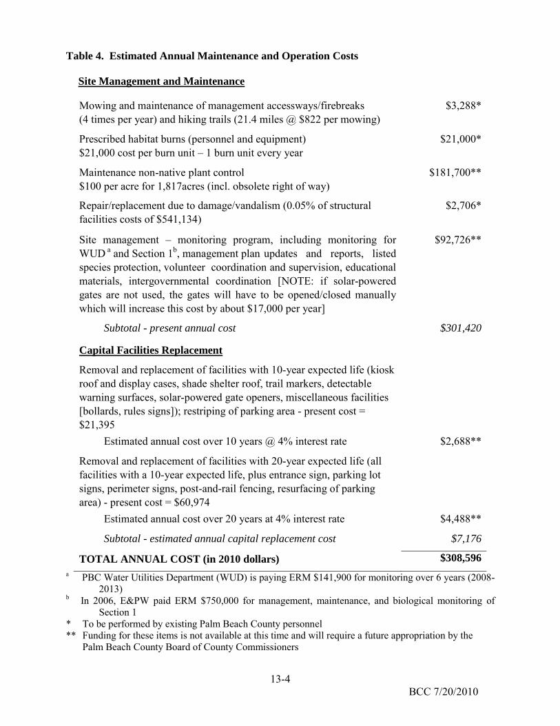
13-4 BCC 7/20/2010
Table 4. Estimated Annual Maintenance and Operation Costs
Site Management and Maintenance
Mowing and maintenance of management accessways/firebreaks (4 times per year) and hiking trails (21.4 miles @ $822 per mowing)
$3,288*
Prescribed habitat burns (personnel and equipment) $21,000 cost per burn unit – 1 burn unit every year
$21,000*
Maintenance non-native plant control $100 per acre for 1,817acres (incl. obsolete right of way)
$181,700**
Repair/replacement due to damage/vandalism (0.05% of structural facilities costs of $541,134)
$2,706*
Site management – monitoring program, including monitoring for WUD a and Section 1b, management plan updates and reports, listed species protection, volunteer coordination and supervision, educational materials, intergovernmental coordination [NOTE: if solar-powered gates are not used, the gates will have to be opened/closed manually which will increase this cost by about $17,000 per year]
$92,726**
Subtotal - present annual cost $301,420
Capital Facilities Replacement
Removal and replacement of facilities with 10-year expected life (kiosk roof and display cases, shade shelter roof, trail markers, detectable warning surfaces, solar-powered gate openers, miscellaneous facilities [bollards, rules signs]); restriping of parking area - present cost = $21,395
Estimated annual cost over 10 years @ 4% interest rate $2,688**
Removal and replacement of facilities with 20-year expected life (all facilities with a 10-year expected life, plus entrance sign, parking lot signs, perimeter signs, post-and-rail fencing, resurfacing of parking area) - present cost = $60,974
Estimated annual cost over 20 years at 4% interest rate $4,488**
Subtotal - estimated annual capital replacement cost $7,176
TOTAL ANNUAL COST (in 2010 dollars) $308,596
a PBC Water Utilities Department (WUD) is paying ERM $141,900 for monitoring over 6 years (2008-2013)
b In 2006, E&PW paid ERM $750,000 for management, maintenance, and biological monitoring of Section 1
* To be performed by existing Palm Beach County personnel ** Funding for these items is not available at this time and will require a future appropriation by the
Palm Beach County Board of County Commissioners
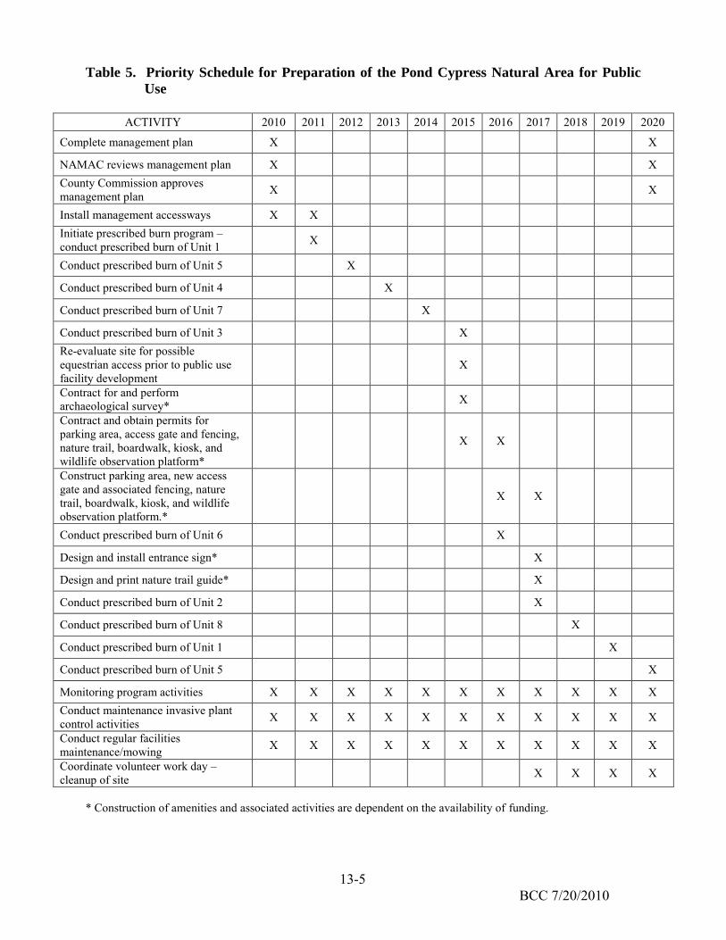
13-5 BCC 7/20/2010
Table 5. Priority Schedule for Preparation of the Pond Cypress Natural Area for Public
Use
ACTIVITY 2010 2011 2012 2013 2014 2015 2016 2017 2018 2019 2020
Complete management plan X X
NAMAC reviews management plan X X County Commission approves management plan X X
Install management accessways X X Initiate prescribed burn program – conduct prescribed burn of Unit 1 X
Conduct prescribed burn of Unit 5 X
Conduct prescribed burn of Unit 4 X
Conduct prescribed burn of Unit 7 X
Conduct prescribed burn of Unit 3 X Re-evaluate site for possible equestrian access prior to public use facility development
X
Contract for and perform archaeological survey* X
Contract and obtain permits for parking area, access gate and fencing, nature trail, boardwalk, kiosk, and wildlife observation platform*
X X
Construct parking area, new access gate and associated fencing, nature trail, boardwalk, kiosk, and wildlife observation platform.*
X X
Conduct prescribed burn of Unit 6 X
Design and install entrance sign* X
Design and print nature trail guide* X
Conduct prescribed burn of Unit 2 X
Conduct prescribed burn of Unit 8 X
Conduct prescribed burn of Unit 1 X
Conduct prescribed burn of Unit 5 X
Monitoring program activities X X X X X X X X X X X Conduct maintenance invasive plant control activities X X X X X X X X X X X
Conduct regular facilities maintenance/mowing X X X X X X X X X X X
Coordinate volunteer work day – cleanup of site X X X X
* Construction of amenities and associated activities are dependent on the availability of funding.

APPENDIX F
Snail Kite Management Plan
F
S
From SR 70
NAIL K
For the
04 (Okeech
FinancFed
KITE MA
e Const
SR 7 obee Boule
Palm Beac
cial Project deral Aid Pro
ETD
Ju
ANAGE
tructio
Extensevard) to C
ch County,
ID No. 229
oject No. 47DM No. 8127
une 2014
EMENT
n Phas
sion R 809A (No
Florida
9664-2-22-0752-030-P7
PLAN
se of:
orthlake Bo
01
oulevard)

1
PROJECT BACKGROUND
The snail kite (Rostrhamus sociabilis plumbeus) is a
medium-sized hawk listed as endangered by the U. S. Fish
and Wildlife Service (USFWS). This hawk is dependent on
appropriate hydrology and water quality of the wetland
habitats it utilizes. Snail kites inhabit relatively open,
freshwater marshes that support adequate populations of
Florida apple snails (Pomacea paludosa) or exotic
ramshorn apple snails (Marisa cornuarietis), the primary
food sources for the snail kite. Favorable areas consist of
extensive shallow open water such as sloughs and flats,
vegetated by sawgrass and spikerushes.
The entire project area is located within the USFWS snail
kite Consultation Area, and snail kites have been previously documented over several
years within natural areas located to the east of the proposed project (Figure 1). The
USFWS Snail Kite Management Guidelines (2006) outline Priority Management Areas
for the species; these areas are located to the east of the project ROW, with the closest
area being approximately 4,605 feet to the east of the eastern Florida Department of
Transportation (FDOT) rangeline right-of-way (ROW) boundary. These management
areas coincide with long-term nesting locations. Priority Management Areas are
determined based upon the current nesting season combined with ten (10) prior years
of continual nesting data being collected for a given locality. After this time, the area is
considered to be a management priority for long-term success of the species.
According to USFWS, snail kite nesting season is from December through July, while
breeding season is from January through May. The snail kite nesting season varies
from year to year, and is likely affected by rainfall and water levels. Peak nesting
season is from February through April.
Nest location data from USFWS (1996-2011) shows that recent nests have been
located within close proximity to the proposed project (Figure 2). During the 2010 and
2011 nesting seasons, four (4) nests were identified just east of the project ROW as
shown below. In more recent years, no nests were located in proximity to the project.
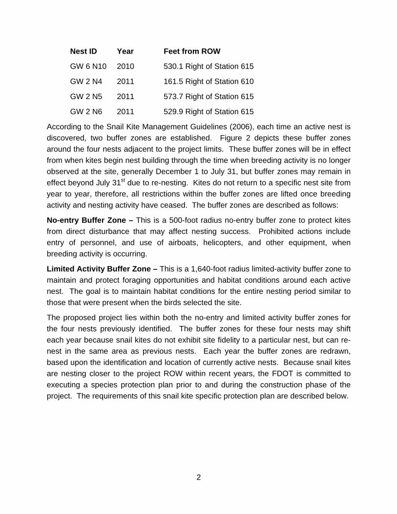
2
Nest ID Year Feet from ROW
GW 6 N10 2010 530.1 Right of Station 615
GW 2 N4 2011 161.5 Right of Station 610
GW 2 N5 2011 573.7 Right of Station 615
GW 2 N6 2011 529.9 Right of Station 615
According to the Snail Kite Management Guidelines (2006), each time an active nest is
discovered, two buffer zones are established. Figure 2 depicts these buffer zones
around the four nests adjacent to the project limits. These buffer zones will be in effect
from when kites begin nest building through the time when breeding activity is no longer
observed at the site, generally December 1 to July 31, but buffer zones may remain in
effect beyond July 31st due to re-nesting. Kites do not return to a specific nest site from
year to year, therefore, all restrictions within the buffer zones are lifted once breeding
activity and nesting activity have ceased. The buffer zones are described as follows:
No-entry Buffer Zone – This is a 500-foot radius no-entry buffer zone to protect kites
from direct disturbance that may affect nesting success. Prohibited actions include
entry of personnel, and use of airboats, helicopters, and other equipment, when
breeding activity is occurring.
Limited Activity Buffer Zone – This is a 1,640-foot radius limited-activity buffer zone to
maintain and protect foraging opportunities and habitat conditions around each active
nest. The goal is to maintain habitat conditions for the entire nesting period similar to
those that were present when the birds selected the site.
The proposed project lies within both the no-entry and limited activity buffer zones for
the four nests previously identified. The buffer zones for these four nests may shift
each year because snail kites do not exhibit site fidelity to a particular nest, but can re-
nest in the same area as previous nests. Each year the buffer zones are redrawn,
based upon the identification and location of currently active nests. Because snail kites
are nesting closer to the project ROW within recent years, the FDOT is committed to
executing a species protection plan prior to and during the construction phase of the
project. The requirements of this snail kite specific protection plan are described below.

3
SNAIL KITE MANAGEMENT PLAN FOR PROJECT CONSTRUCTION
The FDOT shall initiate the requirements of this protection plan prior to the nesting
season that directly precedes construction. Surveys will be conducted both prior to and
during construction. The purpose of the pre-construction survey is to locate active nests
and determine the stage of nesting activities. The data will be used to anticipate the
potential locations of nests during the construction period. During construction, surveys
will be conducted to update nest locations and monitor the nesting progress for the
purpose of establishing and lifting buffer zone restrictions.
Pre-Construction Nesting Season Survey
A pre-construction nesting season survey will be conducted in accordance with the
methodology in the USFWS Draft Snail Kite Survey Protocol dated May 18, 2004
(Attachment A). Results of this survey will be used to locate active snail kite nests and
determine the level of nesting activity that can be anticipated during subsequent nesting
seasons through the construction period. In addition, the foraging, feeding and roosting
patterns of the snail kite group on site will be documented to the extent possible, within
the survey zone. The survey zone is defined as appropriate snail kite habitat within a
1,640-foot radius around the project limits. All survey activities and snail kite behaviors
will be documented on a standardized data form. Nests locations will be documented
on an aerial photograph.
Surveys will be conducted weekly for 4 weeks during the months of February through
April (peak nesting season). Once a nest has been located and the nest activity level
has been determined, no further investigation is necessary. All data will be documented
in a pre-construction survey report, and forwarded to the USFWS within sixty (60) days
of completion of the survey.
Prior to conducting this pre-construction survey, the FDOT will coordinate with USFWS
and the City of West Palm Beach to determine if either entity is conducting the same
type of survey. In the event that a survey is already planned, the FDOT is willing to
participate in a cooperative effort where one data set is produced, and the data can be
shared between FDOT, City of West Palm Beach, and USFWS.
Nesting Season Surveys During Construction
If construction activities are anticipated to occur during nesting season, the FDOT will
conduct similar snail kite survey within an area up to 1,640 feet outside of the planned

4
construction zone in order to determine the presence or absence of nests. These
surveys will be conducted weekly throughout nesting season to determine nest
locations. If nests are detected within the Limited Activity Buffer Zone radius (1,640
feet) of the project, the FDOT will direct the contractor to demarcate the Limited Activity
Buffer Zone around the nest, and cease all field activities within this zone in accordance
with Snail Kite Management Guidelines (Attachment B).
The weekly monitoring throughout the nesting season will also serve to track the
progression of nesting. Since the FDOT does not intend to conduct construction
activities within the Limited Activity Buffer area while a nest is active, the purpose of the
weekly nesting season surveys will be to:
Determine the location of nests and any new nests; and
Determine when each nest is no longer considered active (if the birds leave the
area and/or when nestlings have fledged). Once this has been confirmed for a
particular nest, construction activities will be allowed to resume within the Limited
Activity Buffer Area that had been established for that nest.
SNAIL KITE EDUCATION PLAN
The FDOT will implement a Snail Kite Education Plan for on-site personnel. This plan
will be used to brief project personnel as to the life history of snail kites and the potential
impacts of the project on the species. The plan will include:
A description of the snail kite, its behavior, photographs, and protection afforded
to the species under the law;
Instructions not to injure, harm harass or kill any snail kite, or possess, any part
of a snail kite including the actual animal, feathers, eggs, or nest;
Instructions to cease project activities if a snail kite or roost is found within 500
feet of project activity; and
Telephone numbers of pertinent agencies to contact if a snail kite is found dead
or injured.
The snail kite briefing will be conducted periodically throughout construction to inform
any new personnel. In addition, the briefing will be conducted annually, in November,
the month just prior to snail kite nesting season.

5
All education activities and briefings will be documented in a project log, which will be
submitted along with a written summary will be submitted to the USFWS within 60 days
of project completion.
OTHER SNAIL KITE PROTECTION ACTIVITIES
In addition to the other actions within this protection plan, the FDOT agrees to
undertake other protection measures, including mitigating for all wetland impacts, as
outlined in the Mitigation Plan prepared for this project. The FDOT comments to:
Routine coordination with USFWS regarding the results of the surveys, and
application of the buffers with regard to construction activities as appropriate; and
Compilation of a final report, detailing all activities undertaken related to
protection of the snail kite during construction, and as prescribed within this
project-specific Snail Kite Management Plan and the permitted Mitigation Plan.
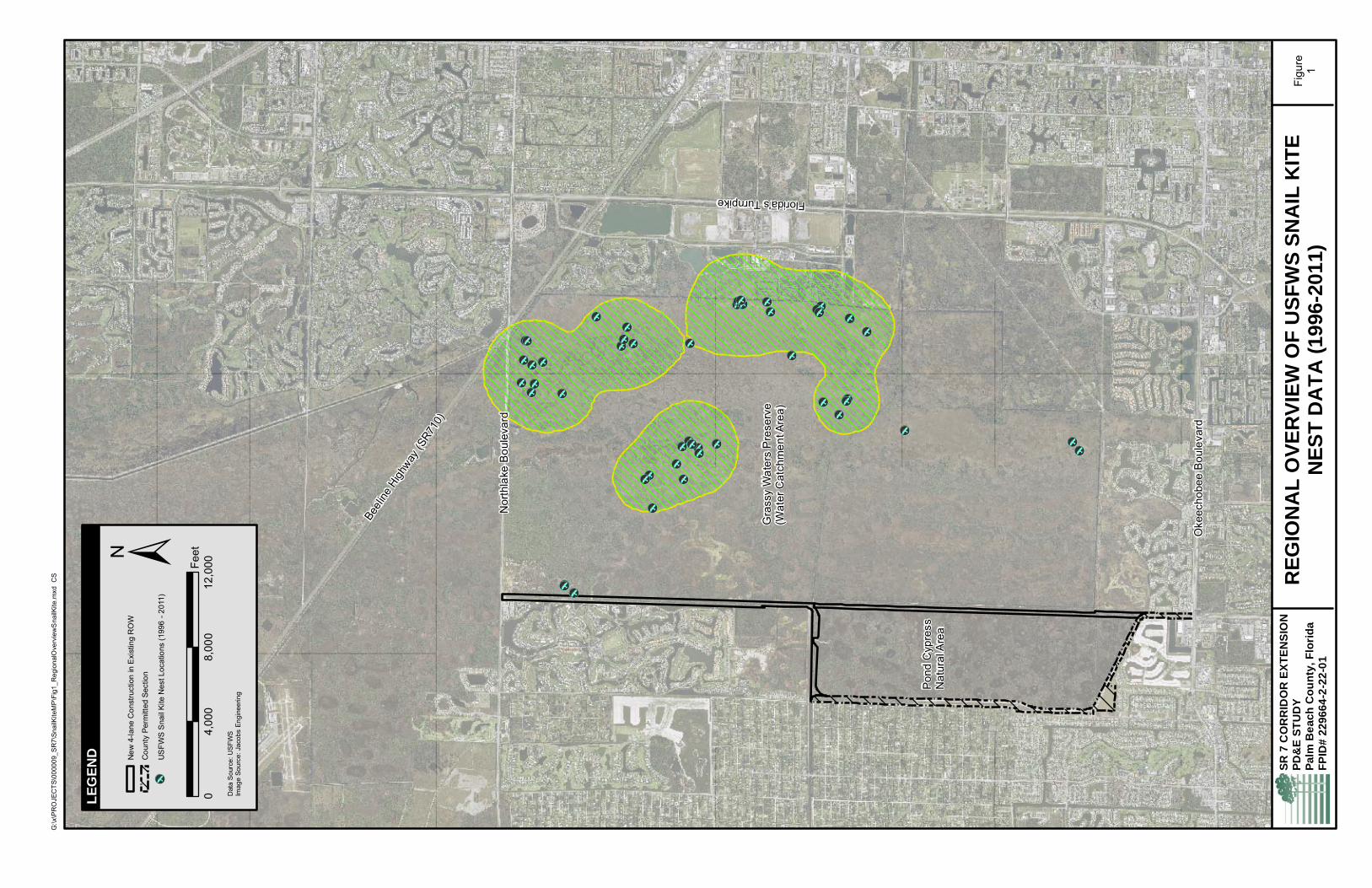
[b
[b
[b
[b
[b
[b
[b
[b
[b
[b
[b
[b
[b
[b
[b
[b
[b
[b
[b
[b[b
[b
[b [b [b
[b
[b
[b
[b [b [b
[b
[b
[b[b
[b
[b
[b
[b
[b
[b
[b
[b
[b
[b
[b
[b
[b
[b
[b[b
Beeli
ne H
ighway
(SR7
10)
Nor
thla
ke B
oule
vard
Florida's Turnpike
Pond
Cyp
ress
N
atur
al A
rea
Gra
ssy
Wat
ers
Pre
serv
e(W
ater
Cat
chm
ent A
rea)
Oke
echo
bee
Bou
leva
rd
RE
GIO
NA
L O
VE
RV
IEW
OF
US
FW
S S
NA
IL K
ITE
NE
ST
DA
TA
(1
996
-20
11)
Figu
re1
G:\x
\PR
OJE
CTS
\000
009_
SR
7\Sn
ailK
iteM
P\F
ig1_
Reg
iona
lOve
rvie
wS
nailK
ite.m
xd C
S
SR
7 C
OR
RID
OR
EX
TE
NS
ION
P
D&
E S
TU
DY
Pa
lm B
ea
ch
Co
un
ty,
Flo
rid
aF
PID
# 2
29
66
4-2
-22
-01
LE
GE
ND
Dat
a S
ourc
e: U
SFW
SIm
age
Sour
ce: J
acob
s En
gine
erin
g
±N
ew 4
-lane
Con
stru
ctio
n in
Exi
stin
g R
OW
Cou
nty
Perm
itted
Sec
tion
[b
US
FWS
Sna
il Ki
te N
est L
ocat
ions
(199
6 - 2
011)
04,
000
8,00
012
,000Fe
et
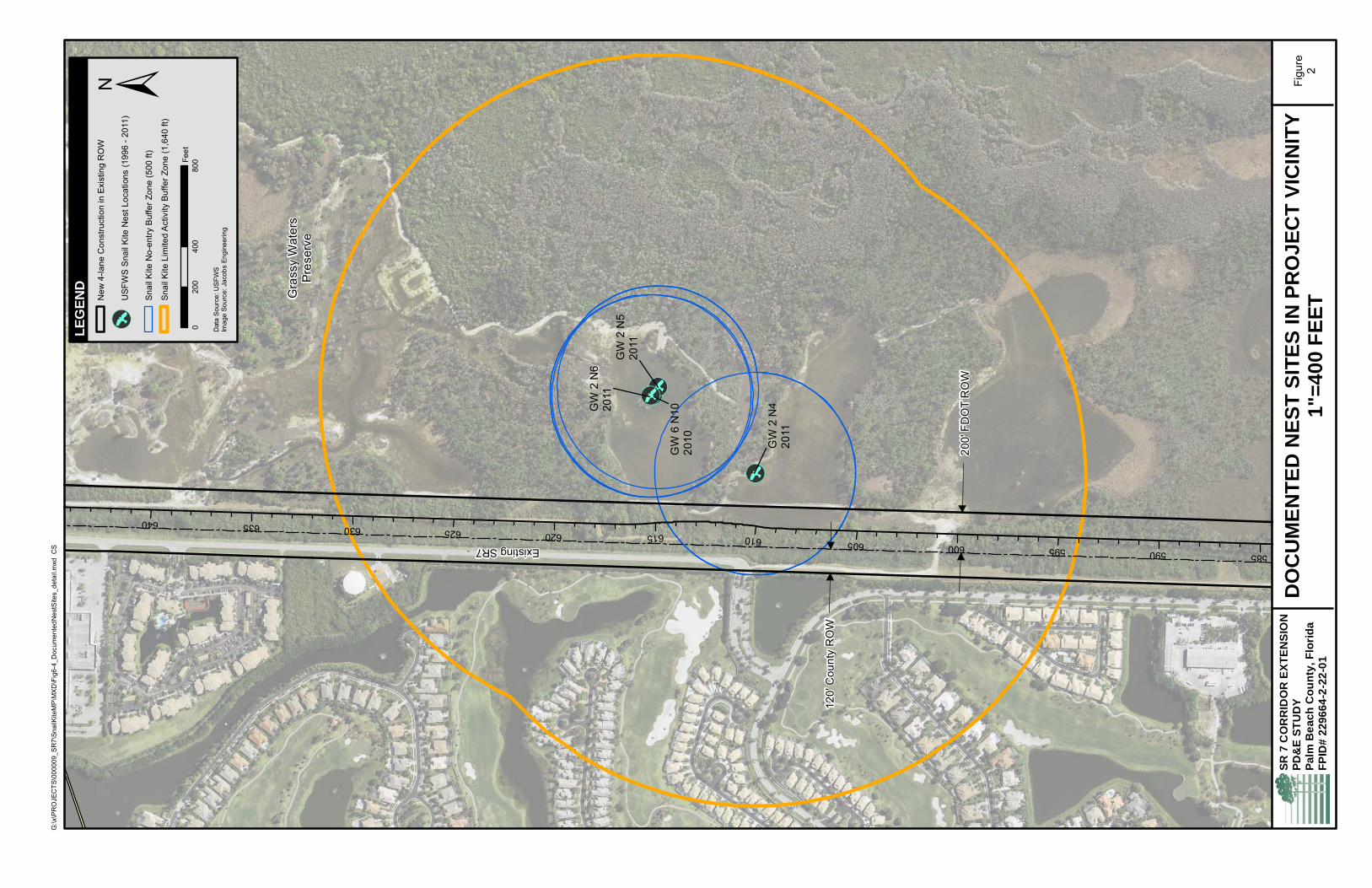
[b
[b
[b[b
585590595600605610615620625630635640
GW
6 N
1020
10 GW
2 N
420
11
GW
2 N
620
11G
W 2
N5
2011
200'
FD
OT
RO
W
120'
Cou
nty
RO
W
Existing SR7
Gra
ssy
Wat
ers
Pre
serv
e
DO
CU
ME
NT
ED
NE
ST
SIT
ES
IN P
RO
JE
CT
VIC
INIT
Y1"
=4
00
FE
ET
Figu
re2
G:\x
\PR
OJE
CTS
\000
009_
SR
7\Sn
ailK
iteM
P\M
XD
\Fig
6-4_
Doc
umen
tedN
estS
ites_
deta
il.m
xd C
S
SR
7 C
OR
RID
OR
EX
TE
NS
ION
P
D&
E S
TU
DY
Pa
lm B
ea
ch
Co
un
ty,
Flo
rid
aF
PID
# 2
29
66
4-2
-22
-01
LE
GE
ND
Dat
a S
ourc
e: U
SFW
SIm
age
Sour
ce: J
acob
s En
gine
erin
g
±N
ew 4
-lane
Con
stru
ctio
n in
Exi
stin
g R
OW
[b
USF
WS
Sna
il K
ite N
est L
ocat
ions
(199
6 - 2
011)
Snai
l Kite
No-
entry
Buf
fer Z
one
(500
ft)
Snai
l Kite
Lim
ited
Act
ivity
Buf
fer Z
one
(1,6
40 ft
)
040
080
020
0Fe
et

South Florida Ecological Services Office DRAFT May 18, 2004
Snail Kite Survey Protocol
A survey is necessary when the project site is within the snail kite consultation area and suitable habitat is present. The following criteria can be used to judge the adequacy of the habitat for snail kites.
1. Appropriate foraging habitat present [paspalidum (Paspalidium geminatum), spikerushes (Eleocharis spp.), panicum (Panicum spp.), or beakrushes (Rhynchospora spp.)].
2. Nesting or perching substrate present [willows (Salix caroliniana), melaleuca (Melaleuca quinquenervia), or pond cypress (Taxodium ascendens)] [sawgrass (Cladium jamaicense), cattail (Typha spp.), giant bulrush (Scirpus validus), or reed (Phragmites australis)].
3. Appropriate water depth (0.2-1.3 m deep) under nesting substrate. 4. Nesting substrate an adequate distance (>150 m) from upland. 5. Proximity of nearest wading bird colony.
If suitable habitat is present or snail kites are reported on site the following survey procedures should be used to document their occurrence. To maximize the chances of finding snail kites the survey should be conducted in January to May during the breeding season. Record conditions in the suitable habitat including emergent vegetation types, nesting and perching substrate types, water depth in potential nesting areas, and distance from uplands. A visual survey of suitable habitat should be made for birds and nests. A boat may be needed for the survey as the best nesting habitat may be a considerable distance (>150 m) from uplands. Check small trees, such as, willow, melaleuca, and pond cypress along the open water edge for nests or perching birds. If snail kites are observed, then nests can be located through the bird’s behavior. When flushed from a nest the adult tends to circle upward, whereas non-nesting birds that are flushed fly more horizontally away from the disturbance (Bennetts et al. 1988). Nests also can be found by following kites carrying sticks, adults carrying apple snails, aerial courtship displays, vocalizations of adults or begging calls of the young, and through a thorough search of areas where adults are repeatedly observed (Bennetts et al. 1988). When water levels are low snail kites may be forced to nest in vegetation along levees and roads. Check herbaceous vegetation, such as sawgrass, cattail, bulrush, and reed for nests. Record the location of all snail kites observed and describe their behavior. If nests are observed estimate the position of the nest (boat geographic position with direction and distance to nest) without approaching any closer than needed to reduce disturbance to the birds. Plot the location of nests on a map of the site. Snail kites are highly gregarious and typically roost in colonies when not breeding. Birds found

South Florida Ecological Services Office DRAFT May 18, 2004 on perches that do not return to a nest site are most likely non-breeding. Follow these birds 1.5 to 2 hours before dusk to their roost location (Sykes 1982). Especially look for snail kites around sites with wading birds colonies (e.g., anhingas and herons) nearby. Record the roost location, vegetation types, and number of snail kites at the site. Where project activities, such as dredging, brush clearing, and herbicide treatment, may come within 130 m (425 ft) of nest or roost sites the area can be marked with PVC poles or poles with white balls on the top if aerial observation is necessary. The geographic coordinates of the markers should be obtained and marked on a site map. Project personnel should be informed to avoid marked areas and given a map indicating protective areas. Because of the secretive nature of the snail kite and the need to differentiate breeding and non-breeding behavior surveys require specialized training. A qualified avian biologist/ecologist should be used to be to obtain acceptable results.

South Florida Ecological Services Office DRAFT May 18, 2004
Snail Kite Monitoring Protocol Every effort should be undertaken to avoid adverse effects to any snail kite observed during project activities. If it appears that these activities will alter breeding, feeding, or roosting behavior of snail kites, the activity must not be carried out until the proper action can be determined. A pre-project activity survey should be conducted to learn foraging, feeding, and roosting patterns of the snail kite group on site. Document the location of all snail kites and describe their behavior. Once project activities begin a monitor should be on site if activities are within 130 m (425 ft) of snail kite nests or roosts. Project activities should cease if the snail kites are disturbed. If disturbance is expected then an incidental take permit is needed. At the end of project activities in the snail kite areas a monitoring report should be sent to the South Florida Ecological Services Office within 60 days. A snail kite education plan can be used to help reduce the effects of a project on snail kites. All project associated personnel should be briefed as to the nature of snail kites and the potential impacts of the project on them. The plan should include:
1. a description of the snail kite, its habits, and protection under Federal law;
2. instruction not to injure, harm, harass, or kill this species or possess any part thereof (e.g., feathers, eggs, and nest);
3. instructions to cease project activities if a snail kite nest or roost is found with 130 m
(425 ft) of project activities; and
4. telephone numbers of pertinent agencies to contact if snail kite is found dead. If an on-site monitor is needed they should have the following qualifications:
a qualified avian biologist/ecologist;
demonstrate their familiarity with south Florida raptor species and have prior south Florida raptor survey and monitoring observational experience; and
have authority to cease all project related activities that may appear to alter breeding, feeding, or roosting behavior of snail kites.
Activities can resume if the birds leave the area or when the nestlings have fledged.

South Florida Ecological Services Office DRAFT May 18, 2004 Literature Cited Bennetts, R.E., M.W. Collopy, and S.R. Beissinger. 1988. Nesting ecology of Snail Kites in Water Conservation Area 3A. Department of Wildlife and Range Science, University of Florida, Gainesville. Florida Cooperative Fish and Wildlife Research Unit, Technical Report No. 31, 174 p. Sykes, P.W., Jr. 1982. Everglade Kite. Pages 43-44 in D.E. Davis, editor. CRC Handbook of Census Methods for Terrestrial Vertebrates. CRC Press, Boca Raton, Florida.

U.S. Fish and Wildlife Service
These guidelines were developed to help resource managers and other interested parties avoid detrimental impacts to endangered Everglade snail kites and their habitat, and to provide information that will allow managers to improve conditions for snail kites. Everglade snail kites are listed as endangered under Federal and Florida State laws. Any disturbance to snail kites or their nests, including flushing perched birds, interrupting foraging, flushing adults from nest sites, interfering with feeding and protection of nestling kites, and impacting vegetation that supports kite nests is prohibited. Adherence to these guidelines will minimize the likelihood that actions result in prohibited impacts to snail kites. If you see snail kites, we always recommend that you simply avoid the immediate area where kites are present. If in doubt about whether an activity may affect kites, please contact a U.S. fish and Wildlife Service (Service) or Florida Fish and Wildlife Conservation Commission (FWC) office.
MINIMIZING IMPACTS TO KITE NESTING DURING BREEDING SEASON
During each nesting season (generally December 1 to July 31, but including all periods when active nests are known), locations of all known snail kite nests will be provided to the Service from researchers and resource managers, and then distributed to appropriate agency representatives. Maps and coordinates of nest sites, kite protection buffers, and priority kite management zones will be distributed to established points of contact for agencies and organizations that conduct management actions in kite habitat. These points of contact will be responsible for disseminating the information to personnel working on the ground.
Nest Protection Buffers Two buffer zones will be established around every active snail kite nest. This includes all nests reported to the Service by researchers and any unreported nest that is encountered during other activities. These buffer zones will be in effect from when kites begin nest building through the time when breeding activity is no longer observed at the site. Because kites can renest, and often renest in the same area as previous attempts, buffer zones may remain in place past the time when fledglings leave the area if adult kites continue to show breeding activity, including courtship, in the general area. Kites do not exhibit fidelity to a specific nest site from year to year. Consequently, all restrictions within these buffer zones will be lifted once breeding activity has ceased.
1. No-entry Buffer Zones - A 500-foot (ft) (~150 meter) radius no-entry buffer zone will be established around all active nests that are discovered. The purpose of this buffer zone is to protect kites from direct disturbance that may affect the fate of nesting.
• Airboats, personnel, helicopters, and other equipment and activity must stay outside of these areas at all times when kite breeding activity is occurring.
• These buffers are slightly larger than the estimate of 430 ft (131 m) recommended in a study of disturbance to birds from airboats (Rodgers and Schwikert 2003). This larger buffer was selected because the disturbance tested in their study does not necessarily represent the types of activity that may occur during land management activities because they monitored the responses of perched birds and not nesting birds.
Draft Snail Kite Management Guidelines February 21, 2006
U.S. Fish and Wildlife Service
2. Limited Activity Buffer Zones - A 1,640 ft (500 meter) radius limited-activity buffer zone will be established around all active kite nests. This buffer zone is intended to maintain and protect foraging opportunities and habitat conditions around each nest to allow the nest to succeed. The goal is to maintain habitat conditions for the entire nesting period similar to those that were present when the birds selected the site.
• Airboats, personnel, helicopters, and other equipment and activity should stay outside of this buffer when possible, and activity within the buffer should be limited to the minimum time necessary to complete appropriate management activities.
• Only management activities that are expected to maintain or improve the existing kite foraging and nesting habitat within these areas should occur while there is evidence of kite breeding activity.
o Exotic and invasive plant control efforts, including water hyacinth, water lettuce, and hydrilla, and similar invasive species that may rapidly encroach on native vegetation communities may be treated within limited-activity buffer zones during kite breeding, so long as treatments are not expected to result in impacts to vegetation species that contribute to snail kite and apple snail habitat. Treatments expected to result in changes > 10 percent in the cover or occurrence of native vegetation species including spike rushes, bulrushes, maidencane, and other emergent vegetation should be avoided.
o Treatments of invasive and undesirable woody plants, cattails, tussocks, and other similar vegetation should not occur within these buffer zones during kite nesting. These treatments should be postponed until after kite breeding activity has ceased.
o These buffer distances are intended to encompass the primary foraging area around a nest. The buffer distance is larger than the 820 ft (250 meter) radius recommended by Sykes (1987), and is a better representation of the area that kites use for foraging during nesting.
Priority Kite Management Areas Snail kite nesting does not occur randomly within wetland systems. Instead, there are generally areas within wetlands, where kite nesting is concentrated. The density of kite nests, frequency of nesting within each area, and the sizes of these “priority kite nesting areas” are highly variable, but identifying these areas may help resource managers to focus management actions. In most years, the majority of kite nesting will occur within these areas, though new nesting areas may become active. At the end of each nesting season, primary kite nesting areas will be delineated based on the current year’s nest locations and nesting in the previous 10 years.
• The polygons that delineate priority kite nesting areas, are ‘kernels’ that represent the 90 percent probability density function for kite nests over a 10-year period (1996-2005 in this case). These polygons were delineated under the assumption that the density of kite nests over the past 10 years indicates the likelihood of future kite nesting, and approximately 90 percent of the kite nesting, on average, will occur within these polygons if patterns of nest site selection continue as in the past.
• These areas will be provided to agency representatives soon after the end of the kite breeding season (July), and represent areas where resource management activities are likely to be limited due to kite nesting activity. Proposed management actions should incorporate pre-treatment kite surveys, or avoid these areas during the early part of the following breeding season (from January 1 to May 31) when kites are selecting nesting

U.S. Fish and Wildlife Service
sites. These also represent the areas where proactive management for snail kite foraging habitat may be most beneficial.
o This information will be provided (in most years) several months prior to the beginning of the kite breeding season to allow land managers to avoid impacts to kite nesting through early planning by timing proposed treatments in these areas to avoid critical periods for kites.
o The extent of these areas will generally not change dramatically from year-to-year. o Management actions do not have to be excluded from these areas during the entire
nesting season, but surveys for kite nesting activity should be conducted prior to working in these areas during the kite nesting season, and avoiding work in these areas during the breeding season is recommended whenever possible.
o There is good potential for kite nesting to occur outside of these areas, and resource managers should always look for evidence of snail kites and kite breeding activity prior to conducting management actions.
MANAGING FOR SNAIL KITE HABITAT
Active management of wetlands to benefit snail kites has not been regularly conducted. However, there are several actions and considerations that resource managers can adopt that may benefit snail kites.
• Foraging habitat – maintaining Florida apple snail populations, and the vegetation types that support healthy Florida apple snail populations is critically important to maintaining snail kite habitat. Not all areas where there are abundant apple snails support snail kite nesting, but most of these areas provide foraging habitat for snail kites at some time.
o Shallow wetlands with emergent vegetation such as spike rush, bulrush, and other native emergent wetland plant species provide good snail kite foraging habitat as long as the vegetation is not so dense that kites would have difficulty locating apple snails. The specific conditions and vegetation species that provide good snail kite foraging habitat vary depending on the specific conditions of each wetland (lake or marsh, variability in water depths, soil characteristics, etc.).
o Control of exotic and invasive plant species such as water hyacinth and water lettuce may be necessary to maintain the open character of vegetation within kite foraging habitat.
o Non-native species of apple snails may provide forage for snail kites. However, initial evidence suggests that these species are not consistent with maintaining sustainable wetland communities. Maintaining a healthy population of Florida’s native apple snail, and working to control non-native snail species is a more sustainable management strategy.
• Nesting habitat – kites are not particularly discriminating about their nest sites, and they may nest in a wide variety of substrates and situations. However, kite nests are generally most successful in low woody species such as willow, buttonbush, pond apple, and other wetland shrubs that remain inundated for the entire nesting period, and efforts to maintain or produce favorable nesting sites may help maintain kite nesting.
o Planting woody wetland species in areas that support snail kite foraging habitat and do not dry out completely during the kite breeding season may facilitate snail kite nesting and nest success. Any planted woody vegetation should be managed for long-term persistence.

U.S. Fish and Wildlife Service
o Nests that occur in dense cattails, bulrush, and other herbaceous species are more vulnerable to collapse than those in woody substrates.
o Potential nesting areas that dry out during the nesting period are vulnerable to land-based predators such as raccoons.
o Nesting areas are almost always located within areas of good foraging habitat. o Invasive and exotic woody vegetation may be used by snail kites as nesting
substrate, but these species are not components of sustainable snail kite habitat. Controlling invasive and exotic woody vegetation outside of snail kite nesting season, and replanting with native wetland woody plant species where needed will be a more effective long-term strategy for managing snail kite nesting habitat.
• Managing hydroperiod – Changes in water regimes and depth and duration of inundation are important characteristics for wetland vegetation that supports snail kite nesting and foraging habitat, Florida apple snails, and all aspects of snail kite and apple snail life history.
o Continuous inundation and stabilized water levels for long periods will probably result in unfavorable vegetation conditions.
o Long periods of drying (> 1-2 months) will detrimentally affect Florida apple snail populations, and reduce the likelihood of use by snail kites. However, occasional drying for shorter periods may be beneficial.
o Rapid changes and large changes in the depth of water within wetlands have the potential to detrimentally affect kite nesting and apple snail populations.
Rapid and/or large drops in water level increase the risk of snail kite nest predation by drying out the substrate beneath nests and allowing land-based predators to access nests.
Rapid and/or large increases in water depth may detrimentally affect desirable vegetation, and can flood out Florida apple snail eggs, leading to reductions in apple snail populations and reduced snail kite foraging.
COMMENTS, FEEDBACK, AND NEW INFORMATION
We always request feedback, new information, and recommendations for improving guidelines and snail kite management from resource managers and on-the-ground crews. • We request that individuals report snail kite nesting activity outside of documented
nesting areas. • We welcome questions about managing snail kites, snail kite habitat, and apple snail
populations. • Additional information about snail kites and their habitat can be found at the Service’s
South Florida Ecological Services Office web site at: http://www.fws.gov/verobeach/index.htm
• Questions, comments, and inquiries can be directed to Tylan Dean by e-mailing: [email protected], or by calling (772) 562-3909, extension 284.
LITERATURE CITED
Rodgers, J.A. Jr. and S.T. Schwikert. 2003. Buffer zone distances to protect foraging and loafing waterbirds from disturbance by airboats in Florida. Waterbirds 26(4):437-443. Sykes, P.W. Jr. 1987. The feeding habits of the snail kite in Florida, USA. Colonial Waterbirds 10(1):84-92.