aspects of the geology of the southwestern barents sea
TRANSCRIPT

64 Jan Reidar Ski/brei NGU - BULL 427. 1995
Aspects of the geology of the southwestern Barents Seafrom aeromagnetic data.
JAN REIDAR SKILBREI
Jan Reidar Ski/brei. Geological Survey of Norway. p.a. Box 3006-Lade. N-7002 Tronobeim, Norway.
IntroductionNGU has covered large parts of the Barents Seaand Svalbard with aeromagnetic measurem ents.The Barents Sea holds oil and gas potential andforms one of the largest continental shelf areasin the world . The magnetic studies carried out inthis region include the mapping of volcanic rockson Svalbard and in the northern Barents Sea,and the mapping of major basement faults andestimation of the depth to the magnetic basement. Such studies are of substantial value inpetroleum exploration work. NGU has deliveredconfidential reports to the oil companies thatfinanced the interpretation work. Portions of thatwork have already been published (Skilbrei,1991, 1992). This abstract focuses on two, previously unpublished examples that serve to illustrate some of the applications of the magneticmethod.
Example 1: Mapping the top of the crystalline crust in the southwestern Barents Sea.Several structural highs and sedimentary basinswithin the southwestern Barents Sea (700-74°N)are bordered by major fault complexes (e.g.Ronnevik & Jacobsen 1984, Faleide et al. 1993).The basinal areas are underlain by large thicknesses of Upper Palaeozoic to Cenozoic rocks.
The aim of this study has been to map the topof the crystalline basement , using all availabledata. Neither magnetic data alone nor releasedgravity or reflection seismic profiles can be usedto map the deeply buried crystall ine basement.Fortunately, exploration for oil has provided adense network of seismic reflection data, as wellas 47 exploration wells from the area (NPD,1986-1992). A combination of methods allowsone to construct a tentative regional depth map.Depth estimates were made on the original aeromagnetic profiles (the straight slope and Petersmethods were used). The wells are unevenly distributed and only three have reached the basement. They therefore provide only minimumdepths to the basement surface from a part ofthe area. Seismic data and gravity data havebeen used to obtain tentative depths from thedeep basins. The data sets have been describedin a dr.ing. thesis (Skilbrei 1993, chapter 8). The
depth map is an aid in elucidating the generalstructure of the area and provides insights intothe deep structure of a rifted region.
Fig. 1 shows the map of depths to the crystalline basement which is derived from all availablesources. The figure legend shows which datasets have been the basis for the contours in thedifferent parts of the map. It is important to notethat only in some of the areas are the contoursdrawn solely from the magnetic depth estimates,and that the map is a smoothed, generalisedmap. Locally (along the deep-seated fault zonesthat form some of the margins of the structuralhighs), the basement surface may be much steeper. Before contouring, the magnetic depth estimates were compared, where possible, withseismic data and well data. In this manner, anattempt was made to differentiate between intrasedimentary volcanic sources and basementsources. In the eastern part of the study area,only the magnetic depth estimates are shown,because neither the point distributions of thesenor the seismic data would allow contouring.
A large portion of the study area is occupiedby basins, some of which are extremely deep riftbasins. As can be seen in Fig. 1, the continentalcrust is fragmented and divided into blocks byseveral highs and basins that are the result ofdifferent rifting events (e.g. Faleide et al. 1984,1991, 1993). An appropriate name for this tectonic region would therefore be the 'SouthwesternBarents Sea Rift Zone'. The structural elementsthat can be recognised on the map in Fig. 1 are:the Nordkapp, Hammerfest, Trornso, Bjernoya,Sorvestnaget and Harstad Basins, the Loppa,Stappen, Nordsel, Veslemoy and Senja Highs,as well as the shallow magnetic basement closeto the Norwegian coast. In structural highs, thedepths shown in Fig. 1 are similar to the depthsthat appear in a magnet ic basem ent map thatwas published by Am (1975). However, from thedeep basins, there is a marked difference. Thisdifference arises because of the lack of magneticanomalies from the deep basins (and thereby nomagnetic depth estimates), and because seismicand gravity data are now available. From thedeep basins, gravity and reflection seismic datawere used to obtain tentative depths to the crys-

NGU · BULL 427,1995 Jan Reidar Ski/brei 65
/'/
Generalisoocoruours jnterpr~:~
tromaer0r1\a9nellCcaia r2terredto sea level
Generalised contours mlerprele<lmainly from seismic linesreterred10 sea level
~ Baw me I hiC; h or '9neous rocks
Magllt"tlCd~,",1h estimateionly In areas wnere contours arenot drawn]
Fig. 1. Tentative map of the depth to the crystalline basement from the southwestern Barents Sea, expressed in km below sea level.Contours have been generalised . The cross-hatched areas represent provinces where many depth estimates are conspicuously'shallow'. Numbers show range of estimates within these areas . SFZ =Senja Fracture Zone.
tal/ine basement. From the southern parts of themap, the depths are very similar to the depthsthat appear in a magnetic basement map published by Olesen et al. (1990) that covers Finnmarkand the adjacent sea areas.
Also of interest are relatively small areas where the shallow estimates may indicate eitherbasement blocks at relatively shallow depths, orthe presence of igneous rocks within the sedimentary rocks overly ing the crysta lline basement(Fig. 1), The high area on the map southwest ofBjornoya represents Tert iary volcanic rocks within the Vestbakken Volcanic Province (Faleide etal. 1988), Low-amplitude aeromagnetic anomali-
es occur over the Senja Ridge (SR), The magnetic depth estimates beneath the SR range from1,8 km (in the north) to 2.8 km (in the south), Themagnetic sources may represent crystallinebasement or volcanic intrusions. On the LoppaHigh, on the landward side of the Harstad Basin,on the SR, and north of Varangerhalvoya, it islikely that the basement is relatively shallow. Inthe other cases shown, intrasedimentary volcanic rocks may be present (see discussionbelow), In the case of the area marked to thewest of the deepest part of the Bjornoya Basin,these sources occur relatively deep within thesedimentary basin (c. 8 km), On the east side of

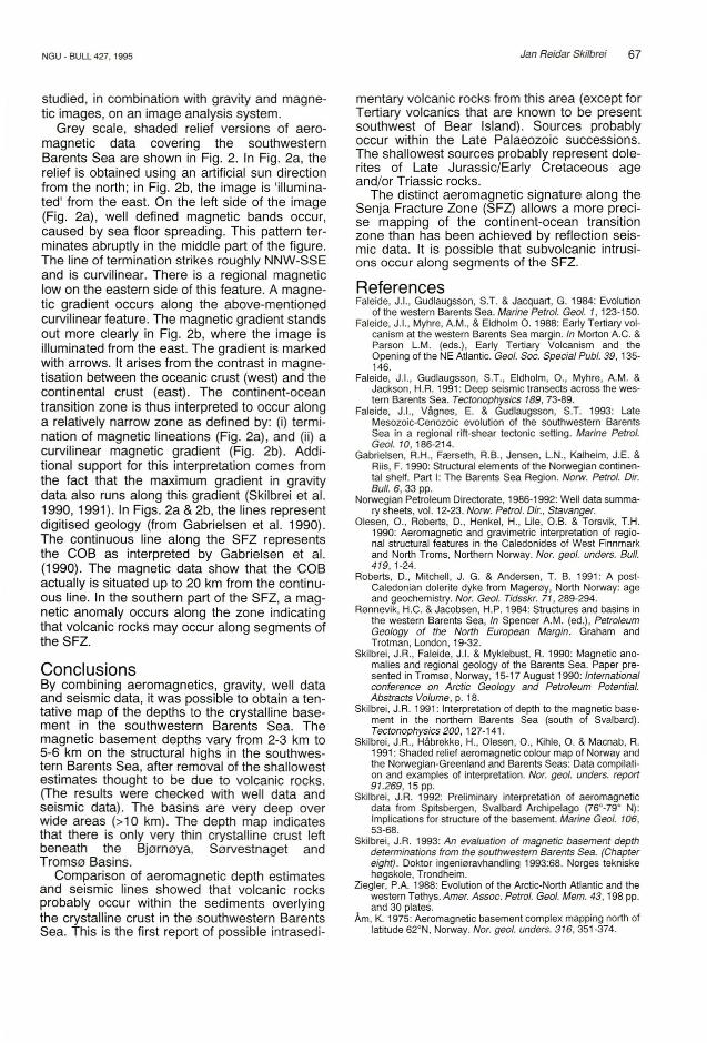
Fig. 2 . G re y scale. shaded relief ve rsions of ae romagnet ic datacovering the Senja Fracture Zone (SFZ) in the southwesternBarents Sea. In Fig. 2a, the relief is obtained using an artificialsun direction from the north ; in Fig. 2b. the image is 'illumlnated' from the east. On the left side of the image in Fig. 2a. thereare well defined. sea floor spreading. magnetic lineations. Seetext for explanat ion.
66 Jan Reidar Ski/brei
the Harstad Basin, magnetic sources occur at 44.5 km depth. This is within the Cretaceous sedimentary sequence. The magnetic sources probably represent volcanic rocks (basalts?).
Magnetic depth determinations performed onthe analog profiles showed some conspicuouslyshallow values in the northern part of the studyarea. The estimated depths were compared withpublished reflection seismic profiles (Gabrielsenet al. 1990 ). Apparently, magnetic sources existwithin both the Carboniferous-Permian and theMesozoic sequences. No volcanic rocks areknown from the boreholes. However, the shallowestimates are located to the north of the wells.On Spitsbergen (Svalbard) and in Storfjorden,there are high-frequency magnetic anomaliesthat are probably due to the presence of doleritesoccurring high up in the sedimentary section, farremoved from the basement. The Carboniferousperiod is associated with rifl ing throughout theentire region (Ziegler 1988), and this may wellhave involved some volcanic activity. OnMageroy (North Finnmark), a dolerite dyke of aLate Carboniferous age has been reported(Roberts et al. 1991) . On the Russian BarentsSea shelf, the Triassic strata are associated withlava units that give rise to magnetic anomaliesnortheast of Hopen (unpublished map, AmarokInc., Oslo). Also, Permian strata in the TimanPechora and South Barents Basins, northwestern Russia, are known to contain volcanic rocks.On the basis of the above discussion, magneticsources within the sediments may be due to volcanic activity associated with the LatePalaeozoic rifl ing that affected the whole region.The shallowest sources probably represent dolerites of Late Jurassic/Early Cretaceous ageand/or Triassic rocks. (In addition, Tertiary volcanic rocks occur along the western margin).
Example 2: Mapping the continent-oceanboundaryA particular fruitful area of investigation is thecontinental margin. Afle r image enhancement ofthe aeromagnetic data, the transition zone between the continental crust and the oceanic crustdisplays a distinct magnetic anomaly signature.The following example is from the southwesternBarents Sea where the Senja Fracture Zone(SFZ) approximates to the continent-oceanboundary (COB). A thick, Upper Cenozoic, sedimentary wedge covers the COB. Because ofth is, and because few se ism ic lines actua llycross the COB, the location and nature of theCOB is not well known. In order to compare withearlier interpretations, all the information appearing in NPD Bulletin No. 6 (Gabrielsen et al.1990 ) was digitised (at a scale of 1:1 million) and
14°
14°
GU . BUU 427.1995
17°
73 °
17°I
- 73°
- 71°
NGU - BULL 427,1995 Jan Reidar Skilbrei 67
studied, in combination with gravity and magnetic images, on an image analysis system.
Grey scale, shaded relief versions of aeromagnetic data covering the southwesternBarents Sea are shown in Fig. 2. In Fig. 2a, therelief is obtained using an artificial sun directionfrom the north; in Fig. 2b, the image is 'illuminated' from the east. On the left side of the image(Fig. 2a), well defined magnetic bands occur,caused by sea floor spreading. This pattern terminates abruptly in the middle part of the figure.The line of termination strikes roughly NNW-SSEand is curvilinear. There is a regional magneticlow on the eastern side of this feature. A magnetic gradient occurs along the above-mentionedcurvilinear feature. The magnetic gradient standsout more clearly in Fig. 2b, where the image isilluminated from the east. The gradient is markedwith arrows. It arises from the contrast in magnetisation between the oceanic crust (west) and thecontinental crust (east). The continent-oceantransition zone is thus interpreted to occur alonga relatively narrow zone as defined by: (i) termination of magnetic lineations (Fig. 2a), and (ii) acurvilinear magnetic gradient (Fig. 2b). Additional support for this interpretation comes fromthe fact that the maximum gradient in gravitydata also runs along this gradient (Skilbrei et al.1990, 1991). In Figs. 2a & 2b, the lines representdigitised geology (from Gabrielsen et al. 1990).The continuous line along the SFZ representsthe COB as interpreted by Gabrielsen et al.(1990). The magnetic data show that the COBactually is situated up to 20 km from the continuous line. In the southern part of the SFZ, a magnetic anomaly occurs along the zone indicatingthat volcanic rocks may occur along segments ofthe SFZ.
ConclusionsBy combining aeromagnetics, gravity, well dataand seismic data, it was possible to obtain a tentative map of the depths to the crystalline basement in the southwestern Barents Sea. Themagnetic basement depths vary from 2-3 km to5-6 km on the structural highs in the southwestern Barents Sea, after removal of the shallowestestimates thought to be due to volcanic rocks.(The results were checked with well data andseismic data). The basins are very deep overwide areas (>10 km). The depth map indicatesthat there is only very thin crystalline crust leftbeneath the Bjorneya, Sorvestnaget andTrornse Basins.
Comparison of aeromagnetic depth estimatesand seismic lines showed that volcanic rocksprobably occur within the sediments overlyingthe crystalline crust in the southwestern BarentsSea. This is the first report of possible intrasedi-
mentary volcanic rocks from this area (except forTertiary volcanics that are known to be presentsouthwest of Bear Island). Sources probablyoccur within the Late Palaeozoic successions.The shallowest sources probably represent dolerites of Late Jurassic/Early Cretaceous ageand/or Triassic rocks.
The distinct aeromagnetic signature along theSenja Fracture Zone (SFZ) allows a more precise mapping of the continent-ocean transitionzone than has been achieved by reflection seismic data. It is possible that subvolcanic intrusions occur along segments of the SFZ.
ReferencesFaleide, J.I., Gudlauqsson, S.T. & Jacquart , G. 1984: Evolution
of the western Barents Sea. Marine Petrol. Geol. 1, 123-150.Faleide, J.I., Myhre, A.M., & Eldholm O. 1988: Early Tertiary vol
canism at the western Barents Sea margin. In Morton AC. &Parson L.M. (eds.), Early Tertiary Volcanism and theOpening of the NE Atlantic. Geol. Soc. Special Publ. 39 , 135146.
Faleide, J.I., Gudlaugsson, S.T., Eldholm, 0. , Myhre, AM. &Jackson, H.R. 1991: Deep seismic transects across the western Barents Sea. Tectonophysics 189,73-89.
Faleide, J.I., VAgnes, E. & Gudlaugsson, S.T. 1993: LateMesozo ic-Cenozoic evolution of the southwestern BarentsSea in a regional rift-shear tectonic setting. Marine Petrol.Geol. 10,186-214.
Gabrielsen, R H., Fasrseth, RB., Jensen, L.N., Kalheim, J.E. &Riis, F. 1990: Structural elements of the Norweg ian continental shelf. Part I: The Barents Sea Region. Norw. Petrol. Dir.Bull. 6, 33 pp.
Norwegian Petroleum Directorate, 1986-1992: Well data summary sheets, vol. 12-23. Norw. Petrol. Dir., Stavanger.
Olesen, 0 ., Roberts, D., Henkel, H., Lile, O.B. & Torsvik, T.H.1990: Aeromagnet ic and gravimetric interpretation of regional structural features in the Caledonides of West Finnmarkand North Troms, Northern Norway. Nor. geol. unders. Bull.419, 1-24.
Roberts, D., Mitchell, J. G. & Andersen, T. B. 1991: A postCaledonian dolerite dyke from Mager0y, North Norway: ageand geochemistry. Nor. Geol. Tidsskr. 71, 289-294.
Ronnevik, H.C. & Jacobsen, H.P. 1984: Structures and basins inthe western Barents Sea, In Spencer AM. (ed.), PetroleumGeology of the North European Margin. Graham andTrotman, London, 19-32.
Skilbrei, J.R., Faleide, J.1.& Myklebust, R 1990: Magnetic anomalies and regional geology of the Barents Sea. Paper presented in Trornse, Norway, 15-17 August 1990: Internationalconference on Arctic Geology and Petroleum Potential.Abstracts Volume, p. 18.
Skilbrei, J.R. 1991: Interpretation of depth to the magnetic basement in the northern Barents Sea (south of Svalbard).Tectonophysics 200, 127-141.
Skilbrei, J.R, Habrekke, H., Olesen, 0. , Kihle, O. & Macnab, R.1991: Shaded relief aeromagnetic colour map of Norway andthe Norwegian-Greenland and Barents Seas: Data compilat ion and examples of interpretation. Nor. geol . unders. report9 1.269 , 15 pp.
Skilbrei, J.R. 1992: Preliminary interpretation of aeromagneticdata from Spitsbergen, Svalbard Archipelago (760 _790 N):Implications for structure of the basement. Marine Geol. 106,53-68.
Skilbre i, J.R. 1993: An evaluation of magnetic basement depthdeterminations from the southwestern Barents Sea. (Chaptereight) . Doktor ingenioravhandling 1993:68. Norges tekniskeheqskole , Trondheim.
Ziegler , P.A. 1988: Evolution of the Arctic-North Atlantic and thewestern Tethys. Amer. Assoc. Petrol. Geol. Mem. 43, 198 pp.and 30 plates .
Am, K. 1975: Aeromagnetic basement complex mapping north oflatitude 62°N, Norway. Nor. geol. unders. 316 , 351-374.