automating capcom using mobile agents and robotic assistants … (clancey).pdf · american...
TRANSCRIPT

American Institute of Aeronautics and Astronautics
1
Automating CapCom Using Mobile Agents and Robotic Assistants
William J. Clancey*, Maarten Sierhuis†, and Richard L. Alena‡ NASA/Ames Research Center, Moffett Field, CA, 94035
Daniel Berrios§ and John Dowding** UC/Santa Cruz, Moffett Field, CA 94035
Jeffrey S. Graham††, Kim S. Tyree‡‡, and Robert L. Hirsh§§ NASA/Johnson Space Center, Houston, TX, 77058
W. Brent Garry and Abigail Semple*** University at Buffalo, Buffalo, NY 14260
Simon J. Buckingham Shum††† Open University, Milton Keynes, MK7 6AA, UK
Nigel Shadbolt‡‡‡ University of Southampton, SO17 1BJ, UK
and
Shannon M. Rupert§§§ MiraCosta College, Oceanside, CA, 92056
We have developed and tested an advanced EVA communications and computing system to increase astronaut self-reliance and safety, reducing dependence on continuous monitoring and advising from mission control on Earth. This system, called Mobile Agents (MA), is voice controlled and provides information verbally to the astronauts through programs called “personal agents.” The system partly automates the role of CapCom in Apollo—including monitoring and managing EVA navigation, scheduling, equipment deployment, telemetry, health tracking, and scientific data collection. EVA data are stored automatically in a shared database in the habitat/vehicle and mirrored to a site accessible by a remote science team. The program has been developed iteratively in the context of use, including six years of ethnographic observation of field geology. Our approach is to develop automation that supports the human work practices, allowing people to do what they do well, and to work in ways they are most familiar. Field experiments in Utah have enabled empirically discovering requirements and testing alternative technologies and protocols.
* Chief Scientist, Human-Centered Computing, Computational Sciences, MS 269-3. † Senior Scientist, USRA/RIACS, Computational Sciences, MS 269-1. ‡ Scientist, Computational Sciences Division, MS 269-3. § Scientist, Computational Sciences Division, MS 269-2. ** Project Scientist, RIALIST Group, Computational Sciences, MS T27A-2. †† Robotics Engineer, S&K Technologies, Inc., MC ER2. ‡‡ Robotics Engineer, Intelligent Systems Branch, MC ER2, AIAA Member. §§ Robotics Engineer, Intelligent Systems Branch, MC ER2. *** Research Assistant, Department of Geology, 876 Natural Science Complex. ††† Senior Lecturer, Knowledge Media Institute. ‡‡‡ Professor, Intelligence, Agents, Multimedia Group. §§§ Instructional Associate, Physical Sciences, One Barnard Drive, MS 8C.

American Institute of Aeronautics and Astronautics
2
This paper reports on the 2004 system configuration, experiments, and results, in which an EVA robotic assistant (ERA) followed geologists approximately 150 m through a winding, narrow canyon. On voice command, the ERA took photographs and panoramas and was directed to move and wait in various locations to serve as a relay on the wireless network. The MA system is applicable to many space work situations that involve creating and navigating from maps (including configuring equipment for local topology), interacting with piloted and unpiloted rovers, adapting to environmental conditions, and remote team collaboration involving people and robots.
I. Introduction XTRAVEHICULAR ACTIVITIES (EVAs) in space or on land are presently expensive, risky, and highly dependent on large teams of ground operation support. The “Mobile Agents” (MA) system is designed to
automate the role of CapCom in Apollo—including monitoring and managing EVA navigation, scheduling, equipment deployment, telemetry, health tracking, and data collection. Mobile Agents uses a multi-agent, distributed architecture,1-7 integrating diverse components in a voice-controlled EVA communications and astronaut assistant system, currently including: biosensors, cameras, GPS, EVA Robotic Assistant, and science database. This wireless computing and software system proactively transmits data, assisting communication between EVA crew, autonomous robots, vehicle or surface habitat crew, and remote support teams. In conventional information processing terms, MA provides a voice-commanded, workflow tool that proactively coordinates the actions of robotic devices and people, while facilitating strategic and scientific collaboration in human teams. Agents—incorporating models of EVA activities and robots/devices represented in a modular, reconfigurable, reusable way—store, forward, interpret, and transform data as they become available to help people and a robotic network cooperate to make operations more safe, affordable, and effective (e.g., agents could monitor EVA progress and consumables to dynamically replan EVAs). A spoken dialogue interface enables people to communicate with agents, including robotic controllers. A science database in the habitat is mirrored to Earth, for access and annotation by scientists and mission support for collaborative review and planning.
The Mobile Agent Architecture (MAA) has been developed iteratively in the context of use, including six years of ethnographic observation9-11 and field experiments,12,13 with scientists doing authentic exploration. The design was inspired by analysis of Apollo lunar traverses,14,15 as well as a two-week simulated Mars mission at the Mars Desert Research Station (MDRS).16 The MDRS field “testbed” facility/site provides a test bed for identifying requirements, competitively testing alternative technologies/protocols, and training astronauts.17
Using the Mobile Agents approach could reduce human monitoring during an EVA from dozens of full-time controllers to an alert-based system that contacts and involves people only during anomalous situations (e.g., habitat loudspeaker broadcast and email to Earth). Target metrics relative to Apollo include: 100% reduction in manual telemetry readouts, 100% transmission of science data to Earth during EVAs, 80% reduction in human monitoring, and 60% automation of dynamic EVA replanning. The current system is ready for advanced application. However, replicating human CapCom capabilities in navigation interpretation and advising, EVA scheduling, and safety monitoring requires development of models with uncertain, judgmental inferences. Such capabilities can be gradually incorporated, but in the limit, expert-level human reasoning lies in the realm of open “artificial intelligence” research. By following the incremental cycle of analysis, design, implementation, and field experimentation, the Mobile Agents system provides EVA computing and communication tools that are always useful, with progressively improving capabilities.
The MAA is applicable to many space work situations. For example, construction involves building and navigating maps (including localization and configuring equipment for terrain topology), interacting with piloted and unpiloted rovers, changing environmental conditions, and remote team collaboration.
Subsequent subsections of this introduction provide an overview of objectives and accomplishments, a summary of the analog mission cycle, and the scenarios and schedule for the field experiments. Subsequent sections of this article describe Field Participants and the Mobile Agents 2004 Configuration, followed by three sections describing Crew Collaboration with the Support Team, Crew/RST Collaboration Tools, and Reporting during the Simulated Mission. More detailed sections are based on reports written in the field: Pedestrian EVA Scenario (Pooh’s Corner), Head of Canyon Scenario Planning, and Long Relay EVA Scenario (Lith Canyon). Finally, the article provides two summary sections: Results and Discussion (including design recommendations) and Conclusions.
E

American Institute of Aeronautics and Astronautics
3
A. Overview of 2004 Objectives and Accomplishments Crew 29 returned to the Mars Desert Research Station (MDRS habitat, “the hab”), five miles from the minuscule
town of Hanksville, tucked in the corner of the southeast Utah canyons and painted desert, for two weeks of experimental operation of the Mobile Agents system. In April 2003, we had shown as Crew 16 how to use MDRS as its name suggests—a research station—a protected workplace for scientists and engineers to configure, deploy, and test sophisticated technologies and protocols in an extreme environment.14 In 2004 we connected a database to the network in the hab (“ScienceOrganizer”) and made a mirrored web site accessible to a remote science team (RST), with a five-minute time delay to simulate interplanetary communication. The RST receives data from the field as it is collected during the EVA, plus they provide feedback on the crew’s plans for each day.
Six people ate and slept in the hab (Clancey, Sierhuis, Alena, Dowding, Garry, and Semple) while the remaining group of 12 or so found accommodation in Hanksville. During the day, the habitat was shared by the full team, with the Ames and Johnson Space Center (JSC) computer scientists and SUNY-Buffalo geologists sharing the upper deck of the habitat. (The JSC team also operated out of a rental truck “office” parked outside the habitat.) Only the EVAs were conducted in simulation mode (with two people in suits, and a support crew off camera). We used collaboration tools to prepare EVAs, preparing diagrams, outlined notes, plans, and videos that could be shared with the RST; this was also performed in a kind of simulation mode, while the remainder of the formal crew of six prepared dinner and wrote reports (and others returned to Hanksville for the night).
Our objectives this year were to demonstrate longer duration (> 30 minutes) and more distant (> 100 meters) EVAs with the Mobile Agents system, including:
o the EVA Robotic Assistant18,19 (ERA, http://www.jsc.nasa.gov/er/era) integrated with astronaut operations o more sophisticated voice commanding for science data collection (images, voice annotations, and samples) o automatic association of science data with named (and automatically mapped) work sites o appropriate alerting for exceeding health, schedule, and location thresholds, including verbal warnings to
the astronauts, as well as on the loudspeaker in the hab, and via email to the RST o collaboration with a well-organized remote science team o planning and meeting replay tools for crew-RST communications o EVA data stored automatically in a database shared by the crew and RST.
Our progress over the two weeks was recorded in daily reports (http://www.marssociety.org/MDRS/fs03). We were host to several NASA managers, two video crews, and an international reporter team. During the second week the field experiments were presented on NASA TV’s Video File.
The schedule was deliberately aggressive, with a week for each of two major sites. However, we had planned to take the hab into “closed simulation mode” after EVAs to document sample curating and mission planning and only did that once. The second week’s EVAs ended at such odd hours (sometimes after dark) and we were so tired, continuing our work in a formal way was impractical. Closed system simulation of planning, EVA, and review will have to wait for a more routinely usable system, certainly one not requiring a dozen support people and a mini-camp in the field. Nevertheless, Sierhuis always carried through the sequence of interactions with the RST (organized remotely by Rupert), and this was itself almost a second expedition on the side, with many participants, tools, and reports. We learned that having EVAs on sequential days was difficult to cooperatively plan and review, given the uncertainty of testing and multiple time zones. Detailed reports about the scenarios appear in the main sections of this paper. See Table 2 in the Results and Discussion section for an example “run” of the system.
B. Annual Cycle of Analog Research and Development From a scientific perspective, an analog is any site (e.g., deep ocean hydrothermal vents) or object (such as a
model in a wind tunnel) that can be studied first hand to learn about another place usually remote or impossible to study directly (e.g., Mars) or an artifact that is being designed (e.g., a space vehicle). In space exploration, analog sites were commonly used in Apollo for training astronauts (see Ref. 11 for a survey and the references in Ref. 9 and 10). Today, scientists, engineers, and flight controllers work together in analog sites for experimenting with tools and operations concepts. For example, analog sites were used to prepare for the Mars Exploration Rover mission during 2003.
The use of analog missions is thus a research and development methodology that integrates operations and technology research. “Research” is used more broadly here than is familiar to some managers—just as the collaboration of flight operations practitioners and academic researchers may be unexpected. Research here refers to any scientifically studied phenomena in authentic work settings, to reveal the interactions of practice (e.g., how geologists prefer to explore), technology (e.g., a robotic system), and operations (e.g., protocols for communication between the crew and RST). Research of this kind, including observational and analytic studies, is an essential

American Institute of Aeronautics and Astronautics
4
aspect of work systems design, which specializes in practically relating roles, procedures, facilities, schedules, and tools.12
Recently, computer scientists and flight operations researchers have chosen to follow geologists and biologists to Mars analog settings, where exploration can be studied and technology used experimentally.20-22 After several years, we can identify an analog learning cycle, which iterates through at least five phases:
1. Analyze Data (including previous field experience, historical analogs, and related work). 2. Identify Operations Concepts (including new scenario and technology opportunities). 3. Requirements and Design Workshop (>= 6 months prior to field work, including all project
participants). 4. Write Buildable Specifications (constrained by time, funding, personnel; including effort and time
worksheets) 5. Operational Readiness Test (at least one month prior to field test, bringing key personnel and
equipment together for connectivity and communications tests in a conventional laboratory/research center setting).
6. Field Experiment in Authentic Work Setting (two weeks or more, with convenient living and work facilities, including observation and recording of simulated operations).
Following this cycle since early 2002, the Mobile Agents project has progressed from connectivity trials to nearly practical application of the tool during actual geologic exploration. Figure 1 shows how the use of the tool progresses in phases from mere testing (which does not require authentic work settings) to exploration in settings that are relatively well-known to science, but new to the participants, to exploration**** that involves authentic science (new, publishable discoveries). For most research and development purposes, analog experiments need only involve authentic exploration; however, some locations such as the Arctic and Antarctic offer the opportunity for new geology and biology research work as well.†††† Note that Fig. 1 can be adapted for engineering work (e.g., systems monitoring). Engineering scenarios and configurations are being developed for Mobile Agents field experiments in 2005.
**** “Exploration” in the context of space exploration involves getting to know a place, with typical phases of surveying, mapping, route finding, and region/boundary demarcation. †††† Note that the word “science” is used here quite narrowly, which is common in the space exploration community, to connote the scientific study of life and the universe. In practice, the development of exploration tools involves new scientific research in many other disciplines, including anthropology, psychology, sociology, and of course computer science. More broadly, the design of flight operations systems involves a kind of scientific work that
Figure 1. Relation of science, exploration, and analog experiments. Research in analog settings investigating a particular work system design shifts from 1) controlled tests (in which the only authentic experience is using the tools in largely predefined settings) to 2) scripted exercises (involving authentic exploration) to 3) planned exploration goals and regions (involving authentic scientific exploration). “Science” here refers to geology, biology, astronomy, physics, etc. The scientific study of people and work systems for the design of space missions proceeds in parallel on another dimension.
American Institute of Aeronautics and Astronautics
5
Furthermore, in the Mobile Agents project, we are investigating the use of simulation-based tools for designing field configurations and scenarios.23-29 Such simulations could become part of the analog learning cycle, such that simulations are fine-tuned from experimental results, and potentially used for evaluating designs when analog experiments are not practical. A simulation using the Brahms tool can be transformed relatively directly into a runtime system, such that some computer agents are replaced by actual people and robots, and others become part of the software used by the astronauts, mission support, engineering, and science teams. An important consideration in Mobile Agents system development is the relation of the tools and scenarios to NASA’s exploration missions. As mentioned, it will take decades before we accomplish the vision of automating the role of Capcom. However, near-term applications can be tied to the requirements for the Crew Exploration Vehicle, emergency EVAs in space, and construction/maintenance in the next lunar expeditions. In this process, we relate the overall work to the MA design in three broad levels of analysis:
1. Identification of Exploration Activities and Tasks (e.g., communications between remote science team and ISS crew).
2. Determination of Fixed Constraints (e.g., Terrain, Timing, Crew Size, External Support) 3. Specification of Design Parameters, for example:
• Data and workflow systems • Tools: Drills, construction equipment, instruments • Suits, gloves, life support • Transportation • Operations protocols: Crew (vehicle/habitat and EVA), Support (engineers and scientists)
Often, in developing tools for future missions, we proceed bottom-up, so we can establish a basic technology infrastructure. However, we expect that soon analog research and development will become more “middle-out” as we relate problems posed by actual mission requirements to the opportunities afforded by existing analog sites, facilities, and technological capabilities (see the Conclusions section).
C. Scenarios and Schedule Overview The 2004 field experiments were organized for two distinct settings, one week each. Each setting required
completely different deployment of the wireless network backbone, with 1-2 days required for reconfiguration. Each setting involved multiple days of work, with different scenarios involving very different interactions between the two geology “astronauts”‡‡‡‡ and the EVA robotic assistant. The scenarios are reviewed briefly here; more details appear in subsequent sections.
The first week involved a pedestrian EVA to “Pooh’s Corner,” a site of interest to the geologists, identified by a brief visit in civilian clothes (called a “baseline study”) in 2003 (see Fig. 2). On the first day, the ERA performed an “autonomous” seven hour reconnaissance, following a route with predetermined waypoints and transmitting video, photographs, and panoramas along the way. An EVA plan was developed using data returned by the ERA and available aerial maps. The plan was represented using computer tools, shared with and annotated by the remote science team (RST), and then uploaded into the Mobile Agents system as a sequence of located, timed activities. On the next day, the astronauts explored on foot and sampled locations according to the activities represented in the plan. The plan provides expectations to the Mobile Agents system, such that it monitor the schedule and the astronauts’ location, providing appropriate alerting to the crew on the EVA and in the hab.
The second week experiments occurred at “Lith Canyon,” a site 5 km away, also involving multiple scenarios. On one day, the ERA was left at the head of the canyon, moving between predetermined waypoints and transmitting photographs and video that enabled the habitat crew to monitor the astronauts in the canyon. On a much longer five hour EVA, the ERA was lowered by block and tackle into the canyon, so it could accompany the astronauts—serving as a network relay, carrying samples and tools on a cart, plus taking photographs and panoramas on voice command, as well as video-tracking an astronaut. The ERA successfully followed the astronauts approximately 150 m, at a rate of 0.15 m/s with laser-based obstacle avoidance (0.5 m/s without obstacle avoidance on relatively flat terrain).
The voice commands introduced for 2004 included: • Boudreaux§§§§, follow/watch/take a picture of me • Boudreaux, take a panorama
cannot be reduced to any of these disciplines (e.g., see the Results and Discussion section for a summary of requirements discovered empirically during Mobile Agents 2004 experiments). ‡‡‡‡ We will refer to the geology graduate students as “astronauts” so the roles being played are clear. §§§§ The ERA team has developed multiple robots. Experiments in 2004 used the ERA named “Boudreaux.”

American Institute of Aeronautics and Astronautics
6
• Boudreaux, execute your plan/come home • Label the last image/collection as X***** • Start activity walk/work/survey/sample {at location Y/here} {for time T} • Change the duration of the current activity to X seconds/minutes/hours • Associate voice note/image/sample bag {called X} with {the last} sample bag/image/voice note {called
Y} • Create sample bag LL/DD/DD†††††
• Call my location work site DD
II. � Participants in Mobile Agents 2004 Field Experiments Over fifty people participated in this project during the two week 2004 field experiments. Twenty-two people
worked on-site at the Mars Desert Research Station, including the crew who lived in the hab and provided regular outreach reports (Clancey, Sierhuis, Alena, Dowding, Garry, Semple). These people came from three NASA centers and six universities: ***** Names in the 2004 configuration must be one of a set of pre-determined vegetables (e.g., “asparagus”) or by saying “work site” followed by a number. ††††† L is a letter specified by a predetermined vocabulary, e.g., “Whiskey-Lima” = WL, which designates “west Lith”; D is a digit (0 – 9).
Figure 2. MDRS Topographic Setting and Scenario Relay Configuration. R1 designates the antenna on Pooh’s Corner hill, providing a wireless LAN relay in first week’s scenarios. R2 and R3 designate antenna placement on ridges (“WLAN Backbone”) for Lith Canyon scenarios in the second week, approximately 5 km from MDRS hab. An ATV served as an access point on the opposite side of the canyon, with the ERA following the astronauts providing the final relay on the canyon floor. A TES trailer-based satellite system, connected by Ethernet cable to MDRS, provided internet access to NASA Ames, where the science data were mirrored for access by the remote science team.

American Institute of Aeronautics and Astronautics
7
• NASA Ames Research Center (Moffett Field, CA) o Brahms Modeling and Simulation System (www.agentisolutions.com): Clancey and Sierhuis, Co-
PIs; Ron van Hoof, Michael Scott, Yilmaz Cengeloglu, Charis Kaskiris (UCB), Jeff Bradshaw (Institute of Human and Machine Cognition, University of West Florida, Pensacola, FL)
o Mobile EXploration System (MEX, wireless computing and communications system): Rick Alena, PI; Charles Lee, John Ossenfort, Ed Walker
o RIACS Language Interfaces and Speech Technology group (RIALIST; www.riacs.edu/speech/speech.html): John Dowding
o NASA Research & Education Network (NREN; www.nren.nasa.gov/): Ray Gilstrap, Thom Stone • NASA Glenn Research Center (Cleveland, OH)
o Michael Cauley, David Pleva, Mark Seibert • NASA Johnson Space Center (Houston, TX)
o EVA Robotic Assistant (ERA, aka “Boudreaux” and “the robot”): Jeff Graham, PI; Kimberly Tyree, Nathan Howard, Robert Hirsh
• SUNY Buffalo (State University New York at Buffalo) o Abigail Semple, Brent Garry (Geology Department)
A group of at least 16 more people were part of the Remote Science Team, led by Rupert and Sierhuis: • Remote Science Team — Geologists and Biologists
o Shannon Rupert (MiraCosta College, Oceanside, CA) o Stacy Sklar (Northern Arizona University) o Melisa Farley, Kyle Frederick, Brett Burkett, Shannon Kobs, Nadine Calis, Amy Webb (SUNY
Buffalo) • Remote Science Team — Collaborative Tools Support
o Compendium: Simon Buckingham Shum, Michelle Bachler, Al Selvin (Knowledge Media Institute, Open University, Milton Keynes, UK)
o BuddySpace: Marc Eisenstadt and Jiri Komzak (Open University) o Meeting Replay tool: Danius Michaelides, Kevin Page, Dave De Roure and Nigel Shadbolt
(Intelligence, Agents, Multimedia Group; Univ. of Southampton, UK) o ScienceOrganizer: Dan Berrios, Ian Sturken, David Hall, Rich Keller (Code IC, NASA-Ames
Research Center) Other support behind the scenes was provided by NASA Ames Public Affairs, the RIACS administration at
Ames, and the Northern California Mars Society volunteers who provided logistic “mission support” (plus Tony Muscatello in Colorado, representing the Mars Society). Frank Schubert and Don Foutz (owner-manager of the Hanksville Whispering Sands Motel) maintained and resupplied the utilities (power, water, septic, ATVs).
III. Mobile Agent 2004 Configuration Here we describe the configuration of software and devices, called the Mobile Agents Architecture (MAA), used
for the 2004 field experiments. The MAA changes from one year to the next, with different configurations used for scenarios within a given field season. For example, during the Pooh’s Corner reconnaissance in 2004, the astronauts were inside the hab and not giving voice commands to the robot; instead they monitored its location and the returned data on computer screens. Each MAA configuration consists of revised capabilities for the existing software agents, new software agents, new software systems (e.g., crew planning tools), new voice commanding vocabulary and processing, and new devices (e.g., a panorama camera).
A. Background: Software agents and Multiagent Systems The term software agent is used in different ways in computer science. Software agents, also called “intelligent
agents,” were invented in the 1970s by artificial intelligence researchers as programs that could assist computer users, such as for finding resources on the internet.30 A software agent is essentially a computer program with goals, models, inferential capability, and a memory of “beliefs” (propositions about the world), designed so people can interact with it as if it were an independent entity. Starting in the 1980s, this approach became particularly useful when software agents were able to communicate over the internet, serving as “personal agents”31 that manage the interests of different people.
In the 1990s, the software agent representational approach was strengthened by the advent of multi-agent systems, essentially systems of coordinated programs within some network and often geographic setting.32 With the invention of internet browsers and their nearly universal use for commerce and research, plus the availability of

American Institute of Aeronautics and Astronautics
8
much faster computers with more memory, the multi-agent approach became adopted for a variety of practical applications. In the Mobile Agents project, we go a step further by implementing the agents on portable computers on a wireless network. In considering the benefit of software agents in the design and implementation of the Mobile Architecture, especially as a means of integrating a diversity of systems with people in a work system, we believe that the software agents approach is not simply a way of programming, but a new paradigm for software development.
B. MAA Technical Overview The Mobile Agents Architecture consists of four software foundations: the Java programming language, the
Brahms multiagent modeling and programming language,23,24 the KAoS agent-communication framework,33 and CORBA. Together these software tools allow us to implement the MAA distributed over a wide variety of wirelessly networked computers, from the astronaut spacesuit computers, to the robot computers and the computers in the MDRS habitat, to the computers for the Remote Science Team (RST) back on Earth (Fig. 3).
In all that follows, the reader should remember that no particular MA configuration represents a recommendation of “what should be,” but rather is always a compromise for what funding allows, what time and personnel available permit to be built and tested, and the technology available and convenient to deploy. What is important, for example, is not the use of USB for connecting a camera to a computer or the use of GPS, but the concept and operation of the multi-agent system as a means of managing exploration, scientific, and engineering work in logistically challenging environments. The essential elements of the MAA are: multi-layer communication network34 (i.e., LAN, agent registry, distributed agents); distributed computers communicating with each other and attached peripherals; use of APIs to integrate peripherals with the agent system; personal agents managing workflow (including agent monitoring, advising, and data management); crew commanding and feedback protocol;35 automated association of time, location, and activity data with science data;36 activity-based planning (vs. task-based approach26); tools to facilitate remote collaboration between crew, support, and RST teams.
Figure 3 shows the hardware, network and software elements in MAA 2004. Starting at the right side of the
graphic we see the two EVA astronauts with their backpack computers. Each backpack computer runs the Brahms
Figure 3. Mobile Agents 2004 Network and Components Configuration. Notice that the ERA serves as relay
to the astronauts, which enables extending EVAs around corners and into craters or ravines.

American Institute of Aeronautics and Astronautics
9
software agents that integrate and communicate with all the other software pieces in the architecture. The agents coordinate the dataflow between the systems as well as the work process of the astronauts. The dialogue system software allows the astronauts to speak to their personal software agents using speech in a predetermined vocabulary with flexible phrasing. The GPS system gathers location data from differential GPS (dGPS) units with 2 cm accuracy. The biovest system gathers astronaut health information from health-monitoring sensors. Digital cameras can be connected to the backpack computers so software agents can download digital image files taken by the astronaut and associate them with other gathered data (such as the astronaut's GPS data), as well as store and forward these images to the habitat and Earth.
Next, one of the ERA computers runs the Brahms software agents supporting the ERA in executing plans and allowing the robot to communicate its information to the Brahms software agents on the astronaut’s spacesuit and in the habitat. The ERA software agents allow us to easily integrate the ERA’s capabilities with the rest of the software in the system. The ERA can be used in two different modes, an autonomous mode and an interactive team mode. In the autonomous mode an ERA software agent executes a previously uploaded EVA plan. This allows the robot to go on EVAs by itself and take panorama and other images that are immediately communicated back to the habitat. In the interactive team mode the ERA supports the astronauts on their EVA and gets its commands either via a speech command from the astronauts or a crew member in the habitat (called the habitat communicator, HabCom), or from a graphical user interface (GUI) operated by HabCom. The ERA can take digital panorama images, find its way to named GPS locations, carry the astronaut’s tools and science samples, print a curation label for the rock and soil samples gathered by the astronauts and autonomously follow an astronaut. The ERA robot can also function as a network relay node for the astronauts, allowing the astronauts to wander to interesting areas providing network connectivity back to the habitat.
An all-terrain vehicle (ATV) serves as a wireless network “hub” between the astronauts, the ERA robot and the habitat (Fig. 3). Using this approach we can reconfigure the communication path for the dataflow between astronauts, robot and habitat. The ATV computer serves as the MAA agent directory service, allowing the agents to find each other on this distributed network. The KAoS software that is part of the Brahms agent software environment in effect creates a distributed agent framework allowing the MAA software agents to be distributed and communicate over a 5 km wireless WAN.
Inside the MDRS habitat a set of software agents serve as the central coordination, communication and storage facility integrated with a number of other software systems previously developed to store science data, and allow distributed teams to collaborate asynchronously (this is important because the communication time-delay between Earth and Mars is too long to permit synchronous collaboration). This integrated habitat software environment allows the crew to collaboratively, but asynchronously, create EVA plans with the RST and analyze science data in the habitat after an EVA. Software agents running inside the habitat automatically monitor and store science and EVA plan data that is communicated by the software agents of the astronauts and ERA. After storing this data, a software agent automatically emails EVA data to the RST back on Earth via a satellite connection to the internet. At the same time the data stored inside the habitat's ScienceOrganizer system36 is automatically copied to a ScienceOrganizer database back on Earth. This allows the RST to access the data in near real-time (with an artificial five minute delay). EVA plans are created and communicated by the crew to the RST using the Compendium software tool (http://www.compendiuminstitute.org) that is specifically developed for discussions and modeling problems in the form of hypermedia concept maps. This Compendium tool is used to allow the crew and the RST to collaborate. A Compendium software agent in the habitat can read the EVA plan from the Compendium database and distribute the plan amongst all the software agents in the MAA. This agent also stores all science data that comes into the habitat in the Compendium database, so that the crew and the RST can discuss the data within the Compendium tool.
Figure 4 gives a graphical view of the software agents within the MAA. The solid icon circles in the three black ovals show the software agents running inside the Brahms virtual machine on the astronaut’s backpack, the ERA robot and on the HabCom computer inside the hab.
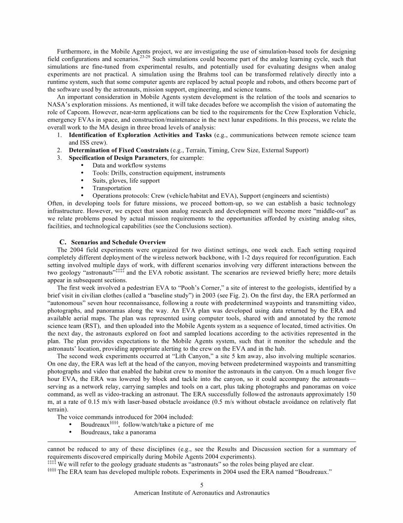
Figure 5 presents an example of the information flow using proxy agents (a form of interagent communication used in the 2002-2004 field experiments). Astronaut one says that he is starting the activity of sampling an area. This is processed by Astronaut one’s dialog agent and passed as a communication to his personal agent (PA). From here, the information needs to be communicated to the HabCom PA, which occurs via the HabCom PA proxy that co-exists in the Brahms system running on Astronaut one’s backpack. The proxy uses information provided by a central registry (in this Mobile Agents configuration) to find the HabCom PA running on a platform in the hab. From the HabCom PA, the information is communicated by email to the RST and by a loudspeaker to the HabCom (a crew member in the hab) via the HabCom dialog agent (which converts the text to speech). HabCom PA then provides feedback to Astronaut one and two that the activity has begun, first using proxies to find the corresponding PAs,

American Institute of Aeronautics and Astronautics
10
from which the information is communicated to the corresponding dialog agents, and then spoken to the astronauts on their headphones. All of the transmission of requests and scientific data follows similar paths between the crew members and their PAs.
Note that biosensor and GPS data is handled more directly for efficiency by pulling data as needed from external sources, rather than using the agent communication network (which is to say that agent communications do not replace telemetry networks). Furthermore, there is nothing fixed about the design of proxies and PAs shown here; this is just one of many possible ways to partition computational procedures and information flow. See the Results and Discussion section for related comments about improved designs.
Figure 4. Brahms software agents in the Mobile Agents 2004 Configuration.
American Institute of Aeronautics and Astronautics
11
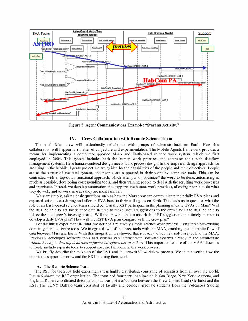
IV. Crew Collaboration with Remote Science Team The small Mars crew will undoubtedly collaborate with groups of scientists back on Earth. How this
collaboration will happen is a matter of conjecture and experimentation. The Mobile Agents framework provides a means for implementing a computer-supported Mars- and Earth-based science work system, which we first employed in 2004. This system includes both the human work practices and computer tools with dataflow management systems. Here human-centered design meets work process design. In the empirical design approach we are using in the Mobile Agents project we are guided by the capabilities of the people and their objectives. People are at the center of the total system, and people are supported in their work by computer tools. This can be contrasted with a top-down functional approach, which attempts to “optimize” the work to be done, automating as much as possible, developing corresponding tools, and then training people to deal with the resulting work processes and interfaces. Instead, we develop automation that supports the human work practices, allowing people to do what they do well, and to work in ways they are most familiar.
We start simply, asking basic questions such as how the Mars crew can communicate their daily EVA plans and captured science data during and after an EVA back to their colleagues on Earth. This leads us to question what the role of an Earth-based science team should be. Can the RST participate in the planning of daily EVAs on Mars? Will the RST be able to get the science data in time to make useful suggestions to the crew? Will the RST be able to follow the field crew’s investigations? Will the crew be able to absorb the RST suggestions in a timely manner to develop a daily EVA plan? How will the RST EVA plan compare with the crew plan?
For the initial experiment in 2004, we defined a relatively simple science work process, using three pre-existing domain-general software tools. We integrated two of the three tools with the MAA, enabling the automatic flow of data between Mars and Earth. With this integration we showed that it is easy to add new software tools to the MAA. Previously developed software tools and systems can interact with software systems already in the architecture without having to develop dedicated software interfaces between them. This important feature of the MAA allows us to freely include separate tools to support specific functions in the work process.
We briefly describe the make-up of the RST and the crew/RST workflow process. We then describe how the three tools support the crew and the RST in doing their work.
A. The Remote Science Team The RST for the 2004 field experiments was highly distributed, consisting of scientists from all over the world.
Figure 6 shows the RST organization. The team had four parts, one located in San Diego, New York, Arizona, and England. Rupert coordinated these parts, plus was point of contact between the Crew Uplink Lead (Sierhuis) and the RST. The SUNY Buffalo team consisted of faculty and geology graduate students from the Volcanoes Studies
Figure 5. Agent Communications Example: “Start an Activity.”

American Institute of Aeronautics and Astronautics
12
Group. Sklar, a student at Northern Arizona University, led a team made up of geologists from the MDRS RST, volunteer scientists who supported all of the 2004 MDRS rotations and have participated as field crew. Buckingham Shum and Selvin of The Open University in the UK led the meeting facilitators, who managed communication between the crew and the RST through Compendium and Meeting Replay.
The RST teams collaborated to analyze the EVA science data and provide feedback on the crew’s next EVA plan. We defined a simple work process in which the crew planned and executed their EVAs in a daily EVA-cycle using several tools. Because the RST members were so distributed, their interaction also benefited from collaboration tools. The RST Facilitator facilitated web-based teleconferences between the RST teams. The workflow process is described next.
B. The Crew/RST Workflow Process The workflow process is divided into two parallel processes that are dependent on each other. Figure 7 shows a
high-level workflow process model. The idealized flow shown in Fig. 7 is as follows: After the EVA, the crew analyzes the collected science data
(rock and soil samples) back in the hab. After this analysis, the crew discusses the results of the day’s EVA and plan the EVA for the next day. This meeting is facilitated with the Compendium meeting capture software and is video taped. The result is communicated to Earth. On Earth, the crew’s meeting video and Compendium database is used in the Meeting Replay tool. This allows the RST to view the EVA planning discussion of the crew and at the same time view the crew’s plan in the Compendium tool. After the individual RST members have viewed the video, they have a remotely facilitated meeting on the web, called the Science Operations Work Group meeting. The name is taken from a similar meeting held during each sol on the Mars Exploration Rover (MER) mission at JPL (http://origin.mars5.jpl.nasa.gov/home/). During the SOWG meeting on the MER mission, science subgroup leaders review and assemble the plan for the next day, relating timing and resources. Similarly, the RST team meets together in a teleconference to review the plan made earlier by the crew on Mars. This meeting is also captured in the Compendium meeting capture tool. The result is emailed back to Mars before the crew wakes up the next morning. The next morning at 8:30 (local Mars time) the crew reviews the RST plan in Compendium, and decides on the final plan for the day’s EVA. More details about the collaboration tools are provided in the following section.
Figure 6. The Remote Science Team. Mars Crew inset corresponds to Fig. 4.

American Institute of Aeronautics and Astronautics
13
V. � Crew/RST Collaboration Support Tools Mobile Agents 2004 introduced a new strand of research in MDRS analog research, concerning how to support
the Remote Science Team (RST), which in actual missions is likely to be spread across the Earth in multiple time zones. Just as the MER 2004 mission showed after a few months, it is impractical to physically co-locate all relevant experts who might be needed in a multi-year Mars mission. Looking ahead a decade or two, this research prototypes and evaluates tools to support scientific teamwork under such circumstances, advancing the state of the art in information networks.
To this end, a collaboration was formed between NASA-Ames’ work systems design research group and the UK’s CoAKTinG Project.37 CoAKTinG (“Collaborative Advanced Knowledge Technologies in the Grid”) is part of the Advanced Knowledge Technologies consortium and is developing new kinds of collaboration technology to support what they call e-Science. MA 2004 provided a testbed for some of the CoAKTinG tools, to see how well they could connect the RST with each other, with a crew living and working out of conversational contact.
A. Preparation for Field Experiments To prepare, the RST held weekly planning meetings via teleconference for over five months, exploring possible
science questions that could be addressed by the field crew during the field test and putting the new collaboration support tools through their paces. Thus we began to understand the role that different collaborative technologies could play in the overall work ecology of the RST and astronauts.
In particular, during the preparation the RST used the ScienceOrganizer system to archive and to link meaningfully their project materials and experimented with Compendium to design their own maps to support a geological methodology. A trial version of the Meeting Replay tool from the Operational Readiness Test in March 2004 also generated much interest, and was fine-tuned as a result. The BuddySpace messaging and awareness tool was released once the MDRS work had started. These RST Communication System tools are described in subsequent sections.
B. ScienceOrganizer: Long-term, formal memory for mission data and knowledge ScienceOrganizer36 was developed at NASA Ames, and provides a web-based semantic database that can be
populated and searched by scientists or engineers. It has been previously used to support the Columbia Shuttle accident investigation,38 to study patterns of malaria in Africa, and to design and execute experiments on microbes, among other applications. ScienceOrganizer provides a rich interface for semantically linking resources (i.e., a
Figure 7. The Mobile Agents Project Crew/RST Workflow.

American Institute of Aeronautics and Astronautics
14
relational database with well-defined descriptive relations, such as “plan activity”), and is most suited for long-term knowledge management, especially for distributed teams collaborating asynchronously. Figures 8 and 9 illustrate how a voice note is stored in ScienceOrganizer and the notification is received by a member of the RST.
From: [email protected] Subject: MDRS New VoiceAnnotation: voice_note_9 Date: May 7, 2004 3:47:36 PM PDT To: [email protected] New VoiceAnnotation: voice_note_9 EVA Plan: LithCanyon_SegmentThreeEVA_Plan Activity: WorkAtWayPoint16 Creator: AstroTwo TimeStamp: 05/07/2004 23:47:12 File Name: voice_note_2004-4-7_23-46-28.wav
Latitude: 3827.3077 NORTH Longitude: 11047.4074 WEST Northing: 4256335.2693082085 Easting: 518312.1563357575 Zone: 12S ScienceOrganizer Link : https://marst.arc.nasa.gov/org/166015
Figure 8. Email sent to RST indicating a new voice note. Besides the time and precise GPS location, the email indicates that astronaut 2 created the voice note while working at waypoint 16 during the Segment 3 EVA in Lith Canyon. This information is associated with the voice note in ScienceOrganizer, at the specified URL.
Figure 9. A ScienceOrganizer database entry showing a voice annotation created Lith Canyon EVA. On the left are hyperlinks to related resources, such as the location the voice note was taken, the astronaut, and the EVA itself. This is the page referenced in the email sent to the RST shown in Figure 8.

American Institute of Aeronautics and Astronautics
15
Because the ScienceOrganizer interface consists of web pages, the system can be made available to virtually anyone, anywhere. However, it was not designed to support meeting capture, free-form thinking, and brainstorming. One of the questions we investigated was how ScienceOrganizer could be complemented by other collaboration tools such as Compendium.
C. Compendium: Mapping meetings as group memory Meetings are as pervasive an activity in scientific life as elsewhere, and similarly, can often also be ineffective.
Moreover, when conducted in an international context via a virtual environment such as a video- or tele-conference, many of the normal non-verbal cues that add fluidity to interaction are missing. The Compendium tool being developed at the Open University provides a way to focus discussions on specific topics, integrating other documents into the idea network that grows as contributions to a discussion are mapped on screen. Compendium differs from other concept mapping tools in the specific visual language it provides to capture and organize issues in real time as they emerge in discussions, and in the hypertext and semantic tagging mechanisms it provides to manage large databases.
Compendium played several roles in the MA 2004 mission: 1. Mediate between the hab crew and software agents. The Crew used Compendium to plan the route of the
next EVA (Fig. 10), constructing a visual map of the locations they wanted to visit and the activities to be conducted at each. These Compendium maps were then interpreted by the agents that coordinated commands and the flow of information during an EVA.
2. Compendium was used to view all the data gathered on the EVA when the Crew returned to the hab. All
the data generated during an EVA (videos, photos, voice annotations...) streamed back over the wireless network
Figure 10. An EVA plan constructed by the Crew in Compendium. This plan was read by the Brahms software agents that coordinated the EVA work flow.

American Institute of Aeronautics and Astronautics
16
and were stored in the hab in ScienceOrganizer and Compendium. Compendium displays data in concept maps (Fig. 11), assisting analysts in seeing and navigating certain kinds of structure, and linking in their own ideas and documents. Compendium maps were sometimes shared by storing then in the ScienceOrganizer database, and data referenced by maps were archived in ScienceOrganizer.
3. Compendium was used by the crew and RST to discuss the implications of the data. Compendium
displays information in visual concept maps to support sense-making activities such as planning, discussions, and the gradual structuring of ideas. As the discussion unfolds, the contributions are simultaneously mapped on the screen (projected in the hab in a crew meeting, or shared over the internet in an RST teleconference). The RST could therefore see what options the crew may have discussed but rejected, and why, in order to provide scientific feedback to the crew (Fig. 12).
Figure 11. Following the EVA, a map is created and populated in Compendium rendering the data gathered. Shown is an example Science Data map, highlighting the data gathered by Astronaut One.

American Institute of Aeronautics and Astronautics
17
The insight that the RST gains into the crew’s decision-making is further enriched by an indexed, digital video record of the crew’s meeting which integrates Compendium with other resources, as described next.
D. Meeting Replay: Enabling the RST to review a crew meeting Given the communication delay between Mars and Earth, the usual electronic ways of working together at a
distance, such as conversation and the sharing of computer screens, are impractical. As part of the CoAKTinG project, the University of Southampton have developed a meeting replay tool, which combines meeting materials within an interface structured to enable quick and easy indexing navigation of the meeting record.
During the mission we recorded the crew’s daily EVA planning meetings and delivering a replay of the meeting to the RST within a few hours. By experimenting with these techniques we hoped to see if the RST could gain a better understanding not only what a crew is deciding, but why, and how, in order to provide the best kind of feedback.
Figure 13 shows the web-based Meeting Replay tool. The upper region shows the video of the meeting and the Compendium map as the discussion progresses. The lower region contains summary information about the meeting—who was there, who was speaking, the agenda, and an overview of the current topic (derived from the Compendium map). Some of this information is presented as a timeline, providing a visual index for an RST member to navigate the video, jumping to relevant or interesting parts of the discussion by clicking on the timeline or moving the slider.
Figure 12. Compendium map summarizing the RST’s feedback to the crew. Each node is hyperlinked to the map (i.e. the context) in which it was created.

American Institute of Aeronautics and Astronautics
18
Before the RST meets collectively, each participant runs their own meeting replay. Should the need arise to review a specific point in the meeting as a group, one member can take control of all the meeting replays using the GroupSync feature. As that member navigates around the meeting everybody else’s client follows their lead, remaining in synchronization as long as required.
E. BuddySpace: Instant messaging meets presence visualization Teams distributed in time and space are less aware of their colleagues’ activities and availability, giving a
reduced sense of presence compared to being co-located. One challenge is how to characterize presence, as something that can be managed and visualized easily, while remaining consistent with the user’s expectations and work habits, including existing patterns for using Instant Messaging (IM) and other communication tools.
A prototype presence management tool called BuddySpace has been developed at the Open University, which overlays presence information onto visualizations, both geographical (e.g. a map of a building, region or planet), and conceptual (e.g. a workflow chart, project plan, or experiment). (BuddySpace is based on Jabber/XMPP, and is interoperable with MSN Messenger, Yahoo, ICQ, and AIM.) In the RST BuddySpace map (Fig. 14), the availability of members is shown mapped to their geographical location.
Figure 13. Web-based meeting replay tool screenshot. When reviewing the meeting replay, Compendium has been extended so that it can be used as a ‘visual contents page’ into the video. For instance, if the RST wants to see discussion prior to the recording of a particular decision, one can now click on this node in Compendium and the replay jumps to the point in the meeting where that node was recorded, and starts to play the video.

American Institute of Aeronautics and Astronautics
19
The preparation and simulated EVA experience suggested that ScienceOrganizer, Compendium, Meeting Replay, and BuddySpace used together is a powerful suite of tools for supporting RST-Crew collaboration. Reporting at a mission web site provided important means of communication between the crew, RST, mission support, and the public. These reports are described in the next section.
VI. Reporting During the Simulated Mission The Mars Society maintains an archived set of crew reports throughout the multiple year campaigns at the
Flashline Mars Arctic Research Station (FMARS) and MDRS. Each crew page includes biographies, mission information, and daily reports with photographs. A good part of this article was prepared from reports written and posted during the two weeks field experiments (see http://www.marssociety.org/MDRS/fs03).
Each member of the official MDRS29 crew wrote reports according to his/her role: Commander “check in” reports provided daily synopses about the status of system deployment and testing, as well as a window on living and working at MDRS during this period. More complete EVA reports were written by the geology-astronauts. An EVA Communications Systems Report described the interaction of the crew with the RST and other aspects of the field work. Other crew reports included: Engineering (e.g., generator status), Greenhab (a gray-water recycling system), plus Health and Safety. To complement these reports, the RST Communication System Report was written by the RST Facilitator (Shum) in the UK, describing the experience and status of the collaboration tools. The RST
Figure 14. Prototype RST BuddySpace map, in which the online availability of colleagues is superimposed on locations in the US and UK. Clicking on one of the presence dots opens a conventional instant messaging session.
American Institute of Aeronautics and Astronautics
20
report written by the RST Lead (Rupert) detailed the experience of the RST team in understanding and commenting on EVA plans and data.
Some of these reports are excerpted and adapted in subsequent sections, which describe the primary scenarios of MA 2004 and what occurred.
VII. � Pedestrian EVA Scenario (Pooh’s Corner) The first scenario involved several sequential activities: Reconnaissance by the ERA, crew-RST planning, and a
pedestrian (walk out of the hab) EVA. These activities were planned for two contiguous days, though weather required a break in between.
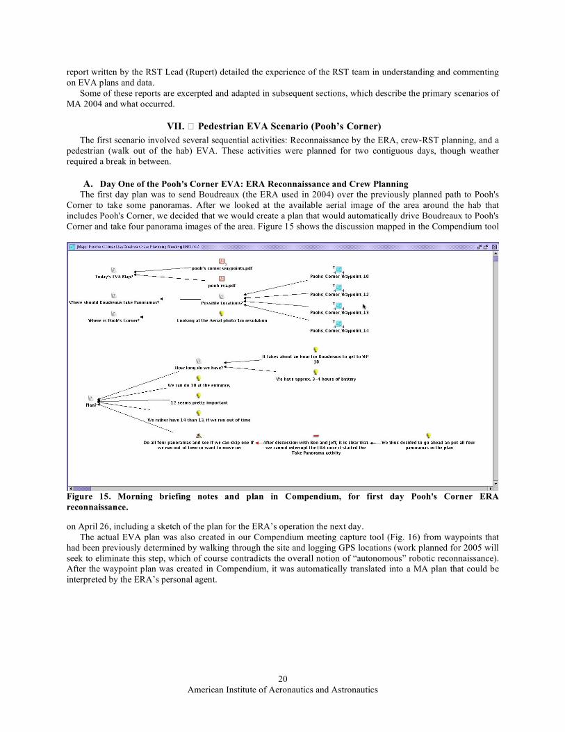
A. Day One of the Pooh's Corner EVA: ERA Reconnaissance and Crew Planning The first day plan was to send Boudreaux (the ERA used in 2004) over the previously planned path to Pooh's
Corner to take some panoramas. After we looked at the available aerial image of the area around the hab that includes Pooh's Corner, we decided that we would create a plan that would automatically drive Boudreaux to Pooh's Corner and take four panorama images of the area. Figure 15 shows the discussion mapped in the Compendium tool
on April 26, including a sketch of the plan for the ERA’s operation the next day. The actual EVA plan was also created in our Compendium meeting capture tool (Fig. 16) from waypoints that
had been previously determined by walking through the site and logging GPS locations (work planned for 2005 will seek to eliminate this step, which of course contradicts the overall notion of “autonomous” robotic reconnaissance). After the waypoint plan was created in Compendium, it was automatically translated into a MA plan that could be interpreted by the ERA’s personal agent.
Figure 15. Morning briefing notes and plan in Compendium, for first day Pooh's Corner ERA reconnaissance.

American Institute of Aeronautics and Astronautics
21
The Mobile Agents system was
started, the plan was read in by the HabCom agent and distributed to the ERA Personal Agent. Boudreaux required about 5 hours to execute the plan autonomously. It eventually arrived at Pooh’s Corner, while the crew monitored its progress via Boudreaux’s video camera (Fig. 17). Excitement was highest when Boudreaux took its first panorama at waypoint 10 at the entrance of Pooh’s Corner. It took about 12 minutes to take the panorama and stitch it together into one image (Fig. 18). The picture was stored in ScienceOrganizer (Fig. 19) in the hab and then copied to the mirror site at Ames. Email was automatically sent to the RST.
Figure 16. Plan created for ERA’s reconnaissance at Pooh’s Corner. Each waypoint icon designates an object containing additional information about location and actions. This representation can be automatically interpreted by a program that generates a plan represented in Brahms that is used by mobile agents during the EVA.
Figure 17. Kim Tyree monitoring Boudreaux’s traversal inside MDRS with video, mapping, and other telemetry from the ERA.
Figure 18. Boudreaux's first panorama at entrance of Pooh's Corner (April 27, 2004).

American Institute of Aeronautics and Astronautics
22
Figure 19. Page in ScienceOrganizer corresponding to panorama (Fig. 18).
Figure 20. Crew’s analysis of Pooh’s Corner reconnaissance (excerpt) with next day EVA planning.

American Institute of Aeronautics and Astronautics
23
Boudreaux returned to MDRS after driving more than 1 km. The reconnaissance was successful, although we did not receive all four panoramas as planned because of a communication error on the third attempt, which propagated to prevent the fourth instruction from working. As in operating the MER rover on Mars, such problems can usually be resolved and the software updated during the mission.
While Boudreaux was returning, the crew analyzed the panoramas and discussed a plan for the next day’s EVA to the same site. Figure 20 shows the Compendium map of that preliminary planning discussion. This information was sent to the RST using the Meeting Replay tool, with the expectation that the RST would annotate the plan.
B. Day Two EVA to Pooh's Corner: Astronaut EVA Before the 2004 field season, we had made a detailed schedule of the two weeks. After the ERA’s
reconnaissance of Pooh’s Corner, the astronauts were planned to return to the site with the robot the next day to perform geology exploration. However, severe winds forced the EVA to be rescheduled a day, which provided an additional day of lab-bench testing and refinement of the EVA plan.
The weather April 29 was cold and cloudy, permitting the EVA to proceed. But when the ERA team turned on Boudreaux its motors were not working. An hour delay (until noon) was anticipated, however at 12:30 PM we decided that the astronauts should prepare, and we would do the EVA without the ERA if necessary. Then it began to rain. At 1 PM the rain had stopped and we started to suit up the astronauts. Preparing the new backpack with dGPS and two laptop computers, as well as getting two microphones fitted in the astronaut’s helmet (one for the speech dialogue system and one for the crew voice loop) and starting the Mobile Agents system required an hour. Coincidentally, HabCom reported that the plan was now ready in the MA system (Fig. 21) and at the same time the ERA team reported that the robot was ready, too. At 2:00 PM AstroOne (Brent Garry) said to his personal agent, “Start Egress activity.”
All systems go, AstroOne then said to his personal agent, “Start walk to waypoint 12 activity.” After several seconds AstroOne’s PA dialog agent said in a new female voice, “Walk to waypoint 12 activity started” (refer to Fig. 5). Next, AstroOne said, “Boudreaux, follow me.” Boudreaux’s PA received the command a couple of seconds later and forwarded the command to the ERA’s Communication Agent (a Brahms agent written in Java), which formulated and sent appropriate instructions to the robot control software via the ERA’s API. Boudreaux locked in on AstroOne’s GPS from his backpack and started following the astronaut at a safe distance. The EVA had begun. Everything was working, and the astronauts proceeded on foot to waypoint 12 at Pooh’s Corner. It had taken Boudreaux almost four hours to get there on Tuesday during its autonomous traverse. However, today it was tracking the astronaut in a level area, and so we were able to turn off automated obstacle avoidance. The astronauts reached waypoint 12 in 30 minutes with Boudreaux following. This 700 m traverse was a record for Boudreaux while following a person.
A potential problem at the beginning of the EVA now became known to AstroOne. Early on, we learned in the hab while monitoring all of the agents from the HabCom computer that AstroOne’s GPS agent in the Brahms model was not receiving any GPS data from the GPS system. HabCom inferred that AstroOne’s PA would probably not be able to download his voice notes. This was confirmed when AstroOne finished his first voice note, and HabCom detected that the “speech act” from AstroOne’s PA did not arrive at the HabCom PA running on the HabCom computer. Thus, none of AstroOne’s voice notes could be stored inside ScienceOrganizer or Compendium. However, AstroOne’s dialogue system was recording his voice notes and storing them on the backpack computer, so they could be retrieved after the EVA. This combination of backup systems and debugging telemetry was an
Figure 21. Day two astronaut EVA plan for Pooh’s Corner. Each icon represents an activity object in the MA system, with location and timing information used by agents for alerts, as well as for automatically associating data in ScienceOrganizer.

American Institute of Aeronautics and Astronautics
24
important part of the MAA design for the 2004 field season, based on difficulties observed in previous years. Put another way, we were now using the MAA architecture for runtime monitoring, diagnosis, and repair of system components during EVAs themselves.
A second problem occurred when AstroTwo attempted to download all images. HabCom detected, again inside the hab using the remote monitoring tools, that AstroTwo’s camera had inexplicably been associated with drive E: instead of the normal drive D:, and thus her PA could not find the image directory. HabCom was able to remotely change how the camera was on AstroTwo’s backpack computer. She repeated the command, “Download all images,” and then less than a minute later HabCom detected the pictures being downloaded into ScienceOrganizer in the hab.
But then the process responsible for communicating with ScienceOrganizer inexplicably quit. This meant that the RST would not receive any of the science data during the EVA itself. HabCom detected that the RST was online and examining the problem remotely. The problem was resolved half way through the EVA; data did enter into the ScienceOrganizer database, and the RST received corresponding email (see Fig. 22).
After almost three hours, the batteries of the backpack computers were almost empty. The astronauts’ PAs
monitor the battery level and warn the astronauts and HabCom of low battery levels. We hot-swapped the batteries, providing another two to three hours. About 5:00 PM, approximately three hours since egress, we decided that the crew should start returning to the hab (the EVA was planned, but timing was flexible to allow for appropriate diagnostics and testing of the system, with the total time determined mainly by the batteries). The EVA crew had completed three of the four sampling activities on the plan and asked Boudreaux to take a panorama and a number of images. AstroOne walked over to Boudreaux, stood in front of his cameras and spoke again, “Boudreaux, follow
Figure 22. Science data for Pooh’s Corner EVA recorded in ScienceOrganizer. Data is listed in hierarchical index on the left; information about selected entry is provided on the right.

American Institute of Aeronautics and Astronautics
25
me.” Like a trusted mule, it pulled the science trailer and followed the astronauts back to the hab. The ingress activity started at around 5:15 PM. The EVA times and distances appear in Table 1.
But work was not yet finished for the astronauts. After removing suits and a debriefing with the MA team, the geologists started sample analysis in the lower floor of the habitat. The RST had provided a sample methodology process that included taking photographs of the samples inside the hab and providing additional voice notes. The MA system was shut down in the backpacks, but the HabCom computer stayed operational to allow the astronauts to create these voice notes and to download pictures from their cameras, so that they could be stored and associated automatically with other data from the EVA. At least this was the plan.
Unfortunately, when the HabCom computer was brought from the upper deck, the system was unable to recover from a broken state. The speech dialogue system became unresponsive, and the crew could add no more science data. After dinner, we decided to use Compendium instead. Both geologists used their stored and downloaded images and voice notes to provide an analysis of the EVA. Finally, by midnight we were able to export the crew’s EVA analysis from Compendium and upload it into ScienceOrganizer, just in time for the RST to download it and have their 5 AM SOWG meeting to provide feedback to the crew.
C. Geologists’ Report on Pooh’s Corner EVA‡‡‡‡‡ Overall impression: Extremely successful EVA in comparison to last field season in regards to the robustness
and sophistication of the system. The EVA lasted 4 hours in a very “real-time” and realistic atmosphere. The ERA played a prominent and crucial role in helping the astronauts achieve their field goals by providing a workstation and reducing fatigue by carrying important equipment. Our accomplishments are summarized here.
1. EVA Plan We accomplished all tasks up through “Sample at Red Hill.” Time constraints prevented “Sample at Little Red
Hill,” “Soil Core” activities, and “Stow equipment.” “Walk back to Hab” was manually instigated by HabCom. 2. ERA and Science Trailer • The ERA followed AstroOne to and from the field with no manual control, using the “Boudreaux,
Follow Me” command. • The ERA served as a base of operations for sampling at Rock Hill and Back Hill locations. • Science Trailer is useful as a storage tool for samples and equipment. There were six sample bags
between the two astronauts. Samples and tools would have been too cumbersome to transfer between locations in the field and to carry back to the hab at the end of the EVA.
• Improvised booklet of maps, panoramas, and voice commands was attached to the top of the Science Trailer as a field reference. This proved useful when we needed to refer back to new voice commands.
3. AstroOne • My first EVA with full human-robot interaction with the robot acting autonomously to my commands. • Majority of time was spent working with commanding Boudreaux (the ERA) such as follow me, take a
panorama, take picture of me, and watch me. • Was able to sample at Rock Hill and The Mount using the nifty nabber, special tongs to grab the rock
samples without bending over. • Able to create sample bags with the Letter Letter / Digit Digit / Digit Digit format. With this format we
could indicate sample location, astronaut who took sample, and sample number (e.g. RK/11/01 is for RocK hill taken by AstroOne at station 1 sample 01).
• Able to lead ERA to the field and return the robot safely.
‡‡‡‡‡ This is a lightly edited first-person account written by the two geologists immediately after the simulated EVA.
Table 1. Distances and duration outside hab during Pooh’s Corner EVA.
Robot/Person
Distance Traveled
(m)
Duration (hr)
Boudreaux
1017.2
2.748
AstroOne (Brent) 2745.45
2.757
AstroTwo (Abby)
1983.01
2.745

American Institute of Aeronautics and Astronautics
26
4. AstroTwo • Managed to follow the majority of the plan (e.g. Egress, Starting Bio-sensors and GPS tracking, and
starting Sample at Rock Hill). • Able to name locations and associate images, voice notes, and samples with locations. • Sample bags could be associated with voice notes, however I had problems with associating images and
voice notes. • Sample bags were taken at Rock Hill, Back Hill, and Red Hill with associated voice notes at each
location and images were associated with each location. • Tried out a number of voice commands: What time is it? Where am I? How much time is left?, What is
current activity? Responses were timely and accurate. 5. Room for Improvement • Astronauts need to stay within safe and helpful distance to each other. This was exhibited by the need to
help with stowing equipment, also during equipment failures (e.g. AstroOne’s camera batteries died [probably from the cold], and needed AstroTwo to take a photo, while at Back Hill). The other astronaut serves as a useful scale in photos and to indicate cardinal directions.
• Push-to-talk (PTT) function on the radios limited the astronauts in discussing what tasks to perform and observations and interpretations of the outcrops. A VOX communication system would be much more helpful and natural for the astronauts to communicate with each other. The PTT function interrupts making voice notes and is mentally distracting from the task at hand. Finding the button or waiting for someone else to finish talking is time consuming. Communication about what tasks the other astronaut has accomplished at the outcrop is hindered by different styles of working and lack of delegation of who was to perform which tasks.
6. Post-EVA Analysis • Samples were photographed individually in the Hab. The astronauts used compendium to create a map of
their own descriptions, observations, and interpretations for each sample and location. This was sent to the RST to help them with their analysis.
VIII. Head of Canyon EVA Scenario Planning The second week of the field experiments was devoted to another site, about 5 km from MDRS. Three segments
were planned for different days, at the head of the canyon (in which the ERA would provide surveillance by moving on voice command between predetermined waypoints at the canyon rim), around the bend, and down the long winding portion with the ERA (described in the next section).
This section discusses the EVA planning by the crew of segment one, at the head of Lith Canyon. Two planning days were involved (May 3 and 4). This report demonstrates the workflow process and collaboration between the crew and the RST over two days.
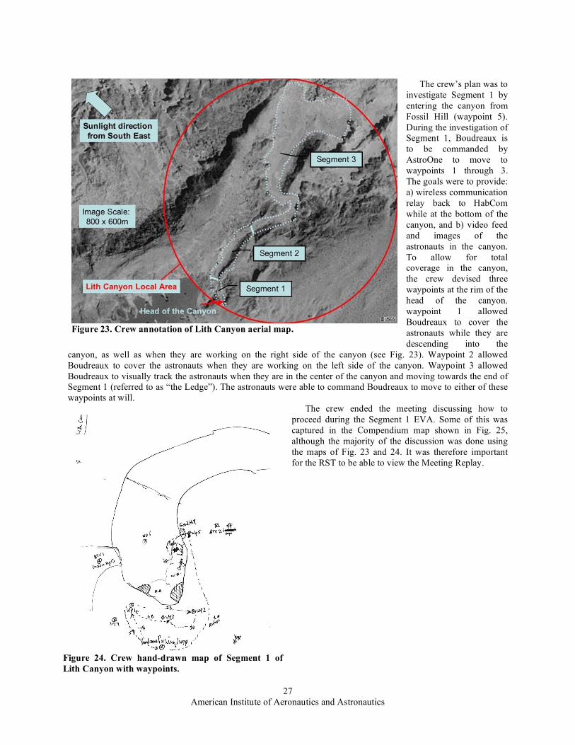
A. Crew Initial Planning of Head of Canyon EVA In the afternoon of May 3rd, the crew had an hour-long initial EVA planning meeting. In this meeting the crew
had two objectives: 1) to review the available data for Lith Canyon and based on that define a doable EVA plan for next day’s EVA, and 2) to provide the RST with as good a background picture of Lith Canyon and the EVA plans in the coming three days as possible. In order to support the second objective, the crew decided again to record the meeting on video, so the Meeting Replay tool could be used. The crew started the meeting with the creation of an aerial map with and explanation of Lith Canyon (See Fig. 23).
Using this map, the crew explained to the RST how they divided Lith Canyon into three segments, and how they planned two EVAs to geologically investigate the three segments. The next day’s EVA would cover Segment 1, while the EVA after that would cover both Segment 2 and 3 in one EVA. The scale of the aerial image in Figure 1 is 1 meter per pixel making Lith Canyon about 600 m long.
After the introduction of Lith Canyon to the RST, the crew focused on what they would be doing in next day’s EVA. To do this, the crew had created a hand-drawn map of Segment 1, which included hand-drawn GPS waypoints for Boudreaux and for the crew to use for demarking the plan. (Fig. 24).
American Institute of Aeronautics and Astronautics
27
The crew’s plan was to investigate Segment 1 by entering the canyon from Fossil Hill (waypoint 5). During the investigation of Segment 1, Boudreaux is to be commanded by AstroOne to move to waypoints 1 through 3. The goals were to provide: a) wireless communication relay back to HabCom while at the bottom of the canyon, and b) video feed and images of the astronauts in the canyon. To allow for total coverage in the canyon, the crew devised three waypoints at the rim of the head of the canyon. waypoint 1 allowed Boudreaux to cover the astronauts while they are descending into the
canyon, as well as when they are working on the right side of the canyon (see Fig. 23). Waypoint 2 allowed Boudreaux to cover the astronauts when they are working on the left side of the canyon. Waypoint 3 allowed Boudreaux to visually track the astronauts when they are in the center of the canyon and moving towards the end of Segment 1 (referred to as “the Ledge”). The astronauts were able to command Boudreaux to move to either of these waypoints at will.
The crew ended the meeting discussing how to proceed during the Segment 1 EVA. Some of this was captured in the Compendium map shown in Fig. 25, although the majority of the discussion was done using the maps of Fig. 23 and 24. It was therefore important for the RST to be able to view the Meeting Replay.
Figure 23. Crew annotation of Lith Canyon aerial map.
Figure 24. Crew hand-drawn map of Segment 1 of Lith Canyon with waypoints.

American Institute of Aeronautics and Astronautics
28
B. Crew RST Debrief Review and Final Planning of Head of Canyon EVA As planned, the morning of May 4 was used to set up the communication network to Lith Canyon. During this
time the crew developed the final EVA plan. One of the first things noticed was that the crew downlink lead had made a mistake in the filenames of the downlinked video files the night before (the RST notified the crew of the problem by email). Consequently, the RST was unable to use the Meeting Replay tool during their early-morning meeting. This simple mistake was the result of fatigue, and illustrates why such tasks, which are easily automated, should be handled by personal agents. Here we were beginning to see how the MAA framework was useful for “office work” in the hab. This example illustrates how the empirically grounded development and field-test methodology helps determine requirements from a human-centered perspective.
The RST was able to use the Meeting Replay tool later in the day and reviewed the video of the crew’s initial planning session (Fig. 26).
Meanwhile, the RST had viewed the EVA plan (Fig. 25) in ScienceOrganizer, enabling them to provide some timely feedback to the crew for its final EVA planning session on May 4 (Fig. 27). The crew incorporated all of the RST’s suggestions in the final EVA plan.
Weather prevented performing the EVA on May 4 as planned. The RST used the Meeting Replay tool and provided further feedback to the crew at the end of the day. The EVA was then run on May 5.
Figure 25. Crew’s initial planning map of Head of Canyon EVA using Compendium (excerpt).

American Institute of Aeronautics and Astronautics
29
On the way into the canyon, AstroTwo made a voice note at Fossil Hill, while AstroOne made a panorama from canyon floor. ERA successfully watched AstroOne for most of the EVA and took an image of him. AstroOne worked on the South Cliff Face, whilst AstroTwo worked on the East Cliff Face, taking voice notes and samples, with images. The EVA was ceased due to lack of sunlight about 8:30 PM.
The following section provides the Commander’s view of the subsequent day, preparing for the Segment 3 EVA on May 7.
IX. � Preparations for Lith Canyon EVA§§§§§ Log Book for May 6, 2004 Commander's Check-In Time: started 8:19 AM May 7, completed 9:51 AM Weather: low 15c (59F) high of 29.1c (84.4F), hot and dry (12% humidity) with mid-afternoon winds Crew Physical Status: Very good, one person with minor scrapes. Narrative of Field Mission Results Today, May 6, was another successful day. We began with a briefing at 9 AM, joined by a NASA Ames
management observer. §§§§§ This is an edited version of the report submitted by the expedition leader.
Figure 26. Meeting Replay of Crew’s Head of Canyon EVA Planning. Video inset shows the crew inside MDRS using Compendium and reviewing the aerial and hand-drawn maps to plan the EVA.
Figure 27. RST email feedback brought into Compendium by the crew.

American Institute of Aeronautics and Astronautics
30
Preparing for the day’s test required a number of steps, which would take most of the day: 1. To deal with the overloading of the ERA’s computers, we would use the spare laptop for running the
Brahms-ERA agent system, locating it in the rental truck at Lith. This computer would be virtually “on board,” communicating wirelessly with ERA systems. Configuring the machine and relating it properly to the ERA might seem complicated, but the modularity of our systems made it relatively easy.
2. To handle the overheating of the astronaut computers, we would reconfigure the ventilation in the metal-enclosed backpacks, adding small fans right against the CPU area, with an additional opening on one of the backpacks. We would use a flow-through method, rather than just pushing or pulling the air. The metal cutting and electrical work required a good part of the day.
3. Once the first two steps were completed, we’d do a full-up start procedure in place at Lith, without intending to run a simulated EVA. We would verify the sequence of starting we had identified yesterday (roughly: network, RIALIST, Mobile Agents, biosensors, and GPS). We've learned that the sequence of plugging in the headsets, sensors, and camera is crucial; unplugging after the system starts can cause odd behavior later.
4. We would examine the far point Cisco repeater (.5 km from our EVA site) and recharge the battery if necessary. 5. We’d replace the push-to-talk mechanism used by AstroOne.
I retired to my stateroom-office to write the previous day’s report and process photographs. I also greeted a Spanish-speaking TV group from Salt Lake City and gave an orientation to the Ames visitor. These activities filled my morning, then I turned to email, including responding to more than 20 fairly interesting questions from an Italian reporter.
The winds picked up at the canyon, requiring equipment to be moved into the truck and the canopy to be tied down even more securely. But the network backbone held with good throughput to the hab. We decided to go out about 4 PM after testing showed that the fans allowed the backpack computers to run cooler than those just sitting on tables in the open truck. An ERA team member had carried around the backpack doing speech tests with the ERA, which showed all was in order. We decided to do a short EVA, rerunning the head of canyon scenario.
What followed was our quickest start to date: We arrived at Lith at 4:40 PM, started the Mobile Agents system from 5-5:13 PM, changed to internal battery at 5:18 PM. By 5:30 PM AstroTwo was fully outfitted and starting her sensor systems by voice command. The EVA then proceeded in its usual chaotic way, lasting nearly 1.5 hours.
Conditions were excellent for this EVA test—moderate to no wind, temperatures in low 80s, partly cloudy, beautiful late afternoon lighting. Of course not everything went according to plan.
The ERA had some GPS trouble and did not ever reach a waypoint by voice command (though it came close on the last try, losing GPS during the operation). The robot was successfully teleoperated from the hab to provide video of the work in the canyon. The astronauts commanded the robot to take photos and a panorama from the ledge, looking down at them on the canyon floor. (However, one photo was a bit late, and AstroTwo had already moved out of sight.)
For about an hour, the geologists went about their work of naming work locations, taking photographs and samples, and making voice notes. New commands like “Associate last voice note with last sample bag” and automatic naming of downloaded images as “collections” occurred properly. By using location names that begin “Work Site” (e.g., WorkSite5), the system automatically associated subsequent sample bags and voice notes with that location (so additional commands are no longer required). The data were properly stored in the ScienceOrganizer database in the hab (transferred automatically by Mobile Agents from the HabCom Brahms system) and copied by MySQL to the mirrored database at NASA Ames.
Members of the RST received email of each filing in ScienceOrganizer (similar to Fig. 8). Notice how the EVA plan, activity (established by the astronaut during each phase of the EVA), astronaut name, exact location and time are stored.
As a member of the hab crew, I received copies of each message, so I can quickly review the sequence of what occurred during the EVA from my mail folder. I see that AstroTwo took 19 photos, used four sample bags, and made three voice notes. She named three work sites, spaced 20 and 16 minutes apart. An email even indicates the moment when her GPS signal was lost (as she stepped under an overhang at the lip of the canyon)—a milestone for this test, because her backpack computer remained on the network, with the ERA serving as a relay to the backbone. Various alerts about heart rate and Oxygen saturation were also sent, but it’s not clear whether these sensor readings were correct.
Although we were disappointed that the ERA could not be moved from side to side by voice command to keep the astronauts within camera view, this was actually an improvised addition to the scenario last week. We in fact met our objectives for this segment of establishing the ERA as a relay and using the Mobile Agents system to properly document the geology of an area.
American Institute of Aeronautics and Astronautics
31
In comparison, last year’s test at Lith lasted only about 20 minutes and only proved that the basic data logging commands worked; only one image was actually received remotely. This year we used the system for over an hour in the canyon, used much more sophisticated naming and association automation, and all of the data were stored automatically in the hab and a remote database.
We have clearly turned the corner from just getting the system to work at all, to having a system that can actually be used experimentally and improved by observing how people use it.
We arrived back in the hab before 8 PM. We were treated to a pizza dinner by NREN, including the entire expedition team (with visitors from two communication network vendors). It was a fun and relaxing evening. Our celebration was tempered only by the absence of the support person who had set up the party, now hospitalized in Provo with a heart problem (though doing well).
The intensity and excitement of the day’s work continued late into the evening, as we watched a “video file” on NASA TV after 11 PM. The 17 minute segment, filmed and edited by a team at NASA Ames, showed our work last week and included interviews with the crew. It was eerie to watch this video sitting in bed in my stateroom, using my laptop on the wireless network. Others watched on the big screen in the main room of the upper deck.
With the draw on the network, the image was out of synch with our voices. And bizarrely, adding to the sense of relativity, my stateroom connection was about 20 seconds ahead of the wardroom’s, so I provided narration about what was coming next. Our experience was a hall of mirrors, of present and future echoing and twined together-just like our field tests, both physically real here and now, yet in our imaginations and videos, projecting the reality of people on Mars.
Plan for Tomorrow: Do Segment 3, in which the ERA follows the astronauts in the long run out of the canyon towards the east and north.
X. � Long Relay EVA Scenario (Lith Canyon) This section provides reports from the ERA team and the geologist-astronauts on the May 7 EVA into Lith
Canyon (Fig. 23).
A. ERA Team Report****** May 7 was our one and only attempt for Segment 3—an endurance challenge designed to run-out
communications, data, batteries, and Boudreaux. Segment 3 required the ERA team to belay Boudreaux down to the bottom of Lith Canyon. There Boudreaux
towed the science trailer carrying tools and equipment to assist the astronauts as they stressed the limits of the wireless data network, the mobile agents infrastructure, and their own stamina in the suits and the heat.
• The ERA team left the motel at 7:30 AM to give plenty of time to belay Boudreaux the robot and its science trailer approximately 75 m along a sloped path down into Lith Canyon. Five men were required to perform this operation.
• The EVA simulation started at approximately 20:10 UTC (2:10 PM local time). • The obstacle avoidance system came very close to failing once at 22:25 UTC, slightly scraping a large rock
after two forward-backward-turn attempts around it. An e-stop was pressed by field support crew, but was strictly unnecessary. AstroOne was asked to issue a “Halt” voice command to reinitialize the rover (which was slightly odd from a human perspective, given that the rover was obviously stopped.)
• ERA’s computer inside AstroOne’s infoPak backpack reached a peak CPU temperature of 44 C (111 F) and never failed due to heat. The MA computer inside the same infoPak did fail due to heat (something above 55 C (131 F). CPU loading on the MA computer and poor venting at the laptop caused the high heat and failure (ambient temperature was 83 F with 7% humidity and no wind).
• The simulated EVA ended at approximately 23:28 UTC. • Boudreaux suffered no hardware failures or anomalies today, and required no primary battery swaps. The
ERA laptops had their batteries replaced at the start of the EVA start (they were up and running since 17:00 UTC, when the EVA was originally scheduled to begin). After the run was over, one of the main laptops onboard Boudreaux failed (dead batteries) because it was not immediately removed and placed on AC power.
• The following objectives were accomplished today from the ERA’s perspective: • Six “take image” commands • Four “take panorama” commands • Six “follow me” commands
****** This is an edited version of the report submitted by the ERA team after the May 7 EVA.

American Institute of Aeronautics and Astronautics
32
• Five “watch me” commands • The interesting combination of watching one astronaut with a pan-tilt camera while following the other
astronaut. • Four “stop” commands • Multiple “report position” commands • Multiple “define position” commands • One “report ground-track map” command • One “report elevation map” command (after a fixed bug on a failed first attempt). The map itself was not
very useful since AstroTwo was not reporting elevation due to using only absolute GPS hardware. • Speech output from Boudreaux through Brahms out to the astronauts and HabCom (using new server and
listener software). • Situational awareness of the remote EVA from HabCom inside MDRS was achieved by providing live
imagery from Boudreaux and various GUIs, some showing the agent positions and their movements. • Boudreaux served as a data communications relay from the astronauts up to the repeaters (ATV and
antenna on ridge, see Fig. 2) and back to the Hab. • A series of still images (1 fps) were collected of the entire EVA to be stitched together as a short movie.
• Only one objective was not accomplished today: the “print curation label” command failed due to a hardware failure in the printer itself (probably due to sand in the mechanism).
• The total times and distances traveled today were: • Boudreaux, 3.3006 hours, 289.937 meters • AstroOne, 3.2945 hours, 1740.931 meters • AstroTwo, 3.2882 hours, 1517.784 meters
• After the run, five men again belayed the robot and science trailer up from the canyon floor and helped it get back to the camp.
• The ERA team packed up and secured everything for the ride along rough BLM roads from the Lith site back to the MDRS Habitat and the motel for packing. To summarize the day, all field teams had an excellent run, and the ERA team performed well. The Lith Canyon
challenge has finally been met, though not conquered.
B. Geologists’ Report on Lith Canyon EVA†††††† Lith Canyon had been separated into three segments, planned for three sequential days (Fig. 23). Due to numerous repetitions of Segment 1 to get all of the equipment functioning, Segment 2 was skipped in preference of Segment 3, which incorporated the ERA and gave more opportunity for geology. Segment 3 is summarized here.
• Morning was spent creating a plan for Segment 3. This was difficult due to lack of images for this area – we decided to employ a basic “walk to the canyon, move along the segment and create worksites at areas we found interesting geologically.”
• The astronauts were on the canyon floor by 2:20 PM (local MST) and the EVA ceased at 6:10 PM – very successful EVA in all!
• Creation of worksites and the subsequent association of voice notes, samples and images all worked well. • ERA followed AstroOne for the majority of the Canyon. • Astronauts were able to lead the ERA trough a complicated “S-turn” in the canyon. • ERA’s panoramas and images were commanded by AstroOne primarily with some by AstroTwo to
demonstrate that either astronaut could command the robot. • Astronauts managed a good EVA with one battery change and a refill of water. Models only failed at the
very end of EVA; AstroTwo’s model was shut down accidentally by HabCom [which indicated an opportunity for intervention by his personal agent!].
• Numerous worksites, samples, images and voice notes were created throughout the EVA. • Geologically, the astronaut’s walked “down-section” into older layers of rock than were found at the head
of the Canyon. Exposure of fresh faces were more abundant in Segment 3. • We were very tired at the end!
†††††† This is an edited version of the report submitted by the geologists after the Lith Canyon EVA of May 7.

American Institute of Aeronautics and Astronautics
33
XI. � Results and Discussion The Mobile Agents 2004 experiments demonstrated that the system has transitioned from an engineering test
phase to experimental use doing authentic work, in particular geologic exploration in terrain that was new for the participating scientists. Different teams analyzed the data appropriately for their needs, focusing on performance of the robot (ERA), voice commanding (RIALIST), communications network (MEX), agent processing (Brahms), and work system design (i.e., correctness, efficiency, and naturalness of the overall tool-using experience relative to the work to be done in the canyon and habitat setting).
Analyses are primarily statistical for each category, using history data recorded during the various scenarios. For example, a complete log exists for all Brahms agent state changes, including changes in belief, activities, and primitive actions (including communications between agents). This log may be viewed graphically, such that one may inspect at any moment what each agent on each platform was doing and how they were interacting. Similar information exists for the ERA, RIALIST, and MEX. An excerpt from the Lith Canyon (May 7) EVA is analyzed in the next section. The subsection following details many improvements based on the 2004 experiments.
A. Example analysis of voice commanding interaction Of particular value is the complete record of speech from the astronauts and HabCom, as well as a record of
what speech was generated by agents as questions or feedback. This data can be consolidated into a table, allowing the full chronology of interactions to be grasped (Table 2). The time is local MST. The astronaut designates one of the EVA crew members or HabCom. The origin indicates either a voice recording by an astronaut (.wav file) or the personal agent of an astronaut or the ERA (in some cases, it is actually the corresponding dialog agent that generates the speech act). Finally, the actual speech spoken by the astronauts or generated by the agent is given. When no speech appears, the astronaut’s remark was not interpreted to be a voice command (e.g., it might be a conversation with the other astronaut or an external support person).
Several interactions are noteworthy, illustrating how the analysis process proceeds: o It can be seen that Boudreaux required nearly 1.5 minutes to halt. On observing this, and anticipating
the safety problems it might cause, we have decided that confirmation of this command should occur after it is executed, rather than before.
o Notice that when Boudreaux halts, all members of the crew are notified that the “tracking sequence is aborted.” The synthetic voice indicates that it is “spoken” by the ERA. This might be distracting to AstroTwo, who has just begun recording a voice note, and is not directly working with the ERA at this time. Hence, context might be taken into account in determining who receives this feedback information.
o AstroOne’s sequential statements at 39:32 and 39:41 suggest that possibly utt105.wav was a command that was not understood. We can listen to the file to determine the cause of the problem, and indeed use the recording to refine the speech recognition system.
o AstroOne asks the ERA to take a panorama before the stop acknowledgment has been received. Before this command is processed, PA 1 tells the astronaut that it is still waiting for a response. But it may not be clear which command it is referring to at this point. It would have been clearer if PA 1 said, “I am still waiting for a response on your halt command.”
o Meanwhile, AstroTwo has been recording a voice note, which lasts for about 1.5 minutes and is stored in the file indicated at 23:40:41. This interaction, like the halt and panorama commands from AstroOne are being relayed back to the HabCom computer, with corresponding data stored in ScienceOrganizer. The agent confirms that a database link should be created that associates the voice note with the astronaut’s activity (“work at waypoint 16”) and the work site (number 7) she named previously, during this EVA. (However, the feedback at 23:41:01 indicates an error, in referring to voice note 8.)
o A similar interaction follows, in creating a sample bag with a name improvised on the spot. AstroOne is told at this point that the ERA’s panorama to not yet complete. When actual problems develop here, the HabCom should have been notified with an alert.
o Keep in mind that while all of this is occurring, agents are simultaneously tracking biosensors, location, and duration within the activity, generating appropriate alerts when thresholds are exceeded.

American Institute of Aeronautics and Astronautics
34
Table 2. Excerpt of voice interactions during May 7 Lith Canyon Scenario.
TIME ASTRO ORIGIN SPEECH 23:38:46 1 utt103.wav Boudreaux stop 23:38:46 1 PA1 Do you want Boudreaux to halt? 23:38:51 1 utt104.wav yes 23:38:51 1 PA1 Asking Boudreaux to halt. 23:38:53 2 utt408.wav 23:39:01 2 utt409.wav 23:39:08 2 utt410.wav take a voice note 23:39:08 2 PA2 Do you want to record a voice note? 23:39:12 2 utt411.wav yes 23:39:12 2 PA2 Please begin recording voice note now: 23:39:16 1 PA ERA Tracking sequence aborted 23:39:18 habcom PA ERA Tracking sequence aborted 23:39:18 2 PA ERA Tracking sequence aborted 23:39:32 1 utt105.wav 23:39:41 1 utt106.wav Boudreaux take panorama 23:39:49 1 PA 1 I am still waiting for a response on your command 23:40:15 1 utt107.wav Boudreaux take a panorama 23:40:16 1 PA 1 Boudreaux stopped. 23:40:16 1 PA 1 Shall I take a panoramic image named panoramic image 1 here? 23:40:41 2 PA 2 Finished recording voice note 23:40:41 2 voice_note_2004-4-7_23-39-8.wav 23:40:44 2 PA 2 Voice annotation is created
23:40:44 2 PA 2 Do you want to associate Astronaut Two Work At Way Point16Work Site7 with Astronaut Two Model VOICE ANNOTATION 7?
23:40:48 1 utt108.wav yes 23:40:48 1 PA 1 Taking a panoramic image named panoramic image 1. 23:40:58 2 utt413.wav yes
23:40:58 2 PA 2 Attempting to associate Astronaut Two Work At Way Point16Work Site7 with Astronaut Two Model VOICE ANNOTATION 7.
23:41:01 2 PA 2 Voice annotation voice note 8 is associated with location Astronaut Two Work At Way Point16Work Site7.
23:41:24 2 utt414.wav create sample bag echo lima slash two seven slash zero one 23:41:24 2 PA 2 Do you want to create sample bag echo lima / 2 7 / 0 1? 23:41:31 2 utt415.wav yes 23:41:31 2 PA 2 Attempting to create sample bag echo lima / 2 7 / 0 1. 23:41:34 1 PA 1 I am still waiting for a response on your command 23:41:34 2 PA 2 Sample Bag is created
23:41:34 2 PA 2 Do you want to associate Astronaut Two Work At Way Point16Work Site7 with sample bag echo lima / 2 7 / 0 1?
23:41:50 2 utt416.wav yes
23:41:51 2 PA 2 Attempting to associate Astronaut Two Work At Way Point16Work Site7 with sample bag echo lima / 2 7 / 0 1.
23:41:54 2 PA 2 Sample bag echo lima / 2 7 / 0 1 is associated with location Astronaut Two Work At Way Point16Work Site7.

American Institute of Aeronautics and Astronautics
35
B. Summary of Discoveries and Tentative Design Recommendations This subsection summarizes by component category the most salient observations made from the 2004
experiments and design changes that are being considered: 1. ERA Use during EVA
o Tele-operate ERA (using video and pancam) to allow the crew to remotely explore new region and define work sites (with dGPS locations), avoiding physical walkthrough prior to an EVA.
o Clarify why using the ERA with a single shared trailer in an area such as Lith Canyon is superior to using individual ATVs for the astronauts with trailers and independent video.
o Investigate ways to increase speed while using obstacle avoidance (a problem of gathering sufficient data); tune motor controllers; use more powerful motors; add remote kill capability.
o Add an arm and hand to each ERA o Build 3D panoramas o Add voice commands to enable astronauts to obstacle avoidance on turn and off (tests showed that it is
unnecessary when following astronauts in relatively flat, unobstructed terrain). o Train astronauts using voice commanding and handling the robots more extensively prior to the field
experiments (this is usually a matter of timing and availability, as the astronauts are students in NY). o Add/Improve robot speech so Astronauts have better awareness of robot activity. Specific examples:
ongoing updates on tracking, taking panoramas to reassure astronauts that robot is healthy, and obeying commands.
o Make the ERA PA more proactive in monitoring safety and ease of use: • During Voice Note recording, ERA automatically takes photograph of the astronaut to establish
the setting • ERA automatically follows astronauts and watches them when they are moving to the next
activity (ask for confirmation) • “Halt” is executed first, then confirmed; continue moving otherwise • Monitor astronaut location with respect to communications relay (maintain line of sight with both
astronauts and ensure that they can see each other) • Do image processing to detect an obscured astronaut or one in medical trouble (combining with
biosensor data and activity expectations, e.g., when is lying prone on the ground acceptable?). • Reject move commands that will break communications relay • Detect and locate objects by gestures, e.g., “Take a picture of that rock.”
o Use a second ERA robot and/or a Athena (MER-class) robot during EVAs: • Leave a robot behind to do analysis for reporting during the EVA, providing information useful
when the astronauts return later to that spot. • Use a second robot as a communications relay, moving the two robots in a teamwork manner to
accomplish better coverage • Teleoperate a robot from the hab (or via program uploads from “Earth”), using it for
reconnaissance of potential EVA sites or revising places identified by the astronauts as worthy of detailed investigation.
2. Agent Language Improvements These suggestions are based on interactions between the astronauts the support personnel, indicating
communications that should be had with their personal agents: o Provide information about the robot’s state, e.g., “Boudreaux, whom are you following now?” o Provide information for navigation, scheduling, and work activities:
• Where is {waypoint # | the next waypoint}? • Where is the next activity? • How do I get to location X? (X = name in the plan) • Where is astronaut N? • What is astronaut N doing? • When do I/we need to turn back?
o Information about EVA histories, e.g., “Where did I/we sample X previously?” o Enable astronauts to classify samples using descriptive language
We also need to properly implement “generic” activities based on EVA ontology: {Move, Sample/Survey/Document (photo + voice note), Apply Instrument} at <loc> for <duration> with <astronauts, robots>

American Institute of Aeronautics and Astronautics
36
3. EVA Planning and Data Display These suggestions concern the collaboration tools used by the crew and the RST:
o RSS-style (Really Simple Syndication) EVA data display during the EVA to which RST and support teams can subscribe, complementing or replacing emails. • Summary and highlights of the EVA to a given point • Resource statistics (time, distance), alerts, key URLS
o EVA “replay” tool – synchronized playback of astronaut and agent voices (now recorded separately in different folders for each speaker), plus agent activities (workframe state), showing alerts, movements
o Above to be integrated with Brahms Virtual Environment40, a graphic-animation of the EVA for viewing state and accessing science data.
o Personal agent to help analyze EVA data in the hab (“CEV-style downlink agent”), including post-EVA curating
o Better integration of ScienceOrganizer, Compendium, route planning and mapping software, with data analysis tools (e.g., Excel spreadsheets)
o Develop a new planning tool with a customized planning user interface on top of Compendium to allow for more structured planning and simplified information entry and validation. The planning tool can be used during an EVA to visualize the status of the plan by interpreting events communicated by the agents.
4. Summary of significant configuration requirements for the MAA o Improved plug-n-play of MA platforms, e.g., carry on an astronaut EVA without the ERA or
dynamically add a robotic module during an EVA o Move plan management from HabCom agent to astronaut PAs, improving response time and safety
in the event of a communications failure, plus allowing each person and robot to have an independent (or specialized) plan and to be able to be run independently of the HabCom computer.
o Separate ScienceOrganizer Agent from PAs on each platform for efficiency. o Eliminate requirement for a second laptop running Linux in backpack for dGPS (by porting software
to Windows); will reduce chance of overheating in the backpack. o Move laptop that manages agent registry from ATV serving as a relay to ERA trailer for more
realistic configuration, including better directory service and an agent search function. o 400 MHz walkie-talkies for all participants to eliminate separate system for astronaut
communications. o Enhanced system monitoring that includes CPU temperature monitoring to prevent unexpected
computer failures. o Develop a procedural agent that relates astronaut actions to semantics of generic activities, to allow
CapCom-style monitoring of what the astronauts are doing at each work site, e.g., alert if did not take a sample during a site survey activity.
o Develop a medical agent for more systematic health monitoring and alerting of crew members during an EVA.
o Develop a navigation agent that reorganizes functions currently in the HabCom PA and has improved capabilities to respond to information requests and commands (listed above).
o Similarly, reorganize data storage and proxy agent functions for increased efficiency and modularity. o Store and make available EVA data to the agent system over long durations (starting with days and
continuing to years). Reminding and alerting functions can be augmented to search and relate current activities to past data, methods, difficulties, etc.
o Improve agent models overall to retain and work within activity contexts, rather than being strictly reactive (speech-act driven).
We believe that the increasing number of ideas generated from field experiments each year indicates the rich potential of our approach, involving incremental development of a useful tool, within an authentic work context, with broad involvement of many roles in integrated simulations. The Conclusions section comments on how this work fits within the overall objectives of planetary EVAs and how the sequence of Mobile Agents experiments exemplifies an analog missions field campaign.

American Institute of Aeronautics and Astronautics
37
XII. � Conclusions The Mobile Agents Architecture is now ready for development in space exploration missions to support a
network of coordinated operations between astronauts and remote support teams, robotic systems, other devices and systems, and software tools. The key aspects of the architecture are: multi-layer communication network relating wireless services to agent software; distributed computers, robotic devices, sensors, and instruments; workflow agents (including monitoring, diagnosis, advising, and data management); a commanding and feedback protocol; semantic database with automated, context-based creation of associations; activity-based analysis and design; tools to facilitate remote collaboration. At the same time, the use of speech recognition, GPS, a wheeled robot, etc. are important in advancing the state of the art, but not essential elements of the computing methods and architecture. In practice, the ERA might be replaced by a personal ATV on which an astronaut could ride, perhaps with tracks rather than wheels; a touch screen on a spacesuit cuff could complement or replace speech processing; GPS might be replaced by any number of alternative location and navigation technologies. The essential idea is gluing together a diverse, distributed set of devices, software, and players by using a multi-agent system to monitor and manage workflow.
Although we believe that the MAA system has reached a state of practical development, it should be emphasized that the vision of automating CapCom requires many more years of work. Agents that do health monitoring are only proof of concept, lacking most of the functionality required. The foundation is laid for navigation by allowing astronauts to name places, but nothing has been implemented for helping the astronauts identify where they are or how to get to other places. Many functions have not even been prototyped, such as replanning EVAs dynamically with teams of people and robots, and handling emergencies. Although the current voice commanding is impressively robust and useful, the dialog system has no capability for real conversational, mixed-initiative interaction, which the state of the art in computational linguistics allows. Within each of these arenas, points of flexibility need to be identified (as outlined in the first paragraph of this section), such that trade studies with competing approaches and technologies can be carried out.
Referring to CapCom’s role in Apollo lunar traverses, one of the most demanding activities involves advising the astronauts about when to move along to the next site, when to take extra time (and what to do), and when to skip part of the EVA plan. CapCom provided this advice by interacting with the science backroom (in a room located near to the Mission Control Center). For extended lunar missions most of the scientists will be distributed in their home locations, as they are today in the extended MER mission. Furthermore, for Mars missions and beyond, the time delay will prevent sufficient awareness and time to advise work that will occur within 15 to 50 minutes roughly, allowing time to receive data, interpret it, and to reach a consensus opinion. Thus, as many people have noted,41 EVA advising from Earth will be more strategic, considering steps in the current EVA and of course planning work for future days. The role of the PAs on the moon or Mars will accordingly require sending important information during EVAs to key personnel, relating current results to the objectives of the EVA (e.g., to detect when results are disappointing or not significant and allow for cutting time short), and revising the plan being followed inside the MA system according to information being received from remote teams during the EVA. One idea is that scientists on Earth could have personal agents that themselves “come alive” at appropriate moments during an EVA, serving as proxies that inform or remind astronauts of interests as opportunities as they occur (e.g., “AstroOne, that rock appears to contain goethite, remember that Dr. Z asked for an underlying soil sample when you found goethite …”). Developing such capabilities in a robust way approach some of the classic artificial intelligence problems of modeling new phenomena on the fly.
In the convergence of new exploration missions (e.g., the Crew Exploration Vehicle) and maturing technologies such as Mobile Agents, concern increases that research activities should “flow down” from requirements. Although returns on investment are important in the long-run, delivering according to specifications is not how research and invention occur. In practice, scientific investigation—which is required to properly relate people and robots in extreme environments—develops from existing instruments, methods, scenarios, settings, and questions. This repertoire of tools and capabilities can be redirected to meet mission objectives, but always some freedom for exploration—here in the scientific domains of cognitive science, anthropology, and sociology—is just as necessary as it is for the geologists and biologists who investigate the universe.
In practice, a “middle out” approach, rather than a strict “flow down” from requirements is possible and advantageous. Scientists already engaged in experimental work can become engaged in near-term mission needs (i.e., for use within 5 to 10 years) by finding connections between advanced approaches (such as Mobile Agents) and operations requirements. To a large degree, existing research provides essential operations concepts that would not be considered if one were only specifying systems according to historical metaphors and tools currently in use.

American Institute of Aeronautics and Astronautics
38
For example, consider a Mars scenario with a crew of four in a surface habitat, a MER-like robot regularly inspecting external systems, robots like the ERA, and EVAs for two crew members of varying durations and distances from the habitat. To what extent can the crew inside the habitat work unimpeded on other tasks, such as writing reports, analyzing data, planning future work, repairing equipment, etc.? If one starts with historical concepts based on the Space Shuttle, one would assume that one crew member will be dedicated to monitoring the EVA for its full duration, maintaining a continuous conversation with the crew and guiding them. But Mobile Agents results suggest that a variable degree of attention is possible, such that responsible crew member (whom we have called HabCom) receives status information that varies from continuous notification (e.g., new activities started by any person or robot) to emergency only alerting (e.g., an astronaut health problem, equipment malfunction, or a violation of a plan constraint that is not resolved by the crew within a certain time period). We know generally how to build such a system today using the MAA. The questions to be determined are: How safe and practical is emergency only alerting (e.g., do the astronauts need to consult with HabCom for many routine problems)? Given the loss of situation awareness by not paying attention, and the possible difficulties of reengaging in what is happening during the EVA, is there an optimal kind of notification that facilitates handling emergencies or even detecting and handling limitations in the agent system? To answer such questions, we could develop a Mars analog simulation (such as at MDRS), include an Earth-based safety monitor role, and experiment with different designs. This example shows that even such a basic question as whether a crew member must always attend to an EVA is called into question by new technology. The implications potentially and dramatically change how crew activities, monitoring tools, and software throughout the system is conceived and built.
In the near term, Mobile Agents experiments will shift from running the system until it fails or the astronauts are exhausted, to full circuit simulations that monitor resources and advise about turn around time and attempt to extend explored areas through EVAs on different days. Thus, schedule priorities, teamwork, and well-timed coordination with the RST will become important. In this way, the system will incrementally become more and more like Apollo’s CapCom in its capabilities. Following a human-centered approach, we will continue to emphasize how people and our computer systems differ,15,16,42 thus highlighting what tasks must be monitored or carried out by the astronauts or HabCom. We believe that this is the only way to reliably, realistically, and efficiently produce human-robotic systems—developing on a foundation of what is useful, remaining cognizant of what is possible using the technology, and yet have our eye on a vision that stretches technical capability and extends the reach of space exploration.
Acknowledgments This project was funded in part by a NASA Research Announcement (NRA) through the Exploration Systems Research and Technology program, John Mankins selecting officer. Project members are civil servants and contractors at NASA-Ames in California and Johnson Space Center in Houston, TX. Satellite network services were funded by the NASA Research & Education Network (NREN), and supported by researchers from NASA Glenn Research Center in Ohio. The United Kingdom’s EPSRC funded the Advanced Knowledge Technologies consortium, of which the CoAKTinG Project is part: www.aktors.org. The Northern California Mars Society mission support volunteers including especially Frank Crossman, as well the MDRS coordinator, Tony Muscatello, and the flight surgeon, Tam Czarnik, provided essential services during the two weeks at MDRS. Please see http://www.marssociety.org/MDRS/fs03/ for the complete listing of participants and daily reports.
References 1Alonso, E., “AI and Agents: State of the Art,” AI Magazine, Vol. 23, No. 3, 2002, pp. 25-29. 2Cohen, P. R., Greenberg, M. L., Hart, D. M., and Howe, A. E., “Trial by Fire: Understanding The Design Requirements for
Agents in Complex Environments,” AI Magazine, Vol. 10, No. 3, 1989, pp. 34-48. 3Jacobson, I., Object-Oriented Software Engineering: A Use Case Driven Approach, Addison-Wesley Publishing Company,
Reading, MA, 1994 4Jennings, N. R., Sycara, K., and Wooldridge, M., “A Roadmap of Agent Research and Development,” Autonomous Agents
and Multi-Agent Systems, Vol. 1, 1998, pp. 7-38. 5Martin D., Cheyer A. and Moran D., “The Open Agent Architecture: A framework for building distributed software
systems,” Applied Artificial Intelligence, Vol. 13, No. 1-2, January-March,1999. 6Pynadath, D. N. and Tambe, M., “An Automated Teamwork Infrastructure for Heterogeneous Software Agents and
Humans,” Autonomous Agents and Multi-Agent Systems, Vol. 7, 2003, pp. 71-100. 7Sycara, K., Paolucci, M., van Velsen, M., and Giampapa, J., “The RETSINA MAS Infrastructure,” Autonomous Agents and
Multi-Agent Systems, Vol. 7, 2003, pp. 29-48. 8Vulkan, N., “Strategic Design of Mobile Agents,” AI Magazine, Vol. 23, No. 3, 2002, pp. 101-106.

American Institute of Aeronautics and Astronautics
39
9Clancey, W. J., “Field Science Ethnography: Methods for Systematic Observation on an Arctic Expedition,” Field Methods, Vol. 13, No. 3, Aug. 2001, pp. 223-243.
10Clancey, W. J., “Simulating ‘Mars on Earth’—A Report from FMARS Phase 2,” On to Mars: Colonizing a New World [CD-ROM], edited by F. Crossman and R. Zubrin, Apogee Books, 2002.
11Clancey, W. J., “Observation of Work Practice in Natural Settings,” Cambridge Handbook on Expertise and Expert Performance, “Methods for Studying the Structure of Expertise,” edited by K. A. Ericsson, N. Charness, P. Feltovich, and R. Hoffman, Cambridge University Press, New York (to be published).
12Clancey, W. J., Lee, P., and Sierhuis, M., “Empirical Requirements Analysis for Mars Surface Operations Using the Flashline Mars Arctic Research Station,” FLAIRS Conference Proceedings, Key West, May 2001, pp. 24-26.
13Clancey, W. J., Sierhuis, M., van Hoof, R., and Kaskiris, C., “Advantages of Brahms for Specifying and Implementing a Multiagent Human-Robotic Exploration System,” FLAIRS Conference Proceedings, St. Augustine, May 2003, pp. 7-11.
14Clancey, W. J., “Automating CapCom: Pragmatic Operations and Technology Research for Human Exploration of Mars,” Martian Expedition Planning, Vol. 107, AAS Science and Technology Series, edited by C. Cockell, 2004, pp. 411-430.
15Clancey, W. J., “Roles for Agent Assistants in Field Science: Understanding Personal Projects and Collaboration,” IEEE Transactions on Systems, Man and Cybernetics, Part C: Applications and Reviews, Special Issue on Human-Robot Interaction, Vol. 34, No. 2, 2004, pp. 125-137.
16Clancey, W. J., “Participant Observation of a Mars Surface Habitat Mission Simulation,” Habitation (to be published). 17Zubrin, R., Mars on Earth: The Adventures of Space Pioneers in the High Arctic, East Rutherford, NJ: Tarcher Penguin,
2003. 18Burridge, R. R., and Graham, J., “Providing Robotic Assistance During Extra-Vehicular Activity,” Proceedings of the SPIE
- The International Society for Optical Engineering, Vol. 4573, 2001, pp. 22-33. 19Shillcutt, K., Burridge, R., and Graham, J., “Boudreaux the Robot (a.k.a. EVA Robotic Assistant),” Papers from the AAAI
Fall Symposium on Human-Robot Interaction, Falmouth, MA, 2002, pp. 92-96. 20Lee, P., “NASA Haughton-Mars Project,” URL: http://www.arctic-mars.org/ [cited 29 Sept. 2004]. 21Clancey, W. J., “Visualizing practical knowledge: The Haughton-Mars Project,” Weltwissen - Wissenswelt. Das globale
Netz von Text und Bild, edited by C. Maar, E. Pöppel and H. U. Obrist, Cologne: Dumont Verlag, 2000, pp. 325-341.. 22Clancey, W. J., “A Framework for Analog Studies of Mars Surface Operations Using the Flashline Mars Arctic Research
Station,” On to Mars: Colonizing a New World [CD-ROM], edited by F. Crossman and R. Zubrin, Apogee Books, 2002. 23Clancey, W. J., Sachs, P., Sierhuis, M., and van Hoof, R., “Brahms: Simulating Practice for Work Systems Design,” Int. J.
Human-Computer Studies, Vol. 49, 1998, pp. 831-865. 24Sierhuis, M., Modeling and simulating work practice, Ph.D. dissertation, Social Science and Informatics (SWI), University
of Amsterdam, The Netherlands, ISBN 90-6464-849-2, 2001. 25Acquisti, A., Sierhuis, M., Clancey, W. J., and Bradshaw, J. M., “Agent-Based Modeling of Collaboration and Work
Practices Onboard the International Space Station,” Proceedings of the 11th Conference on Computer-Generated Forces and Behavior Representation, Orlando, FL, May 2002, pp. 181-188.
26Clancey, W. J., “Simulating Activities: Relating Motives, Deliberation, and Attentive Coordination,” Cognitive Systems Research, Vol. 3, No. 3, 2002, pp. 471-499.
27Sierhuis, M. and Clancey, W. J., “Modeling and Simulating Work Practice: A Method for Work Systems Design,” IEEE Intelligent Systems, Special Issue on Human-Centered Computing at NASA, Vol. 17, No. 5, 2002, pp. 32-41.
28Sierhuis, M., Clancey, W. J., Seah, C., Trimble, J., and Sims, M. H., “Modeling and Simulation for Mission Operations Work Systems Design,” Journal of Management Information Systems, Vol. 19, No. 4, 2003, pp. 85-128.
29Seah, C., Sierhuis, M. and Clancey W. J., “Multi-agent Modeling and Simulation Approach for Design and Analysis of MER Mission Operations,” International Conference on Human-Computer Interface Advances for Modeling and Simulation (SIMCHI’05), Western Simulation Multiconference, January 2005 (to be published).
30Bradshaw, J. M., Software Agents, Cambridge, MA: MIT Press,1997. 31Pan, J.C.Y. and Tenenbaum, J. M., “Towards an Intelligent Agent Framework for Enterprise Integration,” Proc. Ninth Nat'l
Conf. Artificial Intelligence, Vol. 1, 1991, pp. 206-212. 32Lesser, V., Proceedings of the First International Conference on Multi-Agent Systems (ICMAS-95), AAAI Press, San
Francisco, 1995. 33Bradshaw, J. M., Dutfield, S., Benoit, P., and Woolley, J. D., “KAoS: Toward an industrial-strength generic agent
architecture,” Software Agents, edited by J. M. Bradshaw, AAAI Press/The MIT Press, Cambridge, MA, 1997, pp. 375-418. 34Alena, R., Ossenfort, J., Lee, C., Walker, E., and Stone, T., “Design of Hybrid Mobile Communication Networks for
Planetary Exploration,” IEEE Aerospace Conference, Big Sky MT, March 2004. 35Stent, A., Dowding, J., Gawron, M., Bratt, E., and Moore, R., “The CommandTalk Spoken Dialogue System,” Proceedings
of the 37th Annual Meeting of the Association for Computational Linguistics, College Park, MA, 1999. 36Keller, R. M., et al., “SemanticOrganizer: A Customizable Semantic Repository for Distributed NASA Project Teams,”
Int'l Semantic Web Conf. (ISWC-2004), Hiroshima, Japan, 2004, pp. 767-781. 37Buckingham Shum, S., De Roure, D., Eisenstadt, M., Shadbolt, N. and Tate, A., “CoAKTinG: Collaborative Advanced
Knowledge Technologies in the Grid,” Proc. 2nd Workshop on Advanced Collaborative Environments, Eleventh IEEE Int. Symp. on High Performance Distributed Computing (HPDC-11), Edinburgh, July 24-26, 2002.
38Carvalho, R. E., Williams, J. F., Sturken, I. B., Keller, R. M., and Panontin, T., “InvestigationOrganizer: The Development and Testing of a Web-Based Tool to Support Mishap Investigations,” Proc. 2005 IEEE Aerospace Conference (to be published).

American Institute of Aeronautics and Astronautics
40
39Bebout, B. M., Carpenter, S. P., Des Marais, D. J., Discipulo, M., Embaye, T., Garcia-Pichel, F., Hoehler, T. M., Hogan, M., Jahnke, L. L., Keller, R. M., Miller, S. R., Prufert-Bebout, L. E., Raleigh, C., Rothrock M., and Turk, K., “Long term Manipulations of Intact Microbial Mat Communities in a Greenhouse Collaboratory: Simulating Earth's Present and Past Field Environments,” Astrobiology, Vol. 2, 2002, pp. 383-402.
40Damer, B., “BrahmsVE: Platform for Design and Test of Large Scale Multi-Agent Human-Centric Mission Concepts,” Digital Space Commons, URL: http://www.digitalspace.com/reports/sbir04-phase1/ [cited 19 July 2004].
41Hoffman, S. and Kaplan, D. L., “Human Exploration of Mars: The Reference Mission of the NASA Mars Exploration Study Team,” Lyndon B. Johnson Space Center, Houston, TX, July 1997, URL: http://exploration.jsc.nasa.gov/marsref/contents.html [cited 12 Jan. 2005].
42Clancey, W. J., Situated Cognition: On Human Knowledge and Computer Representations. Cambridge University Press, New York, 1997.