background information & event materials
TRANSCRIPT
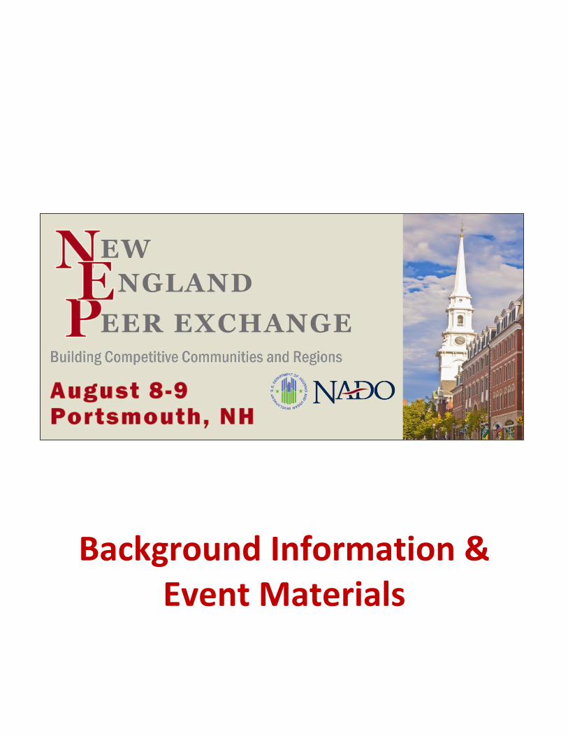
Background Information & Event Materials

NEW ENGLAND PEER EXCHANGE /// 2
Welcome Thank you for joining us in Portsmouth! This peer exchange is designed to build the capacity of HUD Sustainable Communities Regional Planning and Community Challenge grantees and EPA technical assistance/grant recipients in New England and develop plans and partnerships to bolster their communities’ economic competitiveness and quality-of-life by engaging in place-based strategies. Presentations and other event materials, as well as reports, case studies, and other resources related to planning, economic development, transportation, and sustainable development issues can be accessed at www.NADO.org and www.SCLearningNetwork.org. At the conclusion of the peer exchange, please be sure to fill out an evaluation form to assist us in planning future events. Cover image courtesy of Flickr user Tolka Rover
About the Sustainable Communities Capacity Building Program Through a cooperative agreement with the U.S. Department of Housing and Urban Development, the NADO Research Foundation is one of eight teams providing capacity building and technical assistance to HUD and EPA sustainable communities award recipients. The capacity building teams are forming networks among the grantees to exchange ideas on successful strategies, lessons learned, and emerging tools. This work will strengthen the capacity of grantee communities to create more housing choices, make transportation more efficient and reliable, make more efficient investments in water and wastewater infrastructure, and build vibrant, healthy, and economically prosperous neighborhoods. Grantees and their partners can access resources, network with their peers, and find information about upcoming events on the SC Learning Network, available at: http://SCLearningNetwork.org/. This program is a component of the Partnership for Sustainable Communities, an innovative interagency collaboration launched by President Obama in June 2009 between HUD, EPA, and DOT to lay the foundation for a 21st century economy by creating more financially, environmentally, and socially sustainable communities. More information about the Partnership and additional resources can be found at http://www.sustainablecommunities.gov/
Sponsors This peer exchange was coordinated by the NADO Research Foundation through cooperative agreements with the U.S. Department of Housing and Urban Development. Any opinions, findings, and conclusions or recommendations expressed at this event do not necessarily reflect the views of HUD. Special thanks to all of those who assisted in the development of this peer exchange, including all speakers and facilitators lending their expertise and time.
About NADO and the NADO Research Foundation The National Association of Development Organizations (NADO) is a national membership organization for the nation’s 500+ regional planning and development organizations focused on strengthening local governments, communities, and economies. Regional planning and development organizations—known locally as regional planning commissions, councils of governments, area development districts, or similar terms—play a key role in regional and community economic development, business development finance, technology and telecommunications, transportation planning, workforce development, GIS analysis, disaster preparedness, and a variety of other types of services and support for member local governments. Founded in 1988, the NADO Research Foundation is the nonprofit research affiliate of NADO. The NADO Research Foundation identifies, studies, and promotes regional solutions and approaches to improving local prosperity and services through the nationwide network of regional planning and development organizations. The Research Foundation shares best practices and offers professional development training, analyzes the impact of federal policies and programs on RDOs, and examines the latest developments and trends in small metropolitan and rural America. Most importantly, the Research Foundation is helping bridge the communication gap among practitioners, researchers, and policymakers.
400 North Capitol Street, NW, Suite 390 Washington, DC 20001 | 202.624.7806 [email protected] | www.NADO.org www.RuralTransportation.org www.KnowYourRegion.org @NADOweb | facebook.com/NADO.org

NEW ENGLAND PEER EXCHANGE /// 3
Table of Contents
Agenda ........................................................................................................................................................ 4
Location Information ................................................................................................................................... 6
Participant Profiles ...................................................................................................................................... 7 HUD Sustainable Communities Grantees……………………………………………………7 EPA Technical Assistance Recipients ………………………………………………………..28
Peer Exchange Participants and Staff Contact Information .......................................................................... 33

NEW ENGLAND PEER EXCHANGE /// 4
New England Peer Exchange Agenda
THURSDAY, AUGUST 8
8:30 a.m. Registration and Networking Breakfast Coffee and continental breakfast
9:00 a.m. Welcome and Introductions
9:30 a.m. 10:30 a.m.
Keynote Presentation: “Sustainability isn’t about great big things. It’s about the small things that fit together to make a big difference...” Noelle MacKay, Commissioner, Agency of Commerce and Community Development, State of Vermont Break
10:45 a.m. Grantee Success Stories: Sharing What’s Working (5x5 Presentations) – Part 1 Participants will each have five minutes and five PowerPoint slides to highlight one key success story from their project in this fast-paced series of short presentations followed by Q&A
12:00 p.m. Luncheon Presentation / Discussions: Implementing Your Plan Through Local Policy Changes Learn about how the City of Claremont, NH, a FY10 Community Challenge grant recipient, is moving towards project implementation and promoting community and economic development. Nancy Merrill, Director, Planning and Development, City of Claremont, New Hampshire Michael McCrory, Senior Planner, Upper Valley Lake Sunapee RPC, New Hampshire
1:30 p.m.
2:15 p.m.
2:30 p.m.
Grantee Success Stories: Sharing What’s Working (5x5 Presentations) – Part 2 Participants will each have five minutes and five PowerPoint slides to highlight one key success story from their project in this fast-paced series of short presentations followed by Q&A Break to prepare for tour Presentation and Tour of Portsmouth Tour downtown Portsmouth to learn about local economic development, historic preservation, green infrastructure, and climate adaption efforts underway in this beautiful seaside community
5:00 p.m. Adjourn Day 1

NEW ENGLAND PEER EXCHANGE /// 5
FRIDAY, AUGUST 9
8:30 a.m. Breakfast and Networking Coffee and Continental Breakfast
9:00 a.m. Grantee Success Stories: Sharing What’s Working (5x5 Presentations) – Part 3 Participants will each have five minutes and five Powerpoint slides to highlight one key success story from their project in this fast-paced series of short presentations followed by Q&A
10:00 a.m. New Approaches to Economic Development Planning Learn how to engage with economic development practitioners to incorporate asset-based strategies and other place-based economic development efforts into your local and regional plans. Erik Pages, President, EntreWorks Consulting Mike Eisensmith, Director of Regional Planning, Northern Maine Development Commission
11:30 a.m. “Round Robin” Working Lunch in Peer Groups Grantee-led small group discussions about best practices, technical assistance, and additional needs
1:00 p.m. Breakout Sessions (choose one): - Seeking Additional Funding for Your Project: What’s Worked? (and What Hasn’t?) - Maintaining Momentum: Organizational Capacity to Support Your Consortium
2:00 p.m. Key Takeaways / Next Steps Addressing both short-term and long-term goals
2:30 p.m. Adjourn

NEW ENGLAND PEER EXCHANGE /// 6
Location Information
Accommodations: Hilton Garden Inn Portsmouth Downtown
100 High Street Portsmouth, NH, 03801 603.431.1499
Meeting Space: The Penhallow Room Attire: Business Casual
HOTEL
NEW ENGLAND PEER EXCHANGE /// 7
Project Profiles HUD Sustainable Communities Initiative Grantees
SUSTAINABLE KNOWLEDGE CORRIDOR
LOCATION: Greater Hartford, Connecticut and Pioneer Valley, Massachusetts LEAD GRANTEE ORGANIZATION: Hartford Capitol Region Council of Governments (CRCOG) PROJECT PARTNERS: Pioneer Valley Planning Commission (PVPC), Central Connecticut Regional Planning Agency (CCRPA) COUNTIES/MUNICIPALITIES SERVED: 80 municipalities, four counties PROJECT POPULATION AREA: 1.6 million GRANT TYPE AND YEAR AWARDED: FY10 – Regional PROJECT SCOPE: The Sustainable Knowledge Corridor sprang from long-standing inter-regional cooperation among members of the Hartford Springfield Economic Partnership. The project is premised on the fact that the Greater Hartford and Pioneer Valley regions, home to 32 universities and colleges, function as a single economic region and share many key assets including highways, an international airport, freight and passenger rail facilities, cultural institutions, and employers. Further, the region’s largest employment sectors are education, health care, and financial services—all of which depend on skilled knowledge workers. Quality of life in the region is enhanced by the natural resources of the Connecticut River Valley, which include numerous ecological features, recreation areas, and vibrant local agriculture. Transportation agencies in the Sustainable Knowledge Corridor are now implementing $1.5 billion in state and federally funded transit-focused investments, including the 11-station CTfastrak bus rapid transit system; commuter rail service along the New Haven-Hartford-Springfield corridor; intercity passenger rail improvements north of Springfield; major upgrades and restoration of the central downtown passenger terminals in Hartford and Springfield; and improvements to other transit and rail stations in the region. The main goal of the Sustainable Knowledge Corridor project is to leverage these new transit investments, in combination with existing regional assets and programs, to equitably expand opportunities to residents in employment, transportation, housing availability, and environmental quality. A major planning challenge of this effort is to coordinate actions across state boundaries in an area involving three regional planning organizations and 80 municipalities. The project is advancing this goal by focusing on actions that benefit the entire Greater Hartford/Pioneer Valley region and which involve state and federal agency participation. Foremost among these are:
Improving workforce talent, education, and training.
Encouraging more transit-oriented, compact, and walkable neighborhood development.
Enhancing and protecting environmental quality.
Adapting to, and mitigating causes of, climate change.

NEW ENGLAND PEER EXCHANGE /// 8
Fostering social equity.
Five catalytic projects are being supported for their potential to advance the broader project goals:
Springfield Court Square renovation
Chicopee River Walk and Bike Way
Holyoke Depot Square Redevelopment and Rail Station
Hartford North Park Design District
Walkable New Britain Downtown Streetscape Master Plan
With the guidance of a consortium of project stakeholders, staff are implementing targeted recommendations of regional plans that have been prepared and updated by the respective planning commissions. These include:
Creation of a Talent Development Strategy by the Donahue Institute of University of Massachusetts Amherst based on skill gaps, workforce areas with highest growth, and most resilient companies.
Analysis of municipal zoning and subdivision codes to encourage more compact development, protect natural resources and ecosystems, reduce GHG emissions, promote energy conservation, enhance food security planning, and improve housing options.
Developing transit-oriented development zoning districts with performance standards tailored to smaller cities served primarily by bus transit.
Assisting municipalities with establishing local housing committees and action plans, as well as developing innovative land value-capture models.
SUCCESSES:
Completion of a Transit-Oriented Development Real Estate Market Analysis for the bi-state region. This analysis provides corridor- and regional-level analyses of market conditions and challenges related to TOD, as well as 18 station-area evaluations of residential and commercial development potential. The analysis presents a variety of recommended strategies to advance TOD development; foremost among these are enhanced partnerships with major academic and medical institutions for station-area planning, and state policies to direct new development to areas served by transit, as well as the siting and relocation of government offices to these areas.
Holyoke Depot Square catalytic project has supported the successful award of a $2 million grant from the MassWorks infrastructure investment program to design and construct a passenger rail platform at the site of the city’s new Amtrak station. The station area is the center of an intensive TOD zoning analysis and implementation project to develop performance standards for a walkable environment and relocation of the city’s farmers market.
Completion of draft model zoning regulations for more sustainable development. These model regulations have not only built on work already completed with funding previously received through federal smart growth implementation assistance, but have also included a range of solutions to fit the needs of the varied community types in the bi-state region. This project was conducted in coordination with the TOD Market Analysis mentioned above so that the draft models could support
NEW ENGLAND PEER EXCHANGE /// 9
future transit oriented development in the region. To wrap up this project, a public outreach model involving visualization including an already created 3-minute video on the importance of sustainable zoning regulations will aid in implementation.
COMMUNITY CHALLENGES: The Sustainable Knowledge Corridor Consortium of stakeholders has been consulted regularly throughout the project process and has identified the following major challenges to sustainable growth and equitable development in the region:
Shortage of workforce talent for knowledge-dependent industries, as well as skilled manufacturing jobs.
Lack of multifamily homes for retiring Baby Boomers and up-and-coming Millenials seeking alternatives to large-lot suburban single family homes.
Perpetuation of low-density sprawl by out-dated municipal zoning in suburban/rural areas, combined with a lack of investment and market potential in urban infill development.
Racial, ethnic and income segregation that contributes to a lack of social equity in housing and transportation.
MOVING TOWARDS IMPLEMENTATION:
Concerted effort to sustain and further enhance the productive working relationships and good communication among regional, state, and federal agencies that have emerged during the Sustainable Knowledge Corridor.
Implementation of key recommendations and strategies of the bi-state action plan now in development.
Sustainable Codes Project has produced models for on-going best regulatory practices in housing diversity and affordability; live/work housing standards; renewable energy systems; and green roofs and related low-impact development site development techniques.
Establishment of Leadership Pioneer Valley and continuation of Leadership Greater Hartford, two programs that are focused on training and networking to nurture the skills of young professionals. Also, capacity-building partnerships with local United Way chapters to encourage greater participation of people previously left out of planning processes.
Pursuit of private foundation funding for implementation tasks now under way as part of climate action/clean energy, food systems, green infrastructure, brownfields, transportation. Seeking municipal partners ready to, and capable of, pursue this work.
Pursuit and participation in agency-funded projects that involve priorities of the bi-state action plan. Examples include current PVPC participation in a pilot program by Massachusetts Clean Energy Center to develop ongoing community leadership in local energy efficiency and renewable energy generation projects.
PEER EXCHANGE PARTICIPANTS: David Elvin Senior Planner, Pioneer Valley Planning Commission Springfield, MA

NEW ENGLAND PEER EXCHANGE /// 10
[email protected] 413-781-6045 Emily Hultquist Senior Planner and Policy Analyst, Capitol Region Council of Governments Hartford, CT [email protected] 860-522-2217
EASTERN CONNECTICUT SUSTAINABLE COMMUNITIES
REGIONAL PLANNING CONSORTIUM
LOCATION: Eastern Connecticut LEAD GRANTEE ORGANIZATION: Windham Region Council of Governments (WINCOG) PROJECT PARTNERS: Northeast CT COG, Southeast CT COG, Eastern CT Workforce Investment Board COUNTIES/MUNICIPALITIES SERVED: 43 towns, three counties PROJECT POPULATION AREA: Around 430,000 GRANT TYPE AND YEAR AWARDED: FY10 – Regional PROJECT SCOPE: HUD funds (Category I) will support an analysis of current regional plans of Transportation, Housing, Economic Development, Infrastructure, and Land Use Development in the greater Eastern Connecticut region. The analysis will focus on identifying adverse impacts as a result of the absence of a fully integrated plan; the analysis will identify current and future challenges, and look at systems issues contributing to the mismatch between current plans. A comprehensive regional visioning process will be conducted throughout the 41 town / two tribal nation region. The consortium will use the visioning information and analysis to develop an integrated multifaceted plan that leverages existing resources from State agencies such as the Department of Transportation, the Department of Economic Development, Workforce Investment Board, institutions of higher education, local municipality, and federal agencies, among others. The project will ultimately produce significant, long-term economic impacts that better leverage current and future public and private investments. SUCCESSES: We engaged several of the Community Action Agencies in the region to reach out to as many families/individuals as we could. They developed a survey with questions which were given within current programs at the agency. Over 284 people responded and we incorporated those into our study results. COMMUNITY CHALLENGES: The region faces many challenges. Current land use policies threaten to destroy the qualities that area residents value. Development patterns do not support public transportation, infrastructure, or land conservation. Due to growing competition in the gaming industry and structural economic changes, high unemployment rates are expected to be more persistent than in the surrounding areas. One of the largest achievement gaps in the country leaves many students unprepared for the workforce. There is an insufficient pool of workers that gain and maintain the science, technology, engineering, and math (STEM) and entrepreneurial skills required by the new economy. As household composition changes to smaller, poorer and older, there is a mismatch between the housing stock and the population’s housing needs. The cost of housing and transportation is already unaffordable to almost half of

NEW ENGLAND PEER EXCHANGE /// 11
households leading to instability, privation, and continuing foreclosures. Lack of investment is creating functional obsolescence in a housing stock. Storm-related damage is increasing, yet there is insufficient planning for resiliency. MOVING TOWARDS IMPLEMENTATION: What was unique about our consortium was that we engaged the three planning agencies and the Workforce Development board as well as 24 other regional organizations that we currently work and plan with. The structure is in place to implement many of the recommendations by the existing entities. We also see each of them taking on a specific effort relative to their current work and objectives. PEER EXCHANGE PARTICIPANT: Mark Paquette Executive Director, Windham Region Council of Governments Willimantic, CT [email protected] 860-456-2221
GROW WASHINGTON-AROOSTOOK
LOCATION: Washington and Aroostook counties in Maine LEAD GRANTEE ORGANIZATION: Northern Maine Development Commission PROJECT PARTNERS: Northern Maine Development, Aroostook-Washington Workforce Investment Board, Washington County Council of Governments, and Sunrise County Economic Council COUNTIES/MUNICIPALITIES SERVED: Two counties PROJECT POPULATION AREA: 104,120 GRANT TYPE AND YEAR AWARDED: FY10 – Regional PROJECT SCOPE: Creation of the Grow Washington-Aroostook Plan for Sustainable Development (Gro-WA) is a multi-year initiative with four fundamental objectives:
1. Development of a sustainable growth plan for the Washington and Aroostook region, including implementation steps for state and local government, recommendations for private sector stakeholders, and establishing a solid foundation for the new Economic Development District.
2. Large-scale public education to increase visibility and awareness of regional issues related to the economy, environment, and quality of life.
3. Region-wide civic engagement in the planning process with special attention to populations not traditionally involved in planning processes. This will help scope, understand, and adopt regional planning elements thereby improving the efficiency of local Comprehensive Planning in this largely rural area.
4. Institutional capacity and relationship building throughout the region, linking technology and information to community decision making for current and future planning processes.
The Grow Washington Aroostook Regional Plan for Sustainable Development (GRO-WA) is a sixteen element strategy that will plan for the inter-related issues of transportation and housing costs; workforce and economic development, including brownfields redevelopment; infrastructure throughout the region in

NEW ENGLAND PEER EXCHANGE /// 12
support of a sustainable future (broadband, electricity transmission, water and wastewater, structures likely to be impacted by sea level rise, renewable energy); and healthy communities. The plan will address the livability principles outlined by the U.S. Department of Housing and Urban Development Office of Sustainable Housing and Communities.
GROWashington-Aroostook seeks to create jobs, especially for those most in need; it seeks to keep more money in the pockets of all households; and to capitalize on the extraordinary beauty of our region.
GROWashington–Aroostook is a plan that is at once about the facts and figures we need to make
decisions and the people at the table who work together to make those decisions - all representative
of northeastern Maine.
GROWashington-Aroostook is an opportunity for the people of our two counties to embrace the future
– to develop local energy and food sources and to shrink the distances between home, work, and the
world – through improved communication networks, better transportation options for the elderly, and
stronger partnerships.
Supported by a Sustainable Communities Regional Planning Grant from a unique partnership between
three federal agencies (HUD, DOT, EPA) GROWashington–Aroostook uses federal support for
regionally- driven solutions. It calls on local voices to define our best talent and our greatest
advantages for a future community that is prosperous, healthy and economically stable.
SUCCESSES: Gro-WA has created a region-wide focus on critical economic, social, and infrastructure issues that engages municipalities, businesses, and non-profits. Gro-WA has also created connections between business and government that will endure beyond the project grant period. COMMUNITY CHALLENGES: Aversion to risk-taking and a lack in belief that involvement will actually bring change. MOVING TOWARDS IMPLEMENTATION: Gro-WA is directly linked to other strategic initiatives that will be ongoing into the future and the strategies and goals of the plan will be incorporated into those other initiatives. PEER EXCHANGE PARTICIPANT: Michael Eisensmith Director of Regional Planning, Northern Maine Development Commission Caribou, ME [email protected] 207-498-8736

NEW ENGLAND PEER EXCHANGE /// 13
METROFUTURE
LOCATION: Greater Boston (101 communities in and around Boston) LEAD GRANTEE ORGANIZATION: Metropolitan Area Planning Council PROJECT PARTNERS: Multiple through the Metro Boston Consortium for Sustainable Communities COUNTIES/MUNICIPALITIES SERVED: 101 municipalities PROJECT POPULATION AREA: Over 3,000,000 GRANT TYPE AND YEAR AWARDED: FY10 – Regional
PROJECT SCOPE: In 2010, MAPC was awarded a $4 million Sustainable Communities Grant. This grant supports the implementation of MetroFuture through local planning efforts, state and regional policy work, development of tools and data, and capacity building for local residents and leaders. Based on project selection criteria, the Metro Boston Sustainable Communities Steering Committee selected projects that placed particular emphasis on the MetroFuture goals related to equity and sustainability. The Steering Committee also prioritized funding projects that are diverse in nature and in their geographic location.
The following projects are examples that advance MetroFuture objectives in dozens of the region’s cities and towns, and engage in collaborative work with cutting-edge approaches to the region’s problems:
Regional Housing Plan and Regional Fair Housing and Equity Assessment
City of Everett Community Visioning Process
Developing the Orange Line Opportunity Corridor
Feasibility Study for Redevelopment of Millis Town Center Properties
Hingham Master Plan Update Initiative
MetroWest CD Housing Production Planning
Pedestrian and Bicycle Network Planning
Route 9 MetroWest Smart Growth Plan
SUCCESSES: Some early accomplishments include:
Completion of the Fair Housing and Equity Assessment
The development of two new agricultural zoning bylaws in the Town of Littleton, which were subsequently adopted by Town Meeting.
The release of “The State of Equity in Metro Boston,” the region’s first indicators report, which tracks the region’s progress towards MetroFuture’s goals.
A “Walkshop” in North Quincy focused on the architecture of the neighborhood and how it has changed over the years. The event drew more than 15 neighborhood residents, plus many planners and local officials.
A Transit-Oriented Development Finance Summit attracted upwards of 50 participants, who discussed potential models for financing transit-oriented development, as well as a new analysis of station areas in the region and potential goals for development around them.
COMMUNITY CHALLENGES: While there is great breadth and depth of the work that has been completed or is underway, much remains to accomplish. Three challenges that MAPC is working to address with HUD and the Steering Committee:

NEW ENGLAND PEER EXCHANGE /// 14
Evolving the program management functions. At the program midpoint, the focus shifted from establishing management and governance structures and selecting projects to conducting the projects and evaluating the program accomplishments. Evolving the role of the caucuses. The caucuses played a key role in selecting and shaping projects, but now that most project funds have been allocated their role is transitioning to participating in and evaluating ongoing projects and engaging in peer learning in topical clusters. We are working to ensure there are adequate financial resources to support this role. Maximizing the learning and impact of the program. Most projects are up and running; as a whole, they now should provide learning for all consortium members and make a meaningful contribution to change in the region. MOVING TOWARDS IMPLEMENTATION: The Consortium’s Steering Committee is currently working on determining key next steps beyond the grant period. The committee is determining the possibility of continuing to meet and oversee key MetroFuture implementation activities. PEER EXCHANGE PARTICIPANT: Jennifer Raitt Chief Housing Planner, Metropolitan Area Planning Council Boston, MA [email protected] 617-933-0754
WACHUSETT STATION SMART GROWTH CORRIDOR PLAN LOCATION: Leominster, Fitchburg, and Westminster, Massachusetts LEAD GRANTEE ORGANIZATION: Montachusett Regional Planning Commission PROJECT PARTNERS: The level of support to implement the plan includes a partnership with all three communities (the City of Fitchburg, the City of Leominster and the Town of Westminster) located in the plan area, Montachusett Regional Transit Authority (MART), Regional Economic Development Institute (REDI) at Fitchburg State University (FSU), the Fitchburg Redevelopment Authority (FRA), Cleghorn Neighborhood Center (a community group residing in the area of study), Three Pyramids Inc. (a non-profit organization working with the African- American Community) and Westminster Business Park (a private developer with property in the project area). COUNTIES/MUNICIPALITIES SERVED: Three municipalities (Leominster, Fitchburg, and Westminster) and one County (Northern Worcester County). PROJECT POPULATION AREA: 88,250 GRANT TYPE AND YEAR AWARDED: FY11 – Regional PROJECT SCOPE: The purpose of project is the development and completion of a Wachusett Station Smart Growth Corridor Plan. Wachusett Station is a planned passenger rail station on the Massachusetts Bay Transportation Authority (MBTA) Commuter Rail Line that will be situated at the intersection of Route 2 and Route 31 in the City of Fitchburg located in North Central Massachusetts. In February 2010, the Montachusett Regional Transit Authority (MART) was awarded $55.5 million from the US Department of Transportation (US

NEW ENGLAND PEER EXCHANGE /// 15
DOT) in Transportation Investment Generating Economic Recovery (TIGER) grant funds to build the station. Wachusett Station is included in the study area for this plan. Construction has been initiated this summer with an anticipated completion date of December 2014. This plan will study the surrounding area around the future station and engage the local community, including diverse cultural groups and underserved populations. Some Key tasks of the plan include: • Public Outreach Events - a Visioning Charrette, Focus Group Meetings (conducted in the minority community’s first language), translation of outreach documents into Spanish, Hmong, and Vietnamese (ethnic groups residing in Fitchburg), and a webpage with information about the plan. A Steering Committee will also be formed to provide project oversight and input. All Steering Committee meetings will be open to the public. • The development of a Transportation Element accompanied by maps that examines road, bus/trolley, bike, and pedestrian modes and linkages with an emphasis on bicycle and pedestrian paths and their design as well as bus and trolley planning. • A Land Use Element that looks at zoning across municipal boundaries (Fitchburg, Leominster, and Westminster, MA) within the corridor area. Recommendations will be made to promote sustainability. • A Housing Element to analyze current housing demand/affordability and make recommendations based on needs. • Creating an Economic Development Element that contains a market analysis of the area directly surrounding the Wachusett Station to identify retail and commercial business opportunities. • An Open Space/ Recreation Element to examine and map open space greenways and recreation across municipal jurisdictions within the corridor area as well as plan for urban green space on the Fitchburg side of the corridor. Active greenway space has the potential to be used for bicycle/pedestrian paths that could connect to the future Wachusett Station. • A Facilities/ Institutional Element that depicts and maps the location of schools, community centers, places of worship, hospital and medical health clinics, and governmental services. It is important to identify services that are offered within biking/walking distance from the new Wachusett Station. • Policy Recommendations and Implementation Plans with timetables regarding each of the elements. SUCCESSES: Conducting Focus Group Workshops in Spanish, Hmong, and Vietnamese: MRPC procured bilingual Spanish, Hmong, and Vietnamese speakers and writers to translate outreach materials and facilitate focus groups in the first language of each ethnic group. Bilingual speakers were trained in facilitation by MRPC staff. MRPC and the trained facilitator(s) conducted a total of three focus groups; one each in Spanish, Hmong, and Vietnamese. The facilitator(s) translated the input from these communities into English to be incorporated into the Plan. MRPC and the bilingual translators outreached to the United Hmong of Massachusetts and the Hue Lam Meditation Temple (Vietnamese Buddhist Nuns), both located in Fitchburg, to increase participation of the Hmong and Vietnamese ethnic groups in the various outreach and engagement activities. MRPC also utilized the outstanding support of Cleghorn Neighborhood Center to reach the Latino population. Findings were formally presented by the bilingual speakers to the Steering Committee. The results of this effort include increased participation and decision making of the local community including traditionally marginalized populations in developing and implementing this plan. COMMUNITY CHALLENGES: According to the Center for Neighborhood Technology, the people who live in the block groups in the 2.5 mile area around Wachusett Station spend between 49% to 70% of their income on housing and transportation costs. The area is also plagued with high unemployment rates that continue to rise. In June 2010 the unemployment rate in Fitchburg stood at 11.4%. In July 2011, the unemployment rose to 11.6%, significantly higher than both the national (9.2%) and state (7.2%) rates during that time. Fitchburg’s

NEW ENGLAND PEER EXCHANGE /// 16
housing stock is old. Over half, 52.1%, of residential units were built prior to 1940. Currently, only 1.7% of Fitchburg residents use public transportation to get to work. Historically, the project area has been identified as an area for industrial growth, but now has nearly 700,000 square feet of industrial vacancy. Out of this total, there are 136,000 square feet of vacant mill buildings. These vacant buildings demonstrate that there is infrastructure already in place and that the area is in need of revitalization. The poverty rate of all people in Fitchburg is 19.2% and the poverty rate in Massachusetts is 10.1%. The median household income is lower in Fitchburg than in the state, $47,369 and $64,496, respectively. With Fitchburg’s problems of relatively low median household income rate, its high rising unemployment rate, its enormous amount of foreclosures and high rate of expenditures on transportation and housing costs, the city’s population needs affordable housing, economic development to bring job opportunities, and lower cost transportation options. The Wachusett Smart Growth Corridor Plan will make recommendations to implement and address these essential needs in an effort to revitalize the project area and the city. MOVING TOWARDS IMPLEMENTATION: In developing the Wachusett Station Smart Growth Corridor Plan, local citizenry, including neighborhood groups and underserved populations, are being engaged. All local groups are part of clarifying strengths and weaknesses and the unique characteristics that make this area a special place. Their input is directly guiding the development of the plan to boost these strengths and improve its weakness all the while maintaining the unique characteristics of the community. The plan will recommend many elements to enhance the community (economic development, housing, recreation, and facilities planning including addressing safety concerns) and it will plan for pedestrian/bike paths making the neighborhood more walkable and encouraging a healthier active lifestyle. Massachusetts is a “home rule” state that relies significantly on local officials to implement land use and development policies. State involvement in local land use decision making is not as significant in Massachusetts as in many other states with state controls over local land use decisions exercised only in certain selected areas. This local “home rule” condition is reinforced by the lack of effective counties in Massachusetts. The regional planning agencies (such as MRPC) are the closest entity to regional government but have, for the most part, advisory power only. This situation puts a premium on civic engagement and consensus building as the plan is developed. Training and experience of local officials and non-profit partners are also critical factors in assuring implementation of plan recommendations. Implementation is critical to capacity building and knowledge sharing and will allow local officials hands-on work to implement plan recommendations. It will also address changes in the current structure and the need for training of current local officials. PEER EXCHANGE PARTICIPANT: John Hume Planning and Development Director, Montachusett Regional Planning Commission Fitchburg, MA [email protected] 978-345-7376 (ext. 302)

NEW ENGLAND PEER EXCHANGE /// 17
GRANITE STATE FUTURE
LOCATION: New Hampshire LEAD GRANTEE ORGANIZATION: Nashua Regional Planning Commission PROJECT PARTNERS: New Hampshire’s nine Regional Planning Commissions COUNTIES/MUNICIPALITIES SERVED: 234 municipalities PROJECT POPULATION AREA: 1.3 million GRANT TYPE AND YEAR AWARDED: FY11 – Regional PROJECT SCOPE: New Hampshire’s nine Regional Planning Commissions, with Nashua Regional Planning Commission acting as the lead applicant, will be working collaboratively through their HUD grant to develop comprehensive and coordinated regional plans in each of the State’s nine regional planning areas. The three year project will culminate with a snapshot of regional priorities and visions for New Hampshire’s future. New Hampshire’s participation as a statewide project presents a unique opportunity to create a truly integrated approach to planning, not just in one city or region, but across the state as a whole, particularly given that our state’s entire population could fit within the boundaries of many of the nation’s major cities. The staff of New Hampshire’s nine Regional Planning Commissions will be working with a range of business and community leaders, state agencies, counties and municipalities, and citizen groups to develop a robust and productive public dialogue within each region. The project is specifically committed to engaging members of communities at the grass roots level, including and being responsive to the interests of every sector of the community. The final plans aim to create a road map for large communities and small villages throughout the state to achieve economic vitality while safeguarding the natural resources, character, and rural landscapes that we so deeply value. SUCCESSES: The first year of our planning efforts was devoted to outreach and information gathering through collaboration, cooperation, and integration of efforts. The nine regions have expanded their individual outreach efforts with technical assistance from the University of New Hampshire and the shared development of a series of online public input tools. The nine RPCs were able to extend their outreach by sharing resources and developing a consistent set of products including:
Searchable Database of What Residents Like Best and What could be better – 2,145 Comments received to date
Online forum - 295 comments received to date within the map and topic based portions of the forum
My Granite State Future Blog with 11 articles written by the nine RPCs and an additional four articles by state partners all with the goal of sharing ideas across the state
Statewide survey with over 2,000 responses and a statewide margin of sampling error for the survey of +/- 2.2%
Additionally, working with the Carsey Institute, NH Listens, and UNH Cooperative Extension, the outreach efforts employed a consistent process of engagement. Efforts included:
Communities of Interest focus group sessions with 120 participants at 20 different organizations representing disabled, low income, minority, immigrant, senior, youth, young adult, veteran, and Native American populations.
Communities of Place regional forums held at 10 different locations across the State where approximately 535 participants shared their ideas through 45 small group conversations

NEW ENGLAND PEER EXCHANGE /// 18
The significant amount of public input generated through shared statewide products and processes is further being built upon by each of the nine regional planning commissions through their own independent outreach. In total, the nine regions have conducted over 85 meetings, workshops, presentations, and events across the state. The collected input received through these efforts will help the RPCs to understand the values, concerns, and goals individuals have for the future and will help identify regional needs and priorities to frame the nine regional plans. COMMUNITY CHALLENGES: In many situations where regional planning approaches can provide economic efficiencies and strong social and environmental benefits (e.g., watershed-level development planning, housing needs assessments, and planning based on labor market areas), we consistently come up against seemingly intractable political barriers posed by New Hampshire’s strong tradition of local control. In a seeming paradox, local control is the only extant structure in New Hampshire through which to effect regional change. The lack of regional governance is a New England-wide problem reflective of local insularity that is perhaps most strongly felt in New Hampshire, a dispersed web of villages with no unifying structure. Matched up with some broader social movements that seek to paint a negative picture of the principles of sustainability, regional solutions to local problems are easily marginalized without discussion of their merits.
MOVING TOWARDS IMPLEMENTATION: Continuing the theme of collaboration, cooperation and integration of efforts the RPCs have been working with over 50 statewide partner organizations collaborating within a Statewide Advisory Committee and six Livability Principle Themed Technical Advisory Subcommittees. Through this process, the nine regions with their state partners have compiled an index of existing statewide policies, goals, and objectives into a Regional Plan Framework, a draft Statewide Existing Conditions and Trends Assessment, and a series of 51 core metrics for which both written methodology and all data has been tabulated date for each. The RPCs have further enhanced their planning efforts by organizing a series of staff capacity building trainings including sessions organized by the Department of Environmental Services, Resources and Economic Development and many others. The process began with development of the Regional Plan Framework with the intent of building upon and informing existing programs to ensure implementation and continuity beyond the plan and grant period. PEER EXCHANGE PARTICIPANTS: Matt Monahan Principal Planner, Central New Hampshire RPC Concord, NH [email protected] 603-226-6020 Jennifer Czysz Michelle Mears Senior Regional Planner, Nashua RPC Regional Planner, Strafford RPC Merrimack, NH Rochester, NH [email protected] [email protected] 603-424-2240 (ext. 32) 603-994-3500
NEW ENGLAND PEER EXCHANGE /// 19
NEW HAMPSHIRE COMMUNITY CHALLENGE GRANT PLANNING PROGRAM
LOCATION: State of New Hampshire, Statewide LEAD GRANTEE ORGANIZATION: New Hampshire Housing Finance Authority
PROJECT PARTNERS: State: New Hampshire Housing Finance Authority, New Hampshire Office of Energy and Planning, New Hampshire Department of Environmental Services, New Hampshire Department of Transportation, New Hampshire Community Development Finance Authority. Non-Profit: Plan - The Foundation for Shaping the Built Environment, New Hampshire Municipal Association, New Hampshire Community Loan Fund, New Hampshire Preservation Alliance, New Hampshire Legal Assistance. Research: University of New Hampshire (UNH) Cooperative Extension. COUNTIES/MUNICIPALITIES SERVED: All (234 municipalities/10 counties) PROJECT POPULATION AREA: 1,316,470 GRANT TYPE AND YEAR AWARDED: FY11 – Challenge PROJECT SCOPE: The CPG Program will provide matching competitive grants for communities to conduct work that supports the creation of local regulations that will foster sustainable community development and implement more than a decade of statewide research and reports promoting smart growth and sustainable development. These regulations include the following: form-based codes; mixed-use and inclusionary zoning; lot-size averaging, village plan alternative subdivisions and infill development; growth boundaries, transfer of development rights and density transfer credit codes; neighborhood heritage districts; building codes for energy-efficient rehabilitation of older structures; corridor planning to increase mixed-income housing near employment nodes, pedestrian- and transit-oriented development and affordable housing; and economic development connecting housing and transportation investments and local adoption of the "Community Revitalization Tax Relief Incentive." The adoption of sustainable development regulations by New Hampshire municipalities, and collaboration among CPG Consortium partners and research that informs better land use decisions, will have direct bearing on all of the Livability Principles: • Provide more transportation choices: Enhanced walkability of communities through more compact development close to existing community centers will be fostered by the adoption of corridor studies and land use codes, including mixed-use zoning and codes that permit “planned densification,” which will have the effect of improving the health of citizens by encouraging safe walking and biking to destinations, while also reducing household transportation costs. • Promote equitable, affordable housing: Adoption of inclusionary zoning and integration with transit and pedestrian oriented development, mixed-use zoning, and density transfer credit ordinances will facilitate developer response the state's unmet need for location efficient affordable housing. Their combination with energy-efficient building codes and universal design will promote social and economic diversity and reduce combined housing, utility, and transportation costs. • Enhance economic competitiveness: The creation of mixed-use, form-based, and inclusionary codes will foster development patterns that align workforce housing with economic and social activity in and around community employment centers. This will benefit lower-income households who form the backbone of the state's workforce and who disproportionately bear sprawl's transportation costs.

NEW ENGLAND PEER EXCHANGE /// 20
• Support existing communities: The CPG Program will focus on transit-oriented, mixed-used, and infill development. It will pilot the adoption of "neighborhood heritage districts" and also promote adoption of local redevelopment tax incentives. Combined with density transfer credit ordinances, these will concentrate development in and around existing communities, fostering more efficient use of infrastructure while preserving productive rural landscapes. • Coordinate policies and leverage investment: The CPG Consortium will provide opportunities for its partners to communicate, especially given the unique mix of collaborating organizations. All of the partners already have a strong working relationship that will enhance the ability for each to leverage resources and coordinate policies to produce a robust municipal planning support program. • Value communities and neighborhoods: The fundamental approach of the CPG Program is to value the wisdom of local control and to provide resources necessary to fulfill clearly articulated local sustainability goals. Outreach to marginalized populations will better inform the democratic process, and emphasis on housing affordability will yield greater social equity. Each CPG program awardee will implement a unique scope of work that places the greatest value on achieving local sustainability. SUCCESSES: The CPG Program is itself the success of the project. By providing modest grants to communities throughout the state to help them revise their land use regulatory structures in a manner that better meets the Livability Principles, we have stretched Federal funding to benefit a wide array of communities throughout the state, ranging from our largest city to many of our small towns. Many of these municipal projects simply would not have happened without this allocation of resources. COMMUNITY CHALLENGES: New Hampshire's many small communities treasure their hard-bitten Yankee aesthetic- modest white-clapboard wood-frame homes, stores, and meeting places surrounding a town common, which in turn is ringed by farmland, orchards and forests, and the homes and barns of those who work them. Community members gather annually to participate in the ritual of pure democracy: town meeting, where issues are settled through open discourse. It is an atmosphere of stewardship for the environment and the working landscape, and of respect for the rights and needs of one's neighbor. Local master plans are based on a common vision that celebrates the working landscape surrounding economically sustainable communities, that welcomes economic and social diversity, that treasures the heritage of our built and natural environment, that promotes resilience in the face of economic downturns, and that facilitates flexible adaptation to climate change. Increasingly, however, this vision and its underlying cultural and social standards are giving way to suburban sprawl, increased costs of housing and transportation, and limited job growth. While New Hampshire's communities fiercely maintain their independence and jealously guard their authority over land use regulation, the quality of life that is inherent in our state's strong and economically diverse communities and rich natural resources is being lost. Current local land use decisions are based on outmoded theory and outdated regulations, all of which yield development patterns that compel the use of automobiles, degrade natural resources, leave existing structures and infrastructure under-used, contribute to climate change, and erode social interaction. Between 1960 and 2010, New Hampshire's population more than doubled, from about 600,000 to over 1.3 million people. This pace of growth is expected to continue and is a hallmark of a healthy economy. What is troubling, though, is the pace of sprawl- different measures place the rate of land development at between 150% and 300% greater than the rate of population growth in the state. This pattern is partly attributable to local resistance to new housing development, often expressed as frustration over loss of fields and forests. The typical regulatory response has been to adopt large-lot zoning, now pervasive throughout New
NEW ENGLAND PEER EXCHANGE /// 21
Hampshire. But what is seen as a measure to preserve a community's treasured rural character has had the opposite effect, as the rate of land consumption has increased dramatically. MOVING TOWARDS IMPLEMENTATION: We have required each of our 41 municipal grantees to report back to us for five years after grant close-out regarding performance of any regulatory measures that were adopted. The focus will be to identify how the new regulations have changed the type, location, and form of development activity to be more consistent with Livability Principles. We will also create a program handbook that will capture the stories of these municipal grantees – successes, lessons learned, and ideas for other communities in the state to learn from and to model. PEER EXCHANGE PARTICIPANT: George Reagan Housing Awareness Program Administrator Bedford, NH [email protected] 603-310-9253
CITY CENTER PROJECT
LOCATION: Claremont, NH LEAD GRANTEE ORGANIZATION: City of Claremont PROJECT PARTNERS: Upper Valley Lake Sunapee Regional Planning Commission, UNH Cooperative Extension COUNTIES/MUNICIPALITIES SERVED: One PROJECT POPULATION AREA: 13,330 GRANT TYPE AND YEAR AWARDED: FY10 – Community Challenge
PROJECT SCOPE: Claremont’s City Center project was designed to encourage private investment in the built historic environment. The City had developed in a traditional pattern with housing density and mixed uses in an urban core in the 19th and early 20th centuries. The City Center then underwent a transformation as uses were separated, commercial activity declined, and vacancy rates increased as population declined. The City Center project included a comprehensive zoning analysis that would identify effective zoning tools to enact sustainability practices and reverse recent trends, specifically to:
Encourage use of underutilized space
Encourage development that maximizes existing infrastructure
Encourage economic investment and revitalization
Improve vehicular and pedestrian travel mode choices and needed infrastructure
Preserve and maintain the historic cityscape
Improve the quality of existing commercial and residential property The project area focused on the most densely populated, contiguous areas of the City that are home to over 50% of Claremont’s residents but encompasses less than 8.3% of the Claremont land mass. SUCCESSES: Appropriate new zoning regulations for historic urban core area were approved that broadened use groups and increasingly focused on form and performance based standards. The public participation was engaged and the time frame allowed an in depth review of how zoning had impacted the ability of residents and businesses to maintain their properties.

NEW ENGLAND PEER EXCHANGE /// 22
COMMUNITY CHALLENGES: Low median income, poor health outcomes, educational attainment below state average. This despite being part of a region that does not share these attributes. Several large employers closed in the 1980’s and 1990’s that had a dramatic impact on the city well being. MOVING TOWARDS IMPLEMENTATION: We have a merged economic development, planning, building codes and project management departments, so are in the process of moving forward with projects that are consistent with the goals of the City Center Project. Several of those projects will involve redevelopment of city owned property with a long term goal of moving those properties onto the tax rolls and into non-public ownership. PEER EXCHANGE PARTICIPANT: Nancy Merrill Director, Planning and Development, City of Claremont Claremont, NH [email protected] 603-504-0340
UPPER VALLEY LAKE SUNAPEE REGIONAL COMMUNITY
CHALLENGE GRANT
LOCATION: UVLSRPC Region, New Hampshire LEAD GRANTEE ORGANIZATION: Upper Valley Lake Sunapee Regional Planning Commission PROJECT PARTNERS: NH Office of Energy and Planning, Granite United Way, Upper Valley Housing Coalition, Healthy Eating Active Living NH, Regional Municipalities, Vital Communities, Two Rivers-Ottauquechee Regional Commission (neighboring VT region) COUNTIES/MUNICIPALITIES SERVED: 27 municipalities in the UVLSRPC service area PROJECT POPULATION AREA: 89,100 GRANT TYPE AND YEAR AWARDED: FY10 – Community Challenge PROJECT SCOPE: UVLSRPC approached this Community Challenge Grant with tasks in its scope of work that are interrelated, but distinct. The goal for the project has been to assess and develop recommendations to improve sustainable development practices to support resident access to healthy foods, housing opportunities, and multiple modes of transportation in a rural region. Regional Food Mapping: This project sought to quantify geographic availability of grocery stores in underserved areas to increase availability and distribution of foods from local farms to reduce food insecurity within the region. Regional Housing Needs: The Commission prepared a Housing Needs Assessment for its service area and a large area in Vermont with which the Commission has strong socio-economic ties. The assessment applied population/household and employment-based housing models to the region, surveyed regional residents about housing preferences, identified areas of housing need, and projected likely housing demand in the coming decades. The study explored the housing/transportation relationship in the region.

NEW ENGLAND PEER EXCHANGE /// 23
Community Policy Audits: The project will assist municipalities within the Upper Valley Lake Sunapee Region with policy opportunities that cultivate foundations for sustainable communities. The Commission will conduct regulatory/policy audits to inform participating communities how to incorporate measures that enable appropriately scaled grocery stores to locate in areas that encourage walkable communities. Roadway Walk and Bike Assessments: Conducted an in-depth analysis on the quality of roads for biking and walking for thousands of NHDOT segments in the region. This analysis reviewed the quality of roadways for walking and biking, as well as proximity of populations to good quality food sources. SUCCESSES: Created the Sustainable Communities Corps which generated about 19 volunteers who were trained to conduct surveys at 84 food stores within the region using a national survey instrument to evaluate the quality and diversity of foods available at a given location. This comprehensive assessment of food sources allowed regional analyses of gaps in the food network and enables comparisons with similar studies that are being conducted throughout the country. COMMUNITY CHALLENGES: The trends of housing choices and gaps in the food and transportation networks make the goal of promoting walkable, livable communities difficult to achieve. MOVING TOWARDS IMPLEMENTATION: Commission Staff and project partners continue to educate and encourage regional communities and decision makers to implement improvements to the transportation and food networks through local and regional planning and construction projects. The Housing Needs Assessment is a regional resource for housing developers (both non-profit and for profit organizations) as the housing market improves. PEER EXCHANGE PARTICIPANT: Michael McCrory Senior Planner, Upper Valley Lake Sunapee RPC Lebanon, NH [email protected] 603-448-1680
TRANSPORTATION CORRIDORS TO LIVABLE COMMUNITIES LOCATION: Providence, Rhode Island LEAD GRANTEE ORGANIZATION: City of Providence Department of Planning & Development PROJECT PARTNERS: Rhode Island Public Transit Authority (RIPTA) and the City of Providence Department of Arts, Culture and Tourism COUNTIES/MUNICIPALITIES SERVED: One PROJECT POPULATION AREA: 178,432 GRANT TYPE AND YEAR AWARDED: FY10 – Community Challenge PROJECT SCOPE: In 2010, the Office of Sustainable Housing and Communities awarded the City of Providence a Community Challenge Planning Grant to conduct the Transportation Corridors to Livable Communities project. This innovative project will improve bus service, encourage mixed-income housing, generate jobs and capitalize on the City’s reputation as the "The Creative Capital" of Rhode Island by showcasing arts and cultural opportunities.

NEW ENGLAND PEER EXCHANGE /// 24
From 2010 to 2012, the City worked closely with the Rhode Island Public Transit Authority (RIPTA) to conduct corridor studies on the most utilized bus routes in the city— Broad and North Main Streets, and Elmwood, Manton, and Chalkstone Avenues. These studies will identify ways to improve transit service, enhance bus stops, add pedestrian amenities, encourage the development of mixed-income housing, integrate art, and create opportunities for jobs and healthy food choices along each corridor. A major outcome of the project will be the introduction of Rapid Bus service along the two, highest-use bus corridors in the State— Broad and North Main Streets. The Department of Planning, RIPTA, and the Department of Art, Culture + Tourism, using separate implementation funds, are coordinating the introduction of improved bus service, enhanced bus stop amenities, and cultural art installations along these transit corridors.
Along each of the five transit corridors, community hubs were identified and analyzed as areas where increased building height and density could be accommodated to provide high-density, affordable housing, and employment opportunities. Vacant and underutilized land within these hub locations provides opportunities for transit-oriented infill development and redevelopment that will serve the nearby transit stop, as well as surrounding neighborhoods. Directing investment to these hubs is critical to ensure the success of the transit investment in those areas and to catalyze change along each corridor. Three-dimensional build-out scenarios were created for each community hub location to help the City visualize the potential form and function of future redevelopment in these areas. Each development scenario was evaluated against both transit-supportive densities and current zoning regulations; where conflicts exist, recommendations for regulatory adjustments are being explored by the City. By combining best practices techniques with the needs and desires of the community, these scenarios establish the framework that will guide future development along these corridors.
Subsequent to the completion of the corridor studies, the City initiated an update of its Zoning Ordinance to better reflect the economic and cultural potential of the corridor communities, as well as the needs of residents and businesses, citywide. When completed, the City will be equipped with a modernized strategy for addressing its development potential, and realizing its long-term livability and sustainability goals.
SUCCESSES: Operation of the State’s first Rapid Bus line, the R-Line, will begin in January 2014 along the Broad-North Main corridor, connecting both Pawtucket and Cranston to downtown Providence. The corridor will feature uniquely-branded stops, frequent service and additional amenities that will significantly improve the speed and attractiveness of bus service along existing Routes 99 and 11. The City of Providence and RIPTA collaborated on specialized bus shelters that will incorporate artistic panels, freestanding screens, and seating elements that emphasize cultural “themes” of each corridor, developed by neighborhood stakeholders. These themes represent the unique heritages of the neighborhoods along each corridor and will guide the composition of artwork that is integrated along each corridor. This “Art in Transit” program will place equal focus on creative place-making and improved transit service in order to connect RIPTA passengers with people and places along the transit corridors.
COMMUNITY CHALLENGES: Despite broad-based support and a strong planning foundation for the Transportation Corridors to Livable Communities project, there are a few barriers to realizing its long-term outcomes.
Transit Funding: RIPTA continues to face challenges similar to transit agencies across the country, such as high fuel prices and growing environmental awareness, which have both led to record ridership demands. RIPTA cannot afford to add more service to meet these demands because it depends on a share of the Rhode Island state gas tax receipts to finance its operations. Unfortunately, this revenue stream has been declining due to

NEW ENGLAND PEER EXCHANGE /// 25
a reduction in miles traveled by state resident drivers who have been negatively impacted by high fuel prices and a stagnant economy.
Economy: The short-term lack of demand for development, due in large part to the sluggish economy, is of concern. Access to Arts and Cultural Amenities: Participation in artistic and cultural activities builds communities and stabilizes neighborhoods’ social diversity. Despite Providence’s rich, cultural diversity and artistic and creative expression, resident participation in such activities can be limited. Coordination: Planning for the integration of art into the bus shelters has been challenging, as it is a first-of-its-kind project for the state and has required a deeper level of coordination between the Departments of Art, Culture + Tourism, Planning & Development and Public Works, RIPTA, the community, artists, the contracted manufacturer, and the City’s landscape architects. MOVING TOWARDS IMPLEMENTATION: To ensure broad participation and input in the project, the City and RIPTA convened an Advisory Committee, five corridor stakeholder committees, and held numerous public meetings during the first phase of the project. Both the City and RIPTA worked with the various committees to engage appropriate community members and residents, and disseminate information to partner agencies and neighborhood organizations in an effort to better align future investments. Providing a forum for committee member organizations to share investment knowledge has been essential to facilitating and coordinating cross-programmatic, place-based approaches, implementing grants, and seeking future grant assistance.
Members of the corridor stakeholder committees included representatives from neighborhood associations, business owners, merchants associations, housing and redevelopment organizations, major institutions, and large employers along each of the five corridors. Conducting regular stakeholder meetings for each corridor group fostered open communication among members, and provided an occasion for less-organized communities to engage in structured collaboration.
RIPTA and its partners continue to seek opportunities to increase funding for both existing and new services. Planning for new efforts takes time, and it is essential to take advantage of various funding sources, including maximizing federal assistance and developing partnerships with private, non-profit and local organizations. The project’s action steps will also be incorporated into RIPTA’s long-range capital and operating budgets, which will ensure their implementation as funding sources become available.
PEER EXCHANGE PARTICIPANT: Emily Kish Principal Planner, City of Providence Providence, RI [email protected] 401-680-8523

NEW ENGLAND PEER EXCHANGE /// 26
RHODE MAP RI: BUILDING A BETTER RHODE ISLAND
LOCATION: State of Rhode Island LEAD GRANTEE ORGANIZATION: State of Rhode Island Division of Planning PROJECT PARTNERS: 32 member consortium including state agencies, universities, and non-profits COUNTIES/MUNICIPALITIES SERVED: 39 PROJECT POPULATION AREA: 1,000,000 GRANT TYPE AND YEAR AWARDED: FY11 – Regional PROJECT SCOPE: How do we build strong, resilient communities with jobs and housing for all Rhode Islanders? How do we improve our economy while preserving those qualities that make Rhode Island special? Where should we direct future investments in housing, infrastructure, and businesses to have the greatest positive impact on the state? We will develop a new economic development vision for Rhode Island that builds on the state’s existing assets to position it for future growth. It will identify the industries in which the state should make investments as well as the regulatory, marketing, and financial strategies it should implement in order to achieve the vision. We will create a new state housing plan with strategies to ensure that housing is accessible to households at all income levels and located in proximity to jobs and other opportunities. We will also develop an Analysis of Impediments to Fair Housing, which is an assessment of the barriers to fair and equitable housing in the state. We will collaborate with partners from around the state to determine how and where Rhode Island should grow by defining growth center types - areas of the state that already have a core of residential and commercial development or are well suited to planned, future development; they are the places that will accommodate and nurture Rhode Island’s future growth while protecting its natural and cultural resources. These three plans will come together with the state’s existing Land Use, Transportation, and Water plans to serve as the Regional Plan for Sustainable Development. We are also working to improve social equity outcomes in Rhode Island through the creation of a Social Equity Advisory Committee which will be integrally involved in the development of the three plans and the integrated implementation plan. SUCCESSES: We have had success in engaging traditionally underserved and underrepresented populations through our Social Equity Advisory Committee and we’ve been able to start a larger conversation within the state about our changing demographics (courtesy of a PolicyLink Equity Profile) and what that means for equitable outcomes for the state’s future. COMMUNITY CHALLENGES: Our economy is a huge challenge; we have the fourth highest unemployment rate in the country, the highest in New England. We also have a significant skills gap between the available jobs and our residents. Affordable housing and workforce housing remains a large challenge. Our housing market has not yet recovered from the housing crash, we have a large shadow inventory and many of the “affordable” homes available require more work than a low to moderate income family can afford. We also continue to have shortages of affordable housing, both subsidized and unsubsidized. We have not being growing for the past several years and when developments come in it’s hard for the communities to say, “Perhaps this isn’t the best place for this.” We are combating all growth is good and trying to reach people that smart growth/targeted growth is better for the overall future of the state.

NEW ENGLAND PEER EXCHANGE /// 27
MOVING TOWARDS IMPLEMENTATION: We are in the early part of the second year of our grant and while we have tried to have these conversations with our consortium, we have not had a lot of traction with them. PEER EXCHANGE PARTICIPANTS: Melanie Jewett Army Supervising Planner, Rhode Island Statewide Planning Program Providence, RI [email protected] 401-222-6183
EAST CENTRAL VERMONT: WHAT WE WANT
LOCATION: 40 towns in East Central Vermont (the Two Rivers-Ottauquechee Regional Commission and Southern Windsor County Regional Planning Commission areas) LEAD GRANTEE ORGANIZATION: Two Rivers-Ottauquechee Regional Commission PROJECT PARTNERS: Over 35 separate organizations including towns, transit agencies, state agencies, hospitals, senior agencies, housing agencies, a land trust, chambers of commerce, environmental groups and other non-profits A full up-to-date listing is at: http://site.ecvermont.org/consortium-members/ COUNTIES/MUNICIPALITIES SERVED: 40 towns in parts of four counties, mostly Windsor and Orange Counties in Vermont PROJECT POPULATION AREA: Approximately 80,000 GRANT TYPE AND YEAR AWARDED: FY11 – Regional PROJECT SCOPE: The grant’s work is focused on eight interconnected areas: our homes, transportation, climate resilience, energy in the built environment, water supply, place-based economic development, habitat, and health and society. The main focus is on the location of development, with an emphasis on trying to achieve a more dense pattern that uses less land and energy, keeps our valuable countryside, makes transportation and infrastructure more affordable, and makes transit feasible. This pattern should also help address issues of health and aging. A full scope can be found at: http://ecvermont.org/wp/wp-content/uploads/2013/01/work-plan_4-29-13_pw.pdf SUCCESSES: We have managed to achieve a diverse and talented consortium that has the ability to get a lot done, and are aiming at a plan that means to do just that. We are also getting a much better handle on the actual data indicators that we should be watching and what they are telling us right now in terms of housing need, energy use, etc. COMMUNITY CHALLENGES: Anticipating the future, and taking some responsibility for deciding what we want and making it happen. MOVING TOWARDS IMPLEMENTATION: The partnerships within the consortium itself will have lasting effects, and inside of TRORC we are already making our planning approach more direct, understandable, visible, and action-oriented. We now also have the ability to borrow funds and own property, are undergoing a strategic planning process likely to result in a more active stance and a possible new affiliated organization. We will likely be seeking additional funding.

NEW ENGLAND PEER EXCHANGE /// 28
PEER EXCHANGE PARTICIPANTS: Kevin Geiger Senior Planner, Two Rivers - Ottauquechee Regional Commission Woodstock, VT [email protected] 802-457-3188 Peter Gregory Executive Director, Two Rivers - Ottauquechee Regional Commission Woodstock, VT [email protected] 802-457-3188
EPA Grantee/ Technical Assistance Recipients
SANFORD BROWNFIELDS AREA-WIDE PLANNING PILOT PROJECT
LOCATION: Sanford, Maine LEAD GRANTEE ORGANIZATION: City of Sanford, PROJECT PARTNERS: Weston & Sampson Engineers, State of Maine DEP COUNTIES/MUNICIPALITIES SERVED: One city PROJECT POPULATION AREA: 22,000 YEAR AWARDED: FY10 – Area-wide Planning Pilot Project PROJECT SCOPE: The primary goal of the Brownfields Area-Wide Planning Pilot Program was to ask and answer the question: “What next?” The study was centered around the revitalization of the Sanford Mill Yard. Sanford, not unlike many other New England mill towns, has a large inventory of vacant and underused former textile mills. The relocation of the manufacturing activities away from these locations without any meaningful replacement left cancerous and hazardous areas in the center of the community. The Brownfields program allowed for the identification of these conditions and the removal of them. The need to identify and implement successful follow-up uses is the biggest challenge. SUCCESSES: The development of an action plan as a result of the recognition of a revitalization strategy is the single most important success to come out of the pilot planning project. Sanford must build upon its existing assets in the development of a brand that is focused upon specific market niches. These niches identified are: Sustainability, Health and Wellness, and Recreation (Eco Tourism). Sanford has received an additional $400,000.00 in a Brownfields Assessment grant and two $200,000.00 Brownfields Clean Up Grants. Also additional leverage funding to assist in the implementation of these goals has been recognized. We have created a brand-style logo with a tag line Explore Create Gro. We are in the beginning states of developing a new exciting four year vocational and traditional education complex. We will soon see the
NEW ENGLAND PEER EXCHANGE /// 29
opening of the Sanford Mill, the first revitalized mill in the complex which includes 34 market rate rental units as well as ground floor non-residential uses. COMMUNITY CHALLENGES: As the saying goes “Location …location…location”. The City of Sanford is not located on the Maine Coast, nor located immediately adjacent to the Interstate, I-95. The City of Sanford does not have a ski hill or a large lake. Sanford must create its own image. PEER EXCHANGE PARTICIPANT: James Gulnac Director of Planning and Community Development / Brownfields Program Coordinator, City of Sanford Sanford, ME [email protected] 207-324-9150
BRATTLEBORO, VT SUSTAINABLE STRATEGIES FOR LAND
USE REGULATIONS LOCATION: Brattleboro, Vermont LEAD GRANTEE ORGANIZATION: Town of Brattleboro Planning Services Department COUNTIES/MUNICIPALITIES SERVED: One town PROJECT POPULATION AREA: 12,005 YEAR AWARDED: 2013 PROJECT SCOPE: Brattleboro received EPA Technical Assistance in April 2013 through the Building Blocks for Sustainable Communities program. The targeted assistance, delivered over 1 ½ days, focused on integrating smart growth strategies into the town’s policies and zoning codes using the Sustainable Strategies for Small Cities and Rural Areas tool. We sought the assistance with the goal of drafting new land use regulations. Having land use regulations that are clear, concise, understandable, and accessible is an important tool in facilitating orderly and productive land development. Brattleboro’s land use regulations are outdated and overly complex and the Town Plan encourages a complete overhaul of Brattleboro’s Zoning Ordinance and Subdivision Regulations. The Technical Assistance which we received from the EPA Building Blocks program included an assessment of our zoning ordinance and training on smart growth principles to help build consensus on how to improve these regulations. We focused on four specific areas:
1. Reform planned unit development rules
2. Encouraging appropriate densities on the periphery
3. Conservation subdivisions
4. Protect agricultural and natural areas
There are two phases to the project 1) revise the subdivision regulations and 2) revise the zoning ordinance. We are currently in the process of revising the subdivision regulations. We plan to begin work on the zoning ordinance in the fall.

NEW ENGLAND PEER EXCHANGE /// 30
The work on the subdivision regulations is dealing with three of the four areas listed above: encouraging appropriate densities on the periphery, conservation subdivisions, and the protection of agricultural and natural areas. SUCCESSES: We received the technical assistance at the end of April so we are still in the beginning stage of our project. The workshop helped us kick off work on the subdivision regulations. It provided good training to the public and the Planning Commission on conservation subdivision. As a result, the Planning Commission has spent considerable time studying different ways to achieve development patterns that are desired. Due to the challenges of having such slow growth and the fact that most of Brattleboro’s subdivisions are generally small (less than 3 lots), the Planning Commission is proceeding in the direction of using feature-based density rather than requiring conservation subdivisions. We are currently in the process of reviewing technical information so that we can better understand the ground conditions and demonstrate the reasonableness of our proposal. Essentially, this comprises of mapping and modeling different development scenarios on a parcel-by-parcel basis to that it can help inform zoning changes and any adjustments that we make to minimum lot sizes. This is important because we are moving away from a one-size-fits-all rule approach to an approach that will require interaction between town planners and developers to work with the individual conditions on each parcel. COMMUNITY CHALLENGES: As in other rural areas, growth has been slow for some time. In addition, there is weak current demand for development. The result is that there is sentiment amongst some in the community that any growth is better than no growth. Education is needed to help the community understand that the decisions made today have long term impacts. There is also an unfamiliarity with various contemporary land use best-practices such as conservation development, compact development, stormwater management, and access management. In broad terms, we need to strike a balance between broad benefits of land use regulation and desires of individual landowners. The current zoning and subdivision regulations do not provide adequate protection for important natural features and sensitive areas. Examples include:
Much of Brattleboro consists of steep slopes, but development is not subject to requirements that help
protect against issues such as erosion and flooding.
As a result of the historic development pattern and of having few flat parcels of land, there is extensive
development within floodplains and floodways, especially along the Whetstone Brook. The Whetstone
floods frequently, severely, and unpredictably, often due to rain or snow, spring runoff, and ice jams.
Its steep headwaters results in a high volume of water with increased velocity transporting large
amounts of sediment and deposition into and through this section of West Brattleboro.
Brattleboro’s landscape is integral to the character of the community. Public outreach for the Town Plan demonstrated strong public support for maintaining and enhancing the Town’s farmland, forests, and natural areas. Yet, our current land use regulation do not provide adequate protection or encouragement to maintain and enhance these resources. The majority of farmland, forests, and natural areas are zoned “Rural” in the current Brattleboro Zoning Ordinance. This zoning district has a 3-acre minimum lot size. It is generally acknowledged that in order to provide a land base large enough for sustainable, economically viable farming and forestry, or to protect the important natural functions or amenities of land, it is important to promote large lot sizes. A low minimum lot size such as 3 acres puts the land at risk for fragmentation by residential

NEW ENGLAND PEER EXCHANGE /// 31
development. A very large minimum lot size does significantly reduce development potential but it does not necessarily achieve the desired development pattern and it can increase housing costs. PEER EXCHANGE PARTICIPANT: Susan Fillion Planner, Town of Brattleboro Brattleboro, VT [email protected] 802-251-8112
DISASTER RECOVERY AND LONG-TERM RESILIENCE PLANNING IN
VERMONT (PLAN TODAY FOR TOMORROW’S FLOOD)
LOCATION: State of Vermont with a focus on the Mad River Valley LEAD GRANTEE ORGANIZATION: Vermont Department of Housing and Community Development PROJECT PARTNERS: EPA, FEMA, Vermont Agencies of Transportation and Natural Resources, Central Vermont Regional Planning Commission, Mad River Valley Planning District, and others. COUNTIES/MUNICIPALITIES SERVED: 260 Vermont municipalities. Five municipalities in the Mad River watershed and project focused on two. PROJECT POPULATION AREA: Vermont (626,000), Town of Waitsfield (1,719); Town of Moretown (1,658) YEAR AWARDED: PROJECT SCOPE: Goal: Partner with federal, state, and regional agencies and work with communities in a single watershed affected by Tropical Storm Irene in 2011 to develop state and local-level guidance on how to avoid or minimize the destructiveness of flooded rivers. Project components included:
Visit to Vermont by EPA and FEMA personnel and consultants including a tour of the Mad River Valley, meetings with state agencies, regional planners and local officials, and culminating in a public forum
Review of local policies and regulations for two municipalities in the Mad River Valley resulting in recommended options for improved resilience
A flood resilience guidance document with checklist for all Vermont municipalities based on the Mad River Valley policy options
A review of state agency policies and recommendations for improving state agency coordination to improve flood preparedness, mitigation, and prevention.
SUCCESSES: With input from all partners but most importantly from the Mad River Valley residents and leaders, the options proposed by the EPA consultants were used to arrive at a framework that can be used in localities throughout Vermont (and beyond) to structure policies for improving flood resilience.
A. River Corridors: Conserve land and avoid development in particularly vulnerable areas such as
floodplains and river corridors;
B. Vulnerable Settlements: Where development already exists in vulnerable areas, protect people,
buildings, and facilities to reduce future flooding risk;

NEW ENGLAND PEER EXCHANGE /// 32
C. Safer Areas: Plan for and encourage new development in areas that are less vulnerable to future
flooding events; and
D. Upland and Everywhere: Implement stormwater management techniques to slow, spread, and sink
floodwater.
COMMUNITY CHALLENGES:
Threat from climate change - increased frequency of heavy rain events and subsequent destructive flooding
Vermont’s local control ethic and the limited capacity of small Vermont towns (staff, funds, and political will) to implement changes that can help them become more resilient.
Limited capacity of state, regional, and non-profit entities to support changes at the local level through education, technical assistance, and multi-town initiatives.
PEER EXCHANGE PARTICIPANTS: Faith Ingulsrud Planning Coordinator, Vermont Department of Housing and Community Development Montpelier, VT [email protected] 802-828-5228 Noelle MacKay Commissioner, Agency of Commerce and Community Development, Department of Housing and Community Development Montpelier, VT [email protected] 802-828-5216
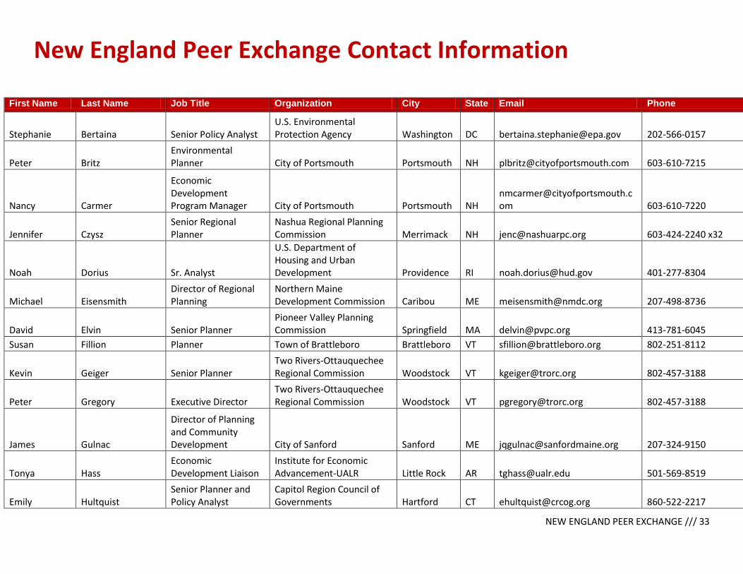
NEW ENGLAND PEER EXCHANGE /// 33
New England Peer Exchange Contact Information
First Name Last Name Job Title Organization City State Email Phone
Stephanie Bertaina Senior Policy Analyst U.S. Environmental Protection Agency Washington DC [email protected] 202-566-0157
Peter Britz Environmental Planner City of Portsmouth Portsmouth NH [email protected] 603-610-7215
Nancy Carmer
Economic Development Program Manager City of Portsmouth Portsmouth NH
[email protected] 603-610-7220
Jennifer Czysz Senior Regional Planner
Nashua Regional Planning Commission Merrimack NH [email protected] 603-424-2240 x32
Noah Dorius Sr. Analyst
U.S. Department of Housing and Urban Development Providence RI [email protected] 401-277-8304
Michael Eisensmith Director of Regional Planning
Northern Maine Development Commission Caribou ME [email protected] 207-498-8736
David Elvin Senior Planner Pioneer Valley Planning Commission Springfield MA [email protected] 413-781-6045
Susan Fillion Planner Town of Brattleboro Brattleboro VT [email protected] 802-251-8112
Kevin Geiger Senior Planner Two Rivers-Ottauquechee Regional Commission Woodstock VT [email protected] 802-457-3188
Peter Gregory Executive Director Two Rivers-Ottauquechee Regional Commission Woodstock VT [email protected] 802-457-3188
James Gulnac
Director of Planning and Community Development City of Sanford Sanford ME [email protected] 207-324-9150
Tonya Hass Economic Development Liaison
Institute for Economic Advancement-UALR Little Rock AR [email protected] 501-569-8519
Emily Hultquist Senior Planner and Policy Analyst
Capitol Region Council of Governments Hartford CT [email protected] 860-522-2217

NEW ENGLAND PEER EXCHANGE /// 34
John Hume Planning and Development Director
Montachusett Regional Planning Commission Fitchburg MA [email protected] (978) 345 - 7376 x302
Faith Ingulsrud Planning Coordinator Dept of Housing & Community Development Montpelier VT [email protected] 802-828-5228
Melanie Jewett Army Supervising Planner Rhode Island Statewide Planning Providence RI [email protected] 401-222-6183
Emily Kish Principal Planner City of Providence Providence RI [email protected] 401-680-8523
Noelle MacKay Commissioner Agency of Commerce and Community Development Montpelier VT [email protected] 802-828-5216
Megan McConville Program Manager NADO Research Foundation Washington DC [email protected] 202-624-7843
Michael McCrory Senior Planner Upper Valley Lake Sunapee Lebanon NH [email protected] 603-448-1680
Michelle Mears Regional Planner Strafford Regional Planning Commission Rochester NH [email protected] 603-994-3500
Nancy Merrill Director Planning and Development Claremont NH [email protected] 603-504-0340
Rosemary Monahan Smart Growth Coordinator
U.S. Environmental Protection Agency Boston MA [email protected] 617-918-1087
Matt Monahan Principal Planner Central NH Regional Planning Commission Concord NH [email protected] 603-226-6020
Erik Pages President EntreWorks Consulting Arlington VA [email protected] 703-237-2506
Mark Paquette Executive Director Windham Region Council of Governments Willimantic CT [email protected] 860-456-2221
Carlos Pena
Planning and Development Manager
Federal Highway Administration Augusta ME [email protected] 207-512-4914
Deb Perry Senior Program Officer
Institute for Sustainable Communities Montpelier VT [email protected] 802-225-2947
Jennifer Raitt Chief Housing Planner Metropolitan Area Planning Council Boston MA [email protected] 617-933-0754
George Reagan
Housing Awareness Program Administrator New Hampshire Housing Bedford NH [email protected] 603-310-9253
Brett Schwartz Program Manager NADO Research Foundation Washington DC [email protected] 202-624-7736