batang toru hydropower plant - pt-nshe.compt-nshe.com/images/batangtoru_whitebook_nshe_v4.pdf · pt...
TRANSCRIPT

BATANG TORUHydropower Plant

I. ABOUT NORTH SUMATERA HYDRO ENERGY
Table of Content
II. BATANG TORU REGION
III. FACTS RELATED TO THE CONSTRUCTION OFBATANG TORU HYDROPOWER PLANT
IV. COMMITMENT TOWARDS ENVIRONMENTAND BIODIVERSITY
V. SUMMARY
• 3
• 5
• 7
• 12
• 15

I. ABOUT NORTH SUMATERA HYDRO ENERGY
• 3
Batang Toru Hydropower Plant is an independent power producer of PT North Sumatera Hydro Energy (NSHE) whose shares hold by PT Dharma Hydro Nusantara (DHN) at 52.82%, PT Pembangkitan Jawa Bali Investasi (PJBI) 25% and Fareast Green Energy Pte Ltd at 22.18%. The total investment for Batang Toru Hydropower Plant is IDR 21 trillion with funding comes from internal (equities) and external (bank loans).
Batang Toru Hydropower Plant with the capacity of 4x127.5MW is located on the Batang Toru River, Sipirok Village, South Tapanuli Regency, and will supply 15% of North Sumatera’s peak load electricity.
The preconstruction phase started on 21 December 2015 following the signing of the contract agreement between PPA North Sumatera Hydro Energy (NSHE) and the State Electricity Company (PLN). According to the contract agreement with PLN, Batang Toru Hydropower Plant will commence the operation in August 2022.
Batang Toru Hydropower Plant is part of the National Strategic Program of 35,000 megawatt (MW) powerplants with the goals of:
Reducing global warming through reduction of carbon emission, a concrete step to implement the Paris Agreement ratified by the Indonesian Government in Law No.16/2016. The project will contribute to carbon emission reduction at 1.6-2.2 MTon per year1 or 4% of the national target from the energy sector2.
Reducing diesel power during peak load in North Sumatera that will save around USD 400 million per year of the government’s budget from fuel cost avoidance.
1.
2.
1 Pustaka Alam (2018)2 Indonesia’s carbon emission reduction target in 20130 is 0.8Tton from baseline of 0.3Gton/year, or addition of 0.5Gton. Energy sector contributes 11%, therefore contribution by energy sector is 0.05Gton or 55MTon.
• 4
Batang Toru Hydropower Plant follows the international standards, stand by the environmental impact assessment or AMDAL, adhere to the equator principal using IFC Performance Standard as the benchmark and comply to all permit requirements for large-scale projects such as this.
The 122 hecatares of land used for the project is designated as ‘land allocated for other purposes’ (also called APL in Indonesia) according the the Regional Spacial Plan and sits on the 163,000 hectares of Batang Toru region, or just 0.07% of the entire Batang Toru ecosystem. The ecosystem also has protection forests, conservation forests, and production forests as well area for other non-forest-related purposes.
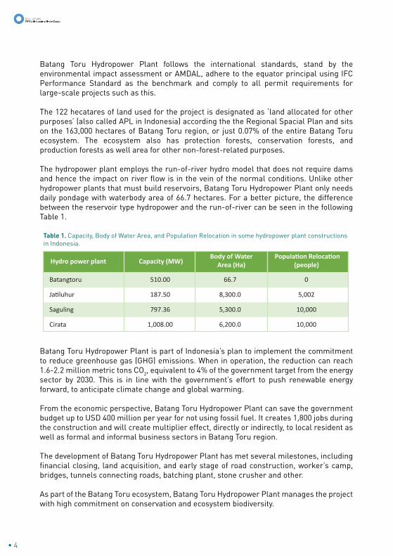
The hydropower plant employs the run-of-river hydro model that does not require dams and hence the impact on river flow is in the vein of the normal conditions. Unlike other hydropower plants that must build reservoirs, Batang Toru Hydropower Plant only needs daily pondage with waterbody area of 66.7 hectares. For a better picture, the difference between the reservoir type hydropower and the run-of-river can be seen in the following Table 1.
Batang Toru Hydropower Plant is part of Indonesia’s plan to implement the commitment to reduce greenhouse gas (GHG) emissions. When in operation, the reduction can reach 1.6-2.2 million metric tons CO2, equivalent to 4% of the government target from the energy sector by 2030. This is in line with the government’s effort to push renewable energy forward, to anticipate climate change and global warming.
From the economic perspective, Batang Toru Hydropower Plant can save the government budget up to USD 400 million per year for not using fossil fuel. It creates 1,800 jobs during the construction and will create multiplier effect, directly or indirectly, to local resident as well as formal and informal business sectors in Batang Toru region.
The development of Batang Toru Hydropower Plant has met several milestones, including financial closing, land acquisition, and early stage of road construction, worker’s camp, bridges, tunnels connecting roads, batching plant, stone crusher and other.
As part of the Batang Toru ecosystem, Batang Toru Hydropower Plant manages the project with high commitment on conservation and ecosystem biodiversity.
Hydro power plant
Batangtoru 510.00 66.7
Jatiluhur 187.50 8,300.0
Saguling 797.36 5,300.0
Cirata 1,008.00 6,200.0
0
5,002
10,000
10,000
Capacity (MW)Body of Water
Area (Ha)Population Relocation
(people)
Table 1. Capacity, Body of Water Area, and Population Relocation in some hydropower plant constructions in Indonesia.

II. BATANG TORU REGION
Batang Toru is a sub-district spread over three regencies: North Tapanuli, Central Tapanuli, and South Tapanuli in the North Sumatera Province, Indonesia. The area that spans some 163,000 hectares is rich in natural resources and biodiversity including:
Aside from forests, there are endemic wildlife such as orangutan, Sumatran tiger, Mahseer fish, tapir, bears, and hornbills in Batang Toru. The Sumatran tiger, for example, as of now only 500 remains in Sumatra.
Batang Toru area is currently being used for various purposes, including the Batang Toru Hydropower Plant which occupied area mainly covered by rubber plantation (UNEP, 2011). There are several land utilisations that dispersed the wildlife:
Batang Toru Hydropower Plant itself uses relatively small area compared to other land utilisation.
Batangtoru Regional Map
• 5
• Protection Forest • Conservation Forest • Production Forest • Areas for other purpose, allocated by the government for residentials, agriculture, mining etc.
• Plantation • Mining • Roads• Residential and Urban Area

Batang Toru River is the main river in the area, flowing from Tarutung, Humbang Hasundutan Regency, down to the Indian Ocean. Heavy erosion has been building up along its watershed for quite some time.
Source: various sources
Land Uses
Protected Forest 151,373 47,10
Mining 130,300 40,43
Nature Reserve 18,979 5,89
Forest Consession 17,000 5,27
Community Plantation 2,948 0,92
Plantation Corporation 1,325 0,41
Geothermal 130 0,04
Batangtoru HEPP 122 0,037
Total 322,177 100
Land Area (Ha) %
Map of Land Cover Change in Batangtoru Region
0 5 10 20 km
Source: Unep (2011)
Undisturbed Forest
Disturbed Forest
Rubber Plantation
Coffee Plantation
Plantations
Brush
Residential Area
Body of Water
Connected Corridor
Unconnected Corridor
Note: Erosion LevelA < 15 ton/ha/year
A = 15-60 ton/ha/year
A = 61-180 ton/ha/year
A > 480 ton/ha/year
A = 181-480 ton/ha/year
Batang Toru Hydro Power Plant specifically will give a positive impact. Water is a main raw material of a hydro power plant. Therefore, the hydro power plant must be involved in environment improvement, especially in the river area.
Damage and erosion that happens in the Batang Toru forest area have happened
before plans to build Batang Toru Hydro Power Plant.
Hydro PowerPlant Location
EROSION MAP OFBATANG TORU
REGION
Source: Conservation International 2015
• 6
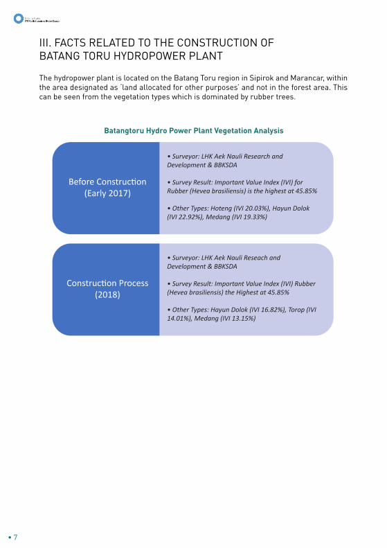
The hydropower plant is located on the Batang Toru region in Sipirok and Marancar, within the area designated as ‘land allocated for other purposes’ and not in the forest area. This can be seen from the vegetation types which is dominated by rubber trees.
• 7
III. FACTS RELATED TO THE CONSTRUCTION OFBATANG TORU HYDROPOWER PLANT
Batangtoru Hydro Power Plant Vegetation Analysis
Before Construction (Early 2017)
• Surveyor: LHK Aek Nauli Research andDevelopment & BBKSDA
• Survey Result: Important Value Index (IVI) forRubber (Hevea brasiliensis) is the highest at 45.85%
• Other Types: Hoteng (IVI 20.03%), Hayun Dolok (IVI 22.92%), Medang (IVI 19.33%)
Construction Process (2018)
• Surveyor: LHK Aek Nauli Reseach and Development & BBKSDA
• Survey Result: Important Value Index (IVI) Rubber (Hevea brasiliensis) the Highest at 45.85%
• Other Types: Hayun Dolok (IVI 16.82%), Torop (IVI 14.01%), Medang (IVI 13.15%)

Marancar Site Vegetation Analysis(Santosa et al 2018)
Height Level
Lower Vegetation Selaginella plana 2875 22.19
Seedling Leea sp. 913 20.48
Stake Aglaia tomentosa Teijsm. & Binn.744 15.14
Pole Hevea brasiliensis (Wild. ex A.Juss.)Müll. Arg. 34 88.78
Tree Hevea brasiliensis (Wild. ex A.Juss.)Müll. Arg. 42 131.78
Cyclosorus sp. 2081 16.06
Hydnocarpus kunstleri (King) Warb. 781 17.53
Lepisanthes senegalensis (Poir.) Leenh. 600 12.21
Macaranga bancana (Miq) Mull. Arg. 9 30.02
Macaranga hypoleuca (Rchb.f. & Zoll.)Muell. Arg. 5 16.82
Type K (ind/ha) IVI (%)
Sipirok Site Vegetation Analysis(Santosa et al 2018)
Height Level
Lower Vegetation Dicranopteris Linearis 4238 17.80
Seedling Hevea brasiliensis (Wild. ex A.Juss.)Müll.Arg. 344 6.87
Stake Hevea brasiliensis (Wild. ex A.Juss.)Müll. Arg. 363 11.96
Pole Hevea brasiliensis (Wild. ex A.Juss.)Müll. Arg. 31 133.98
Tree Hevea brasiliensis (Wild. ex A.Juss.)Müll. Arg. 29 107.77
Arcypteris irregularis 2775 11.66
Cinnamomum verum J. Presl. 338 6.74
Garcinia lateriflora Blume 338 11.13
Achidendron ellipticum (Blume) I.C. Nielsen 3 14.64
Parkia 4 12.55
Type K (ind/ha) IVI (%)
• 8

Spoilbank Batangtoru Hydro Power Plant Preconstruction(a): Mixed Plantation(b): Rubber(c): Sugar Palm
Batangtoru Hydro Power Plant Workshop(Quarry & Stone Crusher) Preconstruction
• 9

The hydropower plant is designed as run-of hydro just like micro hydro where the operations are adjusted to the water level in the river. Run-of hydro does not hold water like in reservoir hydropower plant, it uses the natural stream. Water reserves are not stored in the reservoir but stored naturally in the upstream forests of Batang Toru watershed.
Differ from other reservoir hydropower plants, Batang Toru Hydropower Plant does not use
giant dam but only daily pondage. Therefore, the size of the water catch area is relatively small, only 66 hectares. This is far smaller compared to other hydropower plants that use thousands of hectares for water reservoirs.
The natural flow rate of Batang Toru river is between 41.9 – 484 m3/s, with the lowest rate in July-August of 84 m3/s. It varies from day to day. On 23 September 2018, the flow rate can go as high as 514 m3/s and some villages in the downstream may be impacted.
Upon operation, the hydropower plant will regulate the water flow to maintain the ecological function of the river and for power generator. In rainy season, water will be released from the daily pondage through the control gate at 2.5 m3/s along with additional flow from tributaries between the pondage and the power house. With 4 turbines in full operations, the water will flow from the turbine at the rate of 207m3/s and will not cause flood. Looking at the flow rate of Batang Toru River, the chance for the hydropower plant to operate around the clock is very high and hence the water will flow at normal rate uniterrupted.
• 10
Batang Toru Hydropower Plant doesn’t do major drilling as the deepest tunnel is 300m under the ground. Tunnel construction doesn’t require the opening of surface land and the soil from drilling will be collected in 185 hectares disposal areas which land is acquired from local resident. Therefore, it will not hoard the forests or cause fragmentation.

3 Wanda Kuswanda, main researcher of Research Center for Environment and Forestry have done Batang Toru orangutan research since 2003.
• 11
Road and other facilities are built in the area that is not old-growth forest. Of the 669 hectares licensed for this project, 122 hectares will be used for permanent building structures, 100 hectares for support function, and the remaining 446 hectares will be replanted and restored. Land clearing will only be performed along the riverbank. Arboreal bridges for the animals will be built in case the road constructions fragment the orangutans from the river.
The habitat of orangutan is spread across forests in 163,000 hectares of Batang Toru ecosystem (TFCA, 2018) – an area the size of London and larger than Jakarta. Orangutan continues to move, travels around 800-3,000 hectares of area. Survey of Kuswanda and Fitri (2017, 2018)3 indicates the density of nests around the project area is 0.41 per km2, or one orangutan in 250 hectares. The Batang Toru Hydropower Plant occupied land of 122 hectares, smaller than the minimum area needed for a single orangutan.
Tapanuli orangutan have adapted with the environment and live on highland (>600 meters above sea level, masl) with low temperatures. Therefore, it has very thick fur and longer than other orangutans. The highest point of Batang Toru Hydropower Plant project is at 430masl, far lower in altitude than the main habitat of orangutans.
These two facts provide confirmation that the project is not located on the main habitat or population source of orangutans.
Groundcheck results (Professor Yanto Santosa, 2018) on the map of the nests spread by YEL (2015) in the permitted location (7,200 hectares) showing that most locations earlier reported as gathering nests are no longer used for nesting activities. Only 10.34% of nests are classified as new nests (or A class nests) while largely are old nests (E class nests, 51.72%). Meanwhile, B, C, and D class nests each are at 6.89%, 13.79%, and 17.24%. Another interesting fact from the groundcheck results is that most of nests in “YEL version” are located on steep cliffs very difficult to be reached by orangutans, especially if they used normal methods of orangutan nest survey. It needs to be reminded that the confusion/mistake of the method on the field will result in inaccurate survey data and cannot be used as valid reference for science. This fact also proves that the area for the Batang Toru Hydropower Plant is least used by orangutans, therefore cannot be categorized as main habitat.
Data analysis of nest density, inputting all factors to assume population have resulted in the possible number of orangutan population density of 0.48 individuals/km2 across 7,200 hectares in the Batang Toru Hydropower Plant. This is not far different from the research results on the same location done by Kuswanda (2017), and is relatively smaller if compared with orangutan density in Dolok Sibual-buali, Ketambe and Mamas in Gunung Leuser National Park (7-1.2 individuals/km2).

The construction of Batang Toru Hydropower Plant will have some impact on the area. The project is awarded a license to operate on an area of 6,598.35 hectares for exploration, survey, and planning. Around 669 hectares of land have been obtained from the community, while the remaining will be returned to the South Tapanuli administration. According to the Batang Toru Region strategic spatial planning, the area is designated as nature reserve for ecotourism or as buffer zone.
Of the 669 hectares acquired land, 447 hectares will suffer temporary damage during the construction period as follow:
Batang Toru Hydropower Plant will improve the area with vegetation to feed the wildlife animal, replacing the current rubber trees (Hevea brasiliensis). This has been initiated in partnership with local residents, the South Tapanuli administration, and University of North Sumatera.
Permanent damage will include permanent building area of 122 hectares (0.07% of the total 163,000 hectares of Batang Toru ecosystem) in the form of access road, daily pondage, power house, switchyard, and basecamp. The permanently lost habitat will be replaced through Biodiversity Offset Program.
IV. COMMITMENT TOWARDS ENVIRONMENT AND BIODIVERSITY
Commitment Towards the Ecosystem
• 12

Batang Toru Hydropower Plant is located on the ‘land allocated for other purposes’ (APL) and entirely acquired from local resident. It has legal basis to be used for non-forestry purposes. If protected wildlife is found on the ‘land allocated for other purposes’, by law the government must protect the interest of the land owner and at the same time also protecting the wildlife. This clearly regulated in the Ministry of Forestry Regulation No.53/Menhut-II/2014 juncto Ministry of Forestry Regulation No. 48/Menhut-II/2008.
Actions to preserve and protect the wildlife:
Commitment Towards the Wildlife
• 13
• Zero tolerance’ policy for all personnel and onsite workers towards poaching and illegal trade of wildlife • Implementation of limited road access with security check for entry/exit • Security patrols• Shall protected animals enter the project area, all work activities will be put on halt• Wildlife signboards on the area frequently passed by the protected animals• Construct arboreal bridge for orangutan and other primates• Monitoring and rescue of wildlife• Etc
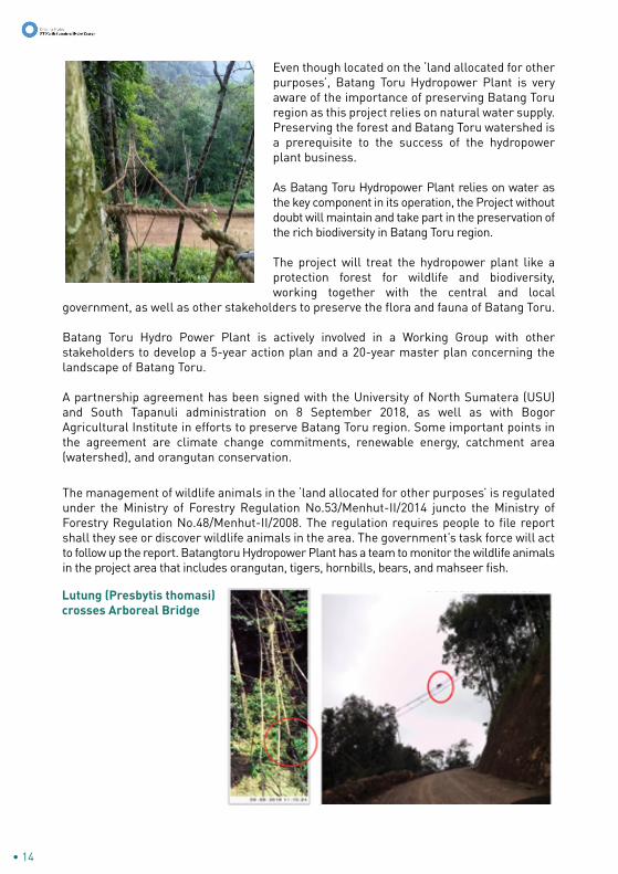
Even though located on the ‘land allocated for other purposes’, Batang Toru Hydropower Plant is very aware of the importance of preserving Batang Toru region as this project relies on natural water supply. Preserving the forest and Batang Toru watershed is a prerequisite to the success of the hydropower plant business.
As Batang Toru Hydropower Plant relies on water as the key component in its operation, the Project without doubt will maintain and take part in the preservation of the rich biodiversity in Batang Toru region.
The project will treat the hydropower plant like a protection forest for wildlife and biodiversity, working together with the central and local
government, as well as other stakeholders to preserve the flora and fauna of Batang Toru.
Batang Toru Hydro Power Plant is actively involved in a Working Group with other stakeholders to develop a 5-year action plan and a 20-year master plan concerning the landscape of Batang Toru.
A partnership agreement has been signed with the University of North Sumatera (USU) and South Tapanuli administration on 8 September 2018, as well as with Bogor Agricultural Institute in efforts to preserve Batang Toru region. Some important points in the agreement are climate change commitments, renewable energy, catchment area (watershed), and orangutan conservation.
• 14
Lutung (Presbytis thomasi) crosses Arboreal Bridge
The management of wildlife animals in the ‘land allocated for other purposes’ is regulated under the Ministry of Forestry Regulation No.53/Menhut-II/2014 juncto the Ministry of Forestry Regulation No.48/Menhut-II/2008. The regulation requires people to file report shall they see or discover wildlife animals in the area. The government’s task force will act to follow up the report. Batangtoru Hydropower Plant has a team to monitor the wildlife animals in the project area that includes orangutan, tigers, hornbills, bears, and mahseer fish.

• 15
V. SUMMARY
1. Batang Toru Hydropower Plant is part of the National Strategic Program to achieve 35,000-megawatt (MW) powerplants. As IPP holder, PT NSHE accepts and executes the task from the government to build Batang Toru Hydropower Plant.
2. Batang Toru Hydropower Plant is a renewable power plant that will contribute to the government program of 23% renewable energy. With the 510 MW capacity, Batang Toru Hydropower Plant will supply energy of 2,124 MWH/year.
3. Batang Toru Hydropower Plant is designed to meet the peak load power needs as a replacement from the fossil fuel power station. The project will contribute to the reduction of import and spending cuts from fossil fuel of USD 400 million per year.
4. Fossil fuel replacement by Batang Toru Hydropower Plant will contribute to the reduction of carbon emission by 1.6 million tons in efforts to support the Indonesian government’s commitment to reduce carbon emission by 29% in 2030.
5. Batang Toru Hydropower Plant is located on ‘lands allocated for other purposes’ with the entirety of land acquired from local resident, legally permitted by the Indonesian government for non-forestry purposes.
6. Batang Toru Hydropower Plant is a run-of-river type that doesn’t need reservoir like other Hydropower plants, only needs daily ponds. It will adjust the operation to the river flow from upstream and the natural water regulation. Therefore, the water reserves are not stored in the reservoir but stored naturally in the upstream forests along the Batang Toru watershed.
7. Dependency on water supply from nature means that Batang Toru forests and watershed is an integral part of Batang Toru Hydropower Plant.
8. Aside from performing environmental impact analysis for ‘land allocated for other purposes’ and fulfilling the required laws and regulations, Batang Toru Hydropower Plant adopts the IFC standards, including standard number 6 on Biodiversity Conservation and Management of Living Natural Resources. Batang Toru Hydropower Plant also performs mitigation actions to protect and preserve biodiversity in the project area.