big river loop - oregon birding trailsoregonbirdingtrails.org/wvguide/big river loop.pdf · 42 b1....
TRANSCRIPT
41
Shoestring rd
Wilsonville
Sherwood
Newberg
Yamhill
Carlton
Gaston
Forest GroveHillsboro
Beaverton
Tigard
Wil lame t t e R iv e r
North Plains
Banks
Henry Hagg Lake
Vernonia
Scoggins valley rd
Spring Hill rd
laurel rd
Bald Peak rd
river rd
Scholls ferry rd
cornell rd
corneli
us P
ass r
d
neh
alem
Hw
y
wilson river Hwy
Tualatin Sherwood rd
Tualatin rd
Tualatin
Boo
nes
ferr
y r
d
roy
rog
ers
rd
Tua latin River
Scholls-Sherwood rd
Bald Peak rd
Salem
Corvallis
Philomath
Wren
Kin
gs v
alle
y H
wy
Blodgett
Airlie
Kings Valley
Hoskins
MonmouthIndependence
cor
valli
s r
d
Bue
na v
ista
rd
Albany
Falls City
Pedee
Dallas
Luckiamute River
Will
am
ette River
Oak c
reek Dr
walnut Blvd
53rd
st
Buena Vista Ferry
Talbot rd
Buena vista rd
lib
erty
rd
river rd com
mercial r
d
airlie rd
maple grove rd
maxfi eld creek rd
monmouth Hwy
Springhill Dr
camp adair rd
Canby
Aurora
Oregon City
Woodburn
St. Paul
Dundee
Molalla
Estacada
Sandy
Damascus
Boring
Clackamas
Galdstone
West Linn
Lake Oswego
Staf
ford
rd
Staf
ford
rd m
ountain rd
locu
st S
t
Knights Bridge rd
arndt rd
champoeg rd
fren
ch P
rairi
e rd
mer
idia
n r
d
Molalla Riv er
Pudd
ing
Riv
er
Spangler rd
Beaver creek rd
Springwater rd
molalla forest rd
South fork rd
alp
ine
rd
Bel
lfoun
tain
rd
Bruce rd
Decker rd
mary’s Peak rd
Will
amett
e Riv
er
Mary’s R
ive r
Vancouver
St. Hellens
Scappoose
Ridgefi eld
Clatskanie
Rainier
Longview
Scappoose vernonia Hwy
Skyline Blvd.
cornell rd.
Co l u m
b ia Ri v
er
C o l u m b i a R i v e r
Neh
a l e m Ri v
e r
eric
kson
Dik
e rd
Beaver falls rd
Quincy
Mayger
Mist
SauvieIsland
Warren
Willamette R
iver
Fern Ridge Lake
Fall Creek Reservoir
Dexter Reservoir
Lookout Point Reservoir
Tangent
SheddPeoria
Calapooia River
South Santiam R i v e r
Brownsville
Peo
ria r
d
Peoria rd
Tangent Dr
gap
rd
Diamond Hill rd
Amity
Sheridan
Willamina
Keizer
McMinnville
Lafayette
Dayton
Valley Junction
coville rd
farmer rd
Smithfi eld rd
live
mor
e r
d
Bethel rd
grand island rd
lafa
yett
e H
wy
amity rd
zena rd
Oak r
d
London
Dorena Lake
Coas
t For
k W
illam
ette
Riv
er
Middle Fork Willamette River
R ow Ri v e r
Mosby Creek
Big River
Cottage Grove
Lake
BohemiaMtn.
Fairview Peak
Snow Peak
Willamette National
Forest
Umpqua National
Forest
Umpqua National
Forest
Hazelgreen rd
Silverton rd
cas
cad
e H
wy
22
Portland rd
whe
atla
nd r
d
Brooklake rd
ankeny Hill r
d
Jefferson Hw
y
wintel rd
Jefferson marion rd
Stayton rd
Duc
kfl a
t r
d
Hunsaker rd
Sta
yton
-Sci
o r
d
22
Silverton
Mt. Angel
TurnerAumsville
Tualatin valley Hwy
laurelwood rd
Harrison Blvd
ind
epen
den
ce H
wy
cor
valli
s r
d
8
47
47
219
219
217
99W
30
240
99W
219
8
205
205
210
219
99W
223
99W
99W
20
20
51
22
20
223
Eugene
Belt line Hwy
126
99
99
126 126
Springfi eld
126
126Veneta
36
36Cheshire
Junction City
Coburg
Harrisburg
205
99E
211
211
212224
211
211213
99E
211
214
219
43
43
99E
213
Monroe
Alpine
Bellfountain
Alsea
Greenberry
99W
99W
99W
34
34
30
30
30
433
432
4
47
47
47
202
Elmira
SantaClaraclear lake rd
gre
en H
ill r
d
99
Terr
itoria
l Hw
y
cen
tral
rd cantrell rd
will
amet
te r
dlo
wer f
ox
Hollow
rd
royal ave
Alvadore
126
58
58
99
Creswell
Cottage Grove
Walterville
Vida
Leaburg
Jasper-lowell rd.
DexterBoundary rd.
Lowell
Pengra rd.
winberry creek rd.
Big fall creek rd.
Boundary rd.
nor
th S
ide
rd.
Sunset rd.
Westfi r Oakridge
n fork rd.
58
Goshen
99E
Halsey
Sweet Home
Lebanon34
20
20
20
22899E
99E20
228
Wil lame t t e Riv e r
Co lumb ia Riv e r
99W
99W
22
22
18
221
221
1818
233
47
london rd
cotta
ge g
rove
res
. rd
lond
on r
d
government rd
row river rd
row river rd laying creek rd
Brice creek rd
fr 22
fr 2
212
Sharps creek rd
martin creek rd
fr 23
Sharps creek rd
clark creek rd
row
c
reek
r
d
Blm 23-2-22
couger Bend rd
Big river rd
lond
on r
d
fr 17
fr 1
7
fr 5
840
Patte
rson
mtn
. rd
213
214
99E
214
214214
213
226
Sublimity
Stayton
Lyons
Scio
Marion
Jefferson
34
20
B9
B1
B4
B2
B3
B8
B7
B5
Big RiveR LooP
B6
To Eugene ▲
To Oakridge
▲
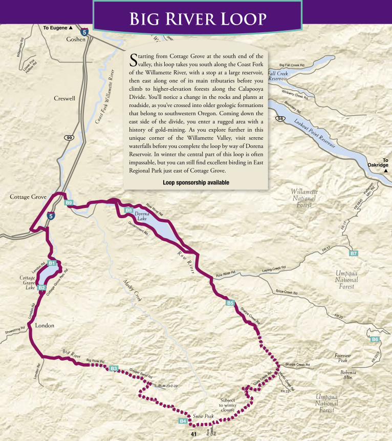
Starting from Cottage Grove at the south end of the valley, this loop takes you south along the Coast Fork
of the Willamette River, with a stop at a large reservoir, then east along one of its main tributaries before you climb to higher-elevation forests along the Calapooya Divide. You’ll notice a change in the rocks and plants at roadside, as you’ve crossed into older geologic formations that belong to southwestern Oregon. Coming down the east side of the divide, you enter a rugged area with a history of gold-mining. As you explore further in this unique corner of the Willamette Valley, visit serene waterfalls before you complete the loop by way of Dorena Reservoir. In winter the central part of this loop is often impassable, but you can still find excellent birding in East Regional Park just east of Cottage Grove.
Loop sponsorship available
Subject to winter closure
41

42
B1. Cottage Grove Lake – Lower EndFrom i-5 exit 172 at S end of cottage Grove, go e on 6th St, which turns into London rd. Follow for 4.1 mi to intersection with cottage Grove reservoir rd on L. From here either turn L and go 0.6 mi to riverside park at base of dam (GpS 43˚ 42.959’ N, 123˚ 02.968’ W), or continue for 0.5 mi on London rd to Lakeside park (Mp 2.8).This reservoir on the Coast Fork of the Willamette River is home to Bald Eagles year-round, with nesting Osprey and many species of waterfowl. In late fall, the water level is lowered but deep water remains around the dam and hosts flocks of Green-winged Teal, Bufflehead, Common and Hooded Merganser, Lesser Scaup, and Pied-billed Grebe; view from Lakeside Park or from a small pullout on the E end of the dam just above Riverside Park. Watch for Spotted Sandpiper on the shore. A wastewater treatment pond near Riverside Park is closed to the public, but you can scan the American Wigeon flock from the road to pick out Eurasian Wigeon.
RVOSTQSponsorship available
B2. Cottage Grove Lake – Upper End LoopFrom Lakeside park (Site B1) continue S 1 mi on London rd to Williams creek rd to scan a reservoir backwater, then continue 2 mi to intersection with reservoir rd. Turn L (N) and go 1 mi to Wilson creek campground. additional stops with shoreline access are at pine Meadow campground and Shortridge park, 1 and 2 mi further N, respectively. continue 1.5 mi past Shortridge park to return to London rd below reservoir.
The upper end of this reservoir has a series of developed parks and campgrounds (closed in winter) that offer a wide variety of birding habitats. The backwater at Williams Creek provides close views of waterfowl. Wilson Creek has open pine woods next to marshy and riparian areas, with nesting Osprey, Tree and Violet-Green Swallows. At Pine Meadow, ponderosa pines, Douglas-firs and cottonwoods host Brown Creeper, Chestnut-backed and Black-capped Chickadees, and wintering Townsend’s Warbler with kinglet flocks. A human-acclimated Wild Turkey flock may wander through from nearby residential areas. Shortridge Park is shaded by mature Douglas-fir, hemlock and big-leaf maple. Look for Hermit and Varied Thrushes in winter. Listen for Pacific-slope and Hammond’s Flycatchers in spring, along with Cassin’s and Hutton’s Vireos and Black-throated Gray Warbler singing from oaks and madrones on the slopes above the reservoir. In winter, when water levels are drawn down, check for Least Sandpiper and American Pipit on the sparsely vegetated mudflats.
BRCVDOSTSponsorship available
B3. Big River RoadFrom Lakeside park (Site B1) go S 10 mi on London rd to Mp 13. Just before bridge, turn L on Big river rd (paved). Mileposts along Big river rd are painted on the pavement. Bird along road to Mp 8 3/4 at junction with BLM rd 23-2-22 (GpS 43˚ 33.567’ N, 122˚ 55.198’ W), where the main route curves sharply to r and starts up hill toward calapooya divide (Site B4).Starting from the upper valley of the Willamette River’s Coast Fork, where small pockets of pastures, fields, and rural residences are tucked among riparian deciduous forest, this stretch of road passes through mixed forest with Douglas-fir, big-leaf maple and alder at elevations of 1400 to 1600 ft. Bird along the main road, or walk along gravel side roads for forest species including Ruffed Grouse, Sharp-shinned Hawk, Pacific-slope Flycatcher, Steller’s Jay, Chestnut-backed Chickadee, Varied and Swainson’s Thrushes, Western Tanager, and Red Crossbill. Note that the mini-market in the hamlet of London (at MP
7 of London Rd) is the closest stop for gas and groceries, and is open limited hours. This road can be closed due to snow in winter.
GOS NSTSponsorship available
B4. Calapooya DivideFrom Mp 8 3/4 of Big river rd (GpS 43˚ 42.959’ N, 123˚ 02.968’ W, see Site B3), follow main route as it curves sharply r and up hill. The road winds steeply uphill for the next 5 mi to reach elevations up to 4540 ft at Snow peak on the calapooya divide (Mp 15.8, GpS 43˚ 30.820’ N, 122˚ 52.239’ W). To continue loop route see directions for Site B5.This divide between the Willamette
River drainage and the Umpqua River drainage to the south is the highest elevation part of this birding trail. The hemlock, red-cedar and Douglas-fir forest with patches of alder, maple, and madrone is home to Ruffed and Sooty Grouse, Northern Goshawk, Spotted Owl, Pileated and Hairy Woodpeckers, Hammond’s and Olive-sided Flycatchers, Gray Jay, Hermit and Varied Thrush, Hermit, Wilson’s and MacGillivray’s Warblers, Western Tanager, and Red Crossbill. The crest of the divide at Snow Peak offers stunning views in all directions. Hike or bicycle along gravel side roads for access to more of the habitat, but be sure to watch for logging trucks. Note: This road can be closed due to snow in winter and early spring. Carry tire chains or traction tires and winter survival gear if you travel this route between November and May. There are no residences or services along this route.
KOS NSTSponsorship available
B5. Sharps Creek CampgroundTo continue loop route from Snow peak (Site B4), go e 2 mi to junction with rock creek rd, which comes in from S. Here Big river rd becomes clark
dark-eyed (oregon) JuncoPHOTO BY: glen linDeman
Northern Saw-whet owl
PH
OTO
BY:
Pa
T Ti
lle
Y
ruffed Grouse
PH
OTO
BY:
Pa
T Ti
lle
Y

43
creek rd. continue e, then Ne and downhill on clark creek rd for 9.3 mi to intersection with Martin creek rd (GpS 43˚ 34.586’ N, 122˚ 44.961’ W, elevation 1650 ft). Bear L and continue 0.7 mi to intersection with Sharps creek rd. Turn L and go 7 mi to campground. alternatively from upper end of dorena reservoir (Site B8) go Se on row river rd for 4 mi, turn r on Sharps creek rd and go 3 mi to campground on r. GpS 43˚ 39.957’ N, 122˚ 48.460’ W.This small BLM-managed campground, shaded by tall Douglas-firs and red-cedars, includes one handicapped-accessible campsite. A small day-use area across the road gives views of Sharps Creek with chances to see American Dipper and Harlequin Duck. Try your luck panning for gold, or listen for Golden-crowned Kinglet along with nesting Pacific-slope Flycatcher, Winter Wren, Varied and Swainson’s Thrushes, Black-throated Gray, Wilson’s and MacGillivray’s Warblers, and Red-breasted Nuthatch. This makes a good base camp for exploring the lush riparian habitats of the historic mining district to the south. Pay attention to signs for the many private claims in the area, where small-scale gold mining and panning still goes on.
BVDOS NSTSponsor: Bureau of Land Management, Eugene district
B6. Noonday Ridge and Bohemia SaddleFrom intersection of row river rd and Sharps creek rd (3 mi NW of Site B5, or 4 mi Se of the upper end of Site B8), turn e on row river rd. Go 3.6 mi and bear r on Brice creek rd (Forest road
22). Go 12 mi Se. Turn r on Forest road 2212 (gravel), which climbs steeply along Noonday ridge (GpS 43˚ 37.1’ N, 122˚ 36.7’ W) and eventually reaches Bohemia Saddle after 10 mi.This gravel forest road is a steady climb from 3000 ft to 4500 ft. Watch for Sooty and Ruffed Grouse in the shaded stretches, and Mountain Quail in logged areas, along with Pileated Woodpecker, Varied and Hermit Thrushes, and Hermit, Townsend’s, Wilson’s and MacGillivray’s Warblers. The wildflower meadows in Bohemia Saddle are alive with hummingbirds in June. Most will be Rufous but with luck you might spot a Calliope or Black-chinned Hummingbird. Keep an eye open for Northern Goshawk, along with other raptors that soar along the ridge. This road can be impassable due to snow from November through early May. Watch out for off-road vehicles at crossings with old mining trails, which are used as motorized trails. Vault toilets are located at several National Forest campgrounds along Forest Rd 22; higher up only primitive facilities are available.
ABS NSTSponsorship available
B7. Spirit Falls & Moon FallsFrom intersection of row river rd and Sharps creek rd 4 mi Se of dorena reservoir (Site B8), turn e on row river rd. Go 3.6 mi and bear L on Layng creek rd (Forest rd 17). Go 8.8 mi to junction with Forest rd 1790. Turn r on rd 1790 and go 0.15 mi to trailhead for Spirit Falls (Trail #1413), or continue to Moon Falls by turning L on rd 1702 for 2.8 mi, then r on rd 1702-728 for 0.3 mi, and left on spur rd 1702-203 to reach trailhead (Trail #1723).Spirit Falls tumbles 60 ft into a secluded pool at the end of a short (0.4 mi) trail through mature forest with some steep switchbacks at the end. Moon Falls is a 125 ft high cascade, reached by a 0.5 mi walk with gentle grades through old-growth forest. Black Swift, one of the Pacific Northwest’s most enigmatic species, has been spotted (rarely) at both of these sites. To look for them, hike in before sundown in June or July, settle back to watch the
sky as evening comes on, and scan for larger swifts among the more likely Vaux’s Swifts and bats feeding overhead. You may also hear Western Screech-Owl, Northern Saw-whet, and even Spotted Owl calling. Be sure to bring a headlamp for the hike out, as camping is not permitted. The nearest developed campground is at Rujada Campground, 8 mi back down Rd 17. From the junction of Forest Rds 17 and 1720 a shortcut is possible to Oakridge on the Middle Fork Link (Site M10), but note that this road passes over a high ridge where several side roads can cause confusion; before trying this route, you should obtain a forest map and inquire about conditions at the Ranger Station in Cottage Grove.
AS NSTSponsorship available
B8. Dorena ReservoirFrom i-5 exit 174 at N end of cottage grove, go 5 mi e on row river rd to the intersection with Shore dr. From here a paved loop route around the lake offers several birding stops: (1) continue straight on Shore dr for one block, then L on Spillway rd for 0.5 mi to end where you can walk gravel road past gate to base of dam; (2) back on Shore dr, go 0.5 mi Se to Schwartz park; (3) continue 2.5 mi to Baker county park; (4) continue Se 4 mi to top end of reservoir, turning L at another intersection with row river rd by the covered bridge, and continue 1 mi NW to Bake Stewart park; (5) continue NW 4 mi more to Harms Boat ramp; and (6) pass two more access points at row point and dorena dam on the way back to the intersection with Shore dr below dam.This reservoir hosts Bald Eagle, Osprey, Great Blue Heron, Great Egret, and many species of waterfowl,
swallows, with occasional White-tailed Kite. Yellow-breasted Chat and other warblers are found here in springtime. A maintained meadow at Schwartz Park (closed in winter) has interpretive signage; here you can also access the river at the back of the campground. The paved Row River Trail, accessible from Bake Stewart Park, Harms Park, Row Point and Dorena Dam, runs 15.6 mi along an abandoned rail line from Cottage Grove, passing through patches of dense old forest and open meadows along the reservoir’s north shore, and continuing and beyond to Culp Creek and Umpqua National Forest. The reservoir is drained in winter. Fees apply at Baker County Park.
ABRCKOSponsor: Eugene, Cascades & Coast
B9. East Regional ParkFrom i-5 exit 174, go Se on row river rd for 1 mi to truck scale and parking lot. a paved trail leads into the park.East Regional Park consists of a series of ponds and riparian woodland with willows and cottonwoods along the Row River, and some conifer stands. Watch for Great Blue and Green Herons, Wood Duck and other waterfowl around the ponds and river. Four species of woodpecker are resident, along with chickadees, kinglets, and Wrentit. In spring look for warblers, Bullock’s Oriole, Black-headed Grosbeak, and Red-winged Blackbird. Osprey and Cedar Waxwing are commonly seen in summer. In winter this park can be good for sparrows, with occasional rarities. Black Phoebe has occurred in the park.
ACEFGOPSponsor: Oregon Field Ornithologists
Wilson's WarblerPHOTO BY: STeve DOwlan
Bald eagle
PH
OTO
BY:
PaT
Til
leY