borate deposits in ventura county, california · pdf fileborate deposits in ventura county,...
TRANSCRIPT

BORATE DEPOSITS IN VENTURA COUNTY, CALIFORNIA.
By HOYT S. GALE.
INTRODUCTION.
Colemanite, a borate of lime, was first found in Death Valley, Inyo County, Cal., in 1882, and deposits of this mineral were discovered in the following year in San Bernardino County near the old Calico mining district, about 12 miles north of Daggett, Cal. Within the next few years, owing to the use of colemanite as an ore of boric acid and borax, the production of borax from so-called marsh or dry- lake mud deposits ceased, and the price of borax fell to less than 0 cents a pound. The colemanite deposits of Ventura County, Cal., were discovered in 1898, and the district yielded a practically con tinuous production from 1899 to 1907, inclusive, amounting to a total of about 35,000 tons of crude ore, valued at approximately $1,000,000. After an interval of several years of nonproduction, shipments of ore were resumed during 1911 and there are at present two operating properties in the district.
The borate deposits of Ventura County, although classed among the few important deposits of this class of ores in the country, have suffered the disadvantage of being at a long distance from the main routes of transportation. The district lies in the extreme northeast comer of Ventura County. The deposits are associated with rocks whose outcrop extends in a belt from southwest to northeast from the head of Cuyama River along the southern flank of Mount Pinos, crossing into the southern edge of Kern County along the valley of Cuddy Creek. (See fig. 41.)
The locality is most readily reached from the San Joaquin Valley for example, from Bakersfield by the road that runs southward to Lebec and through Tejon Pass. A little over a mile beyond Lebec and less than a mile north of Tejon Pass the road forks and .one branch turns westward up the Cuddy Creek valley and thence crosses to Stauffer, in the Lockwood Valley on the headwaters of Piru Creek, a total distance from Bakersfield of about 55 miles. Mail to the mines (Stauffer post office) is brought by stage from Lancaster, on the Southern Pacific Railroad in the Mohave Desert, via Neenach and Tejon Pass, a total distance of about 75 miles. Both of these roads have been used for hauling the borate ores to the railroad for ship ment.
434

BOBATE DEPOSITS IN VENTURA COUNTY, CAL. 435
The district contains at present three principal "borax" mining properties and a considerable number of other holdings. These prop erties lie in the foothills at the northern margin of Lockwood Valley, on the headwaters of Pira Creek. They are commonly known as the Frazier mine, property of the Sterling Borax Co., of Los Angeles; the Kussell Borate Mining Co.'s mine, belonging to the Russell Bros., of Ventura, and the old Columbus mine, formerly property of the Calm Bros., of Los Angeles, recently reported to have been sold and reorganized under the name National Borax Co. of California. Several
119*10' R.2IW.
R. ZOW.IIS'OO'
FIGURE 41. Index map showing borate district of Ventura County, Cal., and the location of the area shown on the sketch map, Plate I.
other properties in the district, largely in the prospective stage, are described in subsequent paragraphs. Some of them have made small shipments of ore.
HISTORY OF THE DISTRICT.
The discovery of colemanite or borate minerals in Ventura County is said to have been made in 1898. Reports state that the material supposed to be "lime" (crystalline calcite) had long been known to prospectors at the present site of the Frazier mine. A prospector named McLaren, who had settled in the vicinity, happening to see some colemanite specimens while on a visit in Los Angeles, recognized that they were identical with material supposed to be lime in Ventura County. Divulging the information thus obtained to acquaintances

436 CONTRIBUTIONS TO ECONOMIC GEOLOGY, 1912, PART I.
in Los Angeles, he returned with a party who at once set about locating claims on and near the outcrop then known and later proceeded to develop the property. The first locations were made where crystal line colemanite was visible at the surface of the ground in the steep slope just above the present site of the Frazier mine. Soon afterward other properties were located on adjoining ground. The history of development involves a record of changes in management that is of local and personal interest only.
GEOLOGY OF THE DEPOSITS.
The colemanite deposits occur within a series of bedded rock forma tions that have been extensively folded and faulted. In general the trend of their outcrop is northeast and southwest and the beds dip southeastward, away from the higher elevations in the Mount Pinos Range. (See general index map, fig.-41.)
A representative section of the formations more directly associated with the bof ate-bearing beds is exposed in the lower part of the canyon of North Fork, in and near sec. 30, T. 8 N., R. 21 W. Here the stratiform rocks of this series are well exposed in regular section with a uniform steep southerly dip, and the relations of the several members are very clear. From this section, by means of paced traverses along North Fork, the following measurements and general descriptions of the rocks were obtained. This section warrants more detailed study, as the beds are well exposed in the upper canyon slopes.
Stratigraphic section on North Fork west of Stauffer, Cal.Feet.
Shale, whitish exposures, containing also beds of light friable sand stone and in the lower part, near the basalt, zones of gypsiferous shale, from which borate minerals, chiefly pandermite, have been extracted. Total thickness not determined, as the upper limit in this section is fixed by a strike fault.................. 300
Basaltic flow rock, with compact as well as vesicular and slaggy layers. The lava flows include zones of shale and in other parts of the field some beds of massive limestone, the latter containing the largest colemanite ore bodies of the field.................... 600
Shale, thin-bedded, at least in part. These beds include zones of much contorted shale whose outcrops are conspicuous for the abundance of gypsum in thin stringer veins which they contain. These gypsiferous zones have been prospected for borate ores.... 625
Sandstone and conglomerate, white or light-colored, usually form ing massive ledge outcrops. Composed mainly of light-colored granitic wash material....................................... 150
Shale, light-colored, not conspicuously exposed................. 200Conglomerate, dark reddish or iron-stained in general aspect, com
posed of large bowlders or cobbles consisting of gray and pinkish granite, with fine granitic material. A conspicuous ledge-form ing rock ................................................... 250
Sandstone, white, friable, and shaly beds; not measured, appar-. ently limited by a strike fault, "
2,125

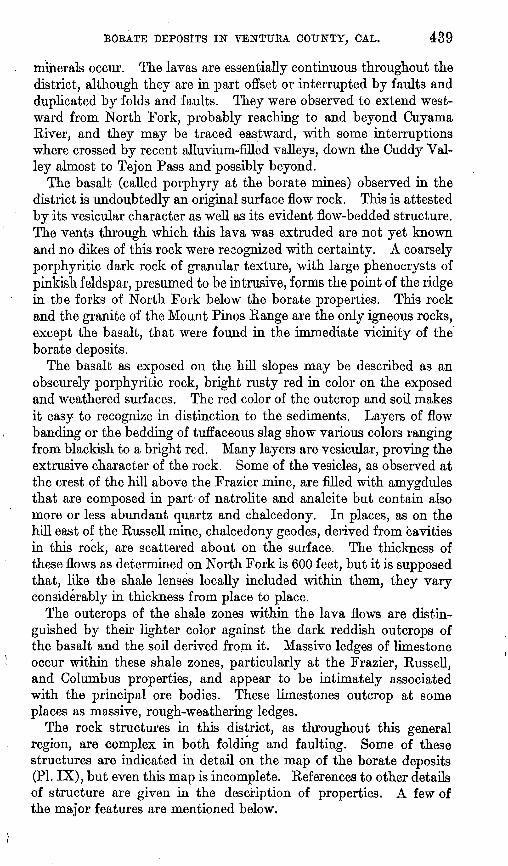
BOBATE DEPOSITS IN VENTURA COtJNTY, CAL. 437
FIGURE 42. View and section of the borate-bearing beds on North Fork, Ventura County, Cal., looking northeast across the lower canyon from a point situated on the outcrop of the tilted basalt ledges. Arrows indicate dip of rocks.

438 CONTRIBUTIONS TO ECONOMIC GEOLOGY, 1912, PART I.
The dip of the whole section is fairly uniform toward the south or southeast, the angles ranging from 70° to 80°.
The view given herewith (fig. 42) illustrates the general aspect of the North Fork section described above, as, seen from the summit on the west side of North Fork looking northeast. In a region of less pro nounced faulting or other deformation such a section would not be unusual, but it may here be taken as a key to the stratigraphy of the borate deposits. The whole section dips conformably with the basalt flow rock, which is by nature one of the most distinct lithologic units in the series. The basalt and the conglomeratic members form the units more resistant to weathering and erosion, and these stand out as distinct ledge-making rocks, also forming the higher crests or sum mits along the ridges.
Both north and south of the section described are exposed thick beds of other rocks whose relations, other than that they are gener ally faulted into juxtaposition with the rocks described, have not been determined. Along the north side of Lockwood Valley are extensive exposures of white clays and gravels, distinctly bedded but only slightly consolidated, whose most distinguishing characteristic lies in the manner of their erosion and exposure. These formations weather or cave into great fluted wash banks, intricate in the detail of pinna cles and large to minute gullies. Small exposures of these wash banks are to be seen just east of the Frazier mine, and larger ones lie in the ridge that projects south into Lockwood Valley between Bitter Creek and Middle Fork. Very extensive exposures of similar character were observed from a distance in the upper part of Dry Canyon, in the headwater region of Cuyama River. These also include strata of white and varicolored clays, which are in a few places exposed in wash banks near the borate deposits, showing hues of red, pink, and pale greenish.
The borate-bearing beds lie in the sedimentary rocks closely asso ciated with the basalt lava flows. Even if a genetic relationship between the borate deposits and the basalt can not be said to have been established, the regional association is borne out by the observed distribution of the deposits. From the detailed descriptions of the colemanite deposits developed in the mines it will be noted that the larger ore bodies have all been found in shale zones which are included within the lava flows, so that the shales were evidently deposited dur ing interflow epochs. Similar shale zones both above and below the lava flows have been extensively prospected for borate ores, and sev eral considerable deposits (chiefly pandermite) have been opened there. In a general consideration of the geology of these deposits attention is therefore chiefly directed to these lava flows.
The outcrops of the basaltic lava flows extend along the foothills of the Mount Pinos Range throughout the district in which the borate

U. S. GEOLOGICAL SURVEY BULLETIN 540 PLATE IX
LEGEND
From paced compass o.traverses.adjustmentapproximate Contour interval 50 feet
(Based on barometric readings and an assumed 'elevation Of 5625 'at Stauffer fi Q.)
SKETCH MAP OF BORATE DEPOSITS NEAR STAUFFER, VENTURA COUNTY, CAL.
BORATE DEPOSITS IN VENTURA COUNTY, CAL. 439
minerals occur. The lavas are essentially continuous throughout the district, although they are in part offset or interrupted by faults and duplicated by folds and faults. They were observed to extend west ward from North Fork, probably reaching to and beyond Cuyama River, and they may be traced eastward, with some interruptions where crossed by recent alluvium-filled valleys, down the Cuddy Val ley almost to Tejon Pass and possibly beyond.
The basalt (called porphyry at the borate mines) observed in the district is undoubtedly an original surface flow rock. This is attested by its vesicular character as well as its evident flow-bedded structure. The vents through which this lava was extruded are not yet known and no dikes of this rock were recognized with certainty. A coarsely porphyritic dark rock of granular texture, with large phenocrysts of pinkish feldspar, presumed to be intrusive, forms the point of the ridge in the forks of North Fork below the borate properties. This rock and the granite of the Mount Pinos Range are the only igneous rocks, except the basalt, that were found in the immediate vicinity of the borate deposits.
The basalt as exposed on the hill slopes may be described as an obscurely porphyritic rock, bright rusty red in color on the exposed and weathered surfaces. The red color of the outcrop and soil makes it easy to recognize in distinction to the sediments. Layers of flow banding or the bedding of tuffaceous slag show various colors ranging from blackish to a bright red. Many layers are vesicular, proving the extrusive character of the rock. Some of the vesicles, as observed at the crest of the hill above the Frazier mine, are filled with amygdules that are composed in part of natrolite and analcite but contain also more or less abundant quartz and chalcedony. In places, as on the hill east of the Russell mine, chalcedony geodes, derived from cavities in this rock, are scattered about on the surface. The thickness of these flows as determined on North Fork is 600 feet, but it is supposed that, like the shale lenses locally included within them, they vary considerably in thickness from place to place.
The outcrops of the shale zones within the lava flows are distin guished by then- lighter color against the dark reddish outcrops of the basalt and the soil derived from it. Massive ledges of limestone occur within these shale zones, particularly at the Frazier, Russell, and Columbus properties, and appear to be intimately associated with the principal ore bodies. These limestones outcrop at some places as massive, rough-weathering ledges.
The rock structures in this district, as throughout this general region, are complex in both folding and faulting. Some of these structures are indicated in detail on the map of the borate deposits (PI. IX), but even this map is incomplete. References to other details of structure are given in the description of properties. A few of the major features are mentioned below.

440 CONTRIBUTIONS TO ECONOMIC GEOLOGY, 1912, PART I.
The north border of Lockwood Valley is evidently determined by at least one major fault, the relations of which are not yet under stood. Another fault of considerable magnitude, approximately parallel to the strike, crosses North Fork about a mile north of the major valley-margin fault.
Some details along the valley-margin fault observed near the borate mines are shown on the map (PI. IX). From a study of this area it is also evident that there is a system of faults transverse to the valley-margin fault and offsetting it. This relation is very distinct at a point between the Russell and Frazier mines. Smaller faults of this transverse system are found near the Columbus mine, following the lower canyon valley of North Fork and elsewhere.
BORATE ORES.
The valuable borate mineral in the deposits of Ventura County is colemanite, a borate of lime, which may be expressed by the formula Ca2B6On.5H20, whose theoretical composition is as follows:
B2o3 ............:............................................ 50.9CaO. ......................................................... 27. 2H20........................................................... 21.9
100. 0 Its specific gravity is about 2.4.Colemanite is a monoclinic crystalline and massive mineral, with
uneven fracture, transparent to translucent, with vitreous luster, usually either colorless or milky white. It has one highly perfect and another distinct cleavage. When heated it decrepitates and, losing its water, is reduced to a loose white powder. It is relatively insoluble in water, tests by W. B. Hicks, made at the writer's suggestion, showing that about 1 part in 1,100 of water is taken up at ordinary temperatures (20-25° C.). It is soluble in hot hydrochloric acid and boric acid separates on cooling. This mineral is the principal con stituent of the borate ores now mined in the Ventura County district.
Two other mineral forms of borate of lime resemble colemanite so closely hi chemical composition that they are not usually distin guished from it by analysis, but differ in physical form. The term pandermite, as applied to California borate minerals, signifies an apparently amorphous compact massive form which does not decrepi tate on heating, occurs in the deposits of Ventura County, in places apparently to the exclusion of colemanite. The so-called pandermite is not as readily susceptible to reduction to merchantable forms as the colemanite and it has not generally been considered of value as ore. It is characteristically white, but its chemical composition and mineralogical properties have not yet been studied in detail. The other form of borate of lime near colemanite in composition is priceite, which is massive, friable, and chalky. This mineral has been found

441
at one locality in the United States, on Chetco River, in extreme southwestern Oregon.
A variety of colemanite called neocolemanite has recently been described 1 as being the principal constituent of the borate ores at Lang, Los Angeles County, Cal., a deposit resembling the deposits of Ventura County. The mineral agrees with the colemanite from the Death Valley and Calico districts in its chemical composition, but has somewhat different optical and crystallographic properties.
The colemanite of the deposits of Ventura County occurs in roughly ij-lenticular bodies which are extremely irregular in outline. The
greater part of the ore is massive and crystalline, ranging from the transparent glassy crystals occurring here and there to milky-white masses. Most of the deposits are of dark-gray to blackish color, probably owing to included impurities. In general the material would be described as a gray ore.
A variety locally distinguished as "needle ore/' while probably not of much practical importance, has attracted some attention. It con sists of stringer veins of distinct cross-fibrous structure ("needles") generally formed in thin bands between the evenly bedded shale layers adjacent to the main colemanite ore bodies. A specimen of this ore, analyzed by Maner L. Wade at the Russell mine, showed approxi mately the normal boric-acid content of colemanite, and it seems likely that this is merely a thin stringer-like form of that mineral.
The mineral masses as a whole are of very irregular form, but they have been generally referred to as bedded deposits, because they appear to follow the bedding of the sedimentary strata with which they are associated. When examined in detail, however, the mineral colemanite does not exhibit any bedding structure, but only the forms characteristic of the crystallization of the mineral itself. The massive deposits are either crystalline without definite arrangement or show radial structures as well as seams of definitely vein-banded material, commonly containing open cavities lined with crystal terminations. The irregularity or bunchy character of the deposits alone would prohibit strict parallelism with the distinctly bedded shales in which they are included. Other evidence afforded by the deposits themselves is suggestive of a vein mode of formation.2
The gangue of the colemanite ores in Ventura County is chiefly shale, with some limestone. The limestone is believed to be directly associated with the larger ore bodies. The ore-bearing lodes are evidently zones of brecciation or foliation in these sedimentary rocks. The limestone is shattered and cemented and in part replaced by colemanite. The shale has been crushed and crumpled by move ments of the adjacent rocks.
1 Eakle, A. S., Neocolemanito, a variety of colemanite, and howlite from Lang, Los Angeles County, Cal.: Bull. Dept. Geology Univ. California, vol. 6,1911, No. 9.
2 Gale, H. S., The origin of colemanite deposits: Prof. Paper U. S. Geol. Survey No. 85 A, 1913.

442 CONTRIBUTIONS TO ECONOMIC GEOLOGY, 1912, PART I.
The so-called pandermite is believed to occur in minor quantities in the principal deposits that have been mined in the district, and is in irregular masses where noted. A number of prospects opened in properties on Bitter Creek, Middle Fork, and North Fork are reported to have disclosed large bodies consisting almost exclusively of pandermite. As none of this material seems to have yet been successfully used in the commercial manufacture of borax, work on these deposits has not been continued. It is believed to be generally true, however, that the principal masses of pandermite ore opened outside of the productive mines have been derived from shale zones both above and below the section of basalt flows. A single large cavity in the massive basalt filled solidly with pandermite was observed in the Kussell mine, but it is not known that this has any relation to the main ore body.
The outcrop of the colemanite ore-bearing zones may be distinctly traced at least for a certain distance at the Frazier, Russell, and Columbus mines, and as these are the only occurrences of proved ore in depth, inferences concerning change of character in depth must be based largely on these examples. On the Russell and Columbus properties colemanite itself either does not outcrop or shows only in minor amounts. The original outcrop from which the deposits were first discovered occurred at the Frazier mine. This outcrop, how ever, may be regarded as more or less accidental, for it occurs at the head of a steep slide and is in fact somewhat more in the nature of an artificial exposure. In general, it appears that the colemanite ore has not been found to any extent in outcrop on the surface.
The chief characteristics of the outcrops seem to be the occurrence of gypsum, in stringer form, mainly interlaminated in the bedding of the fissile and crumpled shales, as a rule closely associated with beds of basaltic lava and in the principal ore bodies with ledges of massive travertine-like limestone. A characteristic of the associated shales that is conspicuous in some of the outcrops is the occurrence of small rounded calcareous concretions or "buttons," which are commonly mistaken for fossils.
The gypsiferous shales are very characteristically crumpled in closely compressed folds, which are presumed to be the result of stress on these weakest members of the series at the time the major folding movements were taking place. Such beds naturally afford the open spaces for vein deposition, aside from the influence their calcareous composition may have had in producing precipitation by chemical reaction. The crumpled shales evidently afford zones favorable to the more ready circulation of ground waters.
The presence of massive limestone in the principal ore-bearing zones of the district has suggested another feature of the probable mode of origin of these deposits. Certain specimens of ore and

BORATE DEPOSITS IN VENTtJKA COUNTY, CAL. 443
limestone obtained from the mine dumps show indisputably that some of the colemanite is a replacement in the limestone. The similar relation of the larger bodies of colemanite to the thick de posits of limestone is suggested, although substantial evidence on this point is at present not at hand.
The borate mineral has been found in greater or less amounts at numerous places in prospecting on the gypsiferous shales, and it is a common inference that "borax makes only at depth." Just how far to credit this generalization is not yet satisfactorily determined, but the evidence certainly seems to favor the idea. As it is difficult to believe that the deposition of borate ores could have been so recent as to have had any original relation to the present topographic sur face, it becomes in a way necessary to consider the possible later migration of the ore material. There may have been leaching of the colemanite at the surface and dissemination or possible redeposition at or near ground-water level or elsewhere, gypsum being brought up by circulation or capillarity of ground-water solutions and deposited by crystallization on the outcrop. This supposition brings in the consideration of possible enrichment of the ore bodies, or merely the complete removal in solution from the outcrop zone without locali zation of redeposited material.
DETAILED DESCRIPTIONS.
MAPPING.
The accompanying map of the more important developed part of the borate district was prepared by the writer, based on foot-paced compass traverses made during the examination of the property. As it is not the result of precise instrumental work the locations and relative adjustments are not intended to be exact, but in general it is believed to be a good representation of the district. The contours and elevations are based on barometric readings, tied to the eleva tion of the United States Geological Survey bench-mark post set on the south side of the road in the road gap between Cuddy and Lock- wood Valleys, which is marked with the elevation of 5556.. The district is shown on the smaller-scale topographic maps of the Mount Pinos and Tejon quadrangles of the United States Geological0Survey.
FRAZIEB MINE.
The Frazier mine (see PI. IX) is situated about midway between Seymour and Bitter creeks, the tunnel entrances and mine dumps occupying a steep slope on the front of the foothills of the Mount Pinos Range, overlooking Lockwood Valley. The mine entrances are located near the southwest corner of sec. 14, T. 8 N., R. 21 W.
The Frazier was the first property located for "borax" in "the district and has the most extensive underground development.

444 CONTRIBUTIONS TO ECONOMIC GEOLOGY, 1912, PART I.
The property is reported to have been discovered by a prospector named McLaren. The first locations were filed in 1898, and the work of development was undertaken soon afterwards. The mine first reported production in 1899 and continued from that date to and including 1907, since when no ore has been shipped from it. It is estimated that the total amount of crude ore shipped from this property alone has been about 25,000 short tons. The mine and a rather extensive series of claims adjoining are said to be the property of the Sterling Borax Co., of Los Angeles.
The examination of the underground workings of the Frazier mine was not made in sufficient detail to permit anything like a complete description at the present writing. The property was idle and con ditions in the old workings were not so favorable for study as in properties more recently worked. The following notes and the course of the tunnel shown on the map (PI. IX) were obtained on a single rather hasty trip through a part of the mine, without the attempt to make a complete survey or to work out in detail the minor features of the local geology.
The outcrop of the ore-bearing zone at the Frazier mine is repre sented by a thickness of 40 feet or more of thin-bedded gypsiferous shale, which includes in its midst a ledge of fractured and rough- weathering limestone some 12 feet thick. This section is limited above and below by basalt, being evidently interstratified within the flows of the lava. The shales may be readily traced around the steep hill slopes in both directions from the mine. An overlying zone of shale, also including a limestone ledge, outcrops higher on the slope. These zones of interlaminated sediments within the lava flows are supposed to be of lenticular form and therefore probably not con tinuous for long distances.
. Within the mine the ore body consists chiefly of whitish or grayish crystalline material, essentially massive colemanite. The ore is reported to have been very irregular in thickness, pinching and thickening again as traced by development. It is now evident, however, that good ore still remains at the extreme north end of the present workings. Ore to a height of 5 or 6 feet is still exposed in some of the more recent-looking workings. The greater part of the mine is now so heavily timbered that no estimate of thickness or character of ore could be made.
The uppermost entry in the bluff is reported to have been the first working and to have consisted of a 35-foot incline starting from the outcrop and a nearly horizontal drift for about 70 feet more. This working, which is on the lower of the two outcropping zones of shale and limestone, followed a lens of ore 14 feet thick; from which 1,300 tons of ore is said to have been taken. At a somewhat lower level, opposite the old boiler house at the top of the dump, at the terminus

BOBATE DEPOSITS IN VENTUBA COUNTY, CAL. 445
of the wagon road that formerly led up to the mine, is a tunnel re ported to have run.in on a level for 160 feet, down a slope of 45° for about 280 feet, and beyond again on a level, presumably following tho course of the same ore body as that developed by the higher workings.
The main tunnel starts in on a still lower level, from the line of track and snowsheds which cross the head of the main dump. This tunnel presumably strikes the same ore body as the upper workings had reached, and from it the most extensive drifting and stoping have been done. Some of these workings were hastily examined and traversed, as indicated on Plate IX. As shown, the main tunnel extends under the hill in a northerly course for at least a quarter of a mile. For the first 600 to 700 feet from the entrance the mam entry is driven through basalt, beyond which the shale underlying the ore body was encountered. When they reached the ore the tunnels were run on almost horizontally along the course of the vein, with numerous branching -tunnels and stopes. It is evident that a large amount of ore has been extracted from these workings.
A still lower tunnel situated in the gulch below the main dump was reported as having been driven for the purpose of cutting the limestone "dike" which outcrops with the ore in the slope above and was supposed to have dipped this way. It is said that this tunnel is 1,700 feet long, but that it did not encounter any ore of importance. It seems to have been started in the shale on the south side of the valley-margin fault.
RUSSELL MINE.
The mine of the Russell Borate Mining Co. was the only property in operation at the time of the present examination (October, 1912). The post office, Stauffer, is at the company's store near the mine, situated on Seymour Creek, near the middle of sec. 14, T. 8 N., R. 21 W.
The workings consist of a main shaft that was down 200 feet at the time of this examination, sunk in the basalt, from which a main tunnel has been driven N. 16° W., reaching the ore body at a distance of about 350 feet from the shaft. From this point the mine workings follow the ore body, which has a general trend of approximately N. 75° E., with variable southerly dip, averaging perhaps 60°. A winze sunk in the main entry near the ore body reaches the 250-foot level in the mine, and a considerable amount of ore is developed from that entry. The lava cut at the base of the main shaft is vesicular and is filled with zeolites.
The ore body in the Russell mine is included in a section of shale and limestone interbedded in the basaltic flow rocks, the whole series having a dip of about 60° S. The shales associated with the main ore

446 CONTRIBUTIONS TO ECONOMIC GEOLOGY, 1912, PART I.
body are shown by the crosscuts in the mine to be at least 150 feet thick, the north basalt wall not having been reached in any of the developments visited. The ore bodies are very irregularly distributed in the ore-bearing zone, in at least one place apparently showing good ore across a section of about 50 feet. The largest ore bodies, however, including the highest-grade ore, are found along a slicken- sided or fault-gouge wall encountered at the footwall in the shale, on the north side of the ore body. The gouge is a foliated clay, coaly black and fractured in polished flakes. It includes smooth rolled balls of similar claylike material, probably also indicating movement along a somewhat irregular fissure. Beyond (north of) this footwall, the shale is fine and even grained-, containing thin lenses of calcareous shale and some stringer veins or lenses of so-called needle ore, which is supposed to be colemanite, but is not present in sufficient quantity to be of value.
The main ore body consists of glassy crystalline colemanite, mostly massive, varying from white to dark in color, the latter- known as the "black" ore. The ore contains a few cavities showing clear glassy, distinctly terminated crystals. Some of the best and most massive ore has a marked spotted or blotchy appearance, especially near the black footwall gouge, where the white crystalline ore is intermingled with patches of dark-gray to black, similarly crystalline ore in a solid mass. The ore is so mingled with limestone that it varies from nearly pure colemanite to limestone masses containing blotches of colemanite. The relation is certainly in part suggestive of replacement of the original calcium carbonate by calcium borate. As a whole the ore bodies are exceedingly irregular, in general form also suggesting the replacement type of. deposit. In part, however, the colemanite is undoubtedly original vein matter, as shown by its typical banded vein structure and the fact that it occupies distinct fissures.
A crosscut run south from the 200-foot level of the main shaft traversed mainly basaltic lava for 190 feet, beyond which a second shale band about 10 feet wide was encountered, but this shale con- tamed no ore nor limestone. Near the mam shaft along this crosscut a massive vug of clear white material said to be pandermite was observed to be embedded in and completely inclosed by the basalt. It is a chalky white material of uniform grain and rather hard and compact.
Special attention was directed to observation of the occurrence of gypsum at depth in the mine. Gypsum is present in abundance throughout the outcrops of the shale zone which in depth is asso ciated with the ore bodies, and it is generally supposed throughout the field to be the "cap rock" of the ores. At the surface it consists of secondary stringer veins of selenite following bedding or other

BORATE DEPOSITS IN VENTURA COUNTY, CAL. 447
openings in the shale, and. it is thought that this may very likely be a surface phenomenon. Gypsum is to be found on the lower levels of the Russell mine, but, as nearly as could be judged, in nothing like the abundance in which it occurs on the surface. It is believed to be a relatively minor constituent of the vein in depth.
The geologic structure at the Russell mine and in that vicinity is only partly understood. That the mine itself is situated on the south flank of an east-west anticlinal fold of the borate-bearing beds seems satisfactorily determined. The portion of the outcrop that crosses the axis of the fold as shown on the map (PI. IX) has not been actually traced on the ground. The anticline is indicated by the dips of the strata, the apparent repetition of the large craggy limestone ledges associated with shales, the occurrence of the "button" concretions in the associated shales with the bo rate beds on both flanks of the fold, and borate minerals showing in the double succession of expo sures in Seymour Canyon, which are believed by the writer to be outcrops of the same section of beds. A view from the summit above the Frazier mine west of Seymour Creek, looking east toward the Columbus property in line with the axis of this anticline, shows, in a favorable light, unmistakable evidence of this fold. The axis runs about N. 65° E., and the dips of the north flank are considerably less steep than those on the south, as at the Russell mine. It seems likely that the same folds extend eastward into the gulch in which the Columbus mine is situated, but the axis probably passes consid erably north of the Columbus mine. These relations have not, how ever, been worked out to an entirely satisfactory conclusion.
The rocks exposed in the wooded ridge north of the Seymour Creek anticline suggest a correlative synclinal fold, which would in part account for repetition of the outcrops of borate-bearing shales in the upper part of the Seymour Creek valley.
As shown by the map (PI. IX) a fault has been postulated following the channel of Seymour Creek. This is not proved, but seems the most reasonable assumption to account for failure to find the outcrop of the Russell ore body across the creek to the west, in direct exten sion of that part already developed. Furthermore, the structure
. indicated in the flow beds On the west side of Seymour Creek does not appear to be related to the structure of the east side of the creek, and it is thought that the .stream channel itself may be a most likely site of dislocation by faulting. These structures will undoubtedly be m de clearer through the further mining development of the ore bodies.
The ore at the Russell mine is sorted by hand for shipment, yielding a large proportion of very high-grade material. Pure colemanite theoretically contains about 51 per cent of boron trioxide, 27 per cent of calcium oxide, and 22 per cent of water. The ore shipped is said

448 CONTRIBUTIONS TO ECONOMIC GEOLOGY, 1912, PART I.
to average 42£ per cent of boron trioxide in the first grade, of which a considerable proportion is obtained, and about 29 per cent in the second grade. The crude ore is sent by wagon to Bakersfield or Lancaster, whence it is shipped by rail to San Francisco for manu facture into boric acid and borax.
OTHER PROSPECTS ON SEYMOUR CREEK.
A considerable amount of prospecting has been done in the upper valley of Seymour Creek above the Russell mine. Tne gypsiferous shales within the basalt flows outcrop on the north flank of the east- west anticline, of which the Russell mine is assumed to mark the south flank. Several prospect tunnels on the northwest side of the valley in the hill slope 500 or 600 yards northwest of the Russell mine follow a well-defined band of the gypsiferous shales included in the basalt flow beds, and this outcrop is believed to represent the same ore-bearing zone as that worked at the Russell mine. The lowest of these prospects consist of two old entry tunnels in a small gulch or draw, in which the strike of the beds is N. 75°-80° E. and the dip 35°-40° N. The tunnels run in under a massive pitted weathering limestone, similar to that associated with the Russell ore and also with the ore of the Columbus and Frazier mines. At each prospect the basalt is intimately associated with the prospected beds, showing just above the tunnels as well as in the hill slopes below. A consid erable amount of vein gypsum is developed in all the shales pros pected. Other tunnels, more conspicuous as viewed from the valley below, are situated in the steep hillside east of the two tunnels just mentioned, and conditions in all these tunnels are essentially similar. The small spheroidal concretions which have sometimes been mistaken for fossils are abundant.
Prospecting has been done also north of the open valley, on upper Seymour Creek, in at least one place showing a mass of gypsiferous shale similar to that in which the borate ores occur. It is possible that the basalt and associated bo rate-bearing shales are here repeated by folding or faulting, or both, and this may explain the further series of outcrops in this part of the valley.
COLUMBUS MINE.
The Columbus mine, which is the northeasternmost of the three principal properties in this district (see PL IX), is situated near the middle of the east side of sec. 14, T. 8 N., R. 21 W. The mine is reported to have been located in 1899, the year following that in which the original locations on the Frazier property were made. The locations are said to have been made by B. F. Stevens in the interest of Calm Bros., of Los Angeles, by whose name the property

BOEATE DEPOSITS IN VENTURA COUNTY, GAL. 449
has also been known. The record of production from this mine begins in 1902, reports stating a total production of 8,000 to 9,000 tons of crude ore to 1907, inclusive, after which the property was closed down. The property is reported to have been sold in the spring of 1912 to the National Borax Co., organized to reopen the mine and develop it and the adjoining property. An extensive plant was in process of construction and installation at the time of visit, in October, 1912, including an independent electric power plant using crude oil as fuel, to be obtained from the pipe line at Lebec. A large rotary roaster already on the ground was being refitted, and a new shaft was being sunk from which to reopen the mine.
The underground workings of the old Columbus mine are said to have been extensive, but were wholly inaccessible at the time the property was visited. The main entry of the old workings consisted of a tunnel running in N. 6° E. for 200 feet or more, crosscutting through basalt to the gypsiferous shale and limestone, including some colemanite on this level. Stringer veinscof so-called needle ore (see p. 10) were pointed out in the shales of the main tunnel level. These thin seams are reported to consist of high-grade ore, but it is believed that the ore has not been obtained in considerable quantity. The main workings of the old mine were developed through a winze sunk in this tunnel at the shale contact, and the lower levels had filled with water when the mine was abandoned. The ore at the Columbus mine is said to have come almost altogether from the lower workings, bearing out the idea that here, as at the Russell property, borate minerals "make" at depth only. The contact of the basalt and the shale and limestone shows distinctly at the upper end of the winze in the entrance level of this old tunnel, and there is a narrow zone of alteration in the sediments at the contact. It was not proved whether this metamorphism was caused by the heat of the volcanic rock or by secondary alteration along the contact.
The ore body of the Columbus mine is associated with the massive limestone that outcrops in the gulch just above the mine. This ledge strikes north of east and stands nearly .vertical. At the outcrop it is about 10 feet thick, and the softer shales are concealed in slide at the base of the steep slope. However, the outcrop of these shales and limestones may be readily followed eastward in the line of strike at least as far as the crest of the ridge above the mine. About halfway up the slope along the outcrop is an air shaft extending up from the old workings, and 30 or 40 feet below this shaft there is another old prospect tunnel. At this upper tunnel the thickness of the inter- bedded gypsiferous shales included between the steeply dipping lava flow rocks was shown by paced measurements to be at least 100 feet. About 60 feet of this thickness is represented by the beds crosscut at an angle in this tunnel. These beds consist of shale carrying a
22652° Bull. 540 14 29

450 CONTRIBUTIONS TO ECONOMIC GEOLOGY, 1912, PART I.
large amount of gypsum in the form of interlaminated veins of selenite, but no colemanite was noted. Much of the shale is highly contorted. The strike of the beds in the tunnel at the air shaft is N. 70° E. and the dip 55° N.
The structure of the formations in the bottom, of the gulch above the Columbus mine is obscure, and the relations are not yet clearly understood, presumably because insufficient time was available for thorough investigation on this property. It appears that the anti clinal axis recognized in the structure on the Seymour Creek side of the ridge should cross the upper gulch of the Columbus property and that the axis would He 900 feet or more northwest of the Columbus shaft if it is in regular continuation. However, the minor cross faults encountered in the Columbus mine suggests the possibility of con siderable offsets in the structure, although it appears more than likely that the continuation of the fold could be traced. Such a fold is suggested by the broad exposure across the strike of the basalt beds and the repetition of gypsiferous shale bands on the property. A more complete understanding of these relationships may prove of considerable importance in the future development of the ore bodies on this property, as well as elsewhere in the district.
The workings on the Eureka claim, about half a mile northeast of the Columbus mine, forming a part of the Columbus property, con sisted of a tunnel running in near the summit of the ridge. This tunnel reached a total length of about 120 feet, but remained at shallow depth from the surface, following the strike of the gypsiferous shales, which outcrop conspicuously at this place. The strike in these beds is about N. 45° E. and the dip about 70° NW. The abundance of gypsum on the surface at this place has been taken by the owners of the property as a favorable indication of ore in depth. The gypsum showed in considerably greater amount at the surface and near the tunnel entrance than underground in the tunnel, but no colemanite was observed in either place. The gypsum is evidently a secondary vein product deposited in the bedding planes of the shale, which afford spaces favorable to the deposition of thin veins, but it also fills joints or fissures transverse to the bedding.
BITTER CREEK.
Gypsiferous shales interstratified with basaltic lava flows are abun dantly exposed in the lower part of the canyon of Bitter Creek, the first considerable stream west of the Frazier mine. The exposures are supposed to be due to repetition by folding in the beds, as the structure of this part of the district is understood only in a general way. J. M. Fraser, one of the early residents of the district, states that he mined about 40 tons of^ore from one deposit that outcropped on Bitter Creek. In all, about 140 tons of ore is said to have been

BOBATE DEPOSITS IN VENTURA COUNTY, CAL. 451
taken out. All these workings have caved and without further de velopment afford at present but little evidence from which to judge the character of the deposits.
When the canyon is entered from Lockwood Valley by way of the old wood road, the basaltic lava flows are crossed in section, with downstream (southeastward) dip as intersected by the stream valley.
The thickness of these lava beds is judged to be about the same as on North Creek, possibly somewhat more than 600 feet. Under lying this section is a small showing of the coarse granite-bowlder conglomerate. Beyond this, presumably brought down by a fault, is exposed a contorted section of the gypsiferous shales, whose general attitude must be approximately, horizontal, as the exposure of the section follows the grade of the creek for a considerable dis tance. In detail, however, the gypsiferous shales seem to have dips in all directions. One good exposure in the creek bed strikes N. 30° W. and dips about 45° SW., while the bluff, above on the east side appears to be an anticlinal fold with axis transverse to the course of the creek. These shales have been prospected in many places. They are supposed to be the shales underlying the basaltic lava flows, as this rock does not show in the sections. The shale banks weather to yellowish earthy slides. The gypsiferous shales can be traced upstream to the northwest, showing various dips until the lava is again observed on the west side of the creek, evi dently overlying the section conformably. This relation continues for some distance until the contortions in the gypsiferous shale increase to an extreme degree, and finally the whole sequence breaks off with a sharp tilting up of all the beds against the exposures of underlying strata on the upstream side. These underlying strata include some soft whitish sandstone. A huge block of 'granite- bowlder conglomerate or breccia is exposed on the west side of the gulch, which may be a portion of the outcrop of the similar
1 formation that underlies the basalt and shale in the North Fork section. Beyond this the stratigraphic relations are obscured in
i the fluviatile debris that has been washed down through the rugged \ canyon by which Bitter Creek emerges from the higher mountains. ' It is possible that the Bitter Creek canyon represents also a line of > transverse (northwest-southeast) faulting. The general anticlinal
structure exhibited in the contorted gypsiferous shales is interpreted as a continuation of the anticlinal structure shown in the mountain above and north of the Frazier mine. This structure is supposed to be continuous westward across Middle Fork, with modified form to be discussed with the rest of that section.

452 CONTRIBUTIONS TO ECONOMIC GEOLOGY, 1912, PAET I.
DEPOSITS OF MIDDLE FORK.
Middle Fork, or Center Creek, as this stream is locally called, affords an interesting section, including the borate-bearing beds, in structures which are believed to be somewhat more readily inter preted than those farther northeast. This section lies between the camp of Mrs. S. D. Ives, situated at the mouth of the canyon, near the southwest corner of sec. 21, and the little falls not quite a mile above the camp.
The borate-bearing beds and lava are repeated by faults on Middle Fork, a lower belt of these beds outcropping on the face of the bluff at the mouth of the canyon and the beds again crossing the course of the stream higher in the canyon at a point just below the rocky gorge and little falls above referred to.
The lower, part of the Middle Fork canyon is cut in nearly hori zontal, massively bedded sandstone and pebble and bowlder con glomerate. To the south, or toward the valley at the canyon mouth, these beds apparently dip southward, and it is assumed that they terminate in the same valley-margin fault that is exhibited near the Frazier and Kussell mines. These are the beds underlying the series comprising the borate-bearing shale and basalt lava flows. Upstream these horizontally disposed beds are terminated by a fault transverse to the course of the valley, which is supposed to be in more or less direct extension of the general anticlinal structure lying above and north of the Frazier mine. On Middle Fork this fault terminates the section of horizontal structure and the borate and lava series is repeated in steeply tilted rocks above. In the upper part of this canyon the prospects for borates are in the shales underlying the lava beds instead of being in shale layers included within the flows themselves. Pandermite is shown in a pile of slabs at an old pit in the upper section near the creek, but no ore has ever been shipped from this place. It is believed that the work was done as assessment work on claims and has not been carried to any great depth. The Ives tunnel, high on the hill slope on the west side of the creek, was being driven at the time of visit, but the work had not advanced far enough to give much of a cross section of the borate shales, being in the beds below the lava and not having extended in as far as the base of the flows. The tunnel had been driven in toward the south for a distance of 50 feet. The strike at the breast of the Ives tunnel was N. 70° E. and the dip 50° S. Stringers of gypsum, which are abundant on the surface croppings of the shale, show in much less amounts interlaminated with and filling cross fractures in the shale at the breast of the tunnel. They have a maximum thickness of about an inch. Just below the mouth of the tunnel and the outcrop of gypsiferous shales is a great exposure

453
of the granite-bowlder conglomerate, at first sight suggesting a fault relation, but very probably underlying the shale in normal sequence. It is this ledge which, being cut by the stream channel, produces the picturesque little falls already referred to.
The following section, partly measured, partly estimated, was taken from the steeply dipping shales of upper Middle Fork:
Section of borate-bearing beds exposed in Middle Fork canyon.
Interval, probably shaly, covered by slide. This is the south or downstream end, and begins with the stratigraphically younger beds at the top; beyond (downstream) are exposed the flat-lying shales and vesicular basalt at the margin of the creek, but this Feet, exposure is supposed to be due to a surface slump.............. 30
Shale, gypsiferous, thin bedded................................ 90Shale and some sandstone, thick and thin bedded............... 26Shale, gypsiferous, thin bedded, rusty.......................... 2Mostly shale, with sandstone layers................. 1............ 30Sandstone..................................................... 1£Shale and sandstone interbedded................................ 15Sandstone...................................................... 3Shale, reddish................................................. 18Sandstone, stratum thin bedded, reddish........................ -1Shale, thin bedded...:......................................... 12Interval, covered.............................................. 9Sandstone, friable, even grained, thick bedded................... 12Shale, brownish................................................ 2£Sandstone, reddish............................................. 5
250
This section represents a portion of the 625-foot interval described in the general section given on page 5 as predominantly shaly beds, underlying the basaltic lava flows. Below this section (downstream) is a highly contorted section of the gypsiferous shales, and on the southwest side of the canyon the steep, rugged slope reveals mainly basalt with interbedded layers of similar shales. No limestone was observed in any of the beds at this locality.
A property known as the Stubblefield & Halloway, situated on the front of the mountain, facing the valley, half a mile or so west of the Ives camp, is reported to have shipped two carloads of ore. The old tunnel had been abandoned at the time of the writer's visit and the property was not examined in detail. The workings consisted of several tunnels, run in on the outcrop of gypsiferous shales, inti mately associated with the basaltic lava. The strike of the beds at the entrance to the lower tunnel is about N. 65° E. and the dip is steep, nearly vertical. The general dip here is evidently to the south east. About 200 yards north of these entries up the gulch the under lying sandstones are exposed in prominent ledges. These make the abrupt flank of the mountain front at this place.

454 CONTRIBUTIONS TO ECONOMIC GEOLOGY, 1912, PART I.
DEPOSITS OF NORTH FORK.
Some prospecting for borate ores has been done on the canyon of North Creek or on the adjoining hillsides. It is reported that about 160 tons of ore have been shipped from a deposit on the west side of the creek, this being principally the work done in obtaining patent to the property. The prospecting here has been confined to either the beds that normally underlie or those that overlie the lava, and no deposits interstratified with the lava flows have been opened. The lava itself, being tilted at a steep angle and exposed in a some what regular section, is revealed as a very distinct stratigraphic unit. It seems to be thinner than the aggregate of flows represented in the Frazier, Russell, and Columbus properties. Certainly the shale members interbedded with the flows, if such are present in the North Fork section, are not conspicuous. The prospects along the creek are in gypsiferous shale underlying the lava flows, but reports state that the ore shipped was obtained from similar shales overlying the lava (on the south). There is said to have been developed a very large body of pandermite in shafts high on the hill slope on the west side of the canyon not far from the summit. A shipment of this pandermite as a possible ore of borax and boric acid is said to have been made as an experiment, the material having been taken to Chicago for treatment, where the attempts to utilize it are supposed to have resulted in unfavorable results.
The valley of North Fork in the northern part of sec. 30, T. 8 N., R. 21 W., which is the locality of the section given on page 5, follows the trace of an obvious fault, whose trend is N. 15° W., nearly in the channel of the stream. The fault itself is therefore chiefly concealed in alluvial wash, but the offset in the formations is quite unmistakable. The offset- is to the north on the east side or to the south on the west and amounts to several hundred feet at least, no more than an estimate having been made of the horizontal distance. This fault is of the same type and direction of movement as the other faults transverse to the trend of the formations, such as those mapped at the Russell and Columbus properties, and is assumed to be one of a system of such faults occurring in the district.
IVES PROPERTY AND PROBABLE WESTWARD EXTENSION.
The same stratigraphic sequence, including the gypsiferous shales and lava flows, trends in outcrop westward from North Creek for an undetermined distance. Views in that direction from the vicinity of the high point marked "B. M. 6675" on the Mount Pinos topo graphic map indicate that these formations continue in apparently regular structure almost due west from that point at least as far as Dry Canyon, one of the extreme headwater channels of Cuyama River.

BORATE DEPOSITS IN VENTURA COUNTY, CAL. . 455
The presence and character of borate minerals within this district remain as yet unproved. A certain tract adjacent to North Fork on the west, extending nearly to the 6,675-foot summit above mentioned, is located in mining claims which follow the . gypsiferous shales. This tract, together with some tracts on upper Middle Fork, is known as the Ives property. It extends along the north side of sees. 25 and 26, T. 8 N., R. 22 W.
Here the whole series of bedded formations has a regular east-west trend, with steep dip tending to the south. The excellent views across country from this place make clear the stratigraphic relations and sequence. In a view eastward across North Fork the prominent ledges show the section illustrated in figure 42 (p. 437).
Several shallow pits have been dug on the Ives property west of North Fork. One prospect near the northwest corner of sec. 25, a pit dug at the summit of the ridge, shows a strong development of vein gypsum interlaminated with thin fissile shales, striking east and west and standing nearly vertical. The tilted lava flows show in section from the summit of this ridge down the south slope, so that this prospect is probably in the shale underlying these flows.
East of the prospect just described, on the summit of the ridge, a large bowlder of supposed pandermite had been found lying entirely within the basalt. Some prospecting 0 had revealed nothing further than the basalt, of which the whole crest of the ridge at this place is composed.
No estimate of the value of the property west of North Creek can yet be made. The stratigraphic and structural relations are appar ently similar to those of the more completely developed parts of the district. The presence of some pandermite and the outcrops of abundant gypsiferous shale may possibly be indications of ore in depth, but it is safe to postpone any definite judgment until actual conditions shall have been shown by further underground develop ments.
CUDDY PROSPECTS AND PROBABLE EASTWARD EXTENSION.
The eastward extension of the borate-bearing beds has not been traced in detail. Some very general assertions are to be heard in local statements to the effect that the same belt, including outcrops of shale and basalt, can be traced eastward through Tejon Pass, directly through the producing borate properties at Lang, in Los Angeles County, and beyond.
In crossing from Lockwood Valley northeastward into Cuddy Valley the basalt flows are to be found in outcrop at intervals, fol lowing the same general alignment of outcrop as that in the present productive district. The basalt shows in a little knob just west of the old Cuddy ranch in sec. 5, T. 8 N., R. 20 W. Eastward from the

456 CONTRIBUTIONS TO ECONOMIC GEOLOGY, 1912, PART I.
Cuddy ranch the whole section is evidently concealed in the valley wash for a short distance. The trace of the San Andreas rift follows the main Cuddy Valley, and the rocks north of this fault are quite distinct in character from those exposed to the south. Apparently the basalt flows and associated strata assume an eastward trend along the lower Cuddy Valley, for they are exposed again on the south side of the canyon at the foot of Frazier Mountain, in sees. 34 and 35, T. 9 N., R. 20 W., in Kern County, just north of the county boundary line. A prominent foothill peak, apparently composed chiefly of basalt flows folded in anticlinal structure, has been prospected by pits and tunnels in many places. These are known as the Cuddy Bros/ pros pects. They were not examined in detail, but it is understood that no ore has been shipped from the locality. Further data bearing directly on the eastward continuation of this series has not yet been obtained.