burlington bottoms wildlife mitigation project · . 1.3.3 review schedule.....’..... 6 chapter 2:...
TRANSCRIPT
—— .
.
DOE~A-0928
Burlington BottomsWildlife Mitigation Project
Final Environmental Assessment/Management Plan and ‘
Finding of No Significant Impact‘
December 1994I
,*
U.S. Department of EnergyBonneville Power Administration
,
-.

.
._. —- _. —. .
. .
Bmhgton BottomsWd~e Mtigation Project
F&d Entionmenti &sessmenWaagement Planand Finding of No Si@cant hpact
December 1994
. .
.
——
.—. — — . .
,-. .,’
,
T=LE OF CONTENTS
CHAPTER 1: PURPOSE OF AND.~ED FOR ACTION .............. 11
l.l ProposedAction.” .-..----------------- ‘..--.-..-.”--- ~1.2 Purpose and Need for Action. ........................1.3 Background.-..:.>.--.”.”””.””..--.---.--”“-..-.”:.”.”
2
1.3.1 Mitigation Process under PoweG Act ...........- 21.3.2 Relationship to Other Actions.-~”-....-..----.*- 5
. 1.3.3 Review Schedule.. ..................’........... 6
CHAPTER 2: ALTERNATIVES INCLUDING THE PROPOSED ACTION. . 6,2.1 Alternative 1: proposed Action (Maintenance and “ .~
Enhancement/Limited p@lic Access)”..”.”----------‘..2.1.1 Fish and Wildlife Hab$tat Management .......... 7
‘2.1.1.1 Native Vegetation. .................... ?. .2.’1.1.2Non-native Vegetation ........... ...... 82.1.1.3 Artificial Structures.‘forWildlife’... 9
2.1.2 Fish and Wildlife Management .................. 102.1.2.1 Native Fish Managaent ................ 102.1.2.2 Non-native Fish Management ............ 11.
.2.1.2.3 Native Wildlife Management ............ 112.1.2.4 Non-native Wildlife Management ........ 13
2.1.3 Hydrologic Resources Management ............... 132.1.4 Public Access/Recreation,Managaent. .......... 152.1.5 Cultural Resources ,Management..:................ 162.1.6 Operation and Maintenance ..................... 16.
T 2.2 Alternative 2: Maintenance and Enhancement/Closed16to the Public .........“.-.....”---------------.“.-”” ~~
2.3 Alternative:” No-Action; ............................ LO2.3.1 Fish andWildlife Habitat Manag-ent’ - .-
2.3.22.3.32.3.42.3.5.2.3.6
(Status Quo Maintained).: .“.................... ;;Fish and Wil,dlifeManagement ......................
Hydrologic Resources.Managaent. .............. 17Public Access/Recreation Management ........... 17Cultural Resources.Managaent. ..;............. 17Operation and Maintenance. .................... 17
“ ,CHAPTER ’3: THE =FECTEDE~IROmNT- ~“--”---------------183.1 Background................................ ............ ~~3.2 Affected Enviroment. ....................... ........ -=w’
3.2.13’.2;23.2.33.2.4
, 3.2.5
Fish and Wildlife Habitat Resources ........... LY
Fish and Wildlife Resources ................... 20Hydrologic Resources. .......................... 20Air QualitY. .-..-...”~.-”.-....-..-....-------- ~~Cultural Resources. .......?....................
.,
‘ CHAPTER 4: EtiIROmNT~ CONSEQ~NCES .................. 224.1 Potential Environmental Impacts of Alternative 1.... 22
4.1.1 Impacts Upon Fish and Wildlife Habitat ........ 224.1.2 Impacts Upon Fish and Wildlife Resources ...... 224.1.3 Impacts Upon-Hydrologic Resources. :............ 234.1.41mpacts Upon Air Quality ..............-....... 23
—

. . .
TABLE OF CONTENTS(Continued)
\
4.2
4.3
\ m. .
4.1.5 Impacts Upon Cultural Resources ...............4.1:,6Impacts Upon Wetlands and Floodplains .........Potential Environmental Impacts of Alternative 2.....4.2.1 Impacts Upon Fish and Wildlife Habitat ......i..4.2.2 Impacts.Upon Fish and Wildlife Resources ......4.2.3 Impacts Upon Hydrologic Resources .............4.2 .41mpacts Upon Air Quality. .....................4.2.5 Impacts Upon ‘CulturalResources ...............4.2.6 Impacts Upon Wetiandsand FloodplainsPotential Environmental Im~acts .of Alternative 3 ....4.3.14.3.24.3.34’.3.44.3.54.3.6
Impacts UponImpacts UponImpacts UponImpacts UponImpacts UponImpacts Upon,,
Fish an~ Wildlife Habitat ........Fish’and Wildlife Resources .......Hydrologic Resources. ............ .Air Quality.;......... ...........Cultural Resources ...............Wetlands and Floodplains .........
CHAPTER 5: MONITORING5.1 Objectives ........5.2 Adaptive Management.-.....i............................
AND~ALUATION . ........ ..N.......-............................“......
CHAPTER 6:
CHAPTER,7:
CHAPTER8:
C~PTER 9:
,.
AppendixAppendixAppendixAppendixAppendixAppendixAppendixAppendix
,.
Figure
‘-Figure
-.
.
1.
2.
STATUTORY AND tiGULATORY REQUIRWNTS .......
CONSULTATION AND COORDINATION ................
REFERENCES ..................................
SCHEDULING OF IMPLEMENTATION ................
A-B-c-D “-E-F -’G-H-
..
“Ap@E~IcEs- .
Wildlife and Fish Species List ...........Plant Species”List.... ...................Recreational Report.. ....................Historical Survey Notes of 1853 and 1854.Historic,al Photos .........................Letter on Endangered Species .............Comment Letters ..........................Finding of No Significant Impact ........
. LIST OF FIGURES,
Location’of”Burlington Bottoms withinMultnomah County, .Oregon.....................
,Aerial Photo of Burlington Bottoms .........’..
,
24242424252525252525252626262627
272727
28
28
29
30”
A-1B-1c-1D-1E-1‘F-1G-1H-1
3
,4
t
.
, -..— .--..,....,. ... ,. ‘. ‘; .”-.,-’ . . —,
‘.. - ,. ... .:

--— ———
,-
.
.
.
I
,. . .)
c~TER 1 i - P~POSE OF AND NEED FOR ACTION ,
1.1 PROPOSED ACTION ‘ ‘,,
Bonneville PowerAtinistration (BPA) p;opo~es ~0 f~dwildlife managaent and enhanc~ent act~v~tzes for.theBurlington Bottoms wetlan~s mitigation site.
Ac~lred by
BPA in 1991, wildli”fehabitat at Burlington Bottoms wouldcontribute toward the goal of mitigation for w~ldl~fe losses.‘and“inundation of Wildlife habitat due to the const~c~lon ,of Federal dams in the lower Colbia ?n~ wlll~e~t: RIVerBasins. Target wildlife species identified for mt~gat~on
purposes are yellow warbler, great blue heron, black-cappedchickadee, red-tailed hawk, valley ~all,
spotted sandpiper,,
wood duck, and beaver.,..
The Draft Management Plan/Enviromental Assessment (EA)describes alternatives for managing the Burlington Bottomsarea, .and eValUateS the potential envirO~ental impacts Qfthe alternatives., Included in the Draft Man.agaent Plan/EAis an Implementation schedule, and a monitoring andevaluation program, both of which.are sub3ect.to furtherreview pending determination ,offinal ownership ,of theBurlington Bottoms property.
.,
. .
1.2 P~POSE AND NEED FOR ACTION\’ ,,
BPA proposes action to.meet the need for mitigation for
wildlife and wildlife habitat adversely affected by thedevelopment and operation of Federal dams and reservoirs on
the Willamette and Columbia Rivers. The purposes of the.-Proposed Action are to-:
1) MaintainPlanningWildlife
2) Increasewildlife
consistent with the Pacific Northwest PowerCouncil’s Col@ia River Basin Fish andprogram and Amentients.
,
the Wality and Wantity of wildlife andhabitat on the BurlingtonBottoms property.
3) Maintain the area primarily as wetland habitattypical of that,found in the lower Colti~a and .Willamette River Basin systas.
4) Maintain a diversity of wildlife and .wildlife,habitattypi~al of a riverine floodplain:
.
,
. .
1
- .—

. . .. . .
‘ 7)
8)
,,Provide selected’forms of.passive wildlife orientedpublic recreation.
,-Favor native plants and animals over non-native. “ !,
Protect cultiural+sites...
Maintain or improve water ~ality.
9) Meet BPA’s obligation under provisions of the Pacific. . ‘Northwest Electric Power Planning and’Conservation Act .of 1980. . . .
1.3 BACKGROUND
In 1991 BPA purchased the Burlfigton.Bottoms propertyconsisting of appro imately 169 hectares (ha) (417 acres) of,wetlands, riparian,Fand pasture (formerly wet prairie)habitat along the ,floodplain of the lower Columbia and ~WillameEte Rivers. Thearea is located adjacent to theMultnomah Channel between Sauvie Island and the TualatinMountains,. (see mapon page 3) . The area provides importantseasonal and year–round habitat for many species of.fish andwildlife, including the bald eagle and ‘westernpaintedturtle: . ‘
,.
To provide a framework for the management of the area’snatural resources, “developrn,entof a Draft Management plan .and EA began in the fall of .1993’to address such issues ashabitat tianagement, recreation, and cultural resources.Input’for the development of-the Draft management Plan,c&efrom various Federal and State agencies, local en~iromenbal $ ‘groups, and private citizens. A public meeting was held inJune 1993, to foster discussion and formulate.a list ofissues and concerns for the manag~ent of BurlingtonBottoms, which were then incorporated into the Plan/EA~
~ 1.3.1 Mitigation Process under Power Act
Under provisions of the Pacific Northwest Electric Power ‘Planning and Conservation Act of 1980 (Northwest PowerAct),BPA ha,sthe authority and obligation to fund.wildlife .mitigation activities approved by the Northwest PowerPlanning Council and included in the Council]s Fish and <Wildlife Program. The initial phase of mitigation planningfor wildlife habitat losses was submitted to the Council foramendment into the Program in 1989. The Program includes aprocess ‘forreview of habitat losses and design of ‘mitigation plans for each Federal hydro project in the.Willamette and Columbia River Basins (Section 1002).
In 1989; the Council amended the Program to include wildlifehabitat losses resulting from construction and operation ofBonneville, The Dalles, John Day, and McNary Dams. In
,,
,.. 2
,.

_— .--. —. .
I
I
I
,
b
t
,
,’
I
I
1
I
4
,,
1’
,,
*
.
i /--——
‘1i—% —
C/!I‘-
I kI i
“.+-----?
I
——— .- --- -- —-—

=o“
..
_—. —.
addition, this project would’be’,cons.istentwith -Sect<ion1003(7) of ‘the.Program’sWildlife Mitigation Rule.
1.3.2 Relationship to Other Actions
Oregon Land Use Pl,anningAct-of 1973
The Oregon Land Use Planning Act of 1973 (Oregon Revised1,I Statutes (ORS) Chapter 197.225-. 245), created a state-levelII*
program to set policy for and coordinate the administrationof land use planning by all levels’of government in Oregon.
! Statewide planning goals were developed under this prograwhich rewire the protection and management of land, water,,4
I coastal and ocean resources. ..I
~. Goal 5 of the Oregon Land Use Planning Act rewires citiesand counties to adopt progr-s as elements of their1 comprehensive plans that.will -1) ensure open space; 2)protect scenic and historical areas and natural resourcesfor future generations; and 3) promote healthy and v~suallyattractive environments .inharmony with the’naturallandscape character. In 1.988,Multnomah County identifiedBurlington Bottoms ,asbeing “significant wetlands” under.the
I Goal 5 invento~..
In addition, in 1990, streams located in’the contributingwatershed in the northwest hills above Burlington Bottomswere identified as “significant streams and riparianresources.”
Consistent with Goal 5, proposed actions under the DraftManagement Plan for Burlington.Bottoms would protect thehistoric and cultural areas and natural resources,-mintainopen spaces; and maintain and/or enhance the existingnatural landscape.
..
Goal 15: Will=ette River Greenway ‘
1
,,Under Goal 15 of the Oregon Land Use Planning’Act, ‘all of
,- the Burlington Bottoms area is loca~ed in the WillametteRiver Greenway Zone. The purposes of the WiIlamette RiverGreenway subdistrict are to protect, conserve! enhance, and.maintain the natural, scenic, :h+s~orical, agr~cultural,
I economic, and recreational ,~alltles of lands along theWillamette River; to implement the Co~ty’s responsibilities
, under ORS 390.310 to 390.368; to establish.GreenwayCompatibility Review Areas;:and to establ~sh cr~teria,standards and procedures for the intensification of uses,changes of uses, or the development of lands within the .Greenway. ‘
,.
5 -.,
--- . - —— ---

- Sauvie Island Wildlife Area’Management Plan -
T~e Sauvie Island Wildlife Area Management Plan, prepared bythe Oregon Department of Fish and Wildlife (ODFW), (Janua~1993), provides management direction for wildlife habitatand wildlife oriented recreation. Goals developed for thisplan include maintaining natural areas for habiCatdiversity. Because of Sauv’ieIsland’s close proximity toBurlington Bottoms, many species of wildlife, includingwaterfowl, raptors, mammals, and songbirds, may use bothareas “fof their habitat needs. Proposed managementactivities that would protect, maintain, and enhance fishand wildlife habitat at Burlington Bottoms coincide.withmanagement direction for Sauvie Island. Both plans providea framework for the management of ,adiversity of wildli’feand wildlife habitat in the area.
.
“
1.3.3 Review Schedule
The Final Management Plan would be periodically reviewe’d.onthe following schedule: once every year fot the first threeyears, then once every five years,.unless unforeseencircumstances dictate the need for a schedule change.Representatives from the following agencies and groups may “be participants: Bonneville Power A@inistration, U.S. Fishand Wildlife Service, Oregon Department of Fish andWildlife, Metro Regional Parks & Greenspaces Department,
,,
.OregonState Parks, The Nature Conservancy, The WetlandsConservancy, and Burlington Northern Railroad: Otheragencies may be involved if the management of the siteinvolves their jurisdictions. These include the OregonDivision of State Lands, Oregon Dept. of Water’Resources,Oregon Dept. of Environmental Quality, Oregon Dept. ofTransportation, and the U.S. Army Corps of Engineers.
CHAPTER 2: ALTERNATI=S. INCL~ING THE PROPOSED ACTION
The following alternative management scenario’sweredeveloped for Burlington Bottoms, based on input from ●
various Federal, ,State, and local agencies, public andprivate interest groups, environmental groups, recreational “plans, and on mitigation goals developed by the Northwest ,’ .
Power Planning Council. Alternatives were.designed toprovide va~ing levels of management in regard to’.habitatmaintenance and enhanca.ent, wildlife and fisheriesmanagement, recreation, hydrolo~, cultural resources, andpublic access to the area. Alternatives were developed thatwould’meet the purposes and need for action as identified inChapter 1. ,
‘!

-.
I
1
I
[
,
I
I
I
I
I
I
(
II
I
I
.
-,
,
..
.
2.1 ALTERNATIVE 1:: PROPOSED ACTION ‘ - :(Maintenance and Enhancement/Lifited Public Access)
Proposed management activities under Alternative 1 wouldmaintain a ~ivers~ty of plant and animal communities thatinteract with each other and their.environment,representative of a riverine floodplain system. The
emphasis would be to manage for plant and animal communitiesnative to the area that, and in order tothrive, rewireminimal interference from humans.’ ‘ I
A low level of public access would be allowed under thisalternative, with designated areas for trails and viewingbllnds.to provide for passive wildlife oriented recreation.Opportunities for’research and environmental education wouldalso be available under this alternative.
2.1.1 Fish and Wildlife Habitat Managqent ~.,
Maintenance and enhancement of native plant communities(including reestablishment), removal of non-native plantspecies where appropriate, and use of artificial structurescould improve habitat conditions for many species ofwildlife at Burlington Bottoms over time.
Prior to implementation of any manag~ent activities, acornprehensivesuney would be conducted to determine thedistribution of native and non-native plant communities.Long-term monitoring would occur to evaluate the su~cess of -management.,activities, and to ensure that, at ,am~nlmw,baseline habitat units detetined by the habitat evaluation ‘for Burlington Bottoms were being maintained.,.
2.1.1.1 Native Vegetation
Magy areas of Burlington Bottoms contain small r~antpopulations of native plant species .such as Creepzng.spikerush (Electries palustris), and Wapato (Saalttarialatifolia). ~These appear’to be diminishing due to theencroachment of non-native’plant spec~es (e.g. Reed.cana~grass (ph’alarisarundinacea) and Himalaya blackber~ (=discolor)). In most cases, natural plant succession wouldbe’allowe’d to proceed, except in.areas where control of non-natives would be necessa~ and in pasture areas where the .establishment of wet prairies would be desired. Control
methods would follow State ’and Federal regulations. Below
are listed proposed general guidelines fot maintaining andenhancing native plant populations at Burlington Bottoms.
1. Use of native seed and plant sources, preferably oflocal genotypes, for establishing native plant communities.
,
. .
—.—. —— -- —.———...—

,,
.,,
2. Maintenance
-,
of a variety of native plant communitytypes, representing as best as possible.historically ,occurring conditions. ,,
3. Management of a diversityof plant communities couldmean alteration of natural succession because of past humanimpacts; e.g. wetland prairie or open areas should bemaintained and not be allowed to succeed to forest. .
4. Planting of native vegetation’would occur along areasused by humans (e.g. trails and viewing blinds) to createfa’s .
buffer between sensitive wildlife habitat and humanactivities. ,’ .
2.1.1.2 Non-native Vegetation.’
Cdntrol of non-native plant species.at Burlington Bottoms isneeded to protect native plant populations and maintain and.enhance wildlife habitat. Without con,trolof non-natives,native plant diversity’could continue to decrease in manyareas, and non-native populations. such as Himalayablackberry and Reed canary grass could increase. . ,,
Possible methods for controlling non-native species include ‘manipulating water levels, scraping, disking, mowing,burning, biological control agents, herbicides; and managedgrazing of cattle. Only biological and/or herbicide control ‘ ‘methods ,thatare approved under State and Federal guidelines ,’would be considered for use at.Burlington Bottoms.
The installation of a water control structure couldbe one . Imethod used to control Reed-canary grass. Targeted areascould be flooded during the entire growing season, thus ,preventing the plant from.carrying on normal plantfunctions, and eventually causing the plants.to die.
1. Pasture habitat - All pasture habitat surveyed waspredominately-a combination of Reed canary grass, Canadathistle (Cirsifi arvense), Tansy ragwort (Senecio iacobea)”,Scot’s broom (Cvtisus scoDarius), and Himalaya ’blackber~.. ●
Until November 1991, pasture ar,eashad been grazed bycattle. This exerted some control over the spread of non-native plant populations (such as Himalaya blackberry) , but .
also caused an increase in other non-native species such asBull thistle (Cirsium vulaare) and Canada thistle. Surveysof 1853 and 1854 indicate that historically the pastureareas at Burlington Bottoms were once wet’prairie habitat.
2. Wetlands – Past hwan. activities at Burlington Bottomshave altered some of the Wality and ~antity of wetlands ah ‘~Burlington Bottoms. Under this alternative, existingwetlands would be maintained and where possible, enhanced toimprove wildlife habitat. \
,.,,
8.
-——-. . -- -- _ —— -,, ...-- -- ‘.. !. --- .-z ----..,-,-----,,:-... -,, ,,
------.,.: ,,

- — -—- —— ..— —.—.
,,
(
I
>
I
,
i
1
I
II
{
I
II
1I
,
t
r,
.
,.
Enhancm’ent activities could include co’ntrolor-removal ofnon-native plant species such as Reed canav’grass; which ispresent in all of the lakes and ponds. In several lakes, itcovers more than 50 percent of the surface area, and appearsto be spreading rapidly. Native species in these areas,such as Wapato and Burreed (S~araanim emersum), are unableto compete with the non-native-populations.
where.populations of nonnative vegetation are small, hand-pulling may be used. In other areas, treatment methods ~could include manipulation of water levels to ,either drownor dry up the non-native vegetation.
All activities in”the wetlands, whether for maintenance orenhancement, would follow State and Federal regulations, .including the following:
Clean Water Act, Section 404, (Federal)Protection of Wetlands, Executive Order 11990, (Federal)Floodplain Management, Executive Order 11988, (Federal)
-: General Authorization for Wetland Restoration and. Enhancement, 141-89-020(1), (State)- Oregon Dept. of Water Resources, pe~it issued for water ~
regulation in regards to wetland restoration (State)
,
3.’ Disturbed areas - Large portions of-the disturbed areascontain predominantly non-native vegetation,. such asHimalaya blackberry, Scot’s broom, and Reed canary grass.Some of the native plant.pdpulatlons In the disturbed areasare Red elderberv (S-U Cus ~ osa), Nootka rose (-nutkana) , aridScouler willow (~ ECouleriana) . In manyareas, especially under the powerl~ne”and along the road .crossinq Burlington Bottoms,-non-native plants such as the,Himalay~ blackber~’are out~competingnative species.Treatment methods could include biological control agents,tilling, grazing, and herbicides.
It is recommended that reducing and controlling the amountof Reed canary grass at Burlington Bottoms .be a highpriorityy If there are areas where vegetative barriers aredesired (e.g- between.a trail and sensitive wildlifehabitat), use of.native Plant sPeciesJ such as Nootka ~~~e’Creek dogwood, and elderberq, -.shouldbe emphasized. ~native species such as Himalaya blackberry prov~de effect~vebarriers, but also sene as a seed sour@e andt therefore~ .are not desirable.
2.1.1.3 ,Artificial Structures for Wildlife
Enhancement activities could include the use of artificialstructures for the improvement of wildlife habitat.Structures such as wood duck boxes, logs to provide baskingareas for turtle+, purple martin boxes, and bat boxes wouldbe placed in some areas for seleeted wildllfe species.
,.9
. .—. —-———-- — .

,,
.
‘— --- —-----
2.1.2 Fish and Wildlife Management,
Under Alternative 1, “fishand wildlife populations would bemanaged for a diversity of native species that occur withinthe area. Fish-and wildlife management would focus ,primarily,on the protection, main~enance, and enhancement ofwildlife habitats. A comprehensive inventory of fish andwildlife species would be conducted prior to any managementactivities, this information would be used to help determinewhat action(s) would be taken. Long-term monitoring wouldoccur to evaluate the success of management activities.
2.1.2.1 Native Fish Management .,,,
Under Alternative 1, angling for native fish withinBurlington Bottoms would not be permitted.
As the status of anadromous fish in the Coltiia’ Riverchanges (particularly species listed as threatened orendangered under the Endangered Species Act .(ESA) of 1973), .the proposed actionmay have to ‘changeas well. Surveys offish species present at Burlington Bottoms indicate juvenilesalmonids (currently non-listed). are present within theinner stream/canal system and likely within the lakes andponds as well. As a result, human qaused entrapment ofmigrato~ fish would be prevented.
Natural entrapment, however, should be considered to be part -of naturally occurring conditions. Therefore, unlessdirected by Federal or State laws regarding protection and .recovery of listed species, natural entrapment at this timedoes not need to be prevented:
If continued loss ofregional foraging habitat for ‘,,
anadromous fish results in Burlington Bottoms becoming a .more important location for juvenile salmonid foraging, thenwater levels and fluctuations may have to be artificiallymanaged. The beaver dins-present in ‘1993 are a major factorinfluencing current hydrological conditions. Failure of adam may cause loss of.foraging habitat for anadromous fishu,
Cons&ption of’fish by natiye wildlife is considered part ofa functioning ecosystm. Control of native, predatorywildlife, in order to manage native fish species would notoccur unless directed to do so by Federal and State recoveryplans.
Further evaluation of water ~ality, temperature, andhydrologic conditions for fish habitat and populations isrecommended in order to ade~ately plan for fish needs“within,Burlington‘Bottoms. Effects of non-native fish (seenext section) on native fish and a~atic, habitat should beevaluated to better manage native fish populations. Surveys
.— --—-- -v -- ---- -— ----- ., ___ . ..- - .- -.
“
.
.4
,
*
,. ,. ,’., . . ...’ *. :’,. J. ;.,..: -.. .,”,,.., ‘,’.7, ,

.— .-— -— ---- .— -——
I
b
)
I
I
,
.
1
and long-term monitoringalso recommended.
2.1.2.2 ‘Non-native Fish
of invertebrate a~atic species is ~
Management ... ,
Under Alternative 1, populations of predato~ non-nativefish, would be controlled if biologically and economicallyfeasible. Since the.Burlington Bottoms system is open tothe Multnomah Channel, a source for continual re-invasion bynon-native fish, control of non-native fish populationsrather than eradication appears to be a more feasiblemanagement approach,
.
Angling for non-native fish would be considered a managaenttool for population control. Angling would not be permitted .in areas determined to be sensitive wildlife areasf such as : .near heron nesting colonies. Angling would be permittedonly in areas designated by biologists and.would be used forcontrol of non-nat,iye fish only. .
There is evidence of a la”rgepopulation of cam in the lakes ~and,ponds on ‘Burlington Bottoms. The carp population inHorseshoe Lake may be ,adversely affecting water.Wality byincreasing-turbidity, alkalinity and awatic plantcommunities. It is rec’emended that the level of ~mpack onwater ~ality by carp be determined and .aplan deve-lopedtocontrol their numbers, which should include a long-tern ~monitoring program.
2.1.2.3 Native Wildlife Management ‘ ,“
‘Under Alternative 1, wildlife at Burlington Bottoms would bemanaged for a diversity of species associated with-thenative plant communities. If any emphasis were placed oncertain wildlife species, it would be for species listedunder ESA and only under the guidelines of a recovery plan.Appendix A identifies native listed sPecies that maY occurat Burlington Bottoms. A complete inventory of ,wildlifespecies’would be conducted prior to any managementactivities, to help detemine what action(s) should betaken. Long-tern monitoring would occur to evaluate the‘success of management activities.
The potential exists for several spegies, such as black-tailed,deer, raccoons, and coyotes to become so nmerousthat they cause habitat alteration or adverse effects onother wildlife, species. .Causes for this potential. increase . ~include habitat alteration.by man adjacent to BurlingtonBottoms, the lack of higher predators such as bears andcougars, and the result of altered hydrologic conditions.
Recreational hunting of wildlife would not be permitted atBurlington Bottoms. Hunting regulations are prepared andenforced by the Oregon Department of “Fish and Wildlife and ,’
.. .11
., — -. —.-.

.
any changes must be ,approvedby the Oregon Fish-and.’WildlifeComission. Non-recreational .hunting could be allowed to ,control populations of certain species to maintain apopulation balance or to prevent habitatdegradation byoverabundant wildlife. Hunting would then be permitted only’in a manner compatible with other management plan objectivesand carried out ,s6 as,to not cause adverse impacts on otherspecies. ..
,,Recreational trapping for wildlife at Burlington Bottomswould not be pemitted~ Non-recreational snare trapping or “
‘species specific trapping that would not..affectnon-targetspecies could be permitted for,population control of some “wildlife species, especially non-natives, if native wildlife
.
species populations or habitat are threatened. Trapping ofpredators would’not be permitted unless needed to protectnative-wildlife populations or listed species. “ Predation<isto’be considered the preferred means of population control.
. Wildlife at Burlington Bottoms could -becaptured; marked andreleased onsite as part of an approved and permitted (byODFW and/or Federal agencies depending on thespecies)
.. scientific research project. Projects would be permittedonly upon demonstration of a need to manage the species orhabitats. Recreational,or ,educational.capture and bandingof wildlife would be discouraged. Scientific collection ‘of
‘, wildlife species from Burlington Bottoms would not bepermitted unless it could be demonstrated ,toimprovemanagement of the species.
. . >
injured or sick wildlife would not be captured.,treated or,
killed unless theypose a-threat to humans, other wildlifepopulations, or listed species. Sick or injured wildlife .would not be rehabilitated. These wildlife form animportant part of the ecosystem as food for other wildlifeand as a source of nutrients for the system.
Injured, sick, or rehabilitated wildlife would not be’ ‘released into Burlington Bottoms. WY such introductionsshould be considered anunnecessary outside influence on the Q
dynamics of fish and wildlife populations in Burlington ,Bottoms. Illegally introduced. rehabilitated (orincompletely rehabilitated by a good Samaritan) wildli~e
.
should be trapped and relocated or,humanely killed. ‘
Natural disasters or catastrophic events such as floods and ‘,
fire should not be prevented or suppressed if they,were partof the historic environment.’ Naturally occurring firesshould not be suppressed unless certain structures or
.~
;
.’ 12

—. —— .—- .—.———.
I
(
~
II
I
1
1b
!
,
I
{
I
I,
I
I
I
I
,
areas are determined,to be critical or invaluable. Firesuppression would(be permitted to prevent spread of fire toadjacent lands.
2.1.2.4 Non-native Wildlife Manag-sent
‘Under Alternative 1, non-native.wildlife should becontrolled or eliminated from the area if possible. No non-native wildlife should be released on Burlington Bottoms.Non-native wildlife should be removed in a manner that willnot harm native wildlife populations and is legal andhumane. Methods to remove non-native,species could.includetrapping and netting. .
Due to their competition with native-wildlife and adverseeffects on plant communities, some non-nat>.ve species ofconcern are the Virginia opossm, ‘nutria, European Starling,bullfrog, rock doves, house ;sparrow andNorway rats. Acomplete inventov of non-native populations would be ‘ .conducted prior to any management activities’. Long-tern,monitoring would.occur to evaluate the success of management ‘activities for non-native wildlife populations:
,2:1.3 Hydrologic Resources Management. .
Proposed management of”the hydrological resources onBurlington Bottoms under Alternative 1 includes-the :following;’ . .
1. Beaver dams - Both of the beaver’dams would be monitoredperiodically. The beaver dam located on the outlet’channel,northeast,of.Horseshoe Lake.,is the principal flow controlfor the lower lake system. Failure of the dam, whetherhuman caused or natural, could cause the lower lake system ‘to drain in a few days. The second dam, located just northof the timer bridge, is the principaI water surface controlfor the southern lake systm (referred to in the HydrolomReport as Deep Lake and Upper Lake) . This dam may raise thepermanent pool elevation of these lakes by unestimated 0.62meters (2 feet) or more. . .
.-,Should the failure of the dam(s) occur, one manag&en~ ..option is the placment O: a water control Structure In the ‘.outlet channel and/or near the timber bridge to controlwater flow and level. ‘
2. Regulation of water levels - Regulation of water levelsat Burlington Bottoms could be used to control non–nativeplant and.fish specie, such as Reed canary grass and carp.It could also be used to enhance fish and wildlife habitat,including wetlands. .
Reed canary grass is present on the edges of the wetlandsand is encroaching into the,ponds and lakes in.some areas.
13 ‘
— -— — .-

As time’progresses, this grass forms large mats; which as itdecays, results in a high loading of organic matter andaccelerate-danaerobic conditions. Over the long-term, thismay cause the lake system at Burlington Bottoms .totransition to a wet marsh and eventually to a bog. .,
Historically, some of’the ponds and lakes have dried up inthe summer. If control ’of water levels is used as amanagement tool, it may be desirable to allow some ponds tod~ up periodically. This could be beneficial” to waterfowl,shorebirds (e.g: spotted sandpiper), and.other species that , “use the exposed mud banks for foraging.
Sh?uld the failure of the beaver’dam(s) occur, one ..
management tool is the placement of a water control‘structure in the outlet channel and/or near the timberbridge (depending on whether one ok.both dams failed), tocontrol,water flow and level. A water conbrol structurecould also be installed in the backwater slough on the .northeast portion of Upper Lake. Prior to construction Pfthe rail line along the ea~t side of Burlington Bottoms, ‘this slough may have connected to Multnomah Channel andserved as the outlet for all of the upper lakes area..
There would be long-te~’monitoring of water ~ality(including turbidity, total suspended solids, pH levels, andheavy metals).at Burlington Bottoms. Monitoring wouldprovide a basjs for identifying trends in water ~ality and~antity at Burlington Bottoms, andwould also provideimportant information for guiding future.wildlife habitatmaintenance and enhancement activities. ‘
There would be monitoring of off-site activities, such aslogging and mining in the adjacent watershed. Thoughsediment transported to Burlington Bottoms from ’thecontributing off-site watershed does n,otappear to be aproblem at the present time, it may be in the future.Vegetative buffer strips exist between the watershed and thelower.lakes, and should be maintained and/or enhanced forsediment control to help prevent potential problems. . .
3. River banks - ~ estimated 30 to 50 percent ’of the bankadjacent to the Multnomah Channel shows some degree of “
erosion. Riprap in the form of old timber piles and cribwalls ispresent due to past human activities along theMultnomah Channel. In some areas this riprap is helping to . ,protect the bank from erosion:
Long-term monitoring of the river bank would indicatewhether action(s) should be.taken t~ prevent further erosionandbank slouging..,
.
14
..’
..- ——-+,
,.,-, ..- —- . . —...— -- —,.-;., .,-. ,--, .* .,-- . ~.. .. . . ,. ;.. ,’,’
.
2.1.4 Public Access/Recreation Managqent -
Under Alternative 1,”a recreation plan (App’endix”C)would beimplemented that would allow for passive w~ldl~fe or+entedrecreation, while providing protection for and mnlm~zingdisturbance to wildlife, with special emphasis on protectionof sensitive wildlife areas. Sensitive wiJdlife areas (suchas the heron colony) were identified and mapped on the Sitewalysis Plan (Appendix C)r Prior to.the dev~lopment ‘falternatives.
This recreation plan can be altered for future needs (e.g.close a trail), in order to protect wildlife and wildlifehabitat. Planned facilities, trails, etc., would meet full ‘~erican Disabilities Act accessibility re~irments.
The proposed recreation plan for Burlington Bottoms includesthe following: .
1) Trails would be located in the northeast, east, and ‘central portions of Burlington Bottoms on what was the old .road system for the site. Trails would be located away from .’sensitive wildlife areas, such as the heron colony and t
waterfowl breeding areas.
2) ‘Thetrails could have designated .wildlife viewing ,areas; .these areas would be’designed as blinds, using the
. surrounding vegetation and/or adding native vegetation, to.,
minimize disturbance to wildlife while still providingpublic viewing opportunities. ,
3) Interpretive signs would be located adjacent to theviewing areas to provide visitors information on wildlife ..and plant species, habitat, cultural resources, etc.
..4) m off-site visiLor/inte~retive center would,be designedto introduce visitors to Burlington Bottoms and itsresources. Parking and restroom facilities could beavailable. w off-site center would be preferred in orderto minimize’ conflictswith habitat restoration/e*anca”entefforts at Burlington Bottoms and because of problemsaccessing the area on foot or by vehicle-. However, no site
. . has yet been identified.
At the present time the only way to access the area isacross Burlington Northern railroad tracks. Due topotefitialliability and the high costs of installing a.crossing 9ateJ access at this point has not been resolved.
Because of its diverse array of wildlife and habitats,Burlington Bottoms offers many opportmities to the publicfor environmental education and research opportunities.Under.Alternative 1, opportunities that”would be available .include research, education, and wildlife related tours.
.
15
—.—.--— - .—

All research and educational opportunities would beevaluated for their appropriateness in relation to,thepurposes of the proposed action. . .
,.
Several dump’sites exist (left over from a.logging operationon the east side) at Burlington Bottoms. The sites haveabandoned cars, cables, tires, and-other trash that is apotential safety hazard, and also visually unattractiveThese sites would be cleaned up as soon as practical. ~
,
Future garbage removal and methods,to control trash dumping “would be addressed in the Final Management Plan. Security , ,’ ‘would als~ need to be addres,se’d,including whether to have
,, someone on-site at all times. ,Seasbnalrestrictions and .
visitor days would also’be addressed upon resolution ofownership.’ Seasonal public access.restrictions may be usedto protect wildlife and wildlife habitat and.this wouldcoincide with regulation of visitor days.
2.,1.5 Cultural .Resources Management
,. ~ overview survey for cultural/archaeological resourceswould be conducted.at Burlington Bottoms under Alternative1. Wy sites found would be protected and managed accordingto State Historic Preservation.Office (SHPO) regulations.Visitor access woul,dbe directed away from cultural sites in.order to prevent compaction, collection, or erosion.
2.1.6 Operation and Maintenance. .
Under Alternative 1, Burlington Bottoms would be maintained ‘at a level to prevent the loss of native wildlifepopulations and native wildlife habitat. Maintenanceactivities “could include cutting back blackberries along theroad and trail to keep tha’open for maintaining theproperty, removing the garbage, and the periodic monitoringof the area by ‘authorizedpersonnel.
2.2, ~TERNATI~ 2(Maintenance and Enhanc*ent/Closed to the..Public) u,,
All management activities prQposed under Alternative 2 wouldbe the same as those as proposed under Alternative 1, with ‘ .the exception of public access/recreation management.
Under this alternative, the area would be closed to thepublic. ,Access to the site would be for authorizedpersonnel only for custodial purposes such as the repair of ‘ ‘ ~gates. w on-site custodian may be necessary. . “ .,
2.3 ~TERNATI~ 3 (No-Action) .’ i
Under the No-Action ~lterna~ive, BPA would not implement and “fund habitat enhancement projects at Burlington Bottoms.. .

.- .~——- -—. , . ..
II
I
I
!
I
I
.
However, as long as BPA owned the property~ b?sel+ne hab;;atconditions established by the HEP would be ma~nta~ned.qthe No-Action Alternative is selected, the followingenvironmental effects would be anticipated;
2.3.1 Fish and Wildlife Habitat Management (Status QuoMaintained) ,,
r
Under the No-Action Alternative,-habitat-succession would Loccur without human interference. ,Manipulation of nativeand non-native plants or plant comun~tles (e.g. control ofnoxious weeds) would occur only to maintain the basel~nehabitat,units determined by the Habitat Evaluation Procedure.(HEP) in 1993. Long-term monitoring and evaluation of the
“ habitat would occur.
2.3.2 “Fish and Wildlife Management .
No’active management of fish and wildlife would take place.
..
2.3,3 Hydrologic Resources Management
There would be no management of the hydrology at Bu~lingtonBottoms under the No-Action Alternative. Monitoring of
hydrological conditions, such as water ~ali~y, would notoccur.
2.3.4 Public Access/Recreation Management
Under Alternative 3, Burlington Bottoms would be c~osed tothe public, and there would be no recreational oreducational use of the area. The only hman access would befor maintenance of the infrastructure such as repairinggates, removal of noxious weedsf etc.
.
2.3.5 Cultural Resources Management
Under the No-Action Alternative, cultural resourcesidentified, if any, would not be affected because no grounddisturbing activities would occur.
2.3.6 Operation and Maintenance’
‘Under the.No Action Alternative, Burlington Bottoms would be ~maintained at a level to prevent the loss of native wildlifepopulations and native wildlifq habitat. Maintenance
activities could include cutting back blackberries along theroad running through the site in order to keep this open formaintenance of the infrastructure, and the periodicmonitoring “of the area by authorized personnel.
17
..—-—. — -—————.

C~TER
3.’1,.BACKGRO~”’ ,
- Geography.
3: THE =FECTED
Located approximately 1/2 mile north of the Sauvie IslandBridge (T~~ RIW Sections 20,~1), Burlington Bottoms isbordered on the east side by Multnomah Channel and.on thewest side by the.Burlington Northern Railroad right-of-way’ ‘ ,and U.S. Highway 30 (see Figure 1) . The area~was first .,described in surveys,conducted by the General Land Office inNov-er 1853, and again in August 1854 (see Appendix D, ‘Historical Survey Notes of 1853 and 1854). In,these .
surveys; Burlington’Bo-ttomswas chara’eterized as being“level and wet, sparsely tifiered with ash, willow,balmgilead (cottonwood), oak, etc.,” and containing areas ‘of ,.“open prairie.” The 1853 description also describes the . ‘area as being “alternately wet prairie and low narrow ridges . .of ,timber and brush ve~ much cut up with sloughs, lakes,
. ‘ponds, marshes etc.! .
Burlington Bottoms today appears as a mosaic of wetland andriparian communities. A-series of lakes, ponds and channelscover,sa large portion of the site, interspersed with grovesof Oregon ash and cottonwood and open areas ,(historicallywet prairie) previously grazed by cattle. Human activitieshave altered some of the natural features of the.area; theseinclude the operation of a logdump and maintenance facilityup until the early 1.960s,grazing of cattle until,1991, andthe construction of a fill embankment along the eastern sideof the site and across the wetlands in the south.
-Topography and Soils~..
Historically, Burlington Bottoms was described as being ‘“level” and “land low.” “ The area is currently relativelylevel and low, except forthe elevated railro=d,right-of~wayand the road that runs throuah.the middle of the site and‘along.the east side adjacent-tothe Multnomah Channel. *
Reference was made in the 1853 survey,to a 6.1 m (20 feet)high bank on the shore’of Multnomah Channel, indicating.that “
some of the banks were tall, and had built up as natural ‘levees during floods. Most of the bank along MultnomahChannel today ~s,approximately 7.6 m (25 feet) in height,due to the construction of a fill etianhent along the eastside adjacent to Multnomah Channel. Elevation ranges fromapproximately 3.0 to 10.~ m (10.O-to’35.5 feet)..
The soils in Burlington Bottoms are predorninantlyjRafton and ,Sauvie silt loams- Both types of soils are “consideredpoorly drained. These soils are typical of areas that havebeen repeatedly flooded. .
18,,

.. ...-— .—. ———.— .-—. . . . .
t’”, 3.2 ‘AFFECTED EWIRONMENT
. .
.,,, 3.2.1 Fish,and Wildlife Habitat Resources ““
.
‘,Burlington Bottoms is a mosaic of wetland, riparian, ‘and . ,, pasture (’formerlywet prairie) communit-ies,and is a remnantI of a more prevalent system that once existed along the
Willamette and Columbia Rivers. The HEP,characterized the ‘I
area as having six major habitat types: riparian.tree,;n riparian shrub, forested wetland, seasonally flooded
.
t pasture, emergent wetland, and open water.I-t Oregon ash (Fraxinus la~i’folia)and Black.cottonwood
I( Ponulus trichocama) dominate the riparian tree habitat,and appear to be filling in open pasture habitat or what,
I were historically ‘iwetprairie” areas. This is evident whena comparison is made between photos taken in 1993 to those .1of the late 1930s and 1940s (seeAppendix E). . .
TWO ,areasin the central and northern portions of the sitecontain large ash trees, ,perhaps remnants of the “groves ofash trees” described in the 1854 survey. ~o of the treesmeasured in 1993 had a diameter-breast-height (d.b.h.) of125.7 cm (4?.5 inches).’,.
Native herbaceous plant species found at Burlington Bottoms ..include populations of.Wapato (Saaittaria latifolia) in the
. ponds and.marshes. The,wetlands in the southern pOrtiOn Ofthe site have been referred to historically as “WapatoMarsh.”
,.
Approximately 5.7 ha (14 acres) of habitat at BurlingtonBottoms have been characterized as “disturbed,” due.toh~an-related activities. These areas are found under thepowerline, along the @ankment-next to Multnomah Channel,along the road running through the middle of the site, andalong the Burlington Northern Railroad right-of-way.
Vegetation in the ~’disturbed”areas consists ofpredominantly non-native species such as Himalaya blackber~(Rubus disco lor), Scot’s broom (Cvtisus sco~arius), Reedcanary grass (Phalaris arundinatea), Tansy ragwo”rt (Sen~ci~1acobea), Canada’thistle (Cirsih’arvense), and Bull th~stle
‘ (Cirsium vulaare) . Native plants found$in these areas‘include Oregon white oak (Ouercus aarv aria),Scouler willow(- Scouleriana), Douglas spiraea (SDiraea doualasii),and Giant horsetail (Eaisetum telmateia) .
Non-native species have also invaded the wet pasture areasand portionk of the wetlands. Until 1991, grazing of cattleand swine occurred in the pasture areas. Reed cana~ grass,‘Canada thistle, and Bull thistle are the predominant plantsin the seasonally wet pasture habitat. Portions of the
,’ 19

,.
wetlands, particularly the edges of the ponds and lakes,contain large populations of Reed canary grass.
3.2.2 Fish and W~ldlife Resources - ‘ ~
“Wildlife diversityatBurlington Bottoms is highandincludes many species of fish, ‘waterfowl, songbirds,raptors,’m-als, reptiles, and amphibians. The extensive
\
. wetland system provides year-round habitat for such species.
as wood duck, beaver, great blue heron, andwesterq paintedturtle. Species listed by the U.S. Fish and Wlldlzfe
.
Service as threatened or endangered that may occur atBurlington Bottoms include the peregrine falcon and balqeagle; sightings of the red-legged frog, listed as a
“
sensitive species by the State of Oregon have beendocwented (Appe?dix,A).
Surveys for fish were conducted in May 1993”in,several ofthe channels and lakes at Burlington Bottoms and included .the following species: brown bullhead, redside shiner,white crappie, chinook salmon, peamouth, moswitofish, andcommon carp. Native fish species, -such as the chinooksalmon, appearto be using’the channels a’tBurlington ‘Bottoms for feeding and cover areas.
,.-
Non-native species at Burlington Bottoms include thebullfrog, nutria, and carp. Bullfrogs are found throughout.the site and are believed to be a major factor in thedecline of native mphibian populations in the Northwest.Carp are present in most of the’ponds, lakes and channels inthe project, site.
, .
3.2.3 ‘Hydrologic Resources . ... ,.
The hydrology of Burlington Bottoms,is both complex anddynamic, and is influenced by.both natural and hman-relatedfactors. A series of interconnected lakes, marshes andbackwater channels makes up the wetlands system. A beaverd- on the outlet channel, which connects the large centrallake to Multnomah Channel, is the most significant controlfeature of the lake system. ‘
Prior to completion of flood-control dams in the 1960s, theannual spring freshet of the Col@ia and Willamette Riversinundated portions of Burlington Bottoms. Historical photosfrom the Vanport flood of 1948 show the.entire BurlingtonBottoms area betigunderwater (see Appendix E forhistorical photos of the site). ‘The survey of 1853 noted
1 that a layge portion of the site was “s~ject to annualinundation vary”ing from one to fifteen feet deep..”
Runoff from the surrounding.hillsides ,and from U.S.’Highway30, on the western edge’of the site, also contribUtesT~eowsto Burlington Bottoms through a,series of culverts.
20
.

. __ —.——— .— -— ——.
?3
.
I
survey of 1853 referred to three major streams that ,fedthesite with runoff from the Tual,atinMountains. Human-related‘activities such as the construction of the railroad and U.S.H~. 30, logging and ~arry mining have decreased the amountof”flow and diverted the ,direction of flow into the Bottomsin some instances.
Other human activities that have influenced the hydrolow of -the site include the operation of a l.ogdmp along theeastern side adjacent to Multnomah Channel, fromapproximately the late 1930s to the early 1960s. To accessthe logdwp and adjace,ntmaintenance facility by railroad, afill emban~ent was constructed along ‘ultnomah chamel and .across’the southern portion.of the site, from what may havebeen locally excavated material or dredge fill. W access,roadto the logdump was constructed across the mid,dleof thesite (dividing the lower lake system) from U.S: Hw. 30 eastto the Multnomah Channel.
3.2.4 Air Quality .
The existing air ~ality in the Burlington Bottoms area isconsidered good to excellent, and air ~ality measurementsfall within National tiient Air Quality standards. TheDepartment of Environmental Quality’is responsible for airWality managment in the State of OregonOn 340-23-035 (3))- “
3.2.5 Cultural Resources -
Occupation by Native American cultures along the ColumbiaRiver dates back as far as 11,000 years ago (Alkens 1986) .Some of the excavated sites inthe lower Coltila (on SauvieIsland) have been dated to 500 B.C. (Minor et al. 1980). Intheir journey along the Columbia River, Lew~s and Cla,rknoted that they were seldom out of site of Chinook v~llages.
Because of Burlington Bottom’s location and close proximityto Sauvie Island, there is a high potential for theoccurrence of cultural resources at Burlington Bottoms. .Sauvie Island was intensively occupied by indigenous people,with,one of the highest population densities iq the PacificNorthwest. Wapato, a native plant used by Native Amer~cansfor food, can be found in many of the lakes and ponds on thesite. According to the Oregon State Historic PreservationOffice (SHPO), no,.recordof archaeological or historicalsurveys exist for Burlington Bottoms (Gilsen 1993).
,
. . .21
—.

1
,.
—-—-
,,. .
CWTER 4: -IRO-T= . CONSEQ~NCtiS
4:1 POTENTI~ E~IROWNT~ IMPACTS OF ~TERNATI~
4.1.1 Impacts.Upon Fish and Wildlife Habitat
Control or eradication of non-native; invasive plant
1
species,such as Reed.canaW grass and Himalaya blackberry, wouldbenefit fish and wildlife habitat by allowing native plantspecies to become reestablished, and by reducing thecompetition for.resources (air, light, and water) with non-native plant species. Resulting benefits could.include anincrease in the.mality and ~antity of fish and wildlife ~habitat, and an increase in the biological diversity ofnative species. .,
.,Reestablishing or enhan~$ng native pla~t cotiunitieswouldimprove the ~ality of the habitat for many wildlifespecies. In the pasture habitat it would provide higher~ality foraging for such species as the red=tailed hawk,and could improve ‘the~ality and @antity of availableriestinghabitat for the western painted turtle. Protectionand enhancement of native plant species ,would also improvethe food source for many species of waterfowl and otherwildlife. .-
The placement of bat boxes and nest boxes for waterfowl andsongbirds, would increase the -available habitat. for nativewildlife species and could improve the chances forsuccessful reproduction. Turtle basking.ha’bitatwould beimproved with the addition of logs and other refugia wheresuch structures are missing. .
Fish and wildlife habitat may be adversely affected by ,recreational activities if visitorsto the area do not stayon designated trails and away from sensitive wildlifehabitat. To avoid adverse impacts, management of recreationand public access.may include the use of inte~retive signs’to e,ducatevisitors on the need to stay undesignated areas, ~using vegetation as a natural barrier to prevent off-trailuse, and/or having seasonal restrictions on visitor access.
,.4.1.2 Impacts Upon Fish and Wildlife Resources ..
Control of non-native fish and wildlife populations (carp ,and bullfrog). through trapping and netting would bebeneficial by reducing competition with native species forresources. Native species such as the western paintedturtle could benefit by control or eradication of non-nativespecies such as the,bullfrog. ,
*
“
t,
Control-of non-native pl’antpopulations such as Reed canarygrass’;and the enhancement of existing native communities,
-————.— . -—— .. ..
,<1
I.
.
co”uldbenefit native fish and wildlife by improving existinghabitat conditions. These benefits would include the .enhancement of wetland plant communities, which providecover and food for a variety of waterfowl, wading birds;shorebirds, fish, and other species.
Timing and location of management activities (burning ofReed canary grass, mechanical removal of blackberries, andtrapping df bullfrogs) would occur in such a manner as tominimize disturbance to native fish and wildlife, especiallyduring such critical periods as the breeding season for:..waterfowl. Buffers would be placed around sensitivewildlife areas (heron colony), in orde’rto minimizedisturbance”. ~
To minimize potential adverse effects o? native fish andwildlife resources, public access and recreation.would onlybe allowed in locations away from sensitive wildlife andhabitat areas (e.g. heron COlOnY). The use of viewingblinds would afford visitors,the opportunity to observe ‘wildlife while at.the same time minimizing disturbance towildlife. Seasonal restrictions for’recreation and publicaccess would be implemented if it’was detefined that theserestrictions would be necessa~ for.native fish and wildlife.protection.
4.1.3 Impacts Upon Hydrologic Resources
Under’Alternative ,1, the ~egulation of water ’levels tocontrol non-nabive plant, fish, and wildlife populationsshould improve water Wality-.and .mantity over the lon9term. Non-native species.such as carp and Reed canary grass .can negatively affect water ~ality and ~antity; removal ofcarp should decrease turbidity, removal “of Reed canary grassshould prevent wetlands-from transitioning to’.amarsh andshould reduce competition for resources.with native plants.
By restricting public access’to the road and trail whichpresently exist, negative impacts to water ~ality and~antity should be minimal. The use of interpretive si&sand an on-site custodian c~uld help to mini~ze anY negativeimpacts. .
4.1’.4 Impacts”Upon Air Qua’lity-. .
Control of non–native invasive plant species at BurlingtonBottoms may include the burning of vegetation (Reed canarygrass) in certain areas (pasture’habitat) and at certaintimes of the year. This may cause, for the short term, anincrease in carbon monoxide and smoke-particulates. Burning
would be coordinated with the Oregon DEQ to ensure thatimpacts to air ~ality would be minimal. ~-
.’
23‘

t,./
. .
4.1.5 Impacts Upon Cultural Resources
Adverse impacts to cultural-resources could occur due topublic access to Burlin@on Bottoms, possibly resulting incompaction, collection,.or’erosion of sites (deliberate Orunintended) . Adverseimpacts could be prevented or reducedby 1) keeping,public access away from identified culturalresource sites; 2) educating visitors about the significanceand need for protection of any know sites; and/or 3)“having‘a guide or custodian on site-during visito~ hours.
.w
4.1.6 Impacts Upon Wetlands and Floodplains
In accordance with the Department of Energy regulations on..,
.Compliance with Floodplain/Wetlands Enviro~ental. Review. ‘Re~irements (10 CFR 1022.12), BPA has-p~epared thefollowing assessment of theimpacts of the BurlingtonBottoms Wildlife Management Pla’non floodplains andwetlands. A notice,of floodpla~n/wetlands involvement forthis project was published in the FEDE- REGISTER on ‘July 29, 1994.
Impacts to.wetlands and floodplains could occur as a result <of maintenance and enhancement activities to control non-,.,native vegetation and non-native fish (Reed cana~ grass andcarp) . Control of Reed cana~ grass in the wetlands wouldbe beneficial to native Plant sPecies~Y reducing,competition with nonnative populations for resources.Other beneficial impacts could include an increase in both ,plant diversity and structure in the wetlands and .floodplains’.’ “
,’ f,
4.2 “POTENTI~ E~IRO=NT~ IMpACTS OF NTE~ATI~ 2
4.2.1 Impacts Upon Fish and wildlife Habitat ‘ ‘,
Impacts to fish and wildlife habitat under Alternative 2would be the’same as those listed under Alternative 1 (seeAlternative 1, 4.1.1), with the following bhanges:,.
Since the area would have no public access under this..alternative, impacts to fish and wildlife from human
. disturbance would be minimal. Adverse impacts may occur dueto unauthorized human presence, but this could be minimizedby having authorized personnel monitor the area, or byhaving an on-site custodian. .
,>J ,
,
.,.
,.
———.— . ‘ .-__.-. . .._.r______.‘,.——-,. . . .. . ., ..? ,.. -,- - ,.. . . .
. . ..- ., . ---- . ‘, ,,,, ,J

._—._—. . . —-–- —.--p -—
I
I
I
!
i
,
#.-
4.2.2 Impacts Upon Fish and Wildlife Resources-.,
Impacts to fish and wildlife resources under Alternative 2would be the same as those listed under Alternative 1 (see4.1.2 under Alternative 1) with the following changes:
>.
Because the area would be closed the public, adverse impactsto fish and wildlize should be minimal- “Adverse.~mpacts -Yoccur due ,to unauthorized h-n presence, bu~ th~s could beminimized by having authorized personnel mon~tor the area,
r, or by having an on-site custodian.
.4.2.3 Impacts Upon Hydrologic ’Resources,“
Impacts to ’water ~ality and ~antity would be the same asunder Alternative 1, see 4.1.3.
-- -.-– .4.2.4 Impacts upon A~r guality
Under’Alternative 2, impacts to air ~ality would be thesame as under Alternative 1, see 4.1.4.
.
,,
4.2.5 Impacts Upon’Cultural Resources. .
Cultural resource su,meys conducted under Alternative 2#
would allow for,the protection of any potential sites, andwould add to the knowledge of local Native ~ericancu’ltures. Adverse impacts to cultural resources would bereduced since there would be no public ac’cessto the area.A,potential for disturbance due to illegal h~an accesscould occur. This could be minimized by having perlodlcmonitoring of the area by authorized personnel~ or by havingan on-site custodian.
4.2.6 Impacts Upon Wetlands and Floodplains
Impacts to wetlands and floodplains would be the same as “under Alternative 1, see 4.1.6,.
4.3 POTENTIM E~IRONMENTW IMPACTS OF WTE~ATI~ 3
4.3.1 Impacts Upon Fish and Wildlife Habitat ,’
Under the No-Action Alternative, the existing fish and,..
wildlife habitat would be maintained. .Slnce no enhancementactivities would occur, opportunities for improving fish andwildlife habitat would be lost. ,
Adverse impacts on plant communities that could occur ’due tothe lack of enhancement activities include the alteredcourse of plant succession due to an increasing dominance bynon-native invasive plant” species, such as ‘Reed canavgrass. Prior disturbances to Burlington Bottoms by humansthat resulted in the disruption of soils and topography
.,
25 . .
. .,
— —-—— - .- .—-..——-- - ---

I
.
created optimal conditions for invasion by non-nativeplants. . Lack of management would not improve’thissituation.
4.3.2 Impacts Upon Fish and Wildlife Resources
Because of the l,ack.ofenhancement activities, potential ‘adverse impacts of the No-Action Alternative on fish andwildlife could include the potential loss of various native .wildlife species due to competition with non-native species.For exmple, European Starlings competing with native cavity .nesting songbirds for limited cavities; Bullfrogs andpredato~ nop-native fish such as Largemouth.bass consuming .native amphibians’. Other adverse impacts include the .
potential for unlimited or uncontrolled population growth ofa native species such as raccoon, with potential deleteriouseffects o,nothe”rwildlife species such as ground nestingwestern pond turtl’es. ‘,
Without public access; adverse impacts to fish and wildlife .from human disturbance would be minimal. AdverSe impactsthat could occur due to illegal human presenc,e, include ,harassment or disturbance to wildlife, such as nesting ibirds, with a resulting decline in reproduction. Theseadverse impacts could be reduced by periodic monitoring ofthe area by authorized personnel, or by.having an on-sitecustodian. ,.
,“ 4.3.3 Impacts Upon Hydrologic Resources .’
Maintenance of the present baseline habitat conditions.wouldoccur under Alternative 3. Since no enhancement activitieswould occur, opportunities ‘toimprove water ~ality (such asregulation of water levels to reduce Reed canary grass)would be ‘lost.
No adverse impacts f~om htian”presence would be eqected,,since the area wouldbe closed”to public access.
/4.3.4 Impacts Upon Air Quality
Since no enhancement activities would occur under thisalternative, there should be no impacts upon air:~ality.
4.3.5 Impacts Upon Cultural Resources
Beneficial impacts’to cultural resourcesinclude the protection of any sites thatcompletion of surveys. Information from,
under’Alternativemay be found uponcultural resource
0
.
3“”
surveys would’add to the existing knowledge of local NativeAmerican cultures.
Adverse impacts could include,the potential for disturbance(collection, compac~ion, etc.) due to illegal hman ‘,
.,
26,,

.-— ..: — ..
I1
(
1’
l.-
presence. Methods to,reduce potential distu~bance mayinclude periodic monitoring by authorized personnel, or byhaving an on-site custodian- ,
. .
4.3.6 Impacts Upon Wetlands and Floodplains ‘‘
Baseline habitat conditions established by-the HEP in 1993would be maintained in the wetlands and floodplains underAlternative 3. Beneficial impacts from maintenance of thewetlands include the.protection of exis~ing wetland habitatfor wildlife; -.
Since’no enhancement activities would occur under thisAlternative, opport~ities would be lost to improve habitatconditions in the wetlands and floodplains. This would
include lost opportunities to reestablish nati,veplantspecies and remove non-native invasive species.
,.
CHAPTER 5: MONITORING m EV=UATION.
5.1 OBJECTI~S
Long-term monitoring and evaluation of management activitieswould occur 1) to determine if the objectives of the .Proposed Action are met, and 2) to evaluate the success ofthe Management Plan. Included in the monitoring and .evaluation program would be:
1)
,.
.2)
3)
Monitoring and evaluation of habitat through the’use of.aquantifiable method to analyze change in HabitatUnits (as determined by the HEP conducted In 1993) inresponse to habitat maintenance and enhancementactivities.
Monitoring of species presence and occurrence bothbefore, during, and after project implementation Inresponse.to habitat maintenance and enhancementactivities.
.s
C’osteffectiveness of comparative methodologies duringthe development of project proposals and implementation.
.
5.2 ~AP~IVE WAGEMENT
M adaptive management approach for .BurlingtonBottoms wouldgive BPA the opportunity to alter manag~ent actlvit+es “overtime, in re,sponseto the’success or failure of managementactions. The information obtained from monitoring and
evaluation (as stated under 5.1) would be used to developand analyze management ‘activities including:
1) Effectiveness of’habitat maintenance and restoration.activities. , ,.
2) Species occurrence and’response to management actions. ~.’
.,
,, C-T=, 6: STATUTORY _ _G~TORY ~QUI=NTS
Nothing in this d~cwent is intended to be or should be ~
,0
percei~ed to be a-permit to perfom fish and wildlifehabitat management activities in lieu of necessa~ State and “ .Federal permits. Any action involving regulation of gameand fish laws, or capture or control’of fish and wildlife isunder the jurisdiction’of the Oregon Department of Fish andWildlife. Some species of fish and wildlife are under thejurisdictionof the United States Fish and Wildlife Serviceand the National Marine Fisheries Senice. Habitatmanipulations for uplands or’wetlands will likely requirepermits from the county and several State and Federalagencies.
.
CHAPT= 7: CONS~”TATION’_ COORDINATION.. ..
. .
The following agencies participated in the planning and ‘writing of the Draft Management Plan for Burlington Bott~rns: “BPA, The Nature ’Conservancy, M“etroParks and’GreenspacesDept., U.S. Fish.& Wildlife’ Service, and Oregon Dept. of:Fish and Wildlife.
The following groups, public agencies, and individualparticipants provided input on management issues at bhe June1993 public ,meeting for Burlington Bottoms:..
Gordon Howard - Multnomah County PlanningChris Wrench - Friends of Forest ParkChris Foster - local residentSusan’Foster - ODFW Cotiissioner .Jack Broome - The Wetlands ConservancyEllen Lanier-Phelps - Metro GreenspacesEmily Roth’- OR ’Division of State Lands
I Allison Stenger and Chuck Hibbs - Inst. for Archeological.Studies . ~
Michael Jones - Cascade Geographic SocietySkip Mderson - Angell Brothers, Inc.
, Dale Archibald, - OR Historical SocietyEster”Lev - Urban Streams CouncilDonna Matrazzo - Sauvie Island ”Conservancy
.,
28 ‘
v
.
,.-——- . ..-—.- .— - ,.. -- -- ,4., .—.
?. . . .—.= . ..- . - ,.- . -—. -,.. ,-, .,.. .,. ,“

__—- --- .-.——— .—. — .. .- -
7
.
.
CHAPTER 8:
Aikens, M-C. .1986.USDI, Bureau,of LandPortland, Oregon.
\
REFEUNCES and BIBLIOG~= ,. .. .
~cheology “ofOregon. 2nd edition.Management, Oregon State Office,
,1.
Classification of Wetlands andCowardin, L.M. 1979.Deepwater Habitats of the United States. U.S. Fish and
Wildlife Service. FWS/OBS-79/31. lo3pp.
Gilsen, L. 1993. November 1 letter from Oregon StateHistoric Preservation Office to Carlene Fleskes.,BonnevillePower Administration.
Ingles, LG. 1965. Mammals of the Pacific ‘States. 3rd ed.
Stanford University Pre#s, Calif. 506pp. ~
Martin, A.C., Zim, H.S..and Nelson, A.L. 1951. American
Wildlife & Pltits - ~ Guide TO Wildlife Food H*its. New
York, Dover Publications, Inc. 5oopp.
Northwest Power Planning Council. 1993. Resident.Fish and
Wildlife ~endments to the Columbia River Basin Fish andWildlife Progr- (Phase 4). . . .
Oregon Department of Fish and Wildlife. 1993,. Burlington
Bottoms Habitat devaluation. Prepared-for the BonnevillePower Atiinistration. ~ 43pp.
Oregon Department’of Fish and Wildlife. 1993. Sauvie ~
Island Wildlife Area Management Plan.
Oregon Natural Heritage Data.Base. 1993. Rare, *eatened,
and Endangered P1-ts and Animals of Oregon. The NatureConservancy, Portland, Oregon”.
Oregon Statewide Planning Program. 1973. ORS 197.225-.245.
Adopted as administrative rules (.OAR660 Div. 15) .. .. ,.
Short, H.L. and R.J. Cooper. 1985. Habitat suitabilityindex models: Great Blue Heron. U.S. ,Fishand WildlifeService. FwS/OBS-82/10 .43. 27pp.
Sousa, P.J. and A.H. Fa~er. 1983. Habitat suitabilityindex models: Wood Duck. U.S. Fish and Wildlife Service.FWS/OBS-82/10 .43. 27pp.
. .
U.S. Army Co~s of Engineers, Seattle District. 1984.
Wetlands Plants of the Paci~ic Northwest. 85pp..
. ..,.. .
. .
29
-——- --—

U.S. Fish andindex models:
Wildlife Service. 1980. Habitat-suitabilityRed-tailed Hawk. Draft.
‘,
W & H Pacific. 1993. Final Report - Burlington BottomsHydrology and Hydraulics, Assessment. Prepared for OregonDept. of Fish and Wildlife.. 44pp.
C-TER 9:
The implementation of
SCHED~ING OF I~L*NTATION ,
the Management Plan for BurlingtonBottoms would begin upon conclusion of the environmentalreview ~ursuant to the National enviro~ental poliq Act of
.
.
1.969 an~ subject to budget availability.
\
. .
. .. .
\
.-,
(,
,,,.
1,
30

(
—. -—.—— .— . . .
APPE~= A,
.,
.
..
,
.

,.—’-— .———
Appe~dix A ~,.10/93
BIRDS OF BURLINGTON BOTTOMSKNOWN OR BELIEVED TO BE PRESENT I
LOONS.GREBES SD SUFMN
Red-throated Loon...... u U.u’
Pacific Loon........... .rr. Common Loon............
r.
Pied-billed Grebe...... u UUU*Horned Grebe........... r u
~ Red-necked Grebe....... r. r.Eared Grebe.........● .● r rWestern Grebe.......... uClark’s Grebe:......... u
CORMORANTS . SP Su F W N
Double-crested“ Cormorant............. u Ucc.
SWANS:-DUCKS. GEE$E SP Su F W N
Tundra Swan ~.........● .* rTrumpeter Swan......... rGreater White-frontedGoose................. uSnow Goose...........*.Ross’ Goose............Emperor Goose..........Brant.................. rCanada Goose........... aWood Duck . . . . . . . . . . . . . . cGreen-winged Teal...... cfl;;::;n Black Duck.:..
a................Northern Pigtail....... a
* Blue-winged Teal....... u
Cinnamon Teal......”..= cNorthern Shoveler...... c’
. Gadwal1................ rEurasian Widgeon....... U
American Widgeon....... aCanvasbacks.............Redhead..................Ring-necked Duck....... uGreater Scalp........=. ~Lesser Scaup.......”-”.r
rrrr
ruuru
rrr
rrcaacccUcc
rcaauaaucrccrUccruu
‘u’ uraa
Uur
ruurr
rru
**
*
**’
.,
Sp Su F Y N
Black Scoter........... rSurf $coter............ r ,rWhite-winged Scoter.... rrCommon G.oldeneye....... r rrBarrow’s Goldeneye..... rBufflehead...........*. r rccHooded Merganser....... u Uuu *Common Merganser....... U UccRed-breasted Merganser. . rRuddy Duck.............. u . Uu *Oldsquaw............... r
GULLS, TERNS. PELICANS SP SUFWN
Parasitic Jaeger.......Franklin’s Gull........ rBonaparte’s Gull....... u
Mew Gull............... uRing-billed Gull....*.. CCalifornia Gull........ UHerring Gull........... UThayer’s Gull.......... UWestern Gull...........Glaucous-wingedGull....uGlaucous Gull.......... rCaspian Tern........... rCommon Tern............Forster’s Tern.........BlackTern ............. r
rrrrruu
cacaaccc
Uu.Uu’,rr
ucarr
Uurr
r
fierican White Pelican. . r rBrown Pelican.......... r r r
HERONS. BITTERNS IBIS SP SUFMN
Great Blue Heron....... c ccc*Green-backed Heron:.... U urr*Black-crowned.NightHeron................. r rrrAmerican Bittern....... U urr”Great Egret...........= r rurSnowy Egret............ rCattle Egret........... ~ r r ‘White-faced Ibis....... r
!..
Sp= :;-% F = Sept-Nov N = Nests Local }Y* a = Abundant u = Uncmn ac = Accidental
Su= - W = Dec-Feb c = Cown r = Rare
A-~-
.—— ----

1 \ BI~S OF BU~INGTON BOTTOMSII ‘KNOWN OR BELIEVED TO BE PRESENT II
STORKS. CRANES ; SD SUFWN, GROUSE. PHEASANT. SPSUFWN
Wood Stork............. ac Ruffed Grouse.......... u u Uu *Sandhill Crane......... c rcu Ring-necked Pheasant... c ccc*
Northern Bobwhite...... u UUU*,RAILS. COOT SP Su F W N California Quail....... c ccc*
Virginia Rail......?... c cc u * ‘ HAWKS. EAGLES. VULTURESd Su F W N .Soda................... c c c *
American Coot........... u UCC*” Northern Harrier....... c’ u c c *SharD-shinned Hawk..... u UUU.*
SHOREBIRDS SP Su F W N Coop;r’s Hawk........*. u UUU-*. .,,
Black-bellied Plover...Lesser Golden Plover...Semipalmated Plover....Spotted Sandpiper...... uKilldeers.............. cAmerican Avocet........ uGreater Yellowlegs..... uLesser Yellowlegs...... rSolitary Sandpiper..... uWhimbrel............... rLong-billed Curlew.....Marbled Godwit.........Sanderling.............Semipalmated Sandpiper. rWestern Sandpiper...... cLeast Sandpiper........ cBairds Sandpiper....... rPectoral Sandpiper.....Sharp-tailed Sandpiper.Buff-breasted ~Sandpiper.............Short-billed Dowitcher.Long-billed Dowitcher.. uCommon Snipe........... uWilson’s Phalarope......rRed-necked Phalarope...Red Phalarope..........
I
uru
Uuu u u,cccccrccr,U u r.uurrrrrr’rrrrrcarCcur’uruac
rr,r rccrruur. rru
rr
Northern Goshawk....... rRed-shouldered Hawk.... r rSwainson’s Hawk........ r r
,, Red-tailed Hawk........ c ccc** Ferruginous Hawk....... r ~ r* Rough-legged Hawk:..... u Uu
Bald Eagle............. u rue*Golden Eagle........... rTurkey Vulture......... c c cOsprey................. u uurBlack-shoulderedKite.. r rr
, American Kestrel....... c CC.C*Merlin.,................ r s r rPeregrine Falcon....... r r rGyrfalcon.............. rPrairie Falcon..:...... r
OWLS SP Su F W N
Barn Owl............... cNorthern Pygmy Owl..... uWestern Screech Owl.... uGreat Horned Owl....... cSnowy Owl...,..........Long-eared Owl......... rShort-eared Owl........ rNorthern Saw-whet Owl.. u
cccUuuUuuccc
acrrrruuUuu
***,
v
*
.
*
Sp = Mar-May F = Sept-Nov N = Nests Local lY* a = Abundant u = Uncomn ac = AccidentalSu =Jun-Aug W = Dec-Feb c = Comon r = Rare
A-2

BIRDS OF BU~INGTON BOTTOMSKNOWN OR BELIEVED TO BE PRESENT
KINGFISHER SD SUFMN
Belted Kingfisher...... c ccc *
‘P PIGEONS. DOVES SPSUFWN
Band-tailed Pigeon..... u uur. Rock Dove: . . . . . . . . . . . . . c ccc*
Mourning Dove.......... c ccc’*
NIGHTHAWK.HUMMINGBIRDS Su F ‘W N
Common Nighthawk....... r rAnna’s Hummingbird..... r rrr,Rufous Hummingbird..... u c c *.
SWI~S- SP Su F W N
Vaux’s Swift........... u u *
WOODPECKERS SP Su F W N
Lewis Woodpecker....... r rAcorn Woodpecker....... r rRed-breasted Sapsucker. r rrr*Downy Woodpecker........c ccc*Hairy Woodpecker....... u UUU*Northern Flicker....... c ccc*Pileated Woodpecker.... u UUU’*
FLYCATCHERS. SWALLOWS ~p SUFW N
Olive-sided Flycatcher. u(7 Western Wood Pewee..... u
Willow Flycatcher...... uHammond’s Flycatcher...
. Dusky Flycatcher....... rPacific SlopeFlycatcher............ u
Say’s Phoebe........... rWestern Kingbird....... rPurple Martin..........uTree Swallow........... a
.
ucUu-r
Uu
r r.Uuacu
**
*
*.**
Violet-green Swallow... a acu*N;;:;;: Rough-winged
u ru *...............Bank Swallow........... r r. rCliff Swallow.......... a a u *Barn Swallow........... a a a *
LARKS SP Su F W N
Horned Lark............ r rr..
JAYS. CROWS SP Su F W N
Stellerjs Jay.......... u UUU*.Scrub Jay.............. c ccc*Black-billed Magpie.... rrAmerican Crow.......... a cca*Common Raven........... r
CHICKADEES. BUSHTIT SD Su F W N
Black-capped,Chickadee.c ccc*Mountain Chickadee..... rChestnut-backedChickadee............. u UuuBushtit................ c ccc*
N~HATCHES SP Su F W N
Red-breasted Nuthatch.. u .UUU*White-breasted-Nuthatch.............. c ccc*Brown Creeper.......... u Uuu
WRENS SD Su F W N
Bewick’s Wren.......... c cc c *House Wren............. c c c *Winter Wren............ uMarsh Wren:............ c c ~ ~ *
Sp = Mar-Mgy F = Sept-Nov N = Nests Local lY* a = Abundant u = Uncmn ac = AccidentalSu = Jun-Aug W = Dec-Feb c=Cmn, r = Rare
A-3.
————--.—

BI~S OF BUWINGTON BOTTOMSKNOWN OR BELIEVED TO BE PRESENT
,
KINGLETS ~ SPSUFWN
Golden-crowned Kinglet. r rcc*Ruby-crowned Kinglet... c rcc
THRUSHES SD SUFWN
Western Bluebird...;... r r rSwainson’s Thrush...... u c c *Hermit Thrush.......... u UuAmerican Robin.........-a a cc *Varied Thrush.......... u Uu”
PIPIT,WAXWING“ SP Su F W N
American Pipit......... u a rCedar’Waxwing.......... u Uuu,
SHRIKES.STARLING SP Su F W N
Northern Shrikes....... rrLoggerhead Shrikes..... r rEuropean Starling...... a a a a’ *
VIREOS SD Su F W N
Solitary Video......... u uHutton’s Video......... r rrr*Warbling Video......... c c cRed-eyed Video......... u u u *
WOOD WARBLERS SD Su F W N
Orange-crowned Warbler.Nashville Warbler......YellowWarbler.........Yellow-rumped Warbler..B~;;~::~roated Gray
................Townsend’s Warbler.....MacGillivray’s Warbler.Common Yellowthroat....
c c Uu *u ru”u Uu *a u Cu *
c U’cu ,U u ru Uu *c Cu *
.
SP Su F W’ N
Wilson’s Warbler....... c c u *Yellow-breasted Chat....r r *
TANAGER. GROSBEAKS Sp Su F W’ N “
Western Tanager........ u u QBlack-headed Grosbeak.. c c u *
BLACKBIRDS. ORIOLES SP SU F W .N
Red-winged Blackbird... c caa*Tricolored Blackbird... r rrrWestern Meadowlark..... u UuuYellow-headedBlackbird............. u u rr *Rusty Blackbird........ ~ ‘ r ~Brewer’s Blackbird..... c ccc*Brown-headed Cowbird... c CCU*Northern Oriole........ c c r . *
TOWHEE, SPARROWS Sp Su F W N
Rufous-sided Towhee.... cChipping Sparrow....... rClay-colored Sparrow...Vesper Sparrow.....!... rLatk Sparrow........... rTree Sparrow........... cSavannah Sparrow....... cFox Sparrow............ rSong Sparrow........... cLincoln Sparrow........ uSwamp Sparrow.......... rWhite-throated Sparrow. rGolden-crownedSparrow...............mcWhite-crownedSparrow.................uHarris Sparrow......... rDark-eyed Juno........ uLapland Longspur....... r
ccc*urr*
rrrr,f
rc cr *ccr*
,U rccc*
Uu’ wrr,rr
.ca
UUC*r
rcc*r
I SQ = Mar-Hay F = Sept-Nov N = Nests Locally* ‘a = Abundant u = Uncmn ac = AccidentalSu = Jun-Aug W = Dec-Feb c = Comon r = Rare I
.,$ A-4 ,.
———.—— . . ..—_ . .._— +—-- . .. ........ . _ .—..,,- ‘,; V-— — =,- .-, -; . . . . . . . . . . . . ,— —.. .--.,,,. . ~ ,., .:, .,
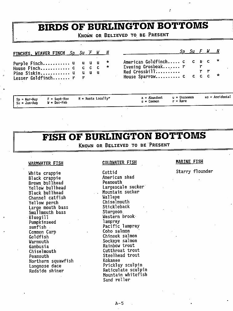
_. .—. . —-— — —. —. ———
{
BIDS OF BURLINGTON BOTTOMSKNOWN OR BELIEVED TO BE PRESENT
FINCHES,HEAVERFINCH ~p SU.FWN SPSUFWN
Purple Finch........... u Uu u * American Goldfinch..... c ca.c*House Finch............ c ccc* Evening Grosbeak...fi...r rPine Siskin............ u Uuu Red Crossbill’.......... rrLesser Goldfinch....... r r House Sparrow.......... c ccc*”
Sp=Mar-May F = Sept-Nov N = Nests Local lY* a = Abundant u = Uncmn ac = Accidental
Su = Jun-Aug W= Dec-Feb c = C-n r = Rare
. .
FISHOFBURLINGTON BOTTOMSKNOWN OR BELIEVED TO BE PRESENT
WARMWATER FISH
White crappieBlack crappieBrown,bullheadYellow bullheadBlack bullhead ,.Channel catfishYellow perchLarge mouth bassSmallmouth bassBluegillPumpkinseedsunfishCommon CarpGoldfishWarmouthGambusiaChiselmouthPeamouthNorthern squawfishLongnose date ~Redside shiner
COLDWATER FISH , - MARINE FISH
Cottid Starry flounderAmerican shadPeamouthLargescale suckerMountain suckerWal1eyeChiselmouthSticklebacksSturgeon,Western brook1ampreyPacific lampreyCoho salmon ~Chinook salmonSockeye salmon ,Rainbow troutCutthroat troutSteelhead troutKokaneePrick~ey sculpinReticulate sculpinMountain whitefishSand roller
A-5

~PTILES AND AMPHIBIANS OFBU~INGTON BOTTOMS
KNOWN OR BELIEVED TO BE PRESENT
REPTILES CUR T&ESS AMPHIBIANS CUR T8ESS
Western Pond turtle...Western paintedturtle...............xWestern fence lizard..N;;;~n alligator. ...............Western skink.........Rubber boa............Ringneck snake........Racer.................Gopher snake..........Common garter snake... xN:;~~Sstern garter
..................xWestern terrestrialgarter snake.......... x
x ., x Pacific tree frog..... xRed-1egged frog.......
x Western toad..........x, Bullfrog..............x
Northwesternx’ salamander...........x Western red-backedx salamander...........x Long-toed salamander:. xx Ensatina.i............Xx ,’ Dunn salamander.......
Clouded salamander..... Rough-skinned newt.... x
xx
x
x
x
xX’x
<,
.
u
b
a’
C = Cm’n U = Uncmon R =Rare T&E = Threatened & Endangered Ss = State sensitive
A-6

.—. ————.—- —. “ .- . ..- _.—
I
I
(
!
I
I
b
I
1
. .
MAMMALS OF BUWINGTON BOTTOMSKNOWNOR BELIEVED TO BE PRESENT
oPOSSUM CUR T8ESS
opossum.............** x
SHREWS CUR T&ESS
Dusky shrew........... XTrowbridge shrew...... XVagrant shrew . . . . . . . . . xPacific water shrew... x
MOLES . CUR T&ESS
Shrew-mole.● .......... xTownsend mole......... xPacific mole..........X
,-BATS CUR T8ESS
Little brown myotis.... xFringed myotis........ x xCalifornia myotis..... XYuma myotis........... XLong-eared myotis..... xSilver-haired bat..... .XRed bat............... xBig brownbat......... XHoary bat............. xW;::ern big-eared
.................. x x
CARNIVORES C U R T&E SS
Black bear............ xRaccoon.............*.xShorttail weasel...... XLongtail weasel....... XMink.................. x“River otter........*..xSpotted skunk.....<...xStriped skunk......... x
CARNIVORES C U R T&E SS..
Red fox.,.....===”x==”xGrey fox.............. xMountain lion......... xBobcat................ x.California.seali6n... xHarbor seal.:.==-=.”== x .Coyote................ x
RODENTS ‘ C’URT&ESS
California groundsquirrel..........● ** x
Townsend’s chipmunk... xChickaree............* xFox squirrel.......... XNorthern flyingsquirrel............. xBushytail woodrat..... xDusky footed woodrat.. xDeer mouse............XTownsend vole......... XLongtail vole......’...XOregon vole.........=-xPacific jumping mouse. XHouse mouse...........XNorway rat..........””x.Black rat............* xBrush rabbit.......... xBlacktail jackrabbit.. xEastern ‘cottontail.... XBeaver................ xMuskrat “............... xNutria................ xPorcupine ‘.............. x
CERVIDS CUR T8ESS
Black-tailed deer..... xElk................... x
C = Croon U = Uncmn -R=Rare . T&E = Threatened & Endangered. Ss = State sensitiveI
. . .
1.,
A-7,.
————— . .--—

— —-..-—-—-- —-: . . ..—.
APPE~= B
P- SPE~S AT Bm~GTON BO~OMS
,
1,
“
\
—..

—- -- :–-—-. — .-. .,,
1
f
,,
,,
,
~.AppendixB
Plants of Burlinwon Botto~s Natural -es,—Multnom~ County, Oregon
Oregon Natmal Heritage Pro~am
/
He~bs ,
c~litrichecdlitriche
,
PONDS .-emergent marsh and a~atic beds
heterophyllastagnalis
Ceratophyllun demerrsunBlodea canadensisGratiola neglects .Umna minor~dwigia pdustris
‘- Myriophyllun’ hippuroidesHyriophyllum spicatumHavarretia sp.Polygonum amphibiumPolygonun hydropiperoidesPotamogeton epihydns .Pot=ogetop crispusPotamogeton pectinatusSagittaria latifoliaSparganiun emersumSpirodela polyrtiza ..Pypha latifolia
Grasses and sedges
.
Cyperu; erythrortizosEleoch=is ovata .Eleoch=is pdustris .Glyceria.tireal$s .~UnCUS bufoni~sJuncus effusus ..Juncus o~nerisJuncus tenuis ~Phdaris arundinacea
Different-1eaved water-st~otiPond water-starwoti .CoontailCanadian waterweed~erican hedge-hyssopDuckweedWater pwslaneWestern water-milfo’il
. ,
Spiked water-milfoilNavarretiaWater smartweedWaterpepperRibbon-1eaf pondweed.Curled pondweedFennel-1eaved pondweed .WapatoSinplesten bur-reedGreat duckweedBroad-leaved cattail
Red-rooted flatsedge ~Ovoid spikerushCreeping .spikerushNorthern mannagrassToad. rush .soft mshPointed rushSlender rushReed canary grass .
.
B-1

. .
. . .
Stis
Rubus
Herbs
WET PAS-
discolor
Chrysanthemum leucanthemunCirsium ~enseCirsiun ~gareGeum macrophy~lum
Grasses and, sedges.
Xopecuws a~alis-Zopecu=s pratensis~thoxanthum odoratumCarex sp.
‘- C~ex apertaFestuca arundinacea-Holcus lanatusZordeum brachyantherumPhalaris ondinacea
Himalaya blackberry
Oxe-eye daisy-ada thistleBull tiistle .Broad-leaved avens
Shortawn foxtailMeadow foxtailSweet vemal.yrassSedgeColumbia sedgeTall fescueVelvet grassMeadow barleyReed canary grass
,, .
. Trees
~nus rubra .Prminus latifoliaPopulus trichocarpa
shrubs
Cornus stoloniferaCratae~s douglasii-s fusca~amnus purshiana.Ritis Sp. .Rosa nutkanaRubus discolorRubus p-iflorusRubus ursinus .Stiix lasiandra
. S&ix sitchensisS-urns racemosa.Spiraea douglasiiSymphoricarpos &bus
-.
Red alderOregon ashBlack cottonwood
[email protected] hawthorn .eabappleCascara . .GooseberryNootka rose !
Himalayan blackberryThitileberryTrailing blac~erry.Pacific willowSitka willow O\ ,Red elderberryDouglas spiraeaSnowberry.
. B-2
-—.— -.— .--— — ,.. .”, -. .,.,: -—— y - -,, ,. ..:a::~~ :,,
—--,—-- ---- ,- --- - ; ---. . . . ,,

.. . _ —-- ———. .
-..
Herbs and ferns
AruncussylvesterAthyrium filix-fetinaBidens frondosaEguisetum mense %Gdiun aparineGlee.ona hederacea
,, Impatiens capensisLvsinachia nummulariaP;lypodium gly~rhizaPolystichum munitum ~Rnunculus repens~mex’occidentalisSolarium dulcamara
GoatsbeardLady fernBeggars tickComon horsetailBedstrawGround ivyJewelweed ,Moneywort
Licorice feti .Sword fernCreeping buttercupWestern dockBittersweet nightshade
Tellima grandiflora Fringe-cup - ‘Urtica dioica - Stinging nettle
Grasses and sedges.J.
Carex deyeyana . Dewey’s sedgePhd=is arundinacea Reed canary grass
.
UPMDS - wooded margins and disturbed areas
Trees ,.
Acer.macrophyllunFraxinus latifoliaPrunus sp.Prunus sp.Prunus emarginata~ercus g~=a
Bigleaf mapleOregon ashCherry (mltivar]Plum (cultivar).Bitter cherryOregon white oak
Shrubs
Corylus Sp.. .*Crataegus douglqsiiCytisus scoparius .Ho16discus discolorRosa multifloraRubus.discolorStiix scouler+ana
Herbs and ferns ,.
~tetisia dougl.asianaBarb=ea orthoceruBozagO officinalisCerastium wenseC~santhemun leucanthemun .
Filbert (cUltivar)Douglas- ha~omScots broomOcean sprayMultiflora roseHimalayan blackberryScouler “willow
.,
. .
Douglas Sagewort~eric= wintercressBorageChickweedOxe-eye daisy
.
.
B-3

~., i
Cirsium menseCirsiuM ~lg~e .Conium naculatihConvol~lus sepiumCrepis sp.Dauas carotaDigitalis purpukeaEpilobium [email protected] telmateiaG~ium ap~ineGera&um mOlle .Eypericun perfora~m~v~ochaeris radicataZi;tuca serriola~psana communis
. .titus cornimltatusMedicago lupulina.Plantago najorPteridium aguilinum
~.~mex acetosella. ~mex crispusSenecio jacobeaSher=dia arvensisSolidago canadensisFanacetim vulgarePrifoliun wetieVicia villosa -
Grasses and sedgeS
Agropyron repenstira cqophylleaAgrostis sp.tiopecuns pratensismthoxanthun odoratunBxomus mollisBromus rigidus
-.. Festuca arundinacea. Holcus lmatus” . -
Phalaris ~ndinacea ,
.
Canada thistleBull thistlePoison hemlock “BindweedHawksbeard .Wild carrotFoxglOVeWatson’s willow-herbGiant horsetailBedstrawDovefoot,geranimSt. JohnswortFalse dandelion .Prickly lettticeNipplewortBird-foot .trefoilBlack medicComon plantain . .Bracken fern. . ,Sheep sorrelCmly dockTansy ragwortBlue field-madderGoldenrodTansyHare/s-footHairy vetch
Quack grassSilver hairgrassBentgrassMeadow fotiailSweet vernal grasssoft bromeRipgutTall fescueVelvet grassReed canary grass ‘
. ..’
!
B-4
.
,
‘.
w

.— ------ . ———. —--- --- -_—.
o
\
,,
.
\
i
“
I
——. — ----- -

.’
B~L~GTON BOTTOMS RECREATION S~Y
A recreational master plan for the Burtigton Bottoms site was developd in 1993 toprovide a framework for the management of on-site recreational activities that arecompatible with the Bonnetie Power Administration’s mitigation go~ and objectivesidentied for the area These gods and objectives include maintaining and enhancing the ,etisting time habitat
I
1’ Recreationd,types included in the master plan were derivd from meetings beween theOregon Department of Fish and Wfi~e, The Nawe Conservancy, Bonne~e PowerAdminis@ation, Mtitnomah County Parks Department and numerous private interestogroups and private citizens. Ideas for recreation ranged horn low impact activhie~ such asw~g and tid~e vie~g, to higher impact activities such as canoeing and dog~aining. Each of the identid activhies were evaluated for it’s potential impact upon the
‘ etisting environmen~ as we~ as for compatibfity witi the gods and objectives for thearea. me “best use” gods includd titing human access onto the she, providing for
,education and research opportunities, and having interpretive signs andor facfities forthe area
Three levels of recreational impact were developd, v-g from a low level of impact -
(Option One),toa high level of impact (Option Three). Option One contains recreationalactivities that need very tier site improvemenfi. .@tions TWO~d ~ee PrOPOSeactivities with progressively more intense site improvements and activities.
The find recreation plan for-~temative 1 for the Burtigton Bottoms ManagementPl@nvironmenti Assessment was devehpd using information from the recreationalmaster pIan that met the gods developd for the site. The main emphasis of the recreationplan for Mtemative 1 is to provide tited pubfic across, wtie preserving &d protectigthe time and time habitat of the ma
‘1
.,
c-1
.————.—-—. .-


.——— .. . . . —- ——.,
I ,:
0
#
OF 1853~ 1854
.,
. .
#
.
u
,
.
.— . .

~~W=ATION OF HETOWC SURVN NO~ FORBURL~GTON BO~OMS NATURAL Am,
WL~OMAH COUN~, O=GON
.JohnA. Christy
OregonNaturalHeritageProgram , -. 1 September1993
m
Burlington Bottoms was described in 1853 as level, wet ~d sparsely timbered,containing groves of ash md open prairie. Much of the interior was occupied by
pond or sloughs. Witness trees included willow, cottonwood, mh and crabapple in thelowlands, with these as well as oak and cedar on slightiy higher ground near what isnow Highway 30. In at least one are% the bank rdong Multnomah Channel was 20feet high. A house and smrdl field occurred along Multnomah Channel, andapparently two alignments existed for the road be~een Portland md St. Heleris. .
J.
Sqction lines crossing Burlington Bottoms, in T2N, RW, were first surveyed by Joseph Hunt ,in November 1853, under contract with the General Land Office (GLO). A donation lad ~claim (DLC) had been established previously on a po~ion of Burlington Bottoms by James
“ Taylor (Tailor?). Under terms of the Donation Land Act, the GLO contracted Peter W.Cratiord to sutiey Taylor’s claim @LC 52) in August 1854. On the modem USGS map,”DLC 52 is superimposed on portions of sections 17 and 20.
Surveyorswererequiredtodescribebrieflythechangesintopography,woody vegetationmdsoilsalongthelinesthey surveyed, and to summarize these features at the. end of each line. ‘When section and quarter section corners wereset,bearings were taken to witness trees, andthe species, diameter and distance to each tree was recorded in chains and links. Treesencountered along the survey line were dso recorded. Finally, at the” end of the survey, thetopography md vegetation oftheentire township w= described briefly, ad a plat map of the
. township was prepmed at a scale of 1:31,680 (2 in = 1 mi). Existing farms and roads wereshown on the maps, as well as natural features.
o
If large enough, wetlands and prairies were .4s0 mapped. Because the surveyors wererequired to list only woody spec]es in their des~riptions of vegetation, the herbaceouscomponents of these habitats can only be inferred from what we know-of similar survivingexamples. The location of these habitats therefore can be plotted, but their vegetation cannotbe determined with certainty. “
,.
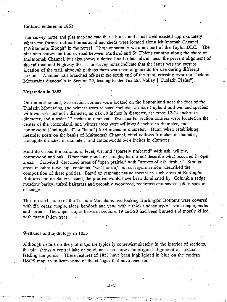
Cultuti featules in 1853
The suney notes md plat map indicate that a house and small field existed approximatelywhere the former railroad turnaround and sheds were located along Multnomah Channel[“willame~e Slough” in the notes]. These apparently were not part of the Taylor DLC. Theplat map shows thi trail or road beween Portland and St. HeIens running rdong the shore ofMultnomah Channel, but dso shows a-dotted line farther inlmd near the present alignment ofthe railroad and Highway 30. The survey notes indicate that the latter was the correctlocation of the trail, although perhaps there were two alignments for use during different
, se~ons. Another trail branched off near the south end of the tract, crossing over the TurdatinMountains diagondly in Section 29, leading to the Tudatin V#ley [“Tudatin Plains”].
vege~tion in 1853.
On the bottomlan& two section comers were located on the bottomland near the foot of theTurdatin Mountains, and wikess trees selected included a mix of upland and wetlmd species:willows 6-8inches in diameter, an oak 30 inches in diameter, ash trees 12-14 inches in
+dimeter, and a cedar 12 inches in diameter. Two quarter section comers were located in the‘center of the bottomland, and witness trees were willows 6 inches in diameter, andcottonwood [“bdmgilead” or “balm”] 6-14 inches in diameter. Hunt, when establishingmeander posts on the banks of Multnomah ChanneI, cited w“llows 6 inches in diameter,crabapple 6 inches in diameter, and cottonwoods 6-14 inchesindiameter.”.
Hunt described the bottoms m’ level, wet and “sparseIy timbered” with ash, willow,cottonwood and oak. Other than ponds or sloughs, he did not describe what occurred ;nopenareas. Crawford described areas of “open-prairie,” with “groves of ash timber.” Similarareas in other townships contained “wet prairie,” but surveyors seldom described thecomposition of these prairies. Based on remnant native species in such areas at BurlingtonBottoms and on Sauvie Island, the prairies would have been dominated by ,Columbia sedge,meadow barley, tufted hairgrass and probably woodreed, reedgrass and several other speciesof sedge. i $
The forested slopes of the Tudatin Mountains overlooking Burlington Bottoms were coveredwith fir, cedar, maple, alder, hemlock and yew, with a thick understo~. of vine maple, herbs ‘<and briars. The upper slopes between sections 19 and 20 had been burned and mostly killed,with many fallen trees. , ~ 1-
/
\Vedmds and hydlalogy in 1853 . -
Although details on the plat maps are typicalIy somewhat sketchy in the interior of sections,the plat shows a central lake or pond, and dso shows’ the original alignment of streamsfeeding the ponds. These features of 1853 have been highlighted in blue on the modernUSGS map, to indicate some of the ch~ges that have occurred. ,
D-2

Thecentral pond of 1853 included much of themodem configuration of theponds, adappears to have extended to the junction of the streams near the present heron rookery. Thesouthern end of the pond, crossed by the line between sections 21 ad 28, was 132 feet wide.A pond dso straddled the ~ bound~ of the site.
Three major streams fed the site with runoff from the Tudatjn Mountains. The two streamsupstream from Burlington Bottoms drained directIy into Multnomah Channel, and at that timedid not contribute to the water budget of the interior pond. The tidd stream draining the ~central pond was 66 feet wide where it was crossed by the line be~een sections 17 and 20.Reworking by subsequent floods, particularly that of 1894, may have been responsible for.some of the changes seen today in configurations of ponds ad streams.
Crawford noted that the site would flood to a depth of 8 feet during the annual spring flood.. .
1 . .
Topogmphy in 1853
‘ , The notes contain little information on topography, other than noting that the bottoms wereJ kvel. However, the suweyor described a 20-foot-high bank on the shore of Multnomah
Channel, where he set a meander post for the line between sections 21 and 28. This sjte iswhere the railroad grade paralleled Multnomah ChanneI, and shows that at least some of thebmks were troll, built up as natural levees during floods, ,md tha; not d] of the shoreline wasdiked in Iater years. There are examples of natural levees on Sauvie Island, with banks ofsimilar height to those observed by the GLO surveyors.
I,.
,.,,D-3
-.

Tmnscxiption of ~neti kd Office suwey notes for Buliington Bottoms.
T2N RIW - Surveyed by Joseph Hunt, November 1853 [Only potions relative to the ‘,
section lines crossing Burlington Bottoms are included here]
Nofi69008000
s Westa,6545
70008030
North300
120030004000
50505250
II tl
bemeen sees 28 & 29 ~ from qutier section post]A trail course westSet post comer to sees 20,21,28 & 29 ‘from whjch
P
A Willow 6 in dia bears N30E 357 lksA ,, , 6 1! “, S88E 287 “ ,“
A Oak 30 “ “ S40W 74 “A Willow 8 “ “ N15W 315“ ..
Ground hilly with a general descent to the’East. Soil second rat,e & stony. ,Timber fir,cedar, hemlock. [This refers to the forested slopes of the Tualatin Mountains,overlooking Burlington Bottoms]. . .
)n the line between sees 21 & 28 .,
Over slough ~ultnomah Channel] and set meander post on bank 20 feet high fromwhich ,.A slough 2 chs wide course N1 OWTo section comerLand level bottoms. Sparsely timbered with ash, balmgilead, oak etc. Soil first rate. ‘
)n the linebetweensees’20& 21 ,.
Fr apondoffset4 chswestCame backtoline
\
‘FrtheeastpointofapondSetqtrsecpostfromwhichA Balm 14indiabearsS85E 32 lksA Willow 6 “ “ N88W 515 “ .
EnterfieldcourseeastA Bdmgilead20 india‘formeandercorneron theleftbankoftheWillametteSlough . , ‘[MultnomahChannel]fromwhjchA Balmgjlead 20 india”bearsS45W 93 Iks “A House bearsN40W 5 chsdist 4
Thencefora b~e N30W 828IksOverslough[MultnomahChannel]...
North bet sections 19&20 [from qtr sec post] ~ .4500725074508000
----~—. -——.
Summit of line course NW : “To a stream 3 Iks wide course NE ~~A fir 60 jn diaEnter bottoms course S45E
D-4

Set ‘post comer of sections 17,18,19 and 20 from whichAn Ash 14 in dia bears N62E 68 lks .
A “ . 12. ” N55W 74 “
A Cedar 12 “ . ~S50W 100 “ ~Ground very hilly & broken. Soilkilled by fire. “
2nd rate. Timber fir, maple & on S hdf mostly
i.west on thetrue line bet sees.17 &202345 A willow6 in dia for meander corner on the left bank of the Willamette Slough
tl[Multnomd Channel] from whjch.A crabapple 6 in dia bears N80W 70 Iks
2500 A slough 100 lks wide course north\
4010 Set qtr sec post from whichA Balm 6 in dia bears N55E 330 lks ‘ ~ ~
, A Willow 6 “ “ “ S15W 114 “
6700 A stream20 lks.widecourseS70E,8020 To sectioncorner .1. Land levelandwet.Sparselytimberedwithash,willow,bdmgileadetc.
West on the true line bet sees 20 & 291300 To a stream 2 Iks wide course North ‘,2000 A Ridge course S 60E ....
General Description of T2N, R1 W, November 1853
Allthat portion of thjs township east .of the Willamette River and slough of theWillarnette [Multnom* Channel] is elevated from 5 to 20 feet above the river. Soil .rich vegetable loam. Alternatively’ wet prairie and low narrow ridges of tjmber andbrush very much cut up with sloughs, lakes, ponds, marshes etc. The greater portion -of which is subject to annual inundation va~ing from one to fifteen feet deep. Timber
,h willow, bdm gilead, thorn etc. On the western portion of Sauvies island there is someoak, fir, yew, maple etc. Sauvies Island is considered ve~ vaIuable for pasturage. Itis too wet except on the highest pIaces for agriculture. All that portion of the
ototiship west of the -WilIamette River & the slough of the Willamette [Multnomah
1 Channel] is hiIly” or mountainous [except Burlington Bottoms], soil 2nd and good 2nd1
rate clay loam, some portions very stony. Maple, alder, cedar, hemlock, yew etc.PartiaIiy burned and fallen’ with a thjck undergrowth of vine maple, herbs, brjars etc.
!,.
D-5
.- ..— —

..
< ,
. Tmnscliption of Donation hd ~tinl sulvey notes for Buliington ~ottoms\
Donation Land Claim 52 [James Taylorflailor]. ‘Su&eyed by Peter W. Crawfotd, August1854
[Most of notes with little useful information].”.,
Open prairie; grove of =h timber. Land low”; h= the appearance of being [overflowed to the , 0
depth of 8 feet. n
., ...>.
‘- ,’
,
i.,
D-6-’ .’

. .—. .’ - ——. ,

Y
,,
.—. - .-, --- .—— ..— —,.
.
~TONCM PHOTOGMHS “ “
.
. .
.
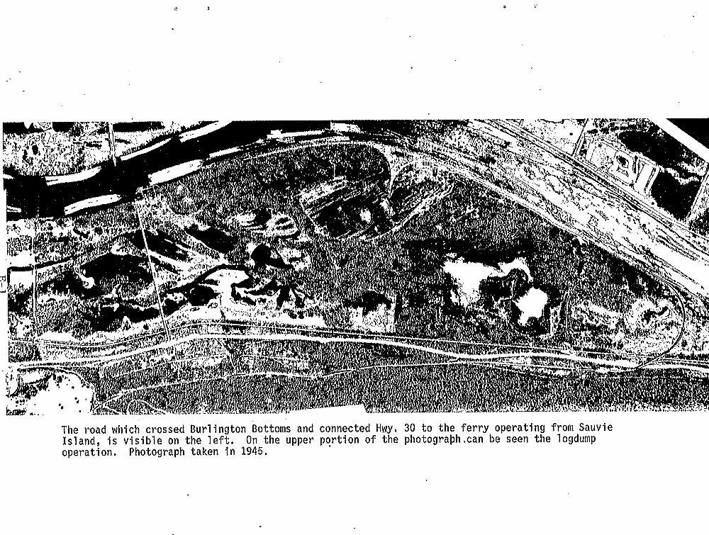
.—..—
——
.
.Q,
.-
.=>
-.—.
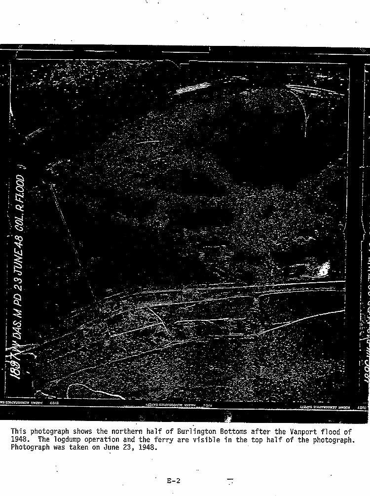
‘. .
. ..
E-2 ..

.“
This photograph shows the south half of Burlington Bottoms after the Vanport floodof 1948. The logdump operation is visible in the upper right portion-Photographwas taken Gn June 23, 1948.
. .
E-3—--
—-———-—

This photograph was taken on, November”19s 1956. The bridge to Sauvie Island is visiblein the center of the photograph.
E-4 —
.——-~ .–-—--- - ,> -, j— , , —-~ ----—-—- — .,, .,?,. , .. . ,. ,, . .,” ‘,.

I
,
.—. -—..-. — —.—
.
Logbooms from the Iogdump operation are visible in Multnomah Channel, located tothe left (east) of Burlington Bottoms. Photograph was taken on December 9, 1963.
E-5 - —.’ ,
..—..

. . ..__
4
(1
This photograph was taken on January 30 , 1980.’ The ‘logdump operation was no longeroperating.
E-6 ..
I

——. _ _ ._ ._ ..__ .. .--- .-: ..” ,. .
.
\’
.
.
,.
,

.—,— —-. ..— — -... , — --
2600 SE 98th Avenue,Portland, Oregon
,...
Suite 10097266
October 14, 1993
Ref : 1-7-94-SP-3
Carlene R. FleskesDepartmentof EnergyBonnevillePowerAdministrationPO BOX 3621’Portland, OR 97208-3621
RE: PGA
Dear Ms. Fleskes:
This is in response to your letter, dated September 21, 1993, requestinginformation on listed and proposed endangered and ,threatened species that maybe present within the area of the Burlington Bottoms Wetland Purchase inMultnomah County, Oregon. The U.S. Fish and Wildlife Service (Service)received your letter on September 22~ 1993.
We have attached a list (Attachment A) of threatened and endangered speciesthat may occur within the area of the Burlington Bottoms Wetland Purchase.The list fulfills the requirement of the Service under Section 7(c) of theEndangered Species Act (Act) of 1973, as amended (16 USC 1531 et seq.). TheBonneville Power Administration’s (BPA) requirements under the Act areoutlined in Attachment B.
shouldBPA’s biological ‘assessment determine that a listed species may beaffected by the project, the BPA should consultwith the Service following therequirements of Federal Regulation 50 CFR 402 which implement the Act.
.. Attachment A includes a list of candidate species under review for listing.
These candidate species have no protection under the Act but are included forconsideration as it is possible candidates could become formal proposals and
o be listed prior to project completion. Therefore, if the proposed project mayaffect candidate species, BPA is not r’equired to perform a biologicalassessment or to consult with the Service. However, if early evaluation ofthe proj’ect indicates that it is likely to adversely impact a candidatespecies, the BPA may wish to request technical assistance from this office.
F-1
-. . . . .
Your interest in endangered species is appreciated. If you have ~estionsregarding your responsibilities under the Act, please contact Laura Todd at(503) 231-6179. For ~estions regarding anadromous fish, please contactNational Marine Fisheries Service, 911 NE llth Ave., Room 620, Portland,Oregon, (503) 230-5420. All correspondence should include the abovereferenced case number.
Sincerely,
9&w ~*,
Ru ell D. PetersonState Supervisor
Attachments \,,
SP3
ONHP/LT/NP
cc: OSO-ESISO-SEODN (Nongame) ‘ONHP
2
*,
,
u
. .
F-2 .
—— --,-,- -——— . .. ,..—— .-,- - —-— . . -.. .....,- ,.,. :? .,,,. ,.,., ,,
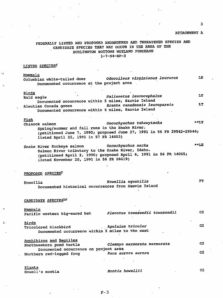
.-—. -–..——— .-
-,
ATTAC=NT
FEDERALLY LISTED AND PROPOSED ENDANGE~D AND -ATENED SPECIES ANDCANDIDATE SPECIES THAT MAY OCC~ IN THE AREA OF THE
B=INGTON BOTTOMS WT_1-7-94-5P-3
LISTED SPECIES~’——
P~CHASE
3
A
MammalsColumbian white-tailed deer Odocoileusvirginianusleucurus LE .
Documented occurrence at the project area
BirdsBald eagle Haliaeetusleucocep~alus LT
Documented occurrence within 5 mileg, Sauvie Islandaleutian Canada goose Brantacanadensisleucopareia LT
Documented occurrence within 5 miles, Sauvie Island\
~Chinook salmon Oncorhynchustshawytscha **LT
Snake
Spring/summer and fall runs in the Snake River.(petitioned June 7, 1990; proposed June 27, 1991 in 56 FR 29542-29544;listed April 22, 1991 in 57 FR 14653)
River Sockeye salmon Oncorhynchusnerka **LESalmon River tributary to the Snake River/ Idaho.(petitioned April 2, lggo; proposed April 6, 1991 in 56 FR- 14055;listed November 20, 1991 in 56 FR 58619)
..
PROPOSED SPECIESY
Howellia HowelliaaguatilisDocumented historical occurrences from Sauvie 151and
PT
CANDIDATE SPECIES~a
v MammalsPacific western big-eared bat Plecotustownsendiitownsendii C2
L BirdsTricolored blackbird Agelaius tricolor C2
Documented occurrence within 5 miles to ‘he ‘ast .
Amphibians & ReDtilesNorthwestern pond turtle Clemmys marmorata marmorata C2
Documented occurrence on project areaNorthern red-legged frog Rena aurora aurora C2
PlantsHowell$s montia Montia howellii C2
. F-3

Colutiia crbssDocumented
Rorippa
historical occurrence fromcolutiiae
Sauvie IslandOregon suilivantia SulJivmtia oregma
Attachment At Page 2
C2
C2
Documented historical,occurrence from Sauvie Island
(E)-fidangered (T) - Threatened (CH) - Critical Habitat
(S)-Suspactad (D) - Documented
(cl)-
(c2)-
(3A)-
(3B)-
(3c)-
Categoryl: TaxaforwhichtheEshandW/d/ife Servicehass~cientbiologicelinformation to supportbproposal
to list as endangered or threatened.
Category2: Taxafor which axisting information indicates maywarmntlisting, but forwhich substantialb;o/ogical
information to supportaproposedrule isiacking.
Category3A: Taxaforwhich thaServicehasperauasive evidenceofextinction.
Category3B: Names thatonthe basis ofcuvant taxonomic unde~tanding donotrapresent taxamaetjng the Act’s
definition of ‘species= .
Category3C: Taxathathavaprovan to bemoreabundant orwidaspread~an waspreviously believed andlot those
thatare notsubjact toanyidentifiab/e thraat. .
● lfavafiebrate orp/ant, asingla asterisk indicates taxonispo=ibly extinct. Faninvertabrata, asingla asterisk indicates
a /ac& of information for the texon sinca 1963.● ● consultation with Nati”onal Marine Fisheries Service raquired.
,,,Q
~ U. S. Department of Irttatior, Fish and WldFfa Service, July 15, 1991, &danqarad ~d ~reatened Wldlife and Plents,
50 CFR 17.11 and? 7.12.
I ~ Federal Register Vol. ,58, No. 72, April 16, 1993, Proposed Rul&Howellia aquati~s
g fideral Ragister VOL 56, No. 225, November21, 1991, Notice of heviaw-Animals
fit Federal Register Vol, 55, No. 38, Fabruary 2 ?, 1990, Notice of Raviaw-PIants
,0
(1
,, ____ .._—— —— _——.& . . ——
,
ATTACHMENT BFEDEWL AGENCIES RESPONSIBILITIES UNDER SECTIONS 7(a) and (c)
OF THE ENDANGERED SPECIES ACT
SECTION 7(a) -.Consultation/Confer-ceRewires: 1) Federal agencies to utilize their authorities to carry out
programs to conserve endangeredand threatened species;2) Consultationwith FWS when a Federal action may affect a
listed endangered or threatenedspecies to insure that any action authorized,funded or carried out by a Federal agency is “notlikely tp jeopardize thecontinued existence of listed species or result in the destruction or adversemodification of Critical Habitat. The process is initiated by the Federalagency after t~ey have determined if their action may affect (adverselyorbeneficially) a listed sPecies; and
3) Conferencewith FWS when a Federal action is likely tojeopardize the continued existence of a proposed species or result.indestruction or adverse modificationof proposed Critical Habitat.
SECTION 7(c) - BiologicalAssessment for ~jor ConstructionProjects 1’Rewires Federal agencies or their designees to prepare a Biological ‘Assessment (BA) for “constructionprojects only. The purpose of the BA is toidentify any proposed and/or listed s?ecies which are/is likely to be affectedby a construe- tion Project. The process is initiated by a Federal agency inre~esting a list of proposed and listed threatened and endangered species(list attached). The BA should be completed within 180 days after itsinitiation (or within such a time period as is mutually agreeable). If the BAis not initiated within 90 days of receipt of the species list, the accuracyof the species list should be informallyverified with our Service.. Noirreversible commitment of resources is to be made during the BA process whichwould foreclose reasonable ad prudent alternatives to protect endangeredspecies. Planning, design, and administrativeactions may be taken; however,no construction may begin.
To complete the BA, your agency or its designee should: (1) conduct anon- site inspection of the area to be affected by the proposal which myinclude a detailed survey of the area to determine if the species is presentand whether suitable habitat exists for either expanding the existingpopulation or for potential reintroductionof the species; (2) reviewliterature and scientificdata to detemine species distribution,habitatneeds, and other biological re~iremmts; (3) inteniew experts includingthose within FWS, National Marine Fisheries SeNice, State conservationdepartments, universities,and others who may have data not yet published inscientific literature;,(4) review and analyze the effects of the proposal onthe species in terms of individuals~d populations, including considerationof cumulative effects of the proposal on the species and’its habitat; (5)analyze alternative actions that may provide conse=ation measues and (6)prepare a report documenting the results, including a discussion of studymethods used, any problems encountered,and other relevant information. TheBA should conclude whether or not a listed or propos~ species will beaffected. Upon completion, the report should be forwarded to our PortlandOffice.
~/A anstrutiion pmjxt (or other udertakfng having sfmf lar ph~fa 1 impcts) tifch is a ~or F&era 1
act ion significant lY affti ing the qualityof thehumanenviti-nt as =ferti to inNEPd(42“u.S.c.4332.(2)c). & proj~ts other than mnstn+ion. it is svggesti that a biologim 1 evaluation similar ti
tk bio logi- 1 assessment b udertaken to arise- s~ies inf ?ue& by the Edange& Swies M.
F-5

—.— ~ ._, ..— ..— — -— _
—— .—.—.-—
1.,
%
\..* , ..-
..’”..- ,-.:\-~.’.-.“.~kx.-.
::-: :: --- ::. : -,. .
August 24, 299.4
Carlene FieskesBonneville Po*-ei+’ Administi-ation
. P. O.Box 3621Portland,Oregon $~~~~ ,,
~ RE: Burlington Bottoms Proposed ifanagement Plans
Dear .Vs.Fieskes:
I There has been an incrpase in wrildlifeand riat~ve plant speci~s in the past 3years since cattle grazing’ceased.to see this trend continue.
This is encouraging, and it would be goodThe swans which used to winter there regularly,
, have not yet returned hOWeVei.. ,-
As development pressures continu= to inci*ease in .a~~acer~t ~.i’~a.~: it isimportant to uphoid the w~ldlife habitat enhancement goai. Good luck in~S~a~liShinga responsible plan. if 1 may be oi any. assistance whatsoever”:please let me know.
o
. .

25 August 1994 ( /
Carlene FleskesBonneville Power Administration
v,
PO BOX 3621Portland; OR 97208 ‘ ,V
Dear Ms Fleskes,
We have reviewed and discussed the proposed Burlington ,Bottoms Wildlife Mitigation Project Plan and offer thefollowing cements.
In general , we feel the plan is well researched,thorough and thoughtful, and gives strong and neededprotection to the Bottoms. Throughout, .it seems to detailconcerns and offers appropriate plans and alternatives. Wefavor ALTERNATI~ 1: MAINTENANCE AND ENHANCEMENT WITHLIMITED PUBLIC ACCESS. Alternative 2, with no publicaccess, deprives the public of the educational and wildlifeappreciation values of the Bottoms. It also would serve toincrease visitors to the Sauvie Island Wildlife Area, whichhas more than 800,000 annual visitors. Alternative 3, noaction, would not sufficiently protect the wildlife andhabitat values of]the site. We also recommend the p,roposedconcept of an on-site caretaker. ‘
But while the proposed plans for wildlife ana habitatare very good, the “proposed,recreation options are for themost part ludicrous and seem not at all in keeping with thepurposes of the Burlington Bottoms acquisition.
The Maps
The recreation maps included with the plan are almostiunintelligible. Even with the enlarged versions that wemade, the writing is difficult to decipher. ‘The map alsodoesn’t show Sauvie Island and the relevant areas that wouldbe affected by development at Burlington Bottoms< One lookat the indexed and color-coded versions we’ve included heremakes it pretty obvious that the proposed recreation sitesand activities fordetrimental impact
Options 2 and 3on wildlife and
G-2
would have an enormoushabitat.
-. —— . - ,,, -. ,.---- ..,.. ~__, . .-.. -,-—,, ,“, –
- ‘;.,:-’::”. ,, l, .-. . ; .:, -. ‘.’ ~ ,-.~!

.—. .- ----- .— —— — ———
Option 1-
We feel that even the “least impact” option is tooinvolved.. Human impact needs to be minimized .
The Trails. Conservancy members who frequent the Bottomsconf~rm that the birds are not accustomed to having humansaround and’are easily spooked. The plan should nottransform the Bottoms into an area that will attract peoplewho just want to hike. People frequently don’t stay on
., trails, and the more miles of trails you create, the m?reopportunities there will-be for visitors to adversely zmpacthabitat areas.
*
The Trails’ Impact on Wildlife. One of your targetmitigation species is the great blue heron, which is themost skittish of all wetl,andsbirds. In a wetlands studyconducted by San Diego State University; great blues tookflight when a person walking was 195 feet away -- comparedto a killdeer, at 15 to 40 feet.
Viewing Blinds. It also appears that there are a .voluminous number of viewing blinds. It’s been ourexperience on the island at Virginia Lakes that the viewingblind is unused and a target for graffiti. We recommendnatural vegetative blinds.
Proposed parking lot and other riverside development.We are also concerned about the proposed parking lot, whichappears to be directly across from the picnic area and boatdock at Hadley’s Landing on Sauvie Island. There have beenillegal structures on the mainland side that we have beenworking with the county to remove. We would hate to see theview then transformed into a parking lot or area with a lotof visible.human activity. We would also like to point out
.that the Willamette River Greenway OAR 660-20-025(2)(b) (B)states that “TO the greatest possible degree theintensification, change of use, or development will providethe maximum possible landscaping, aesthe;i~ enhancement,open space or vegetation between the actzvzty and theriver.ll
Interpretive Center. Any interpretive center should not be\ conceived as a Burlington-Bottoms-only information area.
Metro is currently working on an interpretive center forSmith and Bybee Lakes. There has been talk of eventuallyhaving some sort of interpretive center at Bybee Howell onSauvie Island and also at Ridgefield ~R. If we are totruly have a reaional qreenspaces program and master plan,then-all of the=e inte;preti;e centers should becoordinated.wildlife andexperiences.
,
Each one ;hould focus on a differentshould work together as complementary
aspect of
.
G-3
. ~.3
Perhaps Burlington Bottoms should focus on the PacificFlyway, Smith and Bybee should focus on the disappearing’ ‘wetlands history of’the area, tidgefield with its recentlydiscovered Native American village could focus on native “American history, Sauvie could focus on theinterconnectedness of the wildlife using all the areas.These various facilities should be developed in tandem, withthe appropriate people from the different agencies workingin close cooperation. We should also “considerMike Houck’slong-standing dream of a tyvec map (like the Portland Ibicycling map) of the,region’s natural areas, and a brochure’ fthat advertises them all;
Option 2 v
This proposal seems absurd, and not at all in keepingwith the basic management goal of “increasing the qualityand quantity of wildlife habitat.”
,,Inappropriate Uses. Your study states that these identifiedactivities were “evaluated for their compatibility with thegoals and objectives for the area.” How does a fitnesscourse relate to enhancing wildlife habitat? What about a .’
jogging trail? A picnic area?
Inland Canoe Route. Conservancy members who,frequent thesite have”said that the’’’inlandcanoe route” is ri~iculous;it wouldn’t even be navigable for most of the year without-major dredging.
Increasing Channel Use. We are concerned about developing a .canoe launch or ferry landing -- or any development along’ .’
the Multnomah Channel, for that matter. For the past fouryears wehave been actively fighting development along thecongested channel. The increasing development and usegreatly impact the wildlife who use the channel, includingthreatened and endangered species like bald eagles andperegrine falcons. Also, if that proposed-site for thelaunch/landing extends into the channel and is across fromHadley’s Landing, it would violate”county zoning which doesnot allow “double~loading” of the channel.,.
Option 3
The color-coded version of this plan looks like an .amusement park, not a wildlife area. It’s appalling, andseems unbelievable that it could have been developed inconjunction with the agencies cited. For example, itincludes a mountain bike trail and horseback trail, both of,,which were specifically excluded in the new Sauvie IslandManagement Plan because they weren’t wildlife-basedrecreation. The same could be said for nearly all the other
swimming, picnicking, fitnessproposed recreation ~- ~
I
I
I

— -L-— ——— --——
training, saitioarding and dog training.developing a campground is unfathomable;
Our Conservancy, along with PortlandFriends of Forest Park, recently used our
.%- 4
To even consider .
Audubon’andown funds to file
an appeal to the Multnomah County Commission in oppositionto a proposed 140+ acre expansion of the figell BrothersQuarry which had been approved by the Planning Staff andPlanning Commission. We were concerned, based on the adviCeof expertsr that runoff from the ~arry would silt in theBottoms. We organized test,tiony which convinced the Boardof county commissioners to deny any expansion= We are very
comitted to helping to protect the Bottoms, and weappreciate this opportunity to comment on the proposed plan.
Sincerely,
Donna Matrazzotifor
The Sauvie lSlanq Conservancy
G-5
.
.—-

Dear Ys. Fieskes:
G-6

—.. ---- —- _— .—. —-
.-3,-
.G7

.. ->
,
h
“4.
\
.
G-8 .
—---—--- ---— ., __ - . .—~_.,:...”-<= -,, -., .....”... .,. ,-, .—.--— -:— --r, --- --—,.“.’ ..’. ~..—
,. .

I
“.
..,
I
I
.
n
.
Mrs. Sue Beilke
. .
States Department of the InteriorFISH AND WILDLIFE SERVICE
Potiland Field Office2600”S.E. 98ti Avenue, Suite 100
PotiIand, O&gon 97266(503) 2314179 F=: (503)-231-6195
September 6, 1994
Oregon Department of Fish and Wildlife17330 S.E. Evelyn St.Clackamas, OR 97015
Dear*Sue,
We have reviewed the Burlington Bottom8 Wildlife Mitigation Project,Prelfiinary Environmental Assessment/Managaent Plan. We are providing thefollowing comments for your consideration:
Page 9, Last paragraph.Would goose or osprey-negting platfo~s also have potential in thisarea? ,
Page 10, Section 2.1.2.1 Native Fish Management.We suggest you consider allowing some angling for resident fish,especially warmwater species. Anglfig could be restricted to onlythose non-sensitive wildlife areas or to certain tties of the year.A regulated angling program could provide a portion of the public usewhich is an tipo~ant part of the project.
Page 11, 2.1.2.2, Non-native Fish Management, First sentence.Delete ‘predatory” so as to include all non-native fish.
Page 14, Fourth paragraph.Consider adding temperature to the water Wality parameters to bemonitored. ~
Page 15, 2.1.4, Public Access/Recreation ManagementAs on page 10, we suggest warmwater angling be considered forcertain parts of Burlington Bottoms to provide a balanced publicaccess/resource management plan.
.Page 20, 3.2.3, Hydrologic Resources. Sekond paragraph.To emphasize that there are not any flood control dams on or nearBurlington Bottoms you may wish to rewrite the first sentence asfollows: “Prior to completion of the ~lumbia and-Willamette River floodcontrol dams in the 1960’s, an annual spring freshet inundated portionsof Burlin@on Bottoms”. .
G-9

Page 27? 5.1~ Objectives? Number 2 and Page 28, Number 2.It appears that only the “presence” of species would be monitored. ,We
sugge5t.that be e~anded to include monitoring the densities or relativenumber5 of 5pecies.
Thtik you for the opportunity to provide comments on the plan. If you have
any ~e5tion5 please call Larry Rasmussen at this office (503-231-6179).
LR/cb/mehC:caas2/09-01-94
,
/agtJ#.1 Senior Staff Biologist
●
.,
,“
G-10.,

— .. .’ _— .—-
mmG OF NO SIG~CANT MACT\ ,
. .
.

DEPAR~ OF=RGY
. Bonnevi~e Power Administration. -
Finding ofNo Si@cant hpact.@ONSI) for‘ .Burfingt,on Bottoms WddMe Mitigation Project
S~Y. BPA proposes to find tidfie management and enhancement activities forthe Burlington Bottoms wetlands mitigation site. Acquired by BPA in 1991, tidtiehabitat at Burlington Bottoms would contribute toward the god of mitigation for tid~elosses and inundation of tidMe habitat due to the constmction of Federd dams in thelower Columbia and WWamette River Bas@s. BPA has prepared an environmentalassessment @OE~A-0928) evaluating the potential environmental effects of theproposed project. Nternative 1 @reposed Action) ev~uated maintenance andenhancement of the property with hted pubhc access; Alternative 2 evrduatedmaintenance and enhancement of the property with no pubfic accesg and Ntemative 3evaluated the No-Action Ntemative. Maintenance and enhancement under Ntemative 1would not cause si~cant environmental impact because: (1) there would be no adverseimpacts on soils, air qutity, water qutity, tidme (including no effecton endangeredspecies), vegetatio~ fish and land usq and (2) there would be no effect on culturrdresources. Based on the anrdysisin the environmentrd assessment @A), BPA hasdetermined that the proposed action is not amajor Federd action si@cantly fiectingthe quatity of the human environment, within the meaning of the National EnvironmentrdPolicy Act @PA) of 1969. Therefore, the preparation of an environmental impactstatement @IS) is not required and BPA is issuing this FONSI.
FOR FURHR WOMTION AND COPES OF H E~ CONTACT: JohnTaves, Bonnetie Power Administration-EC-5, P.O. Box 3621, Portland, Oregon97208-3621, phone number 503-2304995. Or Charles Craig, Bonnede PowerAdministration - EWP/State, P.O. Box 3621, Portland, Oregon 97208-3621, phonenumber 503-23 1-6964; or the Pubfic.evolvement and Mormation office voice TTY 503-230-3478 in Portland, or to~ free 1-800-6224519. ~
Pubfic Availabifi@: This FONSI ~ be distributed to d persons and agencieshewn to be interested in or affected by the proposed action or dtematives.
,
Ie!
SUPPLE~NTARY ~ORMA~ON Under provisions of the Pacfic NorthwestElectric Power Planning and Conse~ation Act of 1980 Northwest Power Act), BPA has,the authority and obligation to find fid~e mitigation activities approved by theNorthwest Power Planning Councfl (Councfl) and included in the Councfl’s Fish andWlld~ie Program @rogram). The initial phase of mitigation planning for tidMe habitatlosses was submitted to the Councfl for amendment into the Program in 1989. TheProgram includes a process for review of habhat losses and design of mitigation plans foreach Federal hydro project in the Wtilamette and Columbia River Basins (Section 1002).In 1989, the Council amended the Program to include tidtie habitat losses resulting fromconstruction and operation of Bometie, The Ddles, John Day, and McNary Dams.Consistent with Section 1003(7) of the Program’s WddHe Mitigation Rule, BPA proposesto find projects that are intended to help reach the CouncYs mitigation gods.. BPA ,
!H-1
—---- .-—

I
finding would protide management of habitat management, recreatio~ hydrology,cultural resources, and pubhc access to the area.
Under Mtemative 1, the proposed adio~ control or eradication of non-native invasiveplant species and re-establishment or enhancement of native plants would be beneficial tofish and tidfife and would not si~cantly impact other environmental resources.
Control of non-native fish&d wildWepopulations through trapping and netting would bebeneficial by reducing competition with native species for resources.
Control of non-native invasive plant species at Burkgton Bottoms may include thebufing of vegetation Reed canary grass) in certain areas @asture habitat) and at certain
*
times of the year. This may cause, for the short te~ an increase in carbon monoxide and tsmoke particulate. Burning would be coordinated with the Oregon Department ofEnvironmental Qutity to ensure that impacts to air qutity would be minimal.
To avoid adverse impacts to fish and tid~e habitat, management of pubtic access willinclude the use of interpretive signs to educate visitors on the need to stay in designatedareas, using vegetation as a natural barrier to prevent off-trti use, andor having seasonalrestrictions on visitor access.
Timing and location of management activities @urning ofReed canary grass, mechanicalremoval of blackberries, and trapping of bu~ogs) would occur in such a manner as tofitie disturbance to native fish and wildMe, especidy during such criticrd periods asthe breeding season for watetiowl.
A cultural resource survey was petiormed on the Btirhgton Bottoms ~te in September of1994. No prehistoric materials were observed, possibly due to twentieth centu~ fll
, materird and dense vegetation which obscure the ground surface, hindering recognition ofthese resources. Any ground-disturbing activities (e.g., excavations or sutiace leveling)related to the constm,ction of the trd and tidtie viewing areas and the placement ofinterpretive signs W be monitored by an archaeologist since it is possible that unrecordedprehistoric sites exist beneath the ground surface.
Determination: Based on the Wormation in the E& sumrntied here, BPA1,
determines that the proposed action is not a major Federd action si@cantly tiecting the ,0 $
qutity of the human environment within the meaning of ~P~ 42 U.S.C: 4321 et seq.1
Therefore, an EIS til not be prepared and BPA is issuing this FONSI.I
{~ i
Issued in Portland, OregoL on Decemb6r 28,’1994.
/s/ Randafl W. Hardy
RandaUW. H&dyAdministrator and Chief Executive Officer,
H-2
!.. -. . ..-