calendar year 2013 report to the rio grande compact commission · calendar year 2013 report to the...
TRANSCRIPT
Calendar Year 2013 Report to the Rio Grande Compact Commission
Colorado
Dick Wolfe
New Mexico
Scott A. Verhines
Texas
Patrick R. Gordon
Federal Chairman
Hal Simpson
U. S. Department of the Interior Bureau of Reclamation Albuquerque Area Office Albuquerque, New Mexico March 2014
MISSION STATEMENTS
The mission of the Department of the Interior is to protect and provide access to our Nation's natural and
cultural heritage and honor our trust responsibilities to Indian Tribes and our commitments to island
communities.
The mission of the Bureau of Reclamation is to manage, develop, and protect water and related
resources in an environmentally and economically sound manner in the interest of the American public.
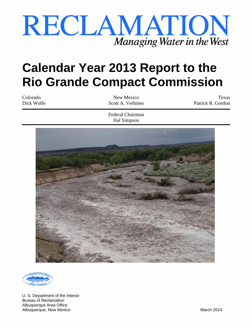
Cover photo – Flooding on Peralta Canyon Arroyo near Cochiti Pueblo (Aubuchon, 9/13/2013)
Calendar Year 2013 Report to the Rio Grande Compact Commission
U. S. Department of the Interior Bureau of Reclamation March 2013

Information contained in this document regarding commercial products or firms may not be used
for advertising or promotional purposes and is not an endorsement of any product or firm by the
Bureau of Reclamation.
i
Table of Contents
Table of Contents ........................................................................................................................... i
List of Figures ............................................................................................................................... iii List of Tables ................................................................................................................................ iii List of Photos ................................................................................................................................ iii Introduction ................................................................................................................................... 1 San Luis Valley Project, Colorado .............................................................................................. 3
Conejos Division, Platoro Reservoir........................................................................................... 3
Platoro Dam Facility Review and Safety of Dams Programs ..................................................... 4 Closed Basin Division................................................................................................................. 4
Operations ............................................................................................................................... 4 Maintenance ............................................................................................................................ 5
Water Quality .......................................................................................................................... 6 Rio Grande Water Conservation District ................................................................................ 6
San Juan – Chama Project, Colorado – New Mexico ................................................................ 7 San Juan - Chama Project Accounting ........................................................................................ 7 Heron Dam and Reservoir Operations ........................................................................................ 8
Heron Dam Facility Review and Safety of Dams Programs ...................................................... 9 Pojoaque Tributary Unit - Nambé Falls Dam and Reservoir .................................................... 10
Nambé Falls Dam Facility Review and Safety of Dams Programs .......................................... 11 2013 San Juan - Chama Outlook .............................................................................................. 12
Middle Rio Grande Project, New Mexico ................................................................................. 13 New Mexico Relinquishment of Rio Grande Compact Credit ................................................. 13 El Vado Dam and Reservoir Operations ................................................................................... 14
El Vado Dam Facility Review and Safety of Dams Programs ................................................. 15 U.S. Army Corps of Engineers’ Related Reservoir Operations................................................ 16
Cooperative Programs with the State of New Mexico .............................................................. 17 Delta Channel History (formerly known as the Temporary Channel) .................................. 17
Delta Channel Maintenance — 2012 - 2013......................................................................... 17 Irrigation Drain Improvements ............................................................................................. 17
River Maintenance .................................................................................................................... 18
River Maintenance Priority Sites .......................................................................................... 19 Truchas Arroyo ..................................................................................................................... 19
San Ildefonso Pond ............................................................................................................... 20 Peralta Arroyo ....................................................................................................................... 21 Santo Domingo ..................................................................................................................... 22 San Felipe.............................................................................................................................. 23
Santa Ana Restoration........................................................................................................... 24 Santa Ana River Mile 205.8.................................................................................................. 24 Drain Unit 7 Extension Spoil Levee ..................................................................................... 25
Drain Unit 7 Priority Site ...................................................................................................... 26 Bosque del Apache Sediment Plug and Habitat Restoration Project .................................... 27 Fort Craig Bend and River Mile 60 ...................................................................................... 27 Truth or Consequences ......................................................................................................... 28 Middle Rio Grande River Maintenance Plan ........................................................................ 29
ii
Determination of River Maintenance Need at Individual Sites and Reaches ....................... 30
Preparation for 2014 Spring Runoff ..................................................................................... 30 Endangered Species .................................................................................................................. 31
Programmatic Water Operations and River Maintenance ESA, Section 7, Compliance ..... 31
Rio Grande Silvery Minnow ................................................................................................. 32 Southwestern Willow Flycatcher .......................................................................................... 34 New Middle Rio Grande Water Management and River Maintenance ESA, Section 7
Consultation .......................................................................................................................... 37 Supplemental Water Program ................................................................................................... 38
Water Acquisition and Management .................................................................................... 38 Low Flow Conveyance Channel (LFCC) Pumping Program – San Acacia to Fort Craig
Reach..................................................................................................................................... 38 Other Ongoing Water Management and Water Quality Related Projects ................................ 39
U.S. Geological Survey (USGS) Groundwater/Surface Water Interaction in the MRG
Valley .................................................................................................................................... 39
USGS MRG River Gage Operation and Maintenance ......................................................... 39 RiverEyes .............................................................................................................................. 40
Middle Rio Grande Endangered Species Collaborative Program ............................................. 40
Rio Grande Project (New Mexico - Texas) 42 Water Supply Conditions .......................................................................................................... 43
Project Irrigation and Drainage Systems .................................................................................. 44 Elephant Butte Reservoir and Powerplant ................................................................................ 45
Elephant Butte Dam Facility Review and Safety of Dams Program ........................................ 46 Caballo Dam and Reservoir ...................................................................................................... 46 Caballo Dam Facility Review and Safety of Dams Program ................................................... 47
Rio Grande Project Adjudications ............................................................................................ 48
Rio Grande Project Operating Agreement ................................................................................ 49 Elephant Butte and Caballo Reservoir Vegetation Management Cooperative Agreement ...... 50
Other Reclamation Programs 51 The Secure Water Act ............................................................................................................... 51
Basin Study Program ............................................................................................................ 51
WaterSMART Grants ........................................................................................................... 53 Title XVI Water Reclamation and Reuse Projects ............................................................... 54
Reclamation’s Water Conservation Field Services Program .................................................... 55 Upper Rio Grande Water Operations Model ............................................................................ 55 Water Accounting Reports Projects .......................................................................................... 58
2013 San Juan – Chama Project Water Accounting ............................................................. 58 Oracle® Hydrologic Database (HDB) .................................................................................. 58
RiverWare®
........................................................................................................................... 58 Evapotranspiration (ET) Toolbox Decision Support System ................................................... 59
Native American Affairs Programs .......................................................................................... 60 Indian Water Rights Settlements .............................................................................................. 60 Emergency Drought Program ................................................................................................... 61 Quagga and Zebra Mussel Update ............................................................................................ 61 Non-Federal Hydroelectric Power Development ...................................................................... 63
iii
List of Figures
Figure 1: Project Map of Reclamation's Albuquerque Area Office ............................................... 2 Figure 2: Area Map of San Luis Valley Project ............................................................................ 3
Figure 3: Area Map of the San Juan-Chama Project ..................................................................... 7 Figure 4: Area Map of the Middle Rio Grande Project ............................................................... 13 Figure 5: October silvery minnow catch rates (1993-2013) from American Southwest
Ichthyological Researchers ................................................................................................... 33 Figure 6: Area Map of the Rio Grande Project ............................................................................ 42
List of Tables
Table 1: San Luis Valley Project - Closed Basin Division Water Accounting ............................. 5 Table 2: SJ-C Project - Diversions through Azotea Tunnel .......................................................... 8 Table 3: SJ-C Project – Water Releases from Heron Reservoir .................................................... 9
Table 4: SJ-C Project – Monthly Water Storage in Heron Reservoir ............................................ 9 Table 5: SJ-C Project – San Juan-Chama Water at Otowi........................................................... 11
Table 6: SJ-C Project – Monthly Water Storage in Nambe Falls Reservoir .............................. 11 Table 7: Reservoir Operation for El Vado Dam .......................................................................... 15 Table 8: Reservoir Operations for Abiquiu Dam ......................................................................... 16
Table 9: 2012 Pumping Volume by Site ...................................................................................... 39 Table 10: Southwestern Willow Flycatcher Territories – Middle Rio Grande Project, 2000 -
2013 Breeding Seasons ......................................................................................................... 35
Table 11: Summary of 2013 Rio Grande Coordinated Spring Runoff Forecasts ........................ 43
Table 12: 2014 Rio Grande Coordinated Spring Runoff Forecasts ............................................. 44
List of Photos
Photo 1: San Francisco Wasteway before maintenance ............................................................... 18
Photo 2: San Francisco Wasteway with maintenance mostly complete ....................................... 18 Photo 3: Constructed bendway weirs at San Ildefonso Priority Site ............................................ 21 Photo 4: Construction of pilot channel at Peralta Arroyo ............................................................. 22
Photo 5: Constructed bendway weirs at Santo Domingo RM 224.6 ............................................ 23 Photo 6: Native vegetation planted at the Pueblo of Santa Ana ................................................... 24
Photo 7: Sediment plug at RM 207.1 ............................................................................................ 25 Photo 8: Temporary fix of spoil levee between Drain Unit 7 Extension and the Rio Grande...... 26 Photo 9: Bend at Drain Unit 7 Priority Site actively mobilized ................................................... 27 Photo 10: Fort Craig Bend, looking north at the Bend, pump site, and LFCC ............................. 28 Photo 11: Temporary dike taken out by monsoons in 2013 ......................................................... 29
2013 Report to the Rio Grande Compact Commission A Century of Water for the West
1
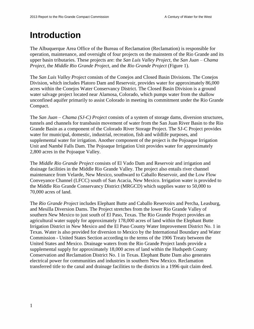
Introduction
The Albuquerque Area Office of the Bureau of Reclamation (Reclamation) is responsible for
operation, maintenance, and oversight of four projects on the mainstem of the Rio Grande and its
upper basin tributaries. These projects are: the San Luis Valley Project, the San Juan – Chama
Project, the Middle Rio Grande Project, and the Rio Grande Project (Figure 1).
The San Luis Valley Project consists of the Conejos and Closed Basin Divisions. The Conejos
Division, which includes Platoro Dam and Reservoir, provides water for approximately 86,000
acres within the Conejos Water Conservancy District. The Closed Basin Division is a ground
water salvage project located near Alamosa, Colorado, which pumps water from the shallow
unconfined aquifer primarily to assist Colorado in meeting its commitment under the Rio Grande
Compact.
The San Juan – Chama (SJ-C) Project consists of a system of storage dams, diversion structures,
tunnels and channels for transbasin movement of water from the San Juan River Basin to the Rio
Grande Basin as a component of the Colorado River Storage Project. The SJ-C Project provides
water for municipal, domestic, industrial, recreation, fish and wildlife purposes, and
supplemental water for irrigation. Another component of the project is the Pojoaque Irrigation
Unit and Nambé Falls Dam. The Pojoaque Irrigation Unit provides water for approximately
2,800 acres in the Pojoaque Valley.
The Middle Rio Grande Project consists of El Vado Dam and Reservoir and irrigation and
drainage facilities in the Middle Rio Grande Valley. The project also entails river channel
maintenance from Velarde, New Mexico, southward to Caballo Reservoir, and the Low Flow
Conveyance Channel (LFCC) south of San Acacia, New Mexico. Irrigation water is provided to
the Middle Rio Grande Conservancy District (MRGCD) which supplies water to 50,000 to
70,000 acres of land.
The Rio Grande Project includes Elephant Butte and Caballo Reservoirs and Percha, Leasburg,
and Mesilla Diversion Dams. The Project stretches from the lower Rio Grande Valley of
southern New Mexico to just south of El Paso, Texas. The Rio Grande Project provides an
agricultural water supply for approximately 178,000 acres of land within the Elephant Butte
Irrigation District in New Mexico and the El Paso County Water Improvement District No. 1 in
Texas. Water is also provided for diversion to Mexico by the International Boundary and Water
Commission - United States Section according to the terms of the 1906 Treaty between the
United States and Mexico. Drainage waters from the Rio Grande Project lands provide a
supplemental supply for approximately 18,000 acres of land within the Hudspeth County
Conservation and Reclamation District No. 1 in Texas. Elephant Butte Dam also generates
electrical power for communities and industries in southern New Mexico. Reclamation
transferred title to the canal and drainage facilities to the districts in a 1996 quit claim deed.
2013 Report to the Rio Grande Compact Commission A Century of Water for the West
2
Figure 1: Project Map of Reclamation's Albuquerque Area Office
2013 Report to the Rio Grande Compact Commission A Century of Water for the West
3
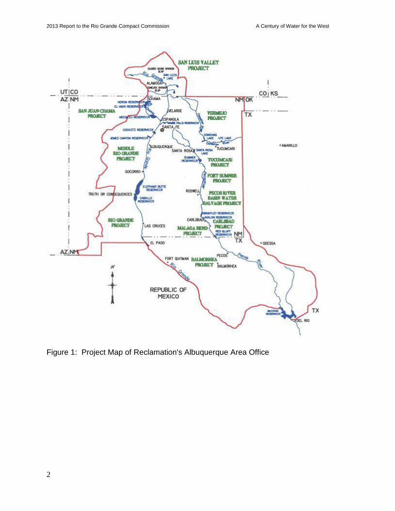
San Luis Valley Project, Colorado
Conejos Division, Platoro Reservoir
The Conejos Water Conservancy District (CWCD) operates Platoro Reservoir, which provides
storage for approximately 86,000 acres associated with the San Luis Valley Project (Figure 2).
The CWCD’s office is located in Manassa, Colorado.
On January 1, 2013, the water surface elevation at Platoro Reservoir was 9,960.03 feet AMSL
with storage volume of 8,781 acre-feet (ac-ft). The September 30, 2013, elevation was
9,960.14 feet with a storage volume of 8,784 ac-ft. A total of 251.7 ac-ft of the September
storage was direct flow storage water, and there was no Rio Grande Compact storage.
On December 31, 2013, the reservoir elevation was 9,962.16 feet and the storage volume was
9,581 ac-ft.
Figure 2: Area Map of San Luis Valley Project
2013 Report to the Rio Grande Compact Commission A Century of Water for the West
4
Platoro Dam Facility Review and Safety of Dams Programs
There were no major issues associated with the operation and maintenance at Platoro Dam, other
than aging infrastructure. Accomplishments in 2013 are listed below.
The Civil Engineering exam for the 2013 Comprehensive Review (CR) was completed in
May, with no significant issues identified. Four new Category 2 O&M recommendations
were developed, and there were no new Category 3 recommendations added.
An inspection of the outlet works coating was completed on November 6, 2013, by staff of
the Denver Materials Engineering Research Laboratory. The coating was found to be in
good condition.
The Security Annual Site Inspection was completed in October 2012.
The Facility Review Rating was updated, resulting in Platoro Dam receiving a rating of
“Good.”
Category 2 O&M Recommendation 2007-2-A, “Establish procedures to annually clean vent
holes in the outlet works penstock….” was completed in 2013.
There are currently three incomplete Category 2 O&M recommendations.
Closed Basin Division
The Alamosa Field Division of the Albuquerque Area Office operates and oversees the
maintenance of a water salvage project constructed in the Closed Basin area of the San Luis
Valley, Colorado (Figure 2). The purpose is to salvage unconfined ground water from the
Closed Basin that would otherwise be lost to evaporation and evapotranspiration. The salvaged
water is pumped from up to 170 salvage wells and delivered through a conveyance channel to the
Rio Grande to assist Colorado in meeting its commitment under the Rio Grande Compact. The
project also delivers mitigation water to the Alamosa National Wildlife Refuge and Blanca
Wildlife Habitat Area, and helps stabilize of San Luis Lake. Reclamation continues to work
under the guidance of the Closed Basin Division Operating Committee in management of Closed
Basin operations and water deliveries. The last Review of Operations and Maintenance
(RO&M) examination was conducted in October of 2011. The next RO&M examination is
scheduled for 2016.
Operations Closed Basin water deliveries in Calendar Year (CY) 2013 included deliveries to the Rio
Grande, Blanca Wildlife Habitat Area, Head Lake West, and Alamosa National Wildlife Refuge.
A total of 11,597 ac-ft of project water was delivered in CY2013. Total deliveries of Compact
water to the Rio Grande for CY2013 were 7,979 ac-ft. Total water deliveries to the Bureau of
Land Management’s (BLM) Blanca Wildlife Habitat Area were 800 ac-ft for annual mitigation
and 2,622 ac-ft of mitigation water was delivered to the Alamosa National Wildlife Refuge. An
exchange of 196.1 ac-ft of Tabor transmountain water was delivered to Head Lake West for the
Colorado Division of Parks and Wildlife.
Natural inflows to San Luis Lake (SLL) are measured by the SLL inlet flume or estimated at the
2013 Report to the Rio Grande Compact Commission A Century of Water for the West
5
spillway and culverts. There was no natural inflow to SLL during CY2013. Closed Basin
Division water accounting for the 2013 calendar year is summarized in Table 1.
Table 1: San Luis Valley Project - Closed Basin Division Water Accounting (units are acre-feet)
NOTE: Delivery to Head Lake West was 196.1 ac-ft of Tabor transmountain water for the
Colorado Division of Parks and Wildlife.
The project continues to provide Priority 1 (Compact) and Priority 2 (mitigation) water
deliveries. The San Luis Valley is in the midst of a severe drought and the water table in the
unconfined aquifer has dropped significantly in some areas. Pumping levels remain stable to
allow the water table to recover while minimizing impacts to the surrounding area and preserving
the integrity of existing project wells. Wells turned off at the recommendation of the Project
Hydrologist in 2007 remain off.
The Alamosa Field Division has been meeting with other interested parties (U.S. Fish and
Wildlife Service, Colorado Division of Parks and Wildlife, and Rio Grande Water Conservation
District) on the operation of San Luis Lake in an effort to make the Lake a viable recreation area
and to provide storage of water for later use to deliver to the Rio Grande to meet Compact
requirements.
The United States Geological Survey’s (USGS) Pueblo, Colorado, Office continues to provide
quality assurance/quality control (QA/QC) of the observation wells’ network data for
Reclamation. Reclamation received an excellent rating through the 2013 QA/QC program.
Maintenance Routine preventive maintenance and repair activities continue at salvage and observation well
sites, canal structures, pumping plants, and shelterbelts.
Repair and replacement of pumps in the salvage well vaults is an ongoing process. All of the
salvage well preventive maintenance tasks were completed for the year. Five salvage wells were
re-drilled and 13 were rehabilitated in 2013.
(BWHA) (ANWR) CREDITABLE
CH03 CH04 TOTAL CREDITABLE CH01 CH02 TOTAL AT AMOUNT TO RG NON-
MONTH STA. STA. MONTH PASSING AMOUNT CHICAGO MUM PUMPING MONTH FLUME MINUS AND NOT USED CREDITABLE PROJECT
730+00 798+60 TOTALS FLUME AT FLUME TURN-OUT TURN-OUT PLANT TOTALS DEL. TO ANWR BY ANWR @ LOBATOS TOTALS
JAN 0 0 0 1228 1228 0 0 0 0 1228 1228 0 1228
FEB 0 0 0 1134 1134 0 0 0 0 1134 1134 0 1134
MAR 0 0 0 1242 1242 238 245 111 594 648 648 0 1242
APR 0 0 0 1182 1182 100 113 56 269 913 913 0 1182
MAY 0 0 0 1085 1085 0 0 0 0 1085 1085 0 1085
JUN 74 18 92 824 824 0 0 0 0 824 824 0 916
JUL 199 133 332 429 429 133 96 0 229 200 200 0 761
AUG 169 133 302 66 66 0 0 10 10 56 56 0 368
SEP 36 38 74 479 479 0 189 223 412 67 67 0 553
OCT 0 0 0 798 798 17 301 164 482 316 316 0 798
NOV 0 0 0 1081 1081 285 303 0 588 493 493 0 1081
DEC 0 0 0 1053 1053 19 19 0 38 1015 1015 0 1053
ANNUAL 478 322 800 10,601 10,601 792 1,266 564 2,622 7,979 7,979 0 11,401
ALAMOSA NATIONAL WILDLIFE REFUGEBLANCA WILDLIFE HABITAT AREA PARSHALL FLUME DELIVERY TO THE RIO GRANDE
2013 Report to the Rio Grande Compact Commission A Century of Water for the West
6
In August, 2012, the Closed Basin Division entered into an agreement with the USGS Water
Science lab located in Oklahoma City, OK. The USGS is tasked with a new design for the
replacement wells and test pumping the wells to establish the sustainable pumping capacity. The
use of a variable frequency drive (VFD) is being tested on the five USGS-designed wells. The
VFD will control the speed of the pump. As the water level in the well drops the pump will slow
down until the water level stabilizes.
Three wells have been rehabilitated in cooperation with USGS and Halliburton. These three
wells were rehabilitated using different methods to see which combination of treatments worked
best. All wells pump tested above 400 gallons per minute (GPM), so the USGS recommended
installation of a VFD set to pump 300 GPM. It is not known if that pumping rate is sustainable.
Also, the rehabilitated wells test pumped at a higher GPM as compared to re-drilled wells.
Closed Basin is also trying a timing program with most of the operating wells on the project.
The wells are on varying schedules depending on well properties, location, and other factors.
The objective is to let the well rest for a period of time to bring the water level up. In addition,
when the pump is shut down it backwashes the well screen and helps prevent plugging.
Preliminary data shows this method is working but more time is needed to draw conclusions.
Water Quality Water quality monitoring of Closed Basin Division salvage wells, the Rio Grande, San Luis
Lake, Head Lake, and the conveyance channel continued throughout 2013.
The Water Quality Laboratory continues to support the Operations and Maintenance groups with
their salvage well rehabilitation and bio-fouling mitigation efforts. The laboratory has the
capability to culture and identify “iron related bacteria,” and all salvage wells are currently
monitored for the presence of these bacteria.
The Water Quality Laboratory participated in the spring and fall USGS’ Evaluation Program for
Standard Reference Water Samples. The Laboratory continues to perform commendably on these
audits.
Rio Grande Water Conservation District The Rio Grande Water Conservation District (RGWCD) continues to perform civil maintenance
on the Project based on a cooperative agreement with Reclamation. Canal berms, lateral access
roads, and right-of-ways were maintained by blading and mowing. Other work included removal
of aquatic weeds and sediment from structures and the canal, repair of fences, repair of erosion to
the berms from large precipitation events, and assisting Reclamation personnel in maintaining
equipment. RGWCD continued its involvement in the groundwater monitoring program and
continues maintenance of the irrigation systems for shelterbelt areas.
The RGWCD continues to assist Reclamation in the re-drill and rehabilitation efforts due to the
bio-fouling in numerous wells.
2013 Report to the Rio Grande Compact Commission A Century of Water for the West
7
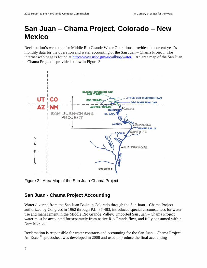
San Juan – Chama Project, Colorado – New Mexico
Reclamation’s web page for Middle Rio Grande Water Operations provides the current year’s
monthly data for the operation and water accounting of the San Juan – Chama Project. The
internet web page is found at http://www.usbr.gov/uc/albuq/water/. An area map of the San Juan
– Chama Project is provided below in Figure 3.
Figure 3: Area Map of the San Juan-Chama Project
San Juan - Chama Project Accounting
Water diverted from the San Juan Basin in Colorado through the San Juan – Chama Project
authorized by Congress in 1962 through P.L. 87-483, introduced special circumstances for water
use and management in the Middle Rio Grande Valley. Imported San Juan – Chama Project
water must be accounted for separately from native Rio Grande flow, and fully consumed within
New Mexico.
Reclamation is responsible for water contracts and accounting for the San Juan – Chama Project.
An Excel® spreadsheet was developed in 2008 and used to produce the final accounting
2013 Report to the Rio Grande Compact Commission A Century of Water for the West
8
document. For some years, reports generated with Excel® have been compared to those
generated with Crystal Reports®, which mines RiverWare
® accounting data from Reclamation’s
hydrologic database (HDB). Results have been favorable, and in 2013 Reclamation generated
the accounting report using Crystal Reports®. San Juan – Chama Project accounting for 2013 is
provided in the separate 2013 Water Accounting Report.
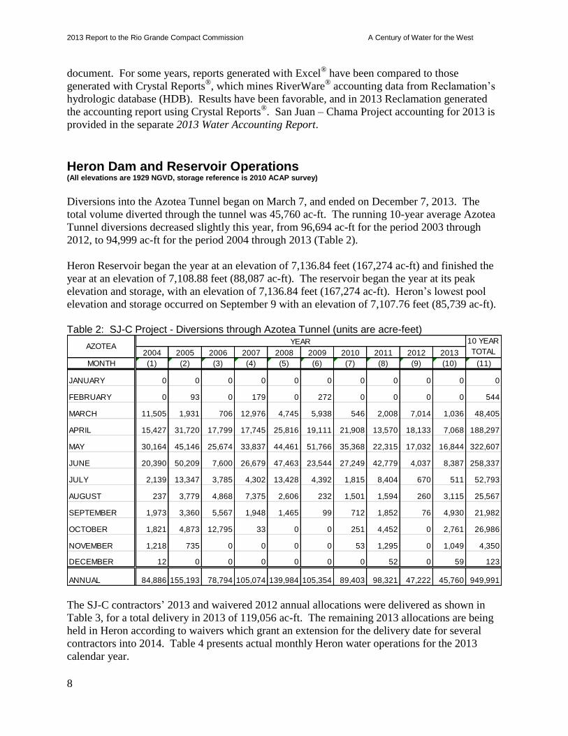
Heron Dam and Reservoir Operations (All elevations are 1929 NGVD, storage reference is 2010 ACAP survey)
Diversions into the Azotea Tunnel began on March 7, and ended on December 7, 2013. The
total volume diverted through the tunnel was 45,760 ac-ft. The running 10-year average Azotea
Tunnel diversions decreased slightly this year, from 96,694 ac-ft for the period 2003 through
2012, to 94,999 ac-ft for the period 2004 through 2013 (Table 2).
Heron Reservoir began the year at an elevation of 7,136.84 feet (167,274 ac-ft) and finished the
year at an elevation of 7,108.88 feet (88,087 ac-ft). The reservoir began the year at its peak
elevation and storage, with an elevation of 7,136.84 feet (167,274 ac-ft). Heron’s lowest pool
elevation and storage occurred on September 9 with an elevation of 7,107.76 feet (85,739 ac-ft).
Table 2: SJ-C Project - Diversions through Azotea Tunnel (units are acre-feet)
The SJ-C contractors’ 2013 and waivered 2012 annual allocations were delivered as shown in
Table 3, for a total delivery in 2013 of 119,056 ac-ft. The remaining 2013 allocations are being
held in Heron according to waivers which grant an extension for the delivery date for several
contractors into 2014. Table 4 presents actual monthly Heron water operations for the 2013
calendar year.
2004 2005 2006 2007 2008 2009 2010 2011 2012 2013
MONTH (1) (2) (3) (4) (5) (6) (7) (8) (9) (10) (11)
JANUARY 0 0 0 0 0 0 0 0 0 0 0
FEBRUARY 0 93 0 179 0 272 0 0 0 0 544
MARCH 11,505 1,931 706 12,976 4,745 5,938 546 2,008 7,014 1,036 48,405
APRIL 15,427 31,720 17,799 17,745 25,816 19,111 21,908 13,570 18,133 7,068 188,297
MAY 30,164 45,146 25,674 33,837 44,461 51,766 35,368 22,315 17,032 16,844 322,607
JUNE 20,390 50,209 7,600 26,679 47,463 23,544 27,249 42,779 4,037 8,387 258,337
JULY 2,139 13,347 3,785 4,302 13,428 4,392 1,815 8,404 670 511 52,793
AUGUST 237 3,779 4,868 7,375 2,606 232 1,501 1,594 260 3,115 25,567
SEPTEMBER 1,973 3,360 5,567 1,948 1,465 99 712 1,852 76 4,930 21,982
OCTOBER 1,821 4,873 12,795 33 0 0 251 4,452 0 2,761 26,986
NOVEMBER 1,218 735 0 0 0 0 53 1,295 0 1,049 4,350
DECEMBER 12 0 0 0 0 0 0 52 0 59 123
ANNUAL 84,886 155,193 78,794 105,074 139,984 105,354 89,403 98,321 47,222 45,760 949,991
AZOTEAYEAR 10 YEAR
TOTAL
2013 Report to the Rio Grande Compact Commission A Century of Water for the West
9
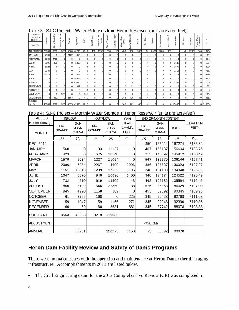
Table 3: SJ-C Project – Water Releases from Heron Reservoir (units are acre-feet)
Table 4: SJ-C Project – Monthly Water Storage in Heron Reservoir (units are acre-feet)
Heron Dam Facility Review and Safety of Dams Programs
There were no major issues with the operation and maintenance at Heron Dam, other than aging
infrastructure. Accomplishments in 2013 are listed below.
The Civil Engineering exam for the 2013 Comprehensive Review (CR) was completed in
ALLOCATION 20900 5230 375 5000 48200 1030 400 1200 1000 15 400 400 500 60 6500 2000 369 40 2215 366 96200
JANUARY 7906 0 0 2182 1050 0 0 0 0 0 0 0 0 0 0 0 0 0 0 0 0 11137
FEBRUARY 5780 4760 0 0 0 0 0 0 0 0 0 0 0 0 0 0 0 0 0 0 0 10540
MARCH 5591 470 0 0 2362 0 0 0 0 0 0 0 0 0 0 0 0 2631 0 0 0 11054
APRIL 1623 0 0 0 0 0 0 0 0 0 0 0 0 0 0 0 0 3076 0 0 0 4699
MAY 9936 0 0 0 0 0 0 0 0 0 0 0 0 0 0 0 0 7216 0 0 0 17152
JUNE 12770 0 0 0 2807 0 0 0 0 0 0 0 0 0 0 0 0 1319 0 0 0 16896
JULY 0 0 0 0 19509 0 0 0 0 0 0 0 0 0 0 0 0 0 0 0 0 19509
AUGUST 0 0 0 0 21485 0 0 0 0 0 0 0 0 0 0 0 0 1365 0 0 0 22850
SEPTEMBER 0 0 0 0 337 0 0 0 0 0 0 41 0 0 0 0 0 0 0 0 0 382
OCTOBER 0 0 0 0 0 0 0 0 0 0 0 0 0 0 0 0 0 0 0 0 0 0
NOVEMBER 0 0 375 0 0 781 0 0 0 0 0 0 0 0 0 0 0 0 0 0 0 1156
DECEMBER 0 462 0 2193 0 431 0 0 0 0 148 400 48 0 0 0 0 0 0 0 0 3682
2013 CY
TOTAL 43606 5692 375 4375 47550 1212 0 0 0 0 148 441 48 0 0 0 0 15607 0 0 0 119056
City
of S
anta
Fe
Cochiti
Tow
n o
f B
ern
alillo
AB
CW
UA
PV
ID
Taos S
ki V
alle
yTABLE 4
SJ-C Heron
Release
Tow
n o
f T
aos
MONTHM
RG
CD
Taos P
ueblo
Tow
n o
f T
aos
Settle
ment
City
of E
spanola
County
of S
anta
Fe
TO
TA
L
Red R
iver
El P
rado
Ohkay O
win
geh
Jic
arilla
Recla
matio
n
Uncontr
acte
d
County
of Los
Ala
mos
Village o
f Los
Lunas
Bele
n(1) (2) (3) (4) (5) (6) (7) (8) (9)
DEC. 2012 350 166924 167274 7136.84
JANUARY 560 0 93 11137 0 467 156137 156604 7133.76
FEBRUARY 423 0 675 10540 0 215 145597 145812 7130.49
MARCH 1579 1034 1227 11054 0 567 135579 136146 7127.41
APRIL 2086 7054 2267 4699 2296 386 135637 136023 7127.37
MAY 1151 16810 1289 17152 1196 248 134100 134348 7126.82
JUNE 1047 8370 948 16896 1400 348 124174 124522 7123.49
JULY 732 510 619 19509 43 462 105132 105594 7116.45
AUGUST 860 3109 646 22850 38 676 85353 86029 7107.90
SEPTEMBER 945 4920 1168 382 0 453 89892 90345 7109.93
OCTOBER 61 2755 168 0 225 345 92423 92768 7111.03
NOVEMBER 59 1047 59 1156 271 345 92048 92390 7110.86
DECEMBER 60 59 60 3681 681 345 87742 88078 7108.88
SUB-TOTAL 9563 45668 9219 119056
ADJUSTMENT -350 (M)
ANNUAL 55231 128275 6150 -5 88092 88078
INFLOW
RIO
GRANDE
RIO
GRANDE
SAN
JUAN
CHAMA
RIO
GRANDE
SAN
JUAN
CHAMA
ELEVATION
(FEET)
SAN
JUAN
CHAMA
TOTAL
TABLE 3
Heron Storage
MONTH
END-OF-MONTH CONTENTOUTFLOW SAN
JUAN
CHAMA
LOSS

2013 Report to the Rio Grande Compact Commission A Century of Water for the West
10
May with no significant issues. Two new SOD related O&M recommendations and two new
Category 3 recommendations were developed.
A functional-level emergency management exercise was completed in September.
The Security Annual Site Inspection was completed in September.
The Facility Review Rating was updated, resulting in Heron receiving a rating of “Good.”
Work continued on Quagga/Zebra mussel prevention.
There are currently four incomplete Category 2 O&M recommendations for Heron Dam.
Pojoaque Tributary Unit - Nambé Falls Dam and Reservoir (All elevations are 1929 NGVD, storage reference is 2004 ACAP survey)
Nambé Falls began 2013 with a reservoir elevation of 6,815.09 feet, providing a storage volume
of 1,332 ac-ft. During the winter, releases averaged about 1 cfs to maximize conservation
storage as agreed to by the Pojoaque Valley Irrigation District and Indian water users. The
reservoir filled and spilled twice in 2013. The maximum elevation for the year was 6,827.79 feet
(1,990 ac-ft) on October 10. The reservoir initially filled in April and remained full until May 1,
when irrigation releases began and reservoir storage and elevation started falling. The reservoir
reached a low point of elevation 6,807.19 feet (1,007 ac-ft) on September 9. Record monsoon
rains then hit the region, allowing the reservoir to fill again. As an example of the amount of
precipitation received, over 2.5 inches of rain fell during the week of September 10-15. Nambé
Falls Reservoir ended 2013 at elevation of 6,825.25 feet (1,843 ac-ft).
Cyclical operations of Nambé Falls Reservoir consist of non-irrigation season operations and
irrigation season operations. During non-irrigation season (November through April), all inflow
in excess of the bypass requirement of 0.5 cfs is stored until an elevation of 6,825.60 feet is
reached. Once that elevation is attained, the outlet gates are regulated weekly to stabilize the
reservoir at 6,825.60 feet, or an elevation determined by 100 percent ice cover. An uncontrolled
spill begins at elevation 6826.6 feet, which is the top of the spillway crest. During irrigation
season (May through October), water is stored and released on demand to meet downstream
requirements.
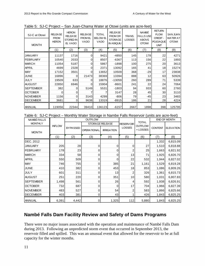
A net depletion of 1,498 ac-ft was calculated for Nambé Falls operations for 2013. The
depletion amount (plus transportation loss) was released from Heron and Abiquiu Reservoirs
throughout 2013. Table 5 provides a summary of Nambé Falls use above Otowi and the
Pojoaque Unit return flow credit used to calculate depletions during 2013. A summary of 2013
Nambé Falls Reservoir operations is provided in Table 6.
2013 Report to the Rio Grande Compact Commission A Century of Water for the West
11
Table 5: SJ-C Project – San Juan-Chama Water at Otowi (units are acre-feet)
Table 6: SJ-C Project – Monthly Water Storage in Nambe Falls Reservoir (units are acre-feet)
Nambé Falls Dam Facility Review and Safety of Dams Programs
There were no major issues associated with the operation and maintenance of Nambé Falls Dam
during 2013. Following an unpredicted storm event that occurred in September 2013, the
reservoir filled and spilled. This was an unusual event that allowed for the reservoir to be at full
capacity for the winter months.
(1) (2) (3) (4) (5) (6) (7) (8) (9)
JANUARY 11137 1716 0 9421 -4850 145 178 22 4271
FEBRUARY 10540 2033 0 8507 -6367 113 156 22 1893
MARCH 11054 5187 0 5867 -1898 100 275 20 3613
APRIL 4699 2328 0 2371 13092 165 41 18 15274
MAY 17152 3501 0 13652 10509 368 -29 17 23838
JUNE 16896 0 21473 38369 13394 888 12 63 50926
JULY 19509 633 0 18876 -13059 260 289 71 5339
AUGUST 22850 6946 0 15904 -8601 241 22 24 7064
SEPTEMBER 382 0 5149 5531 -1803 94 933 60 2760
OCTOBER 0 0 7 7 3147 28 45 30 3110
NOVEMBER 1156 0 3143 4299 -806 79 -45 23 3483
DECEMBER 3681 0 9638 13319 -8915 186 21 28 4224
ANNUAL 119056 22344 39410 136123 -6157 2667 1898 398 125795
RETURN
FLOW
CREDIT -
POJOAQUE
UNIT
SAN JUAN
WATER AT
OTOWI
NAMBÉ
FALLS USE
ABOVE
OTOWIMONTH
TOTAL
BELOW EL
VADO
RELEASE
FROM OR
STORAGE
IN ABIQUIU
TRANS.
LOSSES
SJ-C at Otowi RELEASE
FROM
HERON
HERON
RELEASE
STORED IN
EL VADO
RELEASE
FROM EL
VADO
(1) (2) (3) (4) (5) (6) (7) (8)
DEC. 2012 1,332 6,815.09
JANUARY 205 28 0 0 0 27 1,510 6,818.88
FEBRUARY 178 23 0 0 2 25 1,663 6,821.92
MARCH 334 58 0 0 13 71 1,925 6,826.70
APRIL 550 509 0 0 22 532 1,944 6,827.02
MAY 746 755 0 385 21 1,161 1,529 6,819.28
JUNE 410 382 0 453 18 853 1,086 6,809.26
JULY 601 311 0 13 2 326 1,361 6,815.73
AUGUST 251 220 0 351 10 580 1,031 6,807.83
SEPTEMBER 1,498 561 0 26 4 592 1,938 6,826.91
OCTOBER 732 687 0 0 17 704 1,966 6,827.39
NOVEMBER 483 527 0 54 2 583 1,866 6,825.66
DECEMBER 403 381 0 43 1 426 1,843 6,825.25
ANNUAL 6,391 4,442 0 1,325 112 5,880 1,843 6,825.25
NAMBÉ FALLS
MONTHLYINFLOW
OUTFLOW
RESERVOIR
LOSSES
MONTH
END OF MONTH
BYPASSED
STORAGE RELEASE
CONTENT ELEVATIONOPERATIONAL IRRIGATION
TOTAL
OUTFLOW
+ LOSSES
2013 Report to the Rio Grande Compact Commission A Century of Water for the West
12
Accomplishments achieved for Nambé Falls Dam during 2013 include:
The dive exam for the 2013 Comprehensive Review (CR) was completed in March using
a Remote Operated Vehicle. Inspection of the intake structure found a significant
accumulation of sediment and debris around the top of the structure.
Bathymetric surveys of the reservoir were completed in 2013.
The Civil Engineering exam for the 2013 CR was completed in September.
The Security Annual Site Inspection was completed in September.
A functional-level emergency management exercise was completed in September.
The Facility Review Rating was updated, resulting in Nambé Falls receiving a rating of
“Fair.”
There are currently five incomplete Category 2 O&M recommendations. An initial bathymetric
survey of Nambé Falls Reservoir was completed in March 2013. The March survey indicated
excessive debris and the possibility of a false bottom being observed in the data due to low
density ash distributed throughout reservoir. Low frequency transducers were rented, and a
second survey was completed in June 2013. The June 2013 survey confirmed the data obtained
from the March survey. New ACAP tables are being prepared by Reclamation’s Sedimentation
and River Hydraulics Group.
2013 San Juan - Chama Outlook
On December 31, 2013, Heron Reservoir had 31,143 ac-ft in storage in the Federal Pool. This
amount is below the calculated firm yield of 96,200 ac-ft, and is insufficient for a full annual
allocation for all contractors prior to the 2014 runoff season. Water scarcity was contemplated in
the SJCP authorization, which directs that “when the actual available water supply may be less
than the estimated firm yield, [Contractors] shall share in the available water supply in the ratio
that the above allocation bears to the firm yield.”
An initial allocation of 29% of the firm yield was made on January 1, 2014. Subsequent
allocations will be made monthly, beginning in April. They will continue until either a full
allocation is received, or the end of the calendar year.
2013 Report to the Rio Grande Compact Commission A Century of Water for the West
13
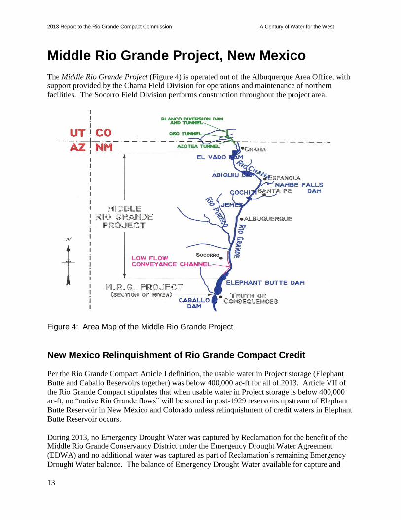
Middle Rio Grande Project, New Mexico
The Middle Rio Grande Project (Figure 4) is operated out of the Albuquerque Area Office, with
support provided by the Chama Field Division for operations and maintenance of northern
facilities. The Socorro Field Division performs construction throughout the project area.
Figure 4: Area Map of the Middle Rio Grande Project
New Mexico Relinquishment of Rio Grande Compact Credit
Per the Rio Grande Compact Article I definition, the usable water in Project storage (Elephant
Butte and Caballo Reservoirs together) was below 400,000 ac-ft for all of 2013. Article VII of
the Rio Grande Compact stipulates that when usable water in Project storage is below 400,000
ac-ft, no “native Rio Grande flows” will be stored in post-1929 reservoirs upstream of Elephant
Butte Reservoir in New Mexico and Colorado unless relinquishment of credit waters in Elephant
Butte Reservoir occurs.
During 2013, no Emergency Drought Water was captured by Reclamation for the benefit of the
Middle Rio Grande Conservancy District under the Emergency Drought Water Agreement
(EDWA) and no additional water was captured as part of Reclamation’s remaining Emergency
Drought Water balance. The balance of Emergency Drought Water available for capture and

2013 Report to the Rio Grande Compact Commission A Century of Water for the West
14
storage by Reclamation and MRGCD during 2014 or later years is 40,536 ac-ft. Reclamation’s
balance for use as supplemental water for endangered species is 19,451 ac-ft. MRGCD’s
balance is 21,085 ac-ft. An additional 20,000 ac-ft was allocated to MRGCD in 2013 and
Reclamation is working on an agreement to store that additional water.
Neither Reclamation nor the MRGCD started 2013 with any Emergency Drought Water stored in
El Vado Reservoir. At the end of the year, the two pools were still empty.
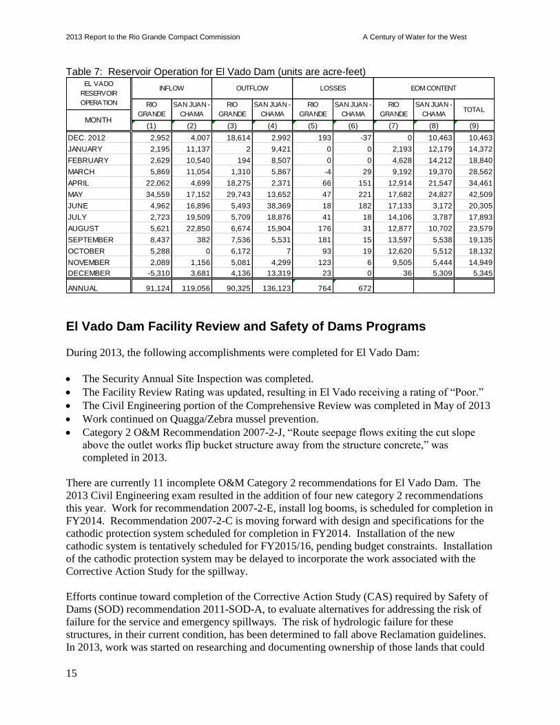
El Vado Dam and Reservoir Operations (All elevations are Middle Rio Grande Project Datum – add 7.8 feet for 1929 NGVD, storage reference is 2007 ACAP survey)
El Vado Reservoir began 2013 at an elevation of 6,800.30 feet (10,463 ac-ft). The reservoir
peaked on May 27 at an elevation of 6,835.17 feet (43,773 ac-ft), and hit a low of 6,791.27 feet
(5,309 ac-ft) on December 30.
MRGCD began the year with 0 ac-ft of Emergency Drought Water, 0 ac-ft of general Rio
Grande storage, and 122 ac-ft of SJ-C water in El Vado for Middle Valley irrigation. This was in
addition to MRGCD’s 20,900 ac-ft of waivered 2012 SJ-C allocation and a curtailed preliminary
2013 allocation of 18,488 ac-ft in Heron Reservoir, and a beginning year balance of 2,087 ac-ft
of SJ-C stored in Abiquiu Reservoir. The 2013 allocation in Heron was brought up to a full
supply of 20,900 ac-ft on May 31. At the end of the year in El Vado, MRGCD had 0 ac-ft of
Emergency Drought Water, 36 ac-ft of general Rio Grande storage, and 0 ac-ft of SJ-C storage.
MRGCD also had 0 ac-ft of SJ-C stored in Abiquiu as of December 31, 2013.
A total of 17,855 ac-ft of water was captured and stored for Prior and Paramount irrigation while
under Article VII restrictions. A total of 4,121 ac-ft was released to meet Prior and Paramount
needs during the irrigation season. Finally, 12,583 ac-ft were released to the Albuquerque
Bernalillo County Water Utility Authority (ABCWUA) account in Abiquiu (12,445 ac-ft arrived)
during late November and December and a like amount was transferred from the ABCWUA
account to the Rio Grande account in Elephant Butte. This exchange, in combination with other
supplemental water releases and other water management actions, could allow for the
opportunity for spawning/recruitment flows for the endangered Rio Grande silvery minnow in
the spring of 2014 as this water could be released to the ABCWUA account in Elephant Butte.
The total SJ-C water in El Vado storage at the end of the year was 5,309 ac-ft which belonged to
the ABCWUA and the City of Santa Fe. Table 7 provides a summary of monthly operations and
water accounting for El Vado Reservoir.
2013 Report to the Rio Grande Compact Commission A Century of Water for the West
15
Table 7: Reservoir Operation for El Vado Dam (units are acre-feet)
El Vado Dam Facility Review and Safety of Dams Programs
During 2013, the following accomplishments were completed for El Vado Dam:
The Security Annual Site Inspection was completed.
The Facility Review Rating was updated, resulting in El Vado receiving a rating of “Poor.”
The Civil Engineering portion of the Comprehensive Review was completed in May of 2013
Work continued on Quagga/Zebra mussel prevention.
Category 2 O&M Recommendation 2007-2-J, “Route seepage flows exiting the cut slope
above the outlet works flip bucket structure away from the structure concrete,” was
completed in 2013.
There are currently 11 incomplete O&M Category 2 recommendations for El Vado Dam. The
2013 Civil Engineering exam resulted in the addition of four new category 2 recommendations
this year. Work for recommendation 2007-2-E, install log booms, is scheduled for completion in
FY2014. Recommendation 2007-2-C is moving forward with design and specifications for the
cathodic protection system scheduled for completion in FY2014. Installation of the new
cathodic system is tentatively scheduled for FY2015/16, pending budget constraints. Installation
of the cathodic protection system may be delayed to incorporate the work associated with the
Corrective Action Study for the spillway.
Efforts continue toward completion of the Corrective Action Study (CAS) required by Safety of
Dams (SOD) recommendation 2011-SOD-A, to evaluate alternatives for addressing the risk of
failure for the service and emergency spillways. The risk of hydrologic failure for these
structures, in their current condition, has been determined to fall above Reclamation guidelines.
In 2013, work was started on researching and documenting ownership of those lands that could
(1) (2) (3) (4) (5) (6) (7) (8) (9)
DEC. 2012 2,952 4,007 18,614 2,992 193 -37 0 10,463 10,463
JANUARY 2,195 11,137 2 9,421 0 0 2,193 12,179 14,372
FEBRUARY 2,629 10,540 194 8,507 0 0 4,628 14,212 18,840
MARCH 5,869 11,054 1,310 5,867 -4 29 9,192 19,370 28,562
APRIL 22,062 4,699 18,275 2,371 66 151 12,914 21,547 34,461
MAY 34,559 17,152 29,743 13,652 47 221 17,682 24,827 42,509
JUNE 4,962 16,896 5,493 38,369 18 182 17,133 3,172 20,305
JULY 2,723 19,509 5,709 18,876 41 18 14,106 3,787 17,893
AUGUST 5,621 22,850 6,674 15,904 176 31 12,877 10,702 23,579
SEPTEMBER 8,437 382 7,536 5,531 181 15 13,597 5,538 19,135
OCTOBER 5,288 0 6,172 7 93 19 12,620 5,512 18,132
NOVEMBER 2,089 1,156 5,081 4,299 123 6 9,505 5,444 14,949
DECEMBER -5,310 3,681 4,136 13,319 23 0 36 5,309 5,345
ANNUAL 91,124 119,056 90,325 136,123 764 672
TOTAL
EL VADO
RESERVOIR
OPERATION
INFLOW OUTFLOW LOSSES
MONTH
EOM CONTENT
RIO
GRANDE
SAN JUAN -
CHAMA
RIO
GRANDE
SAN JUAN -
CHAMA
SAN JUAN -
CHAMA
RIO
GRANDE
SAN JUAN -
CHAMA
RIO
GRANDE
2013 Report to the Rio Grande Compact Commission A Century of Water for the West
16
be impacted by the work proposed by the actions developed by the CAS. Various meetings on
the progress of CAS accomplishments and budget were held.
Following the 2013 Civil Engineering portion of the Comprehensive Review, new SOD
recommendation 2013-SOD-A was developed. Recommendation 2013-SOD-A states:
“Determine where the uncertainties exist and risk reduction can be achieved based on current
understanding of the static risks at El Vado Dam. Conduct additional studies and/or perform
investigations to reduce these uncertainties. After performing these studies/investigations
conduct a risk analysis to re-estimate the static risk.”
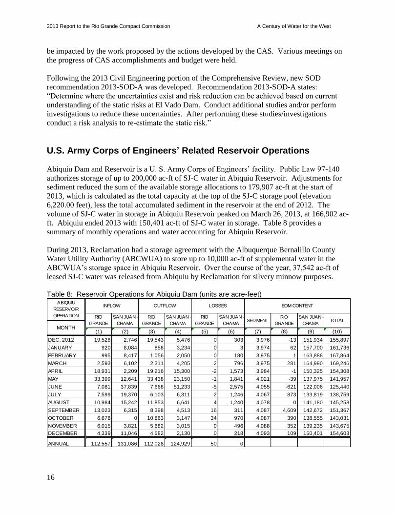
U.S. Army Corps of Engineers’ Related Reservoir Operations
Abiquiu Dam and Reservoir is a U. S. Army Corps of Engineers’ facility. Public Law 97-140
authorizes storage of up to 200,000 ac-ft of SJ-C water in Abiquiu Reservoir. Adjustments for
sediment reduced the sum of the available storage allocations to 179,907 ac-ft at the start of
2013, which is calculated as the total capacity at the top of the SJ-C storage pool (elevation
6,220.00 feet), less the total accumulated sediment in the reservoir at the end of 2012. The
volume of SJ-C water in storage in Abiquiu Reservoir peaked on March 26, 2013, at 166,902 ac-
ft. Abiquiu ended 2013 with 150,401 ac-ft of SJ-C water in storage. Table 8 provides a
summary of monthly operations and water accounting for Abiquiu Reservoir.
During 2013, Reclamation had a storage agreement with the Albuquerque Bernalillo County
Water Utility Authority (ABCWUA) to store up to 10,000 ac-ft of supplemental water in the
ABCWUA’s storage space in Abiquiu Reservoir. Over the course of the year, 37,542 ac-ft of
leased SJ-C water was released from Abiquiu by Reclamation for silvery minnow purposes.
Table 8: Reservoir Operations for Abiquiu Dam (units are acre-feet)
(1) (2) (3) (4) (5) (6) (7) (8) (9) (10)
DEC. 2012 19,528 2,746 19,543 5,476 0 303 3,976 -13 151,934 155,897
JANUARY 920 8,084 858 3,234 0 3 3,974 62 157,700 161,736
FEBRUARY 995 8,417 1,056 2,050 0 180 3,975 1 163,888 167,864
MARCH 2,593 6,102 2,311 4,205 2 796 3,975 281 164,990 169,246
APRIL 18,931 2,209 19,216 15,300 -2 1,573 3,984 -1 150,325 154,308
MAY 33,399 12,641 33,438 23,150 -1 1,841 4,021 -39 137,975 141,957
JUNE 7,081 37,839 7,668 51,233 -5 2,575 4,055 -621 122,006 125,440
JULY 7,599 19,370 6,103 6,311 2 1,246 4,067 873 133,819 138,759
AUGUST 10,984 15,242 11,853 6,641 4 1,240 4,078 0 141,180 145,258
SEPTEMBER 13,023 6,315 8,398 4,513 16 311 4,087 4,609 142,672 151,367
OCTOBER 6,678 0 10,863 3,147 34 970 4,087 390 138,555 143,031
NOVEMBER 6,015 3,821 5,682 3,015 0 496 4,088 352 139,235 143,675
DECEMBER 4,339 11,046 4,582 2,130 0 218 4,093 109 150,401 154,603
ANNUAL 112,557 131,086 112,028 124,929 50 0
SAN JUAN -
CHAMATOTAL
ABIQUIU
RESERVOIR
OPERATION
LOSSES EOM CONTENT
RIO
GRANDE
SAN JUAN -
CHAMA
RIO
GRANDE
SAN JUAN -
CHAMASEDIMENT
MONTH
RIO
GRANDE
INFLOW OUTFLOW
SAN JUAN -
CHAMA
RIO
GRANDE
2013 Report to the Rio Grande Compact Commission A Century of Water for the West
17
Cooperative Programs with the State of New Mexico
In September 2012, a new 5-year Cooperative (State Coop) Agreement (R13CF40001) was
executed between the New Mexico Interstate Stream Commission (NMISC) and Reclamation.
The Agreement provides funding for joint benefit water salvage work on the Middle Rio Grande
Project. This work currently includes Delta Channel maintenance and other river maintenance
projects, and riverside irrigation drain improvements with water salvage potential.
Total State Coop work expenditures for calendar year 2013 involving joint benefit water salvage
projects as of December 31, 2013, were approximately $72,443.
Delta Channel History (formerly known as the Temporary Channel) River disconnection has been an issue at the headwaters of Elephant Butte Reservoir since the
early 1950s. The contributing factors for the disconnection are many: the valley slope is slight,
the incoming sediment load is high, the clay deposits are highly cohesive, and vegetation growth
is very rapid. During drought periods when the reservoir pool decreases rapidly, all of these
factors make it difficult for the river channel to maintain a connection with the reservoir pool.
The latest incidence of disconnection began in the late 1990s, and construction of the Delta
Channel began in 2000. The current alignment of the Delta Channel begins at River Mile 58
(RM 58) and ends approximately at RM 39.
Delta Channel Maintenance — 2012 - 2013 The maintenance work performed along the Delta Channel in 2013 extended from RM 46 north
to RM 54. Given the drought conditions in 2012 and 2013 and the corresponding low peak
runoff, the Delta Channel did not experience any breaches during the year. There were,
however, significant sections along the channel where the banks had narrowed considerably from
vegetation encroachment and bank sloughing.
Maintenance of the Delta Channel was performed by NMISC’s contractor, Wilco Marsh Buggies
Inc. Work on the Delta Channel began in November of 2012 and ended in February 2013.
Channel maintenance efforts involved repair to channel spoil levees, removal of excessive
accumulated sediment and sediment plugs through the delta, improvement of channel alignment
within the current footprint, and disturbance of in-channel islands and bar formations in a
manner that enhances the potential for downstream migration within the Channel.
Reclamation is in the process of re-consulting with the U.S. Fish and Wildlife Service on the
Delta Channel maintenance activities as part of the Middle Rio Grande Project programmatic
consultation.
Irrigation Drain Improvements The following work was accomplished in 2013 under the Cooperative Agreement.
San Francisco Wasteway Vegetation Removal: The purpose of the proposed work on the
San Francisco Riverside Drain Wasteway is to 1) improve wasteway flow conveyance and
water salvage capabilities, 2) improve maintenance access, and 3) reduce potential safety
risks to the general public and maintenance crews. Maintenance consisted primarily of

2013 Report to the Rio Grande Compact Commission A Century of Water for the West
18
removing large vegetation.
Photo 1: San Francisco Wasteway before maintenance (July 2013)
Photo 2: San Francisco Wasteway with maintenance mostly complete (November 2013)
Drain Unit 7 Extension Maintenance: The goal of maintenance work on a portion of Drain
Unit 7 Extension was to improve drain function and accessibility issues caused by service
road wear and erosion and excessive vegetation along the drain banks. Maintenance work
primarily consisted of vegetation mowing and service road grading and repairs.
River Maintenance
Reclamation has authorization for river channel maintenance of the Rio Grande from Velarde,
New Mexico, south to the headwaters of Caballo Reservoir, as specified by the Flood Control
2013 Report to the Rio Grande Compact Commission A Century of Water for the West
19
Acts of 1948 and 1950. Project purposes include ensuring effective water delivery, transporting
sediment, protecting riverside facilities and property, and preventing flooding. Reclamation
prioritizes river maintenance based on public safety, property damage risk, and potential for
reduction of water delivery.
River Maintenance Priority Sites Reclamation is currently pursuing work at 16 active priority sites along the Middle Rio Grande
Project reach where bank erosion or reduced channel capacity could cause levee failure resulting
in shallow overland flooding, reduction of water delivery, or destruction of canals and drains. Of
the active priority sites, six require an annual review of channel capacity and possible
maintenance due to sediment accumulation. These six are the Bosque del Apache sediment plug,
the Bosque del Apache levee, the Tiffany and San Marcial levees, the Tiffany Sediment Plug, the
Truth or Consequences reach, and the Delta Channel. The Delta Channel is discussed in more
detail in the previous section. Under the current monitoring criteria for river maintenance, 20
priority sites have been substantially completed. Eleven of the completed priority sites have
involved Native American Pueblo lands along the Middle Rio Grande involving significant
government to government coordination with tribal council, administration, and technical staff.
All of these completed sites require adaptive and recurring maintenance over the life cycles of
each of the project’s intended design life.
In 2013, Reclamation completed work at two sites (San Ildelfonso Pond and San Felipe RM
215.5) and started work at one existing site (Santo Domingo RM 224.6). In addition,
Reclamation responded to emergency conditions during the September monsoonal high flow
events. The resulting high flow events necessitated maintenance work at Peralta Canyon arroyo
confluence, the Drain Unit 7 extension levee system (near La Joya and San Acacia Diversion
Dam), and in the river channel immediately below Elephant Butte Dam associated with the
Mescal and Cuchillo Negro arroyos. Localized August monsoonal flows also caused
maintenance issues in the Velarde area at the Truchas Arroyo confluence.
Reclamation’s efforts at all maintenance sites include data collection, geomorphic and sediment
investigations, design studies, alternative evaluation, design and development of construction
drawings, material supply and development, lands access, environmental compliance, project and
construction management, and construction maintenance.
In the following narrative, the terms “new”, “existing”, and “adaptive” are used to describe the
maintenance sites. New sites are sites that developed following the September 2013 Monsoonal
high flow events on the Rio Grande. Existing is used to describe sites that are in the process of
being completed. Adaptive is used to describe sites that are substantially completed and being
monitored for function and performance.
Truchas Arroyo (New Maintenance Site) A summer monsoon rainfall runoff flood event occurred on the Truchas Arroyo at approximately
River Mile (RM) 230 on August 4, 2013. A large amount of sediment was deposited at the river
confluence, narrowing the river to as narrow as 10 feet wide in one location and creating a
backwater effect upstream of the confluence. This backwater area was reportedly causing a rise
in the adjacent farm land groundwater levels.
2013 Report to the Rio Grande Compact Commission A Century of Water for the West
20
The flood event also caused the breach of a non-Reclamation arroyo berm, and deposited a large
amount of sediment in the adjacent agricultural orchard, south of the Truchas Arroyo. The flood
flows traveled through the orchard and breached the southern La Rinconada Dike approximately
800 feet downstream. The Dike did not fail on the river side, the portion meant to withstand high
flows, but instead was breached by arroyo flows on the land side.
Two alternatives were developed for the project. After analysis of the channel capacity, it was
determined that the Rio Grande around Truchas Arroyo still has a 5000 cfs channel capacity
based on current conditions. Reclamation chose the alternative to monitor the alluvial fan deposit
and take action to remove the sediment deposit at the arroyo confluence if it becomes an
emergency. Reclamation will send a field team once a month in December, 2013, and January
and February, 2014, to determine if the river has moved the material. Reclamation will also
collect river elevation data around Truchas Arroyo to update a hydraulic model to assess channel
capacity. Reclamation will continue to go through the planning process required for the sediment
removal and berm repair in the event one or both is required.
San Ildefonso Pond (Adaptive Maintenance Site) This priority site is located at RM 259. In spring 2007, a river maintenance project was
constructed by Reclamation’s Socorro Field Division to provide protection for the San Ildefonso
fishing pond. During the spring runoff of 2009, the channel eroded through a line of dense
vegetation planted as part of the project. This erosion resulted in the loss of up to 75 feet of
bankline upstream of the previous project area. This bank erosion exposed and threatened to
flank three of the buried rock vanes. Reclamation worked with the Pueblo de San Ildefonso to
construct a temporary solution prior to the 2010 spring runoff. The project consisted of a buried
trench riprap revetment and a riprap windrow. This 2010 temporary protection work allowed for
the development and permitting of a longer term solution.
The selection of a preferred alternative for the longer term solution was made in April 2012. The
project was divided into two phases. The first phase involved construction of seven bendway
weirs; the second phase involves installing a west bank floodplain side channel to complement
bendway work from the first phase. Detailed designs, construction drawings, project description,
and environmental compliance for the first phase were completed in 2012, with construction of
the bendway weirs (Photo 3) beginning in January 2013 and ending in March 2013. Detailed
designs, construction drawings, project description, and environmental compliance for the
second phase were completed in 2013, with construction beginning in January 2014.
2013 Report to the Rio Grande Compact Commission A Century of Water for the West
21
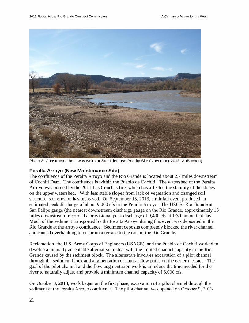
Photo 3: Constructed bendway weirs at San Ildefonso Priority Site (November 2013, AuBuchon)
Peralta Arroyo (New Maintenance Site) The confluence of the Peralta Arroyo and the Rio Grande is located about 2.7 miles downstream
of Cochiti Dam. The confluence is within the Pueblo de Cochiti. The watershed of the Peralta
Arroyo was burned by the 2011 Las Conchas fire, which has affected the stability of the slopes
on the upper watershed. With less stable slopes from lack of vegetation and changed soil
structure, soil erosion has increased. On September 13, 2013, a rainfall event produced an
estimated peak discharge of about 9,000 cfs in the Peralta Arroyo. The USGS’ Rio Grande at
San Felipe gauge (the nearest downstream discharge gauge on the Rio Grande, approximately 16
miles downstream) recorded a provisional peak discharge of 9,490 cfs at 1:30 pm on that day.
Much of the sediment transported by the Peralta Arroyo during this event was deposited in the
Rio Grande at the arroyo confluence. Sediment deposits completely blocked the river channel
and caused overbanking to occur on a terrace to the east of the Rio Grande.
Reclamation, the U.S. Army Corps of Engineers (USACE), and the Pueblo de Cochiti worked to
develop a mutually acceptable alternative to deal with the limited channel capacity in the Rio
Grande caused by the sediment block. The alternative involves excavation of a pilot channel
through the sediment block and augmentation of natural flow paths on the eastern terrace. The
goal of the pilot channel and the flow augmentation work is to reduce the time needed for the
river to naturally adjust and provide a minimum channel capacity of 5,000 cfs.
On October 8, 2013, work began on the first phase, excavation of a pilot channel through the
sediment at the Peralta Arroyo confluence. The pilot channel was opened on October 9, 2013

2013 Report to the Rio Grande Compact Commission A Century of Water for the West
22
(Photo 4). The second phase is augmentation of natural flow paths to take advantage of
overbanking on the existing eastern terrace, in an effort to develop side channels through the
terrace. Topographic data collection and soil sampling were completed in November 2013 for
design of the side channels. A project description was completed in December 2013. The design
report, construction drawings, and environmental compliance are expected to be finished before
the anticipated construction of the side channels in March 2014.
Photo 4: Construction of pilot channel at Peralta Arroyo (October 2013, AuBuchon)
Santo Domingo There are currently three priority sites (RM 225.1, RM 224.6, and RM 223.9) on the reach of the
Rio Grande passing through the Pueblo of Santo Domingo. Bankline erosion on the west side of
the river is the cause for concern at these sites because of the close proximity to the levee and
riverside drain. A Data Collection and Confidentiality Agreement was executed between the
Pueblo of Santo Domingo and Reclamation in August 2007 to allow collection of design data for
the three priority sites. Reclamation reached an agreement in cooperation with the Pueblo of
Santo Domingo on the preferred alternative for the design at each of these three priority sites in
March 2012.
The three project sites were divided into two phases, RM 225.1 as Phase 1, and RM 224.6 and
RM 223.9 as Phase 2. Detailed designs, construction drawings, a project description, and
environmental compliance for RM 225.1 were completed in September 2012. Construction
began for this site in October 2012 and was completed in January 2013. The project description
for RM 224.6 and RM 223.9 was completed in the spring of 2012 and detailed designs,
2013 Report to the Rio Grande Compact Commission A Century of Water for the West
23
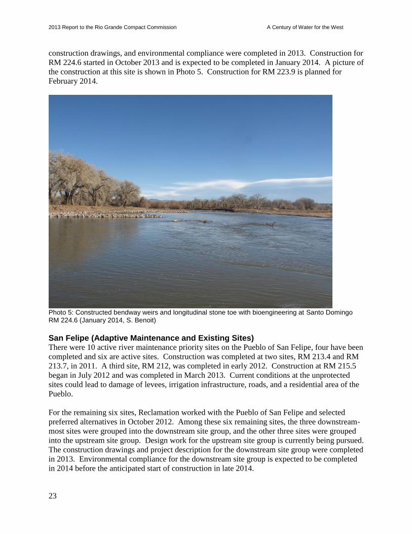
construction drawings, and environmental compliance were completed in 2013. Construction for
RM 224.6 started in October 2013 and is expected to be completed in January 2014. A picture of
the construction at this site is shown in Photo 5. Construction for RM 223.9 is planned for
February 2014.
Photo 5: Constructed bendway weirs and longitudinal stone toe with bioengineering at Santo Domingo RM 224.6 (January 2014, S. Benoit)
San Felipe (Adaptive Maintenance and Existing Sites) There were 10 active river maintenance priority sites on the Pueblo of San Felipe, four have been
completed and six are active sites. Construction was completed at two sites, RM 213.4 and RM
213.7, in 2011. A third site, RM 212, was completed in early 2012. Construction at RM 215.5
began in July 2012 and was completed in March 2013. Current conditions at the unprotected
sites could lead to damage of levees, irrigation infrastructure, roads, and a residential area of the
Pueblo.
For the remaining six sites, Reclamation worked with the Pueblo of San Felipe and selected
preferred alternatives in October 2012. Among these six remaining sites, the three downstream-
most sites were grouped into the downstream site group, and the other three sites were grouped
into the upstream site group. Design work for the upstream site group is currently being pursued.
The construction drawings and project description for the downstream site group were completed
in 2013. Environmental compliance for the downstream site group is expected to be completed
in 2014 before the anticipated start of construction in late 2014.
2013 Report to the Rio Grande Compact Commission A Century of Water for the West
24
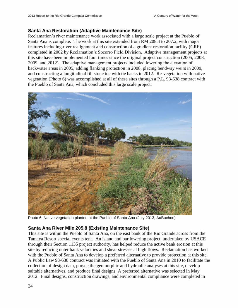
Santa Ana Restoration (Adaptive Maintenance Site) Reclamation’s river maintenance work associated with a large scale project at the Pueblo of
Santa Ana is complete. The work at this site extended from RM 208.4 to 207.2, with major
features including river realignment and construction of a gradient restoration facility (GRF)
completed in 2002 by Reclamation’s Socorro Field Division. Adaptive management projects at
this site have been implemented four times since the original project construction (2005, 2008,
2009, and 2012). The adaptive management projects included lowering the elevation of
backwater areas in 2005, adding flanking protection in 2008, placing bendway weirs in 2009,
and constructing a longitudinal fill stone toe with tie backs in 2012. Re-vegetation with native
vegetation (Photo 6) was accomplished at all of these sites through a P.L. 93-638 contract with
the Pueblo of Santa Ana, which concluded this large scale project.
Photo 6: Native vegetation planted at the Pueblo of Santa Ana (July 2013, AuBuchon)
Santa Ana River Mile 205.8 (Existing Maintenance Site) This site is within the Pueblo of Santa Ana, on the east bank of the Rio Grande across from the
Tamaya Resort special events tent. An island and bar lowering project, undertaken by USACE
through their Section 1135 project authority, has helped reduce the active bank erosion at this
site by reducing outer bank velocities and shear stresses at high flows. Reclamation has worked
with the Pueblo of Santa Ana to develop a preferred alternative to provide protection at this site.
A Public Law 93-638 contract was initiated with the Pueblo of Santa Ana in 2010 to facilitate the
collection of design data, pursue the geomorphic and hydraulic analyses at this site, develop
suitable alternatives, and produce final designs. A preferred alternative was selected in May
2012. Final designs, construction drawings, and environmental compliance were completed in
2013 Report to the Rio Grande Compact Commission A Century of Water for the West
25
2013. Construction of the bendway weirs at RM 205.8 is anticipated in 2014.
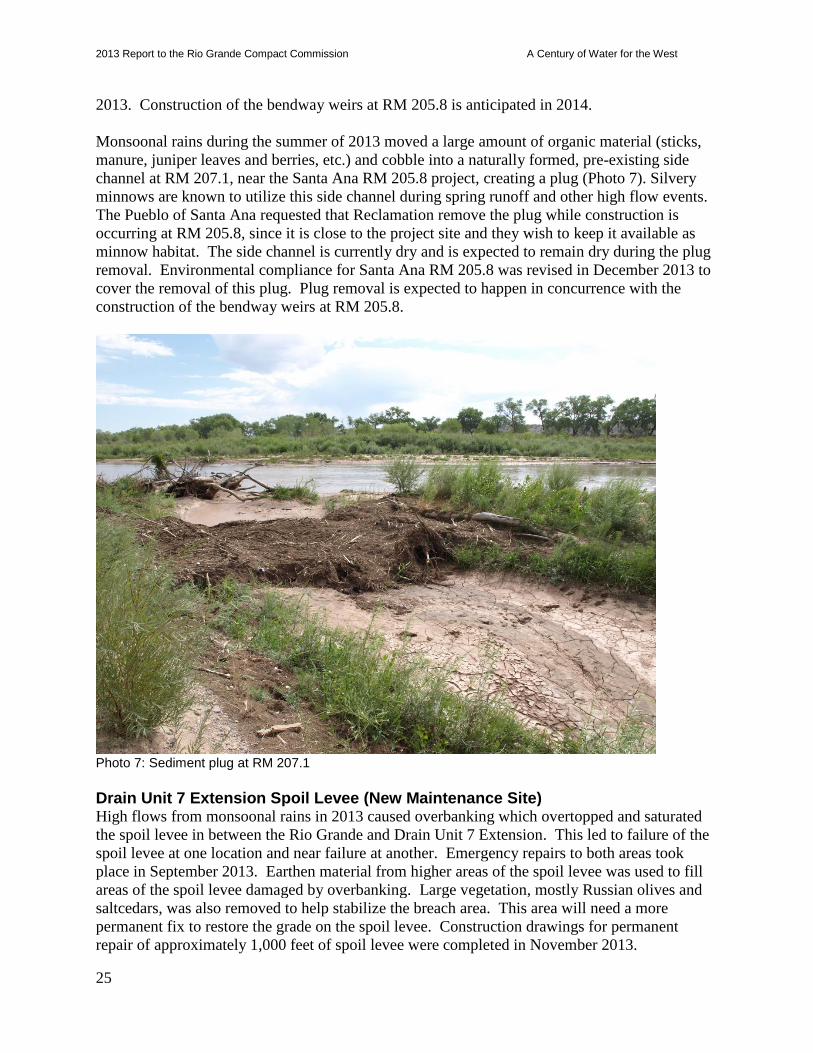
Monsoonal rains during the summer of 2013 moved a large amount of organic material (sticks,
manure, juniper leaves and berries, etc.) and cobble into a naturally formed, pre-existing side
channel at RM 207.1, near the Santa Ana RM 205.8 project, creating a plug (Photo 7). Silvery
minnows are known to utilize this side channel during spring runoff and other high flow events.
The Pueblo of Santa Ana requested that Reclamation remove the plug while construction is
occurring at RM 205.8, since it is close to the project site and they wish to keep it available as
minnow habitat. The side channel is currently dry and is expected to remain dry during the plug
removal. Environmental compliance for Santa Ana RM 205.8 was revised in December 2013 to
cover the removal of this plug. Plug removal is expected to happen in concurrence with the
construction of the bendway weirs at RM 205.8.
Photo 7: Sediment plug at RM 207.1
Drain Unit 7 Extension Spoil Levee (New Maintenance Site) High flows from monsoonal rains in 2013 caused overbanking which overtopped and saturated
the spoil levee in between the Rio Grande and Drain Unit 7 Extension. This led to failure of the
spoil levee at one location and near failure at another. Emergency repairs to both areas took
place in September 2013. Earthen material from higher areas of the spoil levee was used to fill
areas of the spoil levee damaged by overbanking. Large vegetation, mostly Russian olives and
saltcedars, was also removed to help stabilize the breach area. This area will need a more
permanent fix to restore the grade on the spoil levee. Construction drawings for permanent
repair of approximately 1,000 feet of spoil levee were completed in November 2013.
2013 Report to the Rio Grande Compact Commission A Century of Water for the West
26
Photo 8: Temporary fix of spoil levee between Drain Unit 7 Extension and the Rio Grande (September 2013, AuBuchon)
Drain Unit 7 Priority Site (Adaptive Maintenance Site) The Drain Unit 7 River Maintenance Priority Site is located 500 feet upstream of San Acacia
Diversion Dam, on the right bankline of the Rio Grande at RM 116.3. The river was actively
eroding a spoil levee embankment that protects the Drain Unit 7 Extension irrigation structure.
The preferred alternative selected for this site involved protection of the Drain Unit 7 Extension
spoil levee with riprap along the river side of the eastern spoil levee for a length of 1,033 feet.
Phases 1 and 2 of the project placed riprap to protect 650 feet of the spoil levee. Phase 3 would
be performed as needed to extend the riprap protection to the full length of 1,033 feet.
A site visit on September 17, 2013, detected a meander bend that was moving extensively just
upstream of the site (Photo 9). Currently the apex is located at the land side edge of the placed
riprap windrow. A phase 3 for this project to extend this riprap windrow another 383 feet to tie
into an existing groin field that protects the spoil levee of the Drain Unit 7 Extension is
necessary. This length is heavily vegetated and would need to be cleared. The rock for phase 3
has already been stockpiled near this site. It is anticipated that sustained high flows from runoff
or monsoon events will mobilize the bank if phase 3 is not implemented. This would threaten
the spoil levee embankment that protects the Drain Unit 7 Extension irrigation structure.
Environmental compliance is needed before placement of rock for phase 3 occurs.
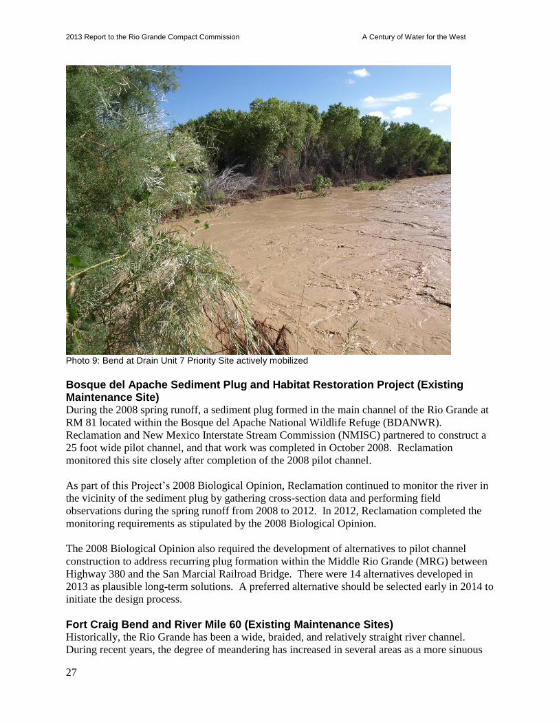
2013 Report to the Rio Grande Compact Commission A Century of Water for the West
27
Photo 9: Bend at Drain Unit 7 Priority Site actively mobilized
Bosque del Apache Sediment Plug and Habitat Restoration Project (Existing Maintenance Site) During the 2008 spring runoff, a sediment plug formed in the main channel of the Rio Grande at
RM 81 located within the Bosque del Apache National Wildlife Refuge (BDANWR).
Reclamation and New Mexico Interstate Stream Commission (NMISC) partnered to construct a
25 foot wide pilot channel, and that work was completed in October 2008. Reclamation
monitored this site closely after completion of the 2008 pilot channel.
As part of this Project’s 2008 Biological Opinion, Reclamation continued to monitor the river in
the vicinity of the sediment plug by gathering cross-section data and performing field
observations during the spring runoff from 2008 to 2012. In 2012, Reclamation completed the
monitoring requirements as stipulated by the 2008 Biological Opinion.
The 2008 Biological Opinion also required the development of alternatives to pilot channel
construction to address recurring plug formation within the Middle Rio Grande (MRG) between
Highway 380 and the San Marcial Railroad Bridge. There were 14 alternatives developed in
2013 as plausible long-term solutions. A preferred alternative should be selected early in 2014 to
initiate the design process.
Fort Craig Bend and River Mile 60 (Existing Maintenance Sites) Historically, the Rio Grande has been a wide, braided, and relatively straight river channel.
During recent years, the degree of meandering has increased in several areas as a more sinuous
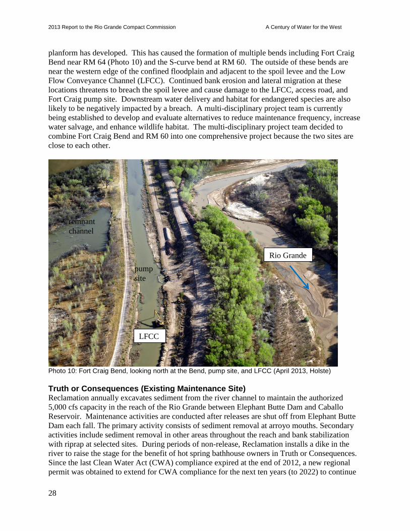
2013 Report to the Rio Grande Compact Commission A Century of Water for the West
28
planform has developed. This has caused the formation of multiple bends including Fort Craig
Bend near RM 64 (Photo 10) and the S-curve bend at RM 60. The outside of these bends are
near the western edge of the confined floodplain and adjacent to the spoil levee and the Low
Flow Conveyance Channel (LFCC). Continued bank erosion and lateral migration at these
locations threatens to breach the spoil levee and cause damage to the LFCC, access road, and
Fort Craig pump site. Downstream water delivery and habitat for endangered species are also
likely to be negatively impacted by a breach. A multi-disciplinary project team is currently
being established to develop and evaluate alternatives to reduce maintenance frequency, increase
water salvage, and enhance wildlife habitat. The multi-disciplinary project team decided to
combine Fort Craig Bend and RM 60 into one comprehensive project because the two sites are
close to each other.
Photo 10: Fort Craig Bend, looking north at the Bend, pump site, and LFCC (April 2013, Holste)
Truth or Consequences (Existing Maintenance Site) Reclamation annually excavates sediment from the river channel to maintain the authorized
5,000 cfs capacity in the reach of the Rio Grande between Elephant Butte Dam and Caballo
Reservoir. Maintenance activities are conducted after releases are shut off from Elephant Butte
Dam each fall. The primary activity consists of sediment removal at arroyo mouths. Secondary
activities include sediment removal in other areas throughout the reach and bank stabilization
with riprap at selected sites. During periods of non-release, Reclamation installs a dike in the
river to raise the stage for the benefit of hot spring bathhouse owners in Truth or Consequences.
Since the last Clean Water Act (CWA) compliance expired at the end of 2012, a new regional
permit was obtained to extend for CWA compliance for the next ten years (to 2022) to continue
Rio Grande
LFCC
remnant
channel
pump
site

2013 Report to the Rio Grande Compact Commission A Century of Water for the West
29
the annual maintenance responsibilities in this reach of the Rio Grande.
Heavy monsoonal rains in 2013 brought significant amounts of sediment to the Rio Grande at
confluences of arroyos with the Rio Grande, such as Mescal Arroyo, Cuchillo Negro Creek,
Feykus Plug, Arroyo Hondo, and local unnamed arroyos. Significant arroyo flows occurred at
Cuchillo Negro Creek and Arroyo Hondo. Monsoonal rains in 2013 also took out the Temporary
Dike (Photo 11). Channel maintenance work such as removal of sediment at arroyo confluences,
excavation of pools in confluences of arroyos to provide habitat, and rebuilding the Temporary
Dike should happen before the beginning of Elephant Butte water operations in the spring of
2014.
Photo 11: Temporary dike taken out by monsoons in 2013 (September 2013, AuBuchon)
Middle Rio Grande River Maintenance Plan The Middle Rio Grande River Maintenance program has developed a long term River
Maintenance Plan that will assist in accomplishing project purposes in an environmentally and
economically sound manner that is consistent with Project authorization. A final report is posted
on the following internet site:
http://www.usbr.gov/uc/albuq/envdocs/reports/mrgRivMaint/index.html
This maintenance plan is an engineering and geomorphic review that can be used to readily
implement the most cost effective and environmentally sound strategies that reduce
Reclamation’s long term commitment of resources.
Ongoing work on the “living” long term comprehensive plan and guide involves evaluating
2013 Report to the Rio Grande Compact Commission A Century of Water for the West
30
reach-based strategies for feasibility, prioritizing reaches, and evaluating effects of strategy
implementation between reaches, upstream and downstream. Work is also being pursued in
updating River Maintenance work prioritization and classification considering risk-based,
conditional, and ecological assessments and criteria.
Determination of River Maintenance Need at Individual Sites and Reaches As part of the Albuquerque Area Office Middle Rio Grande Comprehensive Maintenance Plan
and Guide (Plan and Guide) work, a final report was completed for evaluating sites and reaches
for the purposes of prioritizing maintenance needs. This report is a supplement to the Plan and
Guide and represents a more contemporary, comprehensive update to the River Maintenance
criteria for identification and rating of individual sites (priority sites, monitored sites, and
adaptive maintenance sites) and reach-level strategies. This report was written in partnership
with Reclamation’s Technical Service Center.
The proposed methodology creates a new river maintenance type—reach-level strategies—in
addition to the established individual sites. It includes a technical rating system that integrates a
wider array of technical factors and criteria, best management practices for risk analysis, and the
Best Practices in Dam and Levee Safety Risk Analysis (Reclamation and USACE, 2012). It
combines the evaluation of associated factors of two types of semi-quantitative estimates: 1)
likelihood-relative probability that conditions are causing or may lead to damage or impairment
without future maintenance, and 2) value-derived benefit of performing river maintenance at a
site or reach. The result is a relative need for river maintenance among sites and reaches.
Once the relative need is identified, the river maintenance work is designated under three
classifications (Classes I, II, & III) depending on the level of urgency for addressing maintenance
work at the site or reach. Work is in progress for the continued development and implementation
of this new methodology. The next steps are to: 1) develop a methodology to determine the
value and need of river maintenance for ecological and cultural resource factors; 2) conduct a
pilot evaluation and rating of all existing monitored, priority, and adaptive management sites and
reaches under this methodology; and 3) implement additional recommendations for future
enhancements as identified in this report.
This report and new methodology represents a significant step forward in incorporating technical
advancements in river maintenance state-of-the-practice, a more robust evaluation of river
maintenance priorities, and an effective tool for program managers and leadership to plan,
budget, and schedule river maintenance work.
Preparation for 2014 Spring Runoff As of January 2014, it appears that the spring runoff will be below normal on the Rio Grande,
with some potential for erosion damage to riverside facilities. In preparation, Reclamation is
assessing riprap availability for potential emergency placement and analyzing levee capacity and
the need for levee work prior to the runoff. Specific attention will be given to reach near San
Antonio, the Bosque del Apache Levee, and the Fort Craig Bend. Attention is given to the
Bosque del Apache Levee due to the potential for sediment plug formation and the Fort Craig
Bend will be watched because of the high risk of additional bank erosion. Additionally, periodic
monitoring by aerial flights and levee patrols will occur during high flow periods, and rates of
2013 Report to the Rio Grande Compact Commission A Century of Water for the West
31
bankline erosion will be monitored at selected sites as necessary. Discharge reported by gages
on the Rio Grande and its tributaries will be monitored daily. If flow predictions increase to
above normal as the spring runoff period approaches, Reclamation will coordinate with other
flood control agencies to facilitate efficient reporting of river maintenance needs and issues.
Endangered Species
Programmatic Water Operations and River Maintenance ESA, Section 7, Compliance On March 17, 2003, the Service issued the 2003 Biological Opinion (BiOp) on the effects of
actions associated with the Programmatic Biological Assessment (BA) of Bureau of
Reclamation’s Water and River Maintenance Operations, U.S. Army Corps of Engineers’ Flood
Control Operation, and Related Non-Federal Actions on the Middle Rio Grande, New Mexico
for March 10, 2003, through February 28, 2013. The 2003 BiOp contained a Reasonable and
Prudent Alternative (RPA) designed to alleviate jeopardy to the silvery minnow, adverse
modification to silvery minnow critical habitat, and jeopardy to the flycatcher based on the
biological needs of the species. The RPA elements address some of the long-term needs of the
silvery minnow by incorporating four essential factors during the 10-year scope of the project: 1)
water operations, 2) habitat improvement, 3) population management, and 4) water quality. The
water operations elements establish flow requirements under different hydrologic scenarios that
are needed to alleviate jeopardy to both species.
The Service made a determination that dry year flow requirements would be in effect for the
2013 irrigation season, with anticipated incidental take calculated to be observed mortality of 55
silvery minnows. In anticipation of not meeting flow targets, an interdisciplinary, adaptive
management team, formed under the umbrella of the Middle Rio Grande Endangered Species
Collaborative Program (Collaborative Program), developed a plan to best utilize the available
water for the minnow and the water users. The plan, endorsed by the Collaborative Program,
recommended by Reclamation, and accepted by the Service in May 2013, provided emergency
drought measures for the best possible outcome for the silvery minnow, rather than maintaining
strict adherence to the 2003 BO flow targets.
Under this plan, Reclamation began an early reduction of Supplemental Water releases (with
river drying to begin on June 1 instead of June 15). In compliance with the 2003 BiOp, the Rio
Grande was allowed to dry in isolated locations within the Isleta Reach, and within the San
Acacia Reach downstream to the south boundary of Bosque del Apache National Wildlife
Refuge (BDANWR). However, good monsoonal rains reduced river drying such that rescue and
only very limited salvage efforts were needed after early July. Water pumped from the LFCC
helped slow river drying in the river channel, starting on March 18. The southernmost pumps at
the south boundary of the BDANWR generally remained on all season. Native flow reconnected
the river by September 8, and all LFCC pumping for the year ceased on September 30.
The Service provided provisional data on its silvery minnow rescue and salvage activities, and a
final 2013 Salvage Report will be produced later with greater detail and provided to the
Collaborative Program. Between June 3 and August 23, 2013, the Service’s New Mexico Fish
2013 Report to the Rio Grande Compact Commission A Century of Water for the West
32
and Wildlife Conservation Office (with assistance from Reclamation) conducted rescue and
salvage activities on 36.5 unique miles of the Rio Grande, as compared to 51.0 miles in 2012. Of
this, 26.8 unique miles were salvaged in the San Acacia Reach on 20 days between the south
boundary of BDANWR (RM 74.1) and near Socorro (RM 100.9). Rescue and salvage within 9.7
unique miles of the Rio Grande in the Isleta Reach (RM 132.9 – 135.2 and RM 151.3 – 158.7)
occurred on 12 days.
A total of 1,141 (942 San Acacia, 199 Isleta) Rio Grande silvery minnow > 30 mm standard
length (SL) were salvaged, transported, and released alive to a continuously flowing site in the
reach where collected – either the San Acacia or Isleta Reach. Young of year (YOY) were first
salvaged in August in the San Acacia reach. Of those, 8 were < 30 mm SL and 1 was > 30 mm
SL. One YOY < 30 mm SL was preserved upon mortality, but is not considered as incidental
take under the 2003 BO. There were 19 silvery minnow > 30 mm SL found dead after June 15,
identified as incidental take under the 2003 BO. Prior to June 15, there were 215 observed
mortalities associated with river drying. In addition, a total of 117 (21 San Acacia, 96 Isleta)
either died during transport, were too small or sick to salvage, or were found dead during
secondary drying events. These mortalities do not count towards incidental take of silvery
minnow > 30 mm SL. Of the 1,492 silvery minnow observed in 2013, 1,226 (82.2%) were
marked (VIE), with 1,088 (72.9%) in the San Acacia reach, and 138 (9.2%) in the Isleta reach,
indicating that they were hatchery-released individuals from 2012. In addition, one hatchery fish
from fall 2011 was found in the Isleta reach, which is the first time a second year hatchery fish
has been collected during salvage.
Formal ESA Section 7 consultation was reinitiated by the Service on February 22, 2013, prior to
the end of the term of the 2003 BiOp, providing continued Federal and non-Federal coverage in
accordance with the terms of the 2003 BiOp.
Rio Grande Silvery Minnow The Rio Grande silvery minnow (silvery minnow) was formerly one of the most widespread and
abundant species in the Rio Grande basin of New Mexico, Texas, and Mexico, but is now listed
as endangered (Fish and Wildlife Service, 1994). Currently, RGSM occupies less than 10
percent of its historic range, and is restricted to the reach of the Rio Grande in central New
Mexico from Cochiti Dam to the headwaters of Elephant Butte Reservoir.
Studies to indicate trends of silvery minnow abundance have generally used October catch per
unit effort (CPUE) from the population monitoring project that have used similar survey methods
since 1993. Catch rates were highest in 2005, and were similar in 2004, 2006, 2010, and 2011.
No RGSM were found in the October 2012 monitoring, but they were present in October 2013
monitoring (Figure 5). Silvery minnow was present in three of the 303 seine hauls that yielded
fish during October 2013.
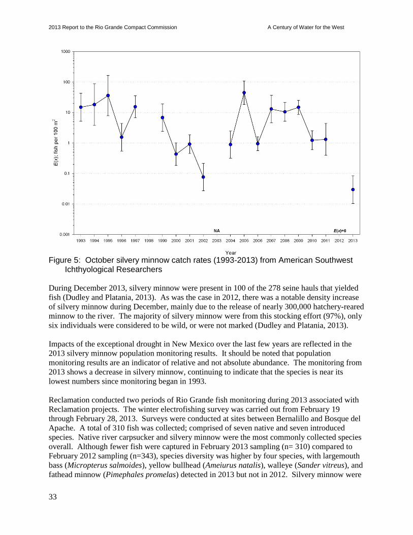
2013 Report to the Rio Grande Compact Commission A Century of Water for the West
33
Figure 5: October silvery minnow catch rates (1993-2013) from American Southwest
Ichthyological Researchers During December 2013, silvery minnow were present in 100 of the 278 seine hauls that yielded
fish (Dudley and Platania, 2013). As was the case in 2012, there was a notable density increase
of silvery minnow during December, mainly due to the release of nearly 300,000 hatchery-reared
minnow to the river. The majority of silvery minnow were from this stocking effort (97%), only
six individuals were considered to be wild, or were not marked (Dudley and Platania, 2013).
Impacts of the exceptional drought in New Mexico over the last few years are reflected in the
2013 silvery minnow population monitoring results. It should be noted that population
monitoring results are an indicator of relative and not absolute abundance. The monitoring from
2013 shows a decrease in silvery minnow, continuing to indicate that the species is near its
lowest numbers since monitoring began in 1993.
Reclamation conducted two periods of Rio Grande fish monitoring during 2013 associated with
Reclamation projects. The winter electrofishing survey was carried out from February 19
through February 28, 2013. Surveys were conducted at sites between Bernalillo and Bosque del
Apache. A total of 310 fish was collected; comprised of seven native and seven introduced
species. Native river carpsucker and silvery minnow were the most commonly collected species
overall. Although fewer fish were captured in February 2013 sampling (n= 310) compared to
February 2012 sampling (n=343), species diversity was higher by four species, with largemouth
bass (Micropterus salmoides), yellow bullhead (Ameiurus natalis), walleye (Sander vitreus), and
fathead minnow (Pimephales promelas) detected in 2013 but not in 2012. Silvery minnow were
2013 Report to the Rio Grande Compact Commission A Century of Water for the West
34
found at all survey sites (n=60), but were most common at the San Acacia Dam site.
Reclamation’s fall surveys (October 2013) were conducted via seining within the delta channel
in the Elephant Butte Reservoir pool and the Low Flow Conveyance Channel (LFCC). Silvery
minnow were found in 2013, whereas none were found during 2012 surveys. Three silvery
minnow were found from the LFCC confluence and south into the Delta Channel.
Captive silvery minnow populations include: City of Albuquerque BioPark, Southwestern
Native Aquatic Resources & Recovery Center (formerly the Dexter National Fish Hatchery), and
the Interstate Stream Commission’s Los Lunas Silvery Minnow Refugium. In 2013, the
following Middle Rio Grande releases of silvery minnow occurred: 1) 123,000 (pink right pre-
dorsal) VIE marked RGSM released in the Angostura Reach; 2) 89,000 (pink right pre-dorsal)
and 77 (green right pre-dorsal) VIE marked silvery minnow released in the Isleta Reach; and 3)
80,000 (pink right pre-dorsal) VIE marked silvery minnow released in the San Acacia Reach.
The Service also annually stocks captively propagated silvery minnow from these facilities into
Big Bend National Park, Texas. In 2013, a total of 72,000 silvery minnow were stocked at
Dryden.
Literature Cited
Dudley, R.K. and S.P. Platania. 2013. Summary of the Rio Grande Silvery Minnow Population
Monitoring Program Results from December 2013 (Draft as of Jan 2014). Report to the
Middle Rio Grande Endangered Species Act Collaborative Program and the U.S. Bureau
of Reclamation, Albuquerque, N.M.
Dudley, R.K. and S.P. Platania. 2013. Summary of the Rio Grande Silvery Minnow Population
Monitoring Program Results from October 2013. Report to the Middle Rio Grande
Endangered Species Act Collaborative Program and the U.S. Bureau of Reclamation,
Albuquerque, N.M. 29 pp.
Southwestern Willow Flycatcher The flycatcher was listed as endangered by the Service effective March 29, 1995. Critical
habitat was designated, effective August 21, 1997, in some areas of New Mexico and other states
throughout the species’ range. The Rio Grande was not designated as critical habitat for the
flycatcher at that time. On October 13, 2004, under court order, the Service reissued a proposed
designation for critical habitat for the flycatcher that now includes portions of the Rio Grande in
New Mexico. The final rule designating critical habitat was issued October 19, 2005, and
includes four sections of riparian forest in the Middle Rio Grande Valley: from the Taos Junction
bridge to the north boundary of Ohkay Owingeh Pueblo, from the south boundary of the Pueblo
of Isleta to the north boundary of Sevilleta National Wildlife Refuge (NWR), from the south
boundary of Sevilleta NWR to the north boundary of Bosque del Apache NWR, and from the
south boundary of Bosque del Apache NWR to the powerline crossing of the Rio Grande near
Milligan Gulch.
The Service revised the designation of critical habitat in January 2013. The southern boundary
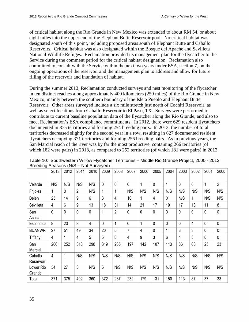
2013 Report to the Rio Grande Compact Commission A Century of Water for the West
35
of critical habitat along the Rio Grande in New Mexico was extended to about RM 54, or about
eight miles into the upper end of the Elephant Butte Reservoir pool. No critical habitat was
designated south of this point, including proposed areas south of Elephant Butte and Caballo
Reservoirs. Critical habitat was also designated within the Bosque del Apache and Sevilleta
National Wildlife Refuges. Reclamation provided its management plan for the flycatcher to the
Service during the comment period for the critical habitat designation. Reclamation also
committed to consult with the Service within the next two years under ESA, section 7, on the
ongoing operations of the reservoir and the management plan to address and allow for future
filling of the reservoir and inundation of habitat.
During the summer 2013, Reclamation conducted surveys and nest monitoring of the flycatcher
in ten distinct reaches along approximately 400 kilometers (250 miles) of the Rio Grande in New
Mexico, mainly between the southern boundary of the Isleta Pueblo and Elephant Butte
Reservoir. Other areas surveyed include a six mile stretch just north of Cochiti Reservoir, as
well as select locations from Caballo Reservoir to El Paso, TX. Surveys were performed to
contribute to current baseline population data of the flycatcher along the Rio Grande, and also to
meet Reclamation’s ESA compliance commitments. In 2012, there were 629 resident flycatchers
documented in 375 territories and forming 254 breeding pairs. In 2013, the number of total
territories decreased slightly for the second year in a row, resulting in 627 documented resident
flycatchers occupying 371 territories and forming 256 breeding pairs. As in previous years, the
San Marcial reach of the river was by far the most productive, containing 266 territories (of
which 182 were pairs) in 2013, as compared to 252 territories (of which 181 were pairs) in 2012. Table 10: Southwestern Willow Flycatcher Territories – Middle Rio Grande Project, 2000 - 2013 Breeding Seasons (N/S = Not Surveyed)
2013 2012 2011 2010 2009 2008 2007 2006 2005 2004 2003 2002 2001 2000
Velarde N/S N/S N/S N/S 0 0 0 1 0 1 0 0 1 2
Frijoles 1 0 2 N/S 1 1 N/S N/S N/S N/S N/S N/S N/S N/S
Belen 23 14 9 6 3 4 10 1 4 0 N/S 1 N/S N/S
Sevilleta 4 6 9 13 18 31 14 21 17 19 17 13 11 8
San
Acacia
0 0 0 0 1 2 0 0 0 0 0 0 0 0
Escondida 8 23 8 4 0 1 0 1 0 0 0 4 0 0
BDANWR 27 51 49 34 20 5 7 4 0 1 3 3 0 0
Tiffany 4 1 4 5 5 8 4 9 3 6 4 3 0 0
San
Marcial
266 252 318 298 319 235 197 142 107 113 86 63 25 23
Caballo
Reservoir
4 1 N/S N/S N/S N/S N/S N/S N/S N/S N/S N/S N/S N/S
Lower Rio
Grande
34 27 3 N/S 5 N/S N/S N/S N/S N/S N/S N/S N/S N/S
Total 371 375 402 360 372 287 232 179 131 150 113 87 37 33
2013 Report to the Rio Grande Compact Commission A Century of Water for the West
36
In 2013, nests were monitored for success rates, productivity, and Brown-headed cowbird
(Molothrus ater) parasitism. The San Marcial reach proved most productive, producing 173
nests. Other studies continued in 2013 include: 1) flycatcher nesting hydrology and habitat
variable study, 2) river maintenance impact monitoring, 3) photo monitoring of habitat
development in the Elephant Butte delta, and 4) depredation monitoring via trail cameras. These
studies are designed to provide further insight into potential threats to and habitat requirements
of flycatcher populations.
Elephant Butte Reservoir
In 2013, the flycatcher population grew the most in the Belen, Elephant Butte, and Lower Rio
Grande reaches, increased a little in the Tiffany and Caballo reaches, and declined in the
remaining five reaches that were surveyed. At Elephant Butte Reservoir, flycatchers have
expanded their occupied habitat farther south near River Mile 40. Flycatcher occupied areas in
the ‘delta’ portion of Elephant Butte Reservoir (i.e., River Miles 60 to 54) used to consist of
mainly dense Goodding’s and coyote willow of various age classes, with water provided by the
LFCC outfall. However, with reduced flows in the last few years, this area rarely receives
overbank flooding from the LFCC and invasive saltcedar is encroaching. Although this provides
refuge habitat for flycatchers, the likely arrival of the saltcedar leaf beetle in the upcoming years
is concerning because they would likely defoliate saltcedar during flycatcher nesting times –
providing less foliage cover and making nests more vulnerable to predation, parasitism, and the
natural elements.
Habitat modeling from 2012 throughout the Middle Rio Grande has shown that there is still
suitable habitat that is not occupied, thus indicating that habitat is not a limiting factor to this
population. The reason that flycatchers do not expand into all areas of suitable habitat is more a
cause of their site fidelity.
Predation rates (50%) during summer 2013 were higher than average and nest success (44%)
increased when compared to last year, but is still relatively low for the average. This decline in
nest success over the past few years could be an indicator that vegetation in the northern end of
the reservoir pool, where the majority of the territories are, is declining in habitat suitability,
which may eventually cause the population to shift to other areas of suitable habitat. This
shifting in territories may be what is currently occurring, particularly with the large population
increase in the Belen and Lower Rio Grande reaches, and historically the population increase in
the Bosque del Apache NWR.
As previously mentioned, the LFCC historically provided water to much of the high quality
flycatcher habitat on the western side of the ‘delta’ within Elephant Butte Reservoir (i.e., River
Miles 60 to 54). The initial drying of some of this habitat was partially beneficial, stimulating
new growth in areas that were becoming overmature or stressed due to the prolonged flooding.
However, in some areas of the ‘delta’, particularly closer to the main channel and farther south,
the continued drought combined with the freezing event in February 2011 caused tremendous
stress to historically occupied vegetation. Much of this habitat is now simply open space.
Flycatcher habitat has historically been a dynamic system that is created and destroyed in
relatively short periods of time. Flycatchers depend on this type of dynamic successional system
2013 Report to the Rio Grande Compact Commission A Century of Water for the West
37
for breeding habitat.
Flycatcher ESA Compliance Issues at Elephant Butte Reservoir
Due to the ongoing drought, Elephant Butte Reservoir has receded and remained low.
Reclamation has allowed temporary habitat to develop as the Reservoir recedes as part of its
ESA Section 7(a)1 authority to help in the conservation of threatened and endangered species.
Under ESA Section 9, Reclamation would still need to address incidental take of flycatchers, and
Yellow-billed Cuckoos (cuckoos) if listed, if the reservoir were to fill up and impact threatened
and endangered species habitat.
Reclamation developed a voluntary ESA Section 7(a)1 “Flycatcher Management Plan” to
develop flycatcher habitat as part of the Rio Grande Project, and submitted the document to the
Federal Register along with flycatcher proposed critical habitat comments in an effort to have
Elephant Butte Reservoir excluded from critical habitat designation. On January 3rd, 2013, the
final critical habitat designation was announced, and the northern-most eight miles of Elephant
Butte Reservoir are now considered critical habitat for the flycatcher.
The cuckoo was proposed for listing on October 3rd, 2013, and their proposed critical habitat
will likely be out on the Federal Register in the near future. Similar to the flycatchers, cuckoos
use habitat in Elephant Butte Reservoir during the breeding season and most likely habitat within
Elephant Butte Reservoir will once again be proposed as critical habitat. Because the cuckoo
and flycatcher occupy similar habitat, Reclamation plans on revising the Flycatcher Management
Plan and incorporating the cuckoo into upcoming habitat restoration applications.
New Middle Rio Grande Water Management and River Maintenance ESA, Section 7 Consultation Formal ESA Section 7 consultation between the Service and Reclamation was reinitiated on
February 22, 2013, prior to expiration of the 2003 BiOp, providing continued federal and non-
federal coverage in accordance with the terms of the 2003 BiOp. Consultation goals include
achieving and maintaining comprehensive ESA compliance through a hydrologically viable
BiOp that maintains and improves the status of listed species.
For these reasons, Reclamation submitted a biological assessment (BA) for Middle Rio Grande
water operations and river maintenance to the Service on July 31, 2012, supplemented on August
15, 2012, on September 17, 2012, and on January 15, 2013, addressing Reclamation, MRGCD,
and State of New Mexico water management-related actions taken in the Middle Rio Grande,
and State actions in the Upper Rio Grande. The BA includes conservation measures proposed by
Reclamation, MRGCD, the State, the Albuquerque-Bernalillo County Water Utility Authority,
and taken by participants of the Collaborative Program. A revised BA was submitted on August
8, 2013. It included the Collaborative Program’s Recovery Implementation Program (RIP) as a
conservation measure, which was endorsed by the Executive Committee of the Collaborative
Program in July 2013.
Concurrent with Reclamation’s consultation, the Service also reinitiated consultation with the
U.S. Army Corps of Engineers (Corps) and initiated consultation with the Bosque del Apache
National Wildlife Refuge on those agencies’ programmatic actions. The Service’s intention was
to accomplish a single comprehensive effects analysis for the three consultations, while
2013 Report to the Rio Grande Compact Commission A Century of Water for the West
38
discussing agency effects separately to the extent possible and issuing individual BiOps. On
November 26, 2013, the Corps withdrew from consultation with the Service to evaluate its BA
and ensure it is compliant with the Corps’ recent legal guidance and policy. The Corps has
stated, “Following that evaluation, we reserve the option to reinitiate consultation unless our
ongoing actions are determined to be wholly non-discretionary and/or part of the environmental
baseline.” Consequently, the Service is considering options for issuing a new BO that does not
include the Corps’ actions.
Supplemental Water Program
The Supplemental Water Program is utilized to comply with elements of the Reasonable and
Prudent Alternative of the 2003 BiOp. The Program consists of water acquisition and storage,
concurrence with waiver requests, the continued conveyance of water from the Low Flow
Conveyance Channel (LFCC) to the Rio Grande, and the implementation of water conservation
practices by water contractors. The Program supports Endangered Species Act coverage under
Section 7(a)(2).
Water Acquisition and Management In 2013, a BiOp “dry” year, 45,980 ac-ft of supplemental water was released for endangered
species purposes. Reclamation ended the year with 19,907 ac-ft of water leased from ABCWUA
in storage in Abiquiu. In addition, for 2014 Reclamation may store up to 19,451 ac-ft of
Emergency Drought Water and has potential leases of up to 13,400 ac-ft from 2014 SJ-C
allocations.
Low Flow Conveyance Channel (LFCC) Pumping Program – San Acacia to Fort Craig Reach During the irrigation season, flows in the Rio Grande between San Acacia Diversion Dam and
the full pool elevation of Elephant Butte Reservoir can drop to a level that may result in adverse
impacts to the silvery minnow and flycatcher. Reasonable and Prudent Alternatives D, G, K, and
O of the 2003 BiOp require the use of pumps to manage river recession, maintain river
connectivity, and supply water for nesting flycatchers. The LFCC Pumping Program also helps
Reclamation comply with the continuous river requirements stipulated by Reasonable and
Prudent Alternatives E, H, and L, and has been effective in allowing Reclamation to maximize
the effectiveness of supplemental water releases made for ESA purposes.
Reclamation installed and maintains portable pumps with flow measurement devices at strategic
locations to move water from the LFCC into the Rio Grande. Discharge data for the pumping
sites is now posted in orange boxes on the MRGCD Gage Schematic page within the
Reclamation ET Toolbox web site. The URL of the referenced site is
http://www.usbr.gov/pmts/rivers/awards/Nm2/rg/riog/schematic/SCHEMATICsocorrodiv.html.
The total available pumping capacity for all pump locations is approximately 200 cfs, although
the maximum total combined rate is limited to 150 cfs by the 2003 permit granted by the New
Mexico Office of the State Engineer.

2013 Report to the Rio Grande Compact Commission A Century of Water for the West
39
Due to the low flows in the Rio Grande and the need to manage recession through Bosque del
Apache, pumps located at the North Boundary pump site were started on March 18, 2013. To
maintain connectivity from the South Boundary of Bosque del Apache to Elephant Butte
Reservoir, pumps at the South Boundary site were turned on March 22. The pumps at the North
Boundary site were shut off on June 5, while the pumps at South Boundary were shut off on
September 30.
Table 9 below summarizes the volume, in acre-feet, pumped at each site for the year.
Table 9: 2012 Pumping Volume by Site
Total Per Pumping Site For The
Year
Neil
Cupp
North
Boundary
South
Boundary Ft. Craig
0 ac-ft 4,426 ac-ft 10,501 ac-ft 0 ac-ft
As Table 9 illustrates, pumps at the North Boundary and South Boundary sites were used, while
pumps at the Ft. Craig and Neil Cupp sites were not used for pumping supplemental water during
the 2013 season. The total volume of supplemental flow provided by the pumping effort in the
2013 season was 14,927 ac-ft.
Other Ongoing Water Management and Water Quality Related Projects
U.S. Geological Survey (USGS) Groundwater/Surface Water Interaction in the MRG Valley The monitoring network presently consists of 252 groundwater piezometers on both sides of the
Rio Grande, from I-25 to the Alameda bridge crossing, and 27 surface water staff gages. The
majority of these components are equipped with data loggers, which monitor water level and
temperature at regular intervals. No additional funding was provided to the USGS in FY2013,
but a small amount of funding was set aside so that Reclamation could continue to collect data
and maintain the wells and transducers.
A report, titled Groundwater Hydrology and Variability of Groundwater Gradients and Fluxes
from the Rio Grande at Selected Locations in Albuquerque, New Mexico, 2009-10, was issued
during 2012. The report is available online in .pdf format at
http://pubs.usgs.gov/sir/2012/5007/SIR2012-5007.pdf Data were collected from one transect in
November by Reclamation personnel. It will be determined in 2014 whether future data will be
collected by Reclamation or a contractor.
USGS MRG River Gage Operation and Maintenance This project has been funded by the Collaborative Program since FY2002. The USGS operates
and maintains a network of 24 streamflow gages in the MRG, including 12 in the mainstem and
12 in tributaries or distribution features. Four streamflow gages and one sediment data collection
gage are funded by the Collaborative Program. Data from the river gages help MRG water
management agencies meet the needs of water users, fulfill the requirements of the Rio Grande
Compact, maintain sufficient water in storage for future needs, maintain adequate water in the
river to support the silvery minnow, and provide the information needed to improve the daily
2013 Report to the Rio Grande Compact Commission A Century of Water for the West
40
management of the river system from Cochiti Dam to Elephant Butte Reservoir. The data from
these gages are available to the public at http://waterdata.usgs.gov/nm/nwis/current/?type=flow.
RiverEyes Reasonable and Prudent Alternative Element C of the 2003 BiOp states that monitoring must be
performed when flows are less than 300 cfs at San Acacia. RiverEyes is a program that provides
current information on river flows and river drying and allows action agencies to react quickly to
changing conditions on the river. RiverEyes also facilitates coordination among agencies to
prevent unexpected drying and prepare for silvery minnow salvage and rescue actions.
For the 2013 irrigation season, RiverEyes monitored river conditions along the Rio Grande from
Isleta Diversion Dam to the full pool elevation of Elephant Butte Reservoir from May 7, 2013,
through October 31, 2013. The total maximum river miles dried during the 2012 RiverEyes
monitoring period was 36 miles which included 11 miles in the Isleta Reach (in two segments)
and 25 miles in the San Acacia Reach. The first occurrence of channel drying was recorded on
June 3, 2013; the last occurrence of channel drying was observed on September 11, 2013. River
drying was restricted to three river segments: from 2.5 miles below the Los Lunas Bridge to 1.4
miles below the Peralta Wasteway in the upper Isleta Reach, from 1.9 miles above the Abeytas
Heading to 1.3 miles below the Abeytas Heading in the lower Isleta Reach, and from 0.2 miles
above Otero Street to the South Boundary pumping station in the San Acacia Reach. There were
three main periods of drying, punctuated by re-wetting events that were caused by flooding
during the summer monsoons.
Middle Rio Grande Endangered Species Collaborative Program
The Middle Rio Grande Endangered Species Collaborative Program (Collaborative Program)
brings diverse groups together to support Endangered Species Act (ESA) compliance and
address environmental issues along the Middle Rio Grande (MRG). The Collaborative Program
consists of stakeholders representing diverse interests including federal, state, and local
government entities; Indian tribes and pueblos; and non-governmental organizations working to
support compliance with the ESA. The Collaborative Program began transitioning to a Recovery
Implementation Program (RIP) through endorsement of a new Program document, action plan,
new Long-Term Plan, and draft cooperative agreement on July 18, 2013. On August 8, 20131, a
Joint Biological Assessment2 was transmitted as Reclamation’s conservation measure for
consultation in new biological opinions (BiOps). The purpose of the RIP is to protect and
improve the status of listed species within the MRG by implementing certain recovery activities
to benefit those species and their associated habitats and, simultaneously, to protect existing and
future water uses while complying with applicable state and federal laws, including Rio Grande
Compact delivery obligations.
In 1994, the U.S. Fish and Wildlife Service listed the silvery minnow as endangered, issued a
1 http://www.usbr.gov/uc/albuq/envdocs/ba/MRG/transLtr.pdf
2 http://www.usbr.gov/uc/albuq/envdocs/ba/MRG/Part4/BA-Part-IV.pdf
2013 Report to the Rio Grande Compact Commission A Century of Water for the West
41
recovery plan in 1999, and released a revised critical habitat designation in 20033. The silvery
minnow recovery plan4 was updated in 2010. The flycatcher was added to the endangered
species list in 1995 and a final recovery plan5 was issued in 2002. The designation for flycatcher
critical habitat was revised in January 20136. Consultation was reinitiated on the 2003 BiOp prior
to its expiration on March 1, 2013. The 2003 BiOp thus remains in effect and requires delivery
of supplemental (leased) water and other measures to reduce impacts to the listed species and
alleviate jeopardy on the MRG Project for water, river maintenance, and flood control
operations. Currently, Reclamation manages and serves as the fiscal agency for the Collaborative
Program as authorized by the Omnibus Appropriations Act of 2009 (P.L. 111-8). In federal fiscal
year (FY) 2013, total appropriations, after sequestration, were $7,762,379, of which $1,351,770
was utilized for Collaborative Program activities and $6,410,609 was utilized for water leasing,
pumping, and Program administration activities. Related FY2013 accomplishments include:
Supported four USGS streamflow gages;
Captive propagation of silvery minnow at the Southwestern Native Aquatic Resources &
Recovery Center7 (formerly the Dexter National Fish Hatchery and Technology Center)
and the City of Albuquerque's BioPark Aquatic Conservation Facility8; the New Mexico
Interstate Stream Commission’s Los Lunas Silvery Minnow Refugium9 did not provide
captive propagation in FY2013;
Silvery minnow rescue efforts during river drying and reproductive monitoring;
Annual monitoring of silvery minnow populations and flycatcher nests;
Leasing of 45,980 ac-ft of supplemental water acquired from San Juan - Chama Project
contractors;
Pumping from the Low Flow Conveyance Channel into the Rio Grande;
Program management, assessment, reporting, and outreach activities.
These and other beneficial activities serve to meet 2003 BiOp requirements and support species
recovery.
3 http://www.gpo.gov/fdsys/pkg/FR-2003-02-19/pdf/03-3255.pdf#page=1
4http://www.fws.gov/southwest/es/Documents/R2ES/Rio_Grande_Silvery_Minnow_Recovery_Plan_First_Revision
.pdf 5http://www.fws.gov/southwest/es/arizona/Documents/SpeciesDocs/SWWF/Final%20Recovery%20Plan/ExecSum
mary_Contents.pdf 6 http://www.gpo.gov/fdsys/pkg/FR-2013-01-03/pdf/2012-30634.pdf
7 http://www.fws.gov/southwest/fisheries/dexter/
8 http://www.cabq.gov/culturalservices/biopark/about-the-biopark/conservation-at-the-biopark
9 http://www.ose.state.nm.us/PDF/SpecialProjects/LosLunasRefugium/LLSMR_WNR_fact%20sheet_2.pdf
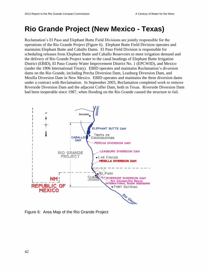
2013 Report to the Rio Grande Compact Commission A Century of Water for the West
42
Rio Grande Project (New Mexico - Texas)
Reclamation’s El Paso and Elephant Butte Field Divisions are jointly responsible for the
operations of the Rio Grande Project (Figure 6). Elephant Butte Field Division operates and
maintains Elephant Butte and Caballo Dams. El Paso Field Division is responsible for
scheduling releases from Elephant Butte and Caballo Reservoirs to meet irrigation demand and
the delivery of Rio Grande Project water to the canal headings of Elephant Butte Irrigation
District (EBID), El Paso County Water Improvement District No. 1 (EPCWID), and Mexico
(under the 1906 International Treaty). EBID operates and maintains Reclamation’s diversion
dams on the Rio Grande, including Percha Diversion Dam, Leasburg Diversion Dam, and
Mesilla Diversion Dam in New Mexico. EBID operates and maintains the three diversion dams
under a contract with Reclamation. In September 2003, Reclamation completed work to remove
Riverside Diversion Dam and the adjacent Coffer Dam, both in Texas. Riverside Diversion Dam
had been inoperable since 1987, when flooding on the Rio Grande caused the structure to fail.
Figure 6: Area Map of the Rio Grande Project

2013 Report to the Rio Grande Compact Commission A Century of Water for the West
43
Water Supply Conditions
Inflow into Elephant Butte Reservoir during 2013 as measured at the Rio Grande Floodway
(FW) plus the Low Flow Conveyance Channel (LFCC) at San Marcial (FW+LFCC) was
302,454 ac-ft. The provisional flow record for the 2013 Spring Runoff (March - July), measured
at San Marcial, was 48,729 ac-ft, or aproximently 10% of the 30-year average.
During the period from 1998 to 2013, the spring runoff at the San Marcial gauging stations
continue to be below the 30 year average. From 1998 to 2013, average inflow was 276,600 ac-ft
and only two years, 2005 and 2008, exceeded the 30 year average of 573,000 ac-ft. The
combined flow in the three previous years, 2011 to 2013, averaged 86,700 ac-ft.
In 2013 the 30 year average for the inflow at San Marcial gauging stations was updated to
510,000 ac-ft. As of January 28, 2014, the 2013 daily streamflow record for these stations
remain provisional. These stations are maintained and operated by the United States Geological
Survey (USGS).
Releases from Elephant Butte Reservoir began on May 23, 2013, and continued through July 8,
2013. During this period a total release of 166,779 ac-ft was recorded by the USGS. The total
calendar year release, including non-irrigation season releases, amounted to 168,732 ac-ft.
November through December daily flow data remains provisional, all other data has been
approved by the USGS.
During the 2013 irrigation season (June 1 to July 17), 168,200 ac-ft of water was released from
Caballo Reservoir. This flow met the irrigation requirements to the Project water users. The
total 2013 calendar year release from Caballo Reservoir was 168,743 ac-ft.
Once more the January - March 2013 forecast seemed much more promising than previous years,
projecting an average spring runoff of 196,000 ac-ft. The most probable January through June
Natural Resources Conservation Service and National Weather Service (NRCS and NWS)
coordinated forecasts received for the 2013 March through July runoff season are presented in
Table 11.
Table 11: Summary of 2013 Rio Grande Coordinated Spring Runoff Forecasts
Month
Forecasted
Otowi
Runoff (ac-ft)
Percent of 30-
Year Average
Forecasted
San Marcial
Runoff (ac-ft)
Percent of 30-
Year Average
Jan 1 340 47 191 37
Feb 1 380 53 197 39
Mar 1 395 55 200 39
Apr 1 235 33 71 14
May 1 171 24 -41 -
June 1 162 23 -49 -
Actual Runoff - - 48.7 10
Combined total storage for Elephant Butte and Caballo Reservoirs was 318,805 ac-ft on
2013 Report to the Rio Grande Compact Commission A Century of Water for the West
44
December 31, 2012, or 14% of their total capacity. The available storage for both reservoirs
during the winter months (October 1 to March 31) is equal to the capacity of Elephant Butte
Reservoir, 2,024,586 ac-ft, minus 25,000 ac-ft that Reclamation reserves for winter operational
flood control space (50,000 ac-ft during the summer), plus the capacity of Caballo Reservoir,
324,934 ac-ft, minus 100,000 ac-ft for flood control space, or a total of 2,224,520 ac-ft during the
winter and 2,199,520 ac-ft during the summer.
Per the Rio Grande Compact Article I definition, the usable water in Project storage (Elephant
Butte and Caballo Reservoirs together) was below 400,000 ac-ft throughout 2013.
Since 2011 the average March through July runoff is 86,700 ac-ft. In 2013 the spring runoff
was estimated at 88,400 ac-ft. With the combined storage and minimal run-off, Reclamation
allotted 6% of a full supply to Rio Grande water users. The available storage was not sufficient
to begin a normal release in late February. Reclamation coordinated with the International
Boundary Water Commision, Mexico, the Elephant Butte Irrigaton district, and the El Paso
Water Improvement District #1 to schedule a timely and organized irrigation release. Release
from Caballo Reservoir began on June 1, 2013. The irrigation season continued for 47 days. The
2013 irrgation season set the record for the shortest season and the lowest irrgation release in a
calendar year. This marks the third consecutive year with irrgation releases lower than 400,000
ac-ft.
The initial allocation for 2014 is scheduled to be finalized in late January 2014. On January 1,
2014, combined storage was 319,970 ac-ft. This value includes all credit water pools therefore
not reflecting total storage available for use by the Rio Grande Project users. Based on the
January 1, 2014, NRCS/NWS spring runoff forecast at the San Marcial gauging stations,
declining snowpack, and present hydrologic conditions, Reclamation anticipates a less than full
supply for irrigation during 2014 for the Rio Grande Project.
The most probable coordinated January and February 2014 forecasts from the NRCS and NWS
are presented in Table 12. Table 12: 2014 Rio Grande Coordinated Spring Runoff Forecasts
Month
Otowi
Runoff (KAF)
(Mar-Jul)
Percent of 30-
Year Average
San Marcial
Runoff (ac-ft)
(Mar-Jul)
Percent of 30-
Year
Average
Jan 1 515 72 300 59
Feb 1 360 50 154 30
Project Irrigation and Drainage Systems
Following title transfer, which was completed in 1996, the irrigation and drainage system is
owned, operated, and maintained by Elephant Butte Irrigation District in the New Mexico
portion of the Rio Grande Project and by El Paso County Water Improvement District No. 1 in
the Texas portion of the Project. Reclamation owns and administers the lands and rights-of-way
activities of the reservoirs and diversion dam areas, and also retains title and operation and

2013 Report to the Rio Grande Compact Commission A Century of Water for the West
45
maintenance responsibilities for Elephant Butte and Caballo Dams and Reservoirs.
The Districts performed flow measurements at canal headings, river stations, and lateral headings
during 2013. Reclamation also preformed flow measurements at canal headings and river
stations, and coordinated and maintained central control of releases, river operations, and water
accounting. To accomplish the water allotment accounting, the Districts collect field flow
measurements and coordinate data from all water user entities. Utilizing the summarized flow
data submitted by the Districts for their areas of responsibility, Reclamation calculated and
summarized the monthly and end-of-year Project water supply use and accounting for 2013. The
International Boundary and Water Commission (IBWC) continued to own, operate, and maintain
the American Diversion Dam and the American Canal during 2013 in accordance with the
International Treaties with Mexico (1906 and 1933). In addition, the IBWC operated the
International Diversion Dam, which diverts irrigation waters into the Acequia Madre headgates
operated by Mexico.
Drainage waters from the Rio Grande Project lands provide supplemental irrigation water for
approximately 18,342 acres of the Hudspeth County Conservation and Reclamation District No.
1 (HCCRD). Total flows out of the Project to HCCRD are measured at three gauging stations
near the Hudspeth County line: the Hudspeth Feeder Canal, the Tornillo Canal at Alamo Alto,
and the Tornillo Drain. Under the Warren Act contracts, HCCRD is charged for drainage water
from the Project between March 1 and September 30. As of February 10, 2014, no data had been
reported to Reclamation.
Water flow is measured by the International Boundary and Water Commission (IBWC) at the
station located on the Rio Grande at Fort Quitman, downstream of the Project and HCCRD
boundaries. The total water flowing past the gage in 2013 was 5,526 ac-ft. Sixty percent of the
flow occurred in the months of January, February and December, 2013.
Elephant Butte Reservoir and Powerplant
In 2013, Elephant Butte Reservoir reached a daily minimum storage of 60,327 ac-ft (elevation
4,286.25 feet) on July 8th
and a daily maximum storage of 279,060 ac-ft (elevation 4,320.83 feet)
on December 31st.
The total gross generation for 2013 was 9,701,974 kilowatt-hours (kWh). Net power generation
for 2013 was 9,269,432 kWh, which was 21 percent of the 9-year average (2005 through 2013)
of 43,862,250 kWh. The power plant releases were utilized to meet downstream irrigation
demand and manage Caballo Reservoir storage levels. The balance valves were used to meet
releases at the end of the 2013 irrigation season. The balance valves will be available for any
required release beyond the Elephant Butte Powerplant capabilities for 2014.
Reclamation anticipates that all three turbines will be available for generation and discharge by
the spring of 2014. The excitation system commissioning was completed in February 2013 and
the switch gear project was completed in April of 2013. Currently the replacement of the unit
grounding transformers, updating the emergency penstock closing system, updating the unit
2013 Report to the Rio Grande Compact Commission A Century of Water for the West
46
protection systems, and completing other recommendations is scheduled for 2014. Most work is
scheduled to be complete by the start of the irrigation season.
The 2013 summer monsoon season was relatively mild until mid September. New Mexico was
hit by record storms in September, but the strongest effects were in the southern and southeastern
parts of the state. This event produced nearly 28,000 acre-feet of inflow and sediment discharges
into the Rio Grande downstream of Elephant Butte Dam.
Elephant Butte Dam Facility Review and Safety of Dams Program
There are no significant dam safety related operations and maintenance issues associated with
Elephant Butte Dam other than aging infrastructure. Elephant Butte Field Office is located at the
dam site, so operation and maintenance issues are resolved as soon as they occur. There are
currently four incomplete O&M Recommendations for Elephant Butte Dam.
One O&M recommendations were completed during 2013. It was EB-2011-2-B, to assess
methods to prevent rock fall from the sides of the spillway discharge chute and stilling basin
walls.
To complete 2011-2-B, the Elephant Butte Rope Access Team assessed of the condition of the
rock face above the spillway discharge chute. The assessment concluded that rocks that would
fall onto the spillway were very weak and broke easily. By the time the rock got to the chute or
wall even a very large rock (48”) was broken down to approximate 6” rock or smaller. With this,
no further action is required and the spillway and wall are safe from extensive damage.
An Annual Security Review was completed in September 2013. The Annual Site Inspection was
completed in September 2013. No significant issues were identified during these inspections.
Caballo Dam and Reservoir
During the 2013 water year, October 2012 to October 2013, Caballo Reservoir reached a
minimum storage of 5,196 ac-ft (4,127.70 feet) on October 1, 2012, and a maximum storage of
39,678 ac-ft (4,143.60 feet) on September 27, 2013.
According to Court Order No. CIV-90-95 HB/WWD of October 17, 1996, which resulted from a
negotiated settlement with the Irrigation Districts, the Caballo Reservoir storage level is targeted
not to exceed 50,000 ac-ft (4,146.44 feet) from October 1 to January 31 of each year, unless
flood control operations, storage of water for conservation purposes, re-regulation of releases
from Elephant Butte Dam, safety of dams purposes, emergency operations, or any other purpose
authorized by Federal law, except non-emergency power generation, dictate otherwise.
Significant variation above 50,000 ac-ft during the winter months of October through January
requires collaboration and consultation between the Districts and Reclamation. Storage in
Caballo Reservoir at the end of the 2013 irrigation season did not exceed 50,000 ac-ft.
2013 Report to the Rio Grande Compact Commission A Century of Water for the West
47
Reclamation’s plan for operation of Caballo Reservoir during the irrigation release period, June 1
through July 17, 2013, was to maintain storage levels such that they would not exceed 35,000 ac-
ft. Operating Caballo Reservoir at these storage levels during the 2013 irrigation season allowed
Reclamation to:
Reduce evaporative losses between Elephant Butte and Caballo Reservoirs,
Provide sufficient operational hydraulic head at Caballo Reservoir during the short irrigation
demand releases,
Use Caballo as a reserve pool should releases from Elephant Butte Dam be interrupted, and
minimize changes to release rates from Elephant Butte Dam,
Allow for data collection and maintenance of OPEC and 3D-sec (ET) systems at Caballo
through cooperative research with New Mexico State University.
Caballo Reservoir’s operating plan for the 2014 water year has not yet been finalized. Currently,
releases are scheduled to begin June 1, 2014. Due to the ongoing drought all parties are
coordinating release schedules to avoid block releases. Reclamation will finalize its reservoir
operating plan in the spring of 2014. The operations plan will reflect accommodations to
minimize evaporation differences between Elephant Butte and Caballo Reservoirs and meet
water user needs.
Caballo Dam Facility Review and Safety of Dams Program
There are no significant dam safety related operations and maintenance issues associated with
Caballo Dam other than aging infrastructure. There are currently seven incomplete O&M
Recommendations for Caballo Dam.
Two Category 2 O&M Recommendations for Caballo Dam were completed during FY2013:
2011-2-C: completed October 2013, perform a CCTV inspection of the embankment toe
drains,
2011-2-D: completed February 2013, replace the weir for drain outfall E.
The toe drains at Caballo dam were inspected with a CCTV-equipped remotely operated vehicle.
The accessible portions of the drains were found to be in good condition, but many pipes had
large amounts of sediment which restricted camera access. The inspection produced another
recommendation, 2012-2-A, to use a high pressure washer to clean out areas with high sediment
deposition and then try to determine the source of the sediment.
The replacement of drain outfall E started as a simply, but as inspection of the area progressed,
the corrugated outfall pipe at drain E collapsed. The corrugated pipe was removed and replaced
by a new dual wall pipe. The connection to the manhole was redesigned and constructed as well.
Once the pipe was replaced and buried, the construction of drain E outfall weir began. Construction
began November 21, 2012 and completed February 1, 2013.
Caballo dentates (energy dissipation devices) corner armor plate was coated. All of the downstream

2013 Report to the Rio Grande Compact Commission A Century of Water for the West
48
dentates were coated. The upstream dentates will be coated next season with the same 3M product. Both an annual Security Inspection and Site Inspection were completed in September 2013. No
significant issues were identified during these inspections.
Rio Grande Project Adjudications
The United States filed the case United States of America v. Elephant Butte Irrigation District, et
al Civ. No. 97-0803 JP/RLP/WWD (Quiet Title to the Waters for the Rio Grande Project) on
June 12, 1997, requesting the Court to quiet legal title to the waters of the Rio Grande Project in
its name. The United States District Court (USDC) for the District of New Mexico dismissed the
case in August 2000. On May 7, 2002, the United States Court of Appeals (10th Circuit) vacated
the USDC’s August 2000 decision and remanded the case back to District Court for further
proceedings. Chief Judge James A. Parker issued an order to stay the case and close for
administrative purposes on August 15, 2002, but further ordered that should it become necessary
or desirable during the pendency of the water adjudications in New Mexico and Texas, any party
may initiate proceedings as though the case had not been closed for administrative purposes.
Lower Rio Grande Basin Adjudication (New Mexico), State of New Mexico, ex rel, Office of the
State Engineer v. EBID, et al, CV-96-888: This "stream adjudication" was originally filed by
Elephant Butte Irrigation District (EBID) against the State Engineer in 1986. Negotiation
meetings on the Offers of Judgment on Lower Rio Grande Basin Adjudication (New Mexico)
have been held between the Office of the State Engineer and the United States. In 2011, as part
of Stream System Issue No. 101, the Court issued a final judgment approving a settlement
agreement whereby the State of New Mexico and the farmers in the Rio Grande Project agreed to
a total consumptive use amount of 4.5 ac-ft per acre per year, consisting of up to 3.024 ac-ft of
surface water and the remainder from groundwater. The total may be increased to a maximum of
5.5 ac-ft if a farmer can prove beneficial use in excess of 4.5 ac-ft per acre per year.
Since 2010, interested parties have been proceeding with Stream System Issue No. 104, which
involves the United States’ water interests in the Lower Rio Grande in New Mexico. In 2012,
the Court determined that the United States did not have a groundwater right associated with the
Rio Grande Project. However, the Court did not rule on whether the various groundwater
inflows into the Rio Grande are considered “project water”, which would mean the United States
still has a right to such inflows once they become surface water again. In January of 2013 Texas
filed a motion in the United States Supreme Court to receive a declaration of the rights of the
State of Texas to the waters of the Rio Grande pursuant to and consistent with the Rio Grande
Compact and the Rio Grande Project Act, issue its decree commanding the State of New Mexico
to deliver the waters of the Rio Grande in accordance with the provisions of the Rio Grande
Compact and the Rio Grande Project Act, plus award damages and other relief for the injury
suffered by the State of Texas. On December 10, 2013, the United States filed a brief stating that
Texas’ motion for leave to file a complaint should be granted, and New Mexico should be
invited to file a motion to dismiss the complaint.
The Texas Commission on Environmental Quality (TCEQ) posted public notice of adjudication
of all claims of water rights in the Upper Rio Grande (above Ft. Quitman) segment of the Rio

2013 Report to the Rio Grande Compact Commission A Century of Water for the West
49
Grande Basin and the requirement to file sworn claims pursuant to section 11.307 of the Texas
Water Code on or before April 22, 1996. On January 27, 2014, the U.S. Supreme Court ruled
that Texas can proceed to the next step in its lawsuit against New Mexico and invited New
Mexico to file a motion to dismiss the action. The Investigation Report was completed under
Phase 1. Phase 2 calls for evidentiary hearings in which claimants present evidence to support
the validity of their claims. Threshold issues were briefed, and on July 31, 2003, the
Administrative Law Judge ruled as follows: (1) the TCEQ has jurisdiction over the proceeding,
(2) the river segment subject to the adjudication does not need to be revised or expanded, and (3)
the proceeding qualifies as an adjudication of water rights under the McCarran Amendment. An
evidentiary hearing was held on December 11, 2003, and Reclamation presented expert
testimony about the Rio Grande Project. Notice was given under Texas Administrative Code
§86.18 (c) that on April 13, 2006, the Texas Commission on Environmental Quality issued a
Final Determination of all claims of water rights under adjudication in the Upper Rio Grande
Segment of the Rio Grande Basin (above Fort Quitman) located within the State of Texas and
which includes all portions of Hudspeth and El Paso Counties, Texas. The effective date of the
Final Determination is May 15, 2006.
Rio Grande Project Operating Agreement
On February 14, 2008, Reclamation, Elephant Butte Irrigation District (EBID), and El Paso
County Water Improvement District No. 1 (EP#1) agreed to, finalized, and signed a new
operating agreement for the Rio Grande Project. This is very significant in that the first
negotiations of a draft operating agreement started almost 30 years ago. This historic document,
and its accompanying operations manual, finalized in August 2008, provides detailed procedures
for operating the Rio Grande Project between Reclamation, EBID, and EP#1 while recognizing
and fulfilling the terms of the 1906 Convention Treaty with Mexico to supply up to 60,000 ac-ft
of irrigation water from the Rio Grande Project.
The most important items in the operating agreement are: (1) procedures for allocation of Rio
Grande Project water supply to the three Project water users, (2) recognition of groundwater
pumping in the Rincon and Mesilla valleys affecting the water supply available to EP#1 and
adjusting the allocation procedures to mitigate the allotment for EP#1, and (3) an incentive for
EBID and EP#1 to carry over their respective unused allotments each year with a maximum
carry over provision for each District of 60% of their respective historical full allocation. This
carry over incentive encourages each District to conserve and effectively utilize irrigation water,
particularly during drought periods on the Rio Grande Project. The Rio Grande Project has
completed six irrigation seasons under the 2008 Operating Agreement and will begin the seventh
irrigation season in June 2014 due to extremely low available water supplies.
EP#1 ended the 2013 irrigation season with -6,487 ac-ft on their allocation carry over account
and EBID ended the season with 3,008 ac-ft on their allocation carry over account.
The technical team for the Rio Grande Project, which consists of representatives from EBID,
EP#1, and Reclamation, will meet in early 2014 to discuss amendments to the operations
manual. At this time, none have been proposed.
2013 Report to the Rio Grande Compact Commission A Century of Water for the West
50
During the 2013 irrigation season, the Project released 168,201ac-ft from Rio Grande Project
storage. The project water users (EBID, EP#1, and Mexico) were charged for 111,197 ac-ft of
delivered water. Releases from storage and deliveries to Project water users during the 2013
irrigation season were the lowest ever recorded for the Project. The release to delivery ratio of
0.66 shall be used in the calculation of the allocation at the start of the 2014 irrigation season.
The release to delivery ratios for the years that the operating agreement has been in effect show
that the Project continues operating in an extreme drought scenario. Reclamation continues to
work with each district to account accurately for water released from Caballo and water
delivered at each diversion point. Snow pack conditions presently are below normal, therefore
reservoir levels are expected to fall during the 2014 irrigation season.
Elephant Butte and Caballo Reservoir Vegetation Management Cooperative Agreement
Under this Agreement, Reclamation performs maintenance of previously managed vegetation,
primarily by mowing to limit the non-beneficial consumption of water by woody phreatophytes
such as saltcedar (Tamarix). Herbicide treatments to saltcedar and tornillo (screwbean mesquite)
are also made to limit the amount of mowing necessary to complete the task. Approximately
6,931 acres have been sprayed at both reservoirs over the past ten years with varying amounts of
success. With assistance from New Mexico State University, scientific investigations are being
done concurrently to estimate reductions in evapotranspiration after various treatments. A report
with recommendations for optimization of storage for water conservation is currently being
compiled.
During FY2013, Reclamation managed 4,451 acres of phreatophytic vegetation at Caballo
reservoir utilizing mowers, mulchers, grubbers, and extraction equipment.

2013 Report to the Rio Grande Compact Commission A Century of Water for the West
51
Other Reclamation Programs
The Secure Water Act The SECURE Water Act became law on March 30, 2009, as a component of the Omnibus Land
Management Act of 2009. It provides authority for Federal water and science agencies to work
both independently and in partnership with States and with local water managers to plan for
climate change and other threats to our water supplies, and to take action to secure water
resources for the communities, economies, and ecosystems they support. The SECURE Water
Act authorizes and funds a number of programs under the Department of the Interior’s
WaterSMART Program to evaluate the risk that climate change and other threats pose to water
supply, and to initiate local actions to mitigate these threats. These programs include:
Basin Study Program
o West-Wide Climate Risk Assessments
o Basin Studies
o SECURE Feasibility Studies
o Landscape Conservation Cooperatives
WaterSMART Grants
o Water and Energy Efficiency Grants
o System Optimization reviews
o Advanced Water Treatment Pilot and Demonstration Projects
o Grants to Develop Climate Analysis Tools
Adaptations to Climate Change through the Water Conservation Initiative
o Water Conservation Challenge Grant Program (previously Water for America
Challenge Grant Program)
o Title XVI Water Reclamation and Re-use Program
Basin Study Program Reclamation’s Basin Study Program, a component of the WaterSMART Program, represents a
comprehensive approach to identifying and incorporating the best available science into climate-
change adaptation planning. Within the Basin Study Program, Reclamation and its partners seek
to identify strategies for addressing imbalances in water supply and demand, as authorized in the
SECURE Act. The Program includes three complementary activities: the West-Wide Climate
Risk Assessment (WWCRA) and basin-specific WWCRA Impacts Assessments, Basin Studies,
and SECURE Feasibility Studies.
West-Wide Climate Risk Assessments
WWCRA implementation activities focus on development of consistent west-wide climate
projections within each of eight major Reclamation river basins, and impacts to water supply,
water demand, and water/reservoir operations, as well as impacts to ecological resources.
WWCRA Impacts Assessments are Reclamation-only projects, which focus on the development
of baseline projections of the impacts of climate change alone, isolated from other human-
induced changes to our water supply and ecological resources, so that the magnitude of the
2013 Report to the Rio Grande Compact Commission A Century of Water for the West
52
impacts of climate change can be understood. WWCRA activities include climate projections,
water supply analyses, water demand analyses, reports to Congress, and WWCRA impacts
assessments.
Upper Rio Grande WWCRA Impact Assessment
In 2013, Reclamation completed and released to the public the Upper Rio Grande Impact
Assessment, in which Reclamation assessed climate change impacts to the headwaters of the Rio
Grande and the Rio Chama in Colorado and New Mexico, and the Rio Grande and its tributaries
as far downstream as Caballo Reservoir. This Impact Assessment was managed by the Upper
Colorado Region, Albuquerque Area Office. Under this project, Reclamation used a suite of 112
General Circulation Model simulations (GCM, which are global climate models) to develop
projections of future climatic conditions in the basin. These forecasts were downscaled and
corrected for bias, and used as input to hydrologic models, which use forecasted temperature and
precipitation to provide projections of future snowpack, evapotranspiration rates, and river flow
rates. These parameters, after additional calibration and correction for bias, were then used in
local routing models that simulate river and reservoir operations within the basin to provide
projections of future river flow and water availability. This project also includes a general
assessment of ecological resilience or vulnerability to the predicted climatic and hydrologic
changes.
Basin Studies
Reclamation has been seeking partnerships with local water management agencies to perform
Basin Studies. Ongoing and proposed Basin Studies in the Upper Rio Grande Basin build on the
hydrologic projections developed by Reclamation as part of the Upper Rio Grande Impact
Assessment. The projects are managed out of the Upper Colorado Region, Albuquerque Area
Office, and seek to develop adaptation and mitigation strategies for watersheds affected by
climate change. Basin studies require a 50% cost share from Reclamation's local water-
management partner(s), and involve considerable cooperation with other members of the water
community in a basin.
Reclamation’s Albuquerque Area Office is nearing completion of a partnership with the City and
County of Santa Fe for a Basin Study covering the Santa Fe River watershed, the headwaters of
the Rio Grande as far downstream as Otowi gage, and the San Juan Basin tributaries that
contribute to Reclamation's San Juan-Chama Project. Under this project, a preliminary
assessment was performed to evaluate the range of potential impacts of climate change on the
Santa Fe watershed, and potential adaptation actions that the community could take to mitigate
the impacts. Work is currently underway on a detailed assessment of the implications of the
predicted hydrologic changes on the City and County's ability to provide a reliable water supply
to its constituents, as well as on the development of adaptation and mitigation measures for
predicted shortages. This work is expected to be completed in the summer of 2014.
In 2012, Reclamation’s Albuquerque Area Office initiated a partnership with the New Mexico
Interstate Stream Commission (ISC) for a Basin Study focusing on the Pecos River watershed in
New Mexico. This project emphasizes groundwater resources in the Pecos River Basin, with a
focus on the Fort Sumner area. Projections of the hydrologic impacts of climate change are
being developed by Reclamation for this Basin. In addition, Reclamation and the ISC are
2013 Report to the Rio Grande Compact Commission A Century of Water for the West
53
working together on the development of a groundwater representation in the basin’s operations
model.
Proposals are currently being developed for 2014 Basin Studies.
SECURE Feasibility Studies and Special Studies
SECURE Feasibility Studies and Special Studies, the third step in the three-step Basin Studies
Program, evaluate the implementation of adaptation and mitigation strategies identified in Basin
Studies to address climate change impacts on water resources, including their impact on
ecological resources. These studies can be used to evaluate the feasibility of changes to reservoir
operations or new or modified infrastructure, such as water management infrastructure or
infrastructure to benefit environmental needs. SECURE Special Studies provide Reclamation
support to the evaluation of adaptation actions that may be taken by local partners. A framework
for the inclusion of climate projections in Reclamation Feasibility Studies and Special Studies, as
well as in environmental compliance efforts, is currently being finalized.
Landscape Conservation Cooperatives
Reclamation is partnering with the U. S. Fish & Wildlife Service to establish Landscape
Conservation Cooperatives (LCCs). LCCs are designed to be links between science and
conservation actions, which address climate change and other stressors within and across
landscapes. The Middle Rio Grande straddles the Southern Rockies LCC and the Desert LCC.
Reclamation invites all federal, state, tribal, local government, and non-governmental
management organizations to become partners in the development of these cooperatives.
WaterSMART Grants The Department of the Interior's WaterSMART Initiative is a plan for working with
communities, irrigation districts, and states to help resolve and avert water supply crises in the
West. The Rio Grande has been identified as among the most likely areas in the West to
experience the kinds of water-related conflicts that the WaterSMART Initiative is addressing.
The WaterSMART Initiative’s goals are being accomplished primarily through competitive
award of challenge grants to irrigation districts, communities, and states. Through the Challenge
Grant Program, Reclamation provides 50/50 cost share funding for projects focused on water
conservation, efficiency, and water marketing. The focus is on projects that can be completed
within 24 months.
Arch Hurley Conservancy District was awarded a grant to apply sodium bentonite to areas along
the main canal to reduce water loss where aquatic vegetation was removed prior to the
agreement. Construction was completed in March of 2013. Due to persistent drought, water
savings calculations have not been available. The FY14 irrigation season will be the first in
years for the district and actual water savings can be calculated.
The Carlsbad Irrigation District was awarded a Water and Energy Efficiency Grant in 2012 in
order to replace Parshall flumes in irrigation channels that were inoperable due to settlement or
problems in original construction. Telemetry systems will be installed to transmit real-time data
to the Irrigation District for managing system losses and measuring water flows. Construction
on the project continued through 2013. The project also includes GIS mapping and creation of a
2013 Report to the Rio Grande Compact Commission A Century of Water for the West
54
database for cataloging system information. The project is scheduled to be complete in 2014.
Title XVI Water Reclamation and Re-use Projects Under the authority of Public Laws 102-575 and 104-266, Reclamation is/was participating with
the cities of Albuquerque, New Mexico, and El Paso, Texas, in the construction of water
reclamation and re-use projects. Reclamation has also participated in a Title XVI feasibility
study with the City of Espanola.
Albuquerque Bernalillo County Water Utility Authority (ABCWUA)
In 1999 Reclamation entered into agreements with ABCWUA that provide the framework for
participation and cost sharing in their $67 million non-potable water reclamation and re-use
project. Up to 25 percent federal cost share was authorized for construction of the project, not to
exceed $20 million. Currently, ABCWUA re-uses about 1 million gallons of reclaimed water
each day.
Southside Municipal Effluent Re-use Project (Southside Project): The Southside Project
consisted of an expanded treatment system at the Southside Wastewater Reclamation
plant to include a clearwell/chlorine contact tank, two pump stations, a 1.9 million gallon
storage reservoir, and associated transmission and distribution pipelines. Construction
began in December 2009, and the project was operational as of March of 2012. The
project will provide about 2,500 acre-feet per year of polished municipal effluent, which
will be used to irrigate approximately 700 acres of turf at 24 schools, parks, and other
recreational areas in the southern part of Albuquerque thereby avoiding the use of San
Juan - Chama water on public landscapes.
Bosque and Tijeras Re-use Projects: The Bosque and Tijeras Re-use Projects feasibility
report was approved by Reclamation in August of 2012. The project consists of two
treatment facilities that would intercept wastewater collection system flows on both the
west (Bosque) and east (Tijeras) sides of the Rio Grande within Albuquerque, separate
solids, then treat the remaining effluent for delivery and irrigation of public turf areas.
Sludge removed from the flows would be sent to the Southside treatment facility for
processing. The transmission and distribution system constructed as part of the above
Southside Municipal Effluent Re-use Project would be used for conveying effluent on the
east side of the Rio Grande. Proposed construction for the Bosque and Tijeras Re-use
Projects would also include transmission, distribution, and storage infrastructure on the
west side of the Rio Grande. Effluent proposed to be delivered from the Bosque plant is
2,811 ac-ft, with 6,104 ac-ft proposed to be delivered from the Tijeras plant.
City of El Paso
The City of El Paso has been using recycled water since 1961. The City of El Paso philosophy is
that “every gallon of reclaimed water used to irrigate crops and landscapes or for construction or
manufacturing is one gallon of potable water that is saved and does not have to be pumped from
our aquifers or treated from the Rio Grande.” Reclamation has contributed to El Paso’s efforts
since 1996 through Title XVI. El Paso currently recycles nearly 2 billion gallons of water per
year (~ 6,000 ac-ft per year) through 50 miles of purple pipe. This recycle program has cost the
City $56 million, with Reclamation’s contribution of $14.4 million
2013 Report to the Rio Grande Compact Commission A Century of Water for the West
55
The City of El Paso is preparing a feasibility study for rerouting collection system flows that are
currently delivered to the Haskell R. Street Wastewater Treatment Plant. The new collection
system reconfiguration will then deliver flows to the Fred Hervey Water Reclamation Plant for
re-use in Northeast El Paso.
Reclamation’s Water Conservation Field Services Program
Through the Water Conservation Field Services Program, Reclamation provides cost-share
funding and technical assistance to a number of water management entities in New Mexico and
Texas. The Water Conservation Field Services Program seeks to promote water use efficiency
through support of outreach efforts, research projects, and technical assistance to water users.
Funding was used to design and construct a headworks facility on the Rio Brazos that has not
been improved since Spanish colonial times. The City of Rio Rancho used funding to upgrade
its Water Conservation Plan. The City of Santa Rosa has initiated the development of their
Water Conservation Plan with funding provided by the program. The City of Santa Fe used its
funding for the installation of automatic water meter readers and software which helps better
manage water. The Bernalillo County Public Works was able to provide the community with
264 rain barrels, 147 low flow toilets, and perform 128 home water audits. The New Mexico
Office of the State Engineer (NMOSE) used funding to sponsor a “Fix-A-Leak” Campaign
which uses public advertisements to inform the public of the importance of correcting leaks in
home water systems. The NMOSE also completed a comprehensive water use census that
categorizes water use.
In addition to funding projects, Reclamation continued to support conservation outreach aimed at
increasing public and industrial awareness of water issues during 2013. Water Conservation
Field Service staff was able to support outreach programs demonstrating water conservation
principals to thousands of children throughout the state by supporting children’s water festivals
in Rio Rancho, Santa Fe, Artesia, Carlsbad, Lovington, and Las Cruces. The New Mexico
Association of Conservation Districts provided funding to support the Rolling Rivers
Educational Trailers throughout New Mexico. Outreach demonstrations are generally held at
State and County Fairs, public and private schools, teacher workshops, water conferences, and
other outreach activities.
Funding was also used to promote the nation’s largest xeriscape conference, as well as for
irrigation water management workshops that were co-sponsored by Reclamation, the New
Mexico Office of the State Engineer and the New Mexico Water Conservation Alliance.
Upper Rio Grande Water Operations Model
The Upper Rio Grande Water Operations Model (URGWOM) is a computational model
developed through an interagency effort and is used to simulate processes and operations in the
Rio Grande Basin in New Mexico as well track the delivery of water allocated to specific users.
RiverWare is the software used by URGWOM and was developed at the Center for Advanced
2013 Report to the Rio Grande Compact Commission A Century of Water for the West
56
Decision Support for Water and Environmental Systems (CADSWES). The primary purpose of
URGWOM is to facilitate more efficient and effective flood risk management operations,
forecasting, accounting, and management of water in the Upper Rio Grande Basin. URGWOM
performs accounting of multiple San Juan-Chama Project water contracts and forecasting to
simulate daily storage and delivery operations in the Rio Grande Basin. A water operations
application is used to complete forecasting of operations for an upcoming year for preparing an
Annual Operations Plan (AOP) and a planning application is used to complete long-term
planning studies.
Water management decisions are becoming even more complex and difficult because of the
broad range of interests and issues that must be addressed. URGWOM is used to provide the
community of water managers and water users with a clear, consistent, and common set of data
to formulate, evaluate, and support decisions.
Work continues on stakeholder outreach for all activities involving URGWOM. Meetings of the
Technical Team, Executive Committee, and Advisory Committee are held periodically, and the
URGWOM website is updated with details on recent activities, postings of the latest
documentation, and meeting notes.
In 2012, the Technical Team worked on an updated calibration for the Middle Rio Grande
portion of the model. While the previous calibration was good, the Technical Team worked to
utilize new data and refined model methods to further improve the model calibration and to
simplify model administration and also improve the model run-time and efficiency for
completing simulations. Enhancements include refinements to the methodology for computing
crop evapotranspiration (ET) rates and changes to the model approach for including crop
consumption to simplify model maintenance and allow for longer-term model runs, on the order
of 50 years, to be completed more efficiently. Work is also being completed to develop
estimates of actual crop ET as needed for the URGWOM database. Currently, actual ET is
estimated as 80 percent of the computed potential ET. During early 2013, the updated
calibration will be finalized by reviewing and adjusting numerous hydraulic conductivities for
the modeled groundwater fluxes throughout the Middle Valley.
Enhancements to the model configuration for the updated URGWOM calibration also included
setting up an updated representation for modeling returns to the river at outfalls and wasteways
from the MRGCD distribution system and a new method for representing evaporation losses
from wetted sands on the river bed.
An updated vegetated area survey was completed in 2011 by the New Mexico Interstate Stream
Commission (ISC) for updating the URGWOM database to include the latest actual irrigated
areas. Efforts were initiated in 2012 and will be completed in 2013 to process the survey data to
be utilized by URGWOM. The work includes completing the data processing of the crop survey
data to estimate irrigated areas using aerial photos and Quality Assurance/Quality Control
(QA/QC) procedures in the process. Crop areas for each groundwater reach in URGWOM will
then be developed.
Two parallel tracks continue to develop watershed models. Work was completed in 2011 to
2013 Report to the Rio Grande Compact Commission A Century of Water for the West
57
develop watershed models for the basin to be used by the National Weather Service (NWS) West
Gulf River Forecasting Center (WGRFC) for providing forecasted flows. In 2012, NWS worked
to implement the new models into their new system with the first forecasted flows are to be
provided in 2013. Work was also initiated with Riverside Technologies, Inc. to develop and
calibrate rainfall-runoff methods in a Hydrologic Modeling System (HMS) model for use during
the summer/monsoon season. The HMS model will use the same basin configuration as the
completed NWS model.
URGWOM has been used in recent years for daily accounting to update the actual status of
accounts with the latest data for preparing AOPs and for long-term planning studies. Separate
URGWOM versions were used for the different applications including the Accounting Model
used for simulations with actual data to track the status of accounts, the Water Operations Model
used with the Forecast Model to complete runs through a calendar year to prepare AOPs, and the
Planning Model used to evaluate long-term impacts of proposed actions (e.g. for NEPA
processes or Biological Assessments) on various indicators in the basin such as deliveries to
water users, river flows, interstate Compact deliveries, and the overall water budget.
Work was completed in 2012 to consolidate the models into two separate URGWOM models
utilized for all modeling exercises and decision support: a Rulebased Simulation Model and an
Accounting Model. Significant work was then completed on a new single master model for 2013
designed by the Technical Team that was used for 2013 accounting. It also simplifies model
maintenance further and allows for more efficient use of URGWOM for all applications
including AOP model runs and planning runs with multiple hydrologic sequences. The new
model may also be configured to be used efficiently for real-time water operations modeling
using 7-day ET forecasts from Reclamation’s ET Toolbox and runoff forecasts from the
watershed models.
Work also continued in 2013 on other tasks included in the URGWOM Five Year Plan as
referenced as part of the interagency URGWOM Memorandum of Understanding (MOU).
Significant progress was made during 2013 on model development for the separate Lower Valley
portion of URGWOM, below Elephant Butte Dam, to represent all the key physical processes
and include greater detail of the physical system. Also, significant work was completed to
develop a separate test model for the Colorado portion of the basin. The test model is being set
up to simulate the delivery of available water to adjudicated water rights holders, as actually
done in Colorado, with consideration for curtailments to the allocatable flow to assure Compact
deliveries are made. Currently, URGWOM uses gaged flows of the Rio Grande near Lobatos as
an upstream input rather than modeling Colorado water management operations, so the new
model for the Colorado portion of the basin is being developed to refine the input flows at
Lobatos for AOP model runs and planning studies.
A water quality component will be included in the development of URGWOM that will be useful
for making management decisions to maintain optimal river ecosystem health while meeting
downstream water delivery requirements. The design and incorporation of needed capabilities
for simulating water quality into RiverWare was completed in 2012. Currently, the Technical
Team is testing the development of the water quality methods and implementing them into
URGWOM.

2013 Report to the Rio Grande Compact Commission A Century of Water for the West
58
In 2013 the Technical Team continued to coordinate with Sandia National Laboratories on
activities that involve the monthly-timestep Upper Rio Grande Simulation Model (URGSiM)
developed with the PowerSim Studio software package.
Water Accounting Reports Projects 2013 San Juan – Chama Project Water Accounting The 2013 San Juan – Chama Project water accounting was accomplished using version 6.4.3 of
the RiverWare modeling system software and version 6.0 of the URGWOM accounting module.
All accounting data and information is stored directly in the final version of the 2013 accounting
model. Reclamation held occaisional meetings with representatives of the New Mexico
Interstate Stream Commission and the U. S. Army Corp of Engineers, Albuquerque District, to
verify accounting data entered for the previous months. This minimized year-end data quality
and accounting concerns.
Oracle® Hydrologic Database (HDB) The Hydrologic Database (HDB) is a specialized relational database for storing and recovering
hydrologic data used by Reclamation in the management of river and reservoir systems. A
generalized version of HDB was specifically developed for Reclamation use with RiverWare®
models. HDB is an Oracle®
relational database application, and includes connections to data
sources such as Reclamation’s Hydromet, DOMSAT, DSS, and models such as RiverWare.
HDB was originally developed at the University of Colorado, Center for Advanced Decision
Support for Water and Environmental Systems. Reclamation’s Albuquerque Area Office
(AAO) HDB instance is now maintained by Reclamation’s Upper Colorado Regional Office as
well as through contract with Sutron Corporation. HDB has been customized by independent
Reclamation consultants and Reclamation offices for specific office and model requirements.
HDB is currently used by Reclamation’s Upper and Lower Colorado Regional Offices for joint
management of the Colorado River. The AAO and the El Paso Field Division (EPFD) depend
on HDB installations for the purposes of data storage and retrieval.
Development of water accounting and reporting functionalities for the AAO’s HDB installation
continued during 2013. Water accounting data is now directly transferred from the RiverWare
URGWOM Accounting Model to HDB, and from HDB to URGWOM, via an HDB/RiverWare
Direction Data Connection interface.
Planned work for 2013 includes continued work to back-populate historical data to HDB.
Additional Crystal Reports (Version 2011) accounting table reports for internal use and external
reporting may be developed, as well as work to automatically update certain accounting tables
posted to the internet.
RiverWare® The use of the new RiverWare
® URGWOM Accounting Module Data Objects allow for all
accounting and accounting report table data to be derived within and acquired directly from the
RiverWare® based URGWOM Accounting Module. The URGWOM Accounting Module Data
Objects easily allow Reclamation, the USACE, and the NMISC to check the current status of

2013 Report to the Rio Grande Compact Commission A Century of Water for the West
59
individual or multiple accounts, transfers, and storage.
Numerous improvements to RiverWare®
were accomplished during 2013 through multiple
contracts (Reclamation and USACE) with the CADSWES at the University of Colorado. The
improvements are documented in the annual report produced by CADSWES and distributed to
the user community at the annual meeting.
Evapotranspiration (ET) Toolbox Decision Support System
Reclamation and others have determined a need for rapid improvement in measuring and
predicting both daily open water evaporation, and daily riparian and crop water use in the Rio
Grande Basin. Reclamation developed the ET Toolbox for estimating these daily water use
requirements at a resolution useful for implementation in URGWOM.
The primary purpose of the ET Toolbox project is to supply water managers within and outside
of Reclamation with accurate, real-time ET predictions via a dedicated website, and to make the
real-time ET dataset (daily riparian and crop water use estimates, open water evaporation
estimates, and rainfall estimates) available to URGWOM for daily water operations model runs.
The ET Toolbox is an extension of Reclamation's Agricultural Water Resources Decision
Support (AWARDS) system that provides internet access to high-resolution rainfall and daily
crop water use estimates for improving the efficiency of water management and irrigation
scheduling. ET Toolbox coverage extends from Cochiti Dam to Elephant Butte Reservoir. ET
currently accounts for an estimated 67 percent of the water depletions over this reach of the Rio
Grande, including riparian vegetation, irrigated crops, and open water/wet sand evaporation.
The ET Toolbox model processes and predictions are highly dependent on local farm weather
station data feeds. Other remote forms of data acquisition are under study, but for the near term
significant resources are necessary to update and maintain the data collection and telemetry
platforms that feed critical hourly weather data to the Toolbox.
The ET Toolbox daily rainfall and water depletion predictions for the Rio Grande are available
to users and water managers at http://www.usbr.gov/pmts/rivers/awards/Nm2/riogrande.html.
During 2013, the operating system was converted from the SUSE Linux to the Community
ENTerprise Operating System (Centos) Linux. The “Candelaria Farms Field Scheduling on
Alfalfa Field,” “Tamarisk ET Model Research and Comparisons,” and New Mexico State
Climate Center weather data were removed from the website due to lack of data. The
agricultural vegetation classifications were updated from the 2011 MRGCD crop report acres to
the 2012 MRGCD crop report acres, resulting in about a 1% increase in agricultural acres. All
Toolbox ET values are based on the 2012 data starting from January 1, 2013. There were no
changes to the riparian acres. Reclamation is exploring ways to improve the website interface
and distributed a related survey. The information collected from the survey is being evaluated to
determine how to best serve our partners, customers, and the public with the data collected and
displayed on the website.
2013 Report to the Rio Grande Compact Commission A Century of Water for the West
60
Native American Affairs Programs
Reclamation has numerous projects underway with Pueblos and tribes. These projects fall under
several categories, including the Native American Affairs Program, planning program, water
conservation program, water rights settlements, WaterSMART Program, cooperative ventures
with other federal agencies, and special projects funded through Congressional legislation.
As part of Reclamation’s Native American and other programs, assistance was given to various
Pueblos to improve irrigation system efficiency. Some of the items funded or purchased
included concrete lining of farm ditches, terracing, laser leveling, check structures, pipes,
culverts, and turnouts. Reclamation is working with the U.S. Department of Agriculture, Natural
Resources Conservation Service on additional irrigation improvements at several Pueblos.
Reclamation is also working with the Bureau of Indian Affairs on irrigation system
improvements for Middle Rio Grande Conservancy District facilities on lands of the six Middle
Rio Grande Pueblos.
The Omnibus Public Land Management Act of 2009, Public Law 111-11, authorized up to $4
million in federal appropriations to conduct a study of the eighteen Rio Grande Pueblos’
irrigation infrastructure. The focus will be to obtain increased water efficiency through
infrastructure improvements. Upon approval of the study by Congress, construction is authorized
up to $6 million per year through Fiscal Year 2019, not to exceed $60 million. In Fiscal Year
2013, Congress continued appropriations for a total of $483,000 to begin the study. These funds
were spent on land surveying at various pueblos to collect data to be used in the study. The study
report cannot be completed until an amount closer to the $4 million authorized is obtained.
Indian Water Rights Settlements
The Claims Resolution Act of 2010 was signed into law on December 8, 2010, authorizing the
settlement of two long-running New Mexico Indian water rights cases. Title V, the Taos Pueblo
Indian Water Rights Settlement Act, authorizes implementation of the Abeyta (Taos Pueblo)
settlement. Title VI, the Aamodt Litigation Settlement Act, authorizes the implementation of the
Aamodt (Pojoaque, Nambe, Tesuque, and San Ildefonso Pueblos) settlement. Reclamation is
working with the Bureau of Indian Affairs (BIA), the Pueblos, the State of New Mexico, and
other involved parties to implement the provisions of these settlements.
Pursuant to Title V of the Claims Resolution Act of 2010 (P.L. 111-291), Reclamation’s
Albuquerque Area Office is working on implementing Reclamation’s responsibilities under the
Taos Pueblo Indian Water Rights Settlement. In order for the Settlement Agreement to become
final and effective, seven conditions precedent need to be fulfilled by March 31, 2017. Three of
the conditions precedent have been satisfied. These are (i) the President signed into law the
settlement legislation (Title V of Pub. L. 111-291), (ii) the Settlement Agreement has been
conformed to the settlement legislation, and (iii) the Secretary of the Interior, Pueblo, and local
parties have executed the Settlement Agreement. Reclamation has entered into San Juan -
Chama Project water contracts with Taos Pueblo, the Town of Taos, and El Prado Water and
Sanitation District. The contracts were signed by the Secretary in July 2012 at a ceremony at
2013 Report to the Rio Grande Compact Commission A Century of Water for the West
61
Taos Pueblo. The Taos Federal Team has been working with the local parties and the United
States District Court for the filing and hearing of objections to a proposed partial final judgment
and decree that would adjudicate the water rights of Taos Pueblo. Upon the Enforcement Date,
Reclamation will provide financial assistance in the form of grants on a non-reimbursable basis
to Eligible Non-Pueblo Entities to plan, permit, design, engineer, and construct the Mutual
Benefit Projects in accordance with the Settlement Agreement. Reclamation has also been
working with the local parties to assist in the planning and design some of the Mutual Benefits
Projects.
The Aamodt Settlement Agreement provides for settlement of water rights claims in the
Pojoaque Basin including claims of the Pueblos of Nambe, Pojoaque, San Ildefonso, and
Tesuque; the County of Santa Fe; and the City of Santa Fe. The Aamodt Litigation Settlement
Act authorizes Reclamation to plan, design, and construct a Regional Water System (RWS). The
RWS will consist of a surface water diversion and water treatment facilities at San Ildefonso
Pueblo on the Rio Grande, and storage tanks, transmission and distribution pipelines, and aquifer
storage and recovery well fields that will supply up to 4,000 acre-feet of water annually to
Pueblo and non-Pueblo customers within the Pojoaque Basin. The Pueblo water supply includes
1,079 acre-feet of San Juan - Chama Project water, 1,141 acre-feet of “Top of the World” water
rights the BIA will acquire from the County of Santa Fe, and 302 acre-feet of Nambé reserved
water rights. A Pojoaque Basin Regional Water Authority will be formed to operate and
maintain the RWS. Permits from the New Mexico Office of the State Engineer will be obtained
to divert and consume the water supply for the RWS. Reclamation completed the public scoping
process for the Pojoaque Basin Regional Water System Environmental Impact Statement in
2012.
Emergency Drought Program
Congress has not reauthorized the Drought Relief Act to date. There have been inquiries,
however, regarding the program’s operations in anticipation of its reauthorization. Reclamation
continues to receive requests from entities interested in being included on the drought well
priority list.
The Regina well is the only open contract that Reclamation has remaining with the Drought
Relief Program. Difficulties were encountered in drilling the well and it is anticipated to be
completed in FY 14.
Quagga and Zebra Mussel Update
In January 2007, an employee with the National Park Service at Lake Mead, NV, discovered the
first quagga mussel in the western United States. The mussels were likely transported to the
west via a contaminated boat from an eastern state. Since that time, mussels have expanded their
range throughout many western states. Since 2009, Reclamation has been sampling seven of its
New Mexico reservoir bodies (Navajo, Heron, El Vado, Elephant Butte, Caballo, Sumner, and
Brantley) for mussels and processing these water samples through Reclamation’s research lab in
2013 Report to the Rio Grande Compact Commission A Century of Water for the West
62
Denver.
In October 2012, a mechanic doing work on a boat at Elephant Butte Reservoir discovered living
mussels; these mussels were later identified as zebra mussels. The contaminated boat had been
utilized multiple times at Elephant Butte Reservoir over a number of years. According to the
owner, who had moved the boat from Michigan to New Mexico, the boat had not been utilized in
any waters other than Elephant Butte since about 2007. Once this discovery was made, additional
water testing for mussels at Elephant Butte was completed in November 2012. Results so far are
negative.
Because Reclamation strongly believes that preventing the spread of mussels is the least costly
option for protecting the state’s water bodies, it is pursuing the following ongoing activities:
Reclamation’s Albuquerque Area Office has made a serious public outreach effort since
2009, printing some 41,000 ‘Zap the Zebra’ brochures and 1,000 mussel posters. These
brochures and posters that have been dispersed throughout New Mexico at the state parks,
convenience and sporting good shops, libraries, etc.
Permanent signs with the “Stop Aquatic Hitchhikers!” message have been installed at boating
docks and other key park locations that are under Reclamation's jurisdiction.
Reclamation purchased three mobile decontamination units; one is permanently assigned to
Elephant Butte Reservoir, one is available for the Chama River area, and the third unit is in
the Pecos River basin area. However, these units can be moved where needed.
State and Federal employees continue to be trained to perform watercraft inspections (Level
1) and decontamination procedures (Level 2).
Seven mussel decontamination station locations have been designated at the following reservoir
locations: Heron, El Vado, Elephant Butte Main Entry, Elephant Butte Hot Springs, Sumner, and
two sites at Brantley. Funding and future direction shall determine if any of these facilities are
built.
During 2013, the Bureau of Reclamation has continued to monitor its New Mexico reservoirs.
No confirmed mussel detections were made during 2013 at these reservoir bodies. However, an
unconfirmed PCR (Polymerase Chain Reaction, a technique to amplify a single or few copies of
a piece of DNA to determine the species of origin) finding occurred from a sample taken at
Navajo Reservoir’s Simms Marina in July 2013. It is believed that the ongoing drought, along
with fluctuating reservoir levels, may be affecting mussel establishment. Continued vigilance is
important as conditions may change in the future. As recently as 2012, Reclamation detected
three reservoirs in the State of New Mexico as “suspect” for having quagga mussels: Sumner, El
Vado, and Navajo. As noted in 2012, further testing and confirmation is necessary before these
waterways meet the State of New Mexico’s criteria for being deemed “infested.” Within the
State of New Mexico, a body of water is deemed infested if it meets one of the following
conditions:
1) Aquatic Invasive Species (AIS) is confirmed by positive PCR testing from two
independent labs and at least one sample is confirmed positive by microscopy analysis; or
2) Confirmation of live adult AIS by two experts in the field of taxonomic identification of
2013 Report to the Rio Grande Compact Commission A Century of Water for the West
63
the taxa in question.
Without the presence of an organism (body), the positive DNA testing indicates an introduction
or “inoculation,” but not enough evidence to state that the water body has an established
reproducing mussel population to call it infested.
Non-Federal Hydroelectric Power Development
The Administration would like to increase America’s renewable energy resources. The Town
Sites and Power Development Act of 1906 and the Reclamation Project Act of 1939 (1939 Act)
authorize the Bureau of Reclamation (Reclamation) to enter into Lease of Power Privilege
(LOPP) contracts with non-Federal entities to use Reclamation facilities for electric power
generation consistent with Reclamation project purposes. Reclamation recently made available to
the public the Hydropower Resource Assessment at Existing Reclamation Facilities Draft Report.
The draft report indicates that it may be economically feasible to develop the hydropower
potential at Caballo Dam and at the Drop Structures along the San Juan - Chama Project. Title to
Reclamation Project facilities, and any modifications to those facilities, remains with the United
States. Title to any installed power plant facilities is with the lessee, unless legislated or
contracted otherwise.
Hydroelectric Power Development at Caballo Dam
On September 22, 2011, Reclamation published a Notice of Intent to Accept Proposals, Select
Lessee, and Contract for Hydroelectric Power Development at Caballo Dam in the Federal
Register. The Notice stated that Reclamation, in consultation with the Department of Energy,
Western Area Power Administration (WAPA), would consider proposals for non-Federal
development of hydroelectric power at Caballo Dam, a feature of the Rio Grande Project.
Reclamation received one proposal from HydroPower Capital L.L.C. of Phoenix, Arizona.
HydroPower Capital was selected as lessee on December 4, 2012. The lessee has two years from
that date to complete the NEPA process and enter into an LOPP for the development. The lessee
then has two years from the date of execution of the LOPP to complete the designs and
specifications, then an additional year to begin construction.
Hydroelectric Power Development on Azotea Tunnel Outlet
On August 7, 2013, Reclamation published a Notice of Intent to Accept Proposals, Select Lessee,
and Contract for Hydroelectric Power Development on Azotea Tunnel Outlet Drop Structures
along the San Juan - Chama Project.
Reclamation received one proposal on January 6, 2014, from the Albuquerque Bernalillo County
Water Utility Authority (ABCWUA). Reclamation is reviewing the proposal and anticipates
working with the ABCWUA to develop the Hydroelectric Power project.