california coastal commission staff report and...
TRANSCRIPT


STATE OF CALIFORNIA -- THE RESOURCES AGENCY ARNOLD SCHWARZENEGGER, Governor
CALIFORNIA COASTAL COMMISSION SOUTH CENTRAL COAST AREA 89 SOUTH CALIFORNIA ST., SUITE 200 VENTURA, CA 93001 (805) 585-1800
Filed: 3/21/07 Staff: D. Christensen Action Date: 7/9/07 Action: Approved with ConditionsRevised Findings Staff Report: 5/29/08 Hearing Date: 6/11/08
draft draft draft W 18a
STAFF REPORT: REVISED FINDINGS
APPLICATION NO: 4-06-163 APPLICANT: Malibu Valley Farms, Inc. AGENT: Fred Gaines and Don Schmitz PROJECT LOCATION: Northeast corner of Mulholland Highway and Stokes Canyon Road,
Santa Monica Mountains (Los Angeles County) APN NO: 4455-028-044 COMMISSION ACTION: Approval with Conditions DATE OF COMMISSION ACTION: July 9, 2007 COMMISSIONERS ON THE PREVAILING SIDE: Achadjian, Blank, Burke, Secord, Neely, Potter, and Kruer. PROJECT DESCRIPTION: Request for after-the-fact approval for an equestrian facility, including a 45,000 sq. ft. arena with five-foot high surrounding wooden wall with posts, 576 sq. ft. covered shelter, 25,200 sq. ft. riding arena, approximately 2,000 sq. ft. parking area, 2,660 sq. ft. back to back mare motel, 1,440 sq. ft. one-story barn, approximately 15,000 sq. ft. fenced paddock, fencing, dirt access road with at-grade crossing through Stokes Creek, and a second at-grade dirt crossing of Stokes Creek. The proposed project also includes removal of twenty-eight 576 sq. ft. portable pipe corrals, four 400 sq. ft. portable pipe corrals, a 288 sq. ft. storage shelter, 200 sq. ft. portable storage trailer, 200 sq. ft. portable rollaway bin/container, 160 sq. ft. storage container, three-foot railroad tie walls, 101 sq. ft. tack room with no porch, four 101 sq. ft. portable tack rooms with 4-ft. porches, 200 sq. ft. portable tack room with four-foot porch, 150 sq. ft. cross tie area, 250 sq. ft. cross tie area, 360 sq. ft. cross tie shelter, two 2,025 sq. ft. covered corrals, and one 1,080 sq. ft. covered corral, and reduction in the size of the fenced paddock area by approximately 5,000 sq. ft. The proposed project also includes new construction of four 2,660 sq. ft. covered pipe barns, two 576 sq. ft. shelters, three 96 sq. ft. tack rooms, two 225 sq. ft. manure storage areas, vegetative swales totaling 1,400 feet in length, an approximately 850 sq. ft. retention basin, 250 sq. ft. riprap pad, 65.8 cu. yds. of grading (32.9 cu. yds. cut, 32.9 cu. yds. fill), and 0.5-acre riparian restoration.
Lot Area: 31.02 acres Lot Area within Coastal Zone (CZ): ~28 acres Proposed development area (in CZ): ~6 acres Zoning: Rural Land III (1 du/2 acres)
4-06-163 (Malibu Valley Farms, Inc.) Revised Findings
Page 2
SUMMARY OF STAFF RECOMMENDATION
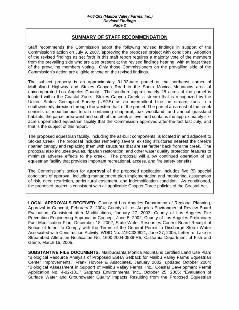
Staff recommends the Commission adopt the following revised findings in support of the Commission’s action on July 9, 2007, approving the proposed project with conditions. Adoption of the revised findings as set forth in this staff report requires a majority vote of the members from the prevailing side who are also present at the revised findings hearing, with at least three of the prevailing members voting. Only those Commissioners on the prevailing side of the Commission’s action are eligible to vote on the revised findings. The subject property is an approximately 31.02-acre parcel at the northeast corner of Mulholland Highway and Stokes Canyon Road in the Santa Monica Mountains area of unincorporated Los Angeles County. The southern approximately 28 acres of the parcel is located within the Coastal Zone. Stokes Canyon Creek, a stream that is recognized by the United States Geological Survey (USGS) as an intermittent blue-line stream, runs in a southwesterly direction through the western half of the parcel. The parcel area east of the creek consists of mountainous terrain containing chaparral, oak woodland, and annual grassland habitats; the parcel area west and south of the creek is level and contains the approximately six-acre unpermitted equestrian facility that the Commission approved after-the-fact last July, and that is the subject of this report.
The proposed equestrian facility, including the as-built components, is located in and adjacent to Stokes Creek. The proposal includes removing several existing structures nearest the creek’s riparian canopy and replacing them with structures that are set farther back from the creek. The proposal also includes swales, riparian restoration, and other water quality protection features to minimize adverse effects to the creek. The proposal will allow continued operation of an equestrian facility that provides important recreational, access, and fire safety benefits. The Commission’s action for approval of the proposed application includes five (5) special conditions of approval, including management plan implementation and monitoring, assumption of risk, deed restriction, agricultural easement, and indemnification condition. As conditioned, the proposed project is consistent with all applicable Chapter Three policies of the Coastal Act. LOCAL APPROVALS RECEIVED: County of Los Angeles Department of Regional Planning, Approval in Concept, February 2, 2004; County of Los Angeles Environmental Review Board Evaluation, Consistent after Modifications, January 27, 2003; County of Los Angeles Fire Prevention Engineering Approval in Concept, June 5, 2002; County of Los Angeles Preliminary Fuel Modification Plan, December 18, 2002; State Water Resources Control Board Receipt of Notice of Intent to Comply with the Terms of the General Permit to Discharge Storm Water Associated with Construction Activity, WDID No. 419C330921, June 27, 2005; Letter re: Lake or Streambed Alteration Notification No. 1600-2004-0539-R5, California Department of Fish and Game, March 15, 2005. SUBSTANTIVE FILE DOCUMENTS: Malibu/Santa Monica Mountains certified Land Use Plan; “Biological Resource Analysis of Proposed ESHA Setback for Malibu Valley Farms Equestrian Center Improvements,” Frank Hovore & Associates, January 2002, updated October 2004; “Biological Assessment in Support of Malibu Valley Farms, Inc., Coastal Development Permit Application No. 4-02-131,” Sapphos Environmental Inc., October 25, 2005; “Evaluation of Surface Water and Groundwater Quality Impacts Resulting from the Proposed Equestrian
4-06-163 (Malibu Valley Farms, Inc.) Revised Findings
Page 3
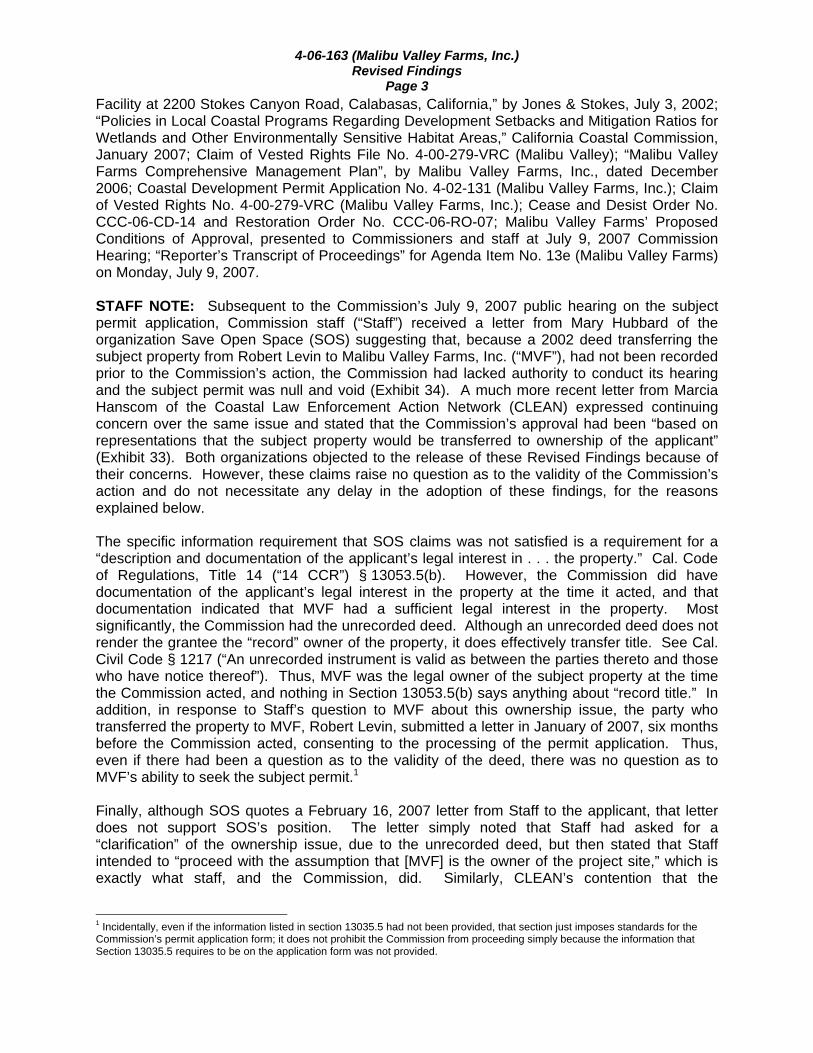
Facility at 2200 Stokes Canyon Road, Calabasas, California,” by Jones & Stokes, July 3, 2002; “Policies in Local Coastal Programs Regarding Development Setbacks and Mitigation Ratios for Wetlands and Other Environmentally Sensitive Habitat Areas,” California Coastal Commission, January 2007; Claim of Vested Rights File No. 4-00-279-VRC (Malibu Valley); “Malibu Valley Farms Comprehensive Management Plan”, by Malibu Valley Farms, Inc., dated December 2006; Coastal Development Permit Application No. 4-02-131 (Malibu Valley Farms, Inc.); Claim of Vested Rights No. 4-00-279-VRC (Malibu Valley Farms, Inc.); Cease and Desist Order No. CCC-06-CD-14 and Restoration Order No. CCC-06-RO-07; Malibu Valley Farms’ Proposed Conditions of Approval, presented to Commissioners and staff at July 9, 2007 Commission Hearing; “Reporter’s Transcript of Proceedings” for Agenda Item No. 13e (Malibu Valley Farms) on Monday, July 9, 2007. STAFF NOTE: Subsequent to the Commission’s July 9, 2007 public hearing on the subject permit application, Commission staff (“Staff”) received a letter from Mary Hubbard of the organization Save Open Space (SOS) suggesting that, because a 2002 deed transferring the subject property from Robert Levin to Malibu Valley Farms, Inc. (“MVF”), had not been recorded prior to the Commission’s action, the Commission had lacked authority to conduct its hearing and the subject permit was null and void (Exhibit 34). A much more recent letter from Marcia Hanscom of the Coastal Law Enforcement Action Network (CLEAN) expressed continuing concern over the same issue and stated that the Commission’s approval had been “based on representations that the subject property would be transferred to ownership of the applicant” (Exhibit 33). Both organizations objected to the release of these Revised Findings because of their concerns. However, these claims raise no question as to the validity of the Commission’s action and do not necessitate any delay in the adoption of these findings, for the reasons explained below. The specific information requirement that SOS claims was not satisfied is a requirement for a “description and documentation of the applicant’s legal interest in . . . the property.” Cal. Code of Regulations, Title 14 (“14 CCR”) § 13053.5(b). However, the Commission did have documentation of the applicant’s legal interest in the property at the time it acted, and that documentation indicated that MVF had a sufficient legal interest in the property. Most significantly, the Commission had the unrecorded deed. Although an unrecorded deed does not render the grantee the “record” owner of the property, it does effectively transfer title. See Cal. Civil Code § 1217 (“An unrecorded instrument is valid as between the parties thereto and those who have notice thereof”). Thus, MVF was the legal owner of the subject property at the time the Commission acted, and nothing in Section 13053.5(b) says anything about “record title.” In addition, in response to Staff’s question to MVF about this ownership issue, the party who transferred the property to MVF, Robert Levin, submitted a letter in January of 2007, six months before the Commission acted, consenting to the processing of the permit application. Thus, even if there had been a question as to the validity of the deed, there was no question as to MVF’s ability to seek the subject permit.1 Finally, although SOS quotes a February 16, 2007 letter from Staff to the applicant, that letter does not support SOS’s position. The letter simply noted that Staff had asked for a “clarification” of the ownership issue, due to the unrecorded deed, but then stated that Staff intended to “proceed with the assumption that [MVF] is the owner of the project site,” which is exactly what staff, and the Commission, did. Similarly, CLEAN’s contention that the
1 Incidentally, even if the information listed in section 13035.5 had not been provided, that section just imposes standards for the Commission’s permit application form; it does not prohibit the Commission from proceeding simply because the information that Section 13035.5 requires to be on the application form was not provided.

4-06-163 (Malibu Valley Farms, Inc.) Revised Findings
Page 4 Commission’s approval was “based on representations that the subject property would be transferred to ownership of the applicant” is simply inaccurate. I. Staff Recommendation MOTION: I move that the Commission adopt the revised findings in support
of the Commission’s action on July 9, 2007 concerning Coastal Development Permit No. 4-06-163.
STAFF RECOMMENDATION OF APPROVAL: Staff recommends a YES vote on the motion. Passage of this motion will result in the adoption of revised findings as set forth in this staff report. The motion requires a majority vote of the members from the prevailing side present at the revised findings hearing, with at least three of the prevailing members voting. Only those Commissioners on the prevailing side of the Commission’s action are eligible to vote on the revised findings. Commissioners Eligible to Vote: Achadjian, Blank, Burke, Secord, Neely, Potter, Chairman Kruer. RESOLUTION TO ADOPT REVISED FINDINGS: The Commission hereby adopts the findings set forth below for Approval with Conditions of Coastal Development Permit No. 4-06-163 on the ground that the findings support the Commission’s decision made on July 9, 2007 and accurately reflect the reasons for it. This Revised Findings Report revises the original Staff Recommendation and Findings by adding new language and deleting existing language as follows below: II. Standard Conditions 1. Notice of Receipt and Acknowledgment. The permit is not valid and development shall not commence until a copy of the permit, signed by the permittee or authorized agent, acknowledging receipt of the permit and acceptance of the terms and conditions, is returned to the Commission office. 2. Expiration. If development has not commenced, the permit will expire two years from the date on which the Commission voted on the application. Development shall be pursued in a diligent manner and completed in a reasonable period of time. Application for extension of the permit must be made prior to the expiration date. 3. Interpretation. Any questions of intent or interpretation of any term or condition will be resolved by the Executive Director or the Commission. 4. Assignment. The permit may be assigned to any qualified person, provided assignee files with the Commission an affidavit accepting all terms and conditions of the permit.

4-06-163 (Malibu Valley Farms, Inc.) Revised Findings
Page 5 5. Terms and Conditions Run with the Land. These terms and conditions shall be perpetual, and it is the intention of the Commission and the permittee to bind all future owners and possessors of the subject property to the terms and conditions. III. Special Conditions 1. Comprehensive Management Plan Implementation and Monitoring By acceptance of this permit, the applicant agrees to implement its proposed “Malibu Valley Farms Comprehensive Management Plan” (December 2006). The applicant shall provide an independent monitoring report to the Executive Director, prepared by a qualified environmental specialist, one year after initiation of implementation of the Malibu Valley Farms Comprehensive Management Plan, and again five years after initiation of implementation of the Plan. The monitoring report shall certify whether the plan has been implemented and plan elements are operational in conformance with the terms of the plan. If a monitoring report indicates that any plan elements are not operational or in conformance with the terms of the plan, the applicant, or successors in interest, shall submit a revised or supplemental management plan for the review and approval of the Executive Director. The revised plan must specify measures to remediate those portions of the original plan that have failed or are not in conformance with the original approved plan. The Executive Director will determine whether an amendment to the permit is necessary prior to implementing the revised plan. If the Executive Director determines that no amendment is needed, the applicant, or successors in interest, shall implement the revised plan upon Executive Director approval. If the Executive Director determines that an amendment is needed, the applicant, or successors in interest, shall submit the necessary amendment application and implement the approved plan upon approval of the amendment. 2. Assumption of Risk By acceptance of this permit, the applicant acknowledges and agrees (i) that the site may be subject to hazards from wildfire, erosion, and flooding; (ii) to assume the risks to the applicant and the property that is the subject of this permit of injury and damage from such hazards in connection with this permitted development; (iii) to unconditionally waive any claim of damage or liability against the Commission, its officers, agents, and employees for injury or damage from such hazards; and (iv) to indemnify and hold harmless the Commission, its officers, agents, and employees with respect to the Commission’s approval of the project against any and all liability, claims, demands, damages, costs (including costs and fees incurred in defense of such claims), expenses, and amounts paid in settlement arising from any injury or damage due to such hazards. 3. Indemnification by Applicant Liability for Costs and Attorneys Fees: By acceptance of this permit, the Applicant/Permittee agrees to reimburse the Coastal Commission in full for all Coastal Commission costs and attorneys fees -- including (1) those charged by the Office of the Attorney General, and (2) any court costs and attorneys fees that the Coastal Commission may be required by a court to pay -- that the Coastal Commission incurs in connection with the defense of any action brought by a party other than the Applicant/Permittee against the Coastal Commission, its officers,

4-06-163 (Malibu Valley Farms, Inc.) Revised Findings
Page 6 employees, agents, successors and assigns challenging the approval or issuance of this permit. The Coastal Commission retains complete authority to conduct and direct the defense of any such action against the Coastal Commission. 4. Agricultural Easement
A. No development, as defined in Section 30106 of the Coastal Act, shall occur in the Agricultural Easement Area as shown on Exhibit 29 except for:
1. Restoration, protection, and enhancement of native habitat and/or sensitive resources;
2. Existing livestock fencing as shown on Exhibit 29.
AND
3. The following development, if approved by the Coastal Commission as an
amendment to this coastal development permit:
Agricultural production activities defined as “activities that are directly related to the cultivation of agricultural products for sale. Agricultural products are limited to food and fiber in their raw unprocessed state, and ornamental plant material,”
Agricultural support facilities directly related to the cultivation of food, fiber, and ornamental plants being undertaken on the site.
Maintaining livestock
B. Prior to issuance of the Coastal Development Permit, the applicant shall execute
and record a document in a form and content acceptable to the Executive Director, granting to a public agency or private association approved by the Executive Director an agricultural conservation easement over the “agricultural easement area” described above, for the purpose of preventing the development or improvement of the land for purposes other than agricultural production or restoration, protection, and enhancement of native habitat and/or sensitive resources. The recorded easement document shall include a formal legal description of the entire property; and a metes and bounds legal description and graphic depiction, prepared by a licensed surveyor, of the agricultural easement area, as generally shown on Exhibit 29. The recorded document shall reflect that no development shall occur within the agricultural easement area except as otherwise set forth in this permit condition. The offer shall be recorded free of prior liens and encumbrances which the Executive Director determines may affect the interest being conveyed.
5. Deed Restriction Prior to issuance of the coastal development permit, the applicant shall submit to the Executive Director, for review and approval, documentation demonstrating that the applicants have executed and recorded against the parcel(s) governed by this permit a deed restriction, in a form and content acceptable to the Executive Director: (1) indicating that, pursuant to this permit, the California Coastal Commission has authorized development on the subject property,

4-06-163 (Malibu Valley Farms, Inc.) Revised Findings
Page 7 subject to terms and conditions that restrict the use and enjoyment of that property; and (2) imposing the Special Conditions of this permit as covenants, conditions and restrictions on the use and enjoyment of the property. The deed restriction shall include a legal description of the entire parcel or parcels governed by this permit. The deed restriction shall also indicate that, in the event of an extinguishment or termination of the deed restriction for any reason, the terms and conditions of this permit shall continue to restrict the use and enjoyment of the subject property so long as either this permit or the development it authorizes, or any part, modification, or amendment thereof, remains in existence on or with respect to the subject property. II IV. Findings and Declarations The Commission hereby finds and declares: A. Project Description The applicant, Malibu Valley Farms, Inc. (MVF), requests after-the fact approval for an equestrian facility that is used for breeding, raising, training, stabling, exercising, rehabilitation, and boarding of horses. The facility includes a 45,000 sq. ft. arena with five-foot high surrounding wooden wall with posts, 576 sq. ft. covered shelter, 25,200 sq. ft. riding arena, approximately 2,000 sq. ft. parking area, 2,660 sq. ft. back to back mare motel, 1,440 sq. ft. one-story barn, approximately 15,000 sq. ft. fenced paddock, fencing, dirt access road with at-grade crossing through Stokes Creek, and a second at-grade dirt crossing of Stokes Creek (Exhibits 4-6). The facility provides equestrians with opportunity to access important trail networks, sponsors educational and recreational opportunities for lower-income youth, and serves as a refuge for horses in the event of fire. The proposed project includes removal of twenty-eight 576 sq. ft. portable pipe corrals, four 400 sq. ft. portable pipe corrals, a 288 sq. ft. storage shelter, 200 sq. ft. portable storage trailer, 200 sq. ft. portable rollaway bin/container, 160 sq. ft. storage container, three-foot railroad tie walls, 101 sq. ft. tack room with no porch, four 101 sq. ft. portable tack rooms with four-foot porches, 200 sq. ft. portable tack room with four-foot porch, 150 sq. ft. cross tie area, 250 sq. ft. cross tie area, 360 sq. ft. cross tie shelter, two 2,025 sq. ft. covered corrals, and one 1,080 sq. ft. covered corral, and reduction in the size of the fenced paddock area by approximately 5,000 sq. ft. The proposed project also includes new construction of four 2,660 sq. ft. covered pipe barns, two 576 sq. ft. shelters, three 96 sq. ft. tack rooms, two 225 sq. ft. manure storage areas, vegetative swales totaling 1,400 feet in length, an approximately 850 sq. ft. retention basin, 250 sq. ft. riprap pad, 65.8 cu. yds. of grading (32.9 cu. yds. cut, 32.9 cu. yds. fill), and 0.5-acre riparian restoration (Exhibits 7-15). The applicant has not provided any information regarding the maximum number of horses that are intended to be maintained on the project site. However, a March 2005 Draft Environmental Impact Report (EIR) prepared for the proposed Malibu Valley Inn and Spa, which was to be developed by the applicant on a site located nearby, estimated that an average of 50 horses were stabled on the subject project site at that time. Based on the existing and proposed site facilities, staff estimates that a larger numbers of horses (approximately 76) could be accommodated.

4-06-163 (Malibu Valley Farms, Inc.) Revised Findings
Page 8 The subject property is an approximately 31.02-acre parcel at the northeast corner of Mulholland Highway and Stokes Canyon Road in the Santa Monica Mountains area of unincorporated Los Angeles County (Exhibits 1-2). The parcel is bisected by the coastal zone boundary. The southern approximately 28 acres of the parcel is located within the coastal zone and is subject to the Coastal Commission’s jurisdiction (Exhibit 3). Stokes Canyon Creek, an intermittent blue-line stream recognized by the United States Geological Survey (USGS), runs in a southwesterly direction through the western half of the parcel and supports riparian habitat within its boundaries and along its banks. The parcel area east of the creek consists of mountainous terrain containing chaparral, oak woodland, and annual grassland habitats; the parcel area west and south of the creek is level and contains the approximately six-acre unpermitted equestrian facility that is the subject of this application (Exhibits 26, 27). The site is located immediately north of the former campus of Soka University, which is now public parkland. Scattered rural and residential development is located west and south of the project site, and undeveloped hillside terrain containing primarily chaparral habitat is located to the east of the property. The site is visible from Mulholland Highway, a designated scenic highway in the Malibu-Santa Monica Mountains Land Use Plan (LUP), as well as from various public viewing points, including along the Backbone Trail and the Las Virgenes View trail, that afford scenic vistas of the relatively undisturbed natural area. Stokes Canyon Creek and its associated riparian canopy are designated as inland ESHA in the Malibu-Santa Monica Mountains Land Use Plan (LUP). Commission staff biologist John Dixon has visited the site, most recently on August 22, 2005, and has confirmed that the stream and surrounding riparian habitat, as well as the hillside oak woodland and chaparral habitat, on the site constitutes ESHA. In addition, some of the existing unpermitted development that the applicant proposes to retain is within the protected zones of individual oak trees outside of the hillside oak woodland. Correspondence that has been received to date from interested parties in support of the proposed project are attached as Exhibit 21. Staff has received approximately 205 copies of the same letter from different individuals. One example of this letter has been attached. The letters express that the horse facility is a valuable asset to the equestrian community and should be preserved. Commissioner ex parte communications are attached as Exhibit 22. B. Background Previous Commission Actions on the Project Site As described above, there is a large equestrian facility existing on the proposed project site. The Commission has not previously approved any coastal development permit for this development or any other development on the site. However, the Commission has taken several other actions that relate to the project site, including the denial of the applicant’s claim of vested rights and the approval of Cease and Desist and Restoration Orders. Commission staff first became aware that there is unpermitted development on the site in 1999. On November 20, 1998, Brian Boudreau, president of Malibu Valley Farms, Inc., submitted an exemption request for replacement of pipe corrals and related improvements that had been destroyed by wildfire in 1996. On December 7, 1998, the Commission issued Exemption Letter No. 4-98-125-X for replacement of 14 pipe corrals (totaling 2,500 sq. ft). However, the Commission rescinded this exemption letter shortly thereafter, in January 1999, because staff discovered that the equestrian facility on the site was constructed after the January 1, 1977 effectiveness date of the Coastal Act, without benefit of a coastal development permit. Exemptions from the Coastal Act’s permit requirements for replacement of structures destroyed
4-06-163 (Malibu Valley Farms, Inc.) Revised Findings
Page 9 by disaster (Section 30610(g)) only apply to structures that were either legally constructed prior to the Coastal Act, or were constructed after the Coastal Act with the appropriate authorization under the Act. Commission staff contacted Mr. Boudreau on January 14, 1999 and sent him a letter dated January 22, 1999 informing him that the exemption was revoked. The letter also stated that a Coastal Development Permit (CDP) is required for the horse riding area, polo field, numerous horse corrals, barn, and accessory buildings at the site and directed the applicant to submit a CDP application requesting after-the-fact approval of the unpermitted development. Commission staff visited the site in November 1999 and March 2000. In March 2000, Commission staff notified Mr. Boudreau that it intended to initiate cease and desist order proceedings regarding the development at the site. Mr. Boudreau, Malibu Valley Farms, Inc., and Robert Levin, the owner of the property at the time, submitted a Statement of Defense dated April 10, 2000. The Executive Director scheduled a Cease and Desist Order hearing at the Commission’s June 2000 meeting. However, just prior to the June 2000 hearing, MVF expressed a desire to cooperate and take necessary steps to resolve the violation and on June 12, 2000 submitted a Claim of Vested Rights application for all of the unpermitted development. On June 13, 2000, Malibu Valley, Inc. (a separate corporation also owned by Mr. Boudreau) submitted a Claim of Vested Rights application (Vested Rights Claim Application No. 4-00-279-VRC). The application contended that a vested right exists to conduct agricultural and livestock activities and erect and maintain structures in connection with those activities on the site. A public hearing on Vested Rights Claim Application No. 4-00-279-VRC was scheduled for the February 2001 Commission meeting, with a staff recommendation of denial. On February 15, 2001, at the applicant’s request, the hearing on the application was continued to allow for the submittal and processing of a coastal development permit application for the unpermitted development instead. More than a year later, the applicant submitted a CDP application (No. 4-02-131). Unfortunately, the CDP application did not contain enough information to deem the application “complete” under the applicable regulations. Over the next four years numerous contacts were made by Commission staff to the applicant attempting to obtain the necessary information. In March 2006, the CDP application was deemed complete and Commission staff scheduled the hearing for the Commission’s August 2006 hearing. Unfortunately, after years of Commission staff time and effort to obtain the information necessary to complete the CDP application, and after preparation of a staff recommendation of denial for the Commission’s consideration, the applicant withdrew the application (in a July 27, 2006 letter) just before the Commission hearing was to be held and stated that it wished to proceed with its Claim of Vested Rights application (4-00-279-VRC). This was the Vested Rights application that was previously scheduled for Commission action at the February 2001 hearing and postponed at the request of the applicant so it could submit the very CDP application (4-02-131) that it later withdrew in July 2006. The Commission heard the applicant’s Claim of Vested Right No. 4-00-279-VRC (Malibu Valley Farms, Inc.) at the November 2006 Commission hearing. The applicant claimed that it had a vested right to: “conduct agricultural and livestock activities on the property that were commenced prior to 1930, right to build new structures in connection with that use, and right to construct, operate, and maintain the equestrian facility that currently exists on the property”. The Commission considered the applicant’s claim, including supporting evidence. The Commission denied the applicant’s claim, finding that the evidence provided by the applicant did not substantiate the claim of vested rights for any of the development existing on the project site.
4-06-163 (Malibu Valley Farms, Inc.) Revised Findings
Page 10 The findings adopted by the Commission in its denial of Vested Rights Claim 4-00-279-VRC are attached as Exhibit 17. A Cease and Desist Order (CCC-06-CD-14) and Restoration Order (CCC-06-RO-07) regarding the subject development were also heard at the November 2006 Commission hearing, following the Commission’s denial of the Claim of Vested Rights (Exhibit 18). The Commission approved the orders, requiring the applicant to cease and desist from maintaining the unpermitted development on the site, to remove the unpermitted development, and to restore the site (including the implementation of restorative grading, erosion control, and revegetation). However, the Commission also provided for the applicant to again submit a coastal development permit application to retain some or all of the unpermitted development on the site. Cease and Desist Order (CCC-06-CD-14) and Restoration Order (CCC-06-RO-07) contained the following provision: If a complete CDP application is not received within 60 days from issuance of these Orders
(unless the Executive Director makes the determination that additional water quality studies cannot be completed within this timeframe) or if Respondent either withdraws the application or otherwise prevents it from coming to a hearing as per the Commission staff planned hearing schedule, Respondent shall remove all unpermitted development and restore these areas consistent with these Orders, set forth herein. Moreover, in the event that the Commission denies all or any part of such application, Respondent shall remove all unpermitted development, and restore these areas in the same manner and timeframes consistent with these Orders set forth herein.
In approving the orders, the Commission found that the development on the site meets the definition of “development” (as defined by Section 30106 of the Coastal Act), that it is subject to the permit requirements of Section 30600(a) of the Coastal Act, and that no permit had been approved for this development. The Commission further found that this unpermitted development is inconsistent with the applicable Chapter 3 policies of the Coastal Act, including Sections 30231, 30236, 30240, and 30251. It was found that Stokes Canyon Creek and its associated riparian woodland on the project site meet the definition of ESHA under the Coastal Act. The Commission found that the unpermitted development on the site is located within and adjacent to the riparian ESHA, does not protect the ESHA from significant disruption of habitat values, and has not been sited or designed to prevent impacts that would significantly degrade the ESHA, inconsistent with Section 30240 of the Coastal Act. The Commission further found that the existing confined animal facility does not provide an adequate setback from Stokes Creek, resulting in degradation of water quality, inconsistent with the requirements of the LUP and Section 30231 of the Coastal Act. Additionally, the existing at-grade dirt crossings of Stokes Canyon Creek on the project site required alteration of the stream, but are not for any of the three permittable uses detailed in Section 30236 of the Coastal. As such, the Commission found that the unpermitted development is inconsistent with this policy as well. The Commission also found that the development is not consistent with Section 30251 of the Coastal Act in that it did not minimize alteration of landforms, was not sited or designed to protect the scenic and visual characteristics of the surrounding area, and that it contributes to a cumulative adverse impact of increased development along Stokes Creek and the adjacent upland areas. Finally, the Commission found that the unpermitted development on the site is causing continuing resource damage. On December 12, 2006 the applicant submitted a new coastal development permit application (No. 4-06-163, the subject of this staff report). The subject permit application contains a few changes to the proposed project previously considered by staff under CDP application No. 4-02-131. These changes include the omission of a proposed 2,400 sq. ft. hay barn south of the

4-06-163 (Malibu Valley Farms, Inc.) Revised Findings
Page 11 northern riding arena, the removal of several structures situated just north of an existing barn, and the incorporation of a site-specific Comprehensive Management Plan that includes vegetative swales, bioretention basin, riparian restoration, and other Best Management Practices to control erosion and runoff from the equestrian facility. Again, the CDP application did not contain enough information to deem the application “complete” under the applicable regulations. After receiving additional information from the applicant, Commission staff deemed the application complete on March 21, 2007 and tentatively scheduled it for the July 2007 Commission hearing. On July 9, 2007, the Commission approved the proposed project with conditions, by a vote of 7 to 5. A transcript of the proceedings is attached as Exhibit 35. Previous Commission Actions on Equestrian Facilities in the Santa Monica Mountains The Commission has considered coastal development permit applications for many equestrian facilities in the Santa Monica Mountains area, although none that have been of the same size, scale, or intensity as the project considered herein. The majority of the projects considered have involved facilities that are accessory to a residence. The Commission has long recognized that confined animal facilities are a major source of non-point source pollution and have the potential to significantly impact the water quality of coastal streams. Additionally, such facilities may result in other impacts associated with their construction, such as landform alteration, habitat displacement or disruption, fuel modification and vegetation removal required to provide fire protection, increased erosion and sedimentation. While the Commission has consistently required the clustering of development in order to minimize impacts to coastal resources, it is difficult to cluster equestrian facilities with other types of development like residential structures. This is because of health restrictions that require a separation of at least fifty feet between confined animal facilities and habitable structures. The Commission has required equestrian facilities to be appropriately sited and designed to minimize impacts to coastal resources, including ESHA. The overall square footage of such facilities has been counted towards the total allowable development area for project sites that contain ESHA [4-02-110 (Khalsa); 4-03-085-A1 (WF Trust); 4-05-202 (Aurora Family LLC)]. Where there is a larger area on a project site that is not considered ESHA (as a result of clearance or grading that was permitted or carried out prior to the effective date of the Coastal Act), the Commission has allowed larger facilities so long as they are constructed of non-combustible materials so that fuel modification is minimized [4-00-128 (Farinella); 4-00-143-A2 (Weeger); 4-05-042 (Weintraub); 4-06-032 (Giraldin)]. The Commission has considered several projects with equestrian facilities located in proximity to streams and riparian corridors and has consistently required that such facilities provide adequate buffers between the development and the canopy of riparian vegetation (if riparian vegetation is present). In Permit 4-00-055 (Stark), the Commission considered a residential project including a home and several accessory structures on a 63-acre site. This project site contained existing unpermitted equestrian facilities, including a 2,000 sq. ft. barn, 21,000 sq. ft. graded arena, and stream culverts within a riparian woodland and stream designated ESHA by the Malibu/Santa Monica Mountains LUP. In order to bring the development into conformity with the policies of Chapter 3 and the LUP, the applicant proposed and the Commission required the removal of all of the equestrian facilities, restorative grading, and riparian revegetation. A new barn and smaller arena located 300 feet from the stream was approved as part of the project. The Commission approved Cease and Desist Order 03-CD-02, and Restoration Order 03-RO-03 (Teherani) to require the removal of unpermitted development, including 1) grading and fencing, 2) clearance of vegetation, 3) construction of a horse corral, 4) construction of a

4-06-163 (Malibu Valley Farms, Inc.) Revised Findings
Page 12 path/road from a previously permitted horse corral to the new, unpermitted horse corral, and 5) construction of railroad tie retaining walls, and restoration of all disturbed areas. The unpermitted development in this case was located within an oak woodland and adjacent to Cold Creek (a blue-line stream designated as ESHA by the Malibu/Santa Monica Mountains LUP). Both the oak woodland and riparian/stream habitats were determined by the Commission to constitute ESHA. The Commission found that the horse corral was constructed within the riparian area (therefore not providing an adequate buffer) and that it was impacting mature oak trees by allowing horses to compact the soil within the dripline. The Commission found that the unpermitted development was not consistent with Section 30240 of the Coastal Act. Further, the corral was located approximately 10 feet from the bank of Cold Creek, and the Commission found that, as long as it remained in that location, there was no means of preventing horse wastes from entering the stream, adversely impacting water quality. The Commission therefore found that the unpermitted development was inconsistent with Section 30231 of the Coastal Act. The Commission also found that the development resulted in increased erosion, inconsistent with Section 30253 of the Coastal Act and that it did not minimize alteration of landforms, inconsistent with Section 30251 of the Coastal Act. Finally, the Commission found that the unpermitted development was causing continuing resource damage. The owner was ordered to remove all of the unpermitted development, to restore the topography, and to implement a habitat restoration plan. In Permit 4-03-117 (Teherani) for development on this same project site, the Commission approved the construction of an approximately 2,500 sq. ft. horse corral with three-rail split wood fencing and an approximately 35 foot long, 7 foot wide access path adjacent to an existing single family residence, with approximately 50 cu. yds. of grading (25 cu. yds. cut, 25 cu. yds. fill) on the same property. This new development was sited on an existing developed area of the project site that is over 100 feet from the oak woodland and riparian ESHA areas on the site. The Commission found this new development, as sited to provide an adequate buffer from the stream and ESHA, and as conditioned to employ animal waste containment management practices and drainage devices, would be consistent with the ESHA and water quality policies of the Coastal Act. In Permit Application 4-03-022 (Rex), the Commission denied an after-the-fact request for a small equestrian facility as an accessory to a single family residence, consisting of an 836 sq. ft. horse corral, 45 sq. ft. hay shed, 13 ft. long retaining wall, and a new 144 sq. ft. awning on posts. The proposed development would have been located approximately 42 feet from the top of bank of an un-named tributary to Cold Creek. The on-site tributary is a blue-line stream and is designated ESHA by the Malibu/Santa Monica Mountains LUP. The Commission required development to be located no closer than 100 feet from ESHA, in order to protect the biological integrity of the ESHA, provide space for transitional vegetated buffer areas, and minimize human intrusion. In denying this permit, the Commission found that not only did the proposed equestrian facilities not provide a 100 foot buffer, but that no area on the project site could provide this buffer, while maintaining the required 50 foot separation from the existing residence. The Commission found that this development would result in significant disruption to habitat values in the ESHA and would not maintain the biological productivity and quality of coastal waters and streams, inconsistent with Sections 30230, 30231 and 30240 of the Coastal Act, and the applicable policies of the LUP.
4-06-163 (Malibu Valley Farms, Inc.) Revised Findings
Page 13 C. Standard of Review The standard of review for the proposed project is the Chapter Three policies of the Coastal Act. In addition, the policies of the certified Malibu-Santa Monica Mountains Land Use Plan (LUP) serve as guidance. As noted above, the applicant’s proposal includes a request for after-the-fact approval for equestrian facilities that were constructed after the January 1, 1977 effectiveness date of the Coastal Act without benefit of a coastal development permit. In evaluating such proposals, the Commission considers all development, including existing unpermitted development, as if it were not already constructed, and considers the condition of the site prior to any unpermitted development. D. Environmentally Sensitive Habitat Areas Section 30240 states:
(a) Environmentally sensitive habitat areas shall be protected against any
significant disruption of habitat values, and only uses dependent on such resources shall be allowed within such areas.
(b) Development in areas adjacent to environmentally sensitive habitat areas
and parks and recreation areas shall be sited and designed to prevent impacts which would significantly degrade such areas, and shall be compatible with the continuance of such habitat areas.
Section 30107.5 of the Coastal Act defines an environmentally sensitive area as:
"Environmentally sensitive area" means any area in which plant or animal life or their habitats are either rare or especially valuable because of their special nature or role in an ecosystem and which could be easily disturbed or degraded by human activities and developments.
Section 30250(a) of the Coastal Act states, in relevant part:
New residential, commercial, or industrial development, except as otherwise provided in this division, shall be located within, contiguous with, or in close proximity to, existing developed areas able to accommodate it or, where such areas are not able to accommodate it, in other areas with adequate public services and where it will not have significant adverse effects, either individually or cumulatively, on coastal resources.
In addition, the Malibu/Santa Monica Mountains LUP provides policy guidance regarding the protection of environmentally sensitive habitats. The Coastal Commission has relied upon the following policies as guidance in its review of development proposals in the Santa Monica Mountains: P57 Designate the following areas as Environmentally Sensitive Habitat_Areas
(ESHAs): (a) those shown on the Sensitive Environmental Resources Map (Figure 6), and (b) any undesignated areas which meet the criteria and which are identified through the biotic review process or other means, including
4-06-163 (Malibu Valley Farms, Inc.) Revised Findings
Page 14 those oak woodlands and other areas identified by the Department of Fish and Game as being appropriate for ESHA designation.
P63 Uses shall be permitted in ESHAs, DSRs, Significant Watersheds, and
Significant Oak Woodlands, and Wildlife Corridors in accordance with Table l and all other policies of this LCP.
P68 Environmentally sensitive habitat areas (ESHAs) shall be protected against
significant disruption of habitat values, and only uses dependent on such resources shall be allowed within such areas. Residential use shall not be considered a resource dependent use.
P69 Development in areas adjacent to environmentally sensitive habitat areas
(ESHAs) shall be subject to the review of the Environmental Review Board, shall be sited and designed to prevent impacts which would significantly degrade such areas, and shall be compatible with the continuance of such habitat areas.
P74 New development shall be located as close as feasible to existing roadways,
services, and existing development to minimize the effects on sensitive environmental resources.
P81 To control runoff into coastal waters, wetlands and riparian areas, as
required by Section 30231 of the Coastal Act, the maximum rate of storm water runoff into such areas from new development should not exceed the peak level that existed prior to development.
P82 Grading shall be minimized for all new development to ensure the potential
negative effects of runoff and erosion on these resources are minimized. Table 1 (ESHAs) Permitted uses within the habitat area: Resource-dependent uses such as
nature observation, research/education, passive recreation including hiking and horseback riding.
The following standards are established for development in sensitive environmental resource areas. Development proposals consistent with these standards shall be subject to normal review procedures. Variations from these standards will be considered on an individual basis according to their potential environmental effects as determined by the Environmental Review Board.
*Land alteration and vegetation removal, including brushing, shall be prohibited within undisturbed riparian woodlands, oak woodlands, and any areas designated as ESHAs by this LCP, except that controlled burns and trails or roads constructed for providing access to recreational areas may be permitted consistent with other policies of the LCP. *Trails or roads permitted for recreation shall be constructed to minimize grading and runoff. A drainage control plan shall be implemented. *Streambeds in designated ESHAs shall not be altered except where consistent with Section 30236 of the Coastal Act. Road crossings shall be

4-06-163 (Malibu Valley Farms, Inc.) Revised Findings
Page 15 minimized, and where crossings are considered necessary, should be accomplished by bridging. Tree removal to accommodate the bridge should be minimized. *A minimum setback of 100 feet from the outer limit of the pre-existing riparian tree canopy shall be required for any structure associated with a permitted use within or adjacent to an Environmentally Sensitive Habitat Area. *Structures shall be located in proximity to existing roadways, services and other development to minimize the impacts on the habitat. Approval of development shall be subject to review by the Environmental Review Board.
Section 30250 of the Coastal Act requires that development be located to ensure that significant adverse impacts, both individual and cumulative, be avoided. In addition, Section 30240 of the Coastal Act states that environmentally sensitive habitat areas must be protected against disruption of habitat values. Environmentally Sensitive Habitat Determination Pursuant to Section 30107.5, in order to determine whether an area constitutes an ESHA, and is therefore subject to the protections of Section 30240, the Commission must ask four questions:
1) What is the area of analysis? 2) Is there a rare habitat or species in the subject area? 3) Is there an especially valuable habitat or species in the area, based on:
a) Does any habitat or species present have a special nature? b) Does any habitat or species present have a special role in the ecosystem?
4) Is any habitat or species that has met test 2 or 3 (i.e., that is rare or especially valuable) easily disturbed or degraded by human activities and developments?
The Coastal Commission has found that the Mediterranean Ecosystem in the Santa Mountains is itself rare, as well as being especially valuable, because of its relatively pristine character, physical complexity, and resultant biological diversity. The Commission further finds that because of the rare and special nature of the Santa Monica Mountains ecosystem, the ecosystem roles of substantially intact areas of the constituent plant communities discussed below are “especially valuable” under the Coastal Act. Therefore, the habitat areas discussed below, which provide important roles in that ecosystem, are especially valuable because of that role and meet the second criterion for the ESHA designation. The subject site contains several habitat types that are part of the Santa Monica Mountains Mediterranean Ecosystem, including riparian woodland, oak woodland, and chaparral. Woodlands that are native to the Santa Monica Mountains, such as oak woodlands and riparian woodlands, have many important and special roles in the ecosystem. Native trees prevent the erosion of hillsides and stream banks, moderate water temperatures in streams through shading, provide food and habitat, including nesting, roosting, and burrowing to a wide variety of wildlife species, contribute nutrients to watersheds, and are important scenic elements in the landscape.

4-06-163 (Malibu Valley Farms, Inc.) Revised Findings
Page 16
In the Santa Monica Mountains, riparian woodland contains the greatest overall diversity of all the plant communities in the area, partly because of its multi-layered vegetation.2 At least four types of riparian communities are discernable in the Santa Monica Mountains: walnut riparian areas, mulefat-dominated riparian areas, willow riparian areas and sycamore riparian woodlands. Of these, the sycamore riparian woodland is the most diverse riparian community in the area. In these habitats, the dominant plant species include arroyo willow, California black walnut, sycamore, coast live oak, Mexican elderberry, California bay laurel, and mule fat. Wildlife species that have been observed in this community include least Bell’s vireo (a State and federally listed species), American goldfinches, black phoebes, warbling vireos, bank swallows (State listed threatened species), song sparrows, belted kingfishers, raccoons, and California and Pacific tree frogs. Riparian communities are the most species-rich to be found in the Santa Monica Mountains. Because of their multi-layered vegetation, available water supply, vegetative cover and adjacency to shrubland habitats, they are attractive to many native wildlife species, and provide essential functions in their lifecycles3. During the long dry summers in this Mediterranean climate, these communities are an essential refuge and oasis for much of the areas’ wildlife. Riparian habitats and their associated streams form important connecting links in the Santa Monica Mountains. These habitats connect all of the biological communities from the highest elevation chaparral to the sea with a unidirectional flowing water system, one function of which is to carry nutrients through the ecosystem to the benefit of many different species along the way. The streams themselves provide refuge for sensitive species including: the coast range newt, the Pacific pond turtle, and the steelhead trout. The coast range newt and the Pacific pond turtle are California Species of Special Concern and are proposed for federal listing4, and the steelhead trout is federally endangered. The health of the streams is dependent on the ecological functions provided by the associated riparian woodlands. These functions include the provision of large woody debris for habitat, shading that controls water temperature, and input of leaves that provide the foundation of the stream-based trophic structure. The importance of the connectivity between riparian areas and adjacent habitats is illustrated by the Pacific pond turtle and the coast range newt, both of which are sensitive and both of which require this connectivity for their survival. The life history of the Pacific pond turtle demonstrates the importance of riparian areas and their associated watersheds for this species. These turtles require the stream habitat during the wet season. However, recent radio tracking work5 has found that although the Pacific pond turtle spends the wet season in streams, it also requires upland habitat for refuge during the dry season. Thus, in coastal southern California, the Pacific pond turtle requires both streams and intact adjacent upland habitats such as coastal sage scrub, woodlands or chaparral as part of their normal life cycle. The turtles spend about four months of the year in upland refuge sites located an average distance of 50 m (but up to 280 m)
2 National Park Service. 2000. Draft: General Management Plan & Environmental Impact Statement, Santa Monica Mountains National Recreation Area, US Dept. of Interior, National Park Service, December 2000. 3 Walter, Hartmut. Bird use of Mediterranean habitats in the Santa Monica Mountains, Coastal Commission Workshop on the Significance of Native Habitats in the Santa Monica Mountains. CCC Hearing, June 13, 2002, Queen Mary Hotel. 4 USFWS. 1989. Endangered and threatened wildlife and plants; animal notice of review. Fed. Reg. 54:554-579. USFWS. 1993. Endangered and threatened wildlife and plants; notice of 1-year petition finding on the western pond turtle. Fed. Reg. 58:42717-42718. 5 Rathbun, G.B., N.J. Scott and T.G. Murphy. 2002. Terrestrial habitat use by Pacific pond turtle in a Mediterranean climate. Southwestern Naturalist. (in Press).

4-06-163 (Malibu Valley Farms, Inc.) Revised Findings
Page 17
from the edge of the creek bed. Similarly, nesting sites where the females lay eggs are also located in upland habitats an average of 30 m (but up to 170 m) from the creek. Occasionally, these turtles move up to 2 miles across upland habitat6. Like many species, the pond turtle requires both stream habitats and the upland habitats of the watershed to complete its normal annual cycle of behavior. Similarly, the coast range newt has been observed to travel hundreds of meters into upland habitat and spend about ten months of the year far from the riparian streambed7. They return to the stream to breed in the wet season, and they are therefore another species that requires both riparian habitat and adjacent uplands for their survival. Riparian habitats in California have suffered serious losses and such habitats in southern California are currently very rare and seriously threatened. In 1989, Faber estimated that 95-97% of riparian habitat in southern California was already lost8. Writing at the same time as Faber, Bowler asserted that, “[t]here is no question that riparian habitat in southern California is endangered.”9 In the intervening 13 years, there have been continuing losses of the small amount of riparian woodlands that remain. Today these habitats are, along with native grasslands and wetlands, among the most threatened in California. In addition to direct habitat loss, streams and riparian areas have been degraded by the effects of development. For example, the coast range newt, a California Species of Special Concern has suffered a variety of impacts from human-related disturbances10. Human-caused increased fire frequency has resulted in increased sedimentation rates, which exacerbates the cannibalistic predation of adult newts on the larval stages.11 In addition, impacts from non-native species of crayfish and mosquito fish have also been documented. When these non-native predators are introduced, native prey organisms are exposed to new mortality pressures for which they are not adapted. Coast range newts that breed in the Santa Monica Mountain streams do not appear to have adaptations that permit co-occurrence with introduced mosquito fish and crayfish12. These introduced predators have eliminated the newts from streams where they previously occurred by both direct predation and suppression of breeding. More recently, surveys conducted in Spring 2006 found the invasive New Zealand mud snail (Potamopyrgus atipodarum) in the Malibu Creek watershed. The tiny snails reproduce rapidly and can achieve densities of up to 500,000 organisms per square meter. Because of their massive density and quantity, the New Zealand mud snail can out-compete and reduce the number of native aquatic invertebrates that the watershed's fish and amphibians rely on for food. This reduction in aquatic invertebrate food supply can disrupt the entire food web with dramatic consequences. Therefore, because of the essential role that riparian plant communities play in maintaining the biodiversity of the Santa Monica Mountains, because of the historical losses and current rarity of
6 Testimony by R. Dagit, Resource Conservation District of the Santa Monica Mountains at the CCC Habitat Workshop on June 13, 2002. 7 Dr, Lee Kats, Pepperdine University, personal communication to Dr J. Allen, CCC. 8 Faber, P.A., E, Keller, A. Sands and B.M. Massey. 1989. The ecology of riparian habitats of the southern California coastal region: a community profile. U.S. Fish and Wildlife Service Biological Report 85(7.27) 152pp. 9 Bowler, P.A. 1989. Riparian woodland: An endangered habitat in southern California. Pp 80-97 in Schoenherr, A.A. (ed.) Endangered plant communities of southern California. Botanists Special Publication No. 3. 10 Gamradt, S.C., L.B. Kats and C.B. Anzalone. 1997. Aggression by non-native crayfish deters breeding in California newts. Conservation Biology 11(3):793-796. 11 Kerby, L.J., and L.B. Kats. 1998. Modified interactions between salamander life stages caused by wildfire-induced sedimentation. Ecology 79(2):740-745. 12 Gamradt, S.C. and L.B. Kats. 1996. Effect of introduced crayfish and mosquitofish on California newts. Conservation Biology 10(4):1155-1162.

4-06-163 (Malibu Valley Farms, Inc.) Revised Findings
Page 18 these habitats in southern California, and because of their extreme sensitivity to disturbance, the native riparian habitats in the Santa Monica Mountains generally meet the definition of ESHA under the Coastal Act, as detailed in Exhibit 16. Additionally, the important ecosystem functions of oak woodlands and savanna are widely recognized13. These habitats support a high diversity of birds14, and provide refuge for many species of sensitive bats15. Typical wildlife in this habitat includes acorn woodpeckers, scrub jays, plain titmice, northern flickers, cooper’s hawks, western screech owls, mule deer, gray foxes, ground squirrels, jackrabbits and several species of sensitive bats. Oak woodlands adjacent to grasslands, such as on the subject site, provide valuable perching opportunities for birds of prey who forage in the grasslands. Therefore, because of their important ecosystem functions and vulnerability to development, the Commission finds that oak woodlands and savanna within the Santa Monica Mountains generally meet the definition of ESHA under the Coastal Act. Further, In the Santa Monica Mountains, coastal sage scrub and chaparral have many important roles in the ecosystem, including the provision of critical linkages between riparian corridors, the provision of essential habitat for species that require several habitat types during the course of their life histories, the provision of essential habitat for local endemics, the support of rare species, and the reduction of erosion, thereby protecting the water quality of coastal streams. For these and other reasons discussed in Exhibit 16, which is incorporated herein, the Commission finds that large, contiguous, relatively pristine stands of coastal sage scrub and chaparral in the Santa Monica Mountains meet the definition of ESHA. This is consistent with the Commission’s past findings on the Malibu LCP16. The subject parcel contains varied terrain and habitats. Stokes Canyon Creek, a stream recognized by the United States Geological Survey (USGS) as an intermittent blue-line stream, runs in a southwesterly direction through the western half of the parcel. The parcel area east of the creek consists of mountainous terrain containing chaparral habitat, Coast live oak woodland, and annual grassland; the parcel area west and south of the creek is level and is the location of the approximately six-acre proposed equestrian facility that is the subject of this application. This area was graded and disturbed in the 1950’s when Los Angeles County constructed the 60-foot wide Stokes Canyon Road off Mulholland Highway. The road alignment required channelizing and relocating portions of Stokes Canyon Creek. Particularly, in the area of the proposed equestrian facility on the subject parcel, the stream channel was relocated from the area where Stokes Canyon Road is now situated to its present configuration. Although this reach of Stokes Canyon Creek was significantly altered in the past, the hydrological connections from the Stokes Canyon watershed to the stream have been maintained and riparian habitat has been established within and along the banks of the modified stream course, as discussed further below. 13 Block, W.M., M.L. Morrison, and J. Verner. 1990. Wildlife and oak-woodland interdependency. Fremontia 18(3):72–76. Pavlik, B.M., P.C. Muick, S. Johnson, and M. Popper. 1991. Oaks of California. Cachuma Press and California Oak Foundation, Los Olivos, California. 184 pp. 14 Cody, M.L. 1977. Birds. Pp. 223–231 in Thrower, N.J.W., and D.E. Bradbury (eds.). Chile-California Mediterranean scrub atlas. US/IBP Synthesis Series 2. Dowden, Hutchinson & Ross, Stroudsburg, Pennsylvania. National Park Service. 1993. A checklist of the birds of the Santa Monica Mountains National Recreation Area. Southwest Parks and Monuments Assoc., 221 N. Court, Tucson, AZ. 85701 15 Miner, K.L., and D.C. Stokes. 2000. Status, conservation issues, and research needs for bats in the south coast bioregion. Paper presented at Planning for biodiversity: bringing research and management together, February 29, California State University, Pomona, California. 16 Revised Findings for the City of Malibu Local Coastal Program (as adopted on September 13, 2002) adopted on February 6, 2003.

4-06-163 (Malibu Valley Farms, Inc.) Revised Findings
Page 19 The applicant has submitted two biological reports that discuss the habitats on site (“Biological Resource Analysis of Proposed ESHA Setback for Malibu Valley Farms Equestrian Center Improvements,” Frank Hovore & Associates, January 2002, updated October 2004; “Biological Assessment in Support of Malibu Valley Farms, Inc., Coastal Development Permit Application No. 4-02-131,” Sapphos Environmental Inc., October 25, 2005). The report by Sapphos Environmental provides a map that shows the location of the varied habitats on the subject parcel (Exhibit 26). Stokes Canyon Creek and its associated riparian canopy is a designated inland environmentally sensitive habitat area (ESHA) in the certified Malibu-Santa Monica Mountains LUP. The riparian canopy contains native riparian woodland species including arroyo willow, mulefat and elderberry. The October 2004 biological report by Frank Hovore & Associates states that the riparian habitat is not typical of southern riparian scrub habitat. This report states that:
A thin, but relatively well-developed mulefat and willow-dominated riparian scrub vegetation occupied the bed and bank of the reach of Stokes Creek passing by and through the facility during surveys. Other woody riparian species present within the banks of the seasonal creek include a few blue elderberry, coffeeberry, Indian tobacco, and bush mallow. The hydrophytic herbaceous component is not well developed, reflecting the ephemeral hydrology, sandy substrate and episodic scouring flows of the water course.
The report goes on to discuss that no sensitive plant or animal species were identified on the site even though riparian habitat might be expected to support them. Of course, it should be noted that these biological surveys were conducted after the unpermitted development had been in place and the facilities were in operation for over 25 years. There is no discussion in the report regarding the likely effects that the ongoing disturbance has had on the stream and riparian habitat or how the riparian habitat in Stokes Creek would be constituted without the impacts that have resulted. Because the existing development on the site has been determined to be unpermitted, as discussed above, the Commission must consider the application as though the development had not occurred and must regard the habitat on the site as though it had not previously been disturbed by this development. Commission staff, including staff biologist John Dixon, have observed native vegetation on the site that is typical of riparian woodlands in the Santa Monica Mountains. Commission staff biologist John Dixon visited the site on August 22, 2005, and has confirmed that Stokes Creek and its associated riparian woodland habitat on the site meet the definition of ESHA pursuant to Section 30107.5 of the Coastal Act. Therefore, the Commission finds the riparian habitat along Stokes Creek on the project site to be an environmentally sensitive habitat area. In addition, the hillside east of the creek contains an extensive oak woodland, covering approximately 10 acres and containing hundreds of trees, that was also confirmed by staff biologist John Dixon to meet the definition of an environmentally sensitive habitat area (ESHA) pursuant to Section 30107.5 of the Coastal Act. Additionally, although this area is not shown as ESHA on the Malibu/Santa Monica Mountains Land Use Plan Sensitive Resource Map, there is a provision detailed under Policy 57 of the Malibu-Santa Monica Mountains LUP for ESHA not shown as ESHA on the map to be so designated as part of a site specific biotic review or other means. The Commission finds that, based on the site specific review of the habitats on the project site by Dr. Dixon, that the oak woodland habitat on the project site is ESHA.

4-06-163 (Malibu Valley Farms, Inc.) Revised Findings
Page 20 In addition, the hillside in the northeast portion of the property contains chaparral habitat that is contiguous with a larger area of chaparral and coastal sage scrub habitat that extends several miles east of the site. Thus the chaparral on the subject site also is considered an environmentally sensitive habitat area (ESHA) pursuant to Section 30107.5 of the Coastal Act and the provisions for ESHA designation under Policy 57 of the Malibu-Santa Monica Mountains LUP. For all of the reasons discussed above, the Commission finds that Stokes Canyon Creek and its associated riparian woodland on the subject site, as well as the chaparral and oak woodland habitats on the subject site, meet the definition of ESHA under the Coastal Act. Environmentally Sensitive Habitat Protection Policies Section 30240 requires that “environmentally sensitive habitat areas shall be protected against any significant disruption of habitat values, and only uses dependent on those resources shall be allowed within those areas.” Section 30240(b) requires development adjacent to ESHA to be sited and designed to prevent impacts that would significantly degrade ESHA, and to be compatible with the continuance of adjacent ESHA. Additionally, the Los Angeles County certified Malibu/Santa Monica Mountains Land Use Plan (LUP) contains policies that require the protection of streams and environmentally sensitive habitat areas. While the County does not have a fully certified Local Coastal Plan, and the standard of review for Commission decisions on coastal developments in the Santa Monica Mountains is the Coastal Act, the Commission has used the policies of the LUP as guidance. The Table 1 (ESHA) development standards and stream protection policies of the certified Malibu-Santa Monica Mountains LUP limit uses adjacent to ESHA to permitted uses that are set back a minimum of 100 feet, and that are consistent with appropriate erosion control and stream protection policies, as well as any other LUP Policy. Table 1 also requires that a minimum 100-foot setback be provided from the ESHA for structures associated with a permitted use and that this setback is measured from the outer edge of the riparian canopy. Table 1 identifies horseback riding as an allowable resource-dependent use in ESHA. Recreational trails are allowed where constructed to minimize grading and runoff and where a drainage control plan is implemented. Table 1 allows stream crossings in ESHA where necessary, although it provides that they should be accomplished by installation of a bridge. Table 1 also indicates that variations from such development standards will be considered on an individual basis according to their potential environmental effects as determined by the County’s Environmental Review Board. Analysis of Project Impacts The applicant requests after-the-fact approval for construction of an approximately six-acre equestrian facility, including two riding arenas, fencing, a dirt access road with at-grade crossing through Stokes Creek, corrals, paddock, shelters, tack rooms, barn, and similar structures, as described fully in Section A. above. The proposed project also includes removal of 32 pipe corrals, and several covered corrals, cross-tie areas, storage containers, and tack rooms. In addition, the proposed project includes reduction in the size of the fenced paddock area and construction of four covered pipe barns, two shelters, three tack rooms, and two manure storage areas as also detailed in Section A. above. Finally, the applicant proposes storm water pollution control measures, streambank stabilization, and riparian restoration.

4-06-163 (Malibu Valley Farms, Inc.) Revised Findings
Page 21 Although the applicant has not provided information regarding the maximum number of horses that it proposes to maintain on the site, the March 2005 Draft Environmental Impact Report (EIR) that was prepared for the nearby Malibu Valley Inn and Spa project (that was to have been developed by the applicant) estimates that an average of 50 horses were stabled on the project site at that time. Based on the proposed new and as-built facilities used for horse breeding, raising, training, stabling, exercising, boarding and rehabilitation of horses, staff estimates that the project will provide stalls for approximately 76 horses. The proposed equestrian facility can be divided into two areas: the northern area, on which the applicant proposes four 2,660 sq. ft. covered pipe barns, two 576 sq. ft. shelters, three 96 sq. ft. tack rooms, one manure storage area, and an approximately 45,000 sq. ft. riding arena; and the southern area, located south of Stokes Creek, between the stream and Mulholland Highway, on which the applicant proposes a 576 sq. ft. shelter, 1,440 sq. ft. barn, 2,660 sq. ft. mare motel, one manure storage area, an approximately 2,000 sq. ft. parking lot, approximately 24,000 sq. ft. riding arena, and approximately 15,000 sq. ft. fenced paddock. In addition, the northern and southern portions of the facility will be linked by an as-built dirt access road with at-grade crossing through Stokes Creek; the road crosses the creek at the northern riding arena, and then runs parallel to the paddock and smaller arena in the southern portion of the property. A second existing at-grade dirt creek crossing, to be retained as part of the proposed project, runs from the southwest corner of the northern arena to the stable area in the southern portion of the property. Lastly, the proposed project includes livestock fencing enclosing the approximately 23-acre hillside area of the property east of Stokes Creek. The proposed new and as-built facilities provide a setback of 50 feet from the top of bank of Stokes Canyon Creek. However, the The Table 1 development standards and stream protection policies of the certified Malibu-Santa Monica Mountains LUP, which the Commission uses as guidance, generally require that structures adjacent to ESHA be set back a minimum of 100 feet from the outer edge of the riparian tree canopy, not the top of the bank of whatever stream happens to be located within the ESHA. When properly measured from the outer edge of the riparian canopy, portions of the proposed equestrian facilities do not even meet a 50-foot setback. The proposed pipe barns and associated development in the northern portion of the property are approximately 30 feet from the edge of the riparian canopy at its closest point. The proposed arena in the northern portion of the property is located as close as 30 feet from the riparian tree canopy. In the southern portion of the site, the proposed development is located as close as 10 feet from the edge of the riparian vegetation canopy. Portions of the dirt access road network that encircles all of the proposed structures and arenas on the site are situated immediately adjacent to the edge of the riparian canopy (Exhibit 23). However, the LUP indicates that variations from such development standards will be considered on an individual basis according to their potential environmental effects as determined by the County Environmental Review Board (ERB).The County ERB reviewed an application to relocate and remove various structures associated with the existing equestrian facility on January 27, 2003. The ERB found the project consistent with the LUP and recommended approval of the project with suggested modifications to limit night lighting and address erosion issues on the site. The ERB did not find that increased setbacks were necessary in order to protect the riparian canopy and stream. The development that is proposed to be located within the riparian corridor, as conditioned, is consistent with Section 30240(a) and the ESHA protection policies of the LUP. Equestrian trails, including stream crossings, are resource dependent uses. The stream crossings have been designed to minimize runoff and include drainage control features. Although the LUP calls for stream crossings to be accomplished by bridges, it does allow the ERB to allow exceptions.
4-06-163 (Malibu Valley Farms, Inc.) Revised Findings
Page 22 Here, the ERB approved the crossings, finding that they were consistent with the LUP’s resource protection policies. The livestock fencing in the upland areas does not significantly disrupt habitat values. The Commission finds that with these features and implementation of the Malibu Valley Farms Comprehensive Management Plan, as required by Special Condition No. 1, the proposed development is a resource-dependent use and that it avoids significant disruption of habitat values. As noted above, the applicant requests approval for construction of an approximately six-acre equestrian facility within and adjacent to a riparian woodland ESHA, and livestock fencing enclosing the approximately 23-acre hillside area east of Stokes Creek, which contains chaparral and oak woodland ESHA. The portions of the proposed development that are within ESHA are inconsistent with Section 30240 of the Coastal Act. Equestrian facilities and livestock enclosures do not have to be located within ESHA to function. Therefore, the Commission finds that the proposed development within ESHA is not a use dependent on ESHA resources. Thus, the livestock fencing and the two proposed stream crossings that extend into the riparian canopy, which involve development directly in ESHA, are inconsistent with Section 30240. Furthermore, the two stream crossings would significantly disrupt habitat values of Stokes Creek by reducing the streambed to compacted bare soil and increasing the transport of pollutants into the stream, inconsistent not only with Section 30240, but with Section 30231 of the Coastal Act and the stream protection standards of the Malibu-Santa Monica Mountains LUP. The LUP also prohibits alteration of streambeds in ESHA, requires road crossings to be minimized, and requires any such crossings that are unavoidable to consist of bridging, as discussed further in Section E. below. The portions of the equestrian facility that are located adjacent to the on-site ESHA are also inconsistent with Coastal Act Section 30240. The majority of these portions of the proposed development are located between 0 and 100 feet from the edge of the stream riparian canopy. Approval of the proposed project would allow intensive equestrian use and equestrian-related development within and immediately adjacent to the boundaries of the riparian woodland ESHA. This development would significantly degrade the riparian woodland ESHA by increasing human and equine activity and its attendant impacts, including noise, lighting, irrigation, erosion, increased introduction of animal waste and other pollutants and, potentially, invasive plant and animal species into the ESHA. The proposed project would also require fuel modification, which would extend into the riparian ESHA. The fuel modification plan submitted by the applicant indicates that riparian vegetation in the southern portion of the property would remain, but does not note the same protection for riparian vegetation on the remainder of the property. Section 30240(b) requires development in areas adjacent to ESHA to be sited and designed to prevent impacts that would significantly degrade such areas, and to be compatible with the continuance of such habitat areas. Section 30231 and 30240(b) require maintenance of natural vegetation buffer areas that protect riparian habitats. The Table 1 development standards and stream protection policies of the certified Malibu-Santa Monica Mountains LUP, which the Commission uses as guidance, generally limits uses adjacent to ESHA to permitted uses that are set back a minimum of 100 feet, and that are consistent with appropriate erosion control and stream protection policies, as well as any other LUP Policy. The LUP provides that the 100-foot setback from the ESHA is measured from the outer edge of the riparian canopy, although there is also a provision for variations from this development standard to be considered on an individual basis by the ERB according to a project’s potential environmental effects. Further, In past permit actions in the Santa Monica Mountains, the Commission has consistently required development to be located no closer than 100 feet from ESHA, in order to protect the biological

4-06-163 (Malibu Valley Farms, Inc.) Revised Findings
Page 23 integrity of the ESHA, provide space for transitional vegetated buffer areas, and minimize human intrusion. The Commission’s recent actions with respect to equestrian facilities in the Santa Monica Mountains have addressed facilities associated with private residences, rather than equestrian facilities such as this that serve the public. In addition, in other areas, the Commission has previously approved a narrower riparian buffer [CDP 6-04-029 (22nd Ag. District)]. In the case of the proposed project, the applicant proposes to set back the majority of the proposed development 50 feet from the top of stream bank. The applicant also proposes to remove existing structures that are located closest to the riparian areas, install approximately 1,400 linear feet of vegetative swales and a retention basin between development and the creek, restore 0.5-acres of disturbed riparian vegetation, and implement the “Malibu Valley Farms Comprehensive Management Plan” that includes construction and operational Best Management Practices. These proposed improvements will reduce or mitigate adverse impacts to riparian habitat and water quality as a result of the project and reduced buffer area. The Commission finds that although the proposed project provides a less than 100 foot buffer between development and riparian vegetation, incorporation of proposed measures to enhance the habitat value of the on-site riparian corridor will serve to minimize adverse impacts from noise, activity, human intrusion, equine intrusion, erosion, and runoff to the on-site ESHA, consistent with Table 1 of the LUP. Thus, the proposed project would maintain an adequate natural vegetation buffer area and not significantly degrade the on-site riparian or oak woodland ESHA. In order to ensure that the applicant’s proposed “Malibu Valley Farms Comprehensive Management Plan” for the facility is implemented, Special Condition No. One (1) is required. Special Condition One (1) requires the applicant to provide an independent monitoring report to the Executive Director, prepared by a qualified environmental specialist, one year after implementation of the Malibu Valley Farms Comprehensive Management Plan, and again five years after implementation of the Plan. The monitoring report shall certify that the plan has been implemented and plan elements are operational in conformance with the approved plan. If a monitoring report indicates that any plan elements are not operational or in conformance with the approved plan, the applicant, or successors in interest, shall submit a revised or supplemental management plan for the review and approval of the Executive Director. The revised plan must specify measures to remediate those portions of the original plan that have failed or are not in conformance with the original approved plan. In addition, the applicant proposes an agricultural easement across the eastern portion of the property that is in the coastal zone (as shown on Exhibit 29). This eastern portion of the property (east of Stokes Creek) consists of approximately 10 acres that contain an extensive oak woodland and chaparral/annual grassland habitat that was confirmed by staff biologist John Dixon to meet the definition of an environmentally sensitive habitat area (ESHA) pursuant to Section 30107.5 of the Coastal Act. The area is currently bound by livestock fencing, which the applicant proposes to retain as part of the proposed project. In order to implement the applicant’s proposal to record an offer-to-dedicate an agricultural easement to maintain this area as open space, Special Condition No. Four (4) has been imposed. For the reasons discussed above, the Commission finds that, as conditioned, the proposed project is consistent with Section 30240 of the Coastal Act and the applicable policies of the Malibu/Santa Monica Mountains Land Use Plan, which the Commission uses as guidance. All of those concerns are relevant here, and thus, in this case, the Commission finds that a 100 foot buffer from the riparian woodland ESHA and the oak woodland ESHA is necessary to prevent impacts that would significantly degrade these ESHAs. Because the proposed

4-06-163 (Malibu Valley Farms, Inc.) Revised Findings
Page 24 development is set back less than 50 feet from the riparian woodland ESHA on the site, the proposed development is inconsistent with Section 30240(b) of the Coastal Act, and the associated standards provided in the certified LUP for the area. Furthermore, Section 30231 and 30240(b) require maintenance of natural vegetation buffer areas that protect riparian habitats. Approval of the proposed development would result in placement of structures and confinement of horses adjacent to the riparian habitat on site, and the construction of at-grade crossings within the stream itself. The proposed project thus would not maintain an adequate natural vegetation buffer area to protect the riparian habitat, inconsistent with Section 30231 and 30240(b) of the Coastal Act. The primary functions of buffers are to protect against human and domestic animal disturbance, that is, to keep disturbance at a distance from sensitive environmental resources, and to provide ecosystem services in benefit of the adjacent ESHA. Riparian buffers adjacent to streams and creeks serve to maintain the integrity of the waterway, stabilize the stream banks, reduce pollution, and provide food, habitat, and thermal protection for both terrestrial and aquatic organisms. Riparian buffers benefit aquatic habitat by improving the quality of nearby waters through shading, filtering, and moderating stream flow. Shade provided by the plants maintains cooler, more even water temperatures. Cooler water holds more oxygen that helps reduce stress on fish and other aquatic animals. The layers of vegetation in a riparian zone include a leafy canopy which provides cover and food to many birds, including flycatchers, owls, and raptors which are helpful to equestrians in insect and rodent control. Plant debris also contributes to a more complex food web providing a food source to microbes, insects, and other invertebrates benefiting all fish and wildlife. Plant roots hold bank soil together and plant stems protect banks by deflecting the cutting action of storm runoff. The vegetation helps stabilize banks and reduces water velocity and erosion. With the vegetation slowing down the velocity of the runoff, the riparian buffer allows water to infiltrate the soil and recharge the groundwater supply. Another benefit is that near-surface groundwater will reach the waterway at a much slower rate over a longer period of time than if it had directly flowed into the waterway. Water infiltration helps control flooding and maintains water flow even during dry periods. The water infiltration capacity of the riparian buffer area also allows sediments and pollutants to settle out, be modified by soil bacteria, and taken up by plants, thereby minimizing the amount of sediment and pollutants that may enter the waterway.17 In this case, the applicant proposes an equestrian facility that could accommodate the boarding of up to approximately 75 horses. Given this intensity of development, the water infiltration capacity of the riparian buffer to absorb and filter nutrients and other pollutants that result from confined animals is particularly critical in order to avoid or minimize impacts to environmentally sensitive habitat. According to a California Coastal Commission January 2007 report entitled, “Policies in Local Coastal Programs Regarding Development Setbacks and Mitigation Ratios for Wetlands and Other Environmentally Sensitive Habitat Areas”, which documents and provides assessment of the resource protection policies in the Local Coastal Programs that currently exist in the state of California, research on the effectiveness of riparian buffers have found that 30-60m (97.5-195 feet) wide riparian buffer strips will effectively protect water resources through physical and chemical filtration processes. For the purpose of filtering nitrogen compounds, a study determined that "the most effective buffers are at least 30m (97.5 feet) or 100 feet wide composed of native forest, and are applied to all streams, including small ones." Studies of the distribution of plant and bird species in relation to variable riparian buffer dimensions within
17 Council of Bay Area Resource Conservation Districts, June 2003. Equine Facilities Manure Management Practices Fact Sheet, “Managing Manure: The Role of Riparian Buffers”.

4-06-163 (Malibu Valley Farms, Inc.) Revised Findings
Page 25 several riparian systems have found that to include 90% of streamside plants, the minimum buffer ranged from 10m (32.5 feet) to 30m (97.5 feet), depending on the stream, whereas minimum buffers of 75m (250 feet) to 175m (570 feet) were needed to include 90% of the bird species. Research suggests that recommended widths for ecological concerns in riparian buffer strips typically are much wider than those recommended for water quality concerns, often exceeding 100m (325 feet) in width.18 In general, as the goals of riparian buffers change from single function to multiple or system functions, the required buffer widths increase. For a riparian ESHA buffer to serve multiple functions, the research indicates that a 100-foot buffer is the absolute minimum required for protecting the habitat area and water quality from adverse environmental impacts caused by development. In the case of an intensive use near a stream, such as the proposed project, the need for a generously sized and functional buffer between development and the waterway becomes greater. As previously described above, the LUP policies require a minimum setback of 100 feet from ESHA. The Commission has consistently required a 100 foot buffer between riparian ESHA and development, including equestrian facilities. It should be noted that in order to protect riparian and other types of ESHA from significant habitat disruption, the Commission has required the 100-foot riparian buffer to be maintained in projects, including equestrian facilities, that are much less dense and intense than the development considered herein. Given the intensity of development proposed and the adverse impacts on ESHA that can result, a buffer of 100-feet is clearly a bare minimum that should be provided in this case. As mentioned previously, the applicant proposes to set back the majority of the proposed development 50 feet from the top of stream bank. The riparian canopy (the dripline of all riparian trees and shrubs) extends outward from the stream top of bank a distance that varies from 1 foot to 20 feet on the development side of the stream. This means that the proposed setback will be less than 50 feet from the stream’s riparian canopy. This will not provide an adequate buffer to avoid or minimize impacts to ESHA from noise, activity, human intrusion, equine intrusion, erosion, runoff, or introduction of animal waste or other pollutants. The applicant proposes to install vegetative swales, a bioretention basin, and restoration of a 0.5-acre area of damaged riparian habitat located within the setback area, approximately 20 feet from the riparian canopy, as part of the proposed project. However, while these proposed improvements attempt to reduce or mitigate for adverse impacts to riparian habitat and water quality as a result of the project and reduced buffer area, these measures do not address many of the impacts listed above and are far from adequate to avoid even the exclusively water quality-related impacts to ESHA from the introduction of animal waste and other pollutants, as discussed in greater detail in Section E below. The buffer will not be of sufficient size to provide physical or chemical filtering of runoff in order to protect the riparian ESHA. Furthermore, siting alternatives exist to comply with the minimum required buffer area of 100 feet and avoid impacts to ESHA. In addition, some of the proposed development is located within the protected zones of individual oak trees in the equestrian area. Specifically, fencing, as well as a cleared area surrounding the arena, is within the protected zone of a mature oak tree adjacent to Stokes Canyon Road in the northern portion of the property. In addition, the access road, fencing, and paddock are within the protected zones of three oak trees in the southern portion of the property, southeast of Stokes Creek (Exhibit 27).
18 “Stream Setback Technical Memo”, James D. Robins of Jones & Stokes, October 18, 2002. Prepared for the Napa County Conservation, Development, and Planning Department.

4-06-163 (Malibu Valley Farms, Inc.) Revised Findings
Page 26 The Commission finds that native oak trees are an important coastal resource. Native trees prevent the erosion of hillsides and stream banks, moderate water temperatures in streams through shading, provide food and habitat, including nesting, roosting, and burrowing to a wide variety of wildlife. The individual oak trees on the subject site (i.e., those that are not part of the oak woodland that is located to the east of Stokes Canyon Creek) provide habitat for wildlife and are an important part of the character and scenic quality of the area. Therefore, even the oak trees on the subject site that are not part of an oak woodland ESHA are still an important coastal resource that is protected by Coastal Act Section 30250. Oak trees are a part of the California native plant community and need special attention to maintain and protect their health. Oak trees in residentially landscaped areas often suffer decline and early death due to conditions that are preventable. Damage can often take years to become evident and by the time the tree shows obvious signs of disease it is usually too late to restore the health of the tree. Oak trees provide important habitat and shading for other animal species, such as deer and bees. Oak trees are very long lived, some up to 250 years old, relatively slow growing becoming large trees between 30 to 70 feet high, and are sensitive to surrounding land uses, grading or excavation at or near the roots and irrigation of the root area particularly during the summer dormancy. Improper watering, especially during the hot summer months when the tree is dormant and disturbance to root areas are the most common causes of tree loss. The publication entitled “Oak Trees: Care and Maintenance,” prepared by the Los Angeles County Department of Forester and Fire Warden, states:
Oak trees in the residential landscape often suffer decline and early death due to conditions that are easily preventable. Damage can often take years to become evident, and by the time the tree shows obvious signs of disease it is usually too late to help. Improper watering…and disturbance to root areas are most often the causes.
That publication goes on to state:
Oaks are easily damaged and very sensitive to disturbances that occur to the tree or in the surrounding environment. The root system is extensive but surprisingly shallow, radiating out as much as 50 feet beyond the spread of the tree leaves, or canopy. The ground area at the outside edge of the canopy, referred to as the dripline, is especially important: the tree obtains most of its surface water and nutrients here, as well as conducts an important exchange of air and other gases….The roots depend on an important exchange of both water and air through the soil within the protected zone. Any kind of activity which compacts the soil in this area blocks this exchange and can have serious long term negative effects on the trees….
In recognition of the sensitive nature of oak trees to human disturbance and to increase protection of these sensitive resources, the Los Angeles County Oak Tree Ordinance defines the “protected zone” around an oak tree as follows:
The Protected Zone shall mean that area within the dripline of an oak tree and extending therefrom to a point at least 5 feet outside the dripline or 15 feet from the trunk, whichever distance is greater.

4-06-163 (Malibu Valley Farms, Inc.) Revised Findings
Page 27 Equestrian traffic has been found to compact soils and can have detrimental impacts on those oak trees whose driplines are located in or adjacent to equestrian facilities. In regards to a horse facility in the Santa Monica Mountains, Doug McCreary, Program Manager for the University of California Cooperative Extension Integrated Hardwood Range Management Program states:
“…my observations are that horses are the worst in causing compaction in a confined situation. Six horses over 2 acres seems like an extremely high density to me (here at the SFREC we have about one cow per 20 acres) and I would guess that after a year, there would be little or no ground vegetation left in the pasture and there would be a risk of heavy compaction during wet periods.”
In addition, the Commission finds that, in the case of soil compaction, it can frequently take many years before damage to oak trees becomes apparent. In this case, through implementation of the Malibu Valley Farms Comprehensive Management Plan, the Commission finds that the proposed development will not result in significant adverse impacts, either individual or cumulative, to the oak trees on site, as required by Section 30250 of the Coastal Act. As such, the proposed project would not have significant avoidable adverse impacts to individual oak trees on the site that are considered an important coastal resource, inconsistent with Section 30250 of the Coastal Act. Project Alternatives Alternatives must be considered to determine if there is an alternative project that would lessen or avoid the significant environmental impacts to ESHA to such an extent that it would be consistent with the ESHA protection policies listed above. An alternative is a description of another activity or project that responds to the major environmental impacts of the project identified through the Commission’s analysis. Project alternatives can fall into one of two categories: 1) on-site alternatives, which generally consist of different uses of the land under consideration, or different siting or design of the proposed development; and 2) off-site alternatives, which usually involve similar uses at different locations. In this case, as discussed above, the proposed development has been designed and conditioned to avoid significant effects to ESHA. Although the alternatives described below would provide different ways to avoid adverse effects, they would disrupt and constrain the existing equestrian operation, which provides important recreational, access, and fire safety benefits. In this case, as discussed in great detail above, the proposed project does not provide an adequate buffer to minimize the impacts of the construction and operation of the equestrian facilities on ESHA. There are on-site siting and design alternatives to the proposed project that would be consistent with Section 30240 of the Coastal Act and the applicable policies of the LUP, but . Although application of the 100-foot setback significantly reduces the amount of area available for development on the lower portion of the property. , it It does allow for two areas – an approximately 40,000 sq. ft area adjacent to Stokes Canyon Road in the central portion of the property, and an approximately 20,000 sq. ft. area in the southern portion of the property, adjacent to Mulholland Highway – to be used for development (Exhibit 24). These areas could accommodate the majority of the proposed structural development, including the covered corrals, barns, tack rooms, mare motel, storage buildings, shelters and other buildings, although they could not accommodate the riding arenas as well. However, there are already additional equestrian facilities existing on the site, including two riding rings, in the far northern portion of the property, which is outside of the Coastal Zone. This alternative would constrain the facility’s

4-06-163 (Malibu Valley Farms, Inc.) Revised Findings
Page 28 equestrian operations and limit its recreational and other benefits. Another feasible alternative would be the construction of a single-family residence in the approximately 40,000 sq. ft. area adjacent to Stokes Canyon Road which would provide a reasonable economic use of the property, but would result in the elimination of the equestrian facility and the various benefits it provides to coastal resources, including recreation, access, and fire safety. There are also potential siting alternatives off-site. Brian Boudreau, president of Malibu Valley Farms, Inc., also owns several other parcels in the project vicinity that appear to contain suitable areas for low-intensity equestrian facility use and are not located in or adjacent to a stream course (Exhibit 25). The parcel to the north, APN 4455-043-007, is owned by Malibu Canyon LP (whose president is Brian Boudreau). While this parcel is also bisected by Stokes Creek, there appear to be areas on the property that are level and can provide a 100 setback from the riparian canopy. Another parcel, APN 4455-028-045, located to the south of the subject parcel, is owned by Robert Levin, a partner of Mr. Boudreau. This parcel contains a flat strip of land adjacent to Mulholland Highway and the subject parcel that appears suitable for equestrian-related development. Additionally, there are a few parcels (APN 4455-028-094, -093, and -096) located on the west side of Stokes Canyon Road that are also controlled by Mr. Boudreau (Malibu Canyon LP) and appear to already be in agricultural use. These parcels also contain level areas that appear appropriate for low-intensity equestrian-related facilities. Although the Commission cannot conclusively state what sort of development would be approvable, or approved, on a given site until it is presented with all of the necessary information, there appear to be ample opportunities in the immediate vicinity for development along the lines of what is currently proposed. However, requiring relocation of the facility to these alternative sites would significantly disrupt and constrain the benefits it provides in terms of recreation, access, and fire safety. In sum, feasible alternatives exist, both on-site and off-site, to accommodate low-intensity equestrian facilities while providing at least a 100-foot setback from streams and avoiding or minimizing impacts to sensitive coastal resources. However, as described above, the Commission finds that the proposed project, as conditioned, is consistent with Sections 30240 and 30250 of the Coastal Act and avoids significant impacts to coastal resources. As such, the Commission does not find it necessary to require the applicant to implement any project alternative in order to minimize environmental impacts. For the reasons discussed above, the Commission finds that the proposed project does not protect the Stokes Canyon Creek ESHA from significant disruption of habitat values and has not been sited and designed in a manner that would prevent impacts that would significantly degrade the riparian woodland ESHA on the site. The project is therefore not consistent with Section 30240 of the Coastal Act. The proposed project would also have significant avoidable adverse impacts on non-ESHA biological coastal resources, such as individual oak trees, inconsistent with Section 30250 of the Coastal Act. Finally, the proposed project is inconsistent with the applicable policies of the Malibu/Santa Monica Mountains Land Use Plan, which the Commission uses as guidance. The project must therefore be denied. E. Water Quality and Stream Resources Section 30231 of the Coastal Act states:
The biological productivity and the quality of coastal waters, streams, wetlands, estuaries, and lakes appropriate to maintain optimum populations of marine organisms and for the protection of human health

4-06-163 (Malibu Valley Farms, Inc.) Revised Findings
Page 29 shall be maintained and, where feasible, restored through, among other means, minimizing adverse effects of waste water discharges and entrainment, controlling runoff, preventing depletion of ground water supplies and substantial interference with surface water flow, encouraging waste water reclamation, maintaining natural vegetation buffer areas that protect riparian habitats, and minimizing alteration of natural streams.
Section 30236 of the Coastal Act states:
Channelizations, dams, or other substantial alterations of rivers and streams shall incorporate the best mitigation measures feasible, and be limited to (l) necessary water supply projects, (2) flood control projects where no other method for protecting existing structures in the floodplain is feasible and where such protection is necessary for public safety or to protect existing development, or (3) developments where the primary function is the improvement of fish and wildlife habitat.
In addition, the Malibu/Santa Monica Mountains LUP provides policy guidance regarding the protection of water quality and marine resources. The Coastal Commission has relied upon the following policies as guidance in its review of development proposals in the Santa Monica Mountains: P76 In accordance with Section 30236 of the Coastal Act, channelizations, dams,
or other substantial alterations of stream courses shown as blue line streams on the latest available USGS map should incorporate the best mitigation measures feasible, and be limited to 1) necessary water supply projects, 2) flood control projects that are necessary to protect public safety or existing structures, and 3) developments where the primary purpose is the improvement of fish and wildlife habitat.
P78 Stream road crossings shall be undertaken by the least environmentally
damaging feasible method. Road crossings of streams should be accomplished by bridging, unless other methods are determined by the ERB to be less damaging. Bridge columns shall be located outside stream courses, if feasible. Road crossings of streams within ESHAs designated by the LCP may be allowed as a conditional use for the purpose of providing access to recreational areas open to the public or homesites located outside the ESHA where there is no feasible alternative for providing access.
P81 To control runoff into coastal waters, wetlands and riparian areas, as
required by Section 30231 of the Coastal Act, the maximum rate of storm water runoff into such areas from new development should not exceed the peak level that existed prior to development.
P82 Grading shall be minimized for all new development to ensure the potential
negative effects of runoff and erosion on these resources are minimized. P86 A drainage control system, including on-site retention or detention where
appropriate, shall be incorporated into the site design of new developments to minimize the effects of runoff and erosion. Runoff control systems shall

4-06-163 (Malibu Valley Farms, Inc.) Revised Findings
Page 30 be designed to prevent any increase in site runoff over pre-existing peak flows. Impacts on downstream sensitive riparian habitats must be mitigated.
P96 Degradation of the water quality of groundwater basins, nearby streams, or
wetlands shall not result from development of the site. Pollutants, such as chemicals, fuels, lubricants, raw sewage, and other harmful waste shall not be discharged into or alongside coastal streams or wetlands.
T 1 Permitted uses within the habitat area: Resource-dependent uses such as
nature observation, research/education, passive recreation including hiking and horseback riding.
The following standards are established for development in sensitive environmental resource areas. Development proposals consistent with these standards shall be subject to normal review procedures. Variations from these standards will be considered on an individual basis according to their potential environmental effects as determined by the Environmental Review Board. *A minimum setback of 100 feet from the outer limit of the pre-existing riparian tree canopy shall be required for any structure associated with a permitted use within or adjacent to an Environmentally Sensitive Habitat Area.
Non-point source pollution is the pollution of coastal waters (including streams and underground water systems), by sources that do not discharge from a discernible, confined, discrete conveyance point, such as a pipe outfall. Non-point source pollutants include suspended solids, coliform bacteria and nutrients. These pollutants can originate from many different sources such as overflow septic systems, storm drains, runoff from roadways, driveways, rooftops and horse facilities. Confined animal facilities are one of the most recognized sources of non-point source pollutants since these types of developments are cleared of vegetation and have concentrated sources of animal wastes that are rarely channeled into any sort of sewage conveyance system. Use of horse corrals generates horse wastes, which includes manure, urine, waste feed, and straw, shavings and/or dirt bedding, which can be significant contributors to pollution. In addition, horse wastes contain organic matter, nutrients such as phosphorous and nitrogen, as well as microbial pathogens such as coliform bacteria which can cause eutrophication and a decrease in oxygen levels resulting in clouding, algae blooms, and other impacts adversely affecting the biological productivity of coastal waters. Other contaminants in runoff from horse facilities can include pesticide residues (fly sprays and wormers), herbicide residues, and chemicals from soaps and other horse-care products. When the pollutants are swept into coastal waters by storm water or other means, they can cause adverse cumulative impacts such as: eutrophication and anoxic conditions resulting in fish kills and diseases and the alteration of aquatic habitat, including adverse changes to species composition and size; excess nutrients causing algae blooms and sedimentation increasing turbidity, which both reduce the penetration of sunlight needed by aquatic vegetation that provide food and cover for aquatic species; disruptions to the reproductive cycle of aquatic species; acute and sublethal toxicity in aquatic organisms leading to adverse changes in reproduction and feeding behavior; and human diseases such as hepatitis and dysentery. These impacts reduce the biological productivity and the quality of coastal waters, streams,

4-06-163 (Malibu Valley Farms, Inc.) Revised Findings
Page 31 wetlands, estuaries, and lakes, reduce optimum populations of aquatic organisms, and can have adverse impacts on human health. These types of pollutants are particularly significant here since Stokes Creek has been placed on the State of California’s list of impaired water bodies (Clean Water Act 303(d) list) in both 2002 and 2006, due to its high coliform count. As noted above, the subject development is located on Stokes Creek, approximately one mile from its outlet into Las Virgenes Creek. Stokes Creek enters Las Virgenes Creek just above the latter stream’s confluence with Malibu Creek, in Malibu Creek State Park. Las Virgenes Creek and Malibu Creek are also listed as impaired water bodies (Clean Water Act 303(d) list) by the Los Angeles Regional Water Quality Control Board (LARWQCB). Malibu Creek outlets into Malibu Lagoon and Surfrider Beach, which is consistently one of the most polluted beaches within the Santa Monica Bay19. The LARWQCB has developed a Total Maximum Daily Load (TMDL) for bacteria in the Malibu Creek Watershed, including Stokes Creek, which took effect January 24, 2006. This TMDL states20 “Manure produced by horses, cattle, sheep, goats, birds and other wildlife in the Malibu Creek Watershed are sources of both nutrients and coliforms.” The Draft Implementation Plan for this TMDL is currently being reviewed by the LARWQCB, and includes provisions to reduce horse facility-related pollutants from entering the watershed. Therefore, the discharge of additional pollutants into Stokes Creek detracts from the efforts being made by LARWQCB to restore this water body and further degrades an already impaired stream, in contravention of the mandates of Section 30231 of the Coastal Act. In addition, Stokes Canyon Creek’s water quality has also been monitored by Heal the Bay, a non-profit environmental organization dedicated to research, education, and advocacy for clean coastal waters in Southern California. Heal the Bay’s volunteer water quality monitoring program (the Stream Team) for the Malibu Creek watershed has a monitoring station located at the Stokes Creek outlet within Malibu Creek State Park, just downstream from the subject property. According to a letter to the Commission from Heal the Bay, dated August 4, 2006, regarding Malibu Valley Farms, Inc. previous permit application (4-02-131), Stokes Creek has periodically exceeded State freshwater bacterial standards for E. coli (coliform bacteria) and has commonly had high amounts of algae at the Stokes Creek outlet monitoring station (Exhibit 20). In addition, Heal the Bay’s Stream Team had documented both hay and horse manure floating in Stokes Creek at discharge points in the southwest corner of the subject property. The applicant requests after-the-fact approval for construction and operation of an approximately six-acre equestrian facility that includes two riding arenas, fencing, a dirt access road with two at-grade crossings through Stokes Creek, corrals, paddock, shelters, tack rooms, barn, and similar structures, as described fully in Section A. above. The proposed project also includes removal of 32 pipe corrals, and several covered corrals, cross-tie areas, storage containers, and tack rooms. In addition, the proposed project includes reduction in the size of the fenced paddock and construction of four covered pipe barns, two shelters, three tack rooms, and two manure storage areas as also detailed in Section A. above. The proposed new structures are located farther away from the riparian corridor than the structures they replace. Although the applicant has not provided information regarding the maximum number of horses that it proposes to maintain on the site, the March 2005 Draft Environmental Impact Report (EIR) that was prepared for the nearby Malibu Valley Inn and Spa project (that was to have been developed by the applicant) estimates that an average of 50 horses were stabled on the 19 According to Heal the Bay’s Beach Report Card: http://www.healthebay.org/brc/gradehistory.asp?beach=10 20 Taken from the TMDL Staff report, page 20:
http://www.swrcb.ca.gov/rwqcb4/html/meetings/tmdl/santa_monica/malibu/05_0309/TMDL%20Staff%20Report.pdf

4-06-163 (Malibu Valley Farms, Inc.) Revised Findings
Page 32 project site at that time. Based on the proposed new and as-built facilities used for horse breeding, raising, training, stabling, exercising, boarding and rehabilitation of horses, staff estimates that the project will provide stalls for approximately 76 horses). Ground cover at the facility consists of primarily bare soil, with the exception of the paddock in the southern portion of the property, and lawn areas surrounding the riding arenas. The proposed equestrian facility is located in and adjacent to Stokes Creek. The proposed pipe barns and associated development in the northern portion of the property provide a setback of approximately 30 feet from the edge of the riparian tree canopy around Stokes Creek at its closest point. The proposed arena in the northern portion of the property is also located approximately 30 feet from the riparian dripline at its nearest point. In the southern portion of the site, proposed development is located approximately 10 feet from the riparian tree canopy at its closest point. In addition, the northern and southern portions of the facility are linked by an existing dirt access road with at-grade crossing through Stokes Creek, which crosses the creek at the northern riding arena, and then runs parallel to the paddock and smaller arena in the southern portion of the property. A second at-grade dirt creek crossing runs from the southwest corner of the northern arena to the stable area in the southern portion of the property. Drainage from the site is currently by sheet flow runoff. The applicant has submitted a report (“Evaluation of Surface Water and Groundwater Quality Impacts Resulting from the Proposed Equestrian Facility at 2200 Stokes Canyon Road, Calabasas, California,” by Jones & Stokes, July 3, 2002) indicating that the proposed project will cause roof runoff and runon water in the northern portion of the project site to be diverted to the area between the riding arena in the central portion of the site and Stokes Canyon Road, or between the riding arena and the stream, and allowed to infiltrate. The report also said that exposed areas between the stream would be stabilized with deer grass (Muhlenbergia rigens) in order to serve as filter strips for the overland flow that occurs between the pole corrals and the edge of the stream. The report also notes that the applicant will implement a manure management program that will involve the regular collection, storage, and treatment of manure generated in the pipe corral areas. The applicant has also submitted a site management plan, entitled “Malibu Valley Farms Comprehensive Management Plan: A Site Specific Animal Management and Emergency Preparedness Manual”, dated December 2006 (Exhibit 15). The plan includes design details and implementation guidance for proposed best management practices (BMP) to be utilized by the facility regarding erosion control, water quality/runoff mitigation, general housekeeping management, and emergency preparedness/fire safety. A Storm Water Runoff Plan, prepared by Diamond West Engineering, Inc. and dated December 2006, has been included as part of the submitted Comprehensive Site Management Plan and discusses the proposed water quality measures for the project (Exhibit 15). These measures include two vegetated swales, totally 1,400 lineal feet, that are situated between the creek and the developed portions of the site in order to convey and treat runoff from the site prior to discharge, and a retention basin located at the south side of the site designed to capture runoff from only a small portion of the site (0.1 acres). These measures are located less than 20 feet from the stream’s riparian canopy. In addition, the applicant is proposing to restore and increase the riparian buffer in certain areas adjacent to the creek (totaling approximately ½ acre). Regarding control of erosion, the plan describes the proposed use of pasture rotation and management to maintain grass cover, rip rap velocity reducers to slow storm flows, stabilization of eroded stream banks, and implementation of dust control measures. Finally, source control measures, including Manure Management and Integrated Pest Management (IPM), are also proposed to protect water quality.

4-06-163 (Malibu Valley Farms, Inc.) Revised Findings
Page 33 While these proposed measures will help control erosion and polluted runoff from the proposed development to an extent, they are not sufficient to ensure maximum water quality protection, especially for such a large, intensive site use as the proposed project. The proposed project is a large-scale horse facility adjacent to an impaired waterbody, and therefore requires additional protections to prevent pollutants from entering the stream. An increase in the proposed riparian buffer would be necessary to ensure adequate water quality protection and increase the effectiveness of the proposed pollution control measures. The Council of Bay Area Resource Conservation Districts notes that:
“Riparian Buffers…are one of the most effective tools to help assure clean runoff from horse facilities. Buffers can be considered a last line of defense against the natural downslope flow of runoff down streambanks before that runoff reaches the creek. As with all horse keeping practices, buffers should be integrated with other proven pollution control and management practices, and incorporated into a facility’s conservation plan to maximize their effectiveness in protecting overall water quality” (Managing Manure: The Role of Riparian Buffers, Fact Sheet, CBARCD, June 2003).
The aforementioned publication goes on to state that “generally, the wider the buffer, the greater the environmental benefit.” A setback distance (for horse facilities) from a water course of 100 feet is specified as ideal by the Resource Conservation District of the Santa Monica Mountains.21 In past permit actions in the Santa Monica Mountains, the Commission has required horse facilities to be located a minimum distance of 100 feet from streams, in addition to requiring the employment of best management practices to minimize runoff of pollutants, in order to protect water quality. The 100-foot setback is measured from the outer edge of the riparian canopy. This setback is necessary to provides sufficient area for infiltration of runoff, prevention of erosion and sedimentation, minimization of the spread of invasive exotic plant and animal species, and to allow for an adequate and functional natural vegetation buffer consistent with Section 30231. The primary functions of buffers are to keep disturbance at a distance from sensitive environmental resources and to provide ecosystem services in benefit of the adjacent ESHA, including water quality. Riparian buffers adjacent to streams and creeks serve to maintain the integrity of the waterway, stabilize the stream banks, reduce pollution, and provide food, habitat, and thermal protection for both terrestrial and aquatic organisms. Riparian buffers benefit aquatic habitat by improving the quality of nearby waters through shading, filtering, and moderating stream flow. Plant roots hold bank soil together and plant stems protect banks by deflecting the cutting action of storm runoff. The vegetation catches dust and pollutants carried by the wind and helps stabilize banks and reduce water velocity and erosion. With the vegetation slowing down the velocity of the runoff, the riparian buffer allows water to infiltrate the soil to help control flooding and runoff pollution. Water infiltration allows sediments and pollutants to settle out, be modified by soil bacteria, and taken up by plants, thereby minimizing the amount of sediment and pollutants that may enter the waterway.22 However, it is also important that pollution control measures, such as vegetative swales and bioretention basins, be situated on the outer edge of the riparian buffer if feasible in order to allow additional infiltration and absorption of excess nutrients, sediments, and pollutants within the buffer before they reach 21 Stable and Horse Management in the Santa Monica Mountains, A Manual on Best Management Practices for the Reduction of Non-point Source Polllution, RCD/SMM, 1999. 22 “Managing Manure: The Role of Riparian Buffers”, Equine Facilities Manure Management Practices Fact Sheet, Council of Bay Area Resource Conservation Districts, June 2003.

4-06-163 (Malibu Valley Farms, Inc.) Revised Findings
Page 34 the creek. Buffers are a last line of defense against the natural flow of runoff down slopes and streambanks before that runoff reaches a waterway. Vegetated buffer areas are especially critical when the nature of the development creates organic and chemical waste and is highly compacting of site soils. These conditions result in reduced site infiltration capacity and increased potential for nutrient, chemical, and sediment-loading of coastal waters. As previously described above, the LUP policies require a minimum setback of 100 feet from streams or riparian areas. It should be noted that in order to protect the water quality of streams and other coastal waters, the Commission has required the 100-foot riparian buffer to be maintained in projects, including equestrian facilities, which are much less dense and intense than the development considered herein. Given the intensity of development proposed and the adverse impacts on water quality that can result, particularly in an impaired water body, a buffer of 100-feet is clearly a bare minimum that should be provided in this case. However, the LUP also indicates that variations from such development standards will be considered on an individual basis according to their potential environmental effects as determined by the County Environmental Review Board (ERB). The County ERB reviewed an application to relocate and remove various structures associated with the existing equestrian facility on January 27, 2003. The ERB found the project consistent with the LUP and recommended approval of the project with suggested modifications to limit night lighting and address erosion issues on the site. The ERB did not find that increased setbacks were necessary in order to protect the riparian canopy and stream. The Commission has required a 100 foot buffer in the Santa Monica Mountains, between riparian areas and development, including for equestrian facilities associated with private residences. However, in other areas, the Commission has previously approved a narrower riparian buffer [CDP 6-04-029 (22nd Ag. District)]. In the case of the proposed project, the applicant proposes to set back the majority of the proposed development 50 feet from the top of stream bank. The applicant also proposes to remove existing structures that are located closest to the riparian areas, install approximately 1,400 linear feet of vegetative swales and a retention basin between development and the creek, restore 0.5-acres of disturbed riparian vegetation, and implement the “Malibu Valley Farms Comprehensive Management Plan” that includes construction and operational Best Management Practices. These proposed improvements will reduce or mitigate adverse impacts to riparian habitat and water quality as a result of the project and reduced buffer area. Although the proposed project provides a less than 50 foot buffer between development and riparian vegetation, incorporation of proposed measures to enhance the habitat value of the on-site riparian corridor will serve to minimize adverse water quality impacts from noise, activity, human intrusion, equine intrusion, erosion, and runoff. Thus, the proposed project would maintain an adequate natural vegetation buffer area and protect riparian habitat and water quality as required by Section 30231 and the applicable LUP policies. The proposed new and as-built development, including the vegetated swales and basin, is located less than 50 feet from the edge of the canopy of the riparian ESHA in several areas, and well within 100 feet of the stream for most of the proposed development. In the case of the as-built stream crossings, the development is in the streambed itself. This is all inconsistent with the LUP standard for setbacks (100 feet). Approval of the proposed development would thus allow placement of structures and confinement of horses within and adjacent to the riparian habitat on site and would not maintain a natural vegetation buffer area to protect the riparian habitat, and water quality, as required by Section 30231. Section 30231 also requires minimal alteration of natural streams. Similarly, the Malibu-Santa Monica Mountains LUP also prohibits alteration of streambeds in ESHA where there are less environmentally damaging feasible alternatives for access, and requires any such crossings that

4-06-163 (Malibu Valley Farms, Inc.) Revised Findings
Page 35 are unavoidable to consist of bridging. In addition, Policy P76 of the LUP limits significant alterations of blue line streams to 1) necessary water supply projects, 2) flood control projects that are necessary to protect public safety or existing structures, and 3) developments where the primary purpose is the improvement of fish and wildlife habitat, consistent with the requirements of Section 30236 of the Coastal Act. Furthermore, Policy P78 of the LUP requires any stream crossings to be undertaken by the least environmentally damaging feasible method, and requires any crossings to consist of bridging unless a less damaging method is recommended by the Los Angeles County Environmental Review Board (ERB). The proposed project includes two at-grade, as-built dirt crossings of Stokes Creek. Although these as-built creek crossings have reduced portions of the existing streambed to compacted bare soil, these areas were disturbed as early as the 1950’s. The crossings are not considered a significant stream alteration and would not increase the transport of pollutants into the stream. In addition, they include features to limit runoff. As allowed under Table 1 of the LUP, the ERB found that these crossings are consistent with the resource protection policies of the LUP. and thereby increase the transport of pollutants into the stream, inconsistent with Section 30231 of the Coastal Act and stream protection standards of the Malibu-Santa Monica Mountains LUP. The proposed crossings are furthermore inconsistent with the LUP policies regarding stream crossings and alteration of streams cited above, and with Section 30236 of the Coastal Act. Further, as mentioned previously, the applicant proposes the use of rip rap as both a velocity reducer for flows discharging into the creek, and to repair and stabilize the streambank on the south side of the creek - a combination of rip rap and erosion control blankets, or other suitable methods, is specifically indicated. In order These measures will serve to minimize the alteration of the stream and protect the integrity of this resource in a manner consistent with Section 30231 and other applicable Coastal Act policies., the most environmentally sensitive methods of reducing flow velocity at creek outlets and stabilizing the streambank, such as the use of bioengineering techniques, should be employed where feasible. In order to ensure that the applicant’s proposed “Malibu Valley Farms Comprehensive Management Plan” for the facility is implemented to protect water quality, Special Condition No. One (1) is required. Special Condition One (1) requires the applicant to provide an independent monitoring report to the Executive Director, prepared by a qualified environmental specialist, one year after initiation of implementation of the Malibu Valley Farms Comprehensive Management Plan, and again five years after implementation of the Plan. The monitoring report shall certify that the plan has been implemented and plan elements are operational in conformance with the terms of the plan. If a monitoring report indicates that any plan elements are not operational or in conformance with the terms of the plan, the applicant, or successors in interest, shall submit a revised or supplemental management plan for the review and approval of the Executive Director. The revised plan must specify measures to remediate those portions of the original plan that have failed or are not in conformance with the original approved plan. In summary, the proposed development will serve to maintain the biological productivity and water quality of Stokes Creeks and downstream coastal waters by controlling polluted runoff, maintaining natural vegetation buffer areas, or minimizing alteration of natural stream banks. Therefore, approval of the proposed development is consistent with Section 30231 and 30236 of the Coastal Act, as well as the policies of the certified LUP listed above. Project Alternatives

4-06-163 (Malibu Valley Farms, Inc.) Revised Findings
Page 36 Alternatives must be considered to determine if there is an alternative project that can lessen or avoid significant environmental impacts to water quality. An alternative is a description of another activity or project that responds to the major environmental impacts of the project identified through the Commission’s analysis. Project alternatives can fall into one of two categories: on-site alternatives which generally consist of different uses of the land under consideration; and off-site alternatives which usually involve similar uses at different locations. . In this case, as discussed above, the proposed development has been designed and conditioned to avoid significant effects to water quality. Although the alternatives described below would provide different ways to avoid adverse effects, they would disrupt and constrain the existing equestrian operation, which provides important recreational, access, and fire safety benefits. In this case, as discussed in great detail above, the proposed project does not provide an adequate buffer or adequate BMPs to reduce the impacts of the construction and operation of the equestrian facilities on water quality to an acceptable level based on the standards provided by Chapter 3 of the Coastal Act. There are also potential siting and design alternatives to the proposed project that would be consistent with the stream protection and water quality policies of the Coastal Act and LUP,. Although but application of the 100-foot setback does significantly reduce the amount of area available for development on the lower portion of the property. , it It does allow for two areas – an approximately 40,000 sq. ft area adjacent to Stokes Canyon Road in the northern portion of the property, and an approximately 20,000 sq. ft. area in the southern portion of the property, adjacent to Mulholland Highway – to be used for development (Exhibit 24). These areas could accommodate the majority of the proposed structural development, including the covered corrals, barns, tack rooms, mare motel, storage buildings, shelters and other buildings, although they could not accommodate the riding arenas as well. However, tThere are also already additional equestrian facilities existing on the site, including two riding rings, in the far northern portion of the property, which is outside of the Coastal Zone. Nevertheless, this alternative would constrain the facility’s equestrian operations and limit its recreational and other benefits. Another feasible alternative would be the construction of a single-family residence in the approximately 40,000 sq. ft. area adjacent to Stokes Canyon Road which would provide a reasonable economic use of the property, but would result in the elimination of the equestrian facility and the various benefits it provides to coastal resources, including recreation, access, and fire safety. There are also potential siting alternatives off-site. Brian Boudreau, president of Malibu Valley Farms, Inc., also owns several other parcels in the project vicinity that contain suitable areas for low-intensity equestrian facility use and are not located in or adjacent to a stream course (Exhibit 25). The parcel to the north, APN 4455-043-007, is owned by Malibu Canyon LP (whose president is Brian Boudreau). While this parcel is also bisected by Stokes Creek, there appear to be areas on the property that are level and can provide a 100 setback from the stream. Another parcel, APN 4455-028-045 located to the south of the subject parcel, is owned by Robert Levin, a partner of Mr. Boudreau. This parcel contains a flat strip of land adjacent to Mulholland Highway and the subject parcel that appears suitable for equestrian-related development. Additionally, there are a few parcels (APN 4455-028-094, -093, and -096) located on the west side of Stokes Canyon Road that are also controlled by Mr. Boudreau (Malibu Canyon LP) and appear to already be in agricultural use. These parcels also contain level areas that appear appropriate for low-intensity equestrian-related facilities. However, requiring relocation of the facility to these alternative sites would significantly disrupt and constrain the benefits it provides in terms of recreation, access, and fire safety.
4-06-163 (Malibu Valley Farms, Inc.) Revised Findings
Page 37 In sum, feasible alternatives exist, both on-site and off-site, to accommodate low-intensity equestrian facilities while providing at least a 100-foot setback from streams and avoiding or minimizing impacts to water quality to such a degree as to make the project consistent with the standard in Chapter 3 of the Coastal Act. As described above, the Commission finds that the proposed project, as conditioned, is consistent with Sections 30230 and 30231 of the Coastal Act and avoids significant impacts to coastal resources. As such, the Commission does not find it necessary to require the applicant to implement any project alternative in order to minimize environmental impacts. In summary, the proposed development does not maintain or restore the biological productivity and water quality of Stokes Creeks or downstream coastal waters to maintain optimum aquatic populations or for the protection of human health by controlling polluted runoff, maintaining natural vegetation buffer areas, or minimizing alteration of natural stream banks. There are project alternatives that can reduce or avoid impacts to water quality. Therefore, approval of the proposed development is inconsistent with Section 30231 of the Coastal Act. It is also inconsistent with Section 30236, for the reasons stated above, and the policies of the certified LUP listed above. The project must therefore be denied. F. Visual Resources Section 30251 of the Coastal Act states, in part:
The scenic and visual qualities of coastal areas shall be considered and protected as a resource of public importance. Permitted development shall be sited and designed to protect views to and along the ocean and scenic coastal areas, to minimize the alteration of natural land forms, to be visually compatible with the character of surrounding areas, and, where feasible, to restore and enhance visual quality in visually degraded areas.
Section 30251 of the Coastal Act requires scenic and visual qualities to be considered and preserved. Section 30251 also requires that development be sited and designed to protect views of scenic areas, minimize alteration of landforms, and be visually compatible with the surrounding area. The subject property is located immediately north of the former campus of Soka University, which is now public parkland. Scattered rural and residential development is located west and south of the subject property, and an undeveloped hillside containing primarily chaparral and oak woodland habitat is located to the east of the property. The subject site is highly visible from Mulholland Highway, a designated scenic highway in the Malibu-Santa Monica LUP, as well as from numerous public viewing points, including along the Backbone Trail, one of the most popular public hiking trails in the Santa Monica Mountains, and the Las Virgenes View trail, that afford scenic vistas of the relatively undisturbed natural area. However, the proposed equestrian development is compatible with the area and will preserve scenic views and will not result in significant visual impacts to the surrounding area. The natural landscape of the Santa Monica Mountains consists of lush riparian environments, oak woodlands, and chaparral and coastal sage scrub communities. The landscape ranges from steeply sloping canyons, to high rocky mountain peaks, to relatively flat alluvial flood plains. In addition to the varied landscape and vegetative communities, the Santa Monica Mountains provides habitat for such species as cooper’s hawk, western screech owl, mule deer, gray foxes, and steelhead trout. Horses are also a relatively common part of the Santa Monica

4-06-163 (Malibu Valley Farms, Inc.) Revised Findings
Page 38 Mountains landscape. This unique natural experience is one that you would find walking, hiking, or driving through the Santa Monica Mountains. The as-built equestrian facility was not sited and designed to protect these views to and across this scenic area. The subject as-built development replaced riparian habitat and oak woodland, chaparral, and coastal sage scrub vegetative communities with an extensive equestrian facility. In addition, the as-built development included the grading of a dirt access road with crossings through Stokes Creek, thereby altering the stream bed and carving out a portion of the stream bank on either side of Stokes Creek. The facility’s many structures, fencing, and access roads are visible along Mulholland Highway (designated as a scenic highway in the Malibu-Santa Monica LUP), and along the many public trails above the subject property. Therefore, the Commission finds that the proposed equestrian development is compatible with its surroundings and is consistent with the visual protection policies of Section 30251. not consistent with Section 30251 of the Coastal Act because it was not sited and designed to protect the scenic and visual characteristics of the surrounding area, and it contributes to a cumulative adverse impact of increased development along Stokes Creek and the adjacent upland areas. As such, the proposed development is inconsistent with Section 30251 and must be denied. G. Hazards and Geologic Stability Coastal Act Section 30253 states in part:
New development shall: (1) Minimize risks to life and property in areas of high geologic, flood, and fire
hazard. (2) Assure stability and structural integrity, and neither create nor contribute
significantly to erosion, geologic instability, or destruction of the site or surrounding area or in any way require the construction of protective devices that would substantially alter natural landforms along bluffs and cliffs.
The proposed development is located in the Santa Monica Mountains, an area which is generally considered to be subject to an unusually high amount of natural hazards. Geologic hazards common to the Santa Monica Mountains include landslides, erosion, and flooding. In addition, fire is an inherent threat to the indigenous chaparral community of the coastal mountains. Wild fires often denude hillsides in the Santa Monica Mountains of all existing vegetation, thereby contributing to an increased potential for erosion and landslides on property. The applicant requests after-the-fact approval for construction of facilities close to Stokes Creek. The application includes relocation of some existing structures so they are located farther away from the creek. The Coastal Act recognizes that certain development projects located in hazardous areas, such as the subject site, still involve the taking of some risk. Coastal Act policies require the Commission to establish the appropriate degree of risk acceptable for the proposed development and to determine who should assume the risk. When development in areas of

4-06-163 (Malibu Valley Farms, Inc.) Revised Findings
Page 39 identified hazards is proposed, the Commission considers the hazard associated with the project site and the potential cost to the public, as well as the individual's right to use his property. As such, the Commission finds that due to the foreseen possibility of erosion, flooding, and slope failure, the applicants shall assume these risks as a condition of approval. Therefore, Special Condition No. Two (2) requires the applicant to waive any claim of liability against the Commission for damage to life or property which may occur as a result of the permitted development. The applicant's assumption of risk will show that the applicant is aware of and appreciate the nature of the hazards which exist on the site, and which may adversely affect the stability or safety of the proposed development. Special Condition No. Five (5) requires the applicant to record a deed restriction that imposes the terms and conditions of this permit as a restriction on the use and enjoyment of the property and provides any prospective purchaser of the site with recorded notice that the restriction are imposed on the subject property. In addition, the facility serves as a refuge for horses in the event of fire. It therefore minimizes fire hazards consistent with Section 30253(1). Therefore, for the reasons discussed above, the Commission finds that the proposed project, as conditioned, is consistent with Section 30253 of the Coastal Act. G. Access, Recreation, and Agriculture The proposed development enhances equestrian opportunities in the Santa Monica Mountains. This is consistent with Coastal Act policies that promote public access and recreation. These include: Coastal Act Section 30213, which states in part:
Lower cost visitor and recreational facilities shall be protected, encouraged, and, where feasible, provided. Developments providing public recreational opportunities are preferred.
Coastal Act Section 30222, which states:
The use of private lands suitable for visitor-serving commercial recreational facilities designed to enhance public opportunities for coastal recreation shall have priority over private residential, general industrial, or general commercial development, but not over agriculture or coastal-dependent industry.
Coastal Act Section 30223, which states:
Upland areas necessary to support coastal recreational uses shall be reserved for such uses, where feasible.
The proposed equestrian facility sponsors educational and recreational opportunities for lower-income youth and provides equestrians with opportunity to access important trail networks in the area. The facility also provides a place of refuge for horses in the event of wildfire. As such, the Commission finds that the proposed project enhances equestrian access and recreation opportunities in the Santa Monica Mountains, consistent with Sections 30213, 30222, and 30223 of the Coastal Act.

4-06-163 (Malibu Valley Farms, Inc.) Revised Findings
Page 40 Section 30242 of the Coastal Act provides for the protection of agricultural land by restricting the conversion of lands suitable for agricultural use. Section 30242 of the Coastal Act specifically states:
All other lands suitable for agricultural use shall not be converted to nonagricultural uses unless (l) continued or renewed agricultural use is not feasible, or (2) such conversion would preserve prime agricultural land or concentrate development consistent with Section 30250 such permitted conversion shall be compatible with continued agricultural use on surrounding lands.
The agricultural easement proposed by the applicant for the eastern portion of the property will preserve the land in its current state so that it is available for this favored use by giving a third party the ability to prevent the development or improvement of the land for any purpose other than agricultural production. To implement the applicant’s proposal, Special Condition No. Four (4) requires recordation of an agricultural easement across the eastern portion of the property indicated on Exhibit 29 so the area is not allowed to be converted to non-agricultural uses. H. Indemnification Coastal Act section 30620(c)(1) authorizes the Commission to require applicants to reimburse the Commission for expenses incurred in processing CDP applications. See also 14 C.C.R. § 13055(e). Thus, the Commission is authorized to require reimbursement for expenses incurred in defending its action on the pending CDP application. Therefore, consistent with Section 30620(c), the Commission imposes Special Condition No. 3, requiring reimbursement of any costs and attorneys fees the Commission incurs “in connection with the defense of any action brought by a party other than the Applicant/Permittee challenging the approval or issuance of this permit.” G. Alternatives Denial of the proposed project will neither eliminate all economically beneficial or productive use of the applicant’s property nor unreasonably limit the owner’s reasonable investment-backed expectations of the subject property. Several alternatives to the proposed development exist. Some of those possible alternatives are discussed in Sections D. and E. above, although those discussions are not intended to be, nor are they, comprehensive. Note that although the Commission presents those alternatives in an effort to assist the applicant and to point out potentially approvable alternative projects, the Commission cannot now guarantee that any given alternative would receive Coastal Act approval when it is presented in the future. This is true for many reasons, among them that: (1) the Commission reviews each project independently when it is presented, along with the required information about impacts to coastal resources, (2) the composition of the Commission may not be the same as it is now, and a different Commission may interpret the governing standards differently, view the facts differently, or simply exercise its discretion differently, and (3) the specific details of the project presented may raise additional issues that the general discussion above does not anticipate. I. Violation

4-06-163 (Malibu Valley Farms, Inc.) Revised Findings
Page 41 Development has occurred on the subject site without the required coastal development permit, including, but not limited to, an equestrian facility containing a 45,000 sq. ft. arena with five-foot high surrounding wooden wall with posts, 200 sq. ft. portable rollaway bin/container, 200 sq. ft. portable tack room with four-foot porch (to be relocated approximately 20 feet west), 576 sq. ft. pipe corral, 576 sq. ft. covered shelter, 25,200 sq. ft. riding arena, approximately 2,000 sq. ft. parking area, 2,660 sq. ft. back to back mare motel, 150 sq. ft. cross tie area, 1,440 sq. ft. one-story barn, 160 sq. ft. storage container, three-foot railroad tie walls, twenty-eight 576 sq. ft. portable pipe corrals, a 288 sq. ft. storage shelter, 200 sq. ft. portable storage trailer, four 400 sq. ft. portable pipe corrals, 101 sq. ft. tack room with no porch, four 101 sq. ft. portable tack rooms with four-foot porches, 250 sq. ft. cross tie area, 360 sq. ft. cross tie shelter, two 2,025 sq. ft. covered corrals, a 1,080 sq. ft. covered corral, an approximately 20,000 sq. ft. fenced paddock, fencing, dirt access road with at-grade crossing through Stokes Creek, and a second at-grade dirt crossing of Stokes Creek. The unpermitted development occurred prior to submission of this permit application. The applicant is requesting after-the-fact approval for the unpermitted development, with the exception of twenty-eight 576 sq. ft. portable pipe corrals, four 400 sq. ft. portable pipe corrals, a 288 sq. ft. storage shelter, 200 sq. ft. portable storage trailer, 200 sq. ft. portable rollaway bin/container, 160 sq. ft. storage container, three-foot railroad tie walls, 101 sq. ft. tack room with no porch, four 101 sq. ft. portable tack rooms with four-foot porches, 200 sq. ft. portable tack room with four-foot porch, 150 sq. ft. cross tie area, 250 sq. ft. cross tie area, 360 sq. ft. cross tie shelter, two 2,025 sq. ft. covered corrals, and one 1,080 sq. ft. covered corral, which the applicant proposes to remove, and reduction in the size of the fenced paddock area by approximately 5,000 sq. ft. As described above, the Commission approved Cease and Desist Order CCC-06-CD-14 and Restoration Order CCC-06-RO-07 (collectively, “Enforcement Orders”) at the November 2006 hearing. These orders require the applicant to cease and desist from maintaining unpermitted development on the site, to remove unpermitted development, and to restore the site (including the implementation of restorative grading, erosion control, and revegetation). The applicant was given the opportunity to apply to retain or remove the unpermitted development before the removal/restoration requirements of the Enforcement Orders would apply. This permit application followed. However, the applicant must remove all unpermitted development that is denied in the subject coastal development permit application and restore the site in the manner and timeframes set forth in the Enforcement Orders. As discussed above, and consistent with the findings in the Enforcement Orders, the proposed project is not consistent with the environmentally sensitive habitat area (ESHA), water quality, or visual resource policies of the Coastal Act or the Malibu/Santa Monica Mountains LUP, and it is therefore being denied approved. Although development has taken place prior to submission of this permit application, consideration of this application by the Commission has been based solely upon the Chapter Three policies of the Coastal Act. Review of this permit application does not constitute a waiver of any legal action with regard to the alleged violations nor does it constitute an admission as to the legality of any development undertaken on the subject sites without a coastal development permit. J. Local Coastal Program Section 30604 of the Coastal Act states, in part:

4-06-163 (Malibu Valley Farms, Inc.) Revised Findings
Page 42
a) Prior to certification of the local coastal program, a coastal development permit shall be issued if the issuing agency, or the commission on appeal, finds that the proposed development is in conformity with the provisions of Chapter 3 (commencing with Section 30200) of this division and that the permitted development will not prejudice the ability of the local government to prepare a local program that is in conformity with the provisions of Chapter 3 (commencing with Section 30200).
Section 30604(a) of the Coastal Act provides that the Commission shall issue a coastal development permit only if the project will not prejudice the ability of the local government having jurisdiction to prepare a Local Coastal Program that conforms with Chapter 3 policies of the Coastal Act. The preceding sections provide findings that the proposed project will not be in conformity with the provisions of Chapter 3 of the Coastal Act. The proposed development will create adverse impacts and is found to be inconsistent with the applicable policies contained in Chapter 3. As discussed, there are alternatives to the project that would conform with the ESHA, water quality, and visual resources of the Coastal Act. Therefore, the Commission finds that approval of the proposed development, as conditioned, would prejudice the County of Los Angeles’ ability to prepare a Local Coastal Program for this area that is also consistent with the policies of Chapter 3 of the Coastal Act, as required by Section 30604(a), and the project must therefore be denied. The preceding sections provide findings that the proposed project will be in conformity with the provisions of Chapter 3 if certain conditions are incorporated into the project and are accepted by the applicant. As conditioned, the proposed development will not create adverse impacts and is found to be consistent with the applicable policies contained in Chapter 3. Therefore, the Commission finds that approval of the proposed development, as conditioned, will not prejudice the County of Los Angeles’ ability to prepare a Local Coastal Program for this area which is also consistent with the policies of Chapter 3 of the Coastal Act, as required by Section 30604(a). K. California Environmental Quality Act Section 13096(a) of the Commission's administrative regulations requires Commission approval of a coastal development permit application to be supported by a finding showing the application is consistent with any applicable requirements of the California Environmental Quality Act (CEQA). Section 21080.5(d)(2)(A) of CEQA prohibits a proposed development from being approved if there are feasible alternatives or feasible mitigation measures available which would substantially lessen any significant adverse effect that the activity may have on the environment. Previous sections of these findings contain documentation of the adverse impacts that the proposed equestrian facility would have on the environment. There are feasible alternatives to and mitigation measures for the proposed project that would lessen the impact on the environment. Therefore, for reasons previously cited in the findings above, the Commission finds that the proposed project is not the least environmentally damaging feasible alternative and is determined to be inconsistent with CEQA and inconsistent with the policies of the Coastal Act. It is therefore denied. The Commission incorporates its findings on Coastal Act consistency at this point as if set forth in full. These findings address and respond to all public comments regarding potential significant adverse environmental effects of the project that were received prior to preparation of the staff report. As discussed above, the proposed development, as conditioned, is consistent

4-06-163 (Malibu Valley Farms, Inc.) Revised Findings
Page 43 with the policies of the Coastal Act. Feasible mitigation measures which will minimize all adverse environmental effects have been required as special conditions. As conditioned, there are no feasible alternatives or feasible mitigation measures available, beyond those required, which would substantially lessen any significant adverse impact that the activity may have on the environment. Therefore, the Commission finds that the proposed project, as conditioned to mitigate the identified impacts, can be found to be consistent with the requirements of the Coastal Act to conform to CEQA.

4-06-163 (Malibu Valley Farms, Inc.) Revised Findings
Page 44 EXHIBITS Exhibit Number Description
1. Vicinity Map 2. Parcel Map 3. Coastal Zone Boundary Determination 4. Existing Conditions Site Plan 5. Site Detail – North (Existing) 6. Site Detail – South (Existing) 7. Proposed Site Plan 8. Site Detail – North (Proposed) 9. Drainage Detail – North (Proposed) 10. Drainage Cross-Section – North (Proposed) 11. Site Detail – South (Proposed) 12. Drainage Detail – South (Proposed) 13. Drainage Cross-Section – South (Proposed) 14. Structural Details 15. Site Management Plan 16. Dr. Dixon ESHA Memo 17. Claim of Vested Right No. 4-00-279-VRC Staff Report 18. Cease & Desist/Restoration Orders No. CCC-06-CD-14, CCC-06-RO-07 Staff
Report (without Exhibits) 19. California Coastal Commission Report on Local Coastal Program Policies
Regarding Setbacks and Mitigation Ratios for Wetlands and Environmentally Sensitive Habitat Areas (CCC Setback Report)
20. Heal the Bay Comment Letter, August 4, 2006 21. Correspondence 22. Ex Parte Communications 23. Riparian Canopy Site Plan 24. On-site Alternatives Site Plan 25. Off-site Alternatives Aerial Photo 26. Biological Resource Map 27. Aerial Views (2) 28. Applicant’s Proposed Conditions of Approval, presented at 7/9/07 Hearing 29. Applicant’s Proposed Agricultural Easement Area, presented at 7/9/07 Hearing 30. County Environmental Review Board (ERB) Approval Form 31. Ca. Department Fish & Game Letter 32. State Water Resources Control Board Letter 33. CLEAN 5/16/08 Correspondence 34. Save Open Space 9/14/07 Correspondence 35. Transcript of 7/9/07 Commission Hearing