causes of degradation and erosion of a blanket mire in the
TRANSCRIPT

Mires and Peat, Volume 1 (2006), Article 04, http://www.mires-and-peat.net, ISSN 1819-754X
© 2006 International Mire Conservation Group and International Peat Society 1
Causes of degradation and erosion of a blanket mire in the southern Pennines, UK
D.E. Yeloff1, J.C. Labadz2 and C.O. Hunt1
1 Department of Environmental and Geographical Sciences, University of Huddersfield, UK
2 Department of Land Based Studies, Nottingham Trent University, UK
________________________________________________________________________________________________________________________________________
SUMMARY This study investigates the causes of erosion and degradation of March Haigh, a blanket mire in the southern Pennines (UK), over a period of 160 years starting in 1840 AD. Peat samples taken from the site were dated using 210Pb; their humification and magnetic susceptibility were measured; and they were examined for pollen, plant macrofossils and microscopic charcoal. Stratigraphic correlation with a dated ‘master’ sample was achieved using indicators of air pollution (magnetic susceptibility) and climate (peat humification). The data were used in conjunction with documentary records to reconstruct past variations in grazing pressure, climate, moorland fires and air pollution. Three major vegetation changes have occurred on the moorland since 1840, namely:
1) the disappearance of Sphagnum spp. in the mid 19th century; 2) the replacement of Calluna vulgaris by Poaceae as the dominant vegetation type ca. 1918; and 3) a reduction in vegetation cover and consequent erosion ca. 1959.
The results concur with the findings of other investigations of ecological change in the southern Pennines insofar as degradation of vegetation prior to the mid 20th century appears to have been caused by air pollution, climate change and fire. Following the removal of vegetation by a severe fire during the summer of 1959, unprecedented sheep stocking levels maintained the bare peat surface and thus precipitated extensive erosion. KEY WORDS: blanket bog, Sphagnum spp. decline, Calluna vulgaris decline _______________________________________________________________________________________ INTRODUCTION Blanket mire occurs in areas with high rainfall and impermeable substrates, lying like a blanket over flat or slightly sloping terrain (Taylor 1983). The area of blanket mire in the British Isles is approximately 25,000 km2, which is about 10% of the world total and thus of considerable international importance; only 3% of the global land surface being covered by peat (Tallis 1997). Blanket mire is vulnerable to ecological degradation, reflected by a reduction in plant biodiversity, and Tallis (1998) suggests that as much as 350,000 ha of British blanket mire may be in an eroded state. The southern Pennine uplands are particularly affected, and in the Peak District National Park, up to three-quarters of the moorland area is degraded and/or eroded (Anderson & Tallis 1981).
The erosion and degradation of blanket peat moorland has significant ecological and economic impacts, which operate at different spatial scales.
Loss of habitat has been shown to have detrimental effects on flora and fauna including the cloudberry (Rubus chamaemorus) and the mountain hare (Lepus timidus) (Yalden 1981a). Economic implications include loss of grazing land (Yalden 1981b), reduction of reservoir capacity (Labadz et al. 1991) and discolouration of drinking water (Pattinson et al. 1994). Lowering of the mire water table resulting from erosion may also increase the efflux of greenhouse gases such as methane and CO2 (Moore & Knowles 1989), and so have indirect implications for global climate change (Heathwaite 1993).
Blanket peat erosion has been described as a three-stage process (Tallis 1998). First, the vegetation cover is disrupted and removed leaving areas of bare peat. Secondly, frost action and drought reduce the cohesiveness of the exposed peat and produce a friable surface layer that is easily eroded. Thirdly, this surface layer is removed by wind, water or oxidation. As well as natural events

D.E. Yeloff et al. DEGRADATION AND EROSION OF A SOUTHERN PENNINE BLANKET MIRE
Mires and Peat, Volume 1 (2006), Article 04, http://www.mires-and-peat.net, ISSN 1819-754X
© 2006 International Mire Conservation Group and International Peat Society 2
and processes such as bog bursts, air pollution, fire, over-grazing, peat cutting, artificial drainage and trampling have all been suggested as agents that modify and damage the vegetation of blanket mire and so initiate peat erosion.
With the exception of research examining the effects of bog failures at Featherbed Moss (Tallis 1985), previous work on blanket mire erosion in the southern Pennines has emphasised the close proximity to areas of high urban population which, over the last 250 years, has resulted in recreational pressures on moorland (e.g. accidental fires), air pollution and agriculture (grazing) (Tallis 1964, Radley 1965, Shimwell 1974, Phillips et al. 1981, Tallis 1987).
This paper describes part of a research project that investigated peat erosion and sediment fluxes in the catchment of March Haigh Reservoir, West Yorkshire, over the last 160 years. Significant expansion of bare peat and widening of erosion gullies between 1948 and 1964 has been recorded from air photographs (Anderson et al. 1989), and examination of peat re-deposited in the sediments of the reservoir during the period 1838 (reservoir inception) to 1999 has confirmed that severe peat erosion commenced ca. 1963 and peaked during the period 1976–1984 (Yeloff et al. 2005). Here, we assess the factors that have influenced vegetation composition and the initiation of peat erosion. METHODS Study area The March Haigh catchment (Figure 1) lies at an altitude of 330–482 m above sea level (UK Ordnance Datum, OD) and drains into the River Colne, which runs adjacent to the Huddersfield Narrow Canal. It forms part of the Marsden Moor Estate, which is managed by the UK National Trust. Owing to the variety and abundance of breeding moorland birds, much of the estate has been designated as a UK Site of Special Scientific Interest (SSSI) and a Special Protection Area (SPA) under the European Habitats Directive. The land is used for water supply and as ‘urban common’ moorland for the grazing of sheep and cattle, with some seasonal grouse shooting.
Namurian Millstone Grit underlies the catchment (Figure 1c). March Hill, altitude 448 m OD, dominates the area. Its northern slopes show evidence of past landslides, and a small quarry on its southern side probably provided material for the construction of the nearby reservoir embankment.
The upper slopes of the catchment are mostly covered by blanket peat, whilst the low-relief area
around the reservoir has podzolic soils. Aerial photographs taken in 1995 indicate a drainage density of 9.92 km per km2 for gully systems (Figure 1d) and that denuded areas are concentrated around Buckstones Moss, which occupies only a small fraction of the catchment (Figure 1e).
The vegetation was described by Anderson et al. (1989). At that time, the upper slopes were dominated by a mixture of grasses and sedges including Nardus stricta, Molinia caerulea, Eriophorum vaginatum and E. angustifolium, interspersed with patches of Empetrum nigrum whilst the steep slopes between the reservoir and Buckstones Moss were covered by a mixture of Pteridium aquilinum and Cladonia lichens. P. aquilinum also occurred on the gentler slopes of March Hill Carr, which lies between the reservoir and March Hill. In wetter areas, Rubus chamaemorus bordered gullies and Sphagnum recurvum was encountered on the sides of gullies. Field sampling Peat samples were collected in October 2000. The catchment was divided into 4 x 3 grid squares, each measuring 700 x 650 m (Figure 1f). With the exception of grid squares 5, 10 and 12, which covered insignificantly small parts of the catchment or lacked significant peat deposits, one site within each grid square was sampled and located using a Leica hand-held Global Positioning System. Details of the sample sites, MMR1–MMR11, are given in Table 1. Peat samples were taken by inserting a plastic monolith box (50 cm deep and 5 cm x 5 cm in cross section) vertically into an exposed peat face, or by digging a small pit and taking a monolith from the wall of the pit. Two samples (labelled A and B) were taken at each site. Laboratory analyses The monolith samples were placed in a domestic chest freezer at -40 °C until frozen solid. One monolith (A) from each site was sub-sampled at ca. 5 mm intervals using an electric saw. By comparing the length of each monolith before and after freezing, the increase in length due to freezing was quantified (range 0–20%), and the measured sub-sample length was corrected assuming that the monolith had expanded uniformly upon freezing. 210Pb dating The activity of the radionuclide 210Pb was assayed in selected sub-samples of MMR4B, using a well detector and employing 209Po as an internal spike. Dry bulk density was determined by oven-drying a portion (1 cm2 cross-section, known thickness) of each frozen sub-sample to constant mass at 105°C.

D.E. Yeloff et al. DEGRADATION AND EROSION OF A SOUTHERN PENNINE BLANKET MIRE
Mires and Peat, Volume 1 (2006), Article 04, http://www.mires-and-peat.net, ISSN 1819-754X
© 2006 International Mire Conservation Group and International Peat Society 3
Figure 1. The catchment of March Haigh Reservoir (UK National Grid Reference SE 015129): a) location of the study area; b) catchment features; c) solid geology (Geological Survey of England and Wales 1932); d) 1995 gully systems; e) areas of bare peat in 1995; f) sampling locations (crosses) and grid squares (circled numbers) with 6-figure positional co-ordinates according to the UK National Grid reference system. In b) and f), the watershed is indicated by a dashed line.
D.E. Yeloff et al. DEGRADATION AND EROSION OF A SOUTHERN PENNINE BLANKET MIRE
Mires and Peat, Volume 1 (2006), Article 04, http://www.mires-and-peat.net, ISSN 1819-754X
© 2006 International Mire Conservation Group and International Peat Society 4
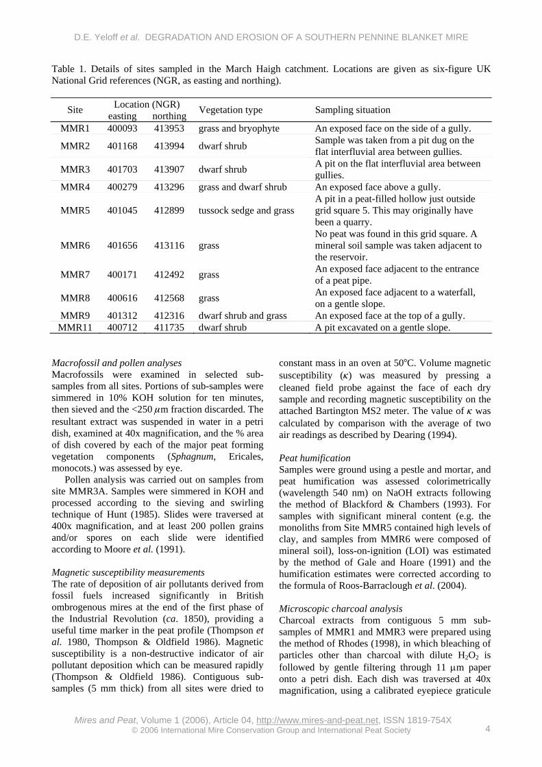
Table 1. Details of sites sampled in the March Haigh catchment. Locations are given as six-figure UK National Grid references (NGR, as easting and northing).
Location (NGR) Site easting northing Vegetation type Sampling situation
MMR1 400093 413953 grass and bryophyte An exposed face on the side of a gully.
MMR2 401168 413994 dwarf shrub Sample was taken from a pit dug on the flat interfluvial area between gullies.
MMR3 401703 413907 dwarf shrub A pit on the flat interfluvial area between gullies.
MMR4 400279 413296 grass and dwarf shrub An exposed face above a gully.
MMR5 401045 412899 tussock sedge and grass A pit in a peat-filled hollow just outside grid square 5. This may originally have been a quarry.
MMR6 401656 413116 grass No peat was found in this grid square. A mineral soil sample was taken adjacent to the reservoir.
MMR7 400171 412492 grass An exposed face adjacent to the entrance of a peat pipe.
MMR8 400616 412568 grass An exposed face adjacent to a waterfall, on a gentle slope.
MMR9 401312 412316 dwarf shrub and grass An exposed face at the top of a gully. MMR11 400712 411735 dwarf shrub A pit excavated on a gentle slope.
Macrofossil and pollen analyses Macrofossils were examined in selected sub-samples from all sites. Portions of sub-samples were simmered in 10% KOH solution for ten minutes, then sieved and the <250 μm fraction discarded. The resultant extract was suspended in water in a petri dish, examined at 40x magnification, and the % area of dish covered by each of the major peat forming vegetation components (Sphagnum, Ericales, monocots.) was assessed by eye.
Pollen analysis was carried out on samples from site MMR3A. Samples were simmered in KOH and processed according to the sieving and swirling technique of Hunt (1985). Slides were traversed at 400x magnification, and at least 200 pollen grains and/or spores on each slide were identified according to Moore et al. (1991). Magnetic susceptibility measurements The rate of deposition of air pollutants derived from fossil fuels increased significantly in British ombrogenous mires at the end of the first phase of the Industrial Revolution (ca. 1850), providing a useful time marker in the peat profile (Thompson et al. 1980, Thompson & Oldfield 1986). Magnetic susceptibility is a non-destructive indicator of air pollutant deposition which can be measured rapidly (Thompson & Oldfield 1986). Contiguous sub-samples (5 mm thick) from all sites were dried to
constant mass in an oven at 50°C. Volume magnetic susceptibility (κ) was measured by pressing a cleaned field probe against the face of each dry sample and recording magnetic susceptibility on the attached Bartington MS2 meter. The value of κ was calculated by comparison with the average of two air readings as described by Dearing (1994). Peat humification Samples were ground using a pestle and mortar, and peat humification was assessed colorimetrically (wavelength 540 nm) on NaOH extracts following the method of Blackford & Chambers (1993). For samples with significant mineral content (e.g. the monoliths from Site MMR5 contained high levels of clay, and samples from MMR6 were composed of mineral soil), loss-on-ignition (LOI) was estimated by the method of Gale and Hoare (1991) and the humification estimates were corrected according to the formula of Roos-Barraclough et al. (2004). Microscopic charcoal analysis Charcoal extracts from contiguous 5 mm sub-samples of MMR1 and MMR3 were prepared using the method of Rhodes (1998), in which bleaching of particles other than charcoal with dilute H2O2 is followed by gentle filtering through 11 μm paper onto a petri dish. Each dish was traversed at 40x magnification, using a calibrated eyepiece graticule

D.E. Yeloff et al. DEGRADATION AND EROSION OF A SOUTHERN PENNINE BLANKET MIRE
Mires and Peat, Volume 1 (2006), Article 04, http://www.mires-and-peat.net, ISSN 1819-754X
© 2006 International Mire Conservation Group and International Peat Society 5
to distinguish two size classes of charcoal fragments, with longest axis <50 μm and >50 μm respectively. No more than 100 particles were counted if the larger size class was absent from the sample, and 300 particles were counted otherwise. Documentary records Yorkshire Water maintains a network of weather stations in the southern Pennines. Rainfall has been measured since 1886 at Blackmoorfoot Reservoir (SE 095129), which is ca. 7 km east of March Haigh Reservoir, at 250 m OD. Records of moorland fires during the period 1976–2001 were obtained from local newspapers, the local fire service and the Estate Manager of the Marsden Moor Estate (D. Finnis, personal communication). Sheep stocking levels recorded on June census returns for the Colne Valley Parish (which includes the March Haigh catchment) were available for the years 1937 to 1988 (H. Buchanan, personal communication). SO2 deposition (1750–1991) for the southern Pennine region has been modelled by Skeffington et al. (1997) using data from McEvedy (1972) and Mylona (1993). SO2 monitoring data (1952–1978) for the nearby town of Slaithwaite were also available (Ferguson & Lee 1983a). RESULTS Peat stratigraphy Figure 2 shows profiles of peat humification and volume magnetic susceptibility for ten of the March Haigh sites. Only drained mineral soils were sampled at Site MMR6, which is therefore omitted.
The peat at most sites is well humified and dark brown in colour. Examination of macrofossils indicated that these peats are composed of a mixture of grass, sedge and ericaceous shrub remains in varying proportions, with small amounts (<10%) of Sphagnum leaves (not identified to species level). However, some sites (MMR1A, 4A, 4B, 8A, 9A, and 11A) showed bands of poorly humified peat of brown-orange colour. The plant remains in these layers are dominated by Sphagnum leaves, suggesting that Sphagnum was abundant at these sites before being replaced by grasses, sedges and ericaceous shrubs. The shallow peat at MMR5A is underlain by organic clay, and macrofossil analysis showed that this peat is dominated by grasses and sedges with a few Sphagnum leaves.
The degree of humification is assumed to be primarily a function of surface wetness, which in ombrogenous mires (bogs) is related to climate (Caseldine et al. 2000). The peat humification estimates are expressed in %T (light transmission) at
540 nm. Low %T indicates that the peat is highly humified and decomposed (dry conditions), and high %T suggests poor humification and lower decomposition (wet conditions). Although blanket peat is formed because the vegetation decomposes slowly under waterlogged conditions, there may still be substantial decay of organic matter in the surface layer (acrotelm) of the mire; a literature review by Clymo (1984) quotes estimates of loss ranging from 80 to 94% of dry mass. To isolate the variation in peat humification due to surface wetness (and therefore climate), it is necessary to eliminate the variation due to decomposition in the acrotelm from the analysis. In this study, the relationship of decomposition (humification) with depth was assumed to be linear, and the variation in peat humification due to surface wetness was distinguished by subtracting the linear trend (modelled using linear regression) from the raw %T data.
Although the magnetic susceptibility profiles for MMR1 and MMR2 show inconsistent patterns, volume magnetic susceptibility (κ) shows a clear rise (‘takeoff point’) above the background level at all sites except MMR5 (Figure 2), and a date of 1840 has been assigned to the point (#1) at which this occurs in each profile. κ varies little with depth at MMR5, which is situated in a disused quarry cut into the side of March Hill and so probably receives inwash from the surrounding steep slopes. The organic matter content (loss on ignition) of the peat here ranged from 40% to 86% by weight, suggesting high and varied inputs of minerals to the site. Yeloff et al. (2005) showed that high mineral inputs from the Millstone Grit of the March Haigh catchment generally reduced magnetic susceptibility values, in line with an observation that the Millstone Grit underlying the Howden Reservoir catchment in Derbyshire is magnetically impoverished (Hutchinson 1995). Thus it appears that minerogenic inputs from the slopes around Site MMR5 have resulted in low magnetic susceptibility, so that a rise in air pollution could not be detected.
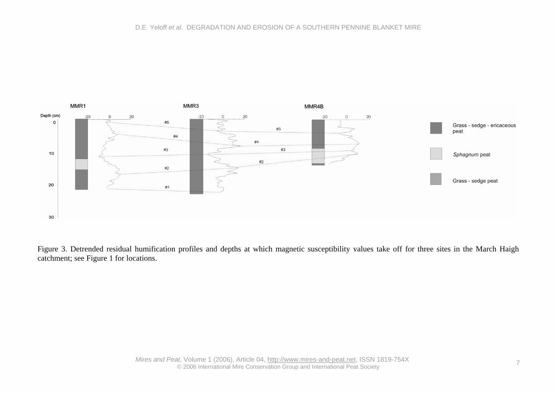
The detrended humification data (residuals) for MMR1, MMR3 and MMR4B are plotted in Figure 3, and the depth of the magnetic susceptibility rise (labelled #1, see below) is also shown. Four synchronous horizons (#2–#5, Table 2), showing either a humification peak (shift to wet conditions) or a trough (shift to dry conditions) were identified by visual inspection. Sites with less than 10 cm of peat above the magnetic susceptibility rise and those with inconsistent records were not considered because their humification profiles did not offer sufficient resolution for correlations to be recognised.

D.E. Yeloff et al. DEGRADATION AND EROSION OF A SOUTHERN PENNINE BLANKET MIRE
Mires and Peat, Volume 1 (2006), Article 04, http://www.mires-and-peat.net, ISSN 1819-754X
© 2006 International Mire Conservation Group and International Peat Society 6
Figure 2. Stratigraphy of the March Haigh catchment. Peat humification (%T) is expressed as % light transmission at 540 nm, and volume magnetic susceptibility (k) is expressed as κ x 10-6.
D.E. Yeloff et al. DEGRADATION AND EROSION OF A SOUTHERN PENNINE BLANKET MIRE
Mires and Peat, Volume 1 (2006), Article 04, http://www.mires-and-peat.net, ISSN 1819-754X
© 2006 International Mire Conservation Group and International Peat Society 7
Figure 3. Detrended residual humification profiles and depths at which magnetic susceptibility values take off for three sites in the March Haigh catchment; see Figure 1 for locations.

D.E. Yeloff et al. DEGRADATION AND EROSION OF A SOUTHERN PENNINE BLANKET MIRE
Mires and Peat, Volume 1 (2006), Article 04, http://www.mires-and-peat.net, ISSN 1819-754X
© 2006 International Mire Conservation Group and International Peat Society 8
Table 2. Depths of synchronous magnetic susceptibility and peat humification horizons at Sites MMR1, MMR3 and MMR4B, expressed in centimetres. horizon description MMR1 MMR3 MMR4B
#5 humification trough 0.8 3.7 5.0
#4 humification peak 4.6 8.7 8.0
#3 humification trough 11.6 11.5 10.5
#2 humification peak 17.1 15.6 11.5
#1 magnetic
susceptibility ‘takeoff’
21.6 23.6 -
Radioisotope chronology The stratigraphy and dry bulk density estimates for Site MMR4B suggested that the peat profile was not physically homogenous. Accordingly, the “Constant Rate of Supply (CRS) of unsupported 210Pb” model (Appleby & Oldfield 1978) was chosen for the age calculations, as this model assumes that deposits are heterogeneous and accumulation rates variable. Twelve 5 mm sub-samples were dated. The activity of supported 210Pb was estimated by subtracting the 210Pb activity measured in the lower (older than 150 years) layers of the monolith (0.007 Bq g-1) from measurements for samples closer to the mire surface. Activity levels are stated in terms of the 210Pb granddaughter, 210Po (Table 3).
Table 3. 210Pb age calculations, based on the “Constant Rate of Supply (CRS) of unsupported 210Pb” model of Appleby & Oldfield (1978), for a profile of sub-samples 5 mm thick from March Haigh Site MMR4B.
Depth (cm)
Unsupported 210Po activity
(Bq g-1)
Thickness of layer between measurements
(cm)
Average drybulk density
(g cm-3)
210Po Inventory below depth
(Bq g-1)
Age (years before 2000)
Error (+ / - yr)
0 0.209 1 0.39 0.248 0 0 1 0.077 1.5 0.43 0.165 13 1
2.5 0.071 0.5 0.62 0.116 24 1 3 0.008 0.5 0.30 0.094 31 1
4.5 0.054 0.5 0.31 0.093 32 1 5 0.011 0.5 0.36 0.084 35 1
6.5 0.062 1.5 0.30 0.082 35 1 8 0.110 0.5 0.18 0.054 49 1
8.5 0.029 1.5 0.18 0.044 55 2 9 0.026 4.5 0.27 0.037 61 2
13.5 0.013 1.5 0.27 0.005 123 8
Figure 4a shows the age-depth plot for Site MMR4B. Accumulation rates here have been relatively constant, except for a sharp rise during the 1960s. The first sharp rise in magnetic susceptibility, however, occurs at 9.5 cm depth (Figure 2), with a 210Pb-derived date of ca. 1940. Thus there may be a hiatus in the peat profile at MMR4B below 9.5 cm, possibly due to burning or erosion (see below). MMR1 also shows an inconsistent magnetic susceptibility record (although there is a clear takeoff point), and it may be that local conditions have affected the deposition of magnetic particles at this site.
The age of each of the synchronous humification horizons #2–#5 was estimated using the 210Pb chronology of MMR4B, and chronologies for Sites MMR1 and MMR3 were constructed by interpolation from these correlation points assuming a constant accumulation rate between dated
horizons. The dating precision is unknown due to the correlated chronology of these sites. Also, the accuracy of interpolated dates between 1840 and 1940 should be viewed with caution owing to the uncertainty in the chronology of MMR4B. Peat accumulation rates Peat accumulation rates are expressed as rates of change of surface height (mm yr-1) (Figure 4b). Accumulation at MMR4B was extremely rapid during the period 1965–1966 (19 mm yr-1) and in 1969 (36 mm yr-1). These values are an order of magnitude higher than those encountered at other sites in the catchment, but since significant quantities of mineral particles were observed during examination of macrofossils in peat from Site MMR4A, the accumulation may be due to inwash of eroded material from another site rather than the result of in situ peat formation. These high peat

D.E. Yeloff et al. DEGRADATION AND EROSION OF A SOUTHERN PENNINE BLANKET MIRE
Mires and Peat, Volume 1 (2006), Article 04, http://www.mires-and-peat.net, ISSN 1819-754X
© 2006 International Mire Conservation Group and International Peat Society 9
a)
b)
Figure 4. Age and peat accumulation profiles for March Haigh peat. a) Age-depth plot for Site MMR4B. Horizontal bars indicate errors in the 210Pb age estimates (Table 3) and vertical dotted lines a possible hiatus. b) Peat accumulation rates (mm yr-1). The arrows indicate dates of extremely high accumulation rates at MMR4B. See text for further explanation.

D.E. Yeloff et al. DEGRADATION AND EROSION OF A SOUTHERN PENNINE BLANKET MIRE
Mires and Peat, Volume 1 (2006), Article 04, http://www.mires-and-peat.net, ISSN 1819-754X
© 2006 International Mire Conservation Group and International Peat Society 10
accumulation estimates are not illustrated graphically in Figure 4b, but the dates at which they occurred are indicated.
Figure 4b shows that peat accumulation rates have varied through time. There are differences between sites, but some common patterns can be discerned. All three sites show low accumulation rates during the period 1840–1905. The rate of accumulation at Sites MMR1 and MMR3 was relatively high between 1919 and 1966, and low from 1966 to 2000. Average accumulation rates for the period 1840–2000 ranged from 0.3 to 1.5 mm yr-
1 (Table 4), and sites on predominantly south-facing slopes (MMR1, 2, 3, 4A, 4B) had higher accumulation rates (0.9–1.5 mm yr-1) than those (MMR7, 8, 9, 11) facing north (0.3–0.5 mm yr-1), suggesting that aspect influences peat accumulation. Table 4. Average peat accumulation rates at March Haigh, calculated for the period 1878–2000 for Site MMR4B and 1840–2000 for the remainder.
site accumulation rate (mm yr-1) aspect
MMR1 1.3 SE MMR2 0.9 SE MMR3 1.5 S
MMR4A 1.4 SE MMR4B 1.1 SE MMR7 0.4 NE MMR8 0.3 NE MMR9 0.4 NE
MMR11 0.5 NE Climate records Mean annual rainfall for Blackmoorfoot Reservoir (1886–2000) is 1154 mm. 10-year moving averages of yearly and summer (JJA) rainfall totals are plotted against time in Figure 5a. Yearly totals were low during the 1930s, the 1940s, the late 1970s and the early 1980s; and high during the 1910s, the 1960s and the late 1980s; but show a gradual increasing trend throughout the period 1886–2000. Summer rainfall was low during the 1910s, the 1930s and from the late 1970s to the early 1980s. Summer precipitation was high from the late 1950s to the early 1970s and from ca. 1910 to ca. 1930. Summer droughts with three-month rainfall totals less than 150 mm occurred in eleven years, namely 1887, 1901, 1925, 1937, 1940, 1947, 1955, 1959, 1976, 1983 and 1995. Fire regime Charcoal counts, expressed as the % of all particles
greater than 50 μm in diameter (% >50 μm), are plotted in Figure 5b. High values indicate high frequency of fires in the vicinity of the site. Peat accumulation rates are temporally variable, so that the length of time represented by a sub-sample will be uneven, and the diagram reflects this.
Figure 5b shows that fire has been temporally and spatially variable. Despite variations between individual sites, some common patterns can be identified, namely an increased frequency of burns during the period 1920–1940 and a distinguishable peak in fire frequency during the late 1950s, which is considered further in the Discussion. Reported occurrences of fires outside the legal burning season (01 October to 15 April) are also shown. Fires during the dry summer months are more likely to result in severe burns causing extensive damage to vegetation and peat. Although Figure 5b may not be an entirely accurate representation because it is probable that not all fires were reported, it is evident that there was heavy burning during the summers of 1984 and 1995. The fires in these two years are conspicuous as the only ones reported in the local newspaper between 1976 and 2001. The 1984 fires burned over a large area including Buckstones and Close Mosses, whilst the 1995 fires burned over Buckstones Moss and the March Haigh area. Severe fires on the southern Pennine moorlands during the summer of 1976 have been widely documented (Tallis 1981) and, given dating uncertainties, it is possible that the ca. 1980 peak in the microscopic charcoal diagram for Site MMR3 resulted from either the 1976 or the 1984 fire. Grazing regime Sheep numbers for the Colne Valley Parish during the period 1937–1988 are shown in Figure 5c. After 1988, the Colne Valley parish was integrated into the Huddersfield and Meltham local authority areas; statistics for the latter areas (1989–2000) are plotted as a dotted line. There was a general upward trend in sheep numbers from 1937 onwards. However, there was a dip in numbers in 1947, probably due to the exceptionally cold winter, and another dip during the period 1968–1974. There was a sharp rise from the mid 1970s, following the introduction of farm subsidies from the European Union, and another significant rise during the period 1995–2000. Air pollution Estimates of SO2 deposition for 1750–1991, based on the work of Skeffington et al. (1997), are shown in Figure 5d. This modelled deposition shows steadily rising levels from the mid 19th century, a peak in the late 1960s, and then a decline until 1991. Figure 5d also shows the mean annual SO2

D.E. Yeloff et al. DEGRADATION AND EROSION OF A SOUTHERN PENNINE BLANKET MIRE
Mires and Peat, Volume 1 (2006), Article 04, http://www.mires-and-peat.net, ISSN 1819-754X
© 2006 International Mire Conservation Group and International Peat Society 11
Figure 5. Documentary records for March Haigh. a) Yearly and summer rainfall (mm) at Blackmoorfoot Reservoir (10-year moving averages). b) Fire regime as indicated by microscopic charcoal counts (% >50 μm) for Sites MMR1 and MMR3, and reported fires outside the legal season (1st October–15th April). c) Sheep stocking levels; the solid line indicates Colne Valley Parish data (left axis) and the dotted graph indicates Huddersfield and Meltham local authority area data (right axis). (d) Pollution deposition; (i) modelled S deposition in the south Pennines, and (ii) annual mean concentrations of SO2 in air at the Slaithwaite monitoring site. concentrations measured at Slaithwaite between 1952 and 1978 (Ferguson & Lee 1983a). These data show a consistent decline in deposition; thus the measured S deposition at Slaithwaite was declining by the early 1950s, at least 15 years earlier than indicated by the model of Skeffington et al. (1997). The Slaithwaite monitoring site may be more representative than the model for the March Haigh
catchment, since it is only ca. 6 km from March Haigh Reservoir. Pollen analysis Of the sampled sites, Site MMR3A (Buckstones Moss) had the highest peat accumulation rate and therefore offered the highest temporal resolution. Figure 6 shows a pollen diagram for this site, with

D.E. Yeloff et al. DEGRADATION AND EROSION OF A SOUTHERN PENNINE BLANKET MIRE
Mires and Peat, Volume 1 (2006), Article 04, http://www.mires-and-peat.net, ISSN 1819-754X
© 2006 International Mire Conservation Group and International Peat Society 12
approximate dates. The data are expressed as the percentage of total land pollen (%TLP). Only major pollen and spore types (%TLP greater than 2%) are shown. The pollen assemblage is dominated by grasses (Poaceae) and Ericales. Also present in
abundance are the tree taxa Alnus, Betula and Quercus, plus a Coryloid type (probably Corylus avellana); sedges (Cyperaceae); peat mosses (Sphagnum spp.); and to a lesser extent spores of other mosses and bracken (Pteridium aquilinum).
Figure 6. Pollen diagram of MMR3 from the moorland above March Haigh reservoir. Dates are approximate.
The pollen profile has been divided into three zones, BMPZ-1–BMPZ-3, delimited by two distinct horizons. At the first of these, ca. 1918, Poaceae (grasses) replaced Ericales as the dominant pollen type. The second gross change in the pollen assemblage occurred ca. 1959, when the two dominant vegetation types Poaceae and Ericales decreased in abundance and Bryophyta (mosses) increased. During pollen counts, relatively few pollen grains and spores were encountered in three consecutive sub-samples dated between 1901 and 1910. As these sub-samples contained abundant charcoal and thermally mature organic matter, it
seems likely that the pollen and spores had been destroyed by fire.
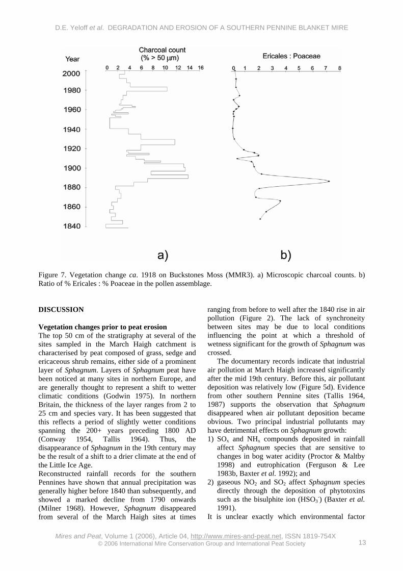
The ratio of Calluna vulgaris : Poaceae pollen has been used as a measure of the past abundance of Calluna vulgaris on blanket bog (Stevenson & Thompson 1993, Stevenson & Rhodes 2000). Variations in the Ericales : Poaceae ratio on Buckstones Moss, together with charcoal counts, are shown in Figure 7. These data show the replacement of Calluna by a grassland vegetation type after ca. 1918. Earlier peaks in the Ericales : Poaceae ratio occurred ca. 1865 and ca. 1880, and reductions are apparent ca. 1870, ca. 1890 and ca. 1910.
D.E. Yeloff et al. DEGRADATION AND EROSION OF A SOUTHERN PENNINE BLANKET MIRE
Mires and Peat, Volume 1 (2006), Article 04, http://www.mires-and-peat.net, ISSN 1819-754X
© 2006 International Mire Conservation Group and International Peat Society 13
Figure 7. Vegetation change ca. 1918 on Buckstones Moss (MMR3). a) Microscopic charcoal counts. b) Ratio of % Ericales : % Poaceae in the pollen assemblage. DISCUSSION Vegetation changes prior to peat erosion The top 50 cm of the stratigraphy at several of the sites sampled in the March Haigh catchment is characterised by peat composed of grass, sedge and ericaceous shrub remains, either side of a prominent layer of Sphagnum. Layers of Sphagnum peat have been noticed at many sites in northern Europe, and are generally thought to represent a shift to wetter climatic conditions (Godwin 1975). In northern Britain, the thickness of the layer ranges from 2 to 25 cm and species vary. It has been suggested that this reflects a period of slightly wetter conditions spanning the 200+ years preceding 1800 AD (Conway 1954, Tallis 1964). Thus, the disappearance of Sphagnum in the 19th century may be the result of a shift to a drier climate at the end of the Little Ice Age. Reconstructed rainfall records for the southern Pennines have shown that annual precipitation was generally higher before 1840 than subsequently, and showed a marked decline from 1790 onwards (Milner 1968). However, Sphagnum disappeared from several of the March Haigh sites at times
ranging from before to well after the 1840 rise in air pollution (Figure 2). The lack of synchroneity between sites may be due to local conditions influencing the point at which a threshold of wetness significant for the growth of Sphagnum was crossed.
The documentary records indicate that industrial air pollution at March Haigh increased significantly after the mid 19th century. Before this, air pollutant deposition was relatively low (Figure 5d). Evidence from other southern Pennine sites (Tallis 1964, 1987) supports the observation that Sphagnum disappeared when air pollutant deposition became obvious. Two principal industrial pollutants may have detrimental effects on Sphagnum growth: 1) SOx and NHx compounds deposited in rainfall
affect Sphagnum species that are sensitive to changes in bog water acidity (Proctor & Maltby 1998) and eutrophication (Ferguson & Lee 1983b, Baxter et al. 1992); and
2) gaseous NO2 and SO2 affect Sphagnum species directly through the deposition of phytotoxins such as the bisulphite ion (HSO3
-) (Baxter et al. 1991).
It is unclear exactly which environmental factor

D.E. Yeloff et al. DEGRADATION AND EROSION OF A SOUTHERN PENNINE BLANKET MIRE
Mires and Peat, Volume 1 (2006), Article 04, http://www.mires-and-peat.net, ISSN 1819-754X
© 2006 International Mire Conservation Group and International Peat Society 14
caused the disappearance of Sphagnum, and it may be that the combination of climate and air pollution provided an adverse environment for growth.
Newspaper reports and contemporary vegetation descriptions suggest that the vegetation of the March Haigh catchment was dominated by Calluna vulgaris before 1918 (Smith & Moss 1903, Woodhead 1904). The increase in Ericales during the period 1880–1900 coincides with a greatly increased frequency of fire, as indicated by high charcoal counts (Figure 7a). This may be the result of controlled burning to maintain Calluna vulgaris in its younger life phases by stimulating fresh shoot growth and regeneration from seed (Whittaker & Gimingham 1962). There is some indication that gamekeepers burned Calluna on the March Haigh catchment after 1870 in order to maintain suitable habitat for grouse (Anderson et al. 1989). The intervals between the reductions in the Ericales : Poaceae ratio on Buckstones Moss (Figure 7b) correspond roughly to the optimum 20-year burning cycle for Calluna on blanket bog (Taylor & Marks 1971, Hobbs 1984). However, charcoal counts and a 3 cm layer of combusted peat at site MMR3 show that widespread and severe moorland fire occurred during the period ca. 1910 to ca. 1930. A severe fire would prejudice the re-establishment of Calluna by destroying the seed bank and regenerative organs (Legg et al. 1992, Scott et al. 2000).
Reducing the frequency of controlled burning of Calluna-dominated moorland can lead to the accumulation of extremely flammable dead plant material. Such poor management has been implicated as a cause for the general decline of heather moorland during the 20th century (Hudson 1986). It has been suggested that the substantial reduction in numbers of land managers and gamekeepers during labour shortages after the First World War resulted in the build-up of old heather leading to severe fires in other parts of northern England (Tallis 1981, Mackay & Tallis 1996), and the March Haigh catchment may have been similarly affected. Moreover, accidental moorland fires tend to occur during prolonged dry periods, and the climate at March Haigh ca. 1918 was relatively dry, with a summer drought in 1925.
In the absence of grazing, Calluna will re-establish as the dominant vegetation type after fire (Rawes & Hobbs 1979); but with even relatively low grazing densities, grasses and sedges will become dominant on areas bared by severe fire (Yalden 1981b, Sydes & Miller 1988). Although there is no quantitative information on sheep stocking levels at the time of the ca. 1918 vegetation change, it is probable that the slopes of the March Haigh catchment were grazed during this period.
Thus the replacement of Calluna by grass was probably due to severe moorland fire. Grazing by sheep and, to some extent, high air pollution levels, may have prevented the re-establishment of Calluna vulgaris on bare peat patches and promoted the dominance of grasses. Changes in moorland vegetation at the time of peat erosion The decline in Poaceae and Ericales and the rise in Coryloid pollen ca. 1959 (Figure 6) suggests that local pollen productivity declined at this time, possibly indicating an increase in the area of bare peat on the slopes of the March Haigh catchment. Increases in bryophyte spores may reflect increased abundance of taxa such as Ceratodon purpureus and Polytrichum spp., which are known pioneers of the bare peat and ash surfaces left by severe moorland fire (Maltby et al. 1990, Legg et al. 1992, Thomas et al. 1994).
Six agents or mechanisms have been proposed as those responsible for disrupting the vegetation cover and initiating peat erosion on blanket peat moorlands; namely natural causes, peat cutting/artificial drainage, trampling/path erosion, air pollution, fire and grazing (e.g. Phillips et al. 1981). The contribution of each of these factors in modifying the moorland vegetation ca. 1959 and in initiating peat erosion ca. 1963 is considered below. Aerial photography and ground observations suggest that there has been no significant peat cutting on the slopes of the March Haigh catchment, and there is little evidence of natural causes of erosion such as mass movement and peat pipes. Bare peat has been exposed on ground immediately adjacent to the two paths that traverse the catchment, but these paths do not cross the most heavily eroded part (Buckstones Moss) and the bare peat patches resulting from trampling represent a very small fraction of the total bare area.
By 1959, air pollution levels were lower than during the 1918–1930 change from Calluna to grass-dominated vegetation, and they continued to decline throughout the period of erosion (ca. 1959 to the present) (Figure 5d). Consequently, any detrimental influence of air pollution on the moorland vegetation probably also diminished over this period. Pollution may have had little effect in 1959 because the moorland vegetation was dominated by grasses which are not known to be negatively affected by air pollutants such as acid deposition, NO2, SO2 and ozone, unlike bog species e.g. Calluna and Sphagnum.
There was a severe drought in the summer of 1959 which precipitated severe moorland fires throughout the Peak District National Park (Radley

D.E. Yeloff et al. DEGRADATION AND EROSION OF A SOUTHERN PENNINE BLANKET MIRE
Mires and Peat, Volume 1 (2006), Article 04, http://www.mires-and-peat.net, ISSN 1819-754X
© 2006 International Mire Conservation Group and International Peat Society 15
1965, Tallis 1981). Microscopic charcoal analysis (Figure 5b) suggests the occurrence of catastrophic fire on the March Haigh catchment during the late 1950s. Documentary and microscopic charcoal evidence indicates that severe fires also occurred in the years following the onset of erosion, and this presumably exposed further areas of bare peat.
Sheep numbers rose steadily during the period 1937–2000. By 1958–1961, sheep stocking levels were more than three times the 1937 levels, and probably far higher than during the change from Calluna to grass-dominated vegetation ca. 1918–1930. The associated intense grazing would tend to maintain the bare peat areas exposed by agents such as fire by significantly impeding the recovery of vegetation (Evans 1997, Rawes & Hobbs 1979).
We suggest that bare peat areas exposed by the severe fire in the summer of 1959 were maintained by the unprecedented high sheep grazing pressure, precipitating erosion and gully formation. Further severe fires and increased grazing pressure subsequently exacerbated the situation, leading to high rates of erosion between 1959 and 2000. The events associated with the vegetation change ca. 1918 indicate that severe fire alone need not initiate erosion; rather that recolonisation of the bare peat patches, albeit by poorer, less diverse grassland vegetation, proved possible under the relatively low grazing pressure at that time. By contrast, large sheep stocks impeded the re-establishment of vegetation after the severe fires of 1959, resulting in erosion. Thus, the disruption of blanket mire vegetation and the occurrence of erosion in the March Haigh catchment appears to be a function of the intensity of both burning and grazing, i.e. the two environmental factors operated synergistically.
Catchment sediment yield peaked significantly during the period 1976–1984, suggesting a period of increased peat erosion (Yeloff et al. 2005). A combination of circumstances may have facilitated this. The period 1976–1984 was relatively dry with several droughts (notably in 1976 and 1984), and severe moorland fires occurred during most summers. The introduction of EU farm subsidies in the 1970s led to very high sheep stocking in the March Haigh area, with over seven times the 1937 levels by 1984 (Figure 5c). The dry summers would have promoted desiccation of peat exposed by fire, leading to direct oxidation of the superficial layers of peat, shrinkage of the peat mass, and the formation of a cracked surface crust. This would ‘prepare’ the peat for erosion by rainstorms during the following winter (Hulme & Blyth 1985, Francis 1990, Evans et al. 1999).
The most eroded part of the catchment is Buckstones Moss, where the extensive gully system
in deep peat (Figure 1d) appears to conform to the Type I erosion category of Bower (1960a, b). Comparison of peat accumulation rates suggests that the southerly aspect of Buckstones Moss renders it more productive than less sunny areas (Table 4), so that it may be more vulnerable than north-facing areas to both severe fires and erosion because it should accumulate more plant biomass to fuel fires and have significantly deeper peat. Buckstones Moss lies close to the only road across the catchment (the A640), and is therefore vulnerable to fires started accidentally by cigarette ends and glass bottles discarded from passing vehicles. Although a few cattle are present, the majority of the grazing animals are sheep, which prefer to graze short vegetation such as grass or the edges of heather stands (Grant et al. 1985). The exposure of bare peat by fire may have facilitated overgrazing and maintenance of bare ground by improving sheep access to such areas (Yalden 1981b).
The southern Pennines receive lower annual rainfall than other blanket mire areas (Tallis 1997), and climate models suggest that severe droughts like that of the summer of 1995 will become more frequent in the future (Hulme 1997). Thus the potential for moorland fire and desiccation of exposed peat surfaces is likely to increase, with serious implications for the March Haigh catchment and other blanket mires in the southern Pennines. CONCLUSIONS 1) Prior to the mid 20th century, the degradation of
vegetation on the March Haigh catchment appears to have been caused by air pollution, climate change and fire, as at other locations in the southern Pennines.
2) A severe fire during the summer of 1959 removed vegetation, the bare peat surface was maintained due to unprecedented high sheep stocking levels, and extensive erosion was thus precipitated.
ACKNOWLEDGEMENTS This research was carried out under a University of Huddersfield research studentship, with assistance from Nottingham Trent University. We thank Mrs Judith Firth of Brunel University for the 210Pb measurements on the peat samples; Yorkshire Water and Ms Helen Buchanan of DEFRA for agricultural and meteorological records; Mr David Finnis for information and site access; Mr Gary Rushworth and Mr Mark Townley for assistance in the field.
D.E. Yeloff et al. DEGRADATION AND EROSION OF A SOUTHERN PENNINE BLANKET MIRE
Mires and Peat, Volume 1 (2006), Article 04, http://www.mires-and-peat.net, ISSN 1819-754X
© 2006 International Mire Conservation Group and International Peat Society 16
REFERENCES Anderson, P., Radford, E. & Mackenzie, S. (1989)
Marsden Moor Estate: moorland erosion, its extent, cause and restoration. Penny Anderson Associates, Buxton (unpublished report to The National Trust).
Anderson, P. & Tallis, J. (1981) The nature and extent of soil and peat erosion in the Peak District. In: Phillips, J., Yalden, D. & Tallis, J. (eds.) Peak District Moorland Erosion Study Phase 1 Report, Peak Park Joint Planning Board, Bakewell, 52-64.
Appleby, P.G., & Oldfield, F. (1978) The calculation of lead-210 dates assuming a constant rate of supply of unsupported 210Pb to the sediment. Catena, 5, 1-8.
Baxter, R., Emes, M.J. & Lee, J.A. (1991) Transition metals and the ability of Sphagnum to withstand the phytotoxic effects of the bisulphite ion. New Phytologist, 118, 433-439.
Baxter, R., Emes, M.J. & Lee, J.A. (1992) Effects of an experimentally applied increase in ammonium on growth and amino acid metabolism of Sphagnum cuspidatum Ehrh. ex. Hoffm. from differently polluted areas. New Phytologist, 120, 265-274.
Blackford, J.J. & Chambers, F.M. (1993) Determining the degree of peat decomposition for peat-based palaeoclimatic studies. International Peat Journal, 5, 7-24.
Bower, M.M. (1960a) The erosion of blanket peat in the southern Pennines. The East Midland Geographer, 13, 22-33.
Bower, M.M. (1960b) Peat erosion in the Pennines. Advancement of Science, 64, 323-331.
Caseldine, C.J., Baker, A. & Charman, D.J. (2000) A comparative study of optical properties of NaOH peat extracts: implications for humification studies. The Holocene, 10, 649-658.
Clymo, R.S. (1984) The limits to peat bog growth. Philosophical Transactions of the Royal Society of London, B 303, 605-654.
Conway, V.M. (1954) Stratigraphy and pollen analysis of southern Pennine blanket peats. Journal of Ecology, 42, 117-147.
Dearing, J.A. (1994) Environmental magnetic susceptibility: Using the Bartington MS2 System. Chi Publishing, Coventry.
Evans, M.G., Burt, T.P., Holden, J. & Adamson, J.K. (1999) Runoff generation and water table fluctuations in blanket peat: evidence from UK data spanning the dry summer of 1995. Journal of Hydrology, 221, 141-160.
Evans, R. (1997) Soil erosion in the UK initiated by grazing animals: a need for a national survey.
Applied Geography, 17, 127-141. Ferguson, P. & Lee J.A. (1983a) Past and present
sulphur pollution in the southern Pennines. Atmospheric Environment, 17, 1131-1137.
Ferguson, P. & Lee, J.A. (1983b) The growth of Sphagnum species in the southern Pennines. Journal of Bryology, 12, 579-586.
Francis, I.S. (1990) Blanket peat erosion in a mid-Wales catchment during two drought years. Earth Surface Processes and Land Forms, 15, 445-456.
Gale, S.J. & Hoare, P.G. (1991) Quaternary Sediments. John Wiley and Sons, Chichester and New York.
Godwin, H. (1975) The History of the British Flora (2nd edition). Cambridge University Press, Cambridge.
Grant, S.A., Suckling, D.E., Smith, H.K., Torvell, L., Forbes, T.D.A. & Hodgson, J. (1985) Comparative studies of diet selection by sheep and cattle: the hill grasslands. Journal of Ecology, 73, 987-1004.
Heathwaite, A.L. (1993) Disappearing peat - regenerating peat? The impact of climate change on British peatlands. Geographical Journal, 159, 203-208.
Hobbs, R.J. (1984) Length of burning rotation and community composition in high-level Calluna-Eriophorum bog in N. England. Vegetatio, 57, 129-136.
Hudson, P. (1986) Red Grouse. The biology and management of a wild game bird. Game Conservancy Trust, Bourne Press, Bournemouth.
Hulme, M. (1997) The climate in the UK from November 1994 to October 1995. Weather, 52, 242-257.
Hulme, P.D. & Blyth, A.W. (1985) Observations on the erosion of blanket peat in Yell, Shetland. Geografiska Annaler, A 67, 119-122.
Hunt, C.O. (1985) Recent advances in pollen extraction techniques: a brief review. British Archaeological Review, 266, 181-188.
Hutchinson, S.M. (1995) Use of magnetic and radiometric measurements to investigate erosion and sedimentation in a British upland catchment. Earth Surface Processes and Landforms, 20, 293-314.
Labadz, J.C., Burt, T.P. & Potter, A.W.R. (1991) Sediment yield and delivery in the blanket peat moorlands of the southern Pennines. Earth Surface Processes and Land Forms, 16, 255-271.
Legg, C.J., Maltby, E., & Proctor, M.C.F. (1992) The ecology of severe moorland fire on the North York Moors: seed distribution and seedling establishment of Calluna vulgaris. Journal of Ecology, 80, 737-752.
D.E. Yeloff et al. DEGRADATION AND EROSION OF A SOUTHERN PENNINE BLANKET MIRE
Mires and Peat, Volume 1 (2006), Article 04, http://www.mires-and-peat.net, ISSN 1819-754X
© 2006 International Mire Conservation Group and International Peat Society 17
Mackay, A.W. & Tallis, J.H. (1996) Summit-type blanket mire erosion in the Forest of Bowland, Lancashire, UK: predisposing factors and implications for conservation. Biological Conservation, 76, 31-44.
Maltby, E., Legg, C.J. & Proctor, M.C.F. (1990) The ecology of severe moorland fire on the North Yorks moors: effects of the 1976 fires, and subsequent surface and vegetation development. Journal of Ecology, 78, 490-518.
McEvedy, C. (1972) The Penguin Atlas of Modern History. Penguin Books, London.
Milner, J.S. (1968) Fluctuations in annual and seasonal rainfall over the leeside of the south Pennines 1761-1965. Weather, 23, 435-441.
Moore, P.D., Webb, J.A. & Collinson, M.E. (1991) Pollen Analysis (2nd edition). Blackwell Science, Oxford.
Moore, T.R. & Knowles, R. (1989) The influence of water table levels on methane and carbon dioxide emissions from peatland soils. Candian Journal of Soil Science, 69, 33-38.
Mylona, S. (1993) Trends of Sulphur Dioxide Emissions, Air Concentrations and Depositions of Sulphur in Europe Since 1880. Norwegian Meteorological Institute, Oslo.
Pattinson, V.A., Butcher, D.P. & Labadz, J.C. (1994) The managment of water colour in peatland catchments. Journal of the Institute of Water and Environmental Managment, 8, 298-307.
Phillips, J., Yalden, D. & Tallis, J. (1981) Peak District Moorland Erosion Study Phase 1 Report. Peak Park Joint Planning Board, Bakewell.
Proctor, M.C.F. & Maltby, E. (1998) Relations between acid atmospheric deposition and the surface pH of some ombrotrophic bogs in Britain. Journal of Ecology, 86, 329-340.
Radley, J. (1965) Significance of major moorland fires. Nature, 205, 1254-1259.
Rawes, M. & Hobbs, R. (1979) Management of semi-natural blanket bog in the northern Pennines. Journal of Ecology, 67, 789-807.
Rhodes, A.N. (1998). A method for the preparation and quantification of microscopic charcoal from terrestrial and lacustrine sediment cores. The Holocene, 8, 113-117.
Roos-Barraclough, F., van der Knaap, W.O., van Leeuwen, J.F.N. & Shotyk, W. (2004) A Late-glacial and Holocene record of climatic change from a Swiss peat humification profile. The Holocene, 14, 7-19.
Scott, A.C., Cripps, J.A., Collinson, M.E. & Nichols, G.J. (2000) The taphonomy of charcoal following a recent heathland fire and some
implications for the interpretation of fossil charcoal deposits. Palaeogeography, Palaeo-climatology, Palaeoecology, 164, 1-31.
Shimwell, D.W. (1974) Sheep grazing intensity in Edale, Derbyshire, 1692-1747, and its effect on blanket peat erosion. Derbyshire Archaeological Journal, 9, 35-40.
Skeffington, R., Wilson, E., Maltby, E., Immirzi, P. & Putwain, P. (1997) Acid deposition and blanket mire degradation and restoration. In: Tallis, J.H., Meade, R. & Hulme, P.D. (eds.) Blanket Mire Degradation - Causes, Consequences and Challenges, Macaulay Land Use Research Institute, Aberdeen, 29-37.
Smith, W.G. & Moss, C.E. (1903) Geographical distribution of vegetation in Yorkshire. Geographical Journal, 21, 375-401.
Stevenson, A.C. & Rhodes, A.N. (2000) Palaeo-environmental evaluation of the importance of fire as a cause for Calluna loss in the British Isles. Palaeogeography, Palaeoclimatology, Palaeoecology, 164, 211-222.
Stevenson, A.C. & Thompson, D.B.A. (1993) Long-term changes in the extent of heather moorland in upland Britain and Ireland: palaeoecological evidence for the importance of grazing. The Holocene, 3, 70-76.
Sydes, C. & Miller, G.R. (1988) Range management and nature conservation in the British uplands. In: Usher, M.B. & Thompson, D.B.A. (eds.) Ecological Change in the Uplands, Blackwell Scientific, Oxford, 323-337.
Tallis, J.H. (1964) Studies on southern Pennine peats III: the behaviour of Sphagnum. Journal of Ecology, 52, 345-353.
Tallis, J.H. (1981) Uncontrolled burns. In: Phillips, J., Yalden, D. & Tallis, J. (eds.) Peak District Moorland Erosion Study Phase 1 Report, Peak Park Joint Planning Board, Bakewell, 176-182.
Tallis, J.H. (1985) Mass movement and erosion of a southern Pennine blanket peat. Journal of Ecology, 73, 283-315.
Tallis, J.H. (1987) Fire and flood at Holme Moss: erosion processes in an upland blanket mire. Journal of Ecology, 75, 1099-1129.
Tallis, J.H. (1997) Peat erosion in the Pennines: the badlands of Britain. Biologist, 44, 277-279.
Tallis, J.H. (1998) Growth and degradation of British and Irish blanket mires. Environmental Review, 6, 81-122.
Taylor, J.A. (1983) The peatlands of great Britain. In: Gore, A.J.P. (ed.) Mires: Swamp, Bog, Fen and Moor. Ecosystems of the World 4B, Elsevier, New York, 1-46.
Taylor, K., & Marks, T.C. (1971) The influence of burning and grazing on the growth and

D.E. Yeloff et al. DEGRADATION AND EROSION OF A SOUTHERN PENNINE BLANKET MIRE
Mires and Peat, Volume 1 (2006), Article 04, http://www.mires-and-peat.net, ISSN 1819-754X
© 2006 International Mire Conservation Group and International Peat Society 18
development of Rubus chamaemorus L. in Calluna-Eriophorum bog. In: Duffey, E. & Watt, A.S. (eds.) The Scientific Management of Animal and Plant Communities for Conservation, Blackwell Scientific, Oxford, 153-166.
Thomas, P.A., Proctor, M.C.F & Maltby, E. (1994) The ecology of severe moorland fire on the North York Moors: chemical and physical constraints on moss establishment from spores. Journal of Ecology, 82, 457-474.
Thompson, R., Bloemendal, J.A., Dearing, J.A., Oldfield, F., Rummery, T.A., Stober J.C. & Turner, G.M. (1980) Environmental applications of magnetic measurements. Science, 207, 481-486.
Thompson, R. & Oldfield, F. (1986) Environmental Magnetism. Allen and Unwin, London.
Whittaker, E. & Gimingham, C.H. (1962) The effects of fire on regeneration of Calluna vulgaris (L.) Hull. from seed. Journal of Ecology, 50, 815-822.
Woodhead, T.W. (1904) Ecology of woodland plants in the neighbourhood of Huddersfield. Botany, 37, 333-406.
Yalden, D. (1981a) Loss of other wildlife and amenity. In: Phillips, J., Yalden, D. & Tallis, J. (eds.) Peak District Moorland Erosion Study Phase 1 Report, Peak Park Joint Planning Board, Bakewell, 204-206.
Yalden, D. (1981b) Loss of grazing. In: Phillips, J., Yalden, D. & Tallis, J. (eds.) Peak District Moorland Erosion Study Phase 1 Report, Peak Park Joint Planning Board, Bakewell, 198-199.
Yeloff, D.E., Labadz, J.C., Hunt, C.O., Higgitt, D.L. & Foster, I.D.L. (2005) Blanket peat erosion and sediment flux in an upland reservoir catchment in the southern Pennines, UK. Earth Surface Processes and Landforms, 30, 717-733.
Received 14 Oct 2004, final copy received 22 Nov 2005 Editor: Olivia Bragg
_________________________________________________________________________________________________________ Author for correspondence: Dr Dan Yeloff, Institute for Biodiversity and Ecosystem Dynamics (IBED), Universiteit van Amsterdam, 1090 GB Amsterdam, The Netherlands. Tel: +31 20 525 7837; Fax: +31 20 525 7832; E-mail: [email protected]