clarkesville green infrastructure implementation strategy (pdf)
TRANSCRIPT

Clarkesville Green Infrastructure Implementation Strategy
2014 GREEN INFRASTRUCTURE TECHNICAL ASSISTANCE PROGRAM City of Clarkesville
Clarkesville, GA
Photo: Justin Ellis April 2015
EPA 832-R-15-005

About the Green Infrastructure Technical Assistance Program
Stormwater runoff is a major cause of water pollution in urban areas. When rain falls in undeveloped areas, soil and plants absorb and filter the water. When rain falls on our roofs, streets, and parking lots, however, the water cannot soak into the ground. In most urban areas, stormwater is drained through engineered collection systems and discharged into nearby water bodies. The stormwater carries trash, bacteria, heavy metals, and other pollutants from the urban landscape, polluting the receiving waters. Higher flows also can cause erosion and flooding in urban streams, damaging habitat, property, and infrastructure.
Green infrastructure uses vegetation, soils, and natural processes to manage water and create healthier urban environments. At the scale of a city or county, green infrastructure refers to the patchwork of natural areas that provides habitat, flood protection, cleaner air, and cleaner water. At the scale of a neighborhood or site, green infrastructure refers to stormwater management systems that mimic nature by soaking up and storing water. Green infrastructure can be a cost-effective approach for improving water quality and helping communities stretch their infrastructure investments further by providing multiple environmental, economic, and community benefits. This multi-benefit approach creates sustainable and resilient water infrastructure that supports and revitalizes urban communities.
The U.S. Environmental Protection Agency (EPA) encourages communities to use green infrastructure to help manage stormwater runoff, reduce sewer overflows, and improve water quality. EPA recognizes the value of working collaboratively with communities to support broader adoption of green infrastructure approaches. Technical assistance is a key component to accelerating the implementation of green infrastructure across the nation and aligns with EPA’s commitment to provide community focused outreach and support in the President’s Priority Agenda Enhancing the Climate Resilience of America’s Natural Resources. Creating more resilient systems will become increasingly important in the face of climate change. As more intense weather events or dwindling water supplies stress the performance of the nation’s water infrastructure, green infrastructure offers an approach to increase resiliency and adaptability.
For more information, visit http://www.epa.gov/greeninfrastructure
ii

Acknowledgements
Principal USEPA Staff Jamie Piziali, USEPA Christopher Kloss, USEPA Community Team Jeremy Pirkle, City of Clarkesville Tim Durham, City of Clarkesville Justin Ellis, Soque River Watershed Association Duncan Hughes, Soque River Watershed Association Consultant Team Heather Fisher, Tetra Tech, Inc. Eric Byrne, Tetra Tech, Inc. Martina Frey, Tetra Tech, Inc. Jason Wright, Tetra Tech, Inc. Alex Porteous, Tetra Tech, Inc. Hillary Nicholas, Tetra Tech, Inc. Maureen Harris, Tetra Tech, Inc.
This report was developed under USEPA Contract No. EP-C-11-009 as part of the 2014 USEPA Green Infrastructure Technical Assistance Program.
iii

Contents
1 Executive Summary ............................................................................................................................. 1
2 Introduction ........................................................................................................................................ 3
2.1 Demographic Information ............................................................................................................ 4
2.2 Local Development Goals/Local Planning Documents ................................................................. 5
2.3 Local Water Quality/Quantity Issues and Goals ........................................................................... 5
3 Potential Site Identification and Prioritization .................................................................................... 8
3.1 Prioritization Results ..................................................................................................................... 8
3.2 Initial Parcel Screening Results ................................................................................................... 13
3.3 Recommendations for Priority Sites ........................................................................................... 14
4 Code and Ordinance Review ............................................................................................................. 15
5 Potential Funding Sources ................................................................................................................. 17
5.1 Funding Related to Water Resources ......................................................................................... 17
5.2 Funding Related to Landscaping ................................................................................................. 18
5.3 Funding Related to Energy Efficiency ......................................................................................... 19
5.4 Funding Related to Economic Development .............................................................................. 19
5.5 Stormwater Utility Funding ........................................................................................................ 20
5.6 Recommended Funding Approach ............................................................................................. 21
6 Strategy Summary ............................................................................................................................. 23
7 References ......................................................................................................................................... 25
Appendix A: Parcel Prioritization Detailed Methods and Results ............................................................. A-1
Appendix B: Compendium of Indicators for Prioritizing Green Infrastructure Opportunities .................. B-1
Appendix C: Design Recommendations ..................................................................................................... C-1
Appendix D: Code Review Checklist .......................................................................................................... D-1
iv

Figures
Figure 2-1. Curbless bioswale at the recently constructed Habersham County Judicial Center .................. 4
Figure 2-2. Soque River past and current 303(d)-listed segments in the vicinity of Clarkesville ................. 7
Figure 3-1. Clarkesville parcel prioritization results .................................................................................... 10
Figure 3-2. Clarkesville parcel prioritization results, close-up of priority parcels....................................... 11
Tables
Table 3-1. Prioritization Results .................................................................................................................. 12
Table 3-2. Initial Screening Results ............................................................................................................. 13
Table 3-3. Preliminary, Planning-Level Cost Estimates for Select Priority Projects .................................... 15
v

(This page is intentionally left blank.)
vi

1 Executive Summary
The City of Clarkesville is a small, fast-growing community interested in developing a green infrastructure plan. The city’s municipal separate storm sewer system is not subject to state or federal requirements to address stormwater pollution. The city has proactively addressed stormwater quality and quantity through post-construction stormwater requirements and supporting the use of green infrastructure for stormwater management.
EPA worked with the city to develop the Clarkesville Green Infrastructure Implementation Strategy, which provides the basic building blocks for a green infrastructure plan: 1) goals and objectives, based on the city’s current and future needs, 2) a comprehensive prioritization of parcels throughout the city to identify opportunities for further evaluation (Appendices A and B), and 3) site-specific design recommendations (Appendix C), including illustrations and descriptions of potential green infrastructure practices. A range of green infrastructure practices are recommended, including rainwater harvesting, a green alley, bioretention, permeable pavement, a green roof, stormwater wetlands, and stormwater detention.
USEPA used Tetra Tech’s Green Infrastructure Opportunity Checklist Tool (Appendix D) to identify opportunities for improving the City of Clarkesville’s Zoning Ordinance to encourage implementation of green infrastructure by developers, property owners, and other parties. The following key opportunities were identified:
1. Street and Parking Dimensions: Allow narrower street and travel lanes with curb pullouts for passing of large vehicles. More specifically, allow travel lanes of 10 to 12 feet or less; in residential developments, allow street pavement widths of 18 to 22 feet. For parking, allow a smaller minimum stall area so that at least some stalls can be 9 feet by 15 feet or smaller. While not specifically prohibited, encouragement or incentives for curb bumpouts/extensions could be included in city policies or programs.
2. Redevelopment: Include incentives for redevelopment through minor relaxation of site design standards (i.e. stormwater retention) or other requirements. The undisturbed land (i.e. greenfield) that might have been developed without the incentives would then continue to provide stormwater management benefits. The City of Clarkesville might consider specific areas for incentives, like the downtown, or have the incentives apply to redevelopment throughout the city.
3. Setbacks: Reduce required setbacks to encourage clustering and open space design. Minimum lot setbacks could be reduced to 20 feet in the front, 25 feet in the rear, and 8 feet on either side for higher density residential development (1/2-acre lot or less in size). Further reductions in setbacks beyond these recommendations could also be considered. At a minimum, these reduced setbacks could be used as guidance for approving conservation subdivisions. The city may also want to consider reducing setbacks for the more urban residential zoning districts like R-1A, R-1B, and R-2.
4. Phased Disturbance of Vegetated Areas: In site plans, require that disturbance of vegetated areas be phased to reduce erosion of topsoil.
5. Wetlands: Require that all development minimize hydrologic alteration to existing wetlands. 6. Stream Buffers: Increase the width of required stream buffers or extend stream buffer
requirements so that all development must preserve at least a 50-foot buffer.
1
7. Best Management Practice (BMP) Maintenance: Require a BMP maintenance plan for all stormwater facilities.
8. Performance Standards: Develop additional stormwater performance standards for new development and redevelopment, including standards for stormwater volume, water quality treatment, and channel protection.
Funding sources were reviewed, and leveraging amongst diverse sources was considered in relation to the city’s interests and site-specific opportunities. The following funding approach is recommended:
• Continue to pursue WaterFirst Community designation. • Investigate feasibility and public interest in a stormwater utility for use in funding projects and
grant cost share. • Collaborate with affordable housing and economic development programs to find opportunities
for green infrastructure and leveraging with Appalachian Regional Commission (ARC) Grants, U.S. Economic Development Administration (USEDA) Economic Development Assistance Programs, and the Community Development Block Grant (CDBG) program.
• Pursue site-specific funding related to water resources, landscaping, energy efficiency, affordable housing, and economic development.
The overall recommended strategy for the City of Clarkesville is summarized in a 6-step process:
1. Investigate property owner interest, cost and general feasibility of site-specific opportunities and select a sub-set to pursue more detailed conceptual designs.
2. Include consideration of key opportunities for code improvement in future zoning code revisions.
3. Continue to pursue WaterFirst Community Designation. 4. Investigate feasibility and public interest in a stormwater utility for use in funding projects and
grant cost share. 5. Collaborate with affordable housing and economic development programs to find opportunities
for green infrastructure and leveraging with ARC Grants, USEDA Economic Development Assistance Programs, and the CDBG program.
6. Pursue site-specific funding for Appendix C Exhibits 1-11 as appropriate based on further planning and evaluation.
This approach should evolve over time based on changing needs and as new opportunities for partnership and funding emerge. With these basic steps, the City of Clarkesville can continue to build their experience with green infrastructure and realize the multiple benefits of green infrastructure including but not limited to water quality improvement, flood prevention, beautification, and community development.
Clarkesville’s recent growth and redevelopment present stormwater management challenges. As a small city, its staff has been proactive about partnering with public and private entities and finding creative solutions to urban stormwater issues. Their efforts, exemplified by this strategy, are helping to address stormwater challenges and prevent larger problems in the future. By outlining goals, priorities, code improvements, project opportunities, and funding sources, the City of Clarkesville’s strategy provides a model approach for small, unregulated communities to successfully pursue green infrastructure.
2
2 Introduction
The City of Clarkesville represents an engaged, close-knit community of residents whose daily lives and recreation depend on its natural resources and downstream water quality. With a downtown square and historic district that draw crowds throughout the year, this city prides itself on its community character. The city’s policies and practices express a value for green space, whether it is defined as urban landscaping, mature trees, parks, or natural areas.
The city’s Public Works staff is familiar with green infrastructure concepts and has been working to incorporate them into a variety of projects. Clarkesville’s recent green infrastructure efforts include the development of greenways and parks with preserved open space. The city’s Greenway Master Plan connects parks to the downtown business district, and future trails are planned to provide a loop around the entire city. The city’s zoning code encourages conservation design in new developments and the use of native vegetation in developed landscaping. The City of Clarkesville partnered with Habersham County, the Soque River Watershed Association (SRWA), and North Georgia Technical College in the design of a pocket wetland, grass swale, and two bioswales for the recently constructed Habersham County Judicial Center (Figure 2-1). The city also played a role in encouraging the retrofit of a bioretention cell on private property near downtown.
Considering the city staff’s familiarity and recent experience with green infrastructure, this strategy provides recommended next steps to help strengthen the city’s current pursuits and minimize both financial and regulatory barriers to implementing green infrastructure. Potential parcel-scale opportunities are prioritized based on the city’s green infrastructure goals as well as key geospatial data. The priority sites are evaluated, and design recommendations are provided for 11 of the most promising sites. To address policy barriers, the strategy recommends changes and additions to the city’s Zoning Ordinance that will help encourage the use of green infrastructure in future development. Finally, funding opportunities are identified to support a variety of green infrastructure pursuits and partnerships.
3

Figure 2-1. Curbless bioswale at the recently constructed Habersham County Judicial Center (Source: Justin Ellis)
2.1 Demographic Information
Clarkesville is a small city with a population of 1,742 located in the Southern Inner Piedmont eco-region of northeast Georgia and is the county seat of Habersham County (City of Clarkesville, 2013). According to the U.S. Census Bureau, the city has a total land area of 1.9 square miles compared to Habersham County, which is 276 square miles (U.S. Census Bureau, 2014). It is approximately 90 miles northeast of Atlanta. The population of Clarkesville has grown by 39 percent since the 2000 census. The median age of residents is 38.9 years. Fifty-three percent of residents are female (City of Clarkesville, 2013). The largest Clarkesville ethnic groups are white (82.9%) followed by black (7.8%) and Hispanic (5.5%) (CensusViewer, 2012).
The median household income in Clarkesville is about $30,000 compared to about $47,000 for the State of Georgia, and nearly 19 percent of Clarkesville residents live in poverty. The predominant industries are accommodation and food services, manufacturing, and retail trade (CensusViewer, 2012; City-Data.com, 2013).
Agriculture is the top industry in Habersham County. The main crops are peaches and apples and the main industries are poultry and beef. Tourism continues to be an important part of the county's economic development and growth. The county is also experiencing a steady growth in retirees (Habersham County, 2014).
4
Clarkesville is designated as a “Better Hometown” by the Georgia Department of Community Affairs. Clarkesville receives assistance to develop commercial areas through historic preservation efforts and downtown revitalization projects (Georgia Department of Community Affairs, 2014).
2.2 Local Development Goals/Local Planning Documents
Several City of Clarkesville planning documents relate directly to the community benefits provided by green infrastructure. The city’ s Zoning Ordinance contains the following sections that seek to protect open areas, preserve natural features, and provide community green space:
• Preservation corridor overlay district. • Subdivision requirements related to open space. • Conservation subdivision design option. • Tree preservation ordinance.
Through the Clarkesville Greenways Plan, the city developed a map that shows existing and planned greenways and trails connected to the downtown area. The city is also interested in streetscape improvement projects throughout its downtown area and has already completed one streetscape project. Greenways and streetscaping provide valuable and cost-effective opportunities for green infrastructure. Combining those projects with green infrastructure could not only reduce development costs for both efforts, but also increase the overall environmental, social, and economic benefits provided. When street trees are implemented as part of a streetscape project, tree boxes can be designed to treat and infiltrate stormwater. Bioretention cells can be located along greenways to protect streams from stormwater impacts, provide additional aesthetic enjoyment of the trail, and promote establishment of native plant species, among other benefits.
Community development projects often provide opportunities for leveraging funding and using green infrastructure to achieve economic and social benefits along with water quality and quantity benefits. Affordable housing is an example of a development project than can incorporate green infrastructure into its design and be at least partially funded by the larger development funding source (e.g., Community Development Block Grant). The City of Clarkesville has expressed an interest in innovative funding opportunities, which can include, but are not limited to, affordable housing developments.
Based on these plans and general public interest, the City of Clarkesville proposed several goals as part of their request for technical assistance. The city and EPA discussed these goals and, adding a few additional details, established the following planning goals for green infrastructure:
• Incorporate green infrastructure into parks. • Integrate green infrastructure planning with streetscape, greenway, and other city plans. • Identify opportunities that are eligible for innovative sources of funding.
The strategy considers these goals and prioritizes sites based on whether they provide opportunities for implementing the city’s existing plans as well as social and economic benefits to the community.
2.3 Local Water Quality/Quantity Issues and Goals
Green infrastructure provides solutions for addressing the city’s stormwater management goals and protecting its water resources, particularly the Soque River and its tributaries. Valued as a river of both local and regional significance, the Soque River provides drinking water for the city and is a tributary of
5

the Chattahoochee River, the primary drinking water supply for millions of downstream residents. Popular recreational activities within and along the river include fishing, paddling, and hiking. The River receives treated effluent from the city’s wastewater treatment plant and stormwater runoff from urban areas within Clarkesville’s jurisdiction.
Georgia Environmental Protection Division (GAEPD) listed a 29-mile reach of the Soque River on the 2014 draft 303(d) list of impaired waters, as impaired for impacts to the river’s biological communities, particularly fish, due to nonpoint sources or other unknown sources (Figure 2-2; GAEPD, 2014). This portion includes the Soque River in Clarkesville upstream of SR 17. The river downstream of SR 17 is currently listed as supporting designated uses in GAEPD’s 2014 draft assessment. The Soque River within Clarkesville was previously listed as impaired due to fecal coliform and has been delisted as of the draft 2014 303(d) list. Clarkesville continues to manage stormwater with a focus on fecal coliform to further protect the river.
The City of Clarkesville is an active member of the Soque River Watershed Partnership (SRWP). In 2007, SRWP completed the Soque River Watershed Protection Plan (WPP), which was based on the USEPA’s Nine Key Elements of Watershed Planning. The WWP identifies pollutant sources and causes and outlines a strategy to achieve pollutant load reductions that would meet water quality standards and support fish and other aquatic life. SRWP has received and implemented several grants and accomplished many of the actions outlined in the WPP. Green infrastructure would provide further opportunities to achieve progress on the WPP goals for improving and protecting water quality and aquatic habitat.
The city has a municipal separate storm sewer system that is not subject to state or federal requirements to address stormwater pollution. The city has been proactive in its control of stormwater quality and quantity through local requirements, and the subdivision section of the Clarkesville Zoning Ordinance requires that a stormwater management plan be prepared for new development or redevelopment of any site that involves:
• New development in which 5,000 square feet or more of new impervious area is created or land disturbing activity of one acre of land or more occurs.
• Redevelopment site on which more than 50 percent of the site is redeveloped or increases the impervious area on site by more than 5,000 square feet.
• Any commercial or industrial development. (All commercial and industrial developments must have at least one stormwater management facility.)
Stormwater facilities are required to:
• Be designed so that peak release rates (when combined with all detention bypass areas) are equal to or less than the predeveloped runoff rates at the same location.
• Control the 2- to 50-year storm events. • Provide the safe passage of the 100-year storm event while providing one foot of free board
between the 100-year pond elevation and the top of the dam.
The identification of green infrastructure opportunities for this project focuses on existing development within the city, paying particular attention to opportunities in Clarkesville’s highly impervious downtown district. Retrofits involving green infrastructure would need to be designed to meet the city’s stormwater requirements. Green infrastructure, by definition, involves techniques that seek to mimic
6

the predevelopment hydrograph. Green infrastructure designs provide an opportunity for the city to manage stormwater not only on new development, but development built prior to the enactment of its stormwater requirements.
Figure 2-2. Soque River past and current 303(d)-listed segments in the vicinity of Clarkesville
Based on its commitment to protecting the Soque River and addressing stormwater runoff from urban areas, the city has established the following green infrastructure goals relating to water quality and stormwater management:
• Address water quality impairments in the Soque River. • Address additional threats to water quality from existing and future increases in stormwater
runoff.
The identification of green infrastructure opportunities was focused on prioritizing parcels and providing recommendations that would best meet the city’s water quality and stormwater management goals.
7

3 Potential Site Identification and Prioritization
The city’s goals formed the basis for prioritizing parcels and screening for urban green infrastructure retrofit opportunities. The selection of site-specific opportunities was based on a comprehensive prioritization using remote spatial data followed by an on-site review of opportunities and constraints. Recommended parcels were identified using the following process:
1. Select parcels within municipal boundaries and within a 100-meter buffer outside of municipal boundaries.
2. Rank parcels based on the following indicators using a scale from 1 (worst opportunity) to 10 (best opportunity):
a. Publicly Owned Parcels b. Impervious Surfaces c. Parcel Size d. Located in a Priority Watershed e. Infiltration Capacity f. Located in a Priority Characterization Area g. Proximity to Maintenance Need h. Proximity to Stormwater Structural Damage i. Proximity to Stormwater Inlet, Catchment Basin, or Conveyance Structure j. Percent Slope
3. Calculate a composite score based on the rankings (i.e., sum of scores divided by number of indicators; highest score indicates best opportunity).
4. Review the 10 highest scoring parcels for green infrastructure opportunities and screen parcels for site-level constraints.
5. Draft recommendations for green infrastructure opportunities on the ten highest ranked parcels.
Appendix A provides detailed definitions of the indicators and outlines the methods that were used to score the parcels. Each parcel received a score for each indicator, and the scores were compiled into a normalized, composite score reflecting all of the indicators.
Throughout the prioritization and screening process, the city’s input and priorities provided key guidance into how the parcels were scored and which parcels were included on the priority list. The prioritization was designed as a tool to facilitate the city’s site identification and decision-making process.
3.1 Prioritization Results
A total of 1,265 parcels meet the first selection criterion of being located within municipal boundaries or within a 100-meter buffer outside these boundaries. Figure 3-1 shows the location of the 10 highest scoring parcels (priority parcels) along with the lower scoring parcels, and Figure 3-2 provides a close-up of the priority parcels. Many of highest scoring parcels are located downtown, and the remaining parcels are located relatively near the downtown area.
Table 3-1 compares the scores of the 10 highest scoring parcels; 9 out of 10 are public properties or are located in a priority watershed, or both. Most of these parcels fall within the two higher categories of imperviousness and size. For all of these parcels, the majority of their land area is classified with hydrologic soil group (HSG) B soils, which represents moderately deep, moderately well-drained soils
8

that should be suitable for infiltration. All of the 10 highest scoring parcels fall within at least one of the priority characterization areas, including parcels near existing or planned parks and/or future planned streetscaping. All of the parcels are within 200 feet of a previously identified stormwater maintenance need and a stormwater catchment/conveyance, and all but one are also within 200 feet of previously documented stormwater structural damage. Most parcels have slopes less than 10 percent; those that have higher slopes required further evaluation in the field.
One initial consideration was the lack of parcels with HSG A (high infiltration) soils in the priority parcels. This is an expected result because outside of the Coastal Plain, HSG A soils are not common and typically occur within alluvial floodplains.
9

10
Figure 3-1. Clarkesville parcel prioritization results

11
Figure 3-2. Clarkesville parcel prioritization results, close-up of priority parcels

Table 3-1. Prioritization Results
Parcel Code
Publicly Owned Parcels
Impervious Surface Parcel Size Priority
Watershed Hydrologic Soil Groups
Priority Charact.
Area
Maint. Need
Struct. Damage
Sw. Catch/ Conv.
% Slope
Composite Score
102 093 10 7.5 7.5 10 7.5 5 10 10 10 10 8.8 069 032 10 5 7.5 10 7.5 5 10 10 10 10 8.5 069A009 10 10 10 1 7.5 7.5 10 10 10 7.5 8.4 104 339 10 7.5 10 10 7.5 5 10 10 10 2.5 8.3 102 086 10 7.5 7.5 10 7.5 5 10 10 10 5 8.3 102 087 10 5 7.5 10 7.5 5 10 10 10 7.5 8.3 069 043 1 7.5 7.5 10 7.5 7.5 10 10 10 10 8.1 102 017 10 2.5 10 10 7.5 7.5 10 10 10 2.5 8.0 104 041 10 7.5 10 1 7.5 5 10 10 10 7.5 7.9 104 024 10 5 10 10 7.5 5 10 1 10 10 7.9
12
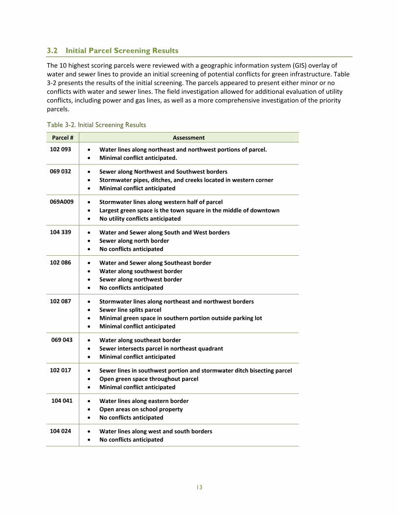
3.2 Initial Parcel Screening Results
The 10 highest scoring parcels were reviewed with a geographic information system (GIS) overlay of water and sewer lines to provide an initial screening of potential conflicts for green infrastructure. Table 3-2 presents the results of the initial screening. The parcels appeared to present either minor or no conflicts with water and sewer lines. The field investigation allowed for additional evaluation of utility conflicts, including power and gas lines, as well as a more comprehensive investigation of the priority parcels.
Table 3-2. Initial Screening Results
Parcel # Assessment
102 093 • Water lines along northeast and northwest portions of parcel. • Minimal conflict anticipated.
069 032 • Sewer along Northwest and Southwest borders • Stormwater pipes, ditches, and creeks located in western corner • Minimal conflict anticipated
069A009 • Stormwater lines along western half of parcel • Largest green space is the town square in the middle of downtown • No utility conflicts anticipated
104 339 • Water and Sewer along South and West borders • Sewer along north border • No conflicts anticipated
102 086 • Water and Sewer along Southeast border • Water along southwest border • Sewer along northwest border • No conflicts anticipated
102 087 • Stormwater lines along northeast and northwest borders • Sewer line splits parcel • Minimal green space in southern portion outside parking lot • Minimal conflict anticipated
069 043 • Water along southeast border • Sewer intersects parcel in northeast quadrant • Minimal conflict anticipated
102 017 • Sewer lines in southwest portion and stormwater ditch bisecting parcel • Open green space throughout parcel • Minimal conflict anticipated
104 041 • Water lines along eastern border • Open areas on school property • No conflicts anticipated
104 024 • Water lines along west and south borders • No conflicts anticipated
13

3.3 Recommendations for Priority Sites
The priority parcels were reviewed in the field by EPA, city, and SRWA staff. Important considerations included slopes, available vacant land area, size of urban drainage area, drainage patterns, existing mature trees, and potential presence of hazardous materials (e.g., underground storage tanks).
Following the field investigation and review by the Community Team, three priority parcels were screened out for significant constraints:
• Parcel 104 339, the City Hall property, was removed from the list due to a combination of steep slopes, intensive use of parking, and lack of space for green infrastructure. This property remains a candidate for rainwater harvesting, which could support Clarkesville’s landscaping maintenance activities. While a green roof was considered, the roof on City Hall had been recently replaced, and other properties offered more promising green roof opportunities.
• Parcel 069 043 was removed because the gas station, which is currently under operation, presents a potential conflict with green infrastructure due to existing underground storage tanks and the use of hazardous materials. If infiltration were used, it might have to be lined and would be less effective than other green infrastructure opportunities. The identification of this constraint was based on visual assessment in the field. Spatial data can be used to screen for these site constraints prior to field visits. The USEPA Envirofacts website (http://www.epa.gov/enviro/facts/topicsearch.html) can be used to identify locations of hazardous waste handlers. Some states maintain similar datasets. Spatial data might not include all locations with hazardous materials constraints, and field visits are important for further screening.
• Parcel 104 024 was removed because the drainage patterns did not provide a promising opportunity for green infrastructure.
Several additional parcels were recommended by the city and reviewed in the field in addition to the already prioritized parcels. Following the field investigation, the parcels were grouped into 11 sites that were determined to provide promising opportunities with minimal apparent constraints. Exhibits 1 through 11 in Appendix C present conceptual recommendations for each selected site. Exhibits 10 and 11 represent sites that will be considered for development by the city in the future; more general recommendations were provided for these sites.
The city selected four parcels for the development of preliminary cost estimates. Table 3-3 presents the cost estimates for these four projects separately by type of BMP. The cost range reflects potential for variation in a number of factors, including drainage area, size of the BMP, cost of labor and materials, and site constraints. These costs are estimated at the planning-level and should be only used for preliminary budgets until more detailed designs and cost estimates can be developed.
14
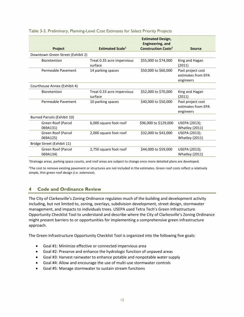
Table 3-3. Preliminary, Planning-Level Cost Estimates for Select Priority Projects
Project Estimated Scale1
Estimated Design, Engineering, and
Construction Costs2 Source Downtown Green Street (Exhibit 2)
Bioretention Treat 0.35 acre impervious surface
$55,000 to $74,000 King and Hagan (2011)
Permeable Pavement 14 parking spaces $50,000 to $60,000 Past project cost estimates from EPA engineers
Courthouse Annex (Exhibit 4) Bioretention Treat 0.33 acre impervious
surface $52,000 to $70,000 King and Hagan
(2011) Permeable Pavement 10 parking spaces $40,000 to $50,000 Past project cost
estimates from EPA engineers
Burned Parcels (Exhibit 10) Green Roof (Parcel
069A131) 6,000 square foot roof $96,000 to $129,000 USEPA (2013);
Whatley (2011) Green Roof (Parcel
069A125) 2,000 square foot roof $32,000 to $43,000 USEPA (2013);
Whatley (2011) Bridge Street (Exhibit 11) Green Roof (Parcel
069A134) 2,750 square foot roof $44,000 to $59,000 USEPA (2013);
Whatley (2011) 1Drainage areas, parking space counts, and roof areas are subject to change once more detailed plans are developed.
2The cost to remove existing pavement or structures are not included in the estimates. Green roof costs reflect a relatively simple, thin green roof design (i.e. extensive).
4 Code and Ordinance Review
The City of Clarkesville’s Zoning Ordinance regulates much of the building and development activity including, but not limited to, zoning, overlays, subdivision development, street design, stormwater management, and impacts to individuals trees. USEPA used Tetra Tech’s Green Infrastructure Opportunity Checklist Tool to understand and describe where the City of Clarkesville’s Zoning Ordinance might present barriers to or opportunities for implementing a comprehensive green infrastructure approach.
The Green Infrastructure Opportunity Checklist Tool is organized into the following five goals:
• Goal #1: Minimize effective or connected impervious area • Goal #2: Preserve and enhance the hydrologic function of unpaved areas • Goal #3: Harvest rainwater to enhance potable and nonpotable water supply • Goal #4: Allow and encourage the use of multi-use stormwater controls • Goal #5: Manage stormwater to sustain stream functions
15

The checklist poses a list of questions under each of these goals, and the code reviewer enters the answer based on the community’s existing code. The checklist rates each item as important, very important, or essential. To identify the key opportunities for improving the code, these ratings were considered, along with how relevant each item was to Clarkesville’s goals and unique characteristics.
Appendix D presents the results of the code review for the City of Clarkesville’s zoning ordinance. The following key opportunities were recommended as priorities for encouraging the application of green infrastructure in Clarkesville:
1. Street and Parking Dimensions: Allow narrower street and travel lane widths with curb pullouts for passing of large vehicles. More specifically, allow 10- to 12-foot travel lanes (or less); in residential developments, allow street pavement widths of 18 to 22 feet. For parking, allow a smaller minimum stall area so that at least some stalls can be 9 feet by 15 feet or smaller. While not specifically prohibited, curb bumpouts/extensions could be encouraged near intersections and mid-block for traffic-calming and bioretention opportunities.
2. Redevelopment: Include incentives for redevelopment through minor relaxation of site design standards (i.e. stormwater retention) or other requirements. The undisturbed land (i.e. greenfield) that might have been developed without the incentives would then continue to provide stormwater management benefits. The City of Clarkesville might consider specific areas for incentives, like the downtown, or have the incentives apply to redevelopment throughout the city.
3. Setbacks: Reduce required setbacks to encourage clustering and open space design. Minimum lot setbacks could be reduced to 20 feet in the front, 25 feet in the rear, and 8 feet on the side for higher density residential development (1/2-acre lot or less in size). Further reductions in setbacks beyond these recommendations could also be considered. At a minimum, these reduced setbacks could be used as guidance for approving conservation subdivisions. The city may also want to consider reducing setbacks for the more urban residential zoning districts like R-1A, R-1B, and R-2.
4. Phased Disturbance of Vegetated Areas: In site plans, require that disturbance of vegetated areas be phased to reduce erosion of topsoil.
5. Wetlands: Require that all development minimize hydrologic alteration to existing wetlands. 6. Stream Buffers: Increase the width of required stream buffers or extend stream buffer
requirements so that all development must preserve at least a 50-foot buffer. 7. BMP Maintenance: Require a BMP maintenance plan for all stormwater facilities. 8. Performance Standards: Develop additional stormwater performance standards for new
development and redevelopment, including standards for stormwater volume, water quality treatment, and channel protection.
The code and ordinance review highlights a number of opportunities to improve the city’s Zoning Ordinance to encourage green infrastructure on existing and new development or redevelopment. The key opportunities identified provide recommended priorities for the short-term, and the full checklist in Appendix D provides a reference for continued code improvements.
16

5 Potential Funding Sources
The multiple benefits of green infrastructure provide eligibility for a diverse array of funding sources. Generally, green infrastructure projects may be eligible for funding programs that prioritize water quality improvement, flood mitigation, and community green space, among other green infrastructure benefits. The energy saving benefits of green infrastructure provide a leveraging opportunity with energy efficiency-related funding. Funding might also be leveraged if a green infrastructure opportunity is part of a housing or economic development project. Stormwater utilities provide communities with a long-term funding source for green infrastructure as well as general stormwater improvement projects. This section provides a review of available funding opportunities and highlights the most promising sources for funding green infrastructure in Clarkesville.
5.1 Funding Related to Water Resources
A number of programs exist that fund infrastructure projects to achieve water resource management goals, and green infrastructure is well-supported by these programs. The following list summarizes the most relevant funding opportunities for the City of Clarkesville in this category:
• USEPA Clean Water Act Nonpoint Source Grant (Section 319 Grants): Funded by USEPA through the Clean Water Act and administered by GAEPD, these grants provide funding for best management practices (BMPs) and other water quality improvement efforts. They require a 40 percent non-federal match that can be met through local funds, in-kind services, or other non-federal sources. Applications are typically due in the fall of each year, and awards are announced in the spring. https://epd.georgia.gov/section-319h-georgias-nonpoint-source-implementation-grant
• USEPA Clean Water State Revolving Fund (CWSRF): Administered by the Georgia Environmental Finance Authority, the CWSRF provides low-interest loans for a variety of water-related infrastructure projects including bioretention, tree planting, green roofs, permeable pavement and cisterns. Recent projects include the construction of stormwater BMPs in Sandy Springs, GA. A 1 percent interest rate reduction is available for recycling and water reuse projects that replace potable sources with non-potable sources (under "Conservation" projects). http://gefa.georgia.gov/clean-water-state-revolving-fund
• National Fish and Wildlife Foundation (NFWF) Five Star and Urban Waters Restoration Program: The program brings together funding from multiple government agencies, non-profit organizations, and private companies into a single grant application process focused on funding projects that restore water quality, watersheds and the habitats in urban areas. Eligible projects may include but are not limited to bioswales, permeable pavers, bioretention, green roofs, downspout disconnection, installation of native vegetation, and wetlands restoration. Awards range from $20,000 to $50,000 with an average size of $30,000, and 40 to 50 grants are awarded per year. The application deadline occurs once per year in February and awards are announced in July. A 50 percent non-federal match is required, and applications offering a greater match are considered more competitive. http://www.nfwf.org/fivestar/Pages/2015RFP.aspx
• U.S. Department of Transportation (USDOT) Transportation Alternatives Program: The Transportation Alternatives Program provides funding for many activities relating to highways including stormwater management, control, and water pollution prevention or abatement
17

related to highway construction or due to highway runoff. Projects involving streetscaping and corridor landscaping might also be eligible. For communities like Clarkesville with a population of less than 5000, grants are administered through Georgia Department of Transportation (GADOT) and are part of its Transportation Enhancement Program. Most awards require a 20 percent state or local match. http://www.fhwa.dot.gov/environment/transportation_alternatives/ http://www.dot.ga.gov/IS/Funding/TE#tab-2
• U.S. Department of Agriculture (USDA) Rural Assistance Program, Water and Waste DisposalDirect Loans and Grants: Available for rural communities with populations less than 10,000, thisprogram funds water and waste disposal systems, specifically construction, land acquisition,legal fees, engineering fees, capitalized interest, equipment, initial operation and maintenancecosts, project contingencies, and other approved costs. The project must benefit primarily ruralusers, and the applicant must be unable to obtain other funding at affordable rates. Loans andgrants are awarded; however, limited grants are available.http://www.rurdev.usda.gov/UWP-dispdirectloansgrants.htm
• Designation as a WaterFirst Community: The City of Clarkesville is also seeking designation as aWaterFirst Community from the Georgia Department of Community Affairs. The designationrequires a community to take a proactive and collaborative approach in protecting waterresources. While working towards this designation, the city will be exposed to resources andpartnerships that will help strengthen their ability to implement green infrastructure. Therecognition associated with being designated a WaterFirst Community will continue to supportthe city’s efforts in advancing green infrastructure.
5.2 Funding Related to Landscaping
While landscaping is a component of green infrastructure, funding for community beautification and other landscaping efforts could be applied to the vegetation costs of green infrastructure. Two Georgia-based programs that provide funding for vegetation-related projects are described below. If these programs are used, it will be important to propose a green infrastructure project that supports the specific goals of each program.
• GADOT GATEway Grant Program: The GATEway Grant Program provides funding for roadside beautification along state routes. The funds can be used only for landscape plant material and its installation. The City of Demorest received $26,030 for roadside beautification from this program.http://www.dot.ga.gov/IS/Funding/Gateway
• The Garden Club of Georgia Historic Landscape and Garden Grant: Local governments and non-profit organizations are eligible to apply for funding to protect or restore historic gardens orother landscapes or promote public awareness of these features. The program requires a 50percent match, and the funding is provided for one year at a maximum of $3,000. The GardenClub of Georgia provides this funding through a partnership with the Georgia Department ofNatural Resources Historic Preservation Division, the Southeast Regional Office of the NationalPark Service, the Cherokee Garden Library at the Atlanta History Center, and the GeorgiaDepartment of Economic Development. http://gardenclub.uga.edu/gardengrant.html
18
5.3 Funding Related to Energy Efficiency
Green infrastructure can improve energy efficiency during warm months by shading impervious area, which decreases a building’s temperature and reduces the overall heat island effect in urban areas. Green roofs provide the most direct form of energy savings by insulating buildings from heat loss during the winter and over-heating during the summer. While there may be other funding programs available, the following program has funded many energy saving projects throughout Georgia and the United States.
• Energy Efficiency and Conservation Block Grant Program: The U.S. Department of Energy's Energy Efficiency and Conservation Block Grant Program provides funding to cities, communities, states, and other entities to develop, promote, implement, and manage energy efficiency and conservation projects. Green roofs and other green infrastructure that help conserve energy can be eligible for these block grants. In Georgia, 28 communities have received this funding for a variety of energy-saving projects. http://energy.gov/eere/wipo/energy-efficiency-and-conservation-block-grant-program
5.4 Funding Related to Economic Development
Projects that seek to provide economic development support to disadvantaged communities can often be directly linked to one or more green infrastructure opportunities. For example, green infrastructure can be integrated into the stormwater management design within an affordable housing project. If a development project seeks to increase jobs, green infrastructure may provide opportunities for additional employment through its long-term required maintenance. Any type of economic development effort may include green infrastructure, and future streetscaping projects could present an important leveraging opportunity.
The following list of funding programs could provide opportunities to leverage economic development funding for green infrastructure.
• Appalachian Regional Commission (ARC) Grants: ARC is a federal, state, and local partnership working within the Appalachian Region to increase job opportunities and improve opportunities for the people of Appalachia to compete in the global economy. The program typically awards grants to state and local agencies and governmental entities (e.g., economic development authorities), local governing boards (e.g., county councils), and nonprofit organizations (e.g., schools and organizations that build low-cost housing). ARC prioritizes grant awards based on economic status maps. Habersham County currently has a status of transitional and would be eligible for a grant with a 50 percent or greater match. Habersham County received a $300,000 grant ($620,000 total including match) for water and sewer Improvements in FY2013. http://www.arc.gov/funding/ARCGrantsandContracts.asp
• U.S. Economic Development Administration (USEDA) Economic Development Assistance Programs: USEDA administers this program to provide funding for a range of business and industrial development activities that create or retain jobs, including infrastructure development. The funding consists of both grants and loans. http://www.grants.gov/web/grants/view-opportunity.html?oppId=248297
19
• Community Development Block Grant (CDBG) Program: CDBG funding is provided by the U.S. Department of Housing and Urban Development and administered by the Georgia Department of Community Affairs. The program requires that at least 70 percent of the funds be used for efforts that benefit low- and moderate-income persons. Green infrastructure could be part of a CDBG-finance project. For example, the City of Chicago used CDBG funds to install a new green roof on its historic Cultural Center. http://www.dca.state.ga.us/communities/cdbg/
5.5 Stormwater Utility Funding
Across the U.S., stormwater utilities are used by local governments of all sizes to provide a consistent and reliable funding source for stormwater system improvement and maintenance. A stormwater utility, much like a water or sewer utility, provides a framework for coordinating responsibilities, generating funding, and planning for short-term and long-term needs. Stormwater utilities are typically funded by a stormwater fee that is administered using an equitable structure across all users within the jurisdiction.
The following are some advantages of a stormwater utility:
• Provides a dedicated stream of funding for capital stormwater improvement projects and operation and maintenance.
• Finances cost shares for federal and state grants. • Allows for a coordinated effort and overall cumulative progress on major stormwater concerns,
providing the ability to address flooding, water quality, and other needs in tandem. • Provides options for incentives (e.g., fee credits) to encourage voluntary practices, like green
infrastructure.
With a water and sewer utility already in place, Clarkesville has an advantage over other small local governments without these utilities. A stormwater fee can be added to the current utility billing structure, which reduces the cost of setting up and administering a fee. When applying for loans, the stormwater utility can borrow against the water and sewer utility’s track record. Linking the stormwater utility with the water and sewer utility also provides additional funding flexibility. Each utility can have its own dedicated funding while loans between the utilities can occur.
There are a variety of approaches to developing stormwater utilities and implementing fees. The simplest approach is to apply a flat rate to all users. When implementing a flat rate, a city can limit potential objections and legal exposure by gaging community support for the rate and evaluating whether a flat rate is sufficiently equitable across the different sizes and uses of customer properties. Tiered or custom rate structures can be developed based on impervious surface, parcel size, or another metric related to stormwater runoff generation. Some jurisdictions choose to fund stormwater utilities through a property tax (i.e., ad valorem tax), which can be appropriate if property value is closely tied to the amount of on-site impervious surface.
The process of creating a stormwater utility involves establishing goals and objectives, determining an administrative structure, gathering stakeholder input, and researching equitable fee structures. Tools and resources are available to help local governments with this process. Most notably, the University of North Carolina Environmental Finance Center has developed the Georgia Stormwater Utility Dashboard, an on-line tool for stormwater utility planning. http://www.efc.sog.unc.edu/reslib/item/ga-stormwater-utility-dashboard
20

In addition, the following list provides examples of relatively small local governments in Georgia who operate stormwater utilities and provide examples of frameworks and fee structures for consideration (University of North Carolina Environmental Finance Center, 2014):
Auburn, GA (Barrow/Gwinnett Counties)
• Service population 6,887 • Administers a flat rate for residential, tiered rate for nonresidential • Website: www.cityofauburn-ga.org/index.aspx?nid=129
Austell, GA (Cobb County)
• Service population 6,581 • Administers a flat rate for residential, custom rate for nonresidential, credit program • Website: www.austellga.gov
Avondale Estates (DeKalb County)
• Service population 2,960 • Administers a flat rate for residential, custom rate for nonresidential, credit program • Website: www.avondaleestates.org/public_works.html
Camilla (Mitchell County)
• Service population 5,360 • Administers a flat rate for residential, custom rate for nonresidential, credit program • Website: www.camillaga.net/stormwater.shtml
Most of the above communities include a credit program as part of their stormwater fee structure, which provides reduced fees or other incentives for users to implement voluntary practices including rain barrels, downspout disconnection, natural area preservation, and impervious surface reduction. All four communities administer a flat rate for residential and either custom or tiered rates for nonresidential.
5.6 Recommended Funding Approach
The review of available funding sources revealed a number of opportunities to seek funding support and leverage multiple sources for green infrastructure in the City of Clarkesville. The water resources-related funding sources would be applicable to all of the recommended projects. However, Clarkesville is likely to achieve greater success if multiple and diverse funding sources are pursued. The projects involving stormwater wetlands and/or detention (Appendix C, Exhibits 6, 7, and 8) should be prioritized for the water resource-related funding sources. While these projects can provide many co-benefits, a more direct case for energy savings, landscaping, or economic development can be made for smaller projects that are integrated into other uses. In addition, Exhibits 2, 3, and 6 all could be designed to treat highway runoff and would be most appropriate for the USDOT Transportation Alternatives Program.
When considering the funding sources that are not directly related to stormwater improvements, it is likely that the city will need to pursue at least two separate sources of funding. For example, the landscaping-related funding would be applied towards the vegetation costs of green infrastructure, and the remaining costs could be funded through a 319 grant or other relevant source with a local match. The Historic Landscape and Garden Grant could provide relevant funding to the Mauldin House site
21

(Exhibit 5) if the specific requirements of the grant are met. Future streetscaping projects can also be coordinated with green infrastructure implementation within the downtown area. Exhibit 2 provides a promising opportunity to provide streetscaping along with stormwater treatment, and landscaping-related funding could be applied to the vegetation costs for this project.
Any green infrastructure project that would increase shading of impervious surfaces could be eligible for energy-efficiency-related funding. A green roof project would provide the most directly relevant proposal for this funding (Exhibits 10 and 11).
Many of the proposed projects include bioretention that will require long-term maintenance. This type of maintenance provides an opportunity for creating jobs for unskilled workers. While a single bioretention cell results in minimal additional employment, a large number of bioretention cells throughout the city could generate employment, provide career development, and increase opportunities for those who are otherwise unskilled and unemployed. By proposing to build enough green infrastructure to create additional employment, Clarkesville could leverage economic development funding with water resource-related funding.
Beyond the current proposed sites, green infrastructure could be integrated into any affordable housing project proposed or planned throughout the city. To achieve this, it would be important for multiple city and County departments to work together and plan to include green infrastructure in grant proposals for affordable housing or other economic development projects.
As discussed in Section 5.5, a stormwater utility and fee structure can provide a consistent funding source for financing local cost share and a broader stormwater management program. The city could implement an initial program with a minimal flat rate added to the sewer/water utility bill for all users and then research more complex fee structures tied more closely to impervious surface and/or other stormwater-related metrics. Another option would be to model the fee structure on the example communities presented above, with a flat rate for residential and a custom or tiered rate for nonresidential. For further guidance on fee structures, Clarkesville and other local governments in Georgia can use the Georgia Stormwater Utility Dashboard, an on-line tool for stormwater utility planning. http://www.efc.sog.unc.edu/reslib/item/ga-stormwater-utility-dashboard
In summary, the recommended funding approach for green infrastructure in Clarkesville is to:
• Continue to pursue WaterFirst Community designation. • Investigate feasibility and public interest in a stormwater utility for use in funding projects and
grant cost share. • Collaborate with affordable housing and economic development programs to find opportunities
for green infrastructure and leveraging with ARC grants, USEDA Economic Development Assistance Programs, and CDBG program.
• Pursue site-specific funding: o Parcel 102 017 and Methodist Church property (Appendix C, Exhibits 7 and 8
respectively): Pursue USEPA Clean Water Act Nonpoint Source Grant (Section 319 Grants) USEPA CWSRF, USDA Rural Assistance Program, Water and Waste Disposal Direct Loans and Grants.
o Grant Street and Parcel 102 087 (Appendix C, Exhibits 3 and 6 respectively): Pursue USDOT Transportation Alternatives Program first and then consider more general water resource-related funding (Section 319 Grants, NFWF, CWSRF, and USDA).
22

o Downtown Area (Appendix C, Exhibit 2 – Green Street): Pursue combination of GADOT GATEway Grant Program, USDOT, and water-resource-related funding (Section 319 Grants, NFWF, CWSRF, USDA); leverage with the city’s streetscape planning.
o Parcel 102 086 (Appendix C, Exhibit 5 – Mauldin House): Investigate leveraging with a project that meets requirements for The Garden Club of Georgia Historic Landscape and Garden Grant.
o Parcels 069A009, 069 032 and 104 041 (Appendix C, Exhibits 1, 4, 9 respectively): Investigate leveraging with Energy Efficiency and Conservation Block Grant Program due to reduced heat island effect from the use of grass pavers.
o Parcels 069A125, 069A131, 069A134 (Exhibits 10 and 11, respectively): Investigate leveraging with Energy Efficiency and Conservation Block Grant Program due to insulation effect of green roofs.
6 Strategy Summary
The components of this strategy provide the City of Clarkesville with basic building blocks for green infrastructure tailored to the city’s goals and objectives. Other local governments can apply this framework and approach to their own community using the steps outlined in this strategy. The selection of site-specific opportunities was based on a comprehensive prioritization using remote spatial data followed by an on-site review of opportunities and constraints. The recommendations described and illustrated in Appendix C provide project concepts that can be further evaluated based on benefits, costs, and feasibility. The code and ordinance review highlights a number of opportunities to improve the city’s Zoning Ordinance to encourage green infrastructure on existing and new development or redevelopment. The key opportunities identified support recommended priorities for the short-term, and the full checklist in Appendix D provides a reference for continued code improvements. Finally, funding sources were identified with Clarkesville’s goals and site-specific opportunities in mind.
Based on discussions with the community team and the evaluations described above the following general approach is recommended for implementing green infrastructure in Clarkesville:
1. Investigate property owner interest, cost and general feasibility of site-specific opportunities and select a subset for pursuing more detailed conceptual designs.
2. Include consideration of the identified key opportunities (Section 4) in future zoning code revisions.
3. Continue to pursue WaterFirst Community designation. 4. Investigate feasibility and public interest in a stormwater utility for use in funding projects and
grant cost share. 5. Collaborate with affordable housing and economic development programs to find opportunities
for green infrastructure and leveraging with ARC Grants, USEDA Economic Development Assistance Programs, and the CDBG program.
6. Pursue site-specific funding for Appendix C Exhibits 1–11 as appropriate based on further planning and evaluation.
This approach should evolve over time based on changing needs within the city and as new opportunities for partnership and funding emerge. With these basic steps, the City of Clarkesville can continue to build experience with green infrastructure and realize its multiple benefits including water quality improvement, flood prevention, beautification, and community development.
23

Clarkesville’s recent growth and redevelopment present stormwater management challenges. As a small city, its staff has been proactive about partnering with public and private entities and finding creative solutions to urban stormwater issues. Their efforts, exemplified by this strategy, are helping to address stormwater challenges and prevent larger problems in the future. By outlining goals, priorities, code improvements, project opportunities, and funding sources, the City of Clarkesville’s strategy provides a model approach for small, unregulated communities to successfully pursue green infrastructure.
24

7 References
CensusViewer. 2012. Clarkesville, Georgia Population: Census 2010 and 2000 Interactive Map, Demographics, Statistics, Quick Facts. <http://censusviewer.com/city/GA/Clarkesville%20(corporate%20name%20for%20Clarksville)>. Accessed October 8, 2014.
City-Data.com. 2013. Clarkesville, Georgia. <http://www.city-data.com/city/Clarkesville-Georgia.html>. Accessed October 8, 2014.
City of Clarkesville. 2013. Community Profile. <http://www.clarkesvillega.com/community-profile.cfm>. Accessed October 8, 2014.
Georgia Department of Community Affairs. 2014. Georgia Main Street. <http://www.boomtowngeorgia.org/general/index.aspx>. Accessed October 8, 2014.
Georgia Environmental Protection Division (GAEPD). 2014. Draft Georgia 2014 305(b)/303(d) List. <https://epd.georgia.gov/georgia-305b303d-list-documents>. Accessed March 27, 2015.
Habersham County Georgia. 2014. County Facts. <http://www.habershamga.com/facts.cfm?lid=20>. Accessed October 8, 2014.
King, D. and P. Hagan. 2011. Costs of Stormwater Management Practices In Maryland Counties. University of Maryland Center for Environmental. Science. Technical Report Series No. TS-626-11. <http://www.mde.state.md.us/programs/Water/TMDL/TMDLImplementation/Documents/King_Hagan_Stormwater%20Cost%20Report%20to%20MDE_Final%20Draft_12Oct2011.pdf> Accessed December 19, 2014.
U.S. Census Bureau. 2014. State and County QuickFacts, Habersham County, Georgia. <http://quickfacts.census.gov/qfd/states/13/13137.html>. Accessed October 8, 2014.
U.S. Environmental Protection Agency (USEPA). 2013. Green Roofs. <http://www.epa.gov/heatisland/mitigation/greenroofs.htm>. Accessed December 19, 2014.
University of North Carolina Environmental Finance Center. 2014. Georgia Stormwater Utility Dashboard. Accessed October 10, 2014. <http://www.efc.sog.unc.edu/reslib/item/ga-stormwater-utility-dashboard>
Whatley, M. B. 2011. Life-cycle cost-benefit analysis of green roofing systems: the economic and environmental impact of installing green roofs on all Atlanta public schools. Georgia Institute of Technology. <https://smartech.gatech.edu/handle/1853/39623> Accessed December 19, 2014.
25

(This page is intentionally left blank.)
26
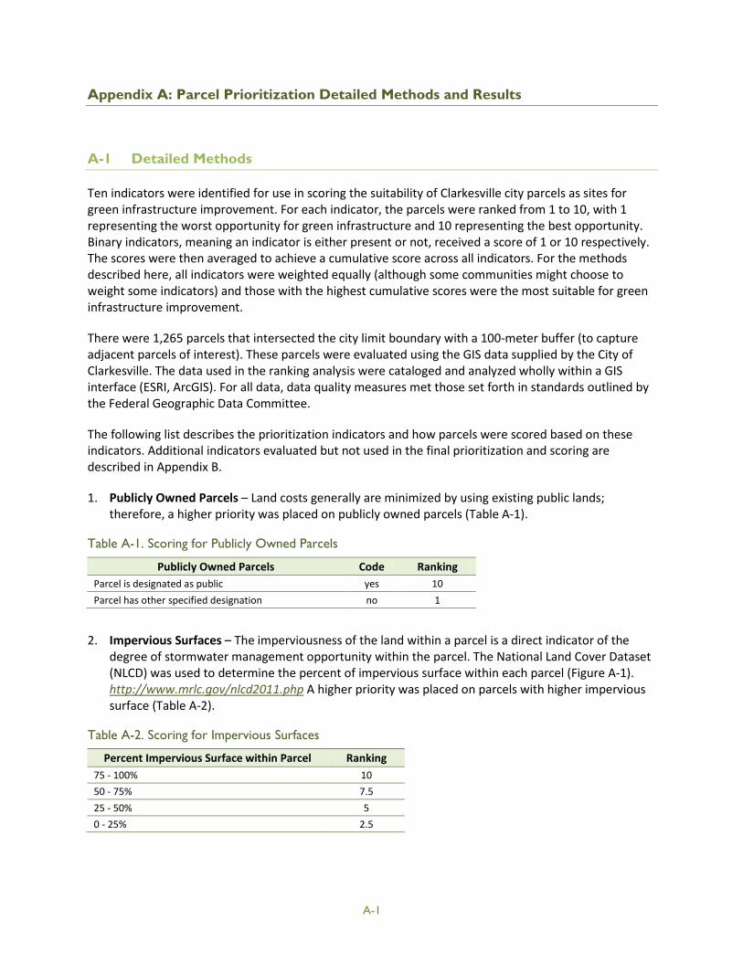
Appendix A: Parcel Prioritization Detailed Methods and Results
A-1 Detailed Methods
Ten indicators were identified for use in scoring the suitability of Clarkesville city parcels as sites for green infrastructure improvement. For each indicator, the parcels were ranked from 1 to 10, with 1 representing the worst opportunity for green infrastructure and 10 representing the best opportunity. Binary indicators, meaning an indicator is either present or not, received a score of 1 or 10 respectively. The scores were then averaged to achieve a cumulative score across all indicators. For the methods described here, all indicators were weighted equally (although some communities might choose to weight some indicators) and those with the highest cumulative scores were the most suitable for green infrastructure improvement.
There were 1,265 parcels that intersected the city limit boundary with a 100-meter buffer (to capture adjacent parcels of interest). These parcels were evaluated using the GIS data supplied by the City of Clarkesville. The data used in the ranking analysis were cataloged and analyzed wholly within a GIS interface (ESRI, ArcGIS). For all data, data quality measures met those set forth in standards outlined by the Federal Geographic Data Committee.
The following list describes the prioritization indicators and how parcels were scored based on these indicators. Additional indicators evaluated but not used in the final prioritization and scoring are described in Appendix B.
1. Publicly Owned Parcels – Land costs generally are minimized by using existing public lands; therefore, a higher priority was placed on publicly owned parcels (Table A-1).
Table A-1. Scoring for Publicly Owned Parcels
Publicly Owned Parcels Code Ranking Parcel is designated as public yes 10 Parcel has other specified designation no 1
2. Impervious Surfaces – The imperviousness of the land within a parcel is a direct indicator of the
degree of stormwater management opportunity within the parcel. The National Land Cover Dataset (NLCD) was used to determine the percent of impervious surface within each parcel (Figure A-1). http://www.mrlc.gov/nlcd2011.php A higher priority was placed on parcels with higher impervious surface (Table A-2).
Table A-2. Scoring for Impervious Surfaces
Percent Impervious Surface within Parcel Ranking 75 - 100% 10 50 - 75% 7.5 25 - 50% 5 0 - 25% 2.5
A-1

Figure A-1. Impervious surfaces with parcels for a select subsegment of Clarkesville
3. Parcel Size – The overall size of the project depends in part on the overall size of the parcel selected during the prioritization process. Parcels with a larger area were prioritized (Table A-3).
Table A-3. Scoring for Parcel Size
Parcel Size (acres) Ranking 1.52 – 180.98 10 0.61 – 1.51 7.5 0.33 - 0.60 5 0.005 - 0.33 2.5
4. Located in a Priority Watershed – The City of Clarkesville identified the Rocky Branch and Stormwater Creek watersheds as priorities for green infrastructure. These watersheds contain a significant amount of development, and their streams have been noticeably altered by stormwater flows. These watersheds also drain to the impaired segment of the Soque River. If the majority of a parcel area overlapped with one of these watershed boundaries, then this parcel was prioritized (Table A-4).
A-2

Table A-4. Scoring for Priority Watershed Status
Priority Watershed Status Ranking Majority (>50%) located within Rocky Branch or Stormwater Creek 10 Majority (>50%) NOT located within Rocky Branch or Stormwater Creek 1
5. Infiltration Capacity – The mapped hydrologic soils groups (HSG) were used as an initial estimate for
the infiltration rate and storage capacity of the soils. Sites where mapped HSGs have infiltration rates suitable for infiltration practices received higher priority for further investigation. The percent of parcel area within each category was calculated. The parcel received the ranking associated with the HSG that represents the largest percent area within the parcel (Table A-5).
Table A-5. Scoring for Hydrologic Soil Groups
Hydrologic Soil Groups Ranking
A - Soils with high infiltrations rates. Usually deep, well-drained sands or gravels. Little runoff. 10
B - Soils with moderate infiltration rates. Usually moderately deep, moderately well-drained soils. 7.5
C - Soils with slow infiltration rates. Soils with finer textures and slow water movement. 5
D - Soils with very slow infiltration rates. Soils with high clay content and poor drainage. High amounts of runoff. 2.5
6. Located in a Priority Characterization Area – Through discussions with the community team, several
priority areas for green infrastructure were identified within the city. Each of these areas was ranked based on potential multiple benefits that green infrastructure would provide if located on these parcels.
First, the recently burned parcels, located downtown, received the highest score of 10 based on their prominence in the community. The area of burned parcels downtown, in conjunction with green infrastructure, would provide additional beautification of the downtown area as well as a cost-effective opportunity for green infrastructure, given that construction would occur along with re-development of the parcels.
Parks and schools generally provide promising green infrastructure opportunities due to relatively large areas of available open space as well as potential for education and outreach and enhanced aesthetics. Proximity to parks and schools can also enhance community benefits. Parcels within 200 feet of a park or school were given a score of 7.5.
In addition to the above areas, the City of Clarkesville has defined four characterization areas that generally represent focus areas for planning in the city (Figure A-2). Green infrastructure could provide multiple benefits within these areas, including enhanced recreation, aesthetics, and education and outreach. The park characterization area was given a score of 7.5, to be consistent with the scoring of other parks. The other characterization areas, representing centrally located and high density parcels, were given a score of 5.
Finally, a score of 7.5 was given to any parcels within the portion of the downtown area where a streetscape improvement project has not yet been implemented. If a parcel met more than one criterion, that parcel was given the highest possible score. Table A-6 summarizes the above the rankings.
A-3

Table A-6. Scoring for Priority Characterization Areas
Clarkesville Priority Characterization Area Ranking
Burned parcel on Washington Street 10
Park Prioritization Area or Proximity to other parks and schools (within 200 feet) 7.5
Remaining opportunity for streetscaping 7.5
Downtown, Old Town, and Washington Street characterization areas 5
Parcel NOT located within any characterization area or other priority area 2.5
Figure A-2. Characterization areas as defined in the zoning GIS files supplied by the City of Clarkesville
7. Proximity to Maintenance Need – The stormwater inventory delivered by the City of Clarkesville and maintained by the public works department contains point locations of infrastructure maintenance needs throughout the city. Green infrastructure could help solve a maintenance issue or present a more cost-effective opportunity when implemented in tandem with infrastructure repair. A parcel within 200 feet of an existing or proposed maintenance need received a priority score for this criterion (Table A-7).
A-4

Table A-7. Scoring for Existing Maintenance Needs
Proximity to an Existing Maintenance Need Code Ranking
Parcel is within 200 feet of an existing maintenance need Yes 10
Parcel is NOT within 200 feet of an existing maintenance need No 1
8. Proximity to Stormwater Structural Damage – The stormwater inventory delivered by the City
of Clarkesville and maintained by the public works department contains point locations of stormwater structural damage throughout the city. Green infrastructure could present a more cost-effective opportunity when implemented in tandem with infrastructure repair. A parcel within 200 feet of an existing stormwater structural damage received a priority score for this criterion (Table 8).
Table A-8. Scoring for Existing Stormwater Structural Damage
Proximity to Existing Stormwater Structural Damage Code Ranking
Parcel is within 200 feet of existing stormwater structural damage Yes 10
Parcel is NOT within 200 feet of existing stormwater structural damage No 1
9. Proximity to Stormwater Inlet, Catchment Basin, or Conveyance Structure – The stormwater
inventory delivered by the City of Clarkesville and maintained by the Public Works Department contains point locations of stormwater inlets, catchment basins, and conveyance structures throughout the city (Figure A-3). These are all indicators of stormwater drainage that can help identify viable green infrastructure opportunities. A parcel within 200 feet of these indicators received a score of 10 for this indicator (Table A-9).
Table A-9. Scoring for Stormwater Inlet, Catchment Basin, or Conveyance Structure
Proximity to Stormwater Inlet, Catchment Basin, or Conveyance Structure Code Ranking
Parcel is within 200 feet of a Stormwater Inlet, Catchment Basin, or Conveyance Structure Yes 10
Parcel is NOT within 200 feet of Stormwater Inlet, Catchment Basin, or Conveyance Structure No 1
10. Percent Slope
Steep slopes can affect the cost-effectiveness and feasibility of green infrastructure. To screen out parcels with very high slopes, the parcels were scored based on quartiles of percent slope (Table A-10).
Table A-10. Scoring for Percent Slope
Percent Slope Ranking
0 – 6.20% Slope 10
6.21 – 9.47% Slope 7.5
9.48 – 12.59% Slope 5
12.60 – 30.95% Slope 2.5
A-5

A-6
Figure A-3. Stormwater inventory data displayed on a downtown portion of Clarkesville

A-2 Detailed Results
Table A-11 presents the highest scoring 100 parcels resulting from the parcel prioritization.
A-7

Table A-11. Detailed Prioritization Results
Rank Order Parcel Code
Publicly Owned Parcels
Impervious Surface
Parcel Size
Priority Watershed
Hydrologic Soil
Groups
Priority Charact.
Area
Maint. Need
Struct. Damage
Sw. Catch/ Conv.
% Slope Composite Score
1.00 102 093 10.00 7.50 7.50 10.00 7.50 5.00 10.00 10.00 10.00 10.00 8.75
2.00 069 032 10.00 5.00 7.50 10.00 7.50 5.00 10.00 10.00 10.00 10.00 8.50
3.00 069A009 10.00 10.00 10.00 1.00 7.50 7.50 10.00 10.00 10.00 7.50 8.35
4.00 104 339 10.00 7.50 10.00 10.00 7.50 5.00 10.00 10.00 10.00 2.50 8.25
5.00 102 086 10.00 7.50 7.50 10.00 7.50 5.00 10.00 10.00 10.00 5.00 8.25
6.00 102 087 10.00 5.00 7.50 10.00 7.50 5.00 10.00 10.00 10.00 7.50 8.25
7.00 069 043 1.00 7.50 7.50 10.00 7.50 7.50 10.00 10.00 10.00 10.00 8.10
8.00 102 017 10.00 2.50 10.00 10.00 7.50 7.50 10.00 10.00 10.00 2.50 8.00
9.00 104 041 10.00 7.50 10.00 1.00 7.50 5.00 10.00 10.00 10.00 7.50 7.85
10.00 104 024 10.00 5.00 10.00 10.00 7.50 5.00 10.00 1.00 10.00 10.00 7.85
11.00 069A137 10.00 10.00 2.50 10.00 7.50 5.00 10.00 10.00 10.00 2.50 7.75
12.00 069A136 10.00 10.00 2.50 10.00 7.50 5.00 10.00 10.00 10.00 2.50 7.75
13.00 102 013 1.00 5.00 7.50 10.00 7.50 7.50 10.00 10.00 10.00 7.50 7.60
14.00 069A143 1.00 10.00 2.50 10.00 7.50 5.00 10.00 10.00 10.00 10.00 7.60
15.00 104 289 1.00 5.00 10.00 10.00 7.50 5.00 10.00 10.00 10.00 7.50 7.60
16.00 069A141 1.00 10.00 2.50 10.00 7.50 5.00 10.00 10.00 10.00 10.00 7.60
17.00 069A138 1.00 10.00 2.50 10.00 7.50 5.00 10.00 10.00 10.00 10.00 7.60
A-8

Rank Order Parcel Code
Publicly Owned Parcels
Impervious Surface
Parcel Size
Priority Watershed
Hydrologic Soil
Groups
Priority Charact.
Area
Maint. Need
Struct. Damage
Sw. Catch/ Conv.
% Slope Composite Score
18.00 069A135 1.00 10.00 5.00 10.00 7.50 5.00 10.00 10.00 10.00 7.50 7.60
19.00 102 040 1.00 2.50 10.00 10.00 7.50 5.00 10.00 10.00 10.00 10.00 7.60
20.00 102 116 1.00 10.00 7.50 1.00 7.50 7.50 10.00 10.00 10.00 10.00 7.45
21.00 069A131 10.00 10.00 2.50 10.00 7.50 10.00 10.00 1.00 10.00 2.50 7.35
22.00 069A012 10.00 10.00 5.00 1.00 7.50 7.50 10.00 10.00 10.00 2.50 7.35
23.00 069 044 1.00 2.50 7.50 10.00 7.50 7.50 10.00 10.00 10.00 7.50 7.35
24.00 069 041 1.00 2.50 7.50 10.00 7.50 7.50 10.00 10.00 10.00 7.50 7.35
25.00 102 014 1.00 2.50 10.00 10.00 7.50 7.50 10.00 10.00 10.00 5.00 7.35
26.00 102 016 10.00 2.50 10.00 10.00 7.50 7.50 10.00 1.00 10.00 5.00 7.35
27.00 104 319 1.00 5.00 5.00 10.00 7.50 5.00 10.00 10.00 10.00 10.00 7.35
28.00 104 320 1.00 5.00 5.00 10.00 7.50 5.00 10.00 10.00 10.00 10.00 7.35
29.00 104 275 1.00 5.00 5.00 10.00 7.50 5.00 10.00 10.00 10.00 10.00 7.35
30.00 104 296 1.00 5.00 7.50 10.00 7.50 5.00 10.00 10.00 10.00 7.50 7.35
31.00 102 098 1.00 7.50 5.00 10.00 7.50 5.00 10.00 10.00 10.00 7.50 7.35
32.00 104 265 1.00 7.50 10.00 10.00 7.50 2.50 10.00 10.00 10.00 5.00 7.35
33.00 104 023 10.00 5.00 10.00 1.00 7.50 2.50 10.00 10.00 10.00 7.50 7.35
34.00 106 096 10.00 5.00 10.00 1.00 7.50 2.50 10.00 10.00 10.00 7.50 7.35
A-9

Rank Order Parcel Code
Publicly Owned Parcels
Impervious Surface
Parcel Size
Priority Watershed
Hydrologic Soil
Groups
Priority Charact.
Area
Maint. Need
Struct. Damage
Sw. Catch/ Conv.
% Slope Composite Score
35.00 104 113 10.00 2.50 10.00 1.00 7.50 2.50 10.00 10.00 10.00 10.00 7.35
36.00 104 039 10.00 5.00 7.50 1.00 7.50 2.50 10.00 10.00 10.00 10.00 7.35
37.00 069A038 10.00 2.50 10.00 1.00 7.50 2.50 10.00 10.00 10.00 10.00 7.35
38.00 102 043 1.00 5.00 10.00 10.00 7.50 2.50 10.00 10.00 10.00 7.50 7.35
39.00 069A125 10.00 10.00 2.50 10.00 7.50 10.00 1.00 1.00 10.00 10.00 7.20
40.00 102 117 1.00 10.00 7.50 1.00 7.50 7.50 10.00 10.00 10.00 7.50 7.20
41.00 069 029 10.00 2.50 2.50 10.00 7.50 7.50 10.00 1.00 10.00 10.00 7.10
42.00 069A011 10.00 10.00 2.50 1.00 7.50 7.50 10.00 10.00 10.00 2.50 7.10
43.00 069A148 1.00 7.50 5.00 10.00 7.50 7.50 10.00 10.00 10.00 2.50 7.10
44.00 069A147 1.00 7.50 5.00 10.00 7.50 7.50 10.00 10.00 10.00 2.50 7.10
45.00 069A146 1.00 7.50 5.00 10.00 7.50 7.50 10.00 10.00 10.00 2.50 7.10
46.00 069 042 1.00 2.50 5.00 10.00 7.50 7.50 10.00 10.00 10.00 7.50 7.10
47.00 069 035 1.00 2.50 10.00 10.00 7.50 7.50 10.00 10.00 10.00 2.50 7.10
48.00 104 318 1.00 2.50 7.50 10.00 7.50 5.00 10.00 10.00 10.00 7.50 7.10
49.00 102 091 1.00 5.00 2.50 10.00 7.50 5.00 10.00 10.00 10.00 10.00 7.10
50.00 102 097 1.00 5.00 2.50 10.00 7.50 5.00 10.00 10.00 10.00 10.00 7.10
51.00 069A133A 1.00 5.00 5.00 10.00 7.50 5.00 10.00 10.00 10.00 7.50 7.10
A-10

Rank Order Parcel Code
Publicly Owned Parcels
Impervious Surface
Parcel Size
Priority Watershed
Hydrologic Soil
Groups
Priority Charact.
Area
Maint. Need
Struct. Damage
Sw. Catch/ Conv.
% Slope Composite Score
52.00 104 276B 1.00 5.00 7.50 10.00 7.50 5.00 10.00 10.00 10.00 5.00 7.10
53.00 104 037 10.00 5.00 10.00 1.00 7.50 2.50 10.00 10.00 10.00 5.00 7.10
54.00 104 262 1.00 2.50 7.50 10.00 7.50 2.50 10.00 10.00 10.00 10.00 7.10
55.00 104 313 1.00 2.50 7.50 10.00 7.50 2.50 10.00 10.00 10.00 10.00 7.10
56.00 104 219 1.00 2.50 10.00 10.00 7.50 2.50 10.00 10.00 10.00 7.50 7.10
57.00 102 194 1.00 2.50 10.00 10.00 7.50 2.50 10.00 10.00 10.00 7.50 7.10
58.00 069A072 10.00 5.00 10.00 1.00 7.50 2.50 10.00 10.00 10.00 5.00 7.10
59.00 071 032 10.00 2.50 10.00 1.00 7.50 2.50 10.00 10.00 10.00 7.50 7.10
60.00 102 141 1.00 5.00 7.50 10.00 7.50 2.50 10.00 10.00 10.00 7.50 7.10
61.00 102 012 1.00 2.50 10.00 10.00 7.50 2.50 10.00 10.00 10.00 7.50 7.10
62.00 102 113 1.00 10.00 2.50 1.00 7.50 7.50 10.00 10.00 10.00 10.00 6.95
63.00 069A010 1.00 7.50 7.50 10.00 7.50 5.00 10.00 1.00 10.00 10.00 6.95
64.00 104 132 1.00 7.50 10.00 1.00 7.50 2.50 10.00 10.00 10.00 10.00 6.95
65.00 106 104 1.00 7.50 10.00 1.00 7.50 2.50 10.00 10.00 10.00 10.00 6.95
66.00 104 114 1.00 10.00 10.00 1.00 7.50 2.50 10.00 10.00 10.00 7.50 6.95
68.00 102 018 1.00 2.50 7.50 10.00 7.50 7.50 10.00 10.00 10.00 2.50 6.85
67.00 069A144 1.00 10.00 2.50 10.00 7.50 5.00 10.00 10.00 10.00 2.50 6.85
A-11

Rank Order Parcel Code
Publicly Owned Parcels
Impervious Surface
Parcel Size
Priority Watershed
Hydrologic Soil
Groups
Priority Charact.
Area
Maint. Need
Struct. Damage
Sw. Catch/ Conv.
% Slope Composite Score
69.00 102 129 1.00 2.50 10.00 10.00 7.50 5.00 10.00 10.00 10.00 2.50 6.85
70.00 069A145 1.00 10.00 2.50 10.00 7.50 5.00 10.00 10.00 10.00 2.50 6.85
71.00 102 085 1.00 2.50 7.50 10.00 7.50 5.00 10.00 10.00 10.00 5.00 6.85
72.00 102 034 1.00 2.50 5.00 10.00 7.50 5.00 10.00 10.00 10.00 7.50 6.85
73.00 104 299 1.00 2.50 7.50 10.00 7.50 2.50 10.00 10.00 10.00 7.50 6.85
74.00 104 245B 1.00 2.50 5.00 10.00 7.50 2.50 10.00 10.00 10.00 10.00 6.85
75.00 104 280 1.00 2.50 10.00 10.00 7.50 2.50 10.00 10.00 10.00 5.00 6.85
76.00 104 264 1.00 2.50 5.00 10.00 7.50 2.50 10.00 10.00 10.00 10.00 6.85
77.00 104 230 1.00 2.50 10.00 10.00 7.50 2.50 10.00 10.00 10.00 5.00 6.85
78.00 104 259 1.00 2.50 5.00 10.00 7.50 2.50 10.00 10.00 10.00 10.00 6.85
79.00 102 194 1.00 2.50 10.00 10.00 7.50 2.50 10.00 10.00 10.00 5.00 6.85
80.00 104 140 1.00 2.50 10.00 10.00 7.50 2.50 10.00 10.00 10.00 5.00 6.85
81.00 104 258 1.00 2.50 7.50 10.00 7.50 2.50 10.00 10.00 10.00 7.50 6.85
82.00 104 260 1.00 2.50 7.50 10.00 7.50 2.50 10.00 10.00 10.00 7.50 6.85
83.00 104 279 1.00 2.50 10.00 10.00 7.50 2.50 10.00 10.00 10.00 5.00 6.85
84.00 104 232 1.00 2.50 7.50 10.00 7.50 2.50 10.00 10.00 10.00 7.50 6.85
85.00 104 148 1.00 2.50 10.00 10.00 7.50 2.50 10.00 10.00 10.00 5.00 6.85
A-12

Rank Order Parcel Code
Publicly Owned Parcels
Impervious Surface
Parcel Size
Priority Watershed
Hydrologic Soil
Groups
Priority Charact.
Area
Maint. Need
Struct. Damage
Sw. Catch/ Conv.
% Slope Composite Score
86.00 104 263 1.00 2.50 10.00 10.00 7.50 2.50 10.00 10.00 10.00 5.00 6.85
87.00 102 133 1.00 2.50 7.50 10.00 7.50 2.50 10.00 10.00 10.00 7.50 6.85
88.00 104 218 1.00 2.50 10.00 10.00 7.50 2.50 10.00 10.00 10.00 5.00 6.85
89.00 069A025 10.00 5.00 10.00 1.00 7.50 2.50 10.00 10.00 10.00 2.50 6.85
90.00 104 264A 1.00 2.50 7.50 10.00 7.50 2.50 10.00 10.00 10.00 7.50 6.85
91.00 069A045 10.00 5.00 7.50 1.00 7.50 2.50 10.00 10.00 10.00 5.00 6.85
92.00 102 011E 1.00 5.00 2.50 10.00 7.50 2.50 10.00 10.00 10.00 10.00 6.85
93.00 102 011Z 1.00 5.00 7.50 10.00 7.50 2.50 10.00 10.00 10.00 5.00 6.85
94.00 102 011 1.00 5.00 10.00 10.00 7.50 2.50 10.00 10.00 10.00 2.50 6.85
95.00 069A142 1.00 10.00 2.50 10.00 7.50 5.00 10.00 1.00 10.00 10.00 6.70
96.00 069 045 1.00 2.50 10.00 10.00 7.50 7.50 10.00 1.00 10.00 7.50 6.70
97.00 069 030 10.00 2.50 10.00 1.00 7.50 7.50 10.00 1.00 10.00 7.50 6.70
98.00 102 111 1.00 5.00 7.50 1.00 7.50 7.50 10.00 10.00 10.00 7.50 6.70
99.00 102 119 1.00 7.50 7.50 1.00 7.50 7.50 10.00 10.00 10.00 5.00 6.70
100.00 102 118 1.00 7.50 7.50 1.00 7.50 7.50 10.00 10.00 10.00 5.00 6.70
A-13

(This page is intentionally left blank.)
A-14

Appendix B: Compendium of Indicators for Prioritizing Green Infrastructure Opportunities
Depending on a community’s planning and water quality and quantity goals, additional indicators, beyond what were used in Clarkesville’s prioritization, may be considered. The following indicators were considered for the prioritization but were not directly relevant to Clarkesville’s green infrastructure goals. Other indicators, like threatened and endangered species, were not used because available information indicated that these species did not exist within or immediately downstream of the city.
• Infiltration capacity – Natural rate of infiltration through soils: Soils with higher infiltration rates present more promising opportunities for infiltration basins, bioretention, and other infiltration-based practices.
• Proximity to existing stormwater facility – Distance between parcel and existing green infrastructure or other stormwater management facility: Depending on the type and condition of the facility, a shorter distance may present a greater or lesser opportunity for green infrastructure. An existing structure, such as a stormwater pond, may provide a retrofit opportunity that would improve the treatment and/or storage capabilities of the current structure. However, if green infrastructure has already been implemented near a parcel, a city may want to prioritize other areas that have more pressing needs.
• Land use – Specific type of land use or land cover that represents a priority for the city: While impervious surface provided the best indicator of stormwater management needs for the City of Clarkesville, other cities may have specific land uses that they are interested in targeting for green infrastructure. For instance, if they wanted to prioritize commercial retrofits, than commercial land use would be a useful indicator.
• Canopy cover – The extent of tree leaves and branches, either individually or within a group of trees: Canopy cover can be used in different ways to support priorities. If a city is interested in improving canopy cover of wildlife habitat, then it can be beneficial to target parcels adjacent to large areas of existing canopy cover or to use green infrastructure to join to separate forest areas, providing great habitat connectivity. Canopy cover can also help reduce the urban heat island effect, and if this is a city priority, then green infrastructure could be prioritized in areas with relatively little or no canopy cover.
• Stream reach length – Length of stream contained in parcel: this indicator can be most useful when green infrastructure efforts are focused on riparian/stream preservation or restoration. By prioritizing parcels with the greatest stream length, a city could optimize the size and benefit of a project by working with a single landowner.
• Located within floodplain – Location with a defined flood hazard zone (e.g., FEMA 100-year floodplain): green infrastructure opportunities within a floodplain are typically prioritized if the city is interested in using wetlands restoration or similar strategies to treat and control floodwaters. This indicator can also be used to identify current buildings or other uses that could be relocated out of the floodplain and be replaced by green infrastructure.
• Protected species – Observed locations of protected species (e.g. federally threatened or endangered): Locations known to support protected species can be used to prioritize nearby green infrastructure that provides or augments habitat for these species. Green infrastructure may also be prioritized where urban areas drain to stream reaches that support protected fish and/or other protected aquatic species.
B-1

• Right-of-way (ROW) evaluation – Area of government controlled right of way: In dense area where retrofit opportunities are limited, cities can use available data on ROW dimensions to locate areas with greater opportunities with ROWs for green infrastructure retrofits.
• Contaminated sites – Known records of actual or potential hazardous materials contamination: where these data are available, cities can use these locations to screen out parcels that may present constraints or additional costs related to contaminated soils or other hazardous materials concerns.
• Space requirements – Minimum opportunity areas required for desired green infrastructure: while green infrastructure ranges widely in size, a city may wish to pursue a specific type of green infrastructure with a minimum space requirement. Using a combination of impervious surface, parcel boundaries, and similar data, this indicator can be used to identify parcels that have vacant land meeting the minimum space requirement.
B-2

Appendix C: Design Recommendations
C-1

(This page is intentionally left blank.)
C-2

C-3
Figure C-1. Location map for Clarkesville Green Infrastructure Design Recommendations

(This page is intentionally left blank.)
C-4
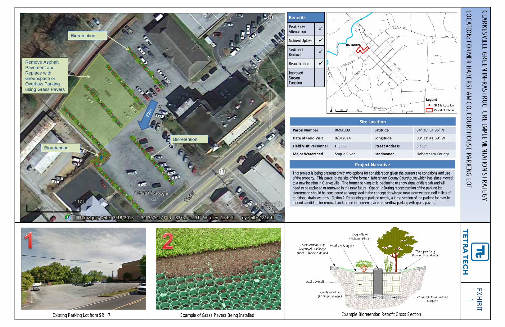
Bioretention
Existing Parking Lot from SR 17 Example of Grass Pavers Being Installed
CLARKESVILLE GREEN INFRASTRUCTURE IMPLEMENTATION STRATEGY LOCATION: FORMER HABERSHAM CO. COURTHOUSE PARKING LOT
Site Location
Parcel Number 069A009 Latitude 34° 36’ 54.96” N
Date of Field Visit 9/8/2014 Longitude 83° 31’ 41.69” W
Field Visit Personnel HF, EB Street Address SR 17
Major Watershed Soque River Landowner Habersham County
Project Narrative
This project is being presented with two options for consideration given the current site conditions and use of the property. This parcel is the site of the former Habersham County Courthouse which has since moved to a new location in Clarkesville. The former parking lot is beginning to show signs of disrepair and will need to be replaced or removed in the near future. Option 1: During reconstruction of the parking lot, bioretention should be considered as suggested in the concept drawing to treat stormwater runoff in lieu of traditional drain systems. Option 2: Depending on parking needs, a large section of the parking lot may be a good candidate for removal and turned into green space or overflow parking with grass pavers.
Example Bioretention Retrofit Cross Section
Benefits
Peak Flow Attenuation
Nutrient Uptake Sediment Removal
Beautification Improved Stream Function
Bioretention
Bioretention
Remove Asphalt Pavement and Replace with Greenspace or Overflow Parking using Grass Pavers
EXHIBIT 1

EXHIBIT 2
Green Street
Downtown Clarkesville Downtown Clarkesville
CLARKESVILLE GREEN INFRASTRUCTURE IMPLEMENTATION STRATEGY LOCATION: GREEN STREETS IN THE DOW
NTOWN AREA
Site Location
Parcel Number N/A Latitude 34° 36’ 55.63” N
Date of Field Visit 9/8/2014 Longitude 83° 31’ 35.83” W
Field Visit Personnel HF, EB Street Address Washington St.
Major Watershed Sweetgum Creek Landowner City of Clarkesville
Project Narrative
This project is being presented in consideration of plans to extend streetscape improvements in the downtown area of Clarkesville along Washington Street. During design of the new streetscape, green street features such as curb extensions with rain gardens and tree box filters should be considered to enhance beautification and provide hydrologic and water quality benefits. Other features that might be considered include permeable pavers in parking areas and bioretention if ample space is provided during the design. These projects are presented as options for phased implementation or as concepts for consideration during coordination with other infrastructure improvements.
Example Green Street Features
Benefits
Peak Flow Attenuation
Nutrient Uptake Sediment Removal
Beautification Improved Stream Function
Green Street

EXHIBIT 3
Disconnect Downspouts to Rain Gardens Permeable
Pavers/Pavement
Route Stormwater from Grant St. into Bioretention Cells
Area along Grant St. to be converted to bioretention cells Dreamers Ln. to be converted to green alleyway
CLARKESVILLE GREEN INFRASTRUCTURE IMPLEMENTATION STRATEGY LOCATION: GRANT STREET AND ALLEY BEHIND PARCEL 069A143
Site Location
Parcel Number 069A143 Latitude 34° 36’ 59.14” N
Date of Field Visit 9/8/2014 Longitude 83° 31’ 35.38” W
Field Visit Personnel HF, EB Street Address Grant St.
Major Watershed Sweetgum Creek Landowner Private
Project Narrative
The main project being proposed for this area includes routing stormwater from Grant Street via curb cuts into bioretention cells along the Grant Street border of the publicly owned parking lot at the corner of Grant St. and Bridge St. Check dams will be incorporated into the bioretention area using hardscape structures to miminize the slope and reduce the flow along the steep gradient. Additional project options include disconnecting downspouts from buildings bordering the alleyway behind parcel 069A143 (Dreamers Ln.) and treating the rooftop runoff from each building with rain gardens and replacing existing asphalt pavement and concrete in the alleyway with permeable pavers or pervious pavement to enhance the green alleyway concept. These projects are presented as options for phased implementation or as concepts for consideration during coordination with other infrastructure improvements.
Example Bioretention Retrofit Cross Section
Benefits
Peak Flow Attenuation
Nutrient Uptake Sediment Removal
Beautification Improved Stream Function

EXHIBIT 4
Bioretention
Existing Parking Lot Example of Grass Pavers Being Installed
CLARKESVILLE GREEN INFRASTRUCTURE IMPLEMENTATION STRATEGY LOCATION: FORMER HABERSHAM CO. COURTHOUSE ANNEX
Site Location
Parcel Number 069 032 Latitude 34° 37’ 00.67” N
Date of Field Visit 9/8/2014 Longitude 83° 31’ 31.14” W
Field Visit Personnel HF, EB Street Address Grant Street
Major Watershed Sweetgum Creek Landowner Habersham County
Project Narrative
This project is being presented with two options for consideration given the current site conditions and use of the property. This parcel is the site of the former Habersham County Courthouse Annex Magistrate Court which has since moved to a new location in Clarkesville. The parking lot appears to be larger than needed for the buildings current use. Option 1: Bioretention should be considered as suggested in the concept drawing to treat stormwater runoff from the rooftop and parking lot. Option 2: Depending on parking needs, a large section of the parking lot may be a good candidate for removal and turned into green space or overflow parking with grass pavers. These projects are presented as options for phased implementation or as concepts for consideration during coordination with other infrastructure improvements.
Example Bioretention Retrofit Cross Section
Benefits
Peak Flow Attenuation
Nutrient Uptake Sediment Removal
Beautification Improved Stream Function
Remove Asphalt Pavement and Replace with Greenspace or Overflow Parking using Grass Pavers

EXHIBIT 5
Garden and Grounds from the Corner of Jefferson St. and Green St. Example of Rainwater Harvesting
CLARKESVILLE GREEN INFRASTRUCTURE IMPLEMENTATION STRATEGY LOCATION: MAULDIN HOUSE - GARDEN AND GROUNDS; LIBRARY
Site Location
Parcel Number 102 086 Latitude 34° 36’ 55.78” N
Date of Field Visit 9/8/2014 Longitude 83° 31’ 30.10” W
Field Visit Personnel HF, EB Street Address 458 Jefferson St.
Major Watershed Sweetgum Creek Landowner City of Clarkesville
Project Narrative
An important asset to the City of Clarkesville, the Mauldin house serves as the City’s welcome center and offices for Downtown Development and Gardens and Grounds. The City acquired the property after the death of Mary Mauldin, and completely refurbished the house and millinery shop and relocated the historic Big Holly Cabin to the property. The project being proposed for this site includes the installation of a rainwater harvesting system for irrigation of the Garden and Grounds. Although the roof top area of the Mauldin house is relatively small for purposes other than irrigation, the proposed project should be considered a great opportunity for green infrastructure education. Additional rainwater harvesting might be feasible on the library property (Parcel 102 093) across the street from the Mauldin house.
Diagram of Typical Rainwater Harvesting for Irrigation
Benefits
Peak Flow Attenuation
Nutrient Uptake
Sediment Removal
Beautification
Improved Stream Function
Flow
Rainwater Harvesting for Irrigation of Garden and Grounds

EXHIBIT 6
Sweetgum Creek
Stormwater Catch Basins at Intersection of Adams St and E Green St Clarkesville Police and Fire Stations
CLARKESVILLE GREEN INFRASTRUCTURE IMPLEMENTATION STRATEGY LOCATION: CLARKESVILLE POLICE AND FIRE STATIONS
Site Location
Parcel Number 102 087 Latitude 34° 36’ 57.20” N
Date of Field Visit 9/8/2014 Longitude 83° 31’ 28.69” W
Field Visit Personnel HF, EB Street Address Adams Street
Major Watershed Sweetgum Creek Landowner City of Clarkesville
Project Narrative
This project is being presented with two options in consideration of potential plans to relocate the existing Clarkesville Police and Fire Stations to a new location within the City. The existing facilities have experienced flooding from large storm events which is not surprising because they are located at the confluence of the stormwater system that forms the Sweetgum Creek headwaters. Because the parcel is “on-line” and in an ideal location, it represents a unique opportunity within the small but densely developed City to provide regional detention and treatment of stormwater. Option 1: Relocate the Police and Fire Stations to a new location within the City and replace with a City Park and Wet Detention Pond. Option 2: Relocate the Police and Fire Stations to a new location within the City and replace with a City Park and Stormwater Wetland.
Example Wet Pond Cross Section
Benefits
Peak Flow Attenuation
Nutrient Uptake Sediment Removal
Beautification Improved Stream Function
Relocate Police and Fire Station and Replace with Park and Wet Detention Pond or Park and Stormwater Wetland

EXHIBIT 7
Rocky Branch
Rocky Branch Aggraded with Sediment Adjacent to Proposed Project Portion of Existing Pond Adjacent to Rocky Branch
CLARKESVILLE GREEN INFRASTRUCTURE IMPLEMENTATION STRATEGY LOCATION: HAW
G WILD BBQ AND CLARKESVILLE GREENW
AY
Site Location
Parcel Number 102 017 Latitude 34° 37’ 10.75” N
Date of Field Visit 9/8/2014 Longitude 83° 31’ 19.28” W
Field Visit Personnel HF, EB Street Address 515 Grant St.
Major Watershed Rocky Branch Landowner Hawg Wild BBQ
Project Narrative
This project represents an opportunity to provide peak flow attenuation, water quality treatment, and sediment removal for Rocky Branch before it enters the Soque River. The project includes retrofitting and expanding an existing pond behind the Hawg Wild BBQ restaurant into a stormwater wetland. Water would be diverted from Rocky Branch into the wetland during storm flows via a diversion structure/weir. Because this project is located just upstream of the confluence with the Soque River, it has the potential to provide significant improvements to impaired waters entering the Soque River. However, further investigation and preliminary design calculations would be required to determine if the site has adequate capacity for implementation.
Example Wetland Retrofit Cross Section
Benefits
Peak Flow Attenuation
Nutrient Uptake Sediment Removal
Beautification
Improved Stream Function
Retrofit Existing Pond into Stormwater Wetland

EXHIBIT 8
Dry Detention Retrofit
Dry Detention Retrofit Opportunity Location Dry Detention Opportunity Location
CLARKESVILLE GREEN INFRASTRUCTURE IMPLEMENTATION STRATEGY LOCATION: CLARKESVILLE UNITED METHODIST CHURCH
Site Location
Parcel Number 102 119 Latitude 34° 36’ 41.87” N
Date of Field Visit 9/8/2014 Longitude 83° 31’ 21.61” W
Field Visit Personnel HF, EB Street Address Madison Street
Major Watershed Soque River Landowner Clarkesville UMC
Project Narrative
This project is being presented with two options should the community want to take advantage of a good opportunity to treat stormwater on the grounds of the Clarkesville United Methodist Church. The site currently has a low depression with a catchbasin that collects stormwater which then flows below Madison Street via a stormwater pipe before draining into an open stormwater channel. Because the parcel is “on-line” and the site is well suited for detention, this project represents a unique opportunity to treat stormwater. Option 1: Retrofit existing low depression and catchbasin with features for dry detention. Option 2: Expand Option 1 to include a second dry detention basin along Madison St. to increase storage capacity.
Example of a Dry Detention Basin During a Rain Event
Benefits
Peak Flow Attenuation
Nutrient Uptake
Sediment Removal
Beautification
Improved Stream Function
Dry Detention

Remove Existing Asphalt Pavement and Replace with Permeable Pavers and/or Permeable Pavement
Habersham Co. Board of Education Parking Lot Example of Grass Pavers Being Installed
CLARKESVILLE GREEN INFRASTRUCTURE IMPLEMENTATION STRATEGY LOCATION: HABERSHAM COUNTY BOARD OF EDUCATION
Site Location
Parcel Number 104 041 Latitude 34° 36’ 28.49” N
Date of Field Visit 9/8/2014 Longitude 83° 31’ 22.17” W
Field Visit Personnel HF, EB Street Address Stanford Mill Rd.
Major Watershed Soque River Landowner Habersham Co.
Project Narrative
This project is being presented with two options in consideration of potential plans to upgrade the parking lot of the Habersham County Board of Education. The existing parking lot is showing signs of its age and has fallen into disrepair along the western edge where the area is covered with gravel. If the parking lot is going to be repaved and or rehabilitated, the following green infrastructure concepts should be considered. Option 1: Replace gravel section with grass pavers or pervious pavement/pavers. Option 2: Replace paved sections with pervious pavement/pavers as generally outlined in the concept drawing. These projects are presented as options for phased implementation or as concepts for consideration during coordination with other infrastructure improvements.
Example of Permeable Pavers Cross Section
Benefits
Peak Flow Attenuation
Nutrient Uptake
Sediment Removal
Beautification Improved Stream Function
Replace Gravel Parking Area with Grass Pavers
EXHIBIT 9

CLARKESVILLE GREEN INFRASTRUCTURE IMPLEMENTATION STRATEGY LOCATION: Burned Parcels - Downtown
Site Locations Parcel Numbers 069A125,
069A131 Latitude 34° 36’ 55.71” N,
34° 36’ 56.61” N
Date of Field Visit N/A Longitude 83° 31’ 31.24” W, 83° 31’ 29.64” W
Field Visit Personnel N/A Street Address 1418 Washington St., 129 E. Water St.
Major Watershed Sweetgum Creek Landowner City of Clarkesville
Project Narrative
In March 2014, a fire occurred in the east side of Clarkesville Square in downtown. Six buildings were damaged, and two were ruled a total loss. The City has acquired these two properties and is currently working on redevelopment plans. This project is presented with several options given the current site conditions and use of the property. Option 1: Replace paved sections of the parking lot with permeable pavers and/or permeable pavement. Option 2: Consider bioretention in parking lot to treat stormwater runoff in lieu of traditional drain systems. Option 3: Install a green roof on one or both sites following reconstruction to capture and treat stormwater, enhance aesthetics, and provide educational opportunities. The insulation provided by green roofs can also result in energy cost savings.
Benefits*
Peak Flow Attenuation
Nutrient Uptake Sediment Removal
Beautification Improved Stream Function
Example Green Roof Installation Example of Parking Lot Bioretention
Grass Pavers
Porous Asphalt
Permeable Interlocking Concrete Pavers (PICP)
Concrete Grid Pavers
Examples of Permeable Pavers/Pavement
*Benefits will vary based on selected practices.
EXHIBIT 10
Example of Green Roof Functional Layers

CLARKESVILLE GREEN INFRASTRUCTURE IMPLEMENTATION STRATEGY LOCATION: BRIDGE STREET
Site Location
Parcel Number 069A134 Latitude 34° 36’ 58.82” N
Date of Field Visit N/A Longitude 83° 31’ 31.82” W
Field Visit Personnel N/A Street Address 106 Bridge St.
Major Watershed Sweetgum Creek Landowner City of Clarkesville
Project Narrative
This undeveloped parcel is located next to Sweetgum Creek and is downslope of the Clarkesville Square. If the City plans to develop or sell the parcel for development, it would be advantageous to include green infrastructure in the plans. Because the rear portion of the property is in the floodway of Sweetgum Creek, this area in particular could be utilized to treat stormwater runoff from the proposed development while maximizing the developable land. Also, depending on the existing drainage network, there may be an opportunity to divert water from Monroe Street and Bridge Street into a treatment system such as bioretention at the rear of the property. Other possibilities to consider during development include on-site retention concepts such as rainwater harvesting, green roofs, and permeable pavements.
Example Green Roof Installation
Sweetgum Creek
Rain Garden, Bioretention or Wet Pond during Development
Example Bioretention Retrofit Cross Section Example of Permeable Pavers Cross Section
Benefits*
Peak Flow Attenuation
Nutrient Uptake Sediment Removal
Beautification Improved Stream Function
*Benefits will vary based on selected practices.
EXHIBIT 11

(This page is intentionally left blank.)
C-16

Appendix D: Code Review Checklist
D-1

(This page is intentionally left blank.)
D-2

Degree of Importance Key to Symbols:
" Essential
³ Very important
! Important
GOAL #1: MINIMIZE EFFECTIVE OR CONNECTED IMPERVIOUS AREA
Objective: Minimize impervious area associated with streets.
Objective: Minimize impervious area associated with parking.
Objective: Minimize impervious area associated with driveways and sidewalks.
Objective: Clustering development.
Objective: Incorporate sustainable hydrology practices into urban redevelopment.
GOAL #1 KEY QUESTIONS DEGREE OF
IMPORTANCE
REVIEWER COMMENTS (INDICATE ORDINANCE FINDINGS “YES” OR “NO.” WHEN
“NO,” NOTE SPECIFIC LOCATION OF BARRIER IN CODE)
Effective Impervious Area
• Does the code definition of impervious area distinguish between impervious area connected to the storm drain system (effective impervious area) and disconnected impervious area?
³ No, ordinance refers to impervious area in general and does not differentiate between effective and disconnected.
Streets
• For residential development, are the street pavement widths allowed to be between 18 to 22 feet, with curb pullouts for passing of large vehicles?
" No, the minimum residential roadbed width allowed is 24 feet with 20 feet minimum pavement (curb and gutter subdivisions). Section 2819 (D)
• Are travel lanes allowed to be from 12 to 10 feet (or less), with curb pullouts for passing of large vehicles?
" No, see above.
D-3

GOAL #1 KEY QUESTIONS DEGREE OF
IMPORTANCE
REVIEWER COMMENTS (INDICATE ORDINANCE FINDINGS “YES” OR “NO.” WHEN
“NO,” NOTE SPECIFIC LOCATION OF BARRIER IN CODE)
• Are curb bumpouts/extensions allowed near intersections and mid-block for traffic-calming and bioretention opportunities?
³ No, curb bumpouts/extensions are not mentioned. Article XXVIII
• Is pervious paving allowed for on-street parking and alleyways?
! Yes, permeable pavement is allowed for parking lots (Section 613), it is not explicitly dis-allowed for on-street, alleyway parking. Section 2822 (J, K) state that pavement materials must be approved by the GADOT Highway Division.
• Are grass swales or bioretention swales allowed instead of curb and gutter or with curb cuts (where slopes allow)?
³ No, Section 2822 (Required Improvements, I): “all streets with subdivisions with 1.5 acre or less lots shall be paved with asphalt…and provided with curbs and gutters constructed with either pre-cast concrete curb, or integral concrete curb and gutter conforming to the dimensions and standards in the adopted standard drawings.”
• Are bioretention areas, swales, and other green infrastructure techniques allowed to replace the required “grass strip” between the sidewalk and curb?
Yes, while not specified, none of the Zoning Ordinance language prohibits these practices.
• If there are cul-de-sacs, is the radius required to be 35 feet or less?
! No, turnarounds (cul-de-sacs) have minimum required radii ranging from 40 to 50-feet depending on road type. Section 2819 (d)
• If there are cul-de-sacs, are landscaped islands or bioretention islands allowed or encouraged?
! Yes, allowed but not explicitly encouraged. See Section 2821 (d).
• Are site designs required to promote the most efficient street layout to reduce overall street length?
! No, the zoning ordinance does not contain any language promoting reduced or minimized street length.
Parking
• Is the minimum stall width for a standard parking space 9 ft. or less?
" Yes, a minimum of 160 square feet is required (width and length unspecified), design flexible. Section 604
• Are parking stall lengths allowed to be 15 ft.? " Yes, see above. However, the square footage requirement does not allow for the 9 x 15-foot dimensions implied, which would equal 135 square feet, well under the minimum.
D-4
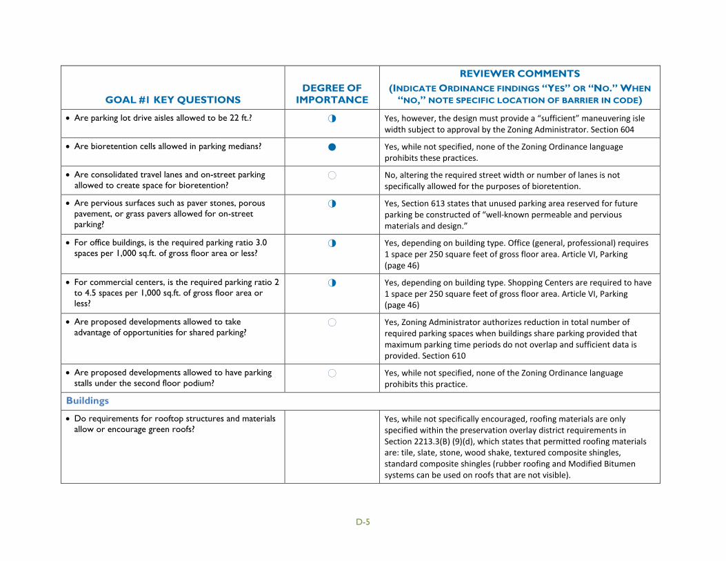
GOAL #1 KEY QUESTIONS DEGREE OF
IMPORTANCE
REVIEWER COMMENTS (INDICATE ORDINANCE FINDINGS “YES” OR “NO.” WHEN
“NO,” NOTE SPECIFIC LOCATION OF BARRIER IN CODE)
• Are parking lot drive aisles allowed to be 22 ft.? ³ Yes, however, the design must provide a “sufficient” maneuvering isle width subject to approval by the Zoning Administrator. Section 604
• Are bioretention cells allowed in parking medians? " Yes, while not specified, none of the Zoning Ordinance language prohibits these practices.
• Are consolidated travel lanes and on-street parking allowed to create space for bioretention?
! No, altering the required street width or number of lanes is not specifically allowed for the purposes of bioretention.
• Are pervious surfaces such as paver stones, porous pavement, or grass pavers allowed for on-street parking?
³ Yes, Section 613 states that unused parking area reserved for future parking be constructed of “well-known permeable and pervious materials and design.”
• For office buildings, is the required parking ratio 3.0 spaces per 1,000 sq.ft. of gross floor area or less?
³ Yes, depending on building type. Office (general, professional) requires 1 space per 250 square feet of gross floor area. Article VI, Parking (page 46)
• For commercial centers, is the required parking ratio 2 to 4.5 spaces per 1,000 sq.ft. of gross floor area or less?
³ Yes, depending on building type. Shopping Centers are required to have 1 space per 250 square feet of gross floor area. Article VI, Parking (page 46)
• Are proposed developments allowed to take advantage of opportunities for shared parking?
! Yes, Zoning Administrator authorizes reduction in total number of required parking spaces when buildings share parking provided that maximum parking time periods do not overlap and sufficient data is provided. Section 610
• Are proposed developments allowed to have parking stalls under the second floor podium?
! Yes, while not specified, none of the Zoning Ordinance language prohibits this practice.
Buildings
• Do requirements for rooftop structures and materials allow or encourage green roofs?
Yes, while not specifically encouraged, roofing materials are only specified within the preservation overlay district requirements in Section 2213.3(B) (9)(d), which states that permitted roofing materials are: tile, slate, stone, wood shake, textured composite shingles, standard composite shingles (rubber roofing and Modified Bitumen systems can be used on roofs that are not visible).
D-5

GOAL #1 KEY QUESTIONS DEGREE OF
IMPORTANCE
REVIEWER COMMENTS (INDICATE ORDINANCE FINDINGS “YES” OR “NO.” WHEN
“NO,” NOTE SPECIFIC LOCATION OF BARRIER IN CODE)
• Are buildings allowed to have bioretention areas, swales, cisterns, and rain barrels near the foundation if properly designed?
Yes, while not specified, none of the Zoning Ordinance language prohibits these practices.
Driveways/Sidewalks
• Are driveway standards 9 feet or less in width? ³ NA, regulated by GADOT’s “Regulations for Driveway and Encroachment Control.”
• Are shared driveways allowed? ! Yes, up to 4 lots or dwellings in a subdivision can share a driveway. Section 2805.
• If sidewalks are required, are they required to be designed to the narrowest allowable width (e.g, 4 ft.)?
! No, the zoning ordinance does not contain requirements for sidewalks or sidewalk width.
• Are sidewalks allowed to be on one side of the street only?
! Yes, while not specified, none of the zoning ordinance language prohibits this practice.
Clustering Development
• Is redevelopment encouraged in lieu of greenfield development through site performance standards?
" No, redevelopment is not specifically encouraged. However, the planning commission encourages redevelopment within the redevelopment character area on a site by site basis.
• Is Conservation or Open Space Design an option? " Yes, there is a conservation design option within the subdivision regulations.
• To encourage clustering and open space design, are setbacks minimized (e.g., for residential lots that are ½-acre or less in size, is the front set back 20 feet or less, the rear setback 25 feet or less, and the side setback 8 feet or less?)
" No, except for the downtown business district (DB), in which the setbacks are zero, none of the front setbacks are less than 25 feet. A few of the side or rear setbacks are relatively small. Article XXIII
D-6

GOAL #1 KEY QUESTIONS DEGREE OF
IMPORTANCE
REVIEWER COMMENTS (INDICATE ORDINANCE FINDINGS “YES” OR “NO.” WHEN
“NO,” NOTE SPECIFIC LOCATION OF BARRIER IN CODE)
• Are site designs required to have development focused on areas of lesser slopes and farther from watercourses?
³ No, the ordinance does not require this; however, preservation of steep slopes and stream buffers as open space is encouraged through the conservation subdivision regulations. Section 2806 (I) Also, part of the intent of the Tree Conservation Ordinance (Article XXIX) is to protect stream buffers: “Existing trees in . . . buffers shall be retained as much as practical.” The city’s Sediment and Erosion Control code requires at least a 25-foot undisturbed buffer along trout streams. Article II Division 1 Section 26-32 (4)
• Are policies effective in encouraging higher density development to be centered around transportation corridors?
! Yes, per the zoning map, the business districts are focused around transportation corridors.
D-7

GOAL #2: PRESERVE AND ENHANCE THE HYDROLOGIC FUNCTION OF UNPAVED AREAS
Objective: Minimize building footprint/envelope area.
Objective: Preserve topsoil structure.
Objective: Preserve sensitive wetlands.
Objective: Preserve sensitive soils.
Objective: Preserve sensitive stream buffers.
GOAL #2 KEY QUESTIONS DEGREE OF
IMPORTANCE
COMMENTS (INDICATE ORDINANCE FINDINGS “YES” OR “NO.” WHEN
“NO,” NOTE SPECIFIC LOCATION OF BARRIER IN CODE)
Topsoil Structure & Building Footprint
• Is disturbance of vegetated areas required to be phased?
" No, the Zoning Ordinance does not contain any language regarding the timing or phasing of land disturbance. Section 2910
• Is disturbance of vegetated areas and riparian areas required to be minimized?
³ Yes, part of the intent of the Tree Conservation Ordinance (Article XXIX) is to retain existing vegetation to the extent possible, including stream buffers: “Existing trees in . . . buffers shall be retained as much as practical.”
Conservation Developments are required to minimize land disturbance and removal of vegetation in residential development, as well as promote interconnected greenways and green space. Section 2806
• Are building envelopes required/encouraged to avoid sensitive environmental areas such as riparian areas, wetlands, high infiltration soils, and steep slopes?
³ Yes, this is encouraged through the conservation subdivision design option. Section 2806(I)
Wetlands
• Are site designs required to minimize hydrologic alteration to existing wetlands?
" No, this is not required, only encouraged through the conservation subdivision design option. Section 2806(I)
D-8

GOAL #2 KEY QUESTIONS DEGREE OF
IMPORTANCE
COMMENTS (INDICATE ORDINANCE FINDINGS “YES” OR “NO.” WHEN
“NO,” NOTE SPECIFIC LOCATION OF BARRIER IN CODE)
Sensitive Soils
• Are building footprints required/encouraged to avoid highly erodible soils?
³ Section 2806. Conservation Developments are to avoid “environmentally sensitive soils.”
• Are building footprints required/encouraged to avoid soils with high permeability (e.g., Hydrologic Soil Group A and B)?
³ Section 2806. Conservation Developments are to avoid “environmentally sensitive soils.”
Stream Buffers
• Is a 50- to 75-foot stream buffer required/encouraged for new development?
" Yes, at a minimum, these buffer widths are encouraged. Stream buffers are defined on page 152 as “an undisturbed buffer on each side of the stream, the minimum width of which is determined by the GAEPD or by local ordinance or condition of zoning, whichever is greater.” If the development falls within a water supply watershed, GAEPD may require 50 to 100-foot stream buffers.
Section 2806: Conservation Developments have a minimum 75-foot buffer zone along perennial and intermittent streams.
• Are stream buffers for new development required to remain in a natural state?
³ No, the Zoning Ordinance does not require that stream buffers remain in a natural state. The Tree Conservation Ordinance (Article XXIX) requires that existing trees be retained to the extent practical but this implies that the area surrounding the trees could be managed. However, a natural, undisturbed state may be required by GAEPD if the development is within a waters supply watershed. The conservation subdivision design option encourages this. Section 2806(I)
• Are site designs required to preserve existing runoff pathways to adequately support existing wetlands?
³ No, this is not required. A topographic map of pre-development drainage is required as part of the stormwater report. Section 2822 (E)
• Is a 50-foot wetland buffer required/encouraged? ! No, the Zoning Ordinance does not contain references to wetland buffers.
D-9

GOAL #3: HARVEST RAINWATER TO ENHANCE POTABLE & NONPOTABLE WATER SUPPLY
Objective: Through plumbing code provisions, enhance rainwater harvesting and water supply resources
Objective: Through the building and zoning code, allow the use of downspout disconnection/redirection, rain barrels, and above-and below-ground cisterns for rainwater harvesting
GOAL #3 KEY QUESTIONS DEGREE OF
IMPORTANCE
COMMENTS (INDICATE ORDINANCE FINDINGS “YES” OR “NO.” WHEN “NO,” NOTE
SPECIFIC LOCATION OF BARRIER IN CODE)
Plumbing Code
• Are interior or exterior cisterns allowed?
" Yes, Article VII, Section 100-1 (B) allows for stormwater capture and reuse.
• Is a BMP maintenance plan required?
" No, but the owner of the property is responsible for all stormwater facility maintenance, and the city can enforce this. Section 2822 (F)
• Is harvested rainwater allowed to be used for nonpotable interior uses such as toilet flushing?
! NA, this is addressed by the state of Georgia plumbing code.
• Are personal treatment systems allowed to be used for potable water supply?
! NA, this is addressed by the state of Georgia plumbing code.
Building and Zoning Code
• Can downspouts be disconnected or redirected to discharge into a rain barrel or yard?
" Yes, this is allowed per the state plumbing code for “one- and two-family dwellings, and where approved.” As stated above, the Zoning Ordinance allows for stormwater re-use. http://www.dca.state.ga.us/development/constructioncodes/programs/codeamendments.asp
• Are interior or exterior cisterns allowed?
" Yes, the Zoning Ordinance does not prohibit rainwater harvesting facilities of any type.
• Can rain barrels be placed within standard zoning setback areas?
" Yes, see above.
D-10

GOAL #3 KEY QUESTIONS DEGREE OF
IMPORTANCE
COMMENTS (INDICATE ORDINANCE FINDINGS “YES” OR “NO.” WHEN “NO,” NOTE
SPECIFIC LOCATION OF BARRIER IN CODE)
• Do zoning and building provisions allow cisterns to be placed on rooftops to harvest rainwater?
³ Yes, see above.
• Is a BMP maintenance plan required?
" No, but the owner of the property is responsible for all stormwater facility maintenance, and the city can enforce this. Section 2822 (F)
D-11

GOAL #4: ALLOW AND ENCOURAGE MULTI-USE STORMWATER CONTROLS
Objective: Allow and encourage stormwater controls as multiple use in open space areas.
Objective: Allow and encourage stormwater controls as multiple use in landscaped areas.
GOAL #4 KEY QUESTIONS DEGREE OF
IMPORTANCE
COMMENTS (INDICATE ORDINANCE FINDINGS “YES” OR “NO.” WHEN
“NO,” NOTE SPECIFIC LOCATION OF BARRIER IN CODE)
Landscaped Areas
• Are bioretention areas allowed to be constructed in the development’s designated landscape areas, if properly designed?
" Yes, for Conservation Developments. Section 2806 allows for nonstructural stormwater management practices as well as “flexible design” to protect stormwater and watershed integrity. For other developments, nothing is explicitly prohibited.
• Are bioretention areas given “credit” as landscape area to count as a percent of the required landscaping?
" Yes, while not specifically stated, landscaping requirements are based on minimum number of trees, etc. and bioretention could be used to meet these requirements. Section 2917
• Are landscaping plans required to consider less water-intensive, native vegetation?
" Yes, street and parking lot trees are required to be selected from the native plant list. Section 2214 (Native Plant List) is intended to “promote the planting of indigenous species of trees, shrubs and other plants to reestablish and maintain the natural environment.”
• Do landscaping requirements allow plantings conducive to bioretention, bioswales, rain gardens, and other LID BMPs?
" Yes, the native plant list contains appropriate species for LID BMPs.
• Do tree planting requirements allow use of rain gardens, tree boxes, and other LID BMPs?
" Yes, although Section 2913 states that retention of existing healthy trees is a priority over replacement with smaller trees, which should be considered when proposing any kind of green space redevelopment.
• If irrigation is required, are weather-based irrigation controls required?
" No, the Zoning Ordinance does not require irrigation nor weather-based irrigation controls. Article VII, Section 100-1
D-12
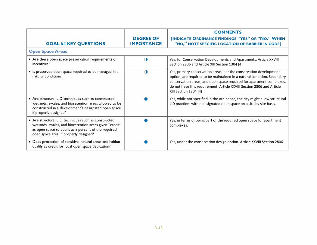
GOAL #4 KEY QUESTIONS DEGREE OF
IMPORTANCE
COMMENTS (INDICATE ORDINANCE FINDINGS “YES” OR “NO.” WHEN
“NO,” NOTE SPECIFIC LOCATION OF BARRIER IN CODE)
Open Space Areas
• Are there open space preservation requirements or incentives?
³ Yes, for Conservation Developments and Apartments. Article XXVIII Section 2806 and Article XIII Section 1304 (4)
• Is preserved open space required to be managed in a natural condition?
³ Yes, primary conservation areas, per the conservation development option, are required to be maintained in a natural condition. Secondary conservation areas, and open space required for apartment complexes, do not have this requirement. Article XXVIII Section 2806 and Article XIII Section 1304 (4)
• Are structural LID techniques such as constructed wetlands, swales, and bioretention areas allowed to be constructed in a development’s designated open space, if properly designed?
" Yes, while not specified in the ordinance, the city might allow structural LID practices within designated open space on a site by site basis.
• Are structural LID techniques such as constructed wetlands, swales, and bioretention areas given “credit” as open space to count as a percent of the required open space area, if properly designed?
" Yes, in terms of being part of the required open space for apartment complexes.
• Does protection of sensitive, natural areas and habitat qualify as credit for local open space dedication?
" Yes, under the conservation design option. Article XXVIII Section 2806
D-13

GOAL #5: MANAGE STORMWATER TO SUSTAIN STREAM FUNCTIONS
Objective: Replicate the predevelopment hydrology of the site, to the extent practicable.
Objective: Maintain water quality functions of the watershed.
Objective: Minimize channel erosion impacts.
Objective: Minimize flooding impacts.
Objective: Inspect BMPs to ensure proper construction and design.
Objective: Long-term maintenance.
GOAL #5 KEY QUESTIONS DEGREE OF
IMPORTANCE
COMMENTS (INDICATE ORDINANCE FINDINGS “YES” OR “NO.” WHEN
“NO,” NOTE SPECIFIC LOCATION OF BARRIER IN CODE)
Performance Standards
• Is stormwater required to be retained/infiltrated onsite (through bioretention, natural areas, and swale infiltration) where possible (e.g., Hydrologic Soil Group A and B)?
" No, the stormwater management sections do not require this. Section 2822 (D) through (F)
• Do stormwater management practice standards and sizing provide sufficient storage volume?
" No, the Zoning Ordinance does not contain storage volume performance standards.
• Are water quality treatment performance standards adequate?
" No, the Zoning Ordinance does not contain water quality treatment performance standards.
• Are channel protection performance standards adequate?
" No, the Zoning Ordinance does not contain channel protection performance standards.
• Are flood control performance standards adequate? " See above.
• Are thresholds of applicability adequate (e.g. land disturbance greater than 5,000 sq.ft.)?
" Yes, Section 2822 (D)(2): New developments with 5,000 sq-ft or greater of new impervious area require a stormwater management plan, or if redevelopment is more than 50% of an existing site area. All commercial or industrial development must have at least one storm water management facility.
D-14

GOAL #5 KEY QUESTIONS DEGREE OF
IMPORTANCE
COMMENTS (INDICATE ORDINANCE FINDINGS “YES” OR “NO.” WHEN
“NO,” NOTE SPECIFIC LOCATION OF BARRIER IN CODE)
• Are outfalls required to be stabilized to reduce erosion?
" No, the Zoning Ordinance does not require this.
Inspections
• Are inspections required during construction and routinely after construction?
" Yes, during construction and once after completion. Section 2808 (9).
• Are inspectors required to be trained and certified? " Yes, inspections must be made by the city’s building inspector or a third party certified building inspector. Article III, Section 301 and throughout city code.
Maintenance
• Are maintenance agreements required? " No, the Zoning Ordinance does not require maintenance agreements for any type of green infrastructure.
• Is maintenance required to be performed by a certified professional?
" No, the Zoning Ordinance does not contain any requirements for who performs the maintenance.
Off-Site Mitigation
• Is offsite mitigation required when on-site management does not meet the performance criteria (unless there is proof of no adverse impact)?
" No, offsite mitigation is not explicitly required. Generally, the city requires the developer to meet performance criteria on-site.
• Is offsite mitigation for forested area conservation allowed in the same named watershed? Is the replacement ratio at least 1:1?
³ See above.
• Is offsite mitigation for riparian area conservation allowed in the same named watershed? Is the replacement ratio at least 1:1?
³ See above.
• Is offsite mitigation for BMP retrofit allowed in the same named watershed?
³ See above.
D-15
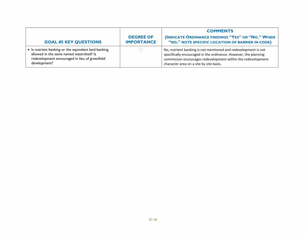
GOAL #5 KEY QUESTIONS DEGREE OF
IMPORTANCE
COMMENTS (INDICATE ORDINANCE FINDINGS “YES” OR “NO.” WHEN
“NO,” NOTE SPECIFIC LOCATION OF BARRIER IN CODE)
• Is nutrient banking or the equivalent land banking allowed in the same named watershed? Is redevelopment encouraged in lieu of greenfield development?
! No, nutrient banking is not mentioned and redevelopment is not specifically encouraged in the ordinance. However, the planning commission encourages redevelopment within the redevelopment character area on a site by site basis.
D-16