coastal management manual chapter 1 - connecticut management manual state of connecticut ......
TRANSCRIPT
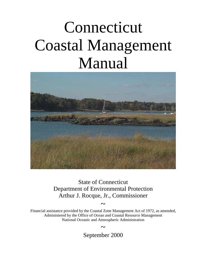
ConnecticutCoastal Management
Manual
State of ConnecticutDepartment of Environmental Protection
Arthur J. Rocque, Jr., Commissioner~
Financial assistance provided by the Coastal Zone Management Act of 1972, as amended,Administered by the Office of Ocean and Coastal Resource Management
National Oceanic and Atmospheric Administration
~September 2000
INTRODUCTION
Connecticut's coastal area provides myriad opportunities for recreation, commercial fishing,marine trades and international shipping, as well as habitat for fish, shellfish, birds, wildlife andplants, and other valuable functions. We all need to work together to make sure all these usesco-exist in perpetuity. The coastal management decisions we make today determine the extent towhich future generations will be able to enjoy this vital area where the land meets the sea. In thecase of Connecticut, our emphasis is on balancing protection of the fragile coastal resources ofLong Island Sound's ecosystem with sustainable economic uses of the shoreline.
This manual is intended to replace the Coastal Policies and Use Guidelines (a.k.a. PlanningReport #30) which was published by the Department of Environmental Protection Coastal AreaManagement Program in December 1979. The manual was developed as a tool for coastal landuse agents, boards and commissions, as well as developers, consultants and individuals, inunderstanding how to apply the standards and policies of the Connecticut Coastal ManagementAct.
The format of this manual is intended to allow for ease of use. It can be readily updated and newmaterials can be added as they become available.
For further information regarding coastal management in Connecticut, please contact the CoastalPrograms Section of the Office of Long Island Sound Programs at 860-424-3034.
TABLE OF CONTENTS SECTION 1 - COASTAL MANAGEMENT PROCESS Municipal Coastal Management Review Process Flowchart Coastal Site Plan Review Application Checklist Coastal Site Plan Review Comments Checklist Sample Coastal Site Plan Review Fact Sheet Coastal Site Plan Review Exemptions Fact Sheet Mandatory Referrals Fact Sheet Shoreline Flood and Erosion Control Structures Consistency Checklist State and Municipal Regulatory Jurisdictions Fact Sheet Watershed Management Planning Fact Sheet
SECTION 2 - COASTAL RESOURCES Adverse Impacts Fact Sheet Beach and Dune Fact Sheet Bluffs and Escarpments Fact Sheet Coastal Hazard Area Fact Sheet Coastal Waters and Estuarine Embayments Fact Sheet Developed Shorefronts Fact Sheet Intertidal Flats Fact Sheet Islands Fact Sheet Rocky Shorefronts Fact Sheet Shellfish Concentration Areas Fact Sheet Shorelands Fact Sheet Submerged Aquatic Vegetation Fact Sheet Tidal Wetlands Fact Sheet Landscape Protection and Visual Impacts Fact Sheet
SECTION 3 - COASTAL USES General Public Access to Coastal Waters Fact Sheet Septic Systems Fact Sheet Sewer and Water Lines Fact Sheet Shoreline Flood and Erosion Control Structures Fact Sheet Stormwater Management Fact Sheet Vegetated Buffers Fact Sheet Water-Dependent Uses Fact Sheet
SECTION 4 - SITE PLAN EXAMPLES Section 4 contains examples of site plans for the following types of coastal development activities: Site Plan #1 - Single Family Site Plan #2 - Multi-family Site Plan #3 - Subdivision Site Plan #4 - Commercial Each plan is accompanied by descriptions and an analysis of coastal site plan deficiencies and coastal management issues specific to that plan, and a discussion of potential solutions to those problems.
SECTION 5 - CONNECTICUT COASTAL MANAGEMENT ACT Connecticut General Statutes Sections 22a-90 through 22a-112 Public Act 00-152 – An Act Concerning Urban Harbors, Boating Safety and Water Systems in the State Reference Guide to Coastal Policies and Definition

CONNECTICUT COASTAL MANAGEMENT MANUALSECTION 1COASTAL MANAGEMENT PROCESS
Municipal Coastal Management Review Process Flowchart
Coastal Site Plan Review Application Checklist
Coastal Site Plan Review Comments Checklist Sample
Coastal Site Plan Review Fact Sheet
Coastal Site Plan Review Exemptions Fact Sheet
Mandatory Referrals Fact Sheet
Shoreline Flood and Erosion Control Structures Consistency Checklist
State and Municipal Regulatory Jurisdictions Fact Sheet
Watershed Management Planning Fact Sheet
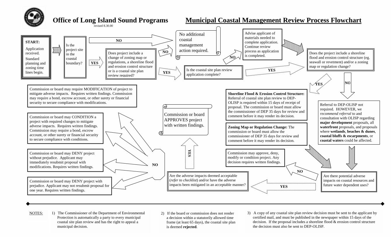
Office of Long Island Sound Programs Municipal Coastal Management Review Process Flowchartrevised 8.30.00
START:
Applicationreceived.Standardplanning andzoning timelines begin. YES
Does project include achange of zoning map orregulations, a shoreline floodand erosion control structureor is a coastal site planreview required?
NO
Is the coastal site plan reviewapplication complete?
NO
YES
Advise applicant ofmaterials needed tocomplete application.Continue reviewprocess as applicationis completed. Does the project include a shoreline
flood and erosion control structure (eg.seawall or revetment) and/or a zoningmap or regulation change?
YES NO
Referral to DEP-OLISP notrequired. HOWEVER, werecommend referral to andconsultation with OLISP regardingmajor development proposals, allwaterfront proposals, and proposalswhere wetlands, beaches & dunes,coastal bluffs & escarpments, orcoastal waters could be affected.
Shoreline Flood & Erosion Control Structure:Referral of coastal site plan review to DEP-OLISP is required within 15 days of receipt ofproposal. The commission or board must allowthe commissioner of DEP 35 days for review andcomment before it may render its decision.
NOAre there potential adverseimpacts on coastal resources andfuture water dependent uses?
Commission may approve, deny,modify or condition project. Anydecision requires written findings.
YES
Are the adverse impacts deemed acceptable(refer to checklist) and/or have the adverseimpacts been mitigated in an acceptable manner?
Commission or board may require MODIFICATION of project tomitigate adverse impacts. Requires written findings. Commissionmay require a bond, escrow account, or other surety or financialsecurity to secure compliance with modifications.
Commission or board may CONDITION aproject with required changes to mitigateadverse impacts. Requires written findings.Commission may require a bond, escrowaccount, or other surety or financial securityto secure compliance with conditions.
Commission or board may DENY project withprejudice. Applicant may not resubmit proposal forone year. Requires written findings.
Commission or board may DENY projectwithout prejudice. Applicant mayimmediately resubmit proposal withmodifications. Requires written findings.
3) A copy of any coastal site plan review decision must be sent to the applicant bycertified mail, and must be published in the newspaper within 15 days of thedecision. If the proposal includes a shoreline flood & erosion control structurethe decision must also be sent to DEP-OLISP.
2) If the board or commission does not rendera decision within a statutorily allowed timeframe (at least 65 days), the coastal site planis deemed rejected.
YE
S
Zoning Map or Regulation Change: Thecommission or board must allow thecommissioner of DEP 35 days for review andcomment before it may render its decision.
Commission or boardAPPROVES projectwith written findings.
Is theproject sitein thecoastalboundary? YES
NONo additionalcoastalmanagementaction required.
NO
1) The Commissioner of the Department of EnvironmentalProtection is automatically a party to every municipalcoastal site plan review and has the right to appeal amunicipal decision.
NOTES:
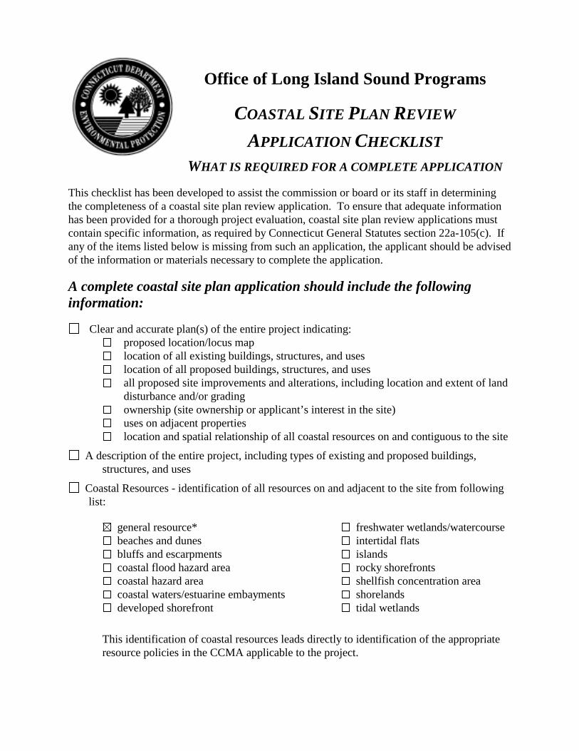
Office of Long Island Sound Programs
COASTAL SITE PLAN REVIEW
APPLICATION CHECKLISTWHAT IS REQUIRED FOR A COMPLETE APPLICATION
This checklist has been developed to assist the commission or board or its staff in determiningthe completeness of a coastal site plan review application. To ensure that adequate informationhas been provided for a thorough project evaluation, coastal site plan review applications mustcontain specific information, as required by Connecticut General Statutes section 22a-105(c). Ifany of the items listed below is missing from such an application, the applicant should be advisedof the information or materials necessary to complete the application.
A complete coastal site plan application should include the followinginformation:
�Clear and accurate plan(s) of the entire project indicating:proposed location/locus maplocation of all existing buildings, structures, and useslocation of all proposed buildings, structures, and usesall proposed site improvements and alterations, including location and extent of landdisturbance and/or gradingownership (site ownership or applicant’s interest in the site)uses on adjacent propertieslocation and spatial relationship of all coastal resources on and contiguous to the site
�A description of the entire project, including types of existing and proposed buildings,structures, and uses
�Coastal Resources - identification of all resources on and adjacent to the site from followinglist:
�general resource*�beaches and dunes�bluffs and escarpments�coastal flood hazard area�coastal hazard area�coastal waters/estuarine embayments�developed shorefront
�freshwater wetlands/watercourse�intertidal flats�islands�rocky shorefronts�shellfish concentration area�shorelands�tidal wetlands
This identification of coastal resources leads directly to identification of the appropriateresource policies in the CCMA applicable to the project.��
*General Resource and General Development policies apply to all sites and uses.cspr completeness checklist.doc revised 9.12.00
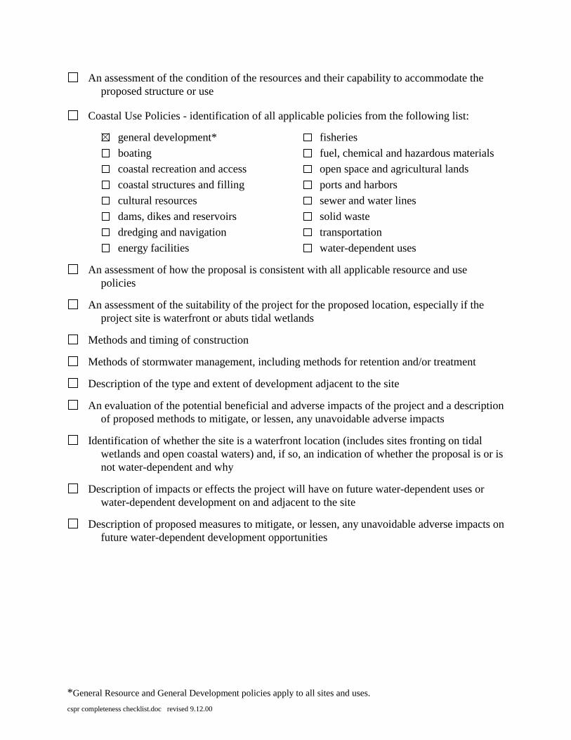
�An assessment of the condition of the resources and their capability to accommodate theproposed structure or use
�Coastal Use Policies - identification of all applicable policies from the following list:
�general development*�boating�coastal recreation and access�coastal structures and filling�cultural resources�dams, dikes and reservoirs�dredging and navigation�energy facilities
�fisheries�fuel, chemical and hazardous materials�open space and agricultural lands�ports and harbors�sewer and water lines�solid waste�transportation�water-dependent uses
�An assessment of how the proposal is consistent with all applicable resource and usepolicies
�An assessment of the suitability of the project for the proposed location, especially if theproject site is waterfront or abuts tidal wetlands
�Methods and timing of construction
�Methods of stormwater management, including methods for retention and/or treatment
�Description of the type and extent of development adjacent to the site
�An evaluation of the potential beneficial and adverse impacts of the project and a descriptionof proposed methods to mitigate, or lessen, any unavoidable adverse impacts
�Identification of whether the site is a waterfront location (includes sites fronting on tidalwetlands and open coastal waters) and, if so, an indication of whether the proposal is or isnot water-dependent and why
�Description of impacts or effects the project will have on future water-dependent uses orwater-dependent development on and adjacent to the site
�Description of proposed measures to mitigate, or lessen, any unavoidable adverse impacts onfuture water-dependent development opportunities
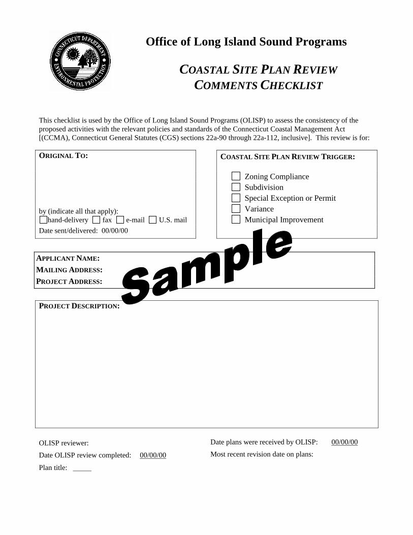
Office of Long Island Sound Programs
COASTAL SITE PLAN REVIEWCOMMENTS CHECKLIST
This checklist is used by the Office of Long Island Sound Programs (OLISP) to assess the consistency of theproposed activities with the relevant policies and standards of the Connecticut Coastal Management Act[(CCMA), Connecticut General Statutes (CGS) sections 22a-90 through 22a-112, inclusive]. This review is for:
COASTAL SITE PLAN REVIEW TRIGGER:
Zoning ComplianceSubdivision
ORIGINAL TO:
Special Exception or PermitVarianceMunicipal Improvement
by (indicate all that apply):hand-delivery fax e-mail U.S. mail
Date sent/delivered: 00/00/00
PROJECT DESCRIPTION:
OLISP reviewer: Date plans were received by OLISP: 00/00/00
Date OLISP review completed: 00/00/00 Most recent revision date on plans:
Plan title:
APPLICANT NAME: MAILING ADDRESS: PROJECT ADDRESS:
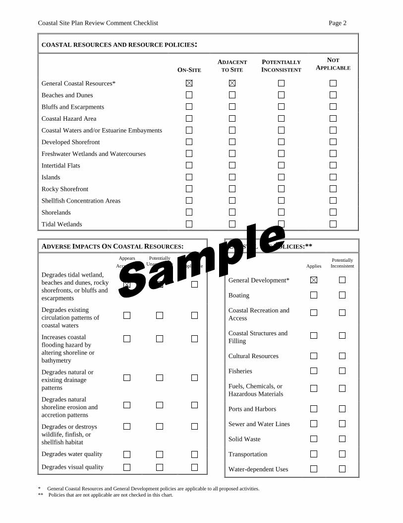
Coastal Site Plan Review Comment Checklist Page 2
* General Coastal Resources and General Development policies are applicable to all proposed activities.** Policies that are not applicable are not checked in this chart.
COASTAL RESOURCES AND RESOURCE POLICIES:
ON-SITEADJACENT
TO SITEPOTENTIALLYINCONSISTENT
NOTAPPLICABLE
General Coastal Resources*
Beaches and Dunes
Bluffs and Escarpments
Coastal Hazard Area
Coastal Waters and/or Estuarine Embayments
Developed Shorefront
Freshwater Wetlands and Watercourses
Intertidal Flats
Islands
Rocky Shorefront
Shellfish Concentration Areas
Shorelands
Tidal Wetlands
ADVERSE IMPACTS ON COASTAL RESOURCES:Appears
AcceptablePotentially
UnacceptableNot
Applicable
Degrades tidal wetland,beaches and dunes, rockyshorefronts, or bluffs andescarpments
Degrades existingcirculation patterns ofcoastal waters
Increases coastalflooding hazard byaltering shoreline orbathymetry
Degrades natural orexisting drainagepatterns
Degrades naturalshoreline erosion andaccretion patterns
Degrades or destroyswildlife, finfish, orshellfish habitat
Degrades water quality
Degrades visual quality
COASTAL USE POLICIES:**
AppliesPotentiallyInconsistent
General Development*
Boating
Coastal Recreation andAccess
Coastal Structures andFilling
Cultural Resources
Fisheries
Fuels, Chemicals, orHazardous Materials
Ports and Harbors
Sewer and Water Lines
Solid Waste
Transportation
Water-dependent Uses
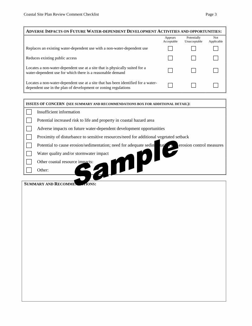
Coastal Site Plan Review Comment Checklist Page 3
ADVERSE IMPACTS ON FUTURE WATER-DEPENDENT DEVELOPMENT ACTIVITIES AND OPPORTUNITIES:Appears
AcceptablePotentially
UnacceptableNot
Applicable
Replaces an existing water-dependent use with a non-water-dependent use
Reduces existing public access
Locates a non-water-dependent use at a site that is physically suited for awater-dependent use for which there is a reasonable demand
Locates a non-water-dependent use at a site that has been identified for a water-dependent use in the plan of development or zoning regulations
ISSUES OF CONCERN (SEE SUMMARY AND RECOMMENDATIONS BOX FOR ADDITIONAL DETAIL):
Insufficient information
Potential increased risk to life and property in coastal hazard area
Adverse impacts on future water-dependent development opportunities
Proximity of disturbance to sensitive resources/need for additional vegetated setback
Potential to cause erosion/sedimentation; need for adequate sedimentation and erosion control measures
Water quality and/or stormwater impact
Other coastal resource impacts:
Other:
SUMMARY AND RECOMMENDATIONS:
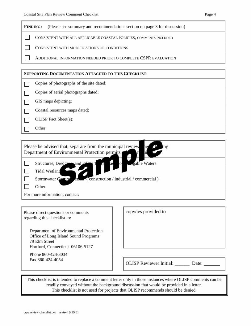
Coastal Site Plan Review Comment Checklist Page 4
cspr review checklist.doc revised 9.29.01
FINDING: (Please see summary and recommendations section on page 3 for discussion)
CONSISTENT WITH ALL APPLICABLE COASTAL POLICIES, COMMENTS INCLUDED
CONSISTENT WITH MODIFICATIONS OR CONDITIONS
ADDITIONAL INFORMATION NEEDED PRIOR TO COMPLETE CSPR EVALUATION
SUPPORTING DOCUMENTATION ATTACHED TO THIS CHECKLIST:
Copies of photographs of the site dated:
Copies of aerial photographs dated:
GIS maps depicting:
Coastal resources maps dated:
OLISP Fact Sheet(s):
Other:
Please be advised that, separate from the municipal review, the followingDepartment of Environmental Protection permits may be required:
Structures, Dredging, and Fill in Tidal Coastal or Navigable Waters
Tidal Wetlands
Stormwater General Permit ( construction / industrial / commercial )
Other:
For more information, contact:
copy/ies provided to
Please direct questions or commentsregarding this checklist to:
Department of Environmental ProtectionOffice of Long Island Sound Programs79 Elm StreetHartford, Connecticut 06106-5127
Phone 860-424-3034Fax 860-424-4054
OLISP Reviewer Initial: ______ Date:
This checklist is intended to replace a comment letter only in those instances where OLISP comments can bereadily conveyed without the background discussion that would be provided in a letter.
This checklist is not used for projects that OLISP recommends should be denied.
Office of Long Island Sound ProgramsFact Sheet
forCOASTAL SITE PLAN REVIEW
What are Coastal Site Plans?
The Connecticut Coastal Management Act [CCMA, Connecticut General Statutes (CGS)sections 22a-90 through 22a-112, inclusive] requires “coastal site plan reviews” for certain siteplans, plans and applications for activities or projects located fully or partially within the coastalboundary. Coastal site plan reviews must be conducted for the following applications if theproposed activity or use is located landward of the mean high water mark1:
� site plans submitted to a zoning commission in accordance with CGS section 22a-109;
� plans submitted to a planning commission for subdivision or resubdivision;
� applications for special exceptions or special permits submitted to a planningcommission, zoning commission or zoning board of appeals;
� applications for variances submitted to a zoning board of appeals; and
� referrals of proposed municipal projects to a planning commission pursuant to CGSsection 8-24 [CGS section 22a-105(b)].
In accordance with CGS section 22a-109(b), certain minor uses and activities may be exemptedfrom coastal site plan review by municipal zoning regulations. Check your municipality�s zoningregulations for exemptions.
What must be included in a coastal site plan?
The CCMA identifies the minimum level of information that must be included in a coastal siteplan application. A complete application must contain the following:
� a plan showing the location and spatial relationship of coastal resources on and contiguous to the subject site;
� a description of the entire project with appropriate plans, indicating project location, design, timing, and methods of construction;
� an assessment of the capability of the resources to accommodate the proposed use;
� an assessment of the suitability of the project for the proposed location, especially if theproject site is waterfront or abuts tidal wetlands;
Coastal Site Plan Review Fact Sheet Page 2
� an evaluation of the potential beneficial and adverse impacts of the project on coastalresources and future water-dependent development activities;
� a description of proposed methods to mitigate (minimize, not compensate) adverse effectson coastal resources and future water-dependent development activities; and
� any other requirements specified by municipal regulation [CGS section 22a-105(c)].
For more information regarding what constitutes a complete application, please see the CoastalSite Plan Review Application Checklist.
What must the commission or board consider when acting upon a coastalsite plan?
The appropriate commission or board must determine: 1) whether or not the proposed activity isconsistent with all applicable coastal policies and standards in the CCMA; and 2) whether or notthe potential adverse impacts of the proposed activity on both coastal resources and future water-dependent development activities are acceptable. In making this determination the municipalauthority must look at the following aspects of the proposal:
� consider the characteristics of the site including the location and condition of coastalresources on-site;
� consider the potential effects, both beneficial and adverse, of the proposed activity oncoastal resources and future water-dependent development opportunities;
� follow all applicable goals and policies stated in CGS section 22a-92 and identifyconflicts between the proposed activity and any goal or policy;
� determine whether any remaining adverse impacts have been adequately minimized (seethe Adverse Impacts fact sheet for more information); and
� determine that the proposed activity satisfies other lawful criteria including, specifically,the municipal zoning or subdivision regulations or other applicable municipal regulationsor ordinances [CGS sections 22a-106(a) and (b)].
Must a coastal site plan application be referred to the DEP for review?
Maybe. If a coastal site plan review application includes a shoreline flood and erosion controlstructure or includes a change in the zoning map or regulations, referral to OLISP is required bystatute [Please see fact sheets on Mandatory Municipal Referrals and Shoreline Flood andErosion Control Structures]. However, even if the project does not require mandatoryreferral, we strongly recommend consultation with OLISP regarding coastal site plans formajor development proposals, all waterfront proposals, and proposals where wetlands,beaches and dunes, coastal bluffs and escarpments, or coastal waters could be affected. Inthese cases, referral to OLISP for technical review assistance may be appropriate.
Coastal Site Plan Review Fact Sheet Page 3
Are there additional statutory considerations when acting upon a coastalsite plan application?
Yes. These include:
DECISION
A municipal commission or board may approve, modify, condition, or deny a coastal site planbased upon the review criteria listed above. The commission or board must state in writing thefindings and reasons for its action (i.e., the action to approve, modify, condition, or deny thecoastal site plan review application) [CGS section 22a-106(d)].
WRITTEN FINDINGS
When a coastal site plan review decision is made, the commission or board must state in writingthe findings and reasons for its actions. These are commonly termed "written findings" andshould document and support the commission's decision. For example, when an application isapproved, with or without conditions or modifications, the written findings should detail why thecommission found that the project:
� is consistent with all applicable goals and conditions contained in CGS section 22a-92;and
� incorporates as conditions or modifications, if applicable, all reasonable measures tomitigate (or lessen) the adverse impacts of the proposed activity on both coastal resourcesand future water-dependent development activities[CGS section 22a-106(e)].
AUTHORITY TO REQUIRE A FINANCIAL ASSURANCE
The commission or board may also require a bond, escrow account, or other surety or financialsecurity arrangement to secure compliance with any modifications, conditions and other termsstated in its approval of a coastal site plan [CGS section 22a-107].
LACK OF TIMELY DECISION
If the commission or board fails to render a decision within the time period provided for by theGeneral Statutes (or by any special act for such decision), the coastal site plan is deemed rejected[CGS section 22a-105(f)].
VIOLATIONS
Any activity within the coastal boundary that is not exempt from coastal site plan review thatoccurs without receiving a lawful approval from a municipal board or commission or thatviolates the terms or conditions of such approval is a public nuisance [CGS section 22a-108].
Municipalities have the authority to exercise all enforcement remedies legally available to themfor the abatement of such nuisances. The commissioner of environmental protection may also
Coastal Site Plan Review Fact Sheet Page 4
cspr fs.doc revised 7.30.01
order that such a public nuisance be halted, abated, removed, or modified and that the site of theviolation be restored as nearly as reasonably possible to its condition prior to the violation [CGSsection 22a-108].
Upon receipt of a petition signed by at least twenty-five residents of the municipality in which anactivity is located, the commissioner of environmental protection shall investigate to determinewhether or not an activity described in the petition constitutes a public nuisance [CGS section22a-108].
Does the DEP have authority over coastal site plan reviews?
Not directly. The authority for coastal site plan review lies with the municipal board orcommission responsible for the decision on the underlying application. However, the DEPexercises an oversight role in municipal coastal management activities and, in accordance withCGS section 22a-110, has "party status" in all coastal site plan reviews and can appeal amunicipal decision.
1 The mean high water mark is the average of all high tide elevations based on 19-year series of tide observations bythe National Ocean Survey. The mean high water mark delineates the seaward extent of private ownership of uplandproperty as well as the limits of municipal jurisdiction for regulating upland development projects; the State ofConnecticut holds title as trustee to the lands waterward of mean high water.
Office of Long Island Sound ProgramsFact Sheet
forMANDATORY MUNICIPAL
REFERRALS
What types of reviews are required by law to be referred to the Departmentof Environmental Protection (DEP) in accordance with the ConnecticutCoastal Management Act (CCMA)?
Any coastal site plan applications that include shoreline flood and erosion control structures asdefined in Connecticut General Statutes (CGS) section 22a-109(c) [CGS section 22a-109(d)].
Any proposed municipal plan of conservation and development, municipal coastal program, orzoning regulations and any proposed changes to a municipal plan of conservation anddevelopment, municipal coastal program, or zoning regulations or zoning map [CGS section 22a-104(e)].
Are there any time frames for such referrals?
Yes. Any coastal site plan review application that includes either a shoreline flood and erosioncontrol structure or a zoning regulation or map amendment, or both, must be referred to thisDepartment in accordance with the general statutes as described below.
A copy of each coastal site plan submitted for any shoreline flood and erosion control structuremust be referred to the DEP within fifteen days of its receipt by the zoning commission. Thezoning commission must allow the commissioner of DEP thirty five days from the day of receiptby the Department for review and comment before it may render its decision [CGS section 22a-109(d)].
Proposed municipal plans of conservation and development or zoning regulations or changesthereto (including zoning map amendments) must be referred to the commissioner of the DEP atleast thirty-five days prior to the commencement of the public hearing thereon [CGS section22a-104(e)].
Please note that submission of these mandatory referrals directly to your OLISP liaison isconsidered by this department to be proper submission to the “commissioner” and is preferred inthe interest of expediency.
What are the municipality’s statutory responsibilities with regard to theseapplications?
Shoreline Flood and Erosion Control Structures: All projects must be reviewed to ensurethat: the structure is necessary and unavoidable for the protection of infrastructure, water-
Mandatory Municipal Referrals Fact Sheet Page 2
mandatory referrals fs.doc revised 9.12.00
dependent uses, or existing inhabited structures that predate January 1, 1980; no feasible, lessenvironmentally damaging alternatives exist; and all remaining unavoidable adverse impactshave been mitigated. (See also the fact sheet on Shoreline Flood and Erosion Control Structuresfor more detailed information.)
Municipal Plans of Conservation and Development or Zoning Regulations, or changesthereto (including zoning map amendments): To ensure that the proposal is consistent withthe policies contained in CGS section 22a-92 and the criteria contained in CGS section 22a-102(b), the applicable land use board must consider:
- the character and distribution of the coastal resources within its coastal boundary;
- the capacity of and limitations on such resources to support development;
- the types and methods of development compatible with wise use, protection, andenhancement of such resources;
- the nature and pattern of existing development; and
- the need for public services.
If the DEP commissioner (or authorized DEP staff agent) comments on and makesrecommendations on any such proposals or changes, such comment, in its entirety, must be readinto the record of the public hearing and must be considered by the appropriate board orcommission before final action on the proposals or changes. Failure to comment by thecommissioner shall not be construed to be approval or disapproval [CGS section 22a-104(e)].
Are there any applications that the DEP would like to review, even thoughthere is not a mandatory referral requirement?
Yes. The OLISP staff is available to and interested in providing technical assistance to coastalland use boards and commissions. Any coastal municipality can take advantage of this freeservice and benefit from our many years of experience in the evaluation of coastal site planreviews. There are several types of applications that typically can either be difficult to evaluatefor coastal consistency or raise specific coastal management concerns. In particular, OLISPcoastal programs staff is interested in reviewing:
- major development proposals in the coastal boundary;
- all waterfront proposals; and
- development proposals where sensitive coastal resources such as beaches and dunes,coastal bluffs and escarpments, wetlands and coastal waters could be affected.
However, we are willing to evaluate any other coastal site plan review application, if time allows,although given limited staff resources and the large number of coastal site plan reviewd typicallyconducted in a year's time, we generally must pass on the more simple applications. Werecommend that you contact OLISP staff to discuss individual applications and the advisabilityof their referral well in advance of the Board or Commission's review.
Office of Long Island Sound ProgramsFact Sheet
forCOASTAL SITE PLAN REVIEW
EXEMPTIONS
What activities may be exempt from coastal site plan review?
Municipalities are required to conduct coastal site plan reviews for most activities within the coastalboundary in accordance with the Connecticut Coastal Management Act [CCMA, Connecticut GeneralStatutes (CGS) sections 22a-90 through 22a-112, inclusive, see Fact Sheet for Coastal Site PlanReviews for more information]. However, the CCMA also allows municipalities to authorize specificexemptions from the coastal site plan review requirements. Exemptions may be made for activitiesspecifically listed in CGS section 22a-109(b) provided these exemptions have been adopted by themunicipality and incorporated into its zoning regulations. The following activities are listed in CGSsection 22a-109(b) as eligible for exemption from coastal site plan review:
� minor additions to or modification of existing buildings or detached accessory buildings,such as garages and utility sheds;
� construction of new or modification of existing structures incidental to the enjoyment andmaintenance of residential property including but not limited to walks, terraces, driveways,swimming pools, tennis courts, docks and detached accessory buildings;
� construction of new or modification of existing on-premise structures including fences,walls, pedestrian walks and terraces, underground utility connections essential electric, gas,telephone, water and sewer service lines, signs and such other minor structures as will notsubstantially alter the natural character of coastal resources or restrict access along thepublic beach. It should be noted that in this context “walls” does not include any structuresthat meet the definition of shoreline flood and erosion control structure found in CGSsection 22a-109(b). (See Fact Sheet for Shoreline Flood and Erosion Control Structuresfor more information);
� construction of an individual single-family residential structure except when such structureis located on an island not connected to the mainland by an existing road bridge orcauseway (i.e., on an island without motor vehicle access) or except when such structure isin or within one hundred feet of the following coastal resource areas: tidal wetlands, coastalbluffs and escarpments, and beaches and dunes;
� activities conducted for the specific purpose of conserving or preserving soil, vegetation,water, fish, shellfish, wildlife and other coastal land and water resources;
� interior modifications to buildings; and
� minor changes in use of a building, structure or property except those changes occurring onproperty adjacent to or abutting coastal waters.

Coastal Site Plan Review Exemptions Fact Sheet Page 2
In addition to the statutory exemptions, there are two items addressed in CGS section 22a-109 that areimportant to note:
1. shoreline flood and erosion control structures, as defined in CGS section 22a-109(b), cannot beexempt from the coastal site plan review requirements contained in the CCMA (See Fact Sheet forShoreline Flood and Erosion Control Structures for more information); and
2. gardening, grazing, and the harvesting of crops are not subject to provisions of the CCMA.
How can I tell if an activity is exempt?
The exemptions must be formally adopted by a municipality in order for them to be in effect. Thestatutorily listed exemptions have been incorporated into the zoning regulations of most coastalmunicipalities. Thus, to determine whether a proposed activity is currently exempt from coastal site planreview, please refer to your municipality’s zoning regulations for its specific list of exemptions and consultwith the municipal planning and zoning office.
Does the DEP have authority over determining whether an activity isexempt from coastal site plan review?
Not directly. Although OLISP can provide assistance in determining whether or not a proposed activitymeets the standards for exemption, the authority for establishing coastal site plan review exemptions lieswith a municipality’s zoning commission. However, if a municipality exempts from coastal site planreview an activity that should have received such a review, the DEP can deem the activity a publicnuisance and take enforcement action in accordance with CGS section 22a-108.
Must DEP be notified of a determination that an activity is exempt fromcoastal site plan review?
No.
What is the process for establishing exemptions?In order to exempt any of the listed activities, the municipality must first formally adopt the exemptions,generally as amendments to their zoning regulations. A municipality is not required to adopt any of theexemptions listed in the statutes nor must they adopt all of the exemptions if they choose to adopt some ofthem. They may also adopt a more restrictive description of exempt activities. However, a municipalitycannot exempt activities that are not specified by CGS section 22a-109(b).
What should be considered when specifying exemptions in the zoningregulations?
Many municipalities have adopted the statutorily listed exemptions verbatim. In fact, in many cases thecurrent municipal regulations indicate that certain uses “shall be exempt” from coastal site plan reviewrather than “may be exempt.” This precludes any flexibility to require coastal site plan review of thoseactivities that may present a threat to sensitive coastal resources due to their location, as the regulationsautomatically exempt the specified activities regardless of their location. Many of the statutorily defineduses and activities may seem to be minor and in most cases they are. However, we have learned fromexperience that it is really the location of these uses and activities relative to sensitive coastal resources that

Coastal Site Plan Review Exemptions Fact Sheet Page 3
is critical in determining the potential adverse impacts that such uses might have. Because municipalitiesare required to ensure that adverse impacts are minimized and found acceptable, the proposed location ofthe activity should be the main factor in determining what constitutes a “minor addition” and/or a “minorchange in use.”
This, combined with several other minor issues and questions from municipalities and applicants regardingthe exemption of specific activities has led us to develop model exemption regulation language. Westrongly encourage municipal zoning commissions to review the exemptions that are currently allowedunder their existing zoning regulations to determine whether amendments are warranted to clarify whichactivities are exempt or to provide reasonable flexibility to better protect sensitive coastal resources, orboth.
MODEL EXEMPTION LANGUAGE.
To assist municipalities in the adoption of clearer and more flexible exemption language, the Office ofLong Island Sound Programs has developed the following model for coastal site plan review exemptionregulations. As you will note, the differences between the statutory language and the model regulation arevery slight and differ only in that they do not exempt activities, no matter how minor, if they have thepotential to impact sensitive coastal resources or affect access along public beaches. Such uses would notbe prohibited by adoption of the model regulation; rather, the regulation preserves the authority ofmunicipalities to require a coastal site plan review application and, importantly, to condition or modifysuch applications to mitigate impacts, where warranted, as part of the approval process.
Please note that in order to exempt any of the uses allowed pursuant to CGS section 22a-109(b) or modifythe existing exemptions regulation, the municipal zoning regulations must be amended in accordance withthe procedure specified in Section 8-3 of the Connecticut General Statutes. As with any proposed zoningregulation change that affects the coastal boundary, adoption of the listed exemptions or changes to theadopted exemptions requires referral to the Department of Environmental Protection for review andcomment at least 35 days prior to the opening of the local public hearing. Please see the OLISP fact sheetregarding Mandatory Referrals for additional information regarding this process.
Notes on the model language below:
The language in italics is not contained in the statutory language of CGS section 22a-109(b).
Text in [brackets] is not necessarily intended as part of the final regulations, but rather is eithernarrative to clarify certain items or provided as alternate criteria for adoption. If the modellanguage is adopted, this text should be either deleted if it is a clarification, or a selection shouldbe made between the suggested alternatives.
In several sections, the model language requires coastal site plan review for activities within 25feet of specific coastal resources. We are recommending 25 feet as a minimum; however,municipalities are encouraged to adopt wider review areas (e.g., all activities within 50, 75, or 100feet). In any event, the review area should be consistent throughout the exemption regulations.
Coastal Site Plan Review Exemptions Fact Sheet Page 4
�Model Regulations:
SECTION XX: COASTAL SITE PLAN REVIEWS – EXEMPTIONS
1. Minor additions to or modification of existing buildings or detached accessory buildings (e.g., garageor utility shed) except when such building or proposed addition or modification is in or within twenty-five feet of the following coastal resources as defined by section 22a-93 of the Connecticut GeneralStatutes: tidal wetlands, beaches and dunes, coastal bluffs and escarpments or coastal waters.
2. Construction of new or modification to existing structures incidental to the enjoyment and maintenanceof residential property including walks, terraces, driveways, decks, swimming pools, docks, tenniscourts, and detached accessory buildings except: (1) where the proposed construction or modificationis in or within 25 feet of the following coastal resources as defined by section 22a-93 of theConnecticut General Statutes: tidal wetlands, beaches and dunes, coastal bluffs and escarpment, orcoastal waters; or (2) where access along a public beach may be affected.
3. Construction of new or modification of existing on-premise structures including fences, walls(provided they do not meet the definition of shoreline flood and erosion control structure found in [useeither of the following: section ___ of these regulations or section 22a-109(c) of the ConnecticutGeneral Statutes]), pedestrian walks and terraces, decks, underground utilities, essential electric, gas,telephone, water and sewer service lines, septic systems, and other services, signs and other minorstructures except: (1) where any of the work or associated activities will occur within 25 feet thefollowing coastal resources as defined by section 22a-93 of the Connecticut General Statutes: tidalwetlands, beaches and dunes, coastal bluffs and escarpments, or coastal waters; or (2) where accessalong a public beach may be affected.
4. Construction of an individual single-family residential structure except when located on an island notconnected to the mainland by an existing road bridge or causeway (i.e., on an island without motorvehicle access) or except when such structure is within one hundred feet of the following coastalresources as defined in section 22a-93 of the Connecticut General Statutes: tidal wetlands, beaches anddunes, coastal bluffs and escarpments, or coastal waters.
5. Activities conducted for the specific purpose of conserving or preserving soil, vegetation, water, fish,shellfish, wildlife, and other coastal land and water resources, except those activities that meet thedefinition of a shoreline flood and erosion control structure as defined in [use either of the following:section ___ of these regulations or section 22a-109(c) of the Connecticut General Statutes].
6. Interior modifications to buildings.
7. Minor changes in use of a building, structure, or property except those changes occurring on propertyadjacent to or abutting coastal waters.
This model language is available to municipalities in electronic form. Please contact the Office of LongIsland Sound Programs at 860-424-3034 to request a copy.
cspr exemptions fs.doc - revised 7.18.01
Office of Long Island Sound Programs
SHORELINE FLOOD AND EROSIONCONTROL STRUCTURES
CONSISTENCY CHECKLIST
Shoreline flood and erosion control structures represent a "hardening" of the shoreline and theirinstallation frequently generates adverse impacts to coastal resources and may result in moreharm than good. Accordingly, they are strongly discouraged by the Connecticut CoastalManagement Act [CCMA, Connecticut General Statutes (CGS) sections 22a-90 through 22a-112]. This checklist is provided to assist land use agencies and private individuals indetermining whether a shoreline flood and erosion control structure may be appropriate in agiven situation. A shoreline flood and erosion control structure is potentially consistent with theConnecticut Coastal Management Act [CCMA, CGS sections 22a-90 through 22a-112] only if aclear demonstration can be provided that ALL of the following criterion (A through G) are met:
A) The shoreline flood and erosion control structure would protect one or more of thefollowing:
a water-dependent use as defined by CGS Section 22a-96(16) (e.g., marina,commercial fishing facility, public access walkway)
infrastructural facilities (e.g., roads, sewer lines, water lines)
an inhabited structure built prior to effective date of the CCMA (January 1,1980). The pre-existing structure itself must be in danger or located perilouslyclose to the water.
B) There is a clear demonstration of the need for erosion or flood protection. Forexample:
There is clear evidence of significant erosion or flooding;
A qualified structure or use is clearly in danger from flooding orerosion;
The proposed flood and erosion control structure would protecta water-dependent structure or use which must be located on orclose to the waterfront, within a coastal flood hazard area or anarea prone to erosion;
Affected infrastructure cannot be designed or relocated toremove it from a flood-prone or erosion-prone area; and
A vulnerable pre-existing (prior to January 1, 1980) inhabitedstructure cannot be relocated away from a flood-prone orerosion-prone area and/or elevated to Federal EmergencyManagement Agency standards.
Shoreline Flood and Erosion Control Structure Consistency Checklist Page 2
sfecs consistency checklist.doc revised 8.7.00
C) There has been a clear and compelling demonstration that nonstructuralalternatives such as vegetative stabilization (e.g., plantings and/or vegetatedberms) or beach nourishment are not possible.
D) There is no feasible, less environmentally damaging alternative to the proposedstructure.
E) The flood and erosion control structure proposed is the minimum dimensionnecessary to protect the structure or use.
F) Adverse impacts to coastal resources have been minimized to the maximumextent practicable and have been deemed acceptable through the provision of allreasonable mitigation measures and techniques
G) Based upon the above criteria, the structure is unavoidable and necessary toprotect a water-dependent use, infrastructural facilities, or an inhabitedstructure(s) that predates January 1, 1980, the effective date of the CCMA.
Office of Long Island Sound Programs Fact Sheet
for STATE AND MUNICIPAL
REGULATORY JURISDICTIONS
Where does the Department of Environmental Protection’s Office of Long Island Sound Programs regulate and why?
The Office of Long Island Sound Programs (OLISP) of the Department of Environmental Protection (DEP) has direct regulatory jurisdiction over activities occurring in tidal wetlands1 and/or waterward of the high tide line2.
If any construction activities or structure(s), in part or in whole, or any incidental work proposed in conjunction with the construction or structure(s) is proposed at or waterward of the high tide line or in tidal wetlands, prior authorization from DEP is required in accordance with the Tidal Wetlands Act (CGS sections 22a-28 through 22a-35) and/or the statutes governing the placement of structures, dredging, and fill in tidal, coastal or navigable waters (CGS sections 22a-359 through 22a-363f, inclusive).
Examples of regulated activities include dredging, the installation of structures such as docks, seawall construction, and filling. The goals of DEP’s coastal regulatory programs are to protect coastal resources, promote safe navigation, balance private rights of access with the public’s right to use and enjoy state public trust waters, and protect water-dependent uses (those uses functionally dependent upon a waterfront location, such as marinas).
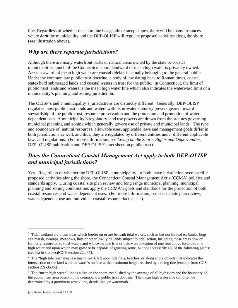
Where does a municipality regulate in comparison to DEP’s jurisdiction? A municipality regulates upland activities under local planning and zoning authority down to the mean high water line3. Because the DEP-OLISP regulates activities waterward of the high tide line, in general, especially on gently sloping shorelines, there will be an area of overlapping jurisdictions because the high tide line will be further landward than mean high water. Along steep or vertical shorefronts, for instance along a seawall, the high tide line and mean high water mark will be more closely spaced, or even coincide as the same jurisdiction
jurisdiction fs.doc revised 9.12.00
line. Regardless of whether the shoreline has gentle or steep slopes, there will be many instances where both the municipality and the DEP-OLISP will regulate proposed activities along the shore (see illustration above).
Why are there separate jurisdictions?
Although there are many waterfront parks or natural areas owned by the state or coastal municipalities, much of the Connecticut shore landward of mean high water is privately owned. Areas seaward of mean high water are coastal tidelands actually belonging to the general public. Under the common law public trust doctrine, a body of law dating back to Roman times, coastal states hold submerged lands and coastal waters in trust for the public. In Connecticut, the limit of public trust lands and waters is the mean high water line which also indicates the waterward limit of a municipality’s planning and zoning jurisdiction.
The OLISP’s and a municipality’s jurisdictions are distinctly different. Generally, DEP-OLISP regulates most public trust lands and waters with its in-water statutory powers geared toward stewardship of the public trust, resource preservation and the protection and promotion of water-dependent uses. A municipality’s regulatory land use powers are drawn from the statutes governing municipal planning and zoning which generally govern use of private and municipal lands. The type and abundance of natural resources, allowable uses, applicable laws and management goals differ in both jurisdictions as well, and thus, they are regulated by different entities under different applicable laws and regulations. (For more information, see Living on the Shore: Rights and Opportunities, DEP- OLISP publication and DEP-OLISP's fact sheet on public trust).
Does the Connecticut Coastal Management Act apply to both DEP-OLISP and municipal jurisdictions?
Yes. Regardless of whether the DEP-OLISP, a municipality, or both, have jurisdiction over specific proposed activities along the shore, the Connecticut Coastal Management Act’s (CCMA) policies and standards apply. During coastal site plan review and long range municipal planning, municipal planning and zoning commissions apply the CCMA’s goals and standards for the protection of both coastal resources and water-dependent uses. (For more information, see coastal site plan review, water-dependent use and individual coastal resource fact sheets).
1 Tidal wetland are those areas which border on or are beneath tidal waters, such as but not limited to; banks, bogs, salt marsh, swamps, meadows, flats or other low lying lands subject to tidal action, including those areas now or formerly connected to tidal waters and whose surface is at or below an elevation of one foot above local extreme high water and upon which may grow or be capable of growing some, but not necessarily all, of the following plants: (see list in statutes)[CGS section 22a-35]. 2 The “high tide line” means a line or mark left upon tide flats, beaches, or along shore objects that indicates the intersection of the land with the water’s surface at the maximum height reached by a rising tide [excerpt from CGS section 22a-359(c)]. 3 The “mean high water” line is a line on the shore established by the average of all high tides and the boundary of the public trust area based on the common law public trust doctrine. The mean high water line can often be determined by a prominent wrack line, debris line, or watermark.
Office of Long Island Sound ProgramsFact Sheet
forWATERSHED MANAGEMENT
PLANNING
What is a Watershed?
Every body of water (e.g., rivers, lakes, ponds, streams, and estuaries) has a watershed. Thewatershed is the area of land that drains or sheds water into a specific receiving waterbody, such as alake or a river. As rainwater or melted snow runs downhill in the watershed, it collects and transportssediment and other materials and deposits them into the receiving waterbody.
What is Watershed Management?
Watershed management is a term used to describe the process of implementing land use practices andwater management practices to protect and improve the quality of the water and other naturalresources within a watershed by managing the use of those land and water resources according to acomprehensive plan.
What is Watershed Management Planning?
Watershed management planning is a process that results in a plan or a blueprint of how to bestprotect and improve the water quality and other natural resources in a watershed. Very often,watershed boundaries extend over political boundaries into adjacent municipalities and/or states. Thatis why a comprehensive planning process that involves all affected municipalities located in thewatershed is essential to successful watershed management.
Why is watershed management important?
Rainwater or snowmelt can contribute significant amounts of pollution into the lake or river. Watershed management helps to control pollution of the water and other natural resources in thewatershed by identifying the different kinds of pollution present in the watershed and how thosepollutants are transported, and recommending ways to reduce or eliminate those pollution sources.
All activities that occur within a watershed will somehow affect that watershed’s natural resourcesand water quality. New land development, runoff from already-developed areas, agriculturalactivities, and household activities such as gardening/lawn care, septic system use/maintenance, waterdiversion and car maintenance all can affect the quality of the resources within a watershed. Watershed management planning comprehensively identifies those activities that affect the health ofthe watershed and makes recommendations to properly implement them so that adverse impacts frompollution are reduced.
Watershed management is also important because the planning process results in a partnership amongall affected parties in the watershed. That partnership is essential to the successful management of the
Watershed Management Planning Fact Sheet Page 2
land and water resources in the watershed since all partners have a stake in the health of thewatershed. It is also an efficient way to prioritize the implementation of watershed management plansin times when resources may be limited.
Because watershed boundaries do not coincide with political boundaries, the actions of adjacentmunicipalities upstream can have as much of an impact on the downstream municipality’s land andwater resources as those actions carried out locally. Impacts from upstream sources can sometimesundermine the efforts of downstream municipalities to control pollution. Comprehensive planning forthe resources within the entire watershed, with participation and commitment from all municipalitiesin the watershed, is critical to protecting the health of the watershed’s resources.
What are some key steps in watershed management?
FAMILIARIZE YOURSELF WITH YOUR WATERSHED
Comprehensive watershed plans should first identify the characteristics of the watershed andinventory the watershed’s natural resources. It is important to establish a baseline of the overallnature and quality of the watershed in order to plan properly for the improvement of the resources inthe watershed and to actually measure those improvements.
The first steps in watershed management planning are to:
Delineate and map the watershed’s boundaries and the smaller drainage basins within thewatershed;
Inventory and map the resources in the watershed;Inventory and map the natural and manmade drainage systems in the watershed;Inventory and map land use and land cover;Inventory and map soils;Identify areas of erosion, including stream banks and construction sites;Identify the quality of water resources in the watershed as a baseline; andInventory and map pollution sources, both point sources (such as industrial discharge pipes)
and nonpoint sources (such as municipal stormwater systems, failing septic systems,illicit discharges).
Much of this information may already be compiled and available through the DEP, the NaturalResources Conservation Service of the U.S. Department of Agriculture, and municipal offices such asplanning and zoning, inland wetlands, and public works. Additional information specific to thewatershed can be gathered during volunteer stream walks which allow for on the ground study of thegeneral conditions of the receiving waters and the adjacent watershed areas.
BUILD LOCAL PARTNERSHIPS
Watershed planning should also identify and include the partners, or “stakeholders,” in the watershed.Development of local partnerships can also lead to greater awareness and support from the generalpublic. Once individuals become aware of and interested in their watershed, they often become moreinvolved in decision-making as well as hands-on protection and restoration efforts. Through suchinvolvement, watershed management builds a sense of community, helps reduce conflicts, increasescommitment to the actions necessary to meet environmental goals, and ultimately, improves thelikelihood of success for the watershed management plan.
Watershed Management Planning Fact Sheet Page 3
Local partnerships can include:
Residents;Landowners;Federal, state, and municipal government officials;Watershed associations and other environmental and civic groups;Local business and industry leaders;Agricultural users;Developers;Teachers; andRecreational users.
DETERMINE PRIORITIES FOR ACTION
Watershed management planning should also determine what the opportunities are to reduce pollutionor address other pressing environmental issues, prioritize those opportunities, and identify a timeframe for accomplishing pollution reduction and resource and habitat improvements. Those issuesthat pose the greatest risk to human health or particular resources, or to desired uses of resources (i.e.,swimming beaches), might be given highest priority for control and reduction. Watershed plansshould establish clear goals, visions, and actions to be taken.
Examples of opportunities to reduce pollution and address other wide-ranging environmental issuesinclude:
9 Infrastructure improvements. More frequent maintenance of municipal stormwater systems orimproving or replacing inadequate stormwater treatment systems, identifying and eliminatingillicit (i.e., non-stormwater) connections to municipal stormwater systems;
9 Reducing paved areas and other impervious cover, especially adjacent to waterbodies andwetlands. Zoning and subdivision regulations can be revised to address issues such asreducing lot coverage/impervious cover, reducing roadway widths, encouraging clusterdevelopment, limiting land disturbance such as grading and clearing, and increasingdevelopment setbacks from resources;
9 Identifying appropriate areas for open space acquisition, greenways planning, and theestablishment of vegetated buffers along waterbodies and wetland areas;
9 Establishing sewer avoidance areas to limit development;
9 Increasing inspections and maintenance of existing septic system and encouraging repairs tofailing systems;
9 Identifying other appropriate housekeeping practices for homeowners and landowners(encouraging the use of vegetated buffers adjacent to waterbodies and wetlands, reducinglawn areas and the amount of fertilizers and chemicals applied to them, recommendingwashing cars over lawns instead of driveways so rinse water can drain into the lawn and notrun-off into storm drains, etc.);
9 Identifying resource and wildlife habitat restoration priorities;
9 Increasing and promoting public access and greenways and identifying areas where it isappropriate to do so; and
9 Identifying and evaluating opportunities for nonstructural flood protection efforts;
Watershed Management Planning Fact Sheet Page 4
watershed mgt fs.doc revised 9.12.00
9 Improving waste management, pollution prevention, and recycling efforts at municipalfacilities and businesses within the watershed.
CONDUCT EDUCATIONAL PROGRAMS
The degree of public education and participation in the planning process can greatly influence thesuccess of watershed management. There are many ways to involve and educate the public inwatershed management. The formation of citizen review groups and advisory committees can gainpublic support from the watershed and are an essential component to a successful, community-based,and locally led effort. These community-based groups and committees can also provide the means tokeep the project going once the plan has been finalized to make sure that recommended actions aretaken. It might also be helpful to identify a watershed coordinator to help in this effort.
Outreach and education efforts can include:
Periodic informational meetings;Stream walk assessments;Organized storm drain stenciling projects;Watershed clean-up days and riparian planting/habitat restoration days;Coordination with school systems within the watershed;Information kiosks and websites;Videos; andNewsletters and other printed materials to provide status and progress reports.
ENSURE IMPLEMENTATION AND FOLLOW-UP
It is important to establish a schedule with milestones and some sort of committee to ensure thatprojects proceed in a timely manner. A monitoring program should also be established to measuresuccess through data gathering. It is also important to identify ways in which landowners can beassisted with undertaking necessary improvements, such as low interest loans or technical outreachinformation. Finally, it is important to ensure that the recommendations contained in the watershedplan, especially design standards, are integrated into municipal land use regulations (zoning,subdivision, inland wetlands).
Where can a municipality get additional information?
If you are interested in watershed planning, please contact the Department of Environmental Protection’sWatershed Management and Coordination Program at 860-424-3020 or Office of Long Island SoundPrograms at 860-424-3034.
In addition, there are several websites that highlight watershed planning. These include:
US Environmental Protection Agency sites: http://www.epa.gov/owow/lessons/ andhttp://www.epa.gov/owow/watershed/tools/
The University of Connecticut’s Cooperative Extension Service Nonpoint Education for MunicipalOfficials (NEMO) site: http://www.lib.uconn.edu/CANR/ces/nemo/index.html
The Rivers Alliance of Connecticut site: http://www.riversalliance.org/
CONNECTICUT COASTAL MANAGEMENT MANUAL SECTION 2 COASTAL RESOURCES
Adverse Impacts Fact Sheet
Beach and Dune Fact Sheet
Bluffs and Escarpments Fact Sheet
Coastal Hazard Area Fact Sheet
Coastal Waters and Estuarine Embayments Fact Sheet
Developed Shorefronts Fact Sheet
Intertidal Flats Fact Sheet
Islands Fact Sheet
Rocky Shorefronts Fact Sheet
Shellfish Concentration Areas Fact Sheet
Shorelands Fact Sheet
Submerged Aquatic Vegetation Fact Sheet
Tidal Wetlands Fact Sheet
Landscape Protection and Visual Impacts Fact Sheet
Office of Long Island Sound ProgramsFact Sheet
forADVERSE IMPACTS
In order for projects proposed in the coastal boundary to be consistent with theConnecticut Coastal Management Act (CCMA), they must be designed to avoid, or ifunavoidable, minimize adverse impacts to coastal resources and future water-dependentdevelopment opportunities and activities.
What are Adverse Impacts to Coastal Resources?
Eight adverse impacts to coastal resources are specifically defined in the Connecticut CoastalManagement Act (CCMA). These include:
� Degrading water quality through the significant introduction into either coastal waters orgroundwater supplies of suspended solids, nutrients, toxics, heavy metals or pathogens, orthrough the significant alteration of temperature, pH, dissolved oxygen or salinity[Connecticut General Statutes (CGS) section 22a-93(15)(A)]. {EXAMPLE: the discharge ofsignificant amounts of freshwater in the form of stormwater can alter the salinity andtemperature in the vicinity of the outfall and, depending upon the upland source of thestormwater, it can introduce suspended solids, nutrients, toxics, heavy metals or pathogens.}
� Degrading existing circulation patterns of coastal waters through the significant patterns oftidal exchange or flushing rates, freshwater input, or existing basin characteristics and channelcontours [CGS section 22a-93(15)(B)]. {EXAMPLE: the installation or alteration of a tidegate on a culvert that connects a tidal wetland to open coastal waters can change the patternsof tidal exchange and flushing rates.}
� Degrading natural erosion patterns through the significant alteration of littoral transport ofsediments in terms of deposition or source reduction [CGS section 22a-93(15)(C)].{EXAMPLE: construction of a new groin on a beach will alter the pattern of deposition.}
� Degrading natural or existing drainage patterns through the significant alteration ofgroundwater flow and recharge and volume of runoff [CGS section 22a-93(15)(D)].{EXAMPLE: establishment of a new large impervious surface (e.g., a new shopping center)without on-site retention of stormwater will alter the volume of runoff.}
� Increasing the hazard of coastal flooding through significant alteration of shorelineconfigurations or bathymetry, particularly within high velocity flood zones [CGS section22a-93(15)(E)]. {NOTE: alterations of shorelines and bathymetry generally occur waterwardof mean high water and thus consideration of this adverse impact is rarely required formunicipal actions.}
Adverse Impacts Fact Sheet Page 2
� Degrading visual quality through significant alteration of the natural features of vistas andview points [CGS section 22a-93(15)(F)]. {EXAMPLE: new construction that significantlyobstructs coastal views from a scenic overlook or public park.}
� Degrading or destroying essential wildlife, finfish or shellfish habitat through significantalteration of the composition, migration patterns, distribution, breeding or other populationcharacteristics of the natural species or significant alteration of the natural components of thehabitat [CGS section 22a-93(15)(G)]. {EXAMPLE: disturbance of piping plover nesting areasduring the nesting season (mid-April to mid-August.}
� Degrading tidal wetlands, beaches and dunes, rocky shorefronts, and bluffs andescarpments through significant alteration of their natural characteristics or function [CGSsection 22a-93(15)(H)]. {EXAMPLE: stabilizing a bluff or escarpment with riprap or otherarmor will eliminate its natural function as a source of sand for the adjacent beach.}
The CCMA also includes definitions of adverse impacts on future water-dependent developmentopportunities and activities which include:
� Locating a non-water-dependent use at a site that (i) is physically suited for a water-dependentuse for which there is a reasonable demand, or (ii) has been identified for a water-dependentuse in the plan of development of the municipality or the zoning regulations [CGS section22a-93(17)(A)]. {EXAMPLE: a waterfront site suitable for marina development is insteadused for condominium or restaurant use.}
� Replacement of a water-dependent use with a non-water-dependent use [CGS section 22a-93(17)(B)]. {EXAMPLE: an existing marina is replaced by a retail development.}
� Siting of a non-water-dependent use which would substantially reduce or inhibit existingpublic access to marine or tidal waters [CGS section 22a-93(17)(C)]. {EXAMPLE: newwaterfront residential condominium development with fencing and signage designed todiscourage access to the public trust area.}
Why is it important to consider adverse impacts?
Avoiding and reducing adverse impacts will aid in preserving and protecting sensitive coastalresources and ensure that suitable waterfront sites are reserved for uses that require direct access to, orlocation in, marine or tidal waters.
Is a municipality required to consider adverse impacts?
Yes. In accordance with CGS section 22a-106, a municipal board or commission reviewing a coastalsite plan must determine whether or not the potential adverse impacts of the proposed activity on bothcoastal resources and future water-dependent uses are acceptable.
In determining the acceptability of potential adverse impacts of the proposed activity described in thecoastal site plan on both coastal resources and future water-dependent development opportunities, amunicipal board or commission is required to:
Adverse Impacts Fact Sheet Page 3
� consider the characteristics of the site, including the location and condition of anycoastal resources;
� consider the potential effects, both beneficial and adverse, of the proposed activity oncoastal resources and future water-dependent development opportunities; and
� follow all applicable coastal resource and use goals and policies stated in CGS section22a-92 and identify conflicts between the proposed activity and any CCMA goal orpolicy.
What can the municipality do to ensure adverse impacts to coastalresources and future water-dependent development opportunities areavoided or minimized?
� Incorporate as conditions or modifications of coastal site plan approval all reasonablemeasures which would mitigate the adverse impacts of the proposed activity on both coastalresources and future water-dependent development activities. For example, require as acondition of coastal site plan approval the provision of a permanent, deed-restricted publicaccess easement and site amenities including parking, seating, and signage to offset the non-water-dependent nature of an upland residential development.
� Update zoning and subdivision regulations to better address minimizing statutorily definedadverse impacts. Ensure that sensitive resources are protected from development through theuse of buffer areas and decreased impervious coverage.
� Adopt a stormwater management ordinance to ensure that stormwater is retained on-siteand/or properly treated prior to its discharge to receiving waters.
� Update the municipal plan of conservation and development and municipal coastal program, ifapplicable, to better address minimizing statutorily defined adverse impacts. Stronglyencourage resource setbacks to protect against development impacts, and identify sites that aresuitable for the development of water-dependent uses, including public access. Promote theinstallation and use of best management practices to minimize impacts from already-developed areas. Prohibit the placement of shoreline flood and erosion control structuresexcept in limited circumstances to protect infrastructure, water-dependent uses, and inhabitedstructures that pre-date January 1, 1980.
� Review development projects to control or mitigate (lessen) on-site and off-site impactsresulting from soil erosion, sedimentation, and stormwater runoff through the use ofappropriate construction, siting, and design practices such as timing and staging ofearthmoving, grading, and vegetating to minimize soil exposure
� use of vegetative control techniques such as sod, temporary vegetation, or vegetation
� buffers,
� use of non-vegetative control techniques such as mulches, nettings, and chemicalbinders,
� use of structural control techniques such as filters, traps, basins, ponds and diversion
Adverse Impacts Fact Sheet Page 4
adverse impacts fs.doc revised 9.12.00
structures
� avoiding excavation on steep slopes (greater than 25%), and
� utilizing terracing for slope control rather than retaining walls.
� Incorporate site planning and design features which limit or avoid negative visual andaesthetic impacts or which create positive visual and aesthetic impacts on the site and on thesurrounding area. For example:
� alleviate blighted or deteriorated conditions on-site;
� blend the architecture, size, materials, color, and texture of new structures with theexisting qualities and characteristics of the man-made and natural environment;
� provide visual setbacks from the water based on consideration of structure, height, andmass for all structures which do not functionally require a shorefront location;
� make extensive use of landscaping, plantings, and natural ground coverings;
� maintain, improve, or enhance visual access to the coast.
� Avoid any use or activity that would significantly increase floodwater elevations, or otherwiseincrease flood or erosion hazards.
� Revise zoning regulations to disallow the development of multi-family residential-type uses,including condominiums, hotels, motels, elderly housing, and assisted living facilities, inflood hazard areas (especially V-zones) unless it can be demonstrated that evacuation routesare not flood-prone and that other hazards to life and property have been minimized.
� Maintain or enhance public access to and along the shorefront when compatible with theproposed use, and design facilities so as to take advantage of their waterfront location in orderto provide an area for public enjoyment.
� Maintain or improve access to and along publicly owned shorefront, including public trustlands below the mean high water mark.
� Ensure that all activities and uses are consistent with the capacity of the soil and subsoil tosupport such use or activity.
� Maintain or enhance cultural features through measures such as 1) protection of historic sitesand districts from incompatible land uses and 2) prevention of harmful alteration ofsignificant archaeological or geologic sites.
Office of Long Island Sound Programs Fact Sheet
forBEACHES AND DUNES1
What are Beaches and Dunes?Beaches and dunes are beach systems including barrier beach spits and tombolos, barrierbeaches, pocket beaches, land contact beaches and related dunes and sandflats [ConnecticutGeneral Statutes (CGS) section 22a-93(7)(C)]. In general, beaches are dynamic areas abuttingcoastal waters that are characterized by sand, gravel or cobbles. Often, in the winter the beachprofile is steeper and more narrow than in the summer.
Why are they valuable?Beaches and dunes provide critical nesting habitat for some shore birds and unique habitats forplant species and communities. They act as a buffer to coastal flooding and erosion and dissipatewave energy. Beaches and dunes provide recreational opportunities, including fishing,swimming, sunning, hiking and sight-seeing. They are areas of scientific and educational value. Dunes and dune ridges act as reservoirs for sand supply to beaches.
What are the statutory policies that apply?To preserve the dynamic form and integrity of natural beach systems in order to providecritical wildlife habitats, a reservoir for sand supply, a buffer for coastal flooding anderosion, and valuable recreational opportunities; to insure that coastal uses are compatiblewith the capabilities of the system and do not unreasonably interfere with naturalprocesses of erosion and sedimentation; and to encourage the restoration andenhancement of disturbed or modified beach systems [CGS section 22a-92(b)(2)(C)]; and
To require as a condition in permitting new coastal structures, including but not limited togroins, jetties or breakwaters, that access to, or along, the public beach below mean highwater must not be unreasonably impaired by such structures [CGS section22a-92(b)(1)(K)].
To disapprove extension of sewer and water services into developed and undevelopedbeaches, barrier beaches and tidal wetlands except that, when necessary to abate existingsources of pollution, sewers that will accommodate existing uses with limited excesscapacity may be used [excerpt from CGS section 22a-92(b)(1)(B)].
In addition, the Connecticut Coastal Management Act defines as an adverse impact:
Degrading tidal wetlands, beaches and dunes, rocky shorefronts, and bluffs andescarpments through significant alteration of their natural characteristics or functions[CGS section 22a-93(15)(H)]
During the coastal site plan review process, a determination must be made that adverseimpacts have been avoided and unavoidable adverse impacts have been minimized in
Beach and Dune Fact Sheet Page 2
order to lawfully approve the application. See the coastal site plan review and adverseimpacts fact sheets for additional information.
What can a municipality do to minimize adverse impacts to thesesensitive coastal resources?
õ Preserve or enhance the natural form, volume and stability of beach systems duringdevelopment reviews through: 1) the maintenance, restoration and enhancement ofnatural beach and dune vegetation; 2) the control of pedestrian access so as toprevent the trampling or destruction of beach system vegetation (through propertraffic design, control, construction methods); and 3) the utilization of non-structural erosion control techniques such as the planting of native dune grass andplacement of sand fill for beach nourishment.
õ Protect the nesting and breeding habitats of terns, plovers, and other shorebirdswhich occupy beach areas through the control of pedestrian and pet access, propertrash control and temporary restrictions of access to nesting and feeding areasduring breeding season.
õ Employ low impact pile and timber construction for the siting of necessary andunavoidable structures on beach systems. Require mitigation of impacts of suchstructures through the planting of native beach vegetation and minimizingencroachments into the beach and dune areas.
õ Prohibit the extension of sewer or water lines to undeveloped beach and dune areas.
õ Minimize seasonal conversions in beach areas allowing only those where: 1) theseptic systems or existing sanitary sewers can accommodate year-round use; 2) theentire structure is located outside (landward) of any V-zone area; and the entirestructure is located landward of the high tide line as defined in CGS section 22a-359(c).
õ Employ construction techniques which minimize the necessary alteration of a beachsystem and its form, volume and vegetation. Such techniques include, but are notlimited to: 1) placement of construction materials on elevated ramps so as toprevent soil compaction and destruction of beach vegetation; 2) storage ofconstruction materials and equipment at a non-beach location; 3) scheduling ofconstruction so as to avoid shorebird and shellfish breeding seasons; 5) restrictingequipment movement to non-vegetated areas; and 6) restoring and revegetatingareas disturbed by construction to predevelopment conditions.
õ Update zoning regulations to better protect sensitive beach and dune areas byestablishing or increasing setbacks or buffers between development (not onlybuildings, but also decks, parking lots, etc.) and for land disturbances which mustoccur on or in areas abutting beach and dune systems. Development setbacksshould be wide enough to allow for predictable shoreline recession and/or dunemigration which may occur during the useful life of the structure. Since January 1,1980, it has been unlawful to approve structural flood and erosion control measures
Beach and Dune Fact Sheet Page 3
to protect new development.
õ Revise zoning and subdivision regulations to reduce development densities on andadjacent to beach resources. Prohibit high density residential-type developmentsuch as condominiums, assisted living facilities, hospitals, hotels/motels andsimilar uses in flood zones designated by the Federal Emergency ManagementAgency as V-zones where damage from direct wave action is likely during a so-called “100-year” storm event.
õ Update the municipal Plan of Conservation and Development and MunicipalCoastal Program, if applicable, to specifically include beach protection andpreservation as a municipal goal in accordance with the guidelines found below. Include identification of appropriate beach areas for possible open space acquisitionand encouragement of beach planting projects and the installation of appropriateeducational signage.
õ Adopt a stormwater management ordinance or make other regulatory changes toimprove stormwater management (see Water Quality fact sheet for moreinformation).
õ Preserve the natural dynamic relationships between littoral sediment sources anddepositional areas of beach systems by avoiding structures and uses which divert orotherwise alter littoral drift volumes, patterns and directions.
õ Preserve public access to or along beaches below the mean high water mark byrequiring that consistent development not obstruct passage along that public portionof the beach.
õ Preserve the physical and spatial relationship between beach systems and relatedintertidal flats through the prohibition of excavation, grading and dredging ofintertidal flats when they abut or are related to beach systems.
Does the DEP regulate activities on beaches and dunes?Maybe, depending on the location and specifics of the proposed activity. The Department ofEnvironmental Protection (DEP) has direct regulatory jurisdiction over activities occurring intidal wetlands and/or waterward of the high tide line. If any construction activities orstructure(s), in part or in whole, or any incidental work proposed in conjunction with theconstruction or structure(s) is proposed at or waterward of the high tide line or in tidal wetlands,authorization from the DEP’s Office of Long Island Sound Programs would be required prior toconstruction in accordance with the Tidal Wetlands Act (CGS sections 22a-28 through 22a-35)and/or the statutes governing the placement of structures, dredging, and fill in tidal, coastal ornavigable waters (CGS sections 22a-359 through 22a-363f, inclusive).
What’s the difference between DEP and municipal regulatory areas?
As mentioned above, the DEP has direct regulatory jurisdiction over activities occurring in tidal
Beach and Dune Fact Sheet Page 4
beach & dune fs.doc - revised 9.11.00
wetlands and/or waterward of the high tide line. The municipality regulates the uplandwaterward to the mean high water mark. In general, the mean high water mark is lower than thehigh tide line. Therefore, on gently sloping shorelines, there will be an area of overlappingjurisdictions (because the high tide line will be further landward than mean high water). Alongsteep shorefronts, for instance along a seawall, the high tide line and mean high water mark willbe more closely aligned, or even coincide as the same line. The area of overlapping jurisdictionswill be minimal in that case. Regardless of whether the DEP and/or the municipality havejurisdiction, the statutory policies and standards apply equally to both jurisdictions (see, also, theFact Sheet for State and Municipal Regulatory Jurisdictions).
1. This fact sheet is one of 13, which detail coastal resources. Fact sheets are available for the following coastal resources: beaches and dunes,bluffs and escarpments, coastal hazard areas, coastal waters, developed shorefront, estuarine embayments, intertidal flats, islands, rocky shorefronts,shellfish beds, shorelands, submerged aquatic vegetation, and tidal wetlands.
Office of Long Island Sound ProgramsFact Sheet
forBLUFFS AND ESCARPMENTS1
What are Bluffs and Escarpments?
Bluffs and escarpments are naturally eroding shorelands marked by dynamic escarpments or seacliffs which have slope angles that constitute an intricate and dynamic balance between erosion,substrate, drainage and degree of plant cover [Connecticut General Statutes (CGS) section 22a-93(7)(A)]. In general, they are dynamic, erosion-prone areas.
Why are they valuable?
Bluffs and escarpments are a significant sediment source for other features such as beaches anddunes. They provide valuable wildlife habitat and support unique plant communities andspecies. They reduce the impact of coastal flooding by dissipating wave energy. In someinstances they can provide recreational opportunities and scenic vistas if such uses can bedesigned to protect the resource from disturbance.
What are the statutory policies that apply to projects where bluffs andescarpments are on or adjacent to the site?
To manage coastal bluffs and escarpments so as to preserve their slope and toe; todiscourage uses which do not permit continued natural rates of erosion; and to disapproveuses that accelerate slope erosion and alter essential patterns and supply of sediments tothe littoral transport system [CGS section 22a-92(b)(2)(A)].
In addition, the Connecticut Coastal Management Act defines as an adverse impact:
Degrading tidal wetlands, beaches and dunes, rocky shorefronts, and bluffs andescarpments through significant alteration of their natural characteristics or functions[CGS section 22a-93(15)(H)]
During the coastal site plan review process, a determination must be made that adverse impactshave been avoided and unavoidable adverse impacts have been minimized in order to lawfullyapprove the application. See the coastal site plan review and adverse impacts fact sheets foradditional information.
Bluffs and Escarpments Fact Sheet Page 2
What can a municipality do to minimize impacts to bluffs andescarpments?
G Maintain coastal bluffs and escarpments in their natural state as vertical buffers tostorms and flooding.
G Preserve bluff and escarpment slopes through the maintenance, enhancement andrestoration of natural vegetative cover. Discourage disturbance of the face of theslope.
G Employ non-structural erosion control techniques such as erosion setbacks andbuffers, locate vulnerable uses out of hazard areas, and stabilize with vegetation. See Fact Sheet for Coastal Hazard Areas for more information regarding erosioncontrol techniques.
G Preserve the natural patterns and volumes of littoral transport between bluffs andescarpments and the related beaches and dunes by minimizing disturbance of theface of the bluff or escarpment. Provide an adequate buffer between the top of theslope and proposed development or use to allow for the continuing natural erosionof this resource.
G Update the municipal Plan of Conservation and Development and MunicipalCoastal Program, if applicable, to specifically include as a goal the protection andpreservation of bluffs and escarpments.
G Establish or increase development setbacks in zoning and subdivision regulationsfor the siting of structures and other work that occurs on lands adjacent to bluffsand escarpments. Setbacks should allow for predictable bluff and escarpmentrecession or erosion that may occur during the useful life of the structure or use ofthe property.
G Employ temporary, non-structural erosion control techniques such as mulch, haybales, fabric nets and short term drainage controls during the development of anynecessary and unavoidable structures on or adjacent to bluffs and escarpments.
G Maintain or enhance public access when compatible with the upland proposed use. Design proposed development to take advantage of waterfront location byproviding an area for public enjoyment. Such area could include: 1) access to andalong the top of the bluff or escarpment to afford coastal views; and/or 2) access toand along the toe of the bluff or escarpment, including the public trust lands belowthe mean high water mark.
Bluffs and Escarpments Fact Sheet Page 3
Does the DEP regulate activities on bluffs and escarpments?Maybe, depending on the location and specifics of the proposed activity. The Department ofEnvironmental Protection (DEP) has direct regulatory jurisdiction over activities occurring intidal wetlands and/or waterward of the high tide line. If any construction activities orstructure(s), in part or in whole, or any incidental work proposed in conjunction with theconstruction or structure(s) is proposed at or waterward of the high tide line or in tidal wetlands,authorization from the DEP’s Office of Long Island Sound Programs would be required prior toconstruction in accordance with the Tidal Wetlands Act (CGS sections 22a-28 through 22a-35)and/or the statutes governing the placement of structures, dredging, and fill in tidal, coastal ornavigable waters (CGS sections 22a-359 through 22a-363f, inclusive).
What’s the difference between DEP and municipal regulatory areas?
As mentioned above, the DEP has direct regulatory jurisdiction over activities occurring in tidalwetlands and/or waterward of the high tide line. The Town regulates the upland waterward to themean high water mark. In general, the mean high water mark is lower than the high tide line. Therefore, on gently sloping shorelines, there will be an area of overlapping jurisdictions(because the high tide line will be further landward than mean high water). Along steepshorefronts, for instance along a seawall, the high tide line and mean high water mark will bemore closely aligned, or even coincide as the same line. The area of overlapping jurisdictionswill be minimal in that case. Regardless of whether the DEP and/or the municipality havejurisdiction, the statutory policies and standards apply equally to both jurisdictions (see, also, theFact Sheet for State and Municipal Regulatory Jurisdictions).
1. This fact sheet is one of 13, which detail coastal resources. Fact sheets are available for the following coastal resources: beaches and dunes,bluffs and escarpments, coastal hazard areas, coastal waters, developed shorefront, estuarine embayments, intertidal flats, islands, rocky shorefronts,shellfish beds, shorelands, submerged aquatic vegetation, and tidal wetlands.
bluffs and escarpments.doc - revised 9.11.00
Office of Long Island Sound ProgramsFact Sheet
forCOASTAL HAZARD AREAS1
What are Coastal Hazard Areas?
Coastal hazard areas are statutorily defined as those land areas inundated during coastal stormevents or subject to erosion induced by such events, including flood hazard areas as defined anddetermined by the National Flood Insurance Act and all erosion hazard areas as determined bythe Commissioner [Connecticut General Statutes (CGS) section 22a-93(7)(H)]. In general,coastal flood hazard areas include all areas designated as within A-zone and V-zones by theFederal Emergency Management Agency (FEMA). A-zones are subject to still-water floodingduring so called “100-year” flood events. During 100-year flood events, V-zones are subject todirect action by waves three feet or more in height.
Why are they valuable?
Coastal hazard areas encompass most other important coastal resources, can serve as floodstorage areas, and provide numerous open space and recreational opportunities. They are, bytheir nature, hazardous areas for structural development, especially residential-type uses.
What are the statutory policies that apply?
To manage coastal hazard areas so as to insure that development proceeds in such amanner that hazards to life and property are minimized and to promote nonstructuralsolutions to flood and erosion problems except in those instances where structuralalternatives prove unavoidable and necessary to protect existing inhabited structures,infrastructural facilities or water-dependent uses [CGS section 22a-92(b)(2)(F)]. An“existing inhabited structure” is a building which was constructed and inhabited prior toauthorization of the CCMA on January 1, 1980 and is still in residential use.
To maintain the natural relationship between eroding and depositional coastal landforms;to minimize the adverse impacts of erosion and sedimentation on coastal land usesthrough the promotion of nonstructural mitigation measures. Structural solutions arepermissible when necessary and unavoidable for the protection of infrastructuralfacilities, water-dependent uses, or existing inhabited structures, and where there is nofeasible, less environmentally damaging alternative and where all reasonable mitigationmeasures and techniques have been provided to minimize adverse environmental impacts[CGS section 22a-92(b)(2)(J)].
Coastal Hazard Area Fact Sheet Page 2
To maintain, enhance, or, where feasible, restore natural patterns of water circulation andfresh and saltwater exchange in the placement or replacement of culverts, tide gates orother drainage or flood control structures [CGS section 22a-92(c)(2)(B)].
In addition, the Connecticut Coastal Management Act defines as an adverse impact:
Increasing the hazard of coastal flooding through significant alteration of shorelineconfigurations or bathymetry, particularly within high velocity flood zones [CGS section22a-3(15)(B)].
During the coastal site plan review process, a determination must be made that adverse impactshave been avoided and unavoidable adverse impacts have been minimized in order to lawfullyapprove the application. See the coastal site plan review and adverse impacts fact sheets forfurther information.
What can a municipality do to minimize impacts to these sensitive coastalresources?
N Update municipal Plan of Conservation and Development, Municipal Coastal Program, ifapplicable, and zoning regulations and subdivision regulations to better managedevelopment in coastal hazard areas by incorporating language that reflects the followingguidance.
N Apply the National Flood Insurance Program flood plain management requirements [24Code of Federal Regulations (CFR) 60.3] to: 1) all activities in designated A-zones andfloodways; and 2) to all new construction or substantial improvements in designatedcoastal high hazard zones (V-zones).
N Prevent development of high-density residential-type uses (e.g., condominium complexes,elderly housing, hospitals, assisted living facilities, hotels/motels, etc.) in V-zones. Allow such uses in A-zones only if access to the site is not flood prone and the applicantcan demonstrate the project has been designed so that risks to life and property are notincreased.
N Site all facilities that have the potential to cause pollution or hazardous conditions as aresult of flooding or erosion, such as energy or oil and chemical handling facilities,outside of coastal hazard areas (A and V zones). If a facility, because of its water-dependent nature, cannot be located outside of a coastal flood hazard area, incorporateflood-proofing measures in the design of the facility to protect against flooding includingextreme conditions (generally a 500-year frequency flood event or greater).
N Site all new or substantially improved buildings, dwellings and non-water-dependentstructures out of the designated coastal high hazard area (V-Zone).
Coastal Hazard Area Fact Sheet Page 3
N Elevate sufficiently above the base flood level the lowest floor of a new or substantiallyimproved water-dependent building and habitable structure which cannot functionally besited outside the V-Zone to minimize the impacts of wave action generated by 100 yearfrequency storm events.
N Where applicable, require that all new development in erosion-prone areas, particularly inany erosion hazard areas designated by the Commissioner of the Department ofEnvironmental Protection, be set back from the water to create a safety buffer stripconsisting of natural vegetative cover. The width of this buffer should be based on thepredicted erosion rate in conjunction with the anticipated �useful life" of the proposedstructure.
N Employ non-structural flood and erosion control techniques such as erosion setbacks andbuffers, location of vulnerable uses out of hazard areas, vegetative stabilization, andconstruction of artificial dunes, as the primary means of controlling flood and erosionhazards except in instances where such non-structural techniques would be inadequate toprotect infrastructural facilities (such as sewer and water lines), water dependent uses, orexisting inhabited structures that were in place prior to January 1, 1980. Structural floodand erosion control methods cannot be approved for residential structures approved afterJanuary 1, 1980.
N Utilize structural flood and erosion control techniques such as groins, seawalls, andrevetments only when: 1) the structures are being placed to provide protection toinfrastructural facilities, water dependent uses, or existing inhabited structures that werein place prior to January 1, 1980; 2) non-structural techniques have been explored andare found to be infeasible; 3) there is no other less environmentally damaging alternative; and 4) all reasonable mitigation measures and techniques are employed to minimizeadverse environmental impacts.
N Maintain or restore natural vegetation in coastal high hazard areas (V-Zones) to serve asbuffers against storm, wind, and wave energy.
N Maintain or restore natural landforms within or adjacent to coastal hazards areas thatserve as buffers to flood and erosion such as beaches, dunes and wetlands.
N Avoid any use or activity which would significantly increase floodwater elevations, orotherwise increase flood or erosion hazards.
N Maintain or restore natural patterns of littoral transport and avoid uses and activitieswhich interrupt or alter natural sediment transport from eroding source areas todepositional receiving areas.
N Apply all coastal policies and use guidelines for other coastal resources where they occurwithin coastal hazard areas (see individual fact sheets for general coastal resources,beaches and dunes, bluffs and escarpments, coastal hazard areas, coastal waters,

Coastal Hazard Area Fact Sheet Page 4
developed shorefront, estuarine embayments, intertidal flats, islands, rocky shorefronts,shellfish beds, shorelands, submerged aquatic vegetation, and tidal wetlands).
Does the DEP regulate activities in coastal flood hazard areas?
Maybe, depending on the location and specifics of the proposed activity. The DEP has directregulatory jurisdiction over activities occurring in tidal wetlands and/or waterward of the hightide line. If any construction activities or structure(s), in part or in hole, or any incidental workproposed in conjunction with the construction of structure(s) is proposed at or waterward of thehigh tide line, authorization from the DEP’s Office of Long Island Sound Programs would berequired prior to construction in accordance with the Tidal Wetlands Act (CGS sections 22a-28through 22a-35 and/or the statutes governing the placement of structures, dredging, or filling intidal, coastal or navigable waters (CGS sections 22a-359 through 22a-363f, inclusive).
While each municipality implements its own flood management regulations, the DEP Bureau ofWater Management, Inland Water Resources Division, provides training, technical and planningassistance to municipalities using guidelines developed under the National Flood InsuranceProgram. However, each municipality maintains its regulatory jurisdiction over its floodmanagement regulations.
What’s the difference between DEP and municipal regulatory areas?
As mentioned above, the DEP has direct regulatory jurisdiction over activities occurring in tidalwetlands and/or waterward of the high tide line. The Town regulates the upland waterward to themean high water mark. In general, the mean high water mark is lower than the high tide line. Therefore, on gently sloping shorelines, there will be an area of overlapping jurisdictions(because the high tide line will be further landward than mean high water). Along steepshorefronts, for instance along a seawall, the high tide line and mean high water mark will bemore closely aligned, or even coincide as the same line. The area of overlapping jurisdictionswill be minimal in that case. Regardless of whether the DEP and/or the municipality havejurisdiction, the statutory policies and standards apply equally to both jurisdictions (see, also, theFact Sheet for State and Municipal Regulatory Jurisdictions).
1. This fact sheet is one of 13, which detail coastal resources. Fact sheets are available for the following coastal resources: beaches and dunes,bluffs and escarpments, coastal hazard areas, coastal waters, developed shorefront, estuarine embayments, intertidal flats, islands, rocky shorefronts,shellfish beds, shorelands, submerged aquatic vegetation, and tidal wetlands.
coastal hazard fs.doc revised 9.11.00
Office of Long Island Sound ProgramsFact Sheet
forCOASTAL WATERS AND
ESTUARINE EMBAYMENTS1
What are Coastal Waters and Estuarine Embayments?
Coastal waters are those waters of Long Island Sound and its harbors, embayments, tidal rivers, streamsand creeks, which contain a salinity concentration of at least five hundred parts per million under the lowflow stream conditions as established by the commissioner [Connecticut General Statutes (CGS) section22a-93(5)].
Coastal waters can be separated into “nearshore waters,” “offshore waters” and “estuarineembayments.”
Nearshore Waters are those waters and their substrates lying between mean high waterand a depth approximated by the ten meter contour [CGS section 22a-93(7)(K)].
Offshore Waters means the area comprised of those waters and their substrates lyingseaward of a depth approximated by the ten meter contour [CGS section 22a-93(7)(L)].
Estuarine Embayments are a protected coastal body of water with an open connection to the sea inwhich saline sea water is measurably diluted by fresh water including tidal rivers, bays, lagoonsand coves [CGS section 22a-93(7)(G)].
Why are they valuable?
Coastal waters are areas of high primary and secondary productivity. Coastal waters providehabitat for a variety of marine organisms (shellfish, finfish, crustaceans and benthic organisms);support many diverse floral and faunal species; provide spawning and breeding areas for manyspecies; and are an important contributor to the productivity of contiguous ocean waters. Coastalwaters are critical to the assimilation of industrial, commercial and residential wastes; supportcommercial and recreational fisheries; are important to marine transportation and navigation; andprovide recreational opportunities for boating, swimming, fishing, diving and vistas.
Estuarine embayments are semi-enclosed bodies of coastal waters, such as tidal rivers or coves,which are measurably diluted by freshwater inputs. As such they have high biologicalproductivity; provide significant habitat for shellfish, finfish and waterfowl; serve as spawning andfeeding grounds for commercially important finfish; are essential biological corridors for spawninganadromous and catadramous fish; exhibit unique circulation patterns (estuarine circulation) whichinfluence nutrient distribution, control salinity, mix the water column and work and redistributesediments; supply sheltered areas for the development of eelgrass flats or beds of other submergedaquatic vegetation which are highly productive; provide nursery grounds, shelter and refuge forvarious aquatic species; are a vital food source for marine organisms, support an importantbiomass of epiphytic plants (plants that grow on other plants or objects upon which they dependfor mechanical support but not as sources of nutrients); and transfer nutrients from sediments into
Coastal Waters Fact Sheet Page 2
the water column. Estuarine embayments also provide protected locations for activities such asboating, swimming, fishing and other passive recreational activities and protected areas for deepwater access and navigational corridors for commercial and industrial waterfront uses; are areas ofunique scientific and educational value, and some embayments contain eelgrass flats which reducecurrent velocities, control erosion by trapping and binding sediments and provide essential aquatichabitat.
What are the statutory policies that apply?
To manage estuarine embayments so as to insure that coastal uses proceed in a mannerthat assures sustained biological productivity, the maintenance of healthy marinepopulations and the maintenance of essential patterns of circulation, drainage and basinconfiguration; to protect, enhance and allow natural restoration of eelgrass flats except inspecial limited cases, notably shellfish management, where the benefits accrued throughalteration of the flat may outweigh the long-term benefits to marine biota, waterfowl, andcommercial and recreational finfisheries [CGS section 22a-92(c)(2)(A)].
It is found and declared that the pollution of the waters of the state is inimical to the publichealth, safety and welfare of the inhabitants of the state, is a public nuisance and isharmful to wildlife, fish and aquatic life and impairs domestic, agricultural, industrial, andrecreational and other legitimate beneficial uses of water, and that the use of public fundsand the granting of tax exemptions for the purpose of controlling and eliminating suchpollution is a public use and purpose for which moneys may be expended and taxexemptions granted, and the necessity and public interest for the enactment of this chapterand the elimination of pollution is hereby declared as a matter of legislative determination[CGS section 22a-422, as referenced by CGS section 22a-92(a)(2)].
In addition, the Connecticut Coastal Management Act defines as an adverse impact:
Degrading water quality through the significant introduction into either coastal waters orgroundwater supplies of suspended solids, nutrients, toxics, heavy metals or pathogens, orthrough the significant alteration of temperature, pH, dissolved oxygen or salinity [CGSsection 22a-93(15)(A)].
During the coastal site plan review process, a determination must be made that adverse impactshave been avoided and unavoidable adverse impacts have been minimized in order to lawfullyapprove the application. (See the Coastal Site Plan Review and Adverse Impacts fact sheets foradditional information.)
Finally, the state statutes regarding planning and zoning contain specific requirements for zoningregulations and Plans of Development that relate to the restoration and protection of coastalresources. These are:
In any municipality that is contiguous to Long Island Sound the regulations adopted underthis section shall be made with reasonable consideration for restoration and protection ofthe ecosystem and habitat of Long Island Sound and shall be designed to reduce hypoxia,pathogens, toxic contaminants and floatable debris in Long Island Sound. Suchregulations shall provide that the commission consider the environmental impact on LongIsland Sound of any proposal for development [CGS section 8-2(b)].
The plan adopted under this section for any municipality that is contiguous to Long IslandSound shall be made with reasonable consideration for restoration and protection of the
Coastal Waters Fact Sheet Page 3
ecosystem and habitat of Long Island Sound and shall be designed to reduce hypoxia,pathogens, toxic contaminants and floatable debris in Long Island Sound [excerpt fromCGS section 8-23].
What can a municipality do to minimize impacts to these sensitive coastalresources?
* Maintain the continued biological productivity and viability of Long Island Sound as aresource capable of supporting: 1) healthy marine and finfish resources; 2) a broadspectrum of safe and healthy recreational opportunities; and 3) an efficient system ofmarine transportation and navigation through the protection of coastal water quality. Themost direct approach is to adopt and implement a stormwater management ordinance, eitheras an amendment to the municipal zoning regulations or as a “stand-alone” ordinance. Ineither case, it should require that the volume of runoff generated by the first one-inch ofrainfall is retained on-site and the post-development runoff rates and volumes should notexceed the pre-development runoff rates and volumes. (See Stormwater Management factsheet for additional information.)
* Review the existing zoning regulations regarding the maximum impervious cover allowed. Reduce this wherever possible, especially adjacent to coastal waters and other sensitivecoastal resources. This will aid in protecting coastal water quality by minimizingstormwater discharges.
* Require regularly scheduled street sweeping and catch basin clean-outs to minimize theamount of sediment, contaminants and floatable debris entering coastal waters through themunicipal stormwater management system.
* Identify outfalls from the municipal stormwater systems and opportunities for retrofits totreat stormwater, especially from roads, prior to discharge.
* Prohibit the dumping of sand, snow and demolition debris into any waterbodies.
* Consider coordination with neighboring municipalities on watershed management planning.
* Update the municipal Plan of Conservation and Development, Municipal Coastal Program,if applicable, and zoning and subdivision regulations to better protect coastal waters andestuarine embayments by increasing buffers between development and these coastalresources, with the possible exception of developed shorefront where water-dependentdevelopment is suitable and to improve stormwater management. (See fact sheets regardingVegetated Buffers, Stormwater Management and Adverse Impacts for more information).
* Maintain and improve water quality in accordance with the highest standards set by federal,state or local authorities by: 1) preserving and maintaining those waters with existingquality better than established standards; 2) restoring the surface waters of the municipalityto a quality consistent with its use for the protection and propagation of fish, shellfish andwildlife including breeding, feeding and nursery grounds and with its use for recreation inand on the water; and 3) restoring all water to the maximum extent possible, at least to a
Coastal Waters Fact Sheet Page 4
quality consistent with Class B or SB. Class B waters for the following recreational uses:fish and wildlife habitat; agricultural and industrial supply and other legitimate usesincluding navigation. Class SB waters allow for the following uses: fish, shellfish andwildlife habitat, shellfish harvesting for transfer to approved areas for purification prior tohuman consumption, recreation, industrial and other legitimate uses including navigation.
Does the DEP regulate activities in coastal waters and estuarineembayments?
Yes. The DEP has direct regulatory jurisdiction over activities occurring in tidal wetlands and/orwaterward of the high tide line. If any construction activities or structure(s), in part or in whole, or anyincidental work proposed in conjunction with the construction of structure(s) is proposed at or waterwardof the high tide line, authorization from the DEP’s Office of Long Island Sound Programs would berequired prior to construction in accordance with the Tidal Wetlands Act (CGS sections 22a-28 through22a-35) and/or the statutes governing the placement of structures, dredging, or filling in tidal, coastal ornavigable waters (CGS sections 22a-359 through 22a-363f, inclusive).
Further, the DEP’s Water Bureau administers programs regulating the discharges of nonpoint (e.g., urbanstormwater runoff) and point sources (e.g., sewage outfalls) of pollution into coastal waters and estuarineembayments. Contact the DEP’s Water Bureau (860-424-3705) for additional information on how tobetter control or report such discharges if you believe they are not being properly managed or areunauthorized.
What’s the difference between DEP and municipal regulatory areas?As mentioned above, the DEP has direct regulatory jurisdiction over activities occurring in tidal wetlandsand/or waterward of the high tide line. The Town regulates the upland waterward to the mean high watermark. In general, the mean high water mark is lower than the high tide line. Therefore, on gently slopingshorelines, there will be an area of overlapping jurisdictions (because the high tide line will be furtherlandward than mean high water). Along steep shorefronts, for instance along a seawall, the high tide lineand mean high water mark will be more closely aligned, or even coincide as the same line. The area ofoverlapping jurisdictions will be minimal in that case. Regardless of whether the DEP and/or themunicipality have jurisdiction, the statutory policies and standards apply equally to both jurisdictions (see,also, the fact sheet for State and Municipal Regulatory Jurisdictions).
1. This fact sheet is one of 13, which detail coastal resources. Fact sheets are available for the following coastal resources: beaches and dunes,bluffs and escarpments, coastal hazard areas, coastal waters, developed shorefront, estuarine embayments, intertidal flats, islands, rocky shorefronts,shellfish beds, shorelands, submerged aquatic vegetation, and tidal wetlands.
coastal waters fs.doc revised 3.13.01

Office of Long Island Sound ProgramsFact Sheet
forDEVELOPED SHOREFRONTS1
What are Developed Shorefronts?Developed shorefronts are those harbor areas which have been highly engineered and developed resultingin the functional impairment or substantial alteration of their natural physiographic features or systems[Connecticut General Statutes (CGS) section 22a-93(7)(I)]. They are areas that are intensely developed,generally with bulkheads, seawalls, revetments, or other hard structures that were usually constructed manyyears ago.
Why are they valuable?Developed Shorefronts have limited natural value; however, they provide other significant benefits. Theyare economically valuable; they serve as major transportation and commercial centers; they supportsignificant recreational boating opportunities; and they provide substantial cultural and historic value.
What are the statutory policies that apply?To promote, through existing state and local planning, development, promotional and regulatoryprograms, the use of existing developed shorefront areas for marine-related uses, including but notlimited to commercial and recreational fishing, boating and other water-dependent commercial,industrial and recreational uses [CGS section 22a-92(b)(2)(G)].
What can a municipality do to best utilize these resources?
, Where feasible, reserve developed shorefront areas for intensive water-dependent uses, includingbut not limited to commercial and recreational fishing, boating, and other water-dependentcommercial, industrial and recreational uses. If a particular site is not physically suited tointensive water-dependent use, the provision of uses providing public access should be required asa critical component of any development or redevelopment effort. Please see the Water-Dependent Use fact sheet for additional information. During redevelopment efforts, properstormwater management measures should be implemented to control on-site and off-site impacts. During construction, of particular concern are impacts resulting from soil erosion, sedimentationand stormwater runoff. Control and mitigation can occur through the use of appropriateconstruction, siting, and design practices such as: 1) timing and staging of earthmoving, gradingand the establishment of vegetation to minimize soil exposure; 2) use of vegetative controltechniques such as sod, temporary vegetation, or vegetated buffers; 3) use of non-vegetativecontrol techniques, such as mulches, netting, and chemical binders; 4) use of structural controltechniques such as filters, traps, basins, ponds, and diversion structures; 5) avoiding developmenton steep slopes (greater than 25%); and 6) terracing. Also, redevelopment provides opportunitiesto retrofit stormwater management systems to minimize adverse impacts to water quality by addingretention systems, and oil, grease, and sediment traps on existing and proposed stormwatercollection systems.
, Update the municipal plan of conservation and development and zoning regulations to identify anddesignate appropriate developed shorefront areas as commercial/industrial water-dependent zones.
Developed Shorefront Fact Sheet Page 2
, Avoid any use or activity, which would significantly increase flood or erosion hazards.
, Maintain or enhance public access to and along developed shorefront areas where compatible withthe nature of the existing or proposed use. Design waterfront commercial, industrial, utility,residential and institutional facilities to provide an attractive area along the water for publicenjoyment of the shorefront.
, Reuse and redevelop built-up or vacant shorefront in preference to development of previouslyundeveloped shorefront.
, Ensure that shorefront development is compatible with municipally and state approved municipalharbor management plans.
, All activities and uses should be consistent with the capacity of the soil and subsoil to support suchuses or activities. This is especially important for stormwater retention/infiltration and treatmentsystems. Please see the stormwater fact sheet for more information.
Does the DEP regulate activities on developed shorefronts?
Maybe, depending to the specifics of the proposed activities. The DEP has direct regulatory jurisdictionover activities occurring in tidal wetlands and/or waterward of the high tide line. If any constructionactivities or structure(s), in part or in whole, or any incidental work proposed in conjunction with theconstruction of structure(s) is proposed at or waterward of the high tide line, authorization from the DEP’sOffice of Long Island Sound Programs would be required prior to construction in accordance with theTidal Wetlands Act (CGS sections 22a-28 through 22a-35) and/or the statutes governing the placement ofstructures, dredging, or filling in tidal, coastal or navigable waters (CGS sections 22a-359 through 22a-363f, inclusive).
What’s the difference between DEP and municipal regulatory areas?
As mentioned above, the DEP has direct regulatory jurisdiction over activities occurring in tidal wetlandsand/or waterward of the high tide line. The municipality regulates the upland waterward to the mean highwater mark. In general, the mean high water mark is lower than the high tide line. Therefore, on gentlysloping shorelines, there will be an area of overlapping jurisdictions (because the high tide line will befurther landward than mean high water). Along steep shorefronts, for instance along a seawall, the hightide line and mean high water mark will be more closely aligned, or even coincide as the same line. Thearea of overlapping jurisdictions will be minimal in that case. Regardless of whether the DEP and/or themunicipality have jurisdiction, the statutory policies and standards apply equally to both jurisdictions (see,also, the fact sheet for State and Municipal Regulatory Jurisdictions).
1 This fact sheet is one of 14, which detail coastal resources. Fact sheets are available for the following coastal resources: general coastal resources, beaches and dunes,bluffs and escarpments, coastal hazard areas, coastal waters, developed shorefront, estuarine embayments, intertidal flats, islands, rocky shorefronts, shellfish beds,shorelands, submerged aquatic vegetation, and tidal wetlands.
developed shorefront fs.doc - revised 9.7.00
Office of Long Island Sound ProgramsFact Sheet
forINTERTIDAL FLATS1
What are Intertidal Flats?
Intertidal flats are very gently sloping or flat areas located between high and low tides composedof muddy, silty and fine sandy sediments and generally devoid of vegetation [ConnecticutGeneral Statutes (CGS) section 22a-93(7)(D)].
Why are they valuable?
Intertidal flats serve as rich sources of and reservoirs for nutrients. Intertidal flats providevaluable feeding areas for invertebrates, fish, and shorebirds and significant shellfish habitat. Intertidal flats are sinks for toxic materials where they are generally sequestered in the finersediments, thereby contributing to improved water quality. Intertidal flats also provide:recreational opportunities including shellfishing, fishing and wildlife observation; buffers forstorm energy; and are areas of scientific and educational value.
What are the statutory policies that apply?
To manage intertidal flats so as to preserve their value as a nutrient source andreservoir, a healthy shellfish habitat and a valuable feeding area for invertebrates,fish and shorebirds; to encourage the restoration and enhancement of degradedintertidal flats; to allow coastal uses that minimize change in the natural currentflows, depth, slope, sedimentation, and nutrient storage functions; and to disallowuses that substantially accelerate erosion or lead to significant despoliation of tidalflats [CGS Sec. 22a-92(b)(2)(C)].
What can a municipality do to minimize impacts to these sensitivecoastal resources?
W Utilize all reasonable siting and construction practices that avoid or substantially reducethe potential negative impacts of development in or on intertidal flats. These practicesmay include, but are not limited to, minimizing and controlling both soil erosion andsedimentation, and stormwater impacts. See the fact sheets regarding Coastal Waters,Stormwater Management, and Vegetated Buffers for additional information.
Intertidal Flat Fact Sheet Page 2
W Update municipal Plan of Conservation and Development and zoning and subdivisionregulations to better protect intertidal flats by increasing buffers between developmentand these coastal resources and improve stormwater management (see fact sheetsregarding Vegetated Buffers, Stormwater Management, and water quality for moreinformation).
W Maintain the natural patterns of sedimentation and littoral transport which determine thecharacter and quality of intertidal flats.
W Avoid or minimize activities that interrupt or alter the nature, chemistry or tidal pattern ofestuarine waters that inundate and permeate intertidal flats.
W Protect and, when practicable, restore shellfish species diversity and the capacity ofintertidal flats to support shellfish, invertebrates, fish and shorebirds.
Does the DEP regulate activities on intertidal flats?
Yes. The DEP has direct regulatory jurisdiction over activities occurring in tidal wetlands and/orwaterward of the high tide line. By definition, intertidal flats areas are waterward of the high tideline. Thus, any construction activities or structure(s), in part or in whole, or any incidental workproposed in conjunction with the construction of structure(s) that is proposed on intertidal flatsrequires prior authorization from the DEP’s Office of Long Island Sound Programs in accordancewith the statutes governing the placement of structures, dredging, and fill in tidal, coastal ornavigable waters (CGS sections 22a-359 through 22a-363f, inclusive).
1. This fact sheet is one of 13, which detail coastal resources. Fact sheets are available for the following coastal resources: beaches and dunes,bluffs and escarpments, coastal hazard areas, coastal waters, developed shorefront, estuarine embayments, intertidal flats, islands, rocky shorefronts,shellfish beds, shorelands, submerged aquatic vegetation, and tidal wetlands.
intertidal flats fs.doc revised 9.7.00
Office of Long Island Sound ProgramsFact Sheet
forISLANDS1
What are Islands?
Islands are lands surrounded on all sides by water [Connecticut General Statutes (CGS) section22a-93(7)(J)].
Why are they valuable?
Islands, undeveloped islands in particular, provide isolated nesting areas and critical habitat forshorebirds, support many floral and faunal species which have all but disappeared from themainland, constitute a large percent of undeveloped shoreline, constitute unique geologicfeatures, provide unique recreational opportunities for fishing, swimming, boating, and wildlifeobservation, contain large amounts of open space, are areas of scientific and educational value,and provide a storm buffer for adjacent mainland areas.
What are the statutory policies that apply?
To manage undeveloped islands in order to promote their use as critical habitats for thosebird, plant and animal species which are indigenous to such islands or which areincreasingly rare on the mainland; to maintain the value of undeveloped islands as amajor source of recreational open space; and to disallow uses which will have significantadverse impacts on islands or their resource components [CGS section 22a-92(b)(2)(H)].
What can a municipality do to minimize impacts to these sensitive coastalresources?
O Limit development to low-density, low-impact residential or recreational uses.O Where limited development is proposed on islands, control or mitigate on-site and off-site
impacts resulting from soil erosion, sedimentation, and stormwater runoff through the useof appropriate construction, siting, and design practices such as: 1) timing and staging ofearthmoving, grading, and establishing vegetation to minimize soil exposure; and 2) useof vegetative control techniques such as filters, traps, basins, ponds, and diversionstructures.
O Prohibit extension of fixed access routes (such as roads or bridges) and infrastructuralfacilities (such as sewer and water lines) that would induce or support high intensityurban or suburban use of islands. Allow and encourage the use of shared docks for accessto and from developed islands.
O Incorporate site planning and design features that limit or avoid negative visual impactsfrom the water. This can be accomplished by: 1) providing visual setbacks from the
Islands Fact Sheet Page 2
water based on considerations of building height and mass for all structures which do notfunctionally require a shorefront location; and 2) making extensive use of landscaping,plantings, and natural ground coverings. See the fact sheet on Adverse Impacts foradditional information regarding visual impacts.
O Maintain, restore, or enhance critical habitats for terns, herons, shorebirds, and othervaluable, unique, rare or endangered flora and fauna.
O Avoid any use or activity that would significantly increase flood or erosion hazards.O Maintain or enhance public access to and along the shorefront areas that are publicly
owned, including public land below the mean high water mark.O Apply all coastal policies and use guidelines for all other coastal resources where they
occur on islands.O Update the municipal Plan of Conservation and Development and Municipal Coastal
Program, if applicable, to specifically include island protection and preservation as amunicipal goal. The unique constraints to development of undeveloped islands must berecognized in the planning process, including difficulties with access for constructionequipment and machinery.
Does the DEP regulate activities on islands?Maybe, depending on the location and specifics of the proposed activity. The Department ofEnvironmental Protection (DEP) has direct regulatory jurisdiction over activities occurring intidal wetlands and/or waterward of the high tide line. If any construction activities orstructure(s), in part or in whole, or any incidental work proposed in conjunction with theconstruction of structure(s) is proposed at or waterward of the high tide line or in tidal wetlands,authorization from the DEP’s Office of Long Island Sound Programs would be required prior toconstruction in accordance with the Tidal Wetlands Act (CGS sections 22a-28 through 22a-35)and/or the statutes governing the placement of structures, dredging, and fill in tidal, coastal ornavigable waters (CGS sections 22a-359 through 22a-363f, inclusive).
What’s the difference between DEP and municipal regulatory areas?
The DEP has direct regulatory jurisdiction over activities occurring in tidal wetlands and/orwaterward of the high tide line. The Town regulates the upland waterward to the mean highwater mark. In general, the mean high water mark is lower than the high tide line. Therefore, ongently sloping shorelines, there will be an area of overlapping jurisdictions (because the high tideline will be further landward than mean high water). Along steep shorefronts, for instance alonga seawall, the high tide line and mean high water mark will be more closely aligned, or evencoincide as the same line. The area of overlapping jurisdictions will be minimal in that case.Regardless of whether the DEP and/or the municipality have jurisdiction, the statutory policiesand standards apply equally to both jurisdictions (see, also, the fact sheet for State and MunicipalRegulatory Jurisdictions).
1. This fact sheet is one of 13, which detail coastal resources. Fact sheets are available for the following coastal resources: beaches and dunes,bluffs and escarpments, coastal hazard areas, coastal waters, developed shorefront, estuarine embayments, intertidal flats, islands, rocky shorefronts,shellfish beds, shorelands, submerged aquatic vegetation, and tidal wetlands.
islands fs.doc revised 9.7.00
Office of Long Island Sound ProgramsFact Sheet
forROCKY SHOREFRONTS1
What are Rocky Shorefronts?
Rocky shorefronts are shorefront areas composed of bedrock, boulders, and cobbles that arehighly erosion resistant and are an insignificant source of sediments for other coastal landforms[Connecticut General Statutes (CGS) section 22a-93(7)(B)]. In general, rocky shorefronts arenaturally occurring rocky outcrops that are the interface between the land and water.
Why are they valuable?
Rocky shorefronts provide hard substrate and habitat for rocky intertidal organisms such asbarnacles, blue mussels, rockweed, starfish, and oyster drills, serve as feeding grounds and refugeareas for shorebirds and finfish, dissipate and absorb storm and wave energy without significantchanges in shoreline configuration, and provide scenic vistas and recreational opportunities forclimbing and wildlife observation.
What are the statutory policies that apply?
To manage rocky shorefronts so as to insure that development proceeds in amanner which does not irreparably reduce the capability of the system to support ahealthy intertidal biological community; to provide feeding grounds and refuge forshorebirds and finfish, and to dissipate and absorb storm and wave energies [CGSsection 22a-92(b)(2)(B)].
In addition, the Connecticut Coastal Management Act defines as adverse impacts:
Degrading tidal wetlands, beaches and dunes, rocky shorefronts, and bluffs andescarpments through significant alteration of their natural characteristics orfunctions [CGS section 22a-93(15)(H)]
During the coastal site plan review process, a determination must be made that adverseimpacts have been avoided and unavoidable adverse impacts have been minimized inorder to lawfully approve the application. See the Coastal Site Plan Review and AdverseImpacts fact sheets for additional information.
What can a municipality do to minimize impacts to these sensitive coastalresources?
D Preserve rocky shorefront slope and composition in order to provide a naturalbuffer to wave attack, storms, and erosion.
Rocky Shorefronts Fact Sheet Page 2
D Maintain the natural features of rocky shorefronts which provide habitat forintertidal shellfish and molluscs and feeding grounds and refuge areas forshorebirds, finfish and shellfish.
D Update the municipal Plan of Conservation and Development and MunicipalCoastal Program, if applicable, to specifically include the identification, protectionand preservation of rocky shorefronts as a municipal goal. Include identification ofrocky shorefront areas where public access is suitable and desirable.
D Update zoning regulations to better protect sensitive resources by establishing orincreasing setbacks or buffers between development (not only buildings, but alsodecks, parking lots, etc.) and for land disturbances which must occur on or in areasabutting rocky shorefronts. Development setbacks should be wide enough to allowfor reasonable upland use in order to discourage disturbance of the rockyshorefront.
Does the DEP regulate activities on rocky shorefronts?Maybe, depending on the location and specifics of the proposed activity. The Department ofEnvironmental Protection (DEP) has direct regulatory jurisdiction over activities occurring intidal wetlands and/or waterward of the high tide line. If any construction activities orstructure(s), in part or in whole, or any incidental work proposed in conjunction with theconstruction of structure(s) is proposed at or waterward of the high tide line or in tidal wetlands,authorization from the DEP’s Office of Long Island Sound Programs would be required prior toconstruction in accordance with the Tidal Wetlands Act (CGS sections 22a-28 through 22a-35)and/or the statutes governing the placement of structures, dredging, and fill in tidal, coastal ornavigable waters (CGS sections 22a-359 through 22a-363f, inclusive).
What’s the difference between DEP and municipal regulatory areas?
The DEP has direct regulatory jurisdiction over activities occurring in tidal wetlands and/orwaterward of the high tide line. The Town regulates the upland waterward to the mean highwater mark. In general, the mean high water mark is lower than the high tide line. Therefore, ongently sloping shorelines, there will be an area of overlapping jurisdictions (because the high tideline will be further landward than mean high water). Along steep shorefronts, for instance alonga seawall, the high tide line and mean high water mark will be more closely aligned, or evencoincide as the same line. The area of overlapping jurisdictions will be minimal in that case.Regardless of whether the DEP and/or the municipality have jurisdiction, the statutory policiesand standards apply equally to both jurisdictions (see, also, the fact sheet for State and MunicipalRegulatory Jurisdictions).
1. This fact sheet is one of 13, which detail coastal resources. Fact sheets are available for the following coastal resources: beaches and dunes,bluffs and escarpments, coastal hazard areas, coastal waters, developed shorefront, estuarine embayments, intertidal flats, islands, rocky shorefronts,shellfish beds, shorelands, submerged aquatic vegetation, and tidal wetlands.
rocky shorefronts fs.doc revised 9.7.00
Office of Long Island Sound ProgramsFact Sheet
forSHELLFISH CONCENTRATION
AREAS1
What are Shellfish Concentration Areas?
Shellfish concentration areas are actual, potential or historic areas in coastal waters, in which oneor more species of shellfish aggregate [Connecticut General Statutes (CGS) section 22a-93(7)(N)]. Many shellfish concentration areas provide harvest opportunities for personalconsumption or by Connecticut’s aquaculture industry.
Why are they valuable?
Shellfish concentration areas provide habitat for several species of shellfish, contribute to thediversity of benthic life, and provide sources of food for shorebirds, lobsters and other marinelife. Shellfish concentration areas support an important source of food, provide recreationalshellfishing opportunities, provide economic opportunities for the shellfish industry, and provideemployment through the shellfish industry.
What are the statutory policies that apply to shellfish concentration areas?
To insure that the state and the coastal municipalities provide adequate planning for…[the restoration and enhancement of Connecticut�s shellfish industry]…and to insure thatany restrictions or exclusion of such…[use]…are reasonable [CGS section 22a-92(a)(10)].
To manage intertidal flats so as to preserve their value as a nutrient source and reservoir,a healthy shellfish habitat and a valuable feeding area for invertebrate, fish and shorebirds[CGS section 22a-92(b)(2)(D)].
Where feasible and environmentally acceptable, to encourage the creation of wetlands forthe purposes of shellfish and finfish management, habitat creation and dredge spoildisposal [CGS section 22a-92(b)(2)(E)].
To give high priority and preference to uses and facilities which are dependent uponproximity to the water or the shorelands immediately adjacent to marine and tidal waters[CGS section 22a-92(a)(3)].
To protect and where feasible, upgrade facilities serving the commercial fishingand recreational boating industries [CGS section 22a-92(b)(1)(I)].
Shellfish Concentration Areas Fact Sheet Page 2
In addition, the Connecticut Coastal Management Act defines as an adverse impact:
Degrading or destroying essential wildlife, finfish or shellfish habitat throughsignificant alteration of the composition, migration patterns, distribution, breedingor other population characteristics of natural species or significant alteration of thenatural components of the habitat [CGS section 22a-93(15)(G)].
During the coastal site plan review process, a determination must be made that adverse impactshave been avoided and unavoidable adverse impacts have been minimized in order to lawfullyapprove the application. See the coastal site plan review and adverse impacts fact sheets foradditional information.
Finally, the statutes regarding planning and zoning contain specific requirements forzoning regulations and plans of development that relate to the restoration and protectionof coastal resources. These are:
In any municipality that is contiguous to Long Island Sound the regulationsadopted under this section shall be made with reasonable consideration forrestoration and protection of the ecosystem and habitat of Long Island Sound andshall be designed to reduce hypoxia, pathogens, toxic contaminants and floatabledebris in Long Island Sound. Such regulations shall provide that the commissionconsider the environmental impact on Long Island Sound of any proposal fordevelopment [CGS section 8-2(b)].
The plan adopted under this section for any municipality that is contiguous toLong Island Sound shall be made with reasonable consideration for restorationand protection of the ecosystem and habitat of Long Island Sound and shall bedesigned to reduce hypoxia, pathogens, toxic contaminants and floatable debris inLong Island Sound [excerpt from CGS section 8-23].
What can a municipality do to minimize impacts to these sensitive coastalresources?
C Update the Plan of Conservation and Development, the Municipal Coastal Program, ifapplicable, and zoning and subdivision regulations to better protect shellfishconcentration areas by increasing buffers between development and these coastalresources, and to improve stormwater management (see fact sheets regarding VegetatedBuffers, Stormwater Management and Water Quality for more information).
C Maintain and ensure the continued viability and productivity of shellfish concentrationareas by: 1) revitalizing and increasing the number and extent of productive shellfishbeds; and 2 ) restoring and maintaining healthy and productive bottom conditions.
C Maintain and restore water quality to a condition that permits direct harvesting ofshellfish for human consumption.
Shellfish Concentration Areas Fact Sheet Page 3
C Avoid activities that may have an adverse impact on water column characteristics,sedimentation, and substrates in shellfish concentration areas during critical spawningperiods.
C Avoid uses and activities that might restrict the harvesting of shellfish of a qualitysuitable for human consumption.
C Avoid the placement of structures associated with upland development which wouldrestrict access to or prevent the harvesting of shellfish.
C Apply guidelines for coastal waters and estuarine embayments for shellfish concentrationareas (see Coastal Waters and Estuarine Embayments fact sheet).
Does the DEP regulate activities in shellfish concentration areas?
Yes. The Department of Environmental Protection (DEP) has direct regulatory jurisdiction overactivities occurring in tidal wetlands and/or waterward of the high tide line. By their nature,shellfish concentration areas are waterward of the high tide line. Thus, any constructionactivities or structure(s), in part or in whole, or any incidental work proposed in conjunction withthe construction of structure(s) that is proposed in shellfish concentration areas requires prior authorization from the DEP’s Office of Long Island Sound Programs in accordance with theTidal Wetlands Act (CGS sections 22a-28 through 22a-35) and/or the statutes governing theplacement of structures, dredging, and fill in tidal, coastal or navigable waters (CGS sections22a-359 through 22a-363f, inclusive).
Other agencies or local commissions may have regulatory jurisdiction over shellfishconcentration areas. Local shellfish commissions or harbor management commissions may havepolicies and regulations regarding shellfish concentration areas that are within theirmunicipality’s jurisdiction. The State of Connecticut Department of Agriculture is the lead stateagency with control over all shellfisheries within state jurisdiction. The Department ofAgriculture Bureau of Aquaculture also has exclusive authority for regulating aquaculturestructures and operations, except for water discharges, in the waters of the State pursuant toPublic Act 99-93.
1. This fact sheet is one of 13, which detail coastal resources. Fact sheets are available for the following coastal resources: beaches and dunes,bluffs and escarpments, coastal hazard areas, coastal waters, developed shorefront, estuarine embayments, intertidal flats, islands, rocky shorefronts,shellfish beds, shorelands, submerged aquatic vegetation, and tidal wetlands.
shellfish fs.doc revised 9.12.00
Office of Long Island Sound ProgramsFact Sheet
forSHORELANDS1
What are Shorelands?
Shorelands are those land areas within the coastal boundary exclusive of coastal hazard areas,which are not subject to dynamic coastal processes and which are comprised of typical uplandfeatures such as bedrock hills, till hills, and drumlins [Connecticut General Statutes (CGS)section 22a-93(7)(M)]. In general, shorelands are not located within coastal flood or erosionhazard areas (V-zones and A-zones as defined by the Federal Emergency Management Agency)and contain no tidal wetlands, beaches and dunes or other sensitive resources.
Why are they important?
Shorelands function as immediate sources of upland runoff contributing to coastal drainage,serve as immediate sources of upland sediments, provide scenic vistas, and have highdevelopment and redevelopment potential.
What are the statutory policies that apply?
To regulate shoreland use and development in a manner which minimizes adverse impactsupon adjacent coastal systems and resources [CGS section 22a-92(b)(2)(I)].
The statutes regarding planning and zoning also contain specific requirements for zoningregulations and Plans of Conservation and Development that relate to the restoration andprotection of coastal resources. These are:
In any municipality that is contiguous to Long Island Sound the regulations adopted underthis section shall be made with reasonable consideration for restoration and protection ofthe ecosystem and habitat of Long Island Sound and shall be designed to reduce hypoxia,pathogens, toxic contaminants and floatable debris in Long Island Sound. Suchregulations shall provide that the commission consider the environmental impact on LongIsland Sound of any proposal for development [CGS section 8-2(b)].
The plan adopted under this section for any municipality that is contiguous to Long IslandSound shall be made with reasonable consideration for restoration and protection of theecosystem and habitat of Long Island Sound and shall be designed to reduce hypoxia,pathogens, toxic contaminants and floatable debris in Long Island Sound [excerpt fromCGS section 8-23].
Shorelands Fact Sheet Page 2
What can a municipality do to minimize impacts to adjacent coastalresources and promote appropriate development and use of shorelands?
) Revise municipal Plan of Conservation and Development, where appropriate, toguide coastal development to shorelands and to require setbacks for new structuresfrom bluffs and escarpments, tidal wetlands, and beaches or dunes in order tominimize potential impacts to sensitive coastal resources. Setbacks should bedesigned to protect resources from both direct development impacts and secondaryimpacts associated with stormwater runoff. See fact sheets for individual resourcesfor additional protection and preservation measures.
) Update municipal zoning regulations to require maintenance of vegetative bufferareas on the perimeter of shorelands as necessary to: 1) protect adjacent coastalwetlands, beaches, and watercourses from the impacts of accelerated velocities orincreased volumes of upland runoff and associated sedimentation and erosion; 2)preserve coastal water quality; 3) provide visual buffers; and 4) protect importanthabitat areas.
) Adopt a stormwater management ordinance, either as an amendment to the zoningregulations or a stand-alone ordinance. It should prohibit increases in volumes andrates of upland runoff to coastal waters by: 1) limiting the amount of impervioussurface area created by construction, even on sites removed from the waterfront; 2)requiring installation of stormwater detention facilities such as ponds, holdingbasins, or infiltration galleries capable of preventing increases in pre-existingnatural runoff rates for all intensities and durations of rainfall; 3) requiring theinstallation of temporary drainage controls during construction; 4) limiting siteclearing to the minimum necessary for construction and location of facilities; and 5) requiring the maintenance of vegetative buffers adjacent to wetlands andwatercourses. See fact sheet on Stormwater Management for more information.
) Include in the Plan of Conservation and Development provisions to maintain orenhance public access to and along the shorefront by: 1) maintaining or improvingaccess to and along publicly owned shorefront including public trust lands belowthe mean high water mark; and 2) discouraging development which reduces oreliminates existing public access to the shoreline.
) In reviewing coastal site plan review applications, prevent erosion by requiring thatplans be designed to: 1) minimize the area of disturbed soil and duration of itsexposure by limiting site clearing and devegetation and phasing constructionactivities; 2) require that vegetative buffers be maintained in an undisturbedcondition (see fact sheet on Vegetated Buffers); 3) require replanting and
revegetation of areas disturbed during construction; 4) employ temporary erosion
Shorelands Fact Sheet Page 3
control techniques such as hay bales, mulching, sod, netting, diversion structuresand filters; 5) avoid development on steep slopes (25% or greater); 6) limitdevelopment on moderately steep slopes (15% to 25%) to low intensity uses; and 7) avoid alteration of natural drainage channels which would accelerate streamflow and/or bank erosion.
) Protect rare and endangered species and preserve their critical habitats.
) Preserve groundwater quality in recharge and aquifer areas by preventing thedischarge, disposal, or storage of toxic or hazardous materials on or near such areas.
) Insure that all activities and uses, including stormwater retention and infiltrationsystems, are consistent with the capacity of the soil or subsoil to support suchactivities.
) Maintain cultural characteristics of shorelands by 1) protecting historic sites anddistricts against incompatible land uses, and 2) preventing the alteration ofsignificant archaeological or geologic sites.
Does DEP regulate activities on shorelands?
Maybe, depending on the location and specifics of the proposed activity. The Office of Long IslandSound Programs at DEP does not have direct regulatory jurisdiction over activities withinshorelands; however other regulatory programs is the Air, Waste or Water Bureaus may apply toshoreland uses. Additional information regarding departmental permitting programs is availableon the DEP website which is located at http://dep.state.ct.us/.
Additional information regarding the areal extent of OLISP's permitting authority is available onthe fact sheet on State And Municipal Regulatory Jurisdictions.
Regardless of whether a project is directly subject to departmental permitting, any developmentactivities on or in shorelands must be consistent with the Connecticut Coastal Management Act(CGS sections 22a-90 through 22a-112), as these activities could have direct impacts on othercoastal resources.
1. This fact sheet is one of 13, which detail coastal resources. Fact sheets are available for the following coastal resources: beaches and dunes,bluffs and escarpments, coastal hazard areas, coastal waters, developed shorefront, estuarine embayments, intertidal flats, islands, rocky shorefronts,shellfish beds, shorelands, submerged aquatic vegetation, and tidal wetlands.
Office of Long Island Sound ProgramsFact Sheet
forSUBMERGED AQUATIC
VEGETATION (SAV)1
What is Submerged Aquatic Vegetation (SAV)?
Submerged aquatic vegetation includes those rooted, vascular, flowering plants that livepermanently submerged below the water in coastal, tidal and navigable waters. The primaryspecies in Long Island and Fishers Island Sounds are eelgrass and widgeon grass. In thebrackish and fresh tidal areas of Connecticut there are seventeen other species of SAV�s, thedominant one being tapegrass.
Why is it valuable?
SAV beds are some of the most productive shallow water habitats on earth. They providecritical shelter for finfish and essential habitat for shellfish, especially scallops, andimprove water quality by taking up nutrients, removing sediment from the water column,and reducing wave energy, thereby minimizing shoreline erosion rates. Thus,recreational and commercial fishing operations in Connecticut are critically dependentupon the preservation of SAV�s. They also are an important food source for manywaterfowl species.
What are the statutory policies that apply?
To protect, enhance and allow natural restoration of eelgrass flats except inspecial limited cases, notably shellfish management, where the benefits accruedthrough alteration of the flat may outweigh the long-term benefits to marine biota,waterfowl, and commercial and recreational fisheries [Connecticut GeneralStatutes (CGS) section 22a-92(c)(2)(A)].
In addition, the Connecticut Coastal Management Act defines as an adverse impact:
Degrading or destroying essential wildlife, finfish or shellfish habitat throughsignificant alteration of the composition, migration patterns, distribution, breedingor other population characteristics of natural species or significant alteration ofthe natural components of the habitat [CGS section 22a-93(15)(G)].
During the coastal site plan review process, a determination must be made that adverse impactshave been avoided and unavoidable adverse impacts have been minimized in order to lawfullyapprove the application. See the Coastal Site Plan Review and Adverse Impacts fact sheets foradditional information.
Submerged Aquatic Vegetation Fact Sheet Page 2
Since SAV�s are essential habitat for wildlife, finfish and shellfish, the destruction ordegradation of SAV�s constitutes an unacceptable adverse impact. This applies not onlyto eelgrass beds, but to all SAV�s.
Finally, the statutes regarding planning and zoning contain specific requirements forzoning regulations and Plans of Development that relate to the restoration and protectionof coastal resources. These are:
In any municipality that is contiguous to Long Island Sound the regulationsadopted under this section shall be made with reasonable consideration forrestoration and protection of the ecosystem and habitat of Long Island Sound andshall be designed to reduce hypoxia, pathogens, toxic contaminants and floatabledebris in Long Island Sound. Such regulations shall provide that the commissionconsider the environmental impact on Long Island Sound of any proposal fordevelopment [CGS section 8-2(b)].
The plan adopted under this section for any municipality that is contiguous toLong Island Sound shall be made with reasonable consideration for restorationand protection of the ecosystem and habitat of Long Island Sound and shall bedesigned to reduce hypoxia, pathogens, toxic contaminants and floatable debris inLong Island Sound [excerpt from CGS section 8-23].
What can a municipality do to minimize impacts to these sensitivecoastal resources?
R Update the municipal Plan of Conservation and Development, zoning regulations andsubdivision regulations to: 1) better protect sensitive resources by establishing orincreasing protective buffers between development and coastal waters; 2) reducedevelopment densities; and 3) require proper stormwater management in newdevelopment and the retrofitting of existing stormwater systems during redevelopment tominimize potential adverse impacts to coastal water quality. See fact sheets regardingVegetated Buffers, Coastal Waters and Stormwater Management for additionalinformation.
R Update the Harbor Management Plan, if applicable, to include municipal goals andpolicies designed to protect SAV beds.
R Amend zoning regulations to require on-site, upland retention of the runoff associatedwith the first one-inch of rainfall and to direct additional runoff, after appropriatetreatment, away from coastal waters, especially where SAV beds are present. Freshwaterinputs such as those associated with stormwater runoff adversely impact the brackish andsaline ecosystems that characterize most SAV beds in Connecticut. See fact sheetsregarding Water Quality and Stormwater Management for additional information.
R Review the existing zoning regulations regarding the maximum impervious cover
Submerged Aquatic Vegetation Fact Sheet Page 3
allowed. Reduce this wherever possible, especially adjacent to coastal waters and othersensitive coastal resources.
R Avoid or minimize activities that interrupt or alter the essential character of SAV beds,including the chemistry or tidal pattern of estuarine waters that inundate and permeatesubmerged aquatic vegetation beds and the bathymetry of the substrate.
Does the DEP regulate activities in SAV beds?
Yes. The DEP has direct regulatory jurisdiction over activities occurring in tidal wetlands and/orwaterward of the high tide line. If any construction activities or structure(s), in part or in whole,or any incidental work proposed in conjunction with the construction of structure(s) is proposedat or waterward of the high tide line, authorization from the DEP’s Office of Long Island SoundPrograms would be required prior to construction in accordance with the Tidal Wetlands Act(CGS sections 22a-28 through 22a-35) and/or the statutes governing the placement of structures,dredging, and fill in tidal, coastal or navigable waters (CGS sections 22a-359 through 22a-363f,inclusive). Since all SAV beds occur waterward of the high tide line, most activities proposedwithin SAV beds are regulated by DEP.
1. This fact sheet is one of 13, which detail coastal resources. Fact sheets are available for the following coastal resources: beaches and dunes,bluffs and escarpments, coastal hazard areas, coastal waters, developed shorefront, estuarine embayments, intertidal flats, islands, rockyshorefronts, shellfish beds, shorelands, submerged aquatic vegetation, and tidal wetlands.
sav fs.doc revised 9.11.00
Office of Long Island Sound ProgramsFact Sheet
forTIDAL WETLANDS1
What are Tidal Wetlands?
Tidal wetlands are �those areas which border on or lie beneath tidal waters, such as, but notlimited to banks, bogs, salt marshes, swamps, meadows, flats, or other low lands subject to tidalaction, including those areas now or formerly connected to tidal waters, and whose surface is ator below an elevation of one foot above local extreme high water; and upon which may grow orbe capable of growing some, but not necessarily all, of [a list of specific plant species - seeConnecticut General Statutes (CGS) section 22a-29(2) for complete list of species]� [CGSsection 22a-29, as referenced by CGS section 22a-93(7)(E)]. In general, tidal wetlands form in“low energy” environments protected from direct wave action. They are flooded by tidal waterstwice a day and support a diverse ecosystem of vegetation and wildlife.
Why are they valuable?
Tidal wetlands are areas of high nutrient and biological productivity that provide detritalproducts forming the base of the food web in Long Island Sound. Tidal wetlands providehabitat, nesting, feeding, and refuge areas for shorebirds; serve as a nursery ground forlarval and juvenile forms of many of the organisms of Long Island Sound and of manyestuarine-dependent oceanic species; and provide significant habitat for shellfish. Tidalwetlands also improve water quality by trapping sediments, reducing turbidity, restrictingthe passage of toxics and heavy metals, decreasing biological oxygen demand (BOD),trapping nutrients, and buffering storm and wave energy. Tidal wetland vegetationstabilizes shorelines and buffers erosion. Tidal wetlands provide recreationalopportunities for fishing, wildlife observation and hunting; are important to commercialand recreational shell- and finfisheries; and are areas of scientific and educational value. Tidal wetlands are a major source of coastal open space.
What are the statutory policies that apply?
It is declared that much of the wetlands of this state have been lost or despoiled byunregulated dredging, dumping, filling and like activities and despoiled by these andother activities, that such loss or despoliation will adversely affect, if not entirelyeliminate, the value of such wetlands as sources of nutrients to finfish, crustacea andshellfish of significant economic value; that such loss or despoliation will destroy suchwetlands as habitats for plants and animals of significant economic value and willeliminate or substantially reduce marine commerce, recreation and aesthetic enjoymentand that such loss of despoliation will, in most cases, disturb the natural ability of tidalwetlands to reduce flood damage and adversely affect the public health and welfare; that
Tidal Wetlands Fact Sheet Page 2
such loss or despoliation will substantially reduce the capacity of such wetlands to absorbsilt and will thus result in the increased silting of channels and harbor areas to thedetriment of free navigation. Therefore, it is declared to be the public policy of this stateto preserve the wetlands and to prevent the despoliation and destruction thereof [CGSsection 22a-28 as referenced by CGS section 22a-92(a)(2)].
To preserve tidal wetlands and to prevent the despoliation and destruction thereofin order to maintain their vital natural functions; to encourage the rehabilitationand restoration of degraded tidal wetlands; and where feasible andenvironmentally acceptable, to encourage the creation of wetlands for the purposeof shellfish and finfish management, habitat creation and dredge spoil disposal[CGS section 22a-92(b)(2)(E)].
To disallow any filling of tidal wetlands and nearshore, offshore, and intertidalwaters for the purpose of creating new land from existing wetlands and coastalwaters which would otherwise be undevelopable, unless it is found that theadverse impacts on coastal resources are minimal [CGS section 22a-92(c)(1)(B)].
To disapprove extension of sewer and water services into developed and undevelopedbeaches, barrier beaches and tidal wetlands except that, when necessary to abate existingsources of pollution, sewers that will accommodate existing sues with limited excesscapacity may be used [excerpt from CGS section 22a-92(b)(1)(B)].
In addition, the Connecticut Coastal Management Act defines as an adverse impact:
Degrading tidal wetlands, beaches and dunes, rocky shorefronts, and bluffs andescarpments through significant alteration of their natural characteristics orfunctions [CGS section 22a-93(15)(H)]
Degrading or destroying essential wildlife, finfish or shellfish habitat throughsignificant alteration of the composition, migration patterns, distribution, breedingor other population characteristics of the natural species or significant alterationsof the natural components of the habitat [CGS section 22a-93(15)(G)].
During the coastal site plan review process, a determination must be made that adverse impactshave been avoided and unavoidable adverse impacts have been minimized in order to lawfullyapprove the application. See the Coastal Site Plan Review and Adverse Impacts fact sheets foradditional information.
What can a municipality do to minimize impacts to these sensitive coastalresources?
M Update the municipal Plan of Conservation and Development, Municipal CoastalProgram, if applicable, and zoning and subdivision regulations to better protecttidal wetlands by providing development setbacks and vegetated buffers from theupland edge of tidal wetlands which are adequate to protect the wetlands from
Tidal Wetlands Fact Sheet Page 3
tidal wetlands fs TO.doc.doc revised 9.7.00
runoff, erosion, construction, and other negative impacts that might result fromdevelopment on adjacent upland resources. See fact sheets regarding VegetatedBuffers, Stormwater Management and Water Quality for more information.
M Amend zoning regulations to require on-site, upland retention of the runoffassociated with the first one-inch of rainfall and to direct additional runoff, afterappropriate treatment, away from tidal wetlands. Freshwater inputs such as thoseassociated with stormwater runoff adversely impact the brackish and salineecosystems that characterize most tidal wetlands in Connecticut. See fact sheetsregarding Water Quality and Stormwater Management for additional information.
M Review the existing zoning regulations regarding the maximum impervious coverallowed. Reduce this wherever possible, especially adjacent to coastal waters andother sensitive coastal resources.
M Include in the municipal Plan of Conservation and Development or MunicipalCoastal Program, if applicable, an inventory of tidal wetland areas and adjacentupland for possible open space acquisition.
M Preserve or restore the structure, function, and integrity of the physical andbiological components of tidal wetlands by encouraging projects that would: 1)maintain or restore the natural tidal flushing, circulation, and chemicalcharacteristics of tidal wetlands and adjacent estuarine waters; 2) maintain orrestore the natural plant and animal species that inhabit tidal wetlands; and, 3)avoid adverse impacts to U.S. and state listed threatened and endangered species.
M Disallow extensions of water and sewer lines into tidal wetlands except sewers thatwill accommodate existing uses with limited excess capacity may be used whennecessary to abate existing sources of pollution.
M Employ siting alternatives which will avoid or substantially limit negative impacts,such as the following: 1) siting inconsistent uses out of tidal wetlands on adjacentupland areas, or 2) siting consistent uses in such a manner as to avoid or minimizethe tidal wetland area affected. When siting consistent uses, consider requiringconstruction techniques which will avoid or substantially limit impacts such as: 1)elevation of consistent uses on low impact pile foundations at a height sufficient toprevent or minimize the effects of shading on the wetland vegetation; 2) storage ofconstruction materials and equipment in non-wetland areas; 3) provision ofwaterborne access to the construction site, or use of temporary elevatedconstruction accessways; 4) schedule construction activities during late fall, winteror early spring months when impacts to wetland systems are generally the leastharmful; 5) schedule construction activities so as to avoid shorebird, shellfish andfinfish breeding seasons; and 6) restore all disturbed marsh surfaces as nearly aspossible to their natural topographic condition following construction activities andre-establishing a natural vegetation cover.
M Where applicable, as a component of permitted activities, rehabilitate and restore
Tidal Wetlands Fact Sheet Page 4
tidal wetlands fs TO.doc.doc revised 9.7.00
degraded tidal wetlands through such means as 1) restoration of natural tidal rangeor circulation patterns 2) restoration of tidal flushing and circulation to wetlandswhich were formerly connected to tidal waters, and 3) re-establishment of marshvegetation.
What is tidal wetland restoration?
The Connecticut DEP is a national leader in efforts to restore degraded tidal wetlands to healthy,productive conditions. Historically, many tidal wetlands were diked and drained, filled, orotherwise cut off from tidal waters in an effort to control mosquitoes and create dry land fordevelopment. Restoration efforts generally involve the removal of obstacles that prevent tidalwaters from reaching the degraded areas. Once tidal flushing is re-established, the natural fishpredators of mosquitoes can enter the wetlands and feed on mosquito larvae which helpsminimize the need for chemical controls. Connecticut is the first state in the nation to establish aunit dedicated to wetland restoration and mosquito management. Through the efforts of theWildlife Division's Wetlands Habitat and Mosquito Management (WHAMM) Program of theDEP, many of the state's tidal wetlands will be restored and enhanced for the benefit ofwaterfowl, shorebirds, and other wetland dependent wildlife.
Does the DEP regulate activities on tidal wetlands?
Yes. The Department of Environmental Protection (DEP) has direct regulatory jurisdiction overactivities occurring in tidal wetlands and/or waterward of the high tide line. If any constructionactivities or structure(s), in part or in whole, or any incidental work proposed in conjunction withthe construction of structure(s) is proposed at or waterward of the high tide line, authorizationfrom the DEP’s Office of Long Island Sound Programs would be required prior to construction inaccordance with the Tidal Wetlands Act (CGS sections 22a-28 through 22a-35) and/or thestatutes governing the placement of structures, dredging, and fill in tidal, coastal or navigablewaters (CGS sections 22a-359 through 22a-363f, inclusive).
1. This fact sheet is one of 13, which detail coastal resources. Fact sheets are available for the following coastal resources: beaches and dunes,bluffs and escarpments, coastal hazard areas, coastal waters, developed shorefront, estuarine embayments, intertidal flats, islands, rocky shorefronts,shellfish beds, shorelands, submerged aquatic vegetation, and tidal wetlands.
Office of Long Island Sound Programs Fact Sheet
for LANDSCAPE PROTECTION AND
VISUAL IMPACTS Why do we need to protect landscapes? The face of coastal Connecticut is often pictured in terms of historic New England fishing villages, beach communities, and quaint villages. However, ongoing development pressures such as skyrocketing real estate values, tear-downs of summer cottages, and rebuilds of much larger permanent residences tend to result in a much different visual landscape. The visual quality of the landscape, in turn, plays a large role in maintaining community identity and quality of life in coastal areas. Though visual resources are statutorily protected, regulators at state and local levels have had difficulty in interpreting and implementing these existing standards in specific cases. This guidance is intended to equip coastal managers and municipalities with tools to discuss, prevent, and mitigate negative impacts to scenic resources. What are the statutory policies and authorities that apply? The Connecticut Coastal Management Act (CCMA), the foundation upon which the coastal management program is based, contains a general statement in §22a-91(5) that the coast is rich in “aesthetic resources,” and §22a-93(15)(F) defines as an “adverse impact on coastal resources” the “degrading [of] visual quality through significant alteration of the natural features of vistas and view points.” The Connecticut River Gateway Commission is a state-local compact charged with protecting the scenic and ecological integrity of the lower Connecticut River. The Commission is organized within the Connecticut General Statutes chapter 477a §25-102a through §25-1021. The statutes declare that the “…lower Connecticut River and the towns abutting the river possess “unique scenic, ecological, scientific and historic value contributing to public enjoyment, inspiration and scientific study,…” and charge the Commission with “…prevent[ing] deterioration of the natural and traditional river way scene for the enjoyment of present and future generations of Connecticut citizens…” The Commission accomplishes this through land protection and zoning standards to be enforced by the participating towns in the Gateway Zone. What are Visual Impacts? Visual impacts include changes in appearance of the landscape as a result of developments. They can be positive or negative, direct or indirect, temporary or permanent, single or cumulative, and can vary in magnitude and significance. Factors to consider include extent of potential visibility of the proposed development, views and viewers affected, quality of views, and magnitude of
Landscape Protection and Visual Impacts Fact Sheet Page 2
visual impact as determined by duration, nature, scale and other criteria.* Significant negative impacts occur when character, quality, or public enjoyment of a visual resource is diminished or impaired. Which views does Coastal Management Act policy protect? At the state level, DEP coastal programs focus on protecting public views of statewide scenic significance. This may include natural views as well as built views that typify a cultural landscape. The policy is intended to protect views generally accessible to the public, even if they are on private lands, but not private individual views. The types of visual resources this policy protects are:
National Wildlife Refuges, and state Wildlife Management Areas, Sanctuaries and
Natural Area Preserves (e.g., Stewart B. McKinney National Wildlife Refuge Units, Barn Island Wildlife Management Area, Hammonasset Natural Area Preserve);
Trails of National or State significance (e.g., East Coast Greenway, Branford Trolley
Trail); Sites of cultural or historical significance including sites on or eligible for inclusion on
the National Register of Historic Places (e.g., Avery Point Lighthouse, Mystic Seaport); National, State, or Municipal Parks or Forests (e.g., Harkness Memorial State Park,
Cockaponset State Forest, Lighthouse Point Park); Coastal public access sites (most are included in the Connecticut Coastal Access Guide
available online at http://www.lisrc.uconn.edu/coastalaccess/index.asp); All other resources identified as “outstanding scenic assets” in the Long Island Sound
Study’s Shoreline Appearance and Design: A Planning Handbook, produced by the New England River Basins Commission in April 1975.
Public natural resources or public landscapes visited by the general public, in part for the
use, observation, enjoyment and appreciation of natural or cultural visual qualities (e.g., Gateway Region of Lower Connecticut River, Long Island Sound).
What can a municipality do to minimize visual impacts? Actions at the municipal level may hold the most potential power in determining the visual quality of coastal landscapes in Connecticut. There may be views that are important to local communities that do not necessarily constitute views of statewide significance. Local entities, including harbor management commissions and planning and zoning boards, should work together to identify local scenic resources and create protections for those resources.
* Institute of Environmental Assessment and The Landscape Institute. Guidelines for Landscape and Visual Impact Assessment. 1995
Landscape Protection and Visual Impacts Fact Sheet Page 3
Step One is to identify through a public process the scenic views that a town wishes to protect. This task requires the identification of what about those views is worth protecting. Is it the natural landscape? The lack of visible built structures? No structures at all, whether visible or not? If there are dilapidated structures, are they adding scenic character? Consider also the potential threats to the view. For example, what stands out most often is development that is out of character with the surrounding environment.
If community meetings have recently been conducted to create comprehensive planning documents, it may be possible to glean this information from that process. Towns may want to preserve views from or of local public access points or historic structures. They may want to protect views that are "pristine," or alternatively, areas that are more appropriate for development, e.g views that encompass structures similar to the proposed development. As a particular example, towns in the Lower Connecticut River Gateway Region will probably want to protect the views from ridgeline to ridgeline as best as possible along the river. From these evaluative processes, towns may create visual zones to preserve characteristic views.
Step Two is to write into local management plans and municipal zoning regulations
measures to protect views identified in Step One. Harbor Management Commissions have a particular responsibility to consider potential upland development that may impact shoreline views. For suggested language for Harbor Management Plans, please see the publication Old Riverport Harbor Management Plan, available from OLISP by calling 860-424-3034.
It is essential for local boards and commissions that have overlapping authorities to work together to ensure implementation of a consistent visual resource policy in accordance with the community’s overall planning process and goals. Cumulative impacts should be considered in areas suggested for development. Keep in mind that visual impacts are only one factor for consideration and must be balanced with navigational, ecological, and economic considerations in implementing CCMA policies.
How can municipalities evaluate visual impacts in Coastal Site Plan Reviews? Based on CCMA visual impact policies, municipal agencies may require applicants to submit, through the Coastal Site Plan Review process, information detailing visual resources, visual public access points and suitable options for mitigation of any adverse impacts on those resources. Views of statewide significance as well as any scenic areas identified in local plans should be considered for inclusion in this analysis. Factors for considerations during agency review of Coastal Site Plans include: the visual characteristics of the site and surrounding location;
the potential effects, both beneficial and adverse, of the proposed activity on the scenic
landscape;
Landscape Protection and Visual Impacts Fact Sheet Page 4
conflicts between the proposed activity and policies stated in CGS §22a-91(5), §22a-93(15)(F), municipal Plans of Conservation and Development, harbor management plans; or other scenic preservation goals.
available alternatives for prevention, minimization, and mitigation of adverse visual
impacts. If the proposed activity impacts a view of statewide significance, a Coastal Site Plan should be forwarded to DEP, if such has not already occurred for other reasons. OLISP staff may request that the applicant demonstrate that the proposed activity does not diminish the quality and public appreciation of the scenic resource. Similarly, local agencies can request such demonstration for views of local significance. An applicant’s assertion that the design is in harmony with or does not diminish the values of the listed resource may not be sufficient for the purposes of determining visual impacts. In some cases, an applicant may need to provide a professional assessment of the visual impact of the proposed activity, including viewshed analyses or simulations conducted by a licensed landscape architect or a professional in a related field. A viewshed is an area of land, water and/or other environmental elements that is visible from a fixed vantage point. Are there tools that applicants and municipalities can use for visual simulation of project proposals? CanVis software, available free of charge through the National Oceanic and Atmospheric Administration’s Coastal Services Center (NOAA-CSC), can be used to depict both two-dimensional and three-dimensional coastal development scenarios. Advanced users may create scale-accurate depictions of docks and other coastal development. This software is not intended for the creation of legal evidence but rather as a tool for discussing alternative scenarios. Visual simulations may assist developers, applicants, and decision-makers in deliberations. Tutorials and downloadable files of docks, boats, vegetation, houses, and other structures designed to assist with coastal development simulation are available from NOAA-CSC at http://www.csc.noaa.gov/canvis. For more information, please contact the Coastal Services Center at (843) 740-1200. OLISP has available a sample list of methods for minimizing or mitigating visual impacts. To obtain a copy, call 860-424-3034.
CONNECTICUT COASTAL MANAGEMENT MANUALSECTION 3COASTAL USES
General Public Access to Coastal Waters Fact Sheet
Septic Systems Fact Sheet
Sewer and Water Lines Fact Sheet
Shoreline Flood and Erosion Control Structures Fact Sheet
Stormwater Management Fact Sheet
Vegetated Buffers Fact Sheet
Water-Dependent Uses Fact Sheet
Office of Long Island Sound ProgramsFact Sheet
forGENERAL PUBLIC ACCESS TO
COASTAL WATERS
What is General Public Access to Coastal Waters?
General public access to coastal waters, as used in the statutory definition of “water-dependentuses” [see fact sheet for Water-Dependent Uses], are uses or facilities which provide forrecreational use or enjoyment of coastal waters and/or their adjacent shoreline by the generalpublic. General public recreational use and enjoyment includes, but is not limited to: fishing,hiking, boat launching, birding or wildlife observation, and general passive enjoyment of scenicwaterfront coastal views and vistas.
When is it most appropriate to incorporate public access into a waterfrontdevelopment proposal?
As required by the Connecticut Coastal Management Act (CCMA) waterfront sites should, inmost instances, be developed with water-dependent uses, unless site specific characteristicsprevent such use. In an instance where a site is inappropriate for more active water-dependentuses, such as marinas, the creation or enhancement of public access should be a priority. (SeeFact Sheet for Water-dependent Uses for more information.)
Generally, coastal public access should be provided where appropriate as a stand-alone water-dependent use and at any waterfront site proposed for non-water-dependent use to make theproject consistent with the water-dependent use policies of the CCMA and to mitigateunacceptable adverse impacts of the proposed development on future water-dependentdevelopment opportunities. The acceptability of potential adverse impacts should be evaluatedbased upon a consideration of the:
� site’s unique characteristics including its potential to accommodate a water-dependentdevelopment or use;
� effects of the proposed non-water-dependent use on possible future water-dependentdevelopment opportunities; and
� consistency of the proposed use with applicable CCMA policies and goals.
The degree to which potential adverse impacts to future water-dependent developmentopportunities are created by a proposed non-water-dependent use should be determined basedupon a consideration of the amount and characteristics of the shoreline proposed to be developedfor non-water-dependent uses and the intensity of such use. The following list of potential public
Public Access Fact Sheet Page 2
access opportunities and constraints should be considered in determining the type and extent ofcoastal public access appropriate for the site:
� general site topography including site elevation and contours;
� on-site or adjacent safety hazards;
� water depths;
� presence of sensitive coastal resources and the need to protect them;
� community coastal recreational facility needs;
� neighborhood privacy concerns; and
� views from the site.
Can a commission legally require coastal public access as a condition ofcoastal site plan review approval?
Yes, when necessary and appropriate to satisfy the water-dependent use requirements of theCCMA. The statutory language found within the CCMA authorizes a municipal planning andzoning commission to require the provision of coastal public access as a condition of coastal siteplan approval for the otherwise non-water-dependent use of a waterfront site. This has beenconfirmed by the Connecticut Supreme Court in the decision DeBeradinis vs. ZoningCommission of the City of Norwalk 228 Conn. 187. The Court also found that the imposition ofa requirement to provide public access at a site proposed for a non-water-dependent use was notan unconstitutional taking of private property without just compensation.
What is the process for evaluating and siting coastal public accessfacilities?
General Site Evaluation
� Get a sense of the site - is there potential for providing meaningful public access?
� Confirm information shown on the site plan (e.g., drainage, solar orientation, slopes,soils, hazards).
� Identify existing or potential site attractions (e.g., scenic view, water depths forfishing/boat launching, surficial geology-sandy beach or rocky shorefront).
� Is there evidence of existing public use at the site (e.g., foot paths)? If none, contact localpotential user groups (e.g., birding or kayak clubs) to evaluate site’s potential.
� Is there enough space to separate public from private use of the site? If not, redesign theproject to accommodate public access.
� Are there significant public safety concerns?
� Can site safety constraints and coastal resource protection concerns be overcome throughappropriate design (e.g., pedestrian overpasses, fencing, security lighting, etc.)?

Public Access Fact Sheet Page 3
� Can the proposed development be redesigned, if necessary, to better accommodate publicuse?
Locate and Map Potential Site Activity Nodes
� Identify areas appropriate to public and private uses, including areas for parking andaccess to the site.
� Develop linkages between public use areas and site access points; locate attractions todraw the visitor to the site from a public street or parking area.
� Identify and locate appropriate barriers to separate public from private areas (e.g.,fencing, landscape screening).
� Identify links to off-site public areas (e.g., public parks) and barriers to adjacentincompatible uses (e.g., railroads).
Site Signage
� Provide signage design and wording details (e.g., open dawn to dusk) and indicate signlocations. Generally, signs should, at a minimum, be located at the street entrance to thesite and, if somewhat distant from the entrance, at the parking area(s). Additionaldirectional signage should be considered if the access area is remote and not obviousfrom the street entrance.
� Develop a town-wide signage program to promote uniform signage and special signcomponents (e.g., directional arrows) and to provide prefabricated signs. Prefabricateduniversal coastal public access signs are also available through the DEP’s bookstore.
Administrative and Legal Items
� To ensure implementation and maintenance of public access component(s), conditioncoastal site plan approval to specifically require:
� general public access component(s) as a separate, enforceable condition ofapproval, even if shown on developer's plans. The formal decision should includedescription of the public access components.;
� recorded public access easements on land records to ensure permanency of access;� maintenance of the public access area and associated amenities and establishment
of a mechanism to provide such maintenance (e.g., create a homeownersassociation public access area maintenance account);
� public access areas and linkages be built before issuing building permit(s) orcertificate(s) of occupancy for the non-water-dependent components of the sitedevelopment; and
� applicants to post performance bonds or escrow accounts, as authorized by CGSsection 22a-107, to ensure that coastal public access facilities are constructed.
� Perform follow-up inspections to ensure the access facilities are properly constructed andassociated easements are filed prior to issuing certificate(s) of occupancy for the non-water-dependent components of the site development and periodic inspections to ensurefacilities are properly maintained.

Public Access Fact Sheet Page 4
public access fs.doc revised 9.12.00
Note: CGS section 52-557f relieves private property owners of liability for injury in mostinstances when they provide public access on private lands at no charge.
What are the principles of coastal public access site design?
� Make the visiting public feel comfortable and welcome (methods: signage, amenitiessuch as benches, trash receptacles, lighting and parking, if appropriate).
� Separate the public and private portions of the development (methods: plantings, fences,adequate space between public and private activity nodes).
� Design to attract and retain public use of access area (methods: provide sufficient spaceand amenities such as seating, trash receptacles and parking, if warranted).
� Promote a sense of visitor safety from on- and off-site hazards such as dogs, privacyconscious neighbors, industrial activities (methods: provide lighting, limit access fromdawn to dusk except for fishing access, orient site away from visual distractions, providevegetated buffers).
� Make access to area easy (methods: on or near site parking; connect site walkways topublic sidewalks, provide gentle slopes).
What can a municipality do to promote coastal public access?
� Amend the Plan of Conservation and Development and Municipal Coastal Program, ifapplicable, to specifically identify both areas where coastal public access is particularlyneeded and the types of access facilities in greatest demand.
� Amend the zoning regulations to specify municipal authority and criteria to specificallyrequire water-dependent uses including coastal public access through the coastal site planreview process, as already provided in the CCMA.
� Direct applicants for waterfront projects to meet with town planning and zoning staffprior to formal application for coastal site plan review approval to review the CCMA’swater-dependent use requirements. The purpose of such meetings should be to explorewhether a site is suitable for active water-dependent uses, and if not, how proposed non-water dependent uses of waterfront sites could be modified to incorporate meaningfulwater-dependent use components. Such meetings could also address concerns about theperceived effects of providing coastal public access (i.e., public access can be designed at“neighborhood scale”; time of access limited to dawn to dusk except where fishing accessis appropriate, landowner liability is limited by statute, etc.).
� Make this fact sheet available to the public and the planning and zoning office.
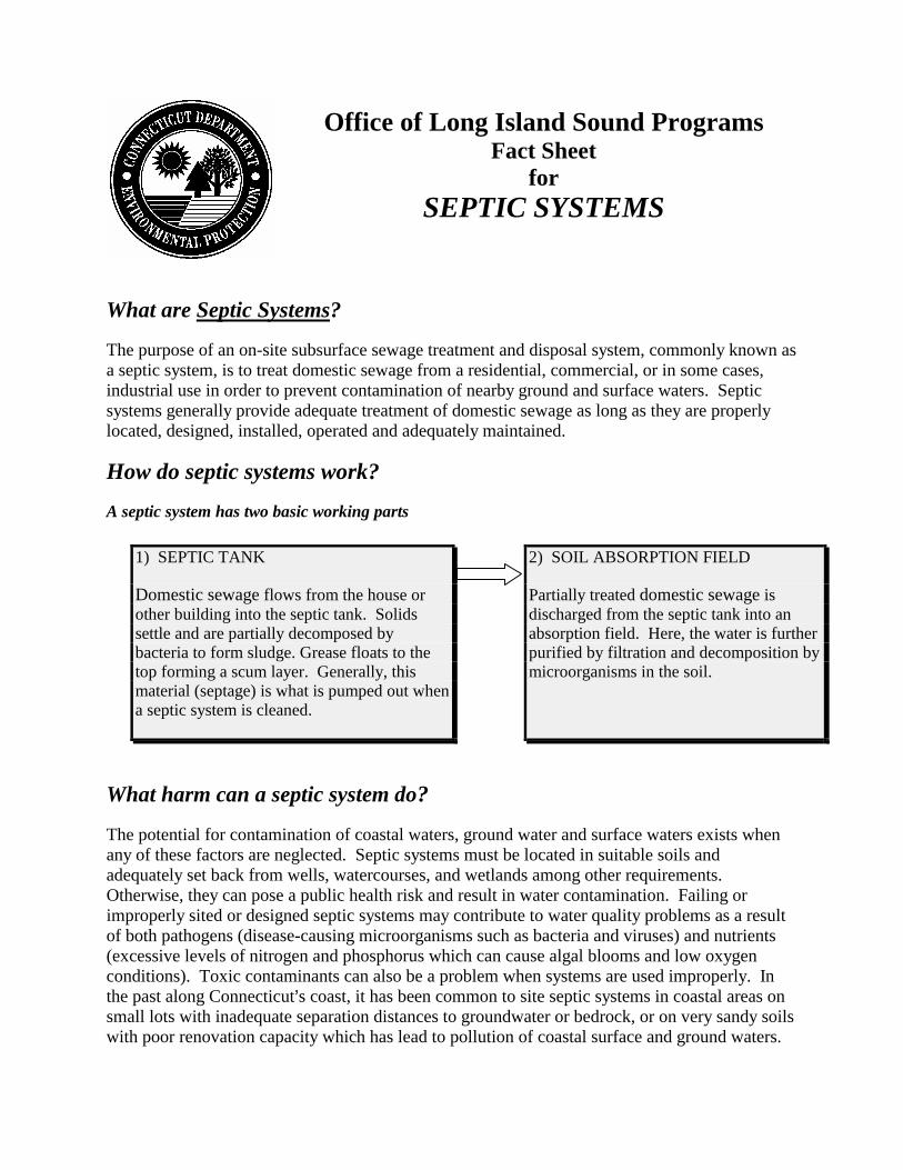
Office of Long Island Sound ProgramsFact Sheet
forSEPTIC SYSTEMS
What are Septic Systems?
The purpose of an on-site subsurface sewage treatment and disposal system, commonly known asa septic system, is to treat domestic sewage from a residential, commercial, or in some cases,industrial use in order to prevent contamination of nearby ground and surface waters. Septicsystems generally provide adequate treatment of domestic sewage as long as they are properlylocated, designed, installed, operated and adequately maintained.
How do septic systems work?
A septic system has two basic working parts
What harm can a septic system do?
The potential for contamination of coastal waters, ground water and surface waters exists whenany of these factors are neglected. Septic systems must be located in suitable soils andadequately set back from wells, watercourses, and wetlands among other requirements.Otherwise, they can pose a public health risk and result in water contamination. Failing orimproperly sited or designed septic systems may contribute to water quality problems as a resultof both pathogens (disease-causing microorganisms such as bacteria and viruses) and nutrients(excessive levels of nitrogen and phosphorus which can cause algal blooms and low oxygenconditions). Toxic contaminants can also be a problem when systems are used improperly. Inthe past along Connecticut�s coast, it has been common to site septic systems in coastal areas onsmall lots with inadequate separation distances to groundwater or bedrock, or on very sandy soilswith poor renovation capacity which has lead to pollution of coastal surface and ground waters.
2) SOIL ABSORPTION FIELD
Partially treated domestic sewage isdischarged from the septic tank into anabsorption field. Here, the water is furtherpurified by filtration and decomposition bymicroorganisms in the soil.
1) SEPTIC TANK
Domestic sewage flows from the house orother building into the septic tank. Solidssettle and are partially decomposed bybacteria to form sludge. Grease floats to thetop forming a scum layer. Generally, thismaterial (septage) is what is pumped out whena septic system is cleaned.
Septic System Fact Sheet Page 2
What can I, as a municipal official, board, commission or resident do topromote wise septic system use?
9 Remember that each new residential or small commercial septic system constructed in thestate must be located, designed, installed and operated in accordance with the ConnecticutPublic Health Code. Municipal directors of health are responsible for ensuring that newsystems meet the health code and its standards.
9 Familiarize yourself with the basic septic system setback requirements (from ledge, watertable, wells, open watercourses) and minimum criteria of the Connecticut Public HealthCode. Ask your health official for information-- if something doesn�t look right to you,ask questions.
9 When reviewing a coastal site plan or zoning proposal, with proposed or modified septicsystems, direct your concerns and questions to your local health official or ConnecticutDepartment of Public Health Services. In addition to the state water quality standards,remember the Connecticut Coastal Management Act has specific criteria that must beconsidered during review of coastal site plan review applications to protect water quality,tidal wetlands, coastal resources and prevent non-point source pollution from septicsystems.
9 Ask that all pertinent septic system information be placed on site plans (septic systemlocation, basis of design, test hole data, percolation rates, etc.).
9 Keep in mind that failing septic systems are also considered a non-point source ofpollution which needs to be addressed under Connecticut�s Coastal Non-Point SourcePollution Control Program.
9 Encourage septic system owners to know the location of their septic systems. Often thelocal health department or septic tank service companies have information regardingspecific systems, or a septic system owner can trace the direction the sewer pipe goesfrom the basement or look for areas where the grass does not grow well, remains greenthroughout the summer when other portions of the lawn browns due to lack of water, orwhere a leach field area may be slightly depressed or raised.
9 Don�t plant trees or shrubs over your septic area.
9 Encourage septic system owners to pump out their septic tanks regularly. Considerpassing a municipal ordinance to require periodic pumping.
9 Develop and distribute fliers around town describing the importance of proper siting, soiltesting and maintenance of septic systems.
9 Protect the absorption field by keeping automobiles and heavy equipment off of them.
9 A septic system does not need to have anything added to it to function properly. Water

Septic System Fact Sheet Page 3
septic system fs.doc revised 9.12.00
softener and conditioner backwash should not be discharged to a septic system.
9 Eliminate the use of garbage disposals and phosphate-based detergents.
9 Don�t put substances such as motor oil, gasoline, paints, thinners and pesticides in drains.While moderate use of household cleaners will do little harm, other substances such asfats, grease, coffee grounds, paper towels, disposable diapers, etc. may clog your system.
9 Keep a maintenance record of your septic system to aid in anticipating when the nextcleaning may be needed.
9 Plant a greenbelt between your absorption field and the shoreline.
9 If you are building a new septic system, construct the system as far away from tidal andinland wetlands and the shoreline as possible.
9 Call your local health official if your system fails. Exercise caution near an opened septictank (it may contain toxic and explosive gases) and fence off the area.
9 Repair and upgrade improperly functioning systems. Retrofit plumbing fixtures with waterconservation units. Fix leaking fixtures. Don’t direct sump pumps or floor drains to septicsystems.
Additional resources and publications
The Connecticut Department of Public Health Services,Capitol Avenue, Hartford860-509-7296Connecticut Public Health CodeDesign of Subsurface Sewage Disposal Systems for Households and Small Commercial
Buildings
The Connecticut Department of Environmental ProtectionMaps and Publications Office, 79 Elm St. Hartford860-424-3555Septic Systems Manual: A Guide to On-Site Subsurface Sewage Disposal for Local Land-Use
OfficialsSeepage and Pollutant Renovation Analysis for Land Treatment, Sewage Disposal SystemsOffice of Long Island Sound Programs- 860-424-3034Coastal Water Quality Protection: A Guide for Local Officials
Office of Long Island Sound ProgramsFact Sheet
forSEWER AND WATER LINES
What are the concerns regarding sewer and water lines in the coastalboundary?
People love to live and play on and near Connecticut’s shore. Many areas along the shore havehistorically been developed within flood prone areas on or near beaches and tidal wetlands. Thepressure continues today to develop any remaining lands. The provision of sewer or water linesto areas previously deemed undevelopable due to the inability to accommodate septic systems orwells, can lead to more people being subject to flood hazards and increase potential adverseimpacts to coastal resources from development. The establishment of new sewer and water linessometimes leads to whole-sale increases in allowable densities or impervious coveragepreviously limited by septic capacity. This overall development pressure can sometimes result inincreased conversions of seasonal cottages to year-round dwellings and impacts to on-site ornearby beaches, dunes, tidal wetlands, and water quality.
What are the statutory policies that apply?
To disapprove extension of sewer and water services into developed and undevelopedbeaches, barrier beaches and tidal wetlands except that, when necessary to abate existingsources of pollution, sewers that will accommodate existing uses with limited excesscapacity may be used [Connecticut General Statutes (CGS) section 22a-92(b)(1)(B)]
To locate and phase sewer and water lines, so as to encourage concentrated developmentin areas which are suitable for development [CGS section 22a-92(b(1)(B)]
Additionally, the Connecticut Coastal Management Act’s (CCMA) planning goal regardingsewer and water line extensions is to encourage development in areas which are suitable andprevent flood-prone and resource intensive areas from becoming developable or developed at ahigher density. It is important to keep in mind that CCMA policies allow extensions only underlimited conditions.1
Under what circumstances can sewer and water lines be extended?
When they are required to abate existing sources of pollution. However, even in such cases, theextension should accommodate only existing uses with limited excess capacity so as to minimizethe potential for additional development in the sensitive resource area and prevent �tie-ins� to thesystem.
Sewer and Water Lines Fact Sheet Page 2
sewer & water fs.doc revised 9.11.00
What can the municipality do to minimize impacts associated with sewerand water line extensions?
Þ Update municipal plan of conservation and development, municipal coastal program, ifapplicable, and zoning and subdivision regulations to establish criteria to identify seweravoidance areas and promote development in appropriate areas outside beaches, barrierbeaches, tidal wetlands, and other flood hazard areas.
Þ Develop and implement a sewer avoidance program.
1 State funds used for sewer and water line extensions generally carry the same limitations on where and under whatcircumstances they can be extended.
Office of Long Island Sound Programs Fact Sheet
forSHORELINE FLOOD & EROSION
CONTROL STRUCTURES
What are Shoreline Flood and Erosion Control Structures?
The Connecticut General Statutes (CGS) defines shoreline flood and erosion control structures as:
any structure the purpose or effect of which is to control flooding or erosion from tidal,coastal or navigable waters and includes breakwaters, bulkheads, groins, jetties,revetments, riprap, seawalls and the placement of concrete, rocks or other significantbarriers to the flow of flood waters or the movement of sediments along the shoreline[CGS section 22a-109(c)].
What are the statutory policies that apply?
To manage coastal bluffs and escarpments so as to preserve their slope and toe [CGS section 22a-92(b)(2)(A)]
To discourage uses which do not permit continued natural rates of erosion [CGS section 22a-92(b)(2)(A)]
To disapprove uses that accelerate slope erosion and alter essential patterns and supply ofsediments to the littoral transport system [CGS section 22a-92(b)(2)(A)]
To preserve the dynamic form and integrity of natural beach systems in order to provide criticalwildlife habitats, a reservoir for sand supply, a buffer for coastal flooding and erosion, andvaluable recreational opportunities [CGS section 22a-92(b)(2)(C)]
To insure that coastal uses are compatible with the capabilities of the beach/dune system and donot unreasonably interfere with natural processes of erosion and sedimentation [CGS section 22a-92(b)(2)(C)]
To promote nonstructural solutions to flood and erosion problems except in those instances wherestructural alternatives prove unavoidable and necessary to protect existing inhabited structures,infrastructural facilities or water-dependent uses [CGS section 22a-92(b)(2)(F)]
To maintain the natural relationship between eroding and depositional coastal landforms [CGSsection 22a-92(b)(2)(J)]
To minimize the adverse impacts of erosion and sedimentation on coastal land uses through thepromotion of nonstructural mitigation measures [CGS section 22a-92(b)(2)(J)]
Structural solutions are permissible when necessary and unavoidable for the protection ofinfrastructural facilities, water-dependent uses, or existing inhabited structures, and where there isno feasible, less environmentally damaging alternative and where all reasonable mitigation
Shoreline Flood and Erosion Control Structures Fact Sheet Page 2
measures and techniques have been provided to minimize adverse environmental impacts [CGSsection 22a-92(b)(2)(J)]
What are the concerns regarding shoreline flood and erosion control structures?
Shoreline flood and erosion control structures are generally proposed for areas such as beaches and bluffs,which can experience erosion in the presence of significant wave action. However, the placement of thesestructures in such sensitive and dynamic areas usually causes adverse impacts to adjacent properties,exacerbates the erosion problem rather that eliminating it, and can cause significant adverse impacts on theresources themselves.
When waves break on a gently sloping sandy beach, their energy is gradually absorbed by the beach. Incontrast, when waves encounter a solid structure, such as a seawall, placed parallel to the shoreline, theirenergy is not absorbed, but rather it is redirected in all directions along the face of the structure. Energydirected downward can cause erosion or scouring of sediments or wetland vegetation at a structure�s base,allowing even greater wave energy to reach the structure because of increased depth of water, eventuallyundermining the structure and causing its collapse. In addition, waves directed upward over the wall oftenseverely damage or destroy the very structure the wall was placed to protect. Further, wave energy focusedby a hardened shoreline can result in faster-than-normal erosion of nearby sediments and vegetation,potentially resulting in the rapid loss of neighboring waterfront property.
Shoreline flood and erosion control structures, such as groins or jetties, placed perpendicular to a beach areintended to interfere with the natural transport of sand along the shoreline. Sand continues to move awayfrom the groin in the downdrift direction but is blocked from passing the groin on the opposite side,resulting in the accretion of sand on one side but also the loss of sand from the opposite side.
In addition, the placement of a flood and erosion control structure in a beach environment eliminates theupland as a source of sediments for beaches in the system and often accelerates erosion due to a lack ofreplacement sediment. This results in a narrowing of the beach since currents continue to transportsediment offshore and along the shore. Further, the structure prevents the beach from migrating landwardas it would naturally tend to do. The combination of structure-induced scour and the cutting off of thesediment supply can cause dramatic changes in beach contour in a relatively short time.
What are the adverse impacts associated with shoreline flood and erosion controlstructures?
The CCMA defines adverse impacts which must be avoided or, if avoidance is not possible, must beminimized in order for a project to be lawfully approvable. From a resource perspective, shoreline floodand erosion control structures can have the following adverse impacts on valuable features and functions ofshoreline areas and coastal resources:
- eliminate natural buffer for coastal floodingand erosion
- alter natural rates of erosion andsedimentation
- interrupt sand supply
- reduce valuable recreational opportunities
- destroy critical wildlife habitats
- detract from the visual quality of a naturalshoreline
Any proposals for such structures must be carefully evaluated, and non-structural erosion controlalternatives such as vegetative stabilization to stop or slow down any erosion and/or flooding problems
Shoreline Flood and Erosion Control Structures Fact Sheet Page 3
should be promoted. (For more information, please see the Fact Sheet for Adverse Impacts.)
When are shoreline flood and erosion control structures generally consistent withthe Connecticut Coastal Management Act?
The Connecticut Coastal Management Act (CCMA) contains strong policies that discourage the placementof shoreline flood and erosion control structures except in those limited instances where they are deemednecessary and unavoidable to protect the following:
- water-dependent uses as defined in CGS section 22a-93(16);
- infrastructural facilities (e.g., roads and sewer and water lines); and
- inhabited structures built prior to implementation of the CCMA (January 1, 1980).
However, there must be a clear and compelling demonstration that there is a threat from erosion and thatnonstructural erosion controls are not viable alternatives. Nonstructural approaches include relocation andelevation of at-risk buildings, vegetative stabilization with native plantings, dune creation or enhancement,and temporary placement of sandbags.
Protective structures are not allowed for newer residential structures because any residential structure builtafter the effective date of the CCMA and in compliance with its goals and policies should have beenplaced sufficient distances from coastal waters, thereby obviating the need for shoreline flood and erosioncontrol structures.
What are the requirements for action on a shoreline flood and erosion controlcoastal site plan application?
, A copy of each coastal site plan submitted for any shoreline flood and erosion control structure(including those proposed as a component of a larger development project) must be referred tothe DEP within 15 days of its receipt by the zoning commission. [CGS section 22a-109(d)]
, The DEP may comment on such plans; any comments must be submitted to the zoningcommission within 35 days of its receipt at the DEP. [CGS section 22a-109(d)]
, The zoning commission must consider any DEP comments prior to final action on the application. [CGS section 22a-109(d)]
, If the DEP does not comment within the 35-day time frame or any extension granted by the zoningcommission, the commission may take final action. [CGS section 22a-109(d)]
, The commission may hold a hearing on a shoreline flood and erosion control structure, and musthold a hearing upon the request of the commissioner of environmental protection. [CGS section22a-109(e)]
A copy of any decision on a coastal site plan for a shoreline flood and erosion control structure shall besent to the commissioner of environmental protection within 15 days after such decision is rendered. [CGSsection 22a-109(f)]
Does the DEP regulate shoreline flood and erosion control structures?
Shoreline Flood and Erosion Control Structures Fact Sheet Page 4
flood & erosion control fs.doc revised 9.7.00
Maybe, depending on the specifics of proposed activities. The Department of Environmental Protection(DEP) has direct regulatory jurisdiction over activities occurring in tidal wetlands and/or waterward of thehigh tide line. If any construction activities or structure(s), in part or in whole, or any incidental workproposed in conjunction with the construction of structure(s) is proposed at or waterward of the high tideline or in tidal wetlands, authorization from the DEP’s Office of Long Island Sound Programs would berequired prior to construction in accordance with the Tidal Wetlands Act (CGS sections 22a-28 through22a-35) and/or the statutes governing the placement of structures, dredging, and fill in tidal, coastal ornavigable waters (CGS sections 22a-359 through 22a-363f, inclusive).
What’s the difference between DEP and municipal regulatory areas?
The DEP has direct regulatory jurisdiction over activities occurring in tidal wetlands and/or waterward ofthe high tide line. The municipality regulates the upland waterward to the mean high water mark. Ingeneral, the mean high water mark is lower than the high tide line. Therefore, on gently sloping shorelines,there will be an area of overlapping jurisdictions (because the high tide line will be further landward thanmean high water). Along steep shorefronts, for instance along a seawall, the high tide line and mean highwater mark may be closely aligned, or may even coincide in the same vertical plane. The area ofoverlapping jurisdictions will be minimal in that case. Regardless of whether the DEP and/or themunicipality have jurisdiction, the statutory policies and standards apply equally to both jurisdictions (see,also, the fact sheet for State and Municipal Regulatory Jurisdictions).
Office of Long Island Sound ProgramsFact Sheet
forSTORMWATER MANAGEMENT
What is Stormwater Management?
Stormwater management is a comprehensive process to minimize potential adverse impacts tonatural resources and water quality from stormwater runoff. The traditional approach to handlingstormwater runoff has been to collect it from the developed area and shunt it as quickly aspossible to the nearest water body to prevent flooding in upland areas. In the past, little attentionhad been paid to the impacts of the associated increases in both the volumes and rates dischargedand the pollutants carried in the runoff. The result has been severe erosion of streams, the lossand degradation of habitat, increased flooding and associated damage, increased siltationresulting in more frequent dredging to maintain navigation, and tremendous capital expendituresto address these problems.
Proper state-of-the-art stormwater management involves many techniques including pollutionprevention, minimization of impervious surfaces, on-site retention of a portion of the runoff,where appropriate, and treatment of non-retained runoff to remove contaminants such as oils,greases, suspended solids and floatable debris. One general goal is to design development insuch a manner that the changes in runoff rates and volumes are minimized. This is initiallyaccomplished through the proper siting and design of proposed structures and infrastructure.
Why is stormwater management important?
Pollution of our surface and ground waters has been a recognized problem for many years. While great strides have been made in controlling point sources of pollution, primarily throughthe National Pollution Discharge Elimination System (NPDES) permitting program andcorresponding state regulatory programs, there is a new awareness of the importance ofcontrolling nonpoint sources of pollution (pollution generated by many diffuse sources). Stormwater runoff is a major contributor of nonpoint source pollution.
The amount of stormwater runoff from a given site is dictated by site-specific conditions, such asthe soil�s infiltration capacity, the type and extent of site cover (e.g., vegetation or pavement), theslope, and the duration and intensity of each rainfall event. Stormwater that penetrates the soil isslowed, filtered, cooled, and renovated. Renovation is a process by which bacteria and mineralsin the soil treat and bind contaminants, removing them from the stormwater.
Impervious surfaces, such as pavement and buildings, reduce the area of soil into which rainfallcan infiltrate, thus increasing the volume of runoff that flows over the land. As this runoff flowsover impervious and pervious surfaces, it can pick up and transport floating, suspended, and
Stormwater Management Fact Sheet Page 2
dissolved constituents such as pathogens, toxic materials (heavy metals, oils, antifreeze,pesticides, etc.), high levels of nutrients (fertilizers and organic matter), eroded sediments(topsoil and road sand), and trash. This runoff flows down gradient over the land to the nearestwater body or depression where it not only deposits the contaminants it carries, but it alters thetemperature, pH, and/or salinity of receiving waters. It should be noted that even clean, potablefreshwater can be a pollutant when introduced to a brackish or saline environment in the coastalarea. Freshwater dilutes the salt concentrations in the receiving area, adversely impacting theflora and fauna that are uniquely suited to such salty environs. Over the long-term, sedimentsettles out of the water column and can degrade habitat in stream bottoms, tidal wetlands, andshellfish beds.
Poorly planned new development and redevelopment can result in increased stormwaterdischarges, and ultimately more polluted runoff reaching watercourses and wetlands. Unlikeconditions in the soil, there are few natural processes available in the receiving waters to treat,reduce, or control many of the harmful constituents in the runoff; they can only be diluted by thevolume of water that they reach. With constant inputs after each rainfall, concentrations of manyharmful constituents have been increasing in the sediments and the water column. Additionally,increasing stormwater discharges can lead to increased risks of flooding and flood damage and toincreased siltation in coastal waters which often results in habitat degradation and an increasedneed to dredge to maintain navigation.
Design issues relate to the topography, soil conditions, existing drainage, and natural resourceson and adjacent to the site. The implementation of structural and/or non-structural bestmanagement practices (BMPs) can also be used to provide both effective erosion andsedimentation control and minimization of other pollutants including oils, greases, toxics,pathogens and floatable debris. Please refer to the manual titled Coastal Water Protection: AGuide for Local Officials, (DEP, 1996) for additional detailed information. A copy of the guidehas been provided to the planning and zoning department in each coastal municipality.
What are the statutory policies that apply?
The Connecticut Coastal Management Act (CCMA) contains several policies that highlight theneed to incorporate stormwater management into individual project reviews and long-rangeplanning. These include the following:
To manage estuarine embayments so as to insure that coastal uses proceed in a mannerthat assures sustained biological productivity, the maintenance of healthy marinepopulations and the maintenance of essential patterns of circulation, drainage and basinconfiguration; to protect, enhance and allow natural restoration of eelgrass flats except inspecial limited cases, notably shellfish management, where the benefits accrued throughalteration of the flat may outweigh the long-term benefits to marine biota, waterfowl, andcommercial and recreational finfisheries [Connecticut General Statutes (CGS) section22a-92(c)(2)(A)].
It is found and declared that the pollution of the waters of the state is inimical to thepublic health, safety and welfare of the inhabitants of the state, is a public nuisance and is
Stormwater Management Fact Sheet Page 3
harmful to wildlife, fish and aquatic life and impairs domestic, agricultural, industrial,recreational and other legitimate beneficial uses of water and that the use of public fundsand the granting of tax exemptions for the purpose of controlling and eliminating suchpollution is a public use and purpose for which moneys may be expended and taxexemptions granted, and the necessity and public interest for the enactment of this chapterand the elimination of pollution is hereby declared as a matter of legislative determination[CGS section 22a-422, as referenced by CGS section 22a-92(a)(2)].
The CCMA defines adverse impacts which must be avoided or, if avoidance is not possible, mustbe minimized in order for a project to be lawfully approvable. The following potential adverseimpacts must be considered during the coastal site plan review process and when evaluatingproposed zoning regulation and map amendments.
Degrading water quality through the significant introduction into either coastal waters orground water supplies of suspended solids, nutrients, toxics, heavy metals, or pathogens,or through the significant alteration of temperature, pH, dissolved oxygen, or salinity[CGS section 22a-93(15)(A)];
Degrading existing circulation patterns of coastal waters through the significant patternsof tidal exchange or flushing rates, freshwater input, or existing basin characteristics andchannel contours [CGS section 22a-93(15)(B)];
Degrading natural or existing drainage patterns through the significant alteration ofgroundwater flow and recharge and volume of runoff [CGS section 22a-93(15)(D)];
Degrading or destroying essential wildlife, finfish or shellfish habitat through significantalteration of the composition, migration patterns, distribution, breeding or otherpopulation characteristics of the natural species or significant alteration of the naturalcomponents of the habitat [CGS section 22a-93(15)(G)]; and
Degrading tidal wetlands, beaches and dunes, rocky shorefronts, and bluffs andescarpments through significant alteration of their natural characteristics and functions[CGS section 22a-93(15)(H)].
In addition, the state statutes pertaining to planning and zoning contain specific requirements forzoning regulations and plans of development that relate to the restoration and protection ofcoastal resources. These are:
In any municipality that is contiguous to Long Island Sound the regulations adopted underthis section shall be made with reasonable consideration for restoration and protection ofthe ecosystem and habitat of Long Island Sound and shall be designed to reduce hypoxia,pathogens, toxic contaminants and floatable debris in Long Island Sound. Suchregulations shall provide that the commission consider the environmental impact on LongIsland Sound of any proposal for development [CGS section 8-2(b)].
The plan adopted under this section for any municipality that is contiguous to Long IslandSound shall be made with reasonable consideration for restoration and protection of the

Stormwater Management Fact Sheet Page 4
ecosystem and habitat of Long Island Sound and shall be designed to reduce hypoxia,pathogens, toxic contaminants and floatable debris in Long Island Sound [excerpt fromCGS section 8-23].
Proper management of stormwater will address these statutory requirements.
Are stormwater discharges regulated by the Department of EnvironmentalProtection?
Yes. Technically, most discharges to the waters of the State Of Connecticut are regulated by theDepartment of Environmental Protection through either a general permit or individual permitrequirement. There are several types of stormwater discharges that are covered by the issuanceof a general permit. If the stormwater discharge does not qualify for coverage by the generalpermit because adverse impacts to the waters of the state would result, an individual permit maybe required prior to discharge.
Registration is required to be submitted in order for stormwater discharges to be authorized bythe following general permits issued by the Connecticut Department of EnvironmentalProtection:
Stormwater and Dewatering Wastewaters from Construction Activities: This generalpermit applies to all discharges of stormwater and dewatering wastewaters fromconstruction activities which include, but are not limited to, clearing, grading, andexcavation and which result in the disturbance of five or more acres of total land area ona site.
Stormwater Associated with Commercial Activities: This general permit applies to alldischarges from any conveyance which is used for collecting and conveying stormwaterand which is directly related to retail, commercial, and/or office services whose facilitiesoccupy five acres or more of contiguous impervious surface.
Stormwater Associated with Industrial Activities: This general permit applies to alldischarges from any conveyance which is used for collecting and conveying stormwaterand which is directly related to manufacturing, processing or material storage areas at anindustrial activity site.
What can a municipality do to minimize impacts from stormwater runoff?
� Maintain, enhance or restore the quality of coastal waters and submerged lands through theadoption and implementation of a stormwater management ordinance, either as anamendment to the municipal zoning regulations or as a “stand-alone” ordinance. In eithercase, it should require 1) that new development projects be designed to minimize clearing,cutting and filling in undisturbed areas to ensure that new development is consistent with thecapabilities of the land to support such development; 2) soil erosion and sediment controlplans for all development projects near sensitive coastal resources, even those projects withless than one-half acre land disturbance proposed, and strictly enforce appropriate
Stormwater Management Fact Sheet Page 5
sedimentation and erosion control measures during construction; and 3) that site plan andspecial permit/exception applications include appropriate best management practices toretain and treat on-site the runoff generated by the first inch of rainfall, remove 80% of thetotal suspended solids on an annual basis, and, where site conditions allow, prohibit post-development increases in the pre-development rates and volumes of stormwater discharge.
� Review zoning regulations to determine the maximum impervious cover allowed in eachdistrict and carefully consider reducing these maximums wherever possible, particularly inareas abutting coastal waters and other sensitive coastal resources, but also for areas servicedby municipal stormwater systems that discharge to coastal waters. Include buildings, pavedareas, sidewalks, terraces, patios and other non-porous surfaces when calculating imperviouscover.
� Update subdivision regulations to encourage cluster developments that incorporate featuressuch as curbless roads, narrow roads, grass swales, retention ponds, and other features thatreduce impervious cover, disperse and treat stormwater, and minimize the collection andtransport of stormwater to surface waters.
� Update the municipality�s Plan of Conservation and Development and Municipal CoastalProgram, if applicable, to encourage best management practices for stormwater for all newor substantially improved development, including improvements to municipal roads, bridgesand other facilities, and for currently developed areas. Consider including the following:
An inventory of existing storm drain outfalls to identify opportunities to retrofit roadsand other municipal facilities for stormwater retention and pollutant reduction;
Identification of illicit connections to municipal storm sewer system (anything thatis not stormwater that is being discharged to the stormwater system without apermit) and recommendations to correct or mitigate adverse impacts associatedwith these connections;
Adoption of a municipal ordinance that prohibits illicit connections to municipalstormwater systems;
Consideration of (and preparation for) the use of alternatives to winter sandingand salting on roadways and parking areas;
Planning for and implementation of appropriate snow disposal practices;
Initiation of a storm drain stenciling program to help identify direct links to coastalwaters and other waterbodies;
Adoption of an ordinance that limits the application of fertilizers and broad-basedpesticides, particularly in months with historically high or low averageprecipitation such as April and August; and
Stormwater Management Fact Sheet Page 6
stormwater mgt fs.doc revised 9.12.00
Recommendations for regularly scheduled street sweeping and catch basin clean-outs to minimize the amount of sediment, contaminants, and floatable debrisentering coastal waters and other waterbodies through the municipal stormwatermanagement system, and recommendations to amend the zoning regulations torequire similar maintenance of private parking lots and streets.
� Develop a watershed management plan with neighboring municipalities that share yourwatershed boundaries, and implement a coordinated stormwater management plan.
� Develop an educational handout that: addresses the importance of stormwater management;identifies actions that individuals can take to minimize potential stormwater impacts(including, for example, the proper use of fertilizer, disposal of used motor oil andcomposting of lawn clippings, etc.); and includes the municipality’s standards fordevelopment. Include it in every application package for land use and/or building permitsand authorization.
� Develop an open space/greenways plan to create recreational opportunities and buffersensitive and important resources, particularly streams, tributaries, and coastal resourcesfrom stormwater impacts.
� During the review process for new or redeveloping marinas, require coastal site planconditions that incorporate the practices identified in Best Management Practices forCoastal Marinas (DEP-OLISP, August 1992).
� Coordinate with the Department of Environmental Protection’s Stormwater ManagementUnit to make sure that all eligible stormwater discharges from industrial, commercial, orconstruction activities are covered by the appropriate general permit and to ensurecompliance with Stormwater Pollution Prevention Plans.
� Refer coastal site plan review applications for waterfront sites or significant developmentproposals within the coastal boundary to the DEP’s Office of Long Island SoundPrograms for comment and technical assistance.
Office of Long Island Sound ProgramsFact Sheet
forVEGETATED BUFFERS
What is a Vegetated Buffer?
A vegetated buffer is a small area or strip of land in permanent undisturbed vegetation adjacentto a waterbody or other resource (e.g., wetland). It can be either in a natural state or artificiallyplanted. Depending upon their purpose and site-specific conditions, vegetated buffers can rangein size from several feet to hundreds of yards wide.
Why are they valuable?
Buffers protect resources from adjacent development by reducing the adverse effects of humanactivities on natural resources including wetlands and surface waters. They protect water qualityand temperature, control erosion and trap sediment, protect and provide wildlife habitat, reducethe effects of flooding, reduce the potential for direct human disturbance of sensitive resources,and maintain aesthetic diversity and recreational value. A buffer provides a mosaic ofinterdependent functions. Installation of a buffer area can also lessen lawn maintenancerequirements by reducing the area of manicured landscape.
How do they work?
Buffer areas work through several means. Land within buffer areas is not developed and,therefore, generally does not generate pollution. Vegetated buffer strips act as filters to interceptand absorb nutrients, sediment and other pollutants carried in stormwater run-off. Buffers slowdown runoff which both reduces erosion and allows silt and other suspended solids to settle outbefore they reach a receiving waterbody or wetlands. Additionally, any contaminants attached tothe sediment do not reach the waterbody or wetlands. Vegetated buffers provide an area forinfiltration, thereby reducing the volume of runoff. Bacteria, pathogens and pesticides that aretrapped within the buffer area decompose or are broken down, thus, preserving water quality.
Creating vegetated buffers
Where do we use vegetated buffers?
Vegetated buffers should be located between upland development and adjacent waterbodies orresources. Some water-dependent uses or water-dependent components of projects will likelyrequire development within a buffer area, but water-dependent uses and vegetated buffers are notnecessarily mutually exclusive.
Vegetated Buffers Fact Sheet Page 2
How big is big enough?
The size of an effective buffer can be anywhere from a small unmown area of a lot to a largeforested strip. The ideal buffer width will depend on the desired emphasis (water qualityprotection, wildlife habitat, temperature moderation, erosion control, etc.), the amount ofavailable land, and the proposed use of the property. Generally, the effectiveness of a bufferincreases with its size. Large buffers (e.g., 100 feet or greater in width) provide the bestprotection for water quality by buffering temperature changes and improving control of erosion,sedimentation and pollution. However, even a narrow buffer (15 to 30 feet in width) can beeffective under certain conditions.
What determines the effectiveness of a buffer area as a stormwatermanagement measure?
� The type of stormwater flow. Sheet flow (unrestricted flow across the ground)along the length of the buffer allows the buffer area to more effectively trapsediments, attenuate pathogens and pollutants, and encourage infiltration. Concentrated flow (e.g., flows directed through swales, pipes or other conveyances)reduce or essentially eliminate the effectiveness of the buffer for stormwatermanagement.
� The general topography of the buffer area. Flat or gently sloping buffers are moreeffective because they slow the rate that stormwater flows across them whichenhances their infiltration and filtering capability.
� The permeability of the soils and the depth to the water table. Generally, higherpermeability and greater depth to the water table will increase the rate of infiltrationand attenuation within the buffer area.
� Whether the current vegetation is native or non-native, its density and its character(e.g., forested, shrubby, grassland, etc.). Dense native vegetation is generally moreeffective and requires less maintenance as it is inherently suited to the local climate.
� Whether the land use above the buffer poses a high, medium or low risk forpollution. The higher the risk posed by the upland use, the greater the need for aneffective buffer. Increasing the width of a required buffer and/or increasing thedensity of native plantings can aid in offsetting the potential impacts from a high-risk upland use.
� Whether there is an existing buffer, and if so, whether its width is sufficient toprovide habitat and corridors for wildlife, erosion and sedimentation control, waterquality protection or other benefits of vegetated buffers. If an existing buffer ofadequate width is present on a lot, all efforts should be made to preserve it in itsnatural state.
� What types of activities are permitted within the buffer. The fewer activities thatinclude land clearing, grading or other disturbances, the better. However, in manyinstances, passive recreational amenities, such as hiking trails, may be appropriate.
Vegetated Buffers Fact Sheet Page 3
vegetated buffers fs.doc revised 9.7.00
In general terms, what does the ultimate vegetated buffer look like?
The answer will depend on what you want the buffer to do (and it can't do it all). However, ingeneral terms, the ultimate vegetated buffer has gentle slopes, with undisturbed, moderatelypermeable soils and dense native vegetation, and is as wide as possible given the lot size, siteconditions and proposed use(s).
How can a municipality implement vegetated buffers?
9 Update zoning regulations to better protect sensitive resources by establishing orincreasing protective buffers between development and coastal waters andassociated sensitive resources. These buffers should be required landward of theupland limit of tidal wetlands, beaches and dunes, and coastal and inland watersand from the tops of bluffs and escarpments.
9 Once buffers are established by regulation, they should be strictly honored. Variances of the minimum buffer width should only be allowed in those extremelylimited cases where there is a statutory hardship as defined in the ConnecticutGeneral Statutes Section 8-6(3) or to provide water-dependent use opportunitieswhere appropriate.
9 Revise subdivision regulations to require vegetated buffers abutting all waterresources in new subdivisions.
9 Revise zoning and subdivision regulations to limit clearing of vegetation to enhanceviews and to prohibit clearing or cutting on or above bluffs and escarpments.
9 Update inland wetlands regulations to require larger buffers for all regulatedactivities adjacent to wetlands, including vernal pools and watercourses.
Office of Long Island Sound ProgramsFact Sheet
forWATER-DEPENDENT USES
What are Water-Dependent Uses?
Water-Dependent Uses are specifically defined in the Connecticut Coastal Management Act(CCMA). In general, they are land uses that require direct access to coastal waters in order tofunction and which therefore must be located at the waterfront rather than on inland sites. Suchuses include, but are not limited to marinas, commercial fishing or boating facilities and uses thatprovide general public access to coastal waters [Connecticut General Statutes (CGS) section 22a-93(16)].
Why is it important to make special provisions for them?
Locating water-dependent uses at waterfront sites is important because:
� waterfront properties are an extremely limited resource with the uniquecapacity to accommodate water-dependent uses, which, by statutory definitionrequire waterfront sites. However, waterfront properties are also in greatdemand for many non-water-dependent uses which can be located inland;
� they are a significant part of our cultural heritage;
� they are an important sector of our state’s economy; and
� they often depend upon or are enhanced by high quality waters therebycreating a constituency for water quality and coastal resource protection.
What are the statutory policies that apply?
To manage uses in the coastal boundary through existing municipal planning,zoning and other local regulatory authorities, giving highest priority andpreference to water-dependent uses and facilities in shorefront areas [CGS section22a-92(b)(1)(A)].
Municipal boards and commissions reviewing coastal site plans shall determine ifthe potential adverse impacts to future water-dependent development activities areacceptable and that such impacts have been mitigated using all reasonablemitigation methods [CGS sections 22a-106(a) and (e)].
Water-dependent Use Fact Sheet Page 2
Evaluating adverse impacts to future water-dependent developmentopportunities:
When a non-water-dependent use is proposed on a waterfront site, the reviewing board orcommission must determine the acceptability of potential adverse impacts to possible futurewater-dependent development activities associated with the proposed development. While doingthis evaluation, the following factors, which define adverse impacts to future water-dependentdevelopment activities, must be considered [see CGS section 22a-93(17)]:
(1) Is site physically suited for a water-dependent use for which there is reasonable demand,or has the site been identified in the plan of development or zoning regulations for water-dependent uses?
(2) Will a non-water-dependent use replace an existing water-dependent use as part of theproposed development or redevelopment?
(3) Will a non-water-dependent use inhibit or restrict existing public access�?
If any of the above three conditions apply, the proposed non-water-dependent use may preclude existingor future water-dependent uses and create unacceptable adverse impacts. Upon such a determination, theproposed use should be modified or conditioned if such impacts can be mitigated to a level which isconsistent with applicable goals and policies of the Act or, if modification cannot achieve consistency,the project should be denied. Adverse impacts may be mitigated by providing coastal public access (seefact sheet for General Public Access to Coastal Waters for additional details).
What can a municipality do to promote water-dependent uses and minimizepotential adverse impacts to such uses?
ù Amend the Plan of Conservation and Development to: (1) identify areas whereactive (e.g., port facilities) and passive (e.g., coastal public access) water-dependentuses are appropriate or most needed and (2) require adequate and appropriaterelocation of existing water-dependent uses if proposed redevelopment ofwaterfront sites cannot be configured to retain such uses. Please note that in asituation such as this, the redevelopment plan must provide a comparable level ofwater-dependent use in order to minimize adverse impacts to future water-dependent development opportunities as required by the CCMA (see above).
ù Amend the zoning regulations to provide specific municipal authority to requirewater-dependent uses including coastal public access through the coastal site planreview process, as already provided in the Coastal Management Act.
ù Amend the zoning regulations to establish separate zoning districts for shorefrontareas currently used for water-dependent uses, as allowed in CGS section 8-3(k), to
� Existing public access can be either formal access secured by public land ownership or an access easement or informal accessresulting from long-term open customary use of the property to access coastal waters.
Water-dependent Use Fact Sheet Page 3
water-dependent use fs.doc revised 9.12.00
promote the continuance of such uses without being subject to challenges of “spotzoning.”
ù Amend zoning regulations in appropriate waterfront zoning districts to ensure that“active” water-dependent uses (e.g., marinas) are allowed as-of-right. If non-water-dependent uses are allowed in such zoning districts, they should only be permitted:(1) on sites where on-site coastal resource constraints preclude the establishment ofactive water-dependent uses and, in these cases, proposed development shouldinclude meaningful general public access as the water-dependent projectcomponent; or (2) the non-water-dependent use is clearly ancillary to or supports awater-dependent use and does not diminish it in any way. Alternatively, themunicipal zoning regulations could be amended to allow only active water-dependent uses.
ù Direct waterfront project applicants and town staff to meet prior to formalsubmission of coastal site plan review applications in order to review the CCMA’swater-dependent use requirements. The purpose of such meeting(s) should be to: 1) evaluate the site's suitability to support water-dependent uses; 2) assess the levelof water-dependency proposed in the development/redevelopment plans; and, 3)explore how any proposed non-water-dependent use of a waterfront site could bemodified to incorporate appropriate water-dependent use components. Where otherwater-dependent uses are not feasible due to site constraints, often a water-dependent use can be incorporated into the site design through the provision of ageneral public coastal access facility which could render the proposal consistentwith the CCMA policies and standards (see fact sheet for General Public Access toCoastal Waters).
ù Require applicants to post performance bonds or escrow accounts to ensure thatwater-dependent use project components are constructed, as authorized by CGSsection 22a-107.
CONNECTICUT COASTAL MANAGEMENT MANUAL SECTION 4 SITE PLAN EXAMPLES Section 4 contains examples of site plans for the following types of coastal development activities: Site Plan #1 - Single Family Site Plan #2 - Multi-family Site Plan #3 - Subdivision Site Plan #4 - Commercial Each plan is accompanied by descriptions and an analysis of coastal site plan deficiencies and coastal management issues specific to that plan, and a discussion of potential solutions to those problems.
Site Plan # 1 Residential Development
Coastal Site Plan Deficiencies 1) Tidal datums (i.e., mean high water and high tide line) and vertical datum (NGVD 1929) not shown. 2) Extent of beach resource not fully depicted. 3) No S&E controls. 4) Drainage not shown. Coastal Management Issues 1) Proposal of shoreline flood and erosion control structure requires mandatory referral to OLISP in
accordance with section 109d of the CCMA. 2) Seawall may be located on the beach. 3) Proposed dwelling in the V-Zone 4) Potential adverse impacts to coastal water quality - no stormwater best management practices (BMPs)
proposed. 5) State coastal permits required for fill/stormwater discharge structures in tidal wetlands or areas below
the high tide line. Analysis The site contains significant topographic relief. With only 10' contours shown, it is difficult to determine specifically where the steep slopes on the property are. The proposal meets the town’s building setback regulation and, since the portion of the dwelling located in the V-Zone is pile supported, it meets FEMA construction standards. However, the proposal is inconsistent with CCMA policies. First, proposed residential development in the V-Zone, even if it can be constructed to meet FEMA standards, should be located outside the V-Zone where possible to minimize hazards to life and property. In this case, the entire structure could not only be located outside the V-Zone, but landward of the A-Zone as well. Keep in mind that the flood zone boundary lines are not exact and given the scale (1" = 500') of the Flood Insurance Rate Maps (FIRMs), it is prudent to err on the side of caution (i.e. locate structures as far landward as possible). Additionally, the boundary lines on the FIRM maps are not drawn for specific properties, but for longer stretches along the coast. Thus, there are inherent inaccuracies built into the maps when they are applied to a particular parcel. The proposal is also inconsistent with the CCMA’s policy regarding shoreline flood and erosion control structures. Structural solutions are not allowed in this case since the house could be relocated such that no shoreline protection would be required during the expected useful life of the house. For more detailed information, please see the fact sheet for Shoreline Flood and Erosion Control Structures. From a coastal permitting perspective, an application to construct the seawall as proposed including fill waterward of the high tide line could not be approved. Potential Solutions In this example, the modifications required to render the site plan consistent with CCMA policies
would drastically change the site plan. So much so that there would be no alternative but to deny the application without prejudice.
The board/commission should clearly document the inconsistencies in its written finding.
In making a subsequent proposal, the applicant should be informed that the residence should be
located outside of the flood hazard area. In this case, that could be landward of elevation 14', even though the transposed A-Zone boundary crosses the 20' contour. Additionally, the applicant should be made aware that no shoreline flood and erosion control structures could be permitted now or in the future to protect the dwelling. Thus, the need to relocate the house as stated becomes evident.
Due to the significant topographic relief on the property, appropriate and specific S&E controls
should be shown on the plans. Stormwater BMPs should be shown on the plans. Potential solutions could include the use of
depression storage, infiltration swales, vegetated buffers, and overland flow (runon). Structural measures such as catch basins and drywells should be avoided if possible.
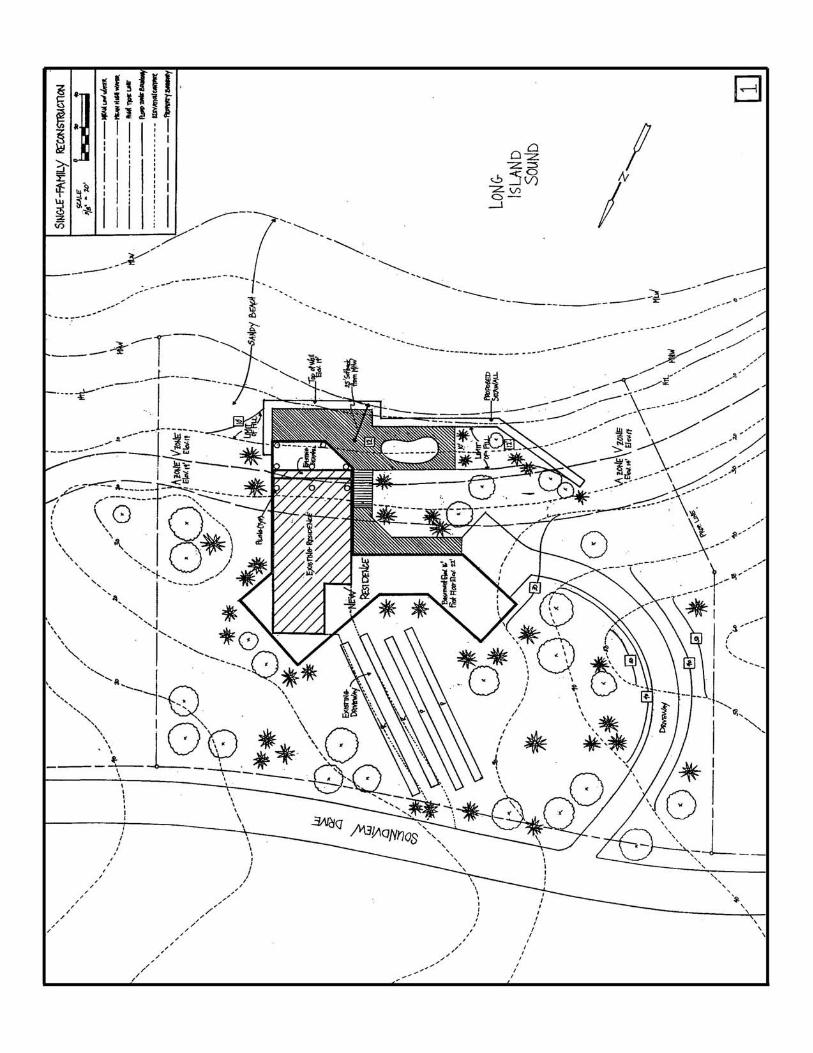
Site Plan #2 Multi-Family Development
Coastal Site Plan Deficiencies 1) No vertical datum shown (plans should reference NGVD of 1929). This is particularly important in
evaluating the accuracy of tidal datums (e.g., mean high water). 2) Accuracy of high tide line (HTL) is questionable. HTL is shown on plan at the same elevation as the
tidal wetland boundary. Typically, the HTL is upland of the tidal wetland boundary. 3) Flood hazard area elevations are not shown. 4) The upland extent of the A zone not indicated on the plan. 5) Incomplete labeling of coastal resources at or adjacent to the site (e.g., intertidal flats?). Coastal Management Issues 1) No water-dependent use of a waterfront site proposed (boat slips are accessory to a non-water-
dependent use/boardwalk not available for public use). 2) Intense residential development in flood hazard V-zone 3) Flood and erosion control structure (i.e., seawall) extends onto dune/beach (such structures require
mandatory referral to OLISP) would replace existing dune which provides a non-structural flood and erosion control and potential plant and wildlife habitat.
4) Protection of tidal wetlands and beach/dune system 5) Structural stormwater management system proposed which does not include any stormwater quality
renovation measures. Includes direct discharge of stormwater to tidal wetlands without prior treatment.
6) Structures (walkway/gazebo) proposed in tidal wetlands require permit from OLISP. Analysis There are no water-dependent uses proposed for this waterfront site. Developable waterfront property, particularly property that can support an active water-dependent use, such as a boat basin, is extremely rare and valuable in Connecticut. Many former water-dependent uses such as marinas, boat yards, and boat building operations have been replaced with office, residential, and other uses that need not be located along the water’s edge. Because the proposed private boat slips and private boardwalk demonstrate that the site is capable of supporting water-dependent uses, the coastal site plan must be modified to incorporate some type of water-dependent use in order to ensure that future water-dependent use opportunities at the site are not lost. In this case, the zoning district may allow for residential use. If there is no requirement under the existing zoning to require an active water-dependent use (e.g., marina), the commission should require that general public access, commensurate with the size of the site, be incorporated into the site design. While offering waterfront residential dwellings as close to the water as possible is an attractive prospect to developers, such a design often creates a myriad of coastal resource management concerns including: (1) proposals for future filling of coastal waters to construct flood and erosion control structures (e.g., seawalls) to protect new construction; (2) increased likelihood of future unpermitted or illegal filling of coastal waters/tidal wetlands; (3) loss of coastal public access; (4) estuarine habitat encroachment/disturbance; (5) increased flood hazards; and (6) loss of riparian buffers.
Potential Solutions The proposed development must be significantly modified to address the above-reference coastal
management concerns, as described below: The proposed extension of the seawall into the dune should be eliminated. If the applicant is
concerned about future flood and erosion in this area of the site, the dune could be modified/expanded with snow fencing and native beach grass plantings to enhance the dune’s flood and erosion control properties.
The residential units and boardwalk should be relocated towards the road out of the V-zone and dune.
Such a redesign would decrease future potential hazards to life and property from flooding and erosion, relocate the open space adjacent to the water for use by the general public to access coastal waters and preserve riparian habitat. Coastal public access areas should always be carefully designed and include appropriate amenities to provide attractive and usable public facilities. It’s also important to ensure that coastal public access is ensured though a duly executed and legally binding access easement.
Stormwater should be retained and treated on-site to the maximum extent practicable using
appropriate best management practices. The open space areas and parking lot islands could potentially used as areas for retention basins or swales. Retention of the first inch of runoff onsite, if feasible, would reduce discharges of fresh water to tidal wetlands and minimize pollutant loadings to tidal wetlands and coastal waters.
Proposed structures should be set back from both the tidal wetlands and the dune formations. Buffers
between these resources will allow them to grow/migrate, protect them from potential adverse impacts of human activities, and reduce impacts to the wildlife that depend upon these resources for one or more parts of their life cycle.
Because of the extent of modifications necessary to render this proposed residential development consistent with the goals and polices of the Connecticut Coastal Management Act, the proposal should be denied.
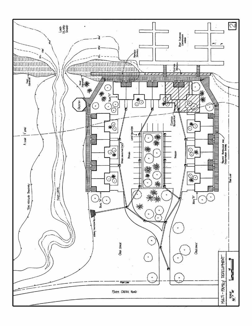
Site Plan # 3 Residential Subdivision
Coastal Site Plan Deficiencies 1) No vertical datum shown (plans should reference NGVD 1929) 2) Incomplete listing of coastal resources (coastal bluff/escarpment not indicated on plan). Coastal Management Issues 1) Potential accelerated erosion of coastal bluff and escarpment and future erosion threats to inhabited
structures 2) Potential adverse impacts to coastal water quality from accelerated bluff erosion and untreated
stormwater runoff. 3) No water-dependent use at a waterfront site. 4) Degraded views and vista of bluff from the river opposite river bank. Analysis The Connecticut Coastal Management Act (CCMA) policy for managing coastal bluffs and escarpments is to preserve their toe and slope, discourage uses which modify natural rates of erosion, and disapprove uses that accelerate slope erosion and alter supply of sediments to the littoral transport system. A related CCMA coastal hazard area policy also applies. It requires that proposed development in these areas be allowed only upon a demonstration that coastal flood and erosion hazards are minimized and that only non-structural methods to control these hazards be allowed for construction permitted after January 1, 1980, the effective date of the CCMA. In order to better understand how these policies apply to a specific location, the board or commission should direct staff to determine if an erosion study of the local shoreline exists. The Connecticut Coastal Management Program funded studies of erosion along Connecticut’s coast during the 1980’s. These studies including maps and periodic aerial surveys can be used to determine how an area of the coast responds to coastal erosion and depositional processes. This information, along with any additional information the commission or board can require from the applicant, should be used to apply these policies to the coastal site plan under review. All three proposed dwelling units would likely increase erosion of the site’s bluff/escarpment and increase hazards to life and property. Stormwater is proposed to directly discharge over the face of the bluff on all three proposed lots, subjecting the bluff to accelerated erosion forces. Further, the deck proposed on lot #2 would encroach waterward of the top of bank of the bluff modifying the face of the bluff that could destabilize the bluff in this area. These site modifications, along with siting the proposed structures proximate to the top of the face of the bluff, would likely also imperil the proposed structures over time. Once the structures become threatened by erosion of the bluff, the homeowners would likely proposed flood and erosion control structures, which is inconsistent with CCMA policy, as described above. Potential Solutions Relocate the proposed structures landward toward Meadow Road and modify the stormwater drainage plan to eliminate direct discharge to the bluff. Such a site redesign, which would require realignment of the proposed Riverview Lane, driveways and lot dimensions, would minimize impervious cover, thereby reducing stormwater runoff, allowing stormwater to drain across a vegetated buffer between the relocated houses and the top of the bluff’s bank and reducing the erosive force of stormwater runoff. A modified site design which maximizes building setback form the top of bank would also minimize potential future erosion hazards to these structures thereby reducing the potential for future structural flood and erosion
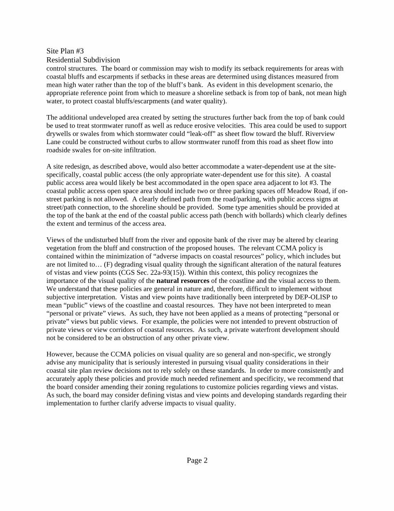
Site Plan #3 Residential Subdivision
Page 2
control structures. The board or commission may wish to modify its setback requirements for areas with coastal bluffs and escarpments if setbacks in these areas are determined using distances measured from mean high water rather than the top of the bluff’s bank. As evident in this development scenario, the appropriate reference point from which to measure a shoreline setback is from top of bank, not mean high water, to protect coastal bluffs/escarpments (and water quality). The additional undeveloped area created by setting the structures further back from the top of bank could be used to treat stormwater runoff as well as reduce erosive velocities. This area could be used to support drywells or swales from which stormwater could “leak-off” as sheet flow toward the bluff. Riverview Lane could be constructed without curbs to allow stormwater runoff from this road as sheet flow into roadside swales for on-site infiltration. A site redesign, as described above, would also better accommodate a water-dependent use at the site- specifically, coastal public access (the only appropriate water-dependent use for this site). A coastal public access area would likely be best accommodated in the open space area adjacent to lot #3. The coastal public access open space area should include two or three parking spaces off Meadow Road, if on-street parking is not allowed. A clearly defined path from the road/parking, with public access signs at street/path connection, to the shoreline should be provided. Some type amenities should be provided at the top of the bank at the end of the coastal public access path (bench with bollards) which clearly defines the extent and terminus of the access area. Views of the undisturbed bluff from the river and opposite bank of the river may be altered by clearing vegetation from the bluff and construction of the proposed houses. The relevant CCMA policy is contained within the minimization of “adverse impacts on coastal resources” policy, which includes but are not limited to… (F) degrading visual quality through the significant alteration of the natural features of vistas and view points (CGS Sec. 22a-93(15)). Within this context, this policy recognizes the importance of the visual quality of the natural resources of the coastline and the visual access to them. We understand that these policies are general in nature and, therefore, difficult to implement without subjective interpretation. Vistas and view points have traditionally been interpreted by DEP-OLISP to mean “public” views of the coastline and coastal resources. They have not been interpreted to mean “personal or private” views. As such, they have not been applied as a means of protecting “personal or private” views but public views. For example, the policies were not intended to prevent obstruction of private views or view corridors of coastal resources. As such, a private waterfront development should not be considered to be an obstruction of any other private view. However, because the CCMA policies on visual quality are so general and non-specific, we strongly advise any municipality that is seriously interested in pursuing visual quality considerations in their coastal site plan review decisions not to rely solely on these standards. In order to more consistently and accurately apply these policies and provide much needed refinement and specificity, we recommend that the board consider amending their zoning regulations to customize policies regarding views and vistas. As such, the board may consider defining vistas and view points and developing standards regarding their implementation to further clarify adverse impacts to visual quality.
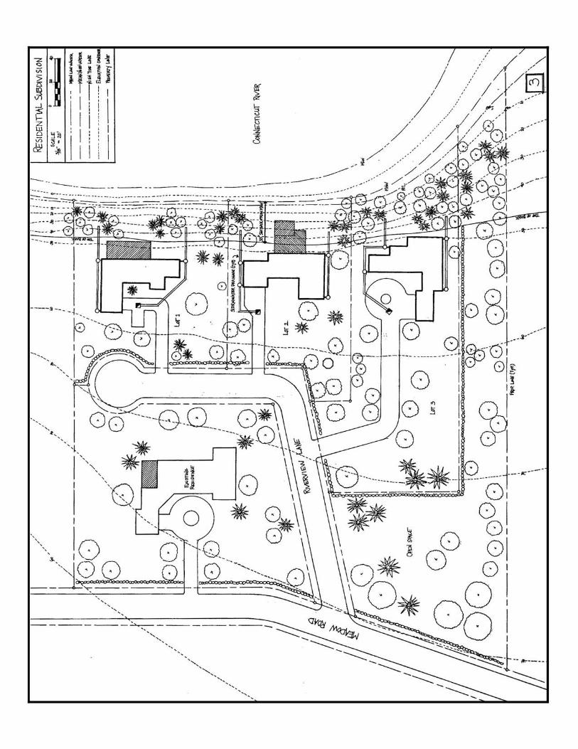
Site Plan #4 Commercial Development
Coastal Site Plan Deficiencies 1) Tidal datums (i.e., mean high water and the high tide line) and vertical datum (NGVD 1929) not
shown. 2) “Wetlands” label does not indicate whether wetlands are tidal wetlands or inland wetlands. 3) No elevation contours shown upland of elevation 11. 4) Flood hazard areas (if present) not delineated. 5) Direction of stormwater flow not shown (optional, but helpful). 6) Coastal resources are not identified on site plan (shorelands, flood hazard areas, tidal wetlands, inland
wetlands, coastal waters) Coastal Management Issues 1) Stormwater management system does not minimize development’s potential adverse impacts to
coastal water quality - no stormwater best management practices (BMPs) proposed. 2) Restored tidal wetland/inland wetlands adversely affected by stormwater discharges and discharge
structures 3) If building is in a flood hazard area, building must be elevated or flood-proofed. 4) State coastal permits required for fill/stormwater discharge structures in tidal wetlands or areas below
the high tide line. Analysis The stormwater drainage plan is unacceptable. To correct the problem, stormwater BMPs should be incorporated into the proposal. The first step in this process is to identify the potential pollutants in stormwater runoff at the site (see Stormwater Management fact sheet for description of parking lot runoff pollutants) and estimate the quantity of runoff generated by the “first-flush” of runoff generated by a 1 inch rainfall event. Next, the appropriate stormwater BMPs should be selected based upon the targeted pollutants, quantity of flow, and site conditions (e.g., soils, slope, available land area, etc.). To the extent possible, non-structural and low maintenance methods (e.g., vegetated swales) for treating stormwater that infiltrates runoff into on-site soils should be used. If necessary, structural methods (e.g., oil and gross particle separators) may be used, ideally in tandem with non-structural methods, if site conditions limit use of non-structural methods. It is particularly important that applicants be made aware that they may need to redesign a proposed development to accommodate non-structural stormwater management methods if insufficient space is provided on the coastal site plan submitted for review. Potential Solutions No direct discharges to tidal wetlands should be allowed. Since runoff from the roof of the proposed
building is cleaner than that from the parking lot, these sources of runoff should be separated and treated differently. Roof runoff can be discharged to a vegetated swale designed to enhance infiltration into the soil. Parking lot runoff can be treated using a variety of BMPs. Often BMPs used in series are the most effective. For example, surface drains containing adsorbent material to capture hydrocarbons could be used, as can modified catch basins with deep sumps and hooded outlets, to capture pollutants early in the stormwater conveyance system. Then, the stormwater could drain through a level spreader and over a vegetated buffer prior to discharge to the restored wetland. Alternatively, dry creeks could be installed adjacent to the parking lot. Again, water passing through the creeks could flow over the vegetated buffer on its way to inland wetlands. For parking lots with islands, dry creeks can be incorporated into the islands. It may be necessary to require the applicant
to eliminate proposed parking spaces to make an area available to accommodate the swales and dry creeks.
Prior to the selection of stormwater BMPs, site design should first consider designing the building
around significant trees and existing topography. Trees that overhang parking areas intercept rainfall, provide shade for the pavement (and vehicles), and transpire large quantities of water back to the atmosphere between rainfall events.
Another potential solution could be to use infiltration galleries located below the parking surface.
However, suitable soil condition must exist and pretreatment of stormwater prior to it entering the galleries to remove litter, suspended solids, and hydrocarbons is required.
Other potential solutions might include the use of catch basin insert technology, depression storage,
curbless parking areas with infiltration trenches, and drywells. Please note that maintenance of the stormwater management system is critical to its effectiveness.
Stormwater management plans should include a scheduled maintenance plan with a dedicated funding source to ensure that periodic maintenance is performed.
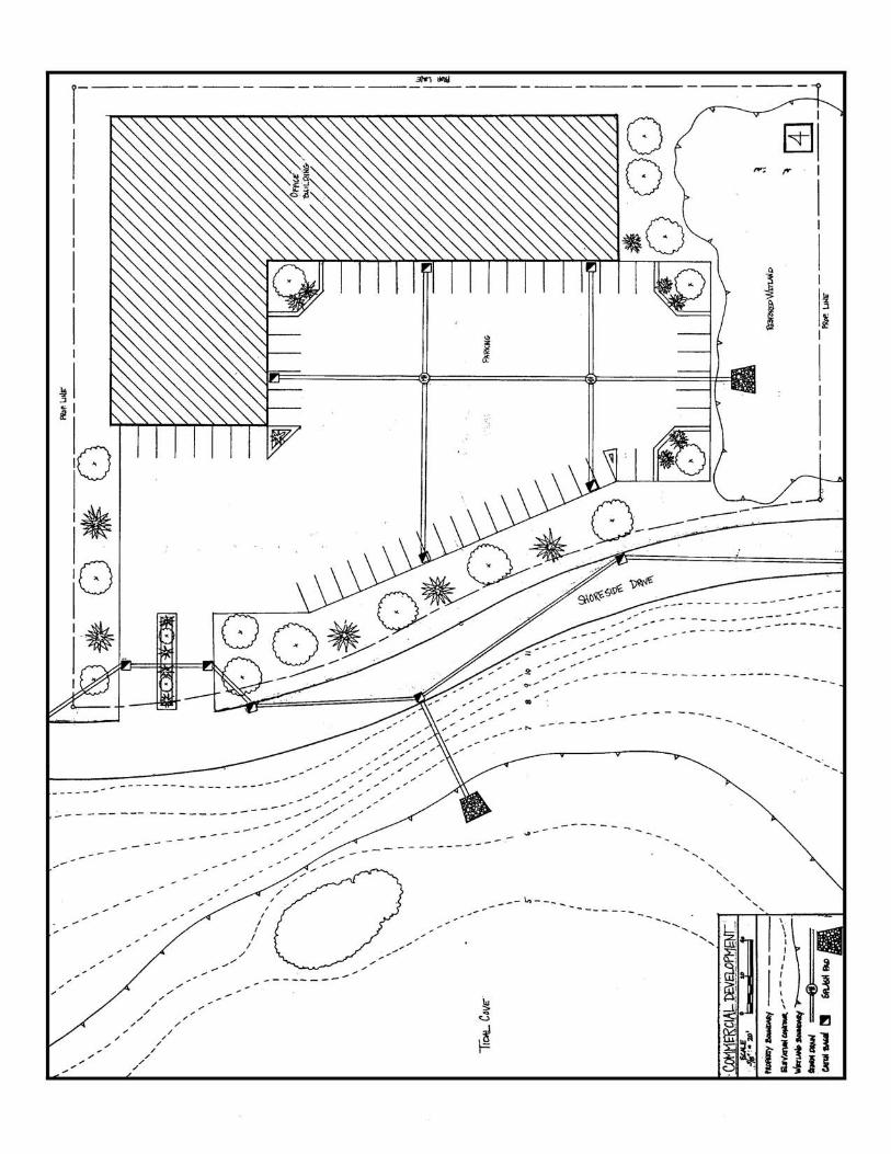
CONNECTICUT COASTAL MANAGEMENT ACTSECTION 5 - CONNECTICUT COASTAL MANAGEMENT ACT
Connecticut General Statutes Sections 22a-90 through 22a-112
Public Act 00-152 – An Act Concerning Urban Harbors, Boating Safety andWater Systems in the State
Reference Guide to Coastal Policies and Definition
CONNECTICUT COASTAL MANAGEMENT ACT
Connecticut General Statutes
CHAPTER 444*
*Cited. 192 C. 353, 354, 358−365. Coastal management act cited. 203 C. 364, 374; 222 C. 269,275. Coastal area management act, Sec. 22a-90 et seq. cited. 227 C. 71, 77, 78, 93. Coastalmanagement act cited. 228 C. 187, 195, 199.Coastal Management Act Sec. 22a-90 et seq. cited. 35 CA 317−325.Coastal Management Act cited. 43 CS 386, 387, 400.
Sec. 22a-90. Short title: Coastal Management Act. Sections 22a-90 to 22a-112, inclusive, shallbe known and may be cited as the "Coastal Management Act".(P.A. 78-152, S. 1, 11; P.A. 83-487, S. 28, 33.)History: P.A. 78-152 effective July 1, 1979; P.A. 83-487 amended section to include Secs. 22a-97 to 22a-112, inclusive, under short title.
Sec. 22a-91. Legislative findings. The General Assembly finds that:(1) The waters of Long Island Sound and its coastal resources, including tidal rivers, streams andcreeks, wetlands and marshes, intertidal mudflats, beaches and dunes, bluffs and headlands,islands, rocky shorefronts, and adjacent shorelands form an integrated natural estuarineecosystem which is both unique and fragile;(2) Development of Connecticut's coastal area has been extensive and has had a significantimpact on Long Island Sound and its coastal resources;(3) The coastal area represents an asset of great present and potential value to the economic well-being of the state, and there is a state interest in the effective management, beneficial use,protection and development of the coastal area;(4) The waterfront of Connecticut's major urban ports is underutilized and many existing urbanwaterfront uses are not directly dependent on proximity to coastal waters;(5) The coastal area is rich in a variety of natural, economic, recreational, cultural and aestheticresources, but the full realization of their value can be achieved only by encouraging furtherdevelopment in suitable areas and by protecting those areas unsuited to development;(6) The key to improved public management of Connecticut's coastal area is coordination at alllevels of government and consideration by municipalities of the impact of development on bothcoastal resources and future water-dependent development opportunities when preparing plansand regulations and reviewing municipal and private development proposals; and(7) Unplanned population growth and economic development in the coastal area have caused theloss of living marine resources, wildlife and nutrient-rich areas, and have endangered other vitalecological systems and scarce resources.
(P.A. 78-152, S. 2, 11; P.A. 79-535, S. 1, 25.)History: P.A. 78-152 effective July 1, 1979; P.A. 79-535 entirely replaced Subdivs. (3) and (5)which had addressed the demand for recreational opportunity in coastal areas and the lack of fullprotection for "natural features and processes" and the lack of beneficial development and addedSubdivs. (6) and (7).
Sec. 22a-92. Legislative goals and policies. (a) The following general goals and policies areestablished by this chapter:(1) To insure that the development, preservation or use of the land and water resources of thecoastal area proceeds in a manner consistent with the capability of the land and water resourcesto support development, preservation or use without significantly disrupting either the naturalenvironment or sound economic growth;(2) To preserve and enhance coastal resources in accordance with the policies established bychapters 439, 440, 446i, 446k, 447, 474 and 477;(3) To give high priority and preference to uses and facilities which are dependent uponproximity to the water or the shorelands immediately adjacent to marine and tidal waters;(4) To resolve conflicts between competing uses on the shorelands adjacent to marine and tidalwaters by giving preference to uses that minimize adverse impacts on natural coastal resourceswhile providing long term and stable economic benefits;(5) To consider in the planning process the potential impact of coastal flooding and erosionpatterns on coastal development so as to minimize damage to and destruction of life and propertyand reduce the necessity of public expenditure to protect future development from such hazards;(6) To encourage public access to the waters of Long Island Sound by expansion, developmentand effective utilization of state-owned recreational facilities within the coastal area that areconsistent with sound resource conservation procedures and constitutionally protected rights ofprivate property owners;(7) To conduct, sponsor and assist research in coastal matters to improve the data base uponwhich coastal land and water use decisions are made;(8) To coordinate the activities of public agencies to insure that state expenditures enhancedevelopment while affording maximum protection to natural coastal resources and processes in amanner consistent with the state plan for conservation and development adopted pursuant to partI of chapter 297;(9) To coordinate planning and regulatory activities of public agencies at all levels ofgovernment to insure maximum protection of coastal resources while minimizing conflicts anddisruption of economic development; and(10) To insure that the state and the coastal municipalities provide adequate planning forfacilities and resources which are in the national interest as defined in section 22a-93 and toinsure that any restrictions or exclusions of such facilities or uses are reasonable. Reasonablegrounds for the restriction or exclusion of a facility or use in the national interest shall include afinding that such a facility or use: (A) May reasonably be sited outside the coastal boundary; (B)fails to meet any applicable federal and state environmental, health or safety standard or (C)unreasonably restricts physical or visual access to coastal waters. This policy does not exemptany nonfederal facility in use from any applicable state or local regulatory or permit program nordoes it exempt any federal facility or use from the federal consistency requirements of Section307 of the federal Coastal Zone Management Act.(b) In addition to the policies stated in subsection (a), the following policies are established for
federal, state and municipal agencies in carrying out their responsibilities under this chapter:(1) Policies concerning development, facilities and uses within the coastal boundary are: (A) Tomanage uses in the coastal boundary through existing municipal planning, zoning and other localregulatory authorities and through existing state structures, dredging, wetlands, and other statesiting and regulatory authorities, giving highest priority and preference to water-dependent usesand facilities in shorefront areas; (B) to locate and phase sewer and water lines so as toencourage concentrated development in areas which are suitable for development; and todisapprove extension of sewer and water services into developed and undeveloped beaches,barrier beaches and tidal wetlands except that, when necessary to abate existing sources ofpollution, sewers that will accommodate existing uses with limited excess capacity may be used;(C) to promote, through existing state and local planning, development, promotional andregulatory authorities, the development, reuse or redevelopment of existing urban andcommercial fishing ports giving highest priority and preference to water dependent uses,including but not limited to commercial and recreational fishing and boating uses; to disallowuses which unreasonably congest navigation channels, or unreasonably preclude boating supportfacilities elsewhere in a port or harbor; and to minimize the risk of oil and chemical spills at portfacilities; (D) to require that structures in tidal wetlands and coastal waters be designed,constructed and maintained to minimize adverse impacts on coastal resources, circulation andsedimentation patterns, water quality, and flooding and erosion, to reduce to the maximum extentpracticable the use of fill, and to reduce conflicts with the riparian rights of adjacent landowners;(E) to disallow the siting within the coastal boundary of new tank farms and other new fuel andchemical storage facilities which can reasonably be located inland and to require any new storagetanks which must be located within the coastal boundary to abut existing storage tanks or to belocated in urban industrial areas and to be adequately protected against floods and spills; (F) tomake use of rehabilitation, upgrading and improvement of existing transportation facilities as theprimary means of meeting transportation needs in the coastal area; (G) to encourage increasedrecreational boating use of coastal waters, where feasible, by (i) providing additional berthingspace in existing harbors, (ii) limiting non-water-dependent land uses that preclude boatingsupport facilities, (iii) increasing state-owned launching facilities, and (iv) providing for newboating facilities in natural harbors, new protected water areas and in areas dredged from dryland; (H) to protect coastal resources by requiring, where feasible, that such boating uses andfacilities (i) minimize disruption or degradation of natural coastal resources, (ii) utilize existingaltered, developed or redevelopment areas, (iii) are located to assure optimal distribution of state-owned facilities to the state-wide boating public and (iv) utilize ramps and dry storage ratherthan slips in environmentally sensitive areas; (I) to protect and where feasible, upgrade facilitiesserving the commercial fishing and recreational boating industries; to maintain existingauthorized commercial fishing and recreational boating harbor space unless the demand for thesefacilities no longer exists or adequate space has been provided; to design and locate, wherefeasible, proposed recreational boating facilities in a manner which does not interfere with theneeds of the commercial fishing industry and (J) to require reasonable mitigation measureswhere development would adversely impact historical, archaeological, or paleontologicalresources that have been designated by the state historic preservation officer.(2) Policies concerning coastal land and water resources within the coastal boundary are: (A) Tomanage coastal bluffs and escarpments so as to preserve their slope and toe; to discourage useswhich do not permit continued natural rates of erosion and to disapprove uses that accelerateslope erosion and alter essential patterns and supply of sediments to the littoral transport system;
(B) to manage rocky shorefronts so as to insure that development proceeds in a manner whichdoes not irreparably reduce the capability of the system to support a healthy intertidal biologicalcommunity; to provide feeding grounds and refuge for shorebirds and finfish, and to dissipateand absorb storm and wave energies; (C) to preserve the dynamic form and integrity of naturalbeach systems in order to provide critical wildlife habitats, a reservoir for sand supply, a bufferfor coastal flooding and erosion, and valuable recreational opportunities; to insure that coastaluses are compatible with the capabilities of the system and do not unreasonably interfere withnatural processes of erosion and sedimentation, and to encourage the restoration andenhancement of disturbed or modified beach systems; (D) to manage intertidal flats so as topreserve their value as a nutrient source and reservoir, a healthy shellfish habitat and a valuablefeeding area for invertebrates, fish and shorebirds; to encourage the restoration and enhancementof degraded intertidal flats; to allow coastal uses that minimize change in the natural currentflows, depth, slope, sedimentation, and nutrient storage functions and to disallow uses thatsubstantially accelerate erosion or lead to significant despoliation of tidal flats; (E) to preservetidal wetlands and to prevent the despoliation and destruction thereof in order to maintain theirvital natural functions; to encourage the rehabilitation and restoration of degraded tidal wetlandsand where feasible and environmentally acceptable, to encourage the creation of wetlands for thepurposes of shellfish and finfish management, habitat creation and dredge spoil disposal; (F) tomanage coastal hazard areas so as to insure that development proceeds in such a manner thathazards to life and property are minimized and to promote nonstructural solutions to flood anderosion problems except in those instances where structural alternatives prove unavoidable andnecessary to protect existing inhabited structures, infrastructural facilities or water dependentuses; (G) to promote, through existing state and local planning, development, promotional andregulatory programs, the use of existing developed shorefront areas for marine-related uses,including but not limited to, commercial and recreational fishing, boating and other water-dependent commercial, industrial and recreational uses; (H) to manage undeveloped islands inorder to promote their use as critical habitats for those bird, plant and animal species which areindigenous to such islands or which are increasingly rare on the mainland; to maintain the valueof undeveloped islands as a major source of recreational open space; and to disallow uses whichwill have significant adverse impacts on islands or their resource components; (I) to regulateshoreland use and development in a manner which minimizes adverse impacts upon adjacentcoastal systems and resources and (J) to maintain the natural relationship between eroding anddepositional coastal landforms and to minimize the adverse impacts of erosion and sedimentationon coastal land uses through the promotion of nonstructural mitigation measures. Structuralsolutions are permissible when necessary and unavoidable for the protection of infrastructuralfacilities, water-dependent uses, or existing inhabited structures, and where there is no feasible,less environmentally damaging alternative and where all reasonable mitigation measures andtechniques have been provided to minimize adverse environmental impacts.(c) In addition to the policies stated in subsections (a) and (b), the following policies areestablished for federal and state agencies in carrying out their responsibilities under this chapter:(1) Policies concerning development, facilities and uses within the coastal boundary are: (A) Tominimize the risk of spillage of petroleum products and hazardous substances, to provideeffective containment and cleanup facilities for accidental spills and to disallow offshore oilreceiving systems that have the potential to cause catastrophic oil spills in the Long Island Soundestuary; (B) to disallow any filling of tidal wetlands and nearshore, offshore and intertidal watersfor the purpose of creating new land from existing wetlands and coastal waters which would
otherwise be undevelopable, unless it is found that the adverse impacts on coastal resources areminimal; (C) to initiate in cooperation with the federal government and the continuing legislativecommittee on state planning and development a long-range planning program for the continuedmaintenance and enhancement of federally-maintained navigation facilities in order toeffectively and efficiently plan and provide for environmentally sound dredging and disposal ofdredged materials; to encourage, through the state permitting program for dredging activities, themaintenance and enhancement of existing federally-maintained navigation channels, basins andanchorages and to discourage the dredging of new federally- maintained navigation channels,basins and anchorages; (D) to reduce the need for future dredging by requiring that new orexpanded navigation channels, basins and anchorages take advantage of existing or authorizedwater depths, circulation and siltation patterns and the best available technologies for reducingcontrollable sedimentation; (E) to disallow new dredging in tidal wetlands except where nofeasible alternative exists and where adverse impacts to coastal resources are minimal; (F) torequire that new or improved shoreline rail corridors be designed and constructed so as (i) toprevent tidal and circulation restrictions and, when practicable, to eliminate any such existingrestrictions, (ii) to improve or have a negligible adverse effect on coastal access and recreationand (iii) to enhance or not unreasonably impair the visual quality of the shoreline; (G) to requirethat coastal highways and highway improvements, including bridges, be designed andconstructed so as to minimize adverse impacts on coastal resources; to require that coastalhighway and highway improvements give full consideration to mass transportation alternativesand to require that coastal highways and highway improvements where possible enhance, but inno case decrease coastal access and recreational opportunities; (H) to disallow the constructionof major new airports and to discourage the substantial expansion of existing airports within thecoastal boundary; to require that any expansion or improvement of existing airports minimizeadverse impacts on coastal resources, recreation or access; (I) to manage the state's fisheries inorder to promote the economic benefits of commercial and recreational fishing, enhancerecreational fishing opportunities, optimize the yield of all species, prevent the depletion orextinction of indigenous species, maintain and enhance the productivity of natural estuarineresources and preserve healthy fisheries resources for future generations; (J) to make effectiveuse of state- owned coastal recreational facilities in order to expand coastal recreationalopportunities including the development or redevelopment of existing state-owned facilitieswhere feasible; (K) to require as a condition in permitting new coastal structures, including butnot limited to, groins, jetties or breakwaters, that access to, or along, the public beach belowmean high water must not be unreasonably impaired by such structures and to encourage theremoval of illegal structures below mean high water which unreasonably obstruct passage alongthe public beach; and (L) to promote the revitalization of inner city urban harbors andwaterfronts by encouraging appropriate reuse of historically developed shorefronts, which mayinclude minimized alteration of an existing shorefront in order to achieve a significant net publicbenefit, provided (i) such shorefront site is permanently devoted to a water dependent use or awater dependent public use such as public access or recreation for the general public and theownership of any filled lands remain with the state or an instrumentality thereof in order tosecure public use and benefit in perpetuity, (ii) landward development of the site is constrainedby highways, railroads or other significant infrastructure facilities, (iii) no other feasible, lessenvironmentally damaging alternatives exist, (iv) the adverse impacts to coastal resources of anyshorefront alteration are minimized and compensation in the form of resource restoration isprovided to mitigate any remaining adverse impacts, and (v) such reuse is consistent with the
appropriate municipal coastal program or municipal plan of development.(2) Policies concerning coastal land and other resources within the coastal boundary are: (A) Tomanage estuarine embayments so as to insure that coastal uses proceed in a manner that assuressustained biological productivity, the maintenance of healthy marine populations and themaintenance of essential patterns of circulation, drainage and basin configuration; to protect,enhance and allow natural restoration of eelgrass flats except in special limited cases, notablyshellfish management, where the benefits accrued through alteration of the flat may outweigh thelong-term benefits to marine biota, waterfowl, and commercial and recreational finfisheries and(B) to maintain, enhance, or, where feasible, restore natural patterns of water circulation andfresh and saltwater exchange in the placement or replacement of culverts, tide gates or otherdrainage or flood control structures.(d) In addition to the policies in this section, the policies of the state plan of conservation anddevelopment adopted pursuant to part I of chapter 297 shall be applied to the area within thecoastal boundary in accordance with the requirements of section 16a-31.(P.A. 78-152, S. 3, 11; P.A 79-535, S. 2, 25; P.A. 90-230, S. 33, 101; P.A. 00-152, S. 1.)History: P.A. 78-152 effective July 1, 1979; P.A. 79-535 added reference to chapter 474a inSubsec. (a)(3), rephrased Subsec. (a)(6), referred to "state" rather than "public expenditures" inSubsec. (a)(8) and added reference to actions consistent with state plan for conservation anddevelopment, added Subdiv. (10) re insuring that use is in national interest and that restrictionsor exclusions of uses and facilities are reasonable, and added Subsecs. (b) to (d) establishingpolicies for federal, state and municipal agencies in carrying out their responsibilities; P.A. 90-230 corrected internal references in Subsec. (a)(2); P.A. 00-152 amended Subsec. (c)(1) byadding new Subpara. (L) re revitalization of urban harbors and waterfronts.Cited. 43 CS 386, 387, 395.Subsec. (a):Subdiv. (6) cited. 182 C. 611, 617.Subdiv. (2) cited. 43 CS 386, 388. Subdiv. (1) cited. Id., 386, 389.Subsec. (b):Subdiv. (1)(D) cited. 43 CS 386, 388. Subdiv. (2)(E) cited. Id., 386, 388, 393. Subdiv. (1)(H)cited. Id., 386, 389. Subdiv. (2) cited. Id., 386, 395.Subsec. (c):Subdiv. (1)(B) cited. 43 CS 386, 388.
Sec. 22a-93. Definitions. For the purposes of this chapter:(1) "Commissioner" means the Commissioner of Environmental Protection;(2) "Municipality" means any town listed in subsection (a) of section 22a-94, the city of Groton,the borough of Stonington, the borough of Groton Long Point, the borough of Fenwick and theborough of Woodmont, but shall not include any special district;(3) "Coastal area" means those lands described in subsection (a) of section 22a-94;(4) "Coastal boundary" means the boundary described in subsection (b) of section 22a-94;(5) "Coastal waters" means those waters of Long Island Sound and its harbors, embayments,tidal rivers, streams and creeks, which contain a salinity concentration of at least five hundredparts per million under the low flow stream conditions as established by the commissioner;(6) "Public beach" means that portion of the shoreline held in public fee ownership by the stateor that portion of the shoreline below the mean high tide elevation that is held in public trust bythe state;
(7) "Coastal resources" means the coastal waters of the state, their natural resources, relatedmarine and wildlife habitat and adjacent shorelands, both developed and undeveloped, thattogether form an integrated terrestrial and estuarine ecosystem; coastal resources include thefollowing: (A) "Coastal bluffs and escarpments" means naturally eroding shorelands marked bydynamic escarpments or sea cliffs which have slope angles that constitute an intricate adjustmentbetween erosion, substrate, drainage and degree of plant cover; (B) "rocky shorefronts" meansshorefront composed of bedrock, boulders and cobbles that are highly erosion-resistant and arean insignificant source of sediments for other coastal landforms; (C) "beaches and dunes" meansbeach systems including barrier beach spits and tombolos, barrier beaches, pocket beaches, landcontact beaches and related dunes and sandflats; (D) "intertidal flats" means very gently slopingor flat areas located between high and low tides composed of muddy, silty and fine sandysediments and generally devoid of vegetation; (E) "tidal wetlands" means "wetland" as definedby section 22a-29; (F) "freshwater wetlands and watercourses" means "wetlands" and"watercourses" as defined by section 22a-38; (G) "estuarine embayments" means a protectedcoastal body of water with an open connection to the sea in which saline sea water is measurablydiluted by fresh water including tidal rivers, bays, lagoons and coves; (H) "coastal hazard areas"means those land areas inundated during coastal storm events or subject to erosion induced bysuch events, including flood hazard areas as defined and determined by the National FloodInsurance Act, as amended (USC 42 Section 4101, P.L. 93-234) and all erosion hazard areas asdetermined by the commissioner; (I) "developed shorefront" means those harbor areas whichhave been highly engineered and developed resulting in the functional impairment or substantialalteration of their natural physiographic features or systems; (J) "island" means land surroundedon all sides by water; (K) "nearshore waters" means the area comprised of those waters and theirsubstrates lying between mean high water and a depth approximated by the ten meter contour;(L) "offshore waters" means the area comprised of those waters and their substrates lyingseaward of a depth approximated by the ten meter contour; (M) "shorelands" means those landareas within the coastal boundary exclusive of coastal hazard areas, which are not subject todynamic coastal processes and which are comprised of typical upland features such as bedrockhills, till hills and drumlins; (N) "shellfish concentration areas" means actual, potential or historicareas in coastal waters, in which one or more species of shellfish aggregate;(8) "Zoning commission" means the municipal zoning commission established under section 8-1or by any special act or the combined planning and zoning commission established under section8-4a;(9) "Planning commission" means the municipal planning commission established under section8-19 or by any special act or the combined planning and zoning commission established undersection 8-4a;(10) "Municipal coastal plans" means the plans listed in subsections (b) and (d) of section 22a-101;(11) "Municipal coastal regulations" means the regulations and ordinances listed in subsection(b) of section 22a-101;(12) "Federal Coastal Zone Management Act" and "federal act" means the U.S. Coastal ZoneManagement Act of 1972, as amended;(13) "Coastal site plans" means the site plans, applications and project referrals listed in section22a-105;(14) "Facilities and resources which are in the national interest" means: (A) Adequate protectionof tidal wetlands and related estuarine resources; (B) restoration and enhancement of
Connecticut's shellfish industry; (C) restoration, preservation and enhancement of the state'srecreational and commercial fisheries, including anadromous species; (D) water pollution controlmeasures and facilities consistent with the requirements of the federal Clean Water Act, asamended; (E) air pollution control measures and facilities consistent with the requirements of thefederal Clean Air Act, as amended; (F) continued operations of existing federally-fundeddredged and maintained navigation channels and basins; (G) energy facilities serving state-wideand interstate markets, including electric generating facilities and facilities for storage, receivingor processing petroleum products and other fuels; (H) improvements to the existing interstaterail, highway and water-borne transportation system; (I) provision of adequate state or federally-owned marine-related recreational facilities, including natural areas and wildlife sanctuaries and(J) essential maintenance and improvement of existing water-dependent military, navigational,resource management and research facilities;(15) "Adverse impacts on coastal resources" include but are not limited to: (A) Degrading waterquality through the significant introduction into either coastal waters or groundwater supplies ofsuspended solids, nutrients, toxics, heavy metals or pathogens, or through the significantalteration of temperature, pH, dissolved oxygen or salinity; (B) degrading existing circulationpatterns of coastal waters through the significant alteration of patterns of tidal exchange orflushing rates, freshwater input, or existing basin characteristics and channel contours; (C)degrading natural erosion patterns through the significant alteration of littoral transport ofsediments in terms of deposition or source reduction; (D) degrading natural or existing drainagepatterns through the significant alteration of groundwater flow and recharge and volume ofrunoff; (E) increasing the hazard of coastal flooding through significant alteration of shorelineconfigurations or bathymetry, particularly within high velocity flood zones; (F) degrading visualquality through significant alteration of the natural features of vistas and view points; (G)degrading or destroying essential wildlife, finfish or shellfish habitat through significantalteration of the composition, migration patterns, distribution, breeding or other populationcharacteristics of the natural species or significant alteration of the natural components of thehabitat and (H) degrading tidal wetlands, beaches and dunes, rocky shorefronts, and bluffs andescarpments through significant alteration of their natural characteristics or function;(16) "Water-dependent uses" means those uses and facilities which require direct access to, orlocation in, marine or tidal waters and which therefore cannot be located inland, including butnot limited to: Marinas, recreational and commercial fishing and boating facilities, finfish andshellfish processing plants, waterfront dock and port facilities, shipyards and boat buildingfacilities, water-based recreational uses, navigation aides, basins and channels, industrial usesdependent upon water-borne transportation or requiring large volumes of cooling or processwater which cannot reasonably be located or operated at an inland site and uses which providegeneral public access to marine or tidal waters;(17) "Adverse impacts on future water-dependent development opportunities" and "adverseimpacts on future water-dependent development activities" include but are not limited to (A)locating a non-water-dependent use at a site that (i) is physically suited for a water-dependentuse for which there is a reasonable demand or (ii) has been identified for a water-dependent usein the plan of development of the municipality or the zoning regulations; (B) replacement of awater-dependent use with a non-water-dependent use, and (C) siting of a non-water-dependentuse which would substantially reduce or inhibit existing public access to marine or tidal waters;and(18) "Zoning board of appeals" means the municipal zoning board of appeals established
pursuant to section 8-5 or any special act.(P.A. 78-152, S. 4, 11; P.A. 79-535, S. 3, 25; P.A. 82-250, S. 1, 6; P.A. 83-587, S. 83, 96; P.A.95-218, S. 7.)History: P.A. 78-152 effective July 1, 1979; P.A. 79-535 redefined "municipality" and "coastalwaters" in specific rather than general terms, redefined "public beach" to specify those owned bystate, expanded definition of "coastal resources" and added Subdivs. (8) to (16) defining variousplanning and zoning commissions, coastal plans and regulations, the applicable federal act,"facilities and resources which are in the national interest", "adverse impacts on coastalresources" and "water dependent uses"; P.A. 82-250 added definitions for "adverse impacts onfuture water dependent development opportunities", "adverse impacts on future water dependentdevelopment activities" and "zoning board of appeals"; P.A. 83-587 substituted reference tofederal clean air act for reference to clean water act in Subdiv. (14); P.A. 95-218 amended thedefinition of "adverse impacts on coastal resources" to make a minor clarification re patterns oftidal exchange.Subdiv. (7):Subpara. (E) cited. 43 CS 386, 395, 396.Subdiv. (16):Cited. 228 C. 187, 200.Subdiv. (17):Cited. 228 C. 187, 200.
Sec. 22a-94. Coastal area; coastal boundary. Commissioner to prepare maps. (a) TheConnecticut coastal area shall include the land and water within the area delineated by thefollowing: The westerly, southerly and easterly limits of the state's jurisdiction in Long IslandSound; the towns of Greenwich, Stamford, Darien, Norwalk, Westport, Fairfield, Bridgeport,Stratford, Shelton, Milford, Orange, West Haven, New Haven, Hamden, North Haven, EastHaven, Branford, Guilford, Madison, Clinton, Westbrook, Deep River, Chester, Essex, OldSaybrook, Lyme, Old Lyme, East Lyme, Waterford, New London, Montville, Norwich, Preston,Ledyard, Groton and Stonington.(b) Within the coastal area, there shall be a coastal boundary which shall be a continuous linedelineated on the landward side by the interior contour elevation of the one hundred yearfrequency coastal flood zone, as defined and determined by the National Flood Insurance Act, asamended (USC 42 Section 4101, P.L. 93-234), or a one thousand foot linear setback measuredfrom the mean high water mark in coastal waters, or a one thousand foot linear setback measuredfrom the inland boundary of tidal wetlands mapped under section 22a-20, whichever is farthestinland; and shall be delineated on the seaward side by the seaward extent of the jurisdiction ofthe state.(c) The coastal boundary as defined in subsection (b) of this section shall be shown on maps orphotographs prepared by the commissioner which supplement flood hazard rate maps preparedby the United States Department of Housing and Urban Development under the National FloodInsurance Act. Such maps shall be sufficiently precise to demonstrate whether the holdings of aproperty owner, or portions thereof, lie within the coastal boundary. Copies of such maps orphotographs shall be filed with the commissioner and with the clerk of each coastal municipality.(d) The maps described in subsection (c) of this section shall be promulgated not later than July1, 1980. Prior to final adoption of any map, the commissioner shall hold a public hearing inaccordance with the provisions of chapter 54 within the applicable coastal town. The
commissioner may use interim maps prepared on United States Geological Survey Topographicbase at a scale of one to twenty-four thousand or their metric equivalent. In preparing suchinterim maps, the commissioner may use any man-made structure, natural feature, property line,preliminary flood hazard boundary maps as prepared by the United States Department ofHousing and Urban Development, or a combination thereof which most closely approximates thelandward side of the boundary. Further, the commissioner may use city or town property taxmaps or aerial photographs, state tidal wetlands photographs, or similar maps of propertydelineation as they are available.(e) The commissioner may, from time to time, amend such maps described in subsection (c) ofthis section. Prior to the adoption of an amendment to any map, the commissioner shall hold apublic hearing in the affected municipality in accordance with the provisions of chapter 54. Thecommissioner shall consider for amendment changes in the boundary petitioned by the coastalmunicipality, by any person owning real property within the boundary, or by twenty-fiveresidents of such municipality. The commissioner shall approve, deny or modify such petitionwithin sixty days of receipt and shall state, in writing, the reasons for his action. All amendmentsto the boundary shall be consistent with subsection (b).(f) A municipal coastal boundary may be adopted by the municipal planning commission of eachcoastal municipality in accordance with the notice, hearing and other procedural requirements ofsection 8-24. Such boundary may be delineated by roads, property lines or other identifiablenatural or man-made features, provided such boundary shall approximate and in no eventdiminish the area within the coastal boundary as defined in subsection (b) and as mapped undersubsection (d). Such boundary shall be sufficiently precise to demonstrate whether the holdingsof a property owner, or portions thereof, lie within the boundary. Upon adoption such boundaryshall be submitted to the commissioner for mapping in accordance with subsection (c). Themunicipal planning commission may, at its own discretion or upon request of a property owner,amend the coastal boundary in accordance with the procedures and criteria of this subsection.(g) All property lying within the coastal boundary shall be subject to the regulatory, developmentand planning requirements of this chapter.(P.A. 78-152, S. 5, 11; P.A. 79-535, S. 4, 25.)History: P.A. 78-152 effective July 1, 1979; P.A. 79-535 substituted "towns" for"municipalities", clarified coastal boundary by including reference to 1,000 foot linear setback,substituting "high water mark" for "high tide" and deleting description of specific types ofenvironment to be included, i.e. coastal waters, submerged lands, intertidal zones, etc. in Subsec.(b), changed deadline for maps in Subsec. (d) from "within twenty-four months of July 1, 1979",to "July 1, 1980", added provisions in Subsec. (e) re petitions to change boundaries, and addedSubsecs. (f) and (g) re adoption of boundaries and re applicability of chapter to property withinthe established coastal boundary.Cited. 228 C. 187, 189.
Sec. 22a-95. Duties of commissioner. Model municipal coastal program. (a) Thecommissioner shall, on a continuing basis, assist coastal municipalities in carrying out theirresponsibilities under this chapter.(b) The commissioner shall provide each coastal municipality with resource factor maps andother information concerning the location and condition of its coastal resources and shall alsoprovide general technical background information on the beneficial and adverse impacts ofvarious types of development on coastal resources.
(c) The commissioner shall respond to questions regarding the requirements of this chapter, shallrespond to requests by coastal municipalities for background technical information and shallmeet reasonable requests by such municipalities for technical staff assistance in developing andimplementing municipal coastal programs and coastal site plan reviews.(d) The commissioner shall consult regularly with officials of coastal municipalities regardingimplementation of this chapter and shall periodically hold workshops with municipal officialsresponsible for making decisions under this chapter.(e) The commissioner shall prepare a model municipal coastal program which shall include, butnot be limited to: (1) Model municipal coastal plans and regulations; (2) suggested planningmethodologies useful in revising municipal coastal plans; (3) suggested regulatory methodsuseful in revising municipal coastal regulations to conform to and effectuate the purposes ofmunicipal coastal plans and (4) suggested criteria and procedures for undertaking municipalcoastal site plan reviews.(f) Written technical information provided by the commissioner to coastal municipalities shall bein clear and readily understandable language.(P.A. 78-152, S. 6, 8, 11; P.A. 79-535, S. 5, 25.)History: P.A. 79-535 replaced previous provisions which had established interim studycommittee to recommend plan for coastal area management and had set forth commissioner'sduties concerning plans establishment with new provisions re commissioner's duties to assistcoastal municipalities in fulfilling their responsibilities.
Sec. 22a-96. Commissioner authorized to enter into agreements; designated asrepresentative of state. (a) The commissioner is authorized to enter into written agreementswith federal agencies concerning the matters set forth in subsection (b) of this section having aninterest in or regulatory authority in the coastal area. Such agreements shall be consistent withthe provisions of sections 22a-90 to 22a-96, inclusive, and chapters 439, 440, 446i, 447, 474 and477, shall indicate the respective powers and duties of the commissioner and the federal agencyor agencies thereunder and shall provide for cooperation and coordination in the implementationof state and federal programs with jurisdiction in the coastal area in a manner consistent with theprovisions of sections 22a-90 to 22a-96, inclusive.(b) Agreements concerning regulatory programs of the U.S. Army Corps of Engineers and theU.S. Coast Guard, Bridges Section, may include the following: (1) Procedures for conductingjoint hearings on permit applications; (2) procedures for issuing common and joint applicationmaterials and instructions for permit applications; (3) procedures for timely exchange oftechnical materials related to permit applications and other matters and (4) procedures forcoordinating the timing and sequence of the issuance of decisions on permit applications.(c) The commissioner is authorized to (1) represent the state in formal proceedings regarding"federal consistency" as defined in the federal act; (2) request, receive and administer fundsunder said act and (3) develop and coordinate, in cooperation with other state agencies, plans toachieve the purposes of sections 22a-90 to 22a-96, inclusive.(d) The commissioner is designated as the representative of the state in all matters concerning theconsistency of federal activities, projects or proposals with the policies and provisions of sections22a-90 to 22a-96, inclusive.(P.A. 78-152, S. 7, 9−11; P.A. 90-230, S. 34, 101.)History: Subsec. (c) effective May 23, 1978, and Subsecs. (a), (b) and (d) effective July 1, 1979;P.A. 90-230 corrected an internal reference in Subsec. (a).
Sec. 22a-97. Duties of the commissioner. Technical, coordinating and research services.Supervision. Annual report. (a) The commissioner shall provide, within availableappropriations, technical, coordinating and research services to promote the effectiveadministration of this chapter at the federal, state and local levels.(b) The commissioner shall have the overall responsibility for general supervision of theimplementation of this chapter and shall monitor and evaluate the activities of federal and stateagencies and the activities of municipalities to assure continuing, effective, coordinated andconsistent administration of the requirements and purposes of this chapter.(c) The commissioner shall prepare and submit to the General Assembly and the Governor, on orbefore December first of each year, a written report summarizing the activities of the departmentconcerning the development and implementation of this chapter during the previous year. Suchreport shall include, but not be limited to: (1) The department's accomplishments and actions inachieving the goals and policies of this chapter including, but not limited to, coordination withother state, regional, federal and municipal programs established to achieve the purposes of thischapter and research programs established pursuant to subsection (a) of section 22a-112; (2)recommendations for any statutory or regulatory amendments necessary to achieve suchpurposes; (3) a summary of municipal and federal programs and actions which affect the coast;(4) recommendations for any programs or plans to achieve such purposes; (5) any aspects of theprogram or the chapter which are proving difficult to accomplish, suggested reasons for suchdifficulties and proposed solutions to such difficulties; (6) a summary of the expenditure offederal and state funds under this chapter and (7) a request for an appropriation of fundsnecessary to match federal funds and provide continuing financial support for the program. Suchreport shall comply with the provisions of section 46a- 78. On and after October 1, 1996, thereport shall be submitted to the joint standing committee of the General Assembly havingcognizance of matters relating to the environment and, upon request, to any member of theGeneral Assembly. A summary of the report shall be submitted to each member of the GeneralAssembly if the summary is two pages or less and a notification of the report shall be submittedto each member if the summary is more than two pages. Submission shall be by mailing thereport, summary or notification to the legislative address of each member of the committee or theGeneral Assembly, as applicable.(P.A. 79-535, S. 17, 25; P.A. 96-251, S. 10.)History: P.A. 96-251 amended Subsec. (c) by requiring that on and after October 1, 1996, reportsbe submitted to environment committee and upon request to any legislator and by addingprovisions on submission of report summaries to legislators.
Sec. 22a-98. Commissioner to coordinate regulatory programs. The commissioner shallcoordinate the activities of all regulatory programs under his jurisdiction with permittingauthority in the coastal area to assure that the administration of such programs is consistent withthe goals and policies of this chapter. Such programs include, but are not limited to: (1)Regulation of wetlands and watercourses pursuant to chapter 440; (2) regulation of streamencroachment pursuant to sections 22a-342 to 22a-349, inclusive; (3) regulation of dredging andthe erection of structures or the placement of fill in tidal, coastal or navigable waters pursuant tosections 22a-359 to 22a-363f, inclusive; and (4) certification of water quality pursuant to thefederal Clean Water Act of 1972 (33 USC 1411, Section 401). The commissioner shall assureconsistency with such goals and policies in granting, denying or modifying permits under such
programs. Any person seeking a license, permit or other approval of an activity under therequirements of such regulatory programs shall demonstrate that such activity is consistent withall applicable goals and policies in section 22a-92 and that such activity incorporates allreasonable measures mitigating any adverse impacts of such actions on coastal resources andfuture water-dependent development activities. The coordination of such programs shall include,where feasible, the use of common or combined application forms, the holding of joint hearingson permit applications and the coordination of the timing or sequencing of permit decisions.(P.A. 79-535, S. 21, 25; P.A. 83-525, S. 1; P.A. 96-145, S. 16; P.A. 99-225, S. 12, 33.)History: P.A. 83-525 required that any person seeking a permit or approval of any activity underthe requirements of a regulatory program demonstrate that such activity incorporates allreasonable measures mitigating damage to coastal resources; P.A. 96-145 deleted former Subdiv.(4) re removal of sand and gravel, renumbering former Subdiv. (5) accordingly; P.A. 99-225added a provision regarding coordination of dredging regulation with coastal management,effective July 1, 1999.Cited. 43 CS 386, 387, 395.
Sec. 22a-99. Testimony by coastal municipality on permits and licenses. Appeal fromdecision of the commissioner. A coastal municipality may submit written testimony to thecommissioner and may appear by right as a party to any hearing before said commissionerconcerning any permit or license to be issued by said commissioner for an activity occurringwithin the coastal boundary of the municipality or occurring within the coastal boundary of anyadjacent municipality and within five hundred feet of the boundary of such municipality and mayappeal any decision of the commissioner concerning such permit or license.(P.A. 79-535, S. 18, 25.)
Sec. 22a-100. State plans and actions to be consistent with this chapter. (a) All major stateplans, other than the state plan for conservation and development adopted pursuant to part I ofchapter 297, which affect the coastal area shall be consistent with the goals and policies stated insection 22a-92 and existing state plans, other than the state plan for conservation anddevelopment adopted pursuant to part I of chapter 297, which affect the coastal area shall, on orbefore July 1, 1981, be revised, if necessary, to insure consistency with this chapter. Agenciesresponsible for revising state plans, other than the state plan for conservation and developmentadopted pursuant to part I of chapter 297, shall consult with the commissioner in making suchrevisions.(b) Each state department, institution or agency responsible for the primary recommendation orinitiation of actions within the coastal boundary which may significantly affect the environment,as defined in section 22a-1c, shall insure that such actions are consistent with the goals andpolicies of this chapter and incorporate all reasonable measures mitigating any adverse impactsof such actions on coastal resources and future water-dependent development activities. TheSecretary of the Office of Policy and Management shall consider the consistency of suchproposed actions with such goals and policies in determining whether or not an environmentalimpact evaluation prepared pursuant to section 22a-1b satisfies the requirements of sections 22a-1a to 22a-1h, inclusive, and regulations adopted pursuant thereto. The commissioner shall amendsuch regulations, if necessary, to insure consistency with the goals and policies of this chapter.(P.A. 79-535, S. 20, 25; P.A. 83-525, S. 2.)History: P.A. 83-525 amended Subsec. (b), requiring agencies to insure that actions which might
affect the environment incorporate all reasonable safeguards against any adverse affect.
Sec. 22a-101. Municipal coastal programs. (a) In order to carry out the policies and provisionsof this chapter and to provide more specific guidance to coastal area property owners anddevelopers, coastal municipalities may adopt a municipal coastal program for the area within thecoastal boundary and landward of the mean high water mark.(b) A municipal coastal program shall include, but is not limited to: (1) Revisions to themunicipal plan of conservation and development under section 8-23 or special act, insofar as itaffects the area within the coastal boundary, such revisions to include an identification andwritten description of the municipality's major coastal-related issues and problems, bothimmediate and long-term, such as erosion, flooding, recreational facilities, and utilization of portfacilities and to include a description of the municipal boards, commissions and officialsresponsible for implementing and enforcing the coastal program, a description of enforcementprocedures and a description of continuing methods of involving the public in theimplementation of the municipal coastal program; (2) revisions to the municipal zoningregulations under section 8-2 or under special act and revisions to the following regulations andordinances if the municipality has adopted such regulations or ordinances, and insofar as suchregulations or ordinances affect the area within the coastal boundary: (A) Historic districtordinances under section 7-147b; (B) waterway encroachment line ordinances under section 7-147; (C) subdivision ordinances under section 8-25; (D) inland wetland regulations undersubsection (e) of section 22a-42 and section 22a-42a; (E) sewerage ordinances under section 7-148; (F) ordinances or regulations governing filling of land and removal of soil, loam, sand orgravel under section 7-148; (G) ordinances concerning protection and improvement of theenvironment under section 7-148; and (H) regulations for the supervision, management, control,operation or use of a sewerage system under section 7-247.(c) If a municipality has not yet adopted a municipal plan of conservation and developmentunder section 8-23, a municipal planning commission may prepare a municipal coastal plan ofdevelopment solely for that portion of municipality within the coastal boundary in accordancewith subsection (b) of this section and section 22a-102.(d) A municipal coastal program may include revisions to the following municipal plans orprograms which revisions shall be consistent with the municipal plan of conservation anddevelopment revised in accordance with subsection (b) of this section and section 22a-102: (1)The community development plan under sections 8-169c and 8- 169d; (2) the harborimprovement plan under section 13b-56; (3) the redevelopment plan under sections 8-125 and 8-127; (4) the port development plan under section 7- 329c; (5) the capital improvement plan undersection 8-160; (6) the open space plan under section 12-107e; (7) any development project planor plans under section 8-189; and (8) the municipal water pollution control plan under section 7-245.(e) Revisions to the municipal plan of development in accordance with subsection (b) of thissection and section 22a-102 may include a description of any development projects, acquisitionplans, open space tax abatement programs, flood and erosion control projects and othernonregulatory measures which the municipality intends to undertake in order to promote wisemanagement of coastal resources.(P.A. 79-535, S. 7, 25; P.A. 82-327, S. 10; P.A. 85-409, S. 1, 8; P.A. 95-335, S. 18, 26.)History: P.A. 82-327 changed a reference to sewer ordinance adopted under Sec. 7-153 to Sec. 7-148 to acknowledge a transfer; P.A. 85-409 removed reference to planned unit development
regulations under Secs. 8-13c and 8-13d, which were repealed by that act; P.A. 95-335 amendedSubsecs. (b) to (d) to change "plan of development" to "plan of conservation and development",effective July 1, 1995.
Sec. 22a-102. Municipal plan of development. Proposed municipal land use regulations. (a)In revising the municipal plan of conservation and development in accordance with subsection(b) of section 22a-101, the municipal planning commission shall follow: (1) The policies andgoals in section 22a-92; (2) criteria listed in section 8-23.(b) In adopting any proposed municipal plan of conservation and development, zoningregulations or changes thereto or other municipal coastal regulations listed in subdivision (2) ofsubsection (b) of section 22a-101 or changes thereto, the following criteria shall also beconsidered: (1) The character and distribution of the coastal resources defined in section 22a-93within its coastal boundary, the capacity of and limitations on such resources to supportdevelopment, and the types and methods of development compatible with the wise use,protection and enhancement of such resources; (2) the nature and pattern of existingdevelopment and (3) the need for public services.(c) The municipal planning commission may revise its municipal plan of conservation anddevelopment by making such changes as: Modifications of land use categories, changes in thedensity and intensity of land use, alteration in plan policies; modifications in growth strategies,changes in acquisition priorities, and alterations in public infrastructure, highway and othercapital improvement projects.(d) The municipal planning commission shall submit its proposed revisions to the municipal planof conservation and development prepared in accordance with subsections (a) and (b) of thissection and section 22a-101 to the commissioner and the regional planning agency for reviewand comment prior to the final adoption of such revisions in accordance with section 8-23. Uponreceipt of such proposed revisions the commissioner and the regional planning agency shallreview them for consistency with requirements and criteria listed in subsections (a) and (b) ofthis section and said section 22a-101 and shall within ninety days notify the municipality inwriting of any suggested modifications to the proposed revisions. Upon receipt of suchcomments or ninety days after receipt by the commissioner of proposed revisions, the municipalplanning commission may modify and adopt the proposed revisions in accordance with saidsection 8-23.(P.A. 79-535, S. 8, 25; P.A. 83-287, S. 1; P.A. 95-335, S. 19, 26.)History: P.A. 83-287 amended Subsec. (b) to require that any proposed municipal land use orcoastal regulation, not only a revision to a municipal plan of development, reflect coastalmanagement criteria; P.A. 95-335 amended section to change "plan of development" to "plan ofconservation and development", effective July 1, 1995.
Sec. 22a-103. Municipal zoning regulations. Criteria and process for revision. (a) In revisingzoning regulations and other municipal coastal regulations and ordinances listed in subdivision(2) of subsection (b) of section 22a-101, the municipal agency with jurisdiction over suchregulations or ordinances shall consider the criteria in section 8- 2 and the other sections of thegeneral statutes or special act authorizing such regulations. Such regulations shall conform to andeffectuate the policies and land and water use strategies of the municipal coastal plans revisedunder sections 22a-101 and 22a-102 and the criteria listed in subsections (a) and (b) of section22a-102.
(b) The municipal agency with jurisdiction over the zoning regulations and other municipalcoastal regulations and ordinances listed in subdivision (2) of subsection (b) of section 22a-101shall submit its proposed revisions of such regulations and ordinances to the commissioner forhis review and comment prior to final adoption of such revisions in accordance with theappropriate statutory requirements regarding amendment of such regulations or ordinances.Upon receipt of the proposed revisions to the municipal coastal regulations, the commissionershall review them for their consistency with the municipality's previously adopted municipalplan of conservation and development and the criteria listed in subsections (a) and (b) of section22a-102, and shall within ninety days notify the municipality in writing of any suggestedmodifications. Upon receipt of the commissioner's comments or ninety days after his receipt ofproposed revisions the municipal agency with jurisdiction over such regulations may modify andadopt the proposed revisions in accordance with the appropriate statutory requirements regardingamendment of such regulations and ordinances.(c) In revising zoning regulations under chapter 124 for the area within the coastal boundary themunicipal zoning commission may utilize any lawful zoning techniques, including but notlimited to, modifications of use categories, alteration of density and intensity of use, special usezones, overlay zones, special permit regulations, sign controls, design controls, landscaping andgardening regulations, hazard or geological review requirements, conservation, cluster, openspace and lot coverage requirements, minimum lot sizes, setback requirements, and bonus andincentive zoning regulations.(d) In revising subdivision regulations under chapter 126 the municipal planning commissionmay utilize any lawful technique including, but not limited to, conservation, cluster, open space,park and recreation regulations.(P.A. 79-535, S. 9, 25; P.A. 85-409, S. 2, 8; P.A. 95-335, S. 20, 26.)History: P.A. 85-409 substituted reference to chapter 124 for reference to chapter 124a inSubsec. (c); P.A. 95-335 amended Subsec. (b) to change "plan of development" to "plan ofconservation and development", effective July 1, 1995.
Sec. 22a-104. Implementation of municipal coastal program. Amendments. (a) If amunicipality has adopted a municipal coastal program in accordance with sections 22a-101, 22a-102 and 22a-103, such program shall be implemented by those municipal bodies exercising legalauthority for the regulatory decisions listed in subsection (b) of section 22a-105. The provisionsof subsections (b) to (e), inclusive, of this section shall apply to such municipality.(b) Amendments to the municipal plan of conservation and development affecting the areawithin the coastal boundary or municipal coastal regulations shall be made in accordance withsubsection (e) of this section and sections 22a-101, 22a-102 and 22a-103.(c) When amendments are made to the municipal plan of conservation and developmentaffecting the area within the coastal boundary, the municipality shall also make suchamendments to the zoning regulations and other municipal coastal regulations listed insubdivision (2) of subsection (b) of section 22a-101 in accordance with applicable statutoryrequirements regarding amendment of such regulations and ordinances as are necessary to insurethat such regulations conform to and effectuate the policies and land and water use strategies ofthe amended plans.(d) When amendments are made to zoning regulations and other municipal coastal regulationslisted in subdivision (2) of subsection (b) of section 22a-101 without prior amendments tocorresponding provisions of municipal coastal plans, such regulations, as amended, shall
conform to and effectuate the policies and land and water use strategies of the municipal coastalplans and the criteria listed in subsections (a) and (b) of section 22a-102.(e) Any proposed municipal plan of conservation and development or zoning regulations orchanges thereto affecting the area within the coastal boundary, regardless of whether themunicipality affected has adopted a municipal coastal program in accordance with sections 22a-101, 22a-102 and 22a-103, shall be consistent with the policies of section 22a-92 and the criteriaof subsection (b) of said section 22a-102. The commissioner shall be notified of any suchproposed municipal plan of conservation and development or zoning regulations or changesthereto at least thirty-five days prior to the commencement of the hearing thereon. Thecommissioner may comment on and make recommendations on such proposals or changes. Suchcomment shall be read into the record of the public hearing and shall be considered by theappropriate board or commission before final action on the proposals or changes. Failure tocomment by the commissioner shall not be construed to be approval or disapproval.(P.A. 79-535, S. 10, 25; P.A. 83-287, S. 2, 3; P.A. 95-335, S. 21, 26.)History: P.A. 83-287 amended Subsec. (a) to clarify the application of Subsecs. (b) to (e),inclusive, to municipalities with coastal programs and replaced previous Subsec. (e) re procedurefor adoption of proposed amendments with new provisions; P.A. 95-335 amended Subsecs. (b),(c) and (e) to change "plan of development" to "plan of conservation and development", effectiveJuly 1, 1995.
Sec. 22a-105. Coastal site plan reviews. (a) Coastal municipalities shall undertake coastal siteplan reviews in accordance with the requirements of this chapter.(b) The following site plans, plans and applications for activities or projects to be located fully orpartially within the coastal boundary and landward of the mean high water mark shall be definedas "coastal site plans" and shall be subject to the requirements of this chapter: (1) Site planssubmitted to a zoning commission in accordance with section 22a-109; (2) plans submitted to aplanning commission for subdivision or resubdivision in accordance with section 8-25 or withany special act; (3) applications for a special exception or special permit submitted to a planningcommission, zoning commission or zoning board of appeals in accordance with section 8-2 orwith any special act; (4) applications for a variance submitted to a zoning board of appeals inaccordance with subdivision (3) of section 8-6 or with any special act, and (5) a referral of aproposed municipal project to a planning commission in accordance with section 8-24 or withany special act.(c) In addition to the requirements specified by municipal regulation, a coastal site plan shallinclude a plan showing the location and spatial relationship of coastal resources on andcontiguous to the site; a description of the entire project with appropriate plans, indicatingproject location, design, timing, and methods of construction; an assessment of the capability ofthe resources to accommodate the proposed use; an assessment of the suitability of the projectfor the proposed site; an evaluation of the potential beneficial and adverse impacts of the projectand a description of proposed methods to mitigate adverse effects on coastal resources.(d) Municipalities, acting through the agencies responsible for the review of the coastal site plansdefined in subsection (b) of this section, may require a filing fee to defray the reasonable cost ofreviewing and acting upon an application.(e) The board or commission reviewing the coastal site plan shall, in addition to the discretiongranted in any other sections of the general statutes or in any special act, approve, modify,condition or deny the activity proposed in a coastal site plan on the basis of the criteria listed in
section 22a-106 to ensure that the potential adverse impacts of the proposed activity on bothcoastal resources and future water-dependent development activities are acceptable. Theprovisions of this chapter shall not be construed to prevent the reconstruction of a building after acasualty loss.(f) Notwithstanding the provisions of any other section of the general statutes to the contrary, thereview of any coastal site plan pursuant to this chapter shall not be deemed complete and validunless the board or commission having jurisdiction over such plan has rendered a final decisionthereon. If such board or commission fails to render a decision within the time period providedby the general statutes or any special act for such a decision, the coastal site plan shall be deemedrejected.(P.A. 79-535, S. 11, 25; P.A. 82-250, S. 2, 6; P.A. 83-525, S. 3; P.A. 84-53, S. 1, 2; P.A. 85-409,S. 3, 8.)History: P.A. 82-250 amended Subsec. (b) to require that municipalities with planning andzoning functions authorized by special act comply with coastal site plan review; P.A. 83-525added a new Subsec. (f) which requires a board or commission to decide on a coastal site planbefore it is to be considered complete and valid; P.A. 84-53 amended Subsec. (e) by addingprovision clarifying the lack of authority of a board or commission to prevent reconstructionafter a casualty loss; P.A. 85-409 removed reference to plans submitted to planning commissionfor approval of planned unit development under Sec. 8-13f which was repealed by the same act.Cited. 192 C. 353, 358−360, 362, 363. Cited. 228 C. 187, 196, 203.Subsec. (c):Cited. 228 C. 187, 196.Subsec. (e):Cited. 228 C. 187, 196.Subsec. (f):Cited. 192 C. 353, 364.
Sec. 22a-106. Criteria and process for action on coastal site plans. (a) In addition todetermining that the activity proposed in a coastal site plan satisfies other lawful criteria andconditions, a municipal board or commission reviewing a coastal site plan shall determinewhether or not the potential adverse impacts of the proposed activity on both coastal resourcesand future water-dependent development activities are acceptable.(b) In determining the acceptability of potential adverse impacts of the proposed activitydescribed in the coastal site plan on both coastal resources and future water- dependentdevelopment opportunities a municipal board or commission shall: (1) Consider thecharacteristics of the site, including the location and condition of any of the coastal resourcesdefined in section 22a-93; (2) consider the potential effects, both beneficial and adverse, of theproposed activity on coastal resources and future water-dependent development opportunitiesand (3) follow all applicable goals and policies stated in section 22a-92 and identify conflictsbetween the proposed activity and any goal or policy.(c) Any persons submitting a coastal site plan as defined in subsection (b) of section 22a-105shall demonstrate that the adverse impacts of the proposed activity are acceptable and shalldemonstrate that such activity is consistent with the goals and policies in section 22a-92.(d) A municipal board or commission approving, modifying, conditioning or denying a coastalsite plan on the basis of the criteria listed in subsection (b) of this section shall state in writingthe findings and reasons for its action.
(e) In approving any activity proposed in a coastal site plan, the municipal board or commissionshall make a written finding that the proposed activity with any conditions or modificationsimposed by the board: (1) Is consistent with all applicable goals and policies in section 22a-92;(2) incorporates as conditions or modifications all reasonable measures which would mitigate theadverse impacts of the proposed activity on both coastal resources and future water-dependentdevelopment activities.(P.A. 79-535, S. 12, 25.)Cited. 192 C. 353, 358−360, 362, 363. Cited. 228 C. 187, 190, 196, 203.Subsec. (c):Cited. 228 C. 187, 196.Subsec. (d):Cited. 228 C. 187, 190, 198.Subsec. (e):Cited. 228 C. 187, 196, 198.
Sec. 22a-106a. Civil penalty. Any person who conducts an activity within the coastal boundarywithout having received a lawful approval from a municipal board or commission under all ofthe applicable procedures and criteria listed in sections 22a- 105 and 22a-106 or who violates theterms and conditions of an approval under said sections shall be liable for a civil penalty of notmore than one thousand dollars for each offense. Each violation shall be a separate and distinctoffense and in the case of a continuing violation, each day's continuance thereof shall be deemedto be a separate and distinct offense. The Commissioner of Environmental Protection mayrequest the Attorney General to bring a civil action in the superior court for the judicial district ofHartford to seek imposition and recovery of such civil penalty.(P.A. 87-438, S. 1; P.A. 88-230, S. 1, 12; 88-364, S. 41, 123; P.A. 90-98, S. 1, 2; P.A. 93-142, S.4, 7, 8; P.A. 95-220, S. 4−6.)History: P.A. 88-230 replaced "judicial district of Hartford-New Britain at Hartford" with"judicial district of Hartford", effective September 1, 1991; P.A. 88-364 made a technicalchange; P.A. 90-98 changed the effective date of P.A. 88-230 from September 1, 1991, toSeptember 1, 1993; P. A. 93-142 changed the effective date of P.A. 88-230 from September 1,1993, to September 1, 1996, effective June 14, 1993; P.A. 95-220 changed the effective date ofP.A. 88-230 from September 1, 1996, to September 1, 1998, effective July 1, 1995.
22a-107. Bond as a condition to coastal site plan approval. As a condition to a coastal siteplan approval a board or commission may require a bond, escrow account or other surety orfinancial security arrangement to secure compliance with any modifications, conditions and otherterms stated in its approval of a coastal site plan.(P.A. 79-535, S. 13, 25.)
Sec. 22a-108. Violations. Any activity within the coastal boundary not exempt from coastal siteplan review pursuant to subsection (b) of section 22a-109, which occurs without having receiveda lawful approval from a municipal board or commission under all of the applicable proceduresand criteria listed in sections 22a-105 and 22a-106, or which violates the terms or conditions ofsuch approval, shall be deemed a public nuisance. Municipalities shall have the authority toexercise all enforcement remedies legally available to them for the abatement of such nuisancesincluding, but not limited to, those under section 8-12. After notifying the municipality in which
the activity is located, the commissioner may order that such a public nuisance be halted, abated,removed or modified and that the site of the violation be restored as nearly as reasonablypossible to its condition prior to the violation, under the authority of sections 22a-6 and 22a-7.The commissioner may request the Attorney General to institute proceedings to enjoin or abateany such nuisance. Upon receipt of a petition signed by at least twenty- five residents of themunicipality in which an activity is located the commissioner shall investigate to determinewhether or not an activity described in the petition constitutes a public nuisance. Within ninetydays of receipt of such petition, the commissioner shall make a written determination andprovide the petitioning municipality with a copy of such determination.(P.A. 79-535, S. 14, 25; P.A. 82-250, S. 3, 6.)History: P.A. 82-250 amended the section to authorize the commissioner to request the attorneygeneral to enjoin or abate the public nuisance caused by an activity in violation of the coastal siteplan review process, and applied section to activities "not exempt" from review rather than toactivities "subject to" review requirements.
Sec. 22a-109. Coastal site plans. Review. (a) A coastal site plan shall be filed with themunicipal zoning commission to aid in determining the conformity of a proposed building, use,structure, or shoreline flood and erosion control structure as defined in subsection (c), fully orpartially within the coastal boundary, with the specific provisions of the zoning regulations of themunicipality and the provisions of sections 22a-105 and 22a-106, and in the case of shorelineflood and erosion control structures, the provisions of sections 22a-359 to 22a-363, inclusive,and any regulations adopted thereunder. A coastal site plan required under this section may bemodified or denied if it fails to comply with the requirements already set forth in the zoningregulations of the municipality and, in addition, the coastal site plan may be modified,conditioned or denied in accordance with the procedures and criteria listed in sections 22a-105and 22a-106. A coastal site plan for a shoreline flood and erosion control structure may bemodified, conditioned or denied if it fails to comply with the requirements, standards and criteriaof sections 22a-359 to 22a-363, inclusive, and any regulations adopted thereunder. Review of acoastal site plan under the requirements of this section shall supersede any review required bythe municipality under subsection (g) of section 8-3 and shall be in addition to any applicablezoning regulations of any special district exercising zoning authority under special act. Theprovisions of this section shall not be construed to limit the authority of the Commissioner ofEnvironmental Protection under sections 22a-359 to 22a- 363, inclusive.(b) The zoning commission may by regulation exempt any or all of the following uses from thecoastal site plan review requirements of this chapter: (1) Minor additions to or modifications ofexisting buildings or detached accessory buildings, such as garages and utility sheds; (2)construction of new or modification of existing structures incidental to the enjoyment andmaintenance of residential property including but not limited to walks, terraces, driveways,swimming pools, tennis courts, docks and detached accessory buildings; (3) construction of newor modification of existing on-premise structures including fences, walls, pedestrian walks andterraces, underground utility connections, essential electric, gas, telephone, water and sewerservice lines, signs and such other minor structures as will not substantially alter the naturalcharacter of coastal resources or restrict access along the public beach; (4) construction of anindividual single-family residential structure except when such structure is located on an islandnot connected to the mainland by an existing road bridge or causeway or except when suchstructure is in or within one hundred feet of the following coastal resource areas: Tidal wetlands,
coastal bluffs and escarpments and beaches and dunes; (5) activities conducted for the specificpurpose of conserving or preserving soil, vegetation, water, fish, shellfish, wildlife and othercoastal land and water resources; (6) interior modifications to buildings, and (7) minor changesin use of a building, structure or property except those changes occurring on property adjacent toor abutting coastal waters. Gardening, grazing and the harvesting of crops shall be exempt fromthe requirements of this chapter. Notwithstanding the provisions of this subsection, shorelineflood and erosion control structures as defined in subsection (c) of this section shall not beexempt from the requirements of this chapter.(c) For the purposes of this section, "shoreline flood and erosion control structure" means anystructure the purpose or effect of which is to control flooding or erosion from tidal, coastal ornavigable waters and includes breakwaters, bulkheads, groins, jetties, revetments, riprap,seawalls and the placement of concrete, rocks or other significant barriers to the flow of floodwaters or the movement of sediments along the shoreline. The term shall not include anyaddition, reconstruction, change or adjustment to any walled and roofed building which isnecessary for such building to comply with the requirements of the Code of Federal Regulations,Title 44, Part 50, and any municipal regulation adopted thereunder.(d) A copy of each coastal site plan submitted for any shoreline flood and erosion controlstructure shall be referred to the Commissioner of Environmental Protection within fifteen daysof its receipt by the zoning commission. The day of receipt shall be determined in accordancewith subsection (c) of section 8-7d. The commissioner may comment on and makerecommendations on such plans. Such comments and recommendations shall be submitted to thezoning commission within thirty-five days of the date of receipt of the coastal site plan by thecommissioner and shall be considered by the zoning commission before final action on the plan.If the commissioner fails to comment on a plan within the thirty-five-day period or any extensiongranted by the zoning commission, the zoning commission may take final action on such plan.Failure to comment by the commissioner shall not be construed to be approval or disapproval.(e) The zoning commission may, at its discretion, hold a hearing on a coastal site plan requiredby this section. The commission shall hold a hearing on a coastal site plan for a shoreline floodand erosion control structure upon the request of the Commissioner of Environmental Protection.(f) The zoning commission shall set forth the reasons for any decision to deny, modify orcondition a coastal site plan submitted under this section. A copy of any decision shall be sent bycertified mail to the person who submitted such plan within fifteen days after such decision isrendered. A copy of any decision on a coastal site plan for a shoreline flood and erosion controlstructure shall be sent to the Commissioner of Environmental Protection within fifteen days aftersuch decision is rendered. The commission shall publish notice of the approval or denial of acoastal site plan, in a newspaper having a general circulation in the municipality, not more thanfifteen days after such decision is rendered.(g) The coastal site plan review required under this section shall be subject to the same statutoryrequirements as subsections (a) and (b) of section 8-7d for the purposes of determining the timelimitations on the zoning commission in reaching a final decision.(h) In addition to the requirements of subsection (f) of section 8-3, no building permit orcertificate of occupancy shall be issued for a building, use or structure subject to the zoningregulations of a municipality and located fully or partially within the coastal boundary, or for anyshoreline flood and erosion control structure as defined in subsection (c) of this section, andlocated fully or partially within the coastal boundary, without certification in writing by theofficial charged with enforcement of such regulations that such building, use, structure or
shoreline flood and erosion control structure has been reviewed and approved in accordance withthe requirements of this chapter or is a use exempt from such review under regulations adoptedby the zoning commission in accordance with this section.(i) A municipality by vote of its legislative body may delegate its responsibility for coastal siteplan review under this section to a special district exercising zoning authority under special actfor the area within both the coastal boundary and limits of the special district, subject toacceptance by the special district of such responsibility following the procedures listed in section7-327. The municipality may revoke the delegation of such responsibilities and the specialdistrict may also revoke acceptance of such responsibility under this subsection at any time.Notwithstanding the provisions of this subsection, the town of Groton shall delegate authority forcoastal site plan review to the Noank fire district.(j) A municipal zoning commission reviewing, in accordance with this section, a coastal site planfor a building use, structure, or shoreline flood and erosion control structure occurring within thelimits of a special district exercising zoning authority under special act shall provide a copy ofthe coastal site plan to the chief elected official of such district and shall provide an adequateopportunity for comment by such official prior to making a final decision on the coastal site plan.A special district delegated the responsibility for coastal site plan reviews in accordance withsubsection (i) of this section shall provide a copy of any coastal site plan submitted for its reviewto the municipal zoning commission of the town in which the project is to occur and shallprovide an adequate opportunity for comment by the zoning commission prior to making a finaldecision on the coastal site plan.(P.A. 79-535, S. 15, 25; P.A. 82-250, S. 4, 6; P.A. 83-525, S. 4, 5; P.A. 87-495, S. 1.)History: P.A. 82-250 amended Subsec. (b) to authorize zoning commissions to exempt fromcoastal site plan review interior modifications to buildings and minor use changes in a buildingstructure or property and to make technical corrections; P.A. 83-525 amended Subsec. (b) bylimiting a zoning commission's power to exempt construction of a single- family residentialstructure to those structures not located on an island connected to the mainland by an existingroad, bridge or causeway and amended Subsec. (d) by requiring the commission to publish noticeof the approval of a coastal site plan; P.A. 87-495 amended Subsec. (a) by applying provisions toshoreline flood and erosion control structures, added new Subsec. (c) defining shoreline floodand erosion control structures and new Subsec. (d) regarding review of shoreline flood anderosion control structures and relettered the section accordingly and amended new Subsecs. (f),(h) and (j) to apply to shoreline flood and erosion control structures.Cited. 192 C. 353, 355, 358, 363; Id., 367, 369. Cited. 225 C 432, 438. Cited. 228 C. 187, 189.Cited. 7 CA 684, 694. Cited. 35 CA 317, 321, 323.Subsec. (a):Cited. 192 C. 353, 359, 362, 363.Cited. 35 CA 317, 318, 321−323, 325.Subsec. (d):Cited. 225 C. 1, 4. Cited. 228 C. 187, 192.Subsec. (e):Express incorporation of Sec. 8-7d(b) reflects intent to incorporate as well the presumption ofSec. 8-3(g) making the sixty-five day period mandatory. 192 C. 353, 356, 358, 359, 364. Anyapplication under statute not expressly denied or modified within the statutory period is deemedapproved by operation of law. Id., 367, 369, 370. Cited. 222 C. 269, 275. Cited. 228 C. 187, 192.Cited. 6 CA 284, 289.
Subsec. (f):Cited. 192 C. 353, 356.Subsec. (g):Cited. 222 C. 269, 276. Cited. 225 C. 432, 438.Cited. 35 CA 317, 322.Subsec. (h):Cited. 222 C. 269, 275.
Sec. 22a-110. Testimony by commissioner on municipal actions. Appeals. The commissioneror his designee may submit written testimony to any municipal board or commission and mayappear by right as a party to any hearing before such municipal board or commission concerningany proposed municipal plan of conservation and development or zoning regulations or changesthereto affecting the area within the coastal boundary or the review of a coastal site plan or amunicipal approval, permit or license for a building, use or structure affecting the area within thecoastal boundary and said commissioner may appeal, or appear as a party to any appeal of, amunicipal decision concerning such matters whether or not he has appeared as a party before themunicipal board or commission. If the decision of such board or commission is upheld by a courtof competent jurisdiction, the state shall reimburse the municipality within three months for allcosts incurred in defending the decision.(P.A. 79-535, S. 19, 25; P.A. 83-287, S. 4; P.A. 95-335, S. 22, 26.)History: P.A. 83-287 expanded the commissioner's authorization to submit testimony or appearbefore a municipal agency to any proposal concerning municipal land use regulations affectingthe coastal boundary; P.A. 95-335 changed "plan of development" to "plan of conservation anddevelopment", effective July 1, 1995.Cited. 35 CA 317, 320.
Sec. 22a-111. Connecticut River Gateway Committee. Consistency. (a) The minimumstandards established by the Connecticut River Gateway Committee under section 25-102d andrevisions to such standards adopted by the Connecticut River Gateway Commission undersubsection (c) of section 25-102g before January 1, 1980, shall be deemed to be consistent withthe goals, policies and purposes of this chapter.(b) On or after January 1, 1980, the commission shall make no revisions to such standards whichare inconsistent with the goals and policies stated in subsections (a) and (b) of section 22a-92.(c) No provision of this chapter shall be deemed to derogate from the authority of thecommission to approve or disapprove the adoption, amendment or repeal of local zoning,subdivision or planning regulations under subsection (b) of section 25-102g, provided any suchapproval or disapproval shall be consistent with the goals and policies stated in subsections (a)and (b) of section 22a-92.(P.A. 79-535, S. 16, 25.)
Sec. 22a-112. Financial assistance. Grants to municipalities. Contracts or grant agreementsconcerning coastal management. (a) In order to carry out the purposes of this chapter, thecommissioner shall equitably allocate any funds received for the implementation of this chapterbetween coastal-related state programs, which may include coastal research projects, andmunicipal coastal programs.(b) Upon receipt by the commissioner of a written application from a coastal municipality, said
commissioner shall make a grant to such municipality of not less than twenty- five hundreddollars to be used to carry out the responsibilities of such municipality under this chapter,provided, on or after July 1, 1980, funds shall be allocated to coastal municipalities inaccordance with subsections (c) and (d).(c) The commissioner shall provide, within available appropriations, continuing financialassistance to coastal municipalities to carry out their responsibilities under this chapter.Municipalities may apply annually for financial assistance in carrying out their responsibilitiesfor municipal coastal site plan reviews under sections 22a-105 to 22a- 109, inclusive, and for thepurpose of preparing and implementing municipal coastal programs under sections 22a-101 to22a-104, inclusive. The commissioner shall, by regulations adopted in accordance with chapter54, establish reasonable application requirements consistent with federal applicationrequirements. In reviewing municipal applications for financial assistance the commissionershall consider: (1) The area, length of shorefront, population and development pressures withinthe municipality's coastal boundary, (2) the nature of the municipality's coastal resources andcoastal- related problems, (3) the demonstrated capacity and commitment of the municipality tocarrying out the purposes of this chapter, (4) the number of coastal site plan reviews conductedby the municipality, (5) the availability of funds, and (6) the state plan for conservation anddevelopment adopted pursuant to part I of chapter 297.(d) Not less than thirty per cent of any funds received annually by the state under Section 306 ofthe federal Coastal Zone Management Act shall be provided annually to coastal municipalitiesfor municipal coastal site plan reviews under sections 22a-105 to 22a-109, inclusive. Up to anadditional twenty per cent of any funds received annually by the state under Section 306 of thefederal Coastal Zone Management Act shall as a first priority be provided annually to assistcoastal municipalities which have chosen to prepare and implement a municipal coastal programunder sections 22a-101 to 22a-104, inclusive, provided that if in any one year the total amount ofall grants to municipalities which have agreed to adopt municipal coastal programs is less thantwenty per cent of such federal funds received in that year, the difference shall be allocated forthe purposes of this chapter in accordance with subsection (a).(e) Any funds appropriated to the Department of Environmental Protection for the purposes ofsubsection (b) of this section and for the purpose of providing matching funds to implement acoastal management program pursuant to this chapter which are not used for such purposes shallbe allocated to coastal municipalities in accordance with subsection (c) of this section.(f) The legislative body of a municipality or, in the case of a municipality for which thelegislative body is a town meeting or a representative town meeting, the board of selectmen may,by majority vote, authorize the chief executive officer to enter into contracts or grant agreementsconcerning coastal management with the commissioner. Such contracts or agreements includebut are not limited to those for funding of coastal site plan review, municipal coastal programand any other demonstration or coastal research project funded in accordance with this section.(P.A. 79-535, S. 6, 24, 25; P.A. 82-250, S. 5, 6; P.A. 86-336, S. 2, 19.)History: P.A. 82-250 added Subsec. (f) authorizing the legislative body or board of selectmen ofa coastal community to empower the chief executive officer of a coastal community to enter intocontract or grant agreements with the commissioner for funding coastal site plan review,municipal coastal programs and coastal research projects; P.A. 86-336 amended Subsec. (c) tolimit provision of continuing financial assistance to coastal municipalities to "within availableappropriations".
Sec. 22a-113. Estuarine embayment program established. The Commissioner ofEnvironmental Protection shall establish and implement a program to address problems of waterquality, siltation and erosion in estuarine embayments, as defined in subdivision (7) of section22a-93.(P.A. 86-382, S. 1, 6.)
Sec. 22a-113a. Grants. Eligibility. (a) The Commissioner of Environmental Protection maymake a grant to any municipality, as defined in section 22a-93, for a project to improve thequality of estuarine embayments, as defined in subdivision (7) of said section. The amount of thegrant shall not exceed fifty per cent of the cost of implementation and related costs of any suchproject. Related costs may include costs of design and data collection and monitoring before andafter the project is completed, but shall not include costs for operation, maintenance or upkeep ofany such project.(b) The commissioner shall evaluate the eligibility of a project for a grant and award such a grantbased on the degree of public benefit from such project. He shall determine such benefit byassessing (1) the conditions and problems of the estuarine embayment and their causes; (2) thecost of the project; (3) the short and long term impact of the project; (4) the accessibility of theembayment to the public; and (5) the level of public concern for the condition of the embayment.In making such an assessment, the commissioner shall consider (A) the effect of the project onthe embayment, including the effect on water quality, sedimentation, wetlands, shell and finfisheries, biota, tidal flushing, tidal flow, bathymetry, substrate quality, hydraulics, navigabilityand flooding, (B) public health and public recreational opportunities and (C) any other factorsthe commissioner deems relevant. No grant shall be made unless the project for which such grantis made is consistent with policies and standards established in this chapter and themunicipality's coastal management program approved in accordance with the provisions ofsections 22a-101 to 22a-104, inclusive.(c) The legislative body of a municipality or, in the case of a municipality for which thelegislative body is a town meeting or a representative town meeting, the board of selectmen, bymajority vote, may authorize the chief executive officer to enter into contracts or grantagreements concerning estuarine embayment improvement projects with the Commissioner ofEnvironmental Protection. Two or more municipalities may, with the approval of their legislativebodies, or, as provided in this section, with the approval of their boards of selectmen, jointlyundertake estuarine embayment improvement projects. The state share of a joint project shall notexceed fifty per cent of the cost of the project.(P.A. 86-382, S. 2, 6.)
Sec. 22a-113b. Regulations. The Commissioner of Environmental Protection shall adoptregulations in accordance with chapter 54 to carry out the purposes of section 22a-113a.(P.A. 86-382, S. 3, 6.)
Sec. 22a-113c. State bond issue authorized for estuarine embayment projects. For thepurposes described in section 22a-113a, the State Bond Commission shall have the power, fromtime to time to authorize the issuance of bonds of the state in one or more series and in principalamounts not exceeding in the aggregate two hundred forty- six thousand five hundred dollars.All provisions of section 3-20, or the exercise of any right or power granted thereby which arenot inconsistent with the provisions of sections 22a-113 to 22a-113b, inclusive, are hereby
adopted and shall apply to all bonds authorized by the State Bond Commission pursuant to saidsections, and temporary notes in anticipation of the money to be derived from the sale of anysuch bonds so authorized may be issued in accordance with said section 3-20 and from time totime renewed. Such bonds shall mature at such time or times not exceeding twenty years fromtheir respective dates as may be provided in or pursuant to the resolution or resolutions of theState Bond Commission authorizing such bonds. None of said bonds shall be authorized exceptupon a finding by the State Bond Commission that there has been filed with it a request for suchauthorization, which is signed by or on behalf of the Secretary of the Office of Policy andManagement and states such terms and conditions as said commission, in its discretion, mayrequire. Said bonds issued pursuant to sections 22a- 113 to 22a-113b, inclusive, shall be generalobligations of the state and the full faith and credit of the state of Connecticut are pledged for thepayment of the principal of and interest on said bonds as the same become due, and accordinglyand as part of the contract of the state with the holders of said bonds, appropriation of allamounts necessary for punctual payment of such principal and interest is hereby made, and theTreasurer shall pay such principal and interest as the same become due.(P.A. 86-382, S. 4, 6; P.A. 88-343, S. 13, 32; May Sp. Sess. P.A. 92-7, S. 16, 36.)History: P.A. 88-343 increased the bond authorization from two hundred thousand dollars to fivehundred thousand dollars and provided for the request for authorization to come from thesecretary of the office of policy and management rather than the commissioner of environmentalprotection; May Sp. Sess. P.A. 92-7 decreased the bond authorization from five hundredthousand dollars to two hundred forty-six thousand five hundred dollars.
Secs. 22a-113d to 22a-113j. Reserved for future use.
Substitute Senate Bill No. 32
Public Act No. 00-152
An Act Concerning Urban Harbors, Boating Safety And WaterSystems In The State.Be it enacted by the Senate and House of Representatives in General Assemblyconvened:
Section 1. Subdivision (1) of subsection (c) of section 22a-92 of the general statutes isrepealed and the following is substituted in lieu thereof:
(1) Policies concerning development, facilities and uses within the coastal boundary are:(A) To minimize the risk of spillage of petroleum products and hazardous substances,to provide effective containment and cleanup facilities for accidental spills and todisallow offshore oil receiving systems that have the potential to cause catastrophic oilspills in the Long Island Sound estuary; (B) to disallow any filling of tidal wetlands andnearshore, offshore and intertidal waters for the purpose of creating new land fromexisting wetlands and coastal waters which would otherwise be undevelopable, unlessit is found that the adverse impacts on coastal resources are minimal; (C) to initiate incooperation with the federal government and the continuing legislative committee onstate planning and development a long-range planning program for the continuedmaintenance and enhancement of federally-maintained navigation facilities in order toeffectively and efficiently plan and provide for environmentally sound dredging anddisposal of dredged materials; to encourage, through the state permitting program fordredging activities, the maintenance and enhancement of existing federally-maintainednavigation channels, basins and anchorages and to discourage the dredging of newfederally-maintained navigation channels, basins and anchorages; (D) to reduce theneed for future dredging by requiring that new or expanded navigation channels,basins and anchorages take advantage of existing or authorized water depths,circulation and siltation patterns and the best available technologies for reducingcontrollable sedimentation; (E) to disallow new dredging in tidal wetlands exceptwhere no feasible alternative exists and where adverse impacts to coastal resources areminimal; (F) to require that new or improved shoreline rail corridors be designed and
constructed so as (i) to prevent tidal and circulation restrictions and, when practicable,to eliminate any such existing restrictions, (ii) to improve or have a negligible adverseeffect on coastal access and recreation and (iii) to enhance or not unreasonably impairthe visual quality of the shoreline; (G) to require that coastal highways and highwayimprovements, including bridges, be designed and constructed so as to minimizeadverse impacts on coastal resources; to require that coastal highway and highwayimprovements give full consideration to mass transportation alternatives and to requirethat coastal highways and highway improvements where possible enhance, but in nocase decrease coastal access and recreational opportunities; (H) to disallow theconstruction of major new airports and to discourage the substantial expansion ofexisting airports within the coastal boundary; to require that any expansion orimprovement of existing airports minimize adverse impacts on coastal resources,recreation or access; (I) to manage the state's fisheries in order to promote the economicbenefits of commercial and recreational fishing, enhance recreational fishingopportunities, optimize the yield of all species, prevent the depletion or extinction ofindigenous species, maintain and enhance the productivity of natural estuarineresources and preserve healthy fisheries resources for future generations; (J) to makeeffective use of state-owned coastal recreational facilities in order to expand coastalrecreational opportunities including the development or redevelopment of existingstate-owned facilities where feasible; [and] (K) to require as a condition in permittingnew coastal structures, including but not limited to, groins, jetties or breakwaters, thataccess to, or along, the public beach below mean high water must not be unreasonablyimpaired by such structures and to encourage the removal of illegal structures belowmean high water which unreasonably obstruct passage along the public beach; and (L)to promote the revitalization of inner city urban harbors and waterfronts byencouraging appropriate reuse of historically developed shorefronts, which mayinclude minimized alteration of an existing shorefront in order to achieve a significantnet public benefit, provided (i) such shorefront site is permanently devoted to a waterdependant use or a water dependent public use such as public access or recreation forthe general public and the ownership of any filled lands remain with the state or aninstrumentality thereof in order to secure public use and benefit in perpetuity, (ii)landward development of the site is constrained by highways, railroads or othersignificant infrastructure facilities, (iii) no other feasible, less environmentally damagingalternatives exist, (iv) the adverse impacts to coastal resources of any shorefrontalteration are minimized and compensation in the form of resource restoration isprovided to mitigate any remaining adverse impacts, and (v) such reuse is consistentwith the appropriate municipal coastal program or municipal plan of development.
Sec. 2. The Commissioner of Environmental Protection shall grant a permit to theUnited States Army Corp of Engineers for emergency dredging of Clinton Harbor notlater than fifteen days after receipt of certification, and corresponding evidencesubstantiating certification, that the dredging activity will not negatively impact ClintonHarbor or any area designated as a disposal area for dredged material.
Sec. 3. South Central Regional Water Authority shall, in consultation with theCommissioner of Environmental Protection, develop a management plan setting forthperformance based monitoring and mitigation procedures to be met during theoperation of the proposed Lake Whitney Water Treatment Plant to protect theenvironmental quality of Lake Whitney and the Mill River corridor in New HavenCounty and to avoid unacceptable adverse impacts on the ecology and the aesthetics ofthe area.
Sec. 4. Section 15-140f of the general statutes is repealed and the following is substitutedin lieu thereof:
(a) The Commissioner of Environmental Protection shall formulate courses in safeboating operation.
(b) The commissioner shall adopt regulations in accordance with the provisions ofchapter 54 setting forth the content of safe boating operation courses. Such regulationsmay include provisions for examinations, issuance of safe boating certificates andestablishment of reasonable fees for the course and examination and for issuingcertificates, temporary certificates, and duplicate certificates. Any fees collectedpursuant to such regulations shall be deposited in the boating account establishedpursuant to section 15-155.
[(c) The commissioner may enter into reciprocal agreements with other states havingsimilar safe boating or certificate programs acceptable to the commissioner.]
(c) Any person who [successfully completes a safe boating course of instruction or]holds a certificate from another state [which] that has a reciprocal agreement with thecommissioner may operate a vessel on the waters of this state.
Sec. 5. Sections 20 to 24, inclusive, of public act 98-209 are repealed.
Approved May 16, 2000
REFERENCE GUIDETO COASTAL POLICIES AND
DEFINITIONS
May, 1992
This guide is designed to supplement, but not replace,
Planning Report 30 Coastal Policies and Use Guidelines.
For Use Guidelines refer to Planning Report 30
Connecticut Coastal Management ActStatutorily Defined
Definitions, Policies & Adverse Impacts
INTRODUCTION
DEFINITIONS
ADVERSE IMPACTSCharacteristics & Functions of Resources ...................................................................... - 1 -Coastal Flooding ............................................................................................................. - 1 -Coastal Waters Circulation Patterns ............................................................................... - 1 -Drainage Patterns ............................................................................................................ - 1 -Patterns of Shoreline Erosion and Accretion .................................................................. - 1 -Visual Quality ................................................................................................................. - 1 -Water-Dependency.......................................................................................................... - 2 -Water Quality..................................................................................................................- 2 -Wildlife, Finfish, Shellfish Habitat................................................................................. - 2 -
COASTAL RESOURCES & OTHER DEFINITIONSBeaches and Dunes ......................................................................................................... - 3 -Bluffs and Escarpments .................................................................................................. - 3 -Coastal Hazard Areas...................................................................................................... - 3 -Coastal Waters and Estuarine Embayments.................................................................... - 3 -Developed Shorefront ..................................................................................................... - 3 -Freshwater Wetlands and Watercourses ......................................................................... - 4 -General Resource ............................................................................................................ - 4 -Intertidal Flats ................................................................................................................. - 4 -Islands ............................................................................................................................. - 4 -Rocky Shorefront ............................................................................................................ - 4 -Shellfish Concentration Areas ........................................................................................ - 4 -Shorelands....................................................................................................................... - 5 -Tidal Wetlands ................................................................................................................ - 5 -Water-Dependent Uses ................................................................................................... - 5 -
POLICIES
RESOURCE POLICIESGeneral Resources........................................................................................................... - 6 -Beaches & Dunes ............................................................................................................ - 7 -Bluffs & Escarpments ..................................................................................................... - 7 -Coastal Hazard Area ....................................................................................................... - 7 -Coastal Waters & Estuarine Embayments ...................................................................... - 9 -Developed Shorefront ................................................................................................... - 10 -
Freshwater Wetlands & Watercourses .......................................................................... - 10 -Intertidal Flats ...............................................................................................................- 11 -Islands ........................................................................................................................... - 11 -Rocky Shorefront .......................................................................................................... - 12 -Shellfish Concentration Area........................................................................................ - 12 -Shorelands.....................................................................................................................- 12 -Tidal Wetlands .............................................................................................................. - 13 -
ACTIVITIES POLICIESGeneral Development ................................................................................................... - 14 -Boating.......................................................................................................................... - 15 -Coastal Recreation & Access........................................................................................ - 16 -Coastal Structures & Filling.......................................................................................... - 17 -Cultural Resources ........................................................................................................ - 18 -Dams, Dikes & Reservoirs............................................................................................ - 19 -Dredging & Navigation................................................................................................. - 20 -Energy Facilities............................................................................................................ - 20 -Fisheries ........................................................................................................................ - 22 -Fuel, Chemical & Hazardous Materials........................................................................ - 22 -Open Space & Agricultural Lands ................................................................................ - 24 -Ports & Harbors ............................................................................................................ - 24 -Sewer & Water Lines .................................................................................................... - 24 -Solid Waste ................................................................................................................... - 25 -Transportation ............................................................................................................... - 25 -Water Dependent Uses.................................................................................................. - 26 -
OTHER POLICIESIntergovernmental Coordination ................................................................................... - 27 -Coordination and Consistency ...................................................................................... - 27 -Flooding and Erosion Planning..................................................................................... - 29 -Dredging and Dredged Material Disposal Planning ..................................................... - 29 -Coastal Related Research.............................................................................................. - 29 -National Interest Facilities and Resources .................................................................... - 29 -Air Resources & Air Quality (Pollution) ...................................................................... - 30 -
INTRODUCTION
The attached policies, taken from and developed specifically for the Connecticut CoastalManagement Act, together with those preexisting the Act, provide the foundation for the coastalmanagement program. Their purpose is to guide all federal and state planning, development,acquisition and regulatory activities that are subject to the management program within thecoastal area. Further, they are to guide all municipal planning, development, acquisition andregulatory activities that are subject to the management program within the coastal boundary. Inshort, the coastal policies provide uniform standards and criteria for all public agencies thatconduct or regulate activities subject to the management program. The policies have beenadopted as an integral part of the Act and are directly enforceable through implementation of themanagement program.
To assist in the evaluation of adverse impacts on coastal resources and water-dependentuses associated with activities in the coastal area, the Act specifically defines the adverse impactswhich must be considered for all coastal development proposals and in conjunction with allapplicable coastal policies.
The Connecticut Coastal Management Act also defines all coastal resources within theland and water areas of the coastal boundary. Such resource definitions range from naturalresources (e.g. tidal wetlands, beaches and dunes) to man-made resources (e.g. developedshorefront). Each defined resource category has a set of specific statutory policies pertaining toit. The defined coastal resources have been mapped (resource factor maps) and copies of suchmaps are available through DEP�s Office of Long Island Sound Programs and each coastalmunicipality.
Connecticut�s coastal management program incorporates a resource management/impactzoning concept to be used by both state and municipal agencies. Uses and activities subject tothe management program are evaluated, through all applicable state and municipal permitprograms, for their consistency with the coastal policies and for their adverse impacts on coastalresources and water-dependent uses. To provide the necessary guidance to implement thisresource-based approach to coastal management, the policies are divided into three broadcategories - 1) coastal resource policies, 2) coastal use policies, and 3) governmental processpolicies.
The Coastal Management Act�s �coastal resource� policies apply to all uses occurring inor affecting any resource category defined in the Act. Guidance on the location of coastalresources is provided by the resource factor maps.
The Act also contains specific �coastal use� policies for major uses and activities subjectto the management program. These policies pertain to certain major uses and activitiesindependent of their location within the coastal area. They must be considered in additionto and in conjunction with all applicable coastal resource policies and potential adverseimpacts. The third broad category of policies, �governmental process� policies, pertain tointergovernmental coordination, permit simplification, planning programs, nationalinterest and related topics. Their purpose is to provide direction and standards forprogram implementation, coordination and long-range planning, by governmental entitiesin Connecticut.
USING THE COASTAL POLICIES
The initial step in assuring consistency with the coastal policies for any use or activitysubject to the management program is to determine the coastal resources on or near the sitewhich may be affected. The coastal resource definitions and coastal resource factor maps will aidthe applicant in determining these resources.
Once an accurate identification of the resources has been made, the coastal resourcepolicies corresponding to each of the resources identified should ve reviewed to determine whichare applicable to the project.
The next step is to review the coastal use policies to determine if there are specificpolicies regarding the use or activity under consideration. The applicable coastal resourcepolicies together with any applicable coastal use policies will indicate the criteria an standardswith which the proposed activity or use must be consistent.
Review of applicable coastal policies constitutes the resource management component ofthe resource management/impact zoning system established by the Connecticut CoastalManagement Act. The applicant bears the burden of demonstrating consistency with applicablecoastal policies. For guidance in determining consistency with state policies, refer to theConnecticut General Statutes section 22a-92 and Planning Report 30. Assuming that theapplicant has adequately demonstrated consistency with the coastal policies, the remaining stepin the evaluation process is to assess the adverse impacts on the affected coastal resources andwater-dependent use opportunities. The adverse impacts to be considered are defined by the Act. The magnitude of the impact is dependent upon the nature of the project (e.g. its size, availableinfrastructure such as sewers, water service, method and time of construction) and the project�slocation (e.g. the fragility of the affected resources). While the coastal resources and coastal usepolicies are designed to provide specific locational and siting criteria for major uses or facilities,the minimization or elimination of defined adverse impacts is designed to prevent significantlong-term degradation of the coastal resources.
Once the applicant feels that consistency has been adequately demonstrated and thatadverse impacts associated with the use or activity have been sufficiently evaluated, requiredpermits are sought through municipal zoning and state regulatory programs. The review of theapplication by the permitting agency or agencies includes determination of consistency with thecoastal policies and assessment of the adverse impacts, upon which permit certification is based. Further, any federal permits required must be issued consistent with the coastal policies underthe state�s federal consistency review responsibilities through coastal management. If a permitfor a use or activity subject to the management program is issued without such certification, itdoes not constitute a legal permit.
- 1 -
DEFINITIONS OFADVERSE IMPACTS
Characteristics & Functions of Resources
Degrading tidal wetlands, beaches and dunes, rocky shorefronts, and bluffs and escarpmentsthrough significant alteration of their natural characteristics or function [CGS section22a-93(15)(H)].
Coastal Flooding
Increasing the hazard of coastal flooding through significant alteration of shorelineconfigurations or bathymetry, particularly within high velocity flood zones. CGS section22a-3(15)(E)
Coastal Waters Circulation Patterns
Degrading existing circulation patterns of coastal waters through the significant alteration ofpatterns of tidal exchange or flushing rates, freshwater input, or existing basin characteristics andchannel contours. CGS section 22a-93(15)(B)
Drainage Patterns
Degrading natural or existing drainage patterns through the significant alteration of groundwaterflow and recharge and volume of runoff. CGS section 22a-93(15)(D)
Patterns of Shoreline Erosion and Accretion
Degrading natural erosion patterns through the significant alteration of littoral transport ofsediments in terms of deposition or source reduction. CGS section 22a-93(15)(C)
Visual Quality
Degrading visual quality through significant alteration of the natural features of vistas and viewpoints. CGS section 22a-93(15)(F)
- 2 -
Water-Dependency
"Adverse impacts on future water-dependent development opportunities" and "adverse impactson future water-dependent development activities" include but are not limited to (A) locating anon-water-dependent use at a site that (i) is physically suited for a water-dependent use for whichthere is a reasonable demand or (ii) has been identified for a water-dependent use in the plan ofdevelopment of the municipality or the zoning regulations; (B) replacement of a water dependentuse with a non-water-dependent use; and (C) siting of a non-water-dependent use which wouldsubstantially reduce or inhibit existing public access to marine or tidal waters. CGS section22a-93(17)
Water Quality
Degrading water quality through the significant introduction into either coastal waters orgroundwater supplies of suspended solids, nutrients, toxics, heavy metals or pathogens, orthrough the significant alteration of temperature, pH, dissolved oxygen or salinity. CGS section22a-93(15)(A)
Wildlife, Finfish, Shellfish Habitat
Degrading or destroying essential wildlife, finfish or shellfish habitat through significantalteration of the composition, migration patterns, distribution, breeding or other populationcharacteristics of the natural species or significant alteration of the natural components of thehabitat. CGS section 22a-93 (15)(G)
COASTAL RESOURCES & OTHER DEFINITIONS
BEACHES AND DUNES
"Beaches and Dunes" means beach systems including barrier beach spits and tombolos, barrierbeaches, pocket beaches, land contact beaches and related dunes and sandflats. CGS section22a-93(7)(C)
BLUFFS AND ESCARPMENTS
"Coastal Bluffs and Escarpments" means naturally eroding shorelands marked by dynamicescarpments or sea cliffs which have slope angles that constitute an intricate adjustment betweenerosion, substrate, drainage and degree of plant cover. CGS section 22a-93(7)(A)
COASTAL HAZARD AREAS
"Coastal Hazard Areas" means those land areas inundated during coastal storm events or subjectto erosion induced by such events, including flood hazard areas as defined and determined by the
- 3 -
National Flood Insurance Act, as amended (U.S.C. 42 Section 4101, P.L. 93-234) and all erosionhazard areas as determined by the commissioner. CGS section 22a-93(7)(H)
COASTAL WATERS AND ESTUARINE EMBAYMENTS
"Coastal Waters" means those waters of Long Island Sound and its harbors, embayments, tidalrivers, streams and creeks, which contain a salinity concentration of at least five hundred partsper million under the low flow stream conditions as established by the commissioner. CGSsection 22a-93(5)
"Nearshore Waters" means the area comprised those waters and their substrates lying betweenmean high water and a depth approximated by the ten meter contour. CGS section 22a-93(7)(K)
"Offshore Waters" means the area comprised of those waters and their substrates lyingseaward of a depth approximated by the ten meter contour. CGS section 22a-93(7)(L)
"Estuarine Embayments" means a protected coastal body of water with an open connection to thesea in which saline sea water is measurably diluted by fresh water including tidal rivers, bays,lagoons and coves. CGS section 22a-93(7)(G)
DEVELOPED SHOREFRONT
"Developed Shorefront" means those harbor areas which have been highly engineered anddeveloped resulting in the functional impairment or substantial alteration of their naturalphysiographic features or systems. CGS section 22a-93(7)(I)
FRESHWATER WETLANDS AND WATERCOURSES
"Freshwater Wetlands and Watercourses" means "wetlands" and "watercourses" asdefined by CGS section 22a-38 and CGS section 22a-93(7)(F).
"Wetlands" means land, including submerged land, not regulated pursuant to sections 22a-28 to22a-35, inclusive, which consists of any of the soil types designated as poorly drained, verypoorly drained, alluvial, and flood plain by the National Cooperative Soil Survey, as may beamended from time to time, of the Soil Conservation Service of the United States Department ofAgriculture. CGS section 22a-38(15)
"Watercourses" means rivers, streams, brooks, waterways, lakes, ponds, marshes, swamps, bogsand all other bodies of water, natural or artificial, public or private, which are contained within,flow through or border upon this state or any portion thereof, not regulated pursuant to sections22a-28 to 22a-35, inclusive. CGS section 22a-38(16)
GENERAL RESOURCE
- 4 -
"Coastal Resources" means the coastal waters of the state, their natural resources, related marineand wildlife habitat and adjacent shorelands, both developed and undeveloped, that together forman integrated terrestrial and estuarine ecosystem. CGS section 22a-93(7)
INTERTIDAL FLATS
"Intertidal Flats" means very gently sloping or flat areas located between high and low tidescomposed of muddy, silty and fine sandy sediments and generally devoid of vegetation. CGSsection 22a-93(7)(D)
ISLANDS
"Island" means land surrounded on all sides by water. CGS section 22a-93(7)(J)
ROCKY SHOREFRONT
"Rocky Shorefront" means shorefront composed of bedrock, boulders and cobbles that are highlyerosion-resistant and are an insignificant source of sediments for other coastal landforms. CGSsection 22a-93(7)(B)
SHELLFISH CONCENTRATION AREAS
"Shellfish Concentration Areas" means actual, potential or historic areas in coastalwaters, in which one or more species of shellfish aggregate. CGS section 22a-93(7)(N)
SHORELANDS
"Shorelands" means those land areas within the coastal boundary exclusive of coastal hazardareas, which are not subject to dynamic coastal processes and which are comprised of typicalupland features such as bedrock hills, till hills and drumlins. CGS section 22a-93(7)(M)
TIDAL WETLANDS
"Tidal Wetlands" means "wetland" as defined by CGS Section 22a-29. CGS section22a-93(7)(E)
"Wetland" means those areas which border on or lie beneath tidal waters, such as, but not limitedto banks, bogs, salt marsh, swamps, meadows, flats, or other low lands subject to tidal action,including those areas now or formerly connected to tidal waters, and whose surface is at or belowan elevation of one foot above local extreme high water; and upon which may grow or be capableof growing some but not necessarily all, of the following: (wetland vegetation - see CGS section22a-29(2) for complete list of species).
- 5 -
WATER-DEPENDENT USES
"Water-dependent uses" means those uses and facilities which require direct access to, orlocation in, marine or tidal waters and which therefore cannot be located inland, including butnot limited to: Marinas, recreational and commercial fishing and boating facilities, finfish andshellfish processing plants, waterfront dock and port facilities, shipyards and boat buildingfacilities, water-based recreational uses, navigation aides, basins and channels, industrial usesdependent upon water-borne transportation or requiring large volumes of cooling or processwater which cannot reasonably be located or operated at an inland site and uses which providegeneral public access to marine or tidal waters. CGS section 22a-93(16)
POLICIES
RESOURCE POLICIES
General Resources
1 To preserve and enhance coastal resources in accordance with the policies established bychapters 439 (Environmental Protection Department and State Policy), 440 (Wetlands andWatercourses), 446i (Water Resources), 446k (Water Pollution Control), 447 (State Parksand Forests), 474 (Pollution), and 477 (Flood Control and Beach Erosion) [CGS section22a-92(a)(2)].
2 The general assembly hereby declares that the policy of the state of Connecticut is toconserve, improve and protect its natural resources and environment- and to control air, landand water pollution in order to enhance the health, safety and welfare of the people of thestate. CGS section 22a-1 as referenced by CGS section 22a-92(a)(2)
3 It is hereby found and declared that there is a public trust in the air, water and other naturalresources of the state of Connecticut and that each person is entitled to the protection,preservation and enhancement of the same. CGS section 22a-15 as referenced by CGSsection 22a-92(a)(2)
4 THE COMMISSIONER SHALL CARRY OUT THE ENVIRONMENTAL POLICIESOF THE STATE AND SHALL HAVE ALL POWERS NECESSARY ANDCONVENIENT TO FAITHFULLY DISCHARGE THIS DUTY. IN ADDITION TO,AND CONSISTENT WITH THE ENVIRONMENT POLICY OF THE STATE, THECOMMISSIONER SHALL (a) promote and coordinate management of water, land and airresources to assure their protection, enhancement and proper allocation and utilization; (B)PROVIDE FOR THE PROTECTION AND MANAGEMENT OF plants, trees, FISH,SHELLFISH, wildlife and other animal life of all types, including the preservation ofendangered species; (c) provide for the protection, enhancement and management of the
- 6 -
public forests, parks, open spaces and natural area preserves; (d) provide for the protection,enhancement and management of inland, marine and coastal water resources, including, butnot limited to, wetlands, rivers, estuaries and shorelines; (e) provide for the prevention andabatement of all water, land and air pollution including, but not limited to, that related toparticulate, gases, dust, vapors, noise, radiation, odors, nutrients and cooled or heated liquids,gases and solids; (f) provide for control of pests and regulate the use, storage and disposal ofpesticides and other chemicals which may be harmful to man, sea life, animals, plant life ornatural resources; (g) regulate the disposal of solid waste and liquid waste, including but notlimited to, domestic and industrial refuse, junk motor vehicles, litter and debris, whichmethods shall be consistent with sound health, scenic environmental quality and land usepractices; (h) regulate the storage, handling and transportation of solids, liquids and gaseswhich may cause or contribute to pollution; and (I) provide for minimum state-widestandards for the mining, extraction or removal of earth materials of all types. CGS Section22a-5, referenced by CGS section 22a-92(a)(2)
Beaches & Dunes
5 To preserve the dynamic form and integrity of natural beach systems in order to providecritical wildlife habitats, a reservoir for sand supply, a buffer for coastal flooding and erosion,and valuable recreational opportunities. [CGS section 22a-92(b)(2)(C)].
6 To insure that coastal uses are compatible with the capabilities of the system and do notunreasonably interfere with natural processes of erosion and sedimentation. [CGS section22a-92(b)(2)(C)].
7 To encourage the restoration and enhancement of disturbed or modified beach systems [CGSsection 22a-92(b)(2)(C)].
8 To require as a condition in permitting new coastal structures, including but not limited to,groins, jetties or breakwaters, that access to, or along, the public beach below mean highwater must not be unreasonably impaired by such structures and to encourage the removal ofillegal structures below mean high water which unreasonably obstruct passage along thepublic beach [CGS section 22a-92(c)(1)(K)].
Bluffs & Escarpments
9 To manage coastal bluffs and escarpments so as to preserve their slope and toe [CGS section22a-92(b)(2)(A)].
10 To discourage uses which do not permit continued natural rates of erosion [CGS section22a-92(b)(2)(A)].
11 To disapprove uses that accelerate slope erosion and alter essential patterns and supply of
- 7 -
sediments to the littoral transport system [CGS section 22a-92(b)(2)(A)].
Coastal Hazard Area
12 To manage coastal hazard areas so as to insure that development proceeds in such a mannerthat hazards to life and property are minimized [CGS section 22a-92(b)(2)(F)].
13 To promote nonstructural solutions to flood and erosion problems except in those instanceswhere structural alternatives prove unavoidable and necessary to protect existing inhabitedstructures, infrastructural facilities or water-dependent uses [CGS section 22a-92(b)(2)(F)].
14 To maintain the natural relationship between eroding and depositional coastal landforms[CGS Section 22a-92(b)(2)(J)].
15 To minimize the adverse impacts of erosion and sedimentation on coastal land uses throughthe promotion of nonstructural mitigation measures. [CGS Section 22a-92(b)(2)(J)]
16 Structural solutions are permissible when necessary and unavoidable for the protection ofinfrastructural facilities, water-dependent uses, or existing inhabited structures, and wherethere is no feasible, less environmentally damaging alternative and where all reasonablemitigation measures and techniques have been provided to minimize adverse environmentalimpacts [CGS Section 22a-92(b)(2)(J)].
17 To maintain, enhance, or, where feasible, restore natural patterns of water circulation andfresh and saltwater exchange in the placement or replacement of culverts, tide gates or otherdrainage or flood control structures [CGS section 22a-92(c)(2)(B)].
18 It is hereby found and declared that, because of the occurrence of severe storms accompaniedby winds up to hurricane force, abnormal high tides and tide flooding, the lives and propertyof residents and other persons within areas exposed to such hazards are endangered, and that,in the interest of public health, safety and general welfare, it is necessary to minimize, and asfar as possible to prevent, loss of life, property and revenue to municipalities and the statefrom taxation by the construction of protective works on or near shores and beaches withinsuch areas. As title to the land between high and low watermark is vested in the state, it isfurther found and declared to be in the public interest to secure such exposed areas by themost economical and effective means for safeguarding life and protecting property and,because it is uneconomical and ineffective for the general purpose for an individuallandowner to attempt to maintain protective installations separated from and lacking co-extension with those of abutting properties, that it is in the public interest to provide waysand means for collective and cooperative action to alleviate the dangers and destructioncommon to such exposed areas. It is further found and declared that because of therecurrence of severe flooding of many of the waterways of the state and their tributaries,taking a huge toll in life and property, extensive flood protection measures must be
- 8 -
inaugurated. It is, therefore, found and declared to be in the public interest that encroachmentlimits along waterways be established and any flood control features at dams and reservoirsbe utilized as a part of the construction and installation of any flood control project. CGSSection 25-69, referenced by CGS section 22a-92(a)(2)
19 Land areas fronting on the ocean, or on bays, inlets and coves, or bordering on rivers inwhich tides occur, that are subject to the full force of storms; or land areas in direct contactwith storm waves, including banks, bluffs, cliffs, promontories and headlands or similartopographical or geological formations, that are subject to erosion through wave action; oropen beach areas, including spits, dunes and barrier beaches, that are subject to loss of sandthrough high waves, strong currents or scouring wave action; or land areas subject toinundation during storms or vulnerable to storm damage because of geographic situation,may be classed as exposed areas within the meaning of sections 25-69 to 25-75, inclusive. The limits of such areas shall be the extent of the natural configuration of the land surface notnecessarily co-extensive with political boundaries, and shall include privately-owned andmunicipally-owned properties upon which public money may be spent and public debtincurred for the protection and conservation thereof, and taxes levied to support expendituresfor such purposes. CGS section 25-70, referenced by CGS section 22a-92(a)(2)
20 The commissioner shall establish, along any tidal or inland waterway or flood-prone areaconsidered for stream clearance, channel improvement or any form-of flood control or floodalleviation measure, lines beyond which, in the direction of the waterway or flood-prone area,no obstruction or encroachment shall be placed by any person, firm or corporation, public orprivate, unless authorized by said commissioner. The commissioner shall issue or denypermits upon applications for establishing such encroachments based upon his findings of theeffect of such proposed encroachments upon the flood carrying and water storage capacity ofthe waterways and floodplain, flood heights, hazards to life and property, and the protectionand preservation of the natural resources and ecosystems of the state, including but notlimited to ground and surface water, animal, plant and aquatic life, nutrient exchange, andenergy flow, with due consideration given to the results of similar encroachments constructedalong the reach of waterway. CGS section 22a-342, referenced by CGS section 22a-92(a)(2)
Coastal Waters & Estuarine Embayments
22 It is found and declared that the pollution of the waters of the state is inimical to the publichealth, safety and welfare of the inhabitants of the state, is a public nuisance and is harmful towildlife, fish and aquatic life and impairs domestic, agricultural, industrial, and that the use ofpublic funds recreational and other legitimate beneficial uses of water, and the granting of taxexemptions for the purpose of controlling and eliminating such pollution is a public use andpurpose for which moneys may be expended and tax exemptions granted, and the necessityand public interest for the enactment of this chapter and the elimination of pollution is herebydeclared as a matter of legislative determination. CGS section 22a-422, as referenced byCGS section 22a-92(a)(2)
- 9 -
23 TO MANAGE ESTUARINE EMBAYMENTS SO AS TO INSURE THAT COASTALUSES PROCEED IN A MANNER THAT ASSURES SUSTAINED BIOLOGICALPRODUCTIVITY, THE MAINTENANCE OF HEALTHY MARINE POPULATIONSand the maintenance of essential patterns of circulation, drainage and basin configuration[CGS section 22a-92(c)(2)(A)].
24 TO PROTECT, ENHANCE AND ALLOW NATURAL RESTORATION OFEELGRASS FLATS EXCEPT IN SPECIAL LIMITED CASES, NOTABLYSHELLFISH MANAGEMENT, WHERE THE BENEFITS ACCRUED THROUGHALTERATION OF THE FLAT MAY OUTWEIGH THE LONG-TERM BENEFITSTO MARINE BIOTA, WATERFOWL, AND COMMERCIAL ANDRECREATIONAL FINFISHERIES [CGS SECTION 22A-92(C)(2)(A)].
25 The commissioner of environmental protection shall adopt, and may thereafter amend,standards of water quality applicable to the various waters of the state or portions thereof asprovided in subdivision (a) of section 22a-6. Such standards shall be consistent with thefederal Water Pollution Control Act and shall be for the purpose of qualifying the state andits municipalities for available federal grants and for the purpose of providing clear andobjective public policy statements of a general program to improve the water resources of thestate; provided no standard of water quality adopted shall plan for, encourage or permit anywastes to be discharged into any of the waters of the state without having first received thetreatment available and necessary for the elimination of pollution. Such standards of qualityshall: (1) apply to interstate waters or portions thereof within the state; (2) apply to such otherwaters within the state as the commissioner may determine is necessary; (3) protect the publichealth and welfare and promote the economic development of the state; (4) preserve andenhance the quality of state waters for present and prospective future use for public watersupplies, propagation of fish and aquatic life and wildlife, recreational purposes andagricultural, industrial and other legitimate uses; (5) be consistent with health standards asestablished by the state department of health. CGS section 22a-426(a), as referenced by CGSsection 22a-92(a)(2)
Developed Shorefront
26 TO PROMOTE, THROUGH EXISTING STATE AND LOCAL PLANNING,DEVELOPMENT, PROMOTIONAL AND REGULATORY PROGRAMS, THE USEOF EXISTING DEVELOPED SHOREFRONT AREAS FOR MARINE-RELATEDUSES, INCLUDING BUT NOT LIMITED TO COMMERCIAL ANDRECREATIONAL FISHING, BOATING AND OTHER WATER-DEPENDENTCOMMERCIAL, INDUSTRIAL AND RECREATIONAL USES [CGS SECTION22A-92(B)(2)(G)].
Freshwater Wetlands & Watercourses
- 10 -
27 IT IS, THEREFORE, THE PURPOSE OF SECTIONS 22A-36 TO 22A-45,INCLUSIVE, TO PROTECT THE CITIZENS OF THE STATE BY MAKINGPROVISIONS FOR THE PROTECTION, PRESERVATION, MAINTENANCE ANDUSE OF THE INLAND WETLANDS AND WATERCOURSES BY minimizing theirdisturbance and pollution; maintaining and improving water quality in accordance with thehighest standards set by federal, state or local authority; preventing damage from erosion,turbidity or siltation; PREVENTING LOSS OF FISH AND OTHER BENEFICIALAQUATIC ORGANISMS, WILDLIFE AND VEGETATION AND THEDESTRUCTION OF THE NATURAL HABITATS THEREOF; deterring and inhibitingthe danger of flood and pollution; protecting the quality of wetlands and watercourses fortheir conservation, economic, aesthetic, recreational and other public and private uses andvalues; and protecting the state's potable fresh water supplies from the dangers of drought,overdraft, pollution, misuse and mismanagement by providing an orderly process to balancethe need for the economic growth of the state and the use of its land with the need to protectits environment and ecology in order to forever guarantee to the people of the state, the safetyof such natural resources for their benefit and enjoyment and for the benefit and enjoyment ofgenerations yet unborn. CGS Section 22a-36 as referenced by CGS section 22a-92(a)(2).
28 In carrying out the purposes and policies of sections 22a-36 to 22a-45, inclusive, includingmatters relating to regulating, licensing and enforcing of the provisions thereof, thecommissioner shall take into consideration all relevant facts and circumstances, including butnot limited to:
(1)The environmental impact of the proposed action;(2)The alternatives to the proposed action;(3)The relationship between short-term uses of environment and the maintenance andenhancement of long-term productivity;(4)irreversible and irretrievable commitments of resources which would be involved in theproposed activity;(5)The character and degree of injury to, or interference with, safety, health or the reasonableuse of property which is caused or threatened; and(6)The suitability or unsuitability of such activity to the area for which it is proposed. CGSsection 22a-41(a), referenced by CGS section 22a-92(a)(2)
- 11 -
Intertidal Flats
29 TO MANAGE INTERTIDAL FLATS SO AS TO PRESERVE THEIR VALUE AS ANUTRIENT SOURCE AND RESERVOIR, A HEALTHY SHELLFISH HABITATAND A VALUABLE FEEDING AREA FOR INVERTEBRATES, FISH ANDSHOREBIRDS [CGS SECTION 22A-92(B)(2)(D)].
30 TO ENCOURAGE THE RESTORATION AND ENHANCEMENT OF DEGRADEDINTERTIDAL FLATS [CGS SECTION 22A-92(B)(2)(D)].
31 To allow coastal uses that minimize change in the natural current flows, depth, slope,sedimentation and nutrient storage functions [CGS section 22a-92(b)(2)(D)].
32 To disallow uses that substantially accelerate erosion or lead to significant despoliation oftidal flats [CGS section 22a-92(b)(2)(D)].
33 To require as a condition in permitting new coastal structures, including but not limited togroins, jetties or breakwaters, that access to, or along, the public beach below mean highwater must not be unreasonably impaired by such structures [CGS section 22a-92(c)(1)(K)].
Islands
34 To manage undeveloped islands in order to promote their use as critical habitats for thosebird, plant and animal species which are indigenous to such islands or which are increasinglyrare on the mainland [CGS section 22a-92(b)(2)(H)].
35 To maintain the value of undeveloped islands as a major source of recreational open [CGSsection 22a-92(b)(2)(H)].
36 To disallow uses which will have significant adverse impacts on islands or their resourcecomponents [CGS section 22a-92(b)(2)(H)].
Rocky Shorefront
37 To manage rocky shorefronts so as to insure that development proceeds in a manner whichdoes not irreparably reduce the capability of the system to support a healthy intertidalbiological community; to provide feeding grounds and refuge for shorebirds and finfish, andto dissipate and absorb storm and wave energies [CGS section 22a-92(b)(2)(B)].
Shellfish Concentration Area
38 TO MANAGE THE STATE'S FISHERIES IN ORDER TO PROMOTE THEECONOMIC BENEFITS OF COMMERCIAL AND RECREATIONAL FISHING,
- 12 -
ENHANCE RECREATIONAL FISHING OPPORTUNITIES, OPTIMIZE THEYIELD OF ALL SPECIES, PREVENT THE DEPLETION OR EXTINCTION OFINDIGENOUS SPECIES, MAINTAIN AND ENHANCE THE PRODUCTIVITY OFNATURAL ESTUARINE RESOURCES AND PRESERVE HEALTHY FISHERIESRESOURCES FOR FUTURE GENERATIONS [CGS SECTION 22A-92(C)(1)(I)].
39 THE DEPARTMENT OF HEALTH SERVICES IS EMPOWERED TO PROHIBITTHE TAKING OR HARVESTING OF SHELLFISH IN CERTAIN TIDAL FLATS,SHORES AND COASTAL WATERS WHENEVER IT FINDS BY EXAMINATIONSAND SURVEYS THAT SUCH FLATS, SHORES OR COASTAL WATERS ARECONTAMINATED OR POLLUTED TO THE EXTENT THAT THE WATERS DONOT MEET STANDARDS OF PURITY ESTABLISHED BY SAID DEPARTMENT,AND THAT SHELLFISH OBTAINED THEREFROM MAY BE UNFIT FOR FOODAND DANGEROUS TO THE PUBLIC HEALTH. SUCH CLOSURE MAY BEPERMANENT, TEMPORARY OR CONTINGENT UPON THE OCCURRENCE OFSPECIFIED EVENTS. CGS SECTION 19A-98(A)
40 THE DEPARTMENT OF HEALTH SERVICES MAY INSPECT SHELLFISH BEDSAND AREAS IN THIS STATE WHERE SHELLFISH ARE GROWN ORHARVESTED FOR MARKET, ALL BOATS, TOOLS AND APPLIANCES USED INTHE PRODUCTION AND PREPARATION OF SHELLFISH FOR MARKET ANDALL WHARVES OR BUILDINGS WHERE SHELLFISH ARE OPENED, PACKEDAND PREPARED FOR SALE OR SHIPMENT. IT MAY PRESCRIBEREGULATIONS FOR THE SANITARY GROWTH, PRODUCTION ANDPREPARATION OF SHELLFISH FOR MARKET. CGS SECTION 19A-96
41 NOTHING IN SECTIONS 19A-95 TO 19A-101, INCLUSIVE, SHALL PROHIBITTHE TAKING OF SHELLFISH BY COMMERCIAL HARVESTERS FROMPERMANENTLY CLOSED AREAS WHEN THEY ARE REMOVED FORTRANSPLANTING TO APPROVED AREAS UNDER PERMITS ISSUED BY THEDEPARTMENT OF HEALTH SERVICES AND UNDER SUPERVISION OF STATEAND LOCAL HEALTH AGENCIES HAVING JURISDICTION. CGS SECTION19A-101
Shorelands
42 To regulate shoreland use and development in a manner which minimizes adverse impactsupon adjacent coastal systems and resources [CGS section 22a-92(b)(2)(I)].
Tidal Wetlands
43 To preserve tidal wetlands and to prevent the despoliation and destruction thereof in order tomaintain their vital natural functions [CGS section 22a-92(b)(2)(E)].

- 13 -
44 To encourage the rehabilitation and restoration of degraded tidal wetlands [CGS section22a-92(b)(2)(E)].
45 WHERE FEASIBLE AND ENVIRONMENTALLY ACCEPTABLE, TOENCOURAGE THE CREATION OF WETLANDS FOR THE PURPOSE OFSHELLFISH AND FINFISH MANAGEMENT, habitat creation and dredge spoil disposal[CGS section 22a-92(b)(2)(E)].
46 IT IS DECLARED THAT MUCH OF THE WETLANDS OF THIS STATE HAVEBEEN LOST OR DESPOILED BY UNREGULATED DREDGING, DUMPING,FILLING AND LIKE ACTIVITIES AND DESPOILED BY THESE AND OTHERACTIVITIES, THAT SUCH LOSS OR DESPOLIATION WILL ADVERSELYAFFECT, IF NOT ENTIRELY ELIMINATE, THE VALUE OF SUCH WETLANDSAS SOURCES OF NUTRIENTS TO FINFISH, CRUSTACEA AND SHELLFISH OFSIGNIFICANT ECONOMIC VALUE; that such loss or despoliation will destroy suchwetlands as habitats for plants and animals of significant economic value and will eliminateor substantially reduce marine commerce, recreation and aesthetic enjoyment and that suchloss of despoliation will, in most cases, disturb the natural ability of tidal wetlands to reduceflood damage and adversely affect the public health and welfare; that such loss ordespoliation will substantially reduce the capacity of such wetlands to absorb silt and willthus result in the increased silting of channels and harbor areas to the detriment of freenavigation. Therefore, it is declared to be the public policy of this state to preserve thewetlands and to prevent the despoliation and destruction thereof. CGS section 22a-28 asreferenced by CGS section 22a-92(a)(2)
47 To disallow any filling of tidal wetlands and nearshore, offshore and intertidal waters for thepurpose of creating new land from existing wetlands and coastal waters which wouldotherwise be undevelopable, unless it is found that the adverse impacts on coastal resourcesare minimal [CGS Section 22a-92(c)(1)(B)].
48 IN GRANTING, DENYING OR LIMITING ANY PERMIT THE COMMISSIONEROR HIS DULY DESIGNATED HEARING OFFICER SHALL CONSIDER THEEFFECT OF THE PROPOSED WORK WITH REFERENCE TO THE PUBLICHEALTH AND WELFARE, MARINE FISHERIES, SHELLFISHERIES, wildlife, theprotection of life and property from flood, hurricane and other natural disasters, and thepublic policy set forth in Sections 22a-28 to 22a-35 inclusive. The fact that the department ofenvironmental protection is in the process of acquisition of any tidal wetlands by negotiationor condemnation under the provisions of section 26-17a, shall be sufficient basis for denial ofany permit. CGS section 22a-33 as referenced by CGS section 22a-92(a)(2)
ACTIVITIES POLICIES
- 14 -
General Development
49 To insure that the development, preservation or use of the land and water resources of thecoastal area proceeds in a manner consistent with the capability of the land and waterresources to support development, preservation or use without significantly disrupting eitherthe natural environment or sound economic growth [CGS section 22a-92(a)(1)].
50 To resolve conflicts between competing uses on the shorelands adjacent to marine and tidalwaters by giving preference to uses that minimize adverse impacts on natural coastalresources while providing long-term and stable economic benefits [CGS section22a-92(a)(4)].
51 IT IS HEREBY FOUND AND DECLARED THAT THERE IS A CONTINUINGNEED IN THE STATE FOR: (1) Economic development and activity to provide andmaintain employment and tax revenues, promote the export of products and services beyondstate boundaries, encourage innovation in products and services, and support or broaden theeconomic base of the state, the control, abatement and prevention of pollution to protect thepublic health and safety, and the development and use of indigenous and renewable energyresources to assist industrial and commercial businesses in meeting their energyrequirements; (2) the development of recreation facilities to promote tourism, to provide andmaintain employment and tax revenues and to promote the public welfare; (3) thedevelopment of commercial and retail sales and services facilities in urban areas to provideand maintain construction, permanent employment and tax revenues, to improve conditionsof deteriorated physical development, slow economic growth and eroded financial health ofthe public and private sectors in urban areas and to revitalize the economy of urban areas; (4)assistance to public service businesses providing transportation and utility services in thestate; (5) DEVELOPMENT OF THE COMMERCIAL FISHING INDUSTRY TOPROVIDE AND MAINTAIN EMPLOYMENT AND TAX REVENUES; and (6)assistance to nonprofit and governmental entities in financing facilities providing health,educational, charitable, community, cultural, agricultural, consumer or other servicesbenefiting the citizens of the state; that the availability of financial assistance and suitablefacilities are important inducements to industrial, commercial and nonprofit enterprises toremain or locate in this state and to provide economic development projects, recreationprojects, urban projects, public service projects, commercial fishing projects, health careprojects and nonprofit projects; that there are significant barriers inhibiting access by theauthority and eligible financial institutions to the public capital markets and expansion of thesecondary loan market to assist in financing economic development and other projects in thestate; that the exercise by the authority of the powers in this chapter will promote economicdevelopment by increasing access to the public capital markets for the authority and eligiblefinancial institutions; and that therefore the necessity in the public interest and for the publicbenefit and good for the provisions of this chapter is hereby declared as a matter of legislativedetermination. It is further found and declared that there is a necessity in the state of creatinga department of economic development to coordinate and be responsible for matters affecting
- 15 -
the growth of business and industry in the sate and the maintenance and development ofindustry in the state as well as the promotion of tourism in the state and for the establishmentand creation of an authority to assist the department and the state to carry out the needs andpolicies of the state as set forth in this section. It is further found and declared that existing,pending and proposed federal legislation has limited and restricted and may further limit andrestrict the power of the authority to issue obligations the interest on which is exempt fromfederal income -taxation; that the ability of the authority to issue obligations to providefinancing for projects is essential to the maintenance and expansion of employment and thetax base in the state and to the economic development and health, education and generalwelfare of the state; and that the issuance of obligations the interest on which may beincludable in the holder's gross income for the purposes of federal income taxation serves aneeded public purpose; and therefore the necessity in the public interest and for the publicbenefit and good for the provisions of this chapter is hereby declared as a matter of legislativedetermination. CGS section 32-23c
Boating
52 To encourage increased recreational boating use of coastal waters, where feasible, by (i)providing additional berthing space in existing harbors, (ii) limiting non-water-dependentland uses that preclude boating support facilities, (iii) increasing state-owned launchingfacilities, and (iv) providing for new boating facilities in natural harbors, new protected waterareas and in areas dredged from dry land [CGS section 22a-92(b)(1)(G)].
53 To protect coastal resources by requiring, where feasible, that such boating uses and facilities(i) minimize disruption or degradation of natural coastal resources, (ii) utilize existingaltered, developed or redevelopment areas, (iii) are located to assure optimal distribution ofstate-owned facilities to the statewide boating public and (iv) utilize ramps and dry storagerather than slips in environmentally sensitive areas [CGS section 22a-92(b)(1)(H)].
54 TO PROTECT AND WHERE FEASIBLE, UPGRADE FACILITIES SERVING THECOMMERCIAL FISHING AND RECREATIONAL BOATING INDUSTRIES [CGSSECTION 22A-92(B)(1)(I)].
55 TO MAINTAIN EXISTING AUTHORIZED COMMERCIAL FISHING ANDRECREATIONAL BOATING HARBOR SPACE UNLESS THE DEMAND FORTHESE FACILITIES NO LONGER EXISTS OR ADEQUATE SPACE HAS BEENPROVIDED [CGS SECTION 22A-92(B)(1)(I)].
56 TO DESIGN AND LOCATE, WHERE FEASIBLE, PROPOSED RECREATIONALBOATING FACILITIES IN A MANNER WHICH DOES NOT INTERFERE WITHTHE NEEDS OF THE COMMERCIAL FISHING INDUSTRY [CGS SECTION22A-92(B)(1)(I)].
- 16 -
57 In performance of his duties under pan B the commissioner shall (1) Classify all waters andall vessels for the purpose of establishing uniformity in the regulation of such waters andsuch vessels; (2) prescribe uniform navigation aids for state waters and regulate the use ofsuch aids; (3) establish restricted zones or sea lanes within navigable waters and adoptregulations pertaining thereto for the purpose of protecting the natural ecology of such watersand the abutting shoreline from environmental damage resulting from marine accidents whichcause the release of petroleum products or other hazardous substances and materials into thewaters of the state, provided before establishing such lanes, zones and regulations thecommissioner shall consider at least the following factors: (i) The danger in transporting thetype of material; (ii) the evidence of deleterious incidents arising from the transportation ofsuch hazardous materials; (iii) available alternatives; (iv) the public need; and (v) the effecton interstate commerce; and further provided any such regulations promulgated by thecommissioner shall list and define the substance and materials which are classified ashazardous; (4) prescribe uniform standards for safety devices and equipment required by part11 and certify the types of devices and equipment which meet such standards; (5) designateand assist the several towns in designating prohibited and restricted boating areas and waterslimited to special boating purposes and prescribe uniform standards for the marking andregulation of such areas; (6) adopt such regulations respecting water skiing and underwatersw g and diving as he finds necessary for public safety; (7) study, plan and recommend thedevelopment of boating facilities, safety education and means of improving boating safety;(8) in cooperation with the department of health, investigate matters relating to andrecommended means of improving boating sanitation; (9) cooperate with the department oftransportation and the bureau of aeronautics concerning regulations governing the operationof seaplanes on state waters; (10) cooperate with the United States and the several states inpromoting uniformity of boating laws and regulations and their administration andenforcement, and (11) subject to the applicable provisions of chapter 54 and section 4-117and the limitations of part H, adopt such regulations to provide for public safety andenvironmental quality as he finds necessary to administer and enforce the provisions of saidpart and to promote the safe use and protection of waters and the safe operation of vessels,provided the commissioner shall make no regulations respecting the operation of vessels onLong Island Sound except as are necessary to secure inshore waters and establish and securerestricted areas. CGS section 15-121(b)
Coastal Recreation & Access
58 To encourage public access to the waters of Long Island Sound by expansion, developmentand effective utilization of state-owned recreational facilities within the coastal area that areconsistent with sound resource conservation procedures and constitutionally protected rightsof private property owners [CGS section 22a-92(a)(6)].
59 To make effective use of state-owned coastal recreational facilities in order to expand coastalrecreational opportunities including the development or redevelopment of existing state-owned facilities where feasible [CGS section 22a-92(c)(1)(J)].

- 17 -
60 To require as a condition in permitting new coastal structures, including but not limited togroins, jetties or breakwaters, that access to, or along, the public beach below mean highwater must not be unreasonably impaired by such structures [CGS section 22a-92(c)(1)(K)].
61 In making grants-in-aid for open space land acquisition or development to the commissionerof environmental protection shall: (a) Seek to achieve a reasonable balance among all parts ofthe state in the relative adequacy of present areas devoted to recreational and conservationpurposes and the relative anticipated future needs for additional areas devoted to recreationaland conservation purposes; (b) give due consideration to special park requirement needs ofurban areas; (c) wherever possible, give priority to land which will be utilized for multiplerecreational and conservation purposes; (d) give due consideration to coordination with theplans of departments of the state and regional planning agencies with respect to land use oracquisition and (e) give primary consideration to the needs of municipalities that have formedlocal housing partnerships pursuant to the provisions of CGS section 8-336f. CGS section7-131f.
62 To such extent as may be necessary to assure the proper operation and maintenance of areasand facilities acquired by municipalities or regional authorities pursuant to any programparticipated in by this state under authority of sections 22a-21 to 22a-26, inclusive, such areasand facilities shall be publicly maintained for outdoor recreation or natural resourcespurposes, and such city or other local governmental unit shall give such assurances to thestate as may be required by the commissioner of environmental protection, that it hasavailable sufficient funds to meet its share of the cost of the project and that the acquired ordeveloped areas will be operated and maintained at municipal or regional expense for publicoutdoor recreation or natural resources use. CGS section 22a-27 as referenced by CGSsection 22a-92(a)(2)
Coastal Structures & Filling
63 To require that structures in tidal wetlands and coastal waters be designed, constructed andmaintained to minimize adverse impacts on coastal resources, circulation and sedimentationpattens, water quality, and flooding and erosion, to reduce to the maximum extent practicablethe use of fill, and to reduce conflicts with the riparian rights of adjacent landowners [CGSsection 22a-92(b)(1)(D)].
64 To disallow any filling of tidal wetlands and nearshore, offshore and intertidal waters for thepurpose of creating new land from existing wetlands and coastal waters which wouldotherwise be undevelopable, unless it is found that the adverse impacts on coastal resourcesare minimal [CGS section 22a-92(c)(1)(B)].
65 To require as a condition in permitting new coastal structures, including but not limited to,groins, jetties or breakwaters, that access to, or along, the public beach below mean high
- 18 -
water must not be unreasonably impaired by such structures [CGS section 22a-92(c)(1)(K)].
66 To encourage the removal of illegal structures below mean high water which unreasonablyobstruct passage along the public beach [CGS section 22a-92(c)(1)(K)].
67 To maintain, enhance, or where feasible, restore natural patterns of water circulation andfresh and saltwater exchange in the placement or replacement of culverts, tide gates or otherdrainage or flood control structures [CGS section 22a-92(c)(2)(B)].
68 The commissioner of environmental protection shall regulate dredging and the erection ofstructures and the placement of fill, and work incidental thereto, in the tidal, coastal, ornavigable waters of the state waterward of the high tide line. Any decisions made by thecommissioner pursuant to this section shall be made with due regard for indigenous aquaticlife, fish and wildlife, the prevention or alleviation of shore erosion and coastal flooding, theuse and development of adjoining uplands, the improvement of coastal and inland navigationfor all vessels, including small craft for recreational purposes, the use and development ofadjacent lands and properties and the interests of the state, including pollution control, waterquality, recreational use of public water and management of coastal resources, with properregard for the rights and interests of all persons concerned. CGS section 22a-359(a), asreferenced by CGS section 22a-92(a)(2)
Cultural Resources
69 To require reasonable mitigation measures where development would adversely impacthistorical, archaeological or paleontological resources that have been designated by the statehistoric preservation officer [CGS section 22a-92(b)(1)(J)].
70 Any municipality may, by vote of its legislative body and in conformance with the standardsand criteria formulated by the Connecticut historical commission, establish within itsconfines an historic district or districts to promote the educational, cultural, economic andgeneral welfare of the public through the preservation and protection of the distinctivecharacteristics of buildings and places associated with the history of or indicative of a periodor style of architecture of the municipality, of the state or of the nation. CGS section7-147a(b)
71 The legislative body of any municipality may make appropriations for the purpose of carryingout the provisions of sections 7-147a to 7-147k, inclusive. CGS section 7-147a(c)
72 Any municipality or private organization may acquire, relocate, restore, preserve andmaintain historic structures and landmarks and may receive funds from the state and federalgovernment for such purposes. Grants-in-aid may be made to owners of historic structures orlandmarks in an amount not to exceed fifty percent of the non-federal share of the total costof such acquisition, relocation, historic preservation and restoration. Grants-in-aid shall be
- 19 -
made through an assistance agreement signed by the owners. Subsequent to the execution ofany such assistance agreement, advances of funds may be made by the commissioner to theowner of such an historic structure or landmark. CGS section 10-321a
73 It is found that the lower Connecticut River and the towns abutting the river possess uniquescenic, ecological, scientific and historic value contributing to public enjoyment, inspirationand scientific study, that it is in the public interest that the provisions of this chapter beadopted to preserve such values and to prevent deterioration of the natural and traditionalriverway scene for enjoyment of present and future generations of Connecticut citizens andthat the powers of the commissioner of environmental protection, conferred by the provisionsof section 22a-25, should be exercised in the furtherance of the purposes hereof in conformitywith his general responsibility to preserve the natural resources of the state. CGS section25-102a
74 The commission may, using such funds as may be appropriated to it or available from anyother source, acquire by gift, grant, bequest, devise, lease, purchase or otherwise historicstructures or landmarks, including such adjacent land as may be necessary for the comfortand safety of the visiting public, which the commission determines to be of national or statehistorical importance and to be of such concern to the public at large that they should be heldforever in good condition for visitation by the public and for the protection of the heritages ofthe people of this state and nation. The commission may restore, maintain and operate suchproperties in such a condition as to render them suitable for public visitation and to informthe public of the historic event or circumstance connected therewith. The commission maycharge reasonable visitation fees in order to help defray the cost of maintenance andoperation. CGS section 10-321d.
Dams, Dikes & Reservoirs
75 All dams, dikes, reservoirs and other similar structures, with their appurtenances, withoutexception and without further definition or enumeration herein, which, by breaking away orotherwise, might endanger life or property, shall be subject to the jurisdiction conferred bythis chapter. CGS section 22a-401 [formerly CGS section 25-110, as referenced by CGSsection 22a-92(a)(2)]
76 The commissioner or his representative, engineer or consultant shall determine theenvironmental impact of the construction work on the inland wetlands of the state, inaccordance with the provisions of sections 22a-36 to 22a-45, inclusive, and the need for afishway in accordance with the provisions of section 26-136, and examine the documents andinspect the site, and, upon approval thereof, the commissioner shall issue a permitauthorizing the proposed construction work under -such conditions as the commissioner maydirect. CGS Section 22a-403 [formerly CGS section 25-112 as referenced in CGS section22a-92(a)(2)]
- 20 -
Dredging & Navigation
77 To encourage, through the state permitting program for dredging activities, the maintenanceand enhancement of existing federally maintained navigation channels, basins andanchorages [CGS section 22a-92(c)(1)(C)].
78 Discourage the dredging of new federally maintained navigation channels, basins andanchorages [CGS section 22a-92(c)(1)(C)].
79 To reduce the need for future dredging by requiring that new or expanded navigationchannels, basins and anchorages take advantage of existing or authorized water depths,circulation and siltation patterns and the best available technologies for reducing controllablesedimentation [CGS section 22a-92(c)(1)(D)].
80 To disallow new dredging in tidal wetlands except where no feasible alternative exists andwhere adverse impacts to coastal resources are minimal [CGS section 22a-92(c)(1)(E)].
81 THE COMMISSIONER OF ENVIRONMENTAL PROTECTION SHALLREGULATE THE TAKING AND REMOVAL OF SAND, GRAVEL AND OTHERMATERIALS FROM LANDS UNDER TIDAL AND COASTAL WATERS WITHDUE REGARD FOR THE PREVENTION OR ALLEVIATION OF SHOREEROSION, THE PROTECTION OF NECESSARY SHELLFISH GROUNDS ANDFINFISH HABITATS, the preservation of necessary wildlife habitats, the development ofadjoining uplands, the rights of riparian property owners, the creation and improvement ofchannels and boat basins, the improvement of coastal and inland navigation for all vesselsincluding small craft for recreational purposes and the Improvement, protection ordevelopment of uplands bordering upon tidal and coastal waters, with due regard for therights and interests of all persons concerned. CGS section 22a-383 as referenced by CGS22a-92(a)(2)
82 Harbor masters shall have the general care and supervision of the harbors and navigablewaterways over which they have jurisdiction, subject to the discretion and control of thecommissioner of transportation, and shall be responsible to the commissioner for the safe andefficient operation of such harbor and navigable waterways in accordance with the provisionsof this chapter. The commissioner may delegate, any of his powers and duties under thischapter to such harbor masters or to any existing board of harbor commissioners, but shall atall times be vested with responsibility for the overall supervision of the harbors and navigablewaterways of the state. CGS section 15-1
Energy Facilities
83 The legislature finds that power generating plants and transmission lines for electricity andfuels, community antenna television towers and telecommunication towers have had a
- 21 -
significant impact on the environment and ecology of the state of Connecticut; and thatcontinued operation and development of such power plants, lines and towers, if not properlyplanned and controlled, could adversely affect the quality of the environment, the ecological,scenic, historic and recreational values of the state. The purposes of this chapter are: toprovide services at the lowest reasonable cost to consumers with the need to protect theenvironment and ecology of the state and to minimize damage to scenic, historic, andrecreational values; to provide environmental quality standards and criteria for the location,design, construction and operation of facilities for the furnishing of public utility services atleast as stringent as the federal environmental quality standards and criteria, and technicallysufficient to assure the welfare and protection of the people of the state; to encourageresearch to develop new and improved methods of generating, storing and transmittingelectricity and fuel and of transmitting and receiving television and telecommunications withminimal damage to the environment and other values described above; to require annualforecasts of the demand for electric power, together with identification and advance planningof the facilities needed to supply that demand and to facilitate local, regional, state-wide andinterstate planning to implement the foregoing purposes. CGS section 16-50g
84 In a certification proceeding, the council shall render a decision upon the record eithergranting or denying the application &s filed, or granting it upon such ten-ns, conditions,limitations or modifications of the construction or operation of the facility as the council maydeem appropriate. The council's decision shall be rendered within twelve months of thefiling of an application concerning a facility described in subdivisions (1) to (3), inclusive, ofsubsection (a) of section 16-50i or subdivision (4) of said subsection if the application wasincorporated in an application concerning a facility described in subdivision (1) of saidsubsection, and within one hundred eighty days of the filing of any other applicationconcerning a facility described in subdivision (4) of said subsection and an applicationconcerning a facility described in subdivisions (5) and (6) of said subsection, provided suchtime periods may be extended by the council by not more than one hundred eighty days withthe consent of the applicant. The council shall file, with its order, an opinion stating in fullits reasons for the decision. The council shall not grant a certificate, either as proposed or asmodified by the council, unless it shall find and determine: (1) A public need for the facilityand the basis of the need; (2) the nature of the probable environmental impact, including aspecification of every significant adverse effect, whether alone or cumulatively with othereffects, on, and conflict with the policies of the state concerning the natural environment,ecological balance, public health and safety, scenic, historic and recreational values, forestsand parks, air and water purity and fish and wildlife; (3) why the adverse effects or conflictsreferred to in subdivision (2) of this subsection are not sufficient reason to deny theapplication; (4) in the case of an electric transmission line, (A) what part, if any, of thefacility shall be located overhead, (B) that the facility conforms to a long-range plan forexpansion of the electric power grid of the electric systems serving the state andinterconnected utility systems and will serve the interests of electric system economy andreliability, and � that the overhead portions of the facility, if any, are consistent with thepurposes of this chapter, with such regulations as the council may adopt pursuant to
- 22 -
subsection (a) of section 16-50t, and with the Federal Power Commission "Guidelines for theProtection of Natural Historic Scenic and Recreational Values I-n the Design and Location ofRights-of-Way and Transmission Facilities" or any successor guidelines and any otherapplicable federal guidelines; (5) in the case of an electric or fuel transmission line, that thelocation of the line will not pose an undue hazard to persons or property along the areatraversed by the line. CGS section 16-50p(a)
Fisheries
85 TO MANAGE THE STATE'S FISHERIES IN ORDER TO PROMOTE THEECONOMIC BENEFITS OF COMMERCIAL AND RECREATIONAL FISHING,ENHANCE RECREATIONAL FISHING OPPORTUNITIES, OPTIMIZE THEYIELD OF ALL SPECIES, PREVENT THE DEPLETION OR EXTINCTION OFINDIGENOUS SPECIES, MAINTAIN AND ENHANCE THE PRODUCTIVITY OFNATURAL ESTUARINE RESOURCES AND PRESERVE HEALTHY FISHERIESRESOURCES FOR FUTURE GENERATIONS [CGS SECTION 22A-92(C)(1)(I)].
86 THE PARTY STATES, FOR THE PURPOSE OF PROMOTING THERESTORATION OF ANADROMOUS ATLANTIC SALMON, HEREINAFTERREFERRED TO AS ATLANTIC SALMON, TO THE CONNECTICUT RIVERBASIN BY THE DEVELOPMENT OF A REGIONAL PROGRAM FOR STOCKING,PROTECTION, MANAGEMENT, RESEARCH AND REGULATION, DO HEREBYESTABLISH THE CONNECTICUT RIVER ATLANTIC SALMON COMMISSION.CGS SECTION 26-302, ARTICLE I
Fuel, Chemical & Hazardous Materials
87 To minimize the risk of oil and chemical spills at port facilities [CGS section22a-92(b)(1)(C)].
88 To disallow the siting within the coastal boundary of new tank farms and other new fuel andchemical facilities which can reasonably be located inland [CGS section 22a-92(b)(1)(E)].
89 To require any new storage tanks which must be located within the coastal boundary to abutexisting storage tanks or to be located in urban industrial areas and to be adequately protectedagainst floods and spills [CGS section 22a-92(b)(1)(E)].
90 To minimize the risk of spillage of petroleum products and hazardous substances [CGSsection 22a-92(c)(1)(A)].
91 To provide effective containment and clean up facilities for accidental spills [CGS section22a-92(c)(1)(A)].
- 23 -
92 To disallow offshore oil receiving systems that have the potential to cause catastrophic oilspills in the Long Island Sound estuary [CGS section 22a-92(c)(1)(A)].
93 The commissioner of environmental protection shall, to the extent possible, immediately,whenever there is discharge, spillage, uncontrolled loss, seepage or filtration of oil orpetroleum or chemical liquids or solid, liquid or gaseous products or hazardous wastes uponany land or into any of the waters of the state or into any offshore or coastal waters, whichmay result in pollution of the waters of the state, damage to beaches, wetlands, stream banksor coastal areas, or damage to sewers or utility conduits or other public or private property orwhich may create an emergency, cause such discharge, spillage, uncontrolled loss, seepage orfiltration to be contained and removed or otherwise mitigated by whatever method saidcommissioner considers best and most expedient under the circumstances. Thecommissioner shall also determine the person, firm or corporation responsible for causingsuch discharge, spillage', uncontrolled loss, seepage or filtration. CGS section 22a-449(a), asreferenced by CGS section 22a-92(a)(2)
94 The commissioner may: 1) License terminals in the state for the loading or unloading of oil orpetroleum or chemical liquids or solid, liquid or gaseous products or hazardous wastes andshall adopt, in accordance with Chapter 54, reasonable regulations in connection therewithfor the purposes of identifying terminals subject to licensure and protecting the public healthand safety and for preventing the discharge, spillage, uncontrolled loss, seepage or filtrationof oil or petroleum or chemical liquids or solid, liquid or gaseous product or hazardouswastes. Each license issued under this section shall be valid for a period of not more thanone year commencing July first, unless sooner revoked by the commissioner and there shallbe charged for each such license or renewal thereof a fee established by regulation andsufficient to cover the reasonable cost of the state of inspecting and licensing such terminals;2) provide by regulations for the establishment and maintenance in operating condition andposition of suitable equipment to contain as far as possible the discharge, spillage,uncontrolled loss, seepage or filtration of any oil or petroleum or chemical liquids or solid,liquid-or gaseous products or hazardous wastes; 3) inspect periodically all hoses, gaskets,tanks, pipelines and other equipment used in connection with the transfer, transportation orstorage of oil or petroleum or chemical liquids or solid, liquid or gaseous products orhazardous wastes to make certain that they are in good operating condition, and order therenewal of any such equipment found unfit for further use. Any person, firm or corporationwhich operates any such terminal in this state on or after the first day of July following theeffective date of regulations adopted pursuant to this subsection, without a license issued bythe commissioner, shall be fined one hundred dollars per day during any period of unlicensedoperation. CGS section 22a-449(b), as referenced by CGS section 22a-92(a)(2)
95 The safe and sanitary disposal of toxic or hazardous wastes shall be the responsibility of thegenerator and shall be accomplished in a manner approved by the commissioner. CGS22a-220(a) [formerly CGS section 19-524n, as referenced by CGS section 22a-92(a)(2)]
- 24 -
96 The commissioner of environmental protection shall (1) provide and maintain necessaryequipment and train adequate emergency response personnel for the purpose of oil spillcontainment and removal within the lower Connecticut river and adjacent shoreline area; and(2) assist in and coordinate the development of oil spill containment and removal contingencyplans for the towns located within the lower Connecticut river and adjacent shoreline area. CGS section 25-102t(b)
Open Space & Agricultural Lands
97 It is hereby declared (a) that it is in the public interest to encourage the preservation of farmland, forest land and open space land in order to maintain a readily available source of foodand fan-n products close to the metropolitan areas of the state (b) that it is in the publicinterest to prevent the forced conversion of farm land, forest land and open space land tomore intensive uses as the result of economic pressures caused by the assessment thereof forthe purposes of property taxation at values incompatible with their preservation as such farmland, forest land and open space land, and (c) that the necessity in the public interest of theenactment of the provisions of sections 7-131c and 12-107b to 12-107e, inclusive, is a matterof legislative determination. CGS section 12-107a
98 The general assembly finds that the growing population and expanding economy of the statehave had a profound impact on the ability of public and private sectors of the state tomaintain and preserve agricultural land for farming and food production purposes, that unlessthere is a sound, state-wide program for its preservation, remaining agricultural land will belost to succeeding generations and that the conservation of certain arable agricultural land andadjacent pastures, woods, natural drainage areas and open space is vital for the well-being ofthe people of Connecticut. CGS section 22-26aa
99 Connecticut is a state of relatively small area, undergoing rapid industrialization and rapiddiminution of areas remaining in their natural condition. It is, therefore, declared to be thepublic policy that carefully selected areas of land and water of outstanding scientific andeducational interest be preserved. In implementation of this policy, there is established aConnecticut system of natural area preserve. CGS section 23-5a as referenced by CGSsection 22a-92(a)(2)
Ports & Harbors
100 TO PROMOTE, THROUGH EXISTING STATE AND LOCAL PLANNING,DEVELOPMENT, PROMOTIONAL AND REGULATORY AUTHORITIES, THEDEVELOPMENT, REUSE OR REDEVELOPMENT OF EXISTING URBAN ANDCOMMERCIAL FISHING PORTS GIVING HIGHEST PRIORITY ANDPREFERENCE TO WATER-DEPENDENT USES, INCLUDING BUT NOTLIMITED TO COMMERCIAL AND RECREATIONAL FISHING AND BOATINGUSES
- 25 -
101 To disallow uses which unreasonably congest navigation channels, or unreasonably precludeboating support facilities elsewhere in a port or harbor [CGS section 22a-92(b)(1)(C)].
Sewer & Water Lines
102 To locate and phase sewer and water lines, so as to encourage concentrated development inareas which are suitable for development [CGS section 22a-92(b)(1)(B)].
103 to disapprove extension of sewer and water services into developed and undevelopedbeaches, barrier beaches and tidal wetlands except that, when necessary to abate existingsources of pollution, sewers that will accommodate existing uses with limited excesscapacity may be used [CGS section 22a-92(b)(1)(B)].
Solid Waste
104 Each municipal authority shall make provisions for the safe and sanitary disposal of all solidwastes which are generated within its boundaries, including septic tank pumping, sludgefrom water pollution abatement facilities and water supply treatment plants, solid residuesand sludge from air pollution control facilities and solid wastes from commercial, industrial,agricultural and mining operations, but excluding wastes which are toxic or hazardous. CGS section 22a-220 [formerly CGS section 19-524n, as referenced by CGS section22a-92(a)(2)]
105 The commissioner shall administer and enforce the pluming and implementationrequirements of this chapter. He shall examine all existing or proposed solid wastefacilities, provide for their planning, design, construction and operation in a manner whichconserves, improves and protects the natural resources and environment of the state andshall order their alteration, extension and replacement when necessary to conserve, improveand protect the state's natural resources and environment and to control air, water and landpollution so that the health, safety and welfare of the people of the state may be safeguardedand enhanced. CGS section 19-524b
Transportation
106 To make use of rehabilitation, upgrading and improvement of existing transportationfacilities as the primary means of meeting transportation needs in the coastal area [CGSsection 22a-92(b)(1)(F)].
107 To require that new or improved shoreline rail corridors be designed and constructed so as(i) to prevent tidal and circulation restrictions and, when practicable, to eliminate any suchexisting restrictions, (ii) to improve or have a negligible adverse effect on coastal access andrecreation and (iii) to enhance or not unreasonably impair the visual quality of the shoreline
- 26 -
[CGS section 22a-92(c)(1)(F)].
108 To require that coastal highways and highway improvements, including bridges, be designedand constructed so as to minimize adverse impacts on coastal resource [CGS section22a-92(c)(1)(G)].
109 To require that coastal highway and highway improvements give full consideration to masstransportation alternatives [CGS section 22a-92(c)(1)(G)].
110 To require that coastal highways and highway improvements where possible enhance, but inno case decrease coastal access and recreational opportunities [CGS section22a-92(c)(1)(G)].
111 To disallow the construction of major new airports [CGS section 22a-92(c)(1)(H)].
112 To discourage the substantial expansion of existing airports within the coastal boundary[CGS section 22a-92(c)(1)(H)].
113 To require that any expansion or improvement of existing airports minimize adverse impactson coastal resources, recreation or access [CGS section 22a-92(c)(1)(H)].
Water Dependent Uses
114 TO GIVE HIGH PRIORITY AND PREFERENCE TO USES AND FACILITIESWHICH ARE DEPENDENT UPON PROXIMITY TO THE WATER OR THESHORELANDS IMMEDIATELY ADJACENT TO MARINE AND TIDAL WATERS[CGS SECTION 22A-92(A)(3)].
115 TO MANAGE USES IN THE COASTAL BOUNDARY THROUGH EXISTINGMUNICIPAL PLANNING, ZONING AND OTHER LOCAL REGULATORYAUTHORITIES AND THROUGH EXISTING STATE STRUCTURES, DREDGING,WETLANDS, AND OTHER STATE SITING AND REGULATORY AUTHORITIES,GIVING HIGHEST PRIORITY AND PREFERENCE TO WATER-DEPENDENTUSES AND FACILITIES IN SHOREFRONT AREAS [CGS SECTION22A-92(B)(1)(A)].
OTHER POLICIES
Intergovernmental Coordination of Planning and Regulatory Activities
116 To coordinate planning and regulatory activities of public agencies at all levels ofgovernment to insure maximum protection of coastal resources while minimizing conflictsand disruption of economic development. CGS Sec. 22a-92(a)(9)
- 27 -
Coordination and Consistency of State Programs, Projects, Expenditures, And Acquisitions
117 To coordinate the activities of public agencies to insure that state expenditures enhancedevelopment while affording maximum protection to natural coastal resources and processesin a manner consistent with the state plan for conservation and development adoptedpursuant to Part I of chapter 297. CGS Sec. 22a-92(a)(8)
118 In addition to the policies in this section, the policies of the state plan of conservation anddevelopment adopted pursuant to Part I of chapter 297 shall be applied to the area within thecoastal boundary in accordance with the requirements of section 16a-31. CGS Sec.22a-92(d)
119 In furtherance of and pursuant to sections 22a-1 and 22a-15, the general assembly,recognizing the profound impact of man�s activity on the inter-relations of all components ofthe natural environment, particularly the profound influence of population growth, high-density urbanization, industrial expansion, resource exploitation, and new and expandingtechnological advances, and recognizing further the critical importance of restoring andmaintaining environmental quality to the overall welfare and development of man, declaresthat it is the continuing policy of the state government, in cooperation with federal and localgovernments, and other concerned public and private organizations, to use all practicablemeans and measures, including financial and technical assistance, in a manner calculated tofoster and promote the general welfare, to create and maintain conditions under which manand nature can exist in productive harmony, and fulfill the social, economic, and otherrequirements to present and future generations of Connecticut�s residents.
In order to carry out the policy set forth in sections 22a-1a to 22a-1f, inclusive, it is thecontinuing responsibility of the state government to use all practicable means, consistentwith other essential considerations of the state policy, to improve and coordinate state plans,functions, programs, and resources to the end that the state may: (1) Fulfill the responsibilityof each generation as trustee of the environment for succeeding generations; (2) assure forall residents of the state safe, healthful, productive, and esthetically and culturally pleasingsurroundings; (3) attain the widest range of beneficial uses of the environment withoutdegradation, risk to health or safety, or other undesirable and unintended consequences; (4)preserve important historic; cultural, and natural aspects of our Connecticut heritage, andmaintain, wherever possible, an environment which supports diversity and variety ofindividual choice; (5) achieve an ecological balance between population and resource usewhich will permit high standards of living and a wide sharing of life�s amenities; (6) enhancethe quality of renewable resources and approach the maximum attainable recycling ofdepletable resources; and (7) practice conservation in the use of energy, maximize the use ofenergy efficient systems and minimize the environmental impact of energy production anduse. CGS Sec. 22a-1a(a) and (b) as referenced by CGS Sec. 22a-92(a)(2)
- 28 -
120 The general assembly finds that the growing population and expanding economy of the statehave had a profound impact on the life-sustaining natural environment. The air, water, landand other natural resources, taken for granted since the settlement of the state, are nowrecognized as finite and precious. It is now understood that human activity must be guidedby and in harmony with the system of relationships among the elements of nature. Thereforethe general assembly hereby declares that the policy of the state of Connecticut is toconserve, improve and protects its natural resources and environment and to control air, landand water pollution in order to enhance the health, safety and welfare of the people in thestate. It shall further be the policy of the state to improve and coordinate the environmentalplans, functions, powers and programs of the state, in cooperation with the federalgovernment, regions, local governments other public and private organizations andconcerned individuals, and to manage the basic resources of air, land and water to the endthat the state may fulfill its responsibility as trustee of the environment for the present andfuture generations. CGS Sec. 22a-1 as referenced by CGS Sec. 22a-92(a)(2)
121 The secretary of the office of policy and management shall develop a form for capitaldevelopment impact statements on which state agencies shall indicate the manner in which aplanned or requested capital project or program addresses the following goals: (1)Revitalization of the economic base of urban areas by rebuilding older commercial andindustrial areas, and encouraging new industries to locate in the central cities in order toprotect existing jobs and create new job opportunities needed to provide meaningfuleconomic opportunity for inner city residents; (2) revitalization of urban neighborhoods toreduce the isolation of various income, age and minority groups through the promotion offair and balanced housing opportunities for low and moderate income residents; (3)revitalization of the quality of life for the residents of urban areas by insuring qualityeducation, comprehensive health care, access to balanced transportation, adequate recreationfacilities, responsive public safety, coordinated effective human service programs, decenthousing and employment and clean water and by insuring full and equal rights andopportunities for all people to reap the economic and social benefits of society; (4)coordination of the conservation and growth of all areas of the state to insure that each areapreserves its unique character and sense of community and further insure a balanced growthand prudent use of the state�s resources. The secretary shall establish criteria fordetermining the capital projects and programs for which such statements shall be required tobe filed with said secretary and with the state bond commission. CGS Sec. 4-66b asreferenced by CGS Sec. 22a-92(a)(8)
Flooding and Erosion Planning
122 To consider in the planning process the potential impact of coastal flooding and erosionpatterns on coastal development so as to minimize damage to and destruction of life andproperty and reduce the necessity of public expenditure to protect future development fromsuch hazards. CGS Sec. 22a-92(a)(5)
- 29 -
Dredging and Dredged Material Disposal Planning
123 To initiate in cooperation with the federal government and the continuing legislativecommittee on state planning and development a long range planning program for thecontinued maintenance and enhancement of federally maintained navigation facilities inorder to effectively and efficiently plan and provide for environmentally sound dredging anddisposal of dredged materials. CGS Sec. 22a-92(c)(1)(C)
Coastal Related Research
124 To conduct, sponsor and assist research in coastal matters to improve the data base uponwhich coastal land and water use decisions are made. CGS Sec. 22a-92(a)(7)
NATIONAL INTEREST FACILITIES AND RESOURCES
DEFINITION - �FACILITIES AND RESOURCES WHICH ARE IN THE NATIONALINTEREST� MEANS: (A) ADEQUATE PROTECTION OF TIDALWETLANDS AND RELATED ESTUARINE RESOURCES; (B)RESTORATION AND ENHANCEMENT OF CONNECTICUT�SSHELLFISH INDUSTRY; (C) RESTORATION, PRESERVATION ANDENHANCEMENT OF THE STATE�S RECREATIONAL ANDCOMMERCIAL FISHERIES, INCLUDING ANADROMOUS SPECIES;(D) water pollution control measures and facilities consistent with therequirements of the Federal Clean Water Act, as amended; (E) air pollutioncontrol measures and facilities consistent with the requirements of the FederalClean Air Act, as amended; (F) continued operations of existing federallyfunded dredged and maintained navigation channels and basins; (G) energyfacilities serving statewide and interstate markets, including electric generatingfacilities and facilities for storage, receiving or processing petroleum productsand other fuels; (H) improvements to the existing interstate rail, highway andwaterborne transportation system; (I) provisions of adequate state or federallyowned marine related recreational facilities, including natural areas and wildlifesanctuaries and (J) essential maintenance and improvement of existing waterdependent military, navigational, resource management and research facilities. (Source: CGS Sec. 22a-93(14))
125 To insure that the state and the coastal municipalities provide adequate planning forfacilities and resources which are in the national interest as defined in section 3 of this actand to insure that any restrictions or exclusions of such facilities or uses are reasonable. Reasonable grounds for the restriction or exclusion of a facility or use in the nationalinterest shall include a finding that such a facility or use: (A) may reasonably be sitedoutside the coastal boundary; (B) fails to meet any applicable federal and stateenvironmental, health or safety standard or (C) unreasonably restricts physical or visual
- 30 -
access to coastal waters. This policy does not exempt any nonfederal facility in use fromany applicable state or local regulatory or permit program nor does it exempt any federalfacility or use from the federal consistency requirements of section 307 of the federalCoastal Zone Management Act. CGS Sec. 22a-92(a)(10)
Air Resources & Air Quality (Pollution)
126 The commissioner, in the manner provided in subdivision (1) of section 22a-6, shall havethe power to formulate, adopt, amend and repeal regulations to control and prohibit airpollution throughout the state or in such areas of the state as are affected thereby, whichregulations shall be consistent with the Federal Air Pollution Control Act and whichqualify the state and its municipalities for available federal grants. Any person heard at thepublic hearing on any such regulations shall be given written notice of the determinationof the commissioner. (Source: CGS Sec. 22a-174(a))
127 The commissioner, in making regulations and issuing orders and in enforcing theprovisions of this chapter, shall take into consideration all of the facts and circumstancesbearing on the reasonableness of the activity involved and the regulations proposed tocontrol it, including: (a) The character and degree of injury to, or interference with, safety,health or the reasonable use of property which is caused or threatened to be caused; (b) thesocial and economic value of the activity involved; (c) the suitability or unsuitability ofsuch activity to the area in which it is located; and (d) the practicability, both scientific andeconomic, of reducing or eliminating the discharge resulting from such activity. In allcases the commissioner shall exercise a wide discretion in weighing the equities involvedand the advantages and disadvantages to the residents of the area involved and to anylawful business, occupation or activity involved resulting from requiring compliance withthe specific requirements of any order or regulation. (Source: CGS Sec. 22a-176)