core tests and test wells - bureau of land management · core tests and test wells oumalik area,...
TRANSCRIPT
-- :.~~~=;~~,:,::~:::-,~ .. ~- ~.' <.~-... -~.ilIO - ~~, -"'>t',"-,:'~~
::=-,;,~ .. ~hE71 -...::,~';" -:. ;;:r-,:;,;;" .. ,:,.""_ ............ "l
~~4 ....
Core Tests and Test Wells
Oumalik Area, Alaska EXPLORATION OF NAVAL PETROLEUM RESERVE N"O. 4
AND ADJACENT AREAS, NORTHERN ALASKA, 1944-53
PART 5, SUBSURFACE GEOLOGY AND ENGINEERING DATA
GEOLOGICAL SURVEY PROFESSIONAL PAPER 305-A
Prepared and published at the request of and
ifz cooperation with the U. S~ Department of the Navy, Oifice of Naval Petroleum and
Oil Shale Reserves
.-- - ~
Core Tests and Test Wells
Oumalik Area, Alaska By FLORENCE M. ROBINSON
With Paleontology of Test Wells and Core Tests in the Oumalik Area, Alaska
.By HARLAN R. BERGQUIST
EXPLORATION OF NAVAL PETROLEUM RESERVE NO.4 AND ADJACENT AREAS, NORTHERN ALASKA, 1944-53
PART 5, SUBSURFACE GEOLOGY AND ENGINEERING DATA
GEOLOGICAL SURVEY PROFESSIONAL PAPER 305-A
Prepared and published at the request of and
in cooperation with the U. S. Department of .the Navy, OJlice of Naval Petroleum and Oil Shale Reserves
UNITED STATES GOVERNMENT PRINTING OFFICE, WASHINGTON: 1956
IV
PLATE 1.
2. 3.
4. 5. 6.
FIGURE 1.
CONTENTS
ILLUSTRATIONS [Plates 3-<l are in pocket]
Page
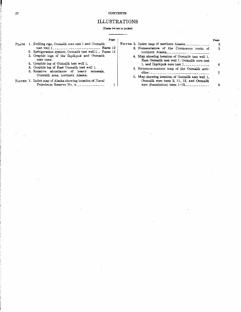
Drilling rigs, Oumalik core test 1 and Oumalik test well L _ _ _ ___ _ ___ _ _ ___ _ _ __ ___ ____ Faces 12
Refrigeration system, Oumalik test well L_ Faces 13 Graphic logs of the Ikpikpuk and Oumalik
core tests. Graphic log of Oumalik test well 1. Graphic log of East Oumalik test well 1. Relative abundance of heavy minerals,
Oumalik area, northern Alaska.
Index map of Alaska showing location of Naval Petroleum Reserve No. L ______________ _
FIGURE 2.. Index map of northern Alaska _____________ _
3. N omenelature of the Cretaceous rocks of northern Alaska _______________________ _
4. Map showing loeation of Ollmalik test well 1, East Oumalik test well 1, Oumalik core test 1, and Ikpikpuk core test L ____________ _
5. Structure-eontour map of the Oumalik anti-cline _________________________________ _
6. Map showing loeation of Oumalik: test well 1, Oumalik core tests 2, 11, 12, and Oumalik epre (foundation) tests 1-10 _____________ _
Page
2 3
6
7
8

I',
EXPLORATION OF NAVAL PETROLEUM RESERVE NO.4 AND ADJACENT AREAS, NORTHERN ALASKA, 1944-53
PART 5, SUBSURFACE GEOLO~Y AND ENGINEERING DATA
INTRODUCTION
By FLORENCE M. ROBINSON
In 1'944 the United States Navy began large-scale ~xploration of Naval Petroleum Reserve No.4, northern Alaska (see fig. 1), to determine the petroleum possibilities. This area of approximately 35,000 square miles includes parts of the Arctic coastal plain, the
":.;;;" Pribilof Islands
..•. i:ii,
Arctic foothills, and the Brooks Range provinces .. The factors of climate, terrain, and geographic location made this a unique operation. The winters are very cold with temperatures as low as the minus sixties, the summers, cool and short. Daylight lasts almost 24 hours a day unbroken from May through July; darkness' is continual through most of December and January. Permafrost underlies much of the area, in places to a·
PACIFI,C
100 o 100 200 300
FI<1URE l.-Index map of.A.Jaska showing location of Naval Petroleum Reserve No, 4, 1
~
! r I I
l I 1
f I I f
2 EXPLORATION OF N.A.YAL PETROLEUM RESERYE NO.4, ALASKA, 1944-53
f 1680 164" ISO· 156·
EXPLANATION C 0 c· I E 0\} C 'f <4
Gas won It p,. +
Abandoned well
-+ 70· Dry hole
SECTI~~ .•••••.• ' c f, •••••••• Of{I~
P R ~.
1
68. II R 0'0 K S
I ~------~==:=====I~64t.====·:··====~======:d5~P======~I;qo;:~~~~~~~~~~:=====115:2.:=======--------~ I SOUTH BARROW TEST WELL 1 2 SOUTH BARROW TEST WELL 2 3 SOUTH BARROW TEST WELL 3 4 SOUTH BARROW TEST WELL 4 3 AVAK TEST WELL I ~ NORTH SIMPSON TEST WELL 1
7 SI MPSON TEST WELL 1 8 TOPAGORUK TEST WELL 1 9 EAST TOPAGORUK TEST WELL t
10 FISH CREEK TEST WELL 1 11 KAOUK TEST WELL 1 12 MEADE TEST WELL 1
13 OU MALII( TEST WELL 1 14 EAST OUMALIK TEST WELL 1 15 SOUARE LAKE TEST WELL 1 16 TITALUK TEST WELL 1 17 WOL~ CREEK TEST WELL 1 18 WOLF CREEK TEST WELL 2
19 WOLF CREEK TEST W!LL 3 20 GUBI K TEST WELL 1 21 GUBIK TEST WElL 2 22 KNIFEBLADE TEST WELL 1 23 KNIFEBLADE TEST WELLS 2 AND 2A 24 GRANDSTAND TEsT WELL 1 25 UMIAT TEST WELLS 1-11
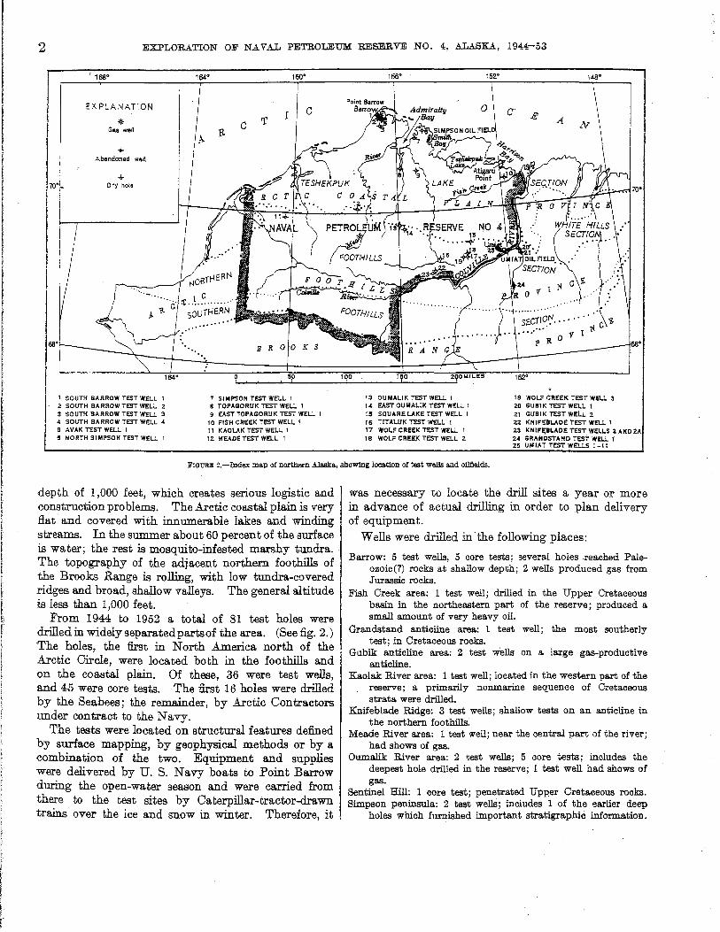
FrGURlI: 2.-Index map of northern Alaska, showing location of test wells and oilllelds.
depth of 1,000 feet, which creates serious logistic and construction problems. The Arctic coastal plain is very flat' and covered with innumerable lakes and winding streams. In the summer about 60 percent of the surface is water; the rest is mosquito-infested marshy tundra. The topography of the adjacent northern foothills of the Brooks Range is rolling, with low tundra-covered ridges and broad, shallow valleys. The general altitude is less than 1,000 feet.
From 1944 to 1952 a total of 81 test holes were drilled in widely separated parts of the area. (See fig. 2.) The holes, the first in North America north of the Arctic Circle, were located both in the foothills and on the coastal plain. Of these, 36 were test wells, and 45 were core tests. The first 16 holes were drilled by the Seabees; the remainder, by Arctic Oontractors under contract to the Navy.
The tests were located on structural features defined by surface mapping, by geophysical methods or by a combination of the two. Equipment and supplies were delivered by U. S. Navy boats to Point Barrow -during the open-water season and were carried from there to the test sites by Caterpillar-tractor-drawn trains' over the ice and snow in winter. Therefore, it
was necessary to locate the drill sites a year or more in advance of actual drilling in order to plan delivery of equipment.
Wells were drilled in' the following places:
Barrow: 5 test wells, 5 core tests; several holes .reached Paleozoic (?) rocks at shallow depth; 2 wells produced gas from Jurassic rocks.
Fish Creek area: 1 test well; drilled in the Upper Cretaceous basin in the northeastern part of the reserve; produced a sma.ll amount of very heavy oil.
Grandstand anticline area: 1 test well; the most southerly test; in Cretaceous rocks.
Gubik anticline area: 2 test wells on a large gas-productive anticline.
Kaola.k: River area: 1 test well; located in the western part of the reserve; a primarily nonmarine sequence of Cretaceous strata were drilled.
Knifeblade Ridge: 3 test wells; sha.llow tests on an anticline in the northern foothills.
Meade River area: 1 test well; near the central part of the river; had shows of gas.
Oumalik River area: 2 test wells; 5 core tests; includes the deepest hole drilled in the reserve; 1 test well had shows of gas.
Sentinel Hill: 1 core test; penetrated Upper Cretaceous rocks. Simpson peninsula: 2 teat wells; includes 1 of the earlier deep
holes which furnished important stratigraphic information.
I [
I r
I
CORE TESTS AND TEST WELLS, OUMALIK AREA, ALASKA 3
Simpson Seeps: 34 core tests; a shallow oilfield was defined by the series of 'core tests.
Square Lake: 1 test well; a prospect northwest of Umiat defined by seismic and photogeologic techniques.
Titaluk River area: 1 test well; located on an anticline mapped primarily by field and photogeologic methods.
Topagoruk River area: 2 test wells; in the central part of the coastal plain; a deep test penetrated rocks ranging in age from Devonian to Pleistocene.
Umiat: 11 test wells; many produced oil. Wolf Creek area: 3 test wells; relatively shallow tests; shows of
gas.
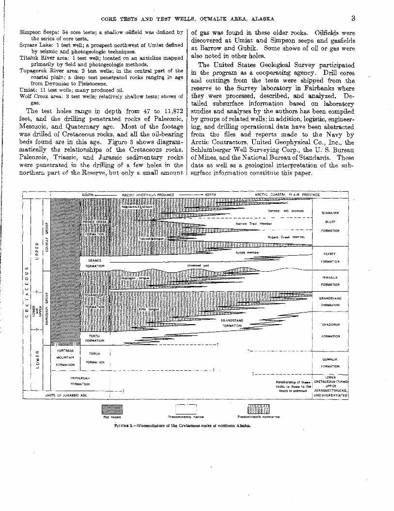
The test holes range in depth from 47 to 11,872 feet, and the drilling penetrated rocks of Paleozoic, Mesozoic, and Quaternary age. Most of the footage was drilled of Cretaceous rocks, and all the oil-bearing beds found are in this age. Figure 3 shows diagrammatically the relationships of the Cretaceous rocks. Paleozoic, Triassic, and Jurassic sedimentary rocks were penetrated in the drilling of a few holes in the northern part of the Reserve, but only a small amount
of gas was found in these older rocks. Oilfields were discovered at Umiat and Simpson seeps and gasfields at Barrow and Gubik. Some shows of oil or gas were also noted in other holes.
The United States Geological Survey participated in the program as a cooperating agency. Drill cores and cuttings from the tests were shipped from the reserve to the Survey laboratory in Fairbanks where they were processed, described, and analyzed. Detailed subsurface information based on laboratory studies and analyses by the authors has been compiled by groups of related wells; in addition, logistic, engineering, and drilling operational data have been abstracted from the files and reports made to the Navy by Arctic Contractors, United Geophysical Co., Inc., the Schlumberger Well Surveying Corp., the U. S. Bureau of Mines, and the National Bureau of Standards. These data as well as a geological interpretation of the subsurface information constitute this paper.
Barrow Trail member
~~z:::===-- - - - - -- ---Rogers Creek member
Ayiyak member
FORMATION
SCHRADER
BLUFF
FORMATION
SEABEE
FORMATION
NINULUK
FORMATION
GRANDSTAND
FORMATION
TOPAGORUK
FORMATION
------- -------.-? FORTRESS
TOROK MOUNTAIN
FORMATION FORMATION
f.-------'-----+--- -- ------- - ------------? OKPtKRUAK
FORMATION I-..L-_L-..L-________ -+- __ ?
-Not known Predominantly marine
?---------------+------4
DUMAUK
FORMATION
?--------------+-----~ LOWER
Relationship ot these CRETACEOUS (?)AN rocks to those to the
south is unknown UNDIFFER
Predominantly nonmarrne
FIOURE 3.-Nomenclature of the Cretaceous,rocks of northern Alaska.
EXPLORATION OF NAVAL PETROLEUM RESERVE NO.4 AND ADJACENT AREAS, NORTHERN ALASKA, 1944-53
CORE TEST AND TEST WELLS, OUMALIK AREA, ALASKA
By FLORENCE M. ROBINSON
ABSTRACT
The Oumalik test wells and core tests were drilled in the years 1947-51 as a part of the exoloration progra.m of Naval Petroleum Reserve No; 4, northern Alaska. These ~sts are located on the Oumalik anticline about 100 miles south-southeast of Point Barrow. Oumalik test well 1 and East Oumalik test weIll were 'drilled primarily to test sandstones of Cretaceous age on the -structure, which was delineated by geophysical means. The <core tests, which were drilled before the deeper holes, served primarily for stratigraphic and foundation studies.
The depth of the holes ranges from 47 feet in a foundation test to 11,872 feet in Oumalik test well 1, the deepest test well drilled
. in the Petroleum Reserve. The stratigraphic section penetrated <consists of the Nanushuk group and the Topagoruk and Oumalik formations, of Early and Late Cretaceous age, plus a unit of Late Jurassic(?) and Ea.rly Cretaceous(?) age. Shows of oil were negligible. Drilling of Oumalik test well 1 revealed some -shows of high-pressure and low-volume gas which is of little present commercial value.
INTRODUCTION
Five core' holes, ten fOlilldation tests, and two test wells were drilled in the Oumalik River region on the Oumalik a.nticline, near the northern bOlilldary of the Arctic foothills province, at lat 69°50' N. and between long 155°15' W. and 156°15' W. The name "Oumalik" comes from the Eskimo name of a small river which heads in the area.
The core holes were preliminary tests drilled on an anticline discovered in 1947 by reflection seismograph. Geophysical and geological investigations in this area led to the drilling in 1949 and 1950 of the two deep tests: Oumalik test well 1 on the crest of the anticline and East Oumalik test well 1 on a subsidiary high at the east end. Inasmuch as rock exposures are practically nonexistent, the stratigraphy of the area is known only from cores and cuttings from the wells. This report describes in detail the strata penetrated, as well as the logistics, engineering, and drilling operations.
ACKNOWLEDGMENTS
Information for this report was compiled from daily and final reports made to the U. S. Navy by Arctic
374616-56-2
Oontractors, United Geophysical 00., Inc., The Schlumberger Well·Surveying Oorp., and the U. S. Geological Survey. Gas analyses were made by the National Bureau of Standards, Washington, D.O., the' U. S. Bureau of Mines, Amarillo, Tex., and the SmithEmery 00., Los Angeles, Oalif. The help of the personnel connected with the above organizations is gratefully acknowledged.
Unless otherwise noted, the core and cutting analyses were made by the staff of the U. S. Geological Survey in Fairbanks, Alaska,. Microfossils were identified by Harlan R. Bergquist. The stratigraphic distribution of fossils in the test wells of northern Alaska will be presented by him in another chapter of this series. Megafossils were identified by Ralph W. Imlay and Roland W. Brown. P. D. Krynine and S. T. Yuster made reservoir analyses and furnished some additional data on porosity and permeability. The heavy-mineral zones were determined as part of a regional study of heavy minerals by Robert H. Morris. A summary of thermal investigations of Oumalik test well 1 was furnished by Max O. Brewer.
STRUCTURE
The Oumalik area (fig. 4) was first explored by the U. S. Geological Survey in cooperation with the Navy, using an airborne magnetometer, during 1945 and 1946. United Geophysical 00., Inc., made a reconnaissance gravity survey and a limited detailed survey of the area in 1947. These surveys indicate that the Oumalik anticline lies in a regional gravity low southwest of a gravity high that extends from a point northwest of Umiat to Smith Bay (Payne and others, 1951, sheet 2, fig. 9). In general, the observed gravity low covers most of the southwestern part of Naval Petroleum Reserve No.4.
The Oumalik anticline was discovered later in 19'47 by reflection seismograph (United Geophysical 00.), in the course of checking magnetic anomalies to the northeast. Additional seismic surveys, both reflection and refraction, were made in the Oumalik-middle
5
6 EXPLORATION OF NAVAL PETROLEUM RESERVE NO.4, ALASKA, 1944-53
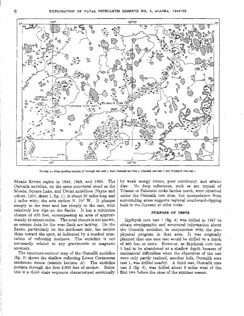
FlOWE 4.-Msp showing location of Oumallk test well 1, East OumaIik test well 1, Oumallk core test I, and Ikpikpuk core test 1.
Meade Rivers region in 1948, 1949, and 1950. The Oumalik anticline, on the same structural trend as the Meade, Square Lake, and Umiat anticlines (Payne and others, 1951, sheet 1, fig. 1), is about 20 miles long an~ 5 miles wide; the axis strikes N. 70° W. It plunges steeply to the west and less steeply to the east, with relatively low dips on the flanks. It has a minimum closure of 450 feet, encompassing an area of approximately 43 square miles. The total closure is not known, as seismic data for the west flank are lacking. On the flanks, particularly on the northeast side, the section thins toward the apex, as indicated by a marked truncation of reflecting horizons. The anticline is not necessarily related to any gravimetric or magnetic anomaly.
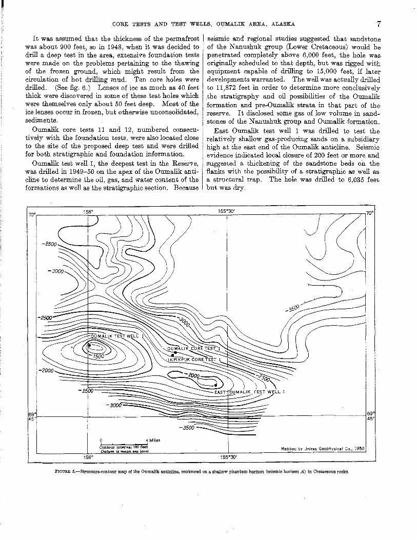
The structure-contour map of the Oumalik anticline (fig. 5) shows the shallow reflecting Lower Oretaceous sandstone strata (seismic horizon A). The anticline persists through the first 5,000 feet of section. Below this is a thick shale sequence characterized seismically
by weak energy return, poor continuity, and erratic dips. No deep reflections, such as are typical of Triassic or Paleozoic rocks farther north, were obtained under the Oumalik test sites, but interpolation from surrounding areas suggests regional southward-dipping beds in the Jurassic or older rocks.
PURPOSE OF TESTS
Ikpikpuk core test 1 (fig. 4) was drilled in 1947 to obtain stratigraphic and structural information about the Oumalik anticline, ill conjunction with the geophysical program in that area. It was originally planned that one core test would be drilled to a depth of 400 feet or more. However, as Ikpikpuk core test 1 had to be abandoned at a shallow depth because of mechanical difficulties when the objectives of the test were only partly realized, another hole, Oumalik core test 1, was drilled nearby. A third test, Oumalik core test 2 (fig. 6), was drilled about 6 miles west of the first two before the close of the summer season.
CORE TESTS AND TEST WELLS, OUMALIK AREA, ALASKA 7
It was assumed that the thickness of the permafrost was about 900 feet, so in 1948, when it was decided to drill a deep test in the area, extensive foundation tests were made on the problems pertaining to the thawing of the frozen ground, which might result from the circulation of hot drilling mud. Ten core holes were drilled. (See fig. 6.) Lenses of ice as much as 40 feet thick were discovered in some of these test holes which were themselves only about 50 feet deep. Most of the ice lenses occur in frozen, but otherwise unconsolidated, sediments.
Oumalik core tests 11 and 12, numbered consecutively with the foundation tests, were also located close to the site of the proposed deep test and were drilled for both stratigraphic and foundation information.
Oumalik test well. 1 , the deepest test in the Reserve, was drilled in 1949-50 on the apex of the Oumalik anticline to determine the oil, gas, and water content of the formations as well as the stratigraphic section. Because
1560
o 4 Miles
Contour interval 100 feei Da.tum is nua.1'I. SfJG. level
seismic and regional studies suggested that sandstone of the Nanushuk group (Lower Cretaceous) would be penetrated completely above 6,000 feet, the hole was originally scheduled to that depth, but was rigged witt equipment capable of drilling to 15,000 feet, if later developments warranted. The well was actually drilled to 11,872 feet in order to determine more conclusively .the stratigraphy and oil possibilities of the Oumalik formation and pre-Oumalik strata in that part of the reserve. It disclosed some gas of low volume in sandstones of the Nanushuk group and Oumalik formation.
East Oumalik test well 1 was drilled to test the relatively shallow gas-producing sands on a subsidiary high at the east end of the Oumalik anticline. Seismic' evidence indicated local closure of 200 feet or more and suggested a thickening of the sandstone beds on the flanks with the possibility of a stratigraphic as well as a structural trap. The hole was drilled to 6,035 feet but was dry.
Mapped by United Geophysical Co .• 1950
155°30'
FIGURE 5.-Structure-contour map of the Oumalik anticline, contoured on a sha.llow phantom horizon (seismic horizon A) in Cretaceous rocks.

8 EXPLORATION OF NAVAL PETROLEUM RESERVE NO.4, ALASKA, 1944-53
I 0 8
N
~ r <'; 0' ill i ~ I
I
0'
0 7 '0
0' O' '. 6IrSO'lS"N -9- OUMAUK TEST wELL 1
.11
C~I-0l
EXPLANATION
.' Core test
o· Core(found8tion) test
0 '0
100 0 200 Feet I , I , I
o·
FIGURE 6.-Map showing location of OumaJik test well 1, OumaJik core tests 2. 11. 12. and OumaJik core (foundation) tests 1-10.
STRATIGRAPHY
The Oumalik tests were drilled in rocks that were deposited in the deepest part of a basin or trough in Cretaceous time. Five units have been distinguished, ranging in age from Late Jurassic(?) and Early Cretaceous(?) to Late(?) Cretaceous (Killik. tongue, Chandler formation.) Th ese rocks are man tIed by Pleistocene and Recent deposits.
QUATERNARY DEPOSITS
GUBIK FORMATION-PLEISTOCENE
The unconsolidated surficial mantle, as much as 40 feet thick over most of the Oumalik region, is made up of river material of Recent age or of the Gubik formation of Pleistocene age, or both. The sediments consist of silt, sand, gravel, and clay containing ice lenses and wedges near the surface and largely covered by tundra. Yellowish-gray and light-olive-gray clay and silt beds are probably the most common. The yellowish-brown sand is fine to coarse grained and contains grains of
subangular to rounded clear and white quartz and yellow, dark-gray, and black chert. Well-rounded sand grains are characteristic of the Gubik as contrasted to 'the angular and sub angular grains of the underlying Cretaceous formations. The pebbles and granules in the gravel are various shades of brown, green, gray, and black polished chert. .Angular pieces of orange to brown clay ironstone and yellowish quartzite are also present. In some areas the Gubik formation does not contain coarse sediments. White shell fragments and nonmarine ostracodes have been found.
CRETACEOUS ROCKS
CHANDLER FORMATION (KlT,T,TK TONGUE)
Rocks of the Nanushuk group (fig. 3; see Gryc, and others, 1956, and Gryc, Patton, and Payne, 1951) underlie the Gubik formation. The youngest Cretaceous strata penetrated by the Oumalik tests are the nonmarine Killik tongue of the Chandler formation. Very little of this tongue is present at the apex of the anticline, but it is about 700 feet thick in East Oumalik test well 1. It is predominantly clay shale and coal interbedded with some sandstone and siltstone. The sandstone beds are light gray and medium soft, but a few are hard with a calcareous matrix. The grains are very fine to fine and are composed mostly of sub angular white and clear quartz, mica, and coal particles in an argillaceous matrix. The sandstone has low porosity and permeability. The siltstone beds are similar to the sandstone but are generally darker. The clay shale is light gray to black and is rather soft and fissile where associated with carbonaceous material. Very rare, very thin beds of hard medium- to dark-gray argillaceous lithographic limestone are also present.
The coal and carbonaceous material which occur as thin beds, partings, and plant fragments throughout the sequence are characteristic of the Killik tongue. The coal is grayish black to black and has a dull to vitreous luster. Yellowish-gray hard ciay ironstone concretions· and nodules are also common in this tongue. The presence of coal and charophytes and the absence of marine fossils indicate that these beds are of nonmarine origin.
GRANDSTAND FORMATION
The transition from the Killik tongue to the Grandstand formation is gradational, and there are a few nonmarine beds of the Killik tongue in the upper part of the Grandstand. The thickness of the Grandstand formation on the Oumalik structure ranges from at least 2,300 to 2,800 feet. About 600 feet of the total thickness is made up of sandstone and siltstone. The sandstone is light to medium light gray, the siltstone is slightly darker. It is made up of 60 percent or more
CORE TESTS AND TEST WELLS, OUMALIK AREA, ALASKA 9
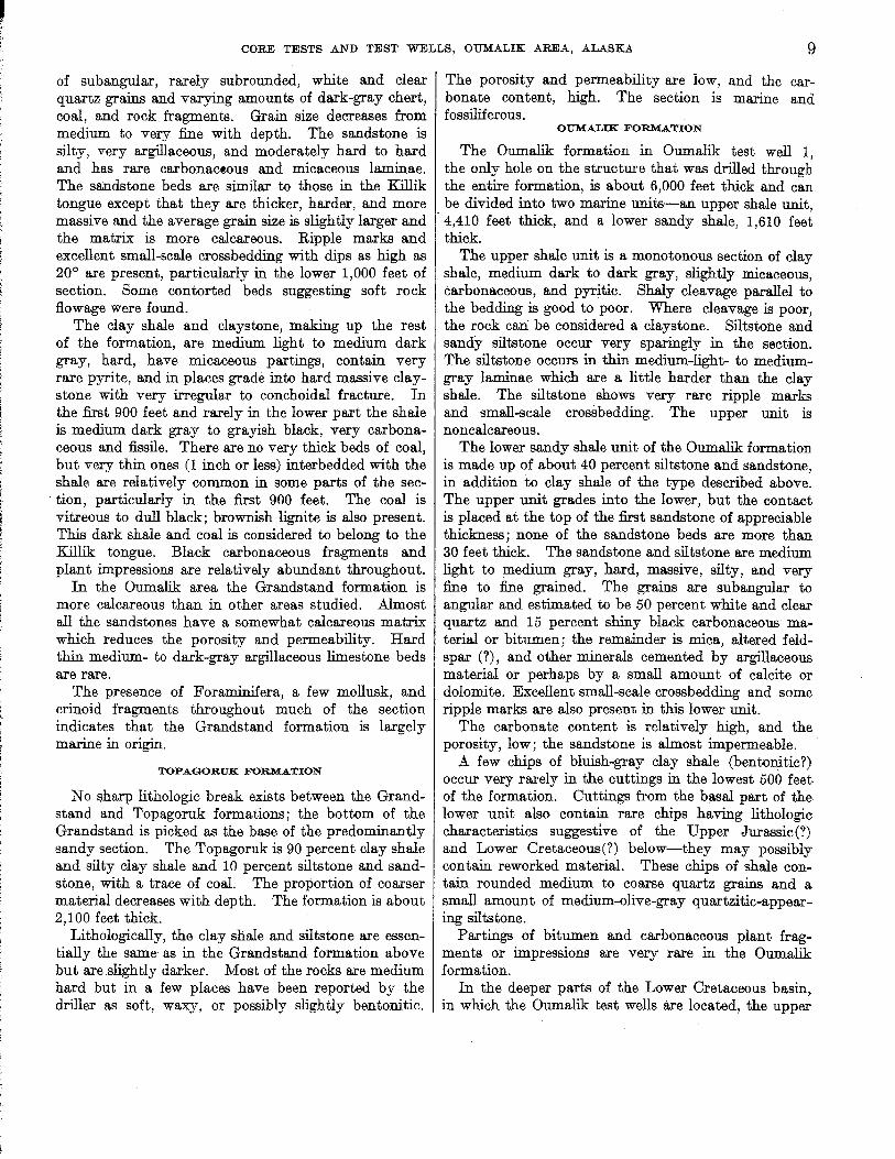
of subangular, rarely subrounded, white and clear I The porosity and permeability are low, and the carquartz grains and varying amounts of dark-gray chert, bonate content, high. The section is marine and coal, and rock. fragments. Grain size decreases from fossiliferous. medium to very fine with depth. The sandstone is silty, very argillaceous, and moderately hard to hard and has rare carbonaceous and micaceous laminae. The sandstone beds are similar to those in the Killik tongue except that they are thicker, harder, and more massive and the average grain size is slightly larger and the matrix is more calcareous. Ripple marks and excellent small-scale crossbedding with dips as high as 20° are present, particularly in the lower 1,000 feet of section. Some contorted beds suggesting soft rock
, flowage were found. The clay shale and claystone, making up the rest
of the formation, are medium light to medium dark gray, hard, have micaceous partings, contain very rare pyrite, and in places grade into hard massive claystone with very irregular to conchoidal fracture. In the first 900 feet and rarely in the lower part the shale is medium dark gray to grayish black, very carbonaceous and fissile. There are no very thick beds of coal, but very thin ones (1 inch or less) interbedded with the shale are relatively common in some parts of the sec-
. tion, particularly in the :first 900 feet. The coal is vitreous to dull black; brownish lignite is also present. This dark shale and coal is considered to belong to the Killik tongue. Black carbonaceous fragments and plant impressions are relatively abundant throughout.
In the Oumalik area the Grandstand formation is more calcareous than in other areas studied. Almost all the sandstones have a somewhat calcareous matrix which reduces the porosity and permeability. Hard thin medium- to dark-gray argillaceous limestone beds are rare.
The presence of Foraminifera, a few mollusk, and crinoid fragments throughout much of the section indicates that the Grandstand formation is largely marine in origin.
TOPAGORUK FORMATION
No sharp lithologic break exists between the Grandstand and Topagoruk formations; the bottom of the Grandstand is picked as the base of the predominantly sandy section. The Topagoruk is 90 percent clay shale and silty clay shale and 10 percent siltstone and sandstone, with a trace of coal. The proportion of coarser material decreases with depth. The formation is about 2,100 feet thick.
Lithologically, the clay shale and siltstone are essentially the same as in the Grandstand formation above but are.slightly darker. Most of the rocks are medium hard but in a few places have been reported by the driller as soft, waxy, or possibly slightly bentonitic.
OUMALIK FORMATION
The Oumalik formation in Oumalik test well 1, the only hole on the structure that was drilled through the entire formation, is about 6,000 feet thick and can be divided into two marine units-an upper shale unit, 4,410 feet thick, and a lower sandy shale, 1,610 feet thick.
The upper shale unit is a monotonous section of clay sbale, medium dark to dark gray, slightly micaceous, carbonaceous, and pyritic. Shaly cleavage parallel to the bedding is good to poor. Where cleavage is poor, the rock can be considered a claystone. Siltstone and sandy siltstone occur very sparingly in the section. The siltstone occurs in thin medium-light- to mediumgray laminae which are a little barder tban the clay shale. Tbe siltstone shows very rare ripple marks and small-scale crossbedding. The upper unit is noncalcareous.
Tbe lower sandy shale unit of the Oumalik formation is made up of about 40 percent siltstone and sandstone, in addition to clay shale of the type described above. The upper unit grades into the lower, but the contact is placed at tbe top of the first sandstone of appreciable thickness; none of the sandstone beds are more than 30 feet thick. The sandstone and siltstone are medium light to medium gray, hard, massive, silty, and very fine to fine grained. Tbe grains are sub angular to angular and estimated to be 50 percent white and clear quartz and 15 percent shiny black carbonaceous material or bitumen; the remainder is mica, altered feldspar (?), and other minerals cemented by argillaceous material or perhaps by a small amount of calcite or dolomite. Excellent small-scale crossbedding and some ripple marks are also present in this lower unit.
The carbonate content is relatively high, and the porosity, low; the sandstone is almost impermeable.
A few chips of bluish-gray clay shale (bentonitic?) occur very rarely in the cuttings in the lowest 500 feet of the formation. Cuttings from the basal part of the lower unit also contain rare chips having lithologic characteristics suggestive of the Upper Jurassic(?) and Lower Cretaceous(?) below-they may possibly contain reworked material. Tbese chips of shale contain rounded medium to coarse quartz grains and a small amount of medium-olive-gray quartzitic-appearing siltstone.
Partings of bitumen and carbonaceous plant fragments or impressions are very rare in the Oumalik formation.
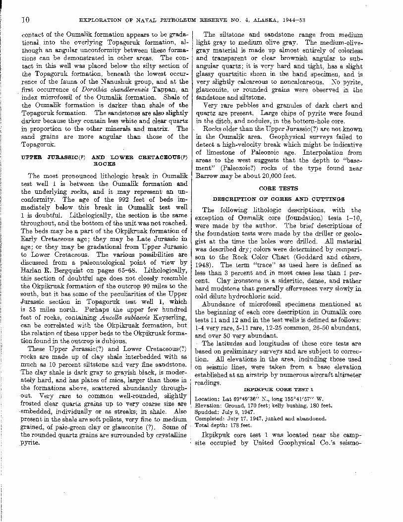
In tbe deeper parts of the Lower Cretaceous basin, in which the Oumalik test wells are located, the upper
10 EXPLORATION OF NAVAL PETROLEUM RESERVE NO.4, ALASKA, 1944-53
contact of the Oumalik formation appears to be gradational into the overlying Topagoruk formation, although an angular unconformity between these formations can be demonstrated in other areas. The contact in this well was placed below the silty section of the Topagoruk formation, beneath the lowest occurrence of the fauna of the Nanushuk group, and at the first occurrence of Dorothia chandlerensis Tappan, an index microfossil of the Oumalik formation. Shale of the Oumalik formation is darker than shale of the Topagoruk formation. The sandstones are also slightly darker because they contain less white and clear quartz in proportion to the other minerals and matrix. The sand grains are more angular than those of the Topagoruk.
UPPER JURASSIC(P) AND LOWER CRETACEOUS(P) ROCKS
The most pronounced lithologic break in Oumalik test well 1 is between the Oumalik formation and the underlying rocks, and it may represent an unconformity. The age of the 992 feet of beds immediately below this break in Oumalik test well 1 is doubtful. Lithologically, the section is the same tl>..roughout, and the bottom of the unit was not reached. The beds may be a part of the Okpikruak formation of Early Cretaceous age; they may be Late Jurassic in age; or they may be gradational from Upper Jurassic to Lower Cretaceous. The various possibilities are discussed from a paleontological point of view by Harlan R. Bergquist on pages 65-68. Lithologically, this section of doubtful age does not closely resemble the Okpikruak formation of the outcrop 90 miles to the south, but it has some of the peculiarities of the Upper Jurassic section in Topagoruk test well 1, which is 55 miles north. Perhaps the upper few hundred feet of rocks, containing Aucella sublaevis Keyserling, can be correlated with the Okpikruak formation, but the relation of these upper beds to the Okpikruak formation found in the outcrop is dubious.
These Upper Jurassic(?) and Lower Cretaceous(?) rocks are made up of clay shale interbedded with as much as 10 percent siltstone and very fine sandstone. The clay shale is dark gray to grayish black, is moderately hard, and has plates of mica, larger than those in the formations above, scattered abundantly throughout. Very rare to common well-rounded, slightly frosted clear quartz grains up to very coarse size are embedded, individually or as streaks; in shale. Also present in the shale are soft pellets, very fine to medium grained, of pale-green clay or glauconite (?). Some of the rounded quartz grains are surrounded by crystalline
:pyrite.
The siltstone and sandstone range from medium light gray to medium olive gray. The medium-olivegray material is made up almost entirely of colorless and transparent or clear brownish angular to subangular quartz; it is very hard and tight, has a slight glassy quartzitic sheen in the hand specimen, and is very slightly calcareous to noncalcareous. No pyrite, glauconite, or rounded grains were observed in the sandstone and siltstone.
Very rare pebbles and granules of dark chert and quartz are present. Large chips of pyrite were found in the ditch, and nodules, in the bottom-hole core.
Rocks older than the Upper Jurassic(?) are not known in the Oumalik area. Geophysical surveys failed to detect a high-velocity break which might be indicative of limestone of Paleozoic age. Interpolation from areas to the west suggests that the depth to "basement" (Paleozoic?) rocks of the type found near Barrow may be about 20,000 feet.
CORE TES'I1S
DESCRIPTION OF CORES AND CUTTINGS
The following lithologic descriptions, with the exception of Oumalik cote (foundation) tests 1-10, were made by the author. The brief descriptions of the foundation tests were made by the driller or geologist at the time the holes were drilled. All material was described dry; colors were determined by comparison to the Rock Oolor Ohart (Goddard and others, 1948). The term "trace" as used here is defined as less than 3 percent and in most cases less than 1 percent. Clay ironstone is a sideritic, dense, and rather hard mudstone that generally effervesces very slowly in cold dilute hydrochloric acid.
A.bundance of microfossil specimens mentioned at the beginning of each core description in Oumalik core tests 11 and 12 and in the test wells is defined as follows: 1-4 very rare, 5-11 rare, 12-25 common, 26-50 abundant, and over 50 very abundant.
The latitudes and longitudes of these core tests are based on preliminary surveys and are subject to correction. All elevations in the area, including those used on seismic lines, were taken from a base elevation established at an airstrip by numerous aircraft altimeter readings.
IKPIKPUK CORE TEST 1
Location: Lat 69°49'36" N., long 155°41'57" W. Elevation: Ground, 170 feet; kelly bushing, 180 feet. Spudded: July 9, 1947. Completed: July 17, 1947, junked and abandoned. Total depth: 178 feet.
Ikpikpuk core test 1 was located near the campsite occupied by United Geophysical Oo.'s seismo-

CORE TESTS AND TEST WELLS, OUMALIK AREA, ALASKA 11
graph party 46. Seismic evidence indicates that the hole was located off the crest on the north flank of the Oumalik anticline (see fig. 5), as contoured on shallow sandstone strata of Cretaceous age. The top of the Cretaceous section in this hole is approximately 400 feet stratigraphically higher than the uppermost Cretaceous penetrated in drilling East Oumalik test well 1. (See p.8.)
No samples were received for the upper 39 feet of the hole. The first sample, at 39 feet, is Cretaceous, with surface contamination suggesting that the Pleistocene and (or) Recent mantle is 30 feet thick or less. The hole from 39 feet to total depth is in both the Lower and Upper Oretaceous, probably in the nonmarine Ohandler formation of the Nanushuk group. (See pI. 3.)
The hole was abandoned when the N-rods twisted off at 90 feet.
The samples from this test are very poor. The cuttings consist almost entirely of contaminating material from the surface and are not necessarily indicative of the formations penetrated. The cores are also poor and badly infiltrated by drilling mud. All depths are measured from the kelly bushing.
Lithologic description
[Where no core numher is given, description is from cuttings]
Core Depth (feet)
0-10 10-39 39-98
1 98-108
____ 108-149
2 149-159
Description
Kelly bushing to ground level. No samples received. Sand, light-olive-gray, unconsolidated, medium
to coarse-grained; grains round to subround and made up of 80 percent clear, yellow, and white quartz, 20 percent dark-gray and black chert. A few shiny black coal chips at 84-94 ft. Clay (drilling mud) loosely cements some of the grains; white pelecypod shell fragments and ostracodes present. Trace of light-gray very calcareous cement throughout.
Recovered 4 ft: Clay shale, medium-light- to medium-gray,
fissile, soft; rare dark-gray carbonaceous noncalcareous clay shale. This part of core badly broken by drill and infiltrated by drilling mud.W ell-rounded black and yellow chert granules and pebbles found in mud in middle of recovered section are probably surface contamination. Dip of beds indeterminate.
Sand and drilling mud as above. Larger proportion of 8ubangular grains with increasing depth. Also a gradual increase in proportion of white and clear quartz to yellow quartz. No sandstone chips recovered.
Recovered 5 ft: 1 ft 6 in., sand, unconsolidated. This sand
is ground-up medium-grained sanditone of Cretaceous age (subangular white and clear quartz and carbonaceous particles)
Core Depth (feet)
Lithologic description-Continued
Description
and a liberal amount of surface material (subround yellow and clear quartz grains, a few rounded chert granules), chips of clay shale, and black low-grade coal, all loosely embedded in drilling mud. Some calcareous material in mud probably is ground-up cement.
3 ft 6 in., siltstone, medium-light-gray, hard, with irregular fracture; grains mostly white and clear quartz and minute particles of carbonaceous material; beds approximately fiat lying, some small-scale crossbedding.
____ 159-178 'Sand and drilling mud. Sand grains are very fine to fine, made up of 85 percent white and clear quartz; remainder is yellow quartz, gray and black chert, dark-colored rock fragments and black carbonaceous material. This sand is a mixture of surface material and ground-up sandstone of Cretaceous age.
OUMA...LlK CORE TEST 1
Location: Lat 69°49'45" N., long 155°41'30" W . . Elevation: Ground, 245 feet; kelly bushing, 255 feet.
Spudded: July 21, 1947. Completed: July 29, 1947, junked and abandoned. Total depth: 392 feet.
. Oumalik core test 1 is located approximately onequarter of a mile northeast of Ikpikpuk core test 1. (See fig. 4.) Although they are relatively close together, Oumalik core test 1 probably started as much as 100 feet higher in the section because of its higher elevation and position farther downdip on the flank of the anticline. Oorrelation between the two holes is difficult, owing to poor samples.
Samples were not 0 btained from the upper 30 feet of the hole. The sample from 30-foot depth is Oretaceous in age. Oontamination in this and lower samples indicates that overlying Pleistocene and (or) Recent sediments are the same as those in Ikpikpuk core test 1; that is, rounded fine to coarse sand, rounded granules of yellow and black chert, and soft light-olive-gray to dusky-yellow clay.
The Lower and Upper Oretaceous rocks, probably of the Ohandler formation, drilled in the rest of the hole are mostly clay shale with a few beds of sandstone and siltstone. The hole was abandoned when the drillers were unable to recover a core barrel stuck at 88 feet.
The cuttings from this test are very poor. About 95 percent of the samples represents contaminating cement, drilling mud, and near-surface Pleistocene or Recent sand and is not necessarily indicative of the formations penetrated. All depths are measured from the kelly bushing.
12 EXPLORATION OF NAVAL PETROLEUM RESERVE NO.4, ALASKA, 1944-53
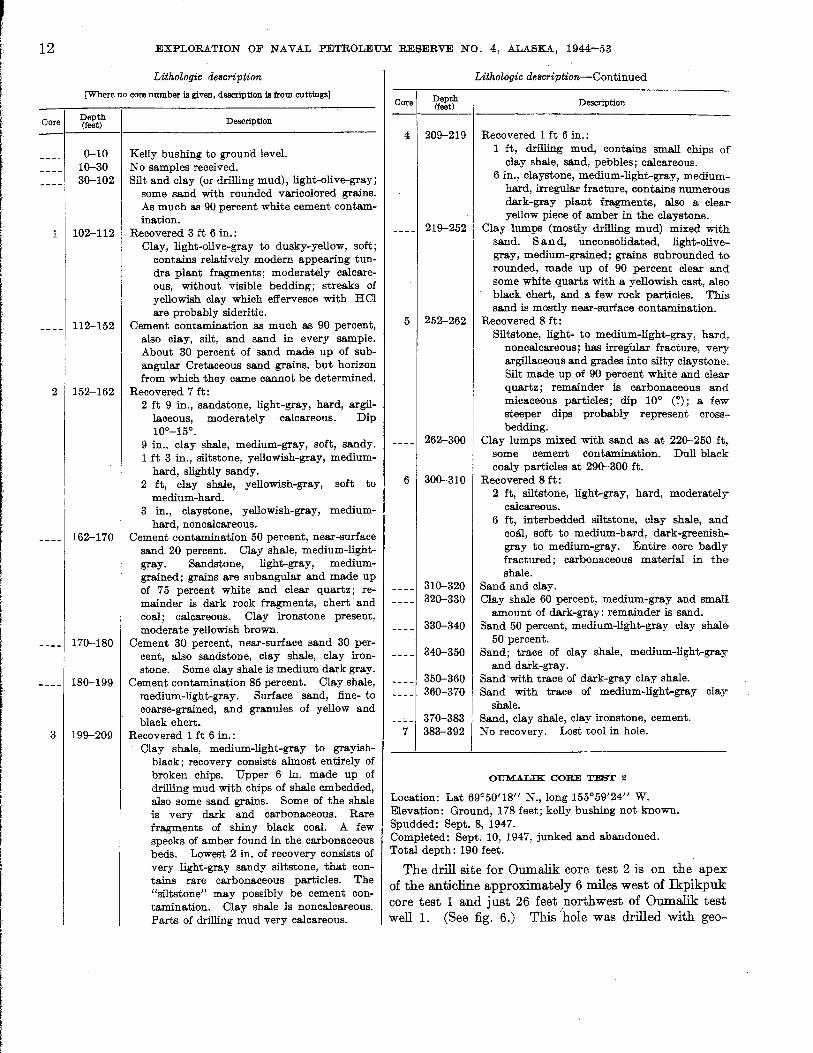
Lithologic description
[Where no core number is given, description is from cuttings]
Oore Depth (feet)
0-10 10-30 30-102
1 102-112
____ 112-152
2 152-162
Description
Kelly bushing to ground level. No samples received. Silt and clay (or drilling mud), light-olive-gray;
some sand with rounded varicolored grains. As much as 90 percent white cement contamination.
Recovered 3 ft 6 in.: Clay, light-olive-gray to dusky-yellow, soft;
contains relatively modern appearing tundra plant fragments; moderately calcareous, without visible bedding; streaks of yellowish clay which effervesce with HCI are probably sideritic.
Cement contamination as much as 90 percent, also clay, silt, and sand in every sample. About 30 percent of sand made up of subangular Cretaceous sand grains, but horizon from which they came cannot be determined.
Recovered 7 ft: 2 ft 9 in., sandstone, light-gray, hard, argil-
laceous, moderately calcareous. Dip 10°-15°.
9 in., clay shale, medium-gray, soft, sandy. 1 ft 3 in., siltstone, yellowish-gray, medium
hard, slightly sandy. 2 ft, clay shale, yellowish-gray, soft to
medium-hard. 3 in., claystone, yellowish-gray, medium
hard, non calcareous. ____ 162-170 Cement contamination 50 percent, near-surface
sand 20 percent. Clay shale, medium-lightgray. Sandstone, light-gray, mediumgrained; grains are subangular and made up of 75 percent white and clear quartz; remainder is dark rock fragments, chert· and coal; calcareous. Clay ironstone present, moderate yellowish brown.
_ _ _ _ 170-180 Cement 30 percent, near-surface sand 30 percent, also sandstone, clay shale, clay ironstone. Some clay shale is medium dark gray.
____ 180-199 Cement contamination 85 percent. Clay shale, medium-light-gray. Surface· sand, fine- to coarse-grained, and granules of yellow and black chert.
3 199-209 Recovered 1 ft 6 in.: Clay shale, medium-light-gray to grayish
black; recovery consists almost entirely of broken chips. Upper 6 in. made up of drilling mud with chips of shale embedded, also some sand grains. Some of the shale is very dark and carbonaceous. Rare fragments of shiny black coal. A few specks of amber found in the carbonaceous beds. Lowest 2 in. of recovery consists of very light-gray sandy siltstone, that contains rare carbonaceous particles. The "siltstone" may possibly be cement contamination. Clay shale is noncalcareous. Parts of drilling mud very calcareous.
Core Depth (feet)
4 209-219
____ 219-252
5 252-262
_ _ _ _ 262-300
6 300-310
7
310-320 320-330
330-340
340-350
350-360 360-370
370-383 383-392
Lithologic description-Continued
Description
Recovered 1 ft 6 in.: 1 ft, drilling mud, contains small chips of
clay shale, sand, pebbles; calcareous. 6 in., claystone, medium-light-gray, medium
hard, irregular fracture, contains numerous dark-gray plant fragments, also a clear yellow piece of amber in the claystone.
Clay lumps (mostly drilling mud) mixed with sand. San d, unconsolidated, light-olivegray, medium-grained; grains subrounded to· rounded, made up of 90 percent clear and some white quartz with a yellowish cast, also black chert, and a few rock particles. This sand is mostly near-surface contamination.
Recovered 8 ft: Siltstone, light- to medium-light-gray, hard,
non calcareous ; has irregUlar fracture, very argillaceous and grades into silty claystone. Silt made up of 90 percent white and clear quartz; remainder is carbonaceous and micaceous particles; dip 10° (1); a few steeper dips probably represent crossbedding.
Clay lumps mixed with sand as at 220-250 ft, some cement contamination. Dull black coaly particles at 290-300 ft.
Recovered 8 ft: 2 ft, siltstone, light-gray, hard, moderately
calcareous. 6 ft, interbedded siltstone, clay shale, and
coal, soft to medium-hard, dark-greenishgray to medium-gray. Entire core badly fractured; carbonaceous material in the shale.
Sand and clay. Clay shale 60 percent, medium-gray and small
amount of dark-gray; remainder is sand. Sand 50 percent, medium-light-gray clay shale
50 percent. Sand; trace of clay shale, medium-light-gray
and dark-gray. Sand with trace of dark-gray clay shale. Sand with trace of medium-light-gray clay
shale. Sand, clay shale, clay ironstone, cement. No recovery. Lost tool in hole.
OUMALIK CORE TEST 2
Location: Lat 69°50'18" N., long 155°59'24" W. Elevation: Ground, 178 feet; kelly bushing not known. Spudded: Sept. 8, 1947. . Completed: Sept. 10, 1947, junked and abandoned. Total depth: 190 feet.
The drill site for Oumalik core test 2 is on the apex of the anticline approximately 6 miles west of Ikpikpuk core test 1 and just 26 feet northwest of Oumalik test well 1. (See fig. 6.) This Iho1e was drilled with geo-

GEOLOGICAL SURVEY
A. OUMALIK CORE TEST 1
Adjoining CAsing " rack piling and barrels mark the site chosen for Oumalik test weill ..
C. OUMALIK TEST WELL 1
View of derrick 600r; drawwork. right hackground. Taken Feh. 7, 1950, when hole waa at ll,007 feet.
PROFESSIONAL PAPER 305 PLATE 1
B. OUMALIK TEST WELL 1
General view of·derrick and rigbouae showing protective covering on rig. This cover i. neceuary for drilling under Arctic condition&. Taken on Feh. 7, 1950.
DRILLING RIGS, OUMALIK CORE TEST 1 AND OUMALIK TEST WELL 1
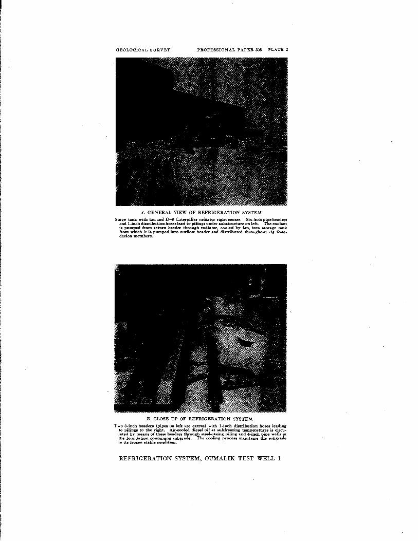
GEOLOGICAL SURVEY .PROFESSIONAL PAPER 305 PLATE 2
A. GENERAL VIEW OF REFRIGERATION SYSTEM
Surge tank with fan and D-8 Caterpillar radiato< right center. Six·inch pipe header. and l~inch distribution hoses lead to pilings under substructure on left. The coolant is pumped from return header througb radiator, cooled by fan .. into storage tank from which it is pumped into outflow header and distributed throughout rig foun .. dation members.
B. CLOSE UP OF REFRIGERATION SYSTEM
Two 6-inch header. (pipe. on left are extra.) with I-inch di.trihution hose. leading to pilings to the right. Air-cooled diesel oil at subfreezing temperatures is circu· Iated by meaDS of these headers through steel..casing piling and 4-inch pipe well. in the foundation containing suhgrade. The cooling prGCeB8 maintains the sub grade in its frozen stable condition.
REFRIGERATION SYSTEM, OUMALIK TEST WELL 1

CORE TESTS .AND TEST WELLS, OUMALIK AREA, ALASKA 13
physical shothole drilling equipment after the seismic program for the 1947 season was essentially completed.
Forty feet of Gubik formation (pleistocene) consisting of pale-yellowish-brown clay and light-olive-gray sand is present at the top of this test. The rest of the hole is in the Grandstand formation (Lower and Upper Cretaceous) of the Nanushuk group. The beds from 40 to 70 feet are nonfossiliferous and consist of mediumlight-gra;y clay shale and some medium-dark-gray carbonaceous shale, a trace of light-gray siltstone, and 20 to 50 percent black coal with vitreous luster and conchoidal fracture. The coaly beds probably represent a few intertonguing beds of the nonmarine Chandler formation.
The marine Verneuilinoides borealis microfauna appears in this core test at 70 feet. From 70 feet to the total depth at 190 feet the Grandstand is made up primarily of mediu:m-light-gray clay shale with some medium-dark-gray clay shale. Some light-gray sandy siltstone and a small amount of medium-bluish-gray hard argillaceous limestone are also present.
The hole was abandoned at 190 feet because of a stuck drill pipe.
The cuttings from Oumalik core test 2 are poor and very contaminated. No cores were taken because no core barrel was available. All depths are measured from ground level.
Lithologic description
[No core; descriptions from cuttings only]
Depth D . ti (feet) escnp on
0-10 Clay, pale-yellowish-brown. Sand 30 per(lent, lightolive-gray; grams, medium to coarse, subrounded to rounded, made up largely of clear and white quartz, also many grains of clear yellow quartz, (lommon dark-gray or black chert, and rare chert grains of other colors. Ostracodes, mollusk fragments, and tundra plant fragments present.
10-30 Clay, pale-yellowish-brown, slightly silty. Sand 15 percent, as above. Ostracodes present.
30-40 Gravel, pebbles, and granules of moderate yellowishbrown, dark-yellowish-brown, olive-gray, green, and black chert. Also rare sandstone, quartzite, and yellow quartz pebbles. Fragments of dark-yeilowish-orange to light-brown clay ironstone. Chert and rock pebbles are well rounded, but clay ironstone is angular. Sand 15 percent, as described above.
40-50 Coal 50 percent, black, with vitreous luster, conchoidal fracture. Clay shale 10 percent, medium-lightgray, and clay ironstone, light-olive-gray. Sand, 40 percent, is contamination from above.
50-60 Clay shale, medium-light-gray; some medium-darkgray carbonaceous clay shale, trace of light-gray siltstone. Coal, 20 percent, as above.
374616-56--8
Depth (feet)
60-70
70-100
.100-110
110-120
120-140 140-150 150-160
160-170
170-190
Lithologic description-Continued
Description
Clay shale, medium-light-gray, 60 percent. Lightgray siltstone 25 percent, contains small amount of very fine sand and carbonaceous particles; moderately calcareous. Coal 10 percent, vitreous, black, with blocky fracture. Clay ironstone 5 percent, light-olive-gray to olive-gray.
Clay shale, medium-dark-gray, and light-gray siltstone; trace of coal and ironstone.
Siltstone, light-gray, slightly calcareous. Mediumlight-gray clay shale, 30 percent.
Limestone, medium-bluish-gray, hard, very argilla-ceous, with small white veinlets.
Clay shale, medium-light-gray. Clay shale, medium-light-gray, trace of siltstone. Clay shale, medium-light-gray, and light-gray sandy
siltstone. Clay shale, medium-light to medium-gray; 5 percent
light-gray siltstone and 5 percent shiny black coal, with conchoidal fracture; trace of very fine sandstone.
Clay shale, medium-light-gray; coal 30 percent; also traces of very fine-grained sandstone, siltstone, and clay ironstone.
OUMALIK CORE (FOUNDATION) TESTS 1-10
Location: Near Oumalik test well 1. (See fig. 6.) Elevation: Not known, but probably between 170-180 feet
above sea level. Spudded: October 1948. Completed: October 1948.
Ten shallow core (foundation) tests and two deeper holes were drilled all within 900 feet of the site of Oumalik test well 1 ; Nos. 1 and 2 should not be confused with Oumalik core tests 1 and 2, described on pages 11 and 12. None of the samples from these shallow foundation tests were shipped to Fairbanks. The descriptions for 1-8 are from the driller's logs, and the descriptions for 9 and 10 were made at the Barrow soil laboratory.
Soil tests were made in Barrow from February to June 1949. The project was set up primarily for gaining information concerning properties of the soils at Oumalik, in relation to foundation and refrigeration problems. Studied also were the effects of temperature changes on the physical properties of frozen soil and the strength properties of frozen soil. This information was needed for designing rig foundations for future wells to be drilled in the Reserve. Tests and procedures were used which would yield the required engineering data with a minimum of time and expense. Tests and equipment were improvised for adfreeze, bearing, shear, and heat conductivity. Standard testing procedures (American Society for Testing Materials) were used to determine liquid limit, plastic limit, mechanical analysis, moisture content, density, and specific gravity.
14 EXPLORATION OF NAVAL PETROLEUM RESERVE NO.4, ALASKA, 1944-53
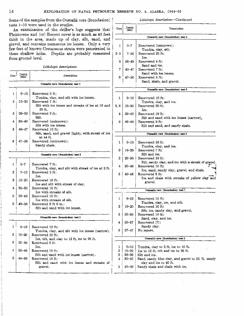
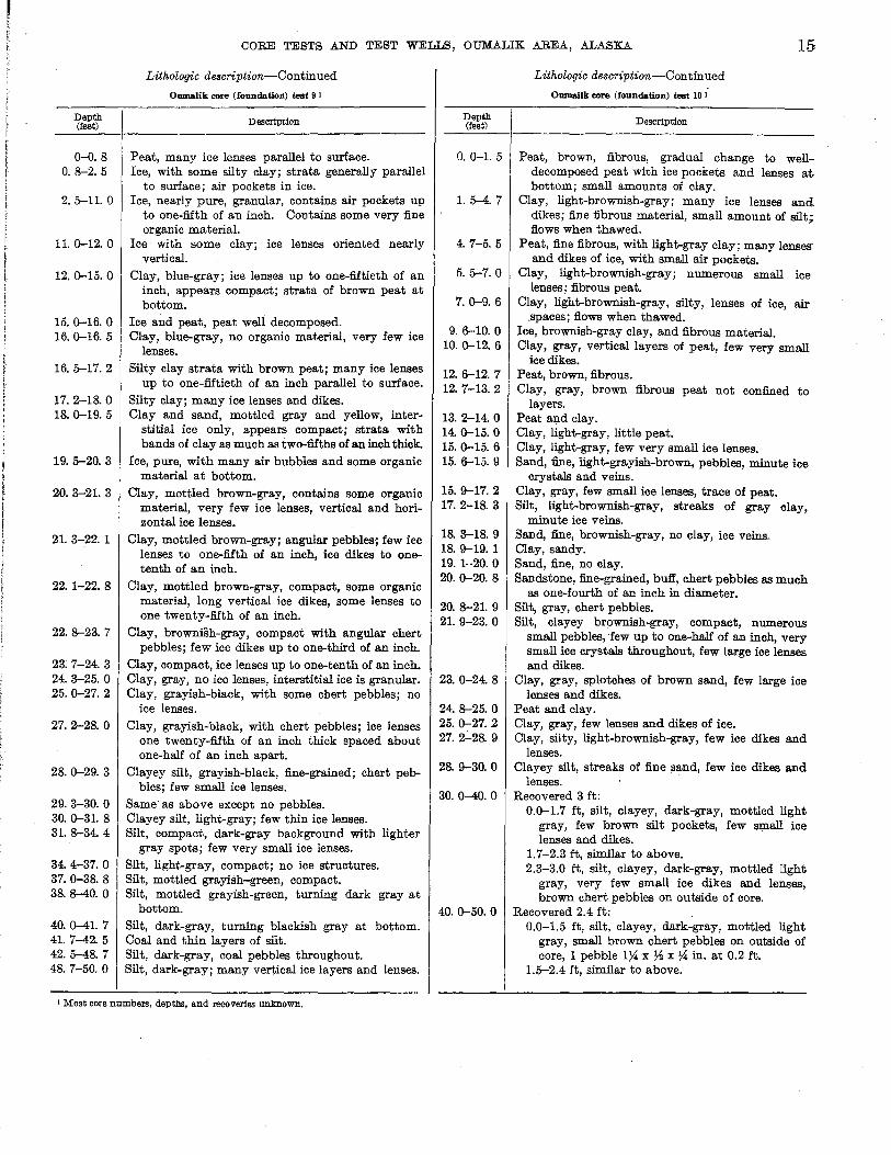
Some of the samples from the Oumalik core (foundation) tests 1-10 were used in the studies.
An examination of the driller's logs suggests that Pleistocene and (or) Recent cover is as much as 40 feet thick in the area, made up of clay, silt, sand, and gravel, and contains numerous ice lenses. Only a very few feet of known Oretaceous strata were penetrated in these shallow holes. Depths are probably measured from ground level.
Core I Depth (feet)
Lithologic descriptions
DescriptIon
Oumalik core (foundation) test 1
1 0-10 Recovered 9 ft: Tundra, clay, and silt with ice lenses.
2 10-20 Recovered 7 ft: Silt with ice lenses and streaks of ice at 16 and
20 ft. 3 20-30 Recovered 9 ft:
Silt. 4. 30-40 Recovered (unknown):
Silt with ice lenses. 5 40-47 Recovered 10 ft:
Silt, sand, and gravel (light), with streak of ice at 44 ft.
6 47--50 Recovered (unknown): Sandy shale.
Oumalik <ore (foundation) test 2
1 0-7 Recovered 7 ft: Tundra, clay, and silt with streak of ice at 2 ft.
2 7-10 Recovered 3 ft: Ice.
3 10-20 Recovered 10 ft: Ice and silt with streak of clay.
4 20-30 Recovered 10 ft: Ice with streaks of silt.
5 30-40 Recovered 10 ft: Ice with streaks of silt.
6 40-50 Recovered 8 ft 6 in.: Silt and sand with ice lenses.
Oumalik <ore· (foundatiou) test 3
1 0-10 Recovered 10 ft: Tundra, clay, and silt with ice lenses (narrow).
2 10-20 Recovered 10 ft:
3 20-30
4 30-40
5 40-50
Ice, silt, and clay to 12 ft, ice to 20 ft. Recovered 5 ft:
Ice. Recovered 10 ft:
Silt and sand with ice lenses (narrow). Recovered 10 ft:
Silt and sand with ice lenses and streaks of gravel.
Core I
1
2-5
6
7
8
1
2,3
4
5
Depth (feet)
0-7
7-36
36-40
40-47
47-50
0-10
10-30
30-40
40-49
Lithologic description-Continued
DescriptIon
Oumalik core (fonndation) test 4
Recovered (unknown): Tundra, clay, silt.
Recovered 29 ft: Ice.
Recovered 4 ft: Sand and ice.
Recovered 7 ft: Sand with ice lenses.
Recovered 3 ft: Sand, shale, and gravel.
Oumalik <ore (foundation) test 5
Recovered 10 ft: Tundra, clay, and ice.
Recovered 20 ft: Ice.
Recovered 10 ft: Silt and sand with ice lenses (narrow).
Recovered 9 ft: Silt and sand, and sandy shale.
Oumalik <Ore (fonndation) test 6
1 0-10 Recovered 10 ft: Tundra, clay, and ice.
2 10-20 Recovered 7 ft: Silt and ice.
3 20-30 Recovered 10 ft:
4 30-40
5 40-48
1 0-10
2 10-20
3 20-30
4 30-37
5 37-47
1 2 3 4
5
0-10 10-20 20-30 30-40
40-50
Silt, sandy clay, and ice with a streak of gravel. Recovered 10 ft: r_~
Ice, sand, sandy clay, gravel, and shale. ""1 Recovered 8 ft: _ .,
Ice and shale with streaks of yellow clay and gravel.
Oumalik core (foundation) test 7
Recovered 10 ft: Tundra, clay, ice, and silt.
Recovered 10 ft: Silt, ice, sandy clay, and gravel.
Recovered 10 ft: Sand, clay, and ice.
Recovered (?): Sandy clay.
No report.
Oumalik <ore (foundation) test 8
Tundra, clay to 2 ft, ice to 10 ft. Ice to 15 ft, silt and ice to 20 ft. Silt and ice. Sand, sandy blue clay, and gravel to 35 ft, sandy
clay and ice to 40 ft. Sandy shale and shale with ice.
CORE TESTS AND TEST WELLS, OUMALIK AREA, ALASKA 15
Depth (feet)
0-0. 8 0.8-2.5
2. 5-11. 0
11. 0-12. 0
12.0-15.0
15.0-16.0 16.0-16.5
16.5-17.2
17.2-18.0 18.0-19.5
19.5-20.3
20.3-21. 3
21. 3-22.1
22.1-22.8
22.8-23.7
23. 7-24. 3 24. 3-25. 0 25.0-27. 2
27.2-28.0
28.0-29.3
29.3-30.0 30.0-31. 8 31. 8-34. 4
34.4-37.0 37. 0-38. 8 38.8-40.0
40.0-41. 7 41. 7-42. 5 42.5-48.7 48. 7-50. 0
Lithologic description-Continued
Oumalik core (foundation) test 9 1
Description
Peat, many ice lenses. parallel to surface. Ice, with some silty clay; strata generally parallel
to surface; air pockets in ice. Ice, nearly pure, granular, contains air pockets up
to one-fifth of an inch. Contains some very fine organic material.
Ice with some clay; ice lenses oriented nearly vertical.
Clay, blue-gray; ice lenses up to one-fiftieth of an inch, appears compact; strata of brown peat at bottom.
Ice and peat, peat well decomposed. Clay, blue-gray, no organic material, very few ice
lenses. Silty clay strata with brown peat; many ice lenses
up to one-fiftieth of an inch parallel to surface. Silty clay; many ice lenses and dikes. Clay and sand, mottled gray and yellow, inter
stitial ice only, appears compact; strata with bands of clay as much as two-fifths of an inch thick.
Ice, pure, with many air bubbles and some organic material at bottom.
Clay, mottled brown-gray, contains some organic material, very few ice lenses, vertical and horizontal ice lenses.
Clay, mottled brown-gray; angular pebbles; few ice lenses to one-fifth of an inch, ice dikes to onetenth of an inch.
Clay, mottled brown-gray, compact, some organic material, long vertical ice dikes, some lenses to one twenty-fifth of an inch.
Clay, brownish-gray, compact with angular chert pebbles; few ice dikes up to one-third of an inch.
Clay, compact, ice lenses up to one-tenth of an inch. Clay, gray, no ice lenses, interstitial ice is granular. Clay, grayish-black, with some chert pebbles; no
ice lenses.
Clay, grayish-black, with chert pebbles; ice lenses one twenty-fifth of an inch thick spaced about one-half of an inch apart.
Clayey silt, grayish-black, fine-grained; chert peb-bles; few small ice lenses.
Same· as above except no pebbles. Clayey silt, light-gray; few thin ice lenses. Silt, compact, dark-gray background with lighter
gray spots; few very small ice lenses.
Silt, light-gray, compact; no ice structures. Silt, mottled grayish-green, compact. Silt, mottled grayish-green, turning dark gray at
bottom. -
Silt, dark-gray, turning blackish gray at bottom. Coal and thin layers of silt. Silt, dark-gray, coal pebbles throughout. Silt, dark-gray; many vertical ice layers and lenses.
1 Most core numbers, depths, and recoveries unknown.
Depth (feet)
0.0-1. 5
1. 5-4. 7
4. 7-5. 5
5. 5-7. 0
7.0-9.6
9.6-10.0 10.0-12.6
12.6-12.7 12.7-13.2
13.2-14. 0 14. 0-15. 0 15. 0-15. 6 15.6-15.9
15.9-17.2 17.2-18.3
18. 3-18. 9 18.9-19.1 19. 1-20. 0 20.0-20.8
20.8-21.9 21. 9-23. 0
23.0-24. 8
24. 8-25. 0 25.0-27. 2 27.2-28.9
28.9-30.0
30. 0-40. 0
40.0-50.0
Lithologic de8cription-Continued
Oumalik core (foundation) test 10 1
Description
Peat, brown, fibrous, gradual change to welldecomposed peat with ice pockets and lenses at. bottom; small amounts of clay.
Clay, light-brownish-gray; many ice lenses and dikes; fine fibrous material, small amount of silt; flows when thawed.
Peat, fine fibrous, with light-gray clay; many lenses' and dikes of ice, with smail air pockets.
Clay, light-brownish-gray; numerous small ice lenses; fibrous peat.
Clay, light-brownish-gray, silty, lenses of ice, air .spaces; flows when thawed.
Ice, brownish-gray clay, and fibrous material. Clay, gray, vertical layers of peat, few very small
ice dikes. Peat, brown, fibrous. Clay, gray, brown fibrous peat not confined to
layers. Peat and clay. Clay, light-gray, little peat. Clay, light-gray, few very small ice lenses. Sand, fine, light-grayish-brown, pebbles, minute ice
crystals and veins. Clay, gray, few small ice lenses, trace of peat. Silt, light-brownish-gray, streaks of gray elay,
minute ice veins. Sand, fine, brownish-gray, no clay, ice veins. Clay, sandy. Sand, fine, no clay. Sandstone, fine-grained, buff, chert pebbles as much
as one-fourth of an inch in diameter. Silt, gray, chert pebbles. Silt, clayey brownish.gray, compact, numerous
small pebbles,few up to one-half of an inch, very small ice crystals throughout, few large ice lenses and dikes.
Clay, gray, splotches of brown sand, few large ice lenses and dikes.
Peat and clay. Clay, gray, few lenses and dikes of ice. Clay, silty, light.brownish-gray, few ice dikes and
lenses. Clayey silt, streaks of fine sand, few ice dikes and
lenses. Recovered 3 ft:
0.0-1.7 ft, silt, clayey, dark-gray, mottled light gray, few brown silt pockets, few small ice lenses and dikes.
1.7-2.3 ft, similar to above. 2.3-3.0 ft, silt, clayey, dark-gray, mottled light
gray, very few small ice dikes and lenses, brown chert pebbles on outside of core.
Recovered 2.4 ft: 0.0-1.5 ft, silt, clayey, dark-gray, mottled light
gray, small brown chert pebbles on outside of core, 1 pebble 1~ x ~ x ~ in. at 0.2 ft.
1.5-2.4 ft, similar to above.
16 EXPLORATION OF NAVAL PETROLEUM RESERVE NO.4, ALASKA, 1944-53
OUM.ALIX CORE TESTS 11 AND 12
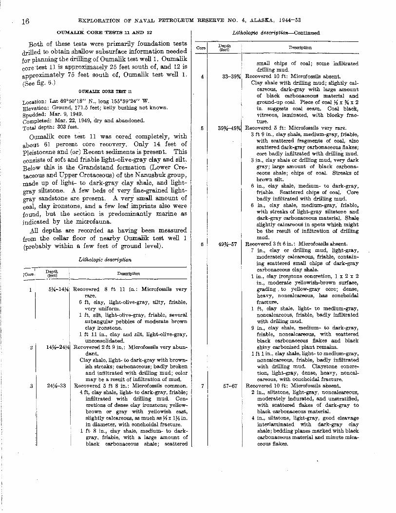
Both of these tests were primarily foundation tests drilled to obtain shallow subsurface information needed for planning the drilling of Oumalik test welll. Oumalik core test 11 is approximately 25 feet south of, and 12 is approximately 75 feet south of, Oumalik test well L (See fig. 6.)
OUMALIK CORE TEST 11
Location: Lat 69°50'18" N., long 155°59'24" W. Elevation: Ground, 171.5 feet; kelly bushing not known. Spudded: Mar. 9, 1949. . Completed: Mar. 22, 1949, dry and abandoned. Total depth: 303 feet.
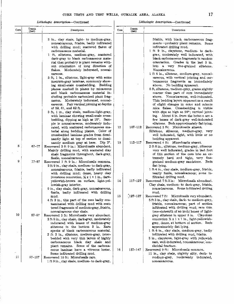
Oumalik core test 11 was cored completely, with about 61 percent core recovery. Only 14 feet of Pleistocene and (or) Recent sediments is present. This consists of soft and friable light-olive-gray clay and silt. Below this is the Grandstand formation (Lower Cretaceous and Upper Cretaceous) of the Nanushuk group, made up of light- to dark-gray clay shale, and lightgray siltstone. A few beds of very fine-grained lightgray sandstone are present. A very small amount of coal, clay ironstone, and a few leaf imprints also were found, but the section is predominantly marine as indicated by the microfauna.
All depths are recorded as having been measured from the cellar floor of nearby Oumaiik test well 1 (probably within a few feet of ground level).
Lithologic description
Depth I'Core (feet)
1--'----1 Description
1 5X-14Ys Recovered 8 ft 11 in.: Microfossils very rare.
6 ft, clay, light-olive-gray, silty, friable, very uniform.
1 ft, silt, light-olive-gray, friable, several subangular pebbles of moderate brown clay ironstone.
1 ft 11 in., clay and silt, light-olive-gray, unconsolidated.
:& 14Ys-24Ys Rerovered 2·ft 9 in.: Microfossils very abun-dant.
Clay shale, light- to dark-gray with brownish streaks; carbonaceous; badly broken and infiltrated with drilling mud; color may be a result of infiltration of mud .
. 3 24Ys-33 Recovered 5 ft 8 in.: Microfossils common. 4 ft, clay shale, light- to dark-gray, friable;
infiltrated with drilling mud. Concretions of dense clay ironstone; yellowbrown or gray with yellowish cast, slightly calcareous, as much as 7~ x 172 in. in diameter, with conchoidal fracture.
1 ft 8 in., clay shale, medium- to darkgray, friable, with a large amount of black carbonaceous shale; scattered
LithoZof}'ic description-Continued
Core ~f:~~ Description --\---'-----\
4
5
6
7
small chips of coal; some infiltrated drilling mud.
33-39~ Recovered 10 ft: Microfossils absent. Clay shale with drilling mud; slightly cal
careous, dark-gray with large amount of black carbonaceous material and ground-up coal. Piece of coal Ys x ~ x 2 in. suggests coal seam. Coal black, vitreous, laminated, with blocky fracture.
39Y.49% Recovered 5 ft: Microfossils very rare. 3 ft 9 in., clay shale, medium-gray, friable,
with scattered fragments of coal, also scattered dark-gray carbonaceous flakes; core badly infiltrated with drilling mud.
3 in., clay shale or drilling mud, very dark gray; large amount of black carbonaceous shale; chips of coal. Streaks of brown silt.
6 in., clay shale, medium- to dark-gray, friable. Scattered chips of coal. Core badly infiltrated with drilling mud.
6 in., clay shale, medium-gray, friable, with streaks of light-gray siltstone and dark-gray carbonaceous material. Shale slightly calcareouS in spots which might be the result of infiltration of drilling mud.
49Y.57 Recovered 3 ft 6 in.: Microfossils absent. 7 in., clay or drilling mud, light-gray,
moderately calcareous, friable, containing scattered small chips of dark-gray carbonaceous clay shale.
1 in., clay ironstone concretion, 1 x 2 x 2 in., moderate yellowish-brown surface, grading. to yellow-gray core; dense, heavy, noncalcareous, has conchoidal fracture.
1 ft, clay shale, light- to medium-gray, noncalcareous, friable, badly infiltrated with drilling mud.
9 in., clay shale, medium- to dark-gray, friable, noncalcareous, with scattered black carbonaceous flakes and black shiny carbonized plant remains.
1 ft 1 in., clay shale, light- to medium-gray, noncrucareous, friable, badly infiltrated with drilling mud. Claystone concretion, light-gray, dense, heavy, noncalcareous, with conchoidal fracture.
57-67 Recovered 10 ft: Microfossils absent. 2 in., siltstone, light-gray, noncrucareous,
moderately indurated, and unstratified, with scattered flakes of dark-gray to black carbonaceous material.
4 in., siltstone, light-gray, good cleavage interlaminated with dark-gray clay shale; bedding planes marked with black carbonaceous material and minute micaceous flakes.
Core
8
9
10
11
CORE TESTS AND TEST WELLS, OUMALIK AREA, ALASKA 17
Lithologic de8criptio_Continued
Depth (feet) DeScription
3 in., clay shale, light- to medium-gray, nonca.J.careous, friable, badly infiltrated with drilling mud; scattered flakes of carbonaceous material.
1 ft, siltstone, medium-gray, scattered dark-gray to black carbonaceous material that probably is plant remains without orientation of long direction of flakes. Moderately indurated, noncalcareous.
5 ft, 1 in., siltstone, light-gray with some meaium-gray laminae, commonly showing small-scale crossbedding. Bedding planes marked in places by micaceous and black carbonaceous material including probable carbonized plant fragments. Moderately indurated, non calcareous. Fair vertical jointing at depths of 59, 61, and 62 ft.
3 ft, 1 in., clay shale, medium-light-gray, with laminae showing small-scale crossbedding, dipping as high as 180
• Sample is noncalcareous, moderately indurated, with scattered carbonaceous material along bedding planes. Color of crossbedded laminae grades from dominantly light at top of section to dominantly medium gray at base. Dip 20
•
67-77 Recovered 2 ft 9 in.: Microfossils abundant. Mainly drilling mud, with scattered clay
shale fragments throughout, dark-gray, fissile, noncalcareous.
77-87 Recovered 7 ft 9 in.: Microfossils common. 2 ft 9 in., clay shale, medium- to dark-gray,
noncalcareous, friable, badly infiltrated with drilling mud; dense, heavy clay ironstone concretion, ~ x 1 x 1 in., darkyellowish-brown on surface, light-yellowish-gray interior.
9 in., clay shale, dark-gray, noncalcareous, fissile, badly infiltrated with drilling mud.
4 ft 3 in., this part of the core badly contaminated with drilling mud with scattered fragments of medium-gray,friable, non calcareous clay shale.
87-97 Recovered 5 ft: Microfossils very abundant. 2 ft 9 in., clay shale, dark-gray, moderately
indurated with lenses of medium-gray siltstone in the bottom 3 in. Rare specks of black carbonaceous material.
2 ft 3 in., siltstone, medium-gray, interbedded with very thin layers of highly carbonaceous black clay shale and plant remains. Some of the carbonaceous laminae have a vitreous luster. Some infiltrated drilling mud.
97-107 Recovered 10 ft: Microfossils rare. 1 ft 9 in.,. clay shale, medium- to dark-gray,
Core
12
13
14
15
16
Lithologic de8criptionr-Continued
Depth (feet)
107-112
112-117
117-127
)27-137
137-147
Description
friable, with black carbonaceous fragments-probably plant remains. Some infiltrated drilling mud.
1 ft 9 in., claystone, medium- to darkgrav, moderately well indurated, with black carbonaceous fragments in random orientation. Grades in the last 5 in .. into a very fine-grained siltstone .. Nonca lea reous.
1 ft 6 in., siltstone, medium-gray, noncalcareous, with vertical jointing and carbonaceous fragments as immediatflly above. No bedding apparent.
5 ft, siltstone, medium-gray, grains .slightly coarser than part of core immediately above. Noncalcareous, well-indurated. Thin bedding layers apparent as a result of slight changes in color and minute· mica flakes. Crossbedding is visible with dips as high as 200
; vertical jointing. About 6 in. from the botto.u are a· few lenses of dark-gray well-indurated siltst<me. Beds approximately flat lying.
Recovered 3 ft: Microfossils absent. Silt.'ltone, siliceous, medium-gray, very
well indurated, tight, with little or no bedding apparent.
Recovered 4 ft: Microfossils absent. 2 ft 8 in., siltstone, medium-gray, siliceous
very well indurated, grades in last foot of this section of the core into an extremely hard and tight, very finegrained medium-gray sandstone. Beds fl.a.t lying.
1 ft 4 in., clay shale, medium-gray, fria ble, nearly fissile, noncalcareous; some infiltrated drilling mud.
Recovered 7 ft 3 in: Microfossils abundant. Clay shale, medium- to dark-gray, friable,
nonca.lcareous. Some infiltrated drilling mud.
Recovered 7 ft: Microfossils very abundant. 5 ft 3 in., clay shale, dark- to medium-gray,
friable, noncalcareous; part of section infiltrated with drilling mud; rare thin (one-sixteenth of an inch) lenses of lightgray siltstone in upper 8 in. Claystone concretion ~ x 1 x 1 in., light-yellowishgray, dense, at bottom of section. Beds approximately flat lying.
1 ft 6 in., clay shale, medium-gray, badly infiltrated with drilling mud, friable.
3 in., claystone, light-gray with yellowish cast, well-indurated, non calcareous ;'conchoidal fracture.
Recovered 9 ft: Microfossils common. 11 in., clay shale, slightly silty, dark- to
medium-gray, moderately indurated, noncalcareous.

18
Core
17
EXPLORATION OF NAVAL PETROLEUM RESERVE NO.4, ALASKA, 1944-53
Lithologic description-Con tinu ed
Depth (feet)
147-157
De51lI"iption
5 in., clay shale, non calcareous, friable, dark-gray, intercalated with discontinuous vitreous coaly laminae.
6 in., clay shale, dark-gray, moderately indurated, noncalcareous, with scattered dark-gray flakes of carbonaceous material.
6 in., drilling mud, cont3ining fragments of black friable clay shale and chips of black vitreous coal.
10 in., clay shale, medium-gray, slightly silty, friable, nonca.lcareous, with darkgray to black carbonaceous flakes, probably plant remains, scattered throughout; infiltrated with drilling mud.
6 in., clay shale, medium-gray, noncalcareous, moderately indurated, with dark-gray to black carbonized plant remains.
1 ft 3 in.,. clay shale, light-gray, noncalcareous, moderately indurated, with dark-gray to black carbonized plant fragments, including rare leaf imprints.
7 in., clay shale, medium-gray, friable; badly infiltrated with drilling mud; contains scattered flakes of dark-gray carbonaceous material.
1 ft 10 in., claystone, medium-gray, moderately indurated, noncalcareous, with scattered dark-gray carbonized plant fragments.
1 ft 1 in., siltstone, light-gray, moderately indurated, with scattered dark-gray flakes of carbonaceous material; slightly to moderately calcareous, possibly owing to infiltrated drilling mud.
2 in., clay shale, black, moderately indurated, non calcareous, with much black, shiny carbonized plant remains.
5 in., black carbonaceous shale, as above; badly infiltrated with drilling mud.
Recovered 7 ft: Microfossils absent. 5 in., coal fragments, as large as ~ x ~ x 1
in., black; subvitreous, conchoidal fracturing; no visible stratification.
1 ft 10 in., clay shale, medium-gray, slightly silty, moderately indurated, noncalcareous; dark-gray to black carbonaceous material marks bedding planes. Carbonized plant fragments scattered throughout; at 149 ft, a friable non calcareous I-in. layer of interlaminated dark-gray shale and black vitreous coaly material.
9 in., siltstone, medium-gray, well-indurated, noncalcareous; black to darkgray carbonaceous material and carbonized plant fragments scattered throughout.
Core
18
19
Lithologic description-Continued
Depth (feet)
157-167
167-177
DeScription
4 ft., claystone, light-gray, well-indurated, noncalcareous, slightly silty in some sections. Dark-gray carbonaceous plant remains scattered throughout.
Recovered 10 ft: Microfossils absent. 1 ft 2 in., clay shale, medium-gray,
moderately indurated, slightly calcareous.
2 in., claystone, light-gray with yellowish cast, dense, heavy, with conchoidal fracture, probably is a concretion.
2 ft 2 in., clay shale, medium-gray, noncalcareous, friable to moderately indurated; partly infiltrated with drilling mud; dark-gray carbonaceous plant remains scattered sparsely throughout.
3 ft 4 in., sandstone, very fine-grained, light-gray, well-indurated; .streaks of dark-gray carbonaceous clay shale with one-half of an inch intercalated laminae of siltstone; very fine sandstone and black carbonaceous material at base.
8 in., clay shale, medium-gray, moderately indurated, slightly calcareous.
9 in., sandstone, very fine-grained, lightgray, noncalcareous, moderately indurated, silty and clayey matrix. Numerous dark-gray carbonaceous and micaceous laminae and some partings of clay shale or siltstone mark irregular discontinuous bedding planes. Dip 10.
1 ft 9 in., siltstone, otherwise same as above.
Recovered 7 ft 9 in.: Microfossils common. 1 ft 9 in., siltstone, light- to medium-gray;
interbedded with thin layers (up to Ys in. in thickness but generally much thinner) of black carbonaceous material; also contains numerous scattered plant fragments. Blocky fracture noted on thicker carbonaceous layers, also vitreous luster-coal (?). The last 3 in. contains lenses of medium-gray clay shale and claystone. Clay ironstone at at the bottom of this core is medium gray with a yellowish cast, has conchoidal fracture. Dip as indicated by bedding in this core is approximately 50 to walls of core. Some crossbedding present, but even more prominent is the curving of the darker laminae over and under lenses of clay shale, distortion possibly the result of slumping or minor reworking of the sediments.
6 ft, clay shale, medium- to dark-gray, noncalcareous, moderately indurated; a few laminae or lenses of siltstone, also black carbonaceous plant remaills scattered throughout. Bedding and dis-
•
Core
20
21
22
CORE TESTS AND TEST WELLS, OUMALIK AREA, ALASKA 19
Lithologic description-Continued
Depth (feet)
177-187
187-197
197-207
Description
tortion of laminae essentially as described above. The clay shale less well indurated and somewhat infiltrated with drilling mud in lower foot of section.
Recovered 8 ft 2 in: Microfossils absent. 1 ft, coal, carbonaceous material, and
medium-gray friable clay shale. Core badly broken up and infiltrated with drilling mud. Coal chips as much as three-fourths of an inch in. thickness present, bedded, black, with vitreous luster and blocky to conchoidal fracture.
8 in., clay shale, medium-gray, moderately indurated.
1 ft, siltstone, medium-gray, grading to very fine-grained light-gray sandstone in middle of this part of core and then back into siltstone. Siltstone, moderately indurated; shows faint bedding approximately at right angles to walls of core. Sandstone, very well indurated, tight, siliceous, massive or with only very faint trace of bedding. Black carbonaceous remains with random orientation throughout this part of core.
1 ft 5 in., silty clay shale, medium-gray, moderately indurated, noncalcareous; black carbonaceous fragments scattered throughout.
3 ft 10 in., siltstone, light-gray, wellindurated, with some thin lenses of sandstone and clay shale; dip of beds not well defined. Swirly bedding; crossbeds with dips as high as 12°; only a few fragments of carbonaceous material. Slightly calcareous in the finer grained layers.
3 in., as immediately above but with larger proportion of clay shale.
Recovered 4 ft 9 in.: Microfossils very rare. 7 in., interbedded clay shale and siltstone
medium-gray, moderately indurated, with black carbonaceous fragments; slightly calcareous.
3 ft 2 in., clay shale, medium- to dark-gray, moderately indurated; has some tendency to fracture nearly vertically, effervesces mildly with HCl. Dip P.
1 ft, drilling mud with scattered chips of medium-gray clay shale and black carbonaceous material.
Recov-ered 2 ft: Microfossils absent. 1 ft, claystone, silty, medium-gray, moder
ately indurated, with scattered darkgray carbonized plant remains.
1 ft, siltstone, light-gray, moderately indurated, slightly calcareous (possibly owing to infiltrated drilling mud);. two
Core
23
24
25
26
27
Lithologic description-Continued
Depth (feet)
207-217
217-227
227-237
237-247
247-257
Description
claystone concretions, dense, hard, Iightto dark-gray, slightly calcareous, 2 x 2 x 1 in. in size.
Recovered 2 ft: Microfossils very rare. 3 in., siltstone, medium-gray, moderately
indurated, slightly calcareous; dark-gray carbonaceous material on bedding planes.
1 ft 9 in., clay shale, medium-gray, moderately indurated, slightly calcareous.
Recovered 2 ft: Microfossils common. 9 in., drilling mud, containing chips of
medium-gray, friable clay shale. 3 in., coal chips, brownish-black, dull to
subvitreous, with blocky fracture. 1 ft, sandstone, fine-grained, light-gray,
slightly argillaceous, moderately indurated, massive.
Recovered 2 ft: Microfossils absent. 1 ft 9 in., same as above. 3 in., siliceous sandstone, fine-grained, very
well indurated, medium-gray, very slightly calcareous, massive; has conchoidal fracture.
Recovered 9 ft: Microfossils absent. Sandstone, light-gray, very fine-grained,
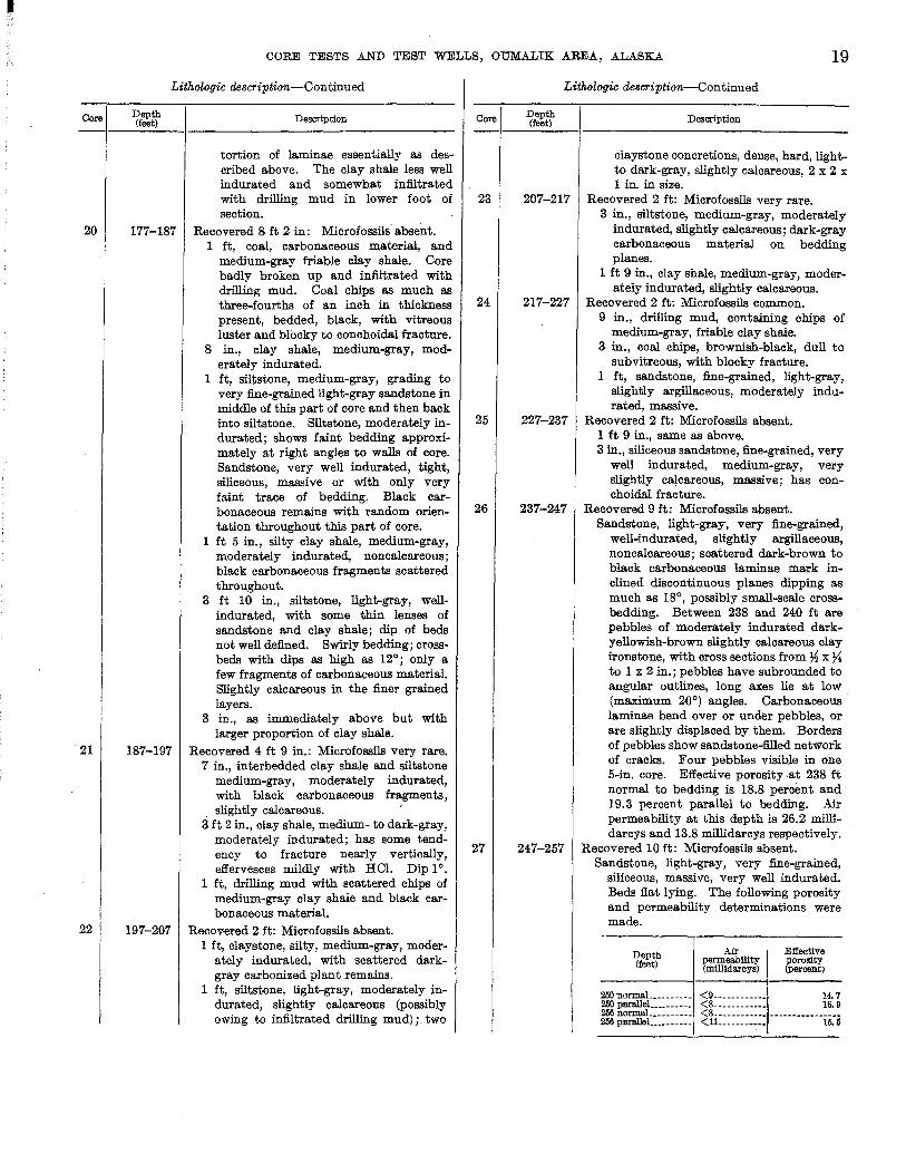
well-indurated, slightly argillaceous, noncalcareous; scattered dark-brown to black carbonaceous laminae mark inclined discontinuous planes dipping as much as 18°, possibly small-scale cross· bedding. Between 238 and 240 ft are pebbles of moderately indurated darkyellowish-brown slightly calcareous clay ironstone, with cross sections from )4 x ~ to 1 x 2 in.; pebbles have subrounded to angular outlines, long axes lie at low (maximum 20°) angles. Carbonaceous laminae bend over or under pebbles, or are slightly displaced by them. Borders of pebbles show sandstone-filled network of cracks. Four pebbles visible in one 5-in. core. Effective porosity at 238 ft normal to bedding is 18.8 percent and 19.3 percent parallel to bedding. Air permeability at this depth is 26.2 millidarcys and 13.8 millidarcys respectively.
Recovered 10 ft: Microfossils absent. Sandstone, light-gray, very fine-grained,
siliceous, massive, very well indurated. Beds fiat lying. The following porosity and permeability determinations were made.
Deptb (feet)
Air permeability (millidarcys)
Effective porosity (percent)
250 normaL ________ <9____________ 14.7 250 para1JeL________ <8____________ 16. 9 266 normaL_________ <8 ___________________________ _ 266 paralJeL________ <IL__________ 16. 5
20
28
29
30
31
32
33
EXPLORATION OF NAVAL PETROLEUM RESERVE NO.4, ALASKA, 1944-53
Lithologic description-Continued
Depth Description (feet)
257-266 Recovered 2 ft: Microfossils very rare. 5 in., sandstone, light-gray, completely
ground up and irregularly recemented with drilling mud (?). 1 ft 7 in., clay shale (or drilling mud?), medium- to dark-gray, poorly indurated, noncalcareous. One fragment of interbedded coal and siltstone three-fourths of an: inch thick; one pyrite concretion one-third of an inch in diameter.
266-276 Recovered 2 ft 9 in.: Microfossils absent. 5 in., siltstone, medium-gray, moderately
indurated, noncalcareous. 5 in., claystone. slightly silty, light-gray,
well-indurated, noncalcareous. 11 in., siltstone, light-gray, well-indurated,
very slightly calcareous. 1 ft, siltstone, medium-gray, siliceous,
well-indurated, non calcareous. 276-280 Recovered 4 ft: Microfossils absent.
Clay shale, medium-gray, moderately indurated to friable, noncalcareous; mostly infiltrated with drilling mud. Beds flat lying.
280-288 Recovered 1 ft 9 in.: Microfossils absent. 1 ft 1 in., clay shale, slightly silty, medium
gray, moderately indurated, noncalcare-. ous. Dense clay ironstone concretions,
light-gray with yellowish cast, have conchoidal fracture and are slightly calcareous, ~ x 1 x 1 in. in size.
8 in., sandy siltstone, light-gray, wellindurated, noncalcareous, with scattered dark-gray ,carbonaceous partings.
288-296 Recovered 4 ft 6 in.: Microfossils very rare. 1 ft, clay shale, friable, medium-gray,
badly infiltrated with drilling mud. 9 in., clay shale, medium-gray, moderately
indurated, slightly calcareous; contains black carbonaceous fragments.
2 ft 9 in., silty claystone, medium-gray, moderately indurated, slightly calcareous; contains black plant remains. Beds approximately flat lying.
296-303 Recovered 7 ft: Microfossils common. 8 in., clay shale, silty, medium-gray,
slightly calcareous, moderately indurated; scattered flakes of dark-gray carbonaceous plant remains.
1 ft 7 in., siltstone, light-gray, well-indurated, slightly calcareous, with darkgray carbonaceous material marking bedding planes; scattered intercalations of medium-gray clay shale.
4 ft 9 in., clay shale, medium-gray, wellindurated, slightly calcareous, slightly silty, with scattered black carbonized flakes of plant remains, including a leaf imprint. Two small pelecypods at approximately 302 ft. Dip 1 0.
OUMALIK CORE TEST 12
Location: Lat 69°50'18" N., long 155°59'24" W. Elevation: Ground, approximately 172 feet; kelly bushing not
known. Spudded: Probably drilled in April 1949. Completed: Probably drilled in April 1949; dry and abandoned. Total depth: 300 feet.
Oumalik core test 12 (see fig. 5) is in essentially the same structural position as core test 11. The approximately 17 -foot thickness of Pleistocene and (or) Recent is clay in which ice is interbedded. The Grandstand formation is the same as in core test 11.
No ditch samples were taken from this test, and the section is not completely represented by the recovered cores. Consequently, there are a few parts which could not be described. The datum from which depths were measured is not known but was probably close to ground level.
Core
1
2 3
4
5
6-9 10
11
12
Lithologic description
Depth (feet)
0-10
10-17 17-22
22-27
27-32
32-427~ 42~7~
47~50
50-54
Description
Recovered 10 ft: Microfossils absent. Clay, medium-dark-olive-gray, soft;
much vegetal material. Apparently about 7 ft of the recovery was ice.
No core received in Fairbanks. Recovered 4 ft: Microfossils abundant.
2 ft, clay, light-brownish-gray, grading to medium-gray clay with grayish-yellow streaks.
1 ft, clay, medium-dark-gray, shaly, with very small shell fragments on some partings; carbonaceous laminae at base.
1 ft, clay,medium-light-gray. Recovered 4 ft: Microfossils abundant.
Clay, medium-light-gray, with streaks of grayish-yellow clay; rare silty or carbonaceous laminae in top 1 if.
Recovered 1 ft 4 in.: Microfossils absent.
Clay, medium-light-gr8 y , slightly silty. No cores received in Fairbanks. Recovered 5 ft: Microfossils absent.
4 ft 8 in., clay shale, medium-gray, with small yellowish-gray streaks throughout; scattered carbonized macerated plant remains.
4 in., claystone, medium-light-gray, very slightly silty, with scattered carbonized plant remains.
Recovered 1 ft 4 in.: Microfossils absent. Clay shale, medium-gray, with scat
tered macerated carbonized plant remains; one clay ironstone nodule 1x1x3in.
Recovered 3 ft 2 in.: Microfossils absent. 3 ft, claystone and clay shllle, medium
gray, silty, with some carbonaceous partings and fragments of carbonized plant remains.
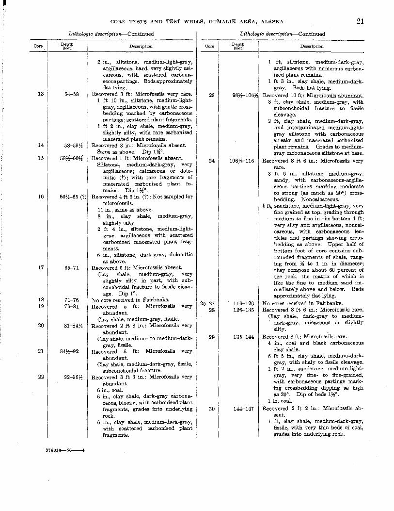
Core
13
14
15
16
17
18 19
20
21
22
CORE TESTS AND TEST WELLS, OUMALIK AREA, ALASKA 21
Lithologic description-Continued
Depth (feet)
54-58
5&-59~
59~-60~
607~65 (?)
65-71
71-76 76-81
81-84~
84)1-92
92-96~
374616--56---4
Description
2 in., siltstone, medium-light-grll-y, argillaceous, hard, very slightly calcareous, with scattered carbona.ceous partings. Beds approximately flat lying.
Recovered 3 ft: Microfossils very rare. 1 ft 10 in., siltstone, medium-light
gray, argillaceous, with gentle croS3-bedding marked by carbonaceous partings; scattered plant fragments.
1 ft 2 in., clay shale, medium-gray, slightly silty, with rare carbonized macerated plant remains.
Recovered 8 in.: Microfossils absent. Same as above. Dip 1~0.
Recovered 1 ft: Microfossils absent. Siltstone, medium-dark-gra.y, very
argillaceous; calcareous or dolomitic (?); with rare fragments of macerated carbonized plant remains. Dip 1~0.
Recovered 4 ft 6 in. (?): Not sampled for microfossils.
11 in., same as above. 8 in., clay shale, medium-gray,
slightly silty. 2 ft 4 in., siltstone, medium-light
gray, argillaceous with scattered carbonized macerated plant fragments.
6 in., siltstone, dark-gray, dolomitic as above.
Recovered 6 ft: Microfossils absent. Clay shale, medium-gray, very
slightly silty in part, with subconchoidal fracture to fissile cleavage. Dip 10.
~ 0 core received in Fairbanks. Recovered 5 ft: Microfossils very
abundant. Clay shale, medium-gray, fissile.
Recovered 2 ft 8 in.: Microfossils very abundant.
Clay shale, medium- to medium-darkgray, fissile.
Recovered 5 ft: Microfossils very abundant.
Clay shale, medium-clark-gray, fissile, subconchoidal fracture.
Recovered 3 ft 3 in.: Microfossils very abundant.
6 in., coal. . 6 in., clay shale, dark-gray carbona
ceous, blocky, with carbonized plant fragments, grades into underlying rock.
6 in., clay shale, medium-dark-gray, with scattered carbonized plant fragments.
Core
23
24
25-27 28
29
30
Lithologic description-Continued
Depth (feet) Description
1 ft, siltstone, medium-dark-gray, argillaceous with numerous carbonized plant remains.
1 ft 3 in., clay shale, medium-darkgray. Beds flat lying.
96)4-106~ Recovered 10 ft: Microfossils abundant. 8 ft, clay shale, medium-gray, with
subconchoidal fracture to fissile cleavage.
2 ft, clay shale, medium-dark-gray, and inter laminated medium-lightgray siltstone with carbonaceous streaks and macerated carbonized plant remains. Grades to mediumgray carbonaceous siltstone at base.
106)4-116 Recovered 8 ft 6 in.: Microfossils very rare.
116-126 126-135
135-144
144-147
3 ft 6 in., siltstone, medium-gray, sandy, with carbonaceous-argillaceous partings marking moderate to strong (as much as 200
) crossbedding. N on calcareous.
5 ft, sandstone, medium-light-gray, very fine grained at top, grading through medium to fine in the bottom 1 ft; very silty and argillaceous, noncalcareous, with carbona.ceous lentic1es and partings showing crOSBbedding as above. Upper half of bottom foot of core contains subrounded fragments of shale, ranging from 7i to 1 in. in diameter; they compose about 60 percent of the rock, the matrix of which is like the fine to medium sand immediate'yabove and below. Beds approximately flat lying.
No cores received in Fairbanks. Recovered 8 ft 6 in.: Microfossils rare.
Clay shale, dark-gray to mediumdark-gray, micaceous or slightly silty.
Recovered 8 ft: Microfossils rare. 4 in., coal and black carbonaceous
clay shale. 6 ft 5 in., cla.y shale, medium-dark
gray, with shaly to fissile cleavage. 1 ft 2 in., sandstone, medium-light
gray, very fine- to fine-grained, with carbonaceous partings marking crossbedding dipping as high as 200
• Dip of beds lW. 1 in, coal.
Recovered 2 ft 2 in.: Microfossils absent.
1 ft, clay shale, medium-dark-gray, fissile, with very thin beds of coal, grades into underlying rock.

22
Core
31
32
33
34
35
36
37
38
39
EXPLORATION OF NAVAL PETROLEUM RESERVE NO.4, ALASKA, 1944-53
Lithologic description-Continued
Depth (feet) Description
1 ft 2 in., siltstone, medium-gray, with slight crossbedding marked by carbonaceous laminae.
147-151 Recovered 3 ft 9 in.: Microfossils absent.
2 ft 8 in., siltstone, medium~gray,
very argillaceous, noncalcareous, with carbonized plant fragments some carbonaceous streaks and partings. Dip 2°.
1 ft 1 in., clay shale, medium-gray, with conchoidal fracture.
151-157 Recovered 5 ft 9 in.: Microfossils very rare.
Clay shale, medium-gray, with conchoidal fracture to fissile cleavage.
157-162 Recovered 5 ft: Microfossils very rare. 1 ft 4 in., sandstone, medium-light
gray, very fine-grained, with carbonaceous streaks.
1 ft 2 in., clay shale, medium-gray, grades into underlying rock.
2 ft 6 in., siltstone, medium-lightgray, and very fine-grained sandstone, with carbonaceous partings.
162-164 Recovered 2 ft: Microfossils absent. Siltstone, medium-light-gray as above.
Dip 1°. 164-174 Recovered 10 ft: Microfossils common.
5 ft, clay shale, medium-gray, fissile. 1 ft 3 in., clay shale, medium-dark
gray, silty; grades into underlying rock.
3 ft 9 in., clay shale, medium-gray; fissile; as above.
174-184 Recovered 4 ft 4 in.: Microfossils absent.
8 in., coal. 3 ft 8 in., clay shale, medium-gray;
badly mixed with drilling mud. 184-189 Recovered 5 ft: Microfossils very abun
dant. 1 ft, siltstone and clay shale inter
bedded, micaceous, medium-lightto medium-dark-gray.
4 ft, clay shale, medium-gray, fissile; poker chip cleavage in lower part.
189-192 Recovered 3 ft: Microfossils very abundant.
Clay shale, medium-gray; as above. Dip 1°.
192-195 Recovered 3 ft: Microfossils very abundant.
Claystone, medium-gray, with numerous carbonized plant fragments; slightly silty; slightly micaceous toward base.
195-196~ No sample.
Core
40
41
42
43-47 48
49,50 51
52
53, 54
55
56
57
LithoZouic aescription--Continued
Depth (feet) Description
1967f-201~ Recovered 3 ft 4 in.: Microfossils absent.
201~-206~
2067~-21l7f
211~236~ 2367f-241~
2417f-252 252-257
257-262
262-267
267-272
272-277
277-280
Siltstone, medium-gray, very argillaceous, with rare carbonized plant fragments; grades to medium-lightgray siltstone at base.
Recovered 5 ft: Microfossils absent. Clay shale, medium-gray, slightly
silty, micaceou,s, and siltstone, badly infiltrated with drilling mud. Two ~-in. beds of grayish-yellow claystone at 204 ft.
Recovered 5 ft: 'Microfossils very rare. 1 ft, siltstone and clay shale, intre
laroinated,medium-dark-gray, ~th carbonaceous partings.
4 ft, clay, medium-gray, shaly, very uniform. Dip 1°.
No cores received in Fairbanks. Recovered 5 ft: Microfossils absent.
Siltstone, medium-light-gray, sandy, noncalcareous; grading to silty very fine-grained sandstone at bottom.
No cores received in Fairbanks. Recovered 5 ft: Microfossils common.
Sandstone, very fine-grained, silty; as above, with scattered yellowish. gray clay ironstone lenses 'as much as 1 in. in diameter. Dip 1~0.
Recovered 5 ft: Microfossils common. 4 ft 9 in, clay shale, medium-dark
gray, with 72-in. yellowish-gray olay ironstone bed at 262 ft.
3 in., small (maximum one-half inoh in diameter) fragments of ooal mixed with drilling mud.
Reoovered 4 ft 9 in.: Microfossils absent. 4 ft 6 in., (oores labeled ambiguously)
clay shale, medium-dark-gray. 3 in., siltstone, medium-gray (may be
top of core-53). Recovered 5 ft: Miorofossils absent.
3 ft, claystone, medium-gray, silty, grading into 6 in.' of medium-lightgray crossbedded siltstone with carbonaceous partings.
1 ft 6 in., claystone, medium-gray, silty, as above, with J>f-in. bed of yellow-gray clay ironstone at 671 ft.
6 in., siltstone, medium-gray, very argillaceous. Beds approximately flat lying.
Recovered 5 ft: Microfossils very rare. Clay shale, medium-gray, excellent
cleavage to fissile. Recovered 3 ft: Microfossils common.
Same as above. Beds approximately flat lying.
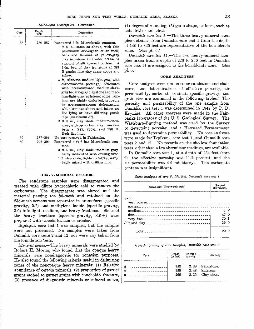
I i
CORE TESTS AND TEST WELLS, OUMALIK AREA, .ALASKA 23
Core
58
59 60
Lithologic description-Continued
Depth (feet)
280-287
287-296 296--300
Description
Recovered 7 ft: Microfossils common. 1 ft 6 in., same as above, with thin
(maximum one-eighth of an inch) beds and laminae of yellow-gray clay ironstone and with increasing amount of silt toward bottom. A I-in. bed of clay ironstone at 281 ft grades into clay shale above and below.
3 ft, siltstone, medium-light-gray, with carbonaceous partings; alternates with inter laminated medium-darkgray to dark-gray claystone and medium-light-gray siltstone; some laminae are highly distorted, probably by contemporaneous deformation, while laminae above and below are fiat lying or have differing gentle dips (maximum 5°).
2 ft 6 in., clay shale, medium-darkgray, with ~- to I-in. clay ironstone beds at 285, 2857f, and 286 ft. Beds fiat lying.
No core received in Fairbanks. Recovered 3 ft 6 in.: Microfossils com
mon. 2 ft 6 in., clay shale, medium-gray;
badly infiltrated with drilling mud. 1 ft, clay shale, light-olive-gray, waxy;
badly mixed with drilling mud.
HEAVY -MINERAL STUDIES
The sandstone samples were disaggregated and treated with dilute hydrochloric acid to remove the carbonates. The disaggregate was sieved and the material passing the 80-mesh and retained on the 235-mesh screens was separated in bromoform (specific gravity, 2.7) and methylene iodide (specific gravity, 3.0) into light, medium, and heavy fractions. Slides of the heavy fractions (specific gravity, 3.0+) were prepared with canada balsam or aroclor.
Ikpikpuk core test 1 was sampled, but the samples were not processed. No samples were taken from Oumalik core tests 2 and 12, nor were any taken from the foundation tests.
Mineral zones.-The heavy minerals were studied by Robert H. Morris, who found that the opaque heavy minerals were nondiagnostic for zonation purposes. He also found the following criteria useful in delimiting zones of the nonopaque heavy minerals: (1) Relative abundance of certain minerals, (2) proportion of garnet grains etched to garnet grains with conchoidal fracture, (3) presence of diagnostic minerals or mineral suites,
(4) degree of rounding, (5) grain shape, or form, such as euhedral or anhedral.
Oumalik core test i.-The three heavy-mineral samples obtained from Oumalik core test 1 from the depth of 140 to 320 feet are representative of the hornblende zone. (See pI. 6.)
Oumalik core test ii.-The two heavy-mineral sam·ples taken from a depth of 220 to 260 feet in Oumalik core test 11 are assigned to the hornblende zone. (See pI. 6.)
CORE ANALYSES
Oore analyses were run on some sandstone and shale cores, and determinations of effective porosity, air permeability; carbonate content, specific gravity, and grain size are contained in the following tables. - The porosity and permeability of the one sample from Oumalik core test 1 was determined in 1947 by P. D. Krynine. All other analyses were made in the Fairbanks laboratory of the U. S. Geological Survey. The Washburn-Bunting method was used by the Survey to determine porosity, and a Hayward Permeameter was used to determine permeability. No core analyses were made for Ikpikpuk core test 1, and Oumalik core tests 2 and 12. No records on the shallow foundation tests, other than a few thermistor readings, are available.
In Oumalik core test 1, at a depth of 154 feet (core 2), the effective porosity was 11.2 percent, and the air permeability was 4.9 millidarcys. The carbonate content was insignificant.
Sieve analysis of core 2, 154 feet, Oumalik core test 1
Grain size (Wentworth scale)
Sand:
Percent (by weight)
very coarse __________________________________ ----------coarse _______________________________________ ----------medium____ _ _ __ __ __ _ _ _ _ __ _ ___ _ _ _ _ _ _ _ _ _ _ _ _ __ _ 1. Z fine____ ____ ____ ______ ____ ____ ____ __ ____ __ ___ 43. I)
very fine_ __ ____ __________ ________ _ _____ ____ _ 20. 1 Silt and clay ___ _ __ _ _ __ _ _ _ _ __ _ _ _ _ _ _ _ _ _ _ _ _ _ _ _ __ _ _ 35. ()
TotaL_ ____ ______ ______ __ _____ _____ ____ _ 99. 9
Specific gravity of core samples, Oumalik core test 1
Core Der.th Spec!flc Lithology (in eet) gravity
2 ______________________ 153 2.29 Sandstone. 2 ______________________ 155 2. 43 Siltstone. 3 ______________________ 205 2. 25 Clay shale.

24 EXPLORATION OF NAVAL PETROLEUM RESERVE NO.4, ALASKA, 1944-53
Porosity and permeability of core samples, Oumalik core test 11
Core Depth (in feet)l
EJl'ectlve porosity (percent)
Air permeability (m1ll1darcys)
26 ____________________ _ 26 ____________________ _ '27 __________ --- _______ _ '27 ____________________ _
27 ____________________ _ 27 _____________________
1
238 P 238 N 250 P 250 N 256 P 256 N
1 P, parallel to the bedding, N, normal to the bedding.
OIL AND GAS
19.3 18.8 16.9 14. 7 15.5
13.8 26. 2
<8 <9
<11 <8
No fluid tests were made as these holes were primarily drilled for stratigraphic and foundation information. No shows of oil or gas were found in any of the holes except 11, from which the driller reported a show of gas while pulling core 8 (67-77 feet) as evinced by flow of mud through drill pipe.
LOGISTICS AND DRILLING OPERATIONS
Ikpilcpuk core test 1 and Oumalik core test I.-These two tests were drilled consecutively with the rig used by United Geophysical 00., Inc.'s seismograph party 46 for shothole drilling. Auxiliary equipment was flown in during April by a. DO-3 aircraft using a frozen lake for a landing strip. The drilling crew consisted of 1 head driller, 2 regular drillers, and 4 floormen and was supported from the nearby geophysical camp. A geologist from the U. S. Geological Survey was present at the time of the drilling.
The essential items of equipment used by Arctic 'Oontractors in drilling these core tests were-Failing M 314-C rotary core drill, equipped with tubular mast,
powered by Chrysler engine model 108-506. Gardner-Denver mud pump, 4 x 5 in., mounted in drilling wani
gan. 1
Auxiliary Gardner-Denver mud pump, 4 x 5 in., powered by Chrysler engine.
Reed Kor-King core barrel model K-500, drill rods, 2%-in. outer-diameter "N-rods."
Kohler electric plant, model LH, 2 kw, 115 v. Water tank, 1,300-gallon capacity, mounted in wanigan on Go-
Devil sled. Caterpillar tractor, RD-8, with blade and winch. Weasel, M-29C. Hobart welding machine.
Depth (f~et) 0 ______ _ 39 _____ _ 63 _____ _
Drilling record of Ikpikpu~ core test 1
Test spudded in July 9, 1947. Casing set. One joint of 7-in. outer-diameter pipe. Mud started channeling behind surface casing and
could not be successfully packed off. Trouble was experienced to the total depth.
Sub broke between swivel and kelly. Installed new sub.
Smalll-r'lom bUilding, lreneraJIy on skids'or runners.
Drilling Teetmi ()j Ikpik'fJ1!.l1: core test l-Contfrrrred'
Depth (Jut)
178_ _ _ _ _ Twisted off N -rods at 90 ft. U nabie' to free' stuck rods. Twisted rods off just above oVeTshot in order' to salvage fishing string. Pulled 7-in_ sm-face casing hm left overshot, drill collar; 5%-in. rock bit, and 7 N-rods in hole. Abandoned J1rl.y 17, Hl'47, and moved rig. No electric log run 0T' therI:llis4><!lT' cables instllilled.
DriUin(J r,etoNl of Owmalik core test t Dept" (jut) 0 _______ Spudded in July 21, HM7. 37 _ _ _ _ _ _ Set 31 ft of 7 -in. ome1"-diameter casing a:nd cemented
with 14 sacks of portland cement. 300 _____ Leaks developed around surface pipe'. Reeemented
around pipe from top. 392_ _ _ _ _ Twisted off drill pipe at 88 ft while coring aiil this
depth. Unable to recover fish. Ab~nd0'ned july 29, 1947, with the casing, 280 ft of dnll pipe, the drill collar, and the core barrel left in the hole. No eleetrie logs "run or thermistor eables'in-stalled. ". ,
In the course of drilling the two tests, the following were used: 1 9 drums of 80-octane gasoline, 1 drum of diesel oil, 25 gallons of lube oil No. 9170, 15 sacks of Aquagel, 5 sacks of Baroid, and 20 sacks of portland cement. Water came from a lake in the vicinity of the camp.
Oumalik core test 2.-This core test was drilled by the shothole crews of seismograph parties 43 and 46 after the geophysic8l work for the season was finished. The drilling crew consisted of the head of the drillers, 2 regular drillers, and 4 floormen. Only shothole drilling equipment was used as it was not desired to expend the funds or the time required to get additional equipment to the location. Cuttings were relied upon for stratigraphic information as no core barrel was available.
The following major items of eguipment were used: Mayhew shothole drill, model 1000 complete with lOO-hp. V-8
Ford engine, IS-ft kelly, fabricated mast, and mounted on pipe sled. Drill equipped with 4~ x 6 in. FXG GardnerDenver mud pump and 2% in. x 10 ft joints of Mayhew fullhole drill pipe with 3-in. tool joints.
Water tank, l,300-gallon capacity, mounted inwanigan on Go-Devil sled.
Caterpillar tractor, RD-8, with blade and winch. Two weasels, M-29C. Sled, Go-Devil-type, for supplies. Hobart welding machine.
Drilling record of Oumalik core test 2 Depth (feet)
0 _______ Spudded in Sept. 8,1947. 9 _ _ _ _ _ _ _ Set casing. A 10~-ft surface string made up of a
2-foot bell nipple with mud outlet on top of an 8~-ft joint of 5~-in. outer-diameter casing. Lightweight 5~-in. outer-diameter casing clamps were used.
CORE TESTS AND TEST WELLS, OUMALIK AREA, .A.L.A.SKA
Drilling record of Oumalik core test 2-Continued
Depth (feet) 190_ _ _ _ _ While reaming, the casing parted at weld below clamp
and dropped to a depth of 42 ft but was fished out. A piece of casing, cut out with a welding torch, fell into the hole, lodged at 42 ft, and was not recovered. Hole abandoned Sept. 10, 1947, with 15 ft of drill rods and a rock bit in the hole. The 5~-in. casing was removed. No electric logs were run or thermistor cables installed.
In the course of drilling the following were used: 120 gallons of 80-octane gasoline, 25 gallons of diesel oil, 10 quarts of lubricating oil SAE 20, and 3 sacks of Aquagel.
Oumalik core (foundation) tests 1-10.-There is no information on the logistics or drilling of Oumalik core (foundation) tests 1-10. Thermistors were installed in some of the holes and temperature records were utilized in designing the foundation for Oumalik test well 1.
Oumalik core test 11.-0umalik core test 11 was drilled with a Failing 1500 rig. (See pI. I-A.) The crew was supported from a geophysical camp. Details on the rest of the equipment, material, and manpower utilized were not recorded. An .Arctic Contractors petroleum engineer and a geologist were present during the drilling of the core test.
Drilling record of Oumalik core test 11 Depth (feet)
0 _______ Spudded in Mar. 9, 1949. 14.2 _____ Set conductor pipe, 8%-in. 127 _ _ _ _ _ Lost circulation around conductor pipe. Recemented. 303 _ _ _ _ _ Suspended coring operations and bailed hole dry
Mar. 22, 1949.
Oumalik core test l2.-No engineering data are available. Thermocouples were probably installed in Oumalik core tests 11 and 12 upon their completion.
OUMALIK TEST WELL 1
Location: Lat 69°50'18" N., long 155°59'24" W. Elevation: Ground, 176 feet; kelly bushing, 194 feet. Spudded: June 11, 1949. Completed: Apr. 23, 1950, plugged and abandoned. Total depth: 11,872 feet.
Oumalik test well 1 (pI. I-B) is located on the apex of the Oumalik anticline (see fig. 5) in an area of low hummocks and ridges, in a slight depression that covers several square miles, and away from any major drainage. The latitude and longitude given above is subject to correction as no detailed topographic surveys have been made in the area. However, the location as shown in figure 4 is accurate with respect to the local drainage.
The following is a list of depths at which the different stratigraphic uni~s are found in Oumalik test well 1.
Deptll (feet) 18-30 ____________________ Recent and (or) Gubik forma-
tion. 30-2,825 _ _ _ _ _ _ _ _ _ _ _ _ _ _ _ _ _ Grandstand formation.
2,825-4,860 _________________ Topagoruk formation. 4,860-10,880 ________________ Oumalik formation.
10,880-11,872 (total depth) ____ Upper J11"" "dc(T; and Ic;w'1r Creta'''') • . 1";
The first sediments penetrated (~";In 18 to 30 feet.) in the well are river material of Re:ent age and (or) Gubik formation of PleiStocene age. The sediments; consiSt of silt., sand, gravel, and clay with tundra anal ice as described on page 8. Actually, not much clay was found, but some was probably present and was washed out during preparation of the samples. Rare white shell fragments of Pleistocene or Recer{. age were found.
The youngest Cretaceous rock penetrated in Oumalik test well 1 is the Grandstand formation, at 30-2,825 feet. Because Oumalik test well 1 is structurally higher than East Oumalik test well 1, the former started some 700 feet stratigraphically lower. Thus, except for possibly a few thin beds, the Killik tongue of the Chandler formation is not present in Oumalik test well 1. The Grandstand formation is 2,795 feet thick in the well and is made up of approximately 45 percent sandstone and siltstone, 50 percent clay shale, and 5 percent coal or carbonaceous material.
Although this section is quite calcareous, very little true limestone was found-22 inches in the core at 528 feet is medium-gray dense hard limestone with much brown drusy siderite lining incipient fractures. Identical material was noted in the cuttings at 550 feet. Some medium-dark-gray crystalline limestone was found in the ditch at 690-700 feet. The carbonate (probably partly dolomite) content of the sandstone and siltstone ranges from 8 to 47 percent, averaging 25 percent. Porosity ranges from 0.4 to 19.3 percent, and permeability, from impermeable to 34 millidarcys.
Thin beds of coal are fairly common in the first 900 feet and between 2,300 and 2,500 feet. Good fernlike and grasslike leaf impressions occur in cores at 517-528 feet. Very rare yellowish to browniSh-gray clay ironstone concretions also were found.
As a rule the beds are fiat lying or dip as much as 5°, although ripple marks and crossbedding with dips as much as 20° are present. "Swirly" beds are present at 2,800 feet; slickensides are very rare. Shows of gas, faint petroliferous odors, and straw-colored cuts were obtained from several sandstone beds in the Grandstand formation.
The Topagoruk formation was penetrated between 2,825 and 4,860 feet in thiS test. The formation is fossiliferous and mostly clay shale with about 10

I 26 EXPLORATION OF NAVAL PETROLEUM RESERVE NO.4, ALASKA, 1944-53
percent siltstone- and sandstone. The porosity of the siltstone and sandstone sections ranges from 1 to 18 percent; permeability is less than 5 millidarcys; and the carbonate content ranges from 10 to 25 percent. The dip of the beds ranges from almost flat to 25°, with the average dip about 4°; the higher dips possibly reflect large-scale crossbedding or faults. A few partings of black bitumen are present. Pale cuts and faint oil odors were obtained in most of the cored sands. Gas found at 3,240-3,244 feet had a shut-in pressure of 1,350 pounds per square inch and a gas reading of 5.7 milliamperes on the Baroid gas detector.
The type section of the Oumalik formation is in this test well (Robinson, Rucker, and Bergquist, 1956). The Oumalik formation is 6,020 feet; thick (4,860-10,880 feet) and is divisible into two parts-an upper shale unit between 4,860 and 9,270 feet and a lower sandy shale between 9,270 and 10,880 feet. (See p. 9.) The carbonate content of the sandstone and siltstone, measured quantitatively at selected points, ranges from 12.2 to 17.4 percent; the sandstone is impermeable to air, and the porosit;y ranges from 2.8 to 11.4 percent.
Several pronounced fracture zones with slickensides and sometimes with fault gouge were noted at 5,100 to 5,900 feet, 7,200 to 7,800 feet, and 8,400 to 8,700 feet. The repeated occurrence of slickensides throughout the shale section suggests local fracturing of incompetent beds.
Shows of gas were detected in the lower part of the Oumalik format;ion from 8,000 to 10,850 feet; faint to fair petroliferous odor was noted on fresh fractures, but no cuts were obtained.
The oldest rocks in Oumalik test well 1 are of Late Jurassic(?) and Lower Cretaceous(?) age, described on page 10. These beds are flat lying or dip as much as 10°, as indicated by two cores only. A few shows ·of gas were noted.
HEAVY-MINERAL STUDIES
Three heavy-mineral zones were recognized by R. H. Morris in Oumalik test well 1 (pI. 6). The glaucophane zone ranges from 434 feet to 2,954 feet. <Glaucophane occurrences within this zone are sporadic. The zoned zircon zone ranges from 1,794 to 3,954 feet. The uppermost 1,000 feet of this zone extends into the lower part of the glaucophane zone. The stratigraphic section, 3,994 to 9,394 feet, is predominantly shale; therefore, no heavy-mineral samples were taken. The augite zone ranges from 9,454 feet to 10,654 feet.
DESCRIPTION OF CORES AND CUTTINGS
The following lithologic description was made by the author using cores, well cuttings, and to some extent the electric log. (See pI. 4.) Many of the well cuttings were badly contaminated with cement and a finegrained white quartz sand. Some of the depths at which this contamination was particularly noted are 1,230-1,460 feet, 1,740-1,770 feet, 1,850-1,870 feet, 2,000-2,030 feet, 2,760-3,200 feet, and 8,000-8,150 feet. Depths are measured from the top of the kelly bushing.
Core
Lithologic description
[Where no core number is listed, description is based on cutting samples]
Depth (feet) Remarks
o-lS Height of derrick floor above ground level.
18-25 Tundra, ice, and silt. 25-30 Sand and gravel; gravel made up of
polished subangular chert and a few quartz granules, primarily various shades of yellow and dark gray; a large amount of dark-yellowish-orange to light-brown angular clay-ironstone granules; also rare pieces of paleyellowish-brown quartzite and other rocks. Sand is fine grained, made up primarily of sub angular clear and white quartz, also some yellow quartz plus a few chert pebbles. Some suggestion of clay. Rare (Pleistocene or Recent?) white shell fragments. The base of the Gubik and top of the Grandstand formation is placed at 30 feet.
30-35 No samples received. 35-50 Clay shale, medium-olive-gray, and a
50-60 60-70
70-80 so-no
110-120 120-130
130-140 140-150 150-160 ,
large amount of grayish-black carbonaceous shale, very rare chips of coal, also some fine-grained sand; sand grains somewhat better roundAo than at 25-30 ft.
No samples received. Clay shale, dark- and light-gray, iron
stone concretions, and considerable amount of vitreous black coal.
No samples received. Siltstone, medium-gray, and medium
gray clay shale; ironstone concretions, small amount of coal, noncalcareous.
No samples received. Siltstone, medium-dark-gray, slightly
sandy, argillaceous, friable. No samples received: Clay shale and siltstone. Clay shale with silty streaks.
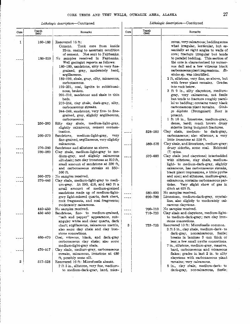
Core
1
2
CORE TESTS AND TEST WELLS, OUMALIK AREA, ALASKA 27
Lithologic description-Continued
Depth (feet)
160-180
180-250
250-260
260-270
270-280 280-360
360-370 370-440
440-450 450-460
460-470
470-517
517-528
Remarks
Recovered 15 ft: Cement. Took core from inside
22-in. casing to ascertain condition of cement. Not sent to Fairbanks.
No samples received in Fairbanks. Well geologist reports as follows:
180-189, sandstone, silty to very finegrained, gray, moderately hard, argillaceous.
189--199, shale, gray, silty, micaceous, carbonaceous.
199--201, coal, lignite to subbitumi-. nous, broken.
201-210, sandstone and shale in thin beds.
210-244, clay shale, dark-gray, silty, carbonaceous streaks.
244--249, sandstone, very fine- to finegrained, gray, slightly argillaceous, carbonaceous.
Silty clay shale, medium-light-gray, slightly calcareous, cement contamination.
Sandstone, medium-light-gray, very fine-grained, argillaceous, very slightly calcareous.
Sandstone and siltstone as above. Clay shale, medium-light-gray to me
dium-gray, and slightly calcareous silt shale; rare clay ironstone at 310 ft, small amount of sandstone at 320 ft, and carbonaceous streaks at 350-360 ft.
No samples received. Clay shale, medium-light-gray to medi
um-gray. At 390, 410, and 440 ft a small amount of medium-grained sandstone made up of medium-lightgrsy light-colored quartz, dark chert, rock fragments, and coal fragments; moderately calcareous.
No samples received. Sandstone, fine- to medium-grained,
"salt and pepper" appearance, subangular white and clear quartz, dark chert; s.rgillaceous, calcareous matrix, also some clay shale and clay' ironstone concretions.
Coal, vitreous, black, and dark-gray carbonaceous clay shale; also some medium-light-gray shale.
Clay shale, medium-gray, carbonaceous streaks, micaceous, ironstone at 480 ft, possibly some silt.
Recovered 10 ft: Microfossils absent. 2 ft 5 in., siltstone, very fine, medium
to medium-dark-grav, hard, mica-
Core
3
Lithologic description-C on tin ued
Depth (feet)
528-560
560-570
570-680
680-690 690-700
700-710 710-723
723-733
Remarks
ceous, very calcareous; bedding some what irregular, lenticular, but essentially at right angles to walls of core; fracture irregular but tends to parallel bedding. This section of the core is characterized by numerous dull and a few vitreous black carbonaceous plant impressions. Elatides sp. was identified.
2 ft, siltstone, very fine, as above, but with fewer plant remains. Grades into rock below.
3 ft 9 in., silty claystone, mediumgray, v.ery calcareous, not fissile but tends to fracture roughly parallel to bedding; contains many black carbonaceous plant remains. Ginkgo digitata (Brongniart) Heer is present.
1 ft 10 in., limestone, medium-gray, dense, hard; much brown drusy siderite lining incipient fractures.
Clay shale, medium- to dark-gray, carbonaceous; also siltstone, a very little limestone at 550 ft.
Clay shale, and limestone, medium-gray; drusy siderite, some coal. Echinoid (?) spine.
Clay shale (and claystone) interbedded with siltstone, clay shale, mediumlight- to medium-dark-gray, slightly calcareous, has carbonaceous streaks, black plant impressions, fI little pyrite and coal; and siltstone, medium-gray, calcareous, contains carbonaceous particles. Very slight show of gas in ditch at 625 ft.
No samples received. Limestone, medium-dark-gray, crystal
line, also slightly to moderately calcareous claystone.
No samples received. Clay shale and claystone, medium-light
to medium-dark-gray; rare clay ironstone concretions.
Recovered 10 ft: Microfossils common. 3 ft 5 in., clay shale, medium-dark- to
dark-gray, noncalcareous, fissile; breaks in laminae 3 mm thick or less; a few small pyrite concretions.
7 in., siltstone, medium-gray, massive, hard, carbonaceous and micaceous flakes; grades in last 2 in. to silty claystone with carbonaceous plant remains; very calcareous.
8 in., clay shale, medium-dsrk- to dsrk-gray, non calcareous, fissile;
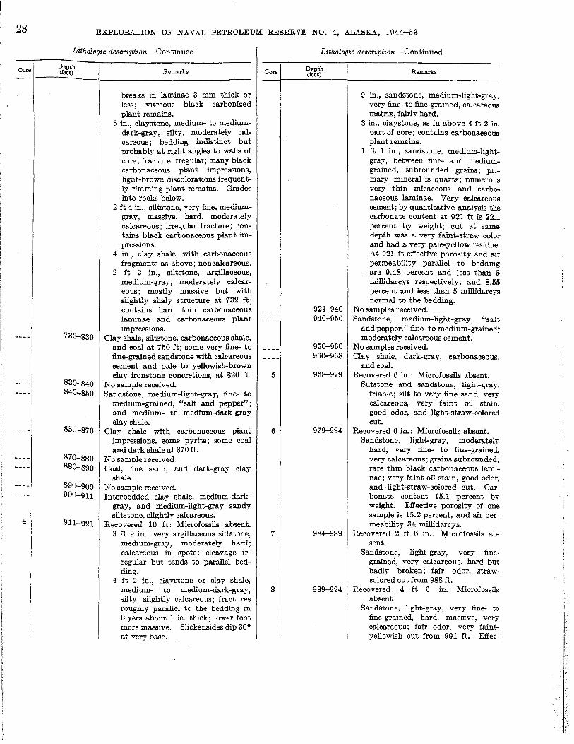
28 EXPLORATION OF NAYAL PETROLEUM RESERVE NO.4, ALASKA, 1944-53
Lithologic description-Continued
I Depth
~ ___ (~ __ t~) _____ I _____________ R_emar ___ k_S ___________ _
4
I I I
I
733-830
830-840 840-850
850-870
870-880 880-890
890-900 900-911
911-921
breaks in laminae 3 mm thick or less; vitreous black carbonized plant remains.
6 in., claystone, medium- to mediumd8.rk-gray, silty, moderately calcareous; bedding indistinct but probably at right angles to walls of core; fracture irregular; many black carbonaceous plant impressions, light-brown discolorations frequently rimming plant remains. Grades into rocks below.
2 ft 4 in., siltstone, very fine, mediumgray, massive, hard, moderately calcareous; irregular fracture; contains black carbonaceDus plant impressions.
4 in., clay shale, with carbonaceous fragments as above; non calcareous.
2 ft 2 in., siltstone, argillaceous, medium-gray, moderately calcareous; mostly massive but with slightly shaly structure at 732 ft; contains hard thin carbonaceous laminae and carbonaceous plant impressions.
Clay shale, siltstone, carbonaceous shale, and coal at 750 ft; some very fine- to fine-grained sandstone with calcareous cement and pale to yellowish-brown clay ironstone concretions, at 820 ft.
No sample received. Sandstone, medium-light-gray, fine- to
medium-grained, "salt and pepper"; and medium- to medium-dark-gray clay shale.
Clay shale with carbonaceous plant impressions. some pyrite; some coal and dark shale at 870 ft.
No sample received. Coal, fine sand, and dark-gray clay
shale. No sample received. Interbedded clay shale, medium-dark
gray, and medium-light-gray sandy siltstone, slightly calcareous.
Recovered 10 ft: Microfossils absent. 3 ft 9 in., very argillaceous siltstone,
medium-gray, moderately hard; calcareous in spots; cleavage irregular but tends to parallel bedding.
4 ft 2 in., claystone or clay shale, medium- to medium-dark-gray, silty, slightly calcareous; fractures roughly parallel to the bedding in layers about 1 in. thick; lower foot more massive. Slickensides dip 30° at very base.
Oore
5
6
7
8
Lithologic description-Continued
Depth (feet)
921-940 940-950
950-960 960-968
968-979
979-984
984-989
989-994
Remarks
9 in., sandstone, medium-light-gray, very fine- to fine-grained, calcareous matrix, fairly hard.
3 in., claystone, as in above 4 ft 2 in. part of core; contains ca-bonaceous plant remains.
1 it 1 in., sandstone, medium-lightgray, between fine- and mediumgrained, subrounded grains; primary mineral is quartz; numerous very thin micaceous and carbonaceous laminae. Very calcareous cement; by quantitative analysis the carbonate content at 921 ft is 22.1 percent by weight; cut at same depth was a very faint-straw color and had a very pale-yellow residue. At 921 ft effective porosity and air permeability parallel to bedding are 9.48 percent and less than 5 roillidarcys respectively; and 8.55 percent and less than 5 millidarcys normal to the bedding.
No samples received. Sandstone, medium-light-gray, "salt
and pepper," fine- to medium-grained; moderately calcareous cement.
No samples received. Clay shale, dark-gray, carbonaceous,
and coal. Recovered 6 in.: Microfossils absent.
Siltstone and sandstone, light-gray, friable; silt to very fine sand, very calcareous, very faint oil stain, good odor, and light-straw-colored cut.
Recovered 6 in.: Microfossils absent. Sandstone, light-gray, moderately
hard, very fine- to fine-grained, very calcareous; grains subrounded; rare thin black carbonaceous laminae; very faint oil stain, good odor, and ligbt-straw-colored cut. Carbonate content 15.1 percent by weight. Effective porosity of one sample is 15.2 percent, and air permeability 34 millidarcys.
Recovered 2 ft 6 in.: Microfossils absent.
Sandstone, light-gray, very. finegrained, very calcareous, bard but badly broken; fair odor, strawcolored cut from 988 ft.
Recovered 4 it 6 in.: Microfossils absent.
Sandstone, light-gray, very fine- to fine-grained, hard, massive, v-ery calcareous; fair odor, very faintyellowish cut from 991 ft. Effec-

I
Core
9
10
11
12
CORE TESTS .AND TEST WELLS, OUMALIK AREA, ALASKA 29
Lithologic description-Continued
Depth (feet)
994-999
991-1,004
1,004-1,010
1,010-1,020 1,020-1,030 1,030-1,033
1,033-1,038
1,038-1,050 1,050-1,060 1,060-1,070 1,070-1,080
1,080-1,090 1,090-1,100 1, 100-1, llO
1,llO-l,150
1,150-1,160 1,160-1,170
1,170-1,180
374616-56-5
Remarks
tive porosity and air permeability of one sample parallel to bedding are 13.15 percent and 9.7 millidarcys respectively, and 13.43 percent and 5.6 millidarcys normal to bedding. Carbonate content 20.4 percent by weight.
Recovered 1 it: Microfossils absent. . Sandstone as above, also some inter
bedded siltstone; very calcareous; faint petroliferous odor.
Recovered 1 ft: Microfossils absent. Siltstone, grading from very fine-grained
sandstone at top, medium-lightgray, with medium-dark-gray carbonaceous and micaceousp artings; hard; carbonaceous plant impressions; very calcareous; very faint petroliferous odor.
Recovered 2 ft 4 in. Microfossils absent. 1 ft, siltstone as above, dip 2°; grades
into rock below. 1 ft 4 in., clay shale, medium-dark
gray, silty, hard, has bla'Ck carbonaceous plant remains, rather hackly cleavage; slightly calcareous.
No samples received. Clay shale and sandy siltstone. Sandstone, medium-light-gray, very fine-
grained to silty; well geologist reports dead tarlike oil at 1,028-1,033 ft; spotty fluorescence; no cut or odor.
Recovered 4 ft Microfossils absent. Clay shale, medium-dark- to dark
gray, rather hard, slightly to moderately calcareous; carbonaceous and micaceous partings; tends to have irregular fracture rather than good cleavage.
Silty sandstone and clay shale. Clay shale and siltstone. No sample received. Silty sandstone, very fine, very calcar-
eous and clay shale. No sample received. Clay shale. Siltstone and very fine-grained sand
stone, some clay shale.
Clay shale, medium-light- to mediumdark-gray; some dark-gray shale and coal at 1,130 ft and 1,150 ft.
No sample received. Sandstone, fine- to medium-grained,
moderately calcareous; subangular white quartz 60 percent, also rock and coal fragments; also dark shale, coal, and brownish lignite.
No sample received.
Core
13
14
15
16
Lithologic de8cription-Continued
Depth (feet)
1,180-1,190
1,190-1,195
1,195-1,205
1,205-1,210
1,210-1,215
1,215-1,23v
1,230-1,410
1,410-1,422
Remarks
Clay shale, light- and dark-gray, and coal.
Sandstone, light-colored shale, and a small amount of dark shale and coal.
Recovered 10 ft: Microfossils absent. Siltstone, medium-light-gray, hard;
contains scattered very thin sandstone layers, some darker laminae which contain a larger proportion of carbonaceous material; silt contains mica; carbonate content at 1,201 ft is 28.3 percent by weight; dip approximately 3°. At 1,201 ft effective porosity and air permeability parallel to bedding 3.4 percent and less than 5 millidarcys, respectively, and 2.4 percent and less than 5 millidarcys normal to bedding.
Recovered 5 ft: Microfossils very rare. 6 in., siltstone as above but contains
larger carbonaceous fragments. and more common carbonaceous laminae.
4 ft 6 in., clay shale, medium-dark- to dark-gray, rather hard, very slightly calcareous in spots; has good shaly cleavage; numerous carbonaceous and micaceous partings.
Recovered 5 ft: Microfossils very rare. 8 in., siltstone, medium-gray, argil
laceous, micaceous, carbonaceous, and slightly calcareous, hard; becomes more argillaceous in lowest 2 in.; dip approximately 5°; slickensides noted in last inch; dip 50°.
4 ft 4 in., silty clay shale or claystone, medium-dark- to dark-gray; rather hard; slightly. calcareous; carbonaceous flecks and mica in partings; tends to have irregular fracture where carbon and mica partings are absent.
Siltstone and shaly clay, medium-lightgray.
Clay shale, medium-gray, slightly to moderately calcareous; some carbonaceous impressions. Samples contaminated with cement.
Recovered 3 ft 4 in: Microfossils rare. Clay shale and claystone, medium
dark-gray, moderately hard, slightly to moderately calcareous; has some good shaly cleavage but also tends to break irregularly along bedding planes In layers more than 1 in. thick; partings showing best shaly cleavage are silty and micaceous; numerous medium-dark-gray
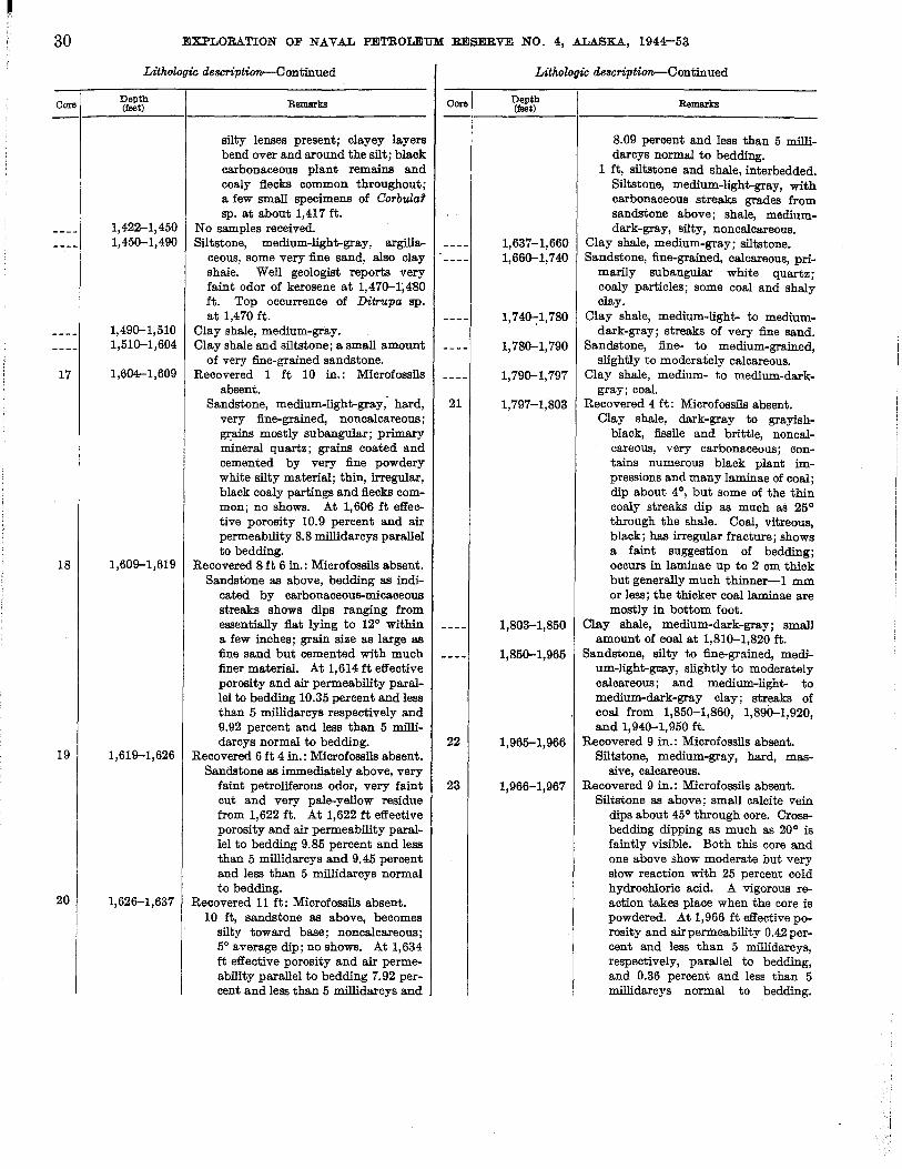
30
Core
17
18
19
20
EXPLORATION OF NAVAL PETROLEUM RESERVE NO.4, ALASKA, 1944-53
Lithologic description-Continued
Depth (feet)
1,422-1,450 1,450-1,490
1,490-1,510 1,510-1,604
1,604-1,609
1,609-1,619
1,619-1,626
1,626-1,637
Remarks
silty lenses present; clayey layers bend over and around the silt; black carbonaceous plant remains and coaly flecks common throughout; a few small specimens of CorbuZa1 sp. at about 1,417 ft.
No samples received. Siltstone, medium-light-gray, argilla
ceous, some very fine sand, also clay shale. Well geologist reports very faint odor of kerosene at 1,470-1;480 ft. Top occurrence of Ditrupa sp. at 1,470 ft.
Clay shale, medium-gray. Clay shale and siltstone; a small amount
of very fine-grained sandstone. Recovered 1 ft 10 in.: Microfossils
absent. Sandstone, medium-light-gray; hard,
very fine-grained, non calcareous ; grains mostly subangular; primary mineral quartz; grains coated and cemented by very fine powdery white silty material; thin, irregular, black coaly partings and flecks common; no shows. At 1,606 ft effective porosity 10.9 percent and air permeability 8.8 roillidarcys parallel to bedding.
Recovered 8 ft 6 in.: Microfossils absent. Sandstone as above, bedding as indi
cated by carbonaceous-micaceous streaks shows dips ranging from essentially flat lying to 12° within a few inches; grain size as large as fine sand but cemented with much finer material. At 1,614 ft effective porosity and air permeability parallel to bedding 10.35 percent and less than 5 millidarcys respectively and 9.92 percent and less than 5 millidarcys normal to bedding.
Recovered 6 ft 4 in.: Microfossils absent. Sandstone as immediately above, very
faint petroliferous odor, very faint cut and very pale-yellow residue from 1,622 ft. At 1,622 ft effective porosity and air permeability parallel to bedding 9.85 percent and less than 5 millidarcys and 9.45 percent and less than 5 roillidarcys normal to bedding.
Recovered 11 ft: Microfossils absent. 10 ft, sandstone as above, becomes
silty toward base; noncalcareous; 5° average dip; no shows. At 1,634 ft effective porosity and air permeability parallel to bedding 7.92 percent and less than 5 roillidarcys and
Core
21
22
23
Lithologic description-Continued
Depth (feet)
1,637-1,660 1,660-1,740
1,740--: 1, 780
1,780-1,790
1,790-1,797
1,797-1,803
1,803-1,850
1,850-1,965
1,965-1,966
1,966-1,967
Remarks
8.09 percent and less than 5 millidarcys normal to bedding.
1 ft, siltstone and shale, interbedded. Siltstone, medium-light-gray, with carbonaceous streaks grades from sandstone above; shale, mediumdark-gray, silty, noncalcareous.
Clay shale, medium-gray; siltstone. Sandstone, fine-grained, calcareous, pri
marily subangular white quartz; coaly particles; some coal and shaly clay.
Clay shale, medium-light- to mediumdark-gray; streaks of very fine sand.
Sandstone, fine- to medium-grained, slightly to moderately calcareous.
Clay shale, medium- to medium-darkgray; coal.
Recovered 4 ft: Microfossils absent. Clay shale, dark-gray to grayish
black, fissile and brittle, noncalcareous, very carbonaceous; contains numerous black plant impressions and many laminae of coal; dip about 4°1 but some of the thin coaly streaks dip as much as 25° through the shale. Coal, vitreous, black; has irregular fracture; shows a faint suggestion of bedding; occurs in laminae up to 2 cm thick but generally much thinner-1 mm or less; the thicker coal laminae are mostly in bottom foot.
Clay shale, medium-dark-gray; small amount of coal at 1,810-1,820 ft.
Sandstone, silty to fine-grained, medium-light-gmy, slightly to moderately calcareous; and medium-light- to medium-dark-gray clay; streaks of coal from 1,850-1,860, 1,890-1,920, and 1,940-1,950 ft.
Recovered 9 in.: Microfossils absent. Siltstone, medium-gray, hard, mas
sive, calcareous. Recovered 9 in.: Microfossils absent.
Siltstone as above; small calcite vein dips about 45° through core. Crossbedding dipping as much as 20° is faintly visible. Both this core and one above show moderate but very slow reaction with 25 percent cold hydrochloric acid. A vigorous reaction takes place when the core is powdered. At 1,966 ft effective porosity and airpermeability 0.42 percent and less than 5 millidarcys, respectively, parallel to bedding, and 0.36 percent and less than 5 millidarcys normal to bedding.

Core
24
CORE TESTS .AND TEST WELLS, OUMALIK AREA, ALASKA 31
Lithologic description-Con tin ued
Depth (feet)
1,967-1,990
1,990-2,000
2,000-2,010 2,010-2,030
2,030-2,050
2,050-2,090
2,090-2,140
2,140-2,151
2,151-2,161
Remarks
Carbonate content at same depth 47 percent by weight.
Coal, vitreous, black, and medium-darkgray shale, plus a small amount of medium-light-gray siltstone.
Sandstone, very fine-grained, and medium- to medium-dark-gray clay shale.
Clay shale, cement contamination. Clay shale, medium-gray, and fine
grained very slightly calcareous silty sandstone.
Clay sbale, dark-gray, and coal; small amount of siltstone toward base.
Sandstone, medium-light-gray, finegrained, and medium-dark-gray clay shale; pyrite, a little coal at 2,070-2,080 ft.
Clay shale, cement, and sand (sand is contamination, possibly from cellar of well).
Sandstone, medium-light-gray, mostly subangular white quartz, with some gray chert, and clay shale; non calcareous.
Recovered 8 ft: Microfossils common. 2 ft, interbedded siltstone and clay
shale, about 33 percent shale and 66 percent silt. Siltstone, mediumlight-gray, bard, noncalcareous; bedding and crossbedding as indicated by slight differences of grain size and color show local dips as high as 20°, general dip probably 3°-50. Clay shale, medium-darkgray, moderately hard. Contacts between shale and silt quite sharp; undulatory nature of some of contacts suggests ripple marks; estimated wave length 2 in., amplitude one-twelfth of an inch. Layer onetwelfth of an inch thick near bottom is siltstone containing thin flat fragments of shale as much as 1~ in. in length-a sort of intraformational conglomerate. A few partings have vitreous, black flakes and fragments of coal. One Ij4-in. layer of fine-grained sandstone at 2,152 ft.
2 ft 4 in., sandstone and siltstone, very fine-grained, medium-light-gray, hard; throughout most of section bedding not pronounced except in center where micaceous and carbonaceous partings are present; dip 50. Slight petroliferous odor. At 2,154 ft effective porosity and air permeability parallel to bedding 3.43 percent and less than 5 millidarcys, respectively, and 3.83 per-
Core
25
26
27
Lithologic description-Continued
Depth (feet)
2,161-2,171
2,171-2,190
2,190-2,210
2,210-2,220
2,220-2,310
2,310-2,330
2,330-2,340
2,340-2,351
2,351-2,356
2,356-2,390
2,390-2,420
2,420-2,430 2,430-2,500
2,500-2,520 2,520-2,529
2,529-2,539
Remarks
cent and less than 5 millidarcys normal to bedding. Carbonate content at same depth 8 percent by weight.
3 ft 8 in., interbedded siltstone and shale as above in this core, 25 percent siltstone, 75 percent shale.
Recovered 10 ft: Microfossils common. Interbedded siltstone, medium-tight
gray, and medium-dark-gray shale as above. Siltstone, 20 percent, shale, 80 percent. Silty lenticles in the clay shale.
Sandstone, silty to fine-grained, -mediumtight-gray; and medium-dark-gray shale; some coal at 2,180-2,190 ft.
Clay shale and a small amount of sandstone.
Sandstone, silty to fine-grained, and some medium-clark-gray clay shale.
Clay shale, medium-gray to grayishblack; streaks of coal throughout, particularly at 2,240-2,250 and 2,280-2,290 ft; also streaks of silt.
Coal, vitreous black, irregular fracture, and medium-dark-gray clay shale.
Sandstone, medium-tight-gray, very fine- to fine-grained, and mediumdark-gray clay; non calcareous.
Clay shale, medium-dark- to dark-gray, moderately hard, coal streaks at 2,340-2,350 ft, slightly calcareous to noncalcareous.
Recovered 5 ft: Microfossils common. Interbedded siltstone, medium-light
gray, and medium-dark-gray clay shale; similar to core 25 except that shale is siltier, harder, and has less shaly cleavage. On the whole, distinction between siltstone and shale is not as great as above.
Clay shale, coa.l strea.ks at 2,370-2,390 ft.
Clay shale, medium-dark-gray, and very fine-grained sandstone.
Coal and clark-gray clay shale. Clay shale, medium- to medium-dark
gray, and small amount of mediumtight-gray siltstone; latter is slightly calcareous; a very little very fine sand; small amount of coal at 2,450-2,460 ft; pyrite present; clay ironstone at 2,440-2,450 ft.
Clay shale and siltstone, 1:1 ratio. Clay shale, some siltstone, and a little
coal. Recovered 8 ft 6 in.: Microfossils absent.
2 ft 4 in., siltstone and shaly silt, medium-light-gray, non calcareous fairly

32
Core
28
EXPLORATION OF NAVAL PETROLEUM RESERVE NO.4, ALASKA, 1944-53
Lithologic de8cription-Continued
Depth (feet)
2,539--2,570
2,570-2;610
2,610-2,620
2,620-2,700
2,700-2,710
2,710-2,730 2,730-2,740
2,740-2,756
2,756-2,757
Remarks
hard; tends to have a shaly cleavage pars.1lel to bedding; bedding and crossbedding visible owing to slight difference in color; dips as high as 20°; regional dip probably close to 3° or 4°; faint petroliferous odor, pale-straw-colored cut from 2,531 ft.
6 ft 2 in., interbedded siltstone and clay shale. Siltstone as above. Clay shale medium- to dark-gray, moderately hard, noncalcareous. Lenticles of silt and "ripple marks" similar to those described in core 24 present.
Clay shale, plus small amounts of siltstone; clay ironstone concretion at 2,550-2,560 ft, a very little coal at 2,540-2,550 ft and 2,560-2,570 ft.
Clay shale, medium-dark- to dark-gray, and varying amounts of medium-lightgray silty sandstone and siltstone. Crinoid fragment at 2,590-2,600 feet.
Clay shale, medium-dark- to dark-gray, and very fine-grained medium-lightgray sandstone.
Clay shale, medium-dark-gray, moderately hard; streaks of sandy siltstone and coal at 2,660-2,700 ft (particularly in last 10 ft); clay ironstone at 2,620-2,630 ft. Crinoid fragment at 2,670-2,680 ft.
Sandstone, very fine-grained, and siltstone, clay shale, and a little coal.
Clay shale and siltstone. Clay shale, medium-dark-gray, and
medium-light-gray siltstone, about 50 percent of each. Also a sms.1l amount of very fine-grained sandstone and coal.
Clay shale, 50 percent, medium-darkgray; and sandstone, 50 percent, medium-light-gray, very fine- to finegrained; 70 percent white and clear quartz, matrix slightly calcareous.
Recovered 1 ft: Microfossils absent. 3 in., siltstone, light- to medium-light
gray, hard; a few black carbonaceous plant impressions; moderate effervescence with cold 25 percent HCl. At 2,756 ft effective porosity 1.78 percent and air permeability less than 5 millidarcys parallel to bedding.
6 in., sandstone, light- to mediumlight-gray, hard; numerous vitreous and dull black coaly fragments and partings; fine-grained (some grains slightly coarser); primarily subangular clear, milky, and some
Core
29
30
31
32
Lithologic description-Continued
Depth (feet) Remarks
gray quartz grains; has calcareous cement. No odor; no cut from 2, 756~ ft. At 2,75672 ft effective porosity parallel to bedding 3.74 percent and carbonate content 7.88 percent by weight; sample unsuitable for permeability determination.
3 in., clay shale or claystone, mediumdark-gray, hard, slightly calcareous; shaly cleavage not prominent, a few micaceous partings.
2,757-2,760 Recovered 3 ft: Microfossils absent. Clay shale or claystone, medium-dark
gray, hard; shaly cleavage' not prominent; about 3 in. of mediumlight-gray siltstone and very fine sandstone at 2,758 ft; sharp but wavy or "ripple-mark-like" contacts between silt and shale. Below 2,758 ft shale contains great deal of silt-therefore slightly lighter in color. Carbonaceous material, both finely disseminated and as larger fragments in certain laminae, is abundant. Siltstone is moderately calcareous.
2,760-2,767 Cement plus a small amount of clay shale (lO~-in. casing set at 2,762 ft).
2,767-2,777 Recovered 10 ft: Microfossils absent. 5 ft, siltstone, medium- to medium
dark-gray, argillaceous, massive, fairly hard, very slightly calcareous; contains both biotite and muscovite, also a large amount of dull to shiny black carbonaceous or bituminous material.
5 ft, claystone, medium-dark-gray, slightly shaly, micaceous, very slightly calcareous, contains finely disseminated carbonaceous material, few laminae of siltstone as above.
2,777-2,787 Recovered 10 ft: Microfossils very rare. 2 ft 6 in., siltstone as described in core
above, slight petroliferolls odor on fresh fracture.
4 ft, claystone as in core 30; very slightly calcareous, high-angle frac·· turing (about 80°) common; some slickensides; slight petroliferous odor on fresh fracture; grades into rocks below.
3 ft 6 in., clay shale, medium-darkgray, hard; not noticeably fractured, cleaves parallel to bedding (?);dip4°.
2,787-2,792 Recovered 1 ft 3 in.: Microfossils very rare.
Claystone or clay shale, mediumdark-gray, with lenses and laminae
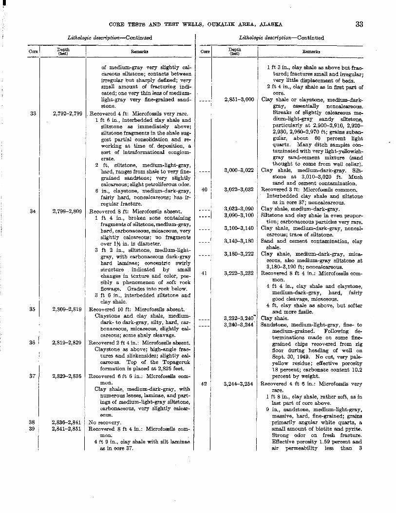
Core
33
34
35
36
37
38 39
CORE TESTS .AND TEST WELLS, OUM.A.LIK AREA, ALASKA 33
Lithologic description-Continued
Depth (feet)
2,792-2,799
2,799-2,809
2,809-2,819
2,819-2,829
2,829-2,836
2,836-2,841 2,841-2,851
Remarkl!l
of medium-gray very slightly calcareous siltstone; contacts between irregular but sharply defined; very small amount of fracturing indicated; one very thin lens of mediumlight-gray very fine-grained sandstone.
. Recovered 4 ft: Microfossils very rare. 1 ft 6 in., interbedded clay shale and
siltstone as immediately above; siltstone fragments in the shale suggest partial consolidation and reworking at time of deposition, a sort of intraformational conglomerate.
2 ft, siltstone, medium-light-gray, hard, ranges from shale to very finegrained sandstone; very slightly calcareous; slight petrolifero us odor.
6 in., claystone, medium-dark-gray, fairly hard, noncalcareous; has· irregular fracture.
Recovered 8 ft: Microfossils absent. 1 ft 4 in., broken zone containing
fragments of siltstone, medium-gray, hard, carbonaceous, micaceous, very slightly calcareous; no fragments over ly'! in. in diameter.
3 ft 2 in., siltstone, medium-lightgray, with carbonaceous dark-gray hard laminae; concentric swirly structure . indicated by small changes in texture and color, possibly a phenomenon of soft rock flowage. Grades into rock below.
3 ft 6 in., interbedded siltstone and clay shale.
Recovered 10 ft: Microfossils absent. Claystone and clay shale, medium
dark- to dark-gray, silty, hard, carbonaceous, micaceous, slightly calcareous; some shaly cleavage.
Recovered 2 ft 4 in.: Microfossils absent. Claystone as above; high-angle frac
tures and slickensides; slightly calcareous. Top of the Topagoruk formation is placed at 2,825 feet.
Recovered 6 ft 6 in.: Microfossils common.
Clay shale, medium-dark-gray, with numerous lenses, laminae, and partings of medium-light-gray siltstone, carbonaceous, very slightly calcareous.
No recovery. Recovered 8 ft 4 in.: Microfossils com
mon. 4 ft 9 in., clay shale with silt laminae
as in core 37.
Core
40
41
42
Lithologic description-Continued
Depth (feet)
2,851-3,000
3,000-3,022
3,022-3,032
3,032-3,090 3,090-3,100
3,100-3,140
3,140-3,180
3,180-3,222
3,222-3,232
3,232-3,240~ 3,240-3,244 •
3,244-3,254
Remarks
1 ft 3 in., clay shale as above but fractured; fractures small and irregular; very little displacement of beds.
2 ft 4 in., clay shale as in first part of core.
Clay shale or claystone, medium-darkgray, essentially noncalcareous. Streaks of slightly calcareous medium-light-gray sandy siltstone, particularly at 2,900-2,910, 2,920-2,930, 2,960-2,970 ft; grains subangular, about 60 percent light quartz. Many ditch samples contaminated with very light-ye1lowishgray sand-cement mixture (sand thought to come from well cellar).
Clay shale, medium-dark-gray. Siltstone at 3,010-3,020 ft. Much sand and cement contamination.
Recovered 3 ft: Microfossils common. Interbedded clay shale and siltstone
as in core 37; noncalcareous. Clay shale, medium-dark-gray. Siltstone and clay shale in even propor
tion; carbonaceous particles very rare. Clay shale, medium-dark-gray, noncal
careous; trace of siltstone. Sand and cement contamination, clay
shale. Clay shale, medium-dark-gray, mica
ceous, also medium-gray siltstone at 3,180-3,190 ft; noncalcareous.
Recovered 8 ft 4 in.: Microfossils common.
4 ft 4 in., clay shale and claystone, medium-dark-gray, hard, fairly good cleavage, micaceous.
4 ft, clay shale as above, but softer and more fissile.
Clay shale. Sandstone, medium-light-gray, fine- to
medium-grained. FollOwing determinations made on some finegrained chips recovered from rig floor during heading of well on Sept. 30, 1949. No cut, very paleyellow residue; effective porosity 18 percent; carbonate content 10.2 percent by weight.
Recovered 4 ft 6 in.: Microfossils very rare.
1 ft 8 in., clay shale, rather soft, as in last part of core above.
9 in., sandstone, medium-light-gray, massive, hard, fine-grained; grains primarily angular white quartz, a small amount of biotite and pyrite. Strong odor on fresh fracture. Effective porosity 1.59 percent and air permeability less than 3

34
Core
43
44 45
46
EXPLORATION OF NAVAL PETROLEUM RESERVE NO.4, ALASKA, 1944-53
Lithologic description-Continued
Depth (feet)
3,254-3,262
3,262-3,272 3,272-3,282
3,282-3,320
3,320-3,400 3,400-3,455
3,455-3,465
3,465-3,480 3,480-3,490
Remarks
millidarcys. Carbonate con ten t 24.2 percent by weight.
4 in., clay shaJ.e, soft as above. 7 in., sandstone, as above, strong
naphthalike odor on fresh fracture, pale-straw-colored cut, pale-yellow residue from 3,251 ft.
1 ft 2 in., clay shale, as above, some sandstone interbedded.
Recovered 8 ft: Microfossils absent. 1 ft 8 in., claystone, medium-light
gray, fairly soft, noncalcareous; darker laminae increase toward bottom and grade into rock below.
2 ft 8 in., clay shale, medium-darkgray, moderately hard, noncalcareous, with good cleavage.
1 ft 7 in., sandstone, very fine, and medium-gray hard massive siltstone; angular white quartz is primary mineral; mica present; somewhat calcareous silty matrix. Faint odor; straw-colored cut and pale-yellow residue from 3,260 ft. At 3,260 ft effective porosity 9.2 percent and air permeability less than 4 millidarcys. Carbonate content 14.23 percent.
9 in., clay shale, medium-dark-gray, micaceous. ~
1 ft 4 in., siltstone and sandstone as above; faint odor.
No recovery. Recovered 10 ft: Microfossils absent.
3 ft, clay shale, medium-dark-gray, with laminae and irregular lenticles of medium-light-gray siltstone.
7 ft, claystone and shale, mediumdark-gray, hard; poorly developed cleavage; dip of beds estimated 4°.
Sandy siltstone and sandstone, mediumlight-gray, very fine-grained, slightly calcareous to noncalcareous; and medium-dark-gray clay shale. Small amount of coal at 3,280-3,290 ft.
Siltstone and shale. Clay shale, medium-dark- to dark-gray,
with silty streaks. Recovered 5 ft: Microfossils common.
Clay shale, medium-dark-gray, hard, carbonaceous, micaceous; interbedded with a few thin irregular laminae of medium-light-gray siltstone; noncalcareous; dips as much as 5°.
No samples received. San d y siltstone, medium-light-gray
sandstone, and clay shale.
Core
47
48
49 50
51
52
LitholO(lic description-Continued
Depth (feet)
3,490-3,500
3,500-3,510
3,510-3,700
3,700-3,710 3,710-3,712
3,712-3,713
3,713-3,740 3,740-3,752
3,752-3,756
Remarks
Recovered 7 ft 3 in.: Microfossils absent. Siltstone, medium-light-gray, hard,
with dark carbonaceous micaceous partings; very slightly calcareous; estimated 2° dip; very faint petroliferous odor on fresh fracture. At 3,494 ft effective porosity 14 percent and air permeability 4.9 millidarcys. At 3,495 ft effective porosity 14.3 percent; sample unsuitable for per·· meability determination.
Recovered 8 ft: Microfossils absent. 2 ft, siltstone, medium-light-gray.
hard; also a small amount of v.ery fine-grained sandstone, micaceous, very slightly calcareous; grades at bottom into rock below.
6 ft, clay shale and claystone, mediumdark-gray, hard, silty, micaceous, very slightly calcareous; contain carbonaceous flecks; interbedded with thin irregular laminae and lenses of medium-light-gray siltstone. Dips range from 4° to 25°_ probably a retlection of large-scale crossbedding.
Clay shale and claystone, medium-darkto dark-gray, moderately hard, micaceous, with streaks of medium-lightto medium-dark-gray siltstone--color darker because. of abundance of carbonaceous particles; some partings of black bitumen present; noncalcareous.
No recovery. Recovered 2 in.: Microfossils abundant.
Clay shale, medium-dark-gray, hard. noncalcareous.
Recovered 6 in.: Microfossils abundant Clay shale as above; dip 10°.
No samples received. Sandstone, medium-gray, very fine
grained, silty, slightly calcareous; made up of subangular quartz and carbonaceous particles, argillaceous matrix, thin streaks of bitumen. Some clay shale.
Recovered 3 ft 6 in.: Microfossils absent. Siltstone, medium-gray, moderately
hard, micaceous, moderately calcareous to noncalcareous; grains primarily quartz, but siltstone is very argillaceous grading to silty claystone in places; small (up to 2 mID long) fragments of black carbonaceous material disseminated throughout; dips 3° or less; faint odor, pale-straw-colored cut and very pale residue from 3,752% ft.
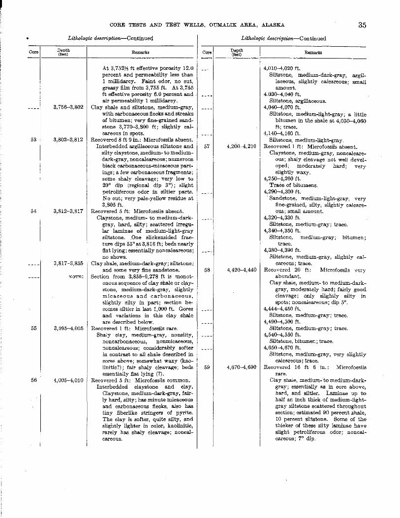
•
Core
53
54
55
56
CORE TESTS AND TEST WELLS, OUMALIK AREA, ALASKA. 35
Lithologic description-Continued
Depth (feet)
3,756-3,802
3,802-3,812
3,812-3,817
3,817-3,855
NOTE:
3,995-4,005
4,005-4,010
Remarks Core
At 3, 752~ ft effective porosity 12.0 percent and permeability less than 1 millidarcy. Faint odor, no cut, greasy film from 3,755 ft. At 3,755 ft effective porosity 6.0 percent and. air permeability 1 millidarcy.
Clay shale and siltstone, medium-gray, with carbonaceous flecks and streaks of bitumen; very fine-grained sandstone 3,770--3,800 ft; slightly calcareous in spots.
Recovered 8 ft 9 in.: Microfossils absent. Interbedded argillaceous siltstone and 57
silty claystone, medium- to mediumdark-gray, noncalcareous; numerous black carbonaceous-micaceous part-ings; a few carbonaceous fragments; some shaly cleavage; very low to 20° dip (regional dip 3°); slight petroliferous odor in siltier parts. No cut; very pale-yellow residue at 3,805 ft.
Recovered 5 ft: Microfossils absent. Claystone, medium- to medium-dark
gray, hard, silty; scattered irregular laminae of medium-light-gray siltstone. .One slickensided fracture dips 55 ° at 3,816 ft; beds nearly flat lying; essentially noncalcareous; no shows.
Clay shale, medium-dark-gray; siltstone; and some very fine sandstone. 58
Section from 3,855-9,278 ft is monotonous sequence of clay shale or claystone, medium-clark-gray, slightly micaceous and carbonaceous, slightly silty in part; section becomes siltier in last 1,000 ft. Gores and variations in this clay shale are described below.
Recovered 1 ft: Microfossils rare. Shaly clay, medium-gray, nonsilty,
noncarbonaceous, nonmicaceous, non calcareous ; considerably softer in contrast to all shale described in cores above; somewhat waxy (kao-linitic?); fair shaly cleavage; beds 59 essentially flat lying (?).
Recovered 5 ft: Microfossils common. Interbedded claystone and clay.
Claystone, medium-dark-gray, fairly hard, silty; has minute micaceous and carbonaceous flecks, also has tiny fiberlike stringers of pyrite. The clay is softer, quite silty, and slightly lighter in color, kaolinitic, rarely has shaly cleavage; noncalcareous.
Lithologic description-Continued
Depth (feet)
4,200--4,210
4,420--4,440
4,670-4,690
Remarks
4,010-4,020 ft. Siltstone, medium-dark-gray, argil
laceous, slightly calcareous; small amount.
4.030-4,040 ft. Siltstone, argillaceous.
4,040--4,070 ft. Siltstone, medium-light-gray; a little
bitumen in the shale at 4,050-4,060 ft; trace.
4,140-4,160 ft. Siltstone, medium-light-gray.
Recovered 1 ft: Microfossils absent. Claystone, medium-gray, noncalcare
ous; shaly cleavage not welldevel~ oped; moderately hard; very slightly waxy.
4,250-4,260 ft. Trace of bitumens.
4,290-4,300 ft. Sandstone, medium-light-gray, very
fine-grained, silty, slightly' calcareous; small amount.
4,320-4,330 ft. Siltstone, medium-gray; trace.
4,340-4,350 ft. Siltstone, medium-gray; bitumen;.
trace. 4,380--4,390 ft.
Siltstone, medium-gray, slightly caTcareous; trace.
Recovered 20 ft: Microfossils very abundant.
Clay shale, medium- to medium-darkgray, moderately hard; fairly good cleavage; only slightly silty in. spots; noncalcareous; dip 5°.
4,444-4,450 ft. Siltstone, medium-gray; trace.
4,490-4,500 ft. Siltstone, medium-gray; trace.
4,540-4,550 ft. Siltstone, bitumen; trace.
4,650--4,670 ft. Siltstone, medium-gray, very slightly
calcareous; trace. Recovered 16 ft 6 in.: Microfossils
rare. Clay shale, medium- to medium-dark
gray; essentially as in core above, hard, and siltier. Laminae up to· half an inch thick of medium-lightgray siltstone scattered throughout section; estimated 90 percent shale, 10 percent siltstone. Some of the thicker of these silty laminae have slight petrolifero us odor; noncalcareous; 7° dip.
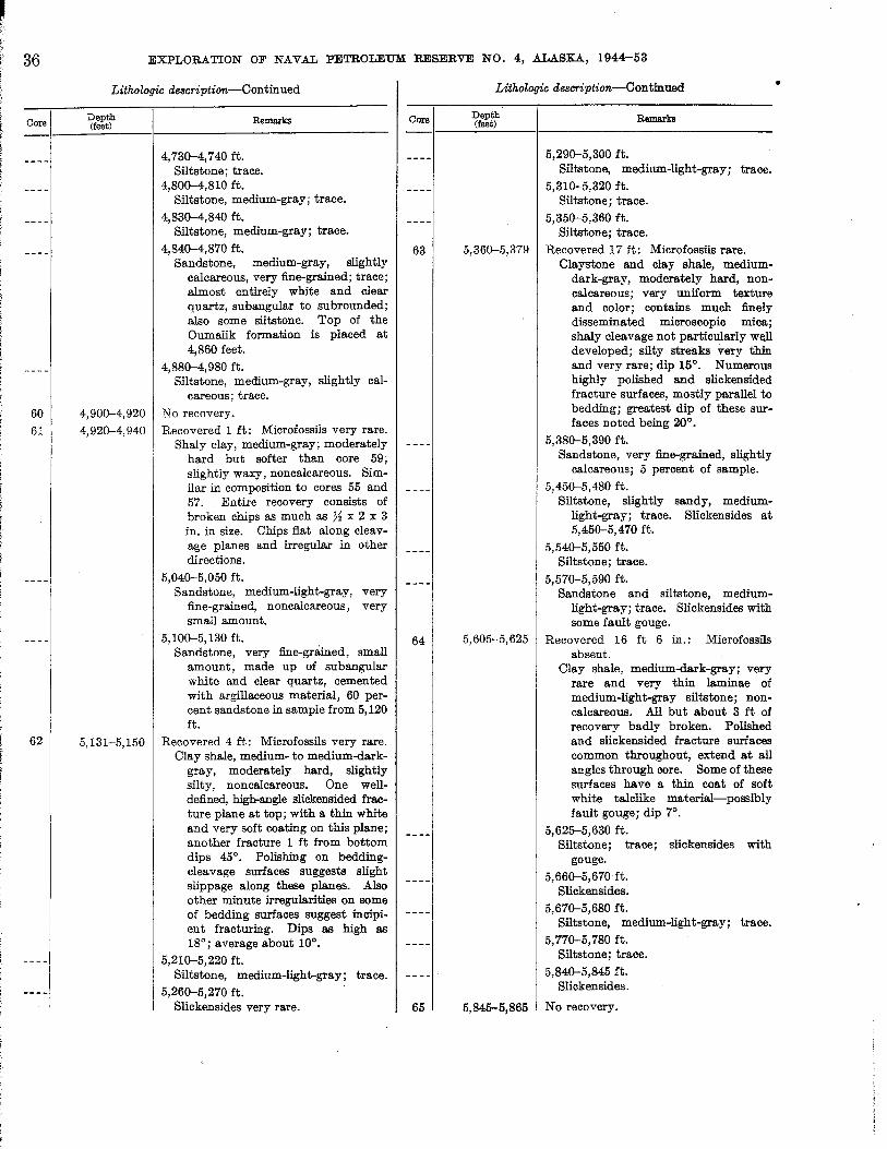
36
Core
60
61
62
----I
EXPLORATION OF NAVAL PETROLEUM RESERVE NO.4, ALASKA, 1944-53
Lithologic description-Continued
Depth Remarks (feet)
4,730-4,740 ft. Siltstone; trace.
4,800-4,810 ft. Siltstone, medium-gray; trace.
4,830-4,840 ft. Siltstone, medium-gray; trace.
4,840-4,870 ft. Sandstone, medium-gray, slightly
calcareous, very fine-grained; trace; almost entirely white and clear quartz, subangular to subrounded; also some siltstone. Top of the Oumalik formation is placed at 4,860 feet.
4,880-4,980 ft. Siltstone, medium-gray, slightly cal
careous; trace.
4,900-4,920 No recovery. 4,920-4,940 Recovered 1 ft: Microfossils very rare.
Shaly clay, medium-gray; moderately hard but softer than core 59; slightly waxy, noncalcareous. Similar in composition to cores 55 and 57. Entire recovery consists of broken chips as much as ~ x 2 x 3 in. in size. Chips fiat along cleavage planes I:I.nd irregular in other directions.
5,040-5,050 ft. Sandstone, medium-light-gray, very
fine-grained, noncalcareous, very small amount.
5,100-5,130 ft. Sandstone, very fine-gr8lned, small
amount, made up of sub angular white and clear quartz, cemented with argillaceous material, 60 percent sandstone in sample from 5,120 ft.
5,131-5,150 Recovered 4 ft: Microfossils very rare. Clay shale, medium- to medium-dark
gray, moderately hard, slightly silty, noncalcareous. One welldefined, high-angle slickensided fracture plane at top; with a thin white and very soft coating on this plane; another fracture 1 ft from bottom dips 45°. Polishing on beddingcleavage surfaces suggests slight slippage along these planes. Also other minute irregularities on some of bedding surfaces suggest incipient fracturing. Dips as high as 18°; average about 10°.
5,210-5,220 ft. Siltstone, medium-light-gray; trace.
5,260-5,270 ft. Slickensides very rare.
Core
63
64
65
Lithologic description-Continued
Depth R ks (feet) emar
5,290-5,300 ft. Siltstone, medium-light-gray; trace.
5,310-5,320 ft. Siltstone; trace.
5,350-5,360 ft. Siltstone; trace.
5,360-5,379 Recovered 17 ft: Microfossils rare. Claystone and clay shale, medium
dark-gray, moderately hard, noncalcareous; very uniform texture and color; contains much finely disseminated microscopic mica; shaly cleavage not particularly well developed; silty streaks very thin and very rare; dip 15°. Numerous highly polished and slickensided fracture surfaces, mostly parallel to bedding; greatest dip of these surfaces noted being 20°.
5,380-5,390 ft. Sandstone, very fine-grained, slightly
calcareous; 5 percent of sample.
5,450-5,480 ft. Siltstone, slightly sandy, medium
light-gray; trace. Slickensides at 5,450-5,470 ft.
5,540-5,550 ft. Siltstone; trace.
5,570-5,590 ft. Sandstone and siltstone, medium
light-gray; trace. Slickensides with some fault gouge.
5,605-5,625 Recovered 16 ft 6 in.: Microfossils absent.
Clay shale, medium-dark-gray; very rare and very thin laminae of medium-light-gray siltstone; noncalcareous. All but about 3 ft of recovery badly broken. Polished and slickensided fracture surfaces common throughout, extend at all angles through core. Some of these surfaces have a thin coat of soft white talclike material-possibly fault gouge; dip 7°.
5,625-5,630 ft. Siltstone; trace; slickensides with
gouge.
5,660-5,670 ft. Slickensides.
5,670-5,680 ft. Siltstone, medium-light-gray; trace.
5,770-5,780 ft. Siltstone; trace.
5,840-5,845 ft. Slickensides.
5,845-5,865 No recovery.
•
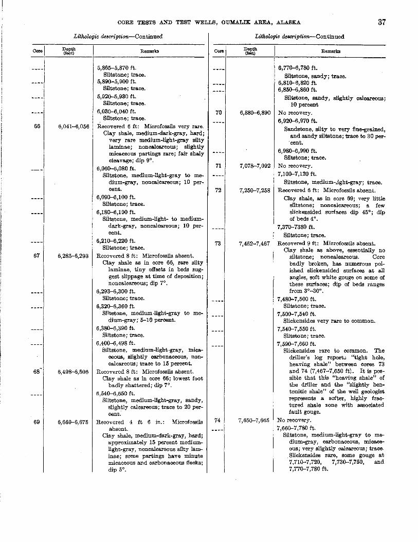
Core
66
67
68~
69
CORE TESTS .AND TEST WELLS, OUMALIK AREA, ALASKA 37
Lithologic de8cription-Continued
Depth (feet) Remarks
5,865-5,870 ft. Siltstone; trace.
5,890-5,900 ft. Siltstone; trace.
5,920-5,930 ft. Siltstone; trace.
6,030-6,040 ft. Siltstone; trace.
6,041-6,056 Recovered 6 ft: Microfossils very rare. Clay shale, medium-dark-gray, hard;
very rare medium-light-gray silty laminae; noncalcareous; slightly micaceous partings rare; fair shaly cleavage; dip 9°.
6,060-6,080 ft. Siltstone, medium-light-gray to me
dium-gray, noncalcareous; 10 percent.
6,090-6,100 ft. Siltstone; trace.
6,180-6,190 ft. Siltstone, medium-light- to medium
dark-gray, noncalcareousj 10 percent.
6,210-6,220 ft. Siltstone; trace.
6,285-6,293 Recovered 8 ft: Microfossils absent. Clay shale as in core 66, rare silty
laminae, tiny offsets in beds suggest slippage at time of deposition; noncalcareous; dip 7°.
6,293-6,300 ft. Siltstone; trace.
6,320-6,360 ft. Siltstone, medium-light-gray to me
dium-gray; 5-10 percent. 6,380-6,390 ft.
Siltstone; trace. 6,400-6,498 ft.
Siltstone, medium-light-gray, micaceous, slightly carbonaceous, noncalcareous; trace to 15 percent.
6,49&-6,506 Recovered 8 ft: Microfossils absent. Clay shale as in core 66; lowest foot
badly shattered; dip 7° . 6,540-6,650 ft.
Siltstone, medium-light-gray, sandy, slightly calcareous; trace to 20 percent.
6,669-6,675 Recovered 4 ft 6 in.: Microfossils absent.
Clay shale, medium-dark-gray, hard; approximately 15 percent mediumlight-gray, noncalcareous silty laminae; some partings have minute micaceous and carbonaceous flecks; dip 5°.
Core
70
71
72
73
74
Lithologic description-Continued
Depth (teet) Remarks
6,770-6,780 ft. Siltstone, sandy; trace.
6,810- 6,820 ft. 6,850-6,860 ft.
Siltstone, sandy, slightly calcareous; 10 percent
6,880-6,890 No recovery. 6,920-6,970 ft.
Sandstone, silty to very fine-grained, and sandy siltstone; trace to 30 percent.
6,980-6,990 ft. Siltstone i trace.
7,07&-7,092 No recovery. 7,100-7,120 ft.
Siltstone, medium-.Jght-gray; trace. 7,250-7,258 Recovered 6 ft: Microfossils absent.
Clay shale, as in core 69; very little siltstone; noncalcareous; a few slickensided surfaces dip 45°; dip of beds 4°.
7,370-7380 ft.
Siltstone; trace. 7,452-7,467 Recovered 9 ft: Microfossils absent.
Clay shale as above, essentially no siltstone; noncalcareous. Core badly broken, has numerous polished slickensided surfaces at all angles, soft white gouge on some of these surfaces; dip of beds ranges from 3°-30°.
7,480-7,500 ft. Siltstone; trace.
7,500-7,540 ft. Slickensides very rare to common.
7,540-7,550 ft. Siltstone; trace.
7,590-7,660 ft. Slickensides rare to common. The
driller's log report.. "tight hole, heaving shale" between cores 73 and 74 (7,467-7,650 ft). It is possible that this "heaving shale" of the driller and the "slightly bentonitic shale" of the well geologist represents a softer, highly fractured shale zone with associated fault gouge.
7,650-7,665 No recovery. 7,660-7,780 ft.
Siltstone, medium-light-gray to medium-gray, carbonaceous, micaceous; very slightly calcareous; trace. Slickensides rare, some gouge at 7,710-7,720, 7,730-7,750, and 7,770-7,780 ft.

• :38
Core
75
76
77
EXPLORATION OF NAVAL PETROLEUM RESERVE NO.4, .A.L.A.SK.A., 1944-53
LithoZogic description--Continned
Depth (feet) Remarks
7,790-7,810 ft. Siltstone, medium-light-gray; trace
to 10 percent. 7,810 ft.
Top of contamination of loose yellowish-gray quartz sand identical to that noted from 2,760-4,120 ft.
7,910-7,940 ft.
Siltstone, medium-light-gray to medium-gray; trace.
7,960-7,970 ft.
Siltstone; trace. 7,990-8,030 ft.
Siltstone, micaceous; carbonaceous, slightly calcareous; trace.
8,080-8,090 ft. Siltstone; trace.
8,090-8,094 Recovered 3 ft: Microfossils absent. Clay shale, medium- to medium-dark
gray, moderately hard, noncalcareous; has fair shaly cleavage. Approximately 7 percent of core made of irregular medium-light-gray silt laminae; dip 3°. Well geologist reports core bled gas.
8;094-8,110 ft. Siltstone, medium-gray; trace.
8,170-8,180 ft. Siltstone; trace.
8,220-8,240 ft. Slickensides very rare.
8,250-8,284 ft. Siltstone, medium-gray, and silty
sandstone, slightly calcareous; trace.
8,284-8,294 Recovered 10 ft: Microfossils very rare. Clay shale, medium-dark-gray, mod
erately hard; good shaly cleavage; some partings coated with minute particles of pyrite; one pyrite concentration has a structure that suggests organic remains. Contains approximately 25 percent of medium-light-gray nonca1careous thin (up to 1 in. but usually X in. or less) siltstone laminae and lenses; slightly harder than the shale. Siltstone has small ripple marks and very small amount of crossbedding; dip 3°. Very faint petrolifero us . odor.
8,330-8,350 ft. Siltstone, medium- to medium-light
gray; trace.
8,488-8,498 Recovered 10 ft: Microfossils absent. Clay shale and claystone, medium
dark-gray, moderately hard, non-
Core
78
79
80
81
Lithologic description--Continned
Depth (feet)
8,691-8,701
8,917-8,927
9,138-9,148 9,148-9,158
Remarks
calcareous; have poor shaly cleavage. No siltstone. About threefourths of this core broken into pieces 1-2 in. in length; a few fractures at 40° are slickensided; beds dip 10°-25°. Well geologist reports core bled gas; strong gasoline odor noted in parts of core in laboratory.
8,640-8,691 ft. Clay shale, medium-dark-gray, slightly
micaceous, also a trace to 25 percent of medium-light-gray to medium-gray sandstone and very fineto fine-grained argillaceous sandy siltstone; grains are subangular to subround; primary mineral is clear quartz. Cuttings are very slightly calcareous.
Recovered 10 ft: Microfossils absent. Clay shale, medium-dark-gray, with
about 15 percent silty laminae similar to core 76; one 60° slickensided surface at 8,692 ft; noncalcareous; fiat lying to 2° dip. Well geologist reports core bled slight amount of gas.
8,760-8,770 ft.
Sandstone, very fine, very slightly calcareous; 10 percent.
8,830-8,917 ft. Siltstone, sandy, medillIil-light-gray,
trace to 15 percent, and very finegrained sandstone.
Recovered 2 ft: Microfossils absent. Clay shale, medium-dark-gray, hard,
fair shaly cleavage, micaceous, carbonaceous, nonca1careous; beds approximately fiat lying (?) but with cleavage dipping as high as 20°.
8,930-8,940 ft. Sandstone, very fine- to fine-grained;
trace.
8,990-9,040 ft. Sandstone, very fine-grained, and silt
stone; noncalcareous; trace.
No recovery. Recovered 1 ft: Microfossils absent.
Clay shale, medium-dark-gray, hard, nonca1careous; has poor shaly cleavage, and contains irregular lenses and laminae of medium-light-gray siltstone; dip 10°.
9,180-9,230 ft. Siltstone, medium-light-gray, sandy;
trace. Slickensides very rare at 9,190-9,200 ft.
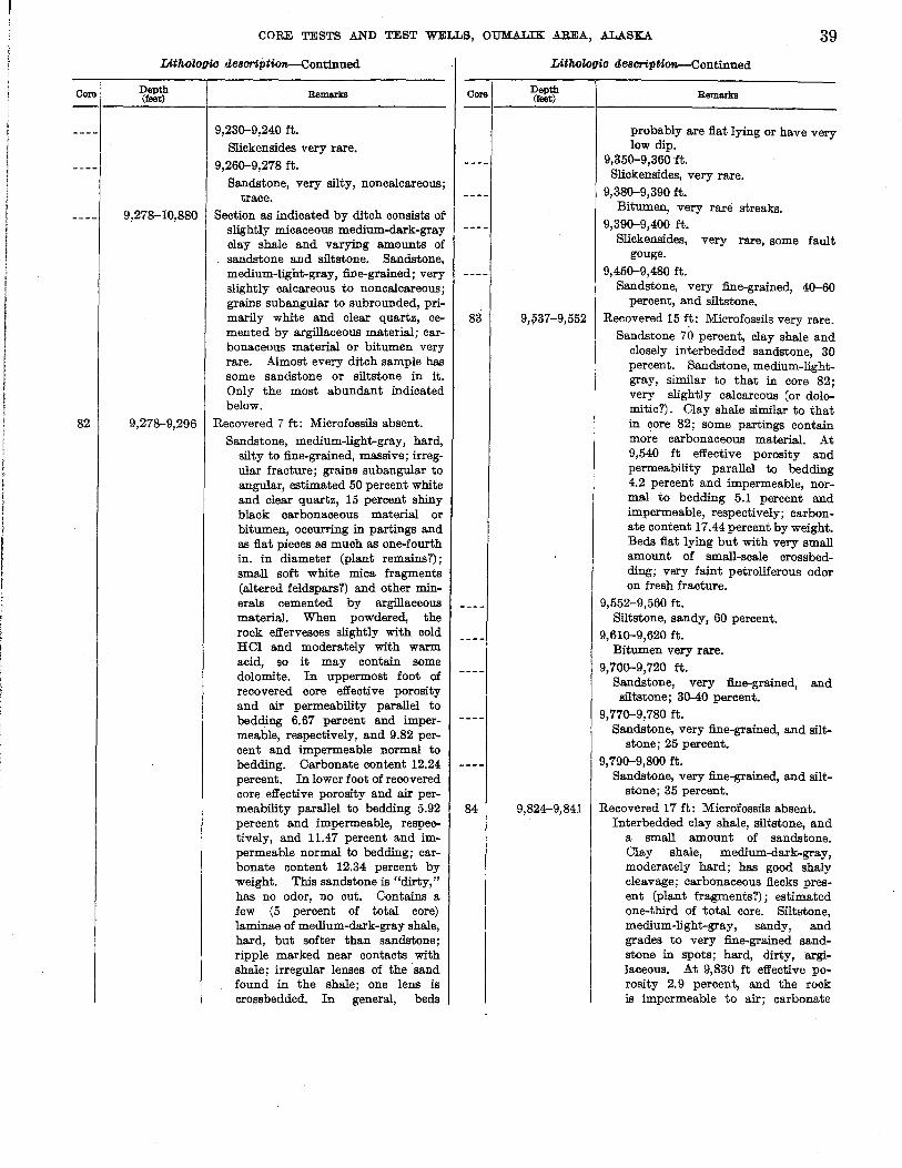
Core
82
CORE TESTS .AND TEST WELLS, OUMALIK AREA, .A.L.A.SKA 39
LithoZogic de8oription-Continued
Depth (feet)
9,278-10,880
9,278-9,296
Remarks
9,230-9,240 ft.
Slickensides very rare. 9,260-9,278 ft.
Sandstone, very silty, noncalcareous; trace.
Section as indicated by ditch consists of slightly micaceous medium-dark-gray clay shale and varying amounts of sandstone and siltstone. Sandstone, medium-light-gray, fiDe-grained; very slightly calcareous to noncalcareous; grains sub angular to subrounded, primarily white and clear quartz, cemented by argillaceous material; carbonaceous material or bitumen very rare. Almost every ditch sample has some sandstone or siltstone in it. Only the most abundant indicated below.
Recovered 7 ft: Microfossils absent. Sandstone, medium-light-gray, hard,
silty to fine-grained, massive; irregular fracture; grains subangular to angular, estimated 50 percent white and clear quartz, 15 percent shiny black carbonaceous material or bitumen, occurring in partings and as flat pieces as much as one-fourth in. in diameter (plant remains?); small soft white mica fragments (altered feldspars?) and other minerals cemented by argillaceous material. When powdered., the rock effervesces slightly with cold HCI and moderately with warm acid, so it may contain some dolomite. In uppermost foot of recovered core effective porosity and air permeability parallel to bedding 6.67 percent and impermeable, respectively, and 9.82 percent and impermeable normal to bedding. Carbonate content 12.24 percent. In lower foot of recovered core effective porosity and air permeability parallel to bedding 5.92 percent and impermeable, respectively, and 11.47 percent and impermeable normal to bedding; carbonate content 12.34 percent by weight. This sandstone is "dirty," has no odor, no cut. Contains a few (5 percent of total core) laminae of medium-dark-gray shale, hard, but softer than sandstone; ripple marked near contacts with shale; irregular lenses of the sand found in the shale; one lens is crossbedded. In general, beds
Core
83
84
LithoZogic de8oripti~ontinued
Depth (feet) Remarks
probably are flat lying or have very low dip.
9,350-9,360 ft. Slickensides, very rare.
9,380-9,390 ft. Bitumen, very rare streaks.
9,390-9,400 ft. Slickensides, very rare, some fault
gouge. 9,450-9,480 ft.
Sandstone, very fine-grained, 40-60 percent, and siltstone.
9,;>37-9,552 Recovered 15 ft: Microfossils very rare. Sandstone 70 percent, clay shale and
closely interbedded sandstone, 30 percent. Sandstone, medium-lightgray, similar to that in core 82; very slightly calcareous (or dolomitic?). Clay shale similar to that in core 82; some partings contain more carbonaceous material. At 9,540 ft effective porosity and permeability parallel to bedding 4.2 percent and impermeable, normal to bedding 5.1 percent and impermeable, respectively; carbonate content 17.44 percent by weight. Beds flat lying but with very small amount of small-scale crossbedding; very faint petroliferous odor on fresh fracture.
9,552-9,560 ft. Siltstone, sandy, 60 percent.
9,610-9,620 ft. Bitumen very rare.
9,700-9,720 ft. Sandstone, very fine-grained, and siltstone; 30-40 percent.
9,770-9,780 ft. Sandstone, very fine-grained, and silt
stone; 25 percent. 9,790-9,800 ft.
Sandstone, very fine-grained, and siltstone; 35 percent.
9,824-9,841 Recovered 17 ft: Microfossils absent. Interbedded clay shale, siltstone, and
a small amount of sandstone. Clay shale, medium-dark-gray, moderately hard; has good shaly cleavage; carbonaceous flecks present (plant fragments?); estimated one-third of total core. Siltbtone, medium-light-gray, sandy, and grades to very fine-grained sandstone in spots; hard, dirty,argilaceous. At 9,830 ft effective porosity 2.9 percent, and the rock is impermeable to air; carbonate
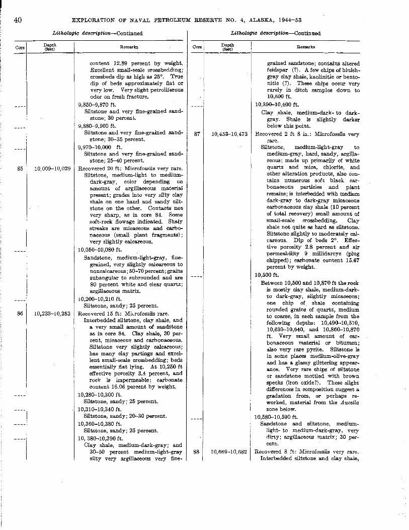
40
Core
85
86
EXPLORATION OF NAVAL PETROLEUM RESERVE NO.4, ALASKA, 1944-53
LithoZogic de8cription-Continued
Depth (feet)
10,009-10,029
10,233-10,253
Remarks
content 12.89 percent by weight. Excellent small-scale crossbedding; crossbeds dip as high as 25°. True dip of beds approximately flat or very low. Very slight petroliierous odor on fresh fracture.
9,850-9,870 ft. Siltstone and very fine-grained sand
stone; 30 percent.
9,880-9,900 ft. Siltstone and very fine-grained sand
stone; 30-35 percent.
9,970-10,000 ft. Siltstone and very fine-grained sand
stone; 25-40 percent. Recovered 20 ft: Microfossils very rare.
Siltstone, medium-light to mediumdark-gray, color depending on amount of argillaceous material present; grades into very silty clay shale on one hand and sandy siltstone on the other. Contacts not very sharp, as in core 84. Some soft-rock flowage indicated. Shaly streaks are micaceous and carbonaceous (small plant fragments); very slightly calcareous.
10,050-10,080 ft. Sandstone, medium-light-gray, fine
grained, very slightly calcareous to non calcareous ; 50-70 percent; grains sub angular to subrounded and are 80 percent white and clear quartz; argillaceous matrix.
10,200-10,210 ft. Siltstone, sandy; 25 percent.
Recovered 15 ft: Mi"rofossils rare. Interbedded siltstone, clay shale, and
a very small amount of sandstone as in core 84. Clay shale, 30 percent, micaceous and carbonaceous. Siltstone very slightly calcareous; has many clay partings and excellent small-scale crossbedding; beds essentially flat lying. At 10,250 ft effective porosity 3.4 percent, and rock is impermeable; carbonate content 16.06 percent by weight.
10,280-10,300 ft. Siltstone, sandy; 25 percent.
10,310-10,340 ft. Siltstone, sandy; 20-30 percent.
10,360-10,380 ft. Siltstone, sandy; 25 percent.
10,380-10,390 ft. Clay shale, medium-dark-gray; and
30-50 percent medium-light-gray silty very argillaceous very fine-
Core
87
88
LithoZogic de8cription-Continued
Depth (feet)
10,453-10,473
10,669-10,682
Remarks
grained sandstone; contains altered feldspar (?). A few chips of bluishgray clay shale, kaolinitic or bentonitic (?). These chips occur very rarely in ditch samples down to 10,600 ft.
10,390-10~400 ft.
Clay shale, medium-dark- to darkgray. Shale is slightly darker below this point.
Recovered 2 ft 8 in.: Microfossils very rare.
Siltstone, medium-light-gray to medium-gray, hard, sandy, argil)aceo us; made up primarily of white quartz and mica, chlorite, and other alteration products, also contains numerous soft black carbonaceous particles and plant remains; is interbedded with medium dark-gray to dark-::gray micaceous carbonaceous clay shale (10 percent of total recovery) small amount of small-scale crossbedding. Clay shale not quite as hard as siltstone. Siltstone silghtly to moderately calcareous. Dip of beds 2°. Effective porosity 2.8 percent and air permeability 9 millidarcys (plug chipped); carbonate content 15.67 percent by weight.
10,500 ft.
Between 10,500 and 10,870 ft the rock is mostly clay shale, medium-darkto dark-gray, slightly micaceous; one chip of shale containing rounded grains of quartz, medium to coarse, in each sample from the following depths: 10,490-10,510, 10,630-10,640, and 10,860-10,870 ft. Very small amount of carbonaceous material or bitumen; also very rare pyrite. Siltstone is in some places medium-olive-gray and has a glassy glittering appearance. Very rare chips of siltstone or sandstone mottled with brown specks (iron oxide?). These slight differences in composition suggest a gradation from, or perhaps reworked, material from the Aucetla zone below.
10,580-10,590 ft. Sapdstone and siltstone, medium
light- to medium-dark-gray, very dirty; argillaceous matrix; 30 percent.
Recovered 8 ft: Microfossils very rare. Interbedded siltstone and clay shale,

Core
89
CORE TESTS AND TEST WELLS, OUM.ALIK AREA, ALASKA 41
Lithologic de8cription-Continued
Depth (feet) Remarks
about 60 percent clay shale and silty clay shale and 40 percent siltstone. Clay shale, silty, mediumdark-gray; numerous small shiny black carbonaceous flecks; fair shaly cleavage. Siltstone, medium-lightgray to medium-gray, hard, argillaceous; contains rare streaks of very fine sand and a few black carbonaceous plant impressions; probably has very low porosity and permeability. Some contacts between shale and siltstone are sharp, others gradational; dip 5°-20°; higher dips are probably crossbedding. Fair petroliferous odor in some of silty sections; no cut in CCLt. from sample taken 4 ft from top.
10,840-10,850 ft. Siltstone, sandy; 20 percent.
10,880-11,872 Clay shale, medium-dark-grJ3.Y to grayish-black, micaceous; contains wellrounded, slightly frosted, brownishclear quartz grains up to very coarse embedded individually or in streaks in shale. Also traces of siltstone and very fine-grained sandstone, mediumlight to medium-olive-gray, micaceous. Medium-olive-gray siltstone and sandstone are very tight and have glassy sheen in hand specimen. Pyrite rare to common. Cores and variations are described below.
10,880-10,890 ft.
Clay shale, grayish-black. Top of the Upper Jurassic(?) and Lower Cretaceous(?) is at 10,880 ft.
10,890-10,992 ft.
Clay.shale fragments containing glauconite (?), well-rounded quartz grains, and rare pyrite. Trace to 10 percent medium-gray sandstone and siltstone.
10,992--11,007 Recovered 4 ft 6 in.: Microfossils rare. Siltstone and clay shale interbedded
in very thin laminae. Clay shale, 70 percent of recovery, silty, darkgray to grayish-black, moderately hard; breaks irregularly parallel to bedding, plates of mica lying parallel to bedding are very prominent in hand specimens. Siltstone, 30 percent of recovery, medium-darkolive-gray; 98 percent quartz, angular to subangular, some very fine
Core
Lithologic de8cription--Continued
Depth (feet) Remarks
sand grains; no megascopic carbonaceous material noted. Siltstone occurs as very thin laminae, irregular lenses, and nodules in clay shale. Slight change in lithology from core 88. The following features are noted: Clay shale in core 88 is lighter in color and lacks the prominent mica plates (although mica is present). Clay shale in core 88 is slightly harder than in 89. Sandy siltstone of core 88 is composed of subangular to subrounded quartz and dark mineral ~ains; quartz is clear, some slightly frosted, giving a milky appearance (hence, a lighter color to the whole sample). Siltstone of core 89 is finer grained, better sorted, almost all more angular quartz, and has a vitreous luster. Clay particles lodged in reentrants of quartz grains give grains a darker olivebrown cast and probably account for darker color of siltstone as a whole. Noncalcareous; no shows; beds essentially flat lying. Several casts of A ucella sublaevis Keyserling and other pelecypods were found 1 ft from bottom.
11,010-11,140 ft. Glauconite (?), very rare; well-rounded
quartz grains rare; large chips of pyrite rare to common.
11,140-11,270 ft. Rounded quartz grains very rare.
Pyrite rare to common. 11,270-11,280 ft.
Chert, one dark granule, one chip of sandstone with well-rounded grains of quartz containing some glauconite (?).
11,280-11,320 ft. Pyrite abundant.
11,320-11,330 ft. Sandstone with rounded grains and
glauconite (?) very rare. 11,330-11,510 ft.
Rounded quartz grains very rare; traces of glassy-looking siltstone and very fine-grained sandstone. Pyrite abundant.
11,510-11,520 ft. Rounded pebble of very dark-gray
chert. 11,520-11,530 ft.
Clay shale fragment bearing Aucellalike rib impressions.
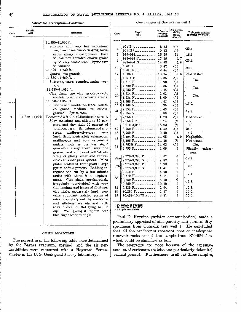
42 EXPLORATION OF NAVAL PETROLEUM RESERVE NO.4, ALASKA, 1944-53
Core
LithoZogic description.-Continued
Depth (feet) Remarks
11,530-11,620 ft. Siltstone and very fine sandstone,
medium- to medium-olive-gray, micaceous, glassy in part; trace. Rare to cornmon rounded quartz grains up to very coarse size. Pyrite rare to cornmon.
11,620-11,630 ft. Quartz, one granule.
11,630-11,680 ft. Siltstone, trace; rounded grains very
rare. 11,680-11,690 ft.
Clay shale, one chip, grayish-black, containing white vein-quartz grains.
11,690-11,852 ft. Siltstone and sandstone, trace, round
ed grains. medium- to coarsegrained. Pyrite rare.
90 11,852-11,872 Recovered 3 ft 4 in.: Microfossils abSe!lt. Silty sandstone and siltstone 80 per
cent, and clay shale 20 percent of total recovery. Sandstone and siltstone, medium-olive-gray, very hard, tight, moderately calcareous; argillaceous and (or) calcareous matrix; rock sample has slight quartzitic glassy sheen, very fine grained and composed almost entirely of glassy, clear and brownish-clear subangula.r quartz. Mica plates scattered throughout: large pyrite nodule present. Bedding irregular and cut by a few minute faults with about ~-in. displacement. Clay shale, grayish-black, irregularly interbedded with very thin laminae and lenses of siltstone; clay shale, moderately hard; contains abundant isolated plates of mica; clay shale and the sandstone and siltstone are identical with that in core 89; flat lying to 10° dip. Well geologist reports core bled slight amount of gas.
CORE ANALYSES
The porosities in the following table were determined by the· Barnes (vacuum) method, and the air permeabilities were measured with a Hayward Permeameter in the U. S. Geological Survey laboratory.
Core analyses of Oumalik test well 1
Core Depth (feet)
4 {921 P 1 ____________
921 N 2 ____________
6 979-984 ____________
8 {989-994 P __________
989-994 N _________
13 p,201 P ____________
1,201 N ____________
17 1,606 P ____________
18 {I, 614 P ____________
1,614 N ____________
19 f1,622 P ____ , ________ [1,622 N ____________
20 {1,634 P ____________
1,634 N ____________
23 {1,966 P ____________
1,966 N ____________
24 {2,154 P ____________
2,154 N ____________
28 {2,756 P ____________
2,756).§ P ___________
---- 3,240-3,244 ________ 42 3,250 P ____________
43 3,260 P ____________
47 {3,494 P ____________
3,495 P ____________
52 {3,752).§ P ___________
3,755 P ____________
8211. {9,278-9,296 P ______
9,278-9,296 N ______
82b {9,278-9,296 P ______
9,278-9,296 N ______ r540 P ____________
83 9,540 N ____________ 9,550 P ____________
9,550 N ____________
84 9,830 P ____________
86 10,250 P ___________
87 10,453-10,473 P ____
1 P, pa.raJJeI to beddlng. • N, normal to beddlng. 3 Sample unsuitable.
I Effective porosity (percent)
8.55 9.48
15.25 13. 15 13.43
3. 42 2. 44
10.94 10. 35
9. 92 9. 85 9. 45 7. 92 8.09 .42 .36
3.43 3.83 1. 78 3. 74
18.00 1. 59 9.20
14. 05 14.36 12.02
6. 08
6. 67 9.82 5. 92
11. 47 4. 20 5.14 5.10
10. 10 2.94 3.47 2.81
Alrperme· ability Carbonate content (milll· (percent by weight)
darcys)
<5 }22.1.
<5 34 15.1. 9.7
}20.4. 5. 6 <5
}28.3. <5
8.8 Not tested. <5 } Do. <5 <5 } Do. <5 <5 } Do. <5 <5
}47.0. <5 <5
}19.9. <5 <5 Not tested.
(3) 7.8. (3) 10.2.
<3 24.3. <4 14.2.
4.9 Negligible. (3) Not tested.
<1 Do. 1 Slightly calcar-
eous. 0
}12.2. 0 0
}12.3. 0 0
} 17.4. 0 0
}13.8. 0 0 12.8. 0 16.0. 9 15.6.
Paul D. Krynine (written communication) made a preliminary appraisal of nine porosity and permeability specimens from Oumalik test well 1. He concluded that all the sandstones represent poor or inadequate reservoir rocks except the sample from 974-984 feet which could be classifie d as fair.
The reservoirs are poor because of the excessive amount of carbonate (calcite and particularly dolomite) cement present. Furthermore, in all but three samples,
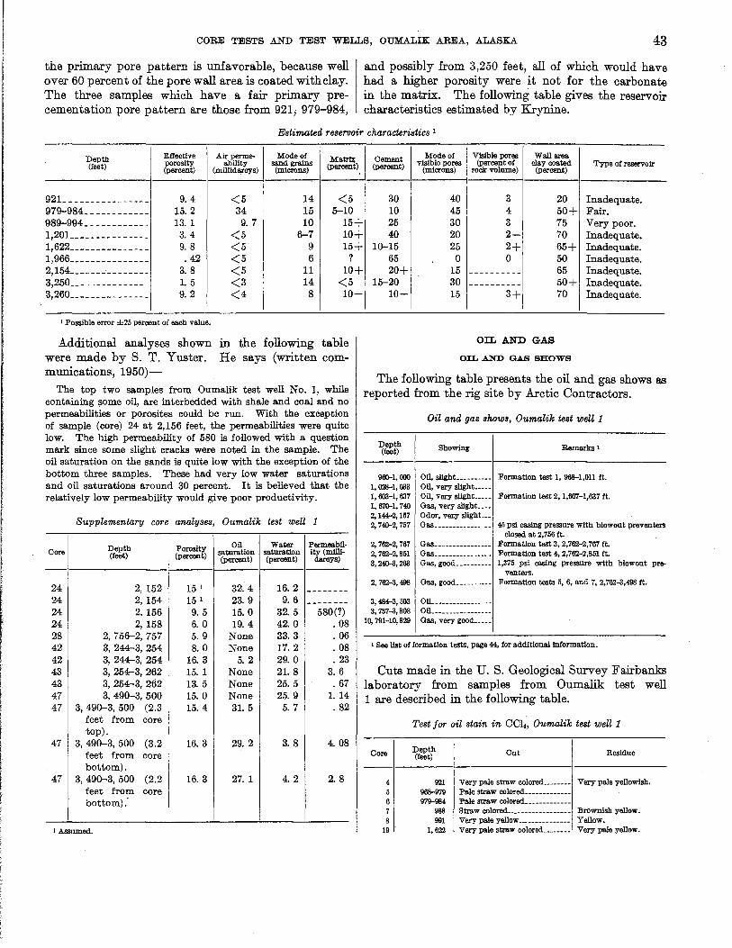
CORE TESTS .AND TEST WELLS, OUMALIK AREA, .ALASKA 43
the primary pore pattern is unfavorable, because well over 60 percent of the pore wall area is coated with clay. The three samples which have a fair primary precementation pore pattern are those from 921; 979-984,
and possibly from 3,250 feet, all of which would have had a higher porosity were it not for the carbonate in the matrix. The following table gives the reservoir characteristics estimated by Krynine.
Estimated reservoir characteri:stics 1
Depth Effective (feet) &orosity
ercent)
921 ________________ 9. 4
979-984 ____________ 15.2 989-994 ____________ 13. 1 1,201 _______________ 3. 4 1,622 _______________ 9.8 1,966 _______________ .42 2,154 _______________ 3.8 3,250 _______________ 1.5 3,260 _______________ 9. 2
I Possible error ±25 percent of each value.
Additional analyses shown were made by S. T. Yuster. munications, 1950)-
Airperme- Mode of Matrb; ahility sand grains (percent) (m1ll1darcys) (microns)
<5 14 <5 34 15 5-10 9.7 10 15+
<5 6-7 10+ <5 9 15+ <5 6 ? <5 11 10+ <3 14 <5 <4 8 10-
in the following table He says (written com-
The top two samples from Oumalik test well No.1, while containing some oil, are interbedded with shale and coal and no permeabilities or porosites could be run. With the exception of sample (core) 24 at 2,156 feet, the permeabilities were quite low. The high permeability of 580 is followed with a question mark since some slight cracks were noted in the sample. The oil saturation on the sands is quite low with the exception of the bottom three samples. These had very low water saturations and oil saturations around 30 percent. It is believed that the relatively low permeability would give poor productivity.
Supplementary core analyses, Oumalik test well 1
Depth Porosity Oil Water Permeabil-Core saturation saturation ity (miDi-(feet) (percent) (percent) (percent) darcys)
24 2,152 15 1 32. 4 16. 2 --------24 2,154 151 23.9 9. 6 --------24 2, 156 9.5 15.0 32.5 580(?) 24 2, 158 6.0 19.4 42.0 . 08 28 2, 756-2, 757 5.9 None 33. 3 .06 42 3, 244-3, 254 8.0 None 17.2 .08 42 3, 244--3, 254 16.3 5.2 29.0 .23 43 3, 254--3, 262 15. 1 None 21. 8 3. 6 43 3, 254--3, 262 13.5 None 25. 5 .67 47 3,490-3,500 15.0 None 25. 9 1. 14 47 3,490-3,500 (2.3 15.4 31. 5 5.7 . 82
feet from core top).
47 3,490-3,500 (3.2 16.3 29.2 3. 8 4. 08 feet from core bottom).
47 3, 490-3, 500 (2.2 16.3 27.1 4. 2 2. 8 feet from core bottom):
J Assumed.
Cement Mode of Vlslble pores WaUarea (percent) vlslblo pores (percent of clay coated Type of reservoir
(microns) rock: volume) (percent)
30 40 3 20 Inadequate. 10 45 4 50+ Fair. 25 30 3 75 ' Very poor. 40 20 2- 70 Inadequate.
10-15 25 2+ 65+ Inadequate. 65 0 0 50 Inadequate. 20+ 15 ---------- 65 Inadequate.
15-20 30 ---------- 50+ Inadequate. 10- 15 3+ 70 Inadequate.
OIL AND GAS
OIL AND GAS SHOWS
The following table presents the oil and gas shows as reported from the rig site by Arctic Contractors.
Oil and gas shows, Oumalik test weill
Depth R (feet) Showing emarlrs 1
960-1,000 Oil, slIght ...... __ .. Formation test 1, 968-1,011 ft. 1,028-1,033 OU, very sllght __ .. _ 1,603-1,637 Oil, very slIght. __ .. Formation test 2, 1,607-1,637 ft. 1,670-1,740 Gas, very slight .... 2, 144-2, 157 Odor, V6J;y slight... 2,740-2,757 Gas ..... ___ ....... 45 psi casing pressure with blowout preventers
closed at 2,756 ft. 2,762-2,767 Gas................ Formation test 3, 2,762-2,767 ft. 2,762-2, 851 Gas .............. __ Formation test 4, 2,762-2,851 ft. 3,240-3,263 Gas, good.... ...... 1,375 psi casing pressure with blowout pre-
venters. 2,762-3,498 Gas, good.......... Formation ·tests 5, 6, and 7, 2,762-3,498 ft.
3,484-3,503 OlL .. _ .... _ ...... .. 3,737-3,808 OU_ .............. ..
10,791-10,829 Gas, very good .... .
I See list of formation tests, page 44, for additional information.
Cuts made in the U. S. Geological Survey Fairbanks laboratory from samples from Oumalik test well 1 are described in the following table .
Core
4
6
8 19
Test for oil stain in CCl4, OumaZik test well 1
Depth (feet)
921 968-979 979-984
988 991
1,622
Cut Residue
Very pale straw colored........ Very pale yellowlsil. Pale straw colored .... _____ .. .. Pale straw colored .......... __ _ Straw colored. __ ............ _ .. Brownish yellow. Very pale yellow ..... _ .. _...... Yellow. Very pale straw colored .. __ .... Very pale yellow.

44 EXPLORATION OF NAVAL PETROLEUM RESERVE NO.4, ALASKA, 194±-53
Test for oil stain in CC4, Oumalik test welll-Continued
Core Depth (feet) Cut Residue
27 2,531 Pale straw colored_____________ Pale yellow. 28 2, 756~ None __________________________ None.
3,240-3,244 None _____________ ~ ____________ Very pale yellow.
42 3,251 Pale straw colored_____________ Pale yellow. 43 3,260 Straw colored__________________ Pale yellow. 52 3, 752~ Pale straw colored_____________ Very pale yellow. 52 3,755 None__________________________ Greasy film. 53 3,805 None __________________________ Very pale yellow.
82 9,278-9,296 None__________________________ None. 88 10,669-10,689 None__________________________ Greasy film.
FORM.A.TION TESTS
Test 1, 968-1,011 feet. -A Johnston formation tester was run on a 5~-inch drill pipe, dry, and a tapered packer was set on the shoulder (15~in. hole to 968 ft and 8%-in. hole at 968-1,011 ft) at 968 feet with perforated tail and pressure bomb to 992 feet. The valve was tripped, and the packer held. There was a weak blow of air for 4 minutes 20 seconds which decreased gradually and ceased after 17 minutes and 30 seconds. The tester was open 33 minutes. The tool was pulled, and a 3-foot rise in the drilling fluid was noted. The chart showed the valve was open, and the test satisfactory.
Test 2, 1,607-1,637 Jeet.-A Johnston formation tester was run on the 5~-inch drill pipe, and a tapered packer was set on the shoulder (13%-in. casing to 1,218 ft; 12X-in. hole, 1,218-1,403 ft; 10rs-in. hole, 1,403-1,604 ft; and 8%-in. hole, 1,604-1,637 ft) at 1,604 feet and was worked down to 1,607 feet. The valve was tripped, and the packer held. There was a weak puff of air when the tool was opened, but the hole was dead for the remainder of the test. The tool was open 35 minutes. When the tool was pulled, 15 feet of drilling mud was recovered.
Test 3, 2,762-2,767 feet.-A water shutoff test on the shoe of the 10%-inch casing proved dry. With the 10%-inch casing cemented at 2,762 feet and the shoe drilled out with a 9%-inch bit to 2,767 feet, a Johnston formation tester was run on the 4~-inch drill pipe, dry. An Olympic-type casing packer was set in the 10%-inch casing at 2,749 feet with a perforated tail and two pressure bombs to 2,761 feet. The valve was tripped satisfactorily, and a fair blow for 1 hour 40 minutes with gas to the surface in 35 minutes was recorded. The tool was closed for 20 minutes, and the recorder indicated a pressure build-up to 100 psi at the end of the period. On pulling the tool, 20 feet of drilling fluid wasrecovered. A sample of gas was taken 20 minutes after the gas reached the surface (55 minutes after the tool was opened).
Test 4, 2,762-2,851 feet.-The hole was cored with 8%-inch core barrel from 2,767-2,851 feet and reamed with 9%-inch bit in the same interval. A .Johnston formation tester with Olympic-type casing packer was run on the 47f-inch drill pipe, dry. The packer was set in the 10%-inch casing at 2,756 feet with perforated tail and two pressure bombs to 2,768 feet. The valve was tripped satisfactorily, and a weak blow for 1 hour with gas to the surface in 55 minutes was recorded. The tool was closed in at the surface for 30 minutes, and the surface pressure increased slowly to 7.5 psi. The valves at the surface were opened for a second flow test in which there was a fair blow of gas for the duratjon of the 42 minute period. Two samples of gas at atmospheric pressure were taken. The tool was then closed for 1 hour 4 minutes, and the recorder indicated a pressure build-up to 1,700 psi. The tool was pulled, and 107 feet of gas-cut drilling fluid was recovered.
Test 5, 2,762-3,498 feet.-With a cement plug in the 9%-inch hole below 3,498 feet, the Johnston formation tester with an Olympic-type casing packer was run on the 4%-inch drill pipe, dry. The packer was set in the lO%-inch casing at 2,551 feet with 452 feet of 2%-inch tubing tail with. the bottom 21 inches perforated and two pressure recorders to 3,003 feet. The valve was tripped satisfactorily, but there was no blow at the well head. The tool was pulled and found plugged with sand and gravel and fragments of cement. The test was unsuccessful.
Test 6, 2,762-3,498 feet.-The mud was conditioned and tester run as before with the packer set at 2,525 feet. After setting the packer and tripping the valve, gas was noted working in the annulus between the 4~inch drill pipe and the 10%-inch casing. This gas was observed throughout the test. There was a weak blow for 1 hour 20 minutes, but the hole was dead for the remainder of the test. The valve was open 3 hours and 10 minutes. The tool was pulled, and a :fluid rise of 2,434 feet was noted. One pressure recorder was lost in the hole. The test was considered unsuccessful. It was assumed the packer was not properly seated because of cement on the casing walls.
Test 7, 2,762-3,498 feet.-The walls of the lO%-inch casing from 2,540-2,762 feet were cleaned with a 9%inch bit. The Johnston formation tester was run as before but with one pressure recorder. The packer was set at 2,736 feet with 431 feet of 2~-inch tubing below and 21 feet of perforated pipe at the bottom. The valve was tripped satisfactorily, and the packer held. No gas was noted in the mud in the annulus between the 4~-inch drill pipe and the 10%-inch casing. There was a fair blow for 2 hours decreasing during the third hour, a.nd the hole was dead by the end of the
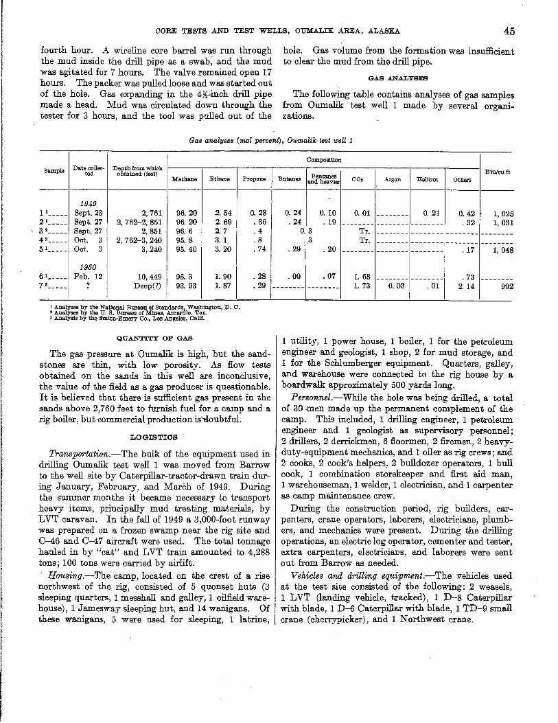
CORE TESTS .AND TEST WELLS, OUMALIK AREA, ALASKA. 45
fourth hour. A wireline core barrel was run through the mud inside the drill pipe as a swab, and the mud was agitated for 7 hours. The valve remained open 17 hours. The packer was pulled loose and was started out of the hole. Gas expanding in the 4~-inch drill pipe made a head. Mud was circulated down through the tester for 3 hours, and the tool was pulled out of the
hole. Gas volume from the formation was insufficient to clear the mud from the drill pipe.
GAS ANALYSES
The following table contains analyses of gas samples from Oumalik test well 1 made by several organizations.
Gas analyses (mol percent), Oumalik test well 1
Sample Date collae- Depth from which ted obtained (feet)
Methane Ethane
1949 11 _____ Sept. 23 2, 761 96.20 2. 54 21 _____ Sept. 27 2, 762-2, 851 96.20 2.69 3 2 _____ Sept. 27 2,851 96.6 2. 7 4 2 _____ Oct. 3 2,762-3,240 95.8 3.1 5 1 _____ Oct. 3 3,240 95.40 3. 20
1950 6 1 _____ Feb. 12 10,449 95.3 1. 90 7 3 _____ ? Deep(?) 93.93 1. 87
1 Analyses by the National Bureau of Standards, Washington, D. C. , Analyses by the U. S. Bureau of Mines, Amarillo, Tex • • Analysis by the Smith·Emery Co., Los Angeles, CaUf.
QUA.NT:tTY OF GAS
Propane
0.28 .36 .4 .8 .74
.28
.29
The gas pressure at Oumalik is high, but the sandstones are thin, with low porosity. As flow tests obtained on the sands in this well are inconclusive, the value of the field as a gas producer is questionable. It is believed that there is sufficient gas present in the sands above 2,760 fe~t to furnish fuel for a camp and a rig boiler, but commercial production is"tloubtful.
LOGISTICS
Transportation.-The bulk of the equipment used in drilling Oumalik test well 1 was moved from Barrow to the well site by Oaterpillar-tractor-drawn train during January, February, and March of 1949. During the summer months it became necessary to transport heavy items, principally mud treating materials, by LVT caravan. In theiall of 1949 a 3,000-foot runway was prepared on a frozen swamp near the rig site and 0-46 and 0-47 aircraft were used. The total tonnage hauled in by "cat" and LVT train amounted to 4,288 tons; 100 tons were carried by airlift.
Housing.-The camp, located on the crest of a rise 'llorthwest of the rig, consisted of 5 quonset huts (3 sleeping quarters, 1 messhall and galley, 1 oilfield warehouse), 1 Jamesway sleeping hut, and 14 wanigans. Of these wanigans, 5 were used for sleeping, 1 latrine,
Composition
I Btu/cu ft Pentanes Butanes and heavier CO. Argon Hellum Others
0.24 0.10 0.01 -------- 0.21 O. 42 1,025 .24 . 19 -------- -------- -------- .32 1,031
O. 3 Tr. -------- -------- -------- --------.3 Tr. -------- -------- -------- --------
.29 .20 -------- -------- -------- .17 1, 048
.09 .07 1. 68 -------- -------- .73 ---------------- -------- 1. 73 O. 03 .01 2. 14 992
1 utility, 1 power house, 1 boiler, 1 for the petroleum engineer and geologist, 1 shop, 2 for mud storage, and 1 for the Schlumberger equipment. Quarters, galley, and warehouse were connected to the rig house by a boardwalk approximately 500 yards long.
Per8onnel.-While the hole was being drilled, a total of 30 men made up the permanent complement of the camp. This included, 1 drilling engineer, 1 petroleum engineer and 1 geologist as supervisory personnel; 2 drillers, 2 derrickmen, 6 fioormen, 2 firemen, 2 heavyduty-equipment mechanics, and 1 oiler as rig crews; and 2 cooks, 2 cook's helpers, 2 bulldozer operators, 1 bull cook, 1 combination storekeeper and first aid man, 1 warehouseman, 1 welder, 1 electrician, and 1 carpenter as camp maintenance crew.
During the construction period, rig builders, carpenters, crane operators, laborers, electricians, plumbers, and mechanics were present. During the drilling operations, an electric log operator, cementer and tester, extra carpenters, electricians, and laborers were sent out from Barrow as needed.
Vehicle8 and drilling equipment.-The vehicles used at the test site consisted of the following: 2 weasels, 1 LVT (landing vehicle, tracked), 1 D-8 Oaterpillar with blade, 1 D-6 Oaterpillar with blade, 1 TD-9 small crane (cherrypicker), and 1 Northwest crane.
46 EXPLORATION OF NAVAL PETROLEUM RESERVE NO.4, ALASKA, 1944-53
The amounts of the major items used in drilling by Arctic Contractors were as follows:
L _ _ _ _ _ _ 136-foot Ideco derrick. L ______ 350-ton Ideco crown block, six 4B-inch sheaves. L _ _ _ _ _ _ 350-ton Ideco traveling block, five 48-inch
sheaves. L ______ Byron-Jackson Super Triplex hook, ser. 4300. L _ _ _ _ _ _ Wilson Super Titan drawworks. 3 _ _ _ _ _ _ _ General Motors quad 6 diesel engines. 2 _______ 0-350 National mud pumps. 2 _______ Link-Belt 48 x 60-inch mud shakers. L ______ Ideco rotary table, ser. H&-23-B. L ______ Ideal R-3 swivel. L ______ Cameron QRC blowout preventer. L ______ Hydril GK blowout preventer. L _ _ _ _ _ _ Shaffer double-gate blowout preventer. 3 _______ 150-barrel mud tanks with ditches. 3 _______ 250-barrel storage tanks (1 water, 2 mud). L ~ _ _ _ _ _ 90-barrel "pill" tank. L ______ Kewanee boiler, 75 hp. L _ _ _ _ _ _ Halliburton cementing unit. L _ _ _ _ _ _ Schlumberger electric logging unit.
Fuel, water, and lubricant consumption.-The materials used while drilling the test were as follows: 330,361 gallons of diesel fuel, 5,743 gallons of gasoline, 1,926,943 gallons of water, 1,130 pounds of grease, 1,520 pounds of thread lubricant, 1,002 gallons of No. 9110 lubricant, SAE 10, 2,514 pounds of No. 9170 lubricant, SAE 20, and 403 pounds of No. 9500 lubricant, SAE 50.
DRILLING OPERATIONS
RIG FOUNDATION
The swampy surface at the site of Oumalik test well 1 presented numerous problems of foundation installation and necessitated unusual precautions to prevent thawing of the permafrost and subsequent settling of the rig. After detailed studies were made of permafrost reaction to heat transfer, steel piling was designed with a system to circulate a refrigerant to keep the ground frozen. Arctic Contractors (written communication, November 1950) described the installation as follows:
Analysis of the allowable substructure loads resulted in the selection of 8%-in. steel piling as the means of transferrin~the loads to the ground. In order to attain positive control over the frost zone· the piling was designed to permit circulation of a refrigerating fluid (diesel oil). Insurance against radial thawing from the well hole was gained by inserting a galvanized steel heat-emissivity shield in the annulus between the 13%-in. and 22-in. casing. The shield, 18 in. in diameter, extended from the cellar to a depth of 219.19 ft and was landed on top of a packer set between the 22-in. and 13%-in. casing. A circulating joint in the 13%-in. casing was located immediately above the packer to permit the draining of fluids from the annulus between the 22-in. and the 13%-in. casings. A special manifolding ring for circulating refrigerant through the annulus between the 22-in. and the 13%-in. casing was fabricated at Barrow. Three
refrigeration wells 4 inches in diameter were installed to a depth of 240 ft. at a distance of 5 feet from the well center line. Refrigerant was circulated through these wells to prevent thawing from the hole. As further inllurance against possible delay caused by thawing, a beam fabricated from 10~-in. casing was installed beneath the cellar floor. This beam was also refrigerated.
The subsurface temperatures were obtained by means of a system of thermocouples, and temperature readings were logged at three day intervals. The subsurface temperature showed a steady increase from June 10, 1949, when the rig was put into operation, and on Dec. 3, 1949, circulation was started through those areas which were considered critical. Circulation continued until April 29, 1950. Concurrent thermocouple readings indicated that the system was capable of maintaining the ground at the desired temperature. The rate of heat transfer ranged from 4 tons to 50 tons of refrigeration per day. Cooling of the refrigerating fluid was accomplished by pumping the oil through a fan-equipped radiator located outside the righouse. . The amount of refrigeration available depended upon the ambient air temperature which varied during the period from a high of plus 20° F. to a minimum of minus 53° F. [See pI. 2.]
Although the original cost of labor and material was high, the operation was satisfactory as no settling was observed. By steaming, this type of pile can be recovered for future use.
DRILLING NOTES
-,- The following table contains selected notes from the drilling records of the Arctic Contractors' petroleum. engineer.
Notes from drill records
Depth }?em4ru (fut)
0 _______________ Well spudded in on June 11, 1949. 5 _ _ _ _ _ _ _ _ _ _ _ _ _ _ _ Casing set; 28~-in. outer diameter (2B-in.
inner diameter) shop-made, 3.B-in. roll plate with plain ends installed with cellar floor support truss. Flush with cellar floor at top and 5 ft long.
247.5 ____________ Casing set; 22~-in. outer diameter (22-in. inner diameter) shop-made, ~-in. rolled plate welded, slip joint casing with drive shoe on bottom. Cemented with 200 sacks Hi-Early cement treated with 2 percent CaCI2 • Found cement bridge in pipe at 128· ft. Drilled out with 21-in. bit, taking core 1, 160-180 ft; recovered 15 ft of cement.
1,215 ____________ Drill collar twisted off at 960 ft while ream-ing. Ran overshot and recovered fish. Drill collar had broken off below box.
1,22L ___________ Pulled bit minus two cones. Wore out three 9%-in. Globe baskets trying to recover cones and wore out two 9%-in. W7R bits milling on fish.
1,229 ____________ Had trouble running 13%-in. casing to bottom of hole. While opening hole, twisted another drill collar off at 525 ft. Recovered fish after 15 hr. Installed 18-in. emissivity shield from cellar floor to top of 22-in. packer at 219 ft. Set
, ! ,:. [: I
I It , r (
CORE TESTS AND TEST WELLS, OUMALIK AREA, ALASKA 47
Note8 from drill records-Continued
Depth Remark!! (Jut)
casing at 1,218 ft; 13%-in. outer diameter (12.615-in. inner diameter), 54.4 lb, API seamless, grade J-55, range 2, 8 round thread, long T and C, with Baker guide shoe and Baker float collar. Cemented with 317 sacks of Oil Well Regular cement treated· with 2 percent CaCI,. Float collar at 1,185 ft; 22-in. packer and circulating joint at 219 ft. Circulating joint was later removed and replaced with die collar connection.
1,803 ____________ Threads o~ 5~-in. kelly-cock badly galled. Replaced 5~-in. kelly with 3*in. kelly; 5~-in. kelly was repaired in Barrow shop.
2,024 ____________ Twisted off drill collar leaving sub and bit in hole. Recovered fish.
2,356 ____________ Weld between the 13%-in. casing and the Baash-Ross landing head broke. Removed blowout preventers and sent landing head to Barrow shop where it was rewelded.
2,529 ____________ Circulation broke between 13%-in. and 22%,-in. casings, mud returning to cellar inside of 22%,-in. casing. Removed blowout preventers. Cut away supports for flange on 13%-in. casing and casing dropped 10 in. Tried four times to close circulating joint but was unsuccessful.
2,760 ____________ Well started to blow gas. Treated and eventually raised mud weight to 113~ lb per cu ft to maintain positive control of the gas. Set cement plug at 303 ft. Pulled 13%-in. casing from 222 ft where it had parted in middle of circulating joint. Four joints of casing were in bad condition; one joint bent, rest had flattened ends. Bailed down to 237 ft. Ran 13%-in. casing with die nipple and wooden guide. Screwed into top of 13%-in. casing-withheld 40 tons test. Cemented with 100 sacks of cement treated with 2 percent CaC12 • Welded Baash-Ross base to 22%,-in. casing and grouted it into cellar floor. Installed control gates. Found joint still leaking.
2,762 ____________ Set casing 10%,-in. outer diameter (9.76 inner diameter), 55.5 lb, API seamless, grade N-80, range 2, Hydril flush joint with square threads, with 282 sacks Oil Well Regular cement treated with 2 percent CaCI2 • Baker float shoe and Baker float collar at top of lower joint.
3,244 ____________ Well started to head. Closed blowout preventers and pressure built up to 1,350 psi. Mixed mud to 100 lbs per cu ft and bled pressure off through fill-up line. Circulation established with heavy mud and well killed. No test because of insufficient quantities of weight material.
7,793 ____________ Caving shale very troublesome; formations were successfully mudded off.
Note8 from drill record8-Continued
Depth Remarks (Jut)
8,426-10,838 _____ While drilling and reaming this portion of hole, pump pressures indicated possible washouts. Pulled top 20 to 25 stands and located washed out tool joint boxes on eight different occasions.
10,838 ___________ Twisted off drill collar pin. Ran Bowen overshot and recovered fish. Returns from bottom severely gas cut. Increased mud weight to 101~ lbs per cu ft.
11,007 __ _ _ _ _ _ _ _ _ _ Drill pipe pulled into a key seat and stuck with bottom of core barrel at 3,512 ft. Washed over fish. and ran Bowen overshot with jars and bumper sub. Jarred fish in two at top of core barrel, leaving top of fish at 3,491 ft. Washed over fish and fish dropped down hole. Recovered fish. Increased mud weight to 104 lbs per cu ft to limit quantity of gas in bottom returns after round trips. (See pI. 1.)
11,637 ___________ Inspected 10%,-in. casing and found top joints were damaged by continuous wear owing to misalinement. Set two cement plugs; backed off and pulled lO%,-in. casing from 302 ft. Reran 10 joints of new 10%,-in. casing and screwed into lower portion. Cleaned out plugs.
11,872 ___________ Completed drilling Apr. 6, 1950. Opera-tions suspended Apr. 23, 1950. Completion status: All casing was left in hole. Prior to final testing from 2,752 to 3,498 ft, a cement plug was set at 3,400 to 3,600 ft, but top of plug was found at 3,498 ft. After testing, a cement plug was set at 2,543 to 2,815 ft, and no evidence of gas leaking through the plug was found. A thermistor cable was installed to 730 ft. From cellar floor upward the following equipment was installed: a BaashRoss landing base, 20-in., Series 600; a spool, 20-in., Series 600, to 12-;in., Series 900; a landing spool, 12-in., Series 900, to 10-in., Series 1500; a shop-made head consisting of a plate, 10 in., Series 1500, with two 2*in. nipples and one I-in. nipple with I-in. Nordstrom plug valve; two 2~~in. nipples have packing glands through which thermistor cables run. Hole was left full of mud.
Coldest outdoor temperature was minus 58°F. Derrick house and heating facilities proved to be sufficient even during coldest weather. Only time lost owing to weather was approximately 12 hr on February 1 and 2 when winds increased to gale force. While drilling .in January the bearings on one crown sheave burned out. In enclosed derricks the crown blocks operate under very warm temperatures rather than under Arctic conditions, as the warm air is concentrated at top of derrick.
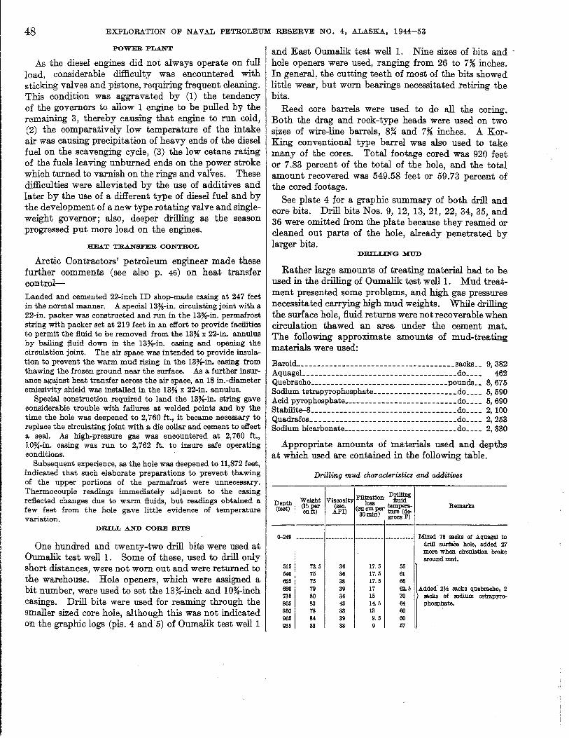
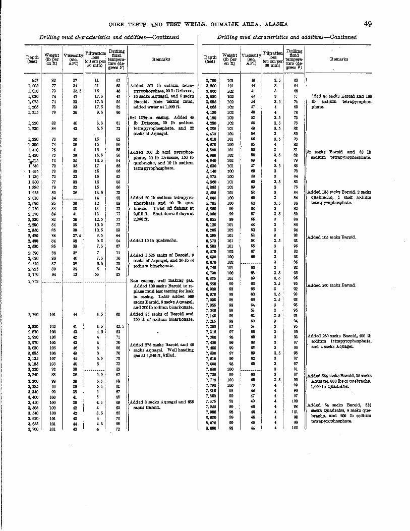
CORE TESTS AND TEST WELLS, OUMALIK AREA, ALASKA 49
Drilling mud characteristics and additives-Continued DriUing mud characteristics and additives-Continued
Weight Flltration Drilling Depth Viscosity loss :fluid (feet) (lb per (sec. (cucmper tempera- Remarks
cu ft) API) ture(de-30 min) grees F)
:Filtration Drilliug
Depth Weight Viscosity loss :fluid (feet) (lbper (sec. (cucmper tempera- Remarks
cu tt) API) ture(de-30 min) grees F)
--------- ---------957 82 37 11 67 3,750 101 ill 3.5 63 :1
I'
1,005 77 34 11 63 Added 50! Ib sodium tetra-1,010 73 35.5 16 46 pyrophosphate, 20 Ib Drisoose,
3,800 101 44 I
3 64 '.
3,860 102 41 3 68 1,030 74 47 17.5 47 16 sacks Aqnagel, and 5 sacks 3,930 102 44 3 7-:' :ded 85 saclw harold and 100 1,075 74 33 17.5 55 Baroid. Hole taking mud, 3,995 102 54 3.5 7u lb sodium tetrapyropbos-1,205 73 33 17.5 52 added water at 1,000 ft. 4,065 102 57 4 69 phate. 1,215 79 39 9.5 60 4,120 102 49 4 78 r "*", -.. Add'" ~ 1,220 82 40 8.5 61 Ib Driscose. 50 Ib sodium 1,220 84 43 5.5 72 tetrapyropbospbate, and 22
sacks of Aquagel.
4, 180 102 63 3.5 73 4, 280 102 55 3.5 73 4,385 101 49 3.5 83 4, 430 102 54 3 80
1,280 73 36 15 62 4, 610 101 55 3.5 78 1,390 74 38 15 60 4, 670 100 65 4 82 1,410 76 41 15 65 Added 100 Ib acid pyropbos-1,420 73 39 15.5 60 pbate, 50 Ib Drisoose, 150 lb ¥I5 74 35 16.5 64 quebracbo, and 10 lb sodium 1,610 72 35 17 66 tetrapyropbosphate.
\ 1,635 73 33 15 65
4,820 101 59 3 81 52 sacks Baroid and 50 lb 4,900 102 66 3.5 82 sodium tetrapyropbospbate. 4,940 102 69 4 79 5,030 101 57 3.5 83 5,140 100 69 3 78
1,730 72 33 15 63 5,275 100 59 3 64 1,800 77 33 16 68 5,360 101 69 3.5 83 1,880' 79 32 15 66 5,395 101 69 3 75 1,955 82 36 13.5 73 5,525 101 68 3 84 Added 136 sacks Baroid, 2 sacks
2,010 84 ---------- 14 68 Added 20 Ib sodium tetrapyro- 5,605 100 60 3 84 quebracbo, 1 sack: sodium
2,090 85 38 12 68 pbosphate and 20 Ib que- 5,765 100 62 3.5 86 tetrapyropbosphate.
2,150 84 39 13 72 bracbo. Twist otf :fishlng at 5,850 99 63 3 82 2, 170 84 41 13 77 2,010ft; Sbut down 6 days at 5,950 99 57 3.5 82 2,220 82 39 12.5 77 2,350 ft. 6,065 99 65 3 86 2,290 84 39 10.5 77 6,125 101 48 3 86 2,350 85 38 10.5 33 6, 205 102 50 3 94 2,420 94 37.5 9.5 64
}Added 10lb quebracbo. 2,490 84 38 9.5 64 2,530 85 38 7.5 67
6, 295 101 68 3 93 Added 105 sacks Baroid. 6,370 101 68 3.5 93 6,500 101 55 3 95
2;590 86 37 7 71 t'''''' ' .. " - ~ -. , 2,620 86 40 7.5 70 sacks of Aquagel, and 30 lb of 2,670 87 38 6.5 73 sodium bicarbonate. 2,725 89 39 6 74 2,760 94 52 55 63
2,762 -_.------- ---------- ---------- ---------- Ran casing, well maIdng gas. Added 100 sacks Baroid to re-place mud lost testing for leak in casing. Later added 560 sacks Baroid, 9 sacks Aquagel. and 200lb sodium bicarbonate.
2. 790 101 44 4.5 60 Added 85 sacks of Baroid and 750 Ib of sodium bicarbonate.
6, 570 102 67 3 92 6, 635 100 66 3 93 6,670 102 --.------- 3 86 6, 745 101 66 3 92 6,790 100 68 3.5 95 6,835 101 69 3.5 96 6, 880 99 66 3.5 95 Added 160 sacks Baroid. 6,920 98 66 3 92 6, 970 98 60 3.5 93 7,005 98 66 3.5 93 7,055 98 64 3 93 7,080 98 68 3 95 7,145 98 62 3. b 91 7,215 98 60 3 94
2,830 102 41 4.5 62.5 7,250 97 68 3 95 2,870 105 43 4.5 62 2,920 105 42 4 71 2,970 105 43 4 70 Added 275 sacks Baroid and 46 3,030 105 46 6 66 sacks Aquagel. Well beading 3,085 106 43 6 70 gas at 3,240 ft, killed. 3,135 107 45 5.5 73
7,315 97 65 3 95 7,380 98 60 3 93 Added 250 sacks Baroid. 400 Ib
7,420 99 68 3 97 sodium tetrapyrophosphate,
7,455 99 63 3 99 and 4 sacks Aquagel.
7,530 97 69 3.5 93 7,610 99 62 3 97
3,185 103 40 6 73 7,650 98 65 3 97 3,220 92 38 ---------- 63 3,240 88 36 5.5 67
3,260 98 38 5.5 68 3,285 99 39 5.5 61 3,340 99 38 5 67 3,400 100 41 5 68 3,450 100 39 4.5 69 Added 8 sacks Aquagel and 685 3,505 100 42 4 65 sacks Baroid. 3,540 100 42 3.5 65 3,610 101 43 4 70 3,655 101 44 4.5 68
7,680 100 ---------- 3 91 7,725 99 60 3 97 )A_"' __ 'U~"" 7,770 100 65 3.5 99 Aquagel, 800 Ibs of quebracbo, 7,790 100 70 4 99 1,050 Ib Quadrafos. 7,815 98 48 4 90 7,850 99 47 4 97 7,875 98 49 4 100 7,920 99 46 4 98 Added 54 sacks Baroid. 5}i
7,990 98 46 4 101 sacks Quadraios, 6 sacks que-
8,030 99 46 4 98 bracbo, and 200 Ib sodium
8,0'70 99 45 4 99 tetrapyrophosphate.
3,700 101 43 4 72 8,090 98 44 4 100
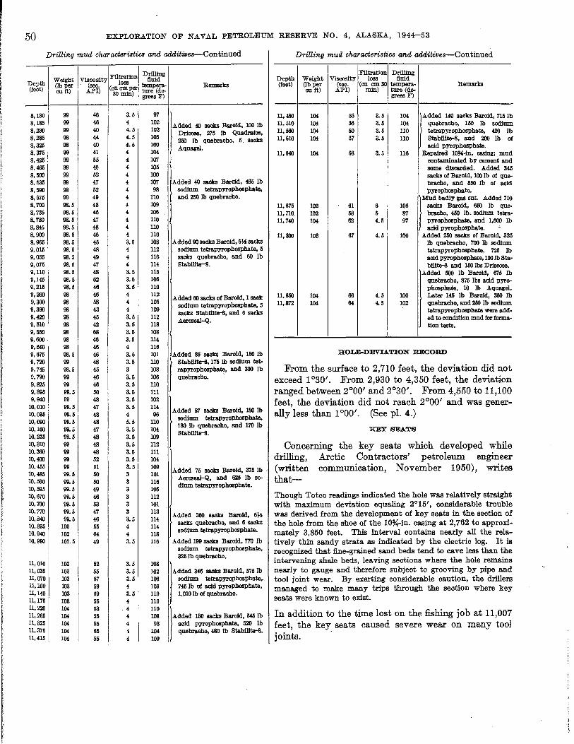
50
Depth (feet)
8,130 8,185 8,230 8,285 8,325 8,375 8,425 8,465 8,500 8,535 8,590 S. 675 8,700 8,785 8,780 8,845 8,900 8,965 9,015 9,085 9,075 9,110 9,145 9,215 9,260 9,300 9,390 9,420 9,510 9,550 9,600 9,640 9,675 9,720 9,745 9,790 9,825 9,895 9,940
10,010 10,085 10,090 10,160 10,235 10,310 10,360 10,400 10,455 10,485 10,560 10,595 10,670 10,700 10,770 10,840 10,895 10,940 10,990
11,010 11,035 11,070 11,100 11,140 11,175 11,220 11,265 11,325 n,375 11,415
EXPLORATION OF NAVAL PETROLEUM RESERVE NO.4, ALASKA, 1944-53
Drilling mud characieriBtiC8 and additive8-Continued
il I DrlJllng Weight Viscosity F tration lluid loss Remarks (lb per (sec. (eU em per tempera-
cuft) API) 30 min) ture (de-grees F)
---------99 46 3.5 97 99 46 4 102 Added 40 sacks Baroid. 100 Ib 99 40 4.5 102 Dricose. 275 Ib Quadrafos. 98 44 4.5 105
250 Ib quebracho, 5" sacks 98 40 4.5 100 Aqnagel. 99 41 4 104 99 65 4 107 99 46 4 105 99 52 4 100 99 47 4 107 Added 40 sacks Baro1d, 485 Ib 98 52 4 98 sodfum tetrapyrophosphate. 99 49 4 110 and 250 Ib quebracho. 98.5 48 4 109 98.5 45 4 106 98.5 47 4 110 98.5 48 4 110 98.5 46 4 110 98.5 45 3.5 108 Added 90 sacks Baroid. 6~ sacks 98.5 48 4 112 sodfum tetrapyrophosphate. 5 98.5 49 4 116 sacks quebracho, and 60 Ib 98.5 47 4 114 Stebilite-S. 98.5 48 3.5 115 98.5 62 3.5 105 98.5 46 3.5 110 98 46 4 112
Added 60 sacks of Baroid. 1 sack 98 58 4 105 sodfum tetrapyrophosphate, 5 98 43 4 109
sacks Stabilite-8, and 6 sacks 98 45 3.5 112
..A.eroseal-Q. 98 42 3.5 118 98 68 3.5 108 98 46 3.5 114 98 46 4 116 98.5 46 3.5 101 Added 85" sacks Baroid, 180 Ib 99 48 3.5 110 Stabilite-8, 175 lb sodfum tet-98.5 45 3 108 rapyrophospha~, and 300 Ib 99 46 3.5 106 quebracho. 99 46 3.5 110 99.5 50 3.5 111 99 48 3.5 102 99.5 47 3.5 114
Added 87 sacks Baroid, 180 lb 99.5 48 4 96
sodium tetrapyrophosphate. 99.5 48 5.5 110
180 lb quebracho, and 170 lb 99.5 47 3.5 104 99.5 48 3.5 109
Stabilite-8.
99 48 3.5 112 99 48 3.5 111 99 52 3.5 104 99 51 3.5 109
Added 75 sacks Baroid. 375 Ib 99.5 50 3 101
Aeroseal-Q. and 625 lb so· 99.5 50 3 116 99.5 49 3 105
dfum tetraPyrophosPhate.
99.5 46 3 112 99.5 53 3 101 99.5 47 3 113
IAd""" .. -....,., .. 99.5 46 3.5 114 sacks quebraoho, and 6 sacks 100 55 4 114 102 64 4 118
sodfum tetraPyrophosphate.
102.5 49 3.5 116 Added 199 sacks Baroid, 770 lb sodfum tetrapyrophosphate, 3251b quebracho.
103 52 3.5 108 103 55 3.5 102 Added 346 sacks Baroid, 575 Ib 103 57 3.5 106 sodfum tetraPyrophosphate, 103 59 4 109 745 lb of acid pyrophosphate. 103 59 3.5 110 1,010 lb of quebracho. 103 55 4 110 104 53 4 110 104 55 4 108
fAd"'" '" .... -. "'. 104 65 4 98 acid pyrophosphate, 520 lb 104 65 4 104 quebracho, 480 Ib Stabilite-8. 104 55 4 109
Drilling mud characteristic8 and additives-Continued
I Filtration DrlJllng Depth Weight Viscosity loss fluid (feet) (lb per (sec. (cu cm30 tempera· Remarks
cu ft) API) min) " ture (de-grees F)
-----------11,460 104 56 3.5 104 r- '''' __ d.",,,, 11,510 104 56 3.5 104 quebraoho, 150 lb sodfum 11,560 104 50 3.5 110 tetrapyrophosphate, 420 lb 11,610 104 57 3.5 110 Stabilite-8, and 200 lb of
acid pyrophosphate. 11,640 104 58 3.5 116 Repaired 10~Hn. casing; mud
contaminated by cement and some discarded. Added 345 sacks of Baroid, 100 lb of que-bracho, and 360 lb of acid pyrophosphate.
f''''''''''''' ~C ..... "" 11,675 102 61 6 106 sacks Baroid, 650 lb que-11,710 102 58 5 87 bracho, 450 lb. sodium tetra· 11,740 104 62 4.5 97 pyrophosphate, and 1,600 Ib
acid pyrophosphate. " 11,800 103 67 4.5 100 Added 250 sacks of Baroid, 325
lb quebraoho, 700 Ib sodfum tetrapyrophosphate, 725 Ib acid pyrophosphate, 100 lb Sta-bilite-8 and 150 lbs Driscose.
Added 500 Ib Baroid, 675 Ib qnebracho, 875 lbs acid pyro· phosphate, 10 lb ..A.quagel.
11,850 104 66 4.5 100 Later 145 Ib Baroid, 360 Ib 11,872 104 64 4.5 102 qnebracho, and 250 Ib sodfum
tetrapyrophosphate were add· ed to condftion mud for forma-tion tests.
HOLE-DEVIATION RECORD
From the surface to 2,710 feet, the deviation did not exceed 1 °30'. From 2,930 to 4,350 feet, the deviation ranged between 2°00' and 2°30'. From 4,550 to 11,100 feet, the deviation did not reach 2°00' and was generally less than 1 °00'. (See pI. 4.)
KEY SEATS
Concerning the key seats which developed while drilling, Arctic Contractors' petroleum engineer (written communication, November 1950), writes that-
Though Totco readings indicated the hole was relatively straight with maximum deviation equaling 2°15', considerable trouble was derived from the development of key seats in the section of the hole from the shoe of the 10*-in. casing at 2,762 to approximately 3,850 feet. This interval contains nearly aJl the relatively thin sandy strata as indicated by the electric log. It is recognized that fine-grained sand beds tend to cave less than the intervening shale beds, leaving sections whe.re the hole remains nearly to gauge and therefore subject to grooving by pipe and tool joint wear. By exerting considerable caution, the drillers managed to make many trips through the section where key seats were known to exist.
In addition to the time lost on the fishing job at 11,007 feet, the key seats caused severe wear on many tool joints. .

, I; f.-
r ,
I
r
l i f
I
CORE TESTS AND TEST WELLS, OUMALIK AREA, ALASKA 51 ELECTRIC LOGGING AND TEMPERATURE SURVEY
The electric log and temperature surveys run· by the Schlumberger Well Surveying Corp. are shown in the following table. No electrical temperature survey was made at the final depth, but maximum temperature readings taken at the bottom of . the hole when the various runs were made indicate a temperature gradient of 1.25°F per 100 feet of depth and a bottom hole temperature of 175°F at the final depth.
Electric log runs and temperature surveys
Run Date Depth (feet) Maximum temperature
191,.9 L _____________ June 28 248-1,013 No reading. 2 __ . .: ___________ July 4 1,013-1,221 No reading. 3 ______________
Aug. 7 1, 221-2, 541 62°F. 4 ______________ Sept. 16 2, 541-2, 764 No reading.
5 ______________ Oct. 9 2, 764-3, 699 74°F. Discarded ______ Oct. 22 3, 699-5, 131 Short in cable. 6 ______________ Oct. 24 3,699-5,365 96°F. 7 ______________
Dec. 2 5, 365-8, 024 130°F. 8 ______________ Dec. 12 8,024-8,420 130°F.
1950 9 ______________ Mar. 4 8,420-11,475 175°F.
10 _____________ Apr. 6 11,475-11,754 175°F.
VELOCITY SURVEY
Seismograph velocity surveys were made on the hole at depths of 5,605 and 11,872 feet in an attempt to obtain a high-velocity break which probably would have been indicative of the limestone of the Lisburne group (Mississippian). However, the highest velocities obtained were on the order of 13,000 feet per second and probably originated in a sandstone-shale sequence. These surveys were made by the United Geophysical Co., Inc.
SUMMAR Y OF THERMAL INVESTIGATIONS
By MAX C. BREWER
A thermal cable, containing 28 thermistors spaced for different depths, was installed in Oumalik test well 1 to a depth of 735 feet on Apr. 22, 1950. The highly viscous mud kept the cable from penetrating to the planned depth of 1,248 feet even though the cable had heavy weights attached just below the bottom thermistor.
The readings taken on Apr. 23, 1950, gave temperatures that ranged from 3.4°C at 227 feet to 11.1°C at 687 feet. The temperatures above 227 feet averaged 4.3°C.
When the site was visited on Aug. 9, 1950, it was found that all the conductors in the cable showed
open circuits, indicating that the conductors were broken. The one set of thermal measurements from this well, taken so soon after the completion of the drilling, do not allow for any particularly significant interpretation.
The cable above the ground surface showed no evidence of damage, and it was therefore assumed that
. the break occurred at some depth below the surface. It was first believed that the well casing collapsed, because the fluid surrounding the casing froze and severed the thermistor cable in the process. This supposition was strengthened by the observation of constriction, near 670 feet in depth, in the tubing recovered from another well, South Barrow test well 2.
More recent evidence has indicated that .casing collapse is probably not nearly as frequent as it was assumed to be in 1950. Four sets of cables have been lost under similar conditions since that time. In three sets it was proved that the cables failed because the metal conductors (1) were designed for strength, (2) were brittle as a result of the alloying, and (3) lacked the ductility necessary to stretch as the ice in the casing expanded. In none of these was there casing collapse. No clear cut evidence is available to indicate the presence or absence of casing collapse in the fourth cable loss.
EAST OUMALIK TEST WELL 1
Location: Lat 69°47'29/1 N., long 155°32'39/1 W. Elevation: Ground, 277 feet; kelly bushing, 293 feet. Spudded: Oct. 23, 1950. Completed: Jan. 7, 1951, dry and abandoned. Total depth: 6,035 feet.
East Oumalik test well 1 is located on a high ridge above an unnamed creek that flows into the Oumalik River (fig. 4). Topographic relief in the area is about 100 feet; streams are incised.
The exact thickness of the permafrost in this well is not known. Numerous lenses of ice were drilled in both the Gubik formation and the Killik: tongue of the Chandler formation. The deepest ice noted by the well geologist in the hole was between 740 and 750 feet. Temperature readings obtained from thermistors, installed in the hole after completion of drilling, are inconclusive.
The following is a list of depths at which the various stratigraphic units are found in East Oumalik test weill:
Depth (feet)
16-50 _________________ Recent and (or) Gubik formation. 50-730 ________________ Chandler formation (Killik tongue).
730-3,050_ _ _ _ __ _ _ ___ _ __ Grandstand formation. 3,050-5,200 ______________ Topagoruk formation. 5,200-6,035 (total depth) _ _ Oumalik formation.

52 EXPLORATION OF NAVAL PETROLEUM: RESERVE NO.4, ALASKA, 1944-53
The :first 34 feet penetrated by the drill consists of relatively unconsolidated fine sand, silt, and clay of Pleistocene and possibly Recent age. (See pI. 5.) Ostracodes and white shell fragments were found in the well cuttings. Underlying the surficial mantle are 680 feet (50-730 ft) of the nonmarine Killik tongue of the Chandler formation. (See p. 8.) It is predominantly clay shale and coal interbedded with a total of about 80 feet of sandstone and 75 feet of siltstone.
The Grandstand formation, part of the lower marine section of the Nanushuk group, is present between 730 and 3,050 feet. It is differentiated from the Killik tongue of the Chandler formation by the presence of an abundant marine fauna. The highest occurrence of this fauna marks the approximate top of the thickest sandstone section in the Oumalik area. About 600 feet of the total thickness of the Grandstand is made up of sandstone and siltstone. The rest is mostly clay shale. Argillaceous limestone occurs in thin beds between 1,150 and 1,450 feet. Some of this calcareous section may be dolomitic or sideritic, as it reacts slowly with cold dilute hydrochloric acid. A few clay ironstone concretions were noted.
The abundant and varied Verneuilinoide8 borealis microfauna is present throughout, as well as a number of associated megafossils. Although the sandstone beds of the Grandstand formation are the major oilproducing Cretaceous unit in Naval Petroleum Reserve No.4, they were essentially dry in this test.
The 2,150-foot marine sequence from 3,050 feet to approximately 5,200 feet in East Oumalik test weill is correlated with the Topagoruk formation. In this well the formation consists of 95 percent silty clay shale and clay shale and only about 5 percent sandstone. The top of the formation is placed at the base of the predominantly sandy section of the overlying Grandstand formation. The Topagoruk formation also contains an excellent Verneuilinoide8 borealis microfauna.
East Oumalik test well 1 penetrated 835 feet of the Oumalik formation from 5,200 feet to the bottom of the hole at 6,035 feet. It is a medium-gray to mediumdark-gray clay shale, with the latter color predominating. No sandstone and only rare siltstone is present. Pyritic specimens of Lithocampe? sp., a radiolarian distinctive of the Oumalik formation, occur below 5,705 feet.
The contact 'between the Oumalik and Topagoruk formations is. placed somewhat arbitrarily at 5,200 feet in the shale section. In general the shale above 5,200 feet is more silty, lighter colored, and contains the Verneuilinoide8 borealis microfauna characteristic of the Topagoruk formation. The angular uncomformity and
lithologic break present between the two formations in test holes in the northern part of the Reserve are absent here in the deepest part of the Cretaceous depositional basin where Early Cretaceous sedimentation probably was continuous.
HEAVY-MINERAL STUDIES
Two heavy-mineral zones are recognized by Robert H. Morris in East Oumalik test well 1 (pI. 6), the glaucophane zone and the zoned zircon zone. The glaucophane zone is represented by one sample at 526 feet. Other minerals of the sample from 915 feet have the general characteristics of the glaucophane zone, but glaucophane is absent. The zoned zircon zone is recognized (m four samples) from 1,693 to 3,869 feet.
DESCRIPTION OF CORES AND CUTTINGS
The well cuttings from which the following record was made were of good quality. See plate 5 for a summary of the lithologic material and engineering data. Depths are measured from the top of the kelly bushing.
Core
Lithologic de8cription
[Where no core number is liste<:l, description is based on cutting samples]
Depth (feet)
0-16 16-30 30-50
50-90
90-106 106-126
Description
Kelly bushing to ground level. No samples received. Ice (reported by well geologist), sand,
silt, and clay. Sand, moderateyellowish-brown, very fine- to medium-grained. Grains subrounded to rounded; 80 percent yellow and yellowish-orange quartz and clear quartz with yellowish cast; 10 percent white and clear quartz, 5 percent black chert and coal; also yellow chert and rare chert of other colors. Some yellowish-gray clay. Rare, white shell fragments and ostracodes.
Clay, yellowish-gray to medium-lightgray, and sand as above. Rare rock fragments, clay ironstone. The top of the Chandler formation is placed at 50 feet.
No samples received. Sandstone, siltstone, limestone, and clay
shale. Sandstone and siltstone, medium-light-gray, very fine- to finegrained; grains subangular to rare subrounded; 95 percent white and clear quartz, also carbonaceous particles. Clay shale, light-gray; contains carbonaceous particles. Limestone, medium- to medium-dark-gray, argillaceous, lithographic, with veinlets of white crystalline calcite.

t
, r I I i I [ i
Core
1
2
CORE TESTS AND TEST WELLS, OUMALIK .AREA, ALASKA. 53 LithoZogic deacription-(Jontmued
Depth (feet) Description
126-146 Clay shale, light- and medium-gray with brownish oast. Some sandstone, stiltstone, and vitreous black coal chips.
146-156 Sandstone, light-gray, medium-grained, subangular to subrounded; largely white and clear quartz; also carbonaceous particles, some grains of glauoonite and yellow quartz.
156-166 Recovered 1 ft: Microfossils rare. Material recovered consists primarily
of drilling mud containing chips of shale and coal. Clay shale or claystone (?), medium-light-gray to medium-gray, medium-soft; thin laminae (to ~ in.) of black coal. Rare light-gray sandy to silty shale chips, slightly calcareous; Minutely shattered coal particles; appears to be coal ground up and repacked while drilling. Dip undetermined.
166-190 Clay shale, light-gray, also hard darkgray clay shale that resembles limestone but is only slightly calcareous. Rare vitreous blaok coal chips. Clay ironstone, light-olive-gray and yellowish-brown, has carbonaceous fragments.
[190-220 Sandstone grading to siltstone below 200 ft. Sandstone, light-gray, very fine-grained with very fine coaly streaks and carbonaceous partings. Brownish-yellow clay ironstone, plant impressions. Very rare chips oicoal.
220-240 Clay shale, light-gray, also yeilowishgray silty clay ironstone.
240-250 Sandstone, light-gray, very fine- to fine-grained; some grayish-orange clay ironstone.
250-270 Sandstone, siltstone, and clay shale, dark carbonaceous partings, noncalcareous.
270-280 Clay shale, light-gray and mediumdark-gray.
280-310 Sandstone, light-gray, fine- to mediumgrained; subangular, 90 percent white and clear quartz, remainder of grains mostly carbonaceous particles; white powdery matrix; numerous carbona.ceous partings; non calcareous, moderately porous to drop test.
310-320 Recovered 2 ft 5 in.: Microfossils absent.
Siltstone, light-gray, medium-soft and friable, sandy, very argillaceous, "dirty." Some streaks of fine- to medium-grained sandstone; subangular grains, mostly white and olear quartz; very light-gray clayey
Core
3
LithoZogic deacription-Contmued
Depth (feet)
320-330 330-350
350-370
370-380
380-400
400-410
410-420
420-430
430-460
460-470
470-480
480-490
490-500
500-517
517-527
Description
cementing material. A few laminae of medium-gray clay shale. Rare thin black layers and fragments of coal; noncalcareous; dips probably low; core slightly broken up.
No sample. Clay shale, light-gray, and some sand
stone; thin layers of coal. Sandstone, fine-grained, siltstone, and
clay shale. Some clay shale is dark gray; numerous carbonaceous particles in the sandstone.
Clay shale, light-gray, and much carbonaceous dark-gray shale. . Lightgray siltstone. Calcareous shell fragments of pelecypods.
Sandstone, light-gray, fine-grained; quartz with carbonaceous and ironstone particles; plant fragments in partings; slightly calcareous. A small amount of light-gray clay shale.
Clay shale, medium-light-gray, rare coaly particles.
Siltstone, light-gray; black carbonaceous plant fragments.
Clay shale and siltstone; plant fragments.
Siltstone, light- and medium-light-gray, slightly sandy; yellowish-gray clay ironstone chunks. Small amount of grayish-black carbonaceous shale.
Clay shale, medium-light- and mediumgray; rare shiny black coal chips.
Siltstone, clay shale, light-gray and very dark-gray; also coal chips.
Coal (half the sample), dull to vitreous, black. Clay shale, medium-light-gray.
Clay shale, medium-gray, .and siltstone; carbonaceous particles.
Coal 60 percent of sample, grayishblack and black, dull to shiny; clay shale, light-olive-gray. Clay ironstone, grayish-yellow.
Recovered 10 ft: Microfossils absent. 5 ft 7 in., clay shale, medium-light- to
medium-dark-gray, soft and slightly fissile; tends to break into little chips when dried out, moderate amount of very thin black coaly streaks and carbonaceous fragments. Grayish-yellow clay ironstone concretion (~-in. diameter) from 517~ ft; non calcareous to slightly calcareous toward base.
4 ft 5 in., sandstone, siltstone, and clay shale, thinly interbedded, becoming progressively sandier toward the bottom of core, medium hard.
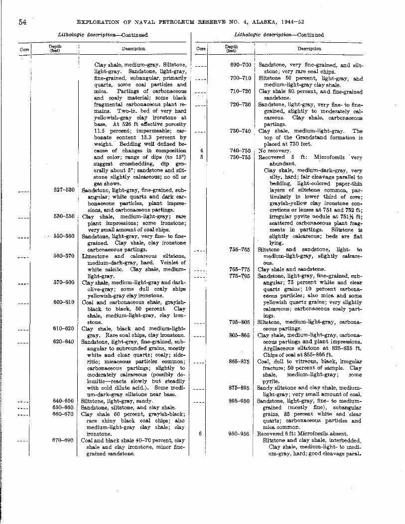
54
Core
EXPLORATION OF NAVAL PETROLEUM RESERVE NO.4, ALASKA, 1944-53
Lithologic description--Continued
Depth (feet)
527-530
530-550
550-560
560-570
570-600
600-610
610-620
620-640
640-650 650-660 660-670
610-690
Description
Clay shale, medium-gray. Siltstone, light-gray. Sandstone, light-gray, fine-grained, subangular, primarily quartz, some coal particles and mica. Partings of carbonaceous and coaly material; some black fragmental carbonaceous plant remains. Two-in. bed of very hard yellowish-gray clay ironstone at base. At 526 ft effective porosity 11.5 percent; impermeable; carbonate content 13.3 percent by weight .. Bedding well defined because of changes in composition and color; range of dips (to 15°) suggest crossbedding, dip generally about 5°; sandstone and siltstone slightly calcareous; no oil or gas shows.
Sandstone, light-gray, fine-grained, subangular; white quartz and dark carbonaceous particles, plant impressions, and carbonaceous partings.
Clay shale, medium-light-gray; rare plant impressions; some ironstone; very small amount of coal chips.
Sandstone, light-gray, very fine- to finegrained. Clay shale, clay ironstone carbonaceous partings.
Limestone and calcareous siltstone, medium-dark-gray, hard. Veinlet of white calcite. Clay shale, mediumlight-gray.
Clay shale, medium-light-gray and darkolive-gray; some dull coaly ohips yellowish-gray clay ironstone.
Coal and carbonaceous shale, grayishblack to black, 50 percent. Clay shale, medium-light-gray, clay ironstone.
Clay shale, black and medium-lightgray. Rare coal chips, clay ironstone.
Sandstone, light-gray, fine-grained, subangular to subrounded grains, mostly white and clear quartz; coaly; sideritic; micaceous particles common; carbonaceous partings; slightly to moderately calcareous (possibly dolomitic-reacts slowly but steadily with cold dilute acid.). Some medium-dark-gray siltstone near base.
Siltstone, light-gray, sandy. Sandstone, siltstone, and clay shale. Clay shale 60 percent, grayish-black;
rare shiny black coal chips; also medium-light-gray clay shale; clay ironstone.
Coal and black shale 40-70 percent, clay shale and clay ironstone, minor finegrained sandstone.
Core
4 5
6
Lithologic description--Continued
Depth (feet)
690-700
700-710
710-720
720-730
730-740
740-750 750-755
755-765
765-775 775-795
795-805
805-865
865-875
875-895
895-950
950-956
Description
Sandstone, very fine-grained, and siltstone; very rare coal chips.
Siltstone 50 percent, light-gray, and medium-light-gray clay shale.
Clay shale 80. percent, and fine-grained sandstone.
Sandstone, light-gray, very fine- to finegrained, slightly to moderately calcareous. Clay shale, carbonaceous partings.
Clay shale, medium-light-gray. The top of the Grandstand formation is placed at 730 feet.
No recovery. Recovered 5 ft: Microfossils very
abundant. Clay shale, medium-dark-gray, very
silty, hard; fair cleavage parallel to bedding, light-colored paper-thin layers of siltstone common, particularly in lower third of core; grayish-yellow clay ironstone concretions or lenses at 751 and 752 ft; irregular pyrite nodule at 751~ ft; scattered carbonaceous plant fragments in partings. Siltstone is slightly calcareous; beds are flat lying.
Siltstone and sandstone, light- to medium-light-gray, slightly calcareous.
Clay shale and sandstone. Sandstone, light-gray,fine-grained, sub
angular; 75 percent white and clear quartz grains; 10 percent carbonaceous particles; also mica and some yellowish quartz grains; very slightly calcareous; carbonaceous coaly partings.
Siltstone, medium-light-gray, carbonaceous partings.
Clay shale, medium-light-gray, carbonaceous partings and plant impressions. Argillaceous siltstone at 825-835 ft. Chips of coal at 855-865 ft.
Coal, dull to vitreous, black, irregular fracture; 50 percent of sample. Clay shale, medium-light-gray; some pyrite.
Sandy siltstone and clay shale, mediumlight-gray; very small amount of coal.
Sandstone, light-gray, fine- to mediumgrained (mostly fine), subangular grains, 85 percent white and clear quartz; carbonaceous particles and mica common.
Recovered 6 ft: Microfossils absent. Siltstone and clay shale, interbedded.
Clay shale, medium-light- to medium-gray, hard; good cleavage paral_
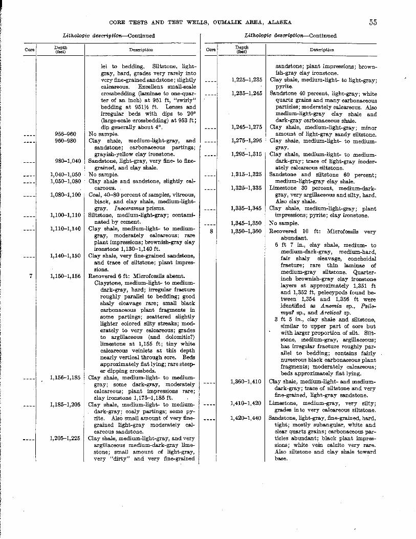
f i i
Core
7
CORE TESTS AND TEST WELLS, OUM.A.LIK .AREA, ALASKA 55
Lithologic d68oripti~ontinued
Depth (feet)
956-960 960-980
980-1,040
1,040-1,050 1,050-1,080
1,080-1,100
1,100-1,110
1,110-1,140
1,140-1,150
1,150-1,156
1,156-1,185
1,185-1,205
1,205-1,225
Description
leI to bedding. Siltstone, lightgray, hard, grades very rarely into very fine-grained sandstone; slightly calcareous. Excellent small-scale crossbedding (laminae to one-quarter of an inch) at 951 ft, "swirly" bedding at 95172 ft. Lenses and irregular beds with dips to 20° (large-scale crossbedding) at 953 ft; dip generally about 4°.
No sample. Clay shale, medium-light-gray, and
sandstone; carbonaceous partings; grayish-yellow clay ironstone.
Sandstone, light-gray, very fine- to finegrained, and clay shale.
No sample. Clay shale and sandstone, slightly cal
careous. Coal, 40-80 percent of samples, vitreous,
black, and clay shale, medium-lightgray. Inoceramus prisms.
Siltstone, medium-light-gray; contaminated by cement.
Clay shale, medium-light- to mediumgray, moderately calcareous; rare plant impressions; brownish-gray clay ironstone 1,130-1,140 ft.
Clay shale, very fine-grained sandstone, and trace of siltstone; plant impressions.
Recovered 6 ft: Microfossils absent. Claystone, medium-light- to medium
dark-gray, hard; irregular fracture roughly parallel to bedding; good shaly cleavage rare; small black carbonaceous plant fragments in some partings; scattered slightly lighter colored silty streaks; moderately to very calcareous; grades to argillaceous (and dolomitic?) limestone at 1,155 ft; tiny white calcareous veinlets at this depth nearly vertical through core. Beds approximately fiat lying; rare steeper dipping crossbeds.
Clay shale, medium-light- to mediumgray; some dark-gray, moderately calcareous; plant impressions rare; clay ironstone 1,175-1,185 ft.
Clay shale, medium-light- to mediumdark-gray; coaly partings; some pyrite. Also small amount of very finegrained light-gray moderately calcareous sandstone.
Clay shale, medium-light-gray, and very argillaceous medium-dark-gray limestone; small amount of light-gray, very "dirty" and very fine-grained
Core
8
Lithologic d68oription--Continued
Depth (feet) Description
sandstone; plant impressions; brownish-gray clay ironstone.
1,225-1,235 Clay shale, medium-light- to light-gray; pyrite.
1,235-1,245 Sandstone 40 percent, light-gray; white quartz grains and many carbonaceous particles; moderately calcareous. Also medium-light-gray clay shale and dark-gray carbonaceous shale.
1,245-1,275 Clay shale, medium-light-gray; minor amount of light-gray sandy siltstone.
1,275-1,295 Clay shale, medium-light- to mediumgray.
1,295-1,315 Clay shale, medium-light- to mediumdark-gray; trace of light-gray moderately calcareous siltstone.
1,315-1,325 Sandstone and siltstone 60 percent; medium-light-gray clay shale.
1,325-1,335 Limestone 30 percent, medium-darkgray, very argillaceous and silty, hard. Also clay shale.
1,335-1,345 Clay shale, medium-light-gray; plant impressions; pyrite; clay ironstone.
1,345-1,350 No sample. 1,350-1,360 Recovered 10 ft: Microfossils very
abundant. 6 ft 7 in., clay shale, medium- to
medium-dark-gray, medium-hard, fair shaly cleavage, conchoidal fracture; rare thin laminae of medium-gray siltstone. Quarterinch brownish-gray clay ironstone layers at approximately 1,351 ft and 1,352 ft, pelecypods found between 1,354 and 1,356 ft were identified as Anomia sp., Psilomyar sp., and Arcticar sp.
3 ft 5 in., clay shale and siltstone, similar to upper part of core but with larger proportion of silt. Siltstone, medium-gray, argillaceous; has irregular fracture roughly parallel to bedding; contains fairly numerous black carbonaceous plant fragments; moderately calcareous; beds approximately flat lying.
1,360-1,410 Clay shale, medium-light- and mediumdark-gray; trace of siltstone and very fine-grained, light-gray sandstone.
1,410-1,420 Limestone, medium-gray, very silty; grades in to very calcareous siltstone.
1,42(}-1,440 Sandstone, light-gray, fine-grained, hard, tight; mostly subangular, white and clear quartz grains; carbonaceous particles abundant; black plant impressions; white vein calcite very rare. Also siltstone and clay shale toward base.

56
Core I
9
10
EXPLORATION OF NAVAL PETROLEUM RESERVE NO.4, ALASKA, 1944-53
Lithologic description--Continued
Depth (feet)
1,440-1,480
1,480-1,500
1,500-1,530
1,530-1,540
1,540-1,550
1,550-1,560
1,560-1,570
1,570-1,590
1,590-1,630
1,630-1,660
1,660-1,692
1,692--1,702
Description
Clay shale, medium-light- to mediumcla.rk-gray; yellowish-gray clay ironstone 1,440-1,450 ft, 1,460-1,470 ft; coal partings 1,470-1,480 ft; pyrite.
Clay shale, medium-light- to mediumgray; minor amount siltstone and finegrained sandstone; pyrite.
Clay shale, medium-light-gray; shiny black coal chips rare; pyrite.
Clay shale, medium-light- to mediumgray; sandy siltstone; pyrite common; one chip of coal.
Clay shale, medium-light-gray, slightly calcareous; small amount of clay ironstone.
Recovered 7 ft 6 in.: Microfossils abundant.
Clay shale, medium-dark-gray, medium-hard, brittle, fissile; conchoidal fracture; brown-shelled pelecypod (unidentified) at 1,560 ft; noncalcareous; beds fiat lying.
Clay shale, medium-light- to mediumgray.
Clay shale, medium- to medium-darkgray, and small amount of very finegrained very calcareous sandstone; trace of siltstone.
Clay shale, medium-light- to mediumdark-gray; brownish clay ironstone; carbonaceous partings and plant impressions; pyrite chunks.
Sandstone, medium-light-gray, fine- to medium-grained; largely white and clear quartz grains; some mica; about 10 percent carbonaceous particles; slightly calcareous. Clay shale, darkgray; rare shiny black coal chips 1,630-1,640 ft.
Sandstone as above, very fine- to finegrained; almost entirely quartz grains; moderately calcareous; some mediumdark-gray very calcareous clay shale or argilla.ceous limestone 1,680-1,690 ft.
Recovered 10 ft: Microfossils very rare. Sandstone, light-gray, hard, massive,
very fine- to fine-grained with scattered medium-sized grains; 85 percent subangula.r white and clear quartz grains; calcareous cement; very rare isolated medium-dark-gray shale chips ~ in. in diameter in the sandstone; chips lie flat parallel to bedding. One inch of medium-gray clay shale 2 in. from top of core. At 1,693 ft effective porosity 11.6 percent; air permeability less than 1 millidarcy, and carbonate content 18.23 percent by weight. Spotty
Core
11
Lithologic description--Continued
Depth (feet)
1,702--1,760
1,760-1,790
1,790-1,810
1,810-1,820
1,820-1,830 1,830-1,840
1,840-1,900
1,900-1,920
1,920-1,940
1,940-1,950 1,950-1,968
1,968-1,974
1,974-1,980 1,980-1,990
1,990-2,020
Description
stain and oil odor, light-strawcolored cut, yellow residue at 1,700 ft; beds fiat lying. Inoceramus prisms in microfossil cut.
Sandstone as in core above, fine-grained becoming very fine with depth; also medium- to medium-dark-gray clay shale, quantity increasing with depth. Inoceramus prisms 1,740-1,750 ft.
Clay shale, medium- to medium-darkgray; 50 percent siltstone 1,770-1,780 ft.
Sandstone 50 percent, light-gray, very fine- to fine-grained, and clay shale 50 percent.
Sandstone, light-gray, very fine- to medium-grained, (latter rare), mostly white and clear quartz grains and carbonaceous particles; 10 percent clay shale. Inoceramu8 prisms.
Sandstone, siltstone, and clay shale. Clay shale, medium-gray, slightly cal
careous; nre plant impressions; 10 percent sandstone.
Clay shale, medium- to medium-darkgray.
Clay shale and small amount of soft light-gray very fine-grained sandstone; pyrite.
Sandstone, light-gray, very fine-grained to silty, rather soft; 20 percent clay shale, medium-light- to medium-gray.
Siltstone and clay shale; pyrite. Sandstone, very fine-grained to silty;
50 percent clay shale, medium-lightto medium-dark-gray; pyrite.
Recovered 6 ft 8 in.: Microfossils absent. Interbedded siltstone, two-thirds, and
clay shale, one-third. Siltstone, light-gray, hard; 95 percent white and clear quartz grains, with coaly grains and subangular, very rare, very fine sand grains; carbonaceousmicaceous partings; noncalcareous to very slightly calcareous. Clay shale, medium-gray, hard; contains minute micaceous partings, noncalcareous. Siltstone has excellent small-scale crossbedding with dips to 150
, ripple marks noted on breaks between silt and shale, amplitude % in. and length about 1 * in.; dip 10
; no shows. Clay shale. Sandstone, light-gray, very fine-grained,
and siltstone 70 percent; clay shale 30 percent, slightly calcareous.
Clay shale, medium-light- to mediumdark-gray. Sandy siltstone 10-35 percent.
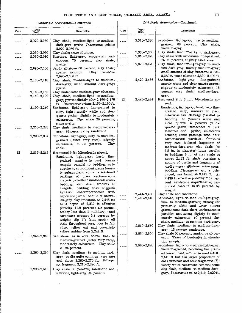
Core
12
CORE TESTS .AND TEST WELLS, OUMALIK AREA, ALASKA. 57
LithoZogiC aesC1"iptiOt'l--Continued
Depth (feet)
2,020-2,050
2,050-2,060 2,060-2,080
2,080-2,100
2,100-2,140
2,140-2,150 2,150-2,190
2,190-2,210
2,210-2,220
2,220-2,237
2,237-2,246
2,246-2,260
2,260-2,290
2,290-2,310
Description
Clay shale, medium-light- to mediumdark-gray; pyrite; Inoceramus prisms 2,020-2,030 ft.
Clay shale; trace siltstone. Siltstone, light-gray, moderately cal
careous, 70 percent; clay shale; pyrite.
Sandy siltstone 60 percent; clay shale; pyrite common. Clay ironstone 2,090-2,100 ft.
Clay shale, medium-light to mediumdark-gray, small amount dark-gray; pyrite.
Clay shale; some medium-gray siltstone. Clay shale, medium-light- to medium
gray; pyrite; slightly silty 2,160-2,170 ft. Inoceramus prisms 2,150-2,160 ft.
Sandstone, light-gray, fine-grained to silty, tight; mostly white and clear quartz grains; slightly to moderately calcareous. Clay shale 20 percent; some pyrite.
Clay shale, medium- to medium-darkgray; 20 perrent silty sandstone.
Sandstone, light-gray, silty to mediumgrained (latter very rare), slightly calcareous, 50-70 percent. Clay shale.
Recovered 9 ft: Microfossils absent. Sandstone, light-gray, hard, fine
grained; massive in part; breaks roughly parallel to bedding; subangular to subrounded grains (mostly subangular); contains scattered partings of black carbonaceous material; excellent small-scale crossbedding; also small amount of irregular bedding that suggests agitation contemporaneous with deposition; small nodule of brownish-gray clay ironstone at 2,245 it; at a depth of 2,239 ft effective porosity 11.9 percent; air permeability less than 1 millidarcy; and carbonate content 9.4 percent by weight; dip 10
; faint spotty oil stain throughout core, poor to fair odor, yellow cut and brownishyellow residue from 2,244 ft.
Sandstone, as in core above, fine- to medium-grained (latter very rare), moderately calcareous. Clay shale 20-25 percent.
Clay shale, medium- to medium-darkgray; pyrite quite common; very rare coal chips 2,260-2,270 ft. Ditrupa sp. fragment 2,270-2,280 ft.
Clay shale 60 percent; sandstone and siltstone, light-gray, 40 percent.
Core
13
LithoZogie aescriptiOt'l--Continued
Depth (feet)
2,310-2,330
2,330-2,350 2,350-2,370
2,370-2,420
2,420-2,436
2,436-2,444
2,444-2,460 2,460-2,510
2,510-2,550
2,550-2,560
2,560-2,620
Description
Sandstone, light-gray, fine- to mediumgrained, 60 percent. Clay shale, medium-gray.
Clay shale, medium-gray to dark-gray. Clay shale with sandstone, fine-grained,
25-40 percent, slightly calcareous. Clay shale, medium-light-gray to med
ium-dark-gray, mostly medium-gray; small amount of clay ironstone 2,370-2,380 ft, trace siltstone 2,390-2,400 ft.
Sandstone, light-gray, fine-grained; mostly white and clear quartz grains;. slightly to moderately calcareous; 15 percent clay shale, medi\Wl-darkgray.
Recovered 8 ft 3 in.: Microfossils absent.
Sandstone, light-gray, hard, very finegrained, silty, massive in part, otherwise fair cleavage parallel to bedding; 85 percent white and clear quartz, 5 percent yellow quartz grains, r~mainder of dark minerals and pyrite; calcareous cement; some partings with dark carbonaceous particles. Contains very rare, isolated fragments of medium-dark-gray clay shale (to 1% in. in diameter) lying parallel to bedding; 6 in. of clay shale at about 2,443 ft; shale contains a nodule of pyrite and fragments of medium-gray siltstone; some crossbedding; Placunopsis sp., a pelecypod, was found at 2,442 ft. At 2,439 ft effective porosity 7.52 percent; sandstone impermeable; carbonate content 16.88 percent by weight.
Clay shale and sandstone. Sandstone, light- to medium-light-gray,
fine- to medium-grained; subangular' primarily white and clear quartz grains; some dark chert, carbonaceous particles and mica; slightly to mod-· erately calcareous; 10 percent clay shale, medium- to medium-dark-gray ..
Clay shale, medium- to medium.:darkgray; 15. percent sandstone.
Clay shale 60 percent; sandstone 40 percent. Trace of bentonite in cireula-· tion sample.
Sandstone, light- to medium-light-gray,. medium-grained, becoming fine grained toward base; similar to sand 2,460-2,510 ft but has larger proportion of dark minerals and rock fragments (?);' nearly white calcareous cement; some· clay shale, medium- to medium-dark-· gray. Inoceramus sp.at2,610-2,620ft_
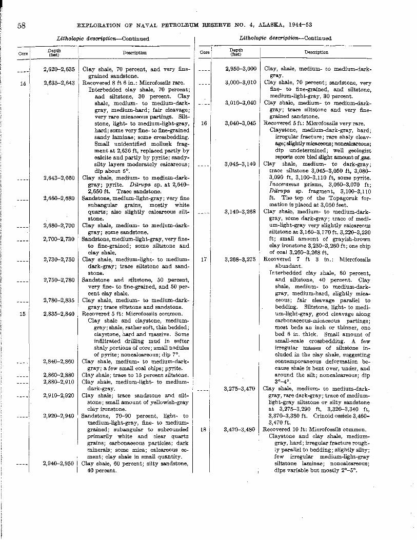
58
Oore
14
15
EXPLORATION OF NAYAL PETROLEUM RESERVE NO.4, ALASKA, 1944-53
Lithologic aescription-ContIDued
Depth (feet)
2,620-2,635
2,635-2,643
2,643-2,660
2,660-2,680
2,680-2,700
2,700-2,730
2,730-2,750
2,750-2,780
2,780-2,835
2,835-2,840
2,840-2,860
2,860-2,880 2,880-2,910
2,910-2,920
2,920-2,940
2,940-2,950
Description
Clay shale, 70 percent, and very finegrained sandstone.
Recovered 8 ft 6 in.: Microfossils rare. Interbedded clay shale, 70 percent;
and siltstone, 30 percent. Clay shale, medium- to medium-darkgray, medium-hard; fair cleavage; very rare micaceous partings. Siltstone, light- to medium-light-gray, hard; some very fine- to fine-grained sandy laminae; some crossbedding. Small unidentified mollusk fragment at 2,636 ft, replaced partly by calcite and partly by pyrite; sandysilty layers moderately calcareous; dip about 5°.
Clay shale, medium- to medium-darkgray; pyrite. Ditru.pa sp. at 2,640-2,650 ft. Trace sandstone.
Sandstone, medium-light-gray; very fine subangular grains, mostly white quartz; also slightly calcareous siltstone.
Clay shale, medium- to medium-darkgray; some sandstone.
Sandstone, medium-light-gray, very fineto fine-grained; some siltstone and clay shale.
Clay shale, medium-light- to mediumdark-gray; trace siltstone and sandstone.
Sandstone and siltstone, 50 percent, very fine- to fine-grained, and 50 percent clay shale.
Clay shale, medium- to medium-darkgray; trace siltstone and sandstone.
Recovered 5 ft: Microfossils common. Clay shale and claystone, medium
gray; shale, rather soft, thin bedded; claystone, hard and massive. Some infiltrated drilling mud in softer shaly portions of core; small nodules of pyrite; non calcareous ; dip 7°.
Clay shale, medium- to medium-darkgray; a few small coal chips; pyrite.
Clay shale; trace to 15 percent siltstone. Clay shale, medium-light- to medium
dark-gray. Clay shale; trace sandstone and silt
stone; small amount of yellowish-gray clay ironstone.
Sandstone, 70-90 percent, light- to medium-light-gray, fine- to mediumgrained; subangular to subrounded primarily white and clear quartz grains; carbonaceous particles; dark minerals; some mica; calcareous cement; clay shale in small quantity.
Clay shale, 60 percent; silty sandstone, 40 percent.
Oore
16
17
18
Lithologic aescription-Continued
Depth (feet)
2,950-3,000
3,000-3,010
3,010-3,040
3,040-3,045
3,045-3,140
3,140-3,268
3,268-3,275
3,275-3,470
3,470-3,480
Description
Clay, shale, medium- to medium-darkgray.
Clay shale, 70 percent; sandstone, very fine- to fine-grained, and siltstone, medium-light-gray, 30 percent.
Clay shale, medium- to medium-darkgray; trace siltstone and very finegrained sandstone.
Recovered 5 ft: Microfossils very rare. Claystone, medium-dark-gray, hard;
irregular fracture; rare shaly cleavage; slightly micaceous; noncalcareous; dip undetermined; well geologist reports core bled slight amount of .gas.
Clay shale, medium- to dark-gray; trace siltstone 3,045-3,050 ft, 3,080-3,090 ft, 3,100-3,110 ft, some pyrite. Inoceramus prisms, 3,060-3,070 ft; Ditru.pa sp. fragment, 3,100-3,110 ft. The top of the Topagoruk formation is placed at 3,050 feet.
Clay shale, medium- to medium-darkgray, some dark-gray; trace of medium-light-gray very slightly calcareous siltstone at 3,160-3,170ft, 3,220-3,230 ft; small amount of grayish-brown clay ironstone 3,250-3,260 ft; one chip of coal 3,260-3,268 ft.
Recovered 7 ft 3 in.: Microfossils abundant.
Interbedded clay shale, 60 percent, and siltstone, 40 percent. Clay shale, medium- to medium-darkgray, medium-hard, slightly micaceous; fair cleavage parallel to bedding. Siltstone, light- to medium-light-gray, good cleavage along carbonaceous-micaceous partings; most beds an inch or thinner, one bed 6 in. thick. Small amount of small-scale crossbedding. A few irregular masses of siltstone included in the clay shale, suggesting contemporaneous deformation beC9.use shale is bent over, under, and around the silt; non calcareous ; dip 3°_4°.
Clay shale, medium- to medium-darkgray, rare dark-gray; trace of mediumlight-gray siltstone or silty sandstone at 3,275-3,290 ft, 3,320-3,340 ft, 3,370-3,380 ft. Crinoid ossicle 3,460-3,470 ft.
Recovered 10 ft: Microfossils common. Claystone and clay shale, medium
gray, hard; irregular fracture roughly parallel to bedding; slightly silty; few irregular medium-light-gray siltstone laminae; noncalcareous; dips variable but mostly 2°_5°.
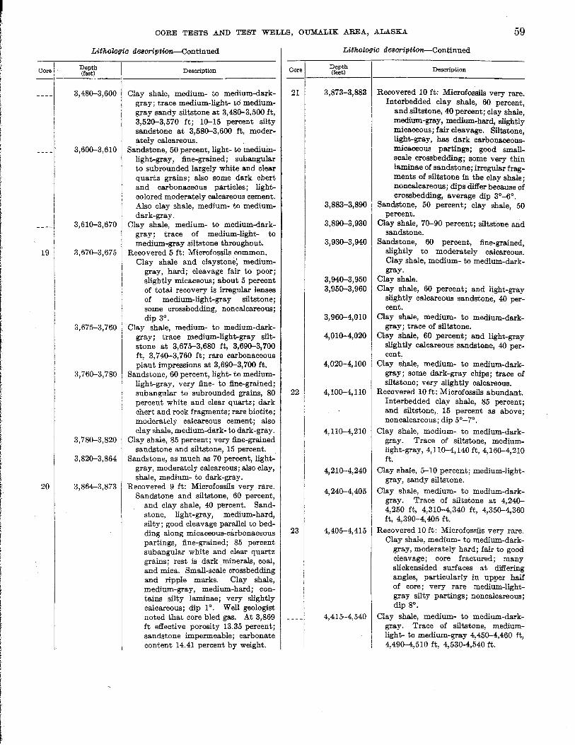
f i I I
r
Core
19
20
CORE TESTS .AND TEST WELLS, OUMALIK .AREA, ALASKA 59
Lithologic clescriptiOflr-Continued
Depth (feet)
3,48(}-3,600
3,60(}-3,610
3,61(}-3,670
3, 67(}-3,675
3,675-3,760
3,76(}-3,780
3,78(}-3,820
3, 82(}-3, 864
3,864-3,873
Description
Clay shale, medium- to medium-darkgray; trace medium-light- to mediumgray sandy siltstone at 3,48(}-3,500 it, 3,52(}-3,570 ft; 1(}-15 percent silty sandstone at 3,58(}-3,600 ft, moderately calcareous.
Sandstone, 50 percent, light- to mediumlight-gray, fine-grained; sub angular to subrounded iargely white and clear quartz grains; also some dark chert and carbonaceous particles; lightcolored moderately calcareous cement. Also clay shale, medium- to mediumdark-gray.
Clay shale, medium- to medium-darkgray; trace of medium-light- to medium-gray siltstone throughout.
Recovered 5 ft: Microfossils common. Clay shale and claystone; medium
gray, hard; cleavage fair to poor; slightly micaceous; about 5 percent of total recovery is irregular lenses of medium-light-gray siltstone; some crossbedding, noncalcareouB; dip 3°.
Clay shale, medium- to medium-darkgray; trace medium-light-gray siltstone at 3,675-3,680 ft, 3,69(}-3,700 ft, 3,7 4(}-3, 760 ft; rare carbonaceous plant impressions at 3,69(}-3,700 ft.
Sandstone, 60 percent, light- to mediumlight-gray, very fine- to fine-grained; subangular to subrounded grains, 80 percent white and clear quartz; dark chert and rock fragments; rare biotite; moderately calcareous cement; also clay shale, medium-dark- to dark-gray.
Clay shale, 85 percent; very fine-grained sandstone and siltstone, 15 percent.
Sandstone, as much as 70 percent, lightgray, moderately calcareous; also clay, shale, medium- to dark-gray.
Recovered 9 ft: Microfossils very rare. Sandstone and siltstone, 60 percent,
and clay shale, 40 percent. Sandstone, light-gray, medium-hard, silty; good cleavage parallel to bedding along micaceous-carbonaceous partings, fine-grained; 85 percent sub angular white and clear quartz grains; rest is dark minerals, coal, and mica. Small-scale crossbedding and ripple marks. Clay shale, medium-gray, medium-hard; contains silty laminae; very slightly calcareous; dip 1°. Well geologist noted that core bled gas. At 3,869 ft effective porosity 13.35 percent; sandstone impermeable; carbonate content 14.41 percent by weight.
Core
21
22
23
Lithologic deScription-Continued
Depth (feet)
3,873-3,883
3,883-3,890
3,89(}-3,930
3,93(}-3,940
3, 94(}-3, 950 3,950-3,960
3,96(}-4,010
4,01(}-4,020
4, 02(}-4, 100
4, 1O(}-4, 110
4, 11(}-4,210
4, 21(}-4,240
4, 24(}-4, 405
4,405-4,415
4,415-4,540
Description
Recovered 10 ft: Microfossils very rare. Interbedded clay shale, 60 percent,
and siltstone, 40 percent; clay shale, medium-gray, medium-hard, slightly micaceous; fair cleavage. Siltstone light-gray, has dark carbonaceous: micaceous partings; good smallscale crossbedding; some very thin laminae of sandstone; irregular fragments of siltstone in the clay shale; noncalcareous; dips differ because of crossbedding, average dip 3°_6°.
Sandstone, 50 percent; clay shale, 50 percent.
Clay shale, 7(}-90 percent; siltstone and sandstone.
San~stone, 60 percent, fine-grained, slightly to moderately calcareous. Clay shale, medium- to medium-darkgray.
Clay shale. Clay shale, 60 percent; and light-gray
slightly calcareous sandstone, 40 percent.
Clay shale, medium- to medium-darkgray; trace of siltstone.
Clay shale, 60 percent; and light-gray slightly calcareous'sandst0ne, 40 percent.
Clay shale, medium- to medium-darkgray; some dark-gray chips; trace of siltstone; very slightly calcareous.
Recovered 10 ft: Microfossils abundant. Interbedded clay shale, 85 percent; and siltstone,. 15 percent as above; non calcareous; dip 5°-7°.
Clay shale, medium- to medium-darkgray. Trace of siltstone, mediumlight-gray, 4, 11(}-4, 140 ft, 4,16(}-4,21Q ft.
Clay shale, 5-10 percent; medium-lightgray, sandy siltstone.
Clay shale, medium- to medium-darkgray. Trace of siltstone at 4,24(}-4,250 ft, 4,31(}-4,340 ft, 4,35(}-4,360 ft, 4,39(}-4,405 ft.
Recovered 10 ft: Microfossils very rare. Clay shale, medium- to medium-dark
gray, moderately hard; fair to good cleavage; core fractured; many slickensided surfaces at differing angles, particularly in upper half of core; very rare medium-lightgray silty partings; noncalcareous; dip 8°.
Clay shale, medium- to medium-darkgray. Trace of siltstone, mediumlight- to medium-gray 4,45(}-4,460 ft, 4,490-4,510 ft, 4,530-4,540 ft.
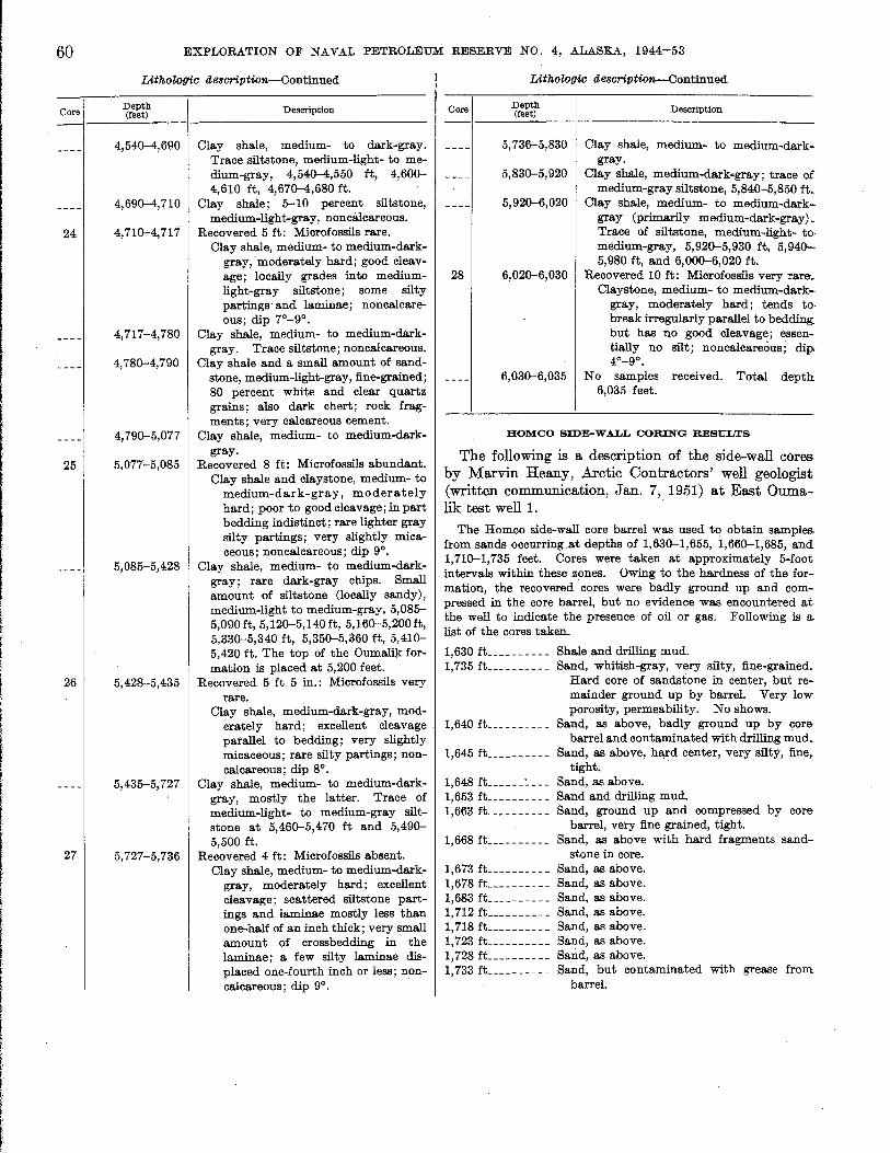
60
Oore
24
25
26
27
EXPLORATION OF NAVAL PETROLEUM RESERVE NO.4, ALASKA, 1944-53
IAthoZo(lic ae8oription-Continued
Depth (feet) Description
4,540-4,690 Clay shale, medium- to dark-gray. Trace siltstone, medium-light- to medium-gray, 4,540-4,550 it, 4,600-4,610 ft, 4,670-4,680 ft.
4,690-4,710 Clay shale; 5-10 percent siltstone, medium-light-gray, nonca1careous.
4,710-4,717 Recovered 5 ft: Microfossils rare. Clay shale, medium- to medium-dark
gray,-moderately hard; good cleavage; locally grades into mediumlight-gray siltstone; some silty partings and laminae; noncalcareous; dip 7°-9°.
4,717-4,780 Clay shale, medium- to medium-darkgray. Trace siltstone; noncalcareous.
4,780-4,790 Clay shale and a small amount of sandstone, medium-light-gray, fine-grained; 80 percent white and clear quartz grains; also dark chert; rock fragments; very calcareous cement.
4,790-5,077 Clay shale, medium- to medium-darkgray.
5,077-5,085 Recovered 8 ft: Microfossils abundant. Clay shale and claystone, medium- to
medium-dark-gray, moderately hard; poor to good cleavage; in part bedding indistinct; rare lighter gray silty partings; very slightly micaceo us; nonca1careous; dip 9°.
5,085-5,428 Clay shale, medium- to medium-darkgray; rare dark-gray chips. Small amount of siltstone (locally sandy), medium-light to medium-gray, 5,085-5,090 ft, 5,120-5,140 ft, 5,160-5,200ft, 5,330-5,340 ft, 5,350-5,360 ft, 5,410-5,420 ft. The top of the Oumalik formation is placed at 5,200 feet.
5,428-5,435 Recovered 5 ft 5 in.: Microfossils very rare.
Clay shale, medium-dark-gray, moderately hard; excellent cleavage parallel to bedding; very slightly micaceous;· rare silty partings; noncalcareous; dip 8°.
5,435-5,727 Clay shale, medium- to medium-darkgray, mostly the latter. Trace of medium-light- to medium-gray siltstone at 5,460-5,470 ft and 5,490-5,500 ft.
5,727-5,736 Recovered 4 ft: Microfossils absent. Clay shale, medium- to medium-dark
gray, moderately hard; excellent cleavage; scattered siltstone partings and laminae mostly less than one-half of an inch thick; very small amount of crossbedding in the laminae; a few silty laminae displaced one-fourth inch or less; noncalcareous; dip 9°.
Core
IAthoZogic ae8cription--Continued
Depth (feet) Description
5,736-5,830 Clay shale, medium- to medium-darkgray.
5,830-5,920 Clay shale, medium-dark-gray; trace of medium-gray siltstone, 5,840-5,850 it.
5,920-6,020 Clay shale, -medium- to medium-darkgray (primarily medium-dark-gray). Trace of siltstone, medium-light- tomedium-gray, 5,920-5,930 ft, 5,940-5,980 ft, and 6,000-6,020 ft.
28 6,020-6,030 Recovered 10 ft: Microfossils very rare-._ Claystone, medium- to medium-dark
gray, moderately hard; tends to· break irregularly parallel to bedding: but has no good cleavage; essentially no silt; non calcareous ; dip, 4°_9°.
6,030-6,035 No samples received. Total depth 6,035 feet.
ROMCO SIDE-WALL CORING RESULTS
The following is a description of the side-wall cores by Marvin Reany, Arctic Contractors' well geologist (written communication, Jan. 7, 1951) at East Ouma-lik test weIll. .
The Homco side-wall core barrel was used to obtain samples. from sands occurring at depths of 1,630-1,655, 1,660-1,685, and 1,710-1,735 feet. Cores were taken at approximately 5-foot intervals within these zones. Owing to the hardness of the formation, the recovered cores were badly ground up and compressed in the core barrel, but no evidence was encountered at the well to indicate the presence of oil or gas. Following is a list of the cores taken.
1,630 ft __________ Shale and drilling mud. 1,735 ft __________ Sand, whitish-gray, very silty, fine-grained.
Hard core of sandstone in center, but remainder ground up by barrel. Very low porosity, permeability. No shows.
1,640 fL _________ Sand, as above, badly ground up by core barrel and contaminated with drilling mud.
1,645 ft ______ ---- Sand, as above, hard center, very silty, fine, tight.
1,648 ft ______ :.. ___ Sand, as above. 1,653 ft __________ Sand and drilling mud. 1,663 ft __________ Sand, ground up and compressed by core
barrel, very fine grained, tight. 1,668 ft __________ Sand, as above with hard fragments sand-
stone in core. 1,673 ft __________ Sand, as above. 1,678 fL _________ Sand, as above. 1,683 ft __________ Sand, as above. 1,712 ft __________ Sand, as above. 1,718 ft __________ Sand, as above. 1,723 ft __________ Sand, as above. 1,728 fL _________ Sand, as above. 1,733 ft __________ Sand, but contaminated with grease from
barrel.

i f
! I f
I I f I
l
f I f·
I t
I I r
I !
t
I
l ,
CORE TESTS AND TEST WELLS, OUMALIK AREA, ALASKA 61
CORE ANALYSES
Core analyses were run on sandstone drill cores, and determinations of effective porosity, air permeability, and carbonate content are contained in the following table. The Barnes (vacuum) method was used to obtain the porosity values. A permeameter, whose general requirements are detailed in API Code No. 27, Second Edition, April 1942, was used to determine the permeability. .
Core analyses, East Oumalik test well 1
Depth E:tfective A.ir permeabil- Carbonate Core (feet) porosity ity (miIli- content (per·
(percent) darcys) cent by weight)
3~ _______________ 526 11.5 0 13.32 10 _______________ 1, 693 11. 6 <1 18. 33 12 _______________ 2,239 11.9 <1 9.40 13 _______________ 2,439 7.5 0 16.88 20 _______________
3, 869 13.3 0 14. 41
OIL AND GAS
. Oil and gas shows in East Oumalik test well 1 were poor. The hole was bailed down to 1,000 feet before. running thermistor cables. When the hydrostatic bead was reduced, gas appeared at the casing head. Some surging was noted during bailing. The volume of gas flowing was not measured. All cuts listed below were made with carbon tetrachloride.
Core Depth (in feet) Remarks
10 1,692-1,702 Spotty stain and oil odor; light-stra w-colored cut; yellow residue at 1,700 ft.
12 2,237-2,246 Spotty stain throu!{.~ut core, poor to fair odor, yellow· cut, and brownishyellow residue from 2,244 ft.
The well geologist, Marvin Reany, reported that cores 8, 9, 10, 16, and 18-28 bled a slight amount of gas. The following shows were also reported by Reany:
Slight shows of gas in sands at 2,310-2,320 feet, 2,470-2,490 feet by gas- detector, but no evidence in the ditch. Light scum of oil appeared in ditch from sand at 2,314-2,319 feet. Very slight show of gas in ditch at 3,500-3,550 feet. No indication of oil. Slight show of gas in ditch from 4,870 feet to 5,100 feet.
LOGISTICS
Personnel.-The supervisory staff consisted of 1 tool pusher, 1 petroleum engineer, and 1 geologist. The rig crew was made up of 2 drillers, 2 derrickmen,
6 floormen, 2 firemen, 2heavy-duty-equipment mechanics, and 1 oiler. .Also employed were 2 cooks and 1 cook's helper, 1 bull cook, 2 bulldozer operators, 1 electrician, 1 carpenter, 1 warehouseman (first aid mar. and storekeeper), and 1 extra floorman.
During camp and rig construction periods, extra carpenters, rig builders, and laborers were employed.
.Six carpenters were sent from Point Barrow to repair the righouse after it was damaged by high winds. Schlumberger operators and cementers were sent as needed.
Housing.-Of 5 quonset huts at the drilling site, 1 was used as a mess hall and galley, 2 for sleeping quarters, 1 forrecreatioI;l, and 1 as a warehouse. One Jamesway hut was used, and of the 11 wanigans used one each was for boiler, generator, office, shop, carpenter' shop, latrine, mess storage, water, and 3 for sleeping quarters.
Vehicles and drilling equipment.-The total tonnage hauled to the test well site was 2,000 tons by Caterpillar tractor-drawn train and 2,000 tons by airlift. For local use, 3 weasels (military, fully-tracked vehicle), 1 LVT (landing vehicle, tracked), 1 D-8 Caterpillar bulldozer, and 1 D-6 Caterpillar tractor were used . Other heavy equipment consisted of 1 forklift, 1 Northwest crane, and 1 small mobile crane (cherrypicker). The major drilling equipment used by Arctic Contractors was as follows:
I. _ _ _ _ _ _ _ _ _ _ 136-foot Ideco derrick. L _ _ _ _ _ _ _ _ _ _ 35G-ton Ideco crown block, six 48-inch
sheaves. I. __________ 350-ton Ideco traveling block, five 48-inch
sheaves. I. _ _ _ _ _ _ _ _ _ _ Wilson Super Titan drawworks. 3 _ _ _ _ _ _ _ _ _ _ _ General Motors quad 6 diesel engines. I. __________ Byron-Jackson Super Triplex hook, ser. 4300. 2 ___________ 0-350 National mud pumps. 2 ___________ Link-Belt 48 x 60 mud shakers. I. __________ Ideco rotary table, ser. HB-23-B. I. __________ Ideal R-3 swivel. 3 ___________ 150-barrel mud tanks with ditches. 3 ___________ 250-barrel storage tanks (1 water, 2 mud). I. __________ 90-barrel "pill" tank. L __________ Cameron QRC blowout preventer. L __________ Hydril GK blowout preventer. I. __________ Shaffer double-gate blowout preventer. I. __________ Kewanee boiler, 75 hp. I. _ _ _ _ _ _ _ _ _ _ Halliburton cementing unit. L __________ Schlumberger electric logging unit.
Fuel, water, and lubricant consumption;-The following materials were used in drilling this test: 91,035 gallons diesel fuel, 1,429 gallons gasoline, 718,500 gallons water, 320 pounds grease, 450 pounds thread lubricant, 524 gallons No. 9170 lubricant, 159 gallons No. 5190 lubricant, 212 gallons No. 9500 lubricant, and 106 gallons No. 9100 lubricant.

62 EXPLORATION OF NAVAL PETROLEUM RESERVE NO.4, ALASKA, 1944-53
DRILLING OPERATIONS
REG FOUNDATION
The following discussion of the rig foundation was supplied by Arctic Contractors' petroleum engineer (written communication, June 1951).
The Wilson Super Titan rig, equipped with a steel substructure, was set on a foundation of 12 by 12 timbers. The refrigeration circulation system consisted of a I-inch pipe cleated to the under side of each timber. The pipes were hose-connected and manifolded into 9 separate circuits off the main headers. Diesel oil, cooled by three mechanical refrigeration units, each of 0.42-ton capacity, was circulated through the refrigeration system. Oil and ground temperatures were obtained from thermometers and thermocouples.
Construction of the foundation was not completed until late spring. The ambient air temperature at that time was well above freezing, requiring that the muck be frozen back by the refrigeration system. This proved to be a slow process since the plant was of insufficient capacity to rapidly extract large quantities of heat from the ground.
During the drilling operation, the ground under the mud pits thawed below the timber sills, requiring shimming under these sections. Part of the excessive thawing was due to drainage of waste water from the derrick through these areas.
DRILLING NOTES
The following table is composed of selected notes from the drilling records of the Arctic Contractors' petroleum engineer.
Notes from drill records Dept" (feet)
0 _______________ Well spudded in at 2 p. m., Oct. 23, 1950, with 15-in. bit.
106 _____________ Casing set. 16%-in. outer diameter, 42 lb, welded slip joint, Western Pipe and Steel, welded plate casing . with Baker casing shoe. Cemented with 65 sacks -.f:Jf CalSeal. Cemented around top through I-in. pipe to 40 ft with 59 sacks of Cal-Seal. Top 55 ft were jacketed with 22-in. welded slip joint casing.
1,10o ____________ Casing set. 11%-in. outer diameter seamless
1,702 ___________ _
3,298 ___________ _
47 lb (thread and coupling) grade J-55, 8 round thread, API casing with Baker Tubing Float Collar. Cemented with 550 sacks of cement. First and last 100 sacks were treated with calcium chloride.
Both casing cement operations were conducted without incident. Though the 16-inch casing cement job was apparently satisfactory at the completion of the job, subsequent circulation of warm fluid caused the circulation to channel by and returns appeared in the cellar. Efforts to overcome the condition were not entirely satisfactory and hole was made to 1,103 feet and reamed to 15% inches with partial or complete returns appearing in the cellar. Mud was circulated from the cellar and drilling continued.
Winds of gale force demolished rig house. Shut down 12 hours (Nov. 10, 1950).
Shut down 17~ hours owing to high winds (Nov. 27, 1950).
Notes from drill records-Continued Depth (feet)
6,03o ____________ Ran Homco side-wall core barrel; obtained cores at 5-ft intervals from sands at 1,630-1,655, 1,660-1,685, and 1,710-1,735 ft.
6,035 ____________ Mud bailed down to a level of approximately 1,000 ft. Five thermistor cables and the follOwing equipment were installed: Landing base (11% x 12 in., series 900) top 19 in. above cellar floor with plate welded on top and 10% x 5 in. nipple welded on plate.
No drill stem or other tests of fluid productivity were made. This well was drilled without mechanical failure in machinery. Failures in drill pipe were numerous, but all were detected by decreased pump pressure, indicative of a washout. Fifteen such washouts were detected, but pipe was pulled and singles exchanged without necessitating fishing. The failures were similar and occurred at similar places in the joints: cracks developed about 3 in. from the end of the upset where boxes are screwed on. The fluid passed through the break, down the threaded section of the drill pipe and tool joint box, then left the drill stem at the bottom of the box.
DRILL AND CORE BITS
Three 15-inch and forty 10%-inch bits were used tv drill East Oumalik test well 1. Bearing wear rather than dulled teeth necessitated retiring most of the bits. The surface hole was drilled to 106 feet, using a 15-inch bit, and was opened to 26 inches with a Reed hole opener. Below 106 feet a 10%-inch hole was drilled to 1,103 feet and opened to 15 inches using 15-inch bits and a reamer;" Below 1,103 feet the hole was drilled to 6,035 feet (totaldepth) using 10%-inch bits to drill and to ream the 8%~inch cored intervals.
A Reed wire.:.linecore barrel and five 8%-inch rock bits were usedf,- ,core a total of 230 feet.
DRILLING MUD
Mud control presented only ~or problems. Most of the rocks penetrated produced heavy mud (90 Ib per cu ft) of very low viscosity. Practically no treating material or agents were used. A. rather large amount of natural mud was eliminated from time to time. As gel strength was very low, 9 sacks of Aquagel were added to the system after drilling to 5,300 feet. Hole condition was excellent at all times.
About the following amounts of mud materials were used in drilling this well: .
AquageL ____________________ 33 sacks Pyrophosphates ______________ 1~ sacks Quebracho ___________________ 6~ sacks Driscose _____________________ 3 sacks (150 pounds) Gel flake _____________________ 6 sacks
Data on drilling mud and additives are contained in the following table.
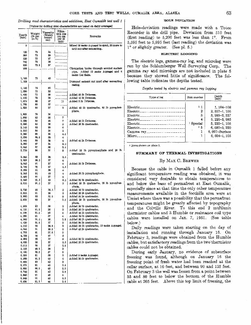
CORE TESTS AND TEST WELLS, OUMALIK AREA, .ALASKA 63
Drilling mud characteristics and additives, East Oumalik test well 1
[Values for dr1lllng mud characteristics are based on daily averages]
Viscosity Filtra-Depth Weight tion loss
(lb per (Marsh (cuem Remarks (feet) funnel euft) sec) per 30 min) --------
0 ---------- -.---.---- ---------- Mixed 20 sacks AquageJ to spud, 20 more to drill out after cementing.
120 72 35 295 72 35 520 73 37 740 73 36 920 73.5 37 956 --------.- -----.---- --------.- Circulation broke through around surface
pipe. Added 12 sacks AquageJ and 6 sacks Gel :flake.
1,100 73 42 1,103 ---------- ---.-.---. ----.----- Dumped cement <JIlt mud after cementing
Casing. 1,150 72 60 1,350 75 32 1,450 75 30 Added 35 Ib Driscose. 1,550 75 35 Added 10 Ib Driscose. 1,675 80 37 11 Added 5 Ib Driscose. 1,760 80 37 1,325 80 37 Added 40 Ib quebracho, 50 Ib pyrophos-
phate_ 1,905 79 36 1,960 82 36 2,030 80 36 7 Added 50 Ie Driscose. 2,090 85 35 Added 20 Ib quebracho. 2,145 83 36 6 2,210 84 35 2,285 85 35 4.5 2,350 86.5 35 4 2,440 89 38 4 Added 40 Ib Driscose. 2,560 87 34 3.5' 2,645 87 36 3.5 2,770 88 37 3 Added 25 Ib pyrophosphate and 25 Ib
quebracbo. 2,845 89 36 3.5 2,955 88.5 37 4 3,045 91 37 4 Added 20 Ib Driscose. 3,150 90 37 4.5 3,260 91 38 4 3,345 91 40 4 Added 20 Ib pyrophospbate' 3,450 91 37 4 3,540 91. 5 42 3.5 Added 50 Ib quebracho. 3,655 91. 5 37 3 Added 30 Ib quebracbo, 25 Ib pyrophos-
phate. 3,720 92 39.5 3 Added 25 Ib quebraeho. 3,805 91 38 3 Added 30 Ib quebraeho. 3,860 92 37.5 3 Added 30 Ib quebracbo. 3,925 90 37 3.5 Added 20 Ib quebracbo, 20 Ib pyrophos-
4,005 92 39 phate.
Added 30 Ib quebracbo. 4,105 91. 5 38 3 Added 30 Ib que.bracho. 4,195 91.5 38 4 Added 35 Ib quebracbo. 4,280 91 37 4 Added 30 Ib quebraeho. 4,360 91.5 38 3.5 Added 30 Ib quebracbo. 4,420 91.5 37 3 Added 30 Ib quebracbo. 4,510 90 36.5 3 Added 30 Ib quebracbo, 12 sacks Aquagel. 4,645 91 36.5 3 Added 45 Ib quebracbo. 4,705 91 37.5 3 4,785 90 37 3 4,860 90 37 3 Added 30 Ib qnebraeho. 4,920 90 37 3.5 Added 25 Ib qnebracbo. 5,015 90 37 3.5 5,105 90.5 38 3 5,190 90.5 37 3 1i,255 91 39 3 Added 9 sacks AquageJ. 5,360 91. 5 43 4 Added 30lb quebracbo. 5,460 92 43 3 5,575 91 42 3.5 5,665 90.5 43 3.5 5,740 91 43 3.5 5,840 91 45 4 5,940 91 43 3.5 6,020 ' 91. 5 44 3.5
HOLE DEVIATION
Hole-deviation readings were made with a Totco Recorder in the drill pipe. Deviation from 510 feet (first reading) to 5,200 feet was less than 10. From 5,595 feet to 5,995 feet (last reading) the deviation was 1 ° or slightly greater. (See pI. 5.)
ELECTRIC LOGGING
The electric logs, gamma-ray log, and microlog were run by the Schlumberger Well Surveying Corp. The gamma ray and micrologs are not included in plate 5 because they showed little of significance. The following table indicates the depths tested.
Depths tested by electric and gamma ray logging
Type of log
Electric ________ ~ _______________ _ Electric ________________________ _ Electric ________________________ _ Electric ________________________ _ Electric ________________________ _ Electric ________________________ _ Gamma ray ____________________ _ Micro _________________________ _
1 Runs shown on plate 3.
Run number
1 1 2 3 4
1 Special 15
1 1
Depth (feet)
1, 104-108 2, 337-1, 105 3,985-2,337 5, 220-3, 985 5, 220-1, 105 6,030-5,220
6, 027-8urface 6, 034-1, 105
SUMMARY OF THERMAL INVESTIGATIONS
By MAX C. BREWER
Because the cable in Oumalik 1 failed before any significant temperature reading was obtained, it was considered very desirable to obtain temperatures to and below the base of permafrost at East Oumalik, especially since at that time the only other temperature measurements available in the foothills area were at Umiat where there was a possibility that the permafrost temperatures might be greatly affected by topography and the Colville River. To this end 2 multiunit thermistor cables and 3 Humble or resistance coil type cables were installed on Jan. 7, 1951. (See table below.)
Daily readings were taken starting on the day of installation and running through January 16. On February 3, readings were obtained from the Humble cables, but satisfactory readings from the two-thermistor cables could not be obtained.
During early January, no evidence of subsurface freezing was found, although on January 16 the freezing point of fresh water had been reached at the cellar surface, at 10 feet, and between 90 and 135 feet. On February 3 the well was frozen from a point between 55 and 80 feet to below the bottom of the Humble cable at 205 feet. Above this top limit of freezing, the

64 EXPLORATION OF NAVAL PETROLEUM RESERVE NO.4, ALASKA, 1944-53
only definitely known frozen zone was between the surface and 5 feet.
The readings obtained from the thermistor cables on January 16, the last day of satisfactory readings, were approxiillately from 4°C at 725 feet to 10°C at 1,500 feet. On Feb. 3, 1951, these cables gave such unsatisfactory results that they can be considered inoperative as of that date. Various tests showed that many of the conductor leads were short circuited together, some by very low resistance shorts; and all but 1 of the 40 individual leads were short circuited to the well casing, although they did not make exceptionally goo(l contact. Test indicated that at least one and probably both cables were severely damaged between the 234- and 750-foot depths.
It is believed that these cables failed because of ice expansion or ice movement within the well casing. This would necessitate assuming that the well refilled with water after bailing to 1,000 feet. The expansion could also be explained by the presence of ice plugs formed by gas-carried water vapor condensing at various depths. In order to rupture the cables, these ice plugs would necessarily have been forced apart by either the freezing of additional fluid between the plugs or gas pressure forcing the upper plug farther up the well casing while the lower plug essentially remained stationary.
Casing collapse could also have been caused by an inward pressure brought about by the freezing of the fluids in the space behind the casing. However, evidence for this phenomenon is meager, occurs only in South Barrow test weil 2, and is not thought to be operative at East Oumalik.
The three short Humble cables were removed in March 1951 because transportation difficulties would not warrant making trips to read these cables.
Depth8 at which temperatures were measured by thermistor cables, East Oumalik test well 1
Lenllth of Depth cable meftSl1red Cable no. (feet) (feet)
Humble or resistance-type coil: 11 ____________________________ _ 120 5-120
17 ____________________________ _ 135 10-135 7 _____________________________ _ 205 15-205
Multiunit thermistor cable: 143 ______ ~ ____________________ _ 1, 000 725-1,000 134 ___________________________ _ 1,500 1, 010-.1, 500
LITERATURE CITED
Goddard, E. N., and others, 19M1, Rock-color chart: Washington, D. C., National Research Council.
Gryc, George, and others, 1956, The Mesozoic sequence in the Colville River region, northern Alaska: Am. Assoc. Petroleum Geologists Bull., v. 40, no. 2, p. 209-254.
Gryc, George, Patton, William, and Payne, T. G., 1951, Present Cretaceous nomenclature of northern Alaska: Wash. Acad. Sci. Jour., v. 41, no. 5, p. 159-167.
Payne, T. G., and others, 1951, Geology of the Arctic Slope of Alaska: U. S. Geol. Survey Oil and Gas Invs., Map OM 126.
Robinson, F. M., Rucker, F. P., and Bergquist, H. R., 1956, Two subsurface formations of Early Cretaceous age in Gyrc, George, and others, The Mesozoic sequence in the Colville River region, northern Alaska: Am. Assoc. Petroleum Geologists Bull., v. 40. no. 2.

PALEONTOLOGY OF TEST WELLS AND CORE TESTS IN THE OUMALIK AREA, ALASKA
By fuRLAN R. BERGQUIST
SOURCE OF SAMPLES
During the drilling of wells on the Oumalik anticline in connection with the exploration of N avaJ. Petroleum Reserve No.4, northern Alaska, samples from cores and cuttings from 2 deep test wells and 3 core tests were prepared for paleontologic study in the U. S. Geological Survey laboratory at Fairbanks, Alaska. The samples were washed and picked under the author's super-
I vision; a total of 947 samples were examined for microfossils, of which 624 samples were from Oumalik test well 1; 190 were from East Oumalik test well 1; and 133 were from Oumalik core tests 1, 2, 11, and 12 and Ikpikpuk core test 1. No samples were available from the other core tests.
A number of the species in these wells are new and have been described by Mrs. Helen Tappan Loeblich (Tappan, 1951, 1956).
OUMALIX TEST WELL 1
All core samples and ditch samples from every 10- or 20-foot interval in Oumalik test well 1 were examined for microfossils. Approximately 920 feet of cores were taken, but microfossils were recovered from only 29 of the 90 cores. Most of the cores below the one at 4,420-4,440 feet were barren. Some of the cores contained.1 or 2 specimens, but a few cores had common to a.bundant specimens of certain species.
Only a few more than 1,000 specimens of Foraminifera, representing 18 arenaceous species and 4 calcareous species, were found in ditch and core samples from the 2,800 feet of the Grandstand formation penetrated in drilling this test hole. These species are typically associated with Verneuilinoides borealis Tappan, an arenaceous foraminifer which is the dominant species in the shallow-water marine fauna of the Grandstand-Topagoruk formations, and whose name is therefore used to designate the faunal zone. In the Grandstand formation in this test hole, V. borealis occurs in most of the ditch samples and in some of the cores, and constitutes 60 percent of the fauna. It is most numerous in ditch samples, but its abundance is corrfined to intervals above the 1,150-foot depth. The next most abundant (7 percent) species is Haplophragmoides topagorukensis Tappan. A few other species makeup 5 or 6 percent each, but most species found in the Grandstand formation in this test well constitute
only 1 or 2 percent of the total specimens collected from the formation.
GRANDSTAND FORMATION (36-2,825 FEET)
Only a few Foraminifera occurred in samples in the· upper few hundred feet of beds of the Grandstand for-· mation penetrated in drilling this test well. Of the few found, Verneuilinoides borealis was common to abundant at 130 feet and at 160 feet. A core from 517-528· feet was barren of microfossils, but carbonized plant. remains of Oretaceous age were in it. A few charophyte oogonia were in ditch samples below this core. About 60 percent of the cores from the Grandstand formation. were barren, but a core from 723-733 feet carried 35 percent of all specimens recovered from cores. In this: core V. borealis and Gaudryinella irregularis Tappan were common, and there were a few specimens each of Ammobaculites tyrrelli Nauss, Miliammina manitobensisWickenden, and Inoceramus prisms.
Inoceramus prisms occurred in cores at 1,410-1,422 and 1,626-1,637 feet, and intermittently in ditch samples through 2,590 feet. A shell fragment of Ditrupa Sp.3 was found at 1,470-1,480 feet. In the test holes drilled in the Umiat field, the Grandstand anticline, and the Topagoruk River and Simpson peninsula areas, the fragmentary shells of Inoceramus and Ditrupa constitute a subzone of the Verneuilinoides borealisfaunal zone and range through most of the Grandstand formation and a part of the underlying Topagoruk formation.
In a core at 2,351-2,361 feet in the lower part of the· Grandstand formation, only fragments of Bathysiphon vitta Nauss were common and mark the first occurrence of this . species in any abundance in this test bole. Other species were rare, but among them were two small Rpecimens of Gaudryina nanushukerisis Tappan.
TOPAGORUK FORMATION (2,825-4,860 FEET)
A greater number of species and specimens of Foraminifera. of the Verneuilinoides borealis faunal zone were recovered from the Topagoruk formation than from the Grandstand formation, and these came from 11 of the 19 recovered cores.
3 Curved tubular shells from the Cretaceous beds of northern Alaska were formerly referred to Laeoidentalmm sp. or Dentalium sp. Determinations by Ralph W. Imlay show that these shells are not scaphopods but are worm tubes of the genus Di!Tupa.
65

66 EXPLORATION OF NAVAL PETROLEUM RESERVE NO.4, ALASKA, 1944-53
Twenty-four arenaceous species and six calcareous species were identified in: 515 specimens picked from core samples, and 706 specimens were identified from ditch samples. In the core samples Haplophragmoides topagorukensis numerically leads all species with 47 percent of the total number of specimens; Textularia topagorukensis Tappan comprises 13 percent of the
. total, and Bathysiphon 'Ditta, 11 percent. The remaining species range downward from 5 specimens for Verneuilinoides borealis to 1 specimen for Gaudryinella irregularis.
A fauna of 10 species was picked from a core sample near the top of the formation (2,841-2,851 feet) where Haplophragmoides topagorukensis and Tritaxia manitobensis Wickenden were common and Textularia topagorukensis was abundant.
OUMALIK FORMATION (4,860--10,880 FEET)
Of the 23 cores taken in this formation 18 were barren, whereas the ditch samples, though fossiliferous, are contaminated by the V. borealis fauna from the overlying beds.
About 20 specimens of 6 long-ranging species (common to the Nanushuk group) occurred in the 4 or 5 fossiliferous cores in the Oumalik formation. Dorothia chandlerensis Tappan, a species found in the lower part of the Torok formation, was found in the Oumalik formation in this test hole and was used to mark the top of the formation. Three other specimens of D. chandlerensis were found in three ditch samples (8,130 feet, 8,310 feet, and 9,310 feet). Eight pyritic casts of a radiolarian, Dictyomitraf sp. came from a core sample from 10,233-10,240 feet. Pyritic casts of another radiolarian, Lithocampe'l sp., were found in ditch samples (8,050-8,060 feet and 10,210-10,220 feet) and in cores from 10,233-10,240 feet and from 10,669-10,682 feet. Pyritic casts of the latter radiolarian are also characteristic of the lower part 9f the Torok formation.
UPPER JURASSIC(?) AND LOWER CRETACEOUS{?) ROCKS UNDIFFERENTIATED (10,880--11,872 FEET, TOTAL DEPTH)
The only Foraminifera found in cores from the beds below the Oumalik formation in this test hole came from a sample at 10,992-11,007 feet in which were also molluscan casts which R. W. Imlay has identified as Aucella sublaevis Keyserling, of Early Oretaceous (middle Valanginian) age; this species is limited to the lower 200 feet of the Okpikruak formation in northern Alaska. The associated Foraminifera are specimens of Haplophragmoides which are more like H. canui Tappan of Late Jurassic age (Oxfordian) than any other species. Other specimens of H. cf. H. canui were scattered through many of the ditch samples but were most numerous in the upper 150 feetof the unit.
In some of the ditch samples there are Foraminifera that are contamination from higher beds and a few that are suggestive of Late Jurassic (Oxfordian or lower Kimmeridgian) species that have been found in Topagoruk test well 1 and in some outcrop samples. Fossils from these rocks have been described by Mrs. Helen Tappan Loeblich (Tappan, 1955). Two specimens of questionable Gaudryina topagorukensis Tap'pan, a small species whose chambers have greater width than height, were found in samples from 10,920-10,930 feet and 11,360-11,370 feet and compare quite favorably to specimens of G. topagorukensis from Topagoruk test well 1. A few coarse-grained arenaceous planispiral specimens (11,140-11,150 feet, 11,180-11,190 feet, -' and 11,690-11,700 feet) resemble an unnamed species of Haplophragmoides found in samples from the lower part of the Tiglukpuk formation on the East Fork of the Nanushuk River and along Welcome Creek (tributary to Kanayut Creek) in the SiksikpukNanushuk Rivers area, Alaska. Within the interval from 11 ,400 to 11 ,550 feet five calcite-filled specimens of a small Globulina (G. topagorukensis? Tappan) were found. The similarity of these Foraminifera to species of Jurassic age presents the possibility of a Late Jurassic age for most of the beds below the Oumalik formation in this test hole.
EAST OUMALIX TEST WELL 1
PLEISTOCENE-RECENT(?) DEPOSITS
A few broken smooth-valved ostracodes in a ditch sample at 30-40 feet resemble the valves of a presentday species found along the Arctic coast. No species characteristic of the Gubik formation were noted.
KTI.J.IK TONGUE OF THE CHANDLER FORMATION (50--730 FEET)
Except for scattered occurrences of Verneuilinoides borealis Tappan and a few specimens of Miliammina awunensis Tappan in this well, the Killik tongue of the Ohandler formation is essentially barren.
GRANDSTAND FORMATION (780-3,050 FEET)
The top of the Grandstand formation was placed at the top (730 feet) of the Verneuilinoides borealis faunal zone, where very abundant specimens of Verneuilinoides borealis and Trochammina rutherfordi Stelck and Wall appear in association with common specimens of Miliammina awunensis and a few specimens of Gaudryinella irregularis Tappan, Textularia topagorukensis? Tappan, and Siphotextulariaf rayi Tappan. Through the succeeding 350 feet of section Verneuilinoides borealis is common to abundant in ditch samples, whereas other species are only sparingly present. Oores from 950-956 feet and from 1,150-1,156 feet
CORE TESTS AND TEST WELLS, OUMALIK AREA, ALASKA. 67
were barren. In core 8 from 1,350-1,360 feet Verneuilinoides borealis was very abundant, and fragments of Ammobaculites humei? Nauss were found in the same sample along with specimens of ostracodes and charophyte oogonia. Specimens of Verneuilinoides borealis, Haplophragmoides topagorukensis Tappan, and Psamminopelta bowsheri Tappan were abundant in core 9 from 1,550-1,560 feet. Most of the' succeeding cores· through 2,446 feet were barren, but Verneuilinoides borealis was fairly persistent in the ditch samples ~hrough that part of the section.
Along with Foraminifera, fragments of the worm tube Ditrupa sp. were found in a ditch sample at 1,850 feet and in core 14 from 2,635-2,645 feet. Inoceramus prisms appeared first in core 10 from 1,692-1,702 feet and also occurred in core 14.
The Verneuilinoides borealis fauna persists in ditch samples through the lower part (about 2,446-3,250 feet) of the Grandstand formation, but relatively few species and specimens were found in the cores. Only Haglophragmoides topagorukensis was common in one core (2,835-2,840 feet), where the highest fragments of Bathysiphon vitta Nauss also occurred.
Oalcareous Foraminifera were very scarce in the Grandstand formation; the first one, Pallaimorphina ruckerae Tappan, appeared low in the section in a ditch sample from 2,080-2,090 feet. Three specimens of Eponides morani Tappan were found in the core from 2,635-2,640 feet; a specimen of Gavelinella stictata (Tappan) and one of Pallaimorphina ruckerae were found in the core from 2,835-2,840 feet.
A specimen of Gaudryina nanushukensis Tappan was found in a ditch sample from 2,950-2,960 feet; scattered specimens occurred in ditch samples from 3,150 feet through 5,710 feet.
TOPAGORUK FORMATION (3,056-5,200 FEET)
The best development of the Verneuilinoides borealis faunal zone in this well is in the upper 500 to 600 feet of the Topagoruk formation. Core 17 from 3,268-3,275 feet furnished the largest fauna of the well, having 13 species, with Haplophragmoides topagorukensis, Verneuilinoides borealis, and Eurycheilostoma robinsonae Tappan of common occurrence, and a few specimens of Bathysiphon brosgei Tappan, Pelosina complanata Franke, Psamminopelta bowsheri, Miliammiria awunensis, Gaudryina hectori Nauss, Tritaxia manitobensis Wickenden, Lenticulina macrodisca (Reuss), Valvulineria loetterlei (Tappan), PaUaimorphina ruckerae, and Gavelinella stictata. In a core from 3,670-3,675 feet nine species occurred, but only Haplophragmoides topagorukensis and Verneuilinoides borealis were common.
Although never common, Ammobaculites humei Nauss occurred low in the Grandstand formation, and in the upper part of the Topagoruk formation in ditch samples and in the cores from 3,470-3,480 feet alld 3,670-3,675 feet. . It is probably not found in the lower part of the Topagoruk formation of this test, though a few specimens occurred in ditch samples. Specimens of Ammobaculites tyrrelli Nauss were rare and were identified in only a few samples.
Gaudryina nanushukensis was found sparingly from 3,150 feet to 5,710 feet, but its rare occurences were in the upper part of the Topagoruk formation. It was not found in the Grandstand formation of this test, although it. does occur in that formation in Ournalik test weIll.
The fauna apparently fades gradually with depth, as in core 22 (from 4,100-4,110 feet) the only species is Haplophragmoides topagorukensis, but it occurs in abundance. In the lower beds of the Topagoruk formation, the ditch samples contain a fairly constant fauna, which may be contamination, because in the cores below 4,400 feet the species typical of the Verneuilinoides borealis faunal zone were almost completely absent. In a core from 5,077-5,085 feet Textularia topagorukensis? was abundant. This species was sparingly present throughout the Verneuilinoides borealis faunal zone in this well, but in Ournalik test well 1 it was common in some cores in the upper part of the Topagoruk formation.
OUM.ALIK FORMATION (5,200-6,035 FEET)
All except the last core taken from the Ournalik formation ill this well were barren. The exception, the bottom-hole core, contained a few specimens, but these were so poorly preserved that positive identifications could not be made. Pyritic specimens of the Radiolaria, Lithocampe? sp., and Dictyomitra? sp. appeared in ditch samples from 5,710-5,720, 5,810-5,820, and 5,890-5,900 feet. The pyritic Lithocampe? marks the Oumalik formation in its type section, Ournalik test weIll.
IXPIXPUX AND OUMALIX CORE TESTS
Samples from Ikpikpuk core test 1 and Ournalik core tests 1, 2, 11, and 12 were studied in the laboratory at Fairbanks. Samples from Ournalik core (foundation) tests 1-10 were never received at the laboratory.
Ikpikpuk core test 1 and Oumalik core test 1.-V ery little paleontologic information came from these two core tests because of the shallow depth of the holes and the poor quality of the samples. Two cores were taken in the Ikpikpuk core test, but these and all ditch samples were badly contaminated with surficial material, making them valueless for age determinations. Common

68 EXPLORATION OF NAVAL PETROLEUM RESERVE NO.4, ALASKA, 1944-53
to all the samples were specimens of a smooth-walled species of nonmarine ostracode Oandona cf. O. candida (Muller), which is apparently indigenous to beds of Pleistocene and Recent age in the uppermost part of the hole. In Oumalik core test 1 all the ditch samples and three of the cores (down to 209 feet) are contaminated with the same species of Pleistocene and Recent ostracode'. A solitary specimen of Pelosina complanata Franke in a sample from 210-220 feet and Inoceramus prisms in a ditch sample from 330-340 feet provide meager evidence of marine beds of Cretaceous age in Oumalik core test 1, but these fossils offer no clue as to which formations were penetrated.
Oumalik core test 2.-About 40 feet of possible Gubik formation covered the Cretaceous rocks in this core test. In the upper 10 feet were ostracode valves that F. M. Swain has identified as Ilyocypris cf. I. bradyi Sars, a lacustrine species.
The fossiliferous Grandstand formation (Lower and Upper Cretaceous) occurs from 70 feet to the total depth, below beds defined as the Chandler formation by Miss Robinson. Only a charophyte oogonium was fotID.d in samples from the Chandler, but there were light-brown, somewhat compressed tests of Verneuilinoides borealis Tappan in most of the samples from the Grandstand formation. This species was very abundant in the lowest 40 feet of samples. In a few of the samples, particularly from the lowest 30 feet, were a few specimens of Miliammina awunensis Tappan, Gaudryina hectori Nauss, and Trochammina rutherfordi S,telck and Wall. Two specimens of charophyte oogonia, which are the same as the specimen found in the Chandler and suggest some contamination during drilling, were in two samples.
Oumalik core test 11.-The Grandstand formation was penetrated at 14 feet in this core test beneath a thin mantle of Pleistocene strata. In the first sample (14-24 feet) were common numbers of compressed tests of
Miliammina awunensis and Trochammina rutherfordi, and a great abundance of Verneuilinoides borealis. These fossils, with the addition of a few others, continue through 137 feet of the core test but are relatively iI:conspicuous in the remainder of the samples. The most fossiliferous core was from 127-137 feet, where V. borealis was very abundant, Psamminopelta subcircularis
. Tappan and Trochammina rutherfordi were abundant, and there were a few specimens of each of three other species.
Oumalik' core test 12.-Foraminifera of the Verneuilinoides borealis faunal zone appeared abruptly in the core at 17 to 27 feet and were irregularly distributed throughout the lower samples from the hole. The most numerous w'ere Verneuilinoides borealis and Trochammina Ml-therfordi, each being common to abundant in 6 samples. Gaudryinella irregularis Tappan was abundant in 3 samples; Psamminopelta subcircularis was abundant to common in 4 samples; and Pelosina complanata, Psamminopelta bowsheri, and Gaudryina hectori each had one common to abundant occurrence. A few specimens of Miliammina awunensis occurred in 5 samples.
SELECTED BIlJLIOGRAFHY
Nauss, A. W., 1947, Cretaceous microfossils of Alberta·: Jour. Paleontology, v. 21, no. 4, p. 329-434.
Stelck, C. R., and Wall, J. H., 1955, Foraminifera of the Cenomanian Dunfleganoceras zone from Peace River area of western Canada: Alberta Res. Council Rept. 70.
Tappan, Helen, 1951, Northern Alaska index Foraminifera: . CushmltIl Foundation.F'oram. Research, v. 2, pt. l.
-- 1955, Foraminifera from the Arctic Slope of Alaska, part 2, Jurassic Foraminifera: U. S. Geol. Survey Prof. Paper 23B-B.
-- 1956, New Cretaceous Foraminifera. from northern Alaska: U. S, Natl. Mus. Bull. 215 (in press).
Wickenden, R. T. D., 1932, New species of Foraminifera from the Upper Cretaceous of the prairie provinces: Royal Soc. Canada Proc. and Trans., 3d ser., v. 26, sec. 4.

INDEX
A E Page Page
Abstract___________ ________ __ ___________________ 5 East Ouma.llk test well L _______________________ 51--M
Acknowledgments___ ____ ___ ___ _ _ __ _ __ __ __ __ ____ 5 core a.uaJyses______________ ____ ____ _ _ _____ _ _ _ 61
AmmobaculitM humeL _________________________ 66,67 cores and cuttings, description_ _ _ _ _ _ _ _ _ _ _ _ _ _ 52r60
tvrreUL _______ ______________________________ 65,67 drilling operatious_ _ _____________ __ _ __ ___ ___ 62--1l3
Area of Reserve No. 4 ___ . ______________________ 1 heavy-minera.l studies_ _ _ _ ______ __ _ _ __ _____ _ 52
Arctic Contractors, quoted _______________ 46,48,50,62 Homco side-well coringresults____ __________ 60
AuCllUa 81l.blaevi8 ________________________________ 10,66 logistics_ _ _ __________________ ______ _________ 61
Augite zoue, Oumalik test well L______________ 26 tlwunenri8. Miliammina ____________ . ________ 66,67,68
oil and gas__ ________ _________ _ _ ____ _ _ ___ __ __ 61 pa.leontology _________ _______ __ ____ _ _________ 66-67 rig foundation_ _ ____ _________ _ ____ _ _________ 62
B Electric logging, East Oumaliktestwell L_______ 63 Ouma.llk test well L_ _______________________ 51
Barrow test wells, location__________________ 2 EponidM moranL_ _ ____ ________ ____ ___ _ ____ _ __ _ _ 67
Basement rocks, depth to_______________________ 10 BathvBipilon bro8geL____________________________ 67 F
vitta _____________________________________ 65, 66, 67 Bibliographies __________________________________ 64, 68
borealis, Vemeulinoide8 ___________________ 65,66,67,68
Fish Creek test wells, location____ __ _ _ __ _ ______ 2 Flowage, rock_ _ _ _ ______ _________ _____ _ _ ________ 9 Foraminifera_ __ ______________ ___ ______ _ _____ __ _ 9
bow8heri, P8amminopelta __________________ . ____ 67 bradyi, IUVocllpris_______________________________ 68
Formation tests, oil and gas _____________________ 44-45
Fuel, consumption at East Oumalik test well L _ 61 Brooks Range__________________________________ 2 Oumalik test well L________________________ 46 brosgei, BathllBiphon_____________________________ 67 type________ _ __ ___________ _________ _____ ____ 48
C G
candida, Candono _ ______________________________ 67 Gaudrvina hectorL ______________________________ 67,68
Candona candida________________________________ 67 nanwhuke1l8io ______________________________ 65,67
canui, HaplophragmoidM________________________ 66 topagorolumiB_ __________________ ___ ________ 66
Chandler formation __________________________ 25,51,68 Gaud.T1/inella irregulariB ___ ______________________ 65,66
East Oumalik test weill, paleontology _____ 66 stictata____ ________________________ ________ _ _ 67
Killik tongue_______________________________ 8 Glauconite_ _ __________________ _______ ______ ____ 10
chandleremis, Dorothia __________________________ 10,66 Glaucophane zone, East OumaJlk test well L____ 52 Charophytes_ _ _ __ _ _ _______________ __ __ __ ___ ____ 8 Ouma.llk test well L________________________ 26
CoaL _______________________________________ 8,9,16,25 Glob'Ulina topagoruke1l8io _ _ _______ _____ _ _ ____ ____ 66
complanata, Pelosina ____________________________ 67,68 Grandstand anticline_________________ ___ ______ _ 65
Cores and cuttings, description, East Oumalik test well L ________ . ___________________________ 5:HlO
Oumalik test well L _______________________ 26-42
test wells in area of______________________ ____ 2
Grandstandformation ______________________ 8-9,25,51
East Oumalik test well 1, paJeontology _ _ _ _ _ _ 66
Core a.uaJyses ___________________________________ 23-24
East Oumalik test well L ______ .___________ 61 OumaJlk test well L _______________________ 42-4a
Ouma.llk test well 1, paleontology _ _ _ _ _ _ _ _ _ _ _ 65 Gubik anticline, test wells in area oL____________ 2 Gubik formation.. _______________________ 8, 25, 51, 66,68
Core and drill bits, East Oumalik test well L _ _ 62 H Cretaceous rocks ______________________________ 3,8-10
Lower ____ ____ _ _____________________________ 10
Oumalik test well 1, paJeontology_______ 66 Crinoids____ _ _ ___ _ _ ________ _________ ____________ 9
HaplophragmoidM canuL______________________ 66 topagorulumiB ___________________________ 65,66,67
Hea.uy, Marvin,.Arctic Contractors quoted _____ 60,61 Heat transfer control, OumaJlk test well 1_ _ _ _ _ _ 48
D Heavy-mineral studies__________________________ 23
studies, East Oumalik test well L__________ 52
Daylight, extent oL ___________________________ _
Dietl/omitra sp__________________________________ 66 Ditrupa sp ______________________________________ 65,67
studies, OumaJlk test well L_______________ 26 hectori, Gaud.T1/ina _______________________________ 67,68
Hole deviation, East OumaJlk test well L______ 63 Ouma.llk test well L________________________ 50
Dorothia chanduren8i8 ___________________________ 10,66
Drill and core bits, East Oumalik test well L___ 62 Ouma.llk test well L_______________________ 48
Homco side-wall coring results, East Oumalik test well L _________________________ . 60
Housing, East OumaJlk test well L____________ 61 Drilling equipment, East OumaJlk test well L___ 61 OumaJlk test well L________________________ 45
Ouma.llk test well L_ ______________________ 45 humei, Ammobacuiitu __________________________ 66,67
Drilling mUd, East Oumalik test well L _________ 62-63 Ouma.llk test well L ________________________ 48-50 I
Drillingnotes, East Ouma.llktestwellL________ 62 Ice lenses_______________________________________ 7 Ouma.l!k test well L ________________________ 46-47 Ikpikpuk core test L __________________________ 10-11
Dril!ing oPerations. (See East Oumalik test logistics_ _ _ _______ _ _________ _ _ __ ____________ 24
weill and Oumalik test well 1.) paJeontology ________________________________ 67-68
Page IlyOC1Ipris bradVi __ --------______________________ 68 lnoceramw prisms ______________________________ 65,67 Introduction_____________ ______________________ 5-8 Introduction to part 5__________________________ 1-3 irreg'UlariB, Gaud.rllinella _________________________ 65,66
J
Jurassic rocks, upper __ _________________________ 10
paJeontology of at OumaJlk test well L ___ : _ 66
K
Kaolak River area test wells, location..__________ 2 Key seats, Ouma.llk test well L_________________ 50 Killik tongue, Chandler formation _________ 8,25,51,66 Knifeblade Ridge test wells,location___________ 2
L
Lenticulina macrodi8ca__________________________ 67 Ltth«.ampe sp __________________________________ 52,66
lottteriei ValllUlimri'L_________________________ 67 Logistics, East OumaJlk test well L____________ 61
OumaJlk test well L _______________________ 45,46
Logistics and drilling operations ________________ 24-25
Lubricant consumption, East Ouma.llk test well L _ _ __________ ________________ ______ 61
OumaJlk test well L_______________________ 46
M
macrodiBca, Lenticulina_______ __________________ 67 manitobm818, Miliammina______________________ 65
TritIJ3:ia_ __ _________ __ ______________________ 66, 67
Meade River area test wells,location___________ 2
Microfossils, definition of terms relating to quan-tity of._____________________________ 10
MiliamminaawunemiB ______________________ 66,67,68 manitobemiB______ __________ ___ ___ ______ ____ 65
Mollusks ______________________________________ _ morani, Eponidu_ ______________________________ 67
N
National Bureau of Standards, a.uaJysis by _____ 45 Nanushuk group _______________________________ 52,66 nanushukemi8, Gaud.T1/ina ______________________ 65,67
o OU and gas, East Oumallk teSt well L_________ 61
OumaJlk test well L _______________________ 43-45 Okpikrnak: formation ___________________________ 10,66 Ostracodes_ _ _ __ ___ _ ________ __ _____ ______ __ _____ 66
nonma.rine_____________ _ ____ ______ _____ _ ____ 8
Oumalik anticline______________________________ 5-6 Ouma.llk core test L ____________________________ 11-12
logistics_ _ ____ _ _________ ___ _ ___ _ __ _____ _ ____ 24
paJeontology ________________________________ 67-68 . Ouma.llk core test 2 _____________________________ 12-13
logistics ____________________________________ 24-25 paJeontology _____________ ________ ______ ____ _ 68
Ouma.llk COle test 11 ____________________________ 16-20 logistics_ _ _____ _____________________________ 25 paJeontology _____ _ ______ ___ _ ___ _ _______ _ __ __ 68
Oumalik core test 12 ____________________________ 20-23 logistics _ _ ____________ __ ________ ___________ _ 25 paJeontology________ _______________________ 68
69

~ I I ~
I t
!
70 Page
Oumallk: core (foundation) tests 1-110 ___________ 13-16 logistlcs____ _ _ _______ _ _ _ ___ _ _ _ __ __ __ _ _____ __ 25
Oumallk: formation ___________________________ ~IO, 51
East Oumalik teat well I, paleontology _____ 67 Oumalik test well 1, paJeontology___________ 66 type section________________________________ 26
Oumallk: River area test wells, location_________ 2 Oumalik teat well L ___________________________ 25-li1
core, analyses _______________________________ 42-43 description _____________________________ 26-42
cutting descriptions ________________________ 26-42
drill and core bits__________________________ 48 drilling mud ________________________________ 43-60 drilling notes _______________________________ 46-47 drilling operations __________________________ 46-51
electric logging and temperaturesurvey____ 51 heat transfer controL______________________ 48 heavy-mineral studies______________________ 26
hole-<ieviation record_______________________ 50 key seats __ :________________________________ 50 logistics ____________________________________ 45-46 oil and gas __________________________________ 4&-46 paleontology _________________ ______ _ ________ 66
power plant________________________________ 48 rig foundation______________________________ 46 thermal investigation, summary of by Max
C. Brewer__________________________ 51 velocity survey_____________________________ 51
P
Paleontology by Harlan R. Bergquist __________ 65-68 East Oumallk test well 1 ___________________ 66-67 Oumallk: and Ikpikpuk core tests ___________ 67-68 Oumalik test well L _______________________ 65-68
PaUaimorphiM rucktrae _________________ c______ 67 PeloriM complanata ____________________________ 67,68 Permafrost ______________________ 1-2,7,13,46,51,62, 63 Permeability, East Oumallk test well L_______ 61
Oumallk core test 1L______________________ 24 Oumallk test well L _______________________ 42-43
Personnel, East Oumallk teat well L___________ 61 Oumallk test well L_______________________ 45
Pleistocene deposits____________________________ 8 East Oumallk test well 1, paleontology _____ 6EHl7
INDEX
Page Porosity, East Oumallk: test well L____________ 61
Oumallk core test 11________________________ 24 Oumallk test well L __________________ ' _____ 42-43
Power plant, Oumalik test well L_____________ 48 Plttlm'llll1lopelta OOwSMn________________________ 67
1lUbe/reul6Ti8_ __________________________ _____ 68
Q Quaternary deposits ___________________________ _
R
raui, Si~a----------------------------- 66 Recent deposits, East Oumallk teat well 1, pale-
ontology ____________________________ 66-67
Rig foundation, East Oumallk: test well L_____ 62 Oumallk test well L_______________________ 46
rockerae PaUaimorphiM________________________ 67 rtllhtrfardl, Trochammina _______________________ 66,68
B Seismic surveys________________________________ 5 Sentinel Hill teat wells,location________________ 2
Side-wall coring results, East Oumalik test well L__________________________________ 50 Simpson penin8uJa test wells, location__________ 2 Simpson Seeps test wells, location______________ 3 Siphote:z:tulmia rcui_____________________________ 66
Smith-Emery Co., analyses by_________________ 45 Speclftc gravity, core samples, OumaJik core
test L______________________________ 23 Square Lake test wells, location________________ 3 Itictata, GaDdindla:_____________________________ 67 Stratigraphy _ _____________________ _ ________ ____ 8-10
Structural features______________________________ 5-6 subeireul6Ti8, .P3cmminopelta____ _ _ _ _ _ _ _ _ ___ _ _ _ _ _ 68 aublaerI/8, AuceUa _______________________________ 10,66
T Temperatures _______________________________ 51,63-64 Terms, definition ot.___________________________ 10 TezhIlaria t()flGgOrU/cef18i8 _ _ _ _ _ _ _ _ _ _ _ _ _ _ _ _ _ _ _ _ ___ 66
Thermal investigation, East Oumalik test well 1, by Max C. Brewer _______________ 63-64
Oumallk: test well 1, by Max C. Brewer ____ 51
Page Tlglukpuk formation______ ____________________ _ 66
Titaluk River area test wells, location__________ 3 Topagoruk formatlon _________________________ 9,25,51
East Oumalik teat well 1, paleontology_____ 67 Oumalik test well 1, paleontology __________ 65-66
Topagoruk River area test wells, location_______ 3 Topagoruk test well L_________________________ 66 tofHlDOTU/cefI8i8, GaudruiM_______________________ 66
GlolndiM_________________ ___________ _______ 66 Haplophra(l1Tloid68 _______________________ 65,66,67 Tatularia_ ______________ _ _ _ ________________ 66
Torok formation________________________________ 66 Trace, de1lnition ot.____________________________ 10
Transportation, Oumalik test well L___________ 45 Tritaxic manUolJemi8 ___________________________ 66, 67 TrochammiM rutherfard!.. ______________________ 66,68 t!lrreUI, Ammobaculites __________________________ 65,67
U Umiat test wells, location _____________________ _
United States Bureau ot Mines, analyses by ___ 45
V
Valoulineria loetterleL__________________________ 67 Vehicles, East Oumallk: test well L____________ 61
Oumalik test well L __________________ , ____ 45
Velocity survey. Oumalik test well L__________ 51 Vermuilinoid68 barealis ________________ 52,66,66, 67;68 rJitta, Bath!lriphOfL __________________________ 65,66,67
W Wells, location ot.______________________________ 2-3
Wolf Creek area test wells,location.____________ 3 Water consumption, East Oumallk: test well L_ 61
Oumallk test well L_______________________ 46
Y
Yuster, S. T .. quoted__________________________ 43
z Zircon zone, East Oumalik test well L_________ 52
Oumallk test well L_______________________ 26
o. s. GOVERNMENT PR)NTING OPPICE: l1U