cubesat nighttime lights - cal polymstl.atl.calpoly.edu/~bklofas/presentations/summer...•...
TRANSCRIPT

© The Aerospace Corporation 2016
CUBESAT Nighttime Lights
August, 2016Dee W. Pack and Brian S. HardyThe Aerospace Corporation

2Aerospace Corp, 2016
Outline
We used existing cameras on Aerospace Corporation 1U and 1.5U CubeSats to image the Earth at Night guided by DMSP, VIIRS and ISS photography results
• Introduction – Nighttime Lights as a CubeSat Mission• AeroCube camera details, AC-4 MFOV, AC-5 NFOV• AC-4 point and stare experiment and comparison to VIIRS DNB• AC-5 sequential point and stare flyby experiment• Comparison of AC-5 to ISS Photography (including change detection)• AC-5 Global City Examples• Future Sensors (near-term)
Acronyms: AeroCube (AC), Medium Field of View (MFOV), Narrow Field of View (NFOV),Visible Infrared Imaging Radiometer Suite (VIIRS), Day-night-band (DNB), International Space Station (ISS), Defense Meteorological Support Program (DMSP)

3Aerospace Corp, 2016
Introduction – Nighttime Lights- a Potential CubeSat Mission• The Use of Nighttime Lights Signals for Monitoring the Global Human
Footprint has been Established by DMSP OLS and VIIRS DNB– City lights, light pollution, urban growth and change, transportation grids– Global Natural Gas Flaring, Global Biomass Burning– Impact of Natural Disasters on Power Grid– New work with ISS photography shows utility of higher resolution– Past work “The Nightsat Mission Concept” proposed mission requirements
• We are using existing Aerospace Corporation CubeSats with small on-board CMOS cameras to research nightlights imaging– Establish capabilities of existing simple cameras– Determine if and how CubeSats complement the VIIRS DNB capability
• Different orbits can sample early evening hours• Different spectral bands – (such as RGB color)• Higher resolution over a smaller field of view
Nighttime lights are a potential CubeSat Mission – Signals are reasonably bright and moderate resolution is necessary – existing CubeSat cameras shown to approach Nightsat study requirements

4Aerospace Corp, 2016
AeroCube Camera Details
Cameras were not specially designed for nighttime measurements, but worked reasonably well. Other spacecraft details, including ACS, are documented in conference paper and references
• 1600x1200 pixel 10-bit color RGB Bayer pattern CMOS arrays. • Autoexposure was the only camera mode available for operations
and images were downlinked using jpeg compression. • The Aptina chips used were very compact, reasonably low-noise
devices designed for use in machine vision and security camera applications and had decent low light sensitivity.
Satellite Camera
Lens F#
Lens FL
(mm)
Pixel Pitch (µm)
Nominal Altitude
(km)
GSD (m)
AC-4 (MFOV)
2 3.40 2.80 600 494
AC-5 (NFOV)
2 15.8 2.80 700 124
AC-4

5Aerospace Corp, 2016
AeroCube-4 Persian Gulf Point and Stare Experiment
The next charts animate the data collect, compare the resulting Persian Gulf image to VIIRS DNB data, and then highlight prominent gas flares in the scene before and after pointing to show the improvement in resolution and sensitivity
• Initial nighttime work with the AC-4 camera MFOV camera was in same “fly and shoot” mode used during daylight.
• A command sequence was crafted to take images every 5 seconds on the way to a target and then point and stare while continuing to take images. This results in enhanced resolution and sensitivity.
• The AC-4 Persian Gulf collection pass for this experiment started over Baghdad and took a sequence of images in push broom mode every 5 seconds until the sensor orbited South directly over Kuwait City. At that position, AC-4 was programmed to stay pointed at Kuwait City to reduce smear and obtain optimal images. The sensor continued to image every 5 seconds until the Earth horizon rose.

6Aerospace Corp, 2016
14 Frame Video - Next 2 slides highlight the Kuwait City nadir shot (frame 9) and the transition to point and stare data collection at frames 8 and 9
11 July 2014 AC-4 Persian Gulf Flyover Experiment
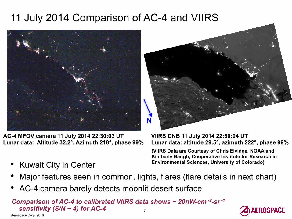
7Aerospace Corp, 2016
Comparison of AC-4 to calibrated VIIRS data shows ~ 20nW-cm -2-sr -1
sensitivity (S/N ~ 4) for AC-4
N
11 July 2014 Comparison of AC-4 and VIIRS
(VIIRS Data are Courtesy of Chris Elvidge, NOAA and Kimberly Baugh, Cooperative Institute for Research in Environmental Sciences, University of Colorado).
VIIRS DNB 11 July 2014 22:50:04 UT Lunar data: altitude 29.5°, azimuth 222°, phase 99%
AC-4 MFOV camera 11 July 2014 22:30:03 UTLunar data: Altitude 32.2°, Azimuth 218°, phase 99%
• Kuwait City in Center• Major features seen in common, lights, flares (flare details in next chart)• AC-4 camera barely detects moonlit desert surface

8Aerospace Corp, 2016
AC-4 Basra Flares Pre and Post Point-and-Stare Command
• Image chips show detailed look at the Basra area gas flares and illustrate how the point and stare maneuver improves resolution and sensitivity
• Image chips from full frame image are ~ 120 x 120 km
N
~ 5 pixel smear and 7.7 km/sec spacecraft velocity allow calculation of of a camera autoexposure of ~ 0.3 seconds in duration

9Aerospace Corp, 2016
The Persian Gulf Region with Overlaid AeroCube Camera Fields of View
3 Frames from the 11 May 2015 AC-5 NFOV Gulf Flyby Experiment with the Larger 11 July 2014 AC-4 MFOV Camera Footprint Superimposed.

10Aerospace Corp, 2016
Qatar, Bahrain and the Coast of Saudi Arabia – city lights, roads, race track ovals, GSD ~ 130 m
AC-5 Persian Gulf – Qatar, Bahrain 11 May 2015 23:29 UT
N

11Aerospace Corp, 2016
AC-5 Persian Gulf – Kuwait, Iraq Border Flares 11 May 2015 23:30 UT
Kuwait City, Roads in Desert, Rumaila Flares, GSD ~ 130m
N

12Aerospace Corp, 2016
Kuwait City: Comparison of ISS Photography to AC-5
ISS Image 12 Feb 2013 21:52 UT, GSD ~ 20 m
AC-5 Image 28 Jun 2015 22:27 UT GSD ~ 95 m
Space Station nightpod with Nikon D3S (f/2.8 180 mm lens) vs. 1.5 U AeroCube-5 utility camera

13Aerospace Corp, 2016
Development of coastal neighborhood evident in the later AC-5 data
Kuwait City: Comparison of VIIRS, ISS and AC-5
VIIRS detail of Kuwait CityJan 2013 Nightlights Composite742 m GSD
ISS Nightpod Nikon with 180 mm Lens ~ 20 m GSD12 Feb 2013
AeroCube-5NFOV Camera~ 130m GSD11 May 2015
N
* * *

14Aerospace Corp, 2016
Qatar: Comparison of ISS to AC-5
A new racetrack appears in Qatar in the more recent AC-5 image
ISS Nikon with 70 mm Lens ~ 50 m GSD10 Oct 2012
AeroCube-5NFOV Camera~ 130 m GSD11 May 2015
N
*

15Aerospace Corp, 2016
N
AC-5 Beijing and Tianjin 29 April 2015 16:08 UT
Beijing and Tianjin – possible obscuration by thin clouds, airport, transportation corridors evident

16Aerospace Corp, 2016
N
AC-5 Osaka 02 May 2015 15:55 UT
Osaka– AC-5A, Moon is 98% full, thin clouds are barely visible, airport in Osaka Bay is prominent

17Aerospace Corp, 2016
AC-5 Chicago 01 May 2015 05:43 UT
Chicago – urban grid, transportation corridors, Lake Michigan coastline evident
N

18Aerospace Corp, 2016
Philadelphia and New York City 31 October 2015 04:49 UT
N
East Coast of USA – Philadelphia, Newark, NYC, I-95 transportation corridor are evident

19Aerospace Corp, 2016
Future Sensors (near term)
Coming next – a higher resolution camera on AC-7 and CUMULOS, a 3-camera VIS/SWIR/LWIR sensor
Satellite Camera
Lens F#
Lens FL
(mm)
Pixel Pitch (µm)
Nominal Altitude
(km)
GSD (m)
AC-7 (high res) 1.9 34.9 1.67 600 28.7
CUMULOS VIS 1.4 17.6 5.20 600 177
CUMULOS SWIR 1.4 25.0 25 600 600
CUMULOS LWIR 1.1 25.0 17 600 408
• 2 NASA Optical Communication and Sensor Demonstration CubeSats (aka AC-7)• CUMULOS (the CUbesat MULtispectral Observation System) which is hosted on the NASA ISARA
(Integrated Solar Array and Reflectarray Antenna) CubeSat• All are scheduled to launch on a Falcon-9 v1.1 rocket along with Formosat-5 and a number of other
CubeSat payloads. The launch is currently scheduled for 18 December 2016. • These camera payloads will add to our ability to research the Earth at night from CubeSat platforms.

20Aerospace Corp, 2016
References• Elvidge, C. D., Ziskin, D., Baugh, K. E., Tuttle, B. T., Ghosh, T., Pack, D. W., Erwin, E. H., Zhizhin, M., "A Fifteen Year Record of Global Natural
Gas Flaring Derived from Satellite Data”, Energies, vol. 2, no. 3, 2009.• Elvidge, C.D, Zhizhin, M., Baugh, K., Hsu, F.-C., Ghosh, T., “Methods for Global Survey of Natural Gas Flaring from Visible Infrared Imaging
Radiometer Suite Data”, Energies, vol. 9, January 2016.• Miller, S.D, Mill, S.P., Elvidge, C.D., Lindsey, D. T., Lee, T.F., Hawkins, J.D., “Suomi Satellite Brings to Light a Unique Frontier of Nighttime
Environmental Sensing Capabilities”, Proceedings of the National Academy of Sciences, vol. 109, no. 39, September, 2012.• Miller, S.D., Straka III, W., Mills, S., Elvidge, C., Lee, T., Solbrig, J., Walther, A., Heidinger, A., Weiss, S., “Illuminating the Capabilities of the Suomi
National Polar-Orbiting Partnership (NPP) Visible Infrared Imaging Radiometer Suite (VIIRS) Day/Night Band”, Remote Sensing, vol. 5, 2013.• Elvidge, C.D.; Hsu, F.-C.; Baugh, K.; Ghosh, T., “Why VIIRS data are superior to DMSP for mapping nighttime lights”, Proceedings of the Asia-
Pacific Advanced Network v. 35, 2013.• Elvidge, C.D.; Hsu, F.-C.; Baugh, K.; Ghosh, T., “National Trends in Satellite Observed Lighting: 1992–2012”, In Global Urban Monitoring and
Assessment through Earth Observation; Weng, Q., Ed.; CRC Press: Boca Raton, FL, USA, pp. 97–120, 2014. • Rowen, D and Dolphus,R. 3-axis attitude determination and control of the AeroCube-4 cubesats. In AIAA/USU Conference on Small Satellites, 10th
Annual CubeSat Developers' Workshop, 2013.• Gangestad, J.W., Rowen, D.W. and Hardy, B.S., “Forest Fires, Sunglint, and a Solar Eclipse: Responsive Remote Sensing with AeroCube-4”,
Geoscience and Remote Sensing Symposium (IGARSS), IEEE, Quebec City, Canada, July 2014.• Gangestad, J.W., Rowen, D.W. and Hardy, B.S., "Along for the Ride: Experience with Flexible Mission Design for CubeSats”, Proceedings of the
AIAA/AAS Astrodynamics Specialist Conference, SPACE Conferences and Exposition, San Diego, CA, August, 2014.• Gangestad, J.W., Rowen, D.W., Hardy, B.S. and Hinkley, D.A., “Flying in a Cloud of CubeSats: Lessons Learned from AeroCube-4, -5 and -6”,
Proceedings of the 65 International Astronautical Congress, Toronto, Canada, September, 2014.• Elvidge, C.D, Cinzano, P., Pettit, D.R., Arvesen, J., Sutton, P., Small, C., Nemani, R., Longcore, T., Rich, C., Safran, J., Weeks, J, Ebener, S. “The
Nightsat Mission Concept”, International Journal of Remote Sensing, vol. 28, No. 12, May 2007.• Kyba, C.C.M., Garz, S. Kuechly, H., De Miguel, S.A., Zamorano, J., Fischer, J., Hölker, F., “High-Resolution Imagery of Earth at Night: New
Sources, Opportunities and Challenges”, Remote Sensing, vol. 7, January 2015• All photographs taken from the International Space Station and their meta data are available at “The Gateway to Astronaut Photography of Earth”,
which is run by NASA: http://eol.jsc.nasa.gov.• De Miguel, S.A.; Castaño, J.G.; Zamorano, J.; Kyba, C.C.M.; Pascual, S.; Ángeles, M.; Cayuela, L.; Martin Martinez, G.; Caltner, P., “Atlas of
astronaut photos of Earth at night” Astronomy and Geophysics, vol. 55, no. 4 August 2014. This helpful Atlas to nighttime ISS photography is described by Kyba et. al. in reference 11 and online at: http://www.citiesatnight.org, and http://www.nightcitiesiss.org/
• Janson, S.W., Welle, R., Rose, T., Rowen, D., Hinkley, D., Hardy, B. La Lumondiere, S., Maul, G., Werner, N. “The NASA Optical Communication and Sensors Demonstration Program: Preflight Update”, Proceedings of the 29th Annual AIAA/USU Conference on Small Satellites, Logan, Utah, USA, August, 2015.