decision support briefing hurricane dorian · decision support briefing • hurricane dorian is...
TRANSCRIPT
Decision Support Briefing
Hurricane Dorian
1:21 PM ETMonday, September 2,
2019
NWSSERFC @NWSSERFC
Issued:
Weather Ready Nation

weather.gov/serfcNWSSERFC
Key Points Southeast River Forecast CenterIssued September 2, 2019 1:21 PM ET
Decision Support Briefing
• Hurricane Dorian is nearly stationary. Models continue to
indicate a northerly track along the Florida coast for the next
couple of days and then up the Atlantic coast through the end
of the week.
• Rainfall associated with the storm along the east coast from
Florida through North Carolina needs to be monitored closely
because small shifts in the storm path will change the
impacts.
• Mostly below normal rainfall over Carolinas and Virginia will
help the area. Based on the current track, significant
flooding does not seem likely, but is still possible. Stay tuned.

weather.gov/serfcNWSSERFC
Latest Weather Condition Southeast River Forecast CenterIssued September 2, 2019 1:21 PM ET
Rainfall over the southeast U.S. will
be associated with Hurricane Dorian
as it moves along the east coast.
Depending on how close Dorian gets
to the east coast, that will determine
where there might be excessive
rainfall.
Please continue to watch for
changes to the forecast and prepare
for heavy rain.
Decision Support Briefing
weather.gov/serfcNWSSERFC
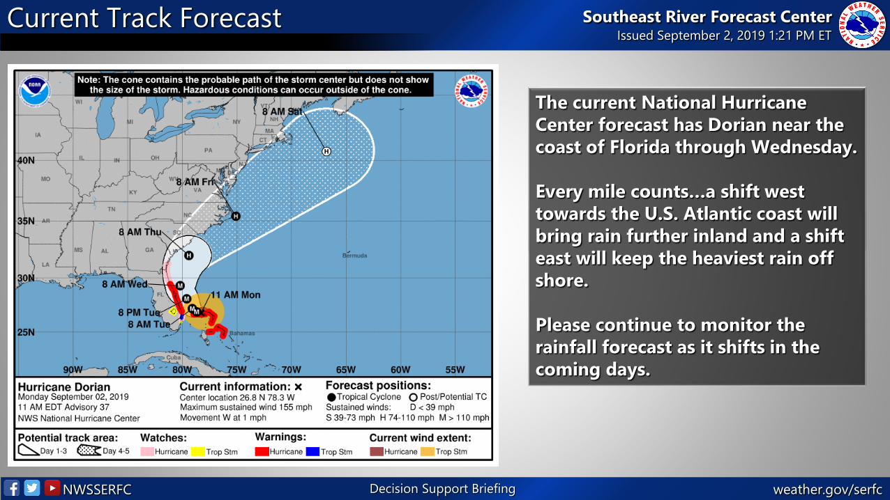
Current Track Forecast Southeast River Forecast CenterIssued September 2, 2019 1:21 PM ET
The current National Hurricane
Center forecast has Dorian near the
coast of Florida through Wednesday.
Every mile counts…a shift west
towards the U.S. Atlantic coast will
bring rain further inland and a shift
east will keep the heaviest rain off
shore.
Please continue to monitor the
rainfall forecast as it shifts in the
coming days.
Decision Support Briefing
weather.gov/serfcNWSSERFC
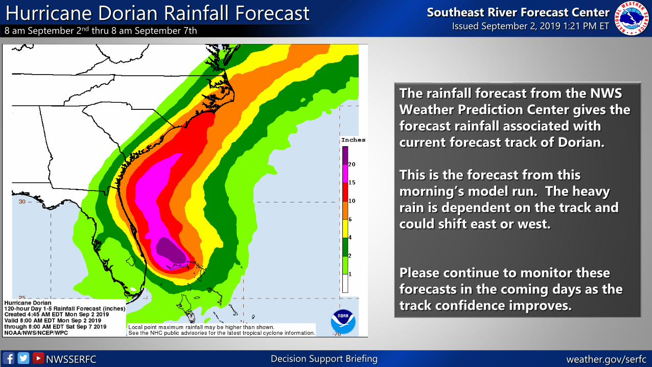
Hurricane Dorian Rainfall Forecast8 am September 2nd thru 8 am September 7th
Southeast River Forecast CenterIssued September 2, 2019 1:21 PM ET
Decision Support Briefing
The rainfall forecast from the NWS
Weather Prediction Center gives the
forecast rainfall associated with
current forecast track of Dorian.
This is the forecast from this
morning’s model run. The heavy
rain is dependent on the track and
could shift east or west.
Please continue to monitor these
forecasts in the coming days as the
track confidence improves.
weather.gov/serfcNWSSERFC
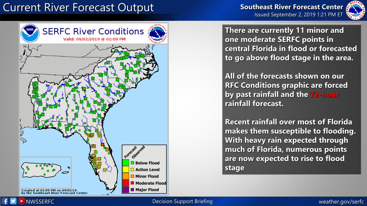
Current River Forecast Output Southeast River Forecast CenterIssued September 2, 2019 1:21 PM ET
Decision Support Briefing
There are currently 11 minor and
one moderate SERFC points in
central Florida in flood or forecasted
to go above flood stage in the area.
All of the forecasts shown on our
RFC Conditions graphic are forced
by past rainfall and the 72-hour
rainfall forecast.
Recent rainfall over most of Florida
makes them susceptible to flooding.
With heavy rain expected through
much of Florida, numerous points
are now expected to rise to flood
stage
weather.gov/serfcNWSSERFC
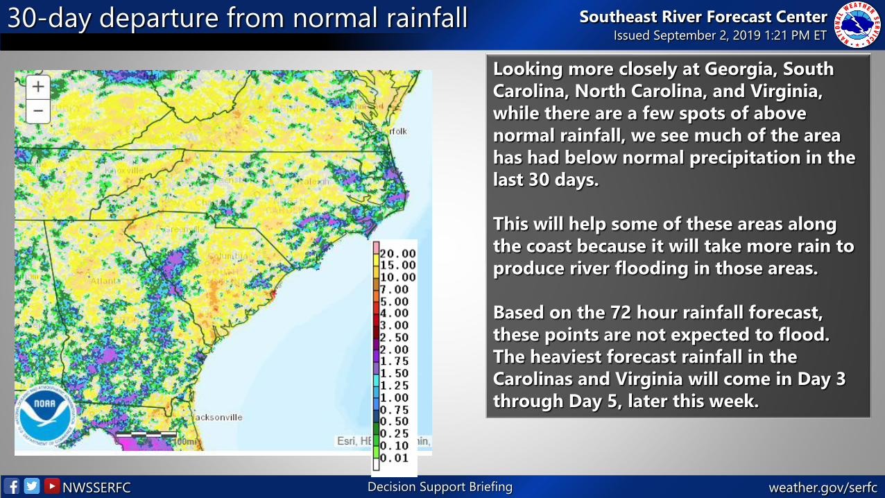
30-day departure from normal rainfall Southeast River Forecast CenterIssued September 2, 2019 1:21 PM ET
Decision Support Briefing
Looking more closely at Georgia, South
Carolina, North Carolina, and Virginia,
while there are a few spots of above
normal rainfall, we see much of the area
has had below normal precipitation in the
last 30 days.
This will help some of these areas along
the coast because it will take more rain to
produce river flooding in those areas.
Based on the 72 hour rainfall forecast,
these points are not expected to flood.
The heaviest forecast rainfall in the
Carolinas and Virginia will come in Day 3
through Day 5, later this week.

weather.gov/serfcNWSSERFC
Significant River Flood Outlook and MMEFSMMEFS (Meteorological Model Ensemble Forecast System)
Southeast River Forecast CenterIssued September 2, 2019 1:21 PM ET
Decision Support Briefing
The Meteorological Model Ensemble Forecast is shown here. This information is based on GEFS ensemble model runs. It provides an indication of where flooding is possible and likely in the coming week. The MMEFS output helps the SERFC to create the Significant River Flood Outlook Product To take a closer look, here is the link to more detailed information:https://www.weather.gov/erh/mmefs
weather.gov/serfcNWSSERFC
SERFC Operational StatusNormal Operating Hours
Southeast River Forecast CenterIssued September 2, 2019 1:21 PM ET
Decision Support Briefing
• SERFC will is on normal operating hours. Normal hours are 6 am to 10 pm
EDT. Please contact us if you have any questions or concerns.
• The Decision Support Briefing will continue until further notice.
Please send all operational correspondence [email protected] or call the office directly.
weather.gov/serfcNWSSERFC
Key PointsDecision Support Briefing.
Southeast River Forecast CenterIssued September 2, 2019 1:21 PM ET
Decision Support Briefing
Latest Radar SERFC Quick Brief
Latest Forecast
RainfallMMEFS – Ensemble River Forecasts
weather.gov/serfcNWSSERFC
Key PointsDecision Support Briefing.
Southeast River Forecast CenterIssued September 2, 2019 1:21 PM ET
Decision Support Briefing
• The Decision Support briefing will continue tomorrow to update you on current conditions and changesto the forecast.
• These slides are intended for your use. Please feel free to share these with others. If you have anyquestions please email [email protected] or contact your local NWS Weather Forecast Office.
• Remember: SERFC briefings cover freshwater flooding. For information on coastal and tidal flooding,flash floods, winds, and severe weather risks, please contact your local Weather Forecast Office.