deliberate search for stratigraphic traps within oligocene ...spgindia.org/spg_2012/spgp275.pdf ·...
TRANSCRIPT
GEOPIC, Oil and Natural Gas Corporation Ltd, Dehradun.
P-275
Deliberate Search for Stratigraphic Traps within Oligocene Sediments of
Central Graben in the Western Offshore Basin, India.
S.K.Biswal *, Harilal, H.S.Vachak, D.S.Rawat, S.Bhagat, A.Bharsakale & A.K.Tandon, ONGC
Summary
Western Offshore Basin is the largest petroliferous province situated in the west coast of India. It is a matured basin
and most of the structural plays whether big or small, have been identified and drilled. It is felt that the remaining
hydrocarbon potential of this basin lies within the stratigraphic traps. The present study attempts to bring out potential
stratigraphic traps within the lows and Central Graben was chosen as the best target for exploration of stratigraphic
traps.
Standard interpretation workflows like log correlation, well-to-seismic calibration, correlation of horizons and faults, 3-
D seismic attribute extraction, spectral decomposition, post stack inversion, 3 -D visualization and geobody detection were
adopted for the identification of stratigraphic features. From the regional log correlation presence of channel sands within
Oligocene sediments towards north were established. Very high amplitude reflections are observed on the vertical seismic
sections and these high amplitude attributes forms channel like features on the maps. After integrating all the geological an d
geophysical data, the study has identified many meandering channels within Oligocene deposits embedded within the thick
shale deposits. Analysis of Paleo-structural disposition and provenance of the sediments during the time of deposition
supports the presence of coarser clastics within these interpreted channels.
Central Graben is the main depocenter during the Tertiary time and had received more than 6 Km thick siliciclastic and
carbonate sediments from south, east and north. Few thin carbonate/sand layers within thick shales are found to be
hydrocarbon bearing in this area, which have produced small quantity of hydrocarbon in two drilled wells. To the west and
southwest of this low is the platform areas where huge structural traps are proved to be hydrocarbon producers
from the carbonate reservoirs. It is an established fact that the Eocene shales have very good source potential and Central
Graben is probably the main kitchen which has charged the platform structures. These identified channels with coarser
clastics are embedded within the thick shales of Oligocene age. Considering the nature of anomaly, paleostructural
disposition, seismic attribute studies, presence of source rocks and seal, stratigraphic entrapment condition favours the
accumulation of hydrocarbons within the mapped channel sands.
Introduction
The Western Continental margin of India hosts three major
petroliferous basins viz. Kutch–Saurashtra, Western
Offshore and Kerala–Konkan basins. The Western Offshore
Basin is the largest producing basin and is in the mature
stage of exploration. Majority of the structural plays have
already been drilled and oil and gas fields are established. In
search of yet to find hydrocarbon within the basin,
stratigraphic plays have become the main target of
exploration in this basin. The present study is primarily
focused for identification of stratigraphic traps within the
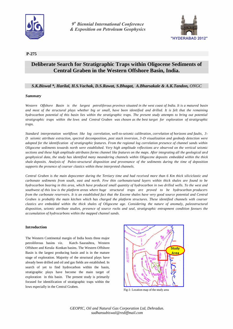
lows especially in the Central Graben. Fig-1: Location map of the study area
2
Deliberate Search for Stratigraphic Traps within Oligocene
Sediments of Central Graben in the Western Offshore Basin,
India.
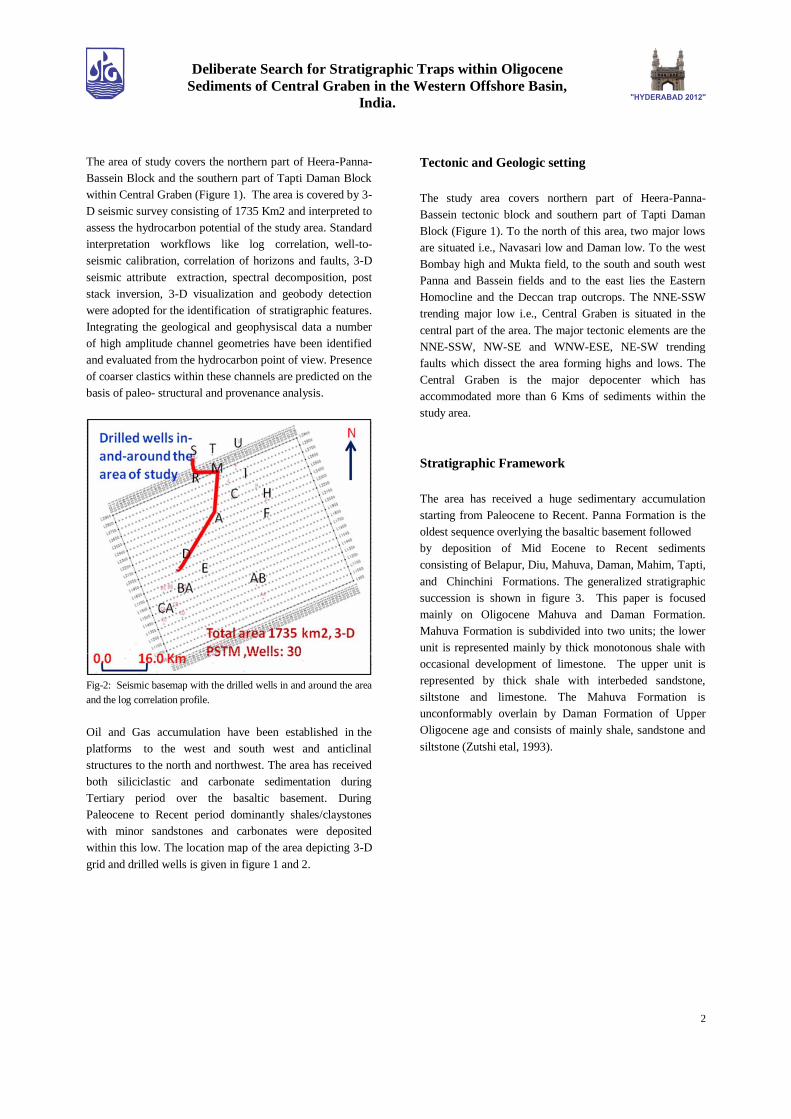
The area of study covers the northern part of Heera-Panna-
Bassein Block and the southern part of Tapti Daman Block
within Central Graben (Figure 1). The area is covered by 3-
D seismic survey consisting of 1735 Km2 and interpreted to
assess the hydrocarbon potential of the study area. Standard
interpretation workflows like log correlation, well-to-
seismic calibration, correlation of horizons and faults, 3-D
seismic attribute extraction, spectral decomposition, post
stack inversion, 3-D visualization and geobody detection
were adopted for the identification of stratigraphic features.
Integrating the geological and geophysiscal data a number
of high amplitude channel geometries have been identified
and evaluated from the hydrocarbon point of view. Presence
of coarser clastics within these channels are predicted on the
basis of paleo- structural and provenance analysis.
Fig-2: Seismic basemap with the drilled wells in and around the area
and the log correlation profile.
Oil and Gas accumulation have been established in the
platforms to the west and south west and anticlinal
structures to the north and northwest. The area has received
both siliciclastic and carbonate sedimentation during
Tertiary period over the basaltic basement. During
Paleocene to Recent period dominantly shales/claystones
with minor sandstones and carbonates were deposited
within this low. The location map of the area depicting 3-D
grid and drilled wells is given in figure 1 and 2.
Tectonic and Geologic setting
The study area covers northern part of Heera-Panna-
Bassein tectonic block and southern part of Tapti Daman
Block (Figure 1). To the north of this area, two major lows
are situated i.e., Navasari low and Daman low. To the west
Bombay high and Mukta field, to the south and south west
Panna and Bassein fields and to the east lies the Eastern
Homocline and the Deccan trap outcrops. The NNE-SSW
trending major low i.e., Central Graben is situated in the
central part of the area. The major tectonic elements are the
NNE-SSW, NW-SE and WNW-ESE, NE-SW trending
faults which dissect the area forming highs and lows. The
Central Graben is the major depocenter which has
accommodated more than 6 Kms of sediments within the
study area.
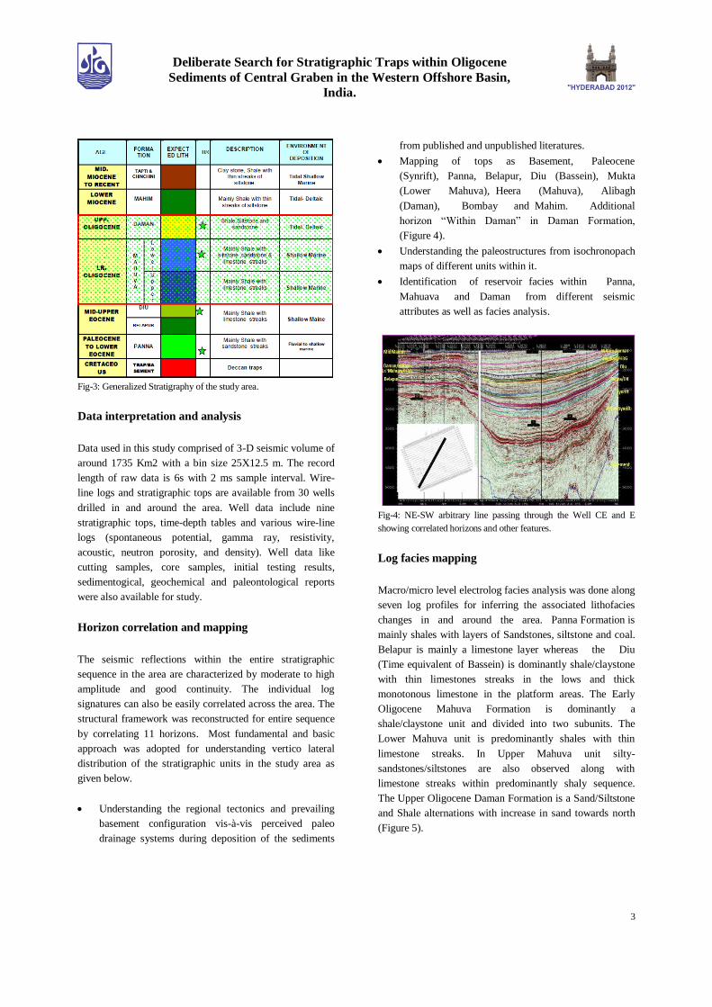
Stratigraphic Framework
The area has received a huge sedimentary accumulation
starting from Paleocene to Recent. Panna Formation is the
oldest sequence overlying the basaltic basement followed
by deposition of Mid Eocene to Recent sediments
consisting of Belapur, Diu, Mahuva, Daman, Mahim, Tapti,
and Chinchini Formations. The generalized stratigraphic
succession is shown in figure 3. This paper is focused
mainly on Oligocene Mahuva and Daman Formation.
Mahuva Formation is subdivided into two units; the lower
unit is represented mainly by thick monotonous shale with
occasional development of limestone. The upper unit is
represented by thick shale with interbeded sandstone,
siltstone and limestone. The Mahuva Formation is
unconformably overlain by Daman Formation of Upper
Oligocene age and consists of mainly shale, sandstone and
siltstone (Zutshi etal, 1993).
3
Deliberate Search for Stratigraphic Traps within Oligocene
Sediments of Central Graben in the Western Offshore Basin,
India.
Fig-3: Generalized Stratigraphy of the study area.
Data interpretation and analysis
Data used in this study comprised of 3-D seismic volume of
around 1735 Km2 with a bin size 25X12.5 m. The record
length of raw data is 6s with 2 ms sample interval. Wire-
line logs and stratigraphic tops are available from 30 wells
drilled in and around the area. Well data include nine
stratigraphic tops, time-depth tables and various wire-line
logs (spontaneous potential, gamma ray, resistivity,
acoustic, neutron porosity, and density). Well data like
cutting samples, core samples, initial testing results,
sedimentogical, geochemical and paleontological reports
were also available for study.
Horizon correlation and mapping
The seismic reflections within the entire stratigraphic
sequence in the area are characterized by moderate to high
amplitude and good continuity. The individual log
signatures can also be easily correlated across the area. The
structural framework was reconstructed for entire sequence
by correlating 11 horizons. Most fundamental and basic
approach was adopted for understanding vertico lateral
distribution of the stratigraphic units in the study area as
given below.
Understanding the regional tectonics and prevailing
basement configuration vis-à-vis perceived paleo
drainage systems during deposition of the sediments
from published and unpublished literatures.
Mapping of tops as Basement, Paleocene
(Synrift), Panna, Belapur, Diu (Bassein), Mukta
(Lower Mahuva), Heera (Mahuva), Alibagh
(Daman), Bombay and Mahim. Additional
horizon “Within Daman” in Daman Formation,
(Figure 4).
Understanding the paleostructures from isochronopach
maps of different units within it.
Identification of reservoir facies within Panna,
Mahuava and Daman from different seismic
attributes as well as facies analysis.
Fig-4: NE-SW arbitrary line passing through the Well CE and E
showing correlated horizons and other features.
Log facies mapping
Macro/micro level electrolog facies analysis was done along
seven log profiles for inferring the associated lithofacies
changes in and around the area. Panna Formation is
mainly shales with layers of Sandstones, siltstone and coal.
Belapur is mainly a limestone layer whereas the Diu
(Time equivalent of Bassein) is dominantly shale/claystone
with thin limestones streaks in the lows and thick
monotonous limestone in the platform areas. The Early
Oligocene Mahuva Formation is dominantly a
shale/claystone unit and divided into two subunits. The
Lower Mahuva unit is predominantly shales with thin
limestone streaks. In Upper Mahuva unit silty-
sandstones/siltstones are also observed along with
limestone streaks within predominantly shaly sequence.
The Upper Oligocene Daman Formation is a Sand/Siltstone
and Shale alternations with increase in sand towards north
(Figure 5).

4
Deliberate Search for Stratigraphic Traps within Oligocene
Sediments of Central Graben in the Western Offshore Basin,
India.
Fig-5: Electrolog correlation along well R, P, O, M, B and D The
profile is Flattened at DamanTop. The correlation profile is shown in
the figure 2.
Seismic Attributes Study
The mapped sedimentary column was analysed by
extracting seismic attributes within sequences and within
time windows with reference to mapped horizons,
computing horizon slices of attributes and seismic trace
data. 3-D visualization, seismic inversion, spectral
decomposition and geobody detection, were attempted to
understand the spatial and temporal distribution of the facies
and identification of the stratigraphic features within the
identified intervals.
Identification of Stratigraphic features
Sand filled channels, point bars within Lower
Oligocene Mahuva Formation
Within Mahuva Formation at top of Lower Mahuva
reflector, meandering channel (Point bar) like features are
mapped from high amplitude anomaly (Figure 6). This
channel is very distinct on seismic sections.
Fig-6: Maximum Positive Amplitude within 20-50ms above Lower
Mahuva showing the Meander Channel & Point Bars.
High positive amplitude may be generated from carbonate-
clastics (sands and/or shales) interface. However,
characteristic meandering geometry and point bar favour
coarser clastics (sandstone). Occurrence of sandstone layers
over the Lower-Mahuva shales are known in nearby drilled
wells towards north (Figure 5). Thus, relatively wider
channel is envisaged to be filled with good reservoir sands
and forming stratigraphic traps.
Fig-7: Horizon slice at 6 ms above Lower Mahuva top showing the
meander channels.
Another channel manifested by high amplitude anomaly at
the top of lower-Mahuva reflector (Figure 7), mapped from
the horizon slice of reflection strength taken at 6 ms above
Lower-Mahuva Top. Log interpretation of well M around
Lower-Mahuva top surface shows that thin sandstones are
embedded in relatively thicker limestone. Sandstones have
lower impedance than limestone and under favourable
5
Deliberate Search for Stratigraphic Traps within Oligocene
Sediments of Central Graben in the Western Offshore Basin,
India.
conditions (thicker layer or higher frequency)
limestone/sandstone interface (high to low impedance) may
generate high positive reflection as seen in this case. Using
this analogy and channel like geometry, it is inferred that
mapped high amplitude channel-like anomaly is generated
from limestone-sandstone interface.
Fig-8: Horizon Slice at 20 ms above the Lower Mahuva showing the
meander channels with ox-bow, chute cutoff and river capture.
Another channel system is identified by low amplitude
anomaly at the top of Lower-Mahuva reflector, mapped
from the horizon slice of reflection strength taken at 20 ms
above Lower-Mahuva Top (Figure 8). This anomaly
exhibits meandering channel geometry along with chute-
cut-off, river capture and ox-bow features. Reservoir
quality rocks are expected to be filled within this channel.
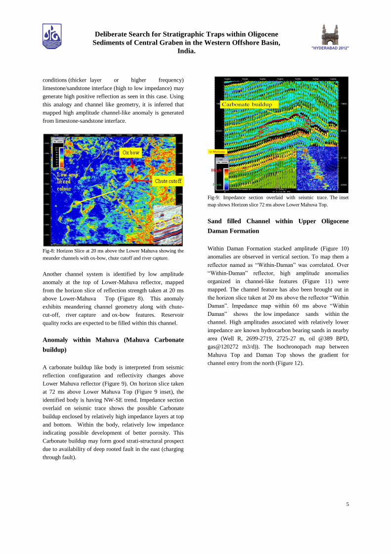
Anomaly within Mahuva (Mahuva Carbonate
buildup)
A carbonate buildup like body is interpreted from seismic
reflection configuration and reflectivity changes above
Lower Mahuva reflector (Figure 9). On horizon slice taken
at 72 ms above Lower Mahuva Top (Figure 9 inset), the
identified body is having NW-SE trend. Impedance section
overlaid on seismic trace shows the possible Carbonate
buildup enclosed by relatively high impedance layers at top
and bottom. Within the body, relatively low impedance
indicating possible development of better porosity. This
Carbonate buildup may form good strati-structural prospect
due to availability of deep rooted fault in the east (charging
through fault).
Fig-9: Impedance section overlaid with seismic trace. The inset
map shows Horizon slice 72 ms above Lower Mahuva Top.
Sand filled Channel within Upper Oligocene
Daman Formation
Within Daman Formation stacked amplitude (Figure 10)
anomalies are observed in vertical section. To map them a
reflector named as “Within-Daman” was correlated. Over
“Within-Daman” reflector, high amplitude anomalies
organized in channel-like features (Figure 11) were
mapped. The channel feature has also been brought out in
the horizon slice taken at 20 ms above the reflector “Within
Daman”. Impedance map within 60 ms above “Within
Daman” shows the low impedance sands within the
channel. High amplitudes associated with relatively lower
impedance are known hydrocarbon bearing sands in nearby
area (Well R, 2699-2719, 2725-27 m, oil @389 BPD,
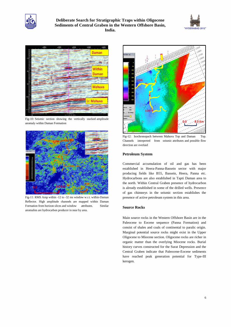
gas@120272 m3/d)). The Isochronopach map between
Mahuva Top and Daman Top shows the gradient for
channel entry from the north (Figure 12).
6
Deliberate Search for Stratigraphic Traps within Oligocene
Sediments of Central Graben in the Western Offshore Basin,
India.
Fig-10: Seismic section showing the vertically stacked amplitude
anomaly within Daman Formation
Fig-11: RMS Amp within -12 to -32 ms window w.r.t. within-Daman
Reflector. High amplitude channels are mapped within Daman
Formation from horizon slices and window attributes. Similar
anomalies are hydrocarbon producer in near by area.
Fig-12: Isochronopach between Mahuva Top and Daman Top.
Channels interpreted from seismic attributes and possible flow
direction are overlaid
Petroleum System
Commercial accumulation of oil and gas has been
established in Heera-Panna-Bassein sector with major
producing fields like B55, Bassein, Heera, Panna etc.
Hydrocarbons are also established in Tapti Daman area to
the north. Within Central Graben presence of hydrocarbon
is already established in some of the drilled wells. Presence
of gas chimneys in the seismic section establishes the
presence of active petroleum system in this area.
Source Rocks
Main source rocks in the Western Offshore Basin are in the
Paleocene to Eocene sequence (Panna Formation) and
consist of shales and coals of continental to paralic origin.
Marginal potential source rocks might exist in the Upper
Oligocene to Miocene section. Oligocene rocks are richer in
organic matter than the overlying Miocene rocks. Burial
history curves constructed for the Surat Depression and the
Central Graben indicate that Paleocene-Eocene sediments
have reached peak generation potential for Type-III
kerogen.

7
Deliberate Search for Stratigraphic Traps within Oligocene
Sediments of Central Graben in the Western Offshore Basin,
India.
Maturation
Synthesis of thermal maturity parameters reveals that the
sediments of Panna Formation attained adequate thermal
maturity for commercial generation of hydrocarbons in the
area. High geothermal gradients have compensated for a
modest overburden which is provided by the Middle
Eocene to Middle Miocene age sediments in the Surat Sub-
basin and the Lower Oligocene to Recent fill in the Central
Graben. Oil generation is reported to be from Late Early
Miocene time and is also in the process of active generation
till recent times.
Reservoirs
Oligocene sandstones, siltstones and limestones of the
Mahuva Formation and Daman Formations deposited in the
identified channels and reefal builups are expected to be
good reservoirs for hosting hydrocarbon. Similar channels
in the north are good reservoirs and is hydrocarbon bearing.
Seals
The identified channels are enclosed within thick shales
which act as both vertical and lateral seals. The limestone of
reefal build ups are expected to have embedded within the
thick Oligocene shales. Middle Miocene to Holocene shales
of Chinchini Formation constitutes the most widespread
regional seal facies in the basin.
Conclusions
Integrated evaluation of 3D seismic data has brought out
many high amplitude channel features and reefal buildups
within Oligocene sequences. Additional studies like
spectral decomposition, post stack inversion, 3-D
visualization and geobody detection, were adopted for
further conforming the identified stratigraphic features.
Central Graben is the main depositional low and a proved
kitchen for the hydrocarbon accumulation in the
surrounding areas. These stratigraphic features located
within the main kitchen and associated with excellent
vertical and lateral seals like clays and shales favours the
stratigraphic entrapment for hydrocarbon accumulation in
this low. Thus, deliberate search for stratigraphic features in
Central Graben may provide fruitful results.
Acknowledgements
Authors express their sincere gratitude to Director (E),
ONGC, India, for according permission for publication of
this paper. The authors are thankful to ED-HOI-GEOPIC
for assigning the project and providing valuable guidance.
The views expressed in this paper are exclusively of the
authors and need not necessarily match with official views
of ONGC.
References
Singh Gita, Sharma S.P., Roymoulik S.K, 2001, Study of
Panna and Bassein Formations in the area east of Bassein
Field to map prospective areas, Unpublished ONGC report,
KDMIPE, ONGC, Dehradun.
Zutsi P.L, Anil sood, Mohapatra P., Ramani KKV, Driwedi
Srivastava H.C,Lithostratigraphy of Indian Petroliferous
basins, Bombay Offshore Basin,KDMIPE,1993.