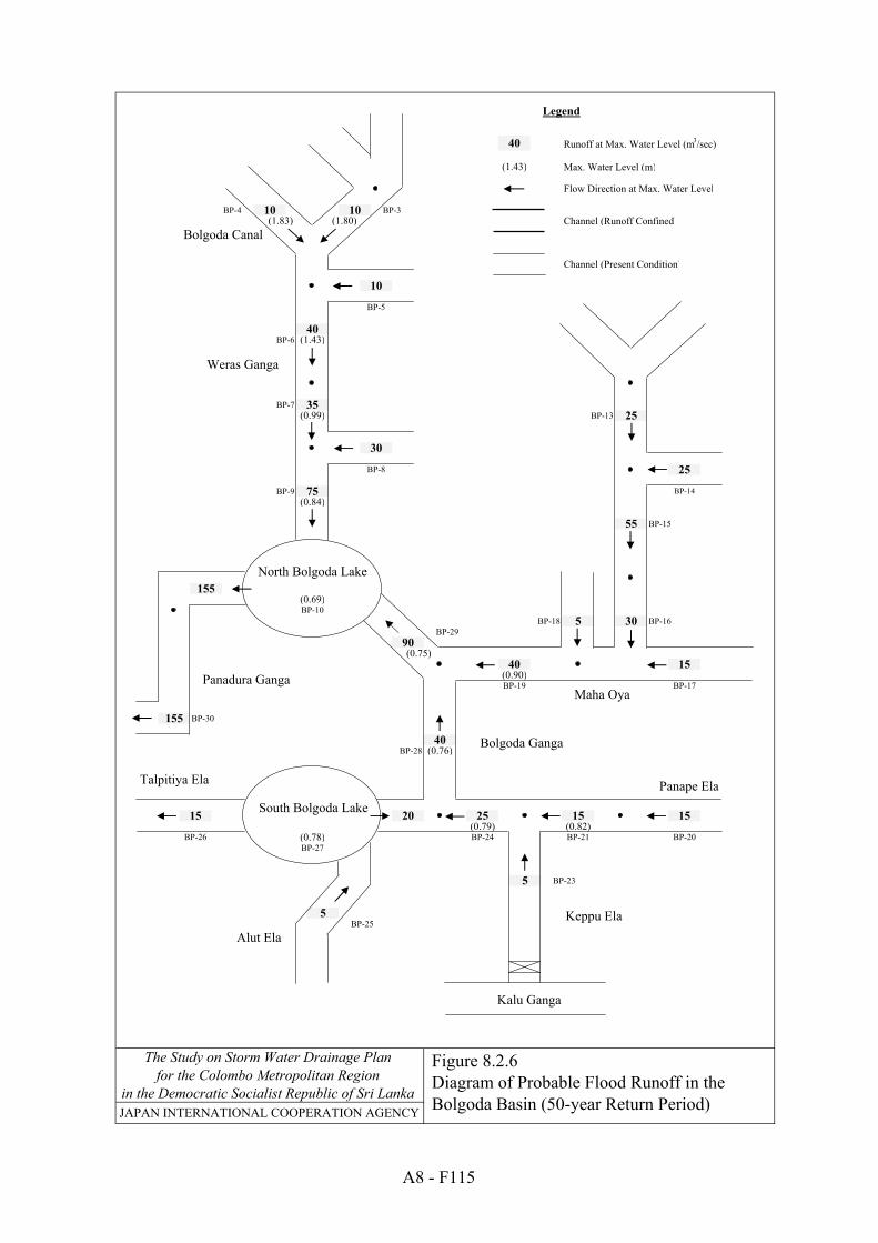
diagram of probable flood runoff in the bolgoda basin (10
TRANSCRIPT

Runoff at Max. Water Level (m3/sec)
Max. Water Level (m)
Flow Direction at Max. Water Level
BP-4 BP-3Channel (Runoff Confined)
Channel (Present Condition)
BP-6
BP-7BP-13
BP-9
BP-15
BP-18 BP-16BP-29
BP-30
BP-28
BP-23
BP-25
130
20
(1.46)
15
50
(1.45)
101520
35(0.64)
30
15
10(0.72)
BP-14
BP-17BP-19
20
70
5
(0.66)
(0.59)
(0.67)
5
10
5
BP-8
BP-10
(0.77)
(1.12)
5
BP-26BP-27
JAPAN INTERNATIONAL COOPERATION AGENCY
The Study on Storm Water Drainage Planfor the Colombo Metropolitan Region
in the Democratic Socialist Republic of Sri Lanka
25
(1.12)
10
130
20
25
25
10
(0.63)
BP-5
30
BP-21 BP-20BP-24(0.68)(0.66)
Bolgoda Canal
Weras Ganga
Maha Oya
South Bolgoda Lake
Alut ElaKeppu Ela
Panape Ela
Kalu Ganga
Figure 8.2.4Diagram of Probable Flood Runoff in the Bolgoda Basin (10-year Return Period)
Talpitiya Ela
Panadura Ganga
Bolgoda Ganga
Legend
North Bolgoda Lake
A8 - F113

Runoff at Max. Water Level (m3/sec)
Max. Water Level (m)
Flow Direction at Max. Water Level
BP-4 BP-3Channel (Runoff Confined)
Channel (Present Condition)
BP-6
BP-7BP-13
BP-9
BP-15
BP-18 BP-16BP-29
BP-30
BP-28
BP-23
BP-25
40
BP-21 BP-20BP-24(0.76)(0.73)
30
(1.29)
10
145
25
30
30
10
(0.69)
BP-5
5
BP-26BP-27
JAPAN INTERNATIONAL COOPERATION AGENCY
The Study on Storm Water Drainage Planfor the Colombo Metropolitan Region
in the Democratic Socialist Republic of Sri Lanka
(0.76)
5
10
10
BP-8
BP-10
(0.89)
(1.29)
80
5
(0.72)
(0.64)
40(0.71)
35
20
10(0.82)
BP-14
BP-17BP-19
25
145
20
(1.68)
20
65
(1.65)
101520
Bolgoda Canal
Weras Ganga
Maha Oya
South Bolgoda Lake
Alut ElaKeppu Ela
Panape Ela
Kalu Ganga
Figure 8.2.5Diagram of Probable Flood Runoff in the Bolgoda Basin (25-year Return Period)
Talpitiya Ela
Panadura Ganga
Bolgoda Ganga
Legend
North Bolgoda Lake
A8 - F114
Runoff at Max. Water Level (m3/sec)
Max. Water Level (m)
Flow Direction at Max. Water Level
BP-4 BP-3Channel (Runoff Confined)
Channel (Present Condition)
BP-6
BP-7BP-13
BP-9
BP-15
BP-18 BP-16BP-29
BP-30
BP-28
BP-23
BP-25
155
20
(1.83)
25
75
(1.80)
151525
40(0.76)
40
25
15(0.90)
BP-14
BP-17BP-19
30
90
5
(0.78)
(0.69)
(0.84)
5
10
10
BP-8
BP-10
(0.99)
(1.43)
5
BP-26BP-27
JAPAN INTERNATIONAL COOPERATION AGENCY
The Study on Storm Water Drainage Planfor the Colombo Metropolitan Region
in the Democratic Socialist Republic of Sri Lanka
40
(1.43)
15
155
30
35
40
10
(0.75)
BP-5
55
BP-21 BP-20BP-24(0.82)(0.79)
Bolgoda Canal
Weras Ganga
Maha Oya
South Bolgoda Lake
Alut ElaKeppu Ela
Panape Ela
Kalu Ganga
Figure 8.2.6Diagram of Probable Flood Runoff in the Bolgoda Basin (50-year Return Period)
Talpitiya Ela
Panadura Ganga
Bolgoda Ganga
Legend
North Bolgoda Lake
A8 - F115

JAPAN INTERNATIONAL COOPERATION AGENCY
The Study on Storm Water Drainage Planfor the Colombo Metropolitan Region
in the Democratic Socialist Republic of Sri Lanka
Figure 8.2.7Runoff Hydrograph in Panadura Ganga at Sea Outfall
Panadura Ganga at Sea Outfall
0
50
100
150
200
250
300
0 6 12 18 24 30 36 42 48 54 60Time (Hours)
Run
off (
m3 /s
ec)
Basic FloodProbable Flood
10-year Return Period
175 m3/secVolume 4.90 MCM
130 m3/sec
Panadura Ganga at Sea Outfall
0
50
100
150
200
250
300
0 6 12 18 24 30 36 42 48 54 60
Time (Hours)
Run
off (
m3 /s
ec)
Basic FloodProbable Flood
25-year Return Period
210 m3/sec
Volume 7.17 MCM
145 m3/sec
Panadura Ganga at Sea Outfall
0
50
100
150
200
250
300
0 6 12 18 24 30 36 42 48 54 60
Time (Hours)
Run
off (
m3 /s
ec)
Basic FloodProbable Flood
50-year Return Period245 m3/sec
Volume 8.72 MCM
155 m3/sec
A8 - F116


JAPAN INTERNATIONAL COOPERATION AGENCY
The Study on Storm Water Drainage Planfor the Colombo Metropolitan Region
in the Democratic Socialist Republic of Sri Lanka
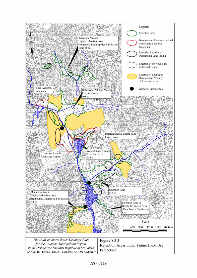
Legend
Retention Area
Expansion Area for Ratmalana Airport
Identified Location of Outstanding Land Filling
Development Plan incorporatedwith Future Land Use Projection
Location of Previous Planwith Land Filling
Garbage Dumping SitePolice AcademyCompound
N
0 400 800 1200 1600 2000 m
Scale
Location of Envisaged Development Vicinity of Retention Area
Belanwilla-Attidiya MarshRetention Area108 ha
Retention Areas in Highly Urbanized Area(Nugegoda-Rattanapitiya Sub-basin)Total 36 ha
Weras Ganga SwampRetention Area65 ha
Retention Area in Highly Urbanized Area(Ratmalana-Moratuwa Sub-basin)23 ha Retention Area in
Highly Urbanized Area(Thumbowila Sub-basin)8 ha
Maha Ela Marsh and LowlandRetention Area132 ha
Boralesgamuwa Theme Park Project Area
Figure 8.3.3Retention Areas under Future Land Use Projection
A8 - F119