driller’s logs 2010 geotechnical...
TRANSCRIPT

Driller’s Logs
2010 Geotechnical Investigation
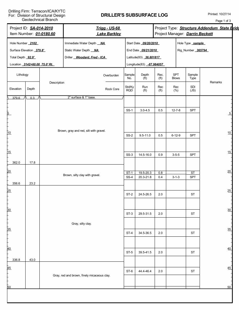
SS-1
SS-2
SS-3
ST-1SS-4
ST-2
ST-3
ST-4
ST-5
ST-6
3.0-4.5
9.5-11.0
14.5-16.0
19.5-20.320.3-21.8
24.5-26.5
29.5-31.5
34.5-36.5
39.5-41.5
44.4-46.4
12-7-8
6-12-9
3-5-5
3-1-3
SPT
SPT
SPT
STSPT
ST
ST
ST
ST
ST
2" surface & 1" base.
Brown, gray and red, silt with gravel.
Brown, silty clay with gravel.
Gray, silty clay.
Gray, red and brown, finely micaceous clay.
379.6
362.0
356.6
336.8
0.3
17.8
23.2
43.0
0.5
0.5
0.9
0.80.4
2.0
2.0
2.0
2.0
2.0
Driller Woodard, Fred - ICA
DRILLER'S SUBSURFACE LOG
Immediate Water Depth NA
Static Water Depth NA
Elevation DepthStd/KyRQD
Lithology
5
10
15
20
25
30
35
40
45
50
5
10
15
20
25
30
35
40
45
50
Depth(ft)
SPTBlows
SampleType
Rec(ft)
Hole Type sample
Rec(%)
Rec.(ft)
SampleNo.
Run(ft)
Description
Overburden
Rock CoreSDI(JS)
Remarks
Rig_Number 365794
Hole Number 2102
Surface Elevation 379.8'
Total Depth 92.9'
End Date 09/21/2010
Latitude(83) 36.801817
Longitude(83) -87.984057
Start Date 09/20/2010
Location 3142+60.00 75.0' Rt.
Printed: 10/27/14
Page 1 of 3
Drilling Firm: Terracon/ICA/KYTCFor: Division of Structural Design Geotechnical Branch
Project Type: Structure Addendum State Bridge
Project Manager: Darrin Beckett
Project ID: SA-014-2010
Item Number: 01-0180.60
Trigg - US-68
Lake Barkley
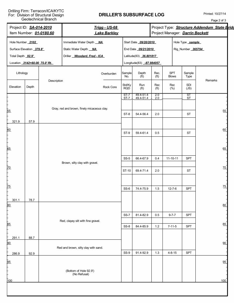
ST-7ST-7
ST-8
ST-9
SS-5
ST-10
SS-6
SS-7
SS-8
SS-9
49.4-51.449.4-51.4
54.4-56.4
59.4-61.4
66.4-67.9
69.4-71.4
74.4-75.9
81.4-82.9
84.4-85.9
91.4-92.9
11-10-11
12-7-6
9-7-7
7-11-5
4-8-15
STST
ST
ST
SPT
ST
SPT
SPT
SPT
SPT
Gray, red and brown, finely micaceous clay.
Brown, silty clay with gravel.
Red, clayey silt with fine gravel.
Red and brown, silty clay with sand.
321.9
301.1
291.1
286.9
57.9
78.7
88.7
92.9
(Bottom of Hole 92.9') (No Refusal)
2.02.0
2.0
0.5
0.4
2.0
1.5
0.5
1.2
1.3
Driller Woodard, Fred - ICA
DRILLER'S SUBSURFACE LOG
Immediate Water Depth NA
Static Water Depth NA
Elevation DepthStd/KyRQD
Lithology
55
60
65
70
75
80
85
90
95
100
55
60
65
70
75
80
85
90
95
100
Depth(ft)
SPTBlows
SampleType
Rec(ft)
Hole Type sample
Rec(%)
Rec.(ft)
SampleNo.
Run(ft)
Description
Overburden
Rock CoreSDI(JS)
Remarks
Rig_Number 365794
Hole Number 2102
Surface Elevation 379.8'
Total Depth 92.9'
End Date 09/21/2010
Latitude(83) 36.801817
Longitude(83) -87.984057
Start Date 09/20/2010
Location 3142+60.00 75.0' Rt.
Printed: 10/27/14
Page 2 of 3
Drilling Firm: Terracon/ICA/KYTCFor: Division of Structural Design Geotechnical Branch
Project Type: Structure Addendum State Bridge
Project Manager: Darrin Beckett
Project ID: SA-014-2010
Item Number: 01-0180.60
Trigg - US-68
Lake Barkley
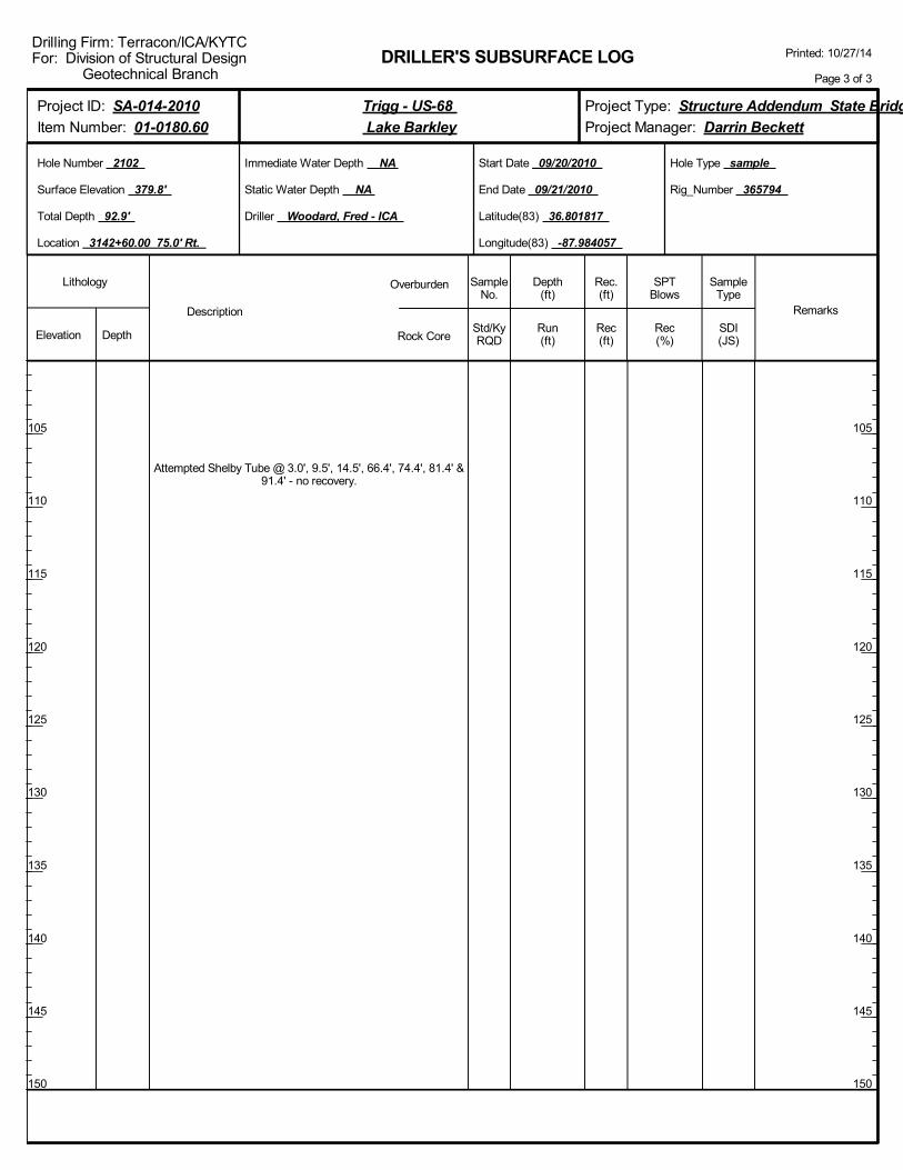
Attempted Shelby Tube @ 3.0', 9.5', 14.5', 66.4', 74.4', 81.4' &91.4' - no recovery.
Driller Woodard, Fred - ICA
DRILLER'S SUBSURFACE LOG
Immediate Water Depth NA
Static Water Depth NA
Elevation DepthStd/KyRQD
Lithology
105
110
115
120
125
130
135
140
145
150
105
110
115
120
125
130
135
140
145
150
Depth(ft)
SPTBlows
SampleType
Rec(ft)
Hole Type sample
Rec(%)
Rec.(ft)
SampleNo.
Run(ft)
Description
Overburden
Rock CoreSDI(JS)
Remarks
Rig_Number 365794
Hole Number 2102
Surface Elevation 379.8'
Total Depth 92.9'
End Date 09/21/2010
Latitude(83) 36.801817
Longitude(83) -87.984057
Start Date 09/20/2010
Location 3142+60.00 75.0' Rt.
Printed: 10/27/14
Page 3 of 3
Drilling Firm: Terracon/ICA/KYTCFor: Division of Structural Design Geotechnical Branch
Project Type: Structure Addendum State Bridge
Project Manager: Darrin Beckett
Project ID: SA-014-2010
Item Number: 01-0180.60
Trigg - US-68
Lake Barkley

SS-1
SS-2
ST-1
ST-2
ST-3
ST-4
ST-5
ST-6
ST-7
ST-8
2.7-4.2
7.7-9.2
14.2-16.2
19.2-21.2
24.2-26.2
29.2-31.2
34.2-36.2
39.2-41.2
44.2-46.2
49.2-51.2
5-7-9
5-1-1
SPT
SPT
ST
ST
ST
ST
ST
ST
ST
ST
Red, brown and gray, clay with gravel.
Brown, clay.
Brown and gray, clay.
363.9
343.9
17.7
37.7
0.5
0.3
1.7
1.7
1.2
1.0
1.0
2.0
2.0
2.0
Driller Woodard, Fred - ICA
DRILLER'S SUBSURFACE LOG
Immediate Water Depth NA
Static Water Depth NA
Elevation DepthStd/KyRQD
Lithology
5
10
15
20
25
30
35
40
45
50
5
10
15
20
25
30
35
40
45
50
Depth(ft)
SPTBlows
SampleType
Rec(ft)
Hole Type sample
Rec(%)
Rec.(ft)
SampleNo.
Run(ft)
Description
Overburden
Rock CoreSDI(JS)
Remarks
Rig_Number 365794
Hole Number 2104
Surface Elevation 381.6'
Total Depth 110.7'
End Date 09/22/2010
Latitude(83) 36.801523
Longitude(83) -87.982977
Start Date 09/22/2010
Location 3146+94.00 65.0' Rt.
Printed: 10/27/14
Page 1 of 3
Drilling Firm: Terracon/ICA/KYTCFor: Division of Structural Design Geotechnical Branch
Project Type: Structure Addendum State Bridge
Project Manager: Darrin Beckett
Project ID: SA-014-2010
Item Number: 01-0180.60
Trigg - US-68
Lake Barkley

ST-8
ST-9
SS-3
SS-4
SS-5
SS-6
SS-7
SS-8
ST-10
ST-11
ST-12
49.2-51.2
54.2-56.2
59.2-60.7
64.2-65.7
69.2-70.7
74.2-75.7
79.2-80.7
84.2-85.7
89.2-91.2
94.2-96.2
99.2-99.5
5-11-10
5-10-8
12-6-5
32-29-23
22-21-18
4-11-11
ST
ST
SPT
SPT
SPT
SPT
SPT
SPT
ST
ST
ST
Brown and gray, clay.
Red and brown, silty clay.
Brown, silty sand with gravel.
Brown, sand with gravel.
Gray, silty sand with gravel.
Gray, silty clay.
Gray, silty clay with gravel.
328.9
323.9
314.1
304.1
294.1
283.9
52.7
57.7
67.5
77.5
87.5
97.7
2.0
2.0
1.0
0.9
1.0
1.1
0.9
1.2
2.0
1.5
0.3
Driller Woodard, Fred - ICA
DRILLER'S SUBSURFACE LOG
Immediate Water Depth NA
Static Water Depth NA
Elevation DepthStd/KyRQD
Lithology
55
60
65
70
75
80
85
90
95
100
55
60
65
70
75
80
85
90
95
100
Depth(ft)
SPTBlows
SampleType
Rec(ft)
Hole Type sample
Rec(%)
Rec.(ft)
SampleNo.
Run(ft)
Description
Overburden
Rock CoreSDI(JS)
Remarks
Rig_Number 365794
Hole Number 2104
Surface Elevation 381.6'
Total Depth 110.7'
End Date 09/22/2010
Latitude(83) 36.801523
Longitude(83) -87.982977
Start Date 09/22/2010
Location 3146+94.00 65.0' Rt.
Printed: 10/27/14
Page 2 of 3
Drilling Firm: Terracon/ICA/KYTCFor: Division of Structural Design Geotechnical Branch
Project Type: Structure Addendum State Bridge
Project Manager: Darrin Beckett
Project ID: SA-014-2010
Item Number: 01-0180.60
Trigg - US-68
Lake Barkley
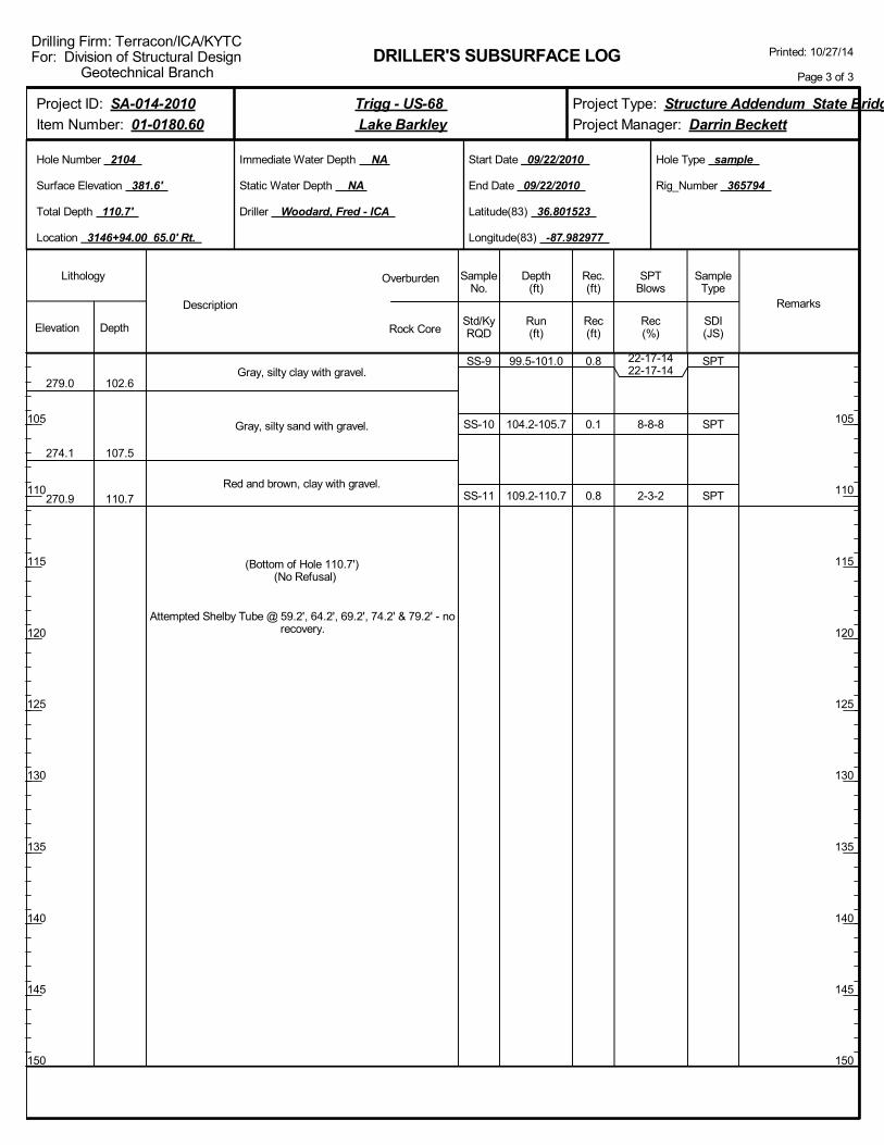
SS-9
SS-10
SS-11
99.5-101.0
104.2-105.7
109.2-110.7
22-17-1422-17-14
8-8-8
2-3-2
SPT
SPT
SPT
Gray, silty clay with gravel.
Gray, silty sand with gravel.
Red and brown, clay with gravel.
279.0
274.1
270.9
102.6
107.5
110.7
(Bottom of Hole 110.7') (No Refusal)
Attempted Shelby Tube @ 59.2', 64.2', 69.2', 74.2' & 79.2' - norecovery.
0.8
0.1
0.8
Driller Woodard, Fred - ICA
DRILLER'S SUBSURFACE LOG
Immediate Water Depth NA
Static Water Depth NA
Elevation DepthStd/KyRQD
Lithology
105
110
115
120
125
130
135
140
145
150
105
110
115
120
125
130
135
140
145
150
Depth(ft)
SPTBlows
SampleType
Rec(ft)
Hole Type sample
Rec(%)
Rec.(ft)
SampleNo.
Run(ft)
Description
Overburden
Rock CoreSDI(JS)
Remarks
Rig_Number 365794
Hole Number 2104
Surface Elevation 381.6'
Total Depth 110.7'
End Date 09/22/2010
Latitude(83) 36.801523
Longitude(83) -87.982977
Start Date 09/22/2010
Location 3146+94.00 65.0' Rt.
Printed: 10/27/14
Page 3 of 3
Drilling Firm: Terracon/ICA/KYTCFor: Division of Structural Design Geotechnical Branch
Project Type: Structure Addendum State Bridge
Project Manager: Darrin Beckett
Project ID: SA-014-2010
Item Number: 01-0180.60
Trigg - US-68
Lake Barkley

SS-1
SS-2
ST-1
ST-2
ST-3
ST-4
ST-5
ST-6
ST-7
3.1-4.6
10.1-11.6
14.6-16.6
19.6-21.6
24.6-26.6
29.6-31.6
36.6-38.6
39.6-41.6
44.6-46.6
4-3-4
4-2-3
SPT
SPT
ST
ST
ST
ST
ST
ST
ST
Red, brown and gray, clay with rock fragments.
Gray, clay.
Gray, clay with coarse sand.
Gray, clay with silt.
Brown, gray and red, clay.
363.8
348.8
342.8
333.8
13.1
28.1
34.1
43.1
1.0
0.2
1.4
2.0
2.0
2.0
2.0
2.0
1.5
Driller Woodard, Fred - ICA
DRILLER'S SUBSURFACE LOG
Immediate Water Depth NA
Static Water Depth NA
Elevation DepthStd/KyRQD
Lithology
5
10
15
20
25
30
35
40
45
50
5
10
15
20
25
30
35
40
45
50
Depth(ft)
SPTBlows
SampleType
Rec(ft)
Hole Type sample
Rec(%)
Rec.(ft)
SampleNo.
Run(ft)
Description
Overburden
Rock CoreSDI(JS)
Remarks
Rig_Number 365794
Hole Number 2105
Surface Elevation 376.9'
Total Depth 96.1'
End Date 09/27/2010
Latitude(83) 36.798520
Longitude(83) -87.971990
Start Date 09/26/2010
Location 3180+91.00 131.0' Rt.
Printed: 10/27/14
Page 1 of 3
Drilling Firm: Terracon/ICA/KYTCFor: Division of Structural Design Geotechnical Branch
Project Type: Structure Addendum State Bridge
Project Manager: Darrin Beckett
Project ID: SA-014-2010
Item Number: 01-0180.60
Trigg - US-68
Lake Barkley

ST-8ST-8
ST-9
ST-10
ST-11
ST-12
SS-3
SS-4
SS-5
SS-6
SS-7
49.6-51.649.6-51.6
54.6-56.6
59.6-61.6
64.6-66.6
69.6-71.6
76.6-78.1
81.6-83.1
84.6-86.1
89.6-91.1
94.6-96.1
2-3-2
1-4-6
28-30-30
23-27-32
11-14-14
STST
ST
ST
ST
ST
SPT
SPT
SPT
SPT
SPT
Brown, gray and red, clay.
Gray, clayey silt.
Brown, silty fine sand.
Brown and gray, fine sand.
Brown, sand with gravel.
318.8
313.8
302.8
293.0
280.8
58.1
63.1
74.1
83.9
96.1
0.60.6
2.0
1.2
2.0
2.0
0.6
1.0
1.2
1.5
0.8
Driller Woodard, Fred - ICA
DRILLER'S SUBSURFACE LOG
Immediate Water Depth NA
Static Water Depth NA
Elevation DepthStd/KyRQD
Lithology
55
60
65
70
75
80
85
90
95
100
55
60
65
70
75
80
85
90
95
100
Depth(ft)
SPTBlows
SampleType
Rec(ft)
Hole Type sample
Rec(%)
Rec.(ft)
SampleNo.
Run(ft)
Description
Overburden
Rock CoreSDI(JS)
Remarks
Rig_Number 365794
Hole Number 2105
Surface Elevation 376.9'
Total Depth 96.1'
End Date 09/27/2010
Latitude(83) 36.798520
Longitude(83) -87.971990
Start Date 09/26/2010
Location 3180+91.00 131.0' Rt.
Printed: 10/27/14
Page 2 of 3
Drilling Firm: Terracon/ICA/KYTCFor: Division of Structural Design Geotechnical Branch
Project Type: Structure Addendum State Bridge
Project Manager: Darrin Beckett
Project ID: SA-014-2010
Item Number: 01-0180.60
Trigg - US-68
Lake Barkley

(Bottom of Hole 96.1') (No Refusal)
Attempted Shelby Tube @ 3.1', 10.1', 76.6', 81.6', 84.6' & 89.6'- no recovery.
Driller Woodard, Fred - ICA
DRILLER'S SUBSURFACE LOG
Immediate Water Depth NA
Static Water Depth NA
Elevation DepthStd/KyRQD
Lithology
105
110
115
120
125
130
135
140
145
150
105
110
115
120
125
130
135
140
145
150
Depth(ft)
SPTBlows
SampleType
Rec(ft)
Hole Type sample
Rec(%)
Rec.(ft)
SampleNo.
Run(ft)
Description
Overburden
Rock CoreSDI(JS)
Remarks
Rig_Number 365794
Hole Number 2105
Surface Elevation 376.9'
Total Depth 96.1'
End Date 09/27/2010
Latitude(83) 36.798520
Longitude(83) -87.971990
Start Date 09/26/2010
Location 3180+91.00 131.0' Rt.
Printed: 10/27/14
Page 3 of 3
Drilling Firm: Terracon/ICA/KYTCFor: Division of Structural Design Geotechnical Branch
Project Type: Structure Addendum State Bridge
Project Manager: Darrin Beckett
Project ID: SA-014-2010
Item Number: 01-0180.60
Trigg - US-68
Lake Barkley

SS-1
SS-2
ST-1
ST-2
ST-3
ST-4
ST-5
ST-6
SS-3
3.0-4.5
10.0-11.5
14.5-16.5
19.5-21.5
24.5-26.5
29.5-31.5
34.5-36.5
39.5-41.5
44.5-46.0
11-7-7
6-2-1
2-3-3
SPT
SPT
ST
ST
ST
ST
ST
ST
SPT
Red and brown, clay with gravel.
Rock fragments.
Dark gray, clay.
Gray, silty clay.
Brown, clayey silt.
Fine, brown, silty sand.
Fine, brown, silty clay.
369.0
363.3
343.3
338.3
333.3
328.5
7.3
13.0
33.0
38.0
43.0
47.8
1.1
0.1
2.0
2.0
1.7
1.8
2.0
2.0
1.2
Driller Woodard, Fred - ICA
DRILLER'S SUBSURFACE LOG
Immediate Water Depth NA
Static Water Depth NA
Elevation DepthStd/KyRQD
Lithology
5
10
15
20
25
30
35
40
45
50
5
10
15
20
25
30
35
40
45
50
Depth(ft)
SPTBlows
SampleType
Rec(ft)
Hole Type sample
Rec(%)
Rec.(ft)
SampleNo.
Run(ft)
Description
Overburden
Rock CoreSDI(JS)
Remarks
Rig_Number 365794
Hole Number 2109
Surface Elevation 376.3'
Total Depth 61.5'
End Date 09/25/2010
Latitude(83) 36.798350
Longitude(83) -87.971238
Start Date 09/25/2010
Location 3183+16.00 123.0' Rt.
Printed: 10/27/14
Page 1 of 2
Drilling Firm: Terracon/ICA/KYTCFor: Division of Structural Design Geotechnical Branch
Project Type: Structure Addendum State Bridge
Project Manager: Darrin Beckett
Project ID: SA-014-2010
Item Number: 01-0180.60
Trigg - US-68
Lake Barkley

ST-7ST-7
ST-8
ST-9
49.5-51.549.5-51.5
54.5-56.5
59.5-61.5
STST
ST
ST
Fine, brown, silty clay.
Fine, silty sand.
318.3
314.8
58.0
61.5
(Bottom of Hole 61.5') (No Refusal)
Attempted Shelby Tube @ 3.0', 10.0' & 48.6' - no recovery.
2.02.0
2.0
2.0
Driller Woodard, Fred - ICA
DRILLER'S SUBSURFACE LOG
Immediate Water Depth NA
Static Water Depth NA
Elevation DepthStd/KyRQD
Lithology
55
60
65
70
75
80
85
90
95
100
55
60
65
70
75
80
85
90
95
100
Depth(ft)
SPTBlows
SampleType
Rec(ft)
Hole Type sample
Rec(%)
Rec.(ft)
SampleNo.
Run(ft)
Description
Overburden
Rock CoreSDI(JS)
Remarks
Rig_Number 365794
Hole Number 2109
Surface Elevation 376.3'
Total Depth 61.5'
End Date 09/25/2010
Latitude(83) 36.798350
Longitude(83) -87.971238
Start Date 09/25/2010
Location 3183+16.00 123.0' Rt.
Printed: 10/27/14
Page 2 of 2
Drilling Firm: Terracon/ICA/KYTCFor: Division of Structural Design Geotechnical Branch
Project Type: Structure Addendum State Bridge
Project Manager: Darrin Beckett
Project ID: SA-014-2010
Item Number: 01-0180.60
Trigg - US-68
Lake Barkley

CPT Logs
2010 Geotechnical Investigation

0 50 100 150 200 250 300qc [ksf]
0
5
10
15
20
25
30
35
40
45
50
55
60
65
70
75
80
85
90
95
100
Dep
thB
elow
Gro
und
Surf
ace
Lev
el(f
t)
0 2 4 6 8fs [ksf]
-2 0 2 4 6 8 10u2 [ksf]
0 2 4 6 8 10Rf [%]
Test no:2102
Project ID:N1105184
Client:Kentucky Transportation Cabinet
Project:Lake Bridges US68/KY 80
LOG OF CONE PENETRATION TEST
Position:X: 314470.01 ft, Y: 45.01 ft
Location:Lawrence Bridge Causeway
Ground level:379.99
Date:9/27/2010
Scale:1 : 145
Page:1/1
Fig:
File:C-2102_S.cpd
U2
Sleeve area [cm2]: 150Tip area [cm2]: 10Cone No: 4202
Classification byRobertson 1986
Sand to silty sand (8)Clay (3)Silty sand to sandy silt (7)Sandy silt to clayey silt (6)Clay (3)
Clay (3)
Clay (3)
Clay (3)
Clay (3)
Clay (3)Silty clay to clay (4)Silty clay to clay (4)Clay (3)
Silty clay to clay (4)Clayey silt to silty clay (5)
Clayey silt to silty clay (5)
Clay (3)
Clayey silt to silty clay (5)Very stiff fine grained (11)
Silty clay to clay (4)Clayey silt to silty clay (5)
Clayey silt to silty clay (5)
Clayey silt to silty clay (5)Clay (3)Clayey silt to silty clay (5)
Very stiff fine grained (11)
Clayey silt to silty clay (5)Clay (3)Clayey silt to silty clay (5)
Sandy silt to clayey silt (6)
Refusal-drilled/cased to 70.25 feet
Gravelly sand to sand (10)
Very stiff fine grained (11)

0 50 100 150 200 250 300qc [ksf]
0
5
10
15
20
25
30
35
40
45
50
55
60
65
70
75
80
85
90
95
100
Dep
thB
elow
Gro
und
Surf
ace
Lev
el(f
t)
0 2 4 6 8fs [ksf]
-2 0 2 4 6 8 10u2 [ksf]
0 2 4 6 8 10Rf [%]
Test no:1
Project ID:N1105184
Client:Kentucky Transportation Cabinet
Project:Lake Bridges US68/KY 80
LOG OF CONE PENETRATION TEST
Position:X: 314764.01 ft, Y: 58.99 ft
Location:Lawrence Bridge Causeway
Ground level:381.69
Date:9/28/2010
Scale:1 : 145
Page:1/1
Fig:
File:C-2104_S.cpd
U2
Sleeve area [cm2]: 150Tip area [cm2]: 10Cone No: 4202
Classification byRobertson 1986
Clay (3)
Clay (3)Sandy silt to clayey silt (6)
Clay (3)
Clay (3)Sand to silty sand (8)
Clay (3)
Clay (3)
Silty clay to clay (4)
Clayey silt to silty clay (5)
Silty clay to clay (4)
Clayey silt to silty clay (5)
Clayey silt to silty clay (5)
Clay (3)Clayey silt to silty clay (5)Sandy silt to clayey silt (6)

0 50 100 150 200 250 300qc [ksf]
0
5
10
15
20
25
30
35
40
45
50
55
60
65
70
75
80
85
90
95
100
Dep
thB
elow
Gro
und
Surf
ace
Lev
el(f
t)
0 2 4 6 8fs [ksf]
-2 0 2 4 6 8 10u2 [ksf]
0 2 4 6 8 10Rf [%]
Test no:C2104B
Project ID:N1105184
Client:Kentucky Transportation Cabinet
Project:Lake Bridges US68/KY 80
LOG OF CONE PENETRATION TEST
Position:X: 314769.00 ft, Y: 58.99 ft
Location:Lawrence Bridge Causeway
Ground level:381.69
Date:9/29/2010
Scale:1 : 145
Page:1/1
Fig:
File:C-2104B.cpd
U2
Sleeve area [cm2]: 150Tip area [cm2]: 10Cone No: 4202
Classification byRobertson 1986
Silty sand to sandy silt (7)Clay (3)Sandy silt to clayey silt (6)
Clay (3)
Clay (3)
Clay (3)
Sand to silty sand (8)
Clay (3)
Clay (3)
Clay (3)Silty clay to clay (4)
Silty clay to clay (4)
Clayey silt to silty clay (5)
Clay (3)
Sandy silt to clayey silt (6)Clayey silt to silty clay (5)Clay (3)
Sand to silty sand (8)
Sand to silty sand (8)
Sand to silty sand (8)
Clayey silt to silty clay (5)
Silty clay to clay (4)Gravelly sand to sand (10)Sand (9)Sand (9)
Gravelly sand to sand (10)
Sand (9)
Sandy silt to clayey silt (6)
Sandy silt to clayey silt (6)
Gravelly sand to sand (10)

0 50 100 150 200 250 300qc [ksf]
0
5
10
15
20
25
30
35
40
45
50
55
60
65
70
75
80
85
90
95
100
Dep
thB
elow
Gro
und
Surf
ace
Lev
el(f
t)
0 2 4 6 8fs [ksf]
-2 0 2 4 6 8 10u2 [ksf]
0 2 4 6 8 10Rf [%]
Test no:C-2105_S
Project ID:N1105184
Client:Kentucky Transportation Cabinet
Project:Lake Bridges US68/KY 80
LOG OF CONE PENETRATION TEST
Position:X: 318029.99 ft, Y: 160.01 ft
Location:Lawrence Bridge Causeway
Ground level:376.90
Date:9/28/2010
Scale:1 : 145
Page:1/1
Fig:
File:C-2105_S.cpd
Classification byRobertson 1986
Silty sand to sandy silt (7)
Clay (3)
Silty sand to sandy silt (7)Clayey silt to silty clay (5)
Clay (3)
Silty clay to clay (4)
Silty clay to clay (4)
Clay (3)
Clay (3)Silty clay to clay (4)
Clay (3)
Silty clay to clay (4)
Clayey silt to silty clay (5)Silty clay to clay (4)
Clayey silt to silty clay (5)
Silty clay to clay (4)
Clay (3)
Silty clay to clay (4)
Silty clay to clay (4)
Clayey silt to silty clay (5)
Sandy silt to clayey silt (6)Sandy silt to clayey silt (6)Clayey silt to silty clay (5)
Sandy silt to clayey silt (6)
Clayey silt to silty clay (5)Sandy silt to clayey silt (6)
Silty sand to sandy silt (7)Sand to silty sand (8)Sand to silty sand (8)
Sand (9)Sand (9)Sand to silty sand (8)
Sand to silty sand (8)
Sand (9)Sand to silty sand (8)Sand (9)
Gravelly sand to sand (10)

0 50 100 150 200 250 300qc [ksf]
0
5
10
15
20
25
30
35
40
45
50
55
60
65
70
75
80
85
90
95
100
Dep
thB
elow
Gro
und
Surf
ace
Lev
el(f
t)
0 2 4 6 8fs [ksf]
-2 0 2 4 6 8 10u2 [ksf]
0 2 4 6 8 10Rf [%]
Test no:C2109S
Project ID:N1105184
Client:Kentucky Transportation Cabinet
Project:Lake Bridges US68/KY 80
LOG OF CONE PENETRATION TEST
Position:X: 318308.99 ft, Y: 158.01 ft
Location:Lawrence Bridge Causeway
Ground level:376.31
Date:9/28/2010
Scale:1 : 145
Page:1/1
Fig:
File:C-2109_S.cpd
U2
Sleeve area [cm2]: 150Tip area [cm2]: 10Cone No: 4202
Classification byRobertson 1986
Clay (3)
Clay (3)
Clay (3)
Clay (3)
Clay (3)
Clayey silt to silty clay (5)
Sandy silt to clayey silt (6)Clayey silt to silty clay (5)Silty sand to sandy silt (7)
Silty sand to sandy silt (7)
Silty sand to sandy silt (7)Clayey silt to silty clay (5)Silty sand to sandy silt (7)
Silty sand to sandy silt (7)
Silty sand to sandy silt (7)
Clayey silt to silty clay (5)Sandy silt to clayey silt (6)Sand to silty sand (8)
Sand to silty sand (8)
Sand to silty sand (8)

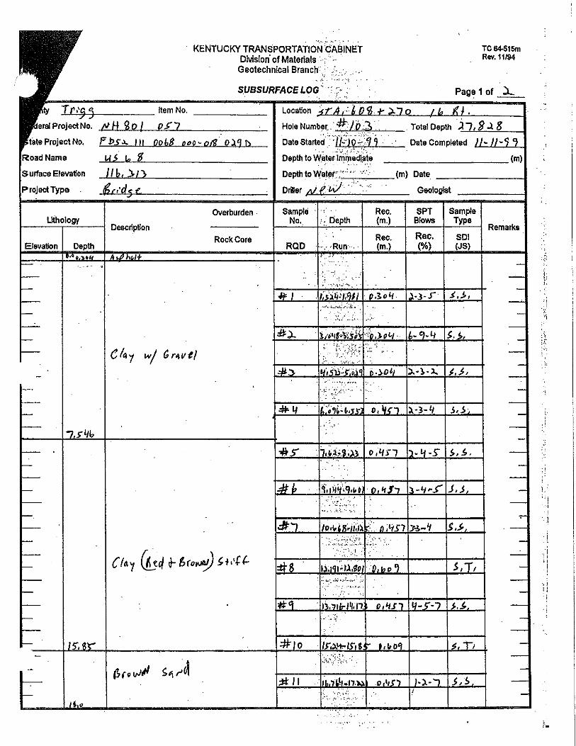
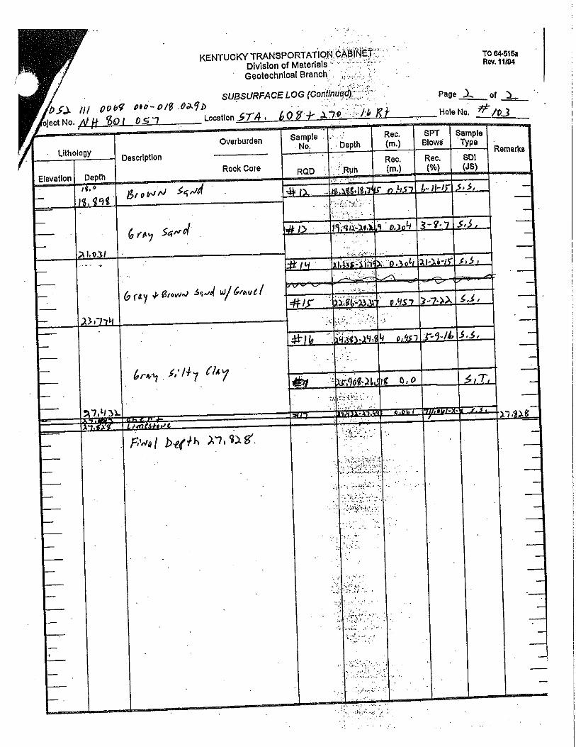
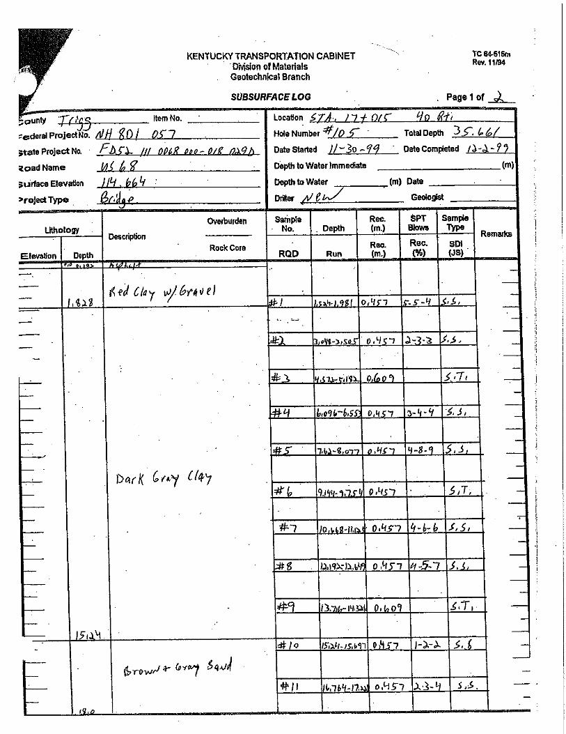
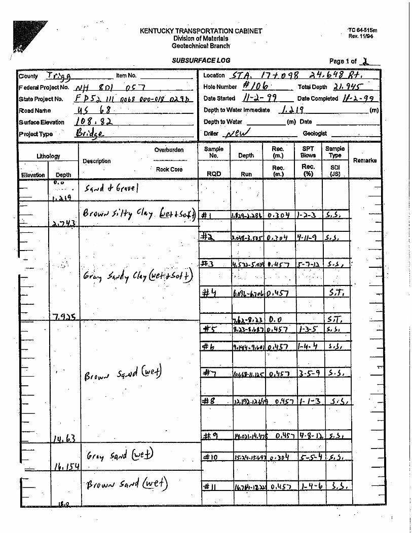
Driller’s Logs
1999 Geotechnical Investigation
Logs are in METRIC


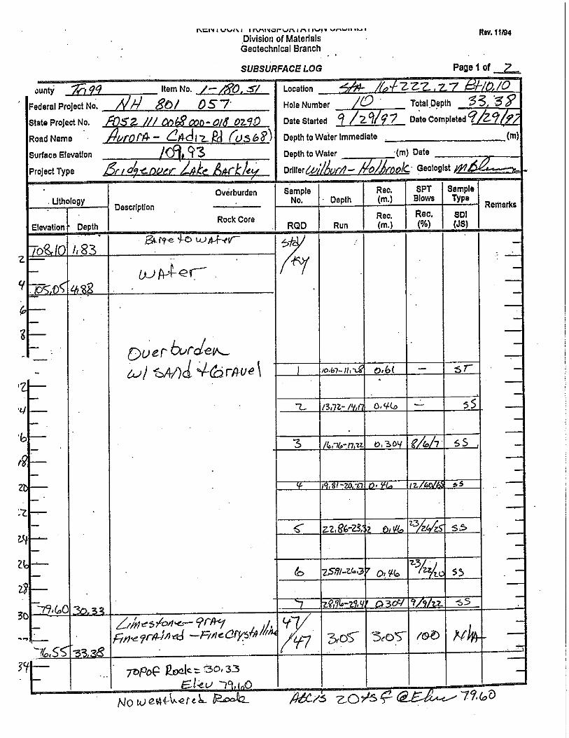
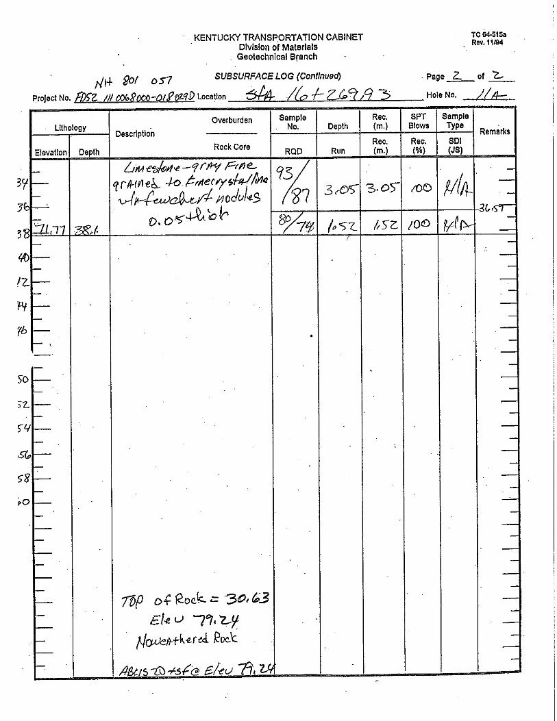
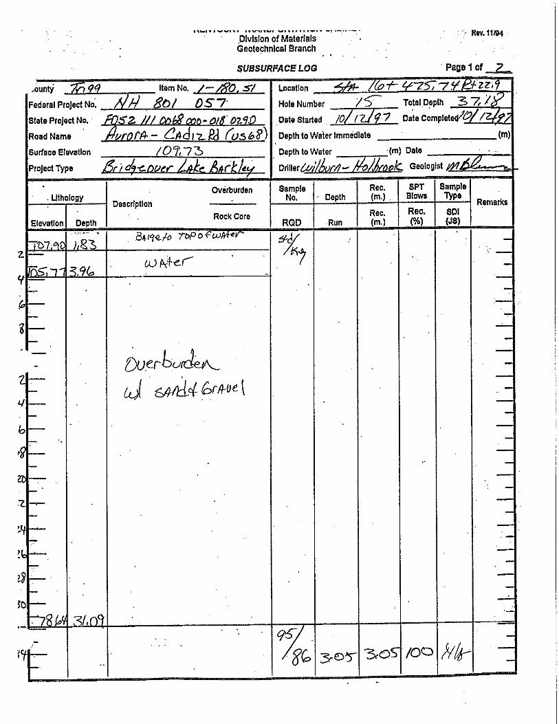
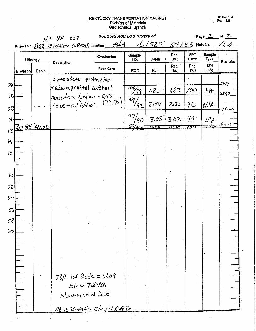
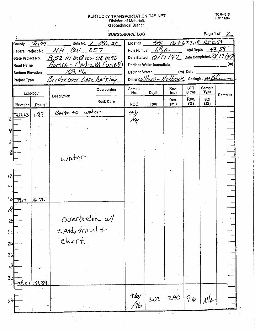
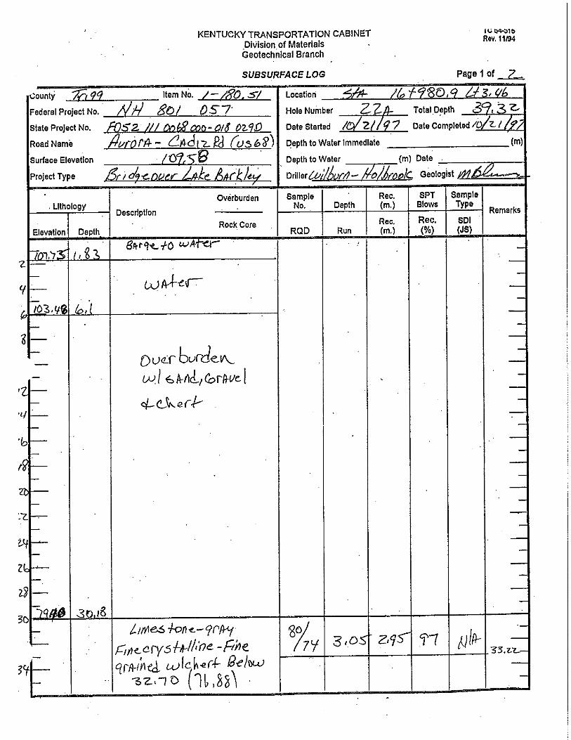
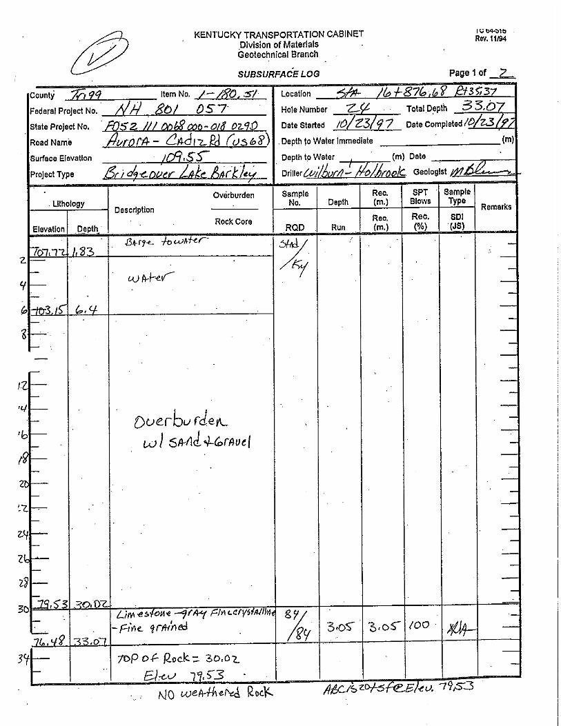
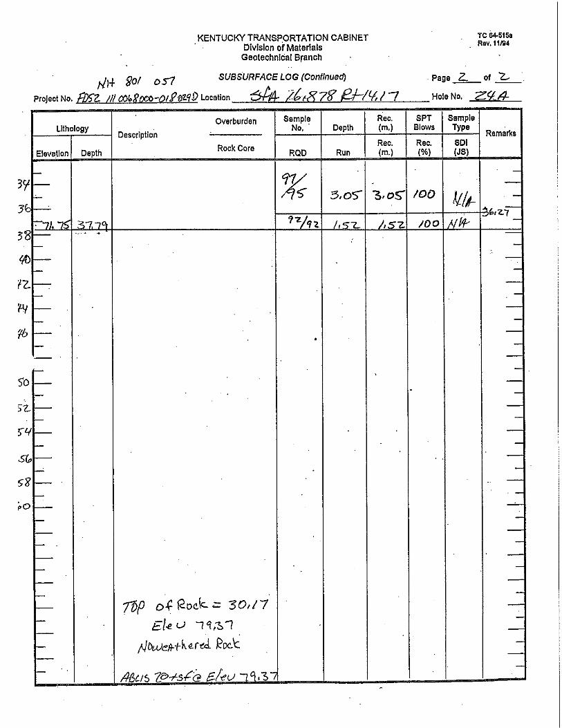
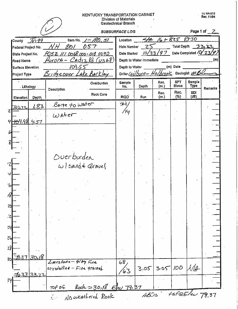
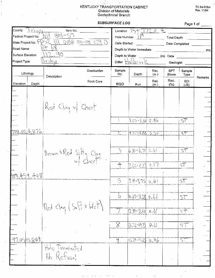
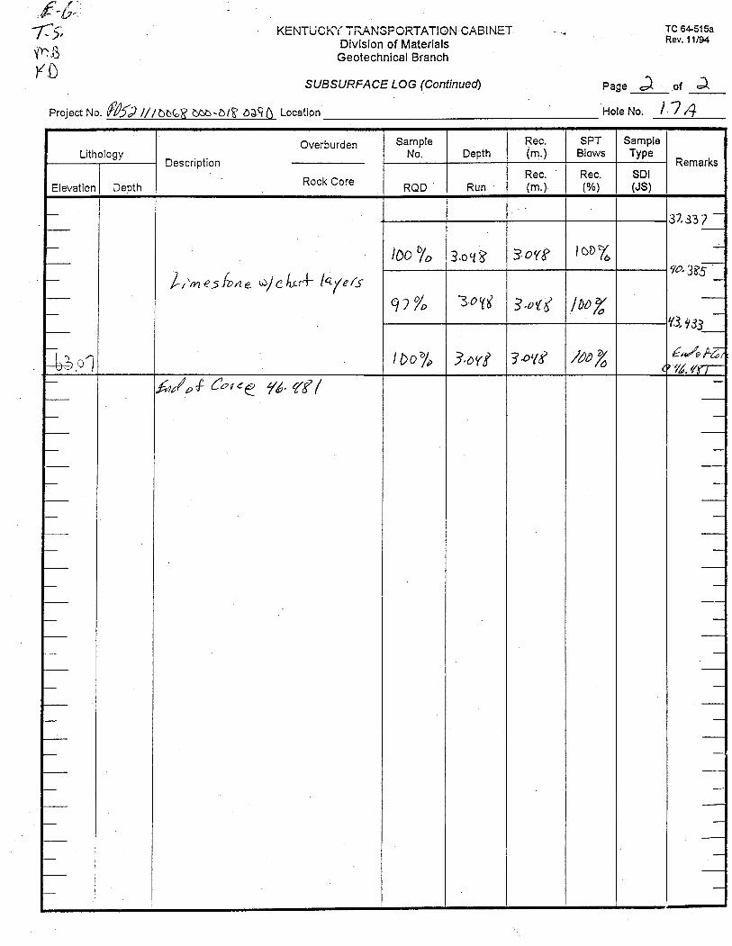
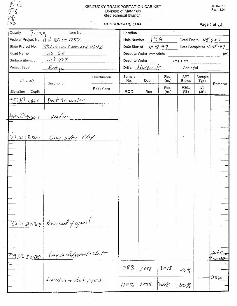
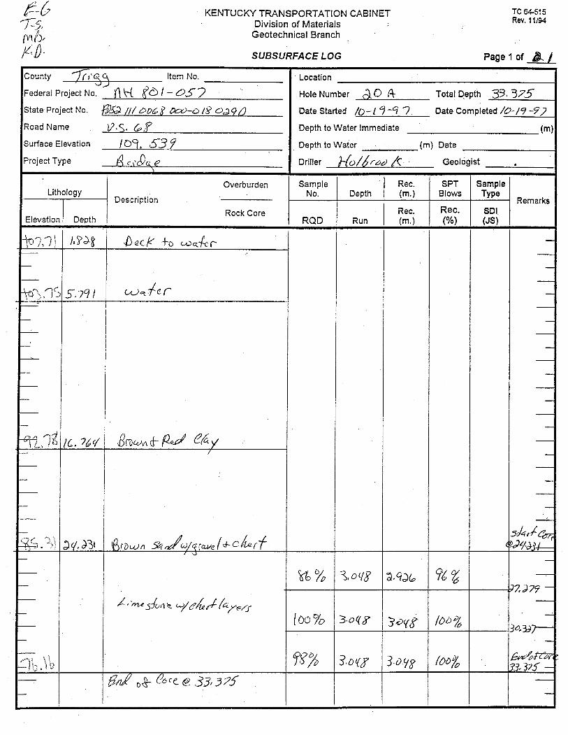
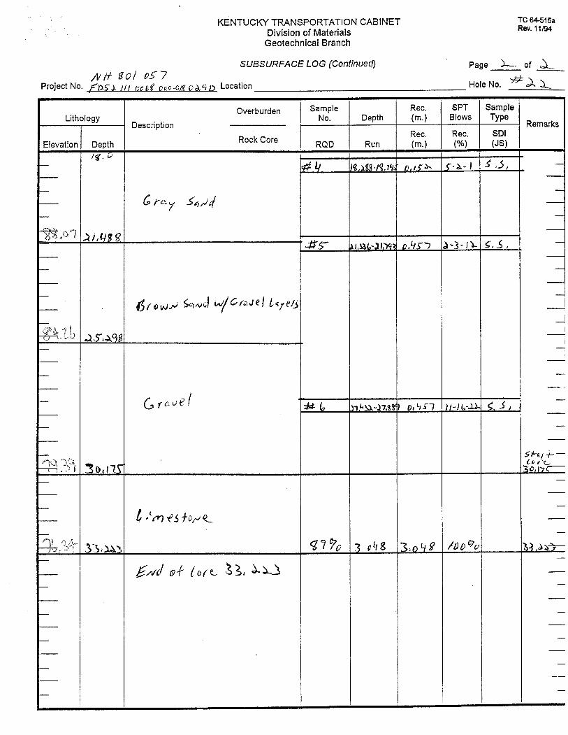
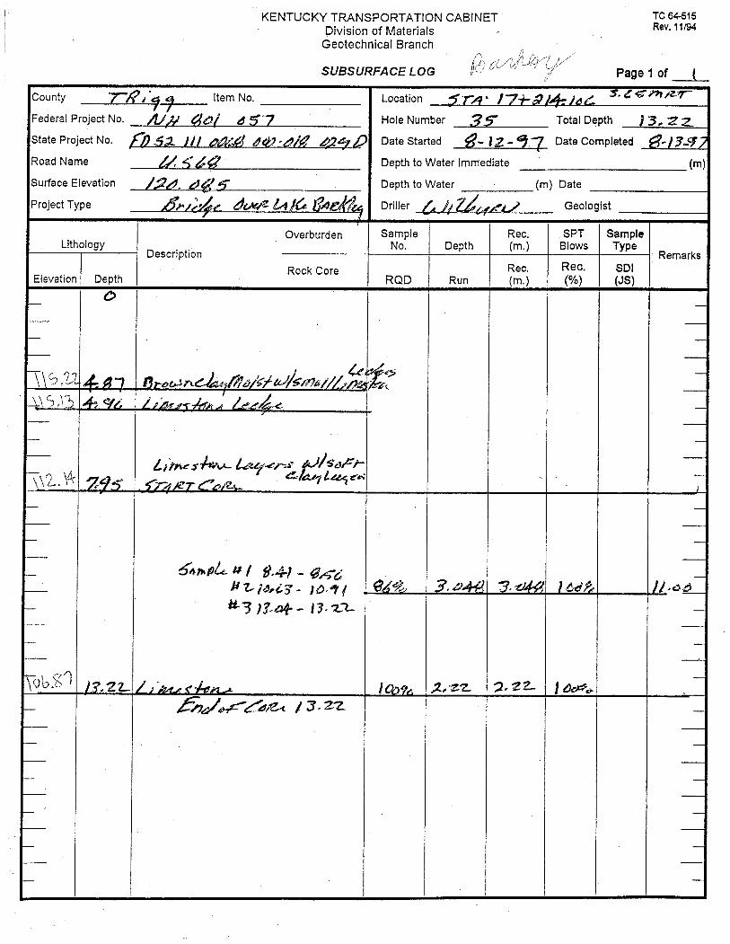
Driller’s Logs
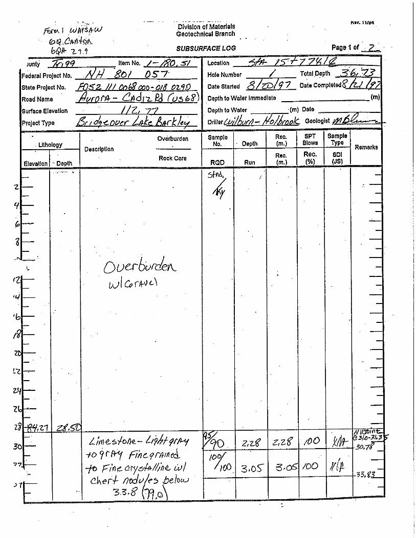
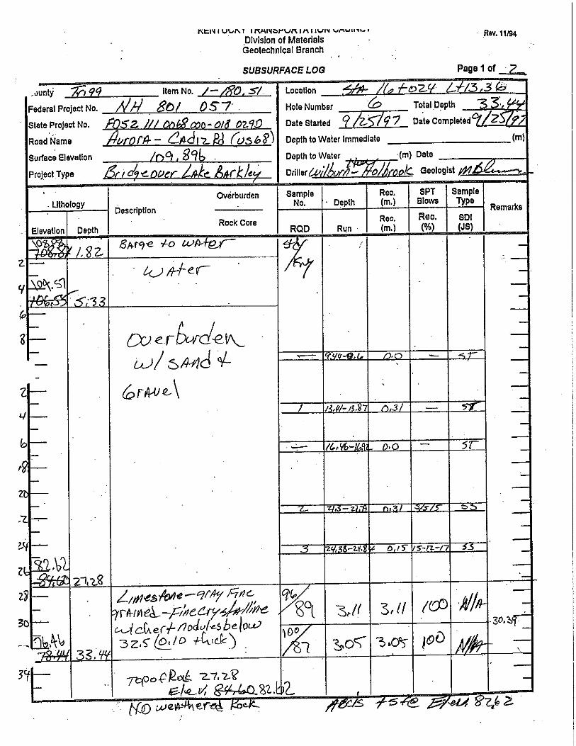
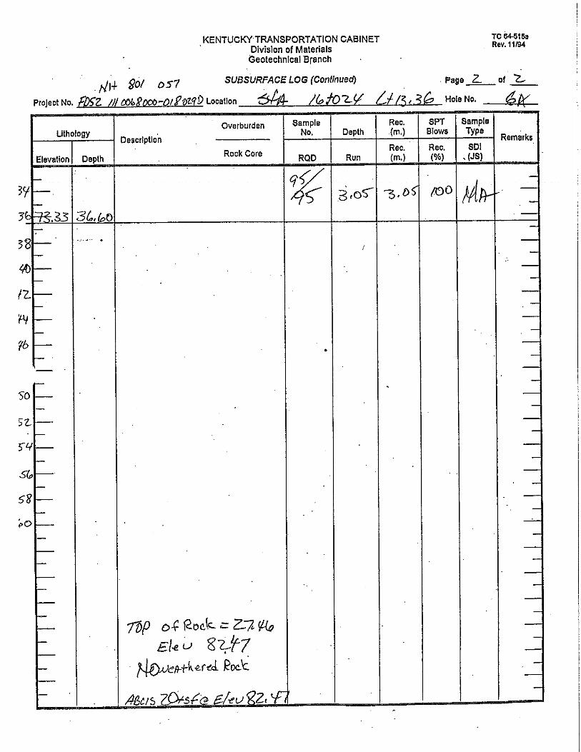
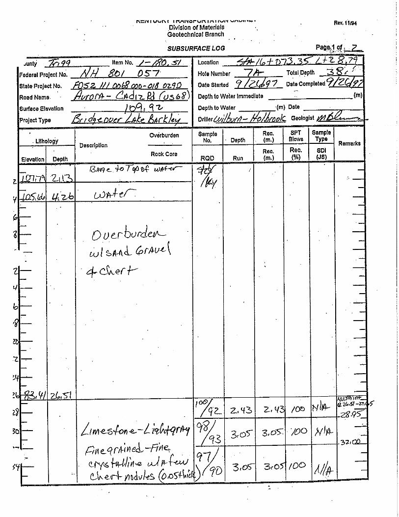
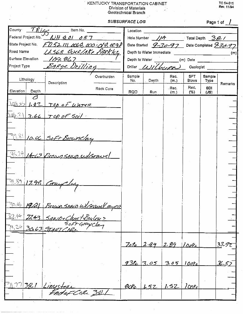
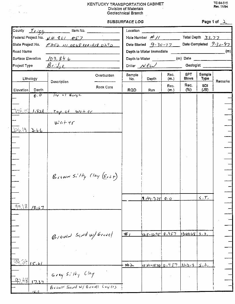
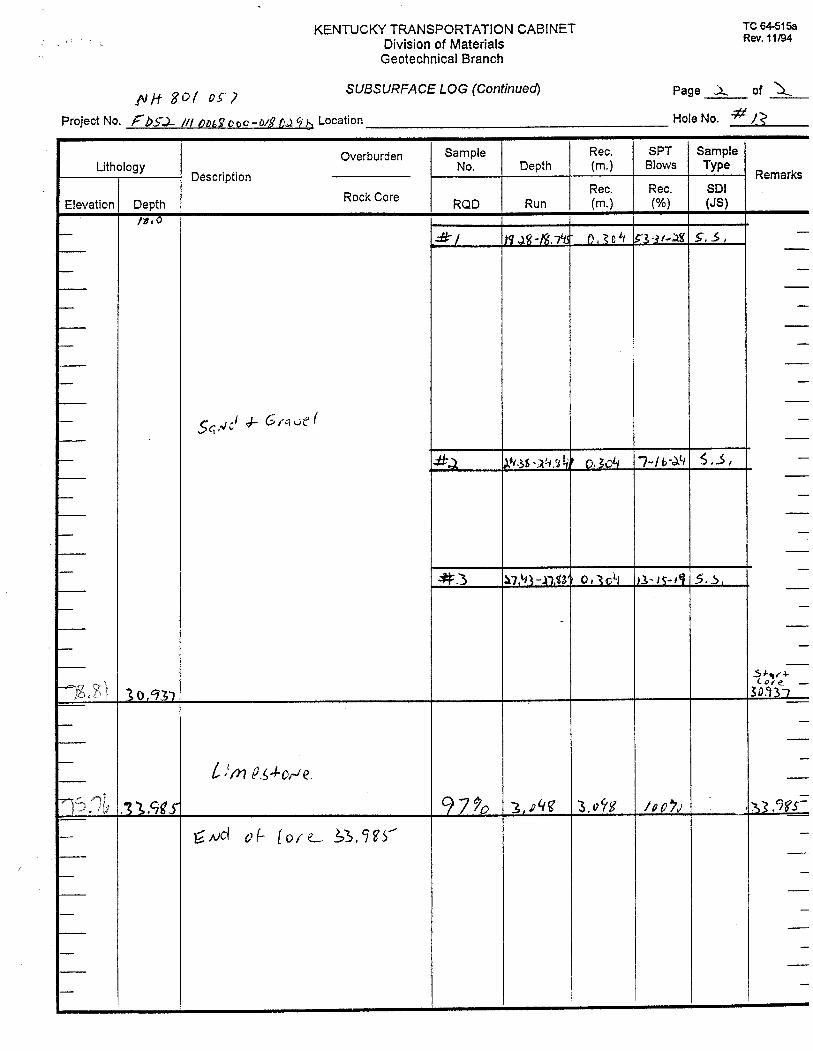
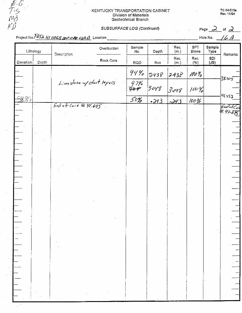
1997 Geotechnical Investigation
Logs are in METRIC


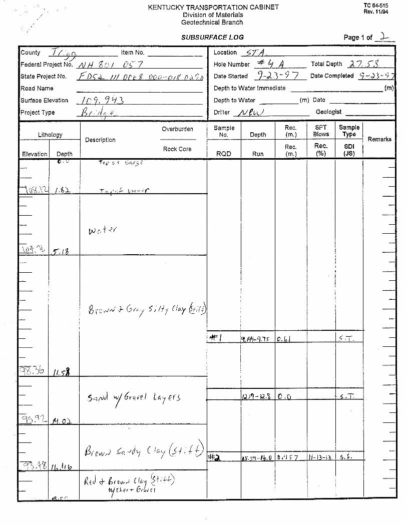


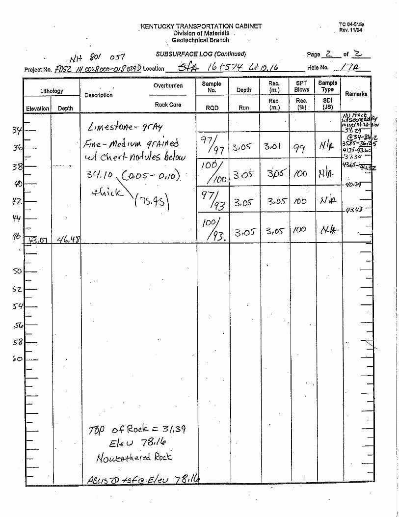
Geologist’s Logs
1997 Geotechnical Investigation
Logs are in METRIC