duteau creek watershed assessment &...
TRANSCRIPT

Final Report December 2008
Duteau Creek Watershed Assessment & Recommendations for Source Protection
Duteau Creek Watershed. Photo courtesy of Tolko Industries
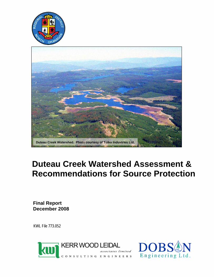
Duteau Creek Watershed. Photo courtesy of Tolko Industries Ltd.
Final Report December 2008
Duteau Creek Watershed Assessment & Recommendations for Source Protection
KWL File 773.052

DUTEAU CREEK WATERSHED ASSESSMENT FINAL REPORT
DECEMBER 2008
KERR WOOD LEIDAL ASSOCIATES LTD. / DOBSON ENGINEERING LTD. Consulting Engineers 773.052
REGIONAL DISTRICT OF NORTH OKANAGAN GREATER VERNON WATER
CONTENTS
EXECUTIVE SUMMARY ................................................................................................. I
1. INTRODUCTION...............................................................................................1-1 1.1 PROJECT SCOPE.............................................................................................................................1-1 1.2 PROJECT TECHNICAL ADVISORY COMMITTEE (TAC) ........................................................................1-2 1.3 DESCRIPTION OF THE GREATER VERNON WATER WATERSHED INFRASTRUCTURE .............................1-3 1.4 ASSESSMENT APPROACH ................................................................................................................1-4 1.5 REFERENCES ..................................................................................................................................1-5 1.6 ABBREVIATIONS..............................................................................................................................1-7
2. MODULE 1–CHARACTERIZATION OF THE DUTEAU CREEK SOURCE .....2-1 2.1 DESCRIPTION OF PROJECT AREA.....................................................................................................2-1 2.2 INTERESTED PARTIES ......................................................................................................................2-4 2.3 BIOPHYSICAL CHARACTERIZATION OF SOURCE AREA.......................................................................2-4 2.4 HYDROLOGIC CHARACTERIZATION OF SOURCE AREA.......................................................................2-5 2.5 SOURCE HAZARDS TO DRINKING WATER QUALITY AND QUANTITY ....................................................2-8 2.6 SOURCE WATER QUALITY AND QUANTITY ......................................................................................2-11 2.7 INTEGRITY AND VULNERABILITY OF GVW INTAKE WORKS ..............................................................2-17 2.8 FOREST DEVELOPMENT.................................................................................................................2-18 2.9 HISTORY OF WATER USE...............................................................................................................2-21 2.10 SUMMARY.....................................................................................................................................2-21
3. MODULE 2 – RESULTS OF CONTAMINANT INVENTORY............................3-1 3.1 SUMMARY OF INTERIOR WATERSHED ASSESSMENT PROCEDURE UPDATE TO DEC. 31, 2007.............3-1 3.2 SUMMARY OF CHANNEL CONDITIONS .............................................................................................3-11 3.3 OVERVIEW OF POTENTIAL CONTAMINANTS AND INVENTORY PROCESS ............................................3-12 3.4 NATURAL FACTORS THAT IMPACT WATER QUALITY AND QUANTITY ................................................3-13 3.5 ANTHROPOGENIC USES THAT IMPACT WATER QUALITY AND QUANTITY...........................................3-15 3.6 DRINKING WATER HAZARD SUMMARY............................................................................................3-20
4. MODULE 7 – RISK CHARACTERIZATION & ANALYSIS...............................4-1 4.1 EVALUATION OF SOURCE PROTECTION BARRIERS............................................................................4-1 4.2 CONSEQUENCE TO DRINKING WATER QUALITY AND QUANTITY .........................................................4-1 4.3 QUALITATIVE RISK ASSESSMENT.....................................................................................................4-3 4.4 RISKS TO DRINKING WATER QUALITY AND QUANTITY .......................................................................4-7 4.5 SUMMARY.....................................................................................................................................4-11
5. MODULE 8 – RECOMMENDATIONS TO IMPROVE DRINKING WATER SOURCE PROTECTION AND SUSTAINABILITY IN DUTEAU CREEK WATERSHED 5-1 5.1 SWOT ANALYSIS............................................................................................................................5-1 5.2 SOURCE PROTECTION PLAN ............................................................................................................5-4

DUTEAU CREEK WATERSHED ASSESSMENT FINAL REPORT
DECEMBER 2008
KERR WOOD LEIDAL ASSOCIATES LTD. / DOBSON ENGINEERING LTD. Consulting Engineers 773.052
REGIONAL DISTRICT OF NORTH OKANAGAN GREATER VERNON WATER
TABLES Table 2-1: Headgates Releases for Fish ........................................................................................2-7 Table 2-2: Module 1 – Potential Hazards to Drinking Water Quality & Quantity at Headgates 2-9 Table 2-3: Draft Water Quality Objectives for Duteau Creek .....................................................2-11 Table 2-4: Draft Water Quality Objectives & 2006/07 Actual Data for Duteau Creek ..............2-13 Table 3-1: Watershed Parameters Used in Assessing Forest Development Impacts ..............3-4 Table 3-2: Duteau Creek 2007 IWAP Update Watershed Report Card........................................3-7 Table 3-3: Equivalent Clear-Cut (ECA) Projection 2007-2020(1) For Natural Regeneration
Condition ......................................................................................................................3-10 Table 3-4: 2007 Hazard Indices for the Duteau Creek Watershed.............................................3-11 Table 3-5: Typical Forest Road Crossing Hazards Identified in 2006 and 2007 ......................3-16 Table 3-6: Typical Cattle Impacts at Road Crossings ................................................................3-19 Table 3-7: Module 2 - Hazards to Drinking Water Quality at Headgates & Current Preventative
Measures.......................................................................................................................3-21 Table 4-1: Qualitative Measures of Consequence to Drinking Water Quality ...........................4-2 Table 4-2: Consequences to Drinking Water Quality at Headgates............................................4-2 Table 4-3: Qualitative Measures of Likelihood..............................................................................4-4 Table 4-4: Likelihood of a Hazard Affecting Drinking Water Quality at Headgates ..................4-4 Table 4-5: Qualitative Risk Analysis Matrix...................................................................................4-7 Table 4-6 Duteau Creek Watershed Qualitative Risk Assessment............................................4-9 Table 5-1: SWOT Analysis Summary .............................................................................................5-3 FIGURES Figure 2-1: Location Map for Duteau Creek Community Watershed ...........................................2-3 Figure 2-2: Duteau Creek Runoff for Water Survey of Canada Station .......................................2-6 Figure 2-3: Total Trihalomethane Results for 1997-2007 ............................................................2-14 Figure 2-4: Total Organic Carbon Levels at Headgates for 2001-2007 ......................................2-15 Figure 2-5: Forest Cover Distribution............................................................................................2-20 Figure 3-1: Hydrologic Recovery for Duteau Watershed Upstream of Headgates, With and
Without Beetle Salvage Logging. .................................................................................3-8 APPENDICES A Watershed Map B Field Assessment Results and Photographs C GVW Water Quality Data D 2007 Hydrology Report completed for Tolko E 1996 and 1999 IWAP Reports F Stream Crossing Assessment Procedure G Sample Grazing License H Grazing Tenure Map I Drinking Water Source Protection Memorandum of Understanding, Southern Interior
Drinking Water Team Membership

Executive Summary
DUTEAU CREEK WATERSHED ASSESSMENT FINAL REPORT
DECEMBER 2008
KERR WOOD LEIDAL ASSOCIATES LTD. / DOBSON ENGINEERING LTD. i Consulting Engineers 773.052
REGIONAL DISTRICT OF NORTH OKANAGAN GREATER VERNON WATER
Executive Summary The Duteau Creek Watershed Assessment and Protection Plan have been prepared for Greater Vernon Water (GVW) in response to a requirement on its Operating Permit by the Interior Health Authority under the Drinking Water Protection Act. The key elements considered in this project are: Modules 1, 2, 7 and 8 of the Comprehensive Drinking Water Source to Tap Assessment Guideline, and an update of the Interior Watershed Assessment Procedure. Duteau Creek is a major source of water supply for GVW. GVW is a partnership established by the Regional District of North Okanagan (RDNO), City of Vernon and District of Coldstream. At the time of preparation of this report, GVW was in the process of building Phase 1 of the Duteau Creek Water Treatment Plant. The Source Area Duteau Creek is a tributary to Bessette Creek, which is tributary to the Shuswap River. The watershed is located approximately 20 km southeast of the City of Vernon. The watershed is located within the Thompson Plateau of the Interior Plateau Physiographic Region with elevation ranging from 660 m at the Headgates intake to 1,800 m in the Grizzly Hills. Biogeoclimatic zones include Interior Douglas Fir and Interior Cedar Hemlock at the lower elevations, with Montane Spruce and Engelmann Spruce Sub-Alpine Fir at mid to upper elevations. The plateau area consists of a gentle, undulating terrain separated by large, commonly steep-sided valleys. The source area upstream of the Headgates intake is a Community Watershed with a drainage area of 182 km2, including a portion of the Harris Creek watershed that is diverted into the Duteau watershed. The Community Watershed area is mostly Crown Land. the water supply system includes three reservoirs in the upper watershed approximately 14 km upstream of the Headgates intake. The watershed upstream of Headgates consists of two parts: a canyon section and an upland section. In the upland section, surficial materials consist of moderate to well drained moraine. The canyon section has steep slopes consisting of rock outcrops, escarpments and steep gravelly colluvium with slopes in excess of 80%. The intake is situated directly ‘on-stream’ hence the intake water quality is not buffered from the raw water in Duteau Creek. The community water supply hence receives direct creek water, at the turbidity levels directly present in the creek. Contaminants originating from within the unbuffered watershed area between the Haddo Reservoir and the intake pose the greatest risk to source water quality. The buffered area upstream of the reservoirs provide some protection from contamination. However, once the reservoirs are full and spilling, this buffering benefit is substantially reduced. Duteau Creek is a snow-dominated system with peak flows occurring from late-April to mid-June. The mean daily discharge measured at Headgates is 0.67 m3/s and the maximum daily discharge was 16.2 m3/s recorded in the spring of 1990. Maximum withdrawals are in the order of 2 to 3 m3/s during peak water demand periods.

DUTEAU CREEK WATERSHED ASSESSMENT FINAL REPORT
DECEMBER 2008
KERR WOOD LEIDAL ASSOCIATES LTD. / DOBSON ENGINEERING LTD. ii Consulting Engineers 773.052
REGIONAL DISTRICT OF NORTH OKANAGAN GREATER VERNON WATER
Water Quality There are draft raw water quality objectives proposed by the Ministry of Environment, as well as the 4-3-2-1-0 guideline for treated drinking water quality established by the Interior Health Authority. The range of source water quality risks are limited in the Duteau watershed as it is mostly Crown Land with minimal private or commercial activity. The activities within the watershed are forest development, range use (cattle), limited industrial traffic associated with a quarry that is accessed via the forest roads, and recreation. The raw water quality variables of greatest concern are turbidity, organic carbon and pathogenic organisms such as E.coli O157:H7, Giardia lamblia and Cryptosporidium parvum. Turbidity is a persistent drinking water quality problem on the Duteau Creek source. During the freshet, high turbidity results from increased overland flow transporting sediment from the creek banks and surrounding areas and from remobilization of sediment within the stream channels. For the duration of the spring freshet, turbidity is greater than the IHA objective of 1 NTU and often above 5 NTU. High levels of total organic material result in the formation of trihalomethanes in the distribution drinking water when the water is chlorinated. The Guidelines for Canadian Drinking Water Quality have set the interim maximum acceptable concentration for trihalomethanes at 100ug/L (0.100 mg/L). Trihalomethanes measured within the distribution system exceed this objective, and show an increasing trend in the past years. This may be due to increase in chlorination dosage, increase in organic matter in the source water, or a combination of both. Bacterial loading is a concern for drinking water quality. Fecal coliform and more specifically E.coli are of particular concern due to known adverse health effects. The peak fecal and E.coli presence is commonly in June. Bacteria levels periodically exceed the MoE draft objective, especially in the spring. Water Quantity Water quantity is of increasing concern as a result of the increased demand for water and effects of mountain pine beetle activity and climate change. There are three key issues regarding quantity: the amount of spring runoff in the upper watershed upstream of the storage reservoirs; the amount of developed storage; and the opportunity to increase the diversion of runoff from adjacent watersheds. GVW has ~19,000 ML of developed storage in the three upland reservoirs. It is in the process of evaluating the potential to divert runoff from the Upper Flyfish Lakes system, a tributary within the Duteau Creek watershed, into upper Duteau Creek, and also evaluating the feasibility of raising Aberdeen Dam for increased supply storage. Vulnerability of Intake Works In its present configuration, the intake is directly vulnerable to contamination from the raw water as the intake is located directly on-stream. The intake is vulnerable to impacts or contamination affecting the stream immediately upstream of the intake, such as landslides and increased channel instability resulting in increased sediment and debris loads. The spillway at Headgates

DUTEAU CREEK WATERSHED ASSESSMENT FINAL REPORT
DECEMBER 2008
KERR WOOD LEIDAL ASSOCIATES LTD. / DOBSON ENGINEERING LTD. iii Consulting Engineers 773.052
REGIONAL DISTRICT OF NORTH OKANAGAN GREATER VERNON WATER
does not meet the current design flood capacity criteria established by the Ministry of Environment. Increases in peak flow, expected as a result of the mountain pine beetle, may exacerbate this vulnerability. Risks to Source Water Quality The primary contaminants of concern identified in the watershed are:
Sedimentation to streams from forest development activities and recreation use; Sedimentation to streams from cattle disturbance at road crossings and along stream banks; Bacteriological and pathogen contamination from cattle and wildlife activity around streams
and reservoirs; By-products from algal blooms in reservoirs resulting from increased nutrient loading; Bacteriological and pathogen contamination from human activity around streams and
reservoirs; and Petroleum spills.
The risk of the contaminants entering the drinking water increases with increased activity in the watershed. The most likely locations of contaminant introduction are those sites with direct access to the stream network, i.e., at stream crossings and around reservoirs. Contamination sources of concern in the watershed originate from forest development, soil disturbance associated with harvesting activities and roads, cattle grazing, soil disturbance around streams, and fecal coliforms from manure deposits near streams, recreation, soil disturbance near streams from off-road vehicles, and pathogenic organisms from human waste. The loss of forest cover due to mountain pine beetle attack will likely change the hydrology in the watershed, resulting in increased runoff and higher more frequent extreme peak flows. This in turn may put road-crossing structures at risk if they have inadequate capacity. Increased peak flows may also increase the risk of failure of the spillway at the Headgates intake. Channels on the mainstem creek could be subject to increased rates of erosion due to higher flows, which would increase sediment loads and degradation of water quality. These changes will occur gradually as the pine stands die and as affected stands are salvaged, but the condition could persist for decades. Risks to source water are categorized as physical, biological and chemical. The particular hazards and risks resulting from this assessment are summarized in the following table.

DUTEAU CREEK WATERSHED ASSESSMENT FINAL REPORT
DECEMBER 2008
KERR WOOD LEIDAL ASSOCIATES LTD. / DOBSON ENGINEERING LTD. iv Consulting Engineers 773.052
REGIONAL DISTRICT OF NORTH OKANAGAN GREATER VERNON WATER
Summary of Risks to Source Water Hazard Type Drinking Water Hazard Risk Comment/Assumption
Sediment - Natural sediment load from channel erosion and mass wasting
Moderate
The mass wasting risk should be low provided development is restricted on class IV and V terrain. Natural sediment loads will increase with increasing peak flows but the reservoirs and wetlands provide substantial buffering.
Sediment - Sedimentation from industrial activity and recreation use
High It is assumed that there will always be some sediment transport at road crossings.
Sediment - Sedimentation from cattle activity in and around streams and road crossings
Very High It is assumed that cattle will continue to graze in the watershed.
Turbidity – Increased turbidity from natural and human activities
Very High
It has been assumed that the mature pine will die and that flows will increase. It is also assumed that recreational use in the watershed will continue to increase.
Organic material - (Total Organic Carbon) Very High
Organic material in streams will increase as the mature pine stands die.
Water Quantity – Increased peak flows as pine dies; decreased runoff from lower snow packs
High
Over the next 30 years there could be increased peak flows related to the loss of forest cover to the pine beetle. Over the long-term, 50 years and beyond, if there is a long-term decline in snow packs, there may be a supply capacity problem.
Physical
Wildfire Very High
Wildfire risk will increase when the pine is in the red attack stage. An intense wildfire could result in the loss of the watershed for water supply for an extended period of time.
Bacteria - Bacteriological contamination from wildlife/cattle/human presence in and along streams
Very High
Protozoa – presence of Giardia, Cryptosporidium Very High
Viruses - presence Very High
Biological
Algae – algal blooms in reservoirs Very High
The likelihood for increased contamination will be very high as recreational use increases and the forest mosaic changes as a result of the pine beetle infestation.
Hydrocarbons -Petroleum contamination from an industrial fuel spill or vehicle accident and gas powered boats on reservoirs
Low Even with increased activity in the watershed the likelihood of a spill affecting the water at the intake is low.
Chemical
Herbicides Low Since herbicides should only be used under permit and by licensed applicators, the likelihood of a spill is low.

DUTEAU CREEK WATERSHED ASSESSMENT FINAL REPORT
DECEMBER 2008
KERR WOOD LEIDAL ASSOCIATES LTD. / DOBSON ENGINEERING LTD. v Consulting Engineers 773.052
REGIONAL DISTRICT OF NORTH OKANAGAN GREATER VERNON WATER
Recommendations The intent of the Source Protection Plan is to recommend opportunities to mitigate risks to public health inherent in the drinking water supply, as well as any issues affecting the sustainability of the water supply. Based on the risks to drinking water quality identified in this assessment, there is an urgent need for diligent protection of the source water quality in the watershed through the implementation of additional barriers. The final section of the report contains a SWOT analysis (strengths, weaknesses, opportunities and threats) and provides an effective summary of the situation in the watershed with regards to risks to source water protection. Recommendations are provided to address the priority risks from sediment and turbidity from anthropogenic activities in the watershed, and from sources of pathogenic organisms. Additional recommendations are provided to address other risks from increased peak flows at Headgates, recreation use, and the use of herbicides and pesticides. Recommendations are also provided for monitoring compliance reporting, education and wildfire planning. The key components of the Source Protection Plan include: enhanced efforts with agencies responsible for watershed use activities (such as cattle,
forestry, recreation) to implement actions to reduce the generation of sediment and presence of pathogens, and to monitor the results of these efforts;
review of existing stream-road crossings (bridges and culverts) to confirm capacity to
convey peak flows; restriction on access to sensitive areas along watercourses, lakes and wetlands;
inclusion of this watershed protection plan in Tolko’s forest stewardship plan;
enhanced education for watershed users (public and agencies) on protection of drinking
water quality; specific focus on reducing the impacts of cattle activity in and about all watercourses and
lakes; review of the Headgates intake area, with the objectives of creating a Duteau Creek bypass
arrangement and/or addressing the susceptibility of the existing spillway to excess flows; providing alternative recreation sites, i.e., away from the mainstem reservoirs and creeks;
an enhanced raw water quality monitoring program;
development of a wildfire preparedness plan;

DUTEAU CREEK WATERSHED ASSESSMENT FINAL REPORT
DECEMBER 2008
KERR WOOD LEIDAL ASSOCIATES LTD. / DOBSON ENGINEERING LTD. vi Consulting Engineers 773.052
REGIONAL DISTRICT OF NORTH OKANAGAN GREATER VERNON WATER
consideration for acquisition of additional GVW-owned land around the reservoirs and mainstem creeks;
a land management plan for GVS-owned lands around the reservoirs and Duteau Creek;
provision for streamflow and reservoir storage monitoring and long-term data trending; and
annual compliance reporting to the Drinking Water Officer.
Finally, it is recommended that GVS and the related agencies establish a technical advisory committee to implement, coordinate and monitor the recommendations herein, and to update the Source Protection Plan on a regular basis.

Section 1 Introduction

DUTEAU CREEK WATERSHED ASSESSMENT FINAL REPORT
DECEMBER 2008
KERR WOOD LEIDAL ASSOCIATES LTD. / DOBSON ENGINEERING LTD. 1-1 Consulting Engineers 773.052
REGIONAL DISTRICT OF NORTH OKANAGAN GREATER VERNON WATER
1. INTRODUCTION
1.1 PROJECT SCOPE
Duteau Creek is a major source of water supply for Greater Vernon Water (GVW). GVW is a regional water system is a partnership established by the Regional District of North Okanagan (RDNO), City of Vernon and District of Coldstream. At the time of preparation of this report, GVW is in the process of building Phase 1 of the Duteau Creek Water Treatment Plant. As source water quality is a significant factor in public health protection, for design of the treatment plant, and as the initial barrier in a comprehensive drinking water protection plan, GVW has initiated this source assessment and watershed protection plan. A source protection plan is also a requirement of the Interior Health Authority (IHA) as part of the water system Operating Permit issued to GVW by the IHA under Section 8 of the Drinking Water Protection Act.
The key elements to be considered in this project are: Modules 1, 2, 7 and 8 of the Comprehensive Drinking Water Source to Tap Assessment Guideline released by the Ministry of Health and the Ministry of Water, Land and Air Protection; and an Interior Watershed Assessment Procedure (IWAP) update. The scope of all four guideline modules are summarized as follows.
MODULE 1
Module 1 includes the following tasks: Delineate the watershed and characterize the water source above the intake at Headgates. Characterize the watershed including the influences of the mountain pine beetle (MPB) and
proposed retention and salvage logging. Consider the potential impacts of climate change on the water supply. Consider the possibility of developing new storage and the impacts of raising existing dams
(e.g., Aberdeen Reservoir). Prepare project maps illustrating the location of the intake, source area, assessment area
boundaries and bio-geophysical information, in a format compatible with the GVW GIS system.
MODULE 2
Module 2 includes the following tasks: Update the 1999 Interior Watershed Assessment Procedure (IWAP) report. A component of
this module will include the update of the 1999 Duteau Creek IWAP using the IWAP Guidebook produced by the Ministry of Forests dated April 1999. The update includes a
DUTEAU CREEK WATERSHED ASSESSMENT FINAL REPORT
DECEMBER 2008
KERR WOOD LEIDAL ASSOCIATES LTD. / DOBSON ENGINEERING LTD. 1-2 Consulting Engineers 773.052
REGIONAL DISTRICT OF NORTH OKANAGAN GREATER VERNON WATER
review of watershed works completed from 1999 to present, assessments on peak flows and hydrologic recovery, sediment source survey, reconnaissance channel assessment procedure, and a riparian assessment focusing on impacts to water quality and quantity. The IWAP report includes a summary of the overall equivalent clear-cut area (ECA), the ECA-by-elevation band, and the road density to 2006 and projected ECAs to 2020.
Conduct contaminant source inventory within the watershed area upstream of Headgates
based on an office review of potential contaminants and reconnaissance- level field inspections.
Comment on future development in the watershed to 2020 and how watershed conditions
may change that may impact water quality at the intake.
MODULE 7
Module 7 includes the following tasks: Evaluate the public health protection barriers in place in the watershed. Provide a drinking water risk assessment based on the identified hazards and barriers.
MODULE 8
Module 8 includes the following tasks: Develop recommendations to improve drinking water safety and sustainability.
WATERSHED PROTECTION PLAN
Supply a Watershed Assessment and Protection Plan based on the results from the Comprehensive Drinking Water Source to Tap Assessment Guideline Modules 1, 2, 7 and 8 including the results of the updated IWAP and best practices for protection of water quality.
1.2 PROJECT TECHNICAL ADVISORY COMMITTEE (TAC)
Development of this watershed assessment and protection plan was guided by a knowledgeable TAC, consisting of: Al Cotsworth, Manager, Greater Vernon Water Daisy Foster, Policies & Programs Manager, Greater Vernon Water Renee Clark, Senior Water Quality Technologist, Greater Vernon Water Tricia Brett, Water Quality Technologist, Greater Vernon Services Solvej Patschke, Source Water Protection Hydrologist, Water Stewardship Division, BC
Ministry of Environment Vic Wright, District Range Agrologist Officer, Okanagan Shuswap Forest District, BC
Ministry of Forests & Range

DUTEAU CREEK WATERSHED ASSESSMENT FINAL REPORT
DECEMBER 2008
KERR WOOD LEIDAL ASSOCIATES LTD. / DOBSON ENGINEERING LTD. 1-3 Consulting Engineers 773.052
REGIONAL DISTRICT OF NORTH OKANAGAN GREATER VERNON WATER
Richard Toperczer, Tenures Officer, Okanagan Shuswap Forest District, BC Ministry of Forests & Range
Kimm Magill-Hofmann, Tenures Forester, Okanagan Shuswap Forest District, BC Ministry of Forests & Range
Mike Adams, Sr. Drinking Water Officer / Okanagan, Interior Health Authority Dale Thomas, Drinking Water Officer, Interior Health Authority Ivor Norlin, Source Protection Officer, Interior Health Authority.
The project consultants were Don Dobson, P.Eng., Dobson Engineering Ltd., Kelowna, B.C. and Mike Nolan, M.Eng., P.Eng., Kerr Wood Leidal Associates Ltd., Vernon, B.C.
1.3 DESCRIPTION OF THE GREATER VERNON WATER WATERSHED INFRASTRUCTURE
The current infrastructure that has been developed by GVW and its predecessors is presented on the Map Duteau Creek Above Headgates in Appendix A and generally includes, proceeding upstream from the intake:
Headgates intake works; Haddo dam and reservoir; Aberdeen dam and reservoir; Grizzly dams and reservoir; and Gold Paradise diversion works.
GVW holds water licenses to store approximately 33,050 ML in its three reservoirs, and a water license in the Harris Creek watershed to divert 9,868 ML of spring runoff from the Gold Creek and Paradise Creek sub-basins into the headwaters of Heart Creek that flows into the Aberdeen Reservoir. GVW operates its Duteau Creek water supply by storing the spring runoff from the high elevation snowmelt in the Grizzly, Aberdeen and Haddo Reservoirs. Once the reservoirs are full the remaining runoff spills into Duteau Creek and hence to Bessette Creek and ultimately the Shuswap River. The community water supply pipeline intake is located at Headgates, and consists of an in-stream intake pond on the creek, which provides initial settling of coarse sediment particles before the water enters the distribution pipeline. Excess runoff is diverted past the intake, via a spillway, and back into Duteau Creek. The Department of Fisheries and Oceans (DFO) has an agreement with GVW for 1,233 ML of the total 4,934 ML of water in the Grizzly Reservoir. Whereas the GVW storage is for domestic and irrigation uses, the DFO storage is to provide conservation flows for fish.

DUTEAU CREEK WATERSHED ASSESSMENT FINAL REPORT
DECEMBER 2008
KERR WOOD LEIDAL ASSOCIATES LTD. / DOBSON ENGINEERING LTD. 1-4 Consulting Engineers 773.052
REGIONAL DISTRICT OF NORTH OKANAGAN GREATER VERNON WATER
1.4 ASSESSMENT APPROACH
This report has been organized to present the results for Modules 1, 2, 7 and 8, followed by an outline for a watershed protection plan and finally a summary of the stakeholder and public consultation. The IWAP update has been included as part of Module 2. The Ministry of Forests describes the purpose of a WAP as follows:
The Watershed Assessment Procedure (WAP) is an analytical procedure to help forest managers understand the type and extent of current water-related problems that may exist in a watershed, and to recognize the possible hydrological implications of proposed forestry-related development or restoration in that watershed. The WAP considers the cumulative effects of forest practices on the aquatic environment. The assessment of hydrological impacts focuses on: 1) the potential for changes to peak streamflow; 2) the potential for accelerated landslide activity; 3) the potential for accelerated surface erosion; 4) channel bank erosion and changes to channel morphology as a result of logging the riparian vegetation; 5) the potential for change to the stream channel; and 6) the interaction of all of these processes, an evaluation of which indicates the sensitivity of the watershed to further forest development. The assessment also draws attention to natural processes occurring in the watershed. Using the results of a WAP, forest managers can make recommendations to prevent or mitigate the impacts of forestry-related activities in the watershed. Results can also be used to guide watershed restoration activities.1
The TAC requested that the WAP process be modified to include a review of all impacts in the watershed that affect the water source in addition to forestry. The WAP process provides useful data on the change in disturbances resulting from forest development over time and this data can also be used to assess the change in other impacts such as cattle movement and recreation that are related to changes in access. The purpose and typical content of a source protection plan is outlined in Section 18 of the Drinking Water Protection Act.
The purpose of an assessment is to identify, inventory and assess:
(a) the drinking water source for the water supply system, including land use and other activities and conditions that may affect that source,
(b) the water supply system, including treatment and operation,
1 Interior Watershed Assessment Procedure Guidebook. Second Edition, Version 2.1, 1999. Ministry of Forests.

DUTEAU CREEK WATERSHED ASSESSMENT FINAL REPORT
DECEMBER 2008
KERR WOOD LEIDAL ASSOCIATES LTD. / DOBSON ENGINEERING LTD. 1-5 Consulting Engineers 773.052
REGIONAL DISTRICT OF NORTH OKANAGAN GREATER VERNON WATER
(c) monitoring requirements for the drinking water source and water supply system, and
(d) threats to drinking water that is provided by the (water) system.2
A 1:50,000 scale map of the watershed detailing the hydrography, waterworks infrastructure, historical forest development and TRIM data is provided in Appendix A. The results from the 2007 Contaminant Field Inventory are provided in Appendix B as well as the results of the Road Summary. A copy of the Field Map that indicates the location of all the identified crossings in the watershed with identification (ID) numbers is provided in Appendix A. The column “Xing ID” refers to the crossing numbers shown on the Field Map.
1.5 REFERENCES
The following reference material was used during this study. BC Ministry of Health Planning, BC Ministry of Water, Land and Air, Comprehensive
Drinking Water Source to Tap Assessment Guideline – Draft for Discussion.
BC Ministry of Health Services, BC Ministry of Water, Land and Air, 2005. Comprehensive Drinking Water Source to Tap Assessment Guideline.
BC Water & Waste Association, 2005. Comprehensive Drinking Water Source to Tap Assessment Pilot Program.
BC Water & Waste Association, 2005. Windermere Water Works Comprehensive Source to Tap Pilot Assessment – Modules 1 & 2.
California Environmental Protection Agency. A Guide to Health Risk Assessment.
EBA Engineering Consultants Ltd. 2002. Detailed Terrain Stability Mapping Duteau Community Watershed.
Greater Vernon Services, 2006. 2006 Annual Overview of Greater Vernon’s Drinking Water Quality.
Health Canada, 2003. Public Health Initiatives Related to Drinking Water Quality in Canada.
Isaac-Renton, J., Moorehead, W., Ross, A., Longitudinal Studies of Giardia Contamination in Two Community Drinking Water Supplies: Cyst Levels, Parasite Viability, and Health Impact.
Jones, A.G., 1959. Geological Survey of Canada Memoir 296 Vernon Map Area, B.C., Department of Mines and Technical Surveys.
2 Section 18. Drinking Water Protection Act, 2001. Ministry of Health.

DUTEAU CREEK WATERSHED ASSESSMENT FINAL REPORT
DECEMBER 2008
KERR WOOD LEIDAL ASSOCIATES LTD. / DOBSON ENGINEERING LTD. 1-6 Consulting Engineers 773.052
REGIONAL DISTRICT OF NORTH OKANAGAN GREATER VERNON WATER
Meays, C., Broersma, K., et al, 2006. Diurnal variability in concentrations and sources of Escherihia coli in three streams, Canadian Journal of Microbiology: 52: 1130-1135.
Regional District of North Okanagan, 2007. Duteau Watershed Water Quality Monitoring Summaries.
Roed, M.A., 1998. Detailed Terrain – Stability Mapping of the Duteau and Harris Creek Watersheds.
Summit Environmental Consultants Ltd., 2006 Duteau Creek Watershed Sensitivity Assessment.
Triton Environmental Consultants Ltd. 2006. Chapman Creek Watershed Drinking Water Source Assessment – Final Report.
U.S. Environmental Protection Agency, 1992. Framework for Ecological Risk Assessment.

DUTEAU CREEK WATERSHED ASSESSMENT FINAL REPORT
DECEMBER 2008
KERR WOOD LEIDAL ASSOCIATES LTD. / DOBSON ENGINEERING LTD. 1-7 Consulting Engineers 773.052
REGIONAL DISTRICT OF NORTH OKANAGAN GREATER VERNON WATER
1.6 ABBREVIATIONS
AES Atmospheric Environment Service MIgpd Million Imperial gallons per day AO Aesthetic Objective MOE Ministry of Environment AWWA American Waterworks Association MOF Ministry of Forests & Range CFU Coliform Forming Unit MOTSA Ministry of Tourism, Sports & Art COV City of Vernon NOWA North Okanagan Water Authority CT concentration x time of contact with disinfectant NTU Nephelometric Turbidity Unit DAF Dissolved Air Flotation O & M Operations and Maintenance da-m3 cubic decameter ( 1,000m3 ) POE Point of Entry DBP Disinfection by-product POU Point of Use DFO Department of Fisheries and Oceans PRV Pressure reducing valve DOC District of Coldstream PS Pump Station GCDWQ Guidelines for Canadian Drinking Water Quality psi pounds per square inch (pressure) GIS Geographical Information System PST Provincial Sales Tax GVW Greater Vernon Water PVC Polyvinyl Chloride (Pipe Material) HAAs Haloacetic Acids RDNO Regional District of North Okanagan HGL Hydraulic grade line (slope of water in m/m) SCADA Supervisory Control and Data Acquisition Igpm Imperial Gallons per minute SOWA Safe Drinking Water Act IMAC Interim Maximum Acceptable Concentration SDWR Safe Drinking Water Regulation IHA Interior Health Authority SI Systems International (unit designation) IWAP Interior Watershed Assessment Procedure SWTR Surface Water Treatment Rule km2 square kilometre TCU True Color Units L litre THMs Trihalomethanes L/ca/day Litres per capita per day TOC Total Organic Carbon L/s litres per second (flow rate) TWL Top water level m metres (length) μg/L micrograms / litre ( parts per billion) M3/s cubic metre per second, (flow rate) USEPA US Environmental Protection Agency mg/L milligrams/litre (parts per million) UV Ultra-violet MAC Maximum Acceptable Concentration WAP Watershed Assessment Procedure ML megalitre ( one(one million litres ) WTP Water Treatment Plant ML/d Million Litres per day WWTP Wastewater Treatment Plant MDD Maximum daily demand WSC Water Survey of Canada

Section 2 Module 1 – Characterization of the Duteau Creek Source

DUTEAU CREEK WATERSHED ASSESSMENT FINAL REPORT
DECEMBER 2008
KERR WOOD LEIDAL ASSOCIATES LTD. / DOBSON ENGINEERING LTD. 2-1 Consulting Engineers 773.052
REGIONAL DISTRICT OF NORTH OKANAGAN GREATER VERNON WATER
2. MODULE 1–CHARACTERIZATION OF THE DUTEAU CREEK SOURCE
2.1 DESCRIPTION OF PROJECT AREA
2.1.1 SOURCE AREA
Duteau Creek is a tributary of Bessette Creek which is a tributary of the Shuswap River (refer to Figure 2-1). The watershed is located southwest of the Village of Lumby. The watershed area to the confluence with Bessette Creek is 224 km2. The Duteau Creek Community Watershed is that portion of the watershed upstream of the GVW intake at Headgates. The area of the Community Watershed is 182 km2, including the portion of Paradise Creek upstream of the point of diversion. The community watershed area is generally comprised of Crown land with the exception of two parcels owned by RDNO at the Haddo and Aberdeen Dams. The watershed abuts the Harris Creek watershed to the east (which is not a community watershed), Deer Creek to the west and Mission Creek to the south (both of which are community watersheds). A detailed map of the Duteau watershed is provided in Appendix A.
2.1.2 INTAKE
The GVW intake on Duteau Creek is located at Headgates approximately 14 km downstream of the Haddo Reservoir. The intake is not buffered from runoff below the reservoirs, and the travel time from any point in this zone is ‘several hours’ during the freshet to ‘several days’ during the low flow period. Activities and contaminants from this unbuffered area pose the greatest risk from turbidity3 and bacteriological contamination. Runoff upstream of the reservoirs is buffered from the intake, as it has to pass through the reservoir system before entering the mainstem creek. Residence time in the reservoirs will vary depending upon the time of year but typically GVW will use approximately 50% of its stored water during the year. This would suggest that water could reside in the reservoirs for up to two years, however, this is quite variable depending on the reservoir, operating conditions and the year. The buffered area provides a certain level of protection at the intake from contamination, as long as releases from the reservoir can be
3 Turbidity has been used in this report as a surrogate for suspended sediment. Refer to the paper Establishing the Relationship
Between Turbidity and Suspended Sediment Concentrations, 2003, C.P. Holliday, T.C. Rasmussen, and W.P. Miller, Proceedings of the 2203 Georgia Water Resources Conference for details on the relationship between turbidity and suspended sediment.

DUTEAU CREEK WATERSHED ASSESSMENT FINAL REPORT
DECEMBER 2008
KERR WOOD LEIDAL ASSOCIATES LTD. / DOBSON ENGINEERING LTD. 2-2 Consulting Engineers 773.052
REGIONAL DISTRICT OF NORTH OKANAGAN GREATER VERNON WATER
controlled should there be a contamination event upstream or in the reservoirs. Also, the arrangement provides the opportunity for some contaminants such as sediment and cysts to settle out in the reservoir water column. During the spring freshet once the reservoirs are full and spilling, this buffering benefit is substantially reduced.

DUTEAU CREEK WATERSHED ASSESSMENT FINAL REPORT
DECEMBER 2008
KERR WOOD LEIDAL ASSOCIATES LTD. / DOBSON ENGINEERING LTD. 2-3 Consulting Engineers 773.052
GREATER VERNON SERVICES
Figure 2-1: Location Map for Duteau Creek Community Watershed

DUTEAU CREEK WATERSHED ASSESSMENT FINAL REPORT
DECEMBER 2008
KERR WOOD LEIDAL ASSOCIATES LTD. / DOBSON ENGINEERING LTD. 2-4 Consulting Engineers 773.052
GREATER VERNON SERVICES
2.2 INTERESTED PARTIES
The known stakeholders or parties with a direct interest in the Duteau Creek watershed are: Regional District of North Okanagan (GVW) – Water licensee Other Water Licensees Tolko Industries Ltd. – Forest licensee Coldstream Ranch Ltd. – Grazing licensee Gary Andrews – Grazing licensee Falkland Ranch – Grazing licensee Okanagan Indian Band Splatsin First Nation DFO/MOE – Wildlife/Fisheries resources Interior Health Authority – Safe drinking water Ministry of Environment – Source protection Ministry of Forests and Range – Forests and range resources Ministry of Energy, Mines & Petroleum – Resources Ministry of Tourism, Culture and the Arts – trails and recreation.
2.3 BIOPHYSICAL CHARACTERIZATION OF SOURCE AREA
The Duteau Creek community watershed is located within the Thompson Plateau of the Interior Plateau Physiographic Region of BC. The community watershed area is approximately 182 km2 with elevation ranging from 660 m at Headgates to over 1,800 m in the Grizzly Hills. Biogeoclimatic zones include Interior Douglas Fir (IDF) and Interior Cedar Hemlock (ICH) at the lower elevations, with Montane Spruce (MS) and Engelmann Spruce Sub-Alpine Fir (ESSF) at mid to upper elevations. The plateau area consists of a gentle, undulating surface separated by large, commonly steep-sided valleys4. The western half of the watershed is dominated by metamorphic rocks of the Monashee or Shuswap Metamorphic Complexes5. These rocks are highly foliated and folded granitic gneisses, slate, schist and quartzite6. A pluton of granite and granodiorite of the Nelson Plutonic Rocks is present in the middle eastern section of the watershed. Both the Monashee and Nelson groups are mantled by a discontinuous sheet of basalt lava belonging to the Chilcotin 4 Detailed Terrain Stability Mapping Duteau Community Watershed, Riverside Forest Products Ltd., EBA Engineering Consultants
Ltd. Project No. 0801-01-81215. 5 Jones, A.G., 1959. Geological Survey of Canada Memoir 296 Vernon Map-Area, British Columbia. Department of Mines and
Technical Surveys. 6 Roed, M.A., 1998. Detailed Terrain Stability Mapping of the Duteau and Harris Creek Watersheds.

DUTEAU CREEK WATERSHED ASSESSMENT FINAL REPORT
DECEMBER 2008
KERR WOOD LEIDAL ASSOCIATES LTD. / DOBSON ENGINEERING LTD. 2-5 Consulting Engineers 773.052
GREATER VERNON SERVICES
Group. This volcanic sheet has been warped and forms abrupt and conspicuous rock escarpments throughout the area7. Physically the watershed upstream of Headgates intake roughly consists of two parts: a canyon section and an upland section. In the upland section, surficial materials consist of moderate-to well-drained moraine with intervening depressional terrain that is poorly drained and dominated by organic deposits8. Moraine commonly consists of a veneer or blanket of sandy bouldery till. Rockfalls exist along the extensive lower escarpments composed of columnar basalt. Steep, short slopes susceptible to small slides (consisting of stratified sands and gravels) exist at the head of the canyon section. Isolated areas of glacio-fluvial outwash are present in the uplands area associated with broad glacial meltwater channels. The canyon section is mapped as Class IV and V terrain with slopes consisting of rock outcrops, escarpments and steep gravelly colluvium in excess of 80% slope. Most of the landslide activity in the watershed is concentrated in this section, and includes large rockslides, debris torrents and debris avalanches9. A very narrow alluvial floodplain exists through the canyon dominated by boulder gravels.
2.4 HYDROLOGIC CHARACTERIZATION OF SOURCE AREA
Duteau Creek is a snow-dominated hydrologic system with peak flows occurring from late-April to mid-June. Hydrometric records are available for Duteau Creek near Lavington (Water Survey of Canada Station No. 08LC006) from 1919 to 1921, 1935 to 1951, and 1959 to 1996. This station is located immediately downstream of the GVW intake and may be a useful station to re-establish to record flows below the intake. Mean daily discharge is 0.67 m3/s and maximum daily discharge was 16.2 m3/s recorded in the spring of 1990. (Persons interpreting data from this station must recognize that the community water system’s demand flow is withdrawn prior to this gauging station. Maximum withdrawals are in the order of 2 to 3 m3/s during peak water demand periods.) Unfortunately, maximum daily discharge is not available for the regionally high runoff years in 1996 and 1997. Peak flows with return periods of 30 and 40 years occurred in Bessette Creek downstream of Nicklen Creek immediately east of the Duteau watershed in 1996 and 1997, respectively. The runoff hydrographs for normal, low and high flow periods are illustrated in Figure 2-2.
7 ibid. 8 ibid. 9 ibid.

DUTEAU CREEK WATERSHED ASSESSMENT FINAL REPORT
DECEMBER 2008
KERR WOOD LEIDAL ASSOCIATES LTD. / DOBSON ENGINEERING LTD. 2-6 Consulting Engineers 773.052
GREATER VERNON SERVICES
Legend
Maximum flows Average flows Minimum flows
Figure 2-2: Duteau Creek Runoff for Water Survey of Canada Station Duteau Creek near Lavington (08LC006) {Note: located downstream of the water system withdrawal location}
The watershed can be considered as having three ‘hydraulic’ zones: (1) The unbuffered area immediately upstream of the intake at Headgates, excluding the Flyfish sub-basin. In this zone any sediment and fecal material that enters streams will be transported directly to the intake pond. (2) The Flyfish sub-basin, considered to be partially buffered as a result of its low-gradient channels and extensive wetland complexes, which provide significant natural storage and reduce the transport of sediment. However, these areas are areas of intensive grazing and wildlife use, resulting in increased fecal material entering the water. (3) Finally, the watershed upstream of the reservoirs. This upper zone has the greatest buffering due to the combined storage in the three reservoirs. The reservoirs act as ‘sinks’ for sediment and fecal material. The hydrologic effect of these reservoirs at Headgates is to modify the runoff period and peak flows through storage. Depending on the volume and timing of runoff, the reservoirs will have varying effects on downstream peak flows. For example, peaks will be reduced or eliminated during low runoff years but may be unaffected during high runoff years or when the reservoirs are spilling. The fecal coliform and sediment loading at the Headgates intake is a function of stream discharge and level of physical activity in the watershed. Following the spring freshet, as flows decline towards base flows, activity increases in and around streams from wildlife, cattle and humans resulting in sediment disturbance and fecal deposits. This activity continues through the fall until the onset of winter. During the spring, snowmelt gradually increases in elevation as spring warming progresses. There is an early small peak in the stream flow at Headgates as runoff occurs in the unregulated zone between the intake and the reservoirs. As the streamflow increases, it fills more of the

DUTEAU CREEK WATERSHED ASSESSMENT FINAL REPORT
DECEMBER 2008
KERR WOOD LEIDAL ASSOCIATES LTD. / DOBSON ENGINEERING LTD. 2-7 Consulting Engineers 773.052
GREATER VERNON SERVICES
channel area and transports disturbed sediments and fecal materials that were deposited in the channel following the previous freshet. The impact is an initial spike in both turbidity and fecal coliform levels at the intake, typically in late April. As the spring freshet progresses into the upper watershed and the reservoirs fill and start to spill, a second and higher spike in turbidity and fecal coliform typically is evident at the intake (usually the maximum for the year). This spike is the result of the channel filling to bankfull capacity and the increased stream flows entraining loose sediment and remaining fecal deposits in the channel. This peak usually occurs in the third week of June when Duteau Creek reaches peak flow. The high turbidity and fecal coliform levels are typically of short duration, and the levels decline rapidly as the available source material is scoured from the channels. The process repeats itself annually. GVW manages the water storage through the collection of spring runoff during the snowmelt period from April through June in the three upland reservoirs, including the diversion of freshet runoff from the upper Harris Creek (which is stored in the Aberdeen Reservoir). Water demands during the spring runoff period are normally met through the diversion of stream flows originating from those unregulated portions of the watershed below the reservoirs. As the water system demand increases, additional flow is released from the reservoirs. This is accomplished by remote or manual operation of the Haddo outlet gate and manual release of water from the higher elevation Aberdeen and Grizzly reservoirs into Haddo. The GVW has an agreement with the Department of Fisheries and Oceans to provide flows for fish in Duteau Creek downstream of Headgates. The Department of Fisheries and Oceans (DFO) holds a storage water license on the Grizzly Reservoir for approximately 1.2 million m3 (2,000 acre-feet) of water as well as conservation water licenses for flows in lower Duteau Creek. Through the agreement with DFO, GVW releases water past Headgates to maintain the flows downstream. It is likely that, under natural conditions, there would be periods when the flows in the lower creek would have been at or near zero. As a result of the agreement there are reduced extreme low flows in the lower creek. The flows specified in the agreement are summarized in Table 2-1.
Table 2-1: Headgates Releases for Fish
Release Dates Fisheries Priority Water Licenses
Jan 1 – Mar 31 0.057 m3/s or 0.004 ML/min or 11.7 ML/day 0.023 ML/day or 0.018 ML/day April 1 – Aug 31 0.113 m3/s or 0.008 ML/min 0r 23.44 ML/day 0.057 m3/s or 11.7 ML/day Sept 1 – Sept 30 0.142 m3/s or 0.010 Ml/min or 29.23 ML/day 0.057 m3/s or 11.7 ML/day Oct 1 – Dec 31 0.142 m3/s or 0.010 Ml/min or 29.23 ML/day 0.023 ML/day or 0.018 ML/day
DUTEAU CREEK WATERSHED ASSESSMENT FINAL REPORT
DECEMBER 2008
KERR WOOD LEIDAL ASSOCIATES LTD. / DOBSON ENGINEERING LTD. 2-8 Consulting Engineers 773.052
GREATER VERNON SERVICES
2.5 SOURCE HAZARDS TO DRINKING WATER QUALITY AND QUANTITY
The identification of potential hazards to drinking water as an ‘office exercise’ is an important component of Module 1. This involves reviewing the activities that occur in the watershed and the potential hazards that they may pose to drinking water, including consultation with the water purveyor to confirm the likely hazards, and to identify any that may have been missed. The results of this review will provide the basis for the field assessment tasks that will be undertaken in Module 2. The hazards to drinking water quality are limited in the Duteau watershed as it is entirely Crown land with limited private or commercial activities. Compared to many other community watersheds, GVW is fortunate in that there are not extensive private lands, subdivisions, highways, recreation developments, etc. upstream of the intake. The intake is located at the Crown land/private land interface and there is no private land upstream of the intake. The activities within the community watershed area are forest development, range use, limited industrial traffic associated with a quarry that is accessed via the forest roads, and recreation. Following Cryptosporidium and Giardia outbreaks in British Columbia during the 1990’s increased disinfection levels for Giardia control was implemented at Headgates in May 1998. Data from the MSP Services for Intestinal Infectious diseases, for Interior Health Authority, confirm that gastrointestinal infections continue to occur in Greater Vernon area but a statistically significant drop occurred after the implementation of the Giardia control disinfection strategy in 1998. The potential hazards to the drinking water at Headgates are summarized in Table 2-2.

DUTEAU CREEK WATERSHED ASSESSMENT FINAL REPORT
DECEMBER 2008
KERR WOOD LEIDAL ASSOCIATES LTD. / DOBSON ENGINEERING LTD. 2-9 Consulting Engineers 773.052
REGIONAL DISTRICT OF NORTH OKANAGAN GREATER VERNON WATER
Table 2-2: Module 1 – Potential Hazards to Drinking Water Quality & Quantity at Headgates Hazard Type Drinking Water Hazard Possible Effects
Sediment - Natural sediment load from channel erosion and mass wasting
- Exceedance of average daily source turbidity level of 1 NTU immediately prior to disinfection1 - Compromised disinfection process - Risk to human health
Sediment - Sedimentation from industrial roads and road crossings
- Increased sediment load resulting in exceedance of average daily source turbidity level of 1 NTU immediately prior to disinfection
- Compromised disinfection process - Risk to human health
Sediment - Sedimentation from cattle activity in and around streams and road crossings
- Increased sediment load resulting in exceedance of average daily source turbidity level of 1 NTU immediately prior to disinfection
- Compromised disinfection process - Risk to human health
Turbidity – Increased turbidity from natural and human activities
- Exceedance of average daily source turbidity level of 1 NTU immediately prior to disinfection - Compromised disinfection process - Risk to human health
Organic material - Total Organic Carbon- Reaction of organics (total organic carbon) with water disinfection resulting in formation of
trihalomethanes (THMs) in drinking water Exceedance of TTHM 100 ug/L IMAC - Risk to human health
Water quantity - Lack of adequate supply could result in public health issues - Interruption to water supply could occur if a failure occurred at a critical infrastructure location. - Increased peak flows due to loss of forest cover and associated increase in sediment transport.
Physical
Wildfire
- There will be an increasing risk of wildfire in the watershed as the mature pine dies. A wildfire could cause a serious degradation in water quality related to increased sediment load, phosphates, nitrates and fire retardants.
- Risk to human health
Bacteria - Bacteriological contamination from wildlife/cattle/human presence in and along streams
- Contravention of DWP Regulation for fecal coliform bacteria, E.coli, and total coliforms in drinking water - Risk to human health
Protozoa – presence of Giardia, Cryptosporidium
- Risk to human health
Viruses - presence - Risk to human health
Biological
Algae – algal blooms in reservoirs - Cytotoxin contamination - Risk to human health

DUTEAU CREEK WATERSHED ASSESSMENT FINAL REPORT
DECEMBER 2008
KERR WOOD LEIDAL ASSOCIATES LTD. / DOBSON ENGINEERING LTD. 2-10 Consulting Engineers 773.052
REGIONAL DISTRICT OF NORTH OKANAGAN GREATER VERNON WATER
Hazard Type Drinking Water Hazard Possible Effects - Trihalomethanes, by-product of disinfection process
Hydrocarbons - Petroleum contamination from an industrial fuel spill or vehicle accident and gas powered boats on reservoirs
- Contamination of drinking water - Risk to human health
Chemical
Herbicides – application for control of noxious weeds
- Contamination of drinking water - Risk to human health
Notes: 1. Guidelines for Canadian Drinking Water Quality - Turbidity Document

DUTEAU CREEK WATERSHED ASSESSMENT FINAL REPORT
DECEMBER 2008
KERR WOOD LEIDAL ASSOCIATES LTD. / DOBSON ENGINEERING LTD. 2-11 Consulting Engineers 773.052
REGIONAL DISTRICT OF NORTH OKANAGAN GREATER VERNON WATER
2.6 SOURCE WATER QUALITY AND QUANTITY
2.6.1 WATER QUALITY
There are several guidelines related to raw water quality applicable to Duteau Creek. The draft water quality objectives proposed by the Ministry of Environment are summarized in Table 2-3. In 2004 the Interior Health Authority introduced the following 4-3-2-1-0 guideline for treated drinking water quality: 4 log (99.99%) inactivation of viruses and bacteria, 3 log (99.9%) removal or inactivation of Giardia Lamblia and Cryptosporidium, 2 (Dual) treatment processes, Less than 1 NTU of turbidity, and 0 total and fecal coliforms and E.coli.
Conformance with the 4-3-2-100 guidelines depends on source control and water treatment processes.
Table 2-3: Draft Water Quality Objectives for Duteau Creek10
Variable Objective Value
Fecal Coliform Bacteria
≤10 CFU/100 mL (90th percentile based on a minimum of 5 weekly samples collected over a 30-day period)
Escherichia coli ≤10 CFU/100 mL (90th percentile based on a minimum 5 weekly samples collected over a 30-day period)
Turbidity 95th %ile of at least 5 samples in 30 days ≤ 4 NTU July 1 – March 31 95th %ile of at least 5 samples in 30 days ≤ 5 NTU April 1 – June 30
Temperature ≤15oC (long-term) at Headgates intake Elsewhere in watershed: max 19°C, max 13°C prior to July 1
True Colour 50 TCU maximum (short-term) 15 TCU maximum (long term)
Total Organic Carbon 95th %ile of 10.1 mg/L (short term) 4.0 mg/L maximum (long term)
Total Suspended Solids (non-filterable residue)
33 mg/L maximum in a 24-hour period 5 mg/L average (based on a minimum of five weekly samples collected over a 30-day period)
10 Water Quality Assessment and Objectives for Duteau Creek – Draft 7, March 2007. Ministry of Environment.

DUTEAU CREEK WATERSHED ASSESSMENT FINAL REPORT
DECEMBER 2008
KERR WOOD LEIDAL ASSOCIATES LTD. / DOBSON ENGINEERING LTD. 2-12 Consulting Engineers 773.052
REGIONAL DISTRICT OF NORTH OKANAGAN GREATER VERNON WATER
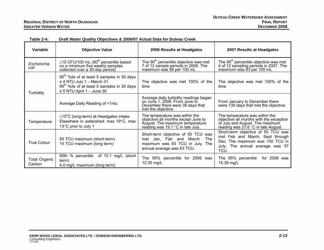
The raw water quality variables of greatest concern with regards to drinking water quality are turbidity, colour, organic carbon and pathogenic organisms such as E.coli O157:H7, Giardia Lamblia and Cryptosporidium Parvum. These pathogenic organisms are known to cause gastrointestinal illness when water disinfection or treatment is not adequate. The particulates that create turbidity can contain toxins, harbour microorganisms and interfere with the disinfection process2. The turbidity objective for GVW ‘Permit to Operate’ as directed by the Interior Health Authority is not to exceed an average daily source turbidity level of 1 NTU. GVW monitors water quality at three locations on Duteau Creek: at the outlet from the Haddo Reservoir; at the bridge crossing Duteau Creek at 12.5 km on the Haddo Forest Service Road; and at Headgates intake (pre-chlorination). Three other Duteau Creek tributaries are also monitored from May to October. Turbidity is always a concern in the source water. There is a natural high background colour level associated with the lignin and tannin, total organic carbon and iron. There is also a concern about increases in the turbidity resulting from anthropogenic activity in the watershed (including grazing impacts). Refer to the reports provided in Appendix C for additional data from the GVW water quality sampling for 2006 and 2007, including information for samples collected at the bridge and at the outlet at Haddo reservoir. Results for 2006/07 sampling results at Headgates (Duteau Creek intake) relative to the objectives are listed in Table 2-4.
DUTEAU CREEK WATERSHED ASSESSMENT FINAL REPORT
DECEMBER 2008
KERR WOOD LEIDAL ASSOCIATES LTD. / DOBSON ENGINEERING LTD. 2-13 Consulting Engineers 773.052
REGIONAL DISTRICT OF NORTH OKANAGAN GREATER VERNON WATER
Table 2-4: Draft Water Quality Objectives & 2006/07 Actual Data for Duteau Creek
Variable Objective Value 2006 Results at Headgates 2007 Results at Headgates
Escherichia coli
≤10 CFU/100 mL (90th percentile based on a minimum five weekly samples collected over a 30-day period)
The 90th percentile objective was met 7 of 12 sample periods in 2006. The maximum was 56 per 100 mL
The 90th percentile objective was met 4 of 12 sampling periods in 2007. The maximum was 83 per 100 mL
95th %ile of at least 5 samples in 30 days ≤ 4 NTU July 1 – March 31 95th %ile of at least 5 samples in 30 days ≤ 5 NTU April 1 – June 30
The objective was met 100% of the time
The objective was met 100% of the time
Turbidity
Average Daily Reading of <1ntu Average daily turbidity readings began on June 1, 2006. From June to December there were 38 days that met the objective.
From January to December there were 139 days that met the objective.
Temperature ≤15oC (long-term) at Headgates intake Elsewhere in watershed: max 19°C, max 13°C prior to July 1
The temperature was within the objective all months except June to August. The maximum temperature reading was 19.1 °C in late July.
The temperature was within the objective all months with the exception of July and August. The maximum reading was 21.6 °C in late August.
True Colour 50 TCU maximum (short-term) 15 TCU maximum (long term)
Short-term objective of 50 TCU was met Jan, Feb and March. The maximum was 93 TCU in July. The annual average was 63 TCU.
Short-term objective of 50 TCU was met Feb and March, Sept through Dec. The maximum was 100 TCU in July. The annual average was 57 TCU.
Total Organic Carbon
95th % percentile of 10.1 mg/L (short term) 4.0 mg/L maximum (long term)
The 95% percentile for 2006 was 12.55 mg/L
The 95% percentile for 2006 was 15.39 mg/L

DUTEAU CREEK WATERSHED ASSESSMENT FINAL REPORT
DECEMBER 2008
KERR WOOD LEIDAL ASSOCIATES LTD. / DOBSON ENGINEERING LTD. 2-14 Consulting Engineers 773.052
REGIONAL DISTRICT OF NORTH OKANAGAN GREATER VERNON WATER
Water quality monitoring has been completed and recorded consistently since 1998 at the Headgates intake. It is important to look at this data as a complete data set in order to identify trends. The following discussion reviews past trends in water quality relative to the potential risks (Table 2-2). Turbidity is a persistent drinking water quality problem within Duteau Creek. The peak turbidity occurs during the spring freshet (April-June). During the freshet the turbidity can be attributed to increased overland flow carrying in sediment from the creek banks and surrounding areas. Occasionally there is a second turbidity spike when the upland reservoirs spill causing a further increase in the creek flow. For the duration of the spring freshet, the turbidity is far greater than the IHA objective of 1 NTU and often above 5 NTU leading to a Boil Water Notice. During July to September there can be rainfall triggered increases in the turbidity. This increase may also be the result of low creek flows but high levels of algae (as measured by Chlorophyll a) and iron. High levels of total organic material will result in the formation of total trihalomethanes (TTHM) when the water is chlorinated. The Guidelines for Canadian Drinking Water Quality have set the interim maximum acceptable concentration (IMAC) for TTHMs at 100ug/L (0.100 mg/L). TTHMs are measured quarterly within the distribution system and, as seen in Figure 2-3, the levels are increasing above the objective. This may be due to increase in chlorination dosage, increase in organic matter in the source water, or a combination of both.
TTHMs Duteau (Upland) Water Water System
0
0.05
0.1
0.15
0.2
0.25
1997 1998 1999 2000 2001 2002 2003 2004 2005 2006 2007
Yea
rly A
vera
ge T
THM
(mg/
L)
Figure 2-3: Total Trihalomethane Results for 1997-2007
Figure 2-4 indicates how the yearly average total organic carbon (TOC) in the source water has increased from 2001 to 2007. Often, Duteau Creek does not meet the Ministry Environment’s draft objective for TOC levels.
Guideline = 0.100 mg/L

DUTEAU CREEK WATERSHED ASSESSMENT FINAL REPORT
DECEMBER 2008
KERR WOOD LEIDAL ASSOCIATES LTD. / DOBSON ENGINEERING LTD. 2-15 Consulting Engineers 773.052
REGIONAL DISTRICT OF NORTH OKANAGAN GREATER VERNON WATER
Figure 2-4: Total Organic Carbon Levels at Headgates for 2001-2007 The colour in the creek correlates to TOC levels for most of the year. In June, July and August there is also a relationship between the colour and iron level. The total iron level is highest in July and August, which are also the peak months in colour. Peaks in TOC occur most often in April but also occur in August. Bacterial loading is a concern for drinking water quality, as previously noted, fecal coliform and more specifically E.coli are of particular concern due to known health effects. The peak in fecal and E.coli presence is commonly in June. There is also a smaller spike in these values in the spring (March-May) during freshet and may be related to high overland flows during snow melt. There is another spike during the fall (September to November). This is a low flow period in the creek and the increase in bacterial loading may be due to wildlife and cattle moving lower in the watershed, accessing the unbuffered mainstem of the creek near the intake. In summary, bacteria levels periodically exceed the MoE draft objective, especially in the spring, the month of June and in the fall. Turbidity levels are typically above the objective set by IHA. Peaks in turbidity occur from April-June and occasionally in August. With respect to true colour the source does not meet the draft objective at any time of the year. In fact, since 2001 the yearly true colour appears to have been increasing (R2=0.50). Total organic carbon also exceeds the objective for most of the year. Finally, TTHM levels are increasing within the treated water and the levels do not meet the drinking water quality guidelines.
2.6.2 WATER QUANTITY
Water quantity is an increasing concern to GVW as a result of the increased demand for water within its service area, as well as the potential of decreasing runoff supply. The
Average Yearly Total Organic Carbon over time
y = 0.4936x - 978.96R2 = 0.8988
0.00
2.00
4.00
6.00
8.00
10.00
12.00
14.00
2001 2002 2003 2004 2005 2006 2007
Aver
age
year
ly T
OC
(mg/
L)

DUTEAU CREEK WATERSHED ASSESSMENT FINAL REPORT
DECEMBER 2008
KERR WOOD LEIDAL ASSOCIATES LTD. / DOBSON ENGINEERING LTD. 2-16 Consulting Engineers 773.052
REGIONAL DISTRICT OF NORTH OKANAGAN GREATER VERNON WATER
mean annual runoff or volume at the WSC station Duteau Creek near Lavington (located downstream of the GVS diversion point) is approximately 21,700 ML. The GVW holds water licenses for 24,468 ML of water for domestic and irrigation uses and storage licenses for 30,258 ML of water. There are three key issues relative to quantity: the amount of spring runoff in the upper watershed upstream of the storage reservoirs; the amount of developed storage; and the opportunity to increase the diversion of runoff from adjacent watersheds. GVW cannot influence climate, so has no control over the annual snow pack and subsequent runoff. GVW can, however, modify its storage capacity and it is currently reviewing options to increase its high elevation storage. It is unlikely that GVW would be granted any further diversion licenses from adjacent watersheds. To the east, Harris Creek watershed supplies Bessette Creek that has very high fish values. It is unlikely that DFO would support any proposal that might reduce the flow in Bessette Creek. To the west, watersheds are also community watersheds, so support for any diversions to the Duteau watershed is considered unlikely. GVW currently has 18,910 ML (15,330 ac ft) of developed storage in the three upland reservoirs. In 2007 the reservoirs did not fill due to a below-normal snowpack. GVW is in the process of evaluating the potential to divert runoff from the upper Flyfish system, a tributary within the Duteau Creek watershed, into the upper Duteau Creek, and also whether there is justification for Aberdeen Dam to be raised. It is recommended that the following water issues be assessed as part of the decision to raise the Aberdeen dam: impacts on nutrient loading in Aberdeen and Haddo reservoirs; impacts on algal production in reservoirs; impacts from flooding lands; preparation of a detailed construction management plan; and preparation of comprehensive reservoir operation plan for all three reservoirs.
A mountain pine beetle epidemic is sweeping through the mature lodgepole pine stands in the interior of the province. This will likely result in damage to most of the mature pine in the watershed. Since a significant portion of the mature forest stand in the upper watershed is mature pine, the loss of the forest cover will result in increased runoff and increased peak flows. The pine will likely die over the next three to five years, during which time the runoff will gradually increase. It is estimated that there will be increased runoff for several decades until the stands recover. Preliminary estimates are that the peak flows may be increased by 20-30%. It is recommended that GVW review the projected future peak flows and the spillway and channel capacities throughout the Duteau system. Additional details on the impacts of the pine beetle are provided in section 2.8.

DUTEAU CREEK WATERSHED ASSESSMENT FINAL REPORT
DECEMBER 2008
KERR WOOD LEIDAL ASSOCIATES LTD. / DOBSON ENGINEERING LTD. 2-17 Consulting Engineers 773.052
REGIONAL DISTRICT OF NORTH OKANAGAN GREATER VERNON WATER
Increased water yields could however be compromised by the potential decrease in snow pack as a result of the changing climate. Recent estimates by the Atmospheric Environment Service for the April 1st snow pack in the Okanagan indicate that by 2020 the mid-elevation snow pack may be reduced by 11%, by 2050 by 40% and by 2080 by 50%11. These decreases in snow pack combined with increasing summer temperatures may result in long-term supply issues for GVW. If there is a long-term trend for lower water yields, then there will be an increased hazard in the reservoirs associated with lower water levels and the increased transport of sediment from the exposed soils within the reservoir bounds during spring runoff and during summer rainstorms. There may also be the problem of increased sediment production resulting from human disturbance of exposed soils within the reservoir pool area. A related issue will be increased water temperatures in the reservoirs as a result of decreased runoff and increased summer temperatures. Higher water temperatures combined with increased turbidity levels will result in increased biological activity in the source waters and likely more frequent algae blooms.
2.7 INTEGRITY AND VULNERABILITY OF GVW INTAKE WORKS
In its present configuration, the intake is vulnerable to contamination from the raw water entering the intake pond as the intake is located directly on-stream as opposed to off-stream. The intake is vulnerable to impacts or contamination affecting the stream immediately upstream of the intake, such as landslides and increased channel instability resulting in increased sediment and debris loads. Increase in peak flow expected as a result of the mountain pine beetle may exacerbate this vulnerability. Preliminary estimates suggest that the 50-year peak flow could increase by approximately 20% as a result of the loss of the mature pine in the upper watershed. This could mean that the current spillway capacity at the reservoirs and Headgates may be undersized. A landslide into the channel in the unbuffered area near the intake did result in a temporary interruption to supply in 1997. In a worst-case scenario, the intake works are vulnerable to potential catastrophic loss in the event of an extreme flood event due to its present configuration. The integrity of the intake works should be capable of safely passing the Q100 peak flow including debris. This criterion should be reviewed with the provincial Dam Safety Branch. The intake works consist of a small intake pond (40,000 m3, 32 ac ft) situated in-line with the stream channel, gated intake works, a screening facility and chlorinator leading to a 48-inch diameter pipeline. The intake pond has a spillway channel that routes excess flow back into the stream channel below the intake. The intake pond intercepts creek bedload and allows some 11 Friscka, G., Atmospheric Environment Service, 2007, Presentation to City of Kelowna.

DUTEAU CREEK WATERSHED ASSESSMENT FINAL REPORT
DECEMBER 2008
KERR WOOD LEIDAL ASSOCIATES LTD. / DOBSON ENGINEERING LTD. 2-18 Consulting Engineers 773.052
REGIONAL DISTRICT OF NORTH OKANAGAN GREATER VERNON WATER
settlement of the coarse suspended material. The pond is not large enough to settle fine suspended load or most of the organic load. Refer to photos 105-108 in Appendix B. The spillway at Headgates has a spillway flood capacity significantly less than that of the new spillway at Haddo Reservoir. If the Headgates spillway is undersized it could place the intake pond works at risk of failure during an extreme flood event. A preliminary review was made of the Q100 design flow at Headgates with consideration for the likely increase in peak flows that will occur as the mountain pine beetle kills the mature lodgepole pine stands throughout the watershed. The report Duteau Creek Community Watershed Cumulative Hydrologic Impact Assessment Of Mountain Pine Beetle Infested Stands And Proposed Retention Plan that was completed for Tolko Industries Ltd. by Dobson Engineering Ltd. in 2007 (Appendix D) . The report suggests that there is a potential for the 50-year peak flows at Headgates to increase by 25%-30% as a result of the changes in the watershed hydrology from past logging and the loss of all the mature pine. The increase in the flow would likely be less but still substantial. A review of the actual spillway capacity at Headgates and the design flow for the works should be a high priority. In 2006 GVW commissioned a report on options and costs for diversion of Duteau Creek around the Headgates pond (Harvey Lake By-Pass Feasibility, EarthTech (Canada) Inc., March 2006). The purpose of this study was to evaluate whether cost-savings could be made to the proposed Duteau Creek Water Treatment Plant by implementing a creek bypass. Briefly, the study concluded that no improvements be made at that time to Harvey Lake due to cost and environmental impact factors, and as the changes would offer little long term benefit to treated water quality once the water treatment plant was constructed. It should be noted that that the study did not examine the flood capacity of the existing works.
2.8 FOREST DEVELOPMENT
Timber harvesting has occurred in the watershed over the past 77 years. From 1930 to approximately 1970, partial cutting techniques were employed in the lower elevation stands. Since the 1970s, clear cutting has been the dominant silviculture system in the even-aged lodgepole pine and Engelmann spruce-sub alpine fir stands at higher elevation. Over the last 37 years, a significant portion of the annual harvest has come from salvage logging of lodgepole pine stands infested with mountain pine beetle. There has also been an outbreak of spruce bark beetle in the Engelmann Spruce stands in the upper watershed that has resulted in additional salvage harvesting. The remaining mature lodgepole pine stands in the watershed are again under attack from the mountain pine beetle and it is estimated by the Ministry of Forests and Range that this current attack will likely destroy most if not all the mature pine by 2013. In the summer of 1998 the Aberdeen Fire burned approximately 700 ha of forest east of Aberdeen and Haddo Lakes. The fire burned a combination of standing timber and existing reforested cutblocks. The majority of the burned standing timber was salvaged in the fall and

DUTEAU CREEK WATERSHED ASSESSMENT FINAL REPORT
DECEMBER 2008
KERR WOOD LEIDAL ASSOCIATES LTD. / DOBSON ENGINEERING LTD. 2-19 Consulting Engineers 773.052
REGIONAL DISTRICT OF NORTH OKANAGAN GREATER VERNON WATER
winter of 1998 and subsequently replanted. Tolko Industries Ltd. is the major forest licensee in the watershed although BC Timber Sales does have minor holdings in the area. As indicated in Section 2.5, Tolko has completed a retention plan to address the mountain pine beetle problem in the watershed. Details of the Duteau Creek Retention Plan are available from Tolko’s Lumby office (Mr. Harold Waters). A retention plan is a forest development planning process that considers all the resource values in the watershed, timber and non-timber, and identifies which stands need to be retained to protect the non-timber values such as water, wildlife, fish, recreation, etc. These are the stands that will be retained, i.e., not harvested in the short-term (next 10 years). The remainder of the stands not required to protect other resource values are those stands that can then be considered for harvesting. This planning process was developed by Tolko to assist in planning salvage logging of mountain pine beetle infested stands. The plan included a review of the hydrologic impacts that may occur as a result of the loss of forest cover in the upper watershed that is the source of peak flows. In summary, the report indicated that there are approximately 2,800 ha of mature pine in the upper watershed or ~28% of the area. In addition there has been ~3,000 ha of past logging for a total disturbed area (not an ECA) of ~58% as the mature pine dies. The distribution of forest cover for the upper watershed is illustrated in Figure 2-5. The loss of forest cover and the loss of water use by the mature forest will result in increased water yields for several decades that could benefit GVW. The forests will recover as new stands replace those lost to beetle attack. Tolko is considering plans to salvage up to 1,921 ha of the 2,800 ha of beetle-infested pine in the upper watershed over the next three to five years, if there is acceptable wood quality. Most of the pine stands are pure pine with no other conifer species. As a result, based on preliminary research results on snow accumulation and melt in the Okanagan12, there may be little difference hydrologically in the equivalent clear-cut area between areas retained but dead and stands salvaged. This preliminary snow research in the Okanagan suggests that stands in the Okanagan do not function in the same way as stands in northern BC. That is to say that whether or not there was any salvage harvesting, the impact of the death of the remaining mature pine combined with the past harvesting will have affected more than 60% of the forested area in the snow sensitive upper watershed. Areas that are harvested and prepared for either natural regeneration or planted should have significant hydrologic recovery in approximately 30 years. For those areas not logged, left to recover naturally, hydrologic recovery will likely take 50-60 years13. Based on the Tolko report the equivalent clear-cut area in the upper Duteau watershed will likely decrease from the projected maximum level of 60% after the mature pine dies to approximately 21% within 30 years14.
12 Research in the Ashnola River watershed undertaken for Gorman Bros. Lumber Ltd. By Dobson Engineering Ltd. in 2007 and
2008 – not published. 13 ibid. 14 Dobson Engineering Ltd., Duteau Creek Community Watershed Cumulative Hydrologic Impact Assessment of Mountain Pine
Beetle Infested Stands and Proposed Retention Plan, 2007.

DUTEAU CREEK WATERSHED ASSESSMENT FINAL REPORT
DECEMBER 2008
KERR WOOD LEIDAL ASSOCIATES LTD. / DOBSON ENGINEERING LTD. 2-20 Consulting Engineers 773.052
REGIONAL DISTRICT OF NORTH OKANAGAN GREATER VERNON WATER
The current (2007) peak flow hazard (pre-beetle) is rated as low for the watershed. The estimated peak flow hazard, should all the mature pine die, or for the proposed retention plan, (for an ECA of 60%) would increase to high. Based on the results of the hydrologic assessment for the loss of the pine and the proposed salvage logging, it is the loss of the pine that is the dominant impact on the hydrology. Assuming that the mature lodgepole pine succumbs to the beetle as projected by the MoFR, ECA could increase to ~58% based on the loss of the pine. The proposed salvage harvesting would result in about the same final ECA, considering areas to be harvested and areas to be retained. However, the differences between the two scenarios are; a) the rate of increase in ECA (faster for the salvage harvesting scenario, 3-5 years, and slower for no harvesting, 5-8 years, and b) the rate of hydrologic recovery (faster for areas harvested and reforested, slower for area left to natural regeneration). Ultimately, the issue is a matter of balancing the risks. For further details refer to the hydrology report provided in Appendix D. It is recommended that GVW review the expansion of the pine beetle in the watershed with Tolko annually. It also recommended that GVW and Tolko review proposed salvage harvesting plans and options to protect the water resources. Figure 2-5: Forest Cover Distribution Note: Figure 2-5 illustrates the total forested area in the upper 40% of the Duteau Creek watershed. The total forested area = 8,769 ha, of which 3,898 ha or 45% of the area was logged in the past, and 1,427 ha or 16% is non-pine species, e.g., spruce, fir etc. Non-pine species account for 501 ha or 6% of the area.
Forest Cover Distribution in Watershed - Above, Retained Data
6%
32%
0%
1%
0%
45%
16%
<40%>70%40-50%51-60%61-70%LoggedNon-Pine
Non-pine = 1,427 Stands with <40% pine = 501 ha
Stands with >70% pine = 2,758 Logged = 3,989
Stands with 51-60% pine = 129

DUTEAU CREEK WATERSHED ASSESSMENT FINAL REPORT
DECEMBER 2008
KERR WOOD LEIDAL ASSOCIATES LTD. / DOBSON ENGINEERING LTD. 2-21 Consulting Engineers 773.052
REGIONAL DISTRICT OF NORTH OKANAGAN GREATER VERNON WATER
These stands are important since the death of the pine in these stands would have very little impact on the hydrology because of all the other trees that would remain alive. The stands with more than 70% pine account for 2,758 ha or 32% of the area. These are the stands that will have the most impact on the hydrology, as the forest cover is lost to the pine beetle. Although the stands are indicated as having more than 70% mature pine, in reality they are 100% pine. The remainder of the stands have between 51% and 60% mature pine and account for 129 ha or 1% of the area. In these stands about half of the stand is pine and the other half is other species. These stands will have some hydrologic value if they are not logged due to the non-pine species that would survive.
2.9 HISTORY OF WATER USE
Earth fill dams were constructed in the upper watershed on Haddo and Aberdeen Lakes in the early 1900s. A diversion from the Harris Creek watershed into Heart Creek was built in the 1930s and refurbished in 1992. Through this diversion, Paradise and Gold Creeks are directed into Heart Creek with a total licensed capacity of 6.5 million m3 per year of freshet runoff. In the 1980s, an earth fill dam was constructed at Grizzly reservoir to create a third storage reservoir in the upper watershed. The reservoir was designed with additional storage that would be used to maintain summer and fall low flows for salmon spawning and egg incubation downstream of Headgates. This portion of the Grizzly reservoir project was funded by DFO. Minimum releases below Headgates were to be 0.06 m3/s between January 1 and March 31, 0.11 m3/s between April 1 and August 31, and 0.14 m3/s between September 1 and December 31. DFO also has an agreement with GVW to provide a further release of water from Headgates upon special request, provided that the total volume released does not exceed 0.14 million m3 per year. The Headgates intake was originally constructed in the 1920s and rebuilt in the 1960s. The total licensed diversion through the Headgates facility exceeds 25 million m3 per year.
2.10 SUMMARY
The intent of this section was to characterize the Duteau Creek watershed. The watershed area upstream of Headgates, which is the designated community watershed, is approximately 182 km2
and includes the portion of the Paradise Creek watershed, a tributary to Harris Creek, where runoff is diverted into Heart Creek. The elevation ranges from ~660 m at Headgates to 1,800 m in the Grizzly Hills. The GVW works include intake works at Headgates, three upland reservoirs Haddo, Aberdeen and Grizzly, and the diversion works from Paradise Creek into Heart Creek. There are 14 known stakeholders with an interest in the watershed. The watershed includes four biogeoclimatic zones and is generally forested. The terrain ranges from a steep narrow canyon upstream of Headgates to rolling plateau in the uplands. The hydrology is snow dominated with peak flows occurring between late-April to mid-June. The maximum discharge recorded at the Water Survey of Canada Hydrometric Station was 16.2 m3/s in 1990. The gauging station is no longer active.

DUTEAU CREEK WATERSHED ASSESSMENT FINAL REPORT
DECEMBER 2008
KERR WOOD LEIDAL ASSOCIATES LTD. / DOBSON ENGINEERING LTD. 2-22 Consulting Engineers 773.052
REGIONAL DISTRICT OF NORTH OKANAGAN GREATER VERNON WATER
From a hydrologic perspective the watershed is considered to have three distinct zones: the unbuffered zone upstream of Headgates to Haddo Reservoir; a partially buffered zone in the Flyfish Lake area; and a buffered zone upstream of the Haddo Reservoir. GVW is concerned about the quality of the water at the intake, particularly with regards to bacteria and sediment loads. Flows for fish are a concern downstream of Headgates and GVW has an agreement with DFO for specified releases. The long-term identified hazards to drinking water include: sediment from roads and cattle; bacteria, protozoa and viruses from humans, wildlife and cattle; cytotoxins from algae; wildfire as the fuel loads increase from the death of the lodgepole pine; herbicides from the application to noxious weeds; and hydrocarbons from a fuel spill. The present raw water quality is considered to be satisfactory for most of the year except during the spring freshet and rainstorm peaks when levels often exceed the established objectives. Water quantity is an issue due to increasing demand and decreasing supply during years with below normal snow packs. The long-term integrity and water quality associated with the Headgates intake is a concern. The configuration of the present intake pond places the intake works directly in line with incoming runoff. As a result in the event of a major sediment influx due to very high flows or a landslide upstream of the intake, sediment and debris could block the intake causing an interim loss of the supply. The spillway capacity is less than that for the spillway at Haddo and may be under capacity particularly if peak flows increase as the lodgepole pine dies. Forest development has occurred in the watershed for the past 77 years. The current forest licensee is Tolko Industries Ltd. There is a high likelihood that the mountain pine beetle will kill most of the mature lodgepole pine in the watershed over the next three to five years. Tolko has developed a retention plan to address the salvage of some of the affected pine. The loss of the mature pine combined with areas logged will increase the equivalent clear-cut area significantly in the watershed from the current level of ~30% to possibly as high as 60%. There will be significant changes to the watershed hydrology as a result of the current beetle infestation.

Section 3 Module 2 – Results of Contaminant Inventory

DUTEAU CREEK WATERSHED ASSESSMENT FINAL REPORT
DECEMBER 2008
KERR WOOD LEIDAL ASSOCIATES LTD. / DOBSON ENGINEERING LTD. 3-1 Consulting Engineers 773.052
REGIONAL DISTRICT OF NORTH OKANAGAN GREATER VERNON WATER
3. MODULE 2 – RESULTS OF CONTAMINANT INVENTORY The objectives of Module 2 are to inventory the land uses and impacts within the community watershed and inventory the potential sources of contamination associated with these land uses that could affect drinking water quality within the watershed. In addition it includes an update for the Interior Watershed Assessment Procedure for the watershed to the end of 2007 with ECAs projected to 2020. The combination of the watershed characterization and the preliminary hazard inventory provided in Module 1, and the contaminant inventory (hazard identification), are used to evaluate the risks to the drinking water supply required in Module 7. Reconnaissance-level field inspections were completed as part of Modules 1 and 2, which included approximately ten field days.
3.1 SUMMARY OF INTERIOR WATERSHED ASSESSMENT PROCEDURE UPDATE TO DEC. 31, 2007
As summarized in Section 1.3 the procedure is an analytical tool designed to help forest managers understand the water-related problems associated with past forest development that may exist in a watershed, and to recognize the possible hydrological implications of proposed forestry-related development. The original Interior Watershed Assessment Procedure (IWAP) was completed for the Duteau Creek watershed in 1996, updated in 1999 and again in 2007 as part of this Duteau Creek Watershed Assessment and Protection Plan. The following sections provide a summary of the results of the 2007 IWAP update. Copies of the 1996 and 1999 reports are provided in Appendix E. The IWAP procedure has evolved since the original guidebook was released in 1995 and the revised guidebook in 1999 to a professional assessment process used in 2007 that relies on the judgment of a qualified professional (PEng, PGeo, or RPF) with demonstrated experience in watershed assessments in the interior of BC. The 1999 guidebook is used for guidance only. It is important to note that the hazard ratings in the IWAP process are directed at forest development impacts and do not necessarily reflect the hazards that are of concern for the protection of drinking water. Since the 2007 update was initiated as part of the Source Protection Plan, the update focused on more than just forestry impacts. The fieldwork included inspections and assessments of all forms of human impacts in the watershed that could affect drinking water quality including recreational use, and hunting and fishing impacts. It also assessed the impacts from grazing on the water sources as well as other industrial activities such as mining (rock quarry development).
3.1.1 RECOMMENDATIONS FROM THE 1999 IWAP
The following recommendations related to water quality were presented in the 1999 IWAP report. Following each recommendation is a comment on whether or not any action was taken on the recommendation.

DUTEAU CREEK WATERSHED ASSESSMENT FINAL REPORT
DECEMBER 2008
KERR WOOD LEIDAL ASSOCIATES LTD. / DOBSON ENGINEERING LTD. 3-2 Consulting Engineers 773.052
REGIONAL DISTRICT OF NORTH OKANAGAN GREATER VERNON WATER
Complete terrain stability field assessments on the three partial cutblocks in the canyon section that address the potential hydrologic effects of harvesting both within cutblocks and on downslope areas.
- Action: unknown. Not known if these blocks were ever developed. Terrain stability assessments would have been completed as a requirement under the Forest Practices Code.
Design road construction and deactivation plans for proposed blocks in and around streams and reservoirs that limit future range and recreation access to the channels or lakes.
- Action: There has been limited road development in the watershed since 1999 and typically new roads are designed as temporary roads to limit ongoing access.
Utilize temporary access structures where possible to harvest cutblocks along the canyon reaches. If a permanent road is required, deactivate as soon as possible following harvest.
- Action: Typically temporary roads are used to access blocks. It is not known if the cutblocks in the canyon area were developed.
Review the landslide site on road 533.1 in upper Duteau Creek prior to any upstream harvesting to determine further mitigation alternatives.
- Action: Slide was reviewed and some additional mitigation work was undertaken.
Improve sediment controls on ‘throttle hill’ immediately beyond the Duteau Creek mainstem crossing on the Haddo FSR.
- Action: Sump, rock drain and sediment trap (cattle guard) have been installed at the bottom of the hill. Sump needs to be reviewed for effectiveness.
Develop a Riparian Management Area (RMA) strategy for mainstem channels between Haddo Lake and the canyon – one that reduces the risk of blowdown in the RMA and recommends possible salvage methods where blowdown occurs to be implemented on a site specific basis.
- Action: Unknown.
Remove the cattle bridge from lower reach D and upgrade or deactivate the trail adjacent to the channel to reduce erosion and sedimentation.
- Action: Some work has been done at this site but it needs to be re-visited for effectiveness.
Continue proactive cattle management in conjunction with range permit holders and the MoF Range and Recreation Branches, particularly between Haddo Lake the canyon and area around the upper reservoirs.
- Action: There has been ongoing work on improving cattle management.
DUTEAU CREEK WATERSHED ASSESSMENT FINAL REPORT
DECEMBER 2008
KERR WOOD LEIDAL ASSOCIATES LTD. / DOBSON ENGINEERING LTD. 3-3 Consulting Engineers 773.052
REGIONAL DISTRICT OF NORTH OKANAGAN GREATER VERNON WATER
Complete the planned MELP/NOWA and SBFEP review of stream channels potentially affected by the Aberdeen fire, and rehabilitate disturbed stream channels and riparian areas where required.
- Action: Unknown.
Assess observed bank shearing and channel sedimentation concerns in the Crescent, Flyfish and Curtis drainages and Aberdeen Residual area through the range use plan process.
- Action: An off-steam watering site has been constructed in the Crescent area.
3.1.2 SUMMARY OF 2006 HYDROLOGIC ASSESSMENT COMPLETED FOR TOLKO
The watershed was inspected in the fall of 2006 by staff from Dobson Engineering with an emphasis on sediment production and delivery to streams as well as mainstem stream channel condition. In addition general observations of road prism condition other issues were noted. Maps supplied by Tolko were utilized to locate inspection sites and recent forest development.
Stream Inspections
Seven stream crossings were visited within the watershed. In general the channels are in fair condition and disturbances were typically related to past industrial activities (forestry) and cattle activity along stream banks. For details on the sites inspected refer to the report Duteau Creek Community Watershed Cumulative Hydrologic Impact Assessment of Mountain Pine Beetle Infested Stands and Proposed Retention Plan located in Appendix D.
Road Inspections
The main roads inspected included: Aberdeen FSR, 2700, Brunnet Main, Haddo Main, Goat Main, and Curtis Main. In general the roads were in good condition with low sediment production and delivery. Problems were typically at stream crossings and were related to road fill erosion at culverts, cattle activity at crossings and general maintenance issues. The following is a summary of the road assessment by road system.
Aberdeen Main Aberdeen Main from 10 km to 39 km is in good condition (Photo 1). The ditchlines and cutslopes were typically well vegetated and not a sediment source. Problems were related to fill erosion at crossdrain and stream culverts (Photos 2, 3, 8, and 27). From 29 km to the 39 km (watershed boundary) on Aberdeen Main, the road is in fair condition. Numerous intermittent stream crossings appear to have undersized or failing culverts. Where the streams have overtopped the roads due to undersized culverts twin culverts have been installed. Ditch erosion and a failing wood culvert were also identified.
DUTEAU CREEK WATERSHED ASSESSMENT FINAL REPORT
DECEMBER 2008
KERR WOOD LEIDAL ASSOCIATES LTD. / DOBSON ENGINEERING LTD. 3-4 Consulting Engineers 773.052
REGIONAL DISTRICT OF NORTH OKANAGAN GREATER VERNON WATER
2700 Road The 2700 Road is in good condition, typically overland type construction (Photo 20), sediment production and delivery is low. Typical problems along this road are related to cattle access at the stream crossings (Photo 21). Brunnet Main Brunnet Main is in good condition, typically a rolling grade with numerous low gradient grassed-in drainages. Sediment production was low to moderate along some sections of ditch (Photos 22, 23, and 24), but delivery was typically to crossdrain culverts and grassed wet areas. Haddo Main and Goat FSR Haddo Main and Goat FSR were in good condition. The road prism outside of the running surface was well vegetated and not considered a sediment source. It was reported that there was a blocked culvert in 2008 at the intersection of Goat and Haddo FSRs. Remedial work was completed to resolve the problem (R. Clark). Curtis Main Curtis Main borders the northern portion of Aberdeen Reservoir. The road grade is rolling with many overland sections (Photo 39). Some maintenance issues were noted potholes are abundant (Photo 44) and cattle activity near streams is evident (Photos 38 and 47). The road is in good condition and not considered a sediment source.
3.1.3 2007 IWAP UPDATE
Prior to undertaking a watershed assessment the watershed is subdivided into separate sub-basins based on the main watershed tributaries and hazard ratings are derived for each of them. For the Duteau Creek watershed there were four sub-basins: Heart, Duteau above Grizzly Reservoir, Aberdeen, and Flyfish. There are also two residual areas: Aberdeen and Duteau that are assessed but the ratings are included in those for the total watershed. Table 3-1 lists parameters that are considered when assessing the impacts of forest development on the watershed. Following each parameter is a brief description of the significance of the parameter. These parameters are used to develop hazard ratings for the impacts of past forest development on peak flow, surface erosion, riparian buffers (i.e., channels), and landslides. Table 3-1: Watershed Parameters Used in Assessing Forest Development Impacts
Parameter Significance Gross watershed area Used to calculate ECA Total harvested area Used to calculate ECA Current equivalent clear-cut area (ECA) Used to assess logging impacts on peak flowsECA below the H40 elevation Part of watershed ECA ECA above the H40 elevation Peak flow sensitive zone

DUTEAU CREEK WATERSHED ASSESSMENT FINAL REPORT
DECEMBER 2008
KERR WOOD LEIDAL ASSOCIATES LTD. / DOBSON ENGINEERING LTD. 3-5 Consulting Engineers 773.052
REGIONAL DISTRICT OF NORTH OKANAGAN GREATER VERNON WATER
Total road density Part of surface erosion assessment Total road length Part of surface erosion assessment Length of road deactivated Part of surface erosion assessment Length of road rated as high and moderate sediment sources
Part of surface erosion assessment
Number of landslides entering a stream Used to assess watershed slope stability Amount of road of class IV and V terrain Used to assess watershed slope stability Number of stream crossings Part of surface erosion assessment Length of stream logged to the bank Used to assess channel stability Length of mainstem channel with non-functioning riparian area
Used to assess channel stability
Length of disturbed mainstem channel Used to assess channel stability
3.1.4 WATERSHED CONCERNS
The following list summarizes the types of concerns that development and recreation uses can pose to drinking water quality and quantity:
Impacts of forestry and range management on water quality and quantity;
Increases in turbidity levels and presence of pathogenic organisms that may require special treatment of drinking water;
Increased access for recreation and range use that may result from forest road construction in and around streams;
Slope stability issues in the lower residual area adjacent to the canyon reaches that is the most sensitive area with respect to forest development;
Hydrologic effects from increased wildfire risk related to the impacts from the mountain pine beetle; and
Increased runoff rates into the upper reservoirs if accelerated by forest development and the impacts from the mountain pine beetle.
The primary purpose of the storage reservoirs is to store water for domestic and irrigation uses; they should not be considered as settling ponds, nor are they meant to be used for intensive recreation purposes.
Recreation uses on and around storage reservoirs increase the risk of contamination with bacteria, viruses and chemicals.
3.1.3 2007 IWAP REPORT CARD
The watershed report card was updated as part of this project. The results provided in Table 3-2 summarize the data for the watershed area above Headgates by elevation band

DUTEAU CREEK WATERSHED ASSESSMENT FINAL REPORT
DECEMBER 2008
KERR WOOD LEIDAL ASSOCIATES LTD. / DOBSON ENGINEERING LTD. 3-6 Consulting Engineers 773.052
REGIONAL DISTRICT OF NORTH OKANAGAN GREATER VERNON WATER
and road density to the end of 2007. Table 3-3 provides a projection of anticipated ECA to 2020.
3.1.4 HAZARD INDICES SUMMARY
Using the results provided in the watershed report card, hazard ratings are derived for the four hydrologic hazards, peak flow, surface erosion, riparian buffers and landslides that are summarized below and in Table 3-4.
PEAK FLOW
The ECA for the watershed has increased from 22.8% in 1999 to 27.4% at the end of 2007. The peak flow hazard remains at a moderate level for the watershed and for the Heart and Aberdeen sub-basins but low for the Duteau upstream of Grizzly and the Flyfish sub-basins. Based on the results of the hydrologic assessment completed for Tolko as part of its Retention Plan for the Duteau Creek watershed, the projected ECAs after the mature pine dies, combined with past and proposed harvesting will result in a maximum ECA of ~58%. This will result in a high peak flow hazard. The report also addressed hydrologic recovery over the 30 year period from 2007 – 2036. Figure 3-1 illustrates how the equivalent clear-cut area may change from the pre-beetle conditions, i.e., year 2006 on the graph, through the beetle attack and the loss of the mature pine (2006-2008) and then the gradual recovery as areas harvested and planted recover (2008-2036). The graph indicates that the pre-beetle equivalent clear-cut area was approximately 30% and that this would increase to approximately 58% for the ‘no salvage option’ and 59% for the ‘salvage’ option. The graph indicates that ECAs would increase more rapidly as salvage harvesting occurs until ~2009 and then recovery commences. For the ‘no salvage’ option the ECA would increase gradually as the pine dies over the next 10-15 years and then recovery takes over. As the new stands grow, the equivalent clear-cut area would decline reaching 38% for the no salvage option in 30 years and 21% for the ‘salvage’ option. The two projections are provided only to illustrate how the ECAs may change over time. The actual ECA values will depend upon the natural conditions that occur in the watershed. ECAs were also projected to the year 2020 based on hydrologic recovery of past harvesting and assuming no new harvesting and no epidemic loss of mature lodgepole pine to the pine beetle. The projected ECAs for 2007 to 2020 are provided in Table 3-3.

DUTEAU CREEK WATERSHED ASSESSMENT FINAL REPORT
DECEMBER 2008
KERR WOOD LEIDAL ASSOCIATES LTD. / DOBSON ENGINEERING LTD. 3-7 Consulting Engineers 773.052
REGIONAL DISTRICT OF NORTH OKANAGAN GREATER VERNON WATER
Table 3-2: Duteau Creek 2007 IWAP Update Watershed Report Card

DUTEAU CREEK WATERSHED ASSESSMENT FINAL REPORT
DECEMBER 2008
KERR WOOD LEIDAL ASSOCIATES LTD. / DOBSON ENGINEERING LTD. 3-8 Consulting Engineers 773.052
REGIONAL DISTRICT OF NORTH OKANAGAN GREATER VERNON WATER
Figure 3-1: Hydrologic Recovery for Duteau Watershed Upstream of Headgates, With and Without Beetle Salvage Logging.
100
90
80
70
60
50
40
30
20
10
00 6 1 0 1 5 2 0 2 5 3 0 3 5
Equ
ival
ent c
lear
-cut
are
(EC
A) a
s Pe
rcen
t
Year (2006 -2036)
30.1%
58.9%
57.7%
37.7%
21.4%
Salvage & RegenerationPast harvesting + proposed salvage logging with regeneration
Natural Regeneration Past 2006 Past harvesting, no salvage logging natural regeneration

DUTEAU CREEK WATERSHED ASSESSMENT FINAL REPORT
DECEMBER 2008
KERR WOOD LEIDAL ASSOCIATES LTD. / DOBSON ENGINEERING LTD. 3-9 Consulting Engineers 773.052
REGIONAL DISTRICT OF NORTH OKANAGAN GREATER VERNON WATER
SURFACE EROSION
Table 3-2 indicates that the road density has decreased from 1.6 km/km2 in 1999 to 1.4 km/km2 in 2007 but the number of stream crossings has increased from 151 to 198. Field inspections identified 94 stream culvert/bridge sites and 96 crossdrains. Some of the older roads were so overgrown that they were not accessible and were not inspected. The surface erosion hazard from forest development remains rated as low for the watershed and for all of the sub-basins.
RIPARIAN BUFFERS
The riparian buffer, as represented by the ‘extent of stream logged to the bank’, has increased from 76 km in 1999 to 85 km in 2007. This value is derived using GIS to identify streams on the TRIM maps that are adjacent to, or within a logged area. Since the TRIM data typically overestimates the stream network, this value is likely an overestimate. For streams that require buffers or reserves under the Forest and Range Practices Act, the riparian area will be intact. Any increase in ‘streams logged to the bank’ will be for the very small streams classified as non-classified drainages where, although there may have been harvesting to the bank, the streams are normally protected by ‘no machine’ buffers.
LANDSLIDES
The landslide hazard remains low as there have been no additional slides identified in the watershed since the 1999 update.
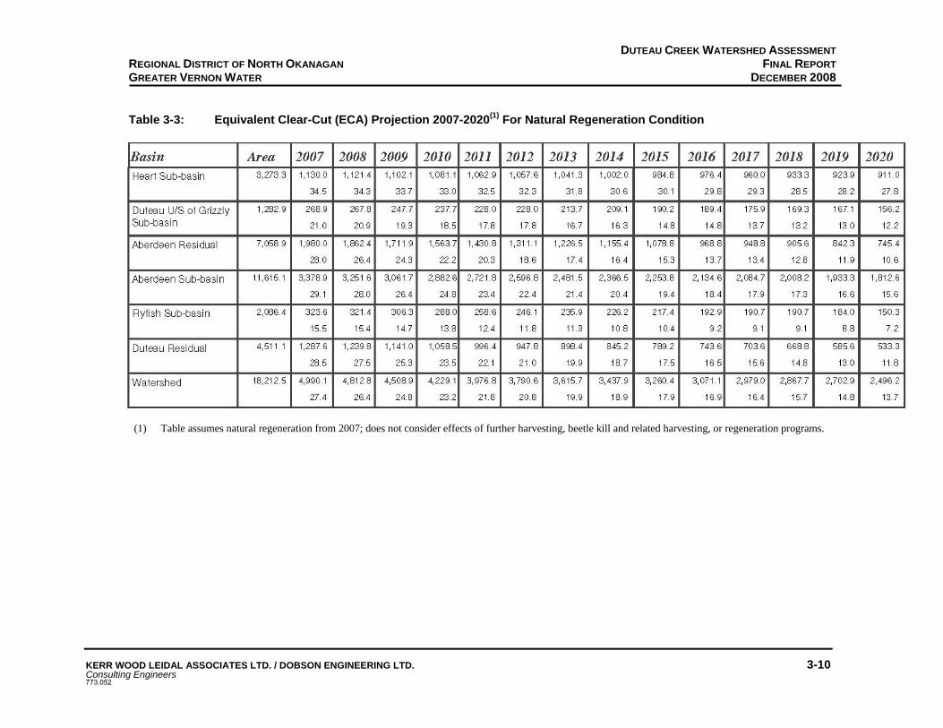
DUTEAU CREEK WATERSHED ASSESSMENT FINAL REPORT
DECEMBER 2008
KERR WOOD LEIDAL ASSOCIATES LTD. / DOBSON ENGINEERING LTD. 3-10 Consulting Engineers 773.052
REGIONAL DISTRICT OF NORTH OKANAGAN GREATER VERNON WATER
Table 3-3: Equivalent Clear-Cut (ECA) Projection 2007-2020(1) For Natural Regeneration Condition
(1) Table assumes natural regeneration from 2007; does not consider effects of further harvesting, beetle kill and related harvesting, or regeneration programs.

DUTEAU CREEK WATERSHED ASSESSMENT FINAL REPORT
DECEMBER 2008
KERR WOOD LEIDAL ASSOCIATES LTD. / DOBSON ENGINEERING LTD. 3-11 Consulting Engineers 773.052
REGIONAL DISTRICT OF NORTH OKANAGAN GREATER VERNON WATER
Table 3-4: 2007 Hazard Indices for the Duteau Creek Watershed
IMPACT CATEGORY WATERSHED SUB-UNIT Peak
Flows Surface Erosion
Riparian Buffers Landslides
Aberdeen Mod Low Low Low
Heart Mod Low Low Low
Grizzly Low Low Low Low
Flyfish Low Low Low Low Entire
Watershed Mod Low Low Low *Note: Hazard indices for the residual area have not been included in this table. Based on IWAP guidelines, hazard ratings are not to be calculated for residual areas. Development data collected for the residual area have instead been included in the calculation of hazard indices for the entire watershed. Any concerns identified in the residual area are addressed in the sections of the report referring to the entire watershed.
3.2 SUMMARY OF CHANNEL CONDITIONS
The following is a summary of channel assessments completed in 2007 for selected channel reaches in the watershed as part of the field assessments.
LOWER DUTEAU CREEK
For lower Duteau Creek above Headgates the channel is considered to be slightly disturbed (CPc/b-D1/A1)15. Channel gradients are 4-5%, banks were boulder/cobble and gravel, eroding in places. Work by Barton and Hesketh to stabilize the channel upstream of the intake appeared to be functional. Several large over-mature cottonwoods are likely to fall into the stream causing further bank instability. There is evidence of old channel avulsions and back channels in the areas immediately upstream of the Headgates pond. There is an abandoned ATV bridge located approximately 300 - 400 m upstream of the Headgates pond that should be monitored regularly or removed (Appendix B Photos 90-104). The landslide near 12 km on the Aberdeen FSR appears to be re-vegetating and sediment input to the channels from this landslide is minimal (Appendix B Photos 109 and 110).
UPPER DUTEAU CREEK
The channel in upper Duteau Creek, near crossing #198, has cobble gravel bed and banks but is eroding in places and is rated as CPc/d1-W. Wood debris is abundant in the channel (Appendix B Photos 57-58, 61). The second landslide in the watershed is located in upper Duteau Creek upstream of Grizzly Reservoir (Appendix B Photos 62-63). Some vegetation is becoming
15 These channel rating diagnostic keys are based on the Ministry of Forests, Channel Assessment Procedure Field Guidebook,
December 1996, http://www.for.gov.bc.ca/TASB/LEGSREGS/FPC/FPCGUIDE/CHANFLD/CFLD-TOC.HTM

DUTEAU CREEK WATERSHED ASSESSMENT FINAL REPORT
DECEMBER 2008
KERR WOOD LEIDAL ASSOCIATES LTD. / DOBSON ENGINEERING LTD. 3-12 Consulting Engineers 773.052
REGIONAL DISTRICT OF NORTH OKANAGAN GREATER VERNON WATER
established on the lower toe of the landslide, but the headwall and transport zone are still exposed sands and gravels. ATVs have been crossing the top of the slide along the deactivated road causing further disturbance.
HEART CREEK
Heart Creek was assessed at crossing #105; the channel is rated as slightly disturbed (CP/c/g – D1). The gradient is ~ 3% (Appendix B Photos 78-81). Bed material is cobble dominated, small gravel deposits behind wood and occasional large cobbles/small boulders. Channel banks are cobble and gravel and for the most part are intact. Some local disturbance at the bridge crossing was noted. Wood is abundant and there are many recently fallen trees in the riparian area. Cattle use common in the riparian zone. The creek was dry at the time of assessment.
CURTIS CREEK
Curtis Creek at the assessment site had a gradient of ~3.5% with cobble and gravel bed and banks. The channel was classified as CP/c-D1. The banks were undercut in places and it appeared that the channel had experienced increased peak flows in recent years (Appendix B Photos 85-86).
SUMMARY
In general, with the few exceptions noted above, the channels in the upper watershed are stable and in good condition.
3.3 OVERVIEW OF POTENTIAL CONTAMINANTS AND INVENTORY PROCESS
The potential contaminants to drinking water are typically a function of land use. As has been summarized in Section 2.5 the land uses within the Duteau Creek watershed are limited to water supply, forest development, grazing, industrial access, and recreation. The primary contaminants associated with these land uses are:
sedimentation to streams from forest access roads (including dust); sedimentation to streams from cattle disturbance at road crossings and along stream banks; bacteriological and pathogen contamination from cattle and wildlife activity around streams
and reservoirs; by-products from algal blooms in reservoirs resulting from increased nutrient loading, e.g.
sediment; bacteriological and pathogen contamination from human activity around streams and
reservoirs; and petroleum spills.
The risk of the identified contaminants entering the drinking water increases with increased watershed activity. The most likely points of contamination are those sites that permit direct access to the stream network at stream crossings. Pierre Beaudry and Associates has developed a

DUTEAU CREEK WATERSHED ASSESSMENT FINAL REPORT
DECEMBER 2008
KERR WOOD LEIDAL ASSOCIATES LTD. / DOBSON ENGINEERING LTD. 3-13 Consulting Engineers 773.052
REGIONAL DISTRICT OF NORTH OKANAGAN GREATER VERNON WATER
method to numerically assess the impact of stream crossings on water quality called the Stream Crossing Quality Index (SCQI). This method considers potential erosion sites at each assessed stream crossing; the road surface on either side of the crossing and the ditches/cutslopes/fill slopes on the high and low sides of the stream at each crossing (refer to Appendix F for details on the procedure). Since the SCQI procedure is proprietary, the procedure was used as a guide for this project. The pre-field assumption was that, by default, all stream crossings were considered to be affecting water quality and are given a score of 1. The field assessment results consider soil type, level of road use, and sediment delivery potential to determine the actual score for each crossing. Soil textures were determined based on visual observations. The contaminant inventory process involved the following four-step process:
Step 1 – Office review of past reports and IWAP results, the updated IWAP report card,
changes in forest development since last assessments and review of forest development maps, review of historical and recent air photographs.
Step 2 – Preparation of new field maps indicating all road crossings and updated forest
development, prepare field cards to record results. Step 3 – Complete field assessment to identify and record contamination related to
anthropogenic activities in the watershed, e.g. roads, stream crossings, channel conditions, recreational use, recent logging, as well as those from natural sources, e.g. unstable channels, unstable slopes, etc.
Step 4 – Evaluate and summarize results.
Since stream crossings represent the most likely point source for contamination especially from sediments and road runoff, a ‘stream crossing quality rating’ system was developed that permitted a consistent rating of sediment production, sediment delivery and cattle disturbance that resulted in a final overall hazard rating for each crossing. The condition of roads with regard to intercepting and diverting runoff and sediment was noted for all roads assessed. In addition, channel assessments were completed for selected reaches using sites that had been assessed during previous work where practical. Riparian condition was also assessed at a sufficient number of locations to characterize the sub-basins. Recreational use was recorded throughout the assessment area with additional emphasis placed on areas of concentrated use around lakes and reservoirs.
3.4 NATURAL FACTORS THAT IMPACT WATER QUALITY AND QUANTITY
CLIMATE CHANGE IMPACTS
Climate change is likely to cause significant and long-term impacts to the Duteau Creek watershed since the area was initially developed for water supply purposes. According to research by the Atmospheric Environment Service, temperatures in the Okanagan are

DUTEAU CREEK WATERSHED ASSESSMENT FINAL REPORT
DECEMBER 2008
KERR WOOD LEIDAL ASSOCIATES LTD. / DOBSON ENGINEERING LTD. 3-14 Consulting Engineers 773.052
REGIONAL DISTRICT OF NORTH OKANAGAN GREATER VERNON WATER
increasing by 0.1oC/year over the spring, summer and fall seasons and by 0.2oC/year over the winter season. There is also a projected decrease in the April 1st snow pack of 10% by 2020, 40% by 2050 and 50% by 2080. The decrease in snowfall is accompanied by an increase in rainfall, i.e., the snowfall/rainfall partitioning is shifting towards more rain and less snow during the winter season. The effects on the Duteau water supply and the GVW water demand require more study to determine the impacts. In summary, the research suggests warming summers resulting in increased water demand by agriculture, and less snow (but perhaps more rain) during the winter that may result in less runoff. The climate models also indicate a shift in the snowmelt period by two weeks earlier.
MOUNTAIN PINE BEETLE IMPACTS
One of the most obvious impacts, currently affecting the watershed, is the mountain pine beetle and hence the likely loss of most of the mature lodgepole pine in the watershed. Lodgepole pine is the dominant conifer species in the watershed, especially in the upper snow-sensitive zone (upper 40% of the watershed). Approximately 28% of the upper watershed area is dominated by mature pine that may die over the next several years. When this area is added to the area previously logged (~30% of the area), the total area where the hydrology may be impacted will be ~58%. This area will provide greater water yield for the next several decades, and could result in significantly increased peak flows as well as a shift in the timing of the runoff to earlier in the spring. There is a risk that the magnitude of peak flows will increase as the lodgepole pine dies and that the frequency of larger flow events will increase. There is a potential for the larger peak flows to exceed the design criteria of existing stream culverts and bridges leading to increased risk of failures of these structures. Increased peak flows could also result in increased channel erosion and subsequent sediment transport that would degrade water quality. It is recommended that the forest licensees and the MoFR review the design capacities of stream crossings and upgrade structures that could be at risk of being undersized. As described in Section 3.3, as a result of the epidemic pine beetle activity, there will be a significant increase in timber harvesting (focused on salvaging infested pine stands while there is still economic value to the wood). Tolko’s current plan is to harvest approximately 50% of the infested stands in the upper watershed over the next three to five years. As stands die and are salvaged there will be increased access to streams and wetlands for wildlife and cattle as grasses and brush species that may dominate many sites temporarily until conifer stands recover. As a result of the increased wildlife and cattle use there will be the associated increases in sediment and fecal loading in the streams. Combining the impacts of the loss of forest cover to the pine beetle and climate change, there may be some benefits from less snow in the short-term that might offset the potential increase in peak flows associated with the loss of forest cover. However, the snowmelt period could be advanced by as much as four weeks resulting in the GVW having to rely on storage for a much longer period of the year. Over the long-term,

DUTEAU CREEK WATERSHED ASSESSMENT FINAL REPORT
DECEMBER 2008
KERR WOOD LEIDAL ASSOCIATES LTD. / DOBSON ENGINEERING LTD. 3-15 Consulting Engineers 773.052
REGIONAL DISTRICT OF NORTH OKANAGAN GREATER VERNON WATER
indications are that there will be less water supply from the watershed to meet an increasing demand.
WILDLIFE IMPACTS
It is likely that all stream crossings are used by wildlife. During the fieldwork though very little evidence of wildlife impacts were noted. Some deer prints and coyote/dog/wolf tracks and bear tracks were noted at a few sites. Wildlife movement in the watershed is unknown. With greater road density, the easier it is for ungulates to move throughout the watershed. Based on the data reported by Cynthia Meays, wildlife may be a significant source of E.coli in the watershed. As noted in the previous section there will likely be increased wildlife as well as cattle use throughout the watershed where the pine stands die or are salvaged and there is increased forage. Where natural barriers are lost it will be important to assess the requirement for strategically located fences to protect the source water quality.
3.5 ANTHROPOGENIC USES THAT IMPACT WATER QUALITY AND QUANTITY
3.5.1 FOREST DEVELOPMENT IMPACTS
Forest development activity typically increases sediment delivery by streams as summarized in section 3.1. The future impacts from forest development, for the short-term, that is the next three to five years will result from the proposed salvage harvesting of pine beetle affected stands. These impacts are likely to be minimal compared to the larger scale hydrologic impacts that are going to occur as a result of the loss of all the mature lodgepole pine, especially in the snow-sensitive upper watershed, as it is the source of peak flows. Since there will be limited additional road required to support the salvage logging, the impacts on water quality should be minimal. The loss of forest through natural causes and salvage logging will result in increased exposure of streams for recreational use and wildlife and cattle access. As the forest cover is reduced there is greater opportunity for increases in grasses and brush species due to improved light, moisture and nutrients. The expansion of these species will encourage greater use by ungulates and cattle into areas along streams not previously accessible or attractive to these animals. Increased animal presence will result in increased sediment and fecal coliform loading. It is Tolko’s responsibility to replace natural barriers to cattle movement that are lost as a result of harvesting.
There are two significant sources of sediment: the most common being from roads at stream crossings; the second related to channel erosion due to increased peak flows. This latter source will likely increase as a function of the loss of forest cover to the pine beetle. The dominant forest development impact is from roads. Prior to initiating the 2007 fieldwork, the road network in the watershed was reviewed using GIS and a field map, which identified each road crossing with an identifier number. The GIS analysis identified 198 sites. During the fieldwork, 94 sites were identified as actual stream

DUTEAU CREEK WATERSHED ASSESSMENT FINAL REPORT
DECEMBER 2008
KERR WOOD LEIDAL ASSOCIATES LTD. / DOBSON ENGINEERING LTD. 3-16 Consulting Engineers 773.052
REGIONAL DISTRICT OF NORTH OKANAGAN GREATER VERNON WATER
crossings and 96 sites as crossdrains, not stream crossings. Of the 96 stream crossings, 83 were assessed. Based on the combined ratings, 65 (78%) were ranked as low hazards, 18 (22%) were moderate hazards, and there were no high hazards. The sites summarized in Table 3-4 illustrate the types of active or potential contamination associated with road crossings. The detailed assessment tables and related photographs are provided in Appendix B. The map titled Field Map that includes the numbered stream crossings is provided in Appendix A.
As presented previously, the loss of forest cover to the mountain pine beetle is going to result in significant changes to the watershed hydrology. The Ministry of Forests and Range Forest Road design requirements are that major culverts and bridges must have a capacity to pass the Q100 peak flows. These design flows will be greater after the pine dies and it is likely that there will be stream crossings on the Duteau Creek main stem and major tributaries downstream of the areas affected by the beetle that are undersized. The failure of a culvert or bridge on a mainstem, particularly in the non-buffered zone upstream of Headgates would cause serious impacts to water quality at the intake.
Table 3-5: Typical Forest Road Crossing Hazards Identified in 2006 and 2007
Crossing
No.16 Hazard Likelihood Hazard Rating
Photograph No.
17 (site 5, 2006)
ent delivery from failing bridge ent (bridge recently replaced)
During freshet and rainstorms Moderate 111, 112,
113, 117
41 Eroding ditch line, sediment to stream
During freshet and rainstorms Moderate 114, 115,
116
71 (site 7, 2006
Significant cattle activity, fresh fecal material adjacent to stream channel
Summer – fall period High
105 (site 6, 2006)
Cattle access in the riparian downstream from the crossing
During freshet Moderate
109 Road runoff ponding on bridge deck
During freshet and rainstorms Low 75, 76
114 (site 1, 2006)
Failing wood culvert below Grizzly Reservoir, sediment and cattle
During freshet and rainstorms Moderate
151 (site 2, 2006)
Culvert, fill erosion over inlet, During freshet Moderate
157 Road runoff into stream During freshet period only Moderate 12, 13
159 Runoff flowing over running surface to stream
During freshet period only Low 14, 15
163 (site Armoured ford Continuous Low 67
16 Refer to Field Map in Appendix A, Crossing No. refers to “Stream Crossing ID” on the map. A summary of the 2007 road
assessments is provided in Appendix B in the Road Summary table. The column “Xing ID” in the table in Appendix B refers to the Crossing No. in the table above. For details on the 2006 road assessments, refer to the report Cumulative Hydrologic Impact Assessment of Mountain Pine Beetle Infested Stands and Proposed Retention Plan provided in Appendix D.

DUTEAU CREEK WATERSHED ASSESSMENT FINAL REPORT
DECEMBER 2008
KERR WOOD LEIDAL ASSOCIATES LTD. / DOBSON ENGINEERING LTD. 3-17 Consulting Engineers 773.052
REGIONAL DISTRICT OF NORTH OKANAGAN GREATER VERNON WATER
Crossing No.16 Hazard Likelihood Hazard
Rating Photograph
No. 4, 2006) 164 (site 3, 2006
Cattle fence damaged, cattle accessing creek Summer – fall period High
171 Bridge deck decaying Continuous Moderate 25, 26 175 Improperly aligned culvert Continuous Low 47, 48
177 Road runoff over road to stream
During freshet and rainstorms Low 17, 18
178 Bridge deck decaying Continuous Low 23 181 Armoured ford Continuous Low 69, 70
187 Eroding culvert outlet, cattle impacts
During freshet and rainstorms Low 37
189 Eroding ford Continuous Low 43
190 Active eroding cutbanks, cattle impacts
During freshet and rainstorms Moderate 40, 42, 44
198 Eroding ditch line, sediment to stream
During freshet and rainstorms Low 59, 60, 64
A meeting was held with Tolko staff involved in forestry planning and logging to discuss the work underway by GVW to develop a source protection plan and to review the results of the field assessments. Tolko indicated that it would review the moderate and high-risk road sites identified during the fieldwork in 2008 and make improvements to reduce the risks from sedimentation. Tolko also provided an overview of its proposed harvesting to address the beetle-infested pine. They indicated that the beetle expansion in 2007 was not as extensive as they had expected. However, the projections remain that most of the mature pine will be killed.
It is likely that there will be increased harvesting activity in the watershed over the next several years if Tolko implements its proposed salvage logging plans. Increased industrial activity, timber harvesting and logging truck traffic, will increase the likelihood of water quality degradation.
3.5.2 RANGE USE IMPACTS
Cattle activity was noted throughout the watershed. According to the information provided by the Ministry of Forests and Range there are currently four grazing tenures issued over the watershed with a total of 8,102 AUMs (animal unit months, equivalent to a cow with one calf). The dates of use vary, but in general cattle are permitted to graze the watershed from June 1 through October 30. Each tenure holder has a Grazing License issued by the Ministry of Forests and Range (refer to Appendix G for a sample license). The watershed includes eight separate grazing areas (refer to Appendix H for Grazing Tenure Map). The presence/absence of cattle impacts were noted at each road crossing assessed. Unfortunately, cattle frequently use road corridors and primary access routes through the watershed. Stream crossings along the roads offer easy access to water as well as to the riparian areas along streams where preferred grasses are often found.

DUTEAU CREEK WATERSHED ASSESSMENT FINAL REPORT
DECEMBER 2008
KERR WOOD LEIDAL ASSOCIATES LTD. / DOBSON ENGINEERING LTD. 3-18 Consulting Engineers 773.052
REGIONAL DISTRICT OF NORTH OKANAGAN GREATER VERNON WATER
Accordingly, it was observed in this watershed, as in most other interior watersheds used for grazing, that there is extensive and chronic sediment disturbance on roads at streams, and more intensive use of the riparian areas upstream and downstream of road crossings17. With increased cattle use there is also the associated increase in manure deposits in the stream channel and the adjacent riparian area. As described in Section 2.3 it is very likely that this disturbance contributes to the significant spikes in turbidity and fecal coliform levels at the intake in April and June.
During the 2007 field inspection it was noted that cattle were contributing to the contamination hazard (sediment and fecal material) at 65 of the 83 sites assessed. There was cattle-induced erosion at all crossings except #192, 180 minor, G2 minor, 197 minor, 196, 187, 175, 184, 181 (minor, dry creek), 113, 122, 109, 110, 41, 18, 19. Table 3-6 provides a summary of the types of impacts noted. The details for all the sites are provided in Appendix B. In addition to these impacts, it was also noted that the intensity of the grazing was severe in a number of locations. This was evident from the minimal height of the stubble that was frequently 2-3 cm tall in these areas. Based on the intensity of the grazing and the extent of trampling and manure, cattle likely utilized these areas for extended periods of time. When these areas were also along stream corridors the risks to drinking water were significant. It is not known whether cattle were using these areas because of lack of forage and water elsewhere late in the season, or if these were simply preferred areas by the cattle.
17 Dobson Engineering Ltd. Watershed Assessment Reports for Lambly Creek, Powers Creek, Trout Creek 1994-1998.

DUTEAU CREEK WATERSHED ASSESSMENT FINAL REPORT
DECEMBER 2008
KERR WOOD LEIDAL ASSOCIATES LTD. / DOBSON ENGINEERING LTD. 3-19 Consulting Engineers 773.052
REGIONAL DISTRICT OF NORTH OKANAGAN GREATER VERNON WATER
Table 3-6: Typical Cattle Impacts at Road Crossings Crossing
No. Hazard Hazard Rating Photograph No.
17 Extensive cattle use near Headgates, sediment and fecal High 111, 112, 113, 117
71 Cattle trail crossing through creek, sediment and fecal High 83, 84, 85, 86
105 Cattle use in riparian, sediment and fecal Moderate 78, 79, 80, 80, 81 164 Cattle use in creek, sediment and fecal High 1, 2, 3, 4 190 Cattle use on fillslope over culvert, sediment
and fecal High 40, 41, 42
RECREATIONAL USE IMPACTS
There is significant recreation use at the three reservoirs. GVW staff report that they regularly clean up refuse at all the reservoirs. Although extensive camping use was evident during the field assessment, there was very little refuse noted. There was also little evidence of human fecal material. The absence of refuse was likely a result of recent clean-up by GVW or others. The presence of outhouses at a number of the heavy use areas likely explains the lack of evidence of human waste. Camping, if it is permitted near reservoirs, should be restricted to designated locations to limit the risks of contamination to the reservoirs. Recreation use in the watershed should be consistent with the objectives set out in the Okanagan-Shuswap LRMP. The reservoirs are sensitive sites and recreation use on or about the reservoirs should be consistent with the LRMP. ATV or any motorized vehicle use within the full pool area of any reservoir should be forbidden. It was noted during the field inspections that the Grizzly Reservoir had been drained to allow for maintenance work on the sluiceway. The reservoir pool area had been severely damaged by ATVs and four-wheel drive vehicles that had used the area for ‘mud bogging’. Mud bogging should be eliminated in the watershed as supported by the LRMP.
As stated in the LRMP, it is recommended that there be a public education program directed at the off-road vehicle community and protection of the environment. Consideration should be given to creating a “recreation brochure” focused on source protection that could be distributed with hunting and fishing licenses, firewood cutting permits, to ATV and motorcycle dealers, and by the Ministry of Tourism, Culture and the Arts at recreation sites. The GVW should work with other water suppliers in the Okanagan to lobby the government to pass Off Highway Vehicle legislation that would require the licensing of all off highway motorized vehicles and regulations to control the use of these vehicles on Crown Land. GVW should also consider the opportunity to request the use of Section 58 of the Forest and Range Practices Act that would restrict the use of motorized vehicles in sensitive areas. Section 58 has been used in the Chilliwack River valley and around the Thirsk Reservoir in Trout Creek to protect the environment.

DUTEAU CREEK WATERSHED ASSESSMENT FINAL REPORT
DECEMBER 2008
KERR WOOD LEIDAL ASSOCIATES LTD. / DOBSON ENGINEERING LTD. 3-20 Consulting Engineers 773.052
REGIONAL DISTRICT OF NORTH OKANAGAN GREATER VERNON WATER
It was also noted that there is disperse recreational activity (hunting traffic, ATVs, etc.) throughout the watershed generally limited to low travel/deactivated roads.
MINING AND QUARRIES
There are no mineral claims staked within the Duteau Creek watershed based on the 2004 (last update) Mineral Titles Map. There is a quarry that has been developed at the south end of the Edwin Lakes, south of the Goat Road. Although there was no activity at the site during the field inspections, there is the potential for a variety of water quality impacts if there are streams near the site. There may also be increased industrial traffic on the roads that also increases the risks to the water sources. Little is known about this operation but it should be reviewed by GVW to confirm if there are impacts to source water supplies.
WIND FARMS
Preliminary investigation is underway to assess the potential for wind turbines in the Buck Hills area. If a wind farm was developed it would require all-weather road access, power line corridors, etc. all of which present risk to water quality. It is assumed that a wind farm proposal would be referred to GVW for review and comment prior to it being issued a permit.
3.6 DRINKING WATER HAZARD SUMMARY
Table 2-2 in Module 1 provided an initial summary of the potential hazards to drinking water in the watershed. Table 3-7 expands on the information in Table 2-2 and provides a summary of the current preventative measures in place to reduce the hazards on the drinking water.
Additional information on future actions that might be undertaken will be provided in Module 8.
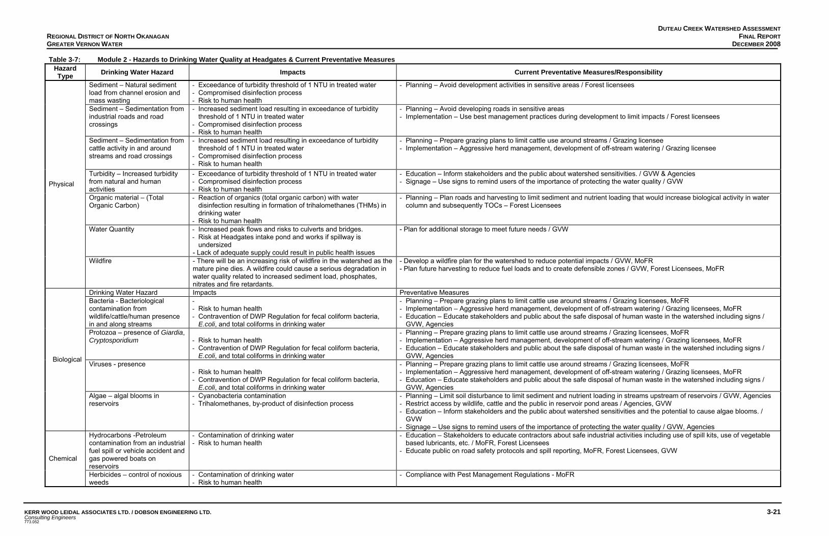
DUTEAU CREEK WATERSHED ASSESSMENT FINAL REPORT
DECEMBER 2008
KERR WOOD LEIDAL ASSOCIATES LTD. / DOBSON ENGINEERING LTD. 3-21 Consulting Engineers 773.052
REGIONAL DISTRICT OF NORTH OKANAGAN GREATER VERNON WATER
Table 3-7: Module 2 - Hazards to Drinking Water Quality at Headgates & Current Preventative Measures Hazard Type Drinking Water Hazard Impacts Current Preventative Measures/Responsibility
Sediment – Natural sediment load from channel erosion and mass wasting
- Exceedance of turbidity threshold of 1 NTU in treated water - Compromised disinfection process - Risk to human health
- Planning – Avoid development activities in sensitive areas / Forest licensees
Sediment – Sedimentation from industrial roads and road crossings
- Increased sediment load resulting in exceedance of turbidity threshold of 1 NTU in treated water
- Compromised disinfection process - Risk to human health
- Planning – Avoid developing roads in sensitive areas - Implementation – Use best management practices during development to limit impacts / Forest licensees
Sediment – Sedimentation from cattle activity in and around streams and road crossings
- Increased sediment load resulting in exceedance of turbidity threshold of 1 NTU in treated water
- Compromised disinfection process - Risk to human health
- Planning – Prepare grazing plans to limit cattle use around streams / Grazing licensee - Implementation – Aggressive herd management, development of off-stream watering / Grazing licensee
Turbidity – Increased turbidity from natural and human activities
- Exceedance of turbidity threshold of 1 NTU in treated water - Compromised disinfection process - Risk to human health
- Education – Inform stakeholders and the public about watershed sensitivities. / GVW & Agencies - Signage – Use signs to remind users of the importance of protecting the water quality / GVW
Organic material – (Total Organic Carbon)
- Reaction of organics (total organic carbon) with water disinfection resulting in formation of trihalomethanes (THMs) in drinking water
- Risk to human health
- Planning – Plan roads and harvesting to limit sediment and nutrient loading that would increase biological activity in water column and subsequently TOCs – Forest Licensees
Water Quantity - Increased peak flows and risks to culverts and bridges. - Risk at Headgates intake pond and works if spillway is
undersized - Lack of adequate supply could result in public health issues
- Plan for additional storage to meet future needs / GVW
Physical
Wildfire - There will be an increasing risk of wildfire in the watershed as the mature pine dies. A wildfire could cause a serious degradation in water quality related to increased sediment load, phosphates, nitrates and fire retardants.
- Develop a wildfire plan for the watershed to reduce potential impacts / GVW, MoFR - Plan future harvesting to reduce fuel loads and to create defensible zones / GVW, Forest Licensees, MoFR
Drinking Water Hazard Impacts Preventative Measures Bacteria - Bacteriological contamination from wildlife/cattle/human presence in and along streams
- - Risk to human health - Contravention of DWP Regulation for fecal coliform bacteria,
E.coli, and total coliforms in drinking water
- Planning – Prepare grazing plans to limit cattle use around streams / Grazing licensees, MoFR - Implementation – Aggressive herd management, development of off-stream watering / Grazing licensees, MoFR - Education – Educate stakeholders and public about the safe disposal of human waste in the watershed including signs /
GVW, Agencies Protozoa – presence of Giardia, Cryptosporidium
- Risk to human health - Contravention of DWP Regulation for fecal coliform bacteria,
E.coli, and total coliforms in drinking water
- Planning – Prepare grazing plans to limit cattle use around streams / Grazing licensees, MoFR - Implementation – Aggressive herd management, development of off-stream watering / Grazing licensees, MoFR - Education – Educate stakeholders and public about the safe disposal of human waste in the watershed including signs /
GVW, Agencies Viruses - presence
- Risk to human health - Contravention of DWP Regulation for fecal coliform bacteria,
E.coli, and total coliforms in drinking water
- Planning – Prepare grazing plans to limit cattle use around streams / Grazing licensees, MoFR - Implementation – Aggressive herd management, development of off-stream watering / Grazing licensees, MoFR - Education – Educate stakeholders and public about the safe disposal of human waste in the watershed including signs /
GVW, Agencies
Biological
Algae – algal blooms in reservoirs
- Cyanobacteria contamination - Trihalomethanes, by-product of disinfection process
- Planning – Limit soil disturbance to limit sediment and nutrient loading in streams upstream of reservoirs / GVW, Agencies - Restrict access by wildlife, cattle and the public in reservoir pond areas / Agencies, GVW - Education – Inform stakeholders and the public about watershed sensitivities and the potential to cause algae blooms. /
GVW - Signage – Use signs to remind users of the importance of protecting the water quality / GVW, Agencies
Hydrocarbons -Petroleum contamination from an industrial fuel spill or vehicle accident and gas powered boats on reservoirs
- Contamination of drinking water - Risk to human health
- Education – Stakeholders to educate contractors about safe industrial activities including use of spill kits, use of vegetable based lubricants, etc. / MoFR, Forest Licensees
- Educate public on road safety protocols and spill reporting, MoFR, Forest Licensees, GVW Chemical
Herbicides – control of noxious weeds
- Contamination of drinking water - Risk to human health
- Compliance with Pest Management Regulations - MoFR

Section 4 Module 7 – Risk Characterization

DUTEAU CREEK WATERSHED ASSESSMENT FINAL REPORT
DECEMBER 2008
KERR WOOD LEIDAL ASSOCIATES LTD. / DOBSON ENGINEERING LTD. 4-1Consulting Engineers 773.052
REGIONAL DISTRICT OF NORTH OKANAGAN GREATER VERNON WATER
4. MODULE 7 – RISK CHARACTERIZATION & ANALYSIS Module 7 considers the hazards to drinking water quality identified in Module 2; along with the consequence to the drinking water should a contaminant or combination of contaminants reach the intake. The following sections review the barriers currently in place, and assess the related risks.
4.1 EVALUATION OF SOURCE PROTECTION BARRIERS
The barriers currently in place in the watershed include varying levels of source protection as set out in the Forest and Range Practices Act, Water Act and the Drinking Water Protection Act and related regulations. However, regardless of the intent by the regulating agencies and the licensed stakeholders to comply with the legislation and regulations and to implement best management practices, the reality is that there is increased sedimentation to streams throughout the watershed from roads and from disturbances from cattle and recreational use. In addition, ‘natural’ hazards such as contamination from wildlife, increased runoff due to the loss of forest cover to the mountain pine beetle, and impacts from climate change are unavoidable, and for which the only effective barrier is drinking water treatment. This does not suggest that enhancing barriers to contamination, such as improved sediment control practices at forest road stream crossings, improved cattle management, improved reservoir monitoring and management, can or should be ignored. To the contrary, recognizing the significant challenges to water quality and quantity that GVW faces, the agencies and stakeholders in the watershed should make every effort to limit the impacts on the source water. Simply, the higher the raw water quality that arrives at the intake, the lower public health risk for those who use this source for their drinking water. This is the essence of a multi-barrier approach.
4.2 CONSEQUENCE TO DRINKING WATER QUALITY AND QUANTITY
The impacts from natural factors that affect water quality, such as climate change and the mountain pine beetle, as well as the anthropogenic activities in the watershed, including recreation, forest development and grazing, are considered in the risk assessment as source area ‘hazards’ that affect drinking water quality. The intent of this section is to address the issue of the ‘consequence(s)’ to the drinking water quality that will be used to estimate the ‘risks’. Consequence is defined as the effect on human well-being, property, the environment, or other things of value or a combination of these (adapted from CSA 1997). Conceptually, in the case of drinking water, consequence is the change, loss, or damage to the water quality caused by contaminants. For Duteau Creek the most likely consequences to drinking water quality will be as a result of: increased sediment loads; increased fecal material/increased pathogen loading; increased organics (THM precursors); and/or

DUTEAU CREEK WATERSHED ASSESSMENT FINAL REPORT
DECEMBER 2008
KERR WOOD LEIDAL ASSOCIATES LTD. / DOBSON ENGINEERING LTD. 4-2Consulting Engineers 773.052
REGIONAL DISTRICT OF NORTH OKANAGAN GREATER VERNON WATER
increased nutrients (algal growth, taste and odour problems and THM precursors). Table 4-1 provides a summary ranking of consequences to drinking water quality, rated from insignificant to catastrophic. Table 4-2 summarizes the consequence ratings for each of the hazards listed in Table 3-7.
Table 4-1: Qualitative Measures of Consequence to Drinking Water Quality
Level Descriptor Description
1 Insignificant Insignificant impact, no illness, little disruption to normal operation, little or no increase in normal operating costs.
2 Minor Minor impact for small population, mild illness moderately likely, some manageable operation disruption, small increase in operating costs.
3 Moderate Minor impact for large population, mild to moderate illness probable, significant modification to normal operation but manageable, operating costs increase, increased monitoring.
4 Major Major impact for small population, severe illness probable, systems significantly compromised and abnormal operation if at all, high level monitoring required,
5 Catastrophic Major impact for large population, severe illness probable, complete failure of systems.
Reproduced from Module 7 of the Comprehensive Drinking Water Source to Tap Assessment Guideline (BC Ministry of Health Services and Ministry of Water, Land and Air Protection 2005).
Table 4-2: Consequences to Drinking Water Quality at Headgates Hazard Type Drinking Water Hazard Consequence
Level Sediment - Natural sediment load from channel erosion and mass wasting 2
Sediment - Sedimentation from industrial roads and road crossings 2
Sediment - Sedimentation from cattle activity in and around streams and road crossings 3
Turbidity – Increased turbidity from natural and human activities 3 Organic material - (Total Organic Carbon) 3 Water Quantity – Increased peak flows as well as lack of supply 2
Physical
Wildfire – increased sediment load and retardant chemicals 4 Bacteria - Bacteriological contamination from wildlife/cattle/human presence in and along streams 4
Protozoa – presence of Giardia, Cryptosporidium 4 Viruses - presence 4
Biological
Algae – algal blooms in reservoirs 4 Hydrocarbons -Petroleum contamination from an industrial fuel spill or vehicle accident and gas powered boats on reservoirs 2 Chemical Herbicides – contamination of water by herbicide spill or mis-use 2

DUTEAU CREEK WATERSHED ASSESSMENT FINAL REPORT
DECEMBER 2008
KERR WOOD LEIDAL ASSOCIATES LTD. / DOBSON ENGINEERING LTD. 4-3Consulting Engineers 773.052
REGIONAL DISTRICT OF NORTH OKANAGAN GREATER VERNON WATER
Given the present configuration of the intake and water treatment works, increases in any one of these hazards, or a combination of more than one, may overwhelm the efficacy of present treatment processes (i.e., screening and chlorination) and thereby increasing public health risk. The upper watershed lakes and reservoirs provide some buffering of the sediment loads upstream of the reservoirs, but cannot address those impacts for the portions of the watershed that are not buffered. The upper reservoirs are prone to algal blooms during the summer months (high water demand period). Increased sediment/nutrient delivery to the reservoirs can exacerbate these conditions and lead to further eutrification of the water. Increased loading of dissolved/suspended organic compounds increases the risk of taste and odour problems, and contributes to THM formation following disinfection. The two main drinking water hazards present in the Duteau Creek watershed are turbidity and pathogens, from various sources as indicated. High levels of turbidity can render water treatment less effective and therefore increase the risk that viable pathogens will be present in the drinking water system. Given the potential for health impacts due to the presence of pathogens, and the size of the service population, the consequence of the biological contaminants presented in Table 3-6 is assumed to be major (‘4’, Table 4-1). The consequence of turbidity events is assumed to be somewhat less severe since turbidity in itself is not directly harmful but can compromise the disinfection process and therefore the consequence is assumed to be at least moderate (‘3’, Table 4-1).
4.3 QUALITATIVE RISK ASSESSMENT
A qualitative risk assessment has been undertaken for the hazards identified in Module 2 (intrinsic watershed hazards and contaminant sources). The risk is assessed at the point of intake on Duteau Creek, prior to treatment. Therefore, the assessed ‘source’ risk at the intake is different from the risk ‘at the tap’ following treatment. This ‘unabated’ risk to the drinking water described above is the worst-case scenario, i.e., in the event of a failure of the treatment system.
ASSESSMENT OF LIKELIHOOD
Risk is the product of likelihood and consequence. Qualitative measures of likelihood are presented in Table 4-3, as provided in the Assessment Guidelines. A time horizon of 10 years is suggested in the Guidelines when attributing likelihood of occurrence to identified hazards.

DUTEAU CREEK WATERSHED ASSESSMENT FINAL REPORT
DECEMBER 2008
KERR WOOD LEIDAL ASSOCIATES LTD. / DOBSON ENGINEERING LTD. 4-4Consulting Engineers 773.052
REGIONAL DISTRICT OF NORTH OKANAGAN GREATER VERNON WATER
Table 4-3: Qualitative Measures of Likelihood
Level of Likelihood Descriptor Description
Probability of
Occurrence in Next 10
Years A Almost certain Is expected to occur in most circumstances. >90%
B Likely Will probably occur in most circumstances. 71-90%
C Possible Will probably occur at some time. 31-70%
D Unlikely Could occur at some time. 10-30%
E Rare May only occur in exceptional circumstances. <10%
Reproduced from Module 7 of the Comprehensive Drinking Water Source to Tap Assessment Guideline (BC Ministry of Health Services and Ministry of Water, Land and Air Protection 2005).
Modules 1 and 2 have identified the hazards to drinking water quality that are summarized in Table 2-2. Assessment of likelihood for the hazards is summarized in Table 4-4 followed by a brief summary for each hazard.
Table 4-4: Likelihood of a Hazard Affecting Drinking Water Quality at Headgates
Hazard Type Drinking Water Hazard Likelihood
Sediment - Natural sediment load from channel erosion and mass wasting C
Sediment - Sedimentation from industrial activity including roads and road crossings B
Sediment - Sedimentation from cattle activity in and around streams and road crossings A
Turbidity – Increased turbidity from natural and human activities A
Organic material - (Total Organic Carbon) B
Water Quantity – increased peak flows; lack of supply C
Physical
Wildfire – increased sediment load and retardant chemicals C
Bacteria - Bacteriological contamination from wildlife/cattle/human presence in and along streams A
Protozoa – presence of Giardia, Cryptosporidium A
Viruses - presence A
Biological
Algae – algal blooms in reservoirs C
Hydrocarbons - Petroleum contamination from an industrial fuel spill or vehicle accident and gas powered boats on reservoirs D
Chemical Herbicides – likelihood of a spill or misuse is unlikely D

DUTEAU CREEK WATERSHED ASSESSMENT FINAL REPORT
DECEMBER 2008
KERR WOOD LEIDAL ASSOCIATES LTD. / DOBSON ENGINEERING LTD. 4-5Consulting Engineers 773.052
REGIONAL DISTRICT OF NORTH OKANAGAN GREATER VERNON WATER
4.3.1 PHYSICAL HAZARDS
SEDIMENT/TURBIDITY
The maximum recommended turbidity level in raw drinking water is 1 NTU18. As previously indicated in Table 2-4, turbidity levels at the intake averaged ~1.7 NTU in 2007 with a maximum of 25 NTU during the spring freshet in the period noted. This is considered to be relatively good for raw creek water in the southern interior. During the watershed inspections it was evident that sediment is being contributed to watercourses as a result of resource development activities that increase the amount of soil exposure and disturbance. The sediment and turbidity that reaches the intake is a combination of natural and anthropogenic sources. The likelihood of sediment/turbidity affecting the intake varies depending upon the source. The cumulative likelihood considering all sources is rated as ‘A’.
WATER QUANTITY
As described in Section 3.5 there is a risk of increased peak flows over the next several decades as the mature lodgepole pine die. This could result in failures of road crossings that were designed using ‘pre-beetle impact’ design criteria. Increased peak flows could also result in increased sediment transport as channels adjust to more frequent, larger flows. The impacts on water quality would be increased suspended and bed load sediment at the intake. These impacts could continue for decades until undersized structures are replaced and the channel has adjusted to a new sate of equilibrium. The existing Headgates spillway does not meet the Ministry of Environment Dam Safety requirements to pass the 100-year flood and the risk of failure may increase in the future if peak flows increase as a result of the loss of the mature lodgepole pine to the pine beetle.
Over the longer term, possibly 50 years and beyond, if the precipitation and temperature patterns change as suggested by the Atmospheric Environment Service, runoff may decline as a result of less snow and warmer temperatures. Lower water yields would mean less supply and subsequent water shortages if demand exceeds supply. These conditions could persist for an indeterminate period of time.
4.3.2 BIOLOGICAL CONTAMINANTS
Wildlife, livestock and humans are all identified potential pathogen sources in the watershed. Livestock/wildlife activity was noted at most of the assessed stream crossings where they enter watercourses to drink, and there are few barriers to such access. Livestock and wildlife activity erodes stream bank and bed material, and contributes to mobilization of fine sediments. Pathogens enter the stream network from manure,
18 H. Singleton, 2001. Ambient Water Quality Guidelines (Criteria) for Turbidity, suspended and Benthic Sediments. Ministry of
Water, Land and Air Protection.

DUTEAU CREEK WATERSHED ASSESSMENT FINAL REPORT
DECEMBER 2008
KERR WOOD LEIDAL ASSOCIATES LTD. / DOBSON ENGINEERING LTD. 4-6Consulting Engineers 773.052
REGIONAL DISTRICT OF NORTH OKANAGAN GREATER VERNON WATER
evidence of which was noted in the proximity of many watercourses during the field assessment.
Water quality sampling conducted at the intake and various other points in the watershed indicates that pathogens (Escherichia coli and fecal coliforms) are found throughout the stream network. The Health Canada Drinking Water Guideline for E.coli and fecal coliforms in treated water is “none present”. Water quality samples collected at the intake and at selected points throughout the watershed since 2002 confirm that fecal coliform and E.coli are present at the intake and at each sampling site in the watershed.
There is a history of algae blooms in the reservoirs depending on the runoff, climate conditions and the presence of avian. Blooms typically occur as a result of increased nutrient loading into the reservoir, combined with warm water temperature. Increased nutrient loading can occur as a result of heavy spring runoff, low reservoir levels resulting in sedimentation into the reservoir from local sources within the pool area, or from runoff from intense rainstorms during the summer months, and is influenced by nutrient loading from avian presence. Increased reservoir water temperature can result from low water levels and from high air temperature during the summer months.
Based on the GVW sampling results, the likelihood of fecal coliform and E.coli being present in raw water at the intake is rated as almost certain, that is ‘A’.
4.3.3 CHEMICAL
HYDROCARBONS
The potential impact on drinking water from a fuel spill is a concern since there is considerable industrial and recreational vehicle use throughout the watershed. Small amounts of oil or diesel fuel can contaminate large volumes of water. One litre of gasoline can contaminate 750,000 litres of water. In the event that water at the intake was contaminated by an oil or fuel spill, GVW would have to close the intake and provide water for its users from alternate sources. To date there are no reported incidents of fuel or oil being detected at the intake; the likelihood of this occurring is rated as a ‘D’.
HERBICIDES
Herbicides may be used by the Range Program in the Ministry of Forests and Range to control noxious weeds in the watershed. Herbicides are normally applied by a licensed applicator in accordance with a Pest Management Permit. The permit typically includes detailed requirements for the protection of water sources and the protocols if there was a chemical spill. The likelihood of contamination of the water supply is considered to be ‘D’.

DUTEAU CREEK WATERSHED ASSESSMENT FINAL REPORT
DECEMBER 2008
KERR WOOD LEIDAL ASSOCIATES LTD. / DOBSON ENGINEERING LTD. 4-7Consulting Engineers 773.052
REGIONAL DISTRICT OF NORTH OKANAGAN GREATER VERNON WATER
TOTAL ORGANIC CARBON (TOC)
Total organic carbon is of concern during the disinfection process as it can produce a by-product known as trihalomethanes which may be carcinogenic. Sample results by GVW confirm that the TOC levels in the raw water collected at the intake during 2007 ranged from 11 – 13 mg/L, thus exceeding the BC Guideline of 4 mg/L for source water that will be chlorinated. The likelihood that there will be elevated TOC levels at the intake are rated as ‘B’.
4.4 RISKS TO DRINKING WATER QUALITY AND QUANTITY
Risk is the product of likelihood and consequence. Using the risk matrix presented in Table 4-5 the risk for each identified hazard is presented in Table 4-6.
Table 4-5: Qualitative Risk Analysis Matrix
Consequence Likelihood 1
Insignificant 2
Minor 3
Moderate 4
Major 5
Catastrophic A
(almost certain) Moderate High Very High Very High Very High
B (likely) Moderate High High Very High Very High
C (possible) Low Moderate High Very High Very High
D (unlikely) Low Low Moderate High Very High
E (rare) Low Low Moderate High High
Reproduced from Module 7 of the Comprehensive Drinking Water Source to Tap Assessment Guideline (BC Ministry of Health Services and Ministry of Water, Land and Air Protection 2005). For the physical hazards, the risk from natural sediment is rated as moderate since there are limited natural sources that are a concern other than channel instability related to natural causes such as the pine beetle. However sediment from industrial activity, including roads, is considered to be a high risk since there is a large inventory of road crossings that are unlikely to be reduced that are the primary source of the sediment. If there is increased industrial activity as a result of salvage logging the risks may increase over the next 3 –5 years. The risk from increased sedimentation from cattle disturbance in and along streams and related increased turbidity levels are both considered to be very high since they are related to the increased likelihood of pathogenic organisms contaminating drinking water and affecting public health. A major concern is the risk to the source water quality from increased recreational activity in the watershed. Unregulated access for off-road vehicles, ATVs, motorcycles and four-wheel drive vehicles, on inactive roads is resulting in additional sediment delivery to streams on roads that would otherwise be considered low hazard sources of sediment.

DUTEAU CREEK WATERSHED ASSESSMENT FINAL REPORT
DECEMBER 2008
KERR WOOD LEIDAL ASSOCIATES LTD. / DOBSON ENGINEERING LTD. 4-8Consulting Engineers 773.052
REGIONAL DISTRICT OF NORTH OKANAGAN GREATER VERNON WATER
The risks from biological contaminants are all rated as very high due to the presence and known levels at the intake, and the limited water treatment barrier currently in place. Construction of the new Duteau water treatment plant will provide an enhanced barrier once in place.
The risk from chemical hazards is rated as low. This risk results from a fuel or oil spill, or from a vehicle accident. The likelihood of hydrocarbons entering a stream and affecting the water quality at the intake is considered to be low. The result of the risk assessment summarized in Table 4-6 indicate that there are risks to the GVW drinking water quality at the Headgates intake. For the physical hazards sediment at stream crossings is an issue that need to be addressed. There are two sources that contribute to the risk: the first is sediment delivery off roads that is considered to be a high risk to drinking water, and also the sediment resulting from cattle activity at the crossings and along the streams upstream and downstream of the crossing. The sediment from cattle presence is rated as very high since it typically occurs at the same sites year after year. Turbidity is also rated as very high risk at the intake. Although the sampling results indicate that the average annual level is within the acceptable range, the spikes during the spring freshet are of concern, and there is a likelihood that these levels will increase as the pine dies and the runoff increases. Elevated turbidity levels result in increased consumption of chlorine as the organic material that causes the turbidity is oxidized. This in turn can result in less chlorine available to attack bacteria. Similarly there is a very high risk associated with total organic material that can have the same impact as turbidity on chlorine levels. However the potential to create trihalomehanes as a by-product of the oxidation of organic material is an added concern. As with sediment, it is likely that as the peak flows increase in the future that the total organic material load will also increase. For the biological hazards (bacteria, protozoa, viruses and algae) the risks are all rated as very high. Data from water samples indicates that bacteria and protozoa are present in the source water at levels that exceed the water quality objectives for raw water. The presence of viruses is unknown at present but viruses, including hepatitis A, rotaviruses, and Norwalk and other caliciviruses, are microbes that can cause illness if they are present in drinking water. The risk from algae blooms in the upland reservoirs is considered to be very high. There have been blooms in the past and the frequency is likely to increase with warmer summer temperatures and increased nutrient loading into the reservoirs associated with increased peak flows related to the loss of forest cover to the pine beetle. It is not the algae that is the concern but rather the by-products associated with decay of algae. Finally, the chemical risk from the presence of hydrocarbons at the intake is considered to be low. Roads are typically located away from streams except at stream crossings and there is the section of channel through the canyon to the intake where there is no access that provides further buffering for the intake.

DUTEAU CREEK WATERSHED ASSESSMENT FINAL REPORT
DECEMBER 2008
KERR WOOD LEIDAL ASSOCIATES LTD. / DOBSON ENGINEERING LTD. 4-9 Consulting Engineers 773.052
REGIONAL DISTRICT OF NORTH OKANAGAN GREATER VERNON WATER
Table 4-6 Duteau Creek Watershed Qualitative Risk Assessment Hazard Type Drinking Water Hazard Likelihood Consequence Risk Comment/Assumption
Sediment - Natural sediment load from channel erosion and mass wasting
C 2 Moderate
The mass wasting risk should be low provided development is restricted on class IV and V terrain. Natural sediment loads will increase with increasing peak flows but the reservoirs and wetlands provide substantial buffering.
Sediment - Sedimentation from industrial activity and recreation use
B 2 High It is assumed that there will always be some sediment transport at road crossings.
Sediment - Sedimentation from cattle activity in and around streams and road crossings
A 3 Very High It is assumed that cattle will continue to graze in the watershed.
Turbidity – Increased turbidity from natural and human activities
A 3 Very High It has been assumed that the mature pine will die and that flows will increase. It is also assumed that recreational use in the watershed will continue to increase.
Organic material - (Total Organic Carbon) B 4 Very High
Organic material in streams will increase as the mature pine stands die.
Water Quantity – Increased peak flows as pine dies; decreased runoff from lower snow packs
B 2 High
Over the next 30 years there could be increased peak flows related to the loss of forest cover to the pine beetle. Over the long-term, 50 years and beyond, if there is a long-term decline in snow packs, there may be a supply problem.
Physical
Wildfire C 4 Very High
There will be an increasing risk of a wildfire over the next several years when the attacked pine is in the “red attack” stage. An intense wildfire could result in the loss of the watershed for water supply for an extended period of time.
Bacteria - Bacteriological contamination from wildlife/cattle/human presence in and along streams
A 4 Very High
Protozoa – presence of Giardia, Cryptosporidium A 4 Very High
Biological
Viruses - presence A 4 Very High
The likelihood for increased contamination will be very high as recreational use increases and as the forest mosaic changes as a result of the loss of the pine.

DUTEAU CREEK WATERSHED ASSESSMENT FINAL REPORT
DECEMBER 2008
KERR WOOD LEIDAL ASSOCIATES LTD. / DOBSON ENGINEERING LTD. 4-10 Consulting Engineers 773.052
REGIONAL DISTRICT OF NORTH OKANAGAN GREATER VERNON WATER
Hazard Type Drinking Water Hazard Likelihood Consequence Risk Comment/Assumption
Algae – algal blooms in reservoirs A 4 Very High
Hydrocarbons -Petroleum contamination from an industrial fuel spill or vehicle accident and gas powered boats on reservoirs
D 2 Low Even with increased activity in the watershed the likelihood of a spill affecting the water at the intake is low.
Chemical
Herbicides D 2 Low Since herbicides should only be used under permit and by licensed applicators, the likelihood of a spill is low.

DUTEAU CREEK WATERSHED ASSESSMENT FINAL REPORT
DECEMBER 2008
KERR WOOD LEIDAL ASSOCIATES LTD. / DOBSON ENGINEERING LTD. 4-11 Consulting Engineers
REGIONAL DISTRICT OF NORTH OKANAGAN GREATER VERNON WATER
4.5 SUMMARY
This section is focused on determining the risks to water quality and quantity based on the results of the contaminant inventory and the barriers currently in place. The available watershed barriers are generally based on the requirements established in the legislation that governs licensed activities in the watershed (i.e., the Forest and Range Practices Act, the Water Act and the Drinking Water Protection Act). The barriers are the application of the regulatory requirements by the licensees. For example, for forest development it is the application of the expected results for water specified in the Forest and Range Practices Act and Regulations. Risk is the product of the hazards and the consequences. In this case the consequence of a hazard will be reduction in the drinking water quality. The risk analysis considers the consequence for a specified hazard and the likelihood that it might occur. The results summarized in Table 4-6 indicate that there are very high risks associated with sediment from cattle and for turbidity, organic material, wildfire, and for the biological hazards (bacteria, protozoa, viruses and algae). The risk rating was high for sediment from roads, moderate for natural sources of sediment and low for hydrocarbons and herbicides.
Section 5 Module 8 – Recommendations to Improve Drinking Water Source Protection and Sustainability in Duteau Creek Watershed

DUTEAU CREEK WATERSHED ASSESSMENT FINAL REPORT
DECEMBER 2008
KERR WOOD LEIDAL ASSOCIATES LTD. / DOBSON ENGINEERING LTD. 5-1Consulting Engineers 773.052
REGIONAL DISTRICT OF NORTH OKANAGAN GREATER VERNON WATER
5. MODULE 8 – RECOMMENDATIONS TO IMPROVE DRINKING WATER SOURCE PROTECTION AND SUSTAINABILITY IN DUTEAU CREEK WATERSHED
The foundation for delivering safe drinking water is the use of multiple barriers to limit the exposure of drinking water to a particular hazard. This starts with barriers in the source watershed. It is recognized that on the Duteau source Greater Vernon Water currently has limited barriers upstream of the intake, and between the intake and the consumer. Water treatment presently consists of coarse screening and chlorination. At the time of the preparation of this report GVW is in the process of building Phase 1 of the Duteau Creek Water Treatment Plant, which will significantly increase the treatment barrier and hence the level of public health protection. Water treatment barriers do not, however, replace the need for diligent protection of the source water quality. In 2006 seven Provincial ministries, the Office of the Provincial Health Officer and the five B.C. Health Authorities signed a Memorandum of Understanding (MOU) that commits the parties to inter-agency accountability and coordination for the protection of drinking water. A Southern Interior Regional Drinking Water Team (SIRDWT), has been formed as required in the MOU, with representation from the seven Ministries and the Interior Health Authority. The Duteau Creek Source Protection Plan is supported by SIRDWT. A copy of the MOU and the list of members of the SIRDWT is provided in Appendix I. Establishing an effective working relationship with the SIRDWT is critical to achieving the objectives of this Plan. The intent of the Source Protection Plan is to recommend a process to address the hazards that are a threat to drinking water safety and sustainability of the GVW water supply. The recommendations herein address the documented source hazards. Based on the risks to drinking water quality presented in Section 4, there is an urgent need for diligent protection of the source water quality through the implementation of strengthened and additional barriers in the watershed area. Section 5.1 provides a SWOT analysis for protection of Duteau Creek source water quality. Section 5.2 provides a Source Protection Plan with actions to improve the raw water quality in Duteau Creek.
5.1 SWOT ANALYSIS.
A SWOT analysis is an effective approach to summarize, understand and balance the strengths, weaknesses, opportunities and threats to the water source in the Duteau Creek watershed. Table

DUTEAU CREEK WATERSHED ASSESSMENT FINAL REPORT
DECEMBER 2008
KERR WOOD LEIDAL ASSOCIATES LTD. / DOBSON ENGINEERING LTD. 5-2Consulting Engineers 773.052
REGIONAL DISTRICT OF NORTH OKANAGAN GREATER VERNON WATER
5-1 provides a summary of the SWOT analysis based on the information provided in the previous sections of this report.

DUTEAU CREEK WATERSHED ASSESSMENT FINAL REPORT
DECEMBER 2008
KERR WOOD LEIDAL ASSOCIATES LTD. / DOBSON ENGINEERING LTD. 5-3Consulting Engineers 773.052
REGIONAL DISTRICT OF NORTH OKANAGAN GREATER VERNON WATER
Table 5-1: SWOT Analysis Summary Strengths Weaknesses
- Forest and range uses are regulated by the Forest and Range Practices Act.
- GVW has a good working relationship with the agencies and stakeholders in the watershed.
- The unbuffered zone along Duteau Creek above the intake has limited access and limited opportunities for development due to steep topography.
- The Drinking Water Protection Act and related regulations provide support for source protection.
- There are established comprehensive planning processes for forest and range development in the watershed that include assessment of potential impacts.
- Recreation use has limited restrictions - There are limited means to regulate off-road
vehicle activity. - The present source protection analysis assesses
individual impacts and activities but there is no cumulative impact analysis that combines the impacts from all activities on source water quality and quantity.
- Funding for ongoing assessments is limited. - Funding to implement remedial works is limited. - Duteau Creek is the primary source of supply for
GVW. - The existing spillway at Headgates is under
capacity for design flood.
Opportunities Threats - Funding may be available through the
Environmental Farm Plan program to assist ranchers in developing off-stream water sites and construct fencing to limit cattle access to sensitive sites.
- GVW may have the opportunity to increase its storage in the Aberdeen Reservoir to capture additional runoff.
- There is a significant opportunity for GVW and the agencies to improve public education and awareness of the importance of protecting the water source.
- Pursue opportunities to have Sections 46 and 58 of the Forest and Range Practices Act applied in the watershed to protect source water.
- Pursue opportunities for additional OBWB funding for source protection.
- Develop the water license sharing from proposal with range tenure holders for off-channel watering.
- Amend Range Use Plans to increase protection to watercourses.
- Encourage assistance from the Southern Interior Drinking Water Team to implement source water protection strategies.
- Coordinate with other watershed initiatives such as Water Use Plans, Sustainable Water Strategies, Forest Retention Plans, and Environmental Assessments for Development Applications.
- Encourage the development of a regional source assessment database availability to local planners.
- Use the British Columbia Draft Trails Strategy as a guide for strategies to consider to reduce impacts from recreation use in the watershed.
- Wildfire is an increasing threat as the mature lodgepole pine forests die from the mountain pine beetle.
- Loss of the mature lodgepole pine to the mountain pine beetle has the potential to cause significant changes to the watershed hydrology resulting in degraded water quality at the intake.
- Salvage harvesting of lodgepole pine could increase road density and ground disturbance resulting in impacts on water quality.
- Changes in climate may result in a long-term decrease in water yields and a reduced supply for GVW.
- Increasing population in the Okanagan Valley will increase recreation pressures in the watershed, increasing the risks to water quality.
- Demand for water in the GVW service area may increase due to increased population and warmer summer temperatures.
- Ongoing unregulated access for off-road vehicles will result in increased dispersed sources of sediment to streams.

DUTEAU CREEK WATERSHED ASSESSMENT FINAL REPORT
DECEMBER 2008
KERR WOOD LEIDAL ASSOCIATES LTD. / DOBSON ENGINEERING LTD. 5-4Consulting Engineers 773.052
REGIONAL DISTRICT OF NORTH OKANAGAN GREATER VERNON WATER
5.2 SOURCE PROTECTION PLAN
The following recommendations are presented in general order of priority with the objective of reducing the risks to drinking water quality present at the Duteau Creek.
5.2.1 RANGE USE
GVW was invited by the Okanagan Shuswap Forest District to the annual Duteau Range Users meeting in February. GVW gave a presentation on the watershed assessment and source protection process as well as presenting the results of the field assessments. The impacts of cattle on the water quality were discussed, particularly the disturbance to stream banks at road crossings and the impacts from manure that is transported to the intake during high flows. The likelihood of increased access to streams as the pine stands die and are salvaged was discussed, as well as opportunities for cooperative efforts to reduce these impacts. GVW advised the group that it had made a request to the Okanagan Basin Water Board for a grant to identify all the various grazing works in the watershed including fences, cattle guards, and off-stream watering sources in 2008. If the grant is approved, GVW would like to work with ranchers to inventory all existing works and to identify improvements that could be used to reduce the cattle impacts around streams. Staff from the Ministry indicated that they would explore opportunities to supply fencing materials. There was also a discussion about approaching the Environmental Farm Program for funds to reduce environmental impacts from grazing.
As soon as the Duteau Creek Watershed Assessment and Protection Plan is adopted by GVW, it is recommended that staff from Greater Vernon Water, the Ministry of Forests and Range and the Drinking Water Officer, Interior Health Authority meet to develop strategies to address the two major drinking water hazards in the Duteau Creek watershed related to cattle range use: that is the anthropogenic sources of sediment and turbidity related to cattle activity; and sources of bacteria/protozoa/virus related to grazing throughout the watershed. (GVW, MoFR, IHA, Grazing licensees) Similar arrangements should be made with representatives of the forest licensees and recreational users to develop strategies for road crossings and recreational sites.
5.2.2 SEDIMENT/TURBIDITY FROM ANTHROPOGENIC ACTIVITIES
The typical sources of sediment/turbidity are roads, soil disturbance associated with forest development and from grazing use. The first barrier is planning, the second barrier is implementation, the third barrier is monitoring and the fourth barrier is revising the plan. It is recommended that the results of the stream crossing assessments be reviewed and improvements implemented at all moderate and high hazard sites to reduce the transport of sediment from roads and ditch lines into streams. The priority area is the unbuffered section between Haddo Reservoir and Headgates. (Tolko, MoFR)

DUTEAU CREEK WATERSHED ASSESSMENT FINAL REPORT
DECEMBER 2008
KERR WOOD LEIDAL ASSOCIATES LTD. / DOBSON ENGINEERING LTD. 5-5Consulting Engineers 773.052
REGIONAL DISTRICT OF NORTH OKANAGAN GREATER VERNON WATER
Maintenance of active forest roads is particularly important in this watershed, especially those sections of road near streams and is the responsibility of the primary road permit holder, in this watershed typically Tolko. Maintenance includes the running surfaces and the ditch lines. It is recommended that road surface runoff should be directed away from streams and stream crossings. It is recommended that ditch lines include crossdrains with ditch blocks so that runoff that accumulates in the road ditches is dispersed onto the forest floor away from the streams. It is recommended that ditch lines and culvert be kept clear of debris and the ditch lines vegetated with grasses to limit erosion and capture sediments. If a grass species that discourages grazing is available, it should be the preferred species. It is recommended that those roads not required for active use should have as a minimum, temporary deactivation measures implemented. It is recommended that those sites in Table 3-4 with moderate or high hazard ratings should be reviewed and actions taken to reduce sediment delivery to streams so that the hazard rating is reduced to low. (Tolko) The Ministry of Forests and Range Forest Road design criteria is that major culverts and bridges must have a capacity to pass the Q100 peak flow. Design flows will be greater after the pine dies and it is likely that there will be stream crossings on the Duteau Creek main stem and major tributaries downstream of the areas affected by the beetle that are found to be undersized. It is recommended that the Ministry of Forests and Range develop and implement a review process to confirm that existing stream crossing structures on the Duteau Creek main stem and major tributaries downstream of the areas affected by the beetle are adequately sized to safely convey projected future peak flows. (MoFR) Loss of the mature lodgepole pine to the pine beetle will likely result in loss of natural barriers that limit access to watercourses by cattle and people, either from loss of the natural stands or from salvage logging. It is recommended that access to sensitive areas along watercourses, lakes and wetlands be restricted as the forest cover changes to protect the water quality. (GVW, MoFR, MoTCA, Forest and Grazing licensees) It is the responsibility of the licensed stakeholders to plan, implement, monitor and revise their works consistent with the legislation, regulations and policies established under their permits/licenses for the protection of soils and water. Planning should also consider best management practices where these are available. It is recommended that Tolko Industries Ltd. consider including recognition of the Duteau source protection plan in its forest stewardship plan. (Tolko, BCTS, GVW, Grazing licensees, Mineral Licensees) It is the responsibility of the Ministries that provide the authority to licensed stakeholders, in accordance with the MOU, to ensure that compliance monitoring of activities is undertaken consistent with their respective policies for source protection. It is recommended that the MoFR provide an annual report to the Drinking Water Officer the compliance of activities undertaken in the Duteau Creek watershed under its jurisdiction. (IHA, MoFR)

DUTEAU CREEK WATERSHED ASSESSMENT FINAL REPORT
DECEMBER 2008
KERR WOOD LEIDAL ASSOCIATES LTD. / DOBSON ENGINEERING LTD. 5-6Consulting Engineers 773.052
REGIONAL DISTRICT OF NORTH OKANAGAN GREATER VERNON WATER
It is recommended that the cattle bridge in lower reach D and the trail adjacent to the channel be inspected to confirm that they are no longer a risk to water quality. (GVW)
5.2.3 PATHOGENIC ORGANISMS
Pathogenic organisms include bacteria, protozoa and viruses. These are typically associated with waste (faeces) from warm-blooded animals, e.g., wildlife, cattle, humans. The results of the research sampling and GVW sampling in the watershed confirm that a variety of the organisms are present throughout the watershed and present at the intake. The results of the field inspections should be reviewed and improvements implemented that will reduce the impacts from cattle on channel disturbance and the deposition of manure in and about streams. The priority area is the unbuffered section between Haddo Reservoir and Headgates. (GVW, MoFR, grazing licensees) Stakeholders should follow approved practices for the disposal of human waste products in the watershed. These apply to individuals working/recreating in the watershed and to the management of waste at recreation and industrial sites. (Grazing licensees, Tolko, Mineral licensees). Regulating agencies need to provide education materials with guidance for disposing of human waste by individuals and to confirm that human waste at recreational sites is managed in accordance with legislation and regulations. The MoFR should provide copies of the Range Use Plans/Range Stewardship Plans developed with the grazing licensees to GVW annually that identify how range use will meet the objectives for water in the Range Planning and Practices Regulation. (MoFR, MEMPR, MTCA, GVW). The results of the field inspections completed in 2007 should be reviewed and improvements implemented to reduce the impacts from cattle on channel disturbance and the deposition of manure in and about streams. Refer to crossing 190 in Table 3-4 and the sites in Table 3-5. The priority area is the unbuffered section between Haddo Reservoir and Headgates. (Grazing Licensees, MoFR) It is recommended that the GVW, MoFR and the grazing licensees make a formal application to the Environmental Farm Plan for funding to assist the grazing licensees implement works to reduce the impact of cattle on source water quality. (GVW, MoFR, Grazing licensees)
5.2.4 OTHER ISSUES
The following issues also require action to protect the GVW water source and are listed in general order of priority. Headgates Intake – Confirm the current capacity of the spillway at the intake pond and determine the appropriate design capacity to accommodate potential increases in peak flows after the loss of the mature pine. (GVW)

DUTEAU CREEK WATERSHED ASSESSMENT FINAL REPORT
DECEMBER 2008
KERR WOOD LEIDAL ASSOCIATES LTD. / DOBSON ENGINEERING LTD. 5-7Consulting Engineers 773.052
REGIONAL DISTRICT OF NORTH OKANAGAN GREATER VERNON WATER
Headgates Intake – Re-consider re-design the intake pond and intake works so that the ponds and intake are situate off-stream rather than on-stream as they are now. (GVW) Reservoirs – Implement an action plan to educate the public about the protection of the three reservoirs from contamination. Post the reservoir perimeter areas as prohibited access for vehicles except at designated boat launches. (GVW, MTCA, MoE) Recreation – Explore the opportunities to reduce the recreation pressures on the reservoirs by providing other high quality recreation sites on other lakes in the watershed that have a lower risk of impacting drinking water quality at Headgates. (GVW, MoE, MoTCA) It is recommended that if camping is permitted near reservoirs that it should be restricted to designated locations that will limit the risks of contamination to the reservoirs. (MoTCA, GVW) Recreation use in the watershed should be consistent with the objectives set out in the Okanagan-Shuswap LRMP. The reservoirs are sensitive sites and recreation use on or about the reservoirs should be consistent with the LRMP. (MoTCA) It is recommended that a ‘recreation brochure’ be prepared focused on source protection and distributed with hunting and fishing licenses, firewood cutting permits, to ATV and motorcycle dealers, and by the Ministry of Tourism, Culture and the Arts at recreation sites. (MoTCA, GVW, MoE, MoFR) It is recommended that GVW request that the Ministry of Forests and Range Compliance and Enforcement personnel and the Ministry of Environment Conservation Officers apply Section 46 of the Forest and Range Practices Act to charge individuals engaging in any activity on Crown land that results in damage to the environment, as defined in the Act. (GVW, MoFR, MoE) The GVW should work with other water suppliers in the Okanagan to lobby the government to pass Off Highway Vehicle legislation that would require the licensing of all off highway motorized vehicles and regulations to control the use of these vehicles on Crown land. (GVW) It is recommended that GVW request that the Minister of Forests and Range apply Section 58 of the Forest and Range Practices Act to restrict the use of motorized vehicles in specified sensitive areas in the watershed including reservoirs. (GVW, MoFR) Pesticides/Herbicides – It is recommended that all applications for the use of herbicides and pesticides in the watershed upstream of Headgates be referred to GVW for review. (MoE)

DUTEAU CREEK WATERSHED ASSESSMENT FINAL REPORT
DECEMBER 2008
KERR WOOD LEIDAL ASSOCIATES LTD. / DOBSON ENGINEERING LTD. 5-8Consulting Engineers 773.052
REGIONAL DISTRICT OF NORTH OKANAGAN GREATER VERNON WATER
Monitoring – Enhance the current water quality monitoring program by including analysis including trend analysis for source tracking of contaminants. (GVW, IHA, MoE, MoFR, MoTCA) Monitoring is an essential component of the Source Protection Plan. GVW has a raw water monitoring program in the watershed. The program has established baseline monitoring and problem identification. This program should be reviewed with specialists from IHA and MoE to confirm that it is adequate as a baseline program or how it might be expanded and enhanced. In addition there should be a co-operative plan to implement additional source tracking and identification of contaminants similar to that carried out by Cynthia Meays in 2005. The support for the source tracking and contaminant identification program should to come from the ministries that signed the MOU, GVW, and hopefully from the stakeholders. The sampling results should be reported to the Drinking Water Officer, SIRDWT members and stakeholders annually. The current water quality monitoring program should be enhanced by including analysis including trend analysis for source tracking of contaminants. (GVW, IHA, MoE, MoFR, MTCA) Watershed Hydrology and Flow Monitoring – It is recommended that the following actions be implemented to develop a historic watershed water use and hydrologic record, and to monitor future streamflows to understand the effects of pine beetle attack and climate change on the watershed hydrology: Re-create the historic (say 10 to 20 year) record of watershed streamflows and
withdrawals using available hardcopy operations and WSC records. A grant may be available through OBWB for this work.
Reinstate streamflow monitoring station WSC Stn. # 08LC006 downstream of
Headgates to monitor spill and release below Headgates intake. Install real-time flow measurement weirs at critical control locations in the
watershed. As a minimum, these should include immediately downstream of Grizzly, Aberdeen and Haddo dams. These are critical for implementation of the reservoir operating protocol noted in this Plan.
Using data from these sources, provide an annual watershed hydrology report,
indicating annual operations and routing, water diverted to users, diverted to lower Duteau Creek, diverted from Harris to Duteau watersheds, etc. (GVS)
Compliance Reporting - The Source Protection Plan must have an annual compliance-reporting requirement. Based on the MOU there should be annual reports provided by the agencies to the DWO that report on source protection. A summary report should be provided to the SIRDWT and the stakeholders, and be reviewed at an annual watershed meeting. Based on the water quality monitoring report and the compliance report and the

DUTEAU CREEK WATERSHED ASSESSMENT FINAL REPORT
DECEMBER 2008
KERR WOOD LEIDAL ASSOCIATES LTD. / DOBSON ENGINEERING LTD. 5-9Consulting Engineers 773.052
REGIONAL DISTRICT OF NORTH OKANAGAN GREATER VERNON WATER
report on drinking water delivery by GVW, appropriate changes can be made to the Source Protection Plan. (GVW) Education – Install information signs at each of the upland reservoirs that would provide information to the public about the Community Watershed and the importance in protecting the water. Continue to install and maintain ‘Community Watershed’ signs on all access roads to the upland watershed. Consider developing a ‘Watershed Fact Sheet’ that could be supplied to the public, government agencies and stakeholders to provide information regarding the watershed, the importance of protecting the water, and what the reader can do to help, e.g., avoid contaminating the water with human waste and refuse. Also recommend that they use the RAPP line to report any observed environmental damage or abuse. Consider establishing an annual ‘watershed awareness day’ that could be part of the IPE, Rivers Day, Mind Grind, etc to raise awareness of the water supply. This could also be taken to the local schools as well. (GVW, MTCA at rec sites) Wildfire – Wildfire is a constant concern in the watershed. The fire in August 1998 burned 800 ha in the Heart Creek sub-basin of the watershed. The subsequent fire near the Buck Hills burned a further portion of the watershed. With the advance of the mountain pine beetle and the death of much of the mature lodgepole pine, the fuel load will increase as will the risk of fire. Consideration should be given to developing a wildfire preparedness plan that would address drinking water related concerns. This should include a long-term fuel reduction plan and firebreak plan. Planning should also include the interface area between the valley private lands and Crown Land, and also GVW private lands. Funding for a fuel reduction plan may be available from UBCM through the RDNO to assist in the development and implementation of a fuel reduction plan. Future harvesting plans should consider the location of new cutblocks as part of a landscape level firebreak plan. (GVW, MoFR, Tolko) Mines/Quarries/Mineral Claims – There are a number of mineral claims within the watershed area and an active quarry. The agency responsible for issues permits for these uses is the Ministry of Energy, Mines and Petroleum Resources (MEMPR). MEMPR is also a signatory to the Drinking Water Source Protection Memorandum of Understanding. It is recommended that GVW contact the MEMPR office in Kamloops that is responsible for claims in the watershed and arrange a meeting to present the Mines Inspector with a copy of this report as well as review the issues and concerns specific to MEMPR with the Inspector. A field tour would assist the inspector to appreciate the concerns. (GVW, MEMPR) All development proposed by MEMPR in the watershed should be referred to the GVW for review. (MEMPR) GVW Private lands – GVW owns lands near the Haddo and Aberdeen reservoirs and at Headgates that should have a land management plan developed that would address forest health, access, use, etc. GVW may consider a request to Provincial ministries to grant ownership of additional Crown Land around the margins of the upland reservoirs to

DUTEAU CREEK WATERSHED ASSESSMENT FINAL REPORT
DECEMBER 2008
KERR WOOD LEIDAL ASSOCIATES LTD. / DOBSON ENGINEERING LTD. 5-10Consulting Engineers 773.052
REGIONAL DISTRICT OF NORTH OKANAGAN GREATER VERNON WATER
RDNO to provide GVS the authority to control and manage lands around the reservoirs for water quality hence public health protection. (GVW) Proposal to Raise Aberdeen Reservoir Dam - It is recommended that the following water quality issues be assessed as part of the decision-making process in raising the Aberdeen Dam: impacts on nutrient loading in Aberdeen and Haddo reservoirs; impacts on algal production in reservoirs; impacts from flooding lands; preparation of a detailed construction management plan; and preparation of comprehensive reservoir operation plan for all three reservoirs. (GVS)
Salvage Harvesting - It is recommended that GVW review the expansion of the pine beetle in the watershed with Tolko annually. It also recommended that GVW and Tolko review proposed salvage harvesting plans and options to protect the water resources, (GVW, Tolko) Source Protection Plan Review - The Duteau Creek Source Protection Plan should be reviewed annually by GVW and IHA and updated on a five-year basis or as a result of a significant increase in risks to the source water quality. (GVW, IHA)
5.2.5 IMPLEMENTATION
The implementation stage is the key to a successful source water protection program. As presented in the foregoing SWOT analysis, GVS is supported by many agencies and stakeholders, who have a common goal of improved source water quality and public health protection. The Technical Advisory Committee (TAC) for this Plan included representation from most of the stakeholder agencies who will be responsible for implementation of this Plan; these parties should consider the merits of continuing forward with members from the TAC, as a steering group or watershed management committee, expanded as needed to suit the implementation matter at hand. As implementation proceeds, the steering group should be responsive to the inevitable unexpected challenges and barriers to implementing the action items. The authors have indicated a preliminary order of priority for the risk management recommendations. To obtain support and buy-in from all parities, and to provide for the necessary resource planning, it is recommended that GVS and the steering committee undertake a priorization exercise, generally as follows (adapted from the Source to Tap Assessment Guideline, Module 8, Section 2.1): confirm the most critical problems for the water supply and public health;

DUTEAU CREEK WATERSHED ASSESSMENT FINAL REPORT
DECEMBER 2008
KERR WOOD LEIDAL ASSOCIATES LTD. / DOBSON ENGINEERING LTD. 5-11Consulting Engineers 773.052
REGIONAL DISTRICT OF NORTH OKANAGAN GREATER VERNON WATER
direct resources most immediately to those actions with the highest potential for water quality improvement;
protect unimpaired areas from degradation;
identify areas where there is a need to coordinate multiple remedial or protective
priorities; and
follow the SMART principles in development and implementation of the risk management activities; specific, measurable, advisable, realistic and time-bound. Module 8 of the Source to Tap Guideline contains useful suggestions for priorizing and assessing effectiveness of risk management activities.

DUTEAU CREEK WATERSHED ASSESSMENT FINAL REPORT
DECEMBER 2008
KERR WOOD LEIDAL ASSOCIATES LTD. / DOBSON ENGINEERING LTD. Consulting Engineers 773.052
REGIONAL DISTRICT OF NORTH OKANAGAN GREATER VERNON WATER
SUBMITTAL
Prepared by: DOBSON ENGINEERING LTD KERR WOOD LEIDAL ASSOC. LTD. _________________________________ _________________________________ Don Dobson, P.Eng. Mike Nolan, M.Eng., P.Eng.

DUTEAU CREEK WATERSHED ASSESSMENT FINAL REPORT
DECEMBER 2008
KERR WOOD LEIDAL ASSOCIATES LTD. / DOBSON ENGINEERING LTD. Consulting Engineers 773.052
REGIONAL DISTRICT OF NORTH OKANAGAN GREATER VERNON WATER
STATEMENT OF LIMITATIONS
This document has been prepared by Kerr Wood Leidal Associates Ltd. (KWL) and Dobson Engineering Ltd. (DEL) for the exclusive use and benefit of Greater Vernon Services for the Duteau Creek Watershed Assessment. No other party is entitled to rely on any of the conclusions, data, opinions, or any other information contained in this document. This document represents KWL's and DEL’s best professional judgement based on the information available at the time of its completion and as appropriate for the project scope of work. Services performed in developing the content of this document have been conducted in a manner consistent with that level and skill ordinarily exercised by members of the engineering profession currently practising under similar conditions. No warranty, express or implied, is made.
COPYRIGHT NOTICE
These materials (text, tables, figures and drawings included herein) are copyright of Kerr Wood Leidal Associates Ltd. (KWL) and Dobson Engineering Ltd. (DEL). Greater Vernon Services is permitted to reproduce the materials for archiving and for distribution to third parties only as required to conduct business specifically relating to the Duteau Creek Watershed Assessment. Any other use of these materials without the written permission of KWL is prohibited.