earthquake and tsunami research in usm: the role of ... papers/jst vol. 20 (1) jan....
TRANSCRIPT
ISSN: 0128-7680Pertanika J. Sci. & Technol. 20 (1): 151 – 163 (2012) © Universiti Putra Malaysia Press
Received: 18 April 2011Accepted: 12 September 2011*Corresponding Author
Earthquake and Tsunami Research in USM: The Role of Disaster Research Nexus
Hock Lye Koh1, Su Yean Teh2*, Taksiah A. Majid1, Tze Liang Lau1
and Fauziah Ahmad1
1Disaster Research Nexus, School of Civil Engineering, Engineering Campus,Universiti Sains Malaysia, 14300 Nibong Tebal, Penang, Malaysia
2School of Mathematical Sciences, Universiti Sains Malaysia, 11800 Penang, Malaysia
*E-mail: [email protected]
ABSTRACTThe 2004 Banda Aceh earthquake and ensuing Andaman mega tsunami that killed a quarter million people worldwide is a wake-up call to many. Active research was initiated in Universiti Sains Malaysia (USM) immediately after the infamous event with the aims to help develop human capacity and resources, and to mitigate any future earthquake and tsunami. The Disaster Research Nexus (DRN) was formed recently within the School of Civil Engineering, USM, to facilitate active collaborative research on earthquakes and tsunamis, as well as on other natural disasters, such as landslides. This paper begins with an introduction to DRN. This is followed by a description of some research achievements undertaken by DRN staff. A concise exposition on the tsunami simulation model TUNA developed by the authors and its application to the 2004 Andaman tsunami are given to illustrate the capability of TUNA. The role of mangrove in reducing the impact of tsunami is then modelled. Tsunami may inundate coastal plain with large quantity of saline water, changing the salinity regimes in the soil and inducing vegetative succession changes. A model called MANHAM was developed to simulate the salinity changes and its associated vegetative evolution to assist in the rehabilitation of vegetation destroyed by tsunami. Meanwhile, an earthquake risk analysis for the Upper Pandas Dam in Sabah is then presented, and this is followed by a model estimation of tsunami forces on the coastal structures. The main objective of this paper is to reach out to research scientists and onsite risk reduction professionals to collaborate towards the development of a vibrant research culture to face future natural disasters such as earthquakes and tsunamis. It is hoped that DRN will move forward to further enhance active collaborations with other research and operational institutions worldwide towards developing earthquake and tsunami resilient communities.
Keywords: DRN, TUNA, MANHAM, tsunami simulation, mangrove, earthquakes, coastal structures
INTRODUCTION TO DRNThe mission of the recently established Disaster Research Nexus (DRN) in Universiti Sains Malaysia (USM) is to advance and to communicate knowledge on natural disasters mitigation, research and community preparedness, response, and recovery. Using an interdisciplinary framework, the DRN fosters information sharing and promotes integration of activities among researchers, practitioners, and policy makers from around the nation. It supports and conducts research on various aspects of natural disasters and provides educational opportunities for the next generation of natural hazard scholars and professionals. The prime objectives consist of conducting fundamentally sound research of deep scientific interest, and producing results which are reliable, accurate and of

Hock Lye Koh, Su Yean Teh, Taksiah A. Majid, Tze Liang Lau and Fauziah Ahmad
152 Pertanika J. Sci. & Technol. Vol. 20 (1) 2012
practical application to both society and industry. Working closely with other centres and institutes within and outside USM, DRN creates opportunities for collaboration with both private and public institutions, locally and internationally, to advance the science of natural disasters, strengthen the communication between the hazard academic scientists and on-site application communities, and improve the implementation of hazards prediction, preparedness and mitigation leading to effective emergency management programmes. It is a recognized resource centre for researchers and practitioners who wish to obtain the most current scientific knowledge and the best practices available to solve hazard-related problems. It accomplishes its work through four major activities, namely, information dissemination and services, regular training workshops, basic scientific research and dedicated consultancy services. In summary, the missions of DRN are:• to coordinate the development of technology and expertise to deal with a broad spectrum of
issues arising from natural disasters;• to conduct rigorous and cutting-edge research on natural disasters, damage monitoring, risk
assessment and risk reduction;• to collaborate with other research centres and institutes to extend the research to a broad social,
economic and financial context; • to provide resources and support services for national and international projects that require
natural disaster considerations.
Guided by the missions and goals of DRN, the researchers devote their full attention to the fields within the scope of the nexus and within their core research interest and competence to achieve the objectives. In this short paper, the researchers limit the exposition to merely two fields of earthquake and tsunamis, leaving the other fields to a later occasion.
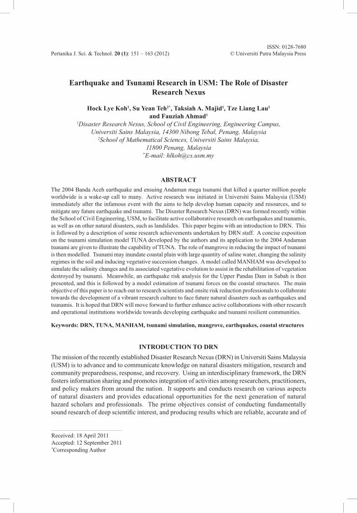
TSUNAMI SIMULATION BY TUNAAn earthquake with magnitude of Mw = 9.3 erupted off the western coast of Banda Aceh, North Sumatera at 00:58:53 UTC (08:58:53 Malaysian time) on 26 December 2004. The earthquake occurred on the tectonic boundaries of the subduction zones, between the Indian plate and the Sunda plate. The instantaneous uplift of the sea floor caused the sea level to be lifted upward by as much as 12 meters at the source, triggering a mega tsunami that killed 200,000 people worldwide. This undersea earthquake lifted upwards a large volume of water, in the order of two hundred trillion tons. Mindful of the deadly potential of future tsunamis inflicting devastating toll on Malaysian coastal communities, Universiti Sains Malaysia (USM) immediately initiated a tsunami research programme to understand the mechanism of tsunami generation, propagation and runup, develop the capability of predicting the impacts of potential tsunamis on the Malaysian coastal communities and establish mitigation measures for reducing these impacts. Two field surveys were conducted along the affected beaches in Penang and Kedah to assess the runup heights and inundation distances as well as to document the damage to properties. The survey data were then collated for calibrating and validating a tsunami simulation model TUNA developed in-house in USM (Koh et al., 2009; Koh et al., 2010). The survey locations are indicated in Fig. 1. A series of international workshops, conferences and roundtables were also held in Malaysia and other affected countries in Asia, including Thailand, Indonesia, Singapore, Philippines, Taiwan, China, Australia, Sri Lanka and India, to report research findings, coordinate collaboration and also establish effective early warning systems. This series of activities and achievements has been reported briefly in an article published by the United Nations Asian and Pacific Centre for Transfer of Technology (UN-APCTT) to provide guidelines and resource for policy makers (Koh et al., 2007).
Earthquake and Tsunami Research in USM: The Role of Disaster Research Nexus
153Pertanika J. Sci. & Technol. Vol. 20 (1) 2012
Fig. 1: Survey locations in Malaysia (Koh et al., 2009)
TUNA is a simulation model that is based on Shallow Water Equation (SWE), as briefly described below. The model consists of a conservation of mass and momentum equations that have been depth averaged. Tsunami propagation fulfils the requirements that are necessary to permit the use of the SWE (Herbert et al., 2005; Koh et al., 2009) and hence may be described by the following SWE equations (Equations 1 to 3).
t xM
yN
022
22
22h
+ + = (1)
tM
x DM
y DMN
gDx D
gnM M N 0
2 2
2 2732
222
22
22h
+ + + + + =c am k (2)
tN
x DMN
y DN
gDD
gnM N
yN 0
2 2
2 2732
222
22
22h
+ + + + + =a ck m (3)
Here, the volume fluxes per unit length (M, N) in the x- and y- directions are related to depth averaged velocities u and v by the expressions M = u(h+h) = uD, and N = v(h+h) = vD, where h is the mean sea depth and h is the water elevation associated with tsunami. Note that g is the gravitational acceleration and D is the total water depth (D = h+h). Further details are available elsewhere (IOC 1997; Teh et al., 2009). TUNA was successfully applied to simulate the impact of the 2004 Andaman tsunami. Fig. 2 illustrates snapshots of the 2004 Andaman tsunami propagation,

Hock Lye Koh, Su Yean Teh, Taksiah A. Majid, Tze Liang Lau and Fauziah Ahmad
154 Pertanika J. Sci. & Technol. Vol. 20 (1) 2012
beginning at the coast off Banda Aceh propagating to Penang and Langkawi and into the Straits of Malacca. At the initialization of the tsunami (the first frame of Fig. 2), the initial tsunami waves split into two fronts, one moving eastwards towards Malaysia and Thailand, while the second propagating westwards towards Sri Lanka and India. The waves moving eastwards are the leading depression N waves, while those moving westwards are the leading elevation N waves. One and a half hour after the earthquake (frame 2 in Fig. 2), the waves reached the offshore of Phuket at the depth of about 50 m, with a leading depression and a surface elevation soon behind. These waves continued to move closer to land, propagating into the Straits of Malacca and moving closer to Langkawi. Three hours after the initiation of the tsunami, the waves reached the coast of Langkawi (frame 3) and propagated towards Penang Island. Four hours after the occurrence of the tsunami (frame 4), the waves propagated almost halfway through the Straits of Malacca.
Fig. 2: Tsunami snapshots by TUNA for 2004 Andaman tsunami
To simulate the wave runup along the dry beaches, the Non-Linear Shallow Water Equations (NLWE) are used (Equations 4 and 5). Extensive simulations of TUNA indicate that the tsunami wave heights might be amplified as the waves propagated up the shallow seas and onto the dry
Earthquake and Tsunami Research in USM: The Role of Disaster Research Nexus
155Pertanika J. Sci. & Technol. Vol. 20 (1) 2012
beaches. The maximum amplification factor of 3.3 to 3.5 was observed in the simulation results, with the maximum inundation distance of about 60 m to 80 m recorded, depending on the bathymetry and other parameters used in these simulations. In general, the simulated wave heights off the coast of Penang at a depth of around 50 m might reach a maximum of 1.0 to 1.2 m, while the runup wave heights might achieve the maximum of 3.3 to 4.0 m. These TUNA simulated runup wave heights are consistent with the range of the runup wave heights recorded, being in the range of 2.3 to 4.0 m surveyed along the beaches in Penang and Kedah after the 26 December 2004 tsunami. The simulated inundation distance of about 60 to 80 m is consistent with the recorded range of the measured inundation distances of 20 to 100 m, which was surveyed after the 2004 Andaman tsunami.
THE ROLE OF MANGROVEMangrove forests have been observed to play a role in reducing tsunami wave heights if the heights are not too high, or are less than 3 m. Hence, these motivated the numerical analysis on the role of mangrove in reducing the adverse impact of tsunamis. For this purpose, a numerical simulation model was developed within the framework of TUNA (Koh et al., 2009). The 1D continuity and momentum equations in flux forms in the x-direction are expressed as Equations (4) and (5), respectively. The last term in Equation (5) is the resistance force used to model the effects of coastal vegetation, such as mangroves (Mazda et al., 1997; Massel et al., 1999). The drag coefficient CD used in the model of the present study is estimated by using Equation (6) while inertia coefficient CM = 1.7 is used (Harada & Imamura, 2000; Hiraishi & Harada, 2003; Harada & Kawata, 2004). There are other estimates of the drag coefficient CD used (Quartel et al., 2007). Equations (4) and (5) are then solved by the finite difference approximation in the runup model TUNA-RP, with the inclusion of mangrove friction term.
0t x
M22
22h
+ = (4)
tM
x DM
gDx D
gn M M CA
D
M MC
VV
tM
20
DM
2 2
0 2
0732
222
22
22h
+ + + + + =c cm m (5)
8.4 . 0.01 0.07 ;CVV
VV
0 66D0 0# #= + a k (6)
In the above,M = flow flux, m2/s; D = (h+h) = total water depth, m;h = still water depth, m;n = Manning coefficient;g = gravitational acceleration, m/s2;CD = drag coefficient; A0 = projected area of trees under water surface, per 100 m2;V0 = total volume of tree under water surface (m3);V = control volume (m3);CM = inertia coefficient.
The role of mangrove forests in reducing the impacts of tsunami waves is demonstrated in this section. The incident solitary wave is a positive half sine curve with a wavelength L = 12000 m, period T = 0.15 hr and amplitude a = 1 m. This wave enters the computational domain at 0 hour

Hock Lye Koh, Su Yean Teh, Taksiah A. Majid, Tze Liang Lau and Fauziah Ahmad
156 Pertanika J. Sci. & Technol. Vol. 20 (1) 2012
and distance 0 m from the left, with a depth h = 50 m, and travels a distance of 10000 m along this flat seabed before it begins its climb at the toe of the slope at 10000 m. The concave slope, with an average slope of 1:40, has a horizontal length of 2000 m, climbing 49 m along this stretch. A healthy and vibrant mangrove forest is located between 12000 m and 13000 m. Fig. 3 shows snapshots of wave heights h at the interval of 0.05 hour. The wave propagates into the computational domain at 0.15 hours (Fig. 3a) and amplifies to 1.8 m at 0.20 hours (Fig. 3b). The presence of a patch of mangrove amplifies the wave heights to 2.5 m in front of the mangrove due to reduced velocity but with a much-reduced wave behind the forests (Fig. 3c). A sharp gradient subsequently causes strong back flows that reduce the height to merely 1.2 m (Fig. 3d), with smaller waves behind the mangroves. This result is consistent with the reported findings.
Fig. 3: Waveforms at an interval of 0.05 hr with mangrove forest between 12 and 13 km
MANHAMIt was observed during the surveys that significant stretches of coastal land in Kedah were extensively exposed to saline seawater brought to coastal lane by the Andaman tsunami. This seawater inundation has resulted in a sharp increase in the salinity of the coastal soil, leading to the land being unsuitable for cultivation of crops such as rice. This salinity inundation is clearly observed in Aceh of Indonesia after the 2004 Andaman tsunami, as it is also commonly seen in other places as well, following large storm surges or inundation by hurricanes. Hence, the study team initiated a research programme on simulating salinity intrusion and its impacts on coastal vegetation. For this purpose, a simulation model known as MANHAM was developed with a collaboration with the scientists from South Florida (Koh et al., 2011; Teh et al., 2008; Sternberg et al., 2007). The results are briefly presented in the subsequent paragraph.

Earthquake and Tsunami Research in USM: The Role of Disaster Research Nexus
157Pertanika J. Sci. & Technol. Vol. 20 (1) 2012
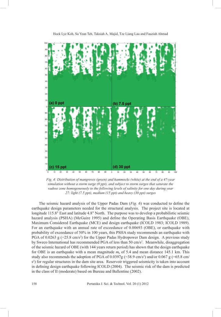
A large tsunami may and will often inundate vast tracks of coastal lands with large volumes of highly saline seawater, thereby changing the salinity regimes. Changes in salinity regimes may induce changes in the coastal vegetation types. Further, mega tsunami may destroy coastal vegetations instantly, giving rise to coastal vegetative successions. This will lead to alteration to coastal ecosystem dynamics. In Malaysia and Indonesia, the 2004 Andaman tsunami has destroyed the stretches of the coastal mangrove forests, exposing the coastal regions to the vagaries of the seas. Thus, rehabilitation and recovery of these coastal mangrove forests is an important element in any effort to develop tsunami resilient communities (Levy & Gopalakrishnan, 2005). Hence, the current research was extended to the study and analysis, via modelling and simulation, on the recovery and succession dynamics of the coastal mangrove forests. To investigate the effects of the increased salinity in the vadose zone, due to storm surge on mangroves and hardwood hammocks, a storm surge was assumed to take place, flooding the entire study domain for one day. Several intensities of the storm surge were also employed in the simulations, ranging from a light surge that saturates the vadose zone homogeneously at 7.5 ppt to a heavy surge event that saturates the vadose zone at 30 ppt. A medium surge saturates the vadose zone at 15 ppt. After the inundation, natural processes of precipitation, tides, and evapotranspiration interact to affect salinity in the soil, and thus, inducing vegetation to undergo succession.
Under stable environmental conditions, where there were no major disturbances, such as storm surges that would cause a catastrophic shift of vegetation, the freshwater hardwood hammocks (white) occupied the higher elevation cells, while mangroves (green) occupied the lower elevation cells (which were frequently inundated by tides), except for some patches of mangroves at higher elevations (Fig. 4a). However, small amounts of biomass of the subdominant species remained in every spatial cell which could act like seeds in the event of an environmental change, such as a storm surge. In the event of a light surge, hardwood hammocks were able to restore the salinity to low levels in a short time period. Twenty years after the storm surge, hardwood hammocks still dominate the cells at higher elevation (Fig. 4b) compared to the case without a storm surge event (Fig. 2a). A medium surge event that saturates the vadose zone at 15 ppt causes the mangroves to invade the cells at higher elevation, which were initially dominated by hardwood hammocks (Fig. 4c). A heavy surge causes the mangroves to take over the entire study domain 20 years after the surge (Fig. 4d). Such vegetation succession patterns have been observed in many coastal zones co-occupied by freshwater and saltwater vegetations such as mangrove and hardwood hammock, respectively.
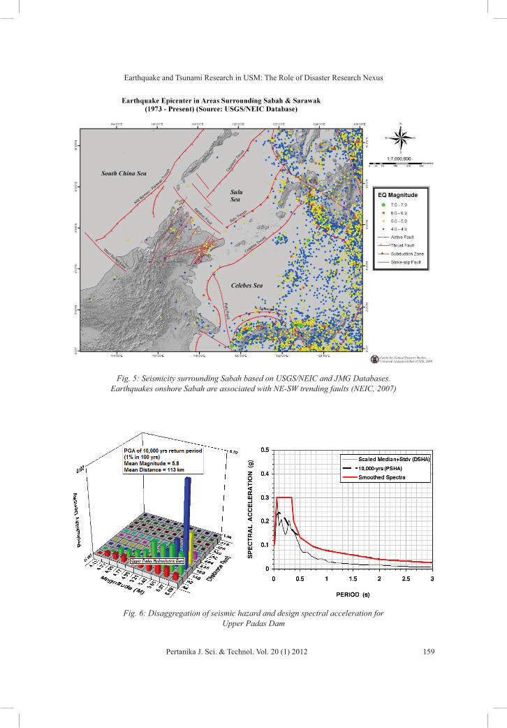
SEISMIC RISK ANALYSISSabah is affected by both regional and local earthquakes. Significant earthquakes from the Sulu and Celebes seas are periodically felt as slight tremors in Sabah. The USGS earthquake database shows a total of 221 with M>6 within 1000 Km from Kota Kinabalu since 1973 (Fig. 5). The source of regional earthquakes for Sabah comes from the active subduction zones marked by the Manila Trench, Negros Trench, Sulu Trench, Cotabato Trench and North Sulawesi Trench (Tongkul, 1992; Tongkul, 1993; Tongkul, 2006).
Three light earthquakes were recorded within 100 Km radius of the Ulu Padas (Upper Padas) area in Sabah where the dam is located. One occurred near Pensiangan, Sabah, with a magnitude of mb=4.1, another at Kuala Penyu, Sabah (mb=4.5) and the third at Long Semado, Sarawak (mb=4.5). The Pensiangan and Long Semado earthquakes appear to be associated with a southward extension of the NE-SW trending Ranau-Labuk Bay seismic zone. This reverse active fault was found near to the Upper Padas Hydroelectric Dam site.
Hock Lye Koh, Su Yean Teh, Taksiah A. Majid, Tze Liang Lau and Fauziah Ahmad
158 Pertanika J. Sci. & Technol. Vol. 20 (1) 2012
Fig. 4: Distribution of mangroves (green) and hammocks (white) at the end of a 47-year simulation without a storm surge (0 ppt), and subject to storm surges that saturate the vadose zone homogeneously to the following levels of salinity for one day during year
27: light (7.5 ppt), medium (15 ppt) and heavy (30 ppt) surges
The seismic hazard analysis of the Upper Padas Dam (Fig. 6) was conducted to define the earthquake design parameters needed for the structural analysis. The project site is located at longitude 115.8° East and latitude 4.8° North. The purpose was to develop a probabilistic seismic hazard analysis (PSHA) (McGuire 1995) and define the Operating Basis Earthquake (OBE), Maximum Considered Earthquake (MCE) and design earthquake (ICOLD 1983; ICOLD 1989). For an earthquake with an annual rate of exceedance of 0.00693 (OBE), or earthquake with probability of exceedance of 50% in 100 years, this PSHA study recommends an earthquake with PGA of 0.0263 g (=25.8 cm/s2) for the Upper Padas Hydropower Dam design. A previous study by Sweco International has recommended PGA of less than 50 cm/s2. Meanwhile, disaggregation of the seismic hazard of OBE (with 144 years return period) has shown that the design earthquake for OBE is an earthquake with a mean magnitude mb of 5.4 and mean distance 145.1 km. This study also recommends the adoption of PGA of 0.0397g (=38.9 cm/s2) and/or 0.067 g (=65.8 cm/s2) for regular structures in the dam site area. Reservoir triggered seismicity is taken into account in defining design earthquake following ICOLD (2004). The seismic risk of the dam is predicted in the class of II (moderate) based on Bureau and Ballentine (2002).
Earthquake and Tsunami Research in USM: The Role of Disaster Research Nexus
159Pertanika J. Sci. & Technol. Vol. 20 (1) 2012
Fig. 5: Seismicity surrounding Sabah based on USGS/NEIC and JMG Databases. Earthquakes onshore Sabah are associated with NE-SW trending faults (NEIC, 2007)
Fig. 6: Disaggregation of seismic hazard and design spectral acceleration for Upper Padas Dam

Hock Lye Koh, Su Yean Teh, Taksiah A. Majid, Tze Liang Lau and Fauziah Ahmad
160 Pertanika J. Sci. & Technol. Vol. 20 (1) 2012
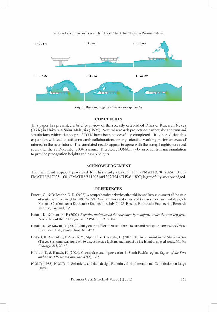
TSUNAMI FORCE FOR ONSHORE STRUCTURESTo ensure integrity and stability of the coastal structures subject to tsunami attack, the determination of wave forces exerted on these structures is essential. When tsunami propagates to near-shore region, the wave breaks and transforms into turbulent bore. Turbulent bore exhibits complicated wave characteristics because it consists of irregular waves and substantial air entrapment. In the runup zone, tsunami advances as a dry-bed surge. Turbulent bores and dry-bed surges have distinctive characteristics and exert different forces on the structures (Yeh, 2007). Local bathymetry and topography are important factors that influence tsunami force on the structures. It is important to note that physical modelling is one of the practical approaches to study the tsunami-induced forces on the structures. Meanwhile, wave flume experiment was conducted to simulate tsunami with certain predicted characteristics. Local bathymetry and topography were also incorporated and the wave propagation towards the shoreline was analyzed. Wave height and flow velocity time histories were measured at various locations along the shoreline using wave gauges and current meters. The desired wave forces and wave pressures were then measured by attaching force transducers and pressure gauges on the structures. Solitary wave was used as a representative of tsunami in deep sea and the transformed turbulent bore in shallow water. An example of the physical simulation for tsunami attacking a bridge structure is shown in Fig. 7. A hydraulic analysis on an inland bridge subjected to tsunami is described in Lau et al. (2008).
Fig. 7: Inland bridge subjected to tsunami
However, the implementation of the physical modelling is time consuming, costly and is limited by certain feasible scales in the laboratory. Thus, an alternative is to perform numerical wave flume experiment on tsunami-structure interaction. A numerical simulation using computational fluid dynamic principles was successfully adopted to simulate tsunami flow in the numerical wave flume (Lau et al., 2009). The experimental results obtained were then adopted to calibrate and validate the numerical model. In order to simulate tsunami-structure interaction, an I-girder bridge was incorporated in the numerical model, which was subsequently upgraded to the prototype scale. The simulated result for an inland bridge subjected to tsunami at various time frames is shown in Fig. 8. Detailed results of wave height, flow velocity, wave forces and pressures were obtained. The findings of the study have enhanced the understanding of tsunami interaction with the structures.
Earthquake and Tsunami Research in USM: The Role of Disaster Research Nexus
161Pertanika J. Sci. & Technol. Vol. 20 (1) 2012
Fig. 8: Wave impingement on the bridge model
CONCLUSIONThis paper has presented a brief overview of the recently established Disaster Research Nexus (DRN) in Universiti Sains Malaysia (USM). Several research projects on earthquake and tsunami simulations within the scope of DRN have been successfully completed. It is hoped that this exposition will lead to active research collaborations among scientists working in similar areas of interest in the near future. The simulated results appear to agree with the runup heights surveyed soon after the 26 December 2004 tsunami. Therefore, TUNA may be used for tsunami simulation to provide propagation heights and runup heights.
ACKNOWLEDGEMENTThe financial support provided for this study (Grants 1001/PMATHS/817024, 1001/PMATHS/817025, 1001/PMATHS/811093 and 302/PMATHS/611897) is gratefully acknowledged.
REFERENCESBureau, G., & Ballentine, G. D. (2002). A comprehensive seismic vulnerability and loss assessment of the state
of south carolina using HAZUS. Part VI. Dam inventory and vulnerability assessment methodology, 7th National Conference on Earthquake Engineering, July 21–25, Boston, Earthquake Engineering Research Institute, Oakland, CA.
Harada, K., & Imamura, F. (2000). Experimental study on the resistance by mangrove under the unsteady flow. Proceeding of the 1st Congress of APACE, p. 975-984.
Harada, K., & Kawata, Y. (2004). Study on the effect of coastal forest to tsunami reduction. Annuals of Disas. Prev., Res. Inst., Kyoto Univ., No. 47 C.
Hérbert, H., Schindelé, F, Altinok, Y., Alpar, B., & Gazioglu, C. (2005). Tsunami hazard in the Marmara Sea (Turkey): a numerical approach to discuss active faulting and impact on the Istanbul coastal areas. Marine Geology, 215, 23-43.
Hiraishi, T., & Harada, K. (2003). Greenbelt tsunami prevention in South-Pacific region. Report of the Port and Airport Research Institute, 42(2), 3-25.
ICOLD (1983). ICOLD 46, Seismicity and dam design, Bulletin vol. 46, International Commission on Large Dams.

Hock Lye Koh, Su Yean Teh, Taksiah A. Majid, Tze Liang Lau and Fauziah Ahmad
162 Pertanika J. Sci. & Technol. Vol. 20 (1) 2012
ICOLD (1989). ICOLD 72. Selecting seismic parameters for large dams, Bulletin, 72, International Commission on Large Dams.
ICOLD (2004). ICOLD 137, Reservoir and seismicity: state of knowledge, Bulletin, 137, International Commission on Large Dams.
IOC (1997). Numerical Method of Tsunami Simulation with the Leap Frog Scheme, 1, Shallow Water Theory and Its Difference Scheme. In Manuals and Guides of the IOC (p. 12-19). Intergovernmental Oceanographic Commission, UNESCO, Paris.
Koh, H. L., Teh, S. Y., & Izani, A. M. I. (2007). Tsunami Mitigation Management. Special Feature: Natural Disaster Management Technologies. The United Nations Asian and Pacific Centre for Transfer of Technology (UN-APCTT) Nov-Dec 2007, Asia Pacific Tech Monitor 24(6), 47-54.
Koh, H. L., Teh, S. Y., Liu, P. L.-F., Izani, A. M. I., & Lee, H. L. (2009). Simulation of Andaman 2004 Tsunami for Assessing Impact on Malaysia. Journal of Asian Earth Sciences, 36(1), 74-83.
Koh, H. L., Teh, S. Y., Liu, P. L.-F., & Che Abas, M. R. (2010).Tsunami Simulation Research and Mitigation Programs in Malaysia Post 2004 Andaman Tsunami. In N. Veitch, & G. Jaffray (Eds.), Tsunamis: Causes, Characteristics and Warnings, and Protection (Chapter 2, pp. 29-56). New York: Nova Science Publishers, Inc., Hauppauge.
Koh, H. L., DeAngelis, D. L., & Teh, S. Y. (2011). Mangrove Wetland Ecosystem Modeling in the Everglades. In James N. Metras (Ed.), Mangroves: Ecology, Biology and Taxonomy. Nova Science Publishers, Inc., Hauppauge, New York.
Lau, T. L., Lukkunaprasit, P., Ruangrassamee, A., & Ohmachi, T. (2008). Physical Modeling: An Estimation of Wave Forces on an Inland Bridge Subject to Tsunami Bores. Proceedings of the 5th International Conference on Urban Earthquake Engineering, Tokyo, Japan, March 4-5, pp. 441-446.
Lau, T. L., Ohmachi, T., & Inoue, S. (2009). Numerical Simulation of Tsunami Flow around I-Girder Bridge Decks. Proceedings of the 6th International Conference on Urban Earthquake Engineering, Tokyo, Japan, March 3-4, 2009, pp. 823-828.
Levy, J. K., & Gopalakrishnan, C. (2005). Promoting Disaster-resilient Communities: The Great Sumatra-Andaman Earthquake of 26 December 2004 and the Resulting Indian Ocean Tsunami. International Journal of Water Resources Development, 21(4), 543-559.
Massel, S. R., Furukawa, K., & Brinkman, R. M. (1999). Surface wave propagation in mangrove forests. Fluid Dynamics Research, 24(4), 219-249.
Mazda, Y., Wolanski, E., King, B., Sase, A., Ohtsuka, D., & Magi, M. (1997). Drag force due to vegetation in mangrove swamps. Mangroves and Salt Marshes, 1, 193-199.
McGuire, R. K. (1995). Probabilistic Seismic Hazard Analysis and Design Earthquakes: Closing the Loop. Bulletin of the Seismological Society of America, 85(5), 1275-1284.
NEIC (2007). Earthquake database. National Earthquake Information Center. Available at http:/neic.usgs.gov/neic/epic.
Quartel, S., Kroon, A., Augustinus, P. G. E. F., Van Santen, P., & Tri, N. H. (2007). Wave attenuation in coastal mangroves in the Red River Delta, Vietnam. Journal of Asian Earth Sciences 29(4), 576-584.
Sternberg, L., Teh, S. Y., Ewe, S., Miralles-Wilhelm, F., & DeAngelis, D. (2007). Competition between Hardwood Hammocks and Mangroves. Ecosystems, 10(4), 648-660.
Teh, S. Y., DeAngelis, D., Sternberg, L., Miralles-Wilhelm, F. R., Smith, T. J., & Koh, H. L. (2008). A Simulation Model for Projecting Changes in Salinity Concentrations and Species Dominance in the Coastal Margin Habitats of the Everglades. Ecological Modelling, 213(2), 245-256.

Earthquake and Tsunami Research in USM: The Role of Disaster Research Nexus
163Pertanika J. Sci. & Technol. Vol. 20 (1) 2012
Teh, S. Y., Koh, H. L., Liu, P. L.-F., Izani, A. M. I., & Lee, H. L. (2009). Analytical and Numerical Simulation of Tsunami Mitigation by Mangroves in Penang, Malaysia. Journal of Asian Earth Sciences, 36(1), 38-46.
Tongkul, F. (1992). The Ranau earthquake: possible causes. Sabah Society Journal, 9(4), 315-322.
Tongkul, F. (1993). Tectonic control on the development of the Neogene basins in Sabah, Malaysia. Bulletin of Geological Society of Malaysia, 33, 95-103.
Tongkul, F. (2006). The structural style of Lower Miocene sedimentary rocks, Kudat Peninsula, Sabah. Bulletin of the Geological Society of Malaysia, 49, 119-124.
Yeh, H. (2007). Design tsunami forces for onshore structures. Journal of Disaster Research, 2(6), 531-536.