ecmwf international session 2003 db-1 weather prediction and the use of weather data the european...
TRANSCRIPT

International Session 2003DB-1 ECMWF
Weather Predictionand the use of weather data
The European Centre forMedium-Range Weather Forecasts
ECMWF
Weather Predictionand the use of weather data
The European Centre forMedium-Range Weather Forecasts
ECMWF
David Burridge with help from A. Simmons, G. Kelly, J-N Thepaut,D. Marbouty, A. Thorpe, A. Lorenc, T. Palmer ……

International Session 2003DB-2 ECMWF
Annual means of the forecast range at which theanomaly correlation of 500 hPa forecasts first reaches The 60%, 655, 70%, 80%, 85% and the 95% levels for the Northern hemisphere (left panel) and theSouthern hemisphere (right panel).

International Session 2003DB-3 ECMWF
• Peaks beyond 500mm/day (670mm at Anduze)
• A large area with more than 200mm in 24h
• Early warnings were available

International Session 2003DB-4 ECMWF
International Session 2003DB-5 ECMWF
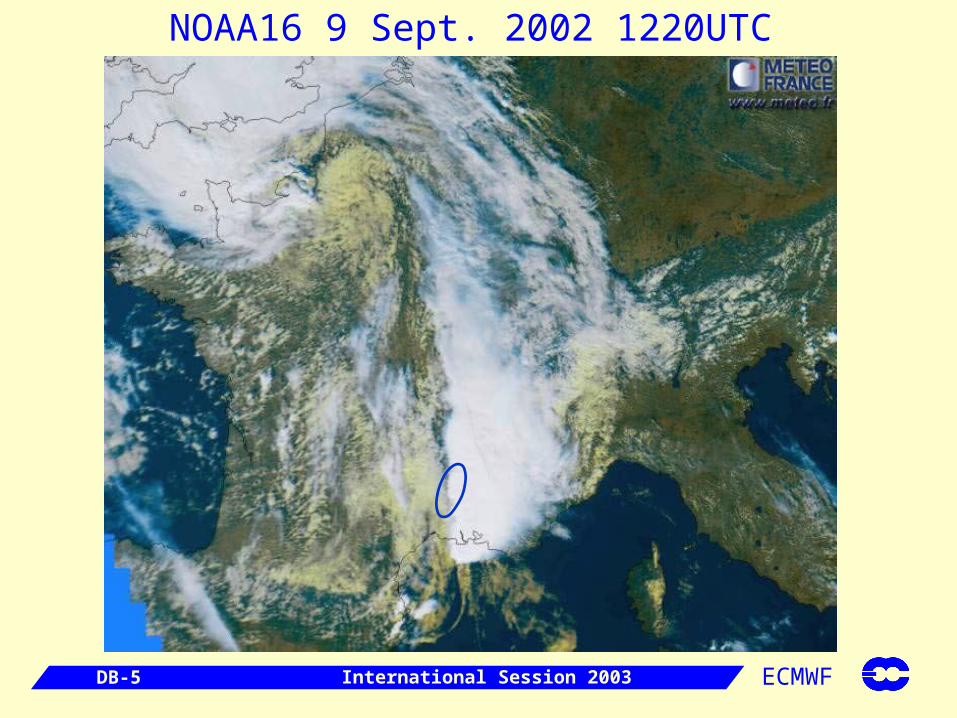
NOAA16 9 Sept. 2002 1220UTC

International Session 2003DB-6 ECMWF
Le Gardon à Collias
9 Sept 2002
11 Sept

International Session 2003DB-7 ECMWF
Forecast consistencyfive consecutive T511 forecasts valid at the same time

International Session 2003DB-8 ECMWF
T511 precipitation forecastscumulated over 24h and valid for: 20020908 18z to 20020909 18z

International Session 2003DB-9 ECMWF
CTRL
Prob.RRR>50mm
Prob. (area)RRR>50mm
Sa 7/9 Fr 6/9 Th 5/9 We 4/9 Tu 3/9
EPS precipitation probabilitiesvalid for TP cumulated over 24h: 20020908 18z to 20020909 18z

International Session 2003DB-10 ECMWF
S-France flood: Summary
A stationary convective system generates huge amounts of precipitation in a few hours ( ~ 600 mm/24h in some places) over a limited area.
The medium-range deterministic forecast is very consistent. The synoptic pattern is correctly forecasted already 5 days in advance. Good ability of the model to simulate the basic ingredients for severe convection.
EPS supports the deterministic forecast showing unusual high probability values. EFI index gives early warning but spread a large area.

International Session 2003DB-11 ECMWF
Precipitation accumulated over the Po' river catchmentarea predicted by the 51 EPS members started on2 November 1994 and run for 10 days (grey lines, cyan for the control)and the 6 nested LEPS members (violet lines, green for the control)started on 3 November and run for 3 days. The red line depicts thearea-average over the river-catchment computed from synoptic observations.

International Session 2003DB-12 ECMWF
Global Weather Prediction – A Triumph
for science and computing
Today we have global operational forecasts with useful skill varying between 7 and 8 days;
During the satellite data era there has been a gain of more than 2 days and 4 day gain since Miyakoda’s experimental forecasts which he carried out in the late 1960s (published in 1972); the hemispheric skill that can be achieved with the 1950s observing system is around 6 days – truly a triumph for science and computing

International Session 2003DB-13 ECMWF
Number of used observational data per 12 UTC cycle inECMWF's operational assimilation system, 1997-2002.

International Session 2003DB-14 ECMWF

International Session 2003DB-15 ECMWF

International Session 2003DB-16 ECMWF
N.HEM LAT 20.000 TO 90.000 LON -180.000 TO 180.000
ANOMALY CORRELATION FORECAST
1000hPa GEOPOTENTIAL
FORECAST VERIFICATION 12UTC
%
10DECEMBER
2002
11 12 13 14 15 16 17 18 19 20 21 22 23 24 25 26 27 28 29 30 31 1 2 3 4 5 6 7 8 9JANUARY
2003
76
78
80
82
84
86
88
90
92
94
96
no_sat_w T+ 96control_w T+ 96no_upper_w T+ 96

International Session 2003DB-17 ECMWF
H
H
H
H
H
H
H
H
H
H
H
H
H
H
H
H
H
H
L
L
L
L
L
L
L
L
LL
L
L
L
L
L
L
L
L
L
L
L
-20
-10
-10
0
0
0
0
0
0
1010
10
10
10
10
2020
20
20
20
20
20
20
20
20°N
30°N
30°N
40°N
50°N
60°N
70°N
80°N80°W
60°W
40°W 20°W 0° 20°E
40°E
60°E
80°E
Wednesday 25 December 2002 12UTC ECMWF Forecast t+96 VT: Sunday 29 December 2002 12UTC 1000hPa geopotential height
HH
H
H
H
H
H
H
HH
H
H
H
H
H
H
H
H
H
H
H
H
LL
L
LL
L
L
L
L
L
L
L
L
LL
L
L
L
LL
L
L
L
-20
-10-10
0
0
0
0
0
0
0
0
10
10
10
1010
10
10
10
20
20
20
20
20
20
20
20°N
30°N
30°N
40°N
50°N
60°N
70°N
80°N80°W
60°W
40°W 20°W 0° 20°E
40°E
60°E
80°E
ECMWF Analysis VT:Sunday 29 December 2002 12UTC 1000hPa geopotential height
H
H
H
H
H
H
H
H
H
H
H
H
H
HH
H
H
H
H
H
H
HLL
LL
L
L
L
L
L
L
L
L
L
L
L
L
L
L
L
-20
-20
-10
-10
0
0
0
0
0
0
0
10
10
10
10
10
10
20
20
20
20
20
20
20
20
20
20
20°N
30°N
30°N
40°N
50°N
60°N
70°N
80°N80°W
60°W
40°W 20°W 0° 20°E
40°E
60°E
80°E
Wednesday 25 December 2002 12UTC ECMWF Forecast t+96 VT: Sunday 29 December 2002 12UTC 1000hPa geopotential height
A F1
F2
Four-day forecasts for Sunday 29 December 2002A – analysisF1 – full systemF2 - without satellite data

International Session 2003DB-18 ECMWF
Real-time data from new research satellites
ENVISAT from ESA, flying a range of instruments to measure ocean waves and ozone - LAUNCHED
AQUA from NASA, flying AIRS the first of a new generation of high-resolution infrared instruments - LAUNCHED

International Session 2003DB-19 ECMWF
Major enhancements of the operational satellite observing system
SEVIRI on MSG, the new generation of EUMETSAT geostationary satellites
- 2003
IASI and other instruments on the first generation of EUMETSAT polar-orbiting satellites
- LATE 2005

International Session 2003DB-20 ECMWF

International Session 2003DB-21 ECMWF

International Session 2003DB-22 ECMWF
THORPEX?THORPEX?
• significant failures in forecasting high-impact weather
• the inability to extend the range of skillful predictions beyond 7 days
• poor prediction of tropical-extratropical interactions
• inadequate skill in predicting specific aspects of mesoscale weather, e.g., precipitation
A combination of inaccurate initial conditions and errors in model formulation contribute to:
International Session 2003DB-23 ECMWF
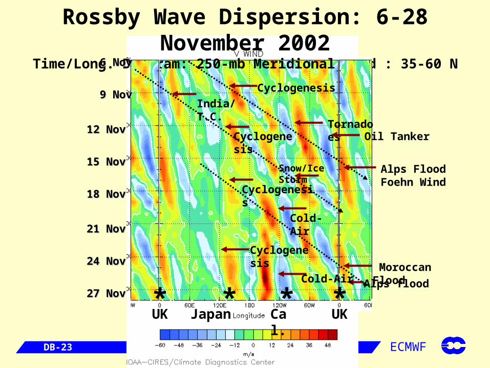
Rossby Wave Dispersion: 6-28 November 2002Time/Long. Diagram: 250-mb Meridional Wind : 35-60 N
UK Japan* *
UKCal.**
Cyclogenesis
TornadoesOil Tanker
Alps FloodFoehn Wind
Cyclogenesis
Snow/Ice Storm
Moroccan Flood
Alps flood
Cyclogenesis
India/T.C.
Cyclogenesis
Cold-Air
Cold-Air
6 Nov6 Nov
9 Nov9 Nov
12 Nov12 Nov
15 Nov15 Nov
18 Nov18 Nov
21 Nov21 Nov
24 Nov24 Nov
27 Nov27 Nov

International Session 2003DB-24 ECMWF
THORPEXTHORPEX ObjectivesObjectives• advance basic knowledge of global-to-regional influences on
the predictability of high-impact weather
• contribute to the development of a dynamically-controlled interactive forecast system
• consider short-range (0-3 days), medium-range (3-7 days) and week-two forecast problems: the “middle ground” between weather and climate
• develop methods for assessing the economic and societal value of improved weather forecast skill

International Session 2003DB-25 ECMWF
Interactive Forecast SystemInteractive Forecast System
• optimal design of fixed and adaptive observing
system
• use of targeting techniques for observing and data
assimilation
• two-way flow of information between model and
observing system

International Session 2003DB-26 ECMWF
ATLANTIC OCEAN
Zero-pressureB alloon
G ondola(24 sonde capacity)
6 hoursbetw eendrops
NORTHAMERICA
EUROPE
O rbC om mLEO S ate llite
Driftsonde System Driftsonde System
High-resolution vertical profiles of Temperature, Wind, Moisture, Pressure
Ground Station
Hourly data at flight level

International Session 2003DB-27 ECMWF
An exampleAn example of of possible possible Driftsonde Driftsonde deployment from Japandeployment from Japan
International Session 2003DB-28 ECMWF
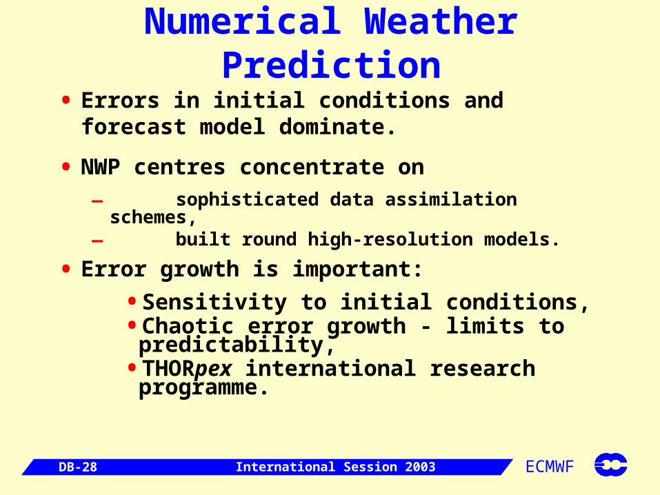
Numerical Weather Prediction
• Errors in initial conditions and forecast model dominate.
• NWP centres concentrate on
– sophisticated data assimilation schemes,– built round high-resolution models.
• Error growth is important:
• Sensitivity to initial conditions,• Chaotic error growth - limits to
predictability,• THORpex international research
programme.

International Session 2003DB-29 ECMWF
Assimilation of cloud & precipitation
Weather systems (In order of priority + possibility?)
1. Resolved, dynamically-forced, vertical motion (eg depressions)
2. Horizontally (but not vertically) resolved forcings and feedback on parametrized boundary-layer processes (eg Strato-Cu)
3. Resolved forcings and feedback on parametrized deep convection (eg MCS, embedded convection in fronts)
4. Scattered convection.
International Session 2003DB-30 ECMWF
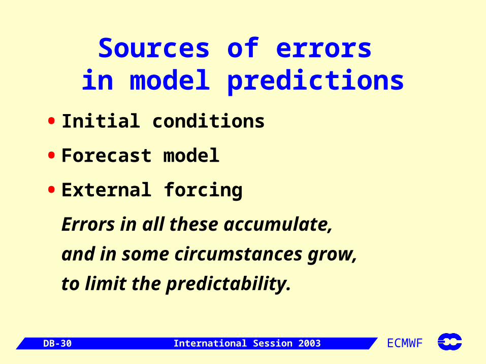
Sources of errors in model predictions
• Initial conditions
• Forecast model
• External forcing
Errors in all these accumulate,
and in some circumstances grow,
to limit the predictability.

International Session 2003DB-31 ECMWF
Seasonal Prediction
• Chaotic growth Detailed initial conditions of the atmosphere are not important.
• Coupled systems have components without this rapid growth, e.g. ocean, land surface.
• Seasonal forecasts do depend on initial conditions for these components.
Data assimilation for coupled models.
International Session 2003DB-32 ECMWF
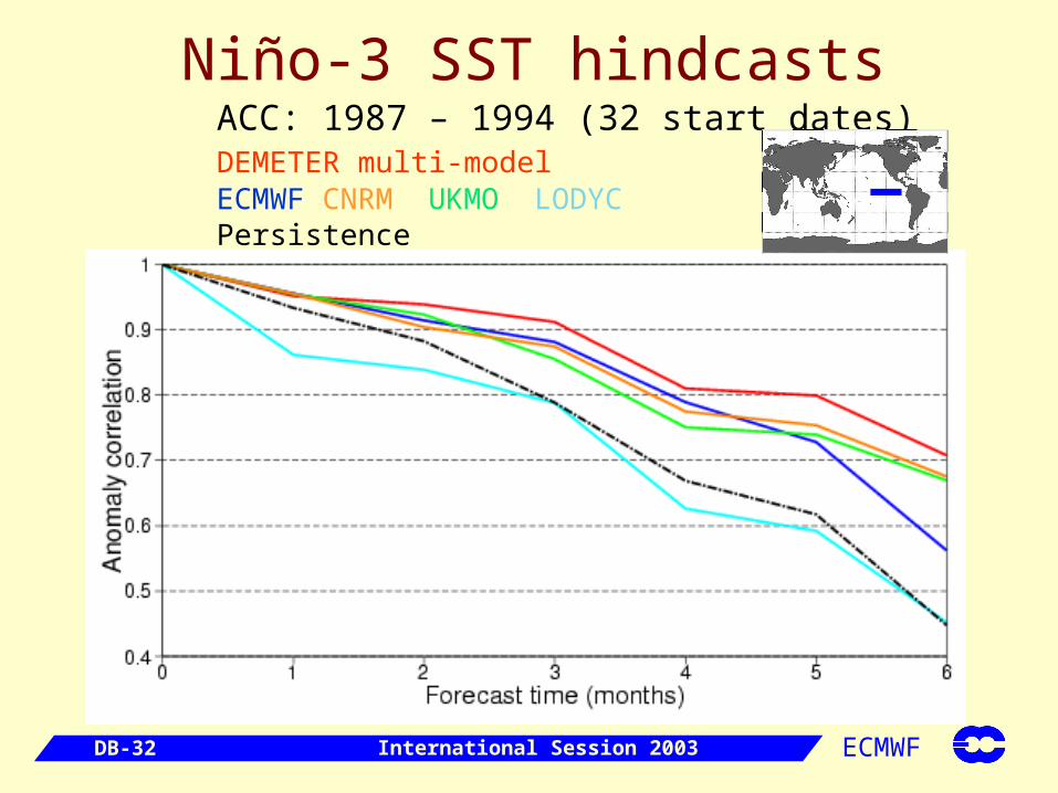
ACC: 1987 – 1994 (32 start dates) DEMETER multi-model ECMWF CNRM UKMO LODYC Persistence
Niño-3 SST hindcasts

International Session 2003DB-33 ECMWF
Real-time dynamical multi-model seasonal forecast
Risk of wet / dry winter 2002/03

International Session 2003DB-34 ECMWF
Climate Prediction
• Changes in external forcing dominate.
• Model validation and development is crucial
• Data assimilation is important for this.

International Session 2003DB-35 ECMWF
Coupled Data Assimilation
• Skill in seasonal predictions comes from slowly evolving sea and land surface.
• We do not have enough observations for these; the atmosphere is relatively better known.
Need atmosphere in coupled Data Assimilation, even though atmosphere Initial Conditions are not important.
• But don’t need fully coupled Data Assimilation:
– the insertion of obs into each model is independent– with coupling, via fluxes, in the forecast steps.

International Session 2003DB-36 ECMWF
Bias
• If a model has bias, it is impossible for Data Assimilation to give consistent bias-free fields and fluxes.
• Exacerbated by biased obs & Data Assimilation methods.
Coupled Data Assimilation must give higher priority to coping with bias than does NWP Data Assimilation.

International Session 2003DB-37 ECMWF
Summary
• Non-NWP Data Assimilation has different priorities
• Biases are unavoidable, and must be allowed for in coupled Data Assimilation
• Re-analyses useful to validate seasonal prediction systems

International Session 2003DB-38 ECMWF
Prospects for NWP and Seasonal Forecasting
• Comprehensive Earth-System forecast facilities
• Comprehensive Earth-System assimilation facilities
• Strong Satellite Capabilities
• Improving ground-based observing systems with experimental
systems to provide guidance
• Robust and efficient Numerical methods
• Thoroughly Validated Parametrizations
• Extensive Ensemble Capabilities
• Strong Computing
• We may confidently expect
– Increasing forecast quality– Further spin-offs and new products

International Session 2003DB-39 ECMWF
The Weather Community can advance Global monitoring of the
environment in:• SYSTEMS FOR RISK ASSESSMENT
– delivering operational support to weather-related risk management (early warning, impact assessment and reaction) in sensitive areas for: floods; forest fires; oil spills; and support for humanitarian aid
• GLOBAL ATMOSPHERE MONITORING
– delivering regular assessments of state of the atmosphere with particular attention to aerosols, ozone, UV radiation and specific pollutants
• GLOBAL OCEAN MONITORING
– in support of seasonal weather predictions, global change research, commercial oceanography and defence.
• GLOBAL VEGETATION MONITORING
– to assess carbon fluxes to/from the biosphere.

International Session 2003DB-40 ECMWF
Areas for GMES Collaboration Global Monitoring / Forecasting of
Greenhouse Gases2.1 Map the seasonal
variations of total column amounts of Greenhouse Gases
2.2 Model and assimilate ocean colour data, to estimate ocean carbon uptake.
2.3 Model and assimilate global aerosol information (to improve weather forecasts & the use of ocean colour data)
2.4 Model and assimilate information on the Land Biosphere and carbon cycle.

International Session 2003DB-41 ECMWF
Global Monitoring / Forecasting of Reactive Gases: The Chemical Weather Forecast
Current operational ozone monitoring capability is a good basis for developing a global capability to monitor reactive gases and associated aerosols
3.1 Integrate chemical modules with weather models, to provide global assimilation & forecasts of the distributions of
•ozone and its precursors•sulphate aerosol•other aerosol
The global models can drive regional chemistry / air quality models.
Ozone
CO

International Session 2003DB-42 ECMWF
Environmental PredictionsEnvironmental Predictions can be very effective if environmental models are driven by
Global Earth-System Assimilations
Global Deterministic & Ensemble Forecasts
Inverse Model for Carbon attribution
Atmosphere Regional Weather Model
Chemical & Aerosol Transport Model
Trajectory Model
Hydrological Model
Land Crop Model
Fire Model
Disease Model
Ocean Oil-spill Model
Storm Surge Model
Coastal Zone Model
Regional Ocean Model