eden district council strategic flood risk assessment … · eden district council strategic flood...
TRANSCRIPT

Eden District Council Strategic Flood Risk Assessment (SFRA)
October 2007 (Final)
Eden District Council Town Hall
Penrith Cumbria
CA11 7YG

Eden District Council STRATEGIC FLOOD RISK ASSESSMENT (SFRA)
EXECUTIVE SUMMARY
Introduction
1. Many of the urban areas within Eden District Council are situated in close proximity to the River Eden and its tributaries. As a consequence there is a considerable history of flooding with significant events (resulting in property flooding) occurring repeatedly at several locations.
2. During the most recent flooding, which happened in 2005, over 120 properties were affected in total at Appleby, Penrith and Eamont Bridge. The Environment Agency estimates that several hundred properties are at ‘significant’ risk of flooding across the District.
Why carry out a Strategic Flood Risk Assessment (SFRA)?
3. Flooding can result not only in costly damage to property, but can also pose a risk to life and livelihood. It is essential that future development is planned carefully, steering it away from areas that are most at risk from flooding, and ensuring that it does not exacerbate existing flooding problems.
4. Planning Policy Statement (PPS) 25: Development and Flood Risk has been developed to underpin decisions relating to future development (including urban regeneration) within areas that are subject to flood risk.
5. In simple terms, PPS25 requires local planning authorities to review the variation in flood risk across their district, and to steer vulnerable development (e.g. housing) towards areas of lowest risk.
6. Where this cannot be achieved and development is to be permitted in areas that may be subject to some degree of flood risk, PPS25 requires the Council to demonstrate that there are sustainable mitigation solutions available that will ensure that the risk to property and life is minimised (throughout the lifetime of the development) should flooding occur.
7. The Strategic Flood Risk Assessment (SFRA) is the first step in this process, and it provides the building blocks upon which the Council’s planning and development control decisions will be made.
What is involved in a Strategic Flood Risk Assessment (SFRA)?
8. The Eden District Council Strategic Flood Risk Assessment (SFRA) has been carried out to meet the following key objectives:
‹ Collate all known sources of flooding - including river, surface water (local drainage), sewers and groundwater, that may affect existing and/or future development within the District;
‹ Identify areas that have a ‘low’, ‘medium’ and ‘high’ probability of flooding -in accordance with Planning Policy Statement 25 (PPS25).
‹ Recommend appropriate land uses within flood affected areas - in accordance with the PPS25 Sequential Test that will not unduly place people or property at risk of flooding.
‹ Recommend possible flood mitigation solutions - that may be integrated into the design (by the developer) in areas where flood risk has been identified as a potential constraint to future development, to minimise the risk to property and life should a flood occur (in accordance with the PPS25 Exception Test).
October 2007 (Final) i

Eden District Council STRATEGIC FLOOD RISK ASSESSMENT (SFRA)
The Sequential Test
9. PPS25 advocates a sequential approach that will guide the planning decision making process (i.e. the allocation of sites). In simple terms, this requires planners to seek to allocate sites for future development within areas of lowest flood risk in the initial instance.
10. Only if it can be demonstrated that there are no suitable sites within these areas should alternative sites (i.e. within areas that may potentially be at risk of flooding) be contemplated. This is referred to as the Sequential Test.
11. As an integral part of the sequential approach, PPS25 stipulates permissible development types. This considers both the degree of flood risk posed to the site, and the likely vulnerability of the proposed development to damage (and indeed the risk to the lives of the site tenants) should a flood occur.
12. The PPS25 Sequential Test is depicted in Figure 3.1 of the Practice Guide Companion to PPS25 (Draft, February 2007) and Section 6.4.1 of this document.
The Exception Test
13. Many towns within England are situated adjacent to rivers, and are at risk of flooding. The future sustainability of these communities relies heavily upon their ability to grow and prosper. PPS25 recognises that, in some areas, including Eden District, restricting residential development from areas designated as Zone 3a High Probability may heavily compromise the viability of existing communities.
14. For this reason, PPS25 provides an Exception Test. Where a local planning authority has identified that there is a strong planning based argument for a development to proceed that does not meet the requirements of the Sequential Test, it will be necessary for the Council to demonstrate that the Exception Test can be satisfied.
15. For the Exception Test to be passed it must be demonstrated that:
‹ “…the development provides wider sustainability benefits to the community that outweigh flood risk, informed by a SFRA where one has been prepared. If the DPD has reached the ‘submission’ stage, the benefits of the development should contribute to the Core Strategy’s Sustainability Appraisal;
‹ the development should be on developable, previously developed land or if it is not on previously developed land, that there are no reasonable alternative sites on previously developed land; and
‹ a FRA must demonstrate that the development will be safe, without increasing flood risk elsewhere, and where possible, will reduce flood risk overall.”
Outcomes of the Eden District SFRA
16. Eden District has been delineated into zones of low, medium and high probability of flooding, based upon existing available information provided by the Environment Agency. Detailed flood risk mapping has been made available for the River Eden and several of its tributaries. The Environment Agency Flood Zone Maps (April 2007) have been adopted as the basis for the SFRA for other watercourses.
17. The spatial variation in flood risk across the District has been delineated in the following manner:
October 2007 (Final) ii

Eden District Council STRATEGIC FLOOD RISK ASSESSMENT (SFRA)
Zone 3b (Functional Floodplain)
18. Areas subject to flooding up to (and including) once in every 20 years on average have been identified as Zone 3b Functional Floodplain. These areas are subject to relatively frequent flooding, which may include fast flowing and/or deep water. Whilst it may be impractical to refuse all future regeneration within some of these areas (especially those which are already developed), careful consideration must be given to future sustainability, planning policies have been developed accordingly.
19. In Penrith, north of the Gilwilly Industrial Estate, a significant area of Zone 3b Functional Floodplain has been identified based upon a topographic data and flood outlines provided by the Environment Agency. There is a degree of uncertainty regarding these flood outlines which may be resolved by future investigations.
Zone 3a High Probability
20. Areas subject to flooding up to (and including) once in every 100 years on average (i.e. Zone 3a High Probability) have been identified. Residential development should be avoided in these areas wherever possible. It is recognised however that there may be strong planning arguments as to why housing may be required in these areas.
21. To meet the requirements of the Exception Test therefore, it will be necessary for the Council to demonstrate that the development provides wider sustainability benefits to the community that outweigh flood risk. The Council must also demonstrate that the development is on developable, previously developed land or if it is not on previously developed land, that there are no reasonable alternative sites on previously developed land.
22. The SFRA has outlined specific development control conditions that should be placed upon development within Zone 3a High Probability to minimise both the damage to property, and the risk to life in case of flooding. It is essential that the developer carries out a detailed Flood Risk Assessment to consider the site-based constraints that flooding may place upon the proposed development.
Zone 2 Medium Probability
23. Areas subject to flooding in events exceeding the 100 year event, and up to (and including) once in every 1000 years on average (i.e. Zone 2 Medium Probability) have been identified. Essential community services, including emergency services, should be avoided in these areas. There are generally no other restrictions placed upon future development in these areas, however it is important to ensure that the developer takes account of possible climate change impacts to avoid a possible increase in the risk of flooding in future years (achieved through completion of a simple Flood Risk Assessment).
Zone 1 Low Probability
24. There are no restrictions placed on development within Zone 1 Low Probability (i.e. all remaining areas of the District). It is important to remember however that development within these areas, if not carefully managed, may exacerbate existing flooding and/or drainage problems downhill. It is necessary therefore to ensure that developers carry out a Drainage Impact Assessment. This should demonstrate that the proposed drainage system design will mitigate any possible increase in runoff that may occur from the site as a result of the proposed development.
The Way Forward
25. A proportion of the Eden District is at risk of flooding. The risk of flooding posed to properties within the District arises from a number of sources including river flooding, localised runoff and sewer flooding.
October 2007 (Final) iii

Eden District Council STRATEGIC FLOOD RISK ASSESSMENT (SFRA)
26. A planning solution to flood risk management should be sought wherever possible, steering vulnerable development away from areas affected by flooding in accordance with the PPS25 Sequential Test. Specific planning recommendations have been provided for all urban centres within the District.
27. Where other planning considerations must guide the allocation of sites and the Sequential Test cannot be satisfied, specific recommendations have been provided to assist the Council and the developer to meet the Exception Test. These should be applied as development control conditions for all future development. It is essential that these are applied, not only where there is a direct risk of flooding to the proposed development site, but elsewhere within the District. It is important to recognise that all development may potentially have an adverse impact upon the existing flooding regime if not carefully mitigated.
28. Council policy is essential to ensure that the recommended development control conditions can be imposed consistently at the planning application stage. This is essential to achieve future sustainability within the District with respect to flood risk management. It is recommended that future revisions to Council policy are developed in light of the suggested development control conditions presented by the Eden SFRA.
29. Emergency planning is imperative to minimise the risk to life posed by flooding within the District. It is recommended that the Council review their adopted flood risk response plan in light of the findings and recommendations of the SFRA.
A Living Document
30. The Eden SFRA has been developed in accordance with PPS25. The SFRA has been developed building heavily upon existing knowledge with respect to flood risk within the District. The Environment Agency regularly review and update their Flood Zone Maps (on a quarterly basis) and a rolling programme of detailed flood risk mapping within the North West region is underway. This will improve the current knowledge of flood risk within the District, and may marginally alter predicted flood extents. This may therefore influence future development control decisions within these areas.
31. In summary, it is imperative that the SFRA is adopted as a ‘living’ document and is reviewed regularly in light of emerging policy directives and an improving understanding of flood risk within the District. It is recommended that the SFRA is reviewed on an annual basis during the first quarter of each year (January to March).
October 2007 (Final) iv

Eden District Council STRATEGIC FLOOD RISK ASSESSMENT (SFRA)
Table of Contents
1 Introduction.................................................................................................... 1 1.1 Overview.................................................................................................................................1 1.2 Future Development in Eden ..................................................................................................1
2 SFRA Approach.............................................................................................. 2
3 Policy Framework........................................................................................... 4 3.1 Introduction .............................................................................................................................4 3.2 National Policy ........................................................................................................................4 3.3 Regional Planning Policy ........................................................................................................5 3.4 Local Planning Policy..............................................................................................................7
4 Data Collection............................................................................................... 8 4.1 Overview.................................................................................................................................8 4.2 Environment Agency Flood Zone Maps..................................................................................8 4.3 Historical Flooding ..................................................................................................................9 4.4 Detailed Hydraulic Modelling ..................................................................................................9 4.5 Flood Defences.......................................................................................................................9 4.6 Consultation..........................................................................................................................10 4.7 Topography...........................................................................................................................11
5 Flood Risk in Eden ....................................................................................... 12 5.1 Overview...............................................................................................................................12 5.2 Fluvial Flooding - Delineation of the PPS25 Flood Zones ....................................................13 5.3 Assessment of Risk to Life (Flood Hazard) ..........................................................................15 5.4 Local Drainage Issues ..........................................................................................................16 5.5 Groundwater Issues..............................................................................................................17 5.6 Climate Change ....................................................................................................................17 5.7 Residual Risk of Flooding.....................................................................................................18
6 Sustainable Management of Flood Risk ....................................................... 19 6.1 Overview...............................................................................................................................19 6.2 Responsibility for Flood Risk Management ..........................................................................19 6.3 Strategic Flood Risk Management - The Environment Agency ............................................20 6.4 Planning & Development Control – Eden .............................................................................22 6.5 Overview of Flood Risk & Development - Character Areas..................................................26 6.6 Detailed Flood Risk Assessment (FRA) – The Developer....................................................33 6.7 Local Community Actions to Reduce Flood Damage ...........................................................36 6.8 Emergency Planning.............................................................................................................36 6.9 Insurance ..............................................................................................................................38
7 Conclusion & Recommendations ................................................................. 39
Appendix A - Eden District Council SFRA User Guide
Appendix B - Character Area Maps
Appendix C - Tables D1, D2 & D3 from PPS25
Appendix D - Policy Example
Appendix E - SFRA Review Procedure
October 2007 (Final) v

Eden District Council STRATEGIC FLOOD RISK ASSESSMENT (SFRA)
October 2007 (Final) vi

Eden District Council STRATEGIC FLOOD RISK ASSESSMENT (SFRA)
1 Introduction
1.1 Overview
32. A large proportion of the urban areas within Eden District Council are situated in close proximity to the River Eden and its tributaries. The Environment Agency estimates that, within Eden, several hundred properties are at ‘significant’ risk of flooding. Flooding represents a risk to both property and life. It is essential therefore that planning decisions are informed, and take due consideration of the risk posed to (and by) future development by flooding.
33. Planning Policy Statement (PPS) 25: Development and Flood Risk requires that local planning authorities prepare a SFRA in consultation with the Environment Agency. The primary purpose of the SFRA is to determine the variations in flood risk across the District. Robust information on flood risk is essential to inform and support the Council’s revised flooding policies in its emerging Local Development Framework (LDF). Jacobs was commissioned by the Eden District Council in July 2006 to develop a Strategic Flood Risk Assessment (SFRA).
34. This SFRA forms part of the Council’s evidence base for its emerging Local Development Framework (LDF). It is a technical document that will be submitted to the Secretary of State with the submission Local Development Framework (LDF). This SFRA will be developed and refined over time and will feed into the Council’s preferred site allocations for housing and employment within the District.
1.2 Future Development in Eden
35. The Eden District Council Local Plan was adopted in December 1996, and outlines the Council’s broad vision for future development within the District. This will remain until superseded by the Local Development Framework which is currently in preparation and due to be adopted in 2008.
36. The challenge for the council is to secure a sustainable level and pattern of development that creates balanced communities and meets needs – including that of new jobs.1 This will mean supporting and developing existing development sites, providing affordable homes for local people and focussing new employment land on indigenous growth.
37. It is anticipated that this will involve provision for moderate levels of development within the larger settlements in the district, known as Key Service Centres. Four Key Service Centres have been identified in Eden District Council. They are:
‹ Penrith ‹ Appleby ‹ Kirkby Stephen ‹ Alston
38. Lesser scale development will be focussed upon Local Service Centres which are smaller, more rural villages of the District. The settlements identified are:
‹ Armathwaite ‹ Lazonby ‹ Bolton ‹ Nenthead ‹ Brough and Church Brough ‹ Orton ‹ Greystoke ‹ Shap ‹ Kirkby Thore ‹ Tebay ‹ Langwathby ‹ Warcop
1 The North West Plan, Submitted Draft Regional Spatial Strategy for the North West of England, January 2006
October 2007 (Final) 1

Eden District Council STRATEGIC FLOOD RISK ASSESSMENT (SFRA)
2 SFRA Approach
39. The primary objective of the Eden District Council SFRA is to inform the revision of flooding policies, including the allocation of land for future development, within the emerging Local Development Framework (LDF). The SFRA has a broader purpose however, and in providing a robust depiction of flood risk across the District, it can:
‹ Assist the development control process by providing a more informed response to development proposals affected by flooding, influencing the design of future development within the District;
‹ Help to identify and implement strategic solutions to flood risk, providing the basis for possible future flood attenuation works;
‹ Support and inform the Council’s emergency planning response to flooding.
40. The Government provides no specific methodology for the SFRA process. Therefore, to meet these broader objectives, the SFRA has been developed in a pragmatic manner in close consultation with both the Council and the Environment Agency.
41. A considerable amount of knowledge exists with respect to flood risk within the District, including information relating both to historical flooding, and the predicted extent of flooding under extreme weather conditions (i.e. as an outcome of detailed flood risk modelling carried out by the Environment Agency). The Eden District Council SFRA has built heavily upon this existing knowledge, underpinning the delineation of the District into ‘high’, ‘medium’ and ‘low’ risk zones, in accordance with PPS25. These zones have then been used to provide a robust and transparent evidence base for the development of flooding related policy, and the future allocation of sites for future housing and employment uses.
42. A summary of the adopted SFRA process is provided in the figure below, outlining the specific tasks undertaken and the corresponding structure of the SFRA report.
Collation of existing information relating to
flooding (refer Section 4)
Assessment of the possible risk to life (flood hazard) should a flood occur
(refer Section 5.3)
Delineation of ‘high’, ‘medium’ and ‘low’ risk zones in accordance with PPS25 (refer
Section 5.2)
Application of the Sequential Test Recommend appropriate land uses within flood affected
areas in accordance with PPS25 (refer Section 6.4)
Assessment of the potential impacts of climate change to 2056
(refer Section 5.6)
Assessment of the residual risk of flooding to the District
(refer Section 5.7)
Application of the Exception Test Recommend development control conditions to mitigate the
risk of flooding should development proceed within flood affected areas in accordance with PPS25
(refer Section 6.4)
October 2007 (Final) 2

Eden District Council STRATEGIC FLOOD RISK ASSESSMENT (SFRA)
43. It is important to recognise that all of the rivers that affect the District flow into, or from, adjoining authorities within the region. Future development within the District, if not carefully managed, can influence the risk of flooding posed to residents within neighbouring areas. Conversely, careless planning decisions within adjacent districts can also impact adversely upon flooding within the District.
44. Authorities within Cumbria are carrying out or have carried out similar strategic flood risk investigations. Whilst the delivery teams and programmes underpinning these studies vary from one district to the next, all are being developed in close liaison with the Environment Agency. Consistency in adopted approach and decision making with respect to the effective management of flood risk throughout the region is important. Regular discussions with the Environment Agency have been carried out throughout the SFRA process to this end, seeking clarity and consistency where needed.
October 2007 (Final) 3

Eden District Council STRATEGIC FLOOD RISK ASSESSMENT (SFRA)
3 Policy Framework
3.1 Introduction
45. This section provides a brief overview of the strategy and policy context relevant to flood risk in the Eden District Council.
46. The success of the SFRA is heavily dependent upon the Council’s ability to implement the recommendations put forward for future sustainable flood risk management, both with respect to planning decisions and development control conditions (refer Section 6.5). A framework of national and regional policy directive is in place, providing guidance and direction to local planning authorities. Ultimately however, it is the responsibility of the Council to establish robust policies that will ensure future sustainability with respect to flood risk.
3.2 National Policy
3.2.1 Overview
47. National planning policy is set out through a number of Planning Policy Statements (PPSs) and Planning Policy Guidance Notes (PPGs). The Government is currently reviewing all PPGs with revised advice being set out in a PPS and, where necessary, accompanying best practice guidance.
48. PPSs and PPGs cover a full range of planning issues drawing on the central issue of sustainable development. Central themes include the re-use of previously developed land and the wish to steer inappropriate (or vulnerable) development away from areas at risk of flooding. It is a requirement that the LDF is consistent with Government planning policy.
3.2.2 Planning Policy Statement (PPS) 25: Development and Flood Risk
49. Planning Policy Statement 25 (PPS25) was released in December 2006, and underpins the process with which local planning authorities are to account for flood risk as an integral part of the planning process. The over-arching principles set out by PPS25 for the management of flood risk at a planning authority level are encapsulated in Paragraph 6 of the document:
“Regional planning bodies (RPBs) and local planning authorities (LPAs) should prepare and implement planning strategies that help to deliver sustainable development by:
Appraising risk ‹ identifying land at risk and the degree of risk of flooding from river, sea and other
sources in their areas; ‹ preparing Regional Flood Risk Appraisals (RFRAs) or Strategic Flood Risk
Assessments (SFRAs) as appropriate, as freestanding assessments that contribute to the Sustainability Appraisal of their plans;
Managing risk ‹ framing policies for the location of development which avoid flood risk to people
and property where possible, and manage any residual risk, taking account of the impacts of climate change;
‹ only permitting development in areas of flood risk when there are no reasonably available sites in areas of lower flood risk and benefits of the development outweigh the risks from flooding;
October 2007 (Final) 4

Eden District Council STRATEGIC FLOOD RISK ASSESSMENT (SFRA)
Reducing risk ‹ safeguarding land from development that is required for current and future flood
management, e.g. conveyance and storage of flood water, and flood defences; ‹ reducing flood risk to and from new development through location, layout and
design, incorporating sustainable drainage systems (SuDS); ‹ using opportunities offered by new development to reduce the causes and
impacts of flooding, e.g. surface water management plans; making the most of the benefits of green infrastructure for flood storage, conveyance and SUDS; recreating functional floodplain; and setting back defences;
A partnership approach ‹ working effectively with the Environment Agency, other operating authorities and
other stakeholders to ensure that best use is made of their expertise and information so that plans are effective and decisions on planning applications can be delivered expeditiously; and
‹ ensuring spatial planning supports flood risk management policies and plans, River Basin Management Plans and emergency planning.”
50. These broad objectives effectively set the scope for the specific outcomes of the SFRA process. The SFRA in turn then informs planning and development control decisions to ensure that the objectives set out above can be achieved.
51. The guidance in PPS25 also indicates that Sustainability Appraisals should be informed by the SFRA for their area. Under the Town and Country Planning (Local Development) (England) Regulations 2004, a Sustainability Appraisal (SA) is required for all Local Development Frameworks (LDFs). The purpose of SA is to promote sustainable development through better integration of sustainability considerations in the preparation and adoption of plans. The Regulations stipulate that SA of LDFs should meet the requirements of the SEA Directive.
52. It is important to reiterate that PPS25 is not applied in isolation as part of the planning process. The formulation of Council policy and the allocation of land for future development must also meet the requirements of other planning policy directives, including (for example) PPS3: Housing.
53. This may introduce some apparent conflict in national policy direction. For example, PPS3 requires that “new housing should be built on previously developed land before greenfield land”. PPS25 reiterates this directive within its Exception Test, however within Eden District Council a proportion of the existing brownfield land is situated within flood affected areas. The PPS25 Sequential Test recommends that residential development should not be permitted in these areas.
54. Clearly a careful balance must be sought in these instances, and the SFRA aims to assist in this process through the provision of a clear and robust evidence base upon which informed decisions can be made.
3.3 Regional Planning Policy
3.3.1 Regional Planning Guidance for the North West (RPG13)
55. Regional planning policies provide the overarching framework for the preparation of the LDF. Regional Planning Guidance for the North West (RPG13) covers the period up to 2021, and sets out the housing requirement for each county within the region. It was adopted in March 2003.
56. Under new Government legislation, a Regional Spatial Strategy to be prepared for each region of England, replacing the Regional Planning Guidance. The document for the North West is known as the North West Plan.
October 2007 (Final) 5

Eden District Council STRATEGIC FLOOD RISK ASSESSMENT (SFRA)
3.3.2 The North West Plan
57. The North West Plan has been prepared by the North West Regional Assembly (NWRA) and was submitted to the Government in January 2006. It sets out the out the framework for the future development of the North West of England through to 2021. Following a Government and public review, the final version of the North West Plan is expected to be published in late 2007.
58. The North West Plan will set a new housing requirement for each local authority district. The submitted North West Plan proposes that 4300 additional dwellings should be built in Eden District between 2003 and 2021. It is a requirement that the Core Strategy is in general conformity with regional planning policy.
59. The regional planning policies that relate to flood risk are:
Policy DP1 - Regional Development Principals As an urgent regional priority, plans and strategies should identify, assess and apply measures to ensure effective adaptation to the likely environmental, social and economic impacts of climate-related changes. And: Proposals and schemes must take into account the local implications of climate change, particularly in vulnerable areas, coastal zones and locations at risk of flooding.
Policy EM5 – Integrated Water Management Plans and strategies should …..manage flood risk by…..implementing the ‘Meeting the Sequential Flood Risk Test – Guidelines for the North West Region’;
3.3.3 The Cumbria and Lake District Joint Structure Plan
60. The Cumbria and Lake District Joint Structure Plan is a statutory document which provides a strategy and policies for the development and use of land within Cumbria, including the Lake District National Park but excluding the Yorkshire Dales National Park. The aim of the Structure Plan is to secure a more sustainable pattern of development, reflecting the Government’s sustainable development objectives.
61. A number of policies within the document contain statements that apply to flood risk. Including:
“Policy ST3: Principles applying to all new development All proposals for development including alterations to existing buildings and land use change will be required to reduce the risk of flooding within the development and elsewhere by a choice of location in the following order of priority:
a. sites with little or no flood risk, followed by b. sites with low or medium flood risk, and only then c. sites in areas of high flood risk.
Design proposals should minimise or mitigate any flood risk and where practicable include sustainable drainage systems.
Policy C42: Flood risk and development Development proposals should take into account an assessment of the risk of flooding and be in accordance with the search sequence outlined in Policy ST3. Development will not be permitted on functional floodplains within areas with a high risk of flooding, except for essential transport and utilities infrastructure that cannot be located elsewhere, including port related development. Land use changes not requiring built development may be permitted provided adequate warning and evacuation procedures are in place, and existing buildings incorporate floodproofing measures. Elsewhere development that reduces flood risk or aids the operation of functional floodplains will be supported.
Policy C43: Coastal and flood defence Development proposals should take into account the sustainable planning and management of coastal and flood defences. Development should:
October 2007 (Final) 6

Eden District Council STRATEGIC FLOOD RISK ASSESSMENT (SFRA)
1. have regard to: a. Flood risk statements and assessments, b. Indicative Flood Plain and Flood Zone Maps, c. Coastal Habitat Management Plans d. Shoreline Management Plans and Coastal Defence Strategies
2. avoid areas of flood risk, coastal erosion and unstable land, not prejudice coastal or flood defences, nor the ability of operating authorities to maintain them, or the capacity of the coast to form a natural sea defence or to adjust to changes, without endangering life or property, and
3. be allowed to relocate from areas of the coast that cannot be sustainably defended in the long term.
3.4 Local Planning Policy
3.4.1 Eden District Council Local Plan (Adopted 1996)
62. The Eden Local Plan makes provision up to the year 2008, in line with the policies of the Cumbria and Lake District Joint Structure Plan. Flowing from that strategy are specific objectives and related, detailed policies and proposals.
3.4.2 Eden District Council Local Development Framework (LDF)
63. Work has commenced on the preparation of the Local Development Framework (LDF), which will eventually replace the policies of the Local Plan. The outcomes of the Eden SFRA will inform the allocation of sites for future development, and the documentations of policies relating to flooding for incorporation into the LDF. The draft policy is
MSC5 Flood Risk
Development should:
‹ Not take place in areas at risk from flooding, unless suitable flood protection measures can be agreed and implemented
‹ Not increase the risk of flooding to properties elsewhere(e.g. through a net increase in surface water run-off, or a reduction in the capacity of flood water storage areas)
‹ Make use of sustainable urban drainage systems(SUDS) to manage surface water run-off, where technically feasible
‹ Be informed by a flood risk assessment, unless the site lies within an area where there is little or no risk of flooding (i.e. the annual probability of flooding is less than 0.1%)
64. The proposed policy broadly encapsulates the key underlying principles set out in PPS25. It is recommended that future revisions to the policy are developed with due consideration to the specific recommendations for future development within flood affected areas as set out in Section 6.5 of this document. These recommendations have been identified and agreed in close consultation with the Environment Agency and the Council. They represent the minimum conditions that will be expected by the Environment Agency should development be permitted to proceed.
October 2007 (Final) 7

Eden District Council STRATEGIC FLOOD RISK ASSESSMENT (SFRA)
4 Data Collection
4.1 Overview
65. A considerable amount of knowledge exists with respect to flood risk within the Eden District Council, including (but not limited to):
‹ Historical river flooding information; ‹ Information relating to localised flooding issues (surface water, groundwater
and/or sewer related), collated in consultation with the Council and the Environment Agency;
‹ Detailed flood risk mapping; ‹ Environment Agency Flood Zone Maps (September 2006); ‹ Topography (LiDAR).
66. All of this data has been sourced from the Council and the Environment Agency, forming the core dataset that has informed the SFRA process. The application of this data in the delineation of the ‘high’, ‘medium’ and ‘low’ risk flood zones, and the formulation of planning and development control recommendations, is explained in Section 5 below. An overview of the core datasets, including their source and their applicability to the SFRA process, is outlined below.
4.2 Environment Agency Flood Zone Maps
67. The Environment Agency’s Flood Map shows the natural floodplain, ignoring the presence of defences, and therefore areas potentially at risk of flooding from rivers or the sea. The Flood Map shows the area that is susceptible to a 1 in 100 (1% annual exceedance probability or AEP) chance of flooding from rivers in any one year. It also indicates the area that has a 1 in 1000 (0.1% AEP) chance of flooding from rivers and/or the sea in any given year. This is also known as the Extreme Flood Outline.
68. The Flood Map outlines have been produced from a combination of a national generalised computer model, more detailed local modelling (if available), and some historic flood event outlines. The availability of detailed modelling for the Eden area is further discussed in Section 4.4. The Environment Agency’s Flood Map provides a consistent picture of flood risk for England and Wales.
69. The Environment Agency’s knowledge of the floodplain is continuously being improved by a variety of studies, detailed models, data from river flow and level monitoring stations, and actual flooding information. They have an ongoing programme of improvement, and updates are made on a quarterly basis.
70. The Flood Map in the Eden District Council area is provided in Appendix B, showing numerous locations being at risk from river flooding.
71. A comparison of Flood Zone Maps against flood outlines provided detailed modelling has been carried out. The review has highlighted that the in certain areas there are substantial differences between the flood extents provided from the two sources. Where available the results from detailed modelling have been used to inform the SFRA, over the Flood Zone Maps.
72. The Flood Zone Maps have only been used in the absence of any higher quality data. However, the areas with the highest flood risk or known flooding problems have been modelled. There are no areas of with significant development pressures that do not have detailed modelling available.
October 2007 (Final) 8

Eden District Council STRATEGIC FLOOD RISK ASSESSMENT (SFRA)
4.3 Historical Flooding
73. The Eden district has a considerable history of flooding with significant events (resulting in property flooding) occurring at several locations a number of times. During the most recent flooding, which happened in 2005, over 120 properties were affected in total at Appleby, Penrith and Eamont Bridge.
74. The flood extents for previous river and tidal flooding events were provided by the Environment Agency and the Council. These outlines are limited in their usefulness for SFRA purposes as the magnitude of the mapped event is not known with a great deal of accuracy. They provide a good depiction of known flood risk areas within the District however, and have been used to review the delineation of the adopted flood risk zones.
4.4 Detailed Hydraulic Modelling
75. A number of detailed flooding investigations have been carried out by the Environment Agency throughout the District of Eden. These studies generally incorporate the development of a detailed hydraulic model, providing a more robust understanding of the localised fluvial flooding regime in line with Section 105 (2) of the Water Resources Act.
76. At the time of writing, detailed model outlines were made available for:
‹ Appleby, River Eden ‹ Kirkby Stephen, River Eden ‹ Eamont Bridge, River Eamont ‹ Penrith, Thacka Beck
77. It should be noted that the detailed hydraulic models developed on behalf of the Environment Agency assume ‘typical’ conditions within the respective river systems that are being analysed. The predicted water levels may change if the operating regimes of the rivers involved are altered (e.g. engineering works which may be implemented in the future), or the condition of the river channel changes.
78. The flood extents derived from detailed hydraulic models are considered to be more refined and accurate than the existing Flood Zone Maps, and therefore have used to underpin the delineation of flood risk in this Strategic Flood Risk Assessment where available.
4.5 Flood Defences
79. Flood defences are typically raised structures that alter natural flow patterns and prevent floodwater from entering property in times of flooding. They are generally categorised as either ‘formal’ or ‘informal’ defences. A ‘formal’ flood defence is a structure that is maintained by its respective owner, regardless of whether it is owned by the Environment Agency. An ‘informal’ flood defence is a structure that has often not been specifically built to retain floodwater, and is not maintained for this specific purpose. Boundary walls and industrial buildings situated immediately adjacent to rivers often act as informal flood defences.
80. A number of properties situated immediately adjacent to the various watercourses are reliant to some degree upon the presence of localised raised defences and/or constructed barriers to protect against flooding. The most significant area of flood defence is at Appleby, where the town centre on the left bank of the River Eden is protected to 1% AEP (100yr) (the location of the defences is highlighted in Figure 2, in Appendix B). The future sustainability of the area is reliant upon the long term structural and operational integrity of these defences.
81. The Environment Agency, as part of their emerging Catchment Flood Management Plan (CFMP) programme, is reviewing the sustainability of the flood defence system protecting the River Eden catchment. ‘Sustainability’ in this context is a consideration of the cost incurred for future maintenance offset against the environmental impacts (and/or benefits)
October 2007 (Final) 9

Eden District Council STRATEGIC FLOOD RISK ASSESSMENT (SFRA)
of the defences and the social and economic benefits provided to the communities protected.
82. Notwithstanding this however, it is important to reiterate that the risk of flooding can never be fully addressed. There will always be a residual risk of flooding, due to (for example) a more extreme event, changing climatic conditions, and/or a structural failure of the constructed flood defence system. It is incumbent on both Council and developers to ensure that the level and integrity of defence provided within developing areas can be assured for the lifetime of the development.
4.6 Consultation
83. Consultation has formed a key part of the data collation phase for the Eden District Council SFRA. The following key stakeholders have been comprehensively consulted to inform the current investigation:
4.6.1 Eden District Council
Planning: Consulted to identify areas under pressure from development and/or regeneration
Drainage: Consulted to identify areas potentially at risk from river flooding and/or urban drainage
4.6.2 Environment Agency
84. The Environment Agency has been consulted to source specific flood risk information to inform the development of the SFRA. In addition, the Environment Agency is a statutory consultee under PPS25 and therefore must be satisfied with the findings and recommendations for sustainable flood risk management into the future. For this reason, the Environment Agency has been consulted during the development of the SFRA to discuss potential flood risk mitigation measures and planning recommendations.
4.6.3 United Utilities
85. United Utilities (UU) is responsible for the management of urban drainage (surface water) and sewerage within the District. The underground drainage systems in many towns and cities of England are being progressively upgraded from the Victorian sewers. However, they often remain under capacity and subject to relatively frequent ‘overload’ (i.e. resulting in flooding on the surface).
86. All water companies must keep a record of occupied properties which have been subject to sewer flooding. This record is known as the DG5 register. UU was consulted to discuss the risk of localised flooding associated with the existing drainage/sewer system. General information was provided from the DG5 register, but due to UU’s confidentiality policy, detailed information could not be given. Consequently, specific areas at risk of sewer flooding cannot be identified. The Eden CFMP states that 8% of flooding in the catchment is related to sewers.
87. It is highlighted however that issues associated with failures of the underground drainage/sewer systems are typically very localised, resulting in nuisance flooding to one or two properties. Issues of this nature should not preclude development. It is important to ensure that future development does not exacerbate known existing problems. Planning decisions should be made with due consideration to potential sewer capacity problems (to be advised by UU as part of the statutory LDF consultation process), and conditions should be placed upon future development to ensure that these capacity issues are rectified before development is permitted to proceed.
October 2007 (Final) 10
Eden District Council STRATEGIC FLOOD RISK ASSESSMENT (SFRA)
4.7 Topography
88. In some areas, detailed flood risk mapping has been carried out, providing a robust means of delineating zones of ‘high’, ‘medium’ and ‘low’ likelihood of flooding. In areas that have not been modelled to date, and/or in which the detailed modelling results could not be made available, dependence must be placed upon the Environment Agency Flood Zone Map, which in these areas provides a relatively coarse depiction of flood risk, as explained in Section 4.2 above.
89. Given that this is the case, a ‘sensibility’ check has been carried out within areas in which detailed modelling is currently not available. The primary purpose of this check is to ensure that the adopted Environment Agency Flood Zone Map is generally representative of anticipated flooding conditions.
90. In simple terms, topography provides the basis for a common sense assessment of predicted flood zone extents. Indeed it is important to ensure that the Environment Agency Flood Zone Map reflects the fact that water flows downhill, and that water levels across the river (i.e. on either bank of the river at the same location) are equal. The Environment Agency LiDAR data has been used to reflect the topography of the District in this instance.
October 2007 (Final) 11

Eden District Council STRATEGIC FLOOD RISK ASSESSMENT (SFRA)
5 Flood Risk in Eden
5.1 Overview
91. The largest river in the district is the River Eden, from which the District derives its name. Its catchment includes several other significant rivers, including the Lowther, Eamont, and Petteril. There are numerous smaller watercourses throughout the area, which drain the upland areas of the Pennines and the Lake District.
92. The Environment Agency identify that in the upper parts of the Eden Catchment (including the Eden Valley) the majority of the flood risk is from fluvial flooding along the principal watercourses. In particular, the River Eden and the River Eamont.
93. This flooding is often related to poor channel capacity as result of development within the functional floodplain. For example, Appleby, on the banks River Eden, has been affected by 21 recorded events in its history. The largest flood occurred in 1968 when 61 residential properties and 31 commercial premises were affected.2
94. A flood alleviation scheme was completed at Appleby in 1995, which provides partial protection for the town centre. Other areas of Appleby remain unprotected. Furthermore, the defended area is still at risk from flooding from a smaller watercourse that flows from behind the defences, and from direct rainfall run-off from the surrounding roads.
95. Although the principal watercourses pose the primary risk of flooding to property in the District, minor watercourses still pose a significant risk of flooding. These smaller watercourses have a tendency to be culverted through developed areas. Culverts are prone to blockage, collapse and may be hydraulically under capacity. Typically, the flooding from a minor watercourse affects only relatively small numbers of properties in isolated locations. However, the cumulative number of properties affected can be high (the Environment Agency estimates that 25% of flooding in the River Eden Catchment is related to culverts).
96. The exception to this is at Penrith where Thacka Beck, a relatively small watercourse, flows through the Town, mostly in culvert. This watercourse has flooded several times, affecting up to 35 residential/commercial properties. The Environment Agency is in the process of investigating potential flood alleviation options, and at the time of writing the timing of delivery of this scheme is unclear, although it is envisaged that it will not be within current planning horizons.
97. Water levels in the rivers and streams in Eden District Council respond rapidly following high rainfall. The small, steep catchments transfer water into the channels quickly, i.e. they are ‘flashy’. This means that flood warning times are typically short, between 1 and 2 hours, and harder to predict accurately. Consequently, the community may be caught by surprise, resulting in damages being sustained on a more frequent basis.
98. It is important to recognise that flooding may also affect transportation links, preventing access to food and medicine during extended periods of flooding, and resulting in severe disruption to communities and business. This could present a large risk to settlements in isolated locations.
99. The precise extents of fluvial flooding within District is not known in all locations, and reliance has been placed (through necessity) upon the current Environment Agency flood zone maps in some areas. Whilst somewhat coarse, the flood zone maps do provide a reasonable indication of likely flood risk areas, triggering a more detailed assessment should future development be under consideration.
2 The Eden Catchment Flood Management Plan, Scoping Report, 2005
October 2007 (Final) 12

Eden District Council STRATEGIC FLOOD RISK ASSESSMENT (SFRA)
100. It is vitally important that planning decisions recognise the potential risk that these additional sources of flooding may pose to property, and that development is planned accordingly so that future sustainability can be assured. In additional to property damage however, flooding can affect lives and livelihoods. It is absolutely essential that future development (particularly residential development) is not placed within areas of the District within which the safety of residents cannot be assured in times of flood.
5.2 Fluvial Flooding - Delineation of the PPS25 Flood Zones
101. It is emphasised that the risk of an event (in this instance a flood) is a function of both the probability that the flood will occur, and the consequence to the community as a direct result of the flood. PPS25 endeavours to assess the likelihood (or probability) of flooding, categorising the District into zones of low, medium and high probability. It then provides recommendations to assist the Council to manage the consequence of flooding in a sustainable manner, for example through the restriction of vulnerable development in areas of highest flood risk.
102. To this end, a key outcome of the SFRA process is the establishment of the Sequential Test in accordance with Appendix D (Table D1) of PPS25. To inform the planning process, it is necessary to review flood risk across the area, categorising the area in terms of the likelihood (or probability) that flooding will occur.
103. The District has been delineated into the flood zones summarised below.
Zone 3b The Functional Floodplain Areas of the region susceptible to flooding within which “water has to flow or be stored in times of flood” (PPS25).
Zone 3a High Probability Land assessed as having a 1 in 100 or greater annual probability of flooding in any year (i.e. 1% AEP).
Zone 2 Medium Probability Land assessed as having between a 1 in 100 (i.e. 1% AEP) and 1 in 1000 (i.e. 0.1% AEP) annual probability of river flooding in any year.
Zone 1 Low Probability Land assessed as having a less than 1 in 1000 annual probability of river flooding in any year (i.e. 0.1% AEP).
104. The delineation of the PPS25 flood zones is discussed in Section 5, and presented in the adjoining Flood Risk Maps.
5.2.1 Delineation of Zone 3b Functional Floodplain
105. Zone 3b Functional Floodplain is defined as those areas in which “water has to flow or be stored in times of flood”. The definition of functional floodplain remains somewhat open to subjective interpretation. PPS25 states that “SFRAs should identify this Flood Zone (land which would flood with an annual probability of 1 in 20 (5%) or greater in any year or is designed to flood in an extreme (0.1%) flood, or at another probability to be agreed between the LPA and the Environment Agency, including water conveyance routes).” For the purposes of the Eden District Council SFRA, Zone 3B has been defined in the following manner:
October 2007 (Final) 13

Eden District Council STRATEGIC FLOOD RISK ASSESSMENT (SFRA)
‹ land where the flow of flood water is not prevented by flood defences or by permanent buildings or other solid barriers from inundation during times of flood;
‹ land which provides a function of flood conveyance (i.e. free flow) or flood storage, either through natural processes, or by design (e.g. washlands and flood storage areas);
‹ land subject to flooding in the 5% AEP (20 year) flood event (i.e. relatively frequent inundation expected, on average once every 20 years).
106. Within the Eden District Council, this encompasses primarily those low lying areas immediately adjoining the River Eden and its tributaries. Any development within these areas is likely to measurably impact upon the existing flooding regime, increasing the severity and frequency of flooding elsewhere.
5.2.2 Delineation of Zone 3a High Probability
107. Zone 3a High Probability is defined as those areas of the District that are situated below (or within) the 1% AEP (100 year) fluvial flood extent. It is emphasised that the delineation of Zone 3a High Probability does NOT consider the presence of raised defences. This is because defences do not remove the risk of flooding completely. There remains a risk that the constructed defences may fail, resulting in the rapid inundation of areas behind the defences (refer Section 5.3 below).
108. For planning purposes, the Environment Agency has issued a series of Flood Zone Maps as depicted on the Environment Agency’s website (www.environment-agency.gov.uk). In those areas for which detailed flood mapping is not available and/or fit for purpose, the Environment Agency’s Flood Zone Maps have been adopted to underpin the SFRA process.
109. At these locations, detailed topography has been used to carry out a ‘sensibility check’ of the flood zone maps. This check has sought to ensure that the predicted floodplain extents are sensible in light of surrounding ground levels. The topography has also been used to provide a means of sub-delineating zones of higher risk within Zone 3a High Probability, guiding vulnerable development into areas in which the risk to life can be safely mitigated against.
110. The detailed modelling outputs developed by the Environment Agency, where available, have been adopted for the delineation of Zone 3a High Probability, superseding the current EA flood zone map (September 2006). It is highlighted however that subsequent revisions of the EA web based mapping will incorporate this more detailed information in due course, updating the flood zone map so that it is consistent with the detailed modelled outlines provided.
5.2.3 Delineation of Zone 2 Medium Probability
111. Zone 2 Medium Probability is defined as those areas of the District that are situated between the 0.1% AEP (1 in 1000 year) and the 1% AEP (1 in 100 year) flood extents. In this instance, Zone 2 Medium Probability is defined in accordance with the Environment Agency Flood Zone Map.
112. It is noted that, given the relatively rapid rise in topography at the periphery of the floodplain, the increase in the predicted flood extents between High Risk Zone 3 and Zone 2 Medium Probability is marginal. Consequently, throughout much of the area, the difference in the FZM3 and FZM2 flood extents is limited. The exception to this is at Appleby and Penrith, where the land is relatively flat and wide adjacent to the watercourse. In these locations small changes in the height of flooding can lead to a considerable increase in the area of flooding.
5.2.4 Delineation of Zone 1 Low Probability
October 2007 (Final) 14
Eden District Council STRATEGIC FLOOD RISK ASSESSMENT (SFRA)
113. Zone 1 Low Probability is defined as those areas of the District that are situated above (or outside of) the 0.1% AEP (1000 year) flood extent. For SFRA purposes, this incorporates all land that is outside of the shaded Zone 2 and Zone 3 flood risk areas (as defined above).
5.3 Assessment of Risk to Life (Flood Hazard)
5.3.1 Definition of Flood Hazard
114. The assessment of flood risk has thus far considered the maximum extent to which flooding will occur during a particular flood event. This provides the basis for assessing broadly the areas potentially impacted by flooding. Of equal importance however is the speed with which flooding occurs as river levels rise. The inundation of floodwaters into low lying areas can pose a considerable risk to life.
115. Substantial research has been carried out internationally into the risk posed to pedestrians during flash flooding. This research has concluded that the likelihood of a person being knocked over by floodwaters is related directly to the depth of flow, and the speed with which the water is flowing. This is referred to as ‘Flood Hazard’.
116. For example, if a flood flow is relatively deep but is low energy (i.e. slow moving), then an average adult will be able to remain standing. Similarly, if the flow of water is moving rapidly but is very shallow, then once again an average adult should not be put off balance. If however the flow is both relatively deep and fast flowing, then a person will be washed off their feet, placing them at considerable risk. The risk to health and safety as a result of submerged hazards during flooding conditions (given the often murky nature of floodwaters) is also a consideration.
117. In summary, research has determined that if the product of flow depth (m) x flow velocity (m/s) is greater than or equal to 0.4 m2/s, then an average adult is likely to be knocked off their feet. If the product of depth x velocity is greater than or equal to 0.6 m2/s, then the average car will be washed away. These ratios have been determined through rigorous physical testing, and are widely accepted as reasonable threshold values above which it is deemed that there is a very real risk to life.
118. It is highlighted however that these figures do relate to an average healthy adult. Young children and the elderly will clearly be more vulnerable, and may be at risk in shallower and/or lower energy flow. It is also essential to emphasise that this in no way is intended to suggest that a depth x velocity ratio that is less than 0.4 m2/s should be adopted as the sole measure of public safety during flooding conditions. Submerged hazards including, for example, exposed manholes and tripping obstacles pose an obvious risk. Flood water is typically both poor quality and low temperature, and these too pose obvious risks to public health.
119. Defra and the Environment Agency have recently collaborated to develop a document entitled ‘Flood Risk to People’. This provides guidance to aid in the review of flood hazard within the UK. Future detailed site based Flood Risk Assessments should make reference to this document when assessing the potential risk to life posed by flooding (and flood defence failure) as outlined below.
5.3.2 Flood Hazard in Eden District
120. The speed and depth with which watercourses flood in Eden is an important consideration. Deep, fast flowing water may potentially pose risk to life. This must be considered when planning future development.
121. Detailed 2D modelling to allow quantitative assessment of flood hazard is not available for the watercourses in Eden District. However, in the Eden CFMP, the Environment Agency has identified that ‘high risk’ areas exist at Eamont Bridge (River Eamont), Appleby (River Eden) and Penrith (Thacka Beck).
October 2007 (Final) 15

Eden District Council STRATEGIC FLOOD RISK ASSESSMENT (SFRA)
122. A qualitative review of these river systems indicates that in the areas highlighted as ‘Zone 3b Functional Floodplain,’ fast flowing, deep waters would be expected during a flood event.
123. The functional floodplain at Penrith, Appleby and Eamont Bridge also coincides with established areas of development, where members of the public are likely to be. Furthermore, the Flood Warning times are two hours or less at Eamont Bridge and Appleby. Thacka Beck in Penrith does not have a warning system in place.
124. It is reasonable to assume that in these three areas, the short warning times, deep waters and fast flows, will pose a potential hazard to life.
5.3.3 Flood Hazard due to Flood Defence Failure
125. The only significant area of raised defences within Eden District Council is at Appleby, as indicated in Section 4, which provides localised protection against fluvial flooding. Flood defences are typically raised structures that alter natural flow patterns and prevent floodwater from entering property in times of flooding.
126. There is always a residual risk that these defences may fail, as a result of either overtopping and/or breach failure. The latter could result in rapid inundation into overbank areas behind the defence, posing a potential risk to residents, pedestrians and property that may be in the path of the floodwaters.
127. A qualitative assessment of the potential risk to life within defended areas was undertaken. The raised defences at Appleby typically exceed 1m in height. Given that this is the case, should (in a worst case scenario) a catastrophic structural failure of one of these raised defences occur during high water levels within the river, then a wave of flood water will rapidly inundate the area immediately behind the location of the breach. This may pose a risk to life to those who happen to be standing immediately behind the defence at the time of failure. Following the initial ‘burst’ of water through the defences however, the flood wave will be relatively shallow and unlikely to pose a risk to life.
128. At Appleby, the existing flood defences are situated adjacent to existing urban development. As a result, the likelihood of a pedestrian standing immediately behind the raised flood defence during flooding conditions within the river is considered high. For this reason, the issue of potential flood hazard due to flood defence failure should affect future planning considerations informed by this SFRA.
129. Notwithstanding this, the structural integrity of the existing flood defences is absolutely integral to the sustainability of both existing and future development in Appleby. Without the raised defences, the severity and frequency of flooding in these areas will increase. It is essential that the detailed site based Flood Risk Assessment for all potential future development in defended areas of the District considers both the likelihood and consequence of defence failure in the vicinity of the site.
5.4 Local Drainage Issues
130. As discussed in Section 4.6, consultation has been carried out with the Environment Agency and the Council to identify known and/or perceived problem areas. These drainage problems may to be attributed to inundation from floodwaters from open drains and watercourses and increased overland flow due to development and/or exceptionally wet weather. In some instances these problems may be due to poor maintenance, associated with (for example) culvert blockages. These issues are typically both minor and localised in nature.
131. A number of known localised problems have been identified throughout the District, highlighted as an outcome of flooding experienced by local residents or businesses. It is important to note that many have either subsequently been (or are in the process of being) addressed through maintenance to rectify the problem (e.g. removal of localised
October 2007 (Final) 16

Eden District Council STRATEGIC FLOOD RISK ASSESSMENT (SFRA)
blockages), or they fall within the ‘high’ risk flood zone identified in the adjoining maps. As a result, the management of localised flooding will be an integral requirement of the detailed Flood Risk Assessment (to be completed by the developer).
132. Within the urban centres of the District, it is inevitable that localised flooding problems arising from under capacity drainage and/or sewer systems will occur. Input has been sought from United Utilities to pinpoint known and/or perceived problem areas, however the information provided is very general. Issues of this nature however, in addition to those outlined above, are generally localised problems that can be addressed as part of the development design process. They should therefore not influence the allocation of land for future development.
133. It is essential to ensure that future development does not exacerbate existing flooding problems. Strict planning conditions should be placed upon developers to ensure that best practice measures are implemented to mitigate any potential increase in loading upon existing drainage system(s).
134. The Environment Agency strongly advocates the use of Sustainable Urban Drainage Systems (SUDS). A wide variety of SUDS techniques are available (refer Section 6.6.3), potentially providing both water quality and water quantity improvement benefits on a site by site basis throughout the District. Wherever possible within brownfield areas, the developer should seek to reduce the rate of runoff from the site to greenfield runoff rates (i.e. the rate of runoff generated from the site assuming an open grassed area). Collectively, the effective application of SUDS as part of all future development will assist in reducing the risk of flooding to the District.
5.5 Groundwater Issues
135. There are no known significant groundwater flooding issues within the Eden District Council area. Notwithstanding this however, it is recognised that the risks associated with groundwater flooding are not well understood, and it is important to ensure that future development is not placed at unnecessary risk.
136. In accordance with PPS25, all future development will require an appropriate Flood Risk Assessment (FRA) at the planning application stage, commensurate with the level of flood risk posed to the site. For the majority of developments in Eden, it is likely that a detailed investigation into groundwater issues will not be necessary.
137. A detailed investigation will be required for developments in close proximity to mineral extraction sites, particularly if dewatering is being carried out. The effect of groundwater rebound after the cessation of dewatering activities will have to be carefully considered
5.6 Climate Change
138. A considerable amount of research is being carried out worldwide in an endeavour to quantify the impacts that climate change is likely to have on flooding in future years. Climate change is perceived to represent an increasing risk to low lying areas of England, and it is anticipated that the frequency and severity of flooding will change measurably within our lifetime.
139. PPS25 (Appendix B) states that a 10% increase in the 1% AEP (100 year) river flow can be expected within the next 20 years, increasing to 20% within the next 100 years.
140. The detailed modelling of the River Eden and its catchment tributaries was developed prior to current Environment Agency guidelines. As a result, the modelling has not considered the potential impact of climate change. Broad scale modelling, carried out by the Environment Agency as part of the Eden CFMP, has identified that climate change could increase the financial damages from flooding across the catchment. In Appleby, for example, an increase of over 25% in the economic value of the damages sustained by the community has been forecast over 50 years.
October 2007 (Final) 17

Eden District Council STRATEGIC FLOOD RISK ASSESSMENT (SFRA)
141. An indication of sensitivity to changes in flood levels can be obtained by comparing the 1% AEP (100 year) flood area to the 0.1% AEP (1000 year) flood area. For the three major flood risk areas of Penrith, Appleby and Eamont Bridge, a big increase in the area and therefore the number of properties can be seen.
142. It is essential that developers consider the possible change in flood risk over the lifetime of the development as a result of climate change. The likely increase in flow over the lifetime of the development should be assessed proportionally to the guidance provided by PPS25 as outlined above. For example, if the proposed lifetime of the development is approximately 50 years, then the impact of a 20% increase in the 1% AEP (100 year) fluvial flow should be considered.
143. It is emphasised that the potential impacts of climate change will affect not only the risk of flooding posed to property as a result of river flooding, but it will also potentially increase the frequency and intensity of localised storms over the District. This may exacerbate localised drainage problems. It is important therefore that both the site based detailed Flood Risk Assessment and the Drainage Impact Assessment (i.e. prepared by the developer at the planning application stage as outlined in Section 6) take due consideration of climate change.
5.7 Residual Risk of Flooding
144. It is essential that the risk of flooding is minimised over the lifetime of the development in all instances. It is important to recognise however that flood risk can never be fully mitigated, and there will always be a residual risk of flooding.
145. This residual risk is associated with a number of potential risk factors including (but not limited to):
‹ a flooding event that exceeds that for which the flood risk management measures have been designed;
‹ the structural deterioration of flood defence structures (including informal structures acting as a flood defence) over time; and/or
‹ general uncertainties inherent in the prediction of flooding.
146. The SFRA process has carried out a review of flood risk within the District in accordance with the PPS25 Sequential Test, identifying a number of areas that fall within Zone 3a High Probability. The modelling of flood flows and flood levels is not an exact science. There are limitations in the methodologies used for prediction, and the models developed are reliant upon observed flow data for calibration, much of which is often of questionable quality. For this reason, there are inherent uncertainties in the prediction of flood levels used in the assessment and management of flood risk.
147. It is difficult to quantify uncertainty. The adopted flood zones underpinning the Eden SFRA are based upon the detailed flood mapping within the area adjoining the River Eden and its tributaries. Whilst these provide a robust depiction of flood risk for specific modelled conditions, all detailed modelling requires the making of core assumptions and the use of empirical estimations relating to (for example) rainfall distribution and catchment response.
148. Taking a conservative approach for planning purposes, it is understood that the Environment Agency generally adopt a 300mm allowance for uncertainty within areas that have been modelled in some detail. The degree of uncertainty in areas reliant upon the Environment Agency’s national generalised computer model will clearly be somewhat higher.
149. It is incumbent on developers to carry out a detailed Flood Risk Assessment as part of the design process. A review of uncertainty should be undertaken as an integral outcome of this more detailed investigation.
October 2007 (Final) 18

Eden District Council STRATEGIC FLOOD RISK ASSESSMENT (SFRA)
6 Sustainable Management of Flood Risk
6.1 Overview
150. An ability to demonstrate ‘sustainability’ is a primary government objective for future development within the UK. The definition of ‘sustainability’ encompasses a number of important issues ranging broadly from the environment (i.e. minimising the impact upon the natural environment) to energy consumption (i.e. seeking alternative sources of energy to avoid the depletion of natural resources). Of particular importance however is sustainable development within flood affected areas.
151. Recent history has shown the devastating impacts that flooding can have on lives, homes and businesses. A considerable number of people live and work within areas that are susceptible to flooding, and ideally development should be moved away from these areas over time. It is recognised however that this is often not a practicable solution. For this reason, careful consideration must be taken of the measures that can be put into place to minimise the risk to property and life posed by flooding. These should address the flood risk not only in the short term, but throughout the lifetime of the proposed development. This is a requirement of PPS25.
152. The primary purpose of the SFRA is to inform decision making as part of the planning and development control process, taking due consideration of the scale and nature of flood risk affecting the District. Responsibility for flood risk management resides with all tiers of government, and indeed individual landowners, as outlined below.
6.2 Responsibility for Flood Risk Management
153. There is no statutory requirement for the Government to protect property against the risk of flooding. Notwithstanding this however, the Government recognise the importance of safeguarding the wider community, and in doing so the economic and social well being of the nation. An overview of key responsibilities with respect to flood risk management is provided below.
154. The Regional Assembly should consider flood risk when reviewing strategic planning decisions including (for example) the provision of future housing and transport infrastructure.
155. The Environment Agency has a statutory responsibility for flood management and defence in England. It assists the planning and development control process through the provision of information and advice regarding flood risk and flooding related issues.
156. The Local Planning Authority is responsible for carrying out a Strategic Flood Risk Assessment. The SFRA should consider the risk of flooding throughout the district and should inform the allocation of land for future development, development control policies and sustainability appraisals. Local Planning Authorities have a responsibility to consult with the Environment Agency when making planning decisions.
157. Landowners & Developers3 have the primary responsibility for protecting their land against the risk of flooding. They are also responsible for managing the drainage of their land such that they do not adversely impact upon adjoining properties.
3 Referred to also as ‘landowners’ within PPS25
October 2007 (Final) 19

Eden District Council STRATEGIC FLOOD RISK ASSESSMENT (SFRA)
6.3 Strategic Flood Risk Management - The Environment Agency
6.3.1 Overview
158. With the progressive development of urban areas along river corridors, particularly during the industrial era, a reactive approach to flood risk management evolved. As flooding occurred, walls or embankments were built to prevent inundation to developing areas. Needless to say, construction of such walls should be carefully assessed so that it does not result in the redistribution of floodwater, inadvertently increasing the risk of flooding elsewhere.
159. The Environment Agency (EA) in more recent years has taken a strategic approach to flood risk management. The assessment and management of flood risk is carried out on a ‘whole of catchment’ basis. This enables the Environment Agency to review the impact that proposed defence works at a particular location may have upon flooding at other locations throughout the catchment.
160. A number of flood risk management strategies are underway within the region, encompassing many of the large river systems that influence flood risk within the Eden District Council. A brief overview of these investigations is provided below.
6.3.2 Catchment Flood Management Plan (CFMP)
161. “One of the Environment Agency ’s main goals is to reduce flood risk from rivers and the sea to people, property and the natural environment by supporting and implementing government policies.
162. Flooding is a natural process – we can never stop it happening altogether. So tackling flooding is more than just defending against floods. It means understanding the complex causes of flooding and taking co-ordinated action on every front in partnership with others to reduce flood risk by:
‹ Understanding current and future flood risk; ‹ Planning for the likely impacts of climate change; ‹ Preventing inappropriate development in flood risk areas; ‹ Delivering more sustainable measures to reduce flood risk; ‹ Exploring the wider opportunities to reduce the sources of flood risk, including
changes in land use and land management practices and the use of sustainable drainage systems.
163. Catchment Flood Management Plans (CFMPs) are a planning tool through which the Agency aims to work in partnership with other key decision-makers within a river catchment to explore and define long term sustainable policies for flood risk management. CFMPs are a learning process to support an integrated approach to land use planning and management, and also River Basin Management Plans under the Water Framework Directive.”4
164. A CFMP is being developed for the River Eden catchment. A summary document has recently been provided outlining the main messages from the CFMP. The key messages have been highlighted by the CFMP:
‹ Projected development, based upon Local Plans, within the catchment may make significant difference to economic damages when compared to the baseline;
‹ Climate change will be the major cause of increased flood risk in the future; ‹ Current flood risk in urban areas is considered high, action is required to address
this risk: ‹ Opportunities exist within the catchment to enhance and/or restore the natural
floodplain.
4 Catchment Flood Management Plans – Volume 1 (Guidance), Version 1.0, July 2004
October 2007 (Final) 20

Eden District Council STRATEGIC FLOOD RISK ASSESSMENT (SFRA)
165. An increase in flood risk (and consequently damage to property) is expected within the region. This is as a result of two factors. Firstly, the number of properties within the floodplain is likely to increase. Secondly, the quantity of runoff entering the watercourse will increase if development is not mitigated. These impacts will be felt downstream of the new development, and consequently it is important to recognise that failure to properly manage surface water runoff within Eden could not only increase flood risk locally within the district, but also in Carlisle downstream.
October 2007 (Final) 21

Eden District Council STRATEGIC FLOOD RISK ASSESSMENT (SFRA)
6.4 Planning & Development Control – Eden
6.4.1 Planning Solutions to Flood Risk Management
The Sequential Test
166. Historically urbanisation has evolved along river corridors, the rivers providing a critical source of water, food and energy. This leaves many areas of England with a legacy of key urban centres that, due largely to their close proximity to rivers, are at risk of flooding.
167. The ideal solution to effective and sustainable flood risk management is a planning led one, i.e. steer urban development away from areas that are susceptible to flooding. PPS25 advocates a sequential approach that will guide the planning decision making process (i.e. the allocation of sites). In simple terms, this requires planners to seek to allocate sites for future development within areas of lowest flood risk in the initial instance. Only if it can be demonstrated that there are no suitable sites within these areas should alternative sites (i.e. within areas that may potentially be at risk of flooding) be contemplated.
168. This sequential approach is referred to as The Sequential Test. This is summarised in the flow chart below5.
5 Figure 3.1 (Application of the Sequential Test), A Practice Guide Companion to PPS25, Consultation Paper, February 2007
October 2007 (Final) 22

Eden District Council STRATEGIC FLOOD RISK ASSESSMENT (SFRA)
It is absolutely imperative to highlight that the SFRA does not attempt, and indeed cannot, fully address the requirements of the PPS25 Sequential Test. As highlighted in Section 6.4.1 and the flow chart above, it is necessary for the Council to demonstrate that sites for future development have been sought within the lowest flood risk zone (i.e. Zone 1 Low Probability). Only if it can be shown that suitable sites are not available within this zone can alternative sites be considered within the areas that are at greater risk of possible flooding (i.e. Zone 2, and finally Zone 3).
169. As indicated by the bottom right hand corner of the flow chart above, PPS25 stipulates permissible development types. This considers both the degree of flood risk posed to the site, and the likely vulnerability of the proposed development to damage (and indeed the risk to the lives of the site tenants) should a flood occur.
170. Wherever possible, the Council should restrict development to the permissible land uses summarised in PPS25 Appendix D (Table D2). This may involve seeking opportunities to ‘swap’ more vulnerable allocations at risk of flooding with areas of lesser vulnerability that are situated on higher ground. This is discussed further in Sections 6.4.2 to 6.4.6 below.
The Exception Test
171. It is recognised that only a relatively small proportion of the District is situated within Zone 3a High Probability. Prohibiting future residential development in these areas is unlikely to have a detrimental impact upon the economic and social welfare of the existing community, however there may be pressing planning ‘needs’ that may warrant further consideration of these areas. Should this be the case, the Council and potential future developers are required to work through the Exception Test (PPS25 Appendix D) where applicable. For the Exception Test to be passed:
‹ “It must be demonstrated that the development provides wider sustainability benefits to the community that outweigh flood risk, informed by a SFRA where one has been prepared. If the DPD has reached the ‘submission’ stage, the benefits of the development should contribute to the Core Strategy’s Sustainability Appraisal;
‹ the development should be on developable, previously development land or if it is not on previously developed land, that there are no reasonable alternative sites on previously development land; and
‹ a FRA must demonstrate that the development will be safe, without increasing flood risk elsewhere, and where possible, will reduce flood risk overall.”
172. The first two points set out in the Exception Test are planning considerations that must be adequately addressed. A planning solution to removing flood risk must be sought at each specific location in the initial instance, seeking to relocate the proposed allocation to an area of lower flood risk (i.e. Zone 1 Low Probability or Zone 2 Medium Probability) wherever feasible.
173. The SFRA has been developed in liaison with the Council and the Environment Agency to work through the requirements of the Sequential Test (and, where necessary, the Exception Test) within the District. It will be the responsibility of the developer (in all instances within Zone 3a High Probability) to develop a detailed Flood Risk Assessment that can demonstrate that the Sequential Test has been applied, and (where appropriate) that the risk of flooding has been adequately addressed in accordance with PPS25.
174. The management of flood risk throughout the District must be assured should development be permitted to proceed, and the SFRA has provided specific recommendations that ultimately should be adopted as planning conditions for all future development. It is the responsibility of the prospective developer to build upon these recommendations as part of a detailed Flood Risk Assessment to ensure that the specific requirements of PPS25 can be met.
October 2007 (Final) 23

Eden District Council STRATEGIC FLOOD RISK ASSESSMENT (SFRA)
175. Specific planning and development control recommendations for future development within the District are presented below. A ‘user guide’ to assist in the application of the SFRA recommendations is provided in Appendix A.
176. An overview of flood risk throughout the District has been provided in Section 6.5 and the adjoining flood risk maps. Future planning decisions should consider the spatial variation in flood risk across the District, as defined by the delineated flood zone that applies at the specified site location, and apply the recommendations provided below accordingly. It is highlighted that PPS25 applies equally to both allocated sites identified within the emerging LDF and future windfall sites.
6.4.2 Future Development within Zone 3b Functional Floodplain
Planning Recommendations – Allocation of Land for Future Development
Future development should be restricted to water-compatible uses and essential infrastructure that has to be there (in accordance with PPS25). A number of residential and commercial areas are affected by Zone 3b Functional Floodplain. It is recommended that future redevelopment (including housing extensions) within this area is strongly discouraged. Careful consideration should be given to the Council’s emergency response in times of flood to ensure that public safety is not compromised.
Development Control Recommendations – Minimum Requirements
Future development, with the exception of water compatible uses and essential infrastructure, should not be permitted. The frequency and severity of flooding within these areas are such that no engineered mitigation measures could be implemented to safely and effectively minimise the risk to life and property over the lifetime of the development.
6.4.3 Future Development within Zone 3a High Probability
Planning Recommendations – Allocation of Land for Future Development
1. Future development within Zone 3a High Probability should be restricted to ‘less vulnerable’ land uses, in accordance with PPS25 (Appendix D) Table D2. ‘More vulnerable’ land uses, including residential development, should be steered towards zones of lower flood risk (i.e. Zone 2 Medium Probability or Zone 1 Low Probability) within which suitable land may be available in adjoining character areas.
2. Where non-flood risk related planning matters dictate that ‘more vulnerable’ (residential) development should be considered further, it will be necessary to ensure that the requirements of the Exception Test are satisfied. In planning terms, it must be demonstrated that “the development provides wider sustainability benefits to the community that outweigh flood risk”, and that “the development is on developable previously developed land, or that there are no reasonable alternative sites on previously developed land”.
3. To satisfy the remaining criteria of the Exception Test, all development within Zone 3a High Probability should be conditioned in accordance with the development control recommendations below.
Development Control Recommendations – Minimum Requirements
1. All proposed future development within Zone 3a High Probability will require a detailed Flood Risk Assessment (FRA);
2. Floor levels must be situated above the 1% (100 year) predicted maximum flood level plus freeboard, incorporating an allowance for freeboard;
October 2007 (Final) 24

Eden District Council STRATEGIC FLOOD RISK ASSESSMENT (SFRA)
3. Wherever possible, ensure that dry access is provided (above flood level) to enable the safe evacuation of residents and/or employees in case of flooding. As a minimum, safe access must be provided at all locations, defined in accordance with the emerging Defra research as outlined in “Flood Risks to People”;
4. Basements are not to be utilised for habitable purposes. All basements must provide a safe evacuation route in time of flood, providing an access point that is situated above the 1% (100year) peak design flood level;
5. Implement SUDS to ensure that runoff from the site (post redevelopment) is not increased, and where possible reduced. Any SUDS design must take due account of groundwater and geological conditions;
6. Ensure that the proposed development does not result in an increase in maximum flood levels within adjoining properties. This may be achieved by ensuring (for example) that the existing building footprint is not increased and/or compensatory flood storage is provided within the site (or upstream);
7. A minimum 8m buffer zone must be provided to ‘top of bank’ within sites immediately adjoining the river corridor. This requirement may be negotiated with the EA in heavily constrained locations
6.4.4 Future Development within Zone 2 Medium Probability
Planning Recommendations – Allocation of Land for Future Development
1. In accordance with PPS25, land use within Zone 2 Medium Probability should be restricted to the ‘water-compatible’, ‘less vulnerable’ and ‘more vulnerable’ category (including residential development), or essential infrastructure, to satisfy the requirements of the Sequential Test
2. Where non-flood risk related planning matters dictate that ‘highly vulnerable’ (residential) development should be considered further, it will be necessary to ensure that the requirements of the Exception Test are satisfied. In planning terms, it must be demonstrated that “the development provides wider sustainability benefits to the community that outweigh flood risk”, and that “the development is on developable previously developed land, or that there are no reasonable alternative sites on previously developed land”.
3. To satisfy the remaining criteria of the Exception Test, all development within Zone 2 Medium Probability should be conditioned in accordance with the development control recommendations below.
Development Control Recommendations – Minimum Requirements
1. All proposed future development within Zone 2 Medium Probability will require a Flood Risk Assessment (FRA) that is commensurate with the risk posed to the proposed development;
2. Floor levels must be situated above the 1% (100 year) predicted maximum flood level plus freeboard, incorporating an allowance for climate change;
3. Wherever possible, ensure that dry access is provided (above flood level) to enable the safe evacuation of residents and/or employees in case of flooding. As a minimum, safe access must be provided at all locations, defined in accordance with the emerging Defra research as outlined in “Flood Risks to People”;
4. Implement SuDS to ensure that runoff from the site (post redevelopment) is not increased, and where possible reduced. Any SuDS design must take due account of groundwater and geological conditions (refer Section 6.6.3)
October 2007 (Final) 25

Eden District Council STRATEGIC FLOOD RISK ASSESSMENT (SFRA)
6.4.5 Future Development within Zone 1 Low Probability
Planning Recommendations – Allocation of Land for Future Development
There are no flood risk related constraints placed upon future development within Zone 1 Low Probability (in accordance with PPS25). Notwithstanding this, all development should be carried out in accordance with the development control recommendation below. Within ‘dry island’ areas that are surrounded by a degree of flood risk, effective emergency planning measures should be in place to ensure that the risk to life is minimised in case of flooding.
Development Control Recommendations – Minimum Requirements
A Drainage Impact Assessment will be required in compliance with PPS25 and current guidance and policy. This will involve the introduction of SuDS techniques to ensure that runoff from the site (post redevelopment) is not increased, and where possible reduced. Any SuDS design must take due account of groundwater and geological conditions.
6.5 Overview of Flood Risk & Development - Character Areas The maps of the following areas are found Appendix B.
6.5.1 Character Area ED1 – Penrith (Key Service Centre)
As the principal town in the Eden District, Penrith is subject to the greatest development pressures in the local authority’s area. It is anticipated that Penrith will be the focus for considerable inward investment, which will lead to improved service provision both for local residents and people across the District
The Regional Spatial Strategy has set targets of 170 new houses to be built annually within Eden. It is estimated that 75% of these will be in Penrith.
In order to allow for growth, sizeable areas of previously undeveloped land on the northern outskirts of the town are being looked at as potentially suitable sites.
The land currently being considered for residential allocation is located out of recognised flood risk areas, and is classified as Zone 1 – Low Probability land. However, there are numerous small watercourses that have not been hydraulically modelled which have the potential to cause localised flooding problems.
Furthermore, the land to the north Penrith is steeply sloping and any development there could be at risk from surface water run-off. It is important to recognise that future development may also increase the risk to existing development downstream or downhill. The presence of new development can increase run-off and alter overland flow routes.
There is also high demand for industrial and commercial land in the Penrith. Consequently, 120 hectares of land between Junction 40 and 41 of the M6 (also known as the Gillwilly Industrial Estate Extension), is being considered for allocation as industrial and commercial development.
However, there is a minor watercourse which flows through this site. The watercourse, Thacka Beck, has been modelled (in places) as it is responsible for flood risk throughout the centre of Penrith. There are also other minor watercourses that have flood risks associated to them.
The modelling has revealed that there are large areas of land to the north of the current Gillwilly Industrial Estate which is Zone 3b Functional Floodplain (see Figure 1.2 and 1.2a). As the area of Functional Floodplain is currently undeveloped, PPS25 states that this area of land is unsuitable for development that is not ‘essential infrastructure’ or ‘water compatible’.
October 2007 (Final) 26

Eden District Council STRATEGIC FLOOD RISK ASSESSMENT (SFRA)
The delineation of this land as Zone 3b Functional Floodplain, means that a large proportion of the site is cannot be used.
However, consultation with the Environment Agency has revealed that the flooding in north of Melbourne House may be related to surface water and localised drainage issues.
According to guidance provided by the Department for Communities and Local Government, functional floodplain relates only to river and coastal flooding. It does not include areas at risk of flooding solely from other sources (e.g. surface water and sewer flooding)6. Therefore, the area may be suitable development if the only risk of flooding is related to non-fluvial sources.
Unfortunately, based on information currently available the SFRA cannot support the allocation of this land. Hydraulic modelling indicates areas of functional floodplain on some parts of this site. Furthermore, examination of the detailed topographic data (LiDAR) shows clearly that there are substantial areas of low-lying land immediately adjacent to the watercourse, that are likely to be at risk of fluvial flooding.
It is important to note that due to the comments from the Environment Agency, it is apparent that there are uncertainties over the source of flooding. Further detailed investigations are needed to confirm the nature and level of flood risk across the Gillwilly site. Following further investigations, areas of land suitable for development may be identified.
Re-development in Penrith town centre is likely to be on previously developed land. However, re-development on land identified as Zone 3b Functional Floodplain should be avoided. There is likely to be deep fast flowing water in this area which will represent a risk to life. Allocation of future sites in Zone 3b is unsustainable.
The Environment Agency is in the process of investigating potential flood alleviation options, and at the time of writing the timing of delivery of this scheme is unclear, although it is envisaged that it will not be within current planning horizons. If a scheme is finished, then land allocations can be reconsidered for both the Gillwilly Industrial Estate and the Town Centre.
The River Eamont, which flows to the south of Penrith through a developed area known as Eamont Bridge, has a significant area of flood risk (see Figure 1.3). The flood risk area includes Zone 3b Functional Floodplain, Zone 3a High Probability and on the higher ground; Zone 2 Medium Probability.
In accordance with PPS25, future development should be restricted to essential infrastructure or water compatible land uses in the Zone 3a and Zone 3b at Eamont Bridge. Intensification of existing residential uses (i.e. extensions) should also be resisted as this will increase the overall level of flood risk.
Myers Beck, which is minor watercourse that flows from rural land to the west of Penrith and joins with Thacka Beck to the south of Penrith Town Centre. There is an area of Zone 3a High Probability which follows the Myers Beck corridor as it passes through Penrith Industrial Estate. There are no significant development pressures identified for this area. Although, any development that is planned for the flood risk zone will need a FRA to confirm that it is not within Zone 3b Functional Floodplain. Less vulnerable developments, such as industrial, are compatible with Zone 3a High Probability.
Other forms of flood risk, such as overland (surface water) flow, groundwater flooding and sewer flooding have not been identified in this Penrith. However, as noted earlier, in areas with a steep topography such as Penrith, there are commonly a number of minor flooding problems from these sources which can cause frequent flooding, but that is localised and shallow, short duration flooding.
6 Department for Communities and Local Government (February 2007), Development and Flood Risk: A Practice Guide Companion to PPS25 ‘Living Draft’
October 2007 (Final) 27

Eden District Council STRATEGIC FLOOD RISK ASSESSMENT (SFRA)
6.5.2 Character Area ED2– Appleby (Key Service Centre)
There are large zones of flood risk in Appleby associated with the principal watercourse through the town; the River Eden. Modelled flood outlines show a significant area of Zone 3b Functional Floodplain with related areas of Zone 3a High Probability and Zone 2 Medium Probability through the centre of Appleby.
The portion of the town situated on the left bank, on the inside of the meander, is protected by flood defences which are estimated to provide protection from flood events from the River Eden with a 1% Annual Exceedance Probability, which is equivalent to 1% probability of occurring in any one year (or, on average, once in every 100 years).
Within the protected area there is a residual flood risk. This risk results from the potential for failure of the flood defences protecting them. The flood wave that would be generated as a result of defence failure is likely to pose a considerable hazard to development in the area. The Council should be mindful that the risk will be greater the closer a development is to the defences and take opportunities to reduce this risk over time. In places, defences are present on both sides of property.
There are several smaller watercourses in Appleby. A flood risk is related an unnamed drain which is culverted along Doomsgate. There is an area Zone 3a High Probability associated to this watercourse to the south of Appleby and also at the defended area in the centre of the town (Chapel Street). The area is not protected from flooding from this source. Furthermore, recent Environment Agency investigations have identified that this problem is unlikely to be economically viable to rectify.
Other forms of flood risk, such as direct rainfall runoff, groundwater flooding and sewer flooding have not been identified in this character area. Although in areas with a steep topography, such as Appleby, there are commonly a number of minor flooding problems from these sources, particularly direct rainfall runoff, which can cause frequent nuisance flooding (i.e. localised and shallow short duration flooding).
The Environment Agency has designated Flood Warning Areas in Appleby and Bolton. The area in Appleby is split into Area A and Area B. Area A covers property outside of the flood defences, The Sands, Cricket Ground, St George’s field, Police Station and Holme. Area B covers residential and commercial properties, as well as roads within the flood defences. These include Chapel Street, Bridge Street, St Lawrence’s Church, Swimming pool and car park, Edenside Residential home and the Fire station.7
Of the 170 new houses to be built annually within Eden, as set out in the RSS, it is estimated that 4% of these will be within Appleby. There are no sites being considered for the highest flood risk areas in the centre of the town.
6.5.3 Character Area ED3 – Kirkby Stephen (Key Service Centre)
Detailed modelling results indicate that the flood risk in Kirkby Stephen is confined to the River Eden corridor. The only existing properties potentially within Zone 3a High Probability or Zone 3b Functional Floodplain are those immediately adjacent to the watercourse at Frank’s Bridge. Re-development or intensification of existing land uses should not be allowed in the narrow area of Zone 3b Functional Floodplain.
The majority of the remaining areas are within Zone 1 Low Probability.
Topographical data indicates that there are large areas of urban development on or near steeply sloping land. Consequently, there is a risk of localised flooding problems as a result of direct surface water runoff during high intensity rainfall events. There is the potential for this type of flooding in any location which happens to be in a low spot or within overland flow paths. A known risk is in the centre of Kirkby Stephen at the junction of Market Street and High Street.
7 Environment Agency Leaflet, Flooding information for Appleby and Bolton
October 2007 (Final) 28

Eden District Council STRATEGIC FLOOD RISK ASSESSMENT (SFRA)
6.5.4 Character Area ED4 – Alston (Key Service Centre)
The Environment Agency Flood Zone Maps indicate that the flood risk in Alston is confined to the River South Tyne corridor, which flows to the west of the town and the River Nent, which passes through the town from the east.
The only existing properties potentially within Zone 3a High Probability are those immediately adjacent to the River South Tyne at Alston Bridge to the south west and at the confluence with River Nent at Nent Bridge.
The caravan park and playing fields at Town Foot is almost entirely contained in Zone 3a High Probability. According to PPS25 this is a highly vulnerable land use and any intensification or increase in the size of the site should be refused. To reduce the risk here, the Council should consider developing a specific evacuation plan for this site.
The remaining areas are within Zone 1 Low Probability.
Topographical data indicates that there are large areas of existing urban development on or near steeply sloping land. This can lead to localised flooding problems as a result of direct surface water runoff during high intensity rainfall events. Consequently, a flood risk from this source of flooding can occur in any location which happens to be in a low spot or within overland flow paths.
6.5.5 Character Area ED5 – Armathwaite (Local Service Centre)
Armathwaite is situated adjacent to the River Eden. The river poses a flood risk to the village located on its banks with substantial parts of the village highlighted as being within Medium Risk – Flood Zone 2. The eastern border of Armathwaite is marked by land classified as Zone 3a High Probability.
Any development within Armathwaite should be steered towards lower risk areas of higher land in the first instance. Sites within flood risk areas only being considered if there is no other suitable land and they satisfy they meet the sequential test.
6.5.6 Character Area ED6 – Bolton (Local Service Centre)
The village of Bolton is situated close to the River Eden, but most of the settlement is located on raised and are consequently out of the floodplain. A small number of properties situated within caravan park at Bolton Mill are located within Zone 3a High Probability. The caravan park is an Environment Agency Flood Warning Area. The caravan park itself is highly vulnerable to the effects of flooding and PPS25 states that it is inappropriate land use for the level of flood risk at the site.
The remainder of the village is located within Zone 1 Low Probability.
6.5.7 Character Area C7 – Brough & Church Brough (Local Service Centre)
There are two watercourses through Brough, these are Swindale Beck and Augill Beck. There are areas of Zone 3a High Probability associated with the corridor of the watercourses, with small areas of Zone 2 Medium Probability on the adjacent land near Market Brough. Detailed flood models suggest the level of flood risk within the town is significantly lower than the more general flood zone maps.
The remainder of the settlement is located within Zone 1 Low Probability.
A smaller unnamed watercourse flow through the village, which has not been modelled, may pose localised flood risks. Other forms of flood risk, such as direct rainfall runoff, groundwater flooding and sewer flooding have not been identified in this character area.
October 2007 (Final) 29
Eden District Council STRATEGIC FLOOD RISK ASSESSMENT (SFRA)
6.5.8 Character Area C8 – Greystoke (Local Service Centre)
The River Petteril flows to the east of Greystoke and the tributary; the North Petteril flows through village. There are large areas of low-lying, flat land adjacent to the North Petteril that are highlighted as being within the 1 in 100 year flood envelope (Zone 3a High Probability). However, experience of the area indicates that flooding to a significant proportion of the undeveloped land adjacent to the watercourse occurs on a frequent basis. It is therefore prudent to classify the undeveloped land as Functional Floodplain Flood Zone 3b, ensuring that only water compatible development and essential infrastructure is considered there.
The remainder of the settlement is located within Zone 1 Low Probability. However, as in many other areas, there still remains a risk of localised flooding issues from smaller watercourse and other drainage problems. For example in Howard Park, there is a culvert blockage problem on a small unnamed drain which can cause disruption and damage to properties in the new housing development.
6.5.9 Character Area C9 – Kirkby Thore (Local Service Centre)
Kirkby Thore is located adjacent to Trout Beck near the confluence with the River Eden. The majority of the village is in Zone 1 Low Probability. However, there is a small area of existing development at Bridge End Farm which is within Zone 3a High Probability.
6.5.10 Character Area C10 – Langwathby (Local Service Centre)
The majority of the village is located on Zone 1 Low Probability land close to the River Eden.
6.5.11 Character Area C11 – Lazonby (Local Service Centre)
There are two sources of fluvial flood risk at Lazonby. The lower part of the village is located on flat land adjacent to the River Eden and is located within Zone 3a High Probability.
Harrow Beck, a small tributary of the River Eden that flows through the village. It is in culvert for many stretches and there is a history of repeated flooding at several points along the watercourse in recent years. It is recommended that flood outline from Harrow Beck is regarded as Zone 3b Functional Floodplain and that the onus is placed on the developer to demonstrate that the flood risk is lower.
6.5.12 Character Area ED12 – Nenthead (Local Service Centre)
The majority of the village is located on Zone 1 Low Probability land close to the River Nent. There is a narrow strip of land immediately adjacent to the river channel which in Zone 3a High Probability.
6.5.13 Character Area ED13 – Orton (Local Service Centre)
Orton is located adjacent to several small watercourses, with the largest being Chapel Beck. There is a narrow strip of Zone 3a High Probability flood risk associated with the beck. However, the flood extents have been produced using high level modelling and appear to be inaccurate in places, for example in the centre of the village. Unfortunately, there is no detailed topographic data available for this area and the flood extents cannot be clarified further unless detailed modelling is undertaken. Environment Agency operatives have confirmed that the centre of Orton is at risk prone to flooding.
Throughout Orton, there are other smaller watercourses which are also likely to present localised flood risks throughout the village, especially where they enter culverts.
Any development in Orton that is adjacent to the watercourse will have to consider the flood risks posed to them in more detail.
October 2007 (Final) 30

Eden District Council STRATEGIC FLOOD RISK ASSESSMENT (SFRA)
6.5.14 Character Area ED14 – Shap (Local Service Centre)
The village is located on Zone 1 Low Probability land.
6.5.15 Character Area ED15 – Tebay (Local Service Centre)
The village is mostly located on Zone 1 Low Probability land near the confluence of Birk Beck and the River Lune. Zone 3a High Probability and Zone 2 Medium Probability are related to these watercourses on the north and western boundary of the settlement.
The Environment Agency has reported that a small unnamed watercourse in Old Tebay surcharges during heavy rain. The precise location of the flooding problem has not been identified but it is believed to be close to Town Head area.
6.5.16 Character Area ED16 – Warcop (Local Service Centre)
Warcop is located near several minor watercourses, including Moor Beck, Lowgill Beck and the largest, Crooks Beck. The flood risk from these watercourses is mostly to the land surrounding the village, where there is large area of Zone 3a High Probability. To the west of the settlement, there is Zone 2 Medium Probability land.
6.5.17 Character Area ED17 – Clifton
There are no significant areas of flood risk identified in this settlement, though the presence of a well suggests groundwater in the area. However, consultation has not revealed any history of groundwater associated problems. As a precautionary measure, any developments requiring FRA should at least consider groundwater levels in the local area.
6.5.18 Character Area ED18 – Culgaith
The level of flood risk within Culgaith is perceived to be low. There area no known problems within the village from any probable sources. However, there is a large area of flood risk associated with the River Eden to the west of the town. Future development should be guided away from this area.
6.5.19 Character Area ED19 – Hackthorpe
No problems have been identified. However, the village is situated on the side of a hill slope. Consequently, any future development in this area should specifically consider the impacts on surface water runoff.
6.5.20 Character Area ED20 – High Hesket High Hesket is located at the top of a small hill and no potential flood risks have been identified.
6.5.21 Character Area ED21 – Plumpton Petteril Terrace to the west of the town has a history of flooding. Detailed modelling has been completed for this watercourse. The modelling results show a wide area of Zone 3b Functional Floodplain surrounding Petteril Terrace that also affects properties at Brockleymoor Farm. Intensification of existing land uses should not be allowed in Zone 3b Functional Floodplain as this would constitute an increase in flood risk.
Brown Sike which flows through the village is known to flood fields south of Beckside. The level of flood risk posed by this watercourse is unknown at present. Therefore any development considered on these fields should be subject to a Flood Risk Assessment to determine the level of this risk.
October 2007 (Final) 31

Eden District Council STRATEGIC FLOOD RISK ASSESSMENT (SFRA)
Plumpton is also situated on a sloping topography which could produce localised instances of surface water runoff. Any development within this area should display consideration of this risk.
6.5.22 Character Area ED22 – Ravenstonedale
There are two watercourses that flow through this village. They are Scandal Beck to the north and Stone Gill to the south. There are areas of Zone 3a High Probability and Zone 2 Medium Probability flood risk associated with the corridors of both these watercourses. The Environment Agency have stated that there is known instances of flooding at Coldbeck Bridge.
6.5.23 Character Area ED23 – Stainton
Consultation with the Environment Agency has identified that there are a number of potential problems in this village. There is an area of flood risk from Kirk Sike which is highlighted as Zone 2 Medium Probability land and affects a single property on the eastern border of the village. There are also concerns with under capacity culverts through the village which can lead to localised flooding.
Surface water runoff within the village could present problems due to the steeply sloping topography. It is known that recent development has included attenuation to help mitigate historic incidents within Stainton.
The presence of a well near Hallbank on the north eastern outskirts of the village and numerous headwaters of local watercourses suggests groundwater in the area.
6.5.24 Character Area ED24 – Temple Sowerby
There are no identified incidents of flooding in this village. However, development to land adjacent should be aware of the risk from surface water runoff.
6.5.25 Character Area ED25 – Yanwath
There are no known problems in Yanwath. However, topographic data suggests that the land here is relatively steeply sloping. This means that particular attention should be paid to the flood risk from surface water runoff.
6.5.26 Remaining Areas of the District
177. All remaining areas are not subject to any significant future development pressures. Fluvial flooding and localised flooding issues may exist and these will need to be investigated on an individual basis by the developer.
178. There are no flood risk related constraints placed upon future development within Zone 1 Low Probability (in accordance with PPS25). Notwithstanding this, a Drainage Impact Assessment will be required in compliance with PPS25 and current guidance and policy. This will involve the introduction of SUDS techniques. Any SUDS design must take due account of groundwater and geological conditions.
6.5.27 Windfall Sites
179. The term 'windfall sites'is used to refer to those sites which become available for development unexpectedly and are therefore not included as allocated land in a planning authority's development plan and as a consequence have not been subject to the Sequential Test as part of the SFRA.
October 2007 (Final) 32

Eden District Council STRATEGIC FLOOD RISK ASSESSMENT (SFRA)
180. It is important that the Sequential Test and the Exceptions Test (if necessary) are applied to these sites at the planning application stage.8
6.6 Detailed Flood Risk Assessment (FRA) – The Developer
6.6.1 Scope of the Detailed Flood Risk Assessment
181. As highlighted in Section 2, the SFRA is a strategic document that provides an overview of flood risk throughout the area. It is imperative that a site-based Flood Risk Assessment (FRA) is carried out by the developer for all proposed developments, and this should be submitted as an integral part of the planning application.
182. The FRA should be commensurate with the risk of flooding to the proposed development. For example, where the risk of flooding to the site is negligible (e.g. Zone 1 Low Probability), there is little benefit to be gained in assessing the potential risk to life and/or property as a result of flooding. Rather, emphasis should be placed on ensuring that runoff from the site does not exacerbate flooding lower in the catchment. The particular requirements for FRAs within each delineated flood zone are outlined below.
It is highlighted that the description of flood risk provided in the Character Area discussions above place emphasis upon the primary source of flood risk (i.e. river flooding). In all areas, a localised risk of flooding may also occur, typically associated with local catchment runoff following intense rainfall passing directly over the District. This localised risk of flooding must also be considered as an integral part of the detailed Flood Risk Assessment.
183. Proposed Development within Zone 3a High Probability
All FRAs supporting proposed development within Zone 3a High Probability should include an assessment of the following:
‹ The vulnerability of the development to flooding from other sources (e.g. surface water drainage, groundwater) as well as from river flooding. This will involve discussion with the Council and the Environment Agency to confirm whether a localised risk of flooding exists at the proposed site.
‹ The vulnerability of the development to flooding over the lifetime of the development (including the potential impacts of climate change), i.e. maximum water levels, flow paths and flood extents within the property and surrounding area. The Environment Agency may have carried out detailed flood risk mapping within localised areas that could be used to underpin this assessment. Where available, this will be provided at a cost to the developer. Where detailed modelling is not available, hydraulic modelling by suitably qualified engineers will be required to determine the risk of flooding to the site.
‹ The potential of the development to increase flood risk elsewhere through the addition of hard surfaces, the effect of the new development on surface water runoff, and the effect of the new development on depth and speed of flooding to adjacent and surrounding property. This will require a detailed assessment, to be carried out by a suitably qualified engineer.
‹ A demonstration that residual risks of flooding (after existing and proposed flood management and mitigation measures are taken into account) are acceptable. Measures may include flood defences, flood resistant and resilient design, escape/evacuation, effective flood warning and emergency planning.
‹ Details of existing site levels, proposed site levels and proposed ground floor levels. All levels should be stated relevant to Ordnance Datum.
8 Department for Communities and Local Government (February 2007), Development and Flood Risk: A Practice Guide Companion to PPS25 ‘Living Draft’ (p68, Section 3.11)
October 2007 (Final) 33

Eden District Council STRATEGIC FLOOD RISK ASSESSMENT (SFRA)
184. It is essential that developers thoroughly review the existing and future structural integrity of the defences (i.e. over the lifetime of the development), and ensure that emergency planning measures are in place to minimise risk to life in the unlikely event of a defence failure.
185. Proposed Development within Zone 2 Medium Probability
For all sites within Zone 2 Medium Probability, a high level FRA should be prepared based upon readily available existing flooding information, sourced from the EA. It will be necessary to demonstrate that the residual risk of flooding to the property is effectively managed through, for example, the provision of raised floor levels (refer Section 6.6.2) and the provision of a planned evacuation route and/or safe haven.
186. Proposed Development within Zone 2 Medium Probability and Zone 1 Low Probability
Within all areas of the District, the risk of alternative sources of flooding (e.g. urban drainage and/or groundwater) must be considered, and sustainable urban drainage techniques must be employed to ensure no worsening to existing flooding problems elsewhere within the area.
187. The SFRA provides specific recommendations with respect to the provision of sustainable flood risk mitigation opportunities that will address both the risk to life and the residual risk of flooding to development within particular ‘zones’ of the area. These recommendations should form the basis for the site-based FRA.
6.6.2 Raised Floor Levels & Basements (Freeboard)
188. The raising of floor levels above the 1% AEP (100 year) fluvial flood level will ensure that the damage to property is minimised. Given the anticipated increase in flood levels due to climate change, the adopted floor level should be raised above the 1% AEP (100 year) predicted flood level assuming a 20% increase in flow over the next 50 years.
189. Wherever possible, floor levels should be situated a minimum of 300mm above the 1% AEP (100 year) plus climate change flood level, determined as an outcome of the site based FRA. A minimum of 600mm above the 1% AEP (100 year) flood level should be adopted if no climate change data is available. The height that the floor level is raised above flood level is referred to as the ‘freeboard’, and is determined as a measure of the residual risks.
190. The use of basements within flood affected areas should be discouraged. Where basement uses are permitted however, it is necessary to ensure that the basement access points are situated 300mm above the 1% AEP (100 year) flood level plus climate change. The basement must be of a waterproof construction to avoid seepage during flooding conditions. Habitable uses of basements within flood affected areas should not be permitted
6.6.3 Sustainable Urban Drainage Systems (SUDS)
191. SUDS is a term used to describe the various approaches that can be used to manage surface water drainage in a way that mimics the natural environment. The management of rainfall (surface water) is considered an essential element of reducing future flood risk to both the site and its surroundings. Indeed reducing the rate of discharge from urban sites to greenfield runoff rates is one of the most effective ways of reducing and managing flood risk within the District.
192. SUDS may improve the sustainable management of water for a site by9: ‹ reducing peak flows to watercourses or sewers and potentially reducing the risk
of flooding downstream;
9 Interim Code of Practice for Sustainable Drainage Systems National SUDS Working Group, 2004
October 2007 (Final) 34

Eden District Council STRATEGIC FLOOD RISK ASSESSMENT (SFRA)
‹ reducing volumes and the frequency of water flowing directly to watercourses or sewers from developed sites;
‹ improving water quality over conventional surface water sewers by removing pollutants from diffuse pollutant sources;
‹ reducing potable water demand through rainwater harvesting; ‹ improving amenity through the provision of public open space and wildlife habitat; ‹ replicating natural drainage patterns, including the recharge of groundwater so
that base flows are maintained.
193. In catchment terms, any reduction in the amount of water that originates from any given site is likely to be small. But if applied across the catchment in a consistent way, the cumulative affect of a number of sites could be significant.
194. There are numerous different ways that SUDS can be incorporated into a development and the most commonly found components of a SUDS system are described in the following table10 . The appropriate application of a SUDS scheme to a specific development is heavily dependent upon the topography and geology of the site (and its surrounds). Careful consideration of the site characteristics must be assured to ensure the future sustainability of the adopted drainage system.
SUDS Component Description
Pervious surfaces Surfaces that allow inflow of rainwater into the underlying construction or soil.
Green roofs Vegetated roofs that reduce the volume and rate of runoff and remove pollution.
Filter drain Linear drains consisting of trenches filled with a permeable material, often with a perforated pipe in the base of the trench to assist drainage, to store and conduct water; they may also permit infiltration.
Filter strips Vegetated areas of gently sloping ground designed to drain water evenly off impermeable areas and to filter out silt and other particulates.
Swales Shallow vegetated channels that conduct and retain water, and may also permit infiltration; the vegetation filters particulate matter.
Basins, Ponds and Wetlands Areas that may be utilised for surface runoff storage.
Infiltration Devices
Sub-surface structures to promote the infiltration of surface water to ground. They can be trenches, basins or soakaways.
Bioretention areas
Vegetated areas designed to collect and treat water before discharge via a piped system or infiltration to the ground
Pipes and accessories
A series of conduits and their accessories normally laid underground that convey surface water to a suitable location for treatment and/or disposal. (Although sustainable, these techniques should be considered where other SUDS techniques are not practicable).
10 Interim Code of Practice for Sustainable Drainage Systems National SUDS Working Group, 2004
October 2007 (Final) 35
Eden District Council STRATEGIC FLOOD RISK ASSESSMENT (SFRA)
195. For more guidance on SUDS, the following documents and websites are recommended as a starting point:
‹ Interim Code of Practice for Sustainable Drainage Systems, National SUDS Working Group, 2004
‹ Draft Planning Policy Statement 25, Annex F, Office of the Deputy Prime Minister, 2005
‹ www.ciria.org.uk/suds/
6.7 Local Community Actions to Reduce Flood Damage
196. It is estimated that several hundred homes within the District are at risk of flooding. As Eden District is a mostly rural area, a large proportion of the properties at risk are in isolated locations and at risk of flooding from small watercourses and surface water runoff. These types of floods are typically short in duration and have a low water depth. These type of floods are not normally economically viable to address.
197. It is essential therefore to ensure a broad awareness with respect to flood risk, providing the community with the knowledge (and tools) that will enable them to help themselves should a flood event occur.
198. The following ‘community based measures’ are cost effective solutions that local communities may introduce to minimise the damage sustained to their own homes in the case of flooding.
6.7.1 Flood Proofing
199. The ‘flood proofing’ of a property may take a variety of forms:
For new homes and/or during redevelopment ‹ Raising of floor levels
The raising of floor levels above the anticipated maximum flood level ensures that the interior of the property is not directly affected by flooding, avoiding damage to furnishings, wiring and interior walls. It is highlighted that plumbing may still be impacted as a result of mains sewer failure.
‹ Raising of electrical wiring The raising of electrical wiring and sockets within flood affected buildings reduces the risks to health and safety, and reduces the time required after a flood to rectify the damages sustained.
For existing homes ‹ Flood boards
The placement of a temporary watertight seal across doors, windows and air bricks to avoid inundation of the building interior may be suitable for relatively short periods of flooding. However the porosity of brickwork may result in damage being sustained should water levels remain elevated for an extended period of time. This may lessen the effectiveness of flood proofing to existing properties affected by flooding from larger river systems such as the Thames
6.8 Emergency Planning
200. Emergency planning is a critical element of any sustainable flood risk management solution. Liaison with both the Environment Agency and emergency services is imperative.
201. The Environment Agency monitor river levels within the main rivers affecting the District, and based upon weather predictions provided by The Met Office, make an assessment of the anticipated maximum water level that is likely to be reached within the proceeding
October 2007 (Final) 36
Eden District Council STRATEGIC FLOOD RISK ASSESSMENT (SFRA)
hours (and/or days). Where these predicted water levels are expected to result in the inundation of populated areas11, the Environment Agency will issue a series of flood warnings within defined flood warning areas, encouraging residents to take action to avoid damage to property in the first instance.
202. As water levels rise and begin to pose a risk to life and/or livelihood, it is the responsibility of the Council to coordinate the evacuation of residents. This evacuation will be supported and facilitated by the emergency services. It is essential that a robust plan is in place that clearly sets out (as a minimum):
‹ roles and responsibilities; ‹ paths of communication; ‹ evacuation routes; ‹ community centres to house evacuated residents; ‹ contingency plans in case of loss of power and/or communication.
203. Cumbria County Council, who is the body responsible for the Emergency Planning during major events, has a long established Multi-Agency Flooding Response Plan. This plan covers the co-ordination of an emergency i.e. receptor centres, welfare, etc. These plans are exercised regularly and have stood the test of real events.
204. Apart from the Key Service Centres, Eden comprises relatively small villages and settlements spread out over a wide area. During a District-wide flood event, the council and other Emergency Services could find it difficult to provide assistance in some areas. Warning times are short, travel distances are long and rural roads may be cut off or damaged by flooding.
205. In order to manage a flood related emergency event as effectively as possible, pre-planning is essential. The council should:
‹ Identify villages or village clusters most at risk (isolation, population, vulnerability) ‹ Install a local emergency response capability/plan for those centres which are
unlikely to be reached by council staff or emergency services. ‹ Develop a post-event plan to manage the after effects of the flood.
206. At County level, the Emergency Planning section has acknowledged that in certain areas the emergency response may be limited and that it is unfeasible to provided emergency cover for all of the small villages and settlements. Consequently, they are now in the process of implementing community resilience measures that will come into effect during an emergency event, which would include flooding. One measure, for example, involves a nominated person knocking on the door of known vulnerable people in the area on a receipt of a flood warning.
207. ‘Dry’ access (i.e. above flood level) should be sought wherever possible as part of future planning applications to ensure that all residents can be safely evacuated in times of flood. This should be enforced by development control.
208. As part of their long term strategy for road maintenance and improvement, the Council progressively should seek to raise critical evacuation routes above the greater of the 1% AEP + 20% flow (i.e. climate change) flood level if feasible. As an absolute minimum, ‘safe’ access must be assured during the 1% AEP (100 year) fluvial flood level, defined with due consideration to the emerging Defra research presented in “Flood Risk to People”. It is highlighted that road raising must not have a detrimental impact upon flow routes and/or the effectiveness of floodplain storage.
209. Residents in areas affected by flooding on a more frequent basis (e.g. in the 5% (20 year) event) are likely to be the most vulnerable as water levels rise. These areas will flood more frequently than other areas of the District, and are likely to be the first cut off from safe evacuation routes.
11 Restricted to those urban areas situated within Environment Agency flood warning zones
October 2007 (Final) 37

Eden District Council STRATEGIC FLOOD RISK ASSESSMENT (SFRA)
210. It is recommended that the Council’s Emergency Response Plan is reviewed in light of the findings and recommendations of the SFRA to ensure that safe access can be provided during a major flooding event.
6.9 Insurance
211. Many residents and business owners perceive insurance to be a final safeguard should damages be sustained as a result of a natural disaster such as flooding. Considerable media interest followed the widespread flooding of 2000 when it became clear that the insurance industry were rigorously reviewing their approach to providing insurance protection to homes and businesses situated within flood affected areas.
212. The precise outcome of this review remains somewhat unclear. However it is broadly understood that those property owners who are situated above the 1.33% AEP (75 year)13 flood level will be able to secure insurance policies that will protect them against damages sustained in case of flooding.
213. There is a lack of clarity where properties are situated below this level, though it is understood that property owners will generally be protected against damages caused by a failure of the urban drainage system (i.e. drainage and/or sewer flooding). Insurance against river flooding may be provided in some areas, however premiums are likely to be considerable. Further information in this respect is available from the Association of British Insurers (ABI).
13 That is, the event that has a 1.33% probability of occurring in any one year. In other words, the event that will occur on average (or be exceeded) once every 75 years.
October 2007 (Final) 38

Eden District Council STRATEGIC FLOOD RISK ASSESSMENT (SFRA)
7 Conclusion & Recommendations
214. A considerable proportion of the Eden District Council is at risk of flooding. The risk of flooding posed to properties within the District arises from a number of sources including river flooding, localised runoff, sewer and groundwater flooding.
215. The District is characterised by a number of major river systems including the River Eden and its tributaries. Collectively, these represent a major source of flood risk to properties within the District, including Penrith, a core centre of future anticipated growth.
216. A collation of potential sources of flood risk has been carried out in accordance with PPS25, developed in close consultation with both the Council and the Environment Agency. The District has been broken down into zones of ‘high’, ‘medium’ and ‘low’ risk in accordance with PPS25, providing the basis for the application of the PPS25 Sequential Test.
217. A planning solution to flood risk management should be sought wherever possible, steering vulnerable development away from areas affected by flooding in accordance with the PPS25 Sequential Test. Specific planning recommendations have been provided for all urban centres within the District (refer Section 6.5).
218. Where other planning considerations must guide the allocation of sites and the Sequential Test cannot be satisfied, specific recommendations have been provided to assist the Council and the developer to meet the Exception Test. These should be applied as development control conditions for all future development (refer Section 6.5).
219. Council policy is essential to ensure that the recommended development control conditions can be imposed consistently at the planning application stage. This is essential to achieve future sustainability within the District with respect to flood risk management. Current Policy SE2 is considered generally robust. It is recommended that future revisions to Council policy are developed in light of the suggested development control conditions presented by the Eden SFRA (refer Section 6.5).
220. Emergency planning is imperative to minimise the risk to life posed by flooding within the District. It is recommended that the Council review their adopted flood risk response plan in light of the findings and recommendations of the SFRA. It is also vital to ensure that spatial planning supports flood risk management policies and emergency planning.
221. The core data used to underpin the development of the SFRA will be superseded over time as the Environment Agency provides further investment in detailed modelling of the River Eden and its tributaries, reviewing its Flood Zone Maps on a quarterly basis. It is recommended that the Environment Agency Flood Zone Maps are retained as the ‘first pass’ filter at the development application stage, triggering (or otherwise) the need for a more detailed site-based investigation.
222. The SFRA should be retained as a ‘living’ document, reviewed on a regular basis in light of better flood risk information and e merging policy guidance.
October 2007 (Final) 39

Eden District Council STRATEGIC FLOOD RISK ASSESSMENT (SFRA)
October 2007 (Final) 40

Eden District Council STRATEGIC FLOOD RISK ASSESSMENT (SFRA)
Appendix A Eden District Council SFRA
User Guide
October 2007 (Final)

Eden District Council STRATEGIC FLOOD RISK ASSESSMENT (SFRA)
October 2007 (Final)

Eden District Council STRATEGIC FLOOD RISK ASSESSMENT (SFRA)
No PPS25 related constraints upon development
No Is proposed allocation situated within Zone 3a High
Probability?
Yes
Is proposed allocation situated within Zone 2 Medium
Probability?
No
Is proposed land use categorised as ‘less’ vulnerable (PPS25 Table D2)? Yes
Yes
It is necessary for the development to pass The Exception Test
No
No Yes
Is proposed land use categorised as ‘highly vulnerable’ (PPS25 Table
D2)?
It must be demonstrated that the development provides wider sustainability benefits to the community that outweigh flood risk.
The development should be on developable previously developed land. If it is not on previously developed land, then there must be no
reasonable alternative sites on developable previously developed land.
Development must be restricted to ‘water compatible uses’ (PPS25 Table D2)
Yes
No
Is proposed allocation situated within Zone 3b Functional
Floodplain?
Is proposed allocation an existing developed site?
No
Yes Development must be restricted in
accordance with Section 6.4.3 of the SFRA
Council Planners must work through The Sequential Test (refer SFRA Section 6.4.1) before considering the nature of
the development as outlined below
Planning conditions must be in place to ensure that the development will be safe, without increasing the flood risk elsewhere and, where
possible, will reduce flood risk overall. Strategic Flood Risk Assessment
User Guide (Planning)
October 2007 (Final)

Eden District Council STRATEGIC FLOOD RISK ASSESSMENT (SFRA)
No
Is development situated within Zone 3a High Probability?
Yes
Is development situated within Zone 2 Medium Probability?
No
Yes
No
PPS25 is satisfied. A detailed FRA must demonstrate the risk to property and life within the site (due to flooding) can be mitigated over the lifetime of the development, resulting in no worsening to adjoining properties. Refer SFRA
Section 6.3.
Yes
Is proposed land use categorised as ‘less’ vulnerable (PPS25 Table D2)?
PPS25 is satisfied. A drainage impact assessment is required to ensure development does not exacerbate localised flooding problems elsewhere. Within Zone 2 Medium Probability it will be necessary to demonstrate
that the residual risk of flooding to the property is effectively managed through, for example, the raising
of floor levels and the provision of a planned evacuation route and/or safe haven.
Refer SFRA Section 6.3.
No
It is necessary for the development to pass The Exception Test
The developer must demonstrate that the development provides wider sustainability benefits to the community that outweigh flood risk.
If not on previously developed land, the developer must demonstrate that there are no reasonable alternative sites on developable previously developed land.
Is proposed land use categorised as ‘highly vulnerable’ (PPS25 Table
D2)?
Yes
No
Development must be restricted to ‘water compatible uses’ (PPS25 Table D2)
No
Yes Development must be restricted in
accordance with Section 6.4.3 of the SFRA
Is development situated within Zone 3b Functional
Floodplain?
Developers must work through The Sequential Test
(refer SFRA Section 6.4.1) before considering the nature of the development
as outlined below
A detailed FRA must demonstrate that the risk to property and life within the site (due to flooding) can be mitigated over the lifetime of the
development, resulting in no worsening to adjoining properties. Where possible, a reduction in flood risk should be sought.
Refer SFRA Section 6.3. Strategic Flood Risk Assessment
User Guide (Development Control)
October 2007 (Final)

South Lakeland District Council STRATEGIC FLOOD RISK ASSESSMENT (SFRA)
Appendix B Character Area Maps
October 2007 (Final)

South Lakeland District Council STRATEGIC FLOOD RISK ASSESSMENT (SFRA)
October 2007 (Final)

South Lakeland District Council STRATEGIC FLOOD RISK ASSESSMENT (SFRA)
Appendix C Tables D1, D2 & D3 from PPS25
October 2007 (Final)

South Lakeland District Council STRATEGIC FLOOD RISK ASSESSMENT (SFRA)
October 2007 (Final)

South Lakeland District Council STRATEGIC FLOOD RISK ASSESSMENT (SFRA)
Table D.1: Flood Zones
(Note: These Flood Zones refer to the probability of river and sea flooding, ignoring the presence of defences)
Zone 1 Low Probability
Definition This zone comprises land assessed as having a less than 1 in 1000 annual probability of river or sea flooding in any year (<0.1%).
Appropriate uses All uses of land are appropriate in this zone.
FRA requirements For development proposals on sites comprising one hectare or above the vulnerability to flooding from other sources as well as from river and sea flooding, and the potential to increase flood risk elsewhere through the addition of hard surfaces and the effect of the new development on surface water run-off, should be incorporated in a FRA. This need only be brief unless the factors above or other local considerations require particular attention. See Annex E for minimum requirements.
Policy aims In this zone, developers and local authorities should seek opportunities to reduce the overall level of flood risk in the area and beyond through the layout and form of the development, and the appropriate application of sustainable drainage techniques.
Zone 2 Medium Probability
Definition This zone comprises land assessed as having between a 1 in 100 and 1 in 1000 annual probability of river flooding (1% – 0.1%) or between a 1 in 200 and 1 in 1000 annual probability of sea flooding (0.5% – 0.1%) in any year.
Appropriate uses The water-compatible, less vulnerable and more vulnerable uses of land and essential infrastructure in Table D.2 are appropriate in this zone.
Subject to the Sequential Test being applied, the highly vulnerable uses in Table D.2 are only appropriate in this zone if the Exception Test is passed.
FRA requirements All development proposals in this zone should be accompanied by a FRA. See Annex E for minimum requirements.
Policy aims In this zone, developers and local authorities should seek opportunities to reduce the overall level of flood risk in the area through the layout and form of the development, and the appropriate application of sustainable drainage techniques.
October 2007 (Final)

South Lakeland District Council STRATEGIC FLOOD RISK ASSESSMENT (SFRA)
Zone 3a High Probability
Definition This zone comprises land assessed as having a 1 in 100 or greater annual probability of river flooding (>1%) or a 1 in 200 or greater annual probability of flooding from the sea (>0.5%) in any year.
Appropriate uses The water-compatible and less vulnerable uses of land in Table D.2 are appropriate in this zone. The highly vulnerable uses in Table D.2 should not be permitted in this zone.
The more vulnerable and essential infrastructure uses in Table D.2 should only be permitted in this zone if the Exception Test (see para. D.9) is passed. Essential infrastructure permitted in this zone should be designed and constructed to remain operational and safe for users in times of flood.
FRA requirements All development proposals in this zone should be accompanied by a FRA. See Annex E for minimum requirements.
Policy aims In this zone, developers and local authorities should seek opportunities to:
i. reduce the overall level of flood risk in the area through the layout and form of the development and the appropriate application of sustainable drainage techniques;
ii. relocate existing development to land in zones with a lower probability of flooding; & iii. create space for flooding to occur by restoring functional floodplain and flood flow
pathways and by identifying, allocating and safeguarding open space for flood storage.
Zone 3b The Functional Floodplain
Definition This zone comprises land where water has to flow or be stored in times of flood. SFRAs should identify this Flood Zone (land which would flood with an annual probability of 1 in 20 (5%) or greater in any year or is designed to flood in an extreme (0.1%) flood, or at another probability to be agreed between the LPA and the Environment Agency, including water conveyance routes).
Appropriate uses Only the water-compatible uses and the essential infrastructure listed in Table D.2 that has to be there should be permitted in this zone. It should be designed and constructed to:
– remain operational and safe for users in times of flood; – result in no net loss of floodplain storage; – not impede water flows; and – not increase flood risk elsewhere.
Essential infrastructure in this zone should pass the Exception Test.
FRA requirements All development proposals in this zone should be accompanied by a FRA.
Policy aims In this zone, developers and local authorities should seek opportunities to:
i. reduce the overall level of flood risk in the area through the layout and form of the development and the appropriate application of sustainable drainage techniques; and ii. relocate existing development to land with a lower probability of flooding.
October 2007 (Final)

South Lakeland District Council STRATEGIC FLOOD RISK ASSESSMENT (SFRA)
Table D.2: Flood Risk Vulnerability Classification
Essential Infrastructure • Essential transport infrastructure (including mass evacuation routes) which has to cross
the area at risk, and strategic utility infrastructure, including electricity generating power stations and grid and primary substations.
Highly Vulnerable • Police stations, Ambulance stations and Fire stations and • Command Centres and telecommunications installations required to be operational during
flooding. • Emergency dispersal points. • Basement dwellings. • Caravans, mobile homes and park homes intended for permanent residential use. • Installations requiring hazardous substances consent.
More Vulnerable • Hospitals. • Residential institutions such as residential care homes, children’s homes, social services
homes, prisons and hostels. • Buildings used for: dwelling houses; student halls of residence; drinking establishments;
nightclubs; and hotels. • Non–residential uses for health services, nurseries and educational establishments. • Landfill and sites used for waste management facilities for hazardous waste. • Sites used for holiday or short-let caravans and camping, subject to a specific warning
and evacuation plan.
Less Vulnerable • Buildings used for: shops; financial, professional and other services; restaurants and
cafes; hot food takeaways; offices; general industry; storage and distribution; non– residential institutions not included in ‘more vulnerable’; and assembly and leisure.
• Land and buildings used for agriculture and forestry. • Waste treatment (except landfill and hazardous waste facilities). • Minerals working and processing (except for sand and gravel working). • Water treatment plants. • Sewage treatment plants (if adequate pollution control measures are in place).
Water-compatible Development • Flood control infrastructure. • Water transmission infrastructure and pumping stations. • Sewage transmission infrastructure and pumping stations. • Sand and gravel workings. • Docks, marinas and wharves. • Navigation facilities. • MOD defence installations. • Ship building, repairing and dismantling, dockside fish processing and refrigeration and
compatible activities requiring a waterside location. • Water-based recreation (excluding sleeping accommodation). • Lifeguard and coastguard stations. • Amenity open space, nature conservation and biodiversity, outdoor sports and recreation
and essential facilities such as changing rooms. • Essential ancillary sleeping or residential accommodation for staff required by uses in this
category, subject to a specific warning and evacuation plan.
October 2007 (Final)
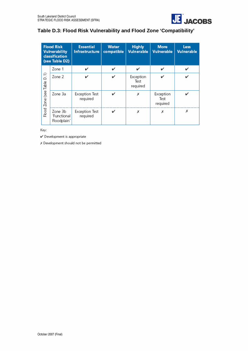
South Lakeland District Council STRATEGIC FLOOD RISK ASSESSMENT (SFRA)
Table D.3: Flood Risk Vulnerability and Flood Zone ‘Compatibility’
October 2007 (Final)

Eden District Council STRATEGIC FLOOD RISK ASSESSMENT (SFRA)
Appendix D Examples of Development Plan Flood Risk Policies
October 2007 (Final)

Eden District Council STRATEGIC FLOOD RISK ASSESSMENT (SFRA)
October 2007 (Final)

Eden District Council STRATEGIC FLOOD RISK ASSESSMENT (SFRA)
Example 1
Policy XX – Flood Risk Management
Flood risk assessment (FRA) will be required for major development proposals within Flood Zone 1 and all new development within Flood Zones 2 and 3 (3a and 3b).
The FRA should be commensurate with the degree of flood risk posed to and by the proposed development and take account of the advice and recommendations set out in the Strategic Flood Risk Assessment 2007, including measures to be adopted by new development to reduce flood risk and meet the requirements of PPS25 (Development and Flood Risk)
Within Flood Zone 3b, functional floodplain, only water compatible uses and essential infrastructure (PPS25 Table D3) will be permitted.
Within High Risk Zone 3a, development proposals should include the flood mitigation measures set out below as an integral part of the design process:
• land use on the ground floor must be limited to non-residential uses; • floor levels must be situated above the 1% predicted maximum flood level plus climate
change, incorporating an allowance for freeboard. The SFRA, section 6 provides further guidance on raised floor levels and predicted flood depths;
• safe escape routes must be provided for evacuation in times of flood; • access to basement areas must be situated above the predicted maximum flood level
plus climate change, incorporating an allowance for freeboard and all basements must be of a waterproof construction;
• development must not result in an increase in maximum flood levels within adjoining properties.
Within Medium Probability Zone 2 development proposals must have:
• floor levels situated above the 1% (100) year predicted maximum flood level plus climate change, incorporating an allowance for freeboard. The SFRA, section 6, provides further guidance on raised floor levels and predicted flood depths;
• safe escape routes must be provided for evacuation in times of flood, even within areas where buildings are not directly affected.
Within all areas (including Low Flood Risk Zone 1), development proposals should, where appropriate, include SUDS (Sustainable Urban Drainage Systems) to reduce surface water runoff rates, or as a minimum ensure that future redevelopment does not increase runoff.
October 2007 (Final)
Eden District Council STRATEGIC FLOOD RISK ASSESSMENT (SFRA)
Example 2
Policy A - Minimising the Risk from Flooding
Development will not be permitted where it would, either in itself or cumulatively with other development, materially;
• increase the risk of flooding elsewhere by impeding the flow of floodwater; • reduce the capacity of the floodplain to store water; • increase the number of people, property or infrastructure at risk of flooding; or • inhibit the effectiveness or maintenance of an artificial drainage channel or flood control
defences,
unless it is demonstrated through a Flood Risk Assessment that;
a) there are no other alternative reasonably available sites at lower risk from flooding; and b) the above effects can be overcome by mitigation measures that will provide adequate
protection for the lifetime of the development secured through planning conditions or planning agreements.
Even in Zone 1 development can potentially affect flooding elsewhere through the addition of hard surfaces and effects on surface water run-off. Planning applications for development in Zone 1 which include additional floorspace or the loss or addition of external hard surface areas on sites of 1ha or more14 should therefore include as a minimum a Drainage Impact Assessment. The Drainage Impact Assessment should demonstrate how the proposed drainage system will adequately mitigate any possible increase in runoff that may occur as a result of the development. It is suggested that Drainage Impact Assessments are prepared in consultation with the Environment Agency.
In the first instance new development should be guided towards areas of low and subsequently moderate flood risk (i.e. Zones 1 or 2). For development proposals in Zone 3a Policy B and supporting text set out the Council’s requirements for applying the Sequential Test and Exceptions Test.
When seeking to overcome the effects of development on flooding, either within the site or elsewhere, applicants will be required to set out in an FRA the most suitable mitigation measures for the proposed development and individual circumstances of the site. Early dialog with the Environment Agency at the pre-application stage is recommended to enable suitable mitigation measures to be incorporated at the design stage and reduce the risk of abortive work, delays to the decision making process or ultimately refusal of planning permission.
Mitigation measures incorporated in site based FRAs will need to be reasonable and enforceable through planning conditions or planning agreements and agreed in advance with the Environment Agency. Applicants should consider one or more of the following Sustainable Urban Drainage components, ‘flood proofing’ measures or localised flood defences as potential mitigations to be incorporated into FRAs:
Potential SUDS Components
• Pervious surfaces • Green roofs • Filter drains or filter strips • Swales • Basins, ponds or wetlands • Infiltration devises
14 Ref: PPS25, Appendix D.
October 2007 (Final)

Eden District Council STRATEGIC FLOOD RISK ASSESSMENT (SFRA)
• Bioretention areas
Flood Proofing Measures
• Raising of floor levels a minimum of 600mm, plus 20%15 , above peak flood levels (reduced to 300mm where detailed flood models are available)
• Incorporation of flood boards • Raising of electrical wiring
Localised Flood Defences
• Low level bunding • Raised curbs • Reprofiling of roads • Dry routes, safe escape routes or ‘safe havens’ above peak flood levels
Policy B - Development in Areas of High Flood Risk
Planning permission will be granted for development on sites of 0.5ha or more, or of 10 dwellings or more or 100 m2 or more of non-residential development within Flood Zone 3a provided it is demonstrated:
a) that there are no other alternative reasonably available sites in areas of low to moderate flood risk (Flood Zones 1 and 2); and
b) through the application of the ‘sequential test’, there are no other alternative reasonably available sites in Zone 3a that are at less risk from flooding or if developed would have less of an effect on flooding elsewhere.
The above policy is consistent with the guidance provided in PPS25 that requires proposals for new development to be subject to a Sequential Test. The purpose of the Sequential Test is to encourage non-water compatible development to take place in areas at lowest risk from flooding. However in some instances it may not be possible or preferable, in the wider planning context, to restrict all forms of development to Zones 1 and 2.
A proportion of the District is situated within Zone 3a and it is broadly recognised that in order to support the future sustainability of the area some degree of development may be required within Zone 3a.
FRAs should also includes appropriate mitigation measures to overcome any individual or cumulative effects of the proposal on flooding either on the site or elsewhere, as referred to in Policy A and supporting text.
Policy C -Development in Close Proximity to Flood Defences
Development on sites of 0.5ha or more, or of 10 dwellings or more or 100 m2 or more of nonresidential development, that are within 1000m of a raised flood defence will only be permitted if it is demonstrated the structural integrity of the defences are, or will be, sufficient to provide flood defence for the lifetime of the development. If improvements are required to flood defences these will be sought through planning conditions or legal agreements.
Areas situated closely behind raised flood defences are referred to in the SFRA areas of high flood hazard where there is a measurable risk to life should the defence fail. It is essential that development proposals in these areas take into account the future structural integrity of these flood defences over the lifetime of the development.
In order to assess the structural condition of flood defences applicants are encouraged to undertake a detailed breach assessment in liaison with the Environment Agency. Breach
15 PPS25 states that a 20% increase in the 1% AEP (100 year) within the next 100 years.
October 2007 (Final)

Eden District Council STRATEGIC FLOOD RISK ASSESSMENT (SFRA)
assessments should focus on the structural integrity of the existing flood defences and the risk to human life should a defence overtopping or any type of breach failure take place over the lifetime of the development, taking into account climatic change.
Where the structural integrity of the defences is considered to be inadequate and it is considered, in the event of a breach, there would be an unacceptable risk to human life planning permission will not be granted unless flood defence improvements are agreed with the Environment Agency and can be delivered through a condition of planning permission or legal agreement.
October 2007 (Final)

Eden District Council STRATEGIC FLOOD RISK ASSESSMENT (SFRA)
Appendix E SFRA Review Procedure
October 2007 (Final)

Eden District Council STRATEGIC FLOOD RISK ASSESSMENT (SFRA)
October 2007 (Final)

Eden District Council STRATEGIC FLOOD RISK ASSESSMENT (SFRA)
The SFRA has been developed building heavily upon existing knowledge with respect to flood risk within the district. A rolling programme of detailed flood risk mapping within Cumbria is underway. This, in addition to observed flooding that may occur throughout a year, will improve the current knowledge of flood risk within the district and may marginally alter predicted flood extents. Furthermore, Communities and Local Government (CLG) are working to provide further detailed advice with respect to the application of PPS25, and future amendments to the PPS25 Practice Guide are anticipated. Given that this is the case, a periodic review of the SFRA is imperative.
It is recommended that the Eden SFRA is reviewed on a regular basis. The following key questions should be addressed as part of the SFRA review process:
Question 1 Has any flooding been observed within the District since the previous review? If so, the following information should be captured as an addendum to the SFRA:
‹ What was the mapped extent of the flooding? ‹ On what date did the flooding occur? ‹ What was the perceived cause of the flooding? ‹ If possible, what was the indicative statistical probability of the observed flooding
event? (i.e. how often, on average, would an event of that magnitude be observed within the District?)
‹ If the flooding was caused by overtopping of the riverbanks, are the observed flood extents situated outside of the current Zone 3a? If it is estimated that the frequency of flooding does not exceed, on average, once in every 100 years then the flooded areas (from the river) should be incorporated into Zone 3a to inform future planning decision making.
Question 2 Have any amendments to PPS25 or the Practice Companion Guide been released since the previous review? If so, the following key questions should be tested:
‹ Does the revision to the policy guidance alter the definition of the PPS25 Flood Zones presented within the SFRA? (refer Section 5.2)
‹ Does the revision to the policy guidance alter the decision making process required to satisfy the Sequential Test? (refer Section 6.4.1)
‹ Does the revision to the policy guidance alter the application of the Exception Test? (refer Section 6.4.1)
‹ Does the revision to the policy guidance alter the categorisation of land use vulnerability, presented within Table D2 of PPS25 (December 2006)?
If the answer to any of these core questions is ‘yes’ then a review of the SFRA recommendations in light of the identified policy change should be carried out.
Question 3 Has the Environment Agency issued any amendments to their flood risk mapping and/or standing guidance since the previous policy review? If so:
‹ Has any further detailed flood risk mapping been completed within the District, resulting in a change to the 20 year, 100 year or 1000 year flood outline? If yes, then the Zone 3b and Zone 3a flood outlines should be updated accordingly.
‹ Has the assessment of the impacts that climate change may have upon rainfall and/or river flows over time altered? (refer Section 5.6) If yes, then a review of the impacts that climate change may have upon the District is required.
‹ Do the development control recommendations provided in Section 6.4 of the SFRA in any way contradict emerging EA advice with respect to (for example) the provision of emergency access, the setting of floor levels and the integration of sustainable drainage techniques? If yes, then a discussion with the EA is required to ensure an agreed suite of development control requirements are in place.
October 2007 (Final)

Eden District Council STRATEGIC FLOOD RISK ASSESSMENT (SFRA)
It is highlighted that the Environment Agency review the Flood Zone Map on a quarterly basis. If this has been revised within the District, the updated Flood Zones will be automatically forwarded to the Council for their reference. It is recommended that only those areas that have been amended by the Environment Agency since the previous SFRA review are reflected in Zone 3 and Zone 2 of the SFRA flood maps. This ensures that the more rigorous analyses carried out as part of the SFRA process are not inadvertently lost by a simple global replacement of the SFRA flood maps with the Flood Zone Maps.
October 2007 (Final)