environmental impact assessment (eia) - epd.punjab.gov.pk
TRANSCRIPT

Environmental Impact Assessment (EIA)
RIVER RAVI TRAINING AND CHANNELIZATION PROJECT
(PHASE-I)
June-2021

( PHASE-I) Environmental Impact Assessment (EIA)
RIVER RAVI TRAINING AND CHANNELIZATION PROJECT
Environmental Impact Assessment (EIA)
Executive Summary
Chapter - 1: Introduction
Chapter - 2: Analysis of Project Alternatives
Chapter - 3: Policy, Legal, and Administrative Framework
Chapter - 4: Project Description
Chapter - 5: Description of Baseline Environment
Chapter - 6: Anticipated Environmental Impacts and Mitigation Measures
Chapter - 7: Environmental Management Plan (EMP)
Chapter - 8: Public & Stakeholders Consultation
Chapter - 9:
Appendices
Conclusion and Recommendations

Table of Contents TOC-I
( PHASE-I) Environmental Impact Assessment (EIA)
TABLE OF CONTENTS
EXECUTIVE SUMMARY ......................................................................................................... 1
S.1.1 TITLE AND LOCATION OF THE PROJECT ................................... 1
S.1.2 NAME OF THE PROJECT PROPONENT ...................................... 1
S.1.3 NAME OF THE ORGANIZATION PREPARING THE REPORT ........ 1
S.1.4 A BRIEF OUTLINE OF THE PROPOSAL (TYPE, PROCESS,
TECHNOLOGY AND LAND REQUIREMENT) .............................. 1
S.1.5 THE MAJOR IMPACTS ............................................................... 2
S.1.5.1 Pre-construction/Design Phase Impacts ............................... 2
S.1.5.2 Project Construction Phase Impacts ..................................... 3
S.1.5.3 Project Operation Phase Impacts .......................................... 4
S.1.5.4 Positive Impacts ....................................................................... 4
S.1.6 RECOMMENDATIONS FOR MITIGATION MEASURES................ 5
S.1.6.1 Pre-Construction Phase Mitigations ....................................... 5
S.1.6.2 Construction Phase Mitigations .............................................. 5
S.1.6.3 Operation Phase Mitigations .................................................. 6
S.1.7 PROPOSED MONITORING ........................................................ 7
SECTION - 1: INTRODUCTION ....................................................................................... 8
1.1 Purpose for the Environmental Impact Assessment Report 8
1.2 IDENTIFICATION OF THE PROJECT AND THE PROPONENT ....... 8
1.3 DETAILS OF THE CONSULTANTS ................................................ 9
1.4 BRIEF DESCRIPTION OF NATURE, SIZE AND LOCATION OF THE
Project ...................................................................................... 9
1.5 SCREENING ............................................................................. 10
1.6 scoping .................................................................................. 10
1.6.1 Spatial and Temporal Boundaries of Environmental
Assessment ............................................................................. 10
1.6.2 Important Issues and Concerns raised during Consultation
................................................................................................ 10
1.6.3 Significant Impacts and Factors to be Determined ........... 10
1.7 APPROACH ADOPTED TO CONDUCT THE STUDY .................. 10

Table of Contents TOC-II
( PHASE-I) Environmental Impact Assessment (EIA)
1.7.1 Review of Available Data ..................................................... 10
1.7.2 Delineation of Area of Project Influence or Study Area ..... 11
1.7.3 Environmental Baseline Survey of the Project ..................... 11
1.7.4 Public and Stakeholders Consultation ................................. 12
1.7.5 Analysis of Data ..................................................................... 13
1.7.6 Screening of Potential Environmental Impacts and
Mitigation Measures .............................................................. 13
1.7.7 Preparation of Environmental Management Plan (EMP) ... 13
1.8 STRUCTURE OF THE REPORT..................................................... 13
SECTION - 2: ANALYSIS OF PROJECT ALTERNATIVES ................................................. 14
2.1 General .................................................................................. 14
2.2 No Project Option (NPO) ....................................................... 14
2.3 Location/SITE Alternatives ..................................................... 15
2.3.1 Alternative I- To Save Anno Bhatti Forest ............................. 15
2.4 DESIGN/TECHNOLOGY Alternatives ..................................... 15
2.4.1 Longitudinal Structures .......................................................... 16
2.4.2 Revetments ............................................................................ 16
2.4.3 Gabion Gravity Structures .................................................... 16
2.4.4 Reinforced Soil Structures...................................................... 17
2.5 Environmental Alternatives ................................................... 17
2.6 ECONOMIC Alternatives ....................................................... 17
SECTION - 3: POLICY, LEGAL, AND ADMINISTRATIVE FRAMEWORK ......................... 18
3.1 GENERAL ................................................................................. 18
3.2 Applicable National and Provincial Government
Regulations ......................................................................... 18
3.3 International Treaties and Conventions Signed by Pakistan
...................................................................................... 31

Table of Contents TOC-III
( PHASE-I) Environmental Impact Assessment (EIA)
3.4 Requirements for Statutory Clearances ............................... 36
3.5 Environmental Approval Requirements of the Project ....... 37
SECTION - 4: PROJECT DESCRIPTION ......................................................................... 39
4.1 General .................................................................................. 39
4.2 Objectives of the Project ...................................................... 39
4.3 Project Administrative Jurisdiction ....................................... 39
4.4 Location and Site Layout of the Project ............................... 39
4.5 Land Use ON THE SITE ............................................................. 39
4.6 Road Access .......................................................................... 40
4.7 Vegetation Features of the Site ............................................ 45
4.8 Cost and Magnitude of Operation ....................................... 45
4.9 Schedule of implementation ................................................ 45
4.10 Description of the project ..................................................... 45
4.10.1 Channelization & Restructuring of River Ravi ...................... 45
4.10.2 Design Parameters for River Training & Channelization Works
................................................................................................ 47
4.10.3 Temporary Storage Water Requirement ............................. 47
4.10.4 Ecological Water Flows ......................................................... 47
4.10.5 Upstream Protection of the Project Area ............................ 48
4.10.6 Basic Criteria for Barrage ...................................................... 50
4.10.7 Design Return Period ............................................................. 50
4.10.8 Salient Features of the Barrage ............................................ 50
4.10.9 Establishment of Barrage ...................................................... 51
4.11 CONSTRUCTION ASPECT ........................................................ 55
4.11.1 Construction Materials .......................................................... 55
4.11.2 Construction Machinery ....................................................... 55
4.11.3 Construction Camps ............................................................. 55
4.11.4 Work Force and Machinery .................................................. 56
4.12 Restoration and Rehabilitation Plan ..................................... 56

Table of Contents TOC-IV
( PHASE-I) Environmental Impact Assessment (EIA)
SECTION - 5: DESCRIPTION OF BASELINE ENVIRONMENT ......................................... 58
5.1 GENERAL ................................................................................. 58
5.2 STUDY AREA ............................................................................ 58
5.3 SITE VISITS ............................................................................... 59
5.4 PHYSICAL ENVIRONMENT ...................................................... 61
5.4.1 Topography ........................................................................... 61
5.4.2 Geology ................................................................................. 61
5.4.3 Seismicity ................................................................................ 64
5.4.4 Soil ........................................................................................... 65
5.4.5 Climate and Meteorology .................................................... 65
5.4.6 Hydrology ............................................................................... 70
5.4.7 Ground Water ........................................................................ 71
5.4.8 Surface Water and Drainage ............................................... 71
5.4.9 Solid Waste and Wastewater Situation ................................ 71
5.5 BASELINE ECOLOGICAL ENVIRONMENT ............................... 72
5.5.1 Habitat Information ............................................................... 72
5.5.2 Flora Information.................................................................... 74
5.5.3 Fauna Information ................................................................. 84
5.5.4 Ecological Mapping of the Study Area ............................... 90
5.5.5 Ecological flow ...................................................................... 91
5.6 SOCIO ECONOMIC ENVIRONMENT ...................................... 92
5.6.1 Objectives .............................................................................. 92
5.6.2 Approach & Methodology ................................................... 93
5.6.3 Data Collection Tools ............................................................ 93
5.6.4 Household and Population ................................................... 93
5.6.5 Villages in Project Area ......................................................... 94
5.6.6 Health ..................................................................................... 94

Table of Contents TOC-V
( PHASE-I) Environmental Impact Assessment (EIA)
5.6.7 Education ............................................................................... 95
5.6.8 Electricity ................................................................................ 95
5.6.9 Natural Gas Supply................................................................ 96
5.6.10 Telephone Facility ................................................................. 97
5.6.11 Transport ................................................................................. 97
5.6.12 Access Roads ........................................................................ 98
5.6.13 Bank Facility ........................................................................... 98
5.6.14 Post Office .............................................................................. 98
5.6.15 Domestic Water Supply ........................................................ 98
5.6.16 Sewerage System .................................................................. 99
5.6.17 Archaeological and Historical Monuments/Sites................ 99
5.6.18 Irrigation System ................................................................... 100
5.6.19 Cropping Pattern and Average Yield ............................... 101
5.6.20 Housing Structures ............................................................... 101
5.6.21 Solid Waste Disposal ............................................................ 101
5.6.22 Language Spoken ............................................................... 101
5.6.23 Settlements Pattern ............................................................. 102
5.6.24 Gender Ratio ........................................................................102
5.6.25 Gender Issues ....................................................................... 102
5.6.26 Resettlement Issues ............................................................. 102
5.7 ENVIRONMENT MONITORING, SAMPLING AND TESTING ... 102
5.7.1 Surface Water and Waste Water Analysis ......................... 103
5.7.2 Ground Water ...................................................................... 111
5.7.3 Ambient Air Quality ............................................................. 115
5.7.4 Noise Level Monitoring ........................................................ 117
5.7.5 Baseline Monitoring Team ................................................... 117
5.8 SUITABILITY OF THE SITE ........................................................ 117
5.8.1 Wetlands .............................................................................. 117
5.8.2 Endangered Species ........................................................... 117

Table of Contents TOC-VI
( PHASE-I) Environmental Impact Assessment (EIA)
5.8.3 Wildlife Sanctuaries and Game Reserves .......................... 118
5.8.4 Critical Habitats ................................................................... 118
5.8.5 Cultural Heritage and Community Structure .................... 118
SECTION - 6: ANTICIPATED ENVIRONMENTAL IMPACTS AND MITIGATION MEASURES 119
6.1 APPROACH AND METHODOLOGY ...................................... 119
6.1.1 Project Interaction Matrix ................................................... 119
6.1.2 Overlays- GIS based ............................................................ 120
6.2 Adverse Impacts during Pre-Construction Phase ............. 121
6.2.1 Land Acquisition and Resettlement ................................... 121
6.2.2 Impact due to Diversion of River ........................................ 124
6.3 IMPACTS AND MITIGATIONS MEASURES DURING THE PROJECT
CONSTRUCTION ................................................................... 125
6.3.1 Physical Environment .......................................................... 125
6.3.2 Ecological Environment ...................................................... 134
6.3.3 Socio Economic Environment ............................................ 138
6.4 IMPACTS AND MITIGATION MEASURES DURING THE PROJECT
OPERATION….............................................................................144
6.4.1 Sedimentation and Erosion ................................................. 144
6.4.2 Aquatic Weeds Formation in River Basin ........................... 145
6.4.3 Impact on Downstream Barrage ....................................... 146
6.4.4 Impact on Micro Climate ................................................... 146
6.5 Potential Environmental and social Enhancement Measures
.............................................................................................. 146
6.5.1 Ecological Uplifting of River Ravi ........................................ 146
6.5.2 Recreational Activities and Tourism ................................... 147
6.5.3 Job Opportunities ................................................................ 147
6.5.4 Economic Uplifting of the Region ...................................... 147
6.5.5 Flood Protection .................................................................. 148

Table of Contents TOC-VII
( PHASE-I) Environmental Impact Assessment (EIA)
SECTION - 7: ENVIRONMENTAL MANAGEMENT PLAN (EMP) .................................. 149
7.1 Scope of the EMP ................................................................. 149
7.2 REGULATORY REQUIREMENTS AND APPLICABLE STANDARDS
.............................................................................................. 149
7.3 Institutional Arrangements for Implementation of EMP during
Construction Phase ............................................................. 150
7.4 ENVIORNMENTAL management TEAM ALONG WITH THEIR
Roles & Responsibilities for Implementation of EMP ..........151
7.4.1 Construction Phase ............................................................. 151
7.4.2 Operation and Maintenance (O&M) Phase ..................... 153
7.5 MITIGATION MANAGEMENT MATRIX (MMM) ..................... 153
7.6 PROPOSED MONITORING PROGRAM TO
ASSESS PERFORMANCE OR OUTPUT OF EMP ................................167
7.6.1 Objectives ............................................................................ 167
7.6.2 Monitoring Strategy ............................................................. 167
7.6.3 Monitoring Parameters and Frequency ............................ 167
7.7 Proposed EMP reporting and reviewing procedures ...... 171
7.7.1 Reporting Mechanism ......................................................... 171
7.7.2 Non-Compliance of the EMP ............................................. 172
7.7.3 Change Management Plan (CMP) ................................... 172
7.7.4 Additions to the EMP ........................................................... 172
7.8 COMMUNICATION AND DOCUMENTATION ....................... 172
7.8.1 Monthly Environmental Report ........................................... 172
7.8.2 Social Complaints Register ................................................. 173
7.8.3 Change Management Record .......................................... 173
7.8.4 Non-Compliance Record Register ..................................... 173
7.8.5 Photographic Record ......................................................... 173
7.9 TRAFFIC MANAGEMENT PLAN (TMP) ................................... 174
7.10 MATERIAL TRANSPORTATION PLAN (MTP) ........................... 174
7.10.1 Material Transportation HSE Arrangements ....................... 174

Table of Contents TOC-VIII
( PHASE-I) Environmental Impact Assessment (EIA)
7.10.2 Material Transportation Documentation ........................... 174
7.11 TRAINING PROGRAM to implement the EMP and monitoring
plan ....................................................................................... 175
7.11.1 Objectives ............................................................................ 176
7.11.2 Roles and Responsibilities .................................................... 176
7.11.3 Training Log .......................................................................... 176
7.11.4 Training Material .................................................................. 176
7.12 PROJECT SITE Management Plans ...................................... 178
7.13 TRAFFIC MANAGEMENT PLAN (TMP) ................................... 178
7.14 SITE RESTORATION PLAN ...................................................... 178
7.15 Occupational Health and Safety ....................................... 179
7.16 Disaster Management Plan ................................................ 179
7.17 Tree Plantation Plan ............................................................. 180
7.18 Disposal Area Management and Restoration Plan........... 180
7.19 Waste Management Plan ................................................... 180
7.20 Drinking Water Supply and Sanitation Plan ....................... 180
7.21 NOC and Other Approvals ................................................. 180
7.22 Cost to implement the EMP ................................................. 181
7.23 SOCIAL/RESETTLEMENT POLICY FRAMEWORK ..................... 185
7.23.1 Resettlement Options .......................................................... 185
7.23.2 Eligibility, Entitlements, Assistance and Benefits ................ 192
7.23.3 Grievance Redress Mechanism (GRM) ............................. 196
SECTION - 8: PUBLIC & STAKEHOLDERS CONSULTANTION ...................................... 202
8.1 GENERAL ............................................................................... 202
8.2 IDENTIFICATION OF STAKEHOLDERS .................................... 202
8.3 CONSULTATION WITH PROPONENT’S ENVIRONMENT
MANAGEMENT TEAM ........................................................... 202

Table of Contents TOC-IX
( PHASE-I) Environmental Impact Assessment (EIA)
8.4 CONSULTATION WITH THE RESPONSBILE AUTHORITY......... 203
8.5 CONSULTATION WITH THE OTHER DEPARTMENTS & AGENCIES
.............................................................................................. 203
8.6 CONSULTATION WITH THE ENVIRONMENTAL PRACTITIONERS
AND EXPERTS ........................................................................ 204
8.7 CONSULTATION WITH THE AFFECTED AND WIDER COMMUNITY
.............................................................................................. 205
SECTION - 9: CONCLUSIONS AND RECOMMENDATIONS ...................................... 220
9.1 Conclusion ........................................................................... 220
9.2 RECOMMENDATIONS ........................................................... 222

TOC-X
( PHASE-I) Environmental Impact Assessment (EIA)
APPENDICES APPENDIX 1: GLOSSARY .......................................................................................... 223
APPENDIX 2: LIST OF ABBREVIATIONS...................................................................... 227
APPENDIX 3: LIST OF INDIVIDUALS AND ORGANIZATIONS CONSULTED ALONG WITH
THEIR FEEDBACK ................................................................... 231
APPENDIX 4: SOURCES OF DATA AND A FULL LIST OF ALL REFERENCES MATERIAL
USED .................................................................................................... 233
APPENDIX 5: TERMS OF REFERENCES ...................................................................... 240
APPENDIX 6: LIST OF EIA TEAM ................................................................................ 243
APPENDIX 7: APPROVAL FROM OTHER CONCERNED DEPARTMENTS .................... 245
APPENDIX 8: PHOTO LOG ....................................................................................... 246
APPENDIX 9: ENVIRONMENTAL MONITORING REPORTS (CONDUCTED BY EPA
CERTIFIED LAB) .................................................................................... 251
APPENDIX 10: ENVIRONMENTAL IMPACT MATRIX ................................................... 252

TOC-XI
( PHASE-I) Environmental Impact Assessment (EIA)
List of Tables LIST OF TABLES Table 3.1: Applicable Legislation and Policies in Pakistan ...................................... 18
Table 3.2: Applicable International Treaties, Conventions, Declaration and
Protocols ..................................................................................................... 31
Table 4.1: Land use on the Site .................................................................................. 40
Table 4.2: Details of Forests Area ............................................................................... 40
Table 4.3: Design Parameters of Barrage ................................................................. 50
Table 4.4: Established Parameters – Main Barrage .................................................. 51
Table 4.5: Location of Barrage ................................................................................. 51
Table 5.1: Average Monthly Temperature and Relative Humidity (1981-2010) ..... 66
Table 5.2: Average Monthly Temperature, Wind Speed and Wind Direction (1981-
2010) ........................................................................................................... 67
Table 5.3: Average Monthly Precipitation (2010-2014) ............................................ 68
Table 5.4: Details of the forest areas within the Project Boundary.......................... 72
Table 5.5: List of Aquatic Plant Species Collected from Ponds and River .............. 74
Table 5.6: List of Plant Species Collected from Different Habitats in the Project
Area ............................................................................................................ 76
Table 5.7: List of Mammals, Birds, Reptiles and Amphibians of the Project Area .. 85
Table 5.8: List of Zooplanktons and Protoctists Found in the Ponds and River of The
Study Area .................................................................................................. 89
Table 5.9: List of the Fish Species found in the River Ravi ......................................... 90
Table 5.10: Detail of the Villages to be Resettled ...................................................... 94
Table 5.11: Comparison Analysis of River Water Upstream to Downstream at the
Project Site................................................................................................ 105
Table 5.12: Comparison Analysis of Drains at Project Site ....................................... 108
Table 5.13: Ground Water Analysis at Project Site ................................................... 112
Table 5.14: Comparison Analysis of Ambient Air Quality at Project Site ................ 116
Table 5.15: Testing Team ............................................................................................ 117
Table 6.1: Loss of Assets, Land Population and Houses ......................................... 121
Table 6.2: Details of Settlements falling in Riverbed ............................................... 121
Table 7.1: Environmental Management Plan for River Ravi Training and
Channelization Project ............................................................................ 155
Table 7.2: Environmental Monitoring Plan .................................................................. 168

TOC-XII
( PHASE-I) Environmental Impact Assessment (EIA)
Table 7.3: Environmental Monitoring Plan- Recommended Effect Monitoring
Protocol .................................................................................................... 170
Table 7.4: Training Program ....................................................................................... 176
Table 7.5: Environmental Management/Monitoring Costs ................................... 182
Table 7.6: Resettlement Options .............................................................................. 185
Table 7.7: Entitlement Matrix .................................................................................... 194
Table 8-1: Views of Proponent’s Environment Management Team ..................... 202
Table 8-2: Views of Responsible Authority ............................................................... 203
Table 8-3: Views of other Department & Agencies ................................................ 203
Table 8-4: Views of Environmental Practitioners & Experts ..................................... 204
Table 8-5: Views & Concerns of the Affected & Wider Community ..................... 205
Table 8-6:
Views & Concerns of the Affected & Wider Community (Survey
Conducted in 2014) ................................................................................ 205

TOC-XIII
( PHASE-I) Environmental Impact Assessment (EIA)
LIST OF FIGURES
ST OF FIGURES Figure 3.1: Flow Chart Diagram Depicting Procedure to get Environmental
Approval..................................................................................................... 38
Figure 4.1: Ravi River Training and Channelization Project Location Map ............. 41
Figure 4.2: Land Use Map of Phase-I of River Training and Channelization Project42
Figure 4.3: Forests in the Project Area ........................................................................ 43
Figure 4.4: Existing Roads in Project Area ................................................................... 44
Figure 4.5: Master Plan of the Project ......................................................................... 46
Figure 4.6: Proposed River Section ............................................................................. 47
Figure 4.7: Mean Monthly Losses due to Seepage and Evaporation...................... 48
Figure 4.8: Proposed dykes for the River Ravi urban Development Project ........... 49
Figure 4.9: Typical Section of Dyke and Bund designed for the Project ................. 49
Figure 4.10: Layout Plan of Barrage ............................................................................. 52
Figure 4.11: Section of Barrage ..................................................................................... 53
Figure 4.12: Plan and Section of Barrage .................................................................... 54
Figure 5.1: Project Study Area/Project Impact Area Map ....................................... 60
Figure 5.2: Topography of the Project Area .............................................................. 62
Figure 5.3: Surface Geological Map of the Project Area ......................................... 63
Figure 5.4: Seismic Zone of Pakistan (Geological Survey of Pakistan) ..................... 64
Figure 5.5: Soil Map of the Study area (Source CDGL) ............................................. 65
Figure 5.6: Maximum and Minimum Temperature in the Project Area (1981-2010)67
Figure 5.7: Relative Humidity in the Project Area (1981-2010) .................................. 67
Figure 5.8: Mean Rainfall in the Project Area (2010-2014) ........................................ 69
Figure 5.9: Simplified Food Web in the Project Area ................................................. 91
Figure 5.10: Net Available Flows for 90% Exceedance Flow Condition ..................... 92
Figure 5.11: Available Health Facilities in Project Area ............................................... 95
Figure 5.12: Availability of Education Facility............................................................... 95
Figure 5.13: Availability of Electricity in Project Area .................................................. 96
Figure 5.14: Availability of Gas Facility in the Project Area ........................................ 96
Figure 5.15: Availability of Landline Telephone Facility .............................................. 97
Figure 5.16: Availability of Public Transport in Project Area ........................................ 97

TOC-XIV
( PHASE-I) Environmental Impact Assessment (EIA)
Figure 5.17: Type of Access Roads in the Project Area .............................................. 98
Figure 5.18: Domestic Water Supply System in the Project Area ............................... 99
Figure 5.19: Availability of Mosques in the Project Villages ........................................ 99
Figure 5.20: Availability of Graveyards in the Project Villages ................................. 100
Figure 5.21: Number of Shrines present in the surveyed Villages ............................. 100
Figure 5.22: Graphical Presentation of Irrigation System in Project Area ................ 100
Figure 5.23: Cropping Pattern in Project Area ........................................................... 101
Figure 5.24: Environmental Sampling Location Map ................................................ 104
Figure 6.1: Settlements Location Map requiring Resettlement .............................. 123
Figure 6.2: Septic Tank ............................................................................................... 131
Figure 7.1: Project Management Unit (PMU)/Project Implementation Unit (PIU)
Level GRC ................................................................................................ 198

Executive Summary 1
( PHASE-I) Environmental Impact Assessment (EIA)
S1 EXECUTIVE SUMMARY
S.1.1 TITLE AND LOCATION OF THE PROJECT
River Ravi Training and Channelization Project is the sub project of Ravi
Riverfront Urban Development Project (RRUDP) and aimed to channelize the
46 KM stretch of River Starting from Syphon and end at Mohlanwal. It also
includes construction of three barrages; one near old Ravi bridge, second
near M-2 crossing and third will be constructed near Mohlanwal at lower end
of this channelization stretch of 46 km. However, this EIA has been prepared
for only Phase-I, which contains one barrage near Old Ravi Bridge as
mentioned below and channelization of River Ravi over length of about
14km.
Sr.
No.
Proposed
Barrage Coordinates Location Phase
1 Barrage-1 310 36’ 56.355” N
740 18’ 25.28” E Near Old Ravi Bridge Phase-I
The objective of River Training and channelization is to protect a River Ravi
from 1000 years Average Recurrence Interval (ARI) flood and also the
channel is designed in a way that it would retain the character of a fresh
water body and it should have adequate capacity to pass 1000 years return
period.
S.1.2 NAME OF THE PROJECT PROPONENT
River Ravi Urban Development Authority (RUDA) on behalf of Government of
Punjab is the proponent for proposed River Ravi Training and Channelization
Project.
S.1.3 NAME OF THE ORGANIZATION PREPARING THE REPORT
RUDA has engaged M/s Engineering Consultancy Services Punjab (ECSP) Pvt.
Ltd. for preparation of Environmental Impact Assessment (EIA) of the
proposed project.
S.1.4 A BRIEF OUTLINE OF THE PROPOSAL (TYPE, PROCESS, TECHNOLOGY AND
LAND REQUIREMENT)
In first Phase, the river Ravi will be channelized with the width of about 01 km
(1000 m) for a length of 14 km. The bed will be raised about 9 meters. In this
way, the total project area is about 14,000,000 m2 (3459.5 acres).
The design flood used for river training works and estimation of
barrage/control structures is considered as 5,86,000 cusecs as the flood
above 5,00,000 cusecs was already witnessed twice in 89 years. Detailed

Executive Summary 2
( PHASE-I) Environmental Impact Assessment (EIA)
analysis for the phase I was carried out to determine the width and depth of
the channel. The width of the channel is 3280.84 ft (1000 m) with wall height
of 33 ft including the free board.
The ultimate goal to carry out river channelization is to make a perennial
water body with temporary storage /detention that will flow throughout the
year. Once this temporary storage is filled, the outflows that would be kept
equal to inflows. The maximum temporary storage is estimated to be about
0.22 Million Acre Feet (MAF) with 1000 m wide and 14km long water body.
The project area starts about 6.39 km from Ravi Syphon. The proposed
development of channelization will reduce impact of the upstream flow of
the project area in case of flooding. The upstream area will require protection
from floods and appropriate measures have been taken. For this protection,
Dykes will be provided for 6.39 Km stretch.
The proposed project route passes through the agriculture, flood plain,
settlements, forest and river area. Some small industrial and commercial units
are also present in the vicinity of project area. Almost 40.78% of the land that
falls in the project boundary is the agriculture covering an area of 1,410.83
acres. All the agriculture land will be submerged in new development. The
total area of the River Ravi present in the project boundary of Phase-I is about
795.7 acres. Total two settlements are also falling in the Project Area and the
details of land use are tabulated as under:
Sr. No. Land use Area (Acres) Percentage
1. Agriculture 1,410.83 40.78
2. Barren Land 14.5 0.42
3. Bund or Spurs 8.2 0.24
4. Creek 153 4.42
5. Drainage 7.3 0.21
6. Flood Plain 899.5 26.00
7. Forest 138.76 4.01
8 Planned 6.6 0.19
9 River 795.7 23.00
10 Settlements 25.11 0.73
Total Area 3,459.50 100.00

Executive Summary 3
( PHASE-I) Environmental Impact Assessment (EIA)
S.1.5 THE MAJOR IMPACTS
This environmental assessment process has identified the major negative and
positive impacts that will be created during project pre-construction,
construction and then operation phases. The proposed mitigation measures
will increase the positive impacts of the project.
S.1.5.1 Pre-construction/Design Phase Impacts
The major impact to be occur in this phase is relocation of two settlements
covering an area of 25.11 acres of land. These settlements contain 634
households with population of 4,271. These will lose their assets as well as
livelihood due to the implementation of this sub project. It is a major impact
as it may involve resettlement of population along with their assets. Both
government and private land exist in the project area and private land needs
to be acquired. The other major impact is submerging of two forests (Anno
Bhatti and Shahdarah Reserve Forest) covering an area of 138.76 Acres which
will be compensated under Project Plantation Plan.
S.1.5.2 Project Construction Phase Impacts
There will be impact on soil condition due to construction activities such as
excavation, filling, development of access roads, construction camps, River
Training and disposal of materials (both solid and liquid). These activities may
likely to lead temporary changes in the existing drainage pattern and may
have a significant adverse impact on the environment. Construction Camps
will generate about 100 kg domestic solid waste (200*0.5 kg/person/day) of
which inappropriate disposal methods will have a negative impact on the
physical environment of the project area. The use of chemicals, fuel and
lubricants and their storage at site may have negative impact on soil. The
construction activities like drilling, concreting, excavation and dumping of
soil, chemicals, oil, lubricants, and detergents can deteriorate surface water
quality which will be avoided by good housekeeping. Sewage generated
from construction camps may deteriorate ground and surface water. Due to
operation of construction machinery including Batching plants, excavators,
dump trucks, road rollers, graders, haul trucks and transport vehicles dust and
emission problems are being generated as most of these are using diesel
engines, which generate noise and exhaust emissions. A major part of dust
generated will be fugitive dust which can be a problem for the nearby
community.
Due to the construction and site clearance, few habitats will be totally lost
e.g., the river shoreline. This will totally diminish the plant species growing on
the shoreline of River Ravi. The shoreline (Land-water interface) is also
important for many amphibians’ species. The construction activities may also
cause fragmentation, isolation and damage of existing habitat and there

Executive Summary 4
( PHASE-I) Environmental Impact Assessment (EIA)
might be disturbance to ecosystems especially to wild animals and birds.
There might be disturbance to migratory birds as well during winter season.
During construction activities, the population residing in and the surroundings
of the Project Area will be affected in terms of general mobility of the local
residents and their livestock, insecurity and theft problems due to the
Contractor’s workers, noise and dust problems and traffic jams on major
roads. There might get disturbance to public properties due to dust and noise.
The most significant impact on socio-economic environment is the loss of
livelihood. About 1,410.83 acres of agricultural land will be lost that is one of
the main asset and source of income for the local people. There might be
public health and safety hazards to local residents and workers due to
construction activities and movement of construction vehicles.
S.1.5.3 Project Operation Phase Impacts
The construction of the proposed barrage across the Ravi, may encounter
sediment deposition due to relatively very low flow-velocities that are
generated because of high increase in flow areas due to artificially increased
water level, as compared to those in the original condition of the river. The
drop in flow-velocity decreases the sediment transport capacity of the
stream which may causes deposition of the sediment in the River.
Due to aquatic weeds formation, there will be negative impacts on Entire
River and its related ecosystem. An aquatic weed reduces the effectiveness
of river water body for fish production. Aquatic weeds can assimilate large
quantities of nutrients from the river water reducing their availability for
planktonic algae. They may also cause reduction in oxygen levels and
present gaseous exchange with river water resulting in adverse fish
production.
Due to increase in volume of water and flow velocity, it will be managed by
the designed barrages in different phases of the project. That is how, the
downstream flow to barrage i.e., Balloki Barrage will be well managed.
S.1.5.4 Positive Impacts
The current project will help in entire ecological uplifting of the river. The
abundance of fresh water will have overall positive impact on ecosystem and
its functions. The proposed artificial island provided in the river will be habitat
for many birds and native species. The Ecological uplifting will have direct
benefit of providing food resources and indirect benefit in increasing
aesthetic beauty of the river.
The development of proposed Ravi River Front Urban Development Project
opens the doors for tourism and recreational activities like boating, sport
fishing, hoteling, visiting and wildlife viewing. The project has state of the art
Executive Summary 5
( PHASE-I) Environmental Impact Assessment (EIA)
parks and floating island which will be worthwhile for watching, visiting and
picnics, spaces and new places to visit, admire and enjoy.
During the design, construction and operational phases of the project, there
will be a demand for workers, both skilled and unskilled. This will include
opportunities for all relevant local people directly on the construction site and
also indirectly in related service works such as supply of construction materials
etc.
The riverfront development will give economic benefits to local people and
business establishments, that it will attract public and private establishments
and will boost investment activity and economic regeneration. In addition, it
will increase the city’s value in economic competitiveness, will attract more
investment, will lead to more spending and will offer substantial premiums to
developers, landowners and local government.
This Project is designed to cater the maximum flood that occurs in the history
of River Ravi. The maximum flood observed in river Ravi is in 1988 which was
around 5,76,000 cusecs. The river now been channelized that will cater the
1000 year return period flood of 586,000 cusecs. So, this is one of the important
benefits that will avoid the flow of flood water in to the developed areas.
S.1.6 RECOMMENDATIONS FOR MITIGATION MEASURES
S.1.6.1 Pre-Construction Phase Mitigations
For the purpose of resettlement, only those villages will be relocated which
are falling in the riverbed, while all other settlements and houses will be
retained. Various options (like apartments, model villages, land for land) have
been explored to resettle these settlements which are given in
Social/Resettlement Framework provided in chapter 7.
The forests especially Anno Bhatti will be avoided either by converting it into
island or by diverting/realigning the river channelization. The forest cover
coming under project area will require sensitive monitoring according to
given plans.
The mature trees falling in the land to be used for various developmental
purposes under this project will be shifted to dedicated green areas/gardens
with the help of tree transplanting machines instead of cutting.
The small industrial units will be resettled in the allocated industrial areas by
the Government while big industrial units will be retained.
S.1.6.2 Construction Phase Mitigations
The Soil contamination can be curtailed by reducing the oil spill and by well
maintaining the construction vehicles. Soil contamination by asphalt and
other obnoxious material should be minimized by placing all containers in
caissons or dumped into temporary pits lined with impervious liners to avoid

Executive Summary 6
( PHASE-I) Environmental Impact Assessment (EIA)
contamination of soils/groundwater from leachates. Proper drainage facility
will be provided at the camp areas to avoid the water accumulation, which
will minimize the soil contamination. Proper solid waste management plan
should be developed by the Contractor and implemented to avoid the litter
and any other waste problems. Adequate number of solid waste containers
should be placed within the camp area and surroundings to ease in storage
and collection/disposal of solid waste by LWMC. Sewage from construction
camp will be disposed off by using septic tanks. Construction camps should
be established in areas with adequate natural drainage channels in order to
facilitate flow of the effluents. Trainings should be given to workers for
managing liquid and solid waste. Tuning of vehicles should be made
mandatory to reduce the noise and emissions of NOx, SOx, CO and PM10.
Emissions and noise from the batching plants and other construction
machinery should be controlled with appropriate control equipment. Fugitive
dust can be mitigated by sprinkling water.
In order to mitigate permanent loss of habitat, embankment slopes planted
with grasses, sedges and herbs should be given along with the river. This will
provide a compensation for the vegetation and land-water interface for the
movement of reptile and amphibian species. The dredged spoil should
properly be disposed in order to avoid habitat damage or amplified
fragmentation. Loud noise must be avoided. The construction activities
related to river should be avoided in winter as to avoid disturbance to
migratory birds. Buffer belt of native species should be planted along the
roads and railway tracks in order to extend the wild life habitat and
compensation for loss of trees in the area. The degraded forests should be
planted with species Dalbergia, sissoo, Tamarix aphylla, Acacia nilotica and
Populus euphratica etc. Forest restoration program will be launched for
existing forests like Shahdara, Jhuggian Arazi and other reserve forests.
Effective construction controls should be placed by the Contractor to avoid
inconvenience to the population due to noise, smoke and fugitive dust.
Proper arrangements in the form of alternative routes should be made to
ensure that the mobility of locals will not disturb. A proper Traffic Management
Plan should be prepared in consultation with Traffic Police Department to
reduce the problems of traffic jams during construction especially on
Shahdara-Bund Road, Kala Khatai-Narang Mandi Road. The land acquisition
and resettlement program will be completed prior to the commencement of
the construction to ensure that suitable replacement provision is made for loss
of assets. Compliance with the Public and worker safety is mandatory in
accordance with International Labor Organization (ILO) Convention No. 62
that will be ensured by the Contractor.

Executive Summary 7
( PHASE-I) Environmental Impact Assessment (EIA)
S.1.6.3 Operation Phase Mitigations
Regular Flushing of river is required to flush out the deposited sediments.
Natural flushing can happen during the flooding season but steps must be
taken in a case if natural flushing is not being happening. The flushing will
have positive impact on life of the project water body and downstream
ecosystem.
The aquatic weeds can be controlled biologically by the introduction of
various herbivorous species. Introduce grass carp with common carp, turtles,
Ducks and Geese which are well known for aquatic weed feeders. The grass
carp and turtles are very much effective in controlling aquatic weed
because they feed directly on these weeds. The common carp feed on
bottom dwelling plants and sediments and important to root out of these
plants.
S.1.7 PROPOSED MONITORING
A comprehensive, Environmental Management Plan (EMP) has been
developed for the Project. An environmental Mitigation Management Matrix
(MMM) has been prepared considering impacts on different components of
physical, ecological and socio-cultural environment. In addition, a
comprehensive monitoring program has been proposed.
The EMP includes Review of regulatory requirements and applicable
standards, MMM Institutional Arrangements for Implementation of EMP, Roles
and Responsibilities of different agencies, Environmental Monitoring Plan,
Change Management Plan (CMP), Communication and Documentation,
Traffic Management Plan (TMP), Disaster Management Plan (DMP), Material
Transportation Plan (MTP), Training Program and a Resettlement Policy
Framework (RPF).

Section - 1: Introduction 8
( PHASE-I) Environmental Impact Assessment (EIA)
SECTION - 1: INTRODUCTION
1.1 PURPOSE FOR THE ENVIRONMENTAL IMPACT ASSESSMENT REPORT
The preparation and submission of an Environmental Impact Assessment (EIA)
report for any development project is a statutory obligation under Punjab
Environmental Protection Act, 1997 (PEPA, 1997) amended in 2012 in terms of
Section 12 of the Act which states as under:
“No proponent of a project shall commence construction or operation unless
he has filed with the Provincial Agency, an Initial Environmental Examination
or where the project is likely to cause an adverse environmental effect, an
Environmental Impact Assessment, and has obtained from the Provincial
Agency approval in respect thereof”.
The purpose of the EIA study is to identify the possible beneficial and adverse
environmental impacts of the project as presently envisaged and propose
the appropriate mitigation measures to be implemented during the
construction and operational stages of the project in order to minimize the
negative impacts and preparation of Environmental Management Plan
(EMP).
This EIA report has been prepared keeping in view the following regulations
and guidelines:
a) Punjab Environmental Protection Amendment Act (PEPA), 2012.
b) Pakistan Environmental Protection Agency Regulations, 2000 for
review of IEE and EIA.
c) Pakistan Environmental Impact Assessment procedures, 2000.
1.2 IDENTIFICATION OF THE PROJECT AND THE PROPONENT
The Ravi Riverfront Urban Development Project (RRUDP) is the proposed
development project that converts dying River Ravi into perennial fresh water
body along with high quality urban development on both banks of the River
(5Km each) for a stretch of approximately 46 KM from Ravi Syphon to
Mohlanwal to be developed in three phases. Under Phase-I, River Training
works and channelization of about 14 KM stretch is planned with one barrage
near old Ravi bridge. The objective of River Training and Channelization is to
protect River Ravi front from 1000 years ARI flood and also the channel is
designed in a way that it would retain the character of a fresh water body
and it should have adequate capacity to pass 1000 years return period. River
Ravi Urban Development Authority (RUDA) is the proponent of the project on
behalf of Government of the Punjab.
The Phase-I Project site is geographically located between 31°41'40.33" N,
74°24'49.13"E upstream and 31°36'53.75" N and 740 18’ 25.28” E
downstream.

Section - 1: Introduction 9
( PHASE-I) Environmental Impact Assessment (EIA)
1.3 DETAILS OF THE CONSULTANTS
RUDA, Government of the Punjab has engaged M/s Engineering Consultancy
Services Punjab (Pvt.) Ltd. (ECSP) for preparation of Environmental Impact
Assessment (EIA) report for this sub project under Ravi strategic
developmental plan. The study team collaborated during a comprehensive
survey of the project site, discussions with the proponents and collection and
analysis of data collected from stakeholders, conducting surveys and spot
analysis and preparation of the report in consultation with specialists. Services
of other experts were also availed on need basis and secondary physical and
socio-economic data of the project area was also compiled. This EIA has
been prepared by the core team of experts given in Appendix-6.
1.4 BRIEF DESCRIPTION OF NATURE, SIZE AND LOCATION OF THE PROJECT
Lahore, the capital of the Punjab Province is rapidly being urbanized as it is a
regional urban center of key commercial, financial, industrial and
socioeconomic activities. The city is located in the most upstream reach of
the Ravi River. All the domestic, commercial and industrial activities from the
City population of about 12 million generate wastewater, which is discharged
directly into the River Ravi without any treatment and ultimately becomes the
biggest pollution source in the river. At present, the major downstream use of
the River Ravi is for irrigation. However, the population and economic
activities in the immediate areas along the river from Lahore to Balloki Barrage
are affected at various degrees by pollution in the river Ravi. To deal with this
issue of untreated sewage, it is the necessity of time to rehabilitate the river
Ravi which is heart of Lahore and currently been known as river of dead.
Currently, the river is flowing with very low flow rate (Average 1500-2,000
cusecs) throughout the season except during monsoon. This low water flow
contains high level pollution and the water is contaminated with organic,
inorganic and heavy metals from industrial, commercial, livestock and
domestic activities. In addition, the Water and Sanitation Agency (WASA)
discharges wastewater of entire city directly into the River Ravi through its
twelve disposal stations. All this waste into river impose threat for river
ecosystem as well as for ground water source.
To deal with Water pollution issue of the River, Government of the Punjab
(GoPb) has planned Ravi River Front Urban Development project and the
river training and channelization is the sub-project. The objective of this sub
project is to protect the River Ravi front from 1000 years ARI flood and design
of channel in a way that it would retain the character of a fresh water body
and should have adequate capacity to pass 1000 years return period.
1.5 SCREENING
The proposed Project of River Ravi Training and Channelization falls under
Schedule- II of subsection E of IEE/EIA Regulations, 2000 as per section 12 of

Section - 1: Introduction 10
( PHASE-I) Environmental Impact Assessment (EIA)
Environmental Protection Act and thus requires Environmental Impact
Assessment (EIA). Environmental Impact Assessment has been prepared by
taking project as a whole in order to obtain Environmental Approval /NOC
from Environmental Protection Agency (EPA), Punjab.
1.6 SCOPING
1.6.1 Spatial and Temporal Boundaries of Environmental Assessment
The boundary considered for environmental assessment includes river stretch
of 14 km starting from Syphon and ending at proposed Barrage-I near Old
Ravi Bridge. Although the major construction activities of the project will
remain confined within the project boundaries along the bank of the river (5
Km stretch), there are some areas where construction related activities may
extend further. These will include areas required for; (a) establishment of
construction camps and erection of asphalt plants on temporarily acquired
land and, (b) construction of haul tracks for transportation of construction
materials. In addition, 200 m has been taken as an area of impact zone on
either side of the river channel.
1.6.2 Important Issues and Concerns raised during Consultation
The major issue raised during consultation is the resettlement of two
settlements located in the riverbed and loss of livelihood of the displaced
persons. In addition, the loss of forests falling in the riverbed is another
ecological issue which requires special attention and mitigation.
Afforestation plans will be an addition for the project.
1.6.3 Significant Impacts and Factors to be Determined
The significant impact is resettlement of two settlements and submerging of
about 138.76 acres of forest areas falling in the riverbed. Both these issues will
be essentially investigated and mitigated according to plans.
1.7 APPROACH ADOPTED TO CONDUCT THE STUDY
Following approach and methodology has been adopted for conducting
the EIA study:
1.7.1 Review of Available Data
A detailed review of the available documents of the project was conducted.
These included; The Feasibility Report, TOR’s, Geotechnical Investigations
Report, Preliminary Design Report, Construction Drawings and Social &
Ecological Baseline Survey Report.

Section - 1: Introduction 11
( PHASE-I) Environmental Impact Assessment (EIA)
The basic objective of the review was to fully understand the Project and the
extent of the developmental activities. The review of studies helped to assess
the nature and extent of the impacts related to the implementation and
operation of the proposed project activities.
1.7.2 Delineation of Area of Project Influence or Study Area
Before proceeding to the environmental analysis of the project, it is
imperative to delineate the area of project influence. Despite the fact that
major construction activities of the project will remain confined within the
project boundaries along the bank of the river (5 Km stretch), there are some
areas where construction related activities may extend further. These will
include areas required for:
Establishment of construction camps and erection of asphalt plants on
temporarily acquired land.
Construction of haul tracks for transportation of construction materials.
The project construction as well as operation activities may have a variety of
direct and indirect impacts on the physical, ecological and human resources
of the Project Area and its surroundings. Even the direct impacts may be of
primary or secondary nature. Strictly speaking, the primary impacts are
directly related to the circumstances where land is to be acquired and the
people are affected in so far as their physical displacement or relocation is
involved. Likewise, removal of vegetation cover for construction may also be
considered as a primary impact. On the other hand, secondary impacts
entail the direct impacts on physical, ecological and human resources arising
from the pollution caused by noise, vibrations, toxic emissions, spill overs,
fugitive dust, or consumption of natural resources, etc. As Lahore is not a
wellplanned city, therefore, the environmental impacts due to the land use
conflicts are also significant. This aspect has also been kept in mind while
delineating the study area.
1.7.3 Environmental Baseline Survey of the Project
Prior to the start of the baseline environmental survey, a checklist was
developed. The major items, which were considered for physical, ecological
and social environment, are discussed in the subsequent paragraphs.
A) Physical Environment
For collecting information on the physical environment, the following main
parameters were considered:
a. Land Resources (that include land use, soil composition, topography,
geology, contamination of soil and soil erosion, etc.).
b. Water Resources (that include sub-surface and surface water and
ground water etc.).

Section - 1: Introduction 12
( PHASE-I) Environmental Impact Assessment (EIA)
c. Climate (including temperature, rainfall, humidity, wind direction,
etc.), Ambient Air and Noise Quality.
d. Existing solid waste and waste water management and effluents
disposal practices and storm water drainage.
e. Other infrastructure (public and private).
To record the baseline conditions of the Ambient Air Quality, noise levels,
ground water, stack emissions from industries and sewage water, EPA
certified Third Party Laboratory Environmental monitoring was carried out at
different sites in the Project Area.
B) Ecological Environment
Under the ecological environment, the following main parameters were
covered:
a. Flora (including vegetation cover of Project Area, trees, shrubs and
grasses, and their loss due to implementation of the project, etc.).
b. Fauna (including wildlife, avifauna, domestic animals, etc.).
c. Reserved Forests and Wildlife Sanctuaries in Project Area or its vicinity.
d. Migratory birds (if any).
e. Endangered Species (both flora and fauna).
C) Social and Cultural Environment
To assess the social and cultural baseline settings of the Study Area, social
survey was carried out to accomplish the following specific objectives:
a. To establish the socio-economic conditions.
b. To identify the potential disruption of private infrastructure.
c. To identify poor and vulnerable groups and strategies to ensure that
such groups should get benefit from the Project.
d. To ensure adequate public/stakeholder consultations and their
participation.
e. To identify the effects on available common resources of the
community due to the implementation of the Project.
1.7.4 Public and Stakeholders Consultation
In addition to recording the baseline conditions of the Project Area and
awareness about the project, public and stakeholder’s consultations were
also carried out including potential Project Affected Persons (PAPs); general
population residing in the Project Area; World Wild Life Fund (WWF);
International Union for Conservation of Nature (IUCN), Forest Department,
Water and Sanitation Agency (WASA), Local NGOs etc.

Section - 1: Introduction 13
( PHASE-I) Environmental Impact Assessment (EIA)
1.7.5 Analysis of Data
After collection of the physical, ecological, environmental and social data
from both primary and secondary sources; a critical analysis was made to
assess the existing baseline conditions and potential impacts.
1.7.6 Screening of Potential Environmental Impacts and Mitigation Measures
After a thorough review of the field notes, collected data, extent of the
proposed project activities and detailed discussions with the stakeholders, the
potential impacts of the Project were assessed and measures were proposed
to mitigate the negative impacts and to enhance the positive impacts. The
potential impacts and mitigation measures were assessed covering the
following parameters:
• Environmental problems due to the Project location (i.e., location of
different components of the Project).
• Environmental problems related to design.
• Environmental problems associated with the construction stage.
• Environmental problems resulting from Project operation stage.
1.7.7 Preparation of Environmental Management Plan (EMP)
An EMP depicting the mitigation measures and monitoring plan has also been
developed. Institutional capacity building of the Client has also been
reviewed and enhancement was proposed for the effective implementation
of the EMP.
1.8 STRUCTURE OF THE REPORT
This document is structured as follows:
Chapter 1 provides an introduction to the report and project; Chapter 2 gives
analyses of the various alternatives considered; Chapter 3 describes the
legislative and policy framework governing the project; Chapter 4 provides
an overall description of the project; Chapter 5 provides general
environmental and social baseline conditions of the project; Chapter 6
assesses the overall environmental impacts of the project and recommends
appropriate mitigation measures, Chapter 7 provides an EMP and institutional
arrangements; and Chapter 8 summarizes the main concerns raised by the
stakeholders during the various public consultations.

Section - 2: Analysis of Project alternatives 14
( PHASE-I) Environmental Impact Assessment (EIA)
SECTION - 2: ANALYSIS OF PROJECT ALTERNATIVES
2.1 GENERAL
This chapter deals with an analytical overview of the different alternatives
that have been considered while planning of the proposed project. The
analysis has been carried out critically so as to justify the need of the Project.
The following alternatives considered during the conduct of the study are
given as below:
• No Project Option (NPO).
• Location/Site Alternatives, their selection and rejection criteria.
• Design/Technology alternatives, their selection and rejection criteria.
• Environmental Alternatives, their selection and rejection criteria.
• Economic Alternatives, their selection and rejection criteria.
2.2 NO PROJECT OPTION (NPO)
Lahore, the city of gardens, is one of the largest cities of world and second
largest in Pakistan. Urban growth in Lahore continues to ascend according to
1981-98 population census but at a slower rate on average by comparison to
previous census 1972-81 because much of the population shift involves
movement away from concentrated urban centers to vast, sprawling
metropolitan regions or to small and intermediate size cities. With its explosive
growth, which is under way at 4% per year, this trend is projected to continue
for several decades and is expected to be about 90 % urban by 2025. Lahore
harbors huge numbers of the urban poor who are shut off from the benefits
of economic growth. In spite of number of vacant planned developed
housing schemes, many live in vast squatter settlements. This situation creates
pressure on surrounding lands and natural resources. Unplanned urbanization
in outskirts regions of Lahore have resulted in intolerable congestion, air
pollution, water shortages and traffic problem. Apart from the rapid
urbanization, the only river which is called vain of Lahore is now dead due to
industrial and sewage pollution. The life that once thrived in the river has all
gone by the dumping of millions of tons of toxic industrial effluent in the water
along with huge amounts of raw sewage.
Under these circumstances, the planned sustainable housing having
improved infrastructure and basic facilities is the need of time along with the
revival of river Ravi. The Ravi River Front Urban Development Project is the first
of its kind that has high quality planned urban development with conversion
of dying river Ravi into perennial fresh water body. The revival of river Ravi will
have overall positive impacts on entire ecosystem with increase in
environmental benefits and recreational activities. The planned sustainable

Section - 2: Analysis of Project alternatives 15
( PHASE-I) Environmental Impact Assessment (EIA)
housing with all basic facilities in the center of city has overall positive impact
in terms of land in order to stop the urban sprawl and reduce pressure on
natural resources. The River Training and Channelization is the sub project of
Ravi Riverfront Urban Development Project and being developed for the
restoration of River Ravi and to improve the ecological, recreational, and
economic value of the River. The River Channelization and Training works is
designed to maintain proper flood control mechanisms. The goals of River
Training and Channelization is revival of ecosystem to make it more suitable
for aquatic wildlife and to provide residents and visitors of Ravi Riverfront
Urban Development Project(RRUDP) with access to more aesthetically
pleasing river to enjoy recreationally. Therefore, in the light of the above
discussion, the current development project with proposed site is very much
needed and NPO is not acceptable for the project.
2.3 LOCATION/SITE ALTERNATIVES
The areas of total two (02) forests are coming into the river trainings. The
reserve forests coming under Area of Influence will be properly planned and
the affected area will be properly dealt according to the proposed plans.
Some of the protected area, however, the ecological study shows that it is
the degraded forest which can be replenished.
2.3.1 Alternative I- To Save Anno Bhatti Forest
• The width of the river at upstream at the location of Anno Bhatti Forest
is 700 while the other end of island it is 300 meter. If location of Island
can be reversed with 300-meter form Anno Bhatti and 700 meter from
the other end, then almost 85 % of the impact on this forest can be
avoided. The area of this forest towards river side then can be utilized
as an Eco-zone. It will increase the overall recreational and aesthetics
of the area.
• Another option is to align the channel of the river island in a way that
the forest can be saved. If overall width of island is reduced, then this
protected area of Anno Bhatti Forest could be saved.
2.4 DESIGN/TECHNOLOGY ALTERNATIVES
By analysing the main factors which are important in the maintenance of a
well-balanced river habitat, when looking at its restoration, it has to be
chosen not only, which materials are to be used, but also to make a proper
evaluation of design methodologies. A natural river course is characterized
both from plan and elevation and dictated by the need to maintain
environmental biodiversity. The solution must supply the immediate required
stabilization and promote a positive evolution of the new ecosystem created

Section - 2: Analysis of Project alternatives 16
( PHASE-I) Environmental Impact Assessment (EIA)
from the river training works. Following could be the design alternatives for
river training works:
2.4.1 Longitudinal Structures
The term longitudinal structures is
used to define structures with their
length parallel to the river flow. These
structures are often built on existing
natural banks and they usually
extend for a considerable distance.
They are used for a variety of
purposes, such as erosion control,
control of meanderings,
containment of the normal flow
channel and flood protection. This option has been adopted in this project.
2.4.2 Revetments
When an erosion process that does
not affect the global stability creates
slope instability, then revetments can
be a possible solution. The choice of
the most suitable type of revetment is
made on the basis of a comparison
between the acting stresses and the
serviceability limits of the material
used. The approach to be
considered is always made under the term of Bioengineering, based on a
combination of live and inert materials where the limitations of both must be
taken into consideration. This option is not viable, as the purpose of River Ravi
Channelization is not only river ecosystem protection, it is aimed to establish
new cities and new economic activities. Therefore, only solid structures can
be adopted.
2.4.3 Gabion Gravity Structures
A bank stabilization may involve the
construction of a retaining structure
that should not only affect the
natural filtration between the
watercourse and the bank, but
must also guarantee the required
consolidation. Gabion structures are
the ideal solution on account of their

Section - 2: Analysis of Project alternatives 17
( PHASE-I) Environmental Impact Assessment (EIA)
flexibility, natural drainage capacity due to the stone filling, and high
structural resistance.
Such solutions normally involve huge stone works and are suitable for hilly
areas. As the river Ravi is located in plain areas further the proposed
channelization is aimed to develop new cities, therefore, this option is not
viable.
2.4.4 Reinforced Soil Structures
The development of new technologies such as reinforced soil structures using
the combined strength of the soil and the reinforcing elements has opened
up new methods for the stabilization of riverbanks. This approach will be used
in this project for lining purposes.
2.5 ENVIRONMENTAL ALTERNATIVES
Historically, the main purpose of river-training works has been flood control.
But, presently, the planners and environmentalists have decided to
incorporate environmental conservation to river training policies, which
involves water quality, landscape, and diversity of wildlife habitats. This
approach has been applied on the Ravi Channelization Project. The 1km
lining and route of channelized river has been selected in a way that
minimum loss to forest take place. For instance, Anno Bhatti forest has been
retained by altering the river direction in new channelized route.
2.6 ECONOMIC ALTERNATIVES
The least cost analysis compared economic costs of technically,
environmentally, and socially viable project options and selected the one
with the lowest present value of economic costs. Analysis of the river
channelization component adopted cost-effective engineering design
options for river dike structures, cross-sections, barrage structure and
landscaping and for river training works. Better protection and enhancement
of the river environments was emphasized. The options for the river training
works included maintaining a natural river flow, creating lakes, channelization
of river and using barrage structures for maintaining flow. For the project’s
Barrage component, cost-effectiveness analysis emphasized eco-friendly
cross-section designs; the selection of the most efficient alternative sites, initial
cost, operation and maintenance (O&M) cost; and the function of the
barrage.
The economic costs included; (i) the capital cost, including those for land
acquisition, resettlement, and environmental mitigation and monitoring; (ii)
the cost for capacity development and institutional strengthening; (iii)
physical contingency costs; and (iv) O&M costs, including the replacement
cost of depreciated equipment.

Section - 3: Policy, Legal, and Administrative Framework 18
( PHASE-I) Environmental Impact Assessment (EIA)
SECTION - 3: POLICY, LEGAL, AND ADMINISTRATIVE FRAMEWORK
3.1 GENERAL
This chapter provides an overview of the policy framework and legislation
that applies to manage/ control the environmental consequences as a result
of a project implementation and operation. The project needs to comply with
all the applicable environmental policies, laws, regulations, guidelines of
Government of Pakistan and Government of the Punjab. According to
Punjab Environmental Protection Act, 2012, an environmental and social
assessment study is required prior to commencement of any development
project. The present document complies with this requirement.
3.2 APPLICABLE NATIONAL AND PROVINCIAL GOVERNMENT REGULATIONS
The national and provincial legislation applicable to the project are given in
Table 3.1.
Table 3.1: Applicable Legislation and Policies in Pakistan
Legislation/
Regulation/
Conventions/
Standards
Theme and General Objective Relevance with the
Proposed Project
Applicable Legislation
Punjab
Environmental
Protection Act, 1997
(Amended 2012)
In this act of 2012, the legislative powers
related to environment and ecology are
given to provincial government. After 18th
constitutional amendment, the provinces are
required to enact their own legislation for
environmental protection. Other
amendments include increasing the
penalties for violations.
The Punjab Environmental Protection Act,
1997 (Amended, 2012) is comprehensive
legislation and provides the legislative
framework for protection, conservation,
rehabilitation and improvement of the
environment. The ‘environment’ has been
defined in the Act as: (a) air, water and land;
(b) all layers of the atmosphere; (c) all
organic and inorganic matter and living
organisms; (d) the ecosystem and ecological
relationships; (e) buildings, structures, roads,
facilities and works; (f) all social and
economic conditions affecting community
life; and (g) the interrelationships between
The provision of the
act is applicable to
the project for
conducting an
IEE/EIA according to
section 12 and to
obtain
environmental
approval from the
EPD/EPA.
The section 11 of the
act is applicable in
term of compliance
with Punjab
Environmental
Quality Standards
(PEQS). Similarly,
section 13 of the act
prohibits the import
of hazardous waste.
The provisions of
section 16 are also
applicable to

Section - 3: Policy, Legal, and Administrative Framework 19
( PHASE-I) Environmental Impact Assessment (EIA)
any of the factors specified in sub-clauses ‘a’
to ‘f’. The notable points of the law are:
No proponent of a project shall commence
construction or operation unless an EIA has
filed with the concerned Provincial EPA, and
has obtained an approval;
Establishment and formation of the Punjab
Environmental Protection Council;
Prohibition of certain discharges or emissions;
Punjab Environmental Quality Standards
(PEQS) for wastewater, air emissions and
noise; and
Provincial Government can issue notices and
enforce them to protect the environment. For
the project, Environmental Protection
Department (EPD)/Environmental Protection
Agency (EPA) of GoPb is the concerned
authority. The regulatory institutions for
environmental management are ultimately
responsible for the success of environmental
assessments to ensure that development
projects are environmentally sound and
sustainable.
comply with the
discharge or emission
of any effluent,
waste, air pollutant
or noise or disposal of
waste or handling of
hazardous
substance. Under
section 17, penalties
will apply
if anyone fails to
comply with the
provisions of section
11, 12, 13 and 16.
Review of IEE and
EIA Regulations,
2000
The Pakistan Environmental Protection
Agency Review of IEE and EIA Regulations
2000, provide the necessary details on the
preparation, submission, and review of the IEE
and EIA. Under these Regulations, projects
are classified on the basis of expected
degree of adverse environmental impacts.
Project types listed in Schedule-II of the
regulations are designated as potentially
serious damages to the environment, and
those listed in Schedule-I as having potentially
less adverse effects.
Schedule-I projects require an IEE to be
conducted, rather than a full-fledged EIA,
provided that the project is not located in an
environmentally sensitive area with
insignificant environment impacts. The
projects listed in Schedule-II are generally
major projects and have significant adverse
environmental impacts. For Schedule-II
projects, conducting an EIA is obligatory.
These regulations set out:
Key policy and procedural requirements for
filing an EIA;
The purpose of environmental assessment;
The provisions of
these regulations are
applicable for
environmental
screening of project,
which implies that
the proposed project
falls under Schedule
(II) thus requires an
EIA.
An EIA has been
prepared by
following the
regulations. The
process described in
the regulation will be
useful for the RUDA to
follow the
procedures to file an
EIA with EPA-Punjab
and to understand its
review process along
with timelines to be
followed.

Section - 3: Policy, Legal, and Administrative Framework 20
( PHASE-I) Environmental Impact Assessment (EIA)
The goals of sustainable development;
The requirement that environmental
assessment be integrated with feasibility
studies;
The jurisdiction of the Federal and Provincial
EPA’s and Planning & Development (P&D)
Departments;
The responsibilities of proponents;
Duties of responsible authorities;
Provides schedules of proposals that the
project requires either IEE or an EIA;
The environmental screening process of the
projects under schedule I, II and III; and
The procedure for the environmental
approval for filing the case with the
concerned Environment Protection
Agency/Environment Protection Department
(EPA/EPD) for the granting of NOC.
Punjab
Environmental
Quality Standards
(PEQS), 2016
PEQS promulgated in 2016. Specified
standards under PEQS are for:
Drinking Water;
Ambient Air;
Noise;
Industrial Gaseous Emissions;
Municipal and Liquid Industrial Effluents;
Motor vehicle exhaust and noise; and
Treatment of Liquid and Bio-Medical Waste.
The project to be
commenced in
Punjab must
conforms to PEQS
during all phases i.e.,
construction and
operation.

Section - 3: Policy, Legal, and Administrative Framework 21
( PHASE-I) Environmental Impact Assessment (EIA)
The Ravi Urban
Development
Authority Act, 2020
The Ravi Urban Development Authority Act
2020 (the “Act 2020”) was promulgated to
establish Ravi Urban Development Authority
(the “Authority”) for carrying out the purposes
of the Act ibid. The preamble of the Act 2020
is exhaustive in nature pointing out the entire
actions in public interest for the purpose of
comprehensive system of planning and
development in the area specified in Master
Plan of the Project so as to improve the
quality of life as per legislative objectives and
further to establish an integrated modern and
regional development approach and a
continuing process of planning and
development to achieve the highest
environmental standards, quality of life and
modern standard facilities so as to make a
healthy and prosperous community in the
designated area duly determined by the
Government to rehabilitate water aquifer
and the dying Ravi River into fresh perennial
water body with a state-of-the-art water front
and urban development on reclaimed and
adjoining lands.
As RUDA is the
proponent of this
project, which is
established under
this act, and RUDA
has to fulfill all its
responsibilities for
implementing this
project as laid down
in this act.
The Parks and
Horticulture
Authority Act, 2012
(Act XLVII of 2012)
The Parks and Horticulture Authority Act 2012
(the “Act 2012”) was promulgated to
establish the Parks and Horticulture Authority
(the “PHA”) in the Punjab for the regulation,
development and maintenance of public
parks, green belts and green areas in the
Punjab; regulation of billboards, sky signs and
outdoor advertisements; to promote open
and unrestricted views of the Punjab; and, to
provide for the connected matters.
The PHA established
under this ac will
work in close
coordination with
RUDA on this project
for establishing green
belts, green areas
etc.
Pakistan Penal
Code, 1860
The Pakistan Penal Code deals with offences
where public or private property and/or
human lives are affected due to the
intentional or accidental misconduct of an
individual or body of people. In the context of
the environment, the Penal Code empowers
local authorities to control noise, toxic
emissions and disposal of effluents
Penal Code
empower
tehsil/district
administration to
check measures to
control noise, toxic
emissions and
disposal of effluents.

Section - 3: Policy, Legal, and Administrative Framework 22
( PHASE-I) Environmental Impact Assessment (EIA)
The Punjab Firewood
and
Charcoal
(Restriction) Act
1964
This act is to prohibit and regulate the burning
of firewood and charcoal in West Pakistan.
This act extends to the whole of Pakistan,
except the tribal areas. Use of firewood is still
very common in the area and for this reason
the act is applicable for the entire project
area.
Use of firewood is
very common in the
project area and for
this reason, the act is
applicable to the
contractor for the
entire project area.
The Provincial Motor
Vehicles
Ordinance, 1965
and Rules, 1969,
GoPb
The law and rules deal with the licensing
requirement for driving; powers of licensing
authority, Regional Transport Authority and
those of Court vis-à-vis disqualification for
license and registration requirements to
control road transport; compensations for the
death of or injury to a passenger of public
carrier; traffic rules, power to limit speed,
weight, use of vehicles; power to erect traffic
signs; specific duties of drivers in case of
accident and powers of police officers to
check and penalize traffic offenders.
All vehicles used for
project by
construction
supervisor consultants
and the contractors
will be subject to this
Motor Vehicle
Ordinance 1965 and
rules 1969.

Section - 3: Policy, Legal, and Administrative Framework 23
( PHASE-I) Environmental Impact Assessment (EIA)
Legislation/
Regulation/
Conventions/
Standards
Theme and General Objective Relevance with the
Proposed Project
Pakistan Antiquities
Act 1975 &
Punjab
Antiquities
Amendment
2012
Act
The Punjab Antiquities Amendment Act, 2012
is adopted from the Pakistan Antiquities Act
of 1975 with a few minor changes. The
Antiquities Act, 1975 (amended in 1990)
states the following:
“Ancient” is any object that is at least 75 years
old;
All accidental discoveries of artefacts must
be reported to the Federal Department of
Archaeology;
The Government is the owner of all buried
antiquities discovered on any site, whether
protected or otherwise;
All new construction within a distance of
60.96m (200 feet) from protected antiquities is
forbidden;
No changes or repairs can be made to a
protected monument, even if it is owned
privately, without approval of the responsible
authorities; and
The cultural heritage laws of Pakistan are
uniformly applicable to all categories of sites
regardless of their state of preservation and
classification as monuments of national or
world heritage.
The law will be
applicable to the
project mainly due to
its provision:
The provisions of this
act would be
applicable, if any
accidental
archaeological
discoveries may
occur during the
excavation works
during the
construction.
In case of
archaeological
discoveries, the
construction activity
within 61 m or 200 ft.
of protected
antiquities, would be
prohibited.
Highway Safety
Ordinance, 2000
This Ordinance includes provisions for
licensing and registration of vehicles and
construction equipment; maintenance of
road vehicles; traffic control offences,
penalties and procedures; and the
establishment of a police force for motorways
and national highways to regulate and
control the traffic as well as keep the
highways clear of encroachments.
This Ordinance will
have an impact on
the road network
leading to the
Project area during
the construction
phase of the project.
Punjab Plantation
and Maintenance The Punjab Plantation and Maintenance of
Trees Act, (1974) regulates tree plantations
The forests in the
project area belong

Section - 3: Policy, Legal, and Administrative Framework 24
( PHASE-I) Environmental Impact Assessment (EIA)
Legislation/
Regulation/
Conventions/
Standards
Theme and General Objective Relevance with the
Proposed Project
of Trees Act, 1974
and enforces measures for their protection.
to Punjab Forest
Department so could
not be cut/uprooted
without approval of
provincial Forest
Department and
compensatory tree
plantation.
Punjab Forest Act
1927 and Punjab
Forests
(Amendment)
Ordinance 2016
The Act prohibits any person from: setting fires
in the forest; quarrying stone; removal of any
forest produce; or causing any damage to
the forest by cutting trees or clearing areas for
cultivation or any other purpose.
The Forest Act, 1927 was largely based on
previous Indian Forest Acts implemented
under the British. The first and most famous
was the Indian Forest Act of 1878. Both the
1878 act and the 1927 one sought to
consolidate and reserve the areas having
forest cover, or significant wildlife, to regulate
movement and transit of forest produce, and
duty leviable on timber and other forest
produce.
The said act has since been amended and
replaced by the provincial Forest
(Amendment) Act 2010, after forestry
became into the provincial domain under
the 18th amendment to the Constitution of
Pakistan. However, the main applicable
clauses still hold true in essence.
The Government of Punjab amended the
Forest Act, 1927 (XVI of 1927) to further
amend the Forest Act, 1927 to make
appropriate provisions for the use of reserved
or protected forest land, where inevitable, for
national projects of strategic importance.
This Act will be
relevant in case any
part of the proposed
intervention is
located on a land
previously prescribed
as forest land by the
Government of
Punjab. In such
cases, land
acquisition will be
governed under this
Act, and the
provincial
department
responsible for
execution of the
project, will need to
negotiate with the
provincial Forest
Department.

Section - 3: Policy, Legal, and Administrative Framework 25
( PHASE-I) Environmental Impact Assessment (EIA)
Legislation/
Regulation/
Conventions/
Standards
Theme and General Objective Relevance with the
Proposed Project
Punjab fisheries
ordinance 1961
Punjab Fisheries Department is responsible for
the Conservation, Management and
Development of Natural Fisheries resources
through the enforcement of Punjab Fisheries
Ordinance and Rules in Punjab province.
Punjab Fisheries department is also
responsible for promoting aquaculture
practices in private sector to bridge gap of
protein deficiency in the diet and to increase
our share in the national economy. Following
sections of Punjab Fisheries Ordinance are
particularly important for the job.
Section-6 Destruction of fish by explosives
No person shall use any dynamite or other
explosive substance in any water with intent
thereby to catch or destroy any of the fish
that may be therein.
Section-7 Destruction of fish by poisoning
water
No person shall put any poison, lime or
noxious material into any water with intent
thereby to catch or destroy any fish that may
be therein.
Section-8 Fish that shall not be taken
No person shall kill, capture, or possess any
species of fish specified in the second column
of the First Schedule, of a size less than that
specified in the third column of the said
Schedule against such species.
Section-(9A) Quality Control
The Government may prescribe standards
and quality of fish and require inspection of
fish. A person shall not sell or commercially
transfer a fish unless it conforms to the
prescribed standards and quality.
This Act will be
equally applicable
to project
stakeholders as well
as to the
Contractor’s
personnel.

Section - 3: Policy, Legal, and Administrative Framework 26
( PHASE-I) Environmental Impact Assessment (EIA)
Punjab Wildlife Act
2015
Government of Punjab has certain rules and
regulations for the conservation and
protection of wildlife under the Punjab
Wildlife Act (amended 2015). Under the
amended wildlife act, private parties could
also set up wildlife breeding farms, wildlife
parks and zoological gardens. The amended
act says in any of the wildlife breeding farm
owned by the government, no shooting,
hunting, trapping, killing and capturing of
animals would be allowed. In a government
owned game reserve, hunting and shooting
would not be allowed except under special
permission that would specify the quantity of
animals which could be killed.
The winter migrants
particularly ducks
(including
endangered white
head duck) from
Siberia while flying
over the Indus Flyway
also diverge to
project area. The
Punjab Wildlife Act
prohibits shooting of
migratory birds more
than a specified
number. This Act will
be applicable to the
Contractor’s
personnel during
project execution.
Land Acquisition Act
1894 and Punjab
Land
Acquisition Rules,
1983 (1983 Rules)
The primary law for acquisition of private land
for public purposes in Punjab is the “Land
Acquisition Act, 1894” (hereinafter referred as
the Act). The Act facilitates the provincial
government and project executing /
implementing agencies (EAs/IAs) in
development projects that involve acquisition
of private land for public purposes. The Act
does not inherently mandate specifically for
resettlement assistance and rehabilitation
provisions benefiting the non-title holders and
other vulnerable groups, or severely affected
persons (APs), nor directly provides for
rehabilitation of income/livelihood losses or
resettlement costs. The Act mandates only for
titleholders and registered tenants of land and
associated assets attached to affected land
such as structures, crops and trees. The Act will
be applied for the land acquisition and
compensation payments to the titleholders
and registered non-titleholders (tenants) for
loss of land and associated assets in this
Project.
The detailed procedures for the purposes of
acquisition of land, the Government of Punjab
has also framed the Punjab Land Acquisition
Rules, 1983 (1983 Rules) under Section 55 of
the Act and the Act and the 1983 Rules have
to be read together.
This Act and 1983
rules are relevant to
the project, as the
land will be acquired
by applying LAA.

Section - 3: Policy, Legal, and Administrative Framework 27
( PHASE-I) Environmental Impact Assessment (EIA)
The Punjab
Land
Revenue
(Amendment) Act
2012
According to this act, the Board of Revenue is
the controlling authority in all matters
connected with the administration of land,
collection of land revenue, preparation of
land records and other matters relating
thereto.
All payments for land
acquisition shall be
made through District
Land
Acquisition Collector
of Lahore and
Sheikhupura districts
under the provisions
of this Act.
Provision in the
Constitution of
Pakistan on Labor
Laws
The Constitution of Pakistan contains a range
of provisions with regards to labor rights, in
particular:
Article 11 of the Constitution prohibits all forms
of slavery, forced labor and child labor;
Applicable to the
project as it would
deal with labor rights
under the constitution
of Pakistan.
Legislation/
Regulation/
Conventions/
Standards
Theme and General Objective Relevance with the
Proposed Project
Article 17 provides a fundamental right to
exercise the freedom of association and the
right to form unions;
Article 25 lays down the right to equality
before the law and prohibition of
discrimination on the grounds of sex alone;
and
Article 37(e) makes provision for securing just
and human conditions of work, ensuring that
children and women are not employed in
vocations unsuited to their age or sex, and for
maternity benefits for women in employment.

Section - 3: Policy, Legal, and Administrative Framework 28
( PHASE-I) Environmental Impact Assessment (EIA)
Labor Laws of GOPb
The labor laws deal with the following
aspects:
Contract of Employment;
Termination of Contract;
Working Time and Rest Time;
Working Hours;
Paid Leave;
Maternity Leave and
Maternity Protection;
Other Leave Entitlements;
Minimum Age and Protection of Young
Workers;
Equality
Pay Issues;
Workers' Representation in the Enterprise;
Trade Union and Employers Association
Regulation; and other Laws.
All labor laws will be
applicable to the
project as it would
deal with
employment of labor
for the construction
works.
Factories Act, 1934
(amended 2012 by
GoPb)
This Act was originally in the
Federal ambit, however, pursuant to the 18th
Amendment in the Constitution, it was
formally adapted, with amendments, for the
Province of Punjab by the Factories
(Amendment) Act 2012. The clauses relevant
to the project are those which concern
health, safety and welfare of workers,
disposal of solid wastes and effluents, and
damage to private and public property. The
Factories Act also provides regulations for
handling and disposal of toxic and hazardous
materials. As construction activity is classified
as ‘industry’, these regulations will be
applicable to the construction contractors.
The provisions of this
act will be
applicable to
personnel of all
project entities
including the
construction
contractor.
Punjab Restriction
on Employment of
Children Act 2016
This act deals with child labor in the
commercial and industrial sectors of Punjab.
The Act prohibits the employment of children
and to restrict the employment of
adolescents in certain occupations and
processes; and, to deal with ancillary matter.
The relevance of this
act to the project will
be to prohibit child
employment for
construction of the
proposed project.

Section - 3: Policy, Legal, and Administrative Framework 29
( PHASE-I) Environmental Impact Assessment (EIA)
The Protection
Against Harassment
of Women at the
workplace Act,
2010 and Rules 2013
The Protection Against Harassment of
Women at the Workplace Act (2010) refers to
sexual harassment at the workplace. It
extends to whole of the Punjab.
This Act will be
applicable to all
females working in
the Project Director
office, CSC and
contractor’s staff of
the project.
The Punjab
Occupational
Health and Safety
Act 2019
This act deals with occupational safety and
health of the persons at workplace and to
protect them against risks arising out of the
occupational hazards; to promote safe and
healthy working environment catering to the
physiological and psychological needs of the
employees at workplace and to provide for
matters connected therewith or ancillary
thereto.
The provisions of this
act will be
applicable to
personnel of all
project entities
including the
construction
contractor to protect
all workers and
employees against
occupational health
and safety risks of the
project related
activities.
B. Guidelines of Government of the Punjab
Guidelines for Public
Consultation, 1997
The guidelines for public consultation are
issued by the Pak-EPA and are presented in
“Pakistan Environmental Protection
Ordinance 1997 and policy and procedures
for filling, review and approval of
environmental assessment”
The guidelines apply
for stakeholder
consultations that
were conducted
during EIA of project
feasibility stage.
Guidelines for
Sensitive and Critical
Areas, 1997
Specifying the sensitive and critical areas in
Pakistan, these guidelines apply to both the
natural environment and cultural aspects of
Pakistan.
The issue of natural
and cultural aspects
of the project areas
would be dealt by
these guidelines.

Section - 3: Policy, Legal, and Administrative Framework 30
( PHASE-I) Environmental Impact Assessment (EIA)
C. Policies
National
Conservation
Strategy, 1992
Pakistan National Conservation Strategy
(NCS), which was approved by the federal
cabinet in March 1992, is the principal policy
document on environmental issues in the
Country. The NCS outlines the Country’s
primary approach towards encouraging
sustainable development, conserving natural
resources and improving efficiency in the use
and management of resources. The NCS has
68 specific programs in 14 core areas in which
policy intervention is considered crucial for
the preservation of Pakistan’s natural and
physical environment.
The core areas that
are relevant in the
context of the
proposed project are
pollution prevention
during construction,
increasing irrigation
water availability,
conserving
biodiversity and
supporting forestry
and plantation.
National
Environment Policy
2005
Government of Pakistan has notified National
Environment Policy 2005, for different
projects/aspects in which guidelines/priorities
have been given to undertake/commence
the projects having significant environmental
impacts. The Policy provides a framework for
addressing the environmental issues
(particularly pollution of fresh water bodies
and coastal waters, air pollution, lack of
proper waste management, deforestation,
loss of biodiversity, desertification etc.)
confronting Pakistan. It recognizes the goals
and objectives of the Pakistan National
Conservation Strategy (PNCS, 1992), National
Environmental Action Plans, and other
existing environment related national
policies, strategies, and action plans. It also
provides broad guidelines to the Federal
Government, Provincial Governments,
federally administrated territories and local
governments to address their environmental
concerns and to ensure effective
management of their environmental
resources.
Clause (b) of
subsection 5.1 will
also apply, which
states that EIA
related provisions in
Environmental
Protection Act, 1997,
will be diligently
enforced for all
developmental
projects.
National Water
Policy 2018
The objective of the National Water Policy is to
take cognizance of the emerging water crisis
and provide an overall policy framework and
guidelines for a comprehensive plan of
action. Pakistan has a federal system of
government and the provinces enjoy a
considerable degree of autonomy. Thus, this
policy is a national framework within which
the provinces can develop their master plans
The project is in line
with the policy
objective No. 2.3
aiming at improving
availability, reliability
and quality of fresh
water resources to
meet critical

Section - 3: Policy, Legal, and Administrative Framework 31
( PHASE-I) Environmental Impact Assessment (EIA)
for sustainable development and
management of water resources. The water
resource is a national responsibility but
irrigation and agriculture, as well as rural and
urban water supply, environment and other
water related sub-sectors are provincial
subjects.
municipal,
agriculture, and
environmental needs.
National Biodiversity
Strategy and Action
Plan 2017 – 2030
Pakistan ratified Convention on Biological
Diversity (CBD) in 1994. The Convention
requires countries to prepare a national
biodiversity strategy and action plan for
achieving Aichi Biodiversity Targets and
Sustainable Development Goals. It focuses
on causes and consequences of biodiversity
loss such as deforestation, grazing, fishing,
pollution etc. It also provides legal and
institutional framework. The strategies have
been drafted for biodiversity awareness,
terrestrial ecosystem, forest ecosystem,
wetlands, coastal and marine ecosystem,
and agrobiodiversity.
The strategies and
plan would be
applicable to the
project to conserve
biodiversity in the
project area.
Water
Apportionment
Accord (1991)
In 1991, the Water Apportionment Accord
was signed between the representatives of
all the four provinces of Pakistan to allocate
supplies to the existing projects and future
developments of the Indus River System.
The need for storage wherever feasible on
the Indus and other rivers was also
recognized for planning future agricultural
developments. The Water Apportionment
Accord also included the following provision
for Indus Delta:
“The need for certain minimum water
escape to the sea below Kotri Barrage to
check sea intrusion was recognized. An
optimum level of 12335m3 (10 Million Acre
Feet) was discussed. It was decided that
further studies would be undertaken to
establish the minimal escape needs
downstream of Kotri Barrage.”
Indus River System Authority (IRSA) was
established to implement the Water
Apportionment Accord with representation
from all four provinces and the Federal
Government. The system-wise allocations
would also be worked out on a 10-day basis
The project is being
designed in
accordance with
Water
apportionment
accord by IRSA.

Section - 3: Policy, Legal, and Administrative Framework 32
( PHASE-I) Environmental Impact Assessment (EIA)
with actual average system uses for the post
Tarbela period 1977-82 providing guidelines
for developing future regulation pattern.
Legislation/
Regulation/
Conventions/
Standards
Theme and General Objective Relevance with the
Proposed Project
Pakistan
Labor
Policy,
2010
The main objective of the Labor Policy, 2010
is the social and economic well-being of the
labor of Pakistan. The Labor Policy, 2010 has
following 4 parts:
i. Legal Framework; ii. Advocacy: rights of
workers and employers; iii. Skill development
and employment; and iv. Manpower export.
The labor will be
employed for
construction activities
of the project. The
provision of policy will
apply to all the labor
employed.
Punjab Labor Policy
2018
The Labour policy identifies policies
concerned with relations between
employers and workers and those
concerned with the employment, training
and distribution of workers in the labour
market and resolution of their disputes
preferably through tripartite forums, so it may
easily be deduced that maintenance of
industrial peace and harmony is directly
related to the effective implementation of a
well thought-out policy document on the
subject.
This Policy covers the key thematic areas in a
redefined format with primary focus and
emphasis on effective implementation of
labour standards, social dialogue,
improvements in workplace safety, living
wages, child/ bonded labour, awareness
raising, excellence in labour inspections
regime, imparting quality technical trainings
The labor will be
employed for
construction
activities. The
provision of policy will
apply to all the labour
employed.

Section - 3: Policy, Legal, and Administrative Framework 33
( PHASE-I) Environmental Impact Assessment (EIA)
through well-improved Training Centres,
simplification of labour laws, medical
facilities for secured workers even after
retirement, establishment of labour colonies
and schools for workers' children, efficient
disbursement of welfare grants and gradual
extension of labour protection framework. It
is expected that the Labour Policy in hand
would augur well with the objectives
conceived by the GoPb.

Section - 3: Policy, Legal, and Administrative Framework 34
( PHASE-I) Environmental Impact Assessment (EIA)
3.3 INTERNATIONAL TREATIES AND CONVENTIONS SIGNED BY PAKISTAN
Pakistan is a signatory to a number of international environment-related
treaties, conventions, declarations, and protocols. The International treaties
and conventions relevant to the project are described in Table 3.2.
Table 3.2: Applicable International Treaties, Conventions, Declaration and
Protocols
Treaty/ Convention Description Relevance with the
proposed Project
Indus Water Treaty,
1960
The Indus Waters Treaty is a water sharing
treaty between Pakistan and India,
brokered by the World Bank (then the
International Bank for Reconstruction and
Development). The treaty, under Article
5.1, envisages the sharing of waters of the
rivers Ravi, Beas, Sutlej, Jhelum and
Chenab which join the Indus River on its left
bank (eastern side) in Pakistan. According
to this treaty, Ravi, Beas and Sutlej, which
constitute the eastern rivers, are allocated
for exclusive use by India before they enter
Pakistan. However, a transition period of 10
years was permitted in which India was
bound to supply water to Pakistan from
these rivers until Pakistan was able to build
the canal system for utilization of waters of
Jhelum, Chenab and the Indus itself,
allocated to it under the treaty. Similarly,
Pakistan has exclusive use of the western
rivers Jhelum, Chenab and Indus but with
some stipulations for development of
projects on these rivers in India. Pakistan
also received one-time financial
compensation for the loss of water from the
eastern rivers. Since March 31, 1970, after
the 10-year moratorium, India has secured
full rights for use of the waters of the three
rivers allocated to it. The treaty resulted in
partitioning of the rivers rather than sharing
of their waters.
As per Indus Water
Treaty, the water of
Ravi River had been
allocated to India.
According to this Treaty
India is bound to inform
Pakistan about any
extra ordinary water
releases in the Ravi
River so that
precautionary
measures against flood
during project
execution be taken
well in advance.

Section - 3: Policy, Legal, and Administrative Framework 35
( PHASE-I) Environmental Impact Assessment (EIA)
United National
Convention on
Biological Diversity
(CBD) 1993 Web Link:
https://www.cbd.int/
Pakistan signed this treaty in 1992 and it was
ratified by cabinet in 1994.
Convention on Biological Diversity, known
informally as the Biodiversity Convention
covers ecosystems, species, and genetic
resources and the field of biotechnology.
The Convention has three main goals:
Conservation of biological diversity;
Sustainable use of its components; Fair and
equitable sharing of benefits arising from
genetic resources.
The objective of the convention is to
conserve biological diversity, promote the
sustainable use of its components, and
encourage equitable sharing of the
benefits arising out of the utilization of
genetic resources. Such equitable sharing
includes appropriate access to genetic
resources, as well as appropriate transfer of
technology, taking into account existing
rights over such resources and such
technology. In other words, its objective is
to develop national strategies for the
conservation and sustainable use of
biological diversity.
The law is relevant as
the project is proposed
intervention on natural
resource management
and it surrounds natural
habitats.
The project is planned
to minimize the
negative impacts of
the project on the
biological resources.
The EMP under the EIA
provided a set of
mitigation measures to
mitigate impacts on
the biological
resources.
The Rio Declaration, 19921
Pakistan signed the treaty on 13 Jun 1992
and ratified on 1 June 1994. The Rio
Declaration comprises 27 principles which
address important issues such as;
sustainable development to integrate
environmental protection into the
development process; common but
differentiated responsibilities to conserve,
protect and restore the earth’s
ecosystems; public participation and
information access at the national level,
reduce and eliminate unsustainable
patterns of production and consumption.
The principles of Rio
Declaration are
applicable to the
project with a focus on
protection of natural
environment.
1 https://www.jus.uio.no/lm/environmental.development.rio.declaration.1992/portrait.a4.pdf

Section - 3: Policy, Legal, and Administrative Framework 36
( PHASE-I) Environmental Impact Assessment (EIA)
2 https://unfccc.int/resource/docs/convkp/kpeng.pdf;
3 https://unfccc.int/kyoto_protocol
Treaty/ Convention Description Relevance with the proposed
Project
Kyoto Protocol, 1992 2
to the Convention
United Nations
Framework on
Climate Change
Pakistan has ratified 3Kyoto Protocol in
2005. The Kyoto Protocol is a protocol to
reduce Greenhouse gasses that cause
climate change. It was agreed on 11th
December, 1997 at the 3rd Conference
of the countries to the treaty when they
met in Kyoto, and entered into force on
16th February, 2005. As of November
2007, 175 countries have ratified the
protocol.
Pakistan has no obligation
beyond monitoring and
reporting emissions. Under
the project, the monitoring
and reporting will be done on
emission of gasses.
UNESCO Convention
on
the Protection of the
World’s Cultural and
Natural Heritage, 1972
Web Link:
http://whc.unesco.org/
en/
Pakistan ratified this Convention on 23rd
July 1976. Convention concerning the
Protection of the World Cultural and
Natural Heritage - requires parties to
adopt a general policy on the
protection of the natural and cultural
heritage, to set up services for such
protection, to develop scientific and
technical studies, to take appropriate
legal, technical, scientific and
administrative measures and to foster
training and education for such
protection.
The ESU of the Project
Director office and ES of CSC
and
Contractor will pay due
attention to cultural and
national heritage during
implementation of the
project.
Bonn Convention on
the Conservation of
Migratory Species of
Wild Animals, 1979
Pakistan ratified this Convention in 1987.
It aims to conserve terrestrial, marine
and avian migratory species throughout
their range. It is concerned with the
conservation of wildlife and habitats on
a global scale.
Owing to abundance of
Sambar (wild deer) and
Nilgai (blue bull) in areas that
border Pakistan and the
Occupied Kashmir, together
with the growing trend of
hunting, the animals
instinctively run away from
places where they feel
threatened. As a result, they
enter
Kasur, Lahore and Sialkot to
save their lives. As per Bonn
convention, they are
protected in Pakistan. The
injured animals are given
proper food and care. Their
wounds are treated and a
balanced diet is provided to

Section - 3: Policy, Legal, and Administrative Framework 37
( PHASE-I) Environmental Impact Assessment (EIA)
International Plant
Protection Convention,
1951/52
Pakistan ratified this Convention in 1954.
This Convention (1997 Revised Text) is to
prevent the international spread of
pests and plant diseases. It requires
maintenance of lists of plant pests,
tracking of pest outbreaks, and
coordination of technical assistance
between member nations.
The provisions of this
Convention will be
applicable if locust attacks
the project area
Stockholm Convention
on Persistent Organic
Pollutants (POPs)
It is a global treaty to protect human
health and the environment from
chemicals that remain intact in the
environment for long periods, become
widely distributed geographically,
accumulate in the fatty tissue of
humans and wildlife, and have harmful
impacts on human health or on the
environment. Exposure to Persistent
Organic Pollutants (POPs) can lead to
serious health effects including certain
cancers, birth defects, dysfunctional
immune and reproductive systems,
greater susceptibility to disease and
damages to the central and peripheral
nervous systems.
Under this convention the
contractor is bound not to
use asbestos and lead
based compounds; banned
pesticides and insecticides.
He will also not dispose of
PCB containing items in
open.
International Covenant
on Economic, Social
and Cultural Rights
It ensures the enjoyment of economic,
social and cultural rights, including the
rights to:
The Contractor,
subcontractors, service
providers and other
4 Daily Tribune, February 15, 2020. Indian wild deer enter Pakistan to save their lives.
https://tribune.com.pk/story/2157129/indian-wild-deer-enter-pakistan-save-lives
them to help them get
healthy 4 . The same practice
will be adopted if any such
animal form India enters in the
project area.

Section - 3: Policy, Legal, and Administrative Framework 38
( PHASE-I) Environmental Impact Assessment (EIA)
Treaty/ Convention Description Relevance with the
proposed Project
Education fair and just conditions of
work an adequate standard of living
the highest attainable standard of
health social security
employers will comply
ensure compliance with
this convention at their
workplace.
International Labor
Organization’s (ILO)
Core Labor Standards
The core labor standards are the
elimination of all forms of forced or
compulsory labor; the abolition of child
labor; elimination of discrimination in
respect of employment and
occupation; and freedom of
association and the effective
recognition of the right to collective
bargaining, as per the relevant
conventions of the International Labor
Organization.
The labor will be
employed for
construction activities of
the project. The
Contractor and other
project implementing
parties will comply with
Core Labor
Standards.
Freedom of Association
and Protection of the
Right to Organize
Convention (087), 1948
Pakistan ratified this Convention in 1951.
This Convention outlines the rights of
both worker and employers to
"join organizations of their own choosing
without previous authorization." Rights
are also extended to the organizations
themselves to draw up rules and
constitutions, vote for officers, and
organize administrative functions
without interference from public
authorities. They are required, in the
exercise of these rights, to respect the
law of the land. In turn, the law of the
land, "shall not be such as to impair, nor
shall it be so applied as to impair, the
guarantees provided for in this
Convention."
The workers and
employers will be
engaged in the project
management and all
entities involve in
project
implementation and
operation will ensure
freedom of association
and protection of the
rights to organize.
5Forced Labor
Convention (29), 1930
and Abolition of Forced
Labor Conventions
(105) and occupation
(conventions 100 & 111)
These Conventions ensure that a work
relationship should be freely chosen and
free from threats aimed at eliminating all
forms of discrimination in respect of
employment and occupation. The
scope covers access to vocational
training, access to employment and to
particular occupations and terms and
conditions of employment.
The Contractor and all
other employers will
strictly prohibit forced
labor and conventions.
5 “Forced or compulsory labor” is defined as “all work or service which is exacted from any person under the menace of
any penalty and for which the said person has not offered himself voluntarily”

Section - 3: Policy, Legal, and Administrative Framework 39
( PHASE-I) Environmental Impact Assessment (EIA)
Treaty/ Convention Description Relevance with the
proposed Project
Abolition of child labor
(conventions 138 and
182)
The obligations under these conventions
are to respect, promote and realize the
abolition of child labor and prohibit the
worst forms of child labor to be
eliminated as a matter of priority.
No child shall be
employed or permitted
to work in any project
related activities.
United Nations
Convention on the
Rights of the Child
This Convention set out children’s rights
and how governments should work
together to make them available to all
children. Under the terms of the
convention, governments are required
to meet children’s basic needs and help
them reach their full potential. Central to
this is the acknowledgment that every
child has basic fundamental rights. These
include the right to:
Life, survival and development;
Protection from violence, abuse or
Neglect.
An education that enables children
to fulfil their potential;
Be raised by, or have a relationship with,
their parents;
Express their opinions and be listened to.
RUDA will ensure that
none of the children
from the affected
families will deprive of
their rights as a result of
adverse impacts of land
acquisition and
resettlement by ensuring
timely disbursement of
compensation.
3.4 REQUIREMENTS FOR STATUTORY CLEARANCES
Prior to construction, the Project Director (PD) appointed by RUDA and
contractor will be responsible to obtain various clearances and approvals
from the following government departments (if required):
• Environmental Protection Agency
• Punjab Irrigation Department
• Forest Department
• Works and Service Department
• National Transmission and Dispatch Company (NTDC)
• Lahore Electric Supply Company (LESCO)
• Pakistan Telecommunication Company Limited (PTCL)
• Sui Northern Gas Pipelines Limited (SNGPL)
• Punjab Archaeological Department

Section - 3: Policy, Legal, and Administrative Framework 40
( PHASE-I) Environmental Impact Assessment (EIA)
3.5 ENVIRONMENTAL APPROVAL REQUIREMENTS OF THE PROJECT
The requirements to issue ‘No Objection Certificate’ (NOC) by the Punjab
Environmental Protection Agency to the proponent are very comprehensive.
Proponent submits detailed Environment Impact Assessment (EIA) report to
EPA along with request to issue NOC. The EPA will review and find any gaps
or shortcomings in the submitted EIA and provides comments for
improvements. Proponent reviews comments made by EPA and re-submit the
revised version. After addressing all the comments, EPA issues notice for
public hearing and disclose report for public review. EPA also circulate the
report in different government agencies and other stakeholders for any
objection or clarification. After commencement of successful public hearing,
EPA issues NOC. This overall procedure will take not more than 120 days. The
flowchart diagram is given Figure 3.1. shows the procedure to get
environmental approval.

Section - 3: Policy, Legal, and Administrative Framework 41
( PHASE-I) Environmental Impact Assessment (EIA)
Figure 3.1: Flow Chart Diagram Depicting Procedure to get Environmental Approval
Proponents Submits EIA to Provincial EPAs
Initial Scrutiny by EPA
Actions by EPA: 1) Notice for Public Hearing; 2) Placement of EIA for Public Review; 3) Circulation of EIA to Concerned Government Agencies
Public Hearing
Optional: Committee of Experts;
Site Visit by EPA
Submission of Acceptance of Conditions by Proponent
Initiate Construction
Initiate Construction
Decision on
Scrutiny
Decision on EIA
Require more information
Return the EIA for revision
Accept
Approve without conditions
Reject
Approve with conditions
Time Frame

Section - 4: PROJECT DESCRIPTION 42
( PHASE-I) Environmental Impact Assessment (EIA)
SECTION - 4: PROJECT DESCRIPTION
4.1 GENERAL
This Chapter provides a brief description of the Phase-I of River Ravi Training
Works & Channelization project including but not limited to; objectives of the
project, location and site layout of the project, land use on the site, road
access, vegetation features of the site, restoration and rehabilitation plan,
construction aspects etc. It also details about the cost and magnitude of the
project and schedule of implementation.
The details of the proposed Project, project components, design
considerations, construction aspects, and operation and maintenance
activities are discussed below.
4.2 OBJECTIVES OF THE PROJECT
The objective of River Training and channelization is to protect River Ravi front
from 1000 years ARI flood and also the channel is designed in a way that it
would retain the character of a fresh water body and it should have
adequate capacity to pass 1000 years return period.
4.3 PROJECT ADMINISTRATIVE JURISDICTION
The proposed project falls under administrative jurisdiction of the District
Lahore of Punjab Province.
4.4 LOCATION AND SITE LAYOUT OF THE PROJECT
The Phase-I Project site is geographically located between 31°41'40.33" N,
74°24'49.13"E upstream and 31°36'53.75" N and 74018’25.28” E
downstream. The Project is located on both bank of River Ravi in a stretch of
approximately 14 KM long from Ravi Syphon to Old Ravi Bridge. In addition,
one barrage is also the component of this channelization project. It will be
located near old Ravi Bridge at lower end of this first Phase of channelization
stretch of 14 km. The project location map is given in Figure 4.1.
4.5 LAND USE ON THE SITE
The proposed project route passes through the agriculture, flood plain,
settlements, forest and river area. Some small industrial and commercial units
are also present in the vicinity of project area. Almost 40.78% of the land that
falls in the project boundary is the agriculture covering an area of 1,410.83
acres. All the agriculture land will be submerged in new development. The
total area of the River Ravi present in the project boundary of Phase-I is about
795.7 acres. Total two settlements are also falling in the Project Area and Table
4.1 and Figure 4.2 show the details of the land use.

Section - 4: PROJECT DESCRIPTION 43
( PHASE-I) Environmental Impact Assessment (EIA)
Table 4.1: Land use on the Site
Sr. No. Land use Area (Acres) Percentage
1. Agriculture 1,410.83 40.78
2. Barren Land 14.5 0.42
3. Bund or Spurs 8.2 0.24
4. Creek 153 4.42
5. Drainage 7.3 0.21
6. Flood Plain 899.5 26.00
7. Forest 138.76 4.01
8 Planned 6.6 0.19
9 River 795.7 23.00
10 Settlements 25.11 0.73
Total Area 3,459.50 100.00
There are two forests in the proximity of project corridor, however, the
proposed Phase-I of channelization project will partially pass through Shahdara
Reserve Forest. Table 4.2: Details of Forests Area
Sr. No. Forest Name Area (Acers)
1. Anno Bhatti Forest 117.43
2. Shahdara Reserve Forest 21.33
Total Area 138.76
The map of the total project boundary showing the total forests in the area
and forests falling in corridor of channelization project is shown in Figure 4.3
and detail is given in Ecological baseline (Chapter 5).
4.6 ROAD ACCESS
The proposed project site is accessible through Grand Trunk (GT) Road,
Sagian Wala Bypass Road, Khaju Ranwali Road, Bund Road – Shahdara and
Kala Kahtie-Narang Mandi Road. Accessibility map of the project area is also
provided as Figure 4.4.

Section - 4: PROJECT DESCRIPTION 44
( PHASE-I) Environmental Impact Assessment (EIA)

Section - 4: PROJECT DESCRIPTION 45
( PHASE-I) Environmental Impact Assessment (EIA)
Figure 4.1: Ravi River Training and Channelization Project Location Map

Section - 4: PROJECT DESCRIPTION 46
( PHASE-I) Environmental Impact Assessment (EIA)
Figure 4.2: Land Use Map of Phase-I of River Training and Channelization Project

Section - 4: PROJECT DESCRIPTION 47
( PHASE-I) Environmental Impact Assessment (EIA)
Figure 4.3: Forests in the Project Area
Figure 4.4: Existing Roads in Project Area

Section - 4: PROJECT DESCRIPTION 48
( PHASE-I) Environmental Impact Assessment (EIA)
4.7 VEGETATION FEATURES OF THE SITE
In first phase, this riverfront urban development will take place on 14 km Long
River with a stretch of 5 km on each side of the riverbank. The cited area is
diverse mix of forests, agriculture, ponds, lowlands and wasteland etc.
Total area of the River Ravi present in the project boundary of Phase-I is about
795.7 acres. The banks of the River Ravi are vegetated with tree species like
Dalbergia sissoo, Eucalyptus and Acacia nilotica etc. where ever riparian
forests exist. Many grasses and sedges are common on the river bank such as
Cynodon dactylon, Saccharum munja, S. spontaneum, Cyperus difformis and
C. iria. There are two (02) forests in the project area with a total area of 138.76
acres. The tree species planted in these forests comprise mainly of Eucalyptus,
Sheesham, Kikar, Willow, Simbal and Mulberry etc. There are few low-lying
grassland areas within the study area. The lowland areas are inundated by
the river when water level is high after monsoon and during the dry season
agriculture is practiced on some parts of them. Common species were
Croton sparsiflorus, Polygonum plebejum and Saccharum spontaneum.
Some invasion of Parthenium hysterophorus was also observed.
Most of the project area is agricultural land and commonly grown crops
include; rice, wheat, Sorghum bicolor and corn while seasonal vegetables
were also grown there. There are many privately owned orchards present in
the project area. These orchards were of guava, lychee, strawberry and only
a few of mango.
4.8 COST AND MAGNITUDE OF OPERATION
The total development cost of the river channelization project is estimated as
PKR 61 billion.
4.9 SCHEDULE OF IMPLEMENTATION
The total project completion time for Phase-I is estimated 10 years’ period. It
will include River Channelization over stretch of 14km and development of
one barrage near Old Ravi Bridge.
4.10 DESCRIPTION OF THE PROJECT
4.10.1 Channelization & Restructuring of River Ravi
The river Ravi will be channelized with the width of about 1 km (1000) for a
length of 14 km in first Phase. The bed will be raised about 9 meters. The path
and specific length of channelization is shown in Master Plan Figure 4.5 while
the cross -sectional view of the river is shown in Figure 4.6.

Section - 4: PROJECT DESCRIPTION
Figure 4.5: Master Plan of the Project
( PHASE-I) Environmental Impact Assessment (EIA)

Section - 4: PROJECT DESCRIPTION 50
( PHASE-I) Environmental Impact Assessment (EIA)
Figure 4.6: Proposed River Section
4.10.2 Design Parameters for River Training & Channelization Works
The design flood used for river training work and estimation of barrage/control
structures is considered as 586,000 cusecs as the flood above 500,000 cusecs
was already witnessed twice in 89 years. Detailed analysis for the phase I was
carried out to determine the width and depth of the channel. The width of
the channel is 3280.84 ft (1000 m) with wall height of 33 ft including the free
board.
4.10.3 Temporary Storage Water Requirement
The ultimate goal to carry out river channelization is to make a perennial
water body with temporary storage /detention that will flow throughout the
year. Once this temporary storage is filled, the outflows that would be kept
equal to inflows. The maximum temporary storage is estimated to be about
0.22 million acre feet with 1200 m wide and 14 km long water body.
4.10.4 Ecological Water Flows
When the water is available in abundance in Ravi River itself, then there will
be no problem in meeting the refreshing requirements of the lake. However,
if requirement is more than the flows available in the river, then the options to
divert the flows from other rivers/sources are to be checked.
The raising of water level in the river by constructing a gated/regulating
structure would cause the flow depths to increase and velocity of flow to
reduce. The freshening in a stream is directly related to the depths and
velocity of flow. The Barrage may lower the water quality particularly when
the flows in the river are low.
The important aspects are quality of influent (DO and BOD), addition of
biological load by the water entering the river along the length of the water
body and the processes that are expected to take place in the water body.

Section - 4: PROJECT DESCRIPTION 51
( PHASE-I) Environmental Impact Assessment (EIA)
USEPA (1985) has recommended a minimum concentration of 3-5.0 mg/l for
healthy water bodies to sustain fish and aquatic life. National Conservation
Strategy (NCS) recommends DO concentration of 4 mg/l to protect and
conserve aquatic life.
Minimum ecological flow requirement to keep the lake fresh depends upon
the season, and water body operating levels. The minimum environmental
flow in different months will be investigated using water quality modelling.
However, the initial estimate is about 300 cusecs and losses due to
evaporation and seepage. Figure 4.6 shows expected losses due to seepage
and evaporation to be held during the year.
The analysis for minimum daily recorded flow in various months indicates that
the additional flow will be required in the months from October to May. The
flow required ranges between 100 to 450 Cusecs from October to May. The
maximum flow required is 450 cusecs in the months of December as shown in
Figure 4.7 (- sign shows additional flow required). It should be noted that this
analysis is carried out for minimum monthly flows from 2001 to 2013.
Figure 4.6 presents worst possible scenario of minimum recorded flow about
additional flows that may prevail from one day to 10 to 15 days in the months
ranging from October to May. However, analysis was carried out for 90% of
flow available time, that shows there will no additional flows required as there
are sufficient flows available throughout the year.
Figure 4.7: Mean Monthly Losses due to Seepage and Evaporation
4.10.5 Upstream Protection of the Project Area
The project area starts about 6.39 km from Ravi Syphon. The proposed
development of channelization will have impact on the upstream of the
project area in case of flooding. The upstream area will require protection
from floods and following measures has been taken. Dykes to be provided for
6.39 Km stretch as shown in Figure 4.8 and typical section of dyke is shown in
Figure 4.9.
0
100
200
300
400
500
600
700
Jan Feb Mar Apr May Jun Jul Aug Sep Oct Nov Dec Months
Total losses Ecological flows Evaporation losses Seepage losses

Section - 4: PROJECT DESCRIPTION 52
( PHASE-I) Environmental Impact Assessment (EIA)
Figure 4.8: Proposed dykes for the River Ravi urban Development Project
Figure 4.9: Typical Section of Dyke and Bund designed for the Project

Section - 4: PROJECT DESCRIPTION 53
( PHASE-I) Environmental Impact Assessment (EIA)
4.10.6 Basic Criteria for Barrage
The Barrage and appurtenant structures will be designed on the basis of
standard design criteria established for other barrages and allied structures,
already constructed on the Ravi River. Basically, the design criteria given in
the following sections in general will follow the design principles practiced for
the design of existing Barrages founded on permeable bed of Ravi and other
rivers.
4.10.7 Design Return Period
A return period of 100 years is generally adopted in the design of important
and costly barrage structures where possible consequences of failure are
very serious. Accordingly, the estimation of design flood has been carried out
for various return periods of 100 years, 200, 500 and 1000 years as desired by
Client. However, the actual recorded peak flood discharge has been
reviewed for design as it exceeds the discharge calculated for the
concerned return period of 100 years. The discharge of 586,000 cusecs has
been used as per HECRAS Model and historical discharge observed during
past years which is very near to 1000 years return period.
4.10.8 Salient Features of the Barrage
Salient features and design parameters of the proposed barrage are given in
Table 4.3. The proposed barrage will be constructed on these parameters.
Table 4.3: Design Parameters of Barrage
Description Quantity
Design discharge 5,86,000 cfs
Normal pond level 695.00 ft
Maximum pond level 698.45 ft
Width of all bays of barrage 40 ft
Maximum discharge intensity 325.56 cfs / ft
Number of bays in main weir Left portion 22
Number of central bays (Under sluice 10
Number of bays in main weir Right portion 22
No of Fish Ladders (L & R) 2
No of Navigation Lock (L & R) 2
No of Divide Walls (L & R) 2
Width of each Pier 6 ft

Section - 4: PROJECT DESCRIPTION 54
( PHASE-I) Environmental Impact Assessment (EIA)
Width of Divide Wall 10 ft
Width of Navigation Lock 40 ft
Designed retrogression 3.0 ft
Design flood level u/s (with 4.92 ft afflux) 701.15 ft
Description Quantity
Design flood level d/s (with 2 ft retrogression) 692 ft
Lacey’s silt factor for cd50= 0.323mm 0.90
Looseness factor 1.3
Table 4.4: Established Parameters – Main Barrage
Parameter Left Main Weir Under sluice
(Centre) Right Main Weir
Crest level 676 (ft) 671 (ft) 676 (ft)
u/s floor level 672.0 (ft) 671.0 (ft) 672.0 (ft)
u/s concrete floor length (ft) 40.0 (ft) 40.0 (ft) 40.0 (ft)
Stilling basin length (ft) 85.0 (ft) 85.0 (ft) 85.0 (ft)
Stilling basin level 667 (ft) 667 (ft) 667 (ft)
Clear width (ft) 880 (ft) 400 (ft) 880 (ft)
Width between abutments (ft) 2651.58
4.10.9 Establishment of Barrage
The plan of the barrage (typical) and its cross sections are shown in Figures
4.10 to 4.12. In first Phase, one (01) barrage is proposed having length of
approximately 1 km. The height of barrage is set at 25 ft. There are 54 total
gates in the barrage, out of which 4 gates are given for navigation and fish
ladder. The location and coordinates of proposed barrage is shown in Figure
4.1.
Table 4.5: Location of Barrage
Sr.
No. Proposed Barrage Coordinates Location
1 Structure 3 310-36’-56.35” N
740-18’-25.28” E Near Old Ravi Bridge

Section - 4: PROJECT DESCRIPTION 55
( PHASE-I) Environmental Impact Assessment (EIA)

Section - 4: PROJECT DESCRIPTION 56
( PHASE-I) Environmental Impact Assessment (EIA)
Figure 4.10: Layout Plan of Barrage
Figure 4.11: Section of Barrage

Section - 4: PROJECT DESCRIPTION 57
( PHASE-I) Environmental Impact Assessment (EIA)
Figure 4.12: Plan and Section of Barrage

Section - 4: PROJECT DESCRIPTION 58
( PHASE-I) Environmental Impact Assessment (EIA)
4.11 CONSTRUCTION ASPECT
4.11.1 Construction Materials
Extensive quantities of building and road construction materials will be
required for construction of the proposed project.
The materials mainly required include: Coarse and fine aggregate for
concrete works, Sandy gravel (free draining materials) for backfilling,
embankment raising, etc., Cement, Steel, Bitumen, Kerb Stones, and other
materials.
4.11.2 Construction Machinery
The following list, but not limited, of construction equipment required by the
Contractor to undertake this work and meet the prescribed schedule will be
required:
• Bulldozer.
• Vibratory Roller.
• Dump Trucks.
• Mobile Water Tanker.
• Hydraulic Excavator.
• Concrete Batching Mixer.
• Pneumatic Drilling Machine.
• Diesel Generators.
• Jeeps.
• Asphalt Plant
• Asphalt Distributor
• Vibratory Roller
• Wheel Loaders
• Motor Grader.
4.11.3 Construction Camps
The construction camps have to be built by the selected contractor to
accommodate construction staff, machinery and batching plants. The
Location of the camps will be selected in a way that there should be
minimum disturbance to the surrounding community, access to motor-able
roads is available and it is close to the site of work. Camp has been properly
fenced and guarded. The area of the camp has been kept sufficiently large
to accommodate parking areas for machinery, construction materials and

Section - 4: PROJECT DESCRIPTION 59
( PHASE-I) Environmental Impact Assessment (EIA)
workshops. Final location of the construction camps will be selected by the
contractor with assistance of Supervision Consultants, which will be finalized
after the approval from Project Director of RUDA, Punjab. For the drinking
water and other domestic uses of the camp, groundwater will be used after
testing.
4.11.4 Work Force and Machinery
The project will involve professional, administrative, skilled and unskilled labor,
which will be deployed for the construction activities. It has been estimated
that the Project will employ about 200 skilled, semi-skilled and unskilled
workforce for its construction. The Contractor will be advised to hire unskilled
labor from the local communities. A training program will be conducted for
unskilled workers.
4.12 RESTORATION AND REHABILITATION PLAN
The implementation of the proposed Project would involve construction
workers’ camp for staff and laborers, establishment of fences around
construction sites, over usage of access roads for movement of heavy
machinery/motor vehicles linking to various components of project, offices,
borrow/quarry areas, etc. During construction, these activities could also
result in accumulation of large amount of unused or spoil material at various
sites such as at access roads, muck dumping sites, quarry sites, colonies,
offices, etc. which will change the existing land cover in the project area.
After completion of the construction work, it is required to restore the
disturbed area to its original conditions wherever it is possible that is the sole
responsibility of the Contractor. Various engineering and biological measures
have been suggested for the restoration of these areas:
• Top soil should be stored at designated areas before performing
excavation activities at quarry sites (if these are agriculture land) and
after the completion of all the construction activities, quarry sites (if
applicable) and construction sites should be covered with the top soil
to support the growth of plant species;
• The area should be planted with indigenous vegetation that would
require the initial establishment of fast growing grasses along with
annuals and perennials, nitrogen fixing herbaceous legumes and
nonlegume shrubs to increase the soil conditioning and to stabilize the
project site;
• Material stockpiles shall be removed as soon as the construction work
will be completed;
• All the construction, toxic and hazardous chemicals/materials shall be
completely removed from the site;

Section - 4: PROJECT DESCRIPTION 60
( PHASE-I) Environmental Impact Assessment (EIA)
• All fencing and gates shall be removed and pits shall be backfilled;
• The reconstruction of interrupted drainage channels and pipes shall
be carried out;
• Rehabilitation of affected roads should be carried out to avoid any
inconvenience to the road commuters; and
• A clearance certificate from the supervisory or the external monitoring
consultant has to be taken by Contractor in this regard.
To achieve the above objectives, the Contractor will prepare a Site
Restoration & Rehabilitation Plan well before the completion of the
construction activities and submit to RUDA through the SC for approval.
Finally, after the completion of the restoration process, RUDA through the
representatives of the Environmental Management and Monitoring Cell and
other community members will inspect the site and give restoration
clearance to the Contractor.

61
( PHASE-I) Environmental Impact Assessment (EIA)
SECTION - 5: DESCRIPTION OF BASELINE ENVIRONMENT
5.1 GENERAL
This chapter describes the baseline conditions, which cover the existing
physical, ecological, and socio-economic environment of the Project Area
as well as the Study Area. Identification of physical, ecological and social
aspects of environment and collection of relevant data is essentially
important for the evaluation of impacts as well as for the suggestion of
adequate mitigation measures which forms the basis of the Environmental
Impact Assessment (EIA) implementation.
Information has been collected from variety of sources including; published
literature, field observations and surveys conducted specifically for this
project. Consultations were also held with the general public and
stakeholders of the project area in order to seek the public opinion on the
implementation of the proposed project.
5.2 STUDY AREA
For an EIA study, it is imperative to delineate the area where the potential
significant impacts of the proposed Project are envisaged. The Study Area is
the area within which the potentially significant adverse environmental and
social impacts of the proposed intervention are envisaged. In the light of this,
potential impacts on the existing environment have to be considered in a
larger geographical area than the proposed “Project Area” depending
upon the extent of direct/indirect impacts.
Based on the experience of the Consultant, the available secondary
information of the proposed Project Area, and technical details of the
proposed project, criteria were developed to delineate the Study Area of
about 200 meters buffer from the edge of project boundary on either side. In
the criteria, critical parameters of physical (wind direction and speed,
topography), ecological and social (location of settlements, other receptors
and existing land use resources) domains of the environment for the
proposed Project have been considered. Study Area includes the actual
proposed Project boundary or the area which is considered to be acquired
for the Project, as well as the area in the surroundings in which potential
adverse impacts may be foreseen due to the implementation of the
proposed Project like location of construction camp, residential and non-
residential buildings, workshops etc.
So the “Study Area” includes the Project Area, nearby land having
settlements, agriculture fields, River Ravi etc. The Study Area map has been
shown in Figure 5.1.
Section - 5: Description of Baseline Environment

62
( PHASE-I) Environmental Impact Assessment (EIA)
5.3 SITE VISITS
A team of experts carried out field visits to the proposed project site (Project
and Study Area), adjoining areas from August, 2014 to October, 2014 and
January, 2021 in order to collect the baseline data on physical, ecological
and socio-economic aspects.
Primary data was collected from various sources. The people living around
the proposed project were interviewed to have their views about the
proposed project and the perceived impacts on the natural environment
around the proposed project. This included information on land, surface
water, groundwater, air, vegetation, animals and human.

Figure 5.1: Project Study Area/Project Impact Area Map
( PHASE-I) Environmental Impact Assessment (EIA)

Following is the description of baseline conditions of the Study Area.
5.4 PHYSICAL ENVIRONMENT
Physical environment covers topography, soil, geology, water resources,
seismicity and climatic data. These are elaborately described as under:
5.4.1 Topography
The project site is located in the suburbs of Lahore along both banks of Ravi
River starting from Ravi Syphon to Old Ravi Bridge. Project site has a flood
history and was flooded back in 1988 last time. The terrain of the project area
is generally flat with few undulations present in the stretch while the general
trend of the slope is towards River Ravi. It is divided into two parts i.e. the low
lying area along River Ravi and the comparatively upland area in the east
away from Ravi. The low lands are generally inundated by the river water
during intense rainfall events. The natural slope of land is around south side.
Figure 5.2 represents the topography of the study area.
5.4.2 Geology
The proposed project site is a vast plain of alluvial material, deposited by Indus
basin and five main river crossing the Punjab Plain. The alluvial deposits
underlying the site are deposited by the river Ravi and its tributaries.
Lahore city lies on the alluvial plain called Bari Doab7. Doab is a local word
for area between rivers. The thickness of alluvial deposits in Lahore is reported
to be more than 300 meter. These alluvial deposits are underlain by the
basement rocks of the Indian shield. The alluvial deposits mainly consist of
sands, with intercalation of silt and clay layers of varying thickness. The
thickness of alluvial deposits in Lahore is thought to be more than 300 m which
are underlain by the basement rocks of the Indian shield. The alluvial deposits
mainly consist of sands, with intercalation of silt and clay layers of varying
thickness. Geological map of the Study Area is given in Figure 5.2.
7 Kadwai, S.U. and Siraj, A. (1964), “The Geology of Bari Doab, West Pakistan”, WAPDA Water and Soil
Investigation Division (Bulletin No. 8)
( PHASE-I) Environmental Impact Assessment (EIA)

Figure 5.2: Topography of the Project Area
( PHASE-I) Environmental Impact Assessment (EIA)

Section - 5: Description of Baseline Environment 62
Figure 5.3: Surface Geological Map of the Project Area
( PHASE-I) Environmental Impact Assessment (EIA)

Section - 5: Description of Baseline Environment 67
( PHASE-I) Environmental Impact Assessment (EIA)
5.4.3 Seismicity
The project site falls in the Punjab plain which shows low to moderate level of
seismicity. The project region has also been subjected to severe shaking in
the past due to earthquakes in the Himalayas. The epicenters of low to
moderate magnitude earthquakes recorded in the Punjab Plain are
associated with the subsurface fractures in the basement rocks which are
concealed by the thick alluvial deposits. The known main active fault near
Lahore is the Main Boundary Thrust (MBT) which passes at a distance of about
180 km towards northeast along the Himalayan front.
On the basis of Peak Ground Acceleration (PGA) values obtained through
Probabilistic Seismic Hazard Assessment (PSHA), Pakistan is divided into five
(05) seismic zones in line with the Uniform Building Code (UBC), 1997 of the
Pakistan. The proposed project area falls in Zone 2A (Lower limit of moderate
damage) with Peak Ground Acceleration (PGA) from 0.08 to 0.16 g. Seismic
zone of Pakistan is shown in Figure 5.4.
It is therefore recommended that the project structures should be designed
to cater the requirements of Zone 2A of Building Code of Pakistan (2007).
Based on the evaluation of tectonic setting and seismicity of the project
region, it is recommended that the important project structures should be
designed to withstand a horizontal PGA with 10% probability of exceedance
in 50 years.
Figure 5.4: Seismic Zone of Pakistan (Geological Survey of Pakistan)

Section - 5: Description of Baseline Environment 68
( PHASE-I) Environmental Impact Assessment (EIA)
5.4.4 Soil
The soil in the project area, Subsurface Lithology, is composed of Lean Clay /
Silt / Silty / Sand / Poorly Graded Sand with Silt up to maximum investigated
depth of 30 m below NSL. The topmost soil layer mostly comprises of Lean
Clay in very soft to soft state. The thickness of this layer is approximately 3.0 m
below NSL. This cover is absent at places.
A 7.0 m thick layer of Silt / Silty / Sand / Poorly Graded sand with silt material
in loose state is present underneath the topmost layer. The water table in the
area is shallow in general having water logging and water pounding in some
places. The minimum depth of ground water table observed at site is about
1 meter but it varies from 3.0 to 6.0 meter below NSL. Soil map of the project
area is given in Figure 5.5.
Figure 5.5: Soil Map of the Study area (Source CDGL)
5.4.5 Climate and Meteorology
Seasonal climatic conditions must be considered for the design and
execution of the project. The climate including air, temperature, precipitation
and humidity is an influencing factor, affecting the construction and other

Section - 5: Description of Baseline Environment 69
( PHASE-I) Environmental Impact Assessment (EIA)
engineering structures. However, to determine the overall effect of the
climatic stresses, daily and seasonal temperature changes and precipitation
must be considered. The project area has extreme climate: it has hot summer
and cold winters. The summer starts from April and lasts till September. May,
June, and July are the hottest months. The mean maximum and minimum
temperature ranges from 40.4ºC and 27.3ºC6 respectively for these months.
The winter seasons lasts from November to March. December, January and
February are the coldest months. The mean maximum and mean minimum
temperature ranges from 19.8ºC to 5.9ºC in January. Temperatures in the
project area vary from 5.9 ºC to 40.4 ºC.
The project area receives rains in all the seasons but monsoon rain is
pronounced and constitutes a definite rainy season between the month of
July and September. The average rainfall is about 629 millimeters per year.
Table 5.1, Table 5.2 & Table 5.3 summarizes month-wise temperature,
precipitation, relative humidity, and wind speed, wind direction and rainfall
while Figure 5.6, Figure 5.7 and Figure 5.8 show the graphical presentation of
humidity, precipitation and temperature in the study area.
Table 5.1: Average Monthly Temperature and Relative Humidity (1981-2010)
Month
Mean Temperature Relative Relative Relative
Maximum Minimum
Humidity (%) Humidity (%) Humidity (%)
00 UTC* 03 UTC 12 UTC
January 18.9 5.4 87.9 86.9 51.6
February 22.1 8.8 82.5 79.3 44.8
March 27.2 13.9 79.6 69.5 40.7
April 34.1 19.0 66.2 51.2 28.9
May 38.9 24.0 57.7 44.3 24.8
June 39.4 26.6 65.0 53.1 32.6
July 35.7 26.6 83.8 75.1 56.2
August 34.7 26.3 88.1 79.5 63.3
September 34.5 23.9 86.4 76.3 53.7
October 32.2 17.7 84.4 72.8 42.7
November 27.2 11.2 85.6 80.5 46.7
6 District Census Report Lahore, 1998
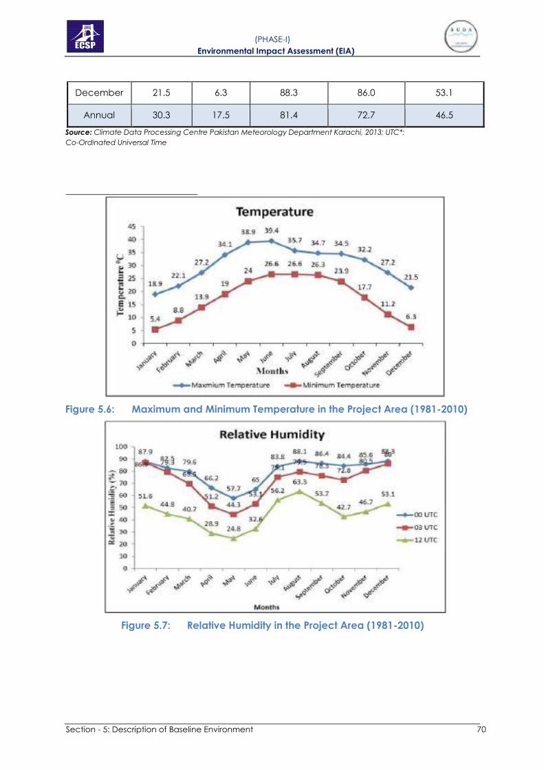
Section - 5: Description of Baseline Environment 70
( PHASE-I) Environmental Impact Assessment (EIA)
December 21.5 6.3 88.3 86.0 53.1
Annual 30.3 17.5 81.4 72.7 46.5
Source: Climate Data Processing Centre Pakistan Meteorology Department Karachi, 2013; UTC*:
Co-Ordinated Universal Time
Figure 5.6: Maximum and Minimum Temperature in the Project Area (1981-2010)
Figure 5.7: Relative Humidity in the Project Area (1981-2010)

Section - 5: Description of Baseline Environment 71
( PHASE-I) Environmental Impact Assessment (EIA)
Table 5.2: Average Monthly Temperature, Wind Speed and Wind Direction
(19812010)
Month Mean
Temperature
Wind Spee d
Wind Direction (knots)
00 03 12 00 03 12
UTC* UTC UTC UTC UTC UTC
January 18.9 1.5 1.4 3.7 N49W 50W N51W
February 22.1 2.4 2.1 6.2 N41W N43W N47W
March 27.2 2.5 3.3 7.1 N29W N25W N41W
Month Mean
Temperature
Wind Spee d
Wind Direction (knots)
00 03 12 00 03 12
UTC* UTC UTC UTC UTC UTC
April 34.1 3.4 4.6 6.8 N18W N N49W
May 38.9 3.8 5.7 6.8 N16E N53E N72W
June 39.4 3.6 6.5 6.9 S77E S57E S23W
July 35.7 3.4 5.7 6.3 S74E S61E S55E
August 34.7 2.3 4.5 5.5 S67E S56E S54E
Septembe 34.5 1.6 3.0 5.0 E S57E W
October 32.2 1.1 1.7 3.5 N N56E N45W
Novembe 27.2 1.1 1.0 2.1 N38W N34W N58W
Decembe 21.5 1.1 1.0 2.2 N48W N45W N63W
Annual 30.3 1.9 3.1 4.9 N N67E N57W
Source: Climate Data Processing Centre Pakistan Meteorology Department Karachi, 2001; UTC*:
Co-Ordinated Universal Time

Section - 5: Description of Baseline Environment 72
( PHASE-I) Environmental Impact Assessment (EIA)
Table 5.3: Average Monthly Precipitation (2010-2014)
Month Maximum Minimum Rainfall (mm)
Mean
January 4.84 0 8.3
February 11.3 0 30.66
March 6.26 0 17.74
April 26.1 0 43.84
May 5.56 0 55.6
June 47.36 0 94.84
July 68.2 0 178.42
August 78.8 0 233.36
September 87.1 0 205.28
October 10.62 0 11.66
November 4.02 0 4.64
December 8.04 0 9.44
Total 358.2 0 893.78
Source: Climate Data Processing Centre Pakistan Meteorology Department, Karachi
a
Figure 5.8: Mean Rainfall in the Project Area (2010-2014)

Section - 5: Description of Baseline Environment 73
( PHASE-I) Environmental Impact Assessment (EIA)
A) Pre-monsoon Season
Pre-monsoon refers to the period from April to June prior to the setting in of
the monsoon. This is the hottest and the driest season, with persistent dry and
hot winds. Day time temperature rises to 40.4oC. The flows in the river begin to
rise simultaneously due to snow-melt water in the high mountains. The water
table falls to the maximum depth.
B) Monsoon Season
Monsoon is the main rainy period, which starts at the beginning of July,
reaches its climax in August and gradually, subsides in September. High
intensity Rainfall causes soil erosion which is a function of erosivity and
erodibility. The cool monsoon winds followed by heavy showers lower the
temperature to great extent. The part of rain percolates into the soil and is
conserved in the subsoil and part ads to the groundwater.
The conserved moisture in the soils is generally sufficient to rejuvenate the
vegetation. All plants grow rapidly and mature towards the end of the
season. With the start of monsoon season, the rivers flow at their peak level.
The groundwater level is improved toward the end of the season in
September and October.
C) Post-monsoon Season
Post monsoon season refers to autumn (October-November). The
temperature starts falling but the extreme aridity prevents plants to flower
early and set seed toward mid-seasons. Groundwater level rises as a result of
infiltration from rainfall.
D) Winter Season
Winter refers to the period from December to January. The lowest
temperatures (< 2oC) and cold winds characterize this season. The plants
become dormant and most of them dry out. Most of the trees shed their
leaves and few remain green or partly green. Sometimes this season
becomes severe due to cold Siberian winds. Groundwater level declines in
this season due to low flows in the rivers and no or little rains which usually fall
in light showers causing little soil erosion.
E) Spring Season
Spring refers to the period from February to March. Temperatures become
pleasant. The mean maximum temperature is 2oC with the highest
precipitation of 41.2 mm and relative humidity of 57.6 percent. Some light
showers of rain may also fall without generating run-off. The vegetation
sprouts again because of conserved moisture from winter and spring rains, if
any. The water table starts falling.

Section - 5: Description of Baseline Environment 74
( PHASE-I) Environmental Impact Assessment (EIA)
5.4.6 Hydrology
A hydrology/hydraulic study was carried out for River Ravi Project to make a
perennial water body. A hydrology modelling was conducted to compute
design flood, Hydraulic modelling for existing and proposed options for river
training work, low flow water requirement and sediment analysis.
The design flood used for river training work and estimation of barrage/
control structures is considered as 586,000 cusecs as the flood above 500,000
cusecs was already witnessed twice in 89 years. Detailed analysis for the
phase I was carried out to determine the width and depth of the channel.
The width of the channel is 3280.84 ft (1000 m) with wall height of 33 ft
including the free board. Dykes will be provided upstream of the project area
to protect it from the flood. The dimension of the dykes will be 10 ft to 30 ft
with side slope 3 to 1 and 2 to 1 on inner and outer side. The top level will be
determined with the water level of maximum flood and free board of 6 ft as
recommended by Federal Flood Commission. Guide bank will be provided
at the start of the project with usual nose having a radius of 1200 ft and top
width of 30 to 40 ft and side slope of 3:1 to 2:1 with stone pitching at the nose
and river side.
There are two discharge measuring stations on the Ravi River in the vicinity of
the project. One is at Ravi Syphon, which is far upstream end of the project
and the other at Shahdara Bridge.
Analysis was carried out to assess the flows at two gauging stations. The results
reveals that Ravi Syphon flows are in reasonable agreement to downstream
gauging station Shahdara bridge. The little difference may be due to
inclusion of drains in the Ravi River between Syphon and Shahdara, seepage
loss or measuring errors.
The mean monthly flow of the Shahdara gauging station indicates that flow
available from October to March is very less. The average flow in these six (06)
months is 1,638 cusecs with low value of 1,371 cusecs that was observed in
the month of November. Flows are available in abundance for the Kharif
season, 12,315 cusecs in these six months from 2001 to 2013.
The monthly flow availability varies to a great extent. The maximum flow could
reach to 18,000 cusecs in the month of July while it may come to very low
value (12,00 cusecs) in the month of December.
5.4.7 Ground Water
Groundwater was encountered at around 1-3 m depth below the NSL as per
Geotechnical Investigation Report. Given a margin for seasonal fluctuations,
the groundwater may be considered to rise/fall beyond this depth by about
1 m.

Section - 5: Description of Baseline Environment 75
( PHASE-I) Environmental Impact Assessment (EIA)
5.4.8 Surface Water and Drainage
River Ravi which is the major natural surface water resource located in the
northern part of the district. River Ravi receives huge amount of wastewater
from the city of Lahore and other industrial discharges from different sources
especially Hudiyara Drain, a natural drain which carries pollution loads from
both Pakistan and India. Most wastewater discharge reaches to Ravi in the
60km stretch between Balloki and Lahore. These wastewater discharges,
along with reduction in available water in River Ravi for dilution, has greatly
deteriorated the quality of river water. River Ravi runs merely as a sullage
carrier near Lahore during low flow season.
Besides, there are 76 minor drains which finally fall in eight (8) major drains
namely Sattu Kattla Drain, Lakshami Drain, Suk Nehar Drain, Upper Chota Ravi
Drain, Siddique Pura Drain and Shahdara Drain. Nowadays, all these drains
collect wastewater from different areas of Lahore and finally fall into River
Ravi.
5.4.9 Solid Waste and Wastewater Situation
Solid waste disposal is another key problem being faced by the population
of the Project Area. Only a few localities have the facility of filth depot, while
a majority of the population of the Project Area throws the solid waste of their
houses in vacant plots, into River Ravi, drains/nullahs and in streets also. Most
of the solid waste is found to be stored in the form of heaps at various
locations near the villages and drains and open burning of waste is a
common practice. The remaining organic and livestock waste is collected in
the designated area which is used to prepare compost utilized by local
farmers in their agriculture fields as a fertilizer. Similarly, no proper sewerage
system exists in the study area.
5.5 BASELINE ECOLOGICAL ENVIRONMENT
The ecological study focus mainly on aquatic and terrestrial ecology. The
total project area was surveyed and data was gathered for the habitat
information on the basis of various parameter including; Identifying types of
habitats, observing existing condition in each habitat and its ecological
characteristics and providing overview of other distinct characters of the site.
The study area is curbed to 14 km river Ravi starting from Syphon to Old Ravi
Bridge. The project area has diverse kinds of habitats ranging from forested
area, agriculture fields, lowland grasslands, orchards, wastelands etc. The
project site is significant due to its biodiversity richness of fauna and flora
species. The ecological baseline data was collected from field surveys
conducted from August to October, 2014 and January, 2021 to assess plants
and animals present in different habitats. The summary of the ecological
environment is given below:

Section - 5: Description of Baseline Environment 76
( PHASE-I) Environmental Impact Assessment (EIA)
5.5.1 Habitat Information
A) Forests
There only two forests falling in close proximity of the project corridor with a
total area of 1087.83 acres. However, out of these two, Shahdara Reserve
Forest fall partially (21.33 acres) in the project area, while, Anno Bhatti Forest
is near (117.43 acres). The tree species planted in these forests comprise
mainly of Eucalyptus, Sheesham, Kikar, Willow, Simbal and Mulberry etc.
Following Table shows the Details of the forest areas within the project
boundary.
Table 5.4: Details of the forest areas within the Project Boundary
Sr. No. Name Area (Acre) Affected Areas
1 Shahdara Reserve Forest 854.1 21.33
2 Anno Bhatti Forest 233.73 117.43
Total 1087.83 138.76
B) Low-lying Grasslands
There are few low-lying grassland areas within the study area. The lowland
areas are inundated by the river when water level is high after monsoon and
during the dry season agriculture is practiced on some parts of them. One
such large grassland is situated adjacent to Dhanna Bhaini forest. This area
was dominated by Cynodon dactylon and other herbs and grasses.
Common species were Croton sparsiflorus, Polygonum plebejum and
Saccharum spontaneum. Some invasion of Parthenium hysterophorus was
also observed. Many ephemeral pools appear during rainy season that add
up to their wildlife and habitat diversity. These areas are used by the people
for livestock grazing. Besides flora, there were bird species like acridoeheres
tristis, hoplopterus indicos, and easer domesticus etc. Other animal species
included Hystrix indica, and Golunda elliota.
C) Agriculture and Roadside
Most of the area in project boundary is agricultural land which is almost
40.78% of the land covering the area of 1,410.83 acres. These lands have an
extensive network of side roads and because of their closeness to the roads
they are kept in a single habitat type. The most common crops grown over
there were rice, Sorghum bicolor, wheat and corn while seasonal vegetables
were also grown there. There were many species of both native and exotic
trees like Acacia nilotica, Eucalyptus camaldulensis, Melia azedarach and D.
sissoo. Shrubs like Calotropis procera, Ricinus communis, herbs and grasses like
Amaranthus viridis, Conyza ambigua, Paspalum distichum, Echinochloa
colonum, Cynodon dactylon, sedges like Cyperus iria and Cyperus rotundus.
Among invasive species Prosopis juliflora and Parthenium hysterophoru were

Section - 5: Description of Baseline Environment 77
( PHASE-I) Environmental Impact Assessment (EIA)
more common. The agriculture land is valuable for birds like Acridoeheres
tristis, Hoplopterus indicos etc. Other animal species are Felis chaus, Hystrix
indica, and Golunda elliota etc.
D) Orchards
There are no orchards in the project area, however, some fruit trees are
present in the agriculture land. These are habitats of various birds. Bird species
were Acridotheres ginginianu, Dicrurus macrocersus, Passer domesticus, and
Corvus splendens. Mammals species were Hystrix indica, Funambulus
pennantii, Golunda elliota and Herpestes mungo. Some grasses and herbs
were also present there.
E) Ponds
The area has wastewater ponds around towns and villages. There will be no
wastewater ponds after the development. Fresh water ponds are seasonal in
the area and are created due to collection of water in depressions after the
rainy season. Following bird species were observed around the ponds Egretta
intermedia, Streptopelia tranquebarica, Acridotheres tristis, Dicrurus
macrocersus vieillot, Egretta garzetta and Corvus splendens. One amphibian
specie Euphlyctis cyanophlyctis was common there. Some aquatic plants
were also there.
F) River
There are many good fish species of high food and economic value known
to this river. Tree species on river banks in the area of the forests were mostly
Eucalyptus canaldulensis, Acacia nilotica and Dalbergia sissoo. The aquatic
species Eichhornia crassipes and Pistia stratiotes were also seen on the water
surface. Birds on the embankments were mainly Egretta intermedia,
Haplopterus indicus, Acridotheres ginginianus and Columbia livia. These river
banks are important for many migratory birds for example, Anas crecca,
Egretta garzetta and Gallinago Gallinago. Fishing activities were observed
both upstream and downstream of River Ravi.
G) Island
There are islands in the study area that are created when water level in the
River goes down, while they inundate when water level rises. No crop is
cultivated in summer because of the risk of flood damage so at that time they
are converted into grasslands. Shrubs found there were are Calotropis
procera, herbs are Eclipta alba, Parthenium hysterophorus, Phyla nodiflora,
Polygonum plebejum, grasses are Cynodon dactylon, Dactyloctenium
scindicum, Echinochloa colonum, Saccharum spontaneum and sedges are
Cyperus rotundus. Out of these species, there are three (03) invasive species
(Parthenium hysterophorus, Lantana and Prosopis juliflora).

Section - 5: Description of Baseline Environment 78
( PHASE-I) Environmental Impact Assessment (EIA)
H) Wasteland
There were wastelands in the area, which were with very little vegetation
cover. Sand dredging was carried out at one of such sites near the River Ravi.
After the development there will be no wasteland. Salt crust was seen on the
surface of soil at a couple of places indicating land salinization.
5.5.2 Flora Information
Plants species in the study area were surveyed by the team using all the major
roads travelling upstream and downstream of River Ravi. Plant species on the
main and side roads, orchards, grasslands and agricultural fields were carried
out using 100 m long transects. Quadrats of 20 m2 were taken in the forests.
Long walks along the bank of the river at various locations helped in
describing shore line vegetation. Islands were reached through boats. Few
common trees were eucalyptus, sisham, kikar, beri, toot, dherak, phulai etc.
Invasive species included Lantan camara, Prosopis juliflora and Parthenium
in terrestrial ecosystems while Pistia and Eichhornia crassipes were invasive
species of aquatic ecosystems. List of aquatic plant species present in River
Ravi or pond is given in Table 5.5 while list of plants from all other habitats is
given in Table 5.3.
Table 5.5: List of Aquatic Plant Species Collected from Ponds and River
AQUATIC PLANTS COMMON NAMES
Habitats Abundance
class IUCN STATUS
R P
ANGIOSPERMS
Eichhornia crassipes* Water Hyacinth + + A Not
Evaluated
Lemna minor Common Duckweed - + B Least
Concern
Pistia stratiotes* Tropical Duck-Weed + + B Least
AQUATIC PLANTS COMMON NAMES
Habitats Abundance
class IUCN
STATUS R P
Concern
Potamogeton sp. Pondweed - + D Not
Evaluated
Typha angustata Lesser indian reed
mace - + C
Not
Evaluated
PTERIDOPHYTES
Marsilea villosa Villous Waterclover - + B Not
Evaluated
BRYOPHYTE

Section - 5: Description of Baseline Environment 79
( PHASE-I) Environmental Impact Assessment (EIA)
Marchantia sp. Liverwort + - D Not
Evaluated
"+" = Present, "-" = Absent, * = Invasive, R= River, P = Pond, A = Very Common, B = Common & Widespread, C = Less Common, D = Rare, E = Very Rare

Section - 5: Description of Baseline Environment 80
( PHASE-I) Environmental Impact Assessment (EIA)
Table 5.6: List of Plant Species Collected from Different Habitats in the Project Area
SCIENTIFIC NAMES COMMON NAMES HABITATS
ABUNDANCE CLASS IUCN STATUS F A + R R. B. O L W K I
TREES
Acacia nilotica Egyptian Thorn + + - + - - + - A Not Evaluated
Albizia lebbeck Rain Tree + + - - - - + - C Not Evaluated
Albizia procera Tall Albizia - - - - - - + - E Not Evaluated
Alstonia scholaris White Cheesewood - - + - - - + - D Least Concern
Azadirachta indica Neem Tree + - - - - - + - C Not Evaluated
Bombax ceiba Cotton Tree + + + - - - + - C Not Evaluated
Broussonetia
papyrifera* Paper Mulberry + + + - - - - - D Not Evaluated
Conocarpus spp Mangrove tree + + - - - - + - D -
Cordia myxa Assyrian Plum + + - - - - - - D Not Evaluated
Cupressus
sempervirens Italian Cypress - - - - - - + - E Not Evaluated
Dalbergia sissoo Sissoo Tree + + + + - - + - A Not Evaluated
Ehretia serrata Koda Tree + - - - - - - - E Not Evaluated
Erythrina suberosa Corky Coral Tree + - - - - - - - E Not Evaluated
Eucalyptus
camaldulensis Red Gum + + + + - - - - B Not Evaluated
Eucalyptus citriodora Spotted Gum + - - - - - + - D Not Evaluated
Eucalyptus largiflorens Flooded Gum + - - - - - + - D Not Evaluated
Ficus benghalensis Banyan Fig - + - - - - + - C Not Evaluated
Ficus carica Fig + + - + - - - - C Least Concern
Ficus infectoria White Fig - - + + - - - - D Not Evaluated

Section - 5: Description of Baseline Environment 81
( PHASE-I) Environmental Impact Assessment (EIA)
SCIENTIFIC NAMES COMMON NAMES HABITATS
ABUNDANCE CLASS IUCN STATUS F A + R R. B. O L W K I
Ficus racemosa Cluster Fig - - - - - - + - E Not Evaluated
Ficus religiosa Peepul Tree + + + + - - + - C Not Evaluated
Mangifera indica Mango - + - - - - + - D Data Deficient
Melia azedarach China Berry + + + + - - + - B Not Evaluated
Mimusops elengi Spanish Cherry - - - - - - + - E Not Evaluated
Morus alba White Mulberry + + + + - - + - B Not Evaluated
Morus nigra Black Mulberry - + - - - - - - E Not Evaluated
Musa paradisiaca Banana - + - - - - - - E Not Evaluated
Nerium oleander Oleander - + - - - - + - E Least Concern
Parkinsonia aculeate Cambron + + + - - - - - C Not Evaluated
Phoenix dactylifera Date Palm + - + - - - + - C Not Evaluated
Platanus orientalis Chinar - - - - - - + - E Not Evaluated
Pongamia pinnata Indian Beech + + + - - - + - C Least Concern
Polyalthia longifolia Ashok - - - - - - + - E Not Evaluated
Populus euphratica Salt Poplar - + - + - - - - D Not Evaluated
Prosopis cineraria Jand - - - - - - + - E Not Evaluated
Prosopis juliflora* Mesquite + + + + - - + - B Not Evaluated
Psidium guajava Guava + + - + - - - - C Not Evaluated
Salix tetrasperma Indian Willow + - - - - - - - D Not Evaluated

Section - 5: Description of Baseline Environment 82
( PHASE-I) Environmental Impact Assessment (EIA)
Syzygium cumini Black Plum - + - + - - + - C Not Evaluated
Tamarix aphylla Athel Pine + - - - - - - - D Not Evaluated
Terminalia arjuna Arjun Tree + - - - - - + - D Not Evaluated
Ziziphus jujuba Chinese Date + + + - - - - - C Least Concern
SCIENTIFIC NAMES COMMON NAMES HABITATS
ABUNDANCE CLASS IUCN STATUS F A + R R. B. O L W K I
Ziziphus nummularia Jujube + + + - - - - - C Not Evaluated
SHRUBS
Abutilon bidentatum Velvetleaf - + - - - - - - E Not Evaluated
Abutilon hybridum Chinese Bellflower + + - - + - - - C -
Acacia farnesiana Mimosa Bush - + - - - - - - E Not Evaluated
Atriplex crassifolia Saltbush - + - - - - - - E Not Evaluated
Bougainvillea
spectabilis wild Bougainvillea - - - - - - + - E Not Evaluated
Calotropis procera Rubber bush/ Aak + + + + - - + - B Not Evaluated
Hibiscus rosa sinensis Shoe Flower - - - - - - + - E Not Evaluated
Ipomoea carnea Bush Morning Glory + + + - + - - + C Not Evaluated
Jasminum officinale Jasminum - - - - - - + - E Not Evaluated
Lantana camara* Big Sage + - + - - - + - C Not Evaluated
Murraya exotica Orange Jasmine - - - - - - + - E Not Evaluated
Ricinus communis Castor Oil Plant + + - - - - + - C Not Evaluated
Rosa indica Rose Bed - - - - - - + - E Not Evaluated
Sida cordifolia Country Mallow + - - - - - - - E Not Evaluated

Section - 5: Description of Baseline Environment 83
( PHASE-I) Environmental Impact Assessment (EIA)
Tamarix dioca Salt Cedar - + + - - - - + D Not Evaluated
Withania somnifera Indian Ginseng + + + + - - - - C Not Evaluated
HERBS
Agave Americana Century Plant + - - - - - - E Not Evaluated
Achyranthes aspera Prickly Chaff Flower + + - + - - - - C Not Evaluated
Alhagi maurorum Camelthorn + - + + - + - - C Not Evaluated
Alternanthera sessilis Sessile Joyweed + + + - - - - - C Least Concern
SCIENTIFIC NAMES COMMON NAMES HABITATS
ABUNDANCE CLASS IUCN STATUS F A + R R. B. O L W K I
Amaranthus viridis Slender Amaranth + + - + - - - - B Not Evaluated
Ammannia baccifera. Blistering Ammania - + - - - - - - E Least Concern
Boerhavia diffusa Red Spiderling + + + - - - - - C Not Evaluated
Cannabis sativa Marihuana + + - - - - - + C Not Evaluated
Cassia absus Tropical Sensitive
Pea + + - - - - - - D Least Concern
Chenopodium
ambrosioides Mexican Tea + + - - - - - + C Not Evaluated
Chenopodium album Lambsquarters + + + - - - - - B Not Evaluated
Chrozophora tinctoria Dyer's Litmus - + - - - - - - E Least Concern
Citrullus lanatus Watermelon + + + + - - - + D Not Evaluated
Convolvulus arvensis Field Bindweed + + - + - - - - C Not Evaluated
Conyza ambigua Rough Conyza + + + + - + - - B Not Evaluated

Section - 5: Description of Baseline Environment 84
( PHASE-I) Environmental Impact Assessment (EIA)
Conyza Canadensis Horseweed + - - - - + - - D Not Evaluated
Croton sparsiflorus Ban Tulasi + + + - + + - - B Not Evaluated
Croton tiglium Purging Croton - - - - - + - - E Not Evaluated
Digera muricata False Amaranth + + + + - - - - C Not Evaluated
Datura metel Devil's Trumpet - - - - - - + - E Not Evaluated
Eclipta alba Eclipte Blanche + + + + - + - + B Data Deficient
Euphorbia hirta Asthma Weed + + - + - - - - C Not Evaluated
Euphorbia prostrata Prostrate Sandmat + + + + - + - - B Not Evaluated
Launaea procumbens Country Dandelion + + + - + - - - C Not Evaluated
Leptochloa panacea Mucronate
Sprangletop + + - + - + - - C Least Concern

Section - 5: Description of Baseline Environment 85
( PHASE-I) Environmental Impact Assessment (EIA)
SCIENTIFIC NAMES COMMON NAMES HABITATS
ABUNDANCE CLASS IUCN STATUS F A + R R. B. O L W K I
Malvastrum
coromandelianum False Mallow + + - + - - - - C Not Evaluated
Nicotiana
plumbaginifolia Tex-Mex Tobacco - + + - - - - - E Not Evaluated
Oxalis corniculata Sleeping Beauty + + + + - + - - B Not Evaluated
Oxystelma esculentum Rosy Milkweed Vine + - - - - + - - D Least Concern
Parthenium
hysterophorus* Whitetop Weed + + + - + + - + B Not Evaluated
Phyla nodiflora Turkey Tangle
Frogfruit + + + + - - - + B Least Concern
Physalis divaricate Ground Cherry - + - - - - - - E Not Evaluated
Polygonum persicaria Redshank + + + + - - - - C Least Concern
Polygonum plebejum Small Knotweed + + - - + + - + B Not Evaluated
Portulaca oleracea Little Hogweed + - - - - - - - E Not Evaluated
Solanum nigrum Black Nightshade + + + - - - - - C Not Evaluated
Solanum
xanthocarpum Thai Eggplant + - - - - + - - D Not Evaluated
Sonchus asper Spiny Milk Thistle + + - - - + - - C Not Evaluated
Sphenoclea zeylanica Gooseweed - + - - - - - - E Least Concern
Suaeda fruticosa Shrubby Seablite + - - - - + - - E Not Evaluated
Trianthema
portulacastrum Wild Water Melon + + + + - - - - C Not Evaluated

Section - 5: Description of Baseline Environment 86
( PHASE-I) Environmental Impact Assessment (EIA)
Tribulus terrestris Bullhead - + - - - - - - E Not Evaluated
Verbena officinalis Herb Of The Cross + - - - - - - - E Not Evaluated
Xanthium strumarium Cocklebur + + - + - - - - B Not Evaluated
SCIENTIFIC NAMES COMMON NAMES HABITATS
ABUNDANCE CLASS IUCN STATUS F A + R R. B. O L W K I
GRASSES
Acrachne racemosa Goosegrass - + - - - - - E Not Evaluated
Bothriochloa
laguroides Silver Beardgrass - + + - - - - - D Not Evaluated
Brachiaria ramose Browntop Millet + - + - - - - - D Least Concern
Brachiaria reptans Creeping Panic
Grass + + + + - - - - C Least Concern
Cenchrus ciliaris Buffel Grass + + - - - - - - D Not Evaluated
Cenchrus setigerus Birdwood Grass + + - + - - - - C Not Evaluated
Cenchrus
pennisetiformis Cloncurry + - - - - - - - E Not Evaluated
Cynodon dactylon Bermuda Grass + + + + + + - + A Not Evaluated
Dactyloctenium
aegyptium
Egyptian Crowfoot
Grass - + - - - - - - D Not Evaluated
Dactyloctenium
scindicum Crowfoot Grass - + + + - - - + B Not Evaluated
Desmostachya
bipinnata Halfa Grass + + + + - + - - B Least Concern
Digitaria ciliaris Southern Crabgrass - + + + - - - - C Not Evaluated

Section - 5: Description of Baseline Environment 87
( PHASE-I) Environmental Impact Assessment (EIA)
Dichanthium
annulatum Marvel Grass + - - + - - - - D Not Evaluated
Echinochloa colonum Jungle Rice + + + + - - - + B -
Echinochloa crusgalli Barnyardgrass - + - + - + - - C Least Concern
Eleusine indica Wiregrass - + - - - - - - E Least Concern
Eragrostis cilianensis Candy Grass - + - - - - - - E Not Evaluated
SCIENTIFIC NAMES COMMON NAMES HABITATS
ABUNDANCE CLASS IUCN STATUS F A + R R. B. O L W K I
Eriochloa procera Spring Grass + + - - - - - - D Least Concern
Hemarthria compressa Whip Grass + + + + - - - - C Least Concern
Imperata cylindrical Blady Grass + + - + - - - - C Not Evaluated
Panicum antidotale Blue Panicgrass - + - - - - - - E Not Evaluated
Paspalidium flavidum. Yellow Watercrown
Grass + - - - - - - - E Least Concern
Paspalum distichum Gingergrass + + - + - + - - B Not Evaluated
Perotis hordeiformis Bottle-brush grass - - - - - + - - E Not Evaluated
Phragmites karka Tall Reed + - - - - - - - E Least Concern
Saccharum munja Plume Grass + + + - - + - - B Not Evaluated
Saccharum ravennae Canne D'italie + + - + - - - - C Least Concern
Saccharum
spontaneum Wild Cane + + + + + + - + B Least Concern
Setaria glauca Yellow Foxtail + + - - - - - - D Not Evaluated
Setaria pumila Pigeon Grass + + + + - - - - C Not Evaluated
Sorghum halepense Johnson Grass + + - + - - - - C Not Evaluated

Section - 5: Description of Baseline Environment 88
( PHASE-I) Environmental Impact Assessment (EIA)
Sporobolus
coromandelianus
Madagascar
Dropseed - + - - - + - - D Not Evaluated
SEDGES
Carex fedia ness. Carex - + + - + + - - C Not Evaluated
Cyperus difformis Small flower Umbrella
Sedge - + - - - - - - E Least Concern
Cyperus iria Rice Flat Sedge + + + + - + - - B Least Concern
Cyperus rotundus Nut-Grass + + + + - - - + B Least Concern
SCIENTIFIC NAMES COMMON NAMES HABITATS
ABUNDANCE CLASS IUCN STATUS F A + R R. B. O L W K I
Fimbristylis dichotoma Two Rowed Rush + - - - - + - - D Least Concern
Pycreus flavidus - - + - - + - - - E Least Concern
"+" = Present, "-" = Absent, * = Invasive, F = Forest, A + R = Agriculture + Roadside, R. B. = River Bank, R= River, O = Orchard, P = Pond, L = Lowland, W = Wasteland, K = Kamran Bara
dari, I = Island ,AC= Abundance class, A = Very Common, B = Common & Widespread, C = Less Common, D = Rare, E = Very Rare

5.5.3 Fauna Information
The survey was done in the project area and data was gathered for
mammals, reptiles, birds, amphibians, insects and zooplanktons. A checklist
of the species that might be expected in the study area was prepared by
searching published literature. Both direct observation and indirect methods
were used to gather information. Community surveys were carried out and
data was gathered from the local people regarding information of animals
in the area using field guides and colored photographs. The detailed survey
included ecological importance of species, their niche and their IUCN
conservation status like endangered, threatened, vulnerable etc.
A) Survey of Birds
Birds were surveyed in early morning and late afternoon of the same day with
the help of transects and walkovers in the study sites. Identification of species
was done using binoculars. Effective sampling distance was 200 m from
transects. The recorded data of birds was about species identity and their
relative abundance in each of the habitat. Table 5.7 shows the details of birds
found in the project area. Bird species were more abundant along the river
banks, agricultural fields and in forest areas. Most common species were
Passer domesticus, Corvus splendens, Acridotheres tristis, Egretta intermedia
and Dicrurus macrocersus vieillot.
B) Survey of Mammals
Mammals were surveyed during the visits and were identified from field
observations of paw prints, scats and their burrows. Table 5.7 shows details of
the mammals found in the project area. Wild boars and jackals were present
in the study area. Mostly small size mammals which included porcupines, rat
and bat species were there. Mammals were mostly found in forests and
agriculture fields.
C) Survey of Reptiles and Amphibians
These field surveys were carried out to locate species and their habitats within
the study area. The morning surveys were conducted in the bright day light
and evening surveys of the same place were also carried out. List of the
species is shown in Table 5.7. Among the reptiles, Varanus bengalensis,
Uromastyx hardwickii and Naja naja etc. were common. Three (03) species
of snakes and two (02) species of turtles are reported. According to the IUCN
red list of threatened species, Nilssonia gangetica is vulnerable and it needs
to be protected. Only three Amphibian species were found in the study area.
Among them, Hoplobatrachus tigrinus and Bufo stomaticus were very
common. None of the species of birds, mammals and amphibians were
found rare in the IUCN lists.
( PHASE-I) Environmental Impact Assessment (EIA)

Section - 5: Description of Baseline Environment 90
( PHASE-I) Environmental Impact Assessment (EIA)
Table 5.7: List of Mammals, Birds, Reptiles and Amphibians of the Project Area
Animal Species Common name
Habitats
AC IUCN
status
Punjab
Wildlife
Act CITES
A+ R W P R O L F
Birds
Egretta intermedia Intermediate Egret + - + + - + + B LC
Accipiter badius Shikra + - - - - - + D LC
Acridotheres ginginianus Bank Myna + + - - + + + B LC
Acridotheres tristis Common Myna + + + + + + + A LC
Actitis hypoleucos* Common Sand piper + + - + - + + B LC
Amaurornis phoenicurus White breasted hen - - - + - + - D LC
Anas crecca* Common teal - - - + - - - D LC
Anas Platyrhynchos* Mallard - + - - + + + C LC
Ardeola grayii Indian pond Heron + - - - + - + C LC
Bubulcus ibis Cattle egret + - - + + + + C LC
Callacanthis burtoni Spectacle Finch - - + + + + + D LC
Centropus sinensis Crow pheasant + - - - + - + C LC
Ceryle rudis Pied kingfisher + - - + + + + C LC
Cinnyris asiaticus Purple sunbird + - - - + - + D LC
Columba livia Wild rock dove + - - + + + + B LC
Copsychus saularis Magpie robin + - - - + - + C LC

Section - 5: Description of Baseline Environment 91
( PHASE-I) Environmental Impact Assessment (EIA)
Coracias benghalensis Indian roller + + - - - - + B LC
Corvus splendens House Crow + + + + + + + A LC
Coturnix coturnix* Common Quail - - - + - - + D LC
Dicrurus macrocersus vieillot Black Drongo + - + + + - + B LC
Dinopium benghalense Golden backed woodpecker + + - - + - + C LC
Animal Species Common name
Habitats
AC IUCN
status
Punjab
Wildlife
Act CITES
A+ R W P R O L F
Egretta garzetta* little egret + - + + + + + B LC
Francolinus pondicerianus Black Partridge + - - - - - + E LC
Francolinus pondicerianus Grey Partridge + + - + + + + C LC
Galerida cristata Crested lark + - - - + + + C LC
Gallinago gallinago* Common snipe - - - + - - - E LC
Gallinula chloropus* Common moorhen - + - + - - + C LC
Gracupica contra Pied myna + + - + + + + D LC
Halcyon smyrnensis White-breasted Kingfisher + - - + + + + B LC
Himantopus himantopus* Black winged stilt + - + + - - - C LC
Hirundo rustica* Common swallow - - - + - - - D LC
Hoplopterus indicus* Red-Wattled Lapwing + + - + + + + B LC
Hydrophasianus chirurgus* white pheasant jacana - - + - - + - E LC
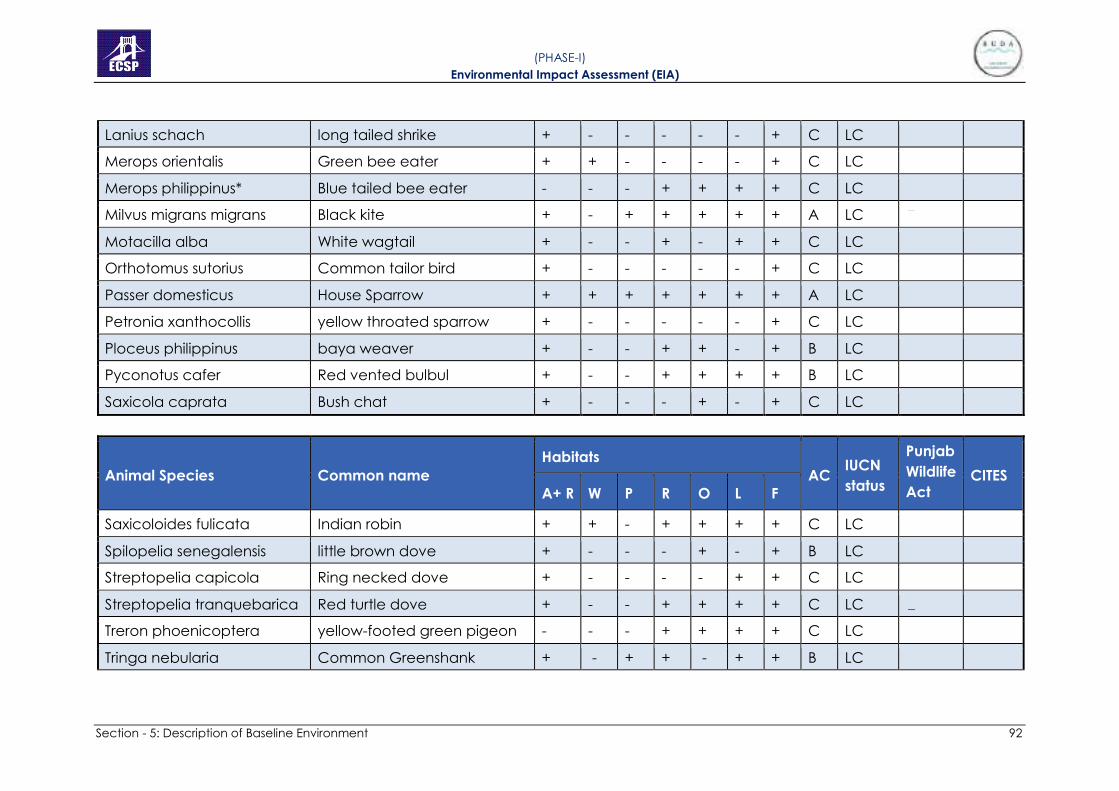
Section - 5: Description of Baseline Environment 92
( PHASE-I) Environmental Impact Assessment (EIA)
Lanius schach long tailed shrike + - - - - - + C LC
Merops orientalis Green bee eater + + - - - - + C LC
Merops philippinus* Blue tailed bee eater - - - + + + + C LC
Milvus migrans migrans Black kite + - + + + + + A LC
Motacilla alba White wagtail + - - + - + + C LC
Orthotomus sutorius Common tailor bird + - - - - - + C LC
Passer domesticus House Sparrow + + + + + + + A LC
Petronia xanthocollis yellow throated sparrow + - - - - - + C LC
Ploceus philippinus baya weaver + - - + + - + B LC
Pyconotus cafer Red vented bulbul + - - + + + + B LC
Saxicola caprata Bush chat + - - - + - + C LC
Animal Species Common name
Habitats
AC IUCN
status
Punjab
Wildlife
Act CITES
A+ R W P R O L F
Saxicoloides fulicata Indian robin + + - + + + + C LC
Spilopelia senegalensis little brown dove + - - - + - + B LC
Streptopelia capicola Ring necked dove + - - - - + + C LC
Streptopelia tranquebarica Red turtle dove + - - + + + + C LC
Treron phoenicoptera yellow-footed green pigeon - - - + + + + C LC
Tringa nebularia Common Greenshank + - + + - + + B LC

Section - 5: Description of Baseline Environment 93
( PHASE-I) Environmental Impact Assessment (EIA)
Turdoides caudata Common babbler + + - - - - + B LC
Upopa epops* Hoopoe + - - + + + + B LC
Zosterops palpebrosus Oriental white eye - - - - + - + D LC
Mammals
Canis Aureus Asiatic Jackal + - - + + + + C LC III
Felis chaus Jungle cat + + - + + + + D LC
Funambulus pennantii Palm squirrel + + + + + + + A LC
Golunda elliota Bush rat + - - - + + + B LC
Herpestes edwardsi Indian mongoose + + - + + + + B LC III
Hystrix indica Indian crested porcupine + + + + + + + A LC
Lepus nigricollis Indian hare + + - - - - + D LC
Megaderma lyra Indian false vampires + + - - + + + B LC
Millardia meltada soft furred field rat + + + + + + + B LC
Mus musculus House mouse + + + + + + + A LC
Rattus Rattus roof rat + + - + + + + B LC
Suncus Murinus Asiatic House shrew + + - + + + + B LC
Sus scrofa Wild boar + - - - - + + C LC
Animal Species Common name
Habitats
AC IUCN
status
Punjab
Wildlife
Act CITES
A+ R W P R O L F
Reptiles
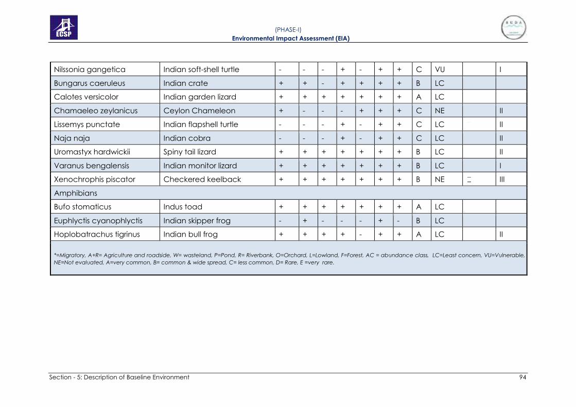
Section - 5: Description of Baseline Environment 94
( PHASE-I) Environmental Impact Assessment (EIA)
Nilssonia gangetica Indian soft-shell turtle - - - + - + + C VU I
Bungarus caeruleus Indian crate + + - + + + + B LC
Calotes versicolor Indian garden lizard + + + + + + + A LC
Chamaeleo zeylanicus Ceylon Chameleon + - - - + + + C NE II
Lissemys punctate Indian flapshell turtle - - - + - + + C LC II
Naja naja Indian cobra - - - + - + + C LC II
Uromastyx hardwickii Spiny tail lizard + + + + + + + B LC II
Varanus bengalensis Indian monitor lizard + + + + + + + B LC I
Xenochrophis piscator Checkered keelback + + + + + + + B NE III
Amphibians
Bufo stomaticus Indus toad + + + + + + + A LC
Euphlyctis cyanophlyctis Indian skipper frog - + - - - + - B LC
Hoplobatrachus tigrinus Indian bull frog + + + + - + + A LC II
*=Migratory, A+R= Agriculture and roadside, W= wasteland, P=Pond, R= Riverbank, O=Orchard, L=Lowland, F=Forest, AC = abundance class, LC=Least concern, VU=Vulnerable,
NE=Not evaluated, A=very common, B= common & wide spread, C= less common, D= Rare, E =very rare.

Section - 5: Description of Baseline Environment 95
( PHASE-I) Environmental Impact Assessment (EIA)
D) Survey of zooplanktons
Water samples from river and ponds were collected and brought into the
laboratory. Zooplanktons were observed under compound and stereo
microscopes. List of zooplanktons is given in Table 5.8.
Table 5.8: List of Zooplanktons and Protoctists Found in the Ponds and River of The
Study Area
Sr. No. Scientific name Group
1. Paulinella nidulus Amoeboid
2. Centropyxis aculeta Amoebozoa
3. Difflugia lobostoma Arcellinida
4. Plumatella fruiticosa Bryozoan
5. Fredericella sultana Bryozoan
6. Diaptomus castor Crustacean
7. Cyclops varicans Crustacean
8. Mesocyclops leuckerti Crustacean
9. Mesocyclops hyalinus Crustacean
10. Parastenocaris lacustris Crustacean
11. Daphnia ambigua Crustacean
12. Ceridaphnia reticulate Crustacean
13. Moinodaphnia malcayii Crustacean
14. Daphnia smilis Crustacean
15. Bosmina longirostris Crustacean
16. Macrothrix rosae Crustacean
17. Polyartha vulgaris Rotifer
18. Keratella quadrata Rotifer
19. Keratella cochlaeris Rotifer
20. Asplancha priodonta Rotifer
21. Epiphanes branchionus Rotifer
22. Euclanis dilatata Rotifer
23. Trochosphaera solstitialis Rotifer

Section - 5: Description of Baseline Environment 96
( PHASE-I) Environmental Impact Assessment (EIA)
24. Philodina roseola Rotifer
25. Filina longiseta Zooplankter
26. Protoctists
27. Euglena Protoctist
28. Paramecuim Protoctist
E) Fish survey
Fish surveys were conducted in the main channel of River Ravi with the help
of local fishermen using nets. These nets were deployed at different sites for
30 minutes to one hour during the vegetation survey of the nearby
community. Fishermen were also interviewed to collect information on the
River Ravi fish in the study site. List of fish species found in the River Ravi are
shown in Table 5.9.
Table 5.9: List of the Fish Species found in the River Ravi
Scientific Names Common Names IUCN status
Catla catla Thaila/Indian carp LC
Channa marulius Saul LC
Channa punctate Daula LC
Cirrhinus mrigala Mori LC
Ctenopharyngodon idella † Grass carp NE
Cyprinus carpio*† Common carp/Gulfam VU
Hypopthalmichthys molitrix † Silver carp NT
Hypophthalmichthys nobilis † Big head carp DD
Labeo rohita Rohu LC
Macrognathus pancalus Groj LC
Oreochromis aureus* Tilapia NE
Rita rita Khagga/Tirkanda LC
Sperata sarwari Singharee LC
Wallago attu Mullee VU
LC=Least concern, VU=Vulnerable, NT=Near threatened, DD= Data deficient, NE=
Not evaluated, * = invasive, † exotic

Section - 5: Description of Baseline Environment 97
( PHASE-I) Environmental Impact Assessment (EIA)
5.5.4 Ecological Mapping of the Study Area
From the data gathered in the project area, there are two important
ecosystems identified, one is in form of aquatic ecosystem provided by the
river and ponds whereas the other one is terrestrial ecosystem. Terrestrial
ecosystem included forest areas, grasslands, orchards, agricultural fields,
islands and wasteland. The two forms of biomes are interconnected and
have developed vital linkages from land to water and water to land. In rainy
seasons, water, sediments, pollutants, nutrients, and other materials flow from
terrestrial environments to aquatic one. The nutrients in form of droppings of
the amphibiotic animals move from water to land. Such connections develop
important food chains and food webs in both ecosystems. An illustration of
such possible food web is provided for the study area.
Figure 5.9: Simplified Food Web in the Project Area
These conceptual models show trophic levels of producers, herbivores,
omnivores and carnivores which existed in the area. e.g., birds are
omnivorous as they eat invertebrates and plants. In an ecosystem, energy
and nutrients flow from a low trophic level to a higher trophic level. As the
river gets polluted the pollutants from water and sediments travel into the
food chain and get bioaccumulated into the bodies of the animals. The area
surrounding river Ravi is mostly agricultural where high pesticides usage exists.
These pesticides are reported from the water and sediments of river (Syed et
al. 2014). Organochlorines have been reported to be present in the eggshells
of cattle egret (Malik et al. 2011). There is a need to clean the river from
pollution loads to save the whole of the ecosystem.

Section - 5: Description of Baseline Environment 98
( PHASE-I) Environmental Impact Assessment (EIA)
5.5.5 Ecological flow
The raising of water level in the river by constructing a gated/regulating
structure would cause the flow depths to increase and velocity of flow to
reduce. The freshening in a stream is directly related to the depths and
velocity of flow. The Barrage may lower the water quality particularly when
the flows in the river are low.
The important aspects are quality of influent (DO and BOD), addition of
biological load by the water entering the river along the length of the water
body and the processes that are expected to take place in the water body.
USEPA (1985) have recommended a minimum concentration of 3-5.0 mg/l for
healthy water bodies to sustain fish and aquatic life. National Conservation
Strategy (NCS) recommends DO concentration of 4 mg/l to protect and
conserve aquatic life.
Minimum ecological flow requirement to keep the lake fresh depends upon
the season, and water body operating levels. The minimum environmental
flow in different months will be investigated using water quality modelling in
hydrological study; the result depicts the initial estimate of about 300 cusecs
and losses due to evaporation and seepage.
The analysis for minimum daily recorded flow of river Ravi in various months
indicates that additional flow will be required in the months from October to
May. The flow required ranges between 100 to 450 Cusecs from October to
May. The maximum flow required is 450 cusecs in the month of December
However, analysis was carried out for 90% of flow available time that shows
there will no additional flows required as there are sufficient flows available
throughout the year as depicted in Figure 5-10.
Figure 5.10: Net Available Flows for 90% Exceedance Flow Condition

Section - 5: Description of Baseline Environment 99
( PHASE-I) Environmental Impact Assessment (EIA)
5.6 SOCIO ECONOMIC ENVIRONMENT
The main purpose of the socioeconomic baseline survey is to understand and
document the prevailing socioeconomic conditions of respondents and
environment in project areas prior to implementation of the project activities.
Socio-economic studies focus mainly on demography, occupation,
education, housing, health, family income and expenditure, basic amenities,
land use, livestock, resettlement concerns, industry, archaeology, tourism,
land values, role of women etc. The socio-economic baseline data was
collected from field surveys conducted from August, 2014 to October, 2014
and January, 2021.
5.6.1 Objectives
The specific objectives of a socioeconomic baseline survey are to:
• Collect socio-economic data or information pertaining to respondents
and environment prior to the project execution;
• Analyse the collected data and interpret the analysed data and
present a meaningful discussion of the variables pertaining to the
respondents and environment in question;
• Put out the baseline results in environmental reports; and
• Define magnitude of acceptability level, identifying perceived
impacts and suggested measures to mitigate those impacts.
5.6.2 Approach & Methodology
The essence of survey method can be explained as “questioning individuals
on a topic or topics and then describing their responses” (Jackson, 2011,
p.17). Survey method can be broadly divided into three categories: mail
survey, telephone survey and personal interview. In this EIA Study individual
interviews were conducted where the list of questions was asked face to face
by sociologists to know the responses regarding proposed project.
5.6.3 Data Collection Tools
There are various data collection tools used in research are:
• Interview Schedule.
• Questionnaire.
• Focus Group Discussions.
• Checklist.
• Observation.

Section - 5: Description of Baseline Environment 100
( PHASE-I) Environmental Impact Assessment (EIA)
In this EIA Study, an interview schedule was developed which is used in field
survey for primary data collection. An interview schedule is basically a list
containing a set of structured questions that have been prepared, to serve
as a guide for interviewers, researchers and investigators in collecting
information or data about a specific topic or issue.
The summary of the socio-economic environment statistics is given below:
5.6.4 Household and Population
The field surveys conducted in the Project Area and data collected from the
relevant agencies indicate that there are 14,351 households in all three
phases of River Ravi Urban Development project area with total built up area
1199 acres and total population of 95,277. Further there is additional 2343
households’units with built-up area 71 acres due to change in river
alignment from Shahdara side for passage of 586,000 cusec flood.
For the purpose of Phase-I of River Training and Channelization project, the
only settlements falling in the riverbed will be relocated. There are only two
settlements in the riverbed and contain 634 households with total built up
area of 25.11 acres and total population of 4, 271 (Table 5.10).
5.6.5 Villages in Project Area
To establish baseline of the whole area, 89 villages have been surveyed, out
of which 20 villages fall in Tehsil City & Cantonment of the Lahore District, and
remaining 69 villages fall in Tehsil Muridkey, Ferozewala, and Narang &
Sharaqpur of Sheikhupura District. Four semi urban settlements fall in
Shahdara district Lahore.
So far as resettlement/relocation is concerned, there are total two
settlements which fall in project area of Phase-I. Administratively, both these
settlements / villages fall in Tehsil City & Cantonment of the Lahore District.
The detail of this village, number of houses with built-up area and population
is shown in Table 5.10.
Table 5.10: Detail of the Villages to be Resettled
Sr.
No. Village Name UC District
No. of
Houses Population
Built-up
Area
(Acres)
1 Jhuggian
Arazi
Kot Abdul
Malik Lahore 300 2,100 11.44
2 Mustafa
Abad Shahdara Lahore 334 2,171 13.67
Total (Phase-I) 634 4,271 25.11

Section - 5: Description of Baseline Environment 101
( PHASE-I) Environmental Impact Assessment (EIA)
5.6.6 Health
The survey indicates that there are only 6 Basic Health Units (BHU) in Project
area, 2 villages have facility of Dispensaries and 55 private practitioners (not
qualified doctors but dispensers, quakes, etc.) are practicing as health facility
provider in different villages. There are only 2 hospitals in the project area.
The available health facility in the project area is shown in Figure 5.11 below:
Figure 5.11: Available Health Facilities in Project Area
5.6.7 Education
Survey indicates that, 81 % villages have education facility from primary to
higher secondary levels. In 19% villages, there is no educational facility, even
of primary school level. The parents send their children to nearby village for
schooling. Figure 5.12 presents the availability of educational facility in
Project area. Girl’s schools are far less than schools for boys in the project
area. Therefore, it is difficult for the girls to have access to educational
institution. Traveling long distance to access the school for girls is the main
cause of illiteracy.

Section - 5: Description of Baseline Environment 102
( PHASE-I) Environmental Impact Assessment (EIA)
Figure 5.12: Availability of Education Facility
5.6.8 Electricity
It is evident from the survey results that 96% villages have electricity facility, whereas
4% lack this facility. The villages, where electricity facility is not available, people use
kerosene oil as a source of light. Figure 5.13 reveals the availability of electricity in
the Project Area.
Figure 5.13: Availability of Electricity in Project Area
5.6.9 Natural Gas Supply
The survey reveals that only 27% villages of the total project area are enjoying
the natural gas facility provided by government; while, significant number of
villages (i.e. 73%) have to use wood or gas cylinders for fuel purpose. Figure
5-10 reveals the availability of gas facility in the Project Area.

Section - 5: Description of Baseline Environment 103
( PHASE-I) Environmental Impact Assessment (EIA)
Figure 5.14: Availability of Gas Facility in the Project Area
5.6.10 Telephone Facility
Most of the people use mobile telephone facility; however, the availability of
landline telephone facility in the surveyed villages indicates that 51% villages
have telephone facility and 49% villages do not have telephone facility. In
49% villages where telephone facility is not available, the only option is to use
mobile phones; however, the signal strength is weak for mobile phones in
these areas. Figure 5.15 reveals the availability of landline telephone facility
in Project Area.
Figure 5.15: Availability of Landline Telephone Facility
5.6.11 Transport
The survey results indicate that people of 58% villages have access to public
transport e.g.,s bus, van and Rickshaw (Chingchi) etc. for traveling purpose.
The remaining 42% villages do not have public transport and they use private

Section - 5: Description of Baseline Environment 104
( PHASE-I) Environmental Impact Assessment (EIA)
transport such as Motor Car, Motor Cycle, Bicycle or travel by foot. Figure 5.16
shows the availability of transport facility in Project Area.
Figure 5.16: Availability of Public Transport in Project Area
5.6.12 Access Roads
Survey results indicates that a large number of the villages have either soling
(27%) or katcha (21%) roads/track. 10% villages have only Metalled roads.
Furthermore, 38% of the villages have mixed types of roads as presented in
Figure 5.17.
Figure 5.17: Type of Access Roads in the Project Area
5.6.13 Bank Facility
The survey reveals that Bank facility is available in only 01 village of the project
area; whereas other villages lack this facility due to which the residents have

Section - 5: Description of Baseline Environment 105
( PHASE-I) Environmental Impact Assessment (EIA)
to travel to access the banking facility to the nearest urban commercial
center
5.6.14 Post Office
Survey results indicated that 34% villages have Post Office facility at their door
step; while, (66%) villages do not have this facility. The residents of the villages,
where the facility is not available, have to travel long distance to reach the
nearest post office
5.6.15 Domestic Water Supply
An easy access to potable / safe drinking water is one of the basic human
rights and needs. Survey indicates that the residents of the total project area
are deprived of tapped water supply system. Only 2% people have this
facility. Most of the population of project area (i.e. 94%) use both hand pumps
and electric motor pumps to extract ground water for domestic water usage.
The remaining 4% of villages extract groundwater through hand pumps as
they have no access to electricity facility. Figure 5.18 reveals different sources
of water supply in the Project Area.
Figure 5.18: Domestic Water Supply System in the Project Area
5.6.16 Sewerage System
Proper sewerage system is not available in the project villages. However, the
local residents use small open drains and septic tanks system made by them.
5.6.17 Archaeological and Historical Monuments/Sites
a. Mosques: Survey indicates that 93 % of villages have mosques while
non-availability in only 7% villages. Figure 5.19 presents the available
mosques in the Project Villages.

Section - 5: Description of Baseline Environment 106
( PHASE-I) Environmental Impact Assessment (EIA)
Figure 5.19: Availability of Mosques in the Project Villages
b. Graveyards: 69% villages have graveyard out of total 86 surveyed
villages. However, 31% villages do not have graveyards. Figure 5.20
presents the available graveyards in the Project Villages.
Figure 5.20: Availability of Graveyards in the Project Villages
c. Shrines: 65% villages have shrines whereas, 35% villages do not have
shrines. Figure 5.21 reveals number of present shrines in the surveyed
villages.
Figure 5.21: Number of Shrines present in the surveyed Villages

Section - 5: Description of Baseline Environment 107
( PHASE-I) Environmental Impact Assessment (EIA)
5.6.18 Irrigation System
Study revealed that 52% villages depend upon tube well (ground water) for
irrigation purpose and 48% villages use canal water for their agriculture lands.
Multiple Responses were recorded in each village due to availability of more
than one option. Figure 5.22 shows irrigation system within the Project Area.
Figure 5.22: Graphical Presentation of Irrigation System in Project Area
5.6.19 Cropping Pattern and Average Yield
The major crops grown in project area are rice and wheat. A few number of
villages sow vegetables (Potato, Onion, Carrot, Radish, Peas, Pumpkin, Brinjal
etc.), strawberry and Orchards of Illaichi & Guava were also observed in
project area. The average yield of major crops in project area is 40 to 45
(maunds) per acre for each crop. The data contains multiple responses
because every village produces number of crops. The graphical presentation
of cropping pattern is given in Figure 5.23.
Figure 5.23: Cropping Pattern in Project Area
5.6.20 Housing Structures
Housing characteristics of the population indicate the living condition and
social well-being. Survey indicates that 93.6% of the houses of the selected

Section - 5: Description of Baseline Environment 108
( PHASE-I) Environmental Impact Assessment (EIA)
households in the Project Area are pucca, while 6.4% are katcha, and 12.2%
are semi-pacca. During the field visit, the katcha housing pattern was only
observed in the proposed urban areas of few villages of Kala Khatai road.
5.6.21 Solid Waste Disposal
Solid waste disposal is another key problem being faced by the population
of the Project Area. Only a few localities have the facility of filth depot, while
a majority of the population of the Project Area throws the solid waste of their
houses in vacant plots, into River Ravi, drains/nullahs and in streets also.
5.6.22 Language Spoken
Main language spoken in the Project Area is Punjabi. While few people speak
Urdu it is the official language. Few Pashto speaking people were also found
and consulted in the Project Area.
5.6.23 Settlements Pattern
The settlement pattern of the Project Area has a mixed origin i.e., urban, semi-
urban and rural. Few areas of Lahore and Sheikupura districts are urban or
semi urban such as Shahdara, Kala Khatai Road, project Area near Baigum
kot etc. Large number of all types industries small, medium and large scale
exist within and outside the project Area (Detail of industries are provided in
next chapter). The central part of the Project Area is urban, while the
peripheral part of the Project Area is semi-urban and the site which for from
the project area is rural.
5.6.24 Gender Ratio
According to the survey 53 % population in the project area are males while
47 % are the females.
5.6.25 Gender Issues
As the Project activities are being carried out within the residential/
agricultural areas of the local community, as a result of it, women activities in
the field are being affected during the construction stage. The induction of
outside labor may create social and gender issues due to the unawareness
of local customs and norms. It will also cause hindrance to the mobility of the
local women. Disturbance was observed to the privacy of the local women
residing along the boundary of the Project Area particularly where no
boundary walls are available at homes.
5.6.26 Resettlement Issues
As per criteria and after efforts to minimize resettlement at this initial stage of
the Project, it is estimated that only two (2) settlements, which fall in riverbed
will need to be resettled for Phase-I, while all other will be retained.

Section - 5: Description of Baseline Environment 109
( PHASE-I) Environmental Impact Assessment (EIA)
Administratively, both these villages fall in Tehsil City & Cantonment of the
Lahore District. These two settlements contain 634 households with total built
up area of 25.11 acres and total population of 4,271. The criterion used in
accordance with the master plan of the project is that the only settlements
which fall in the riverbed will be resettled.
5.7 ENVIRONMENT MONITORING, SAMPLING AND TESTING
To establish baseline conditions for various physical parameters like surface
water, ground water, waste water, ambient air and noise levels, instrumental
environmental monitoring was done and details are described as under and
environmental monitoring/sampling location map is shown in Figure 5.24.
5.7.1 Surface Water and Waste Water Analysis
In order to access the quality of surface water, Environmental Sampling &
Analysis form 3rd party Environmental Laboratory has been carried out at 9
different locations along River Ravi and 7 major drains in the project area. In
2014, Pakistan Council of Scientific and Industrial Research (PCSIR) also
conducted sampling for same project from 5 different locations of surface
water and 6 locations of waste water.
Surface water samples were tested for 32 parameters in accordance with
PEQS. The detailed results are attached in Appendix 9 while comparison
analysis of river water from upstream to downstream and with Pakistan
Council of Scientific and Industrial Research Reports (PCSIR) for the same
project is given in Table 5.11. Comparison analysis of drains at project site with
Pakistan Council of Scientific and Industrial Research Reports (PCSIR) for the
same project in 2014 is given in Table 5.12.

Section - 5: Description of Baseline Environment 110
( PHASE-I) Environmental Impact Assessment (EIA)
Figure 5.24: Environmental Sampling Location Map

Section - 5: Description of Baseline Environment 111
( PHASE-I) Environmental Impact Assessment (EIA)
Table 5.11: Comparison Analysis of River Water Upstream to Downstream at the Project Site
Temperature 0C -- 32.0 18.0 33.0 19.0 34.0 20.0 33.0 18.0 32.0 16.0 18.0 19.0 20.0 18.0
pH value at 25 oC -- 6-10 7.38 7.57 6.89 7.44 7.10 7.43 7.26 7.54 6.87 6.98 7.74 7.52 7.49 7.46
COD mg/L 150 mg/L 92.4 64 98.0 170.0 89.0 234.0 80.0 455 71.0 129 49 174 146.0 827.0
BOD at 200C mg/L 80 mg/L 48.0 40 56.0 72.0 48.0 120.0 38.0 213 39.0 66.0 28 86 68.0 388
Oil &Greases -- 10 mg/L 0.0 0.0 0.0 0.0 0.0 0.0 0.0 0.0 0.0 0.0 0.0 0.0 0.0 0.0
Pesticides/Herbici
des --
0.15
mg/L 0.0 - 0.0 - 0.0 - 0.0 - 0.0 - - - - -
Phenolic
Compounds -- 0.1 mg/L 0.0 0.0 0.0 0.0 0.0 0.0 0.0 0.0 0.0 0.0 0.0 0.0 0.0 0.0
Cyanide mg/L 2.0 mg/L 0.05 0.0 0.03 0.0 0.04 0.0 0.02 0.02 0.03 0.0 0.0 0.0 0.0 0.02
Chlorides mg/L 1000
mg/L 8.10 11.9 9.6 13.9 28.10 69.9 5.90 89.9 16.20 44.9 24.9 19.9 29.9 22.5
Sulphates mg/L 600 mg/L 26.0 22.0 24.0 26.0 30.0 36.9 23.0 82.26 52.0 46.0 18.0 32.36 33.12 36.0
Cadmium -- 0.1 mg/L 0.0 <0.00
6 0.0
<0.00
6 0.0
<0.00
6 0.0 0.007 0.0 0.006 0.007
<0.00
6
<0.00
6 0.009
Chromium -- 1.0mg/L 0.0 <0.00
4 0.0
<0.00
4 0.0
<0.00
4 0.0 0.005 0.0 0.007
<0.00
4 0.005 0.007 0.006

Section - 5: Description of Baseline Environment 112
( PHASE-I) Environmental Impact Assessment (EIA)
Copper mg/L 1.0 mg/L 0.150 <0.16
4
<0.016
4
<0.16
4 0.012
<0.16
4 0.0
<0.16
4 0.03
<0.16
4
<0.16
4
<0.16
4
<0.16
4
<0.16
4
Mercury -- 0.01mg/
L 0.0
<0.00
1 0.0
<0.00
1 0.0
<0.00
1 0.0 0.001 0.0 0.002
<0.00
1 0.001
<0.00
1 0.001
Lead -- 0.5 mg/L 0.0 <0.00
5 0.0
<0.00
5 0.0
<0.00
5 0.0
<0.00
5 0.0
<0.00
5
<0.00
5
<0.00
5
<0.00
5
<0.00
5
Silver mg/L 1.0 mg/L 0.023 0.022 0.034 0.036 0.0 <0.00
2 0.0 0.004 0.0
<0.00
2 0.032 0.003
<0.00
2 0.005
Selenium -- 0.5 mg/L 0.0 <0.01 0.022 0.02 0.026 0.021 0.015 0.015 0.015 0.017 0.012 0.003 0.020 0.013
Nickel mg/L 1.0 mg/L 0.011 <0.02 0.02 <0.02 0.0 <0.02 0.02 <0.02 0.01 <0.02 <0.02 <0.02 <0.02 <0.02
Arsenic -- 1.0 mg/L 0.0 0.027 0.0 0.018 0.0 0.026 0.0 0.023 0.0 0.024 0.025 0.016 0.020 0.023
Barium mg/L 1.5 mg/L 0.086 0.003
5 0.078
0.003
8 0.0
0.003
6 0.002
0.003
5 0.003
0.003
7
0.003
9
0.004
0
0.003
5
0.003
7
Iron mg/L 8.0 mg/L 1.03 1.04 1.11 1.28 1.03 1.19 1.38 1.40 1.59 1.82 1.16 1.10 1.05 1.69
Manganese mg/L 1.5 mg/L 0.463 0.458 0.045 0.046 0.128 0.142 0.04 0.05 0.156 0.14 0.018 0.126 0.06 0.04
Zinc mg/L 5.0 mg/L 0.022 0.028 0.015 0.030 0.02 0.038 N.D <0.01
5 0.012 0.018 0.019 0.010 0.026 0.014
Boron mg/L 6.0 mg/L 0.089 0.084 0.072 0.064 0.03 0.038 0.05 0.06 0.04 0.06 0.040 0.05 0.027 0.062
Total Toxic Metals mg/L 2.0 mg/L 0.224 0.347 0.242 0.342 0.069 0.291 0.098 0.308 0.098 0.311 0.314 0.277 0.276 0.312
Ammonia -- 40 mg/L 0.0 0.0 0.0 0.0 0.0 0.0 0.0 0.0 0.0 0.0 0.0 0.0 0.0 0.0

Section - 5: Description of Baseline Environment 113
( PHASE-I) Environmental Impact Assessment (EIA)
Anionic Detergents
-- 20 mg/L 0.0 0.0 0.0 0.0 0.0 0.0 0.0 0.0 0.0 0.0 0.0 0.0 0.0 0.0
Fluorides -- 20 mg/L 0.0 0.0 0.0 0.0 0.0 0.0 0.0 0.0 0.0 0.0 0.0 0.0 0.0 0.0
Sulphides -- 1.0 mg/L 0.0 0.0 0.0 0.0 1.3 0.0 0.0 0.0 0.0 0.0 0.0 0.0 0.0 0.0
Total Dissolved Solids
mg/L 3500mg
/L 126.0 148.0 154.0 180.0 288.0 198.0 130.0 458.0 195.0 164.0 138.0 182.0 184.0 195.0
Total
Suspended Solids
mg/L 200
mg/L 268.0 258.0 28.0 54.0 25.0 22.0 33.0 33.0 24.0 34.0 176.0 58.0 49.0 52.0
Chlorine -- 1.0 mg/L 0.0 0.0 0.0 0.0 0.0 0.0 0.0 0.0 0.0 0.0 0.0 0.0 0.0 0.0
Faecal
Coliform MPN/100
ml -- 140.0 - 110.0 - 110.0 - 80.0 - 220.0 - - - - -
Total Coliform MPN/100
ml -- 170.0 - 140.0 - 170.0 - 110.0 - 170.0 - - - - -

Section - 5: Description of Baseline Environment 114
( PHASE-I) Environmental Impact Assessment (EIA)
Table 5.12: Comparison Analysis of Drains at Project Site
Temperature 0C -- 34.0 19.0 34.0 20.0 32.0 22.0 33.0 20.0 32.0 21.0 20.0 21.0
pH value at 25 oC -- 6-10 7.99 7.33 6.88 7.45 6.60 7.30 6.57 7.36 7.07 7.30 7.33 7.38
COD mg/L 150 mg/L 4139.0 775.0 101.6 486 314.0 834.0 194.0 690.0 221.70 827 1420 1356
BOD at 200C mg/L 80 mg/L 1540.0 372.0 70.0 232.0 198.0 398.0 120.0 334.0 130.0 388.0 658.0 632.0
Oil &Greases -- 10 mg/L 0.0 0.0 5.0 2.0 0.0 0.0 5.0 1.2 0.0 0.0 0.8 0.6
Pesticides/Herbicides mg/L 0.15 mg/L <0.10 - 0.0 - <
0.05 - 0.0 - 0.0 - - -
Phenolic Compounds
-- 0.1 mg/L 0.0 0.0 0.0 0.0 0.0 0.0 0.0 0.0 0.0 0.0 0.0 0.0
Cyanide mg/L 2.0 mg/L 4.6 0.6 1.6 0.8 0.4 0.2 1.8 0.9 0.4 0.3 0.6 0.7
Chlorides mg/L 1000
mg/L 36.2 55 71.60 77.5 67.90 98 131.50 158 47.30 38 60.9 84.9
Sulphates mg/L 600 mg/L 60.0 52.0 61.0 55.0 53.0 48.0 77.0 66.0 64.0 52.0 58.0 48.0
Cadmium -- 0.1 mg/L 0.0 0.006 0.0 0.007 0.0 0.006 0.0 0.007 0.0 <0.006 0.006 0.008
Chromium mg/L 1.0mg/L 0.35 0.04 0.65 0.12 0.32 0.24 0.28 0.32 0.13 0.22 0.26 0.24
Copper mg/L 1.0 mg/L 0.483 0.283 0.08 0.08 0.12 0.12 0.18 0.18 0.077 0.077 0.16 0.20
Mercury -- 0.01mg/L 0.0 0.001 0.0 <0.001 0.0 0.001 0.0 0.001 0.0 <0.001 0.001 <0.001

Section - 5: Description of Baseline Environment 115
( PHASE-I) Environmental Impact Assessment (EIA)
Lead -- 0.5 mg/L 0.0 0.005 0.017 0.016 0.036 0.034 0.0 <0.005 0.046 0.052 <0.005 0.046
Silver mg/L 1.0 mg/L 0.06 0.06 0.06 0.06 0.03 0.03 0.015 0.015 0.015 0.018 0.017 0.016
Selenium mg/L 0.5 mg/L 0.082 0.078 0.015 0.018 0.0 <0.01 0.01 0.02 0.023 0.024 0.019 0.020
Nickel mg/L 1.0 mg/L 0.08 0.07 0.01 0.04 0.03 0.04 0.022 0.024 0.08 0.07 0.005 0.06
Arsenic -- 1.0 mg/L 0.0 0.052 0.018 0.049 0.015 0.046 0.0 0.051 0.0 0.026 0.032 0.028
Barium mg/L 1.5 mg/L 0.23 0.0038 0.12 0.14 0.13 0.11 0.23 0.19 0.96 0.98 0.11 0.13
Iron mg/L 8.0 mg/L 1.29 0.94 1.16 1.28 1.31 1.18 2.11 2.04 1.16 1.22 1.76 1.84
Manganese mg/L 1.5 mg/L 0.163 0.158 0.101 0.099 0.136 0.128 0.215 0.199 0.170 0.179 0.141 0.153
Zinc -- 5.0 mg/L 0.0 0.025 0.029 0.032 0.164 0.058 0.453 0.0241 0.227 0.032 0.063 0.057
Boron mg/L 6.0 mg/L 0.69 0.18 0.82 0.74 0.88 0.68 0.68 0.76 0.68 0.20 0.71 0.68
Total Toxic Metals mg/L 2.0 mg/L 1.76 0.779 1.790 1.271 1.561 1.317 1.255 1.573 2.011 1.674 1.325 1.429
Ammonia mg/L 40 mg/L 16.8 8.4 10.0 6.8 7.84 5.98 8.96 6.88 0.0 0.0 0.0 0.0
Anionic Detergents mg/L 20 mg/L 3.2 2.8 1.8 0.8 3.2 2.8 2.3 1.6 6.2 4.6 2.0 1.6
Fluorides mg/L 20 mg/L 0.3 0.0 0.0 0.0 0.0 0.0 0.0 0.0 0.0 0.0 0.0 0.0
Sulphides mg/L 1.0 mg/L 6.70 4.52 3.30 2.26 3.30 2.18 5.30 4.11 4.0 3.88 2.6 3.0
Total Dissolved Solids mg/L 3500mg/L 852.0 808.0 722.0 746.0 633.0 758.0 796.0 954.0 397.0 492.0 738.0 742.0
Total Suspended
Solids mg/L 200 mg/L 248.0 232.0 214.0 210.0 28.0 38.0 20.0 32.0 24.0 36.0 270.0 236.0
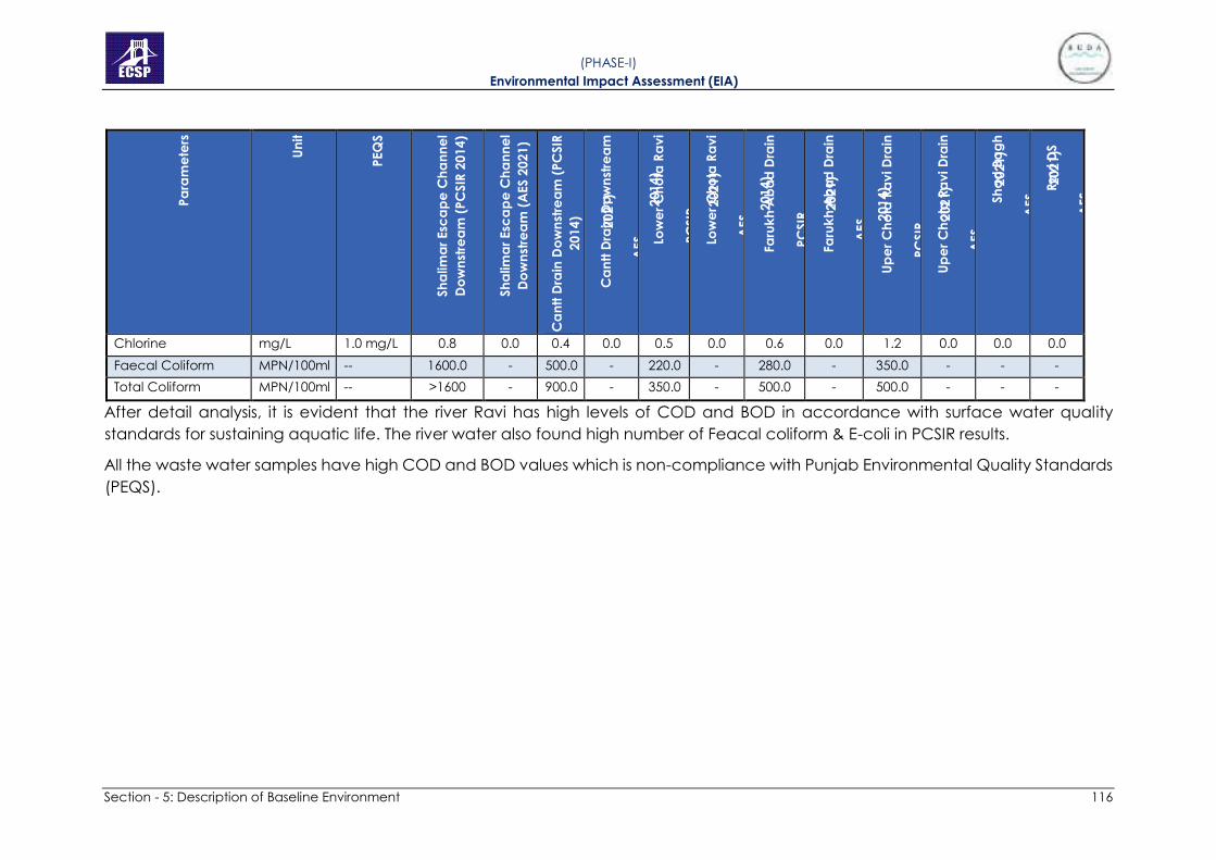
Section - 5: Description of Baseline Environment 116
( PHASE-I) Environmental Impact Assessment (EIA)
Chlorine mg/L 1.0 mg/L 0.8 0.0 0.4 0.0 0.5 0.0 0.6 0.0 1.2 0.0 0.0 0.0
Faecal Coliform MPN/100ml -- 1600.0 - 500.0 - 220.0 - 280.0 - 350.0 - - -
Total Coliform MPN/100ml -- >1600 - 900.0 - 350.0 - 500.0 - 500.0 - - -
After detail analysis, it is evident that the river Ravi has high levels of COD and BOD in accordance with surface water quality
standards for sustaining aquatic life. The river water also found high number of Feacal coliform & E-coli in PCSIR results.
All the waste water samples have high COD and BOD values which is non-compliance with Punjab Environmental Quality Standards
(PEQS).

5.7.2 Ground Water
In order to check the quality of ground water, six samples have been taken
by 3rd party Environmental Laboratory from different locations at which
project is proposed to be constructed. In 2014, Pakistan Council of Scientific
and Industrial Research (PCSIR) also conducted sampling for same project
from five different locations of ground water.
Groundwater samples were tested for 35 selected parameters as per World
Health Organization (WHO). The detail of the results of the samples are
attached as Appendix 9 while comparison analysis of ground water on
different locations at project site is given in Table 5.13.
( PHASE-I) Environmental Impact Assessment (EIA)

Section - 5: Description of Baseline Environment 118
( PHASE-I) Environmental Impact Assessment (EIA)
Table 5.13: Ground Water Analysis at Project Site
Temperature 0C -- 32.0 30.0 32.0 29.0 31.0 31.0 32.0 30.0 32.0 29.0 28.0
Colour Pt-Co
Hazen > 15 Pt-Co Hazen 5.0 2.0 8.0 0.0 5.0 0.0 5.0 0.0 5.0 1.0 0.0
Turbidity -- 5 NTU 0.0 4.0 0.0 0.0 0.0 0.0 0.0 0.0 0.0 1.0 0.0
Odour --
Non-
Objectionable/
Acceptable
Accept
able
NonObjectio
nable/ Accept
able
Acce
ptable
NonObjectio
nable/ Accept
able
Acce
ptabl
e
NonObjectio
nable/ Accept
able
Accept
able
NonObjectio
nable/ Accept
able
Acce
ptabl
e
Non-
Objecti
onable
/
Accept
able
Non-
Objecti
onable
/
Accept
able
Taste --
Non-
Objectionable/
Acceptable
Accept
able Accept able
Acce
ptable Accept able
Acce
ptabl
e
Accept able Accept
able Accept able
Acce
ptabl
e
Accept
able
Accept
able
pH at 25 0C -- 6.5 – 8.5 7.44 7.45 7.21 7.49 7.33 7.67 6.66 7.78 7.3 7.15 7.76
Chlorides mg/L 250 mg/l 39.10 144.95 53.90 50.9 72.4 9.0 3.0 6.99 55.0 18.9 7.99
Hydrogen
Sulphide (H2S) -- 0.05 mg/l 0.0 - 0.0 - 0.0 - 0.0 - 0.0 - -
Sulfate mg/L -- 99.0 168.0 108.0 99.7 59.0 42.8 23.0 32.7 24.0 110.8 39.6
Total Hardness mg/L -- 192.0 326.0 304.0 286.0 180.0 110.0 192.0 98.0 264.0 398 126.0
Calcium mg/L -- 48.0 82 78.0 71 42.0 28.5 48 24.5 66 99.5 31.5
Nitrate mg/L 50 mg/l 0.3 2.2 0.2 0.14 0.1 0.08 1.0 2.24 1.0 1.39 1.03

Section - 5: Description of Baseline Environment 119
( PHASE-I) Environmental Impact Assessment (EIA)
Nitrite -- 3 mg/l 0.0 0.0 0.0 0.0 0.0 0.0 0.0 0.0 0.0 0.0 0.0
Sodium as Na+ mg/L 200 mg/l 27.0 110 22.0 42 39.0 8.2 17.0 5.6 42.0 16.8 17.6
Zinc -- 3 mg/l 0.0 0.024 0.0 0.018 0.0 0.026 0.0 0.029 0.0 0.022 0.028
Copper -- 2 mg/l 0.0 0.164 0.0 0.165 0.0 0.166 0.0 0.164 0.0 0.165 <0.164
Barium -- 0.7 mg/l 0.0 <0.0035 0.0 <0.0035 0.0 <0.0035 0.0 <0.0035 0.0 <0.0035 <0.0035
Boron -- 0.3 mg/l 0.0 <0.02 0.0 <0.02 0.0 <0.02 0.0 <0.02 0.0 <0.02 <0.02
Iron mg/L 0.3 mg/L 0.13 0.15 0.11 0.13 0.12 0.18 0.22 0.19 0.26 0.22 0.20
Arsenic mg/L 0.01 mg/L 0.05 0.052 0.0 0.048 0.07 0.034 0.04 0.045 0.028 0.042 0.048
Lead -- 0.01 mg/l 0.0 <0.005 0.0 <0.005 0.0 <0.005 0.0 <0.005 0.0 <0.006 0.005
Manganese -- 0.5 mg/l 0.0 0.016 0.0 0.024 0.06 0.017 0.05 0.025 0.058 0.018 0.054
Mercury -- 0.001 mg/l 0.0 <0.001 0.0 <0.001 0.0 <0.001 0.0 <0.001 0.0 <0.001 <0.001
Nickel -- 0.02 mg/l 0.0 <0.02 0.0 <0.02 0.0 0.02 0.0 <0.02 0.0 <0.02 <0.02
Antimony -- 0.02 mg/l 0.0 <0.005 0.0 <0.005 0.0 <0.005 0.0 <0.005 0.0 <0.005 <0.005
Aluminum -- 0.2 mg/l 0.0 <0.005 0.0 <0.005 0.0 <0.005 0.0 <0.005 0.0 <0.005 <0.005
Cadmium -- 0.003 mg/l 0.0 0.006 0.0 <0.006 0.0 0.006 0.0 <0.006 0.0 0.006 <0.006
Chromium -- 0.05 mg/l 0.0 0.004 0.0 <0.004 0.0 0.004 0.0 <0.004 0.0 0.004 <0.004
Cyanide -- 0.07 mg/l 0.0 0.0 0.0 0.0 0.0 0.0 0.0 0.0 0.0 0.0 0.0
Fluorides -- 1.5 mg/L 0.0 0.0 0.0 0.0 2.9 2.2 0.0 0.04 0.2 0.09 0.05
Ammonia -- -- 0.0 0.0 0.0 0.0 0.0 0.0 0.0 0.0 0.0 0.0 0.0
Total Dissolved
Solids mg/L 1000 mg/l 549.0 890.0 487.0 554.0 866.0 238.0 229.0 182.0
1119.
0 616.0 220.0

Section - 5: Description of Baseline Environment 120
( PHASE-I) Environmental Impact Assessment (EIA)
Total Suspended Solids
-- -- 0.0 2.0 0.0 0.0 0.0 0.0 0.0 0.0 0.0 0.0 0.0
Total Coliform -- N.D/100ml 0.0 0.0 0.0 0.0 0.0 0.0 0.0 0.0 17.0 0.0 0.0
E-Coli -- N.D/100ml 0.0 0.0 0.0 0.0 0.0 0.0 0.0 0.0 +ve +ve 0.0
As per Analysis, high concentration of Arsenic was found in most of the drinking water samples. The drinking water sample of lakho
dair is unfit for drinking due to the microbiological and heavy metal contamination. The drinking water sample of Chung also found
high concentration of fluoride and arsenic. Only one sample i.e., Sharaqpur out of 5 samples is in compliance and fit for drinking in
accordance with WHO standard guidelines.

121
( PHASE-I) Environmental Impact Assessment (EIA)
5.7.3 Ambient Air Quality
At present, major sources of air pollution are industrial and mobile sources.
Other sources of ambient air pollution are the generators in industrial and
commercial units for alternative power supply sources.
In 2014, Ambient air quality was monitored by PCSIR in accordance with PEQS
at 12 selected locations close to the project sites.
In 2021, ambient air monitoring was again carried at 06 identified locations
for period of 24 hours in accordance with the PEQS. The monitored
parameters included Carbon mono-oxide (CO), Nitrogen dioxide (NO2),
Sulphur dioxide (SO2), Particulate Matter (PM10) and Particulate Matter (PM2.5).
The detailed results of ambient air quality are attached as Appendix 9 while
comparison analysis is given in tables 5.13.

Section - 5: Description of Baseline Environment 122
( PHASE-I) Environmental Impact Assessment (EIA)
Table 5.14: Comparison Analysis of Ambient Air Quality at Project Site
CO mg/m3 10 mg/m3 4.84 1.50 7.59 1.47 8.49 0.67 3.59 1.68 4.84 0.88 13.28 1.46
NO µg/m3 40 µg/m3 36.69 14.67 11.29 8.32 4.12 7.74 7.44 13.50 36.69 10.19 55.0 14.39
NO2 µg/m3 80 µg/m3 7.77 23.42 11.04 17.39 10.53 14.68 4.23 20.84 7.77 18.67 12.80 20.70
NOx
µg/m3 --- 44.46 28.39 22.33 25.71 14.65 22.69 11.67 34.35 44.46 28.85 67.83 35.09
SO2
µg/m3 120 µg/m3 18.21 28.27 37.50 22.84 29.57 17.01 28.90 19.21 18.21 22.96 62.39 21.22
PM 2.5 µg/m3 35 µg/m3 25.0 61.5 30.0 59.3 45.0 61.7 30.0 59.3 25.0 57.2 40.0 64.2
PM 10 µg/m3 150 µg/m3 140.0 173.2 135.0 169.7 140.0 170.2 160.0 164.8 140.0 153.6 180.0 173.4

123
( PHASE-I) Environmental Impact Assessment (EIA)
5.7.4 Noise Level Monitoring
Number of sources of noise emission has been detected in the study area.
These sources are
• Vehicular Traffic in Project Area
• Due to operation of Industrial Activities
• Due to operation of Generators in Commercial Activities
• Due to operation of pumping & disposal stations
Noise levels were monitored at 42 locations (by PCSIR-2014) that are close to
the project sites. The monitoring was carried out for a period of 1 hour and
average is reported.
In 2021, noise levels were monitored at 06 different points for 24 hours. The
results show that the noise levels on all major roads are much higher than
PEQS but the noise levels are in compliance in village settlements, orchards
and forests. The results of noise level at identified locations are given in
Appendix 9.
5.7.5 Baseline Monitoring Team
All laboratory tests for water, noise and ambient air were conducted by AES
(Asian Environmental Services Pvt. Ltd.) which is certified laboratory form EPA-
Punjab. The testing team of expertise is presented in Table
Table 5.15: Testing Team
1 Dilbar Hussain Chief Chemist
M.Phil. Analytical Chemistry,
University of The Punjab
M.Sc. Chemistry,
University of The Punjab
2 Sajjad Hussain Lab Analyst/ Chemist M.Sc. Applied Chemistry,
UET Lahore
3 Abid Farooq Chemist M.Sc. Chemistry,
University of The Punjab
4 Bilal Hameed Field Environmentalist M.Sc. Environmental Sciences – University
of Gujrat
5.8 SUITABILITY OF THE SITE
5.8.1 Wetlands
There are no wetlands or Ramsar site in the project area.
5.8.2 Endangered Species
There are no endangered species of flora and fauna in the project area.

124
( PHASE-I) Environmental Impact Assessment (EIA)
5.8.3 Wildlife Sanctuaries and Game Reserves
No wildlife sanctuary or game reserves are located in the vicinity of the
project area.
5.8.4 Critical Habitats
No wildlife sanctuary or game reserve (Critical Habitats) exists in the project
area, however, there are two (02) forests fall partially in the project area. It is
recommended that NOC must be taken from the Forest Department prior to
start of construction.
5.8.5 Cultural Heritage and Community Structure
During field survey it was observed that two cultural/historical/archaeological
properties are present in the proximity of Phase-I of River Channelization
Project. One is Kamran Baradari, which is a monument declared as “Special
Premises” by Punjab Government under Punjab Special Premises
(Preservation) Ordinance, 1985. It is also an archaeological site / monument
protected by the Federal Government located in Punjab Province under
Guidelines for Protected Areas, 1997. This site is about 1.5km downstream to
the project area. Second is Jahangir’s Tomb, which is also protected by the
Federal Antiquities Act 1975. The site was also inscribed on the tentative list for
UNESCO World Heritage Site status in 1993. It is also 0.5km away from the
construction areas.
In addition to above, should any such other property / chance find / artifact
get identified during implementation, the Contractor will stop work, protect
the cultural property, contact the relevant government department/ agency
responsible and handover the artifact/chance find, etc.

Section - 6: Anticipated Environmental Impacts and Mitigation Measures 125
( PHASE-I) Environmental Impact Assessment (EIA)
SECTION - 6: ANTICIPATED ENVIRONMENTAL
MITIGATION MEASURES
IMPACTS AND
This chapter identifies the potential impacts related with location, design,
construction and operation phases of the Project on the physical, ecological
and socio-economic domains of the environment. Accordingly, mitigation
measures have been proposed to mitigate the negative impacts and to
enhance the positive impacts.
6.1 APPROACH AND METHODOLOGY
For impact identification, various EIA methodologies are available including
the checklists, interaction matrices, networks and overlays. Among these four
methods, following two are used in EIA of River Training Works and
Channelization.
• Project Interaction Matrix
• Overlays- GIS based
6.1.1 Project Interaction Matrix
Interaction matrix is a two dimensional matrix wherein the project actions are
placed along one axis (i.e., along y-axis) and on the other axis there are
different environmental parameters likely to be affected by the proposed
project actions grouped into categories i.e. Physical, Ecological &
Socioeconomic Environment. Interaction matrix is used in this project due to
the following reasons:
• It provides cause-effect relationship between the project actions and
resulting consequences impacts.
• It provides nature (+ve or –ve) and weighting of different impacts.
• It provides cumulative impacts of a project.
• Matrix grouped project actions into temporal phases.
For the impact assessment, project interaction matrix is used by dividing the
project action into different phases (location, design, construction and
operation). The environmental impacts are divided into three main
categories including physical, ecological and socio-economic domains.
The environmental impacts of the project actions are identified and weighed
into the following categories:
HA = Highly Adverse
MA = Medium Adverse
LA = Low Adverse

Section - 6: Anticipated Environmental Impacts and Mitigation Measures 126
( PHASE-I) Environmental Impact Assessment (EIA)
HB = Highly Beneficial
MB = Medium Beneficial
LB = Low Beneficial
0 = None/Insignificant
The assignment of significance is based on the previous knowledge and
professional judgment of EIA team experts. The project impact matrix has
been developed for “without” and “with mitigation” is attached as
Appendix-10. It may be noted that the environmental parameters, which are
not related to the implementation of the projects, have not been considered
in the matrix.
Prior to the mitigation of the obvious negative impacts, it was seen that the
project activities have a negative impact on the physical environment
affecting the water quality, soil, air quality & generation of noise levels during
the construction stage. The other ecological medium negative impacts
include tree removal and effects on fauna. There will be impact on social
environment as local communities in project area will be resettled.
Apart from some negative impacts the project will have far more positive
impacts during operational stage. The positive impacts include restoration of
River and its ecological uplifting, flood protection, Recreational Activities, job
opportunities and economic uplifting of the region.
After executing the proposed mitigation measures, the significant negative
impacts during construction stage and operational stage shall be reduced.
Employment shall boom in the construction as well as operational stage,
which shall be the most beneficial impact of the project.
Reviewing the results of the project impact matrix, it was concluded that after
the reduction/elimination of the negative impacts, the proposed project will
be lucrative and beneficial for the economic development of the area.
6.1.2 Overlays- GIS based
Overlays are the spatial operation, in which two or more maps or layers
registered to a common coordinate system and are superimposed, either
digitally or on a transparent material, for the purpose of showing the
relationships between features that occupy the same geographic space.
Overlays are effective visual aid, useful for documentation of environmental
conditions existing before and after the project implementation. It describes
both biophysical and social aspects of area under study.
The existing land use map of the area has been overlayed with the new
master plan of the proposed Ravi Riverfront Urban Development Project. The
impacts on social and bio-physical environment have been analyzed
through the development of new map.

Section - 6: Anticipated Environmental Impacts and Mitigation Measures 127
( PHASE-I) Environmental Impact Assessment (EIA)
6.2 ADVERSE IMPACTS DURING PRE-CONSTRUCTION PHASE
6.2.1 Land Acquisition and Resettlement
The major impact during Pre-Construction Phase is Land Acquisition and
Resettlement. Both Private and Govt. owned land exist in the Project Area. A
summary listing the main impacts related to land acquisition and resettlement
during the pre-construction phase of the River Channelization Project is given
in Table 6.1.
Table 6.1: Loss of Assets, Land Population and Houses
Item No. Item Quantity
1 Agriculture Land 1410.83 Acres
2 Creek 153 Acres
3 River 795.7 Acres
4 Barren Land 14.5 Acres
5 Forest 138.76 Acres
6 Flood Plain 899.5 Acres
7 Settlements in Riverbed 02 (25.11 Acres)
8 Households 634 Nos.
9 Population 4,271 Nos.
Table 6.2: Details of Settlements falling in Riverbed
Sr.
No. Village Name UC District
No. of
Houses Population
Built-up
Area
(Acres)
1 Jhuggian
Arazi
Kot Abdul
Malik Lahore 300 2,100 11.44
2 Mustafa
Abad Shahdara Lahore 334 2,171 13.67
Total (Phase-I) 634 4,271 25.11
Further, there are the forests with total area of 138.76 acres, which may be
affected. The other forest land outside the channelization will be saved and
taken into the development of overall urban front project. According to the
social survey, small, medium and large bridges, tube-wells, government and
private schools, commercial markets, graveyards, mosques, shrines, and BHUs
are also located in the project area.
Mitigation:
• For the purpose of resettlement, only those villages will be relocated
which are falling in the riverbed, while all other settlements and houses

Section - 6: Anticipated Environmental Impacts and Mitigation Measures 128
( PHASE-I) Environmental Impact Assessment (EIA)
will be retained. Various options (like apartments, model villages, land
for land) have been explored to resettle these settlements which are
given in social/resettlement framework provided in chapter 7. The
settlements location map requiring resettlement is given as Figure 6.1.
• The payment of full, fair and prompt compensation to the affected
people should be made in accordance with LAA, 1894 and the
proposed RPF.
• The forests will be avoided either by converting it into proposed island
or by diverting/realigning the river channelization.
• The mature trees falling in the land to be used for various
developmental purposes under this project will be shifted to
dedicated green areas/gardens with the help of tree transplanting
machines instead of cutting.
• The small industrial units will be resettled in the allocated industrial
areas by the Government while big industrial units will be retained.
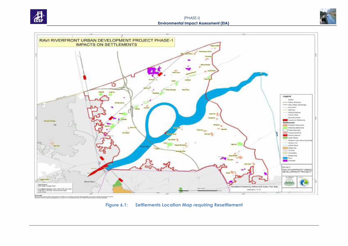
Figure 6.1: Settlements Location Map requiring Resettlement
( PHASE-I) Environmental Impact Assessment (EIA)

Section - 6: Anticipated Environmental Impacts and Mitigation Measures 130
( PHASE-I) Environmental Impact Assessment (EIA)
Strategic Level Measures to Improve Agricultural Produce as an Offset to
Agri Loss.
• The agriculture productivity can be increased by providing modern
agricultural inputs to farming community. These inputs are diversified
and include approved or certified seed, good quality water for
irrigation, fertilizers, weedicides and pesticides.
• Loans may be provided on soft term basis to the farmers for spending
on inputs for agriculture production. Subsidies may be proposed to
farmers on agricultural machineries, like laser tractors, solar/electric
tube wells. The subsidies may also be provided to farmers to install drip
irrigation equipment in fields instead of flood irrigation system. It will
save lot of water, which can be used to further expand agriculture
land.
• The irrigation system requires drastic reforms to make sure
uninterrupted irrigation water supply through canals. The barren areas
should be converted into agriculture land by constructing new canals
and water bodies. Furthermore, alternative policies and investments
are needed in water storage and distribution, including canal
rehabilitation, maintenance, and drainage, to keep water flowing,
protect against severe floods, and meet the country’s changing water
needs.
• The Government must fortify its agriculture sector against weather
extremes including droughts, floods, heat, and cold, and against pests
and diseases. This will require public investment and substantive policy
reforms in agricultural research, extension, seed systems, and
agricultural input markets to support farmers.
• The agriculture should be adaptive to climate change. The crops
should be made resistant to droughts, floods, pests and diseases.
6.2.2 Impact due to Diversion of River
Before the start of the construction of the barrage structure, a River diversion
arrangement has to be made. The River diversion will be accomplished by
the construction of upstream and downstream cofferdams. Failure of the
Coffer Dam during construction includes a partial or total Failure of the Coffer
Dam resulting delay in the Project schedule, loss or damage to equipment,
temporary or permanent damage to structures, serious injury, or even loss of
life and/or the release of sediment and/or debris downstream. This impact is
Site-specific, Possible and Medium Significant.
Mitigation
Standard acceptable engineering design considers and accounts for the
associated loadings or stresses which will be imposed on the Coffer Dam.

Section - 6: Anticipated Environmental Impacts and Mitigation Measures 131
( PHASE-I) Environmental Impact Assessment (EIA)
Mitigation measures include, but are not limited to, designing the Coffer Dam
to relevant codes and scheduling of activities to accommodate weather
interruptions, and regular inspections by the Project Engineer of the Coffer
Dam.
Daily inspections of the Coffer Dam will identify potential weakness or soft
spots in the Coffer Dam which would lead to the Failure of the Coffer Dam
itself. Debris would be caught in the fine trash rack system and removed.
Suspended sediments would be monitored in the downstream flow and in
case of a sudden change, notification would be made for necessary
measures.
The safety of the cofferdams will be checked for the various combinations of
load, as per international design practices. The constructions method &
construction planning of these will also be deliberated upon.
6.3 IMPACTS AND MITIGATIONS MEASURES DURING THE PROJECT
CONSTRUCTION
Following is the brief description of impacts and their mitigation envisaged
during the construction phase:
6.3.1 Physical Environment
A) Soil Erosion and Contamination
Due to the proposed construction activities such as construction of barrage
and river channelization, soil erosion and contamination may occur. Soil
erosion may occur on River Ravi and at contractors’ camps as a result of
uncontrolled run-off from equipment washing yards and excavation of
earth/cutting operations. Whereas contamination of the soil may be caused
by oil and chemical spills at equipment washing yards, camp sites and
temporary construction site office. This impact is, however, temporary and
low adverse in nature.
Mitigations
• Site proposed for barrage and overhead structures where
embankments are more susceptible to erosion by water runoff, stone
pitching or riprap will be provided on the embankment slopes.
• Plantation will be carried out at the toe of the embankment for slope
protection constituting fast growing indigenous trees with deep root
system for anchoring in the soil material.
• Soil contamination can be curtailed by reducing the oil spill in the
camp and at project construction areas by well maintaining the
construction vehicles as well as bitumen/other contaminants in
storage tanks/places.

•
Section - 6: Anticipated Environmental Impacts and Mitigation Measures 132
( PHASE-I) Environmental Impact Assessment (EIA)
Confining excavations to the specified locations as per the approved
engineering drawings and unnecessary excavations should be
avoided;
• Excess soil should be reused where possible and residual soil can be
disposed of at designated site to prevent erosion;
• Septic tanks of adequate capacities should be constructed for
receiving and treating wastewater from all temporary worksite toilets
and construction camps to avoid soil contamination; and
• Regular inspection of the wastewater disposal from construction
camps.
B) Traffic Problems
The proposed project site is accessible through Grand Trunk Road, Saggian
Wala Bypass Road, Khaju Ranwali Road, Bund Road Shahdara and Kala
Khatai-Narang Mandi Road. These roads serve as main approach roads to
the proposed Project Area and due to the proposed construction activities
and movement of heavy project vehicles for construction material supply,
traffic problems may arise for the commuters and transporters travelling to
the proposed areas. The problems will include traffic jams and inconvenience
to the public passing through the Project Area. It will also increase traffic load
on the existing road network or access roads ultimately deteriorating the
existing condition of the roads. The movement of vehicles along the haulage
routes will cause soil erosion, debris flow, dust emissions, vibrational impacts,
etc. Considering these consequences, this impact can be categorized as
direct, moderate, site-specific, medium term, temporary, medium probability
and irreversible.
Mitigation
• Movement of vehicles carrying construction materials and
equipment/machinery will be restricted during the daytime to reduce
traffic load and inconvenience to the local population.
• Construction vehicles, machinery and equipment will be parked at
designated areas (at construction camps site) to avoid un-necessary
congestions along the major roads.
• The speed of the vehicles will be controlled to reduce the probability
of severe accidents, soil erosion, debris flows due to vibrations and dust
emission.
• Damages of roads due to construction vehicles will be instantly
repaired and/or compensated after the completion of work.
• Proper sign boards will be provided for smooth flow of traffic.

Section - 6: Anticipated Environmental Impacts and Mitigation Measures 133
( PHASE-I) Environmental Impact Assessment (EIA)
• Period of construction and area / location of construction site shall be
informed to public in general and specifically to local residents.
• Any closure of the roads (especially main roads) and deviations /
diversions proposed should be informed to the riders through standard
signs and displays.

•
Section - 6: Anticipated Environmental Impacts and Mitigation Measures 134
( PHASE-I) Environmental Impact Assessment (EIA)
C) Air Quality
The air quality of the project area will be affected by the exhaust emissions
(NO2, SO2, CO and PM10) produced from operation of construction machinery
and equipment like batching plants, excavators, dump truck, Road Rollers,
Graders, Haul Trucks, cranes and other transport vehicles etc. Most of these
are using diesel engines that generate noise and exhaust emissions. All these
including PM10 are considered as pollution indicators.
Potential impacts on the air quality during the construction stage will be due
to the fugitive dust and the exhaust gases generated in and around the
construction site. Dust is a major component of air pollution, generated
mainly from the following construction activities:
• Site clearance and use of heavy vehicles and machinery/equipment
etc. at construction site;
• Procurement and transport of construction materials such as sand,
cement, etc. to the construction site;
• Other Gaseous emissions during construction result from operating of
construction vehicles, plant and equipment;
• Increase in air pollution levels without project and with project during
construction period (for mobile & stationary sources) is predicted from
construction machinery, equipment, which reveals that there shall not
be significant contribution towards pollution due to the construction
activity of the project if mitigation plan will be implemented and
monitored in proper sense; and
• Asphalt heating.
This impact is temporary and moderate in nature.
Mitigation
• All vehicles, machinery and equipment to be used during construction
activities should be kept in good working condition and be properly
tuned and maintained in order to minimize the exhaust emissions;
• All vehicles, machinery and equipment to be used for the construction
should be plugged off or switched off immediately after completion of
their work to avoid idling condition;
• Open burning of solid waste from the contractor’s camps should be
strictly banned;

Section - 6: Anticipated Environmental Impacts and Mitigation Measures 135
( PHASE-I) Environmental Impact Assessment (EIA)
Only good quality oils, petroleum products and additives should be
used in the machinery, generators, and the construction vehicles.
Usage of used oil should be strictly prohibited;
• PEQS applicable to gaseous emissions generated by construction
vehicles, equipment and machinery should be enforced during
construction works;
• Air emission monitoring program for NOx, SOx, CO and PM10 should be
undertaken according to the program specified in the EMMP.
• Vehicle and equipment engines should be properly maintained to
reduce exhaust emissions of CO, VOCs, and Particulate Matter.
Equipment that is in good condition will also reduce fuel consumption.
Equipment should be inspected prior to the start of a project. While
equipment is on site, a daily inspection should be conducted and parts
and hoses showing signs of wear should be promptly replaced.
Damaged parts should also be repaired or replaced.
• The fugitive dust emission will be a problem for the nearby settlements,
flora and fauna which will be mitigated by sprinkling of water. Also
main access roads and exposed terrain should be sprayed by water
trucks to minimize the dust.
• Construction workers should be provided with masks for protection
against the inhalation of dust.
• During times of windy conditions, where feasible, construction
operations that generate greater levels of dust may be avoided or
reduced. Instead, these activities can be conducted when more
favourable weather conditions occur. Increased application of other
dust suppressant techniques may also be considered in times of very
windy weather.
D) Noise and Vibration
The noise and vibration will be produced due to the operation of construction
machinery and equipment like bulldozers, scrapers, excavators, compactors,
trucks, large capacity dumpers, graders, heavy duty cranes, concrete
batching plants and stone crushers. The operation and movement of such
equipment will increase the noise and vibration in the Project Area. Noise and
vibration are perceived as one of the most undesirable consequences of
construction activity. The above machinery is expected to generate noise
levels that would be severe in the project area. This impact is temporary and
moderate in nature.

•
Section - 6: Anticipated Environmental Impacts and Mitigation Measures 136
( PHASE-I) Environmental Impact Assessment (EIA)
Mitigation
• For the construction machinery generating noise level in excess of that
prescribed in PEQS, Contractor will make arrangements to bring the
noise level within applicable limits (including proper tuning of vehicles
and mufflers/silencers).
• Movements of the trucks and other construction machinery causing
high noise levels must be restricted at night time to avoid disturbance
to the nearby locality. Truck drivers should be instructed not to play
loud music at night and stop use of horn.
• Proper noise barrier boundary walls will be built on asphalt/ concrete
plants which come close to any locality.
• Providing the construction workers with suitable hearing protection like
ear cap, or earmuffs and training them in their use.
• Use of low noise machinery, or machinery with noise shielding and
absorption.
• Contractors shall comply with submitted work schedule, keeping noisy
operations away from sensitive points; implement regular
maintenance and repairs; and employ strict implementation of
operation procedures.
E) Impact on Water Resources (Surface and Groundwater Contamination)
The proposed project includes the River Training works and Channelization of
River Ravi. During construction of proposed barrage and Channelization
works, surface water resource may get contaminated by sediments, fuel and
chemical spills, or by solid waste and effluents generated by the kitchens and
toilets at the construction camp sites. The impact on these water bodies will
be only for the period of construction and will vanish as the construction work
is over. In addition to that, construction waste, if left unattended will result in
forming leachate which may percolate through the soil strata and will reach
underground water table and hence, will end up contaminating it. This
impact is temporary and adverse in nature.
Mitigation
• Construction camps will be established in areas with adequate natural
drainage channels in order to facilitate the flow of the treated effluents
after ensuring that PEQS are met.
• The surface and groundwater reserves will be adequately protected
by installing screens and barriers to protect the source of
contamination such as construction and oily waste that will degrade
its potable quality.

Section - 6: Anticipated Environmental Impacts and Mitigation Measures 137
( PHASE-I) Environmental Impact Assessment (EIA)
• The proponent will ensure that the construction work is confined and
water bodies are prevented from pollution during construction.
• Suspended sediments would be monitored in the downstream flow
and in case of a sudden change for necessary measures.
• The solid waste will be disposed of in designated landfill sites to sustain
the water quality for domestic requirements.
• Regular water quality monitoring according to determined sampling
schedule.
• The contractor will ensure that construction debris do not find their way
into the River Ravi which may get clogged.
• Prohibit washing of machinery and vehicles in surface waters, provide
sealed washing basins and collect wastewater in
sedimentation/retention pond.
• Wastes will be collected, stored and taken to approve disposal site.
Similarly, if the sewage after treatment is to be discharged on to the
land it will meet the requirements of the PEQS for disposal of
wastewater.

Section - 6: Anticipated Environmental Impacts and Mitigation Measures 138
( PHASE-I) Environmental Impact Assessment (EIA)
F) Change in Hydrologic Regime
The proposed project will involve the construction of a Barrage and
Channelization works on River Ravi. There might be change in water flow
pattern and disturbance to water flow, which will cause impact on
downstream of this water. This impact is moderate in nature.
Mitigation
Barrage on River Ravi and Channelization works shall be properly designed to
accommodate design flows. Provision of culverts to control flood damages
and provision of safety of embankments will be considered during the design
of these arrangements.
G) Borrow/ Open Pits
Borrow/ open pits and its excavation activities may result in land disputes, soil
erosion, loss of potential cropland, loss of vegetation and landscape
degradation. Borrow/ Open pits may also become potential sources of
mosquito breeding and may prove hazardous to human beings, livestock
and wildlife. This will also degrade hygienic condition of the Project Area. This
impact is permanent and moderate negative in nature.
Mitigation
• Necessary permits will be obtained for any borrow pits from the
competent authorities;
• In borrow pits, the depth of the pits will be regulated so that the sides
of the excavation will have a slope not steeper than 1: 4;
• Soil erosion along the borrow pit will be regularly checked to prevent/
mitigate impacts on adjacent lands;
• In case borrow pits are filled with water, measures have to be taken to
prevent the creation of mosquito-breeding sites; and
• Borrow pits will be used for construction waste, but during the
excavation, 6 inch top soil cover will be preserved for vegetation after
the filling of the pits. This is the best way to restore the flora of that area.
H) Wastewater Generation
Wastewater will be generated at the construction camps by the workers. If
the generated wastewater is not properly treated or disposed of, this may
contaminate the surface water sources apart from soil contamination. The
estimated wastewater to be generated from construction camps project
assuming that on average the water demand per person is 100 liters per day
(estimated) and that 80% of the water demand will become wastewater. This
impact is temporary and adverse in nature.

Section - 6: Anticipated Environmental Impacts and Mitigation Measures
Source: The World Bank Report 2012 – What a Waste: Average is 0.45 kg/capita/day.
139
( PHASE-I) Environmental Impact Assessment (EIA)
Mitigation
• Domestic and chemical effluents from the construction camp will be
disposed by the development of on-site sanitation systems i.e., septic
tanks (as shown in Figure 6.2).
• Proper monitoring to check the compliance of PEQS will be carried
out;
• Sewage from construction camps will be disposed of after proper pre-
treatment.
• The Contractor(s) will be responsible to submit details of site-specific
wastewater management plan along with details of wastewater
collection, transportation and its disposal.
Figure 6.2: Septic Tank
I) Solid Waste (Municipal and Construction)
Different type of waste is likely to be generated during the construction phase
of the project. The municipal waste will be in the form of food, cans and
paper from construction camps toilets and washing yards. Considering the
laborers (about 200 in numbers) residing in the construction camp and the
locally available labor, an average solid waste generation rate of 0.5
kg/capita/day9 is adopted for the estimation of solid waste generation.
Based on this assumption, a total of about 100 kg of solid waste will be
generated from construction camps on daily basis. Construction waste may
include excavated soil, sand, gravel, pieces of concrete, bricks, wood, metal
pieces and electrical waste. All these, if left unattended, can become a
source of nuisance and environmental pollution in the project area. Insecure
and unhygienic disposal of the solid wastes particularly garbage and trash
may cause degradation of soil and land. Insecurely disposed of heaps of

Section - 6: Anticipated Environmental Impacts and Mitigation Measures 140
( PHASE-I) Environmental Impact Assessment (EIA)
wastes containing kitchen garbage and food waste can serve as breeding
grounds for the disease spreading vectors and rodents. Throwing away of
solid wastes into water channels and the wastewater network can result into
choking of the latter.
These impacts are temporary and moderate adverse in nature.
Mitigation
• Solid waste generated during construction and camp sites should be
safely disposed of at designated waste disposal sites.
• Proper labelling of waste containers, including the identification and
quantity of the contents should be carried out.
• Construction workers and supervisory staff should be encouraged and
educated to practice waste minimization, reuse and recycling to
reduce quantity of the waste.
• Waste disposal plan must be reviewed during the entire construction
phase in the light of changing weather conditions.
• Close coordination should be carried out between RUDA, construction
contractor and LWMC / concerned department for the proper
disposal of construction waste.
J) Discovery of Heritage Sites/ Structures during Excavation
During construction activities, there is a chance of finding archaeological site.
In case of finding any artefact, the contractor shall immediately report
through Supervision Consultant to Directorate General (DG) of Archaeology
Department, Government of Punjab to take further suitable action to
preserve those antiques or sensitive remains. This impact is site specific.
Mitigation
Project may involve deep excavation. Therefore, the possibility of chance find
is not ignorable. In case of any chance find, the contractor will immediately
report through Supervision Consultant to Directorate General (DG) of
Archaeological Department, Punjab, to take further suitable action to
preserve those antique or sensitive remains. Representative of the DG will visit
the site and observe the significance of the antique, artefact and Cultural
(religious) properties and significance of the project. The report will be
prepared by representative and will be given to the DG. The documentation
will be completed and if required, suitable action will be taken to preserve
those antiques and sensitive remains. In case any artefact, antiques and
sensitive remains are discovered, chance find procedures should be
adopted by contractor’ workers as follows:
• Stop the construction activities in the areas of chance find; Delineate
the discovered site or area;

Section - 6: Anticipated Environmental Impacts and Mitigation Measures
Source: The World Bank Report 2012 – What a Waste: Average is 0.45 kg/capita/day.
141
( PHASE-I) Environmental Impact Assessment (EIA)
• Consult with the local community and provincial Archaeological
Department.
• The suggestion of the local communities and the concerned
authorities will be suitably incorporated during taking the preventive
measures to conserve the antique, artefact and cultural (religious)
properties.
• Secure the site to prevent any damage or loss of removable objects.
In case of removable antiquities or sensitive remain, a night guard shall
be arranged until the responsible local authorities take over.
• After stopping work, the contractor must immediately report the
discovery to the Supervision Engineer.
K) Emergency Response
The construction of the proposed project may encounter emergencies. In
addition, disasters such as earthquakes and fires may occur. Lack of
Emergency Response Plan (ERP) or an inefficient response plan may lead to
an accident or critical injury. This impact is negative, temporary and
moderate in nature.
Mitigation
• An ERP for earthquakes and manmade disasters should be developed
by contractor in coordination with supervisory consultant and RUDA. It
should be implemented in close consultation with the RESCUE Services
and other concerned departments;
• Training of the staff and employees regarding the emergency
procedures and plans should be regularly conducted, the nature of
emergency will be determined as per designated plans;
• Emergency numbers should be clearly posted at all disposal stations;
and Minor incidents and near misses should be reported, and
preventive measures should be formulated accordingly by the RUDA
Management.
6.3.2 Ecological Environment
A) Permanent Loss of Habitat
Due to the construction of a Barrage and Channelization of River Ravi, few
habitats may be affected e.g., the river shoreline. This will totally diminish the
plant species growing on the shoreline of river Ravi at specific place. In
addition, water-land interface is necessary for many amphibians which may
be destroyed due to formation of concrete walls. Many reptiles like freshwater
turtles use these areas as their nesting sites and doing so will seriously affect

Section - 6: Anticipated Environmental Impacts and Mitigation Measures 142
( PHASE-I) Environmental Impact Assessment (EIA)
the population of species that are already under threat. As planned in the
new development that the width of the river will be fixed whereas in natural
flow the rivers do not have a uniform width. This will bring an extra 2.32% area
under the river that will be achieved by clearing many adjacent habitats. The
forest along the project area which might be affected. Similarly, large area
of agriculture and orchard will be lost due to the proposed project. This
impact will be permanent and compensated by modern techniques.
Mitigation
• Embankment slopes should be given along with the river. The slope is
then planted with grasses, sedges and herbs. This will mitigate the
permanent loss of habitat for the threaten species of fresh water turtle.
Planting on such bank slopes would increase the value of habitat by
providing vertical structural diversity and will provide a compensation
for the lost land-water interface for the movement of reptile and
amphibian species. It also provides compensation for clearance of
vegetation along banks of river.
• NOC must be taken from Forest and Wildlife Departments prior to start
of construction in Reserve Forests / Forest Areas.
• Ten (10) trees against each fallen tree of similar floral function on both
sides of the proposed Alignment should be planted that will help in
rehabilitating the floral and faunal activities of the project area.
• Forests restoration should be done with native species, e.g., Dalbergia
sissoo, Tamarix aphylla, Acacia nilotica, Populus euphratica, Prosopis
cineraria and Tamarix dioca etc. It will enhance the site value and in
part will provide compensation for the lost habitat for the species.
• Compensation should be given to the affectees for agriculture and
orchard areas based on current market price.
• The mobility of construction machinery should be planned to minimize
the loss of habitat.
• Incorporate technical design measures to minimize removal of trees, if
possible such as change in the alignment.
• The construction camp management plan during the planning stage
must consider fencing and gating to check the entry of animals in
search of eatable goods.
• Similarly, waste management plan of the camps must be considered
at the planning stage to prevent wild animals and birds.
B) Impact on Aquatic Life
Various construction phase activities like; controlling the flow of water while
creating islands in the river body, construction of a barrage and river

Section - 6: Anticipated Environmental Impacts and Mitigation Measures
Source: The World Bank Report 2012 – What a Waste: Average is 0.45 kg/capita/day.
143
( PHASE-I) Environmental Impact Assessment (EIA)
channelization wall to change water flow, will ultimately affect the aquatic
life. Many studies have proved that creation of barrages or dams in river
channels effect ecology of river, especially fish. As fish needs particular
instream flow of water which is disturbed by barrage and hence affect
spawning and food activities of this fauna. The construction of a Barrage and
the transport of water and sediment will upset the local hydrological
equilibrium, and the effects spread through the community, causing a
general ecological transition. These responses are an important focus of
modern river ecology. Juvenile fish would be affected by altered flow of
water.
Fish ladders can also be provided as a useful structure for the fish mobility
path, depending on the success of the design. Those fish that successfully
negotiate the barrage structure, would then pass into the calmer basin where
the change in current flows, sedimentation, directional clues and predation
could either benefit or dis-benefit differing species (The Severn Barrage, 2007).
There are two categories of threats to fish:
• Direct: injury and mortality due to strikes and water conditions (for
example water pressure) resulting in damage or disorientation.
• Indirect: loss and degradation of habitat which may be important for
feeding and spawning; and disruption to movement.
The current development aims to maintain the natural meander of the river
but fixing the river width will reduce meander and cause straightening of river
as compared to its natural course. Straightening causes the streams to flow
more rapidly, which can, in some instances, vastly increase soil erosion. All of
this results in faster water flow and higher water levels during floods. The
increased erosion results in higher water turbidity, which is a big problem for
all aquatic organisms because it reduces the penetration of sunlight into the
water. The movements of heavy vehicles on the Katcha tracks, excavation
activities, cut and fill processes at the project site, oil and petroleum,
bitumen/coal tar and other liquid and chemical spills may also deteriorate
the quality of the surface water. This impact is significant in nature.
Mitigation
• Barrage and Channelization works shall be properly designed to
accommodate design flows. Provision to control flood damages and
provision of safety of embankments will be considered during the
design of these arrangements
• Control of wastewater and sediment releases to river.
• Contractor will be required to implement the water quality
management protocols.

Section - 6: Anticipated Environmental Impacts and Mitigation Measures 144
( PHASE-I) Environmental Impact Assessment (EIA)
• Ensure the minimum ecological flow at downstream area.
• A monitoring program will be initiated for the impact of the
construction activities on the aquatic habitat and key species.
• Inspections by the fisheries officers should be facilitated in camps to
facilitate the proper implementation of relevant laws.
• All vehicles, machinery, equipment and generators used during
construction activities will be kept in good working condition and be
properly tuned to minimize the adverse impact on waterfowl habitat
by reducing noise, exhaust and land disturbance.
• Communities are given awareness and are involved in the proper
protection of the Biota inside and around the project area.
• Proper monitoring to check the compliance of PEQS will be carried
out.
C) Cutting Down Riparian Vegetation
The removal of this vegetation leads to increased water temperature and
changes in river ecosystems. The absence of riparian belt of vegetation leads
to unhindered passage of nutrients into the river. Where this vegetation belt
is intact, up to 90% of the nutrients are captured and absorbed before
reaching the river. The roots of plants, especially of trees have an important
structural role on the reinforcement of river banks because they retain the soil
particles and prevent the water from carrying them away.
Mitigation
Plantation of grasses, sedges and other herbs on the outside embankment
slopes and their adjacent areas has a potential to mitigate lost riparian
grassland habitats. Planting on such bank slopes would increase the value of
habitat by providing vertical structural diversity and will provide a
compensation for the lost land-water interface for the movement of reptile
and amphibian species. Establishment of extensive and continuous
vegetation cover along the embankments of the river banks is highly
recommended. It is further recommended that at least 50 m wide continuous
green belt comprising of shrubs and trees be established on both sides of the
river. A mixture of plant species with various life forms and heights should be
used to encourage development of a multi-level canopy which would
increase the habitat diversity and resource provision to the biological
diversity.
D) Wildlife Disturbance
Wilderness is a trait of wild areas which are far from the urban areas. Urban
areas display lots of population, roads traffic, congestion, sounds of
machines, etc. The forest areas close to the river bank exhibit trait of
wilderness. Due to construction in this area, human disturbance to

Section - 6: Anticipated Environmental Impacts and Mitigation Measures
Source: The World Bank Report 2012 – What a Waste: Average is 0.45 kg/capita/day.
145
( PHASE-I) Environmental Impact Assessment (EIA)
ecosystems, to the wild animals and birds especially. The severity of this
disturbance totally depends upon duration of activity in the site, its intensity
and frequency. Many mammals and birds can be more disturbed by
presence of workers, loud noises and operational construction plants.
Mitigation
• Hunting, poaching and harassing of wild animals shall be strictly
prohibited, and Contractor shall be required to instruct and supervise
its labor force accordingly and clear orders should be given in this
regard.
• Proponent must take NOC from the relevant department prior to
construction phase.
• After consultation with the Wildlife Department, site specific Wildlife
Safety Plans should be developed.
• Punjab Wildlife Act, 1974 will be followed for compliance.
• Similarly, wastes of the camps shall be properly disposed of to prevent
it being eaten by animals, as it may be hazardous to them.
• Moreover, Proper planning should be done for food storage, setting
up of kitchens, production of sewage and wastewater may result in
multiplication of rodents like rats, mice and shrew etc. and vectors like
mosquitoes, bugs and flies which will have a negative impact.
E) Concrete Boundary of River
River banks are used as corridor for bridging land and terrestrial life. These
banks should be as natural as possible of earthen material, grass concrete or
pebbles rather than concrete. The concrete boundary will act as a barrier for
many amphibians and reptiles that use the sandy banks of the river.
Mitigation
The establishment of grasscrete in the foreshore areas like viewpoints, parking
lots and walking tracts can be made with grasscrete using native grasses.
“Foreshore is the part of a shore between the water and cultivated or
developed land.”
Buffer belts along the main roads and railway tracts shall be created using
native tree species. This will not only help in the conservation of native species
of wild flora and fauna but will also reduce air and noise pollution created by
vehicles. A good compensation for the lost habitats can be creation of new
habitats at other sites.
Section - 6: Anticipated Environmental Impacts and Mitigation Measures 146
( PHASE-I) Environmental Impact Assessment (EIA)
F) Island creation
There is also an island proposed in the project area that will be artificially
created in phase I. Creating new island will be a fruitful idea if it will provide
shoreline and terrestrial habitat to birds and other species. Creation of islands
will mean diverting river water to an artificially constructed channel that can
lead to reduced water flows in the main channel.
Mitigation
Island in the project area should be planted with the shoreline vegetation
which will be removed from the river banks. This will help in compensating the
lost vegetation of the riverbank and restoring a new site with native trees.
6.3.3 Socio-Economic Environment
A) Impacts on Local Population
The population residing in and the surroundings of the Project Area will be
affected during the construction phase as follows:
• During the construction phase, the general mobility of the local
residents and their livestock in and around the Project Area is likely to
be hindered.
• Insecurity problems may arise for the local population due to the
Contractor’s workers during the construction phase.
• Community may face the noise and dust problems during the
construction activities.
• Theft problems to the community by the Contractor’s workers and vice
versa.
• The Kala Khatai Road, Multan Road and Jaranwala Road are very
busy locations; commuters may face problems of traffic jams during
the construction phase of the project.
Mitigations
• Contractor should select specific timings for heavy machinery
operation so as to cause least disturbance to the population
considering their peak movement hours.
• Effective construction controls may be made by the Contractor to
avoid inconvenience to the population due to noise, smoke and
fugitive dust.
• Haul-trucks carrying concrete, aggregate and sand fill materials will be
kept covered with tarpaulin to help contain the construction materials
being transported to the specific site.

Section - 6: Anticipated Environmental Impacts and Mitigation Measures
Source: The World Bank Report 2012 – What a Waste: Average is 0.45 kg/capita/day.
147
( PHASE-I) Environmental Impact Assessment (EIA)
• The Contractor should warn the workers not to involve in any theft
activities and if anyone would involve in such type of activities, he will
have to pay heavy penalty and would be handed over to police.
Similarly, at the time of hiring labor/workers, Contractor has to ensure
that the workers should be of good repute/character.
• In order to improve the project ownership among local residents, the
contractors should engage local semi-skilled and un-skilled labor on
project during construction phase.
• Proper arrangements in the form of alternative routes should be made
to ensure that the mobility of locals should not be disturbed.
• A proper traffic management plan has been prepared by the
contractor in consultation with Traffic Police Department to reduce the
problems of traffic jams during construction.
B) Visual Impacts and Aesthetics
Possible visual impacts during construction phase activities are likely to arise
from fugitive dust, on-site storage of construction material, storage of
construction debris, physical presence and operation of labor camp which
may affect visual and aesthetic aspects of the proposed project area
especially Shahdara area and Barrage-I site. This impact is temporary and low
adverse in nature.
Mitigation
a) The construction site should be fenced and all the construction
activities should be restricted within the demarcated site;
b) Condition of the site approach road should be kept free of dust and
mud as much as possible through implementation of dust suppression
measures; and
c) All temporary structures, surplus materials and wastes should be
completely removed on completion of works.
C) Disturbance to Public Properties
Due to the proposed Project activities, houses, mosques, shrines existing in
and around the Project Area may get affected indirectly due to noise and
dust.
Mitigation
As there is no direct impact, therefore no mitigation is required. The indirect
impact of dust and noise can be reduced by sprinkling water and reducing
the noisy activities during the prayer timings.

Section - 6: Anticipated Environmental Impacts and Mitigation Measures 148
( PHASE-I) Environmental Impact Assessment (EIA)
D) Accessibility Issue
Closure of existing unpaved / deteriorated road and other pathways during
the construction phase of the project will cause inconvenience to the nearby
residents and affecting their daily life activities.
Mitigation
Mitigation measures will include public awareness through media, proper
traffic diversion plans, appropriate sign boards and timely completion of the
project.
E) Loss of Livelihood
One of the main assets and sources of income for local people is agricultural
land. About 1410.83 acres of agricultural land will be lost due to the
implementation of Proposed Ravi Training and Channelization Project. The
impact is significant as most people will lose their livelihood by loss of the
agriculture land.
Mitigation
It is imperative that the land acquisition and resettlement program will be
completed prior to the commencement of the construction of the project. It
will be necessary to ensure that suitable replacement provision is made for
these losses. Every subproject under this strategic developmental plan will
prepare Livelihood Restoration Plan (LRP) in order to restore their livelihood.
F) Impacts on Public Health and Safety Hazards
The construction activities and vehicular movement at construction sites may
result in roadside accidents particularly inflicting local communities who are
not familiar with presence of heavy equipment. Quality of groundwater and
surface water resources available in the nearby local communities may be
affected due to the construction activities, oil spillage and leakage, roadside
accidents, etc. The proposed project will also have potential of air (dust
pollution), noise and vibrational impacts on nearby community. The labor
works with different transmittable diseases may cause spread out of those
diseases in the local residents. The construction areas located near the
residential, settlements, may cause accident for the people moving near to
those areas. Conflicts may arise between the local community and the
construction workers, which may be related to religious, cultural or ethnic
differences, or based on competition for local resources. Tensions may also
arise between different groups within the labor force, and pre-existing
conflicts in the local community may be exacerbated. Ethnic and regional
conflicts may also be aggravated if workers from one group are moving into
the territory of the other.

Section - 6: Anticipated Environmental Impacts and Mitigation Measures
Source: The World Bank Report 2012 – What a Waste: Average is 0.45 kg/capita/day.
149
( PHASE-I) Environmental Impact Assessment (EIA)
Mitigation
• Contractor will ensure the provision of medicines, first aid kits,
emergency vehicles, etc. at the work place.
• The laborers with different transmittable diseases will be restricted
within the construction site.
• Ensure that the site is restricted for the entry of irrelevant people
particularly children.
• Training of workers in the construction safety procedures,
environmental awareness, and equipping all construction workers with
safety boots, helmets, gloves, ear plugs, and protective masks, and
monitoring their proper and sustained usage.
• Provision of proper safety and diversion signage, particularly at urban
areas and at sensitive/accident-prone spots.
• Setting up speed limits in close consultation with the local stakeholders.
• The mitigation measures provided in the for air and noise shall be
adopted to reduce the air pollution, noise pollution and vibrational
impacts on nearby community.
• Effective implementation GRM and reduce this impact.
G) Occupational Health and Safety
Occupational Health and Safety (OH&S) related impacts will arise during
construction phase activities including clearing of earth, levelling,
compaction, carpeting, pavement finishing and testing & commissioning.
Eye injury can be caused by stone or metal particles. Hazard of being hit by
falling objects, major hand-arm and whole body vibration hazards, skin and
respiratory tract irritation from exposure to cement dust, overexertion and
awkward postures etc. will be another impact. Welding hazards include
electric shock, fumes and gases, fire and explosions, falls from height, eye and
head injuries etc. Security as well as the safety of the Contractor and
Consultant staff will be major issue. Operating mechanical and electrical
equipment will trigger the H&S issues e.g., struck by moving vehicles or other
equipment, slips or trips, struck by flying objects, such as dirt or splashed fluids,
caught in pinch points, shear points, crush points, falling from machine etc.
Considering these consequences, this impact temporary and medium
probability.
Mitigation
• Providing basic medical training to specified work staff and basic
medical service and supplies to workers;

Section - 6: Anticipated Environmental Impacts and Mitigation Measures 150
( PHASE-I) Environmental Impact Assessment (EIA)
• Complying with the safety precautions for the construction workers as
per International Labor Organization (ILO) Convention No. 62, as far as
applicable to the Project Contract;
• Training of workers in construction safety procedures, environmental
awareness, equipping all construction workers with safety boots,
helmets, gloves and protective masks, goggles, shields and monitoring
their proper and sustained usage;
• Contractor will ensure the provision of medicines, first aid kits,
ambulance etc. at the camp site;
• Work areas will be cordoned off where necessary;
• Contractors will instruct their staff to use Personnel Protective
Equipment (PPE) (e.g., wire containment, displaying warning signs
along the work site, communicating advance warnings to mats) to
enhance the safety; and
• Safety lookouts will be built to prevent people and vehicles from
passing at the time of hot or cold work; and
• An emergency management plan must be devised by the contactor
in close coordination with the provincial emergency services.
H) Workforce from other Region
This can be particularly acute in smaller communities hosting a largely male
workforce and/or a workforce from other regions which may result in conflicts
between locals and non-locals concerning employment opportunities,
wages and natural resources. Mobile workers can also contribute significantly
to gender-based social impacts and risks. Conflicts may arise between the
local community and the construction workers, which may be related to
religious, cultural or ethnic differences, or based on competition for local
resources
The influx of workers and service providers into communities may increase the
rate of crimes and/or a perception of insecurity by the local community. Such
illicit behaviour or crimes can include theft, physical assaults, substance
abuse, prostitution and human trafficking. Local law enforcement may not
be sufficiently equipped to deal with the temporary increase in local
population.
The influx of people may bring communicable diseases to the project area,
including Sexually Transmitted Diseases (STDs), COVID- 19 or the incoming
workers may be exposed to diseases to which they have low resistance. This
can result in an additional burden on local health resources. Workers with
health concerns relating to substance abuse, mental issues or STDs may not
wish to visit the project’s medical facility and instead go anonymously to local
medical providers, thereby placing further stress on local resources. Local

Section - 6: Anticipated Environmental Impacts and Mitigation Measures
Source: The World Bank Report 2012 – What a Waste: Average is 0.45 kg/capita/day.
151
( PHASE-I) Environmental Impact Assessment (EIA)
health and rescue facilities may also be overwhelmed and/or ill- equipped
to address the industrial accidents that can occur in a large construction site.
Large populations of workers generate increased amounts of waste, for
which no sufficient local waste management capacities may exist, which
would likely lead to improper disposal practices. The camp use can result in
increase in noise and light pollution especially at night. The construction of
new access roads can also lead vegetation removal and landscape
transformation.
Mitigation
• The Contractor will prepare the plan related to construction camp and
labor management. This will be reviewed and approved by RUDA.
• The Contractor will select the specific timings for the construction
activities particularly near the settlements, so as to cause least
disturbance to the local population, particularly women.
• Local population will be given preference in construction related jobs.
Most unskilled workers will be hired from local communities, while for
skilled manpower also, first choice will be given to local area residents.
• Contractor will take due care of the local community and observe
sanctity of local customs and traditions by his staff. Contractor will warn
the staff strictly not to involve in any unethical activities and to obey
the local norms and cultural restrictions.
• The contractor will also ensure that solid waste and wastewater is
disposed of in an approved method only.
• The contract will explore alternative water sources and ensure that
water usage by the project does not affect or compete with water
requirements of the local community.
• SOPs related to COVID-19, should be implemented by the contractor
and should be strictly monitored.
I) Archaeological / Monument / Cultural Site
During field survey it was observed that two cultural/historical/archaeological
properties are present in the proximity of Phase-I of River Channelization
Project. One is Kamran Baradari, which is a monument declared as “Special
Premises” by Punjab Government under Punjab Special Premises
(Preservation) Ordinance, 1985. It is also an archaeological site / monument
protected by the Federal Government located in Punjab Province under
Guidelines for Protected Areas, 1997. This site is about 1.5km downstream to
the project area. Second is Jahangir’s Tomb, which is also protected by the
Federal Antiquities Act 1975. The site was also inscribed on the tentative list

Section - 6: Anticipated Environmental Impacts and Mitigation Measures 152
( PHASE-I) Environmental Impact Assessment (EIA)
for UNESCO World Heritage Site status in 1993. It is also 0.5km away from the
construction areas, hence, no impact is expected.
Due to this river channelization project, it is apprehended that the rise in water
level and other construction activities, may pose some threat of damage to
this historical monument. Such historic structures are vulnerable to damaging
effects from vibration, generated from heavy construction vehicles and
equipment.
Mitigation
• The high water level near Baradari should be managed by
construction protection wall around the Baradari.
• Detailed hydrological and geotechnical investigations should be
carried out to assess the level of impact and to design the mitigations
accordingly.
• In addition, best construction techniques and closely monitored
activities should be carried out to save Kamran Baradari and Jahanir’s
Tomb from vibration impacts.
6.4 IMPACTS AND MITIGATIONS MEASURES DURING THE PROJECT
OPERATION
6.4.1 Sedimentation and Erosion
A water body is proposed to be formed by constructing gated structures
along Ravi River in the proposed project area. This channel is planned to
provide a sizeable water body that would enhance the aesthetics of the
proposed project area as well as recreational facilities to the people living in
the neighbourhood.
The construction of this barrage across the Ravi, may encounter sediment
deposition due to relatively very low flow-velocities that are generated
because of high increase in flow areas due to artificially increased water
level, as compared to those in the original condition of the river. The drop in
flow-velocity decreases the sediment transport capacity of the stream which
may causes deposition of the sediment in the River.
The lack of sediment flowing downstream combined with the natural erosive
force of the flow of the river creates erosion in the form of deepening of the
river channel in project area and widening and deepening outside the
project boundaries. These sediments play an important role in nourishing both
natural ecosystems and agricultural land downstream. The impact is
moderate negative.

Section - 6: Anticipated Environmental Impacts and Mitigation Measures
Source: The World Bank Report 2012 – What a Waste: Average is 0.45 kg/capita/day.
153
( PHASE-I) Environmental Impact Assessment (EIA)
Mitigation
• Regular Flushing of river is required to flush out the deposited
sediments. Natural flushing can happen during the flooding season but
steps must be taken in a case if natural flushing is not being happening.
The flushing will have positive impact on life of the project water body
and downstream ecosystem.
• Afforestation is needed at downstream banks of the river beyond the
boundaries of project areas in order to prevent shore from erosion.
• Sedimentation Management Plan is needed as part of River Basin
Management Plan to be developed before the operational phase of
project.
6.4.2 Aquatic Weeds Formation in River Basin
The condition of proposed river will be ideal for the aquatic weeds formation
because the aquatic weeds are ideal to form with decrease in flow of river
and trapped sediments in a favorable climatic condition (25-42 °C) like
Lahore. Due to aquatic weeds formation, there will be negative impacts on
Entire River and its related ecosystem. The impacts are given as follow-:
• An aquatic weed reduces the effectiveness of river water body for fish
production.
• Aquatic weeds can assimilate large quantities of nutrients from the
river water reducing their availability for planktonic algae.
• They may also cause reduction in oxygen levels and present gaseous
exchange with river water resulting in adverse fish production.
• The excessive weed growth may provide protective cover in river
water for small fish growth it may also interfere with fish harvesting.
• Dense growth of aquatic weeds may provide ideal habitat for the
development of mosquitoes causing malaria, encephality and
filarasis.
• These weeds greatly reduce the aesthetic value of river water body
from a recreational point of view.
• They cause tremendous loss of water from water bodies like lakes and
dams through evapo-transpiration.
Mitigation:
Although many methods exist for the control of aquatic weeds but best
possible measures that can employ under the circumstances are given as
under-:

Section - 6: Anticipated Environmental Impacts and Mitigation Measures 154
( PHASE-I) Environmental Impact Assessment (EIA)
a) The aquatic weeds can be controlled biologically by the introduction
of various herbivorous species. Introduce grass carp with common
carp, turtles, Ducks and Geese are well known for aquatic weed
feeders. The grass carp and turtles are very much effective in
controlling aquatic weed because they feed directly on these weeds.
The common carp feed on bottom dwelling plants and sediments and
important to root out of these plants.
b) The above measure will be very much effective in controlling aquatic
weeds although still if problem exist then mechanical aquatic
harvester should be employed for cutting and removing all the weeds
present in the river water body.
6.4.3 Impact on Downstream Barrage
Due to increase in volume of water and flow velocity especially during
monsoon, there may be impact on downstream areas.
Mitigation
• The increased volume of water will be managed by constructing
barrages.
• The barrages will be designed to deal with extra water flow if
encountered at any stage.
6.4.4 Impact on Micro Climate
• The sizeable water body is likely to have only a very minor effect on the
local micro-climate as compared to the no project situation. There is
likely to increase in humidity in nearby areas due to increase in volume
of water and the presence of the water body could moderate low
winter temperatures and reduce the summer maximums.
Mitigation
Plantation plan.
6.5 POTENTIAL ENVIRONMENTAL AND SOCIAL ENHANCEMENT MEASURES
6.5.1 Ecological Uplifting of River Ravi
The River Ravi is known as River of Death because all the ecological functions
have disturbed due to industrial and sewage pollution. The birds and fishes
which once thrive in the river have all gone and the river takes the form of
sewerage. The current project will help in entire ecological uplifting of the
river. The abundance of fresh water will have overall positive impact on
ecosystem and its functions. The proposed artificial islands provided in the
river will be habitat for many birds and native species. The food chain will be

Section - 6: Anticipated Environmental Impacts and Mitigation Measures
Source: The World Bank Report 2012 – What a Waste: Average is 0.45 kg/capita/day.
155
( PHASE-I) Environmental Impact Assessment (EIA)
naturally created with some artificially species inductions and the fauna
which once seen around the River Ravi will emanate. The Ecological uplifting
will have direct benefit of providing food resources and indirect benefit in
increasing aesthetic beauty of the river.
6.5.2 Recreational Activities and Tourism
The development of proposed Ravi River Front Urban Development Project
opens the doors for tourism and recreational activities like boating, sport
fishing, hoteling, visiting and wildlife viewing. The project has state of the art
parks and floating island which will be worthwhile for watching, visiting and
picnics, spaces and new places to visit, admire and enjoy. Hotels and
restaurants build at bank of the river will attract national and international
tourists that have overall positive impact on economy of the region. It will
provide the general public with an open space for leisure and recreation and
will do the revitalization of the neighbourhood. In addition, the Riverfront
development will create and promote a more positive image of the Lahore
city.
6.5.3 Job Opportunities
During the design, construction and operational phases of the project there
will be a demand for workers, both skilled and unskilled. This will include
opportunities for all relevant local peoples directly on the construction site
and also indirectly in related service works such as supply of construction
materials etc. During the detailed design phase of the proposed strategic
plan, the clearer picture of extent of job opportunities would be estimated.
Among these opportunities, the preference shall be given to locals, especially
those who lose their assets and livelihood. During the operation phase, the
project will have commercial centres, business centres, hotels, recreational
facilities, offices and educational and health institutions. All of these
interventions will create more job opportunities which will ultimately uplift the
earning as well as life standards of the residents of area.
6.5.4 Economic Uplifting of the Region
The project will create new opportunities with great benefit to create one of
the powerful economic zones of the country. The new city created at the
banks of the river will be economic hub of the region at national and
international levels. The new city developed will also know as Economic City.
It will open new horizons for business community as well as for professionals
and labor class. This riverfront development will bring benefit for all city
residents through generation of wealth, job and improved built environment
and physical infrastructure.

Section - 6: Anticipated Environmental Impacts and Mitigation Measures 156
( PHASE-I) Environmental Impact Assessment (EIA)
The riverfront development will give economic benefits to local people and
business establishments, that it will attract public and private establishments
and will boost investment activity and economic regeneration. In addition, it
will increase the city’s value in economic competitiveness, will attract more
investment, will lead to more spending and will offer substantial premiums to
developers, landowners and local government. Moreover, it will increase real
estate tax revenues and cause Economic spin-off’s by rising the value of
properties and acting as a catalyst for redevelopment and renewal of
nearby places.
6.5.5 Flood Protection
Flood events are a part of nature. They have existed and will continue to exist.
Floods have devastating impacts on human’s losing thousands of lives,
property, livestock and agriculture whenever it hits. Considering devastative
impacts of flood in Pakistan, it should be prevented. River Training and
Channelization is designed to cater the maximum flood that occurs in the
history of River Ravi. The maximum flood observed in River Ravi was in 1988
which was around 576,000 cusecs. This was unusual event but the River Ravi
has now been channelized that will cater the 1000 year return period flood of
5,86000 cusecs. So this is one of the important benefits that will avoid the flow
of flood water into the developed areas.

Section - 7: Environmental Management Plan (EMP) 157
( PHASE-I) Environmental Impact Assessment (EIA)
SECTION - 7: ENVIRONMENTAL MANAGEMENT PLAN (EMP)
This Chapter provides an overall approach for managing and monitoring the
environmental issues and describes the institutional framework and reporting
mechanism to implement the Environmental Management Plan (EMP) for the
River Ravi Training and Channelization. This chapter also includes a
Resettlement Policy Framework (RPF) to deal with social/resettlement issues.
The EMP has been prepared with the following objectives:
• Provide the details of the project impacts along with the proposed
mitigation measures, and a corresponding implementation schedule.
• Define the roles and responsibilities of the project proponent,
contractor, and supervisory consultants in order to effectively
communicate environmental issues among them.
• Frame a monitoring mechanism, reporting frequency, auditing
mechanism and identifying monitoring parameters to ensure that all
the mitigation measures are completely and effectively implemented.
• Define the requirements necessary for documenting compliance with
EMP and communicating it to all the concerned regulatory agencies.
• Providing a cost estimate for all proposed EMP actions.
7.1 SCOPE OF THE EMP
The scope of the EMP includes the following phases of the proposed Project:
• Pre-construction Phase;
• Construction Phase; and
• Operation and Maintenance Phase.
All the activities performed during these phases will be controlled and
monitored according to this EMP.
7.2 REGULATORY REQUIREMENTS AND APPLICABLE STANDARDS
The main law and legislation concerned with the environment is Pakistan
Environmental Protection Act (PEPA) 1997 now been amended as Punjab
Environmental Protection Act, 1997 (amended 2012 and 2017) for Punjab
after 18th amendment. This Act is a fairly comprehensive legislation and
provides for protection, conservation, rehabilitation and improvement of the
environment.
The salient features of the law are:
• No proponent of a project shall commence construction or operation
unless he has filed with the Government Agency designated by
Federal EPA or Provincial EPAs an EIA, and has obtained NOC.

Section - 7: Environmental Management Plan (EMP) 158
( PHASE-I) Environmental Impact Assessment (EIA)
• Establishment and Formation of the Pakistan Environmental Protection
Council (PEPC).
• Powers and Functions of the Federal and Provincial Environmental
Protection Agencies.
• Prohibition of certain discharges or emissions.
• PEQS, 2016 for wastewater, air emissions and noise.
• Empowers Federal and Provincial Government to issue notices and to
enforce them for the protection of the environment.
The proposed project related environmental laws/guidelines are as follows:
• Pakistan Environmental Protection Agency Regulations, 2000 for
Review of IEE and EIA
• Pakistan Environmental Impact Assessment Procedures
• Guidelines for Public Consultation
• PEQS, 2016
• Sectoral Guidelines for Environmental Reports, October 1997.
Refer Chapter 3 for details regarding regulatory requirement and applicable
standards.
7.3 INSTITUTIONAL ARRANGEMENTS FOR IMPLEMENTATION OF EMP DURING
CONSTRUCTION PHASE
The key players involved during construction phase of the proposed Project
are the RUDA as employer/proponent, EPA-Punjab, the Supervisory
Consultant (SC) and the Contractor. The roles and responsibilities of these
organizations are outlined below.
The following staff will be involved in the implementation of EMP:
• RUDA/ Proponent / Deputy Director Environment;
• Environmental Specialist of SC’s; and
• Contractor’s Environmental Manager.
The proponent (RUDA) will make Contractor bond through contract
documents to implement the EIA including EMP and other terms and
conditions of the Environmental Permit. The whole EMP will be included as a
clause of the contract documents. Construction camps will be established
after necessary approvals and submission of Site-Specific EMPs to be
developed in the light of the relevant agencies requirements, before
commencement of new works.

Section - 7: Environmental Management Plan (EMP) 159
( PHASE-I) Environmental Impact Assessment (EIA)
7.4 ENVIORNMENTAL MANAGEMENT TEAM ALONG WITH THEIR ROLES &
RESPONSIBILITIES FOR IMPLEMENTATION OF EMP
7.4.1 Construction Phase
This sub section describes the roles & responsibilities required for the
implementation of EMP. Following are the agencies involve in the
implementation process:
• RUDA/ Proponent / Deputy Director Environment;
• Environmental Specialist of SC’s; and
• Contractor’s Environmental Specialist.
The executing agency of the project will be RUDA. Project Director (PD) from
RUDA will be the overall in-charge of the project. PD-RUDA will delegate the
supervisory responsibilities of the project to Deputy Director (DD)-Environment,
RUDA. EPA Punjab will act as the regulatory body. The specific roles of key
functionaries in implementation of EMP are described below:
A) RUDA/ Proponent / Deputy Director Environment
Project Director
The Project Director will be responsible for the successful implementation of
the project. He / She will be assisted by the Supervision Consultants. The
Project Director will have one Deputy Director Environment.
Deputy Director (DD)-Environment
The Deputy Director (Environment) will be handling the RUDA obligations with
respect to the EMP. DD-Environment will be responsible for ensuring that the
provisions of the EMP are implemented. In addition, the DD-Environment will
also coordinate with the EPA Punjab to ensure compliance of provisions of
environmental approval of the project. The DD Environment will be assisted
by two (02) Assistant Directors (ADs) for environment and social aspects. Each
of the ADs will be assisted by two field inspectors.
Supervision Consultant (SC)
Supervision Consultant appointed by RUDA will be headed by a “Project
Manager”. Environmental Engineer / specialist of Supervising Consultant (SC)
will oversee the performance of contractor to make sure that the contractor
is carrying out work in accordance with Site Specific Environmental
Management Plan (SSEMP) as mentioned in the contract documents and
EIA. The Environmental Engineer / Specialist will also provide assistance to the
Contractor’s Staff to implement EMP. SSEMP will be prepared by the
contractor under the supervision of Environmental Specialist of SC. The SSEMP
would be approved by the supervision consultant. EE of SC will provide
guidance to the contractor’s EE for implementing each of the activity as

Section - 7: Environmental Management Plan (EMP) 160
( PHASE-I) Environmental Impact Assessment (EIA)
given in EMP. EE of SC will be responsible for record keeping providing
instruction through the Resident Engineers (REs) for corrective actions and will
ensure the compliance of various statutory and legislative requirements. EE of
the SC will maintain close coordination with the contractor and DD of RUDA
for successful implementation with environmental safeguard measures.
However, overall responsibilities of EE of SC are as follows:
• Directly reporting to Resident Engineer.
• Discussing various environmental issues and environmental mitigation,
enhancement and monitoring actions with all concerned directly or
indirectly.
• Review contractor’s SSEMP as part of their work program.
• Inspect, supervise and monitor all the construction and allied activities
related to the EMP for the project.
• Ensure that all the environmental and social parameters/provisions fulfil
the requirements according to applicable standards.
• Ensure that day-to-day construction activities are carried out in an
environmentally sound and sustainable manner.
• Ensure that all the mitigation measures proposed are being followed
by the contractor.
• Prepare environmental compliance reports against the provisions of
the environmental approval of the project.
• Develop “good practices” construction guidelines to assist the
contractors and RUDA staff in implementing the EMP.
• Assist Resident Engineer to ensure the environmental sound
engineering practices;
• Assisting contractor and DD RUDA in all matters related to public
contacts including public consultation pertaining to environmental
and community health & safety issues;
• Carryout out environmental monitoring;
• Organizing training to Environmental Manager of contractor and field
staff;
• Preparing and submitting monthly and quarterly environmental
progress / compliance reports to DD RUDA.
Construction Contractor
EMP will be made part of the construction contract agreement and the
contractor will ensure that all project activities are in compliance with the
EMP.

Section - 7: Environmental Management Plan (EMP) 161
( PHASE-I) Environmental Impact Assessment (EIA)
• Environmental Specialist of contractor will prepare Site Specific EMP,
monitoring plan traffic control / diversion plan, and asphalt and
batching plant area plans and will submit all the plans to the
Environmental Specialist of SC.
• Environmental Specialist of contractor will be responsible for the
implementation of EMP and to take effective measures against
corrective actions plan;
• Environmental Specialist of contractor will prepare compliance reports
as per schedule and will submit it to the SC;
• Provision of proper Personal Protective Equipment (PPEs) to the workers
and train them on proper use;
• Environmental Specialist of Contractor will conduct the environmental
and health & safety trainings to the workers / labor.
• Reporting to the Environmental Specialist of SC on status of EMP
implementation for onward submission to DD- Environment RUDA and
EPA Punjab.
7.4.2 Operation and Maintenance (O&M) Phase
The proposed Project will be administrated by RUDA during the O&M phase.
The Project Director and DD Environment along with ADs will be responsible
for the following:
• Coordinating with the operational staff to monitor environmental
compliance during operation;
• Advising on, and monitoring tree plantations along the proposed
project;
• Reporting on the progress of environmental compliance to the
EPAPunjab;
• Assessing the long-term environmental impacts of operation;
• Sustaining a working partnership among the RUDA, EPA-Punjab,
Agriculture, Irrigation, Forest and Wildlife departments of Lahore and
Sheikhupura; and
• Reporting to Project Director RUDA about progress of the work.
7.5 MITIGATION MANAGEMENT MATRIX (MMM)
This matrix identifies the environmental impacts of River Ravi Training and
Channelization Project during the construction and operation stages and
establishes the linkages between the environmental and social impacts,
mitigation strategy and the agencies responsible for execution. The MMM
presented in Table 7.1 identifies the following:

Section - 7: Environmental Management Plan (EMP) 162
( PHASE-I) Environmental Impact Assessment (EIA)
• The mitigation measures recommended in EIA.
• The person/organization directly responsible for adhering to or
executing the required mitigation measures.
• The person/organization responsible for ensuring and monitoring
adherence to the mitigation measures.
• The parameters which will be monitored to ensure compliance with
the mitigation measures.
• The timing at which the mitigation or monitoring has to be carried out.

Section - 7: Environmental Management Plan (EMP) 163
( PHASE-I) Environmental Impact Assessment (EIA)
Table 7.1: Environmental Management Plan for River Ravi Training and Channelization Project
Sr.
No.
Anticipated Impacts Mitigation Measure
Institutional
Responsibilities Action/Monitoring
Parameter/Monitoring
Method Execution Supervision
PRE-C ON STRUCTION / DESIGN PHASE
Contr act or’s Mobilization
1.
If the contractor is made
responsible to comply with EMP,
there will be several construction
related impacts.
In order to make the Contractors fully
aware of the implications of the EMP and
responsible for ensuring compliance,
technical specifications in the tender
documents will include compliance with
mitigation measures proposed in the EIA.
The Contractor must be made
accountable through contract documents
for the obligations regarding the
environmental and social components of
the project.
Contractor need to prepare site-specific
construction environmental and social
action plans (CESAP) to manage and
mitigate potential adverse environmental
and social impacts. CESAP will be reviewed
and approved by CSC and RUDA. CESAP
should include the following but not limited
to:
• Material Transportation Plan
• Construction Camp Management
Contractor SC, RUDA
•
The Environment
Specialist of the
contractor should
prepare such plans and
share with supervision
consultant and the
project proponent i.e.
RUDA.

Section - 7: Environmental Management Plan (EMP) 164
( PHASE-I) Environmental Impact Assessment (EIA)
Plan ,Tree plantation plan, Borrow
Area Management plan, Disaster
Management plan, pandemic
management plan,traffic
management plan, Risk
management plan
• Emergency Response Plan
• Solid Waste Management Plan
Sr.
No. Anticipated Impacts Mitigation Measure
Institutional
Responsibilities
Action/Monitoring
Parameter/Monitoring
Method Execution Supervision
Social Impacts during Pre-Construction (Land Acquisition and Resettlement)
2
• Agriculture land acquisition
of about 1410.83 Acres.
• Resettlement of 634
households with population
4,271.
• The payment of full, fair and prompt
compensation to the affected people
should be made in accordance with
LAA, 1894 and the proposed RPF.
• For the purpose of resettlement, only
those villages will be relocated which
are falling in the riverbed, while all
other settlements and houses will be
retained. Various options (like
apartments, model villages, land for
land) have been explored to resettle
these settlements which are given in
RPF.
RUDA RUDA
• Services of local
administration and
revenue department
shall be sorted to resolve
this issue.
Forest Clearance/Tree Cutting

Section - 7: Environmental Management Plan (EMP) 165
( PHASE-I) Environmental Impact Assessment (EIA)
• Two forests will partially be
affected covering an area
of about 138.76 acres.
• Impact of Wildlife Habitat
and disturbance to
Ecosystem.
• The forest area may be avoided
either by converting them into island
or by diverting/realigning the river
channelization.
• The mature trees falling in the land to
be used for various developmental
purposes under this project will be
shifted to dedicated green
areas/gardens with the help of tree
transplanting machines instead of
cutting.
Contractor SC/RUDA
Regular monitoring by CS
and RUDA to make sure the
minimum impact on forest
and trees.

Section - 7: Environmental Management Plan (EMP) 166
( PHASE-I) Environmental Impact Assessment (EIA)
Sr.
No. Anticipated Impacts Mitigation Measure
Institutional
Responsibilities Action/Monitoring
Parameter/Monitoring
Method Execution Supervision
Impact due to Diversion of River
3
Failure of the Coffer Dam during
construction includes a partial
or total Failure of the Coffer
Dam resulting delay in the
Project schedule, loss or
damage to equipment,
temporary or permanent
damage to structures, serious
injury, or even loss of life and/or
the release of sediment and/or
debris downstream.
Standard acceptable engineering design
considers and accounts for the
associated loadings or stresses which will
be imposed on the Coffer Dam. Mitigation
measures include, but are not limited to,
designing the Coffer Dam to relevant
codes and scheduling of activities to
accommodate weather interruptions,
and regular inspections by the Project
Engineer of the Coffer Dam.
Contractor CS, RUDA
Daily inspections of the
Coffer Dam will identify
potential weakness or soft
spots in the Coffer Dam
CONSTRUCTION PHASE
Physical Environment
4
Soil erosion may take place in the
camp areas as a result of
improper runoff drawn from the
equipment washing.
Soil contamination may take
place due to the generated solid
waste at camp site in addition to
oil spillage and use of chemicals
at site.
Good engineering practices should be
adopted by Contractors, which will help to
control soil erosion both at the construction
sites, particularly at camp areas and
overhead structures.
Soil contamination can be curtailed by
reducing the oil spill in the camp as well as at
project construction areas, proper solid waste
management and placing chemical
containers in caissons.
Contractor SC/RUDA
Equipment washing method
and frequency to be
regulated/controlled.
Vegetation to control
erosion.
Placement of solid waste
storage containers at camp
sites.
Collection and disposal into
LWMC containers.

Section - 7: Environmental Management Plan (EMP) 167
( PHASE-I) Environmental Impact Assessment (EIA)
Sr.
No. Anticipated Impacts Mitigation Measure
Institutional Responsibilities Action/Monitoring
Parameter/Monitoring
Method Execution Supervision
Scarified/scraped materials, which
are not disposed of properly, may
contaminate soil resources.
The Contractor is required to impart proper
training to his workforce in the storage and
handling of obnoxious materials, like furnace
oil, diesel, petrol and chemicals, etc., that can
potentially cause soil contamination.
Maintenance of
construction vehicles
5
Due to construction activities i.e.,
drilling, excavation and dumping
of soil, chemicals, oil, lubricants,
detergents, etc. surface water
quality can be slightly
deteriorated.
Sewage is generated from the
construction camps. This may
contaminate surface and
groundwater, if not disposed of
properly
Due to the construction activities
of the proposed Project the
existing hydrology of the Project
Area may get disrupted, which
mainly includes disturbance in
existing drainage of the site.
The contractor should instruct its staff not to
throw any of the waste and the other
scarified/scrapped materials directly into the
river or any surface water body in order to
avoid contamination. The batching plant
should place at least 1 KM away from river
Construction camps should be developed in
area having natural drainage and its sewage
will be disposed off using septic tank
Construction should be done only on the
required land and with minimum disturbance
so that the natural drainage will be prevented.
Avoid accidental spills of oils and lubricants
through good practice and develop
emergency response plans and procedures
Contractor SC/RUDA
Contractor should clearly
instruct his workers no to throw
anything directly in to the river.
Provision of Septic
tank/soakage pit in Camps
Emergency Response
Procedures in case of
Accidents

Section - 7: Environmental Management Plan (EMP) 168
( PHASE-I) Environmental Impact Assessment (EIA)
Sr.
No. Anticipated Impacts Mitigation Measure
Institutional
Responsibilities Action/Monitoring
Parameter/Monitoring
Method Execution Supervision
6
Generation of particulate- matter
(PM10), smoke, dust, CO and NOx in the
ambient air form the activities like
excavation, clearing, leveling and
compaction with the use of machinery
like batching plants, excavators,
dump truck, Road Rollers, Graders,
Haul Trucks, cranes and other transport
vehicles etc. which may deteriorate
the air quality and resulting in impacts
on human health, fauna and flora
Tuning of vehicles should be made mandatory to
reduce the emissions of NOx, CO, Hydrocarbons
(HC) and PM.
Emissions from the batching plants should be
controlled with appropriate control equipment
(such as fabric filters or cyclone separators).
Equipment and vehicles powered with diesel
should be well maintained to minimize particulate
emissions.
Haul-trucks carrying, earth, sand, aggregate and
other materials should be kept covered during
transportation of materials and during storage on
site, with tarpaulin to contain the construction
materials being transported within the body of
each carrier between the sites.
The fugitive dust emission will be a problem for the
nearby settlements, flora and fauna which will be
mitigated by sprinkling of water. Also main access
roads and exposed terrain should be sprayed by
water trucks to minimize the dust.
Contractor SC/RUDA
Regular tuning of construction
equipment and vehicles.
Covering of construction material
with tarpaulin.
Vehicles Emissions Reports.
Checking of Water
Spraying.
7
Noise and Vibration can be
generated and have negative
impact on surroundings from the
machinery utilized for the
construction work
Proper tuning of vehicles should be done in
order to control noise levels that exceeds PEQS.
Movements of the trucks and other construction
machinery causing high noise levels must be
restricted at night time. Truck drivers should be
instructed not to play loud music at night and stop
use of horn.
Proper noise barrier boundary walls will be
built on asphalt/ concrete plants which come
close to any locality.
Contractor SC/RUDA
Noise Emission Reports of Vehicles
Maintenance Records of
Vehicles
Proper Noise Barrier wall in
case of asphalt plant that
exist close to the
settlements

Section - 7: Environmental Management Plan (EMP) 169
( PHASE-I) Environmental Impact Assessment (EIA)
Sr.
No. Anticipated Impacts Mitigation Measure
Institutional
Responsibilities Action/Monitoring
Parameter/Monitoring
Method Execution Supervision
8
During the development
large quantity of
construction waste will
produce, the disposal of
which, if not managed
properly could have
negative impacts on the
site and surrounding areas.
Inadequate provision of
portable restrooms like
worker’s camps, temporary
restaurants and garbage
dumpsters at the
construction site could
lead to unsanitary and
unhygienic conditions.
Resulting impacts could
vary from unsightly littering
of the site, fly and vermin
infestations to increased
nutrient levels in the drains.
A site waste management plan should
be prepared
Appropriate waste storage area on the
site should allocated
Timely collection, waste segregation
and removal of construction debris to
an approved dump site.
Compost should be made from
organic waste
Providing adequate number of camps
/ restrooms for the workmen and waste
baskets and dumpsters is essential to
keep the construction site clean and
pest free.
Contractor SC/RUDA
Waste management Plan
Provision of restrooms and
temporary wash rooms by
contractor at site

Section - 7: Environmental Management Plan (EMP) 170
( PHASE-I) Environmental Impact Assessment (EIA)
Sr.
No. Anticipated Impacts
Mitigation Measure
Institutional
Responsibilities Action/Monitoring
Parameter/Monitoring
Method Execution Supervision
Ecological Environment
9
During the construction
activities some of the
vegetation from land and
from shore needs to be
removed. The removal of
vegetation may have
negative impact on micro
climate of the area. The
removal of vegetation from
bank may increase nutrient
level and temperature in
river
Buffer belt of native species should
be planted along the roads and
railway tracks in order to extend the
wild life habitat and compensation
for loss of trees in the area.
Embankment slope should be given
along with river and planted with
grasses herbs and Serb in order to
compensation for removal of
vegetation from bank of river
Conservation steps should be taken
for the already neglected forests
and Shahdara forest. This will have
positive impact on overall micro
climate of area.
The big trees removed from land will
be transplanted in Eco zone of
phase III or any other area suggested
by forest department.
Contractor /
Forest
Department
/ PHA
SC/RUDA
Heath and Growth of
Transplanted Trees
Tree Plantation Plan
Conservation Plan
10
Few of the habitats will be
lost permanently e.g., river
shoreline. The river shore is
significant for fauna species
Embankment slope should be given
along with the concrete wall and
then planted with grasses and herbs
Contractor SC/RUDA
Monitoring of
construction activities.

Section - 7: Environmental Management Plan (EMP) 171
( PHASE-I) Environmental Impact Assessment (EIA)
Sr.
No. Anticipated Impacts Mitigation Measure
Institutional
Responsibilities Action/Monitoring
Parameter/Monitoring
Method
Execution Supervision
(reptiles and amphibians) like
fresh water turtles that uses
shore as nesting places.
Migratory birds that uses the
route of Indus flyway may be
disturbed due to construction
activities in winter season.
Load noises during construction
activities near forest may disturb
the wild life especially birds
species.
in order to provide the habitat for fauna
species
Construction activities along river should
be restricted in migratory period
Avoid loud noise during construction
activities.
12 Impact of underwater noise levels
from pile driving on Fish fauna
vocalization and behavior.
Use of vibratory hammers instead of
impact hammers.
Monitoring of underwater noise levels and
use of bubble curtains around piles to
reduce noise levels if required.
‘Soft start’ (gradually ramping up sound
levels) approach during drilling to chase
away fish fauna.
Contractor SC/RUDA
Regular check especially at the
time of barrage construction.
Social Environment
13
During the construction phase, the
general mobility of the population
using the roads in and around the
Project Area will be hindered.
Effective construction controls may be
made by the Contractor to avoid
inconvenience to the population due to
noise, smoke and fugitive dust.
Contractor SC/RUDA
Timing of vehicle movement to be
noted.
Checking of Traffic
Management Plan

Section - 7: Environmental Management Plan (EMP) 172
( PHASE-I) Environmental Impact Assessment (EIA)
Sr.
No. Anticipated Impacts Mitigation Measure
Institutional
Responsibilities Action/Monitoring
Parameter/Monitoring
Method
Execution Supervision
People will face the noise and
dust problems during the
construction phase
The Kala Khatai Road, Multan
Road and Jaranwala Road are
very busy locations; commuters
may face problems of traffic
jams on these major roads
during the construction phase
of the project.
Insecurity problems may arise
for the local population due to
the Contractor’s workers during
the construction phase
Temporarily, the Contractor should
select specific timings for heavy
machinery operation so as to cause
least disturbance to the population
considering their peak movement hours.
Proper traffic management plan should
be prepared in consultation with Traffic
Police Department to reduce the
problems of traffic jams during
construction.
The Contractor should warn the workers
not to involve in any theft activities and
if anyone would involve in such type of
activities, he will have to pay heavy
penalty and would be handed
14
Potential of about 200
employment opportunities for
local communities in un-skilled
and semi-skilled category.
Preference to the local communities in the
construction works should be given. Their
capacity building should also be done
before engagement.
Contractor SC/RUDA
SC and RUDA should regularly
check to make sure the hiring of
local people.
15
Due to the proposed Project
activities, houses, mosques and
shrines existing in and around the
Project Area may get
This indirect impact of dust and noise can be
reduced by sprinkling water and reducing
the noisy activities during the prayer timings.
Contractor SC/RUDA
Water Sprinkling should be
checked
Regular Environmental
Monitoring of Noise should be
done

Section - 7: Environmental Management Plan (EMP) 173
( PHASE-I) Environmental Impact Assessment (EIA)
Sr.
No. Anticipated Impacts Mitigation Measure
Institutional
Responsibilities Action/Monitoring
Parameter/Monitoring
Method Execution Supervision
affected indirectly due to noise
and dust.
16
The proposed project will cause traffic
jams and congestions on various roads
like Grand Trunk Road, Sagian Wala
Bypass Road, Khaju Ranwali Road,
Bund Road Shahdara and Kala Khatai-
Narang Mandi Road.
• Movement of vehicles carrying construction
materials and equipment/machinery will be
restricted during the daytime to reduce traffic
load and inconvenience to the local
population.
• Construction vehicles, machinery and
equipment will be parked at designated areas
(at construction camps site) to avoid un-
necessary congestions along the major roads.
• The speed of the vehicles will be controlled to
reduce the probability of severe accidents, soil
erosion, debris flows due to vibrations and dust
emission.
Contractor /
Traffic
Police,
Lahore
SC/RUDA
Regular Monitoring by SC and
RUDA especially the timings of
heavy vehicle movement.
17
Labor influx may create social and
gender issues due to the unawareness
of local customs and norms and can
hinder the mobility of local women.
The contractor will be required to provide
mandatory and repeated training to workers on
sexual exploitation and abuse and HIV/AIDS
prevention.
Contractor SC / RUDA Regular Monitoring and check by
RUDA and SC.
18
Due to this river channelization project,
it is apprehended that the rise in water
level and other construction activities,
may
• Detailed hydrological and geotechnical
investigations should be carried out to assess the
level of
Contractor
SC / RUDA
/
Archaeolo
gical
Regular Monitoring especially
when construction works near
Section - 7: Environmental Management Plan (EMP) 174
( PHASE-I) Environmental Impact Assessment (EIA)
Sr.
No. Anticipated Impacts Mitigation Measure
Institutional
Responsibilities Action/Monitoring
Parameter/Monitoring
Method
Execution Supervision
pose some threat of damage to
Kamran Baradari, a historical
monument located about 1.5km
downstream from the proposed
barrage and
Jahangir’s Tomb located on right
bank at distance of about 0.5km.
Such historic structures are
vulnerable to damaging effects
from vibration, generated from
heavy construction vehicles and
equipment.
impact (if any) and to design the
mitigations accordingly.
• In addition, best construction techniques
closely monitored activities should be
carried out to avoid any impact on both
these historical sites.
Departme
nt of Punjab
Kamran Dari are
process.
under
Operation Stage
19
There may be problem of
sedimentation in proposed river
structure due to decrease in flow
and erosion downstream
beyond the boundaries of
project area.
Regular Flushing of river is required to flush
out the deposited sediments.
Afforestation is needed at downstream
banks of the river beyond the boundaries of
project areas in order to prevent shore from
erosion.
Sedimentation Management Plan is
needed as part of River Basin Management
Plan to be developed before the
operational phase of project.
Forest
Department
/ Irrigation
Department
RUDA/EPA
Sedimentation monitoring in
River Basin
Erosion Monitoring
Downstream
20 Aquatic Weeds may be formed in
the River which may have many
negative impacts on
Aquatic weeds can be controlled
biologically by the introduction of various
herbivorous species like Grass Carp,
Irrigation
Department RUDA
Aquatic Weeds
Monitoring

Section - 7: Environmental Management Plan (EMP) 175
( PHASE-I) Environmental Impact Assessment (EIA)
Sr.
No. Anticipated Impacts Mitigation Measure
Institutional Responsibilities Action/Monitoring
Parameter/Monitoring
Method Execution Supervision
ecological and physical
environment of Entire River. Common Carp, Turtles, Ducks and
Geese etc.
Still if problem exist then mechanical
aquatic harvester should be employed
for cutting and removing all the weeds
present in the river water body.
/Fisheries
Department
21
Due to increase in volume of
water and flow velocity
especially during monsoon,
the downstream area will be
monitored.
The water flow will be managed by
barrages.
The engineering techniques will be
used for the maintenance of water
flow.
Irrigation
Department
/Design
Consultant
RUDA
Monitoring of flow at
downstream
22 Risk of barrage failure due to
earthquakes and floods Preparation of emergency preparedness
plan.
RUDA /
Design
Consultant
RUDA
RUDA should develop a
comprehensive
emergency
preparedness
plan clearly
stating the actions
and responsibilities
of the
personnel.
RUDA: River Ravi Urban Development Authority, SC: Supervisory Consultants, EPA: Environmental Protection Agency – Punjab,
LWMC: Lahore Waste Management Company, WASA: Water and Sanitation Agency Lahore

Section - 7: Environmental Management Plan (EMP) 176
( PHASE-I) Environmental Impact Assessment (EIA)
7.6 PROPOSED MONITORING PROGRAM TO ASSESS PERFORMANCE OR OUTPUT
OF EMP
7.6.1 Objectives
The objectives of the environmental monitoring during the construction and
operation stages are as follows:
• To check compliance with the requirements of the EMP by monitoring
activities of the project contractors. This will be called Activity
Monitoring.
• To monitor actual impacts of the project activities on physical,
ecological and socioeconomic receptors of the Project Area so that
any impacts not anticipated in the EMP or impacts which exceed the
levels anticipated in the EMP can be identified and appropriate
mitigation measures can be adopted in time. This objective will be
achieved through effects monitoring.
• To achieve these objectives, the following monitoring program will be
implemented.
7.6.2 Monitoring Strategy
Activity Monitoring
Activity monitoring will be carried out to ensure compliance with the
requirements of the EMP. The EMMM will be used as a management and
monitoring tool. All the monitoring related activities will be the responsibility of
Contractor during the construction phase and RUDA during the operation
phase.
The Contractors will report compliance with the EMMM to SC and RUDA for
verification. Any non-compliance observed by SC will be recorded on
noncompliance recording forms. The compliance report then also submitted
in EPA - Punjab for effective monitoring and implementation of EMP.
Effects Monitoring
Effects monitoring will be the responsibility of RUDA. Monitoring requirements
have been outline in the EMP. However, a detailed monitoring program is
attached as Table 8.3. The monitoring program describes in detail the
resources and methodology that will be adopted for the purpose of Effects
Monitoring.
7.6.3 Monitoring Parameters and Frequency
Monitoring protocols for compliance and effect monitoring are specified in
Table 7.2 and Table 7.3 respectively. The monitoring should be conducted for
the entire period of construction and operation of the project. It is suggested

Section - 7: Environmental Management Plan (EMP) 177
( PHASE-I) Environmental Impact Assessment (EIA)
that PEQS, 2016 should be used as a main reference and WHO / FAO
standards should be used where PEQS, 2016 are silent or not applicable.
Table 7.2: Environmental Monitoring Plan
Sr.
No.
Parameter/
Receptor
Location
Monitoring
Mechanism
Monitoring and
Reporting
Frequency
1 Surface Water /
Wastewater (as per
PEQS, 2016)
At existing
Sewage near to the
construction sites.
Worker’s camp
Disposal areas of
earthfill or solid
waste
Fuel (Petrol. Oil
and Grease)
products storages
Vehicle and
machine repairing
and
servicing yards.
Estimated sampling
points are
two (02) for surface
water and two (02)
for
wastewater.
Discrete grab
sampling and
Analysis form EPA
certified
laboratory.
Once
before the
start of
construction.
Quarterly basis
during the
construction
stage.
Bi-annually for at
least one year
during O&M.
2 Dust Emissions (as
per PEQS, 2016)
At all Construction
Sites
At sites
where there
is route of most
heavy
transportation.
Estimates sampling
points are
two(02).
Sampling and
Analysis from EPA
certified
Laboratory.
Visual
Monitoring.
Ambient Air
(PM10 and
PM2.5).
Once
before the
start of
construction.
Quarterly basis
during the
construction
stage.
Bi-annually for at
least one year
during O&M.
Visual Daily
Monitoring
3 Noise Levels (as per
PEQS, 2016)
Camp sites,
Construction Sites
At Routes of
From Noise meter
by
Contractor or
Once
before the
start of
construction.

Section - 7: Environmental Management Plan (EMP) 178
( PHASE-I) Environmental Impact Assessment (EIA)
Sr.
No.
Parameter/
Receptor Location
Monitoring
Mechanism
Monitoring and
Reporting
Frequency
Heavy Transport.
Estimates sampling
points are two (02).
from EPA
certified
Laboratory
Quarterly basis
during the
construction stage.
Bi-annually for at
least one year
during O&M.
4
Stack Emission/
Vehicular
Emission
Monitoring (as per
PEQS, 2016)
Silencers of heavy
machinery, trucks and
other vehicles.
Stack monitoring of
Asphalt Plants.
Estimates sampling
points are two (02).
Monitoring of EPA
Certified
Laboratory
Once
before the
start of
construction.
Quarterly basis
during the
construction stage.
Bi-annually for at
least one year
during O&M.
5 Drinking / Ground
Water Quality (as per
PEQS, 2016)
Workers Camps
Sites
Construction Sites
Estimates sampling
points are two (02).
Monitoring by EPA
Certified
Laboratory
Once
before the
start of
construction.
Quarterly basis
during the
construction stage.
Bi-annually for at
least one year
during O&M.
Ecological Environment
6 Cutting of trees
In all Project Area i.e.
during the
infrastructure
development
Periodic visits at site
by
Supervisory
Consultant to ensure
that only those trees
should be cut, which
are demarcated for
cutting and ensure
that trees to be
relocated are
properly
Weekly during routine
monitoring and
reported on
monthly basis
during the
construction
period, and once
in a year
monitoring and
reporting during
the

Section - 7: Environmental Management Plan (EMP) 179
( PHASE-I) Environmental Impact Assessment (EIA)
Sr.
No.
Parameter/
Receptor Location
Monitoring
Mechanism
Monitoring and
Reporting
Frequency
handled. operation
period for one
year.
7
Health of
transplanted
trees
Entire Study Area
and Areas of
Transplantation.
Frequent visits to
the sites by
Supervisory
Consultant to
record these five
characteristics:
new leaves and
buds, leaf size,
twig growth,
trunk deformity,
crown dieback.
Weekly monitoring
and reporting
during the
construction
period, and
once in a
month
monitoring
and reporting
during the
operation
period for one
year.
Socio-Cultural Environment
8
Inconvenience
to the
community
All around the
Project Area
Supervisory
Consultant has
Consultations
with community
to get feedback
about
inconvenience
due to the
construction
activities to
perform their
daily routine
chores.
• Monthly
monitoring and
reporting
during the
construction
period.
• Once in a
month
monitoring and
reporting
during the
operation
period for one
year.
Table 7.3: Environmental Monitoring Plan- Recommended Effect Monitoring
Protocol

Section - 7: Environmental Management Plan (EMP) 180
( PHASE-I) Environmental Impact Assessment (EIA)
Sr.
No. Parameter/Receptor Location
Monitoring
Mechanism
Monitoring and
Reporting
Frequency
1
Surface Water /
wastewater Quality
(as per PEQS, 2016)
Sampling from the
River and
Sewerage points
located at a
greater distance
3rd party EPA
certified
laboratory
testing.
Sampling and
laboratory
testing should
be done on
quarterly basis
Sr.
No. Parameter/Receptor Location
Monitoring
Mechanism
Monitoring and
Reporting
Frequency
from the
construction sites to
ensure that they
show the influence
on a wider range of
receiving body.
during the
construction
stage and
annually during
the operation
stage.
(Construction
and
Operational
Stage)
2
Drinking Water /
Ground Water
Quality (as per PEQS,
2016)
Sampling of ground
water located at
greater distance
form construction
sites.
-do- -do-
3
Ambient Air Quality
and Noise Level (as
per PEQS, 2016)
Ambient Air Quality
and Noise level
parameters in
accordance with
PEQS, 2016 and
points located near
the construction
sites
-do-
Monthly
ambient air
quality
monitoring
during the
construction
stage.
Once a year
during the
operation stage.

Section - 7: Environmental Management Plan (EMP) 181
( PHASE-I) Environmental Impact Assessment (EIA)
7.7 PROPOSED EMP REPORTING AND REVIEWING PROCEDURES
7.7.1 Reporting Mechanism
Environmental Specialist of contractor will prepare and submit the
environmental compliance reports to the SC. Environmental Specialist of SC
after reviewing the reports will submit the Due Diligence reports to DD
Environment for onward submission to PD RUDA and EPA, Punjab. At the
completion of the project, Environmental Specialist of SC will prepare the
project completion report based on the periodical progress reports for
submission to DD Environment for onward submission to PD RUDA and EPA,
Punjab.
7.7.2 Non-Compliance of the EMP
The implementation of the EMP involves inputs from various functionaries as
discussed earlier. The contractor will be primarily responsible for ensuring
implementation of the mitigation measures proposed in the EMP, which will
be part of the contract documents. The provision of the environmental
mitigation cost will be made in the total cost of project. However, if the
contractor fails to comply with the implementation of EMP and submission of
the monthly compliance reports, deductions will be made from the payments
to the contractor’s claimed under the heads of environmental components.
7.7.3 Change Management Plan (CMP)
The present EIA has been carried out on the basis of the Project information
available at this stage. It is however possible that the changes are made in
some components of the Project during the design and construction phases.
In order to address the environmental and social implications of these
changes, a simple framework has been devised, which is described in this
section.
7.7.4 Additions to the EMP
The EMP has been developed based on the best possible information
available at the time of the study. However, it is possible that during the
execution of proposed project, additional mitigation measures based on the
findings of environmental monitoring during the construction and operation
may have to be included in the EMP. In such cases following actions will be
taken for changes during the construction stage:
• A meeting will be held between RUDA, Contractor and the SC
representatives. During the meeting, the proposed addition to the EMP
will be discussed and agreed upon by all parties.

Section - 7: Environmental Management Plan (EMP) 182
( PHASE-I) Environmental Impact Assessment (EIA)
• Based on the discussion during the meeting, a change report will be
produced collectively, which will include the additional EMP clause
and the reasons for the addition.
• The report will be signed by all parties and will be finalized at the site
office. A copy of the report will be sent to RUDA, Contractor and SC
head offices.
• All relevant project personnel will be given information about the
addition/change.
7.8 COMMUNICATION AND DOCUMENTATION
7.8.1 Monthly Environmental Report
A Monthly Environmental Compliance Report will be prepared by Contractor
and summarizing the project activities and results of the activity and effects
monitoring. The Environmental Compliance Report as a minimum will include
the following:
• Summary of Project Activities
• Schedule of Activity Monitoring and Effects Monitoring team
• Summary of Activity and Effects Monitoring
• Statistical record of non-compliances observed during the month
• Record of mitigation measures taken or pending
• Record of social complaints
• Record of change managements
• Record of water consumption
• Record of fuel consumption
• Report should also include Risk Assessments and Mitigations
• Records of Accidents
The Environmental Compliance Monitoring will be prepared by the
Contractor and communicated to the SC and RUDA within three (3) days of
the month’s end. A hard copy of the report will be retained at the SC site
office. One copy will be submitted to EPA, Punjab.
A contractor also required to do environmental monitoring of construction
sites as described in activity monitoring and regular report to SC.
7.8.2 Social Complaints Register
The Contractor will maintain a register of complaints received from the local
communities and measures taken to mitigate these concerns. SC will report
the status of complaints to RUDA, for information and further action.

Section - 7: Environmental Management Plan (EMP) 183
( PHASE-I) Environmental Impact Assessment (EIA)
7.8.3 Change Management Record
All changes to the EMP or the project will be handled through the Change
Management Plan. The Contractor will maintain the change record register.
7.8.4 Non-Compliance Record Register
The Contractor will maintain a non-compliance record register to record all
the non-compliances observed during the construction activities. A copy of
the register will be appended with each Environmental Compliance Report.
7.8.5 Photographic Record
The Contractor will maintain a photographic record of all the areas to be
used during the project. As a minimum, the photographic record will include
the photographs of residential areas, parking areas, access tracks, camp
sites, and activity monitoring of different categories during and after the
construction.
7.9 TRAFFIC MANAGEMENT PLAN (TMP)
Before construction phase the Design Consultant and SC in consultation with
Traffic Police Department prepared a comprehensive Traffic Management
Plan once the implementation of project has been confirmed. The traffic
management plan is needed for smooth flow of traffic at all major roads
during the construction activities of the Project
7.10 MATERIAL TRANSPORTATION PLAN (MTP)
Material Transportation Plan specifies the routes for material transportation for
construction camp and batching plants. These routes have been established
in such a way that there is minimum hindrance or disturbance to the local
communities and flow of traffic.
7.10.1 Material Transportation HSE Arrangements
• Transportation timings should preferably be at night time to minimize
the traffic conflicts.
• Filled trucks should be covered with tarpaulin to avoid fugitive dust and
should be visually inspected for proper loading, sealing and
decontamination.
• Bulk solid debris should be removed from the trucks with shovels and
implements before leaving the site. Where necessary, trucks should be
pressure washed before leaving the site. Pressure washing should only
be used if other methods do not work.
• Vehicles should have passed an annual inspection and carry the
fitness certificate.
Section - 7: Environmental Management Plan (EMP) 184
( PHASE-I) Environmental Impact Assessment (EIA)
• A summary chart representing the load and maps showing the
proposed route to the disposal facility will be accompanied by each
truckload. In the event of an accident involving the transported
material, it will immediately be notified to SC, LDA and Traffic Police.
• The truck drivers will be strictly instructed not to play music and do not
use horns at night time to minimize disturbances.
7.10.2 Material Transportation Documentation
• A field logbook will be maintained for the documentation. This logbook
will additionally serve to document observations, personnel onsite,
equipment arrival, and departure times, a truck exit inspection
checklist and other project information.
• Field logbooks will document where, when, how, and from whom any
vital project information is obtained. Logbook entries will be
completed and accurate enough to permit reconstruction of field
activities. Logbooks will be bound with consecutively numbered
pages. Each page will be dated and the time of entry notice. All
entries will be legible, written in black ink, and signed by the individual
making the entries. Language will be factual, objective, and free of
personal opinions or inappropriate terminology. If an error is made,
corrections will be made by crossing a line through the error and
entering the correct information. Correction will be dated and
initialled. No entries will be obliterated or otherwise rendered
unreadable.
• Entries in the field logbook will include at a minimum the following for
each field work date:
• Site name and address
• Recorder’s name
• Time of site arrival/entry on site and time of site departure
• A summary of any onsite meetings
• Description of transport vehicle(s)
• Quantity of excavated soils in truckloads (approximate percentage of
full load)
• Names of waste transporters and proposed disposal facilities
• Quantity of import fill material in truckloads
• Levels of safety protection
The HSE officer of the Contractor will communicate HSE requirements and
tailgate safety meetings to all drivers and on-site workers. He will provide
information related to contaminant descriptions, and requirements for the

Section - 7: Environmental Management Plan (EMP) 185
( PHASE-I) Environmental Impact Assessment (EIA)
containment and clean-up of an accidental release along with basic safety
requirements, name of personnel in charge, contact information and a map
and directions to the nearest hospital.
7.11 TRAINING PROGRAM TO IMPLEMENT THE EMP AND MONITORING PLAN
An environmental and social training and Technical Assistance (TA) program
is to be carried out before the implementation of the project. Contractor’s
environmental awareness and appropriate knowledge of environmental
protection is critical to the successful implementation of the EMP.
The training will be directed towards all personnel for general environmental
awareness as depicted in Table 8.5.
7.11.1 Objectives
The key objective of the training program is to ensure the implementation of
EMP and Monitoring Plan throughout the Project.
7.11.2 Roles and Responsibilities
SC will be responsible for conducting environmental training to all the Project
personnel on potential environmental issues of the Project through
Contractor, who will be responsible to arrange training and ensure the
presence of targeted staff. SC will prepare a Project specific training manual
for this purpose. Contractors on their part will be required to provide induction
training/briefing to all their staff at the time of their recruitment and before
the start of any activity in the Project Area. This will be followed by training
arranged by the SC to all the targeted staff.
7.11.3 Training Log
A training log will be maintained by the SC. The training log will include;
• Topic
• Date, time and location
• Trainer
• Participants
7.11.4 Training Material
SC will develop and prepare training material regarding the environmental
awareness, EIA and EMP. Training for the operation period will be planned by
RUDA in future. Separate training material will be prepared for each targeted
staff and training program provided in Table 7.4 will be followed along with
need based programs:

Section - 7: Environmental Management Plan (EMP) 186
( PHASE-I) Environmental Impact Assessment (EIA)
Table 7.4: Training Program
Trainees Trainers Contents Timing
Selected Management Staff of RUDA, and CC
SC
Environmental Sensitivity of the Project Area
Vegetation and community issues and related mitigation
EMP communication, documentation and monitoring requirements.
Short lectures relating to Occupational Safety and Health.
Communicable diseases especially COVID-19.
Natural resource conservation
Prior to the start of any Project activity
Trainees Trainers Contents Timing
All Site Personnel (including locally hired staff)
SC and CC
Environmental Sensitivity of the Project Area
Vegetation and community issues Communication of environmental
problems to appropriate officers Waste disposal.
Short lectures relating to Occupational Safety and Health.
Communicable diseases especially COVID-19.
Natural resource conservation.
Prior to the start of Project activities
Construction Supervisors and Survey Crew
SC and CC
Environmental Sensitivity of the Project Area
Vegetation and community issues and related mitigation
EMP communication, documentation and monitoring requirements
Good construction practices Community relations.
Short lectures relating to Occupational Safety and Health.
Communicable diseases especially COVID-19.
Natural resource conservation.
Before the start of construction activities, monthly during construction period

Section - 7: Environmental Management Plan (EMP) 187
( PHASE-I) Environmental Impact Assessment (EIA)
Drivers SC
Road safety Road restrictions Vehicle restrictions Waste disposal Defensive driving. Short lectures relating
to Occupational Safety and Health.
Communicable diseases especially COVID-19.
Natural resource conservation
Before and during start of construction
Mechanics and Vehicle Repair Personnel
SC and CC
Environmental control of vehicles and equipment
Waste disposal Short lectures relating
to Occupational Safety and Health.
Communicable diseases especially COVID-19.
Natural resource conservation
Prior to the start of construction and during construction stage
Restoration and Cleaning- SC and CC
Restoration requirements. Short lectures relating
to
Prior to the start of restoration activity
Trainees Trainers Contents Timing
up Team Occupational Safety and Health. Communicable diseases especially
COVID-19.
7.12 PROJECT SITE MANAGEMENT PLANS
The Contractor will prepare the site-specific management plans for the better
management and implementation of EMP during construction phase of the
proposed Project. These plans should be reviewed by the SC and approved
by the RUDA.
7.13 TRAFFIC MANAGEMENT PLAN (TMP)
Prior to start of construction, the contractor will be developed the detailed
TMP for transportation of construction machinery and materials in
coordination with Traffic Police Department. The traffic management plan is
needed for smooth flow of traffic at all major roads during the construction
activities of the Project.
7.14 SITE RESTORATION PLAN
The main areas to be considered for the site restoration include the
construction area along the existing roads, camp site tracks etc. These areas
will be restored to the original condition before construction with the

Section - 7: Environmental Management Plan (EMP) 188
( PHASE-I) Environmental Impact Assessment (EIA)
maximum possible effort. The restoration work comprises the removal of
temporary construction works and removal of any fence installed, levelling of
areas (wherever required), etc. The following procedures will be adopted for
the restoration of the site:
• All temporary construction built for the Project will be removed.
• All the toxic and hazardous chemicals/materials will be completely
removed the site and properly disposed of. Efforts will be made to
completely remove the spills during the construction stage.
• All fencing and gates will be removed and pits will be backfilled.
• Necessary landscaping will be done as required to restore the site as
per plantation plan.
• Whole of the site will be covered with the original soil and revegetation
will be done, wherever required.
• Finally, after the completion of the restoration process, RUDA and SC
will inspect the site and RUDA will give restoration clearance to the
Contractor.
7.15 OCCUPATIONAL HEALTH AND SAFETY
All the staff (skilled and semi-skilled) should be provided with safe and healthy
working environment taking into account risks inherent to the particular sector
and specific classes of hazards in Project Area. Contractor will be responsible
for all HSE related issues and to comply with national laws and international
standards for occupational health and safety during the construction stage.
The Contractor will be responsible for the preparation of detailed HSE
Management Plan.
7.16 DISASTER MANAGEMENT PLAN
Provincial Disaster Management Authority was formed as result of National
Disaster Management Act, 2010. PDMA is the coordinating authority that
provides a platform for all provincial departments to formulate strategies,
preparedness and response to a disaster. In case of a disaster, PDMA not only
oversees search, rescue and evacuation of the affected people, but also
takes concrete measures to provide immediate relief, early recovery and
long-term rehabilitation to them. In case of emergencies, the PDMA works
closely with District Governments to organize initial and subsequent
assessment of disaster affected areas, and determine the course of action to
ensure long-term rehabilitation of the affected population (DRP-2013). PDMA
has developed Disaster Response Plan (DRP) that clearly mentioned the
coordination mechanism between key provincial departments. The DRP
provides guidelines that must be followed in case of the disaster.

Section - 7: Environmental Management Plan (EMP) 189
( PHASE-I) Environmental Impact Assessment (EIA)
The main natural and manmade disasters that can occur in project area are
listed as under:
• Flood.
• Earth Quake.
• Fire at any Place.
• Terrorist Activity.
• Outbreak of Diseases.
The Provincial Disaster Management Authorities (PDMAs) of Government of
the Punjab are mandated for planning, implementing and coordinating all
activities in case of the onset of a disaster. Therefore, there is a specific
requirement for developing a plan that effectively responds to any Monsoon
induced emergency. PDMA specialize in mitigation, preparedness and an
organized response to a disaster. The most important role of PDMA lie in
providing a platform to come together and strategize management and
response to disasters and calamities.
7.17 TREE PLANTATION PLAN
The proposed project involves the cutting of 2,000 (approximately) including
forest areas. Therefore, there will be a need to restore and augment the
populations after the project completion to enhance the biodiversity in the
area and to provide more habitats for other species. Therefore, ten (10) trees
against each fallen tree of similar floral function on both sides of the proposed
Alignment that will help in rehabilitating the floral and faunal activities of the
project area, approximately, 20,000 trees will be planted in the project area.
Such forest restoration should be done with native species, e.g., Dalbergia
sissoo, Tamarix aphylla, Acacia nilotica, Populus euphratica, Prosopis
cineraria and Tamarix dioca etc. This will enhance the site value and in part
will provide compensation for the lost habitat for the species. The estimated
cost for tree plantation is estimated as PKR 10 million.
7.18 DISPOSAL AREA MANAGEMENT AND RESTORATION PLAN
The management and restoration plan of disposal areas will be prepared by
the Contractor. The Plan will describe the procedures for spoil management,
transportation and disposal at the selected site(s). The Plan will also describe
the procedures for systematically disposing the spoil at the disposal site. This
Plan would aim at minimizing the environmental and social impacts during
disposal activities and restoring as much as possible the original natural
situation of these sites by various measures.

Section - 7: Environmental Management Plan (EMP) 190
( PHASE-I) Environmental Impact Assessment (EIA)
7.19 WASTE MANAGEMENT PLAN
Waste management plan will be prepared and implemented by the
Contractor based on the applicable national, international standards and
mitigation measures in the EMP.
7.20 DRINKING WATER SUPPLY AND SANITATION PLAN
Separate water supply and sanitation provisions will be needed for the
temporary facilities, labor camps and workshops, in order not to cause
shortages and/or contamination. A plan will be prepared by the Contractor
for resource conservation.
7.21 NOC AND OTHER APPROVALS
During the construction stage, the proposed Project involves the clearing of
vegetation and trees which belongs to the forest or agriculture department,
the Contractor will be responsible for acquiring a ‘No Objection
Certificate”(NOC) from the provincial forest and wildlife departments.
Similarly, if any Archaeological monument or site is crossed by or near to the
Proposed Project concerned provincial department needs to be contacted
for NOC. The Contractor is also required to contact with concerned
department before the start of the construction work.
The contractor is also required to obtain NOC from other concerned
departments (which may affect during the construction stage) prior to start
of construction to avoid any delay.
7.22 COST TO IMPLEMENT THE EMP
The cost for EMP will be a part of the contract document with the Contractor
and total project cost. The total estimated cost for the environmental and
social management and monitoring during pre-construction, construction
and operation phases (annual cost and will be updated for next upcoming
years accordingly) comes to about PKRs. 20.42 Million. This cost is for one year
and shall be updated for remaining period of construction phase as the total
project completion time is estimated 10 years for this Phase-I.
Details are given in Table 7.5.

Section - 7: Environmental Management Plan (EMP) 191
( PHASE-I) Environmental Impact Assessment (EIA)
Table 7.5: Environmental Management/Monitoring Costs
Sr.
No. Parameter Mechanism Frequency
Unit Rate
(PKR) Quantity
Cost (PKRs) Remarks
A PRE- CONSTRUCTION PHASE
a-1 Environmental Monitoring Cost
1 Surface Water
Discrete grab sampling and
Analysis form EPA certified
laboratory. Once 20,000 2 40,000
2 Wastewater
Discrete grab sampling and
Analysis form EPA certified
laboratory. As per PEQS Once 20,000 2 40,000
3 Drinking Water /
Groundwater
Form EPA certified
laboratory. As per PEQS Once 20,000 2 40,000
4 Noise Levels dBA Leq. as per PEQS 2016 Once 2,000 2 4,000
5
Ambient Air
Monitoring As per PEQS Once 30,000 2 60,000
6 Tree Plantation
Cost
Including maintenance
cost Plantation of 20,000 trees 10,000,000
This cost is tentative
and will be updated
prior to implement
the project in
consultation with
forest department.
Sub-Total( a) 10,184,000
B CONSTRUCTION PHASE
b-1 Environmental Monitoring Cost

Section - 7: Environmental Management Plan (EMP) 192
( PHASE-I) Environmental Impact Assessment (EIA)
1 Surface Water
Discrete grab sampling and
Analysis form EPA certified
laboratory. Once 20,000 2x4 160,000
• For one-year
construction
Sr.
No. Parameter Mechanism Frequency
Unit Rate
(PKR) Quantity
Cost (PKRs) Remarks
2 Wastewater
Discrete grab sampling and
Analysis form EPA certified
laboratory. As per PEQS Once 20,000 2x4 160,000
period on Quarterly
basis.
• Updated each year
based on latest
rates throughout
the
construction
period
3 Drinking Water /
Groundwater
Form EPA certified
laboratory. As per PEQS Once 20,000 2x4 160,000
4 Noise Levels dBA Leq. as per PEQS 2016 Once 2,000 2x4 16,000
5 Ambient Air
Monitoring As per PEQS Once 30,000 2x4 240,000
6 Environmental
Specialist
Deals with all Environment
related aspects. Monthly 200,000 2,400,000
Tentative cost for one
year 7 Social Specialist
Deals with all Social related
aspects. Monthly 200,000 2,400,000
8 Training Cost
Provide trainings related
environment, health &
safety and social aspects
to ensure the effective
implementation of EMP
Monthly 80,000 960,000 For one year
9 PPEs Cost For 200 staff (skilled and
semi-skilled) -- 1,500,000 1,500,000
Cost for PPEs cost for
200 staff (dust masks,
safety shoes, gloves,
first aid box, ear plugs,
safety helmets, safety
jackets).

Section - 7: Environmental Management Plan (EMP) 193
( PHASE-I) Environmental Impact Assessment (EIA)
10 Medical Tests From approved lab Yearly 200,000 200,000 For Kitchen staff at
each camp site.
Sub-Total (b) 8,196,000
c OPERATION & MAINTENANCE PHASE (One Year Cost)
Sr.
No. Parameter Mechanism Frequency
Unit Rate
(PKR) Quantity
Cost (PKRs) Remarks
c-1 Environmental Monitoring Cost
1 Surface Water
Discrete grab sampling and
Analysis form EPA certified
laboratory.
Once
20,000 2 40,000
2 Wastewater
Discrete grab sampling and
Analysis form EPA certified
laboratory. As per PEQS
Once
20,000 2 40,000
3 Drinking Water /
Groundwater
Form EPA certified
laboratory. As per PEQS
Once
20,000 2 40,000
4 Noise Levels dBA Leq. as per PEQS 2016 Once 2,000 2 4,000
5 Ambient Air
Monitoring As per PEQS Once 30,000 2 60,000
Sub-Total (c) 184,000
Grand Total (a+b+c) 18,564,000
Contingency Charges (10%) 1,856,400
Total 20,420,400

Section - 7: Environmental Management Plan (EMP) 194
( PHASE-I) Environmental Impact Assessment (EIA)
7.23 SOCIAL/RESETTLEMENT POLICY FRAMEWORK
To deal with the social, resettlement and livelihood issues to be faced during
implementation of Phase-I of River Ravi Training and Channelization Project,
a framework has been proposed. This framework comprises three main
components i.e. (a) resettlement options including livelihood restoration; (b)
Eligibility/Entitlement criteria and; (c) Grievance Redress Mechanism (GRM).
These are described as followings:
7.23.1 Resettlement Options
This section provides the fundamental principles for the identification and
preparation of resettlement sites. A detailed assessment will be undertaken
of proposed resettlement sites and the findings should be documented in the
RAP. The fundamental principle in identifying resettlement sites, is that
resettlement sites should, in overall terms, be an equivalent or better location
for the communities moving to them. Besides, the selection of resettlement
sites requires consultation with individual households. The affected
households shall be entitled to compensation as cash payments, in-kind
contributions and/or in the form of assistance or replacement. These terms
and elaborated in following table.
Table 7.6: Resettlement Options
Type Description
Cash Payments
Compensation will be calculated on market rates
and paid in the national currency. Rates will be
adjusted for inflation.
In-Kind Compensation
Compensation may include land, houses, other
structures, building materials, seedlings, agricultural
inputs, and financial credits for equipment.
Replacement Cost for Houses
Cash compensation based on market-based value
for affected land and structure at full replacement
cost-free of taxes, registration, and transfer costs.
Assistance
Assistance may include a transition allowance,
transportation, and labor. Support with livelihood
restoration.
Replacement
Replacement cost of the same or better public
infrastructure and productive assets such as
schools, mosques, health centers, etc.
Specific lessons in Pakistan from resettlement experience at different
development projects indicate that the following are key resettlement
options.

Section - 7: Environmental Management Plan (EMP) 195
( PHASE-I) Environmental Impact Assessment (EIA)
A) Cash Compensation
Cash compensation should be the first reasonable option for affected
persons. They can get a sufficient amount of money and shift wherever they
want. They can buy land or build a house with their own choice.
B) Plot/Apartment
The second option can be a plot or apartment within the project. Most
people belong to villages and are not used to with apartment living style, so
the apartment may not be a suitable option. A rural setting would appear to
be most appropriate for the villages to be resettled. But plot for their house
can be acceptable for them as they may get higher value in shorter time. It
is important to allow ample time to plan and develop the new villages and
the actual evacuation. During the resettlement exercise, if enough time is not
allowed for land acquisition and compensation payment, resulting in tensions
between resettled populations.
C) Model Villages
As most of the affected population belongs to the village, the model
resettlement village can be considered an option at the planning stage. The
village size should be such that it can support services (for example, a school)
but not too large that the village environment and present lifestyle is
significantly changed. Village size affects social networks. If a small village
suddenly becomes part of a large village, social networks' nature can
change dramatically. The same caste/clan people may be able to integrate
to minimize tension due to cultural differences and resettled in the same
resettlement site.
D) Land and Cash
A combined option may also be possible to propose land where government
land available with cash compensation for affected assets. The resettlement
villages should be located, so there is the least amount of difficulty with
respect to land tenure. The community must be chosen where there is
adequate spare land and where ownership of the land is clear and
undisputed.
E) Land for Land
Due regard must be given to establish an economic base in the new
environment similar to that previously practiced by the community (e.g.,
agriculture, livestock, or grazing). Farmers must be moved to the land where
they can continue farming and livestock. The carrying capacity of the land
and access to common natural resources must be considered in site
selection.

Section - 7: Environmental Management Plan (EMP) 196
( PHASE-I) Environmental Impact Assessment (EIA)
F) Compensation for Housing and Structures
The decision to provide the option of cash compensation and/ or alternative
housing will be undertaken in close consultation with village members.
Residents of the same village will be moved together and given alternate
housing in the site; every effort will encourage all resettled households to
accept compensation in kind. No person will be given cash instead of
housing unless they refuse to accept anything other than cash
compensation. Compensation will be facilitated by; (a) paying particular
attention to the adequacy of legal arrangements, registration, site
occupation; (b) publicizing the laws and regulations on valuation and
compensation among people to be displaced, and (c) establishing criteria
for determining the resettlement eligibility of affected households. Property
loss falls under the following categories:
Property Owners: The property owner must be compensated for lost structures
(business or residential); compensation is at full new replacement value and
not depreciated. If alternate structures are provided, households with
multiple structures will be given the option of being provided with multiple
structures at the new site.
Residential Tenants: Any individuals will be paid six months' rent equivalent for
disturbance and compensated for the assets that cannot be moved. During
the RAP preparation, the provisional finding during preparation of the RPF
(that there are no formal tenancy arrangements) will be verified.
G) Preferences for Resettlement
However, these options and the proposals noted above should be verified
through assessment and extensive consultation before the RAP sites are
confirmed. During the detailed design and resettlement planning stage, the
residents will be asked about their resettlement sites' preferences. Residents
of each village should have a clear idea of where they wanted to move, and
the majority of households should move to the same place. Identification of
the eventual sites will need to be undertaken in close consultation with the
village representatives and the local communities, and differences between
the opinions expressed by representatives and villagers, and amongst
households within villages, reconciled.
H) Housing, Infrastructure and Social Services
This section describes key principles relating to the provision of housing,
infrastructure (e.g., water supply, roads), and social services (e.g., schools,
health services) to the resettled population and to ensure comparable
services are provided. These measures will need to be further developed in
the RAP.

Section - 7: Environmental Management Plan (EMP) 197
( PHASE-I) Environmental Impact Assessment (EIA)
The general principle will be to provide new housing that is an improvement
on existing housing conditions. Housing will be designed to accommodate
local resident's social and cultural needs.
The following are key issues that can be raised as part of the resettlement
experience and may be considered in the resettlement plan. These will be
considered and further investigated in the RAP.
Self-building of houses: A decision will be taken as to whether people can
build their own houses (should they wish to). However, if schedules are tight,
the use of contractors may be essential. During the resettlement, the self-help
scheme resulted in significant delays, and the remainder of the work had to
be done by contractors.
Design: Houses must be designed in a manner that is sympathetic to
traditional architectural styles while at the same time addressing people's
aspirations to improve/modernize their houses and have more hygienic
surroundings. The following recommendations are based on the resettlement;
these will need to be discussed with the local residents, as preferences will
vary.
• All permanent structures should be replaced based on a room for a
room (it is unacceptable, for example, to replace three low-quality
rooms with two good quality rooms).
• All houses should be provided with a bath area and an enclosed
compound.
• All houses should be provided with a kitchen.
Allocation of Housing: It is important to move people into dwellings where
they are comfortable with their immediate neighbors. During the census
survey, people should be asked which families they would like to live near.
This information will provide the basis for further consultation during the design
and housing allocation for resettled households at the sites. Due respect
should also be given to people who state they do not wish to live next to
certain households. Efforts should be made to keep caste and clans or
extended family groups together as an identifiable unit.
Consultation: Consultation with the PAPs at all stages of the process is essential
to successful resettlement, i.e., planning the design of the new communities,
planning the designs of the houses and their location relative to each other,
building the houses, and during subsequent monitoring and evaluation of
resettlement.
Plot Size: The RAP process must verify whether existing plot sizes are sufficient
to meet basic subsistence needs. In some cases, small plot size may indicate
vulnerable households that will require additional targeted measures going
beyond the general principle of ensuring that livelihoods are restored to pre-
project levels.

Section - 7: Environmental Management Plan (EMP) 198
( PHASE-I) Environmental Impact Assessment (EIA)
I) Provision of Infrastructure and Social Services
The principle will be to replace access to all infrastructure and social services
and improve it wherever possible. These improved social services should also
be extended to other communities, which provides an incentive for them to
accept incoming households and facilitate the integration of the resettled
population.
Infrastructure: Resettlement will be viewed as an opportunity to improve
public infrastructure access, which is limited in the pre-resettlement villages.
The resettlement process should provide the following to the resettled.
Electricity: As the villages are being resettled due to the development of a
riverside urban development project, it is appropriate that the resettled
residents in their new locations benefit from the supply of electric power in
the area. This should be made available for household lighting and
appliances, irrigation pumps, shops and workshops, and street lighting.
Water: Potable water should be made available through boreholes or by
setting up piped infrastructure.
Roads: All major roads should be surfaced with lateritic gravel, with suitable
ditches and culverts for run-off and drainage. Parking areas adjacent to
communal facilities, such as markets, should be demarcated and gravelled.
Social Services: Currently, the services in the villages to be resettled are
rudimentary or non-existent. Many of the smaller villages to be moved have
no schools, health centres, or market facilities, and children in these
settlements have to walk to a nearby village to go to school, and obtaining
medical treatment or engaging in trade is more complicated.
Health: Appropriate healthcare facilities, namely immediate access to
primary health care and easier access to secondary and tertiary healthcare
facilities, should be provided at all the sites by building new primary facilities
and upgrading transport links, or enhancing existing health care provision
sites.
Education: Provision must be made for primary schools, and if necessary, a
middle school. Specifications for classroom size and design should be based
on present and projected school-age populations. They should consider both
the capacity and requirement for schools at the sites and the characteristics
(e.g., religious and ethnic composition).
Markets: Market stalls should be built in all the villages where trading is likely
to be a significant economic activity. This will discourage the use of random
materials and haphazard layouts.
Discussions should be held with the appropriate authorities at the district level
to ensure that services are staffed and managed by local staff of the relevant
government department (e.g., Department of Health, Education).

Section - 7: Environmental Management Plan (EMP) 199
( PHASE-I) Environmental Impact Assessment (EIA)
Avoiding materials salvage for rebuilding: All building materials from the old
villages should be confiscated during the clearing operation. This is to prevent
random materials from being salvaged and used for making additional rooms
in the new villages, which was a problem during the resettlement.
J) Replacement of Farming Land
Land for land' compensation will be applied to affected households. The
following will be taken into account in the identification of replacement
arable land:
• The quality of the land for equivalent agricultural production; and
• The area of land.
With the consultation of affected households, it will be decided at the
detailed design stage that households express their preference for
compensation in kind, i.e., Land for Land (if government land is available) or
prefer cash compensation.
For cash crops: Harvest or market value will be paid for lost cash crops, based
on the average annual market value over crops for the previous three years.
It is challenging to forecast when a farmer might need to give up his land
during the growing season. Thus, land compensation will cover all investments
that a farmer will make. Assistance will be provided to ensure that
replacement land will be ready by the sowing dates. The farmer will continue
to receive cash compensation to pay for sowing, weeding, and harvesting.
Other assets: Tube wells, graves, fishponds, poultry houses, fences, and other
tangible assets will be replaced in kind (or with functional equivalents),
relocated, or be compensated at full replacement cost.
For public infrastructure: In-kind replacement within an agreed schedule or
full compensation to the agency replacing the service will be provided.
For cultural property and community-owned facilities: In-kind replacement or
compensation at new replacement cost will be provided to owners (primarily
voluntary organizations) for land and structures (e.g., mosques, private or
community-operated schools, etc.).
K) Agricultural Assistance
Key measures are proposed but will require further development through
consultation with farmers and the institutions responsible for developing and
preparing, and implementing the RAP. Agricultural assistance measures will
be complementary and integrated with agricultural extension services
provided by the project.
As per social impact assessment, livelihood of 82.8% of population in the
project area depends on agriculture. After losing their land, they may need
the training to establish a new business. The affected persons should be

Section - 7: Environmental Management Plan (EMP) 200
( PHASE-I) Environmental Impact Assessment (EIA)
provided with training as per available business opportunities after
completing the project. The project affected persons must be prioritized and
assisted in establishing the business. Farmers will attend training to prepare a
Business Plan detailing required inputs, anticipated returns, possible extension
services, and timeline.
L) Trading Business
Small scale trading activities in the project area are dependent on market
linkages and personal contacts through which the local traders buy and sell
their goods. The traders affected by resettlement will need to establish new
connections, change existing practices (i.e., goods stocked, pricing, etc.).
Resettled traders may also face increased competition from traders located
in or near. Any risks to the recovery of their trading business after resettlement
will be identified, and measures to address them will be developed in close
consultation with affected traders and by assessing opportunities post
resettlement to the sites. The measures may include the following:
Ensuring access to markets: It will be essential that market linkages are
considered at sites, taking into account existing traders and trading
infrastructure at the new site (e.g., roads to existing or potential new markets).
It may also be necessary to facilitate negotiations with existing markets if the
resettled traders join a market association to trade.
Ongoing support: Provision of continuing support to traders in the first six
months after resettlement will help them re-establish their business. The
assistance may include identifying new customers and suppliers, developing
new pricing structures, assessing and advising on changes to adjust to
different market preferences amongst their recent clientele, and dealing with
competition.
Construction of market stalls. This will be an essential component of the plans
for the development of the sites. During the consultation to prepare this RPF,
traders highlighted the occupational hazards (dust, accidents, crime) from
having makeshift stalls along the roadside. Provision of planned, appropriate
structures will improve traders' working environment, reduce damage and
deterioration of goods, and provide a more appealing, hygienic sales
environment.
M) Livelihoods Restoration Program
The Livelihoods Restoration Program will provide a "safety net" for those
households for who the disruption to economic and social networks and
livelihoods may heighten the risk of vulnerability and increased poverty, with
all its negative consequences. It will also seek opportunities to improve
livelihoods compared to pre-project levels and will also cover impacts. The
objectives of the Livelihoods Restoration Program, the full details, and the
plan of the program will be developed at the detail design stage.

Section - 7: Environmental Management Plan (EMP) 201
( PHASE-I) Environmental Impact Assessment (EIA)
7.23.2 Eligibility, Entitlements, Assistance and Benefits
This section provides details about eligibility for compensation, entitlements,
assistance and benefits.
A) Eligibility for Compensation
The affected persons will be eligible for compensation or rehabilitation
assistance as discussed below:
• All land owing affected persons having impact on land or non-land
assets, whether covered by legal title or customary land tight for
temporary acquisition;
• Tenants and share croppers, whether registered or not based on
prevailing tenancy arrangements;
• Affected persons losing crops, plants / trees or other assets attached
to the land, irrespective of their legal status;
• DPs losing income and livelihoods;
• Vulnerable affected persons to be identified through the social impact
assessment survey/analysis; and
• In case of severance, one year crop additional compensation in
addition to the standard crop compensation.
The compensation eligibility will be limited by a ‘cut-off date’ for all the the
proposed sub-projects under this plan on the day of the completion of the
“census” survey for the impact assessment in order to avoid an influx of
outsiders. The affected persons who settled in the vicinity of the sub-project
area after the cut-off date will not be eligible for compensation.
B) Entitlements for Compensation
The following entitlements are applicable for affected persons facing
permanent impact on land, crops and trees and other assets.
• Permanent Land Loss: Cash compensation for land based on current
market value to titleholders, plus 15% Compulsory Acquisition
Surcharge (CAS), as provided in LAA. Cash compensation for loss of
land of sharecropper/tenants as per LAA.
• Vulnerable Affected Persons: Vulnerable households, legal/
legalizable owners, tenants or encroachers will be entitled to one
vulnerable impact allowance equal to 03 months’ wage rate fixed by
Government of Pakistan in the financial year budget 2019-20 in
addition to the compensation for his lost assets as agreed during public
consultation. Other options can be considered, including noncash
based livelihood support and employment, both temporary and
permanent.

Section - 7: Environmental Management Plan (EMP) 202
( PHASE-I) Environmental Impact Assessment (EIA)
• Severance: DPs/households owners of land facing impact on more
than 10% of their total landholding will be entitled to one severance
impact allowance equal to the market value of the harvest of the lost
land for one year (summer and winter), in addition to the standard
crop compensation. Other options can be considered, including
noncash based livelihood support and employment, both temporary
and permanent.
• Crops: Crops will be compensated to owners, tenants and
sharecroppers based on their agreed shares. The compensation will
be the full market rate for one year of harvest including both rabi and
kharif seasons.
• Fruit and Non-Fruit Trees: Fruit and other productive trees will be
compensated based on rates sufficient to cover income replacement
for the time needed to re-grow a tree to the productivity of the one
lost. Trees used as sources of timber will be compensated for based on
the market value of the wood production, having taken due
consideration of the future potential value.
• Houses/Structures: Cash compensation at full replacement costs for
affected structure and other fixed assets free of salvageable materials,
depreciation and transaction costs. In case of partial impacts full cash
assistance to restore remaining structure.
• Relocation: Provision of one time shifting charges to cover transport
expenses and livelihood expenses for six months.
• Community Structures and Public Utilities: Community structures and
public utilities, including mosques and other religious sites, graveyards,
schools, health centres, hospitals, roads, water supply and sewerage
lines, will be fully replaced or rehabilitated to ensure their level of
provision is, at a minimum, to the pre-sub-project situation.
• Vulnerable People: The vulnerable groups as households below the
poverty line, the elderly, those without legal title to assets, landless,
women, children and the disabled. This includes distinct groups of
people who may suffer disproportionately from resettlement effects.
• Assistance for livelihood restoration against loss of business/wage
income: (a) One-time lump sum grant to owner of business; minimum
one-month’s income based on the nature of business and type of
losses assessed on a case-to-case basis. (b) One-time financial
assistance to hired laborers equivalent to 30-60 days’ wages to be
computed on the basis of minimum wage board rates for respective
district for respective categories. (c) Family workers in small business
enterprises are not eligible, as they have already been covered by
income assistance for loss of business by shops/SBE owners. (d) One-

Section - 7: Environmental Management Plan (EMP) 203
( PHASE-I) Environmental Impact Assessment (EIA)
time lump sum grant to mobile roadside vendors/SBE; official minimum
wage board rates for one month, plus shifting allowance. Priority to be
given as tenant for any facilities built by respective municipal
administration or RUDA, to streamline the market. (e) APs who are
eligible for semi-skilled and unskilled labor, will be given preference in
employment opportunities in the Project's implementation works.
It is to ensure that the compensation is reflective of appropriate rates
corresponding to actual impacts; the updated rates shall be applied, if and
when the delivery of compensation gets delayed. The compensation and
rehabilitation entitlements are summarized in the Entitlement Matrix
presented as below:
C) Entitlement Matrix
The compensation and rehabilitation entitlements are summarized in the
following Table which outlines the complete entitlement matrix for the Project
based on the identified losses.
Table 7.7: Entitlement Matrix
Sr.
No. Type of Loss Application
Definition of
DPs Compensation Entitlements
1 Permanent Land
Loss
DPs facing
permanent
land
acquisition
Legal
legalizable
landowners
/ • Cash compensation at
replacement cost plus a
15% compulsory acquisition
surcharge (CAS) free of
taxes and transfer costs; or,
through land for land
compensation mechanisms
with plots comparable in
area, productivity and
location to the plots lost or
through the negotiation
with the displaced persons.
• Leaseholders of public land
will receive rehabilitation in
cash equivalent to the
market value of the gross
yield of lost land for the
remaining lease years (up
to a maximum of three
years).
• Encroachers will instead be
rehabilitated for land use
loss through a special self-
relocation allowance
equivalent to one year of
agricultural income or

Section - 7: Environmental Management Plan (EMP) 204
( PHASE-I) Environmental Impact Assessment (EIA)
Sr.
No. Type of Loss Application
Definition of
DPs Compensation Entitlements
through the provision of a
free or leased replacement
plot comparable in area,
productivity and location to
the plots lost.
2 Vulnerability
Allowance
DPs below the
minimum
wage
rate and
female
headed
HHs and
HHs with
3disabled
persons etc.
All affected
vulnerable DPs
• Vulnerable households,
legal/ legalizable owners,
tenants or encroachers will
be entitled to one vulnerable
impact allowance equal to
03 months’ wage rate fixed
by Government of Pakistan in
the financial year budget
2019-20 in addition to the
compensation for his lost
assets.
• Preferred employment, both
temporary and permanent.
3 Severance
Impact
DPs/
households
owners of land
facing impact
on equal to
and more
than 10% of
their total
landholding
All DPs facing
impact on equal
to or more than
10% of their total
landholding
• One severance impact
allowance equal to the
market value of the harvest
of the lost land for one year
(summer and winter), in
addition to the standard
crop compensation.
• Preferred employment, both
temporary and permanent.
4 Crops
Affected crops
All DPs (owners,
tenants and
share croppers)
• Compensation at the full
market rate for one year of
harvest including both rabi
and kharif (summer & winter)
seasons.

Section - 7: Environmental Management Plan (EMP) 205
( PHASE-I) Environmental Impact Assessment (EIA)
5 Fruit and
Fruit Trees
Non
Trees affected
Owner of trees
• Fruit and other productive
trees will be compensated
based on rates sufficient to
cover income replacement
for the time needed to re-
grow a tree to the
productivity of the one lost.
• Trees used as sources of
timber will be compensated
for based on the market
value of the wood
production, having taken
Sr.
No. Type of Loss Application
Definition of
DPs Compensation Entitlements
due consideration of the
future potential value.
6 Houses/Structure
s
All affected
structures
All DPs losing
their
household/misc
ellaneous
structures
fully/
partially
• Cash compensation at full
replacement costs for
affected structure and other
fixed assets free of
salvageable materials,
depreciation and transaction
costs.
• In case of partial impacts full
cash assistance to restore
remaining structure.
7 Relocation
Assistance
Transport and
transitional
livelihood
support
All household
DPs
• Provision of one time shifting
allowance i.e.
Rs.15000/household to cover
transport expenses and
livelihood expenses for six
months equal to minimum
wage rate fixed by the
government of Pakistan in the
financial year budget 2019-20
as agreed during the
consultation with the DPs.

Section - 7: Environmental Management Plan (EMP) 206
( PHASE-I) Environmental Impact Assessment (EIA)
8
Community
Structures and
Public Utilities
Mosques and
other religious
sites,
graveyards,
schools, health
centers,
hospitals,
roads, water
supply and
sewerage lines.
Affected
community
• Fully replaced or rehabilitated
to ensure their level of
provision is, at a minimum, to
the pre-subproject situation.
9 Unidentified
Losses
Unanticipated
Impacts All DPs
• Dealt with as appropriate
during implementation
according to prevailing
provision under the LAA.
10 payment Legal provisions As agreed by the
authority
All payments will be made as per
rules determined under RUDA
and payment mode and final
entitlement will be made after
final verification at site as per
rules and regulations of the
authority.
7.23.3 Grievance Redress Mechanism (GRM)
This section provides policy and procedure, hereinafter to be referred as “The
Grievance Redress Mechanism (GRM)”, outlining a process for documenting,
addressing, responding and employing methods to resolve project
grievances (and complaints) that may be raised by affected persons or
community members regarding major project specific activities such as,
environmental and social performance, the engagement process, land
acquisition and resettlement and/or unanticipated social impacts resulting
from project activities that are performed and/or undertaken by Project
Authority. It describes the scope and procedural steps and specifies roles and
responsibilities of the parties involved.
For the purpose of this GRM an ‘Affected Person (AP)’means a person that is
adversely affected temporarily or permanently as a result of the project
undertaken by the Project Authority or works carried out thereunder.
Moreover, the term ‘Grievance/Complaint’ is confined to any formal
communication made by an AP that expresses dissatisfaction and/or
adversity about an action or lack of action, about the standard of service,
works or policy, deficiency of service, works or policy of the project
management and its implementation mechanism.

Section - 7: Environmental Management Plan (EMP) 207
( PHASE-I) Environmental Impact Assessment (EIA)
A) Principles
A GRM is proposed to address any complaints or grievances arising during
the implementation period of the projects undertaken by Project Authority.
Members of the public may perceive risks to themselves or their property or
their legal rights or have concerns about the possible adverse environmental
and social impact that a project may have. Any concerns or grievances
should be addressed quickly and transparently, and without retribution to the
AP or Complainant.
The primary principle is that any complaints or grievances are resolved as
quickly as possible in a fair and transparent manner.
All minor complaints regarding land or property disputes that can be resolved
should be resolved immediately on the site at the village level/UC level. In
case the concerned parties are unable to resolve the said dispute on the site
the AP may make a complaint to the Grievance Redressal Committee (GRC),
the details of which are provided herein below. The focus of the GRM is to
resolve issues in a customarily appropriate fashion and record details of the
complaint, the Complainant and the resolution.
B) Objectives
The objectives of the GRM are to:
• develop an organizational framework to address and resolve the
grievances of individual(s) or community(s), fairly and equitably;
• provide enhanced level of satisfaction to the aggrieved;
• provide easy accessibility to the aggrieved/affected individual or
community for immediate grievance redressal;
• ensure that the targeted communities and individuals are treated fairly
at all times;
• identify systemic flaws in the operational functions of the project and
suggest corrective measures; and
• ensure that the operation of the project is in line with its conception
and transparently to achieve the goals for sustainability of the project.
C) Structure of Grievance Redress Mechanism
The project shall have multi-tier GRM with designated staff responsibilities at
each level. These levels comprise the following:
i. Project Management Unit (PMU)/Project Implementation Unit (PIU)
Level
The Project Authority shall constitute a Grievance Redressal Committee
(GRC-P) at PMU/PIU level to resolve all grievances and complaints of the APs

Section - 7: Environmental Management Plan (EMP) 208
( PHASE-I) Environmental Impact Assessment (EIA)
and the Complainants. The GRC-P shall comprise of the members shown in
following figure:
Figure 7.1: Project Management Unit (PMU)/Project
Implementation Unit (PIU) Level GRC
PIU will install a complaint box in the office and dedicate a telephone number
for registration of any complaints. PIU will also designate a staff not below the
rank of an Office Assistant who shall record the complaints and immediately
report it in PIU and concerned officials.
The GRC-P, through an authorized representative, will acknowledge the
Complainant about his complaint, scrutinize the record, explore the remedies
available and request the Complainant to produce any record in favor of his
claim. After thorough review and scrutiny of the available record on
complaint, visit the field and collect additional information, if required. Once
the investigations are completed, the GRC shall provide with a decision within
21 days of receipt of the complaint. If aggrieved person is not satisfied, he/she
will be allowed to elevate the complaint to next level of GRM for resolution of
his/her grievances within 07 days after communication of decision by the
GRC-P. ii. RUDA Headquarter (HQ) Level
RUDA shall constitute a Grievance Redressal Committee (GRC-HQ) at HQ
level. The committee will have following composition:
Project Director (or his representative), RUDA as
Convener of GRC
Representative from the supervisory
Consultant
Independent Consultant (a retired
Land Acquisition Collector (LAC) (or equivalent who has
knowledge of the land acquisition and
process to resolve issues) as Member
Any notable personality from the area to be
nominated in writing by the relevant District
Administration in consultation with the
community
stant Director Deputy/Assi cial/Environment), Resettlement/So (
RUDA as Sec retary of GRC
Note: Representative from any other Department may be called as and when required by the GRC

Section - 7: Environmental Management Plan (EMP) 209
( PHASE-I) Environmental Impact Assessment (EIA)
Chief Engineer, RUDA
Director Environment and Social Safeguards as member
Gender Focal Point or RUDA female Director as member
Representative of the Legal Department as member
This GRC-HQ, through authorized representative, will acknowledge the
complainant about his complaint, scrutinize the record of the GRC-P,
investigate the remedies available and request the complainant to produce
any record in favor of his claim. After thorough review and scrutiny of the
available record on complaint, visit the field and collect additional
information, if required. Once the investigations are completed, the GRC-HQ
shall give decision within 21 days of receipt of the complaint. If the
complainant is still dissatisfied with the decision, he can go to the court of law,
if he/she wishes so
Gender representation will be ensured by inducting a female member in both
GRCs. The mechanism will ensure the access of APs to a GRM that openly
and transparently deals with the grievances and makes decision in
consultation with all concerned that are consistent with Foreign Donor’s
requirements and country safeguard system.
D) Grievance Redress Mechanism
The intention of GRM is to resolve a complaint as quickly and at as low a level
as possible to avoid a minor issue becoming a significant grievance.
Irrespective of the stage of the process, a Complainant has the option to
pursue the grievance through the court as is his or her legal right in
accordance with law. The details of the process are given below:
E) Grievance Redress Procedure
a) The grievance or complaint shall be addressed to the Convener of
GRC-P/HQ with copy to Chairman RUDA. This can be launched in
writing, through telephone or verbally at office. If the complaint is
verbal, the office will arrange to convert verbal complaint in written
form.;
b) A serial number will be assigned to it together with the date of receipt;
c) A written acknowledgement to a Complainant shall be sent promptly
and in any case within not more than 3 working days. The
acknowledgement shall contain:
i. The name and designation of the authorized representative (if
the designated representative is in another office then the
relevant address will also be included) who will deal with the
grievance.

Section - 7: Environmental Management Plan (EMP) 210
( PHASE-I) Environmental Impact Assessment (EIA)
ii. Information that necessary action will be taken within
the specified working days from the date of receipt of the
grievance by the authorized representative concerned.
d) If the office receiving the grievance/complaint is not the one
designated to consider and dispose it, the receiving office shall
forward it to the designated office, but after having complied with the
requirements at (b to c) above;
e) The GRC shall provide an opportunity of hearing to all the concerned
parties and examine the relevant record before making the final
decision;
f) The GRC or its representative designated to consider the matter shall
make every effort to ensure that grievances/ appeals are considered
and disposed off preferably within the stipulated period; and
g) The complete records of all activities shall be kept and filed into the
grievance database maintained by the both GRCs. The GRCs shall
also be responsible to compile records of the GRM and make quarterly
reports to the Foreign Donor or any other concerned Authority.
F) Follow up/Closeout
The complaint shall be considered as disposed off and closed when:
• The designated GRC has decided/disposed off the
grievance/complaint;
• Where the Complainant has indicated acceptance of the response
of the GRC in writing;
• Where the complainant has not responded to the Grievance Redress
staff within one month of being intimated the final decision of the
grievance officer on his grievance/complaint;
• Where the Complainant fails to attend the proceedings of the GRC
within the stipulated period of the disposal of the complaint; and
• Where the Complainant withdraws his/her complaint.
G) Exclusions
The following allegations/complaints shall not be construed or taken up for
consideration and disposal as ‘Grievances’:
• Anonymous complaints or frivolous cases in respect of which
inadequate supporting details are provided;
• Cases involving decisions/policy matters in which the Complainant has
not been affected directly/indirectly;
• Cases where quasi-judicial procedures are prescribed for deciding
matters or cases that are sub-judice;

Section - 7: Environmental Management Plan (EMP) 211
( PHASE-I) Environmental Impact Assessment (EIA)
• A grievance which has already been disposed off by GRC;
• Complaints of corruption should be lodged and dealt with separately.
H) Information Dissemination and Community Outreach
GRM will also develop an information dissemination system to inform the APs
about their rights under the statute LAA, 1894, IFI‟s policy and approved
environmental and social reports for the project. The APs will be informed
about the GRM, its functioning, complaint process.

Section - 8: Public & Stakeholders Consultation 212
( PHASE-I) Environmental Impact Assessment (EIA)
8.1 GENERAL
Public consultation is a systematic process, which provides an opportunity for
planners, citizens, managers and selected representatives to share their experience,
knowledge and concerns and perceptions about any proposed development. The
objectives of the public consultation for the proposed Project are to:
• Share information with the stakeholders on the proposed Project works
and their expected impact on the socio-economic environment of the
Study Area.
• Understand the stakeholder’s concerns regarding the various aspects of
the Project, including the existing condition of the Study Area, upgrade
requirements, and the likely impacts of the construction related activities
and operation of the Project.
8.2 IDENTIFICATION OF STAKEHOLDERS
First setup for the stakeholder consultation is the identification of stakeholders. RUDA is
the Project Proponent. The project has both primary as well as secondary
stakeholders. As per definition, stakeholder is an entity which is concerned with the
proposed project in any way. Direct stakeholders are those entities which are directly
concerned with the project.
The primary stakeholders include in the project are the affected persons according to
the conditions, Environmental Protection Authority and District level concerned
departments whereas the secondary stakeholders include the public and private
agencies involved in the implementation of the project. The consultations with the
primary and secondary were conducted in October, 2014 and in January, 2021.
8.3 CONSULTATION WITH PROPONENT’S ENVIRONMENT MANAGEMENT
TEAM
Findings of the consultations with proponent’s environment management team are
summarized in Table 8-1.
Table 8-1: Views of Proponent’s Environment Management Team
Sr.
No.
Name of
Respondent Organization Designation Views/Concerns
1. Mr. Haseeb
Khan
Ravi Urban
Development
Authority
Company
Secretary
This project will;
1. Develop River Ravi in to the
perennial fresh water body to
sustain ecosystem and good
enough for high quality
waterfront development.
SECTION - 8: PUBLIC & STAKEHOLDERS CONSULTANTION

Section - 8: Public & Stakeholders Consultation 213
( PHASE-I) Environmental Impact Assessment (EIA)
Sr.
No.
Name of
Respondent Organization Designation Views/Concerns
2. Treatment of Lahore
cities waste water currently
flowing in to the river.
3. Develop sustainable city
to cater high growing
population of Lahore.
8.4 CONSULTATION WITH THE PRESPONSBILE AUTHORITY
Findings of the consultations with Responsible Authority/EPA’s team are summarized
in Table 8-2.
Table 8-2: Views of Responsible Authority
Sr.
No. Respondent Organization Views/Concerns
1. EPA Officials
Consider all guidelines of Punjab EPA during
preparation of Environmental Impact
Assessment.
Extensive public consultation should be
conducted.
Ecological baseline should
be conducted. Primary and
updated data should be used.
Detailed environmental management
and monitoring plan should be
developed.
Global best practices for green urban
development should be adopted in
detailed designing.
8.5 CONSULTATION WITH THE OTHER DEPARTMENTS & AGENCIES
Findings of the consultations with other departments & agencies are summarized in
Table 8-3.
Table 8-3: Views of other Department & Agencies
Sr.
No.
Name of
Respondent Organization Designation
Views/Concerns
1.
Mr.
Mohammad
Junaid Butt
(Flood Bund
Division),
Department of
Irrigation,
Government of
Punjab
XEN
•
•
•
Already knows about the
project
Concerned about the “
Water way” to be able to
sustain a flood like 1988
Also, since Indus water
treaty, India has control

Section - 8: Public & Stakeholders Consultation 214
( PHASE-I) Environmental Impact Assessment (EIA)
Sr.
No.
Name of
Respondent Organization Designation Views/Concerns
over upstream and can use
water as strategic weapon
• Appreciate the fact that
water parks are planned
which are good for
groundwater recharge and
useful for surface water
supply to the city
• One of his concerns is of
Shahdara Bridge being an
old bridge and doesn’t
have enough waterway
2. Mr. Hassan
Pervaiz WASA
Director
Planning
• Knows about the project
• Already onboard since LDA
times
• He is for the project and
assures full support
• He appreciated the
inclusion of wastewater
treatment plants into the
master plan. Wastewater
treatment is long due and
necessary for the city.
3. Noman Zafar
Lahore Waste
Management
Company
Assistant
Manager
As it is strategic development plan
for year 2050 so the EIA report
should include policy level
mitigations regarding the solid
waste management
4. Shahid Saleem
National
Transmission
Dispatch
Company
Deputy
Director
The Project is good for future
development of Lahore but should
focus more on renewable energy
projects
8.6 CONSULTATION WITH THE ENVIRONMENTAL PRACTITIONERS AND
EXPERTS
Findings of the consultations with Environmental Practitioners & Experts are
summarized in Table 8-4.

Section - 8: Public & Stakeholders Consultation 215
( PHASE-I) Environmental Impact Assessment (EIA)
Table 8-4: Views of Environmental Practitioners & Experts
Sr.
No.
Name of
Respondent Organization Designation Views/Concerns
1. Mansoor
Khan
Individual
Strategic
Environmental
Expert
Individual
Strategic
Environmental
Expert
The policy level issues must be
considered in the EIA Repot
2. Sameen
Khokhar
Associated
Consulting
Engineers
Sr.
Environmental
Expert
Ecological Linkage should be
incorporated in the RRUDP.
Strategic level mitigations should
be given in report
8.7 CONSULTATION WITH THE AFFECTED AND WIDER COMMUNITY
Findings of the consultations with affected & wider community are summarized in
Table 8-5.
Table 8-5: Views & Concerns of the Affected & Wider Community
Sr.
No. Respondent Residence Views/Concerns
1. Village community Barath and
Dogranwala
The project is beneficial as we could also
have facility of school, hospitals and
networks of roads. Our only concern is that if
government acquires our land then they
should give us compensation in form of land
close to or inside the project area so that we
should also be benefited from the project.
2.
Residents and owners of commercial
shops and industry at Kala Khatai
Road
Separate business place in form of retail
shop should be given inside the project area
or close to the project area so that his
commercial activ0ities will not affected.
Current development is the need of time
and of the concern that if his industry needs
to resettle then separate place and
relocation price should be given.
3. Village community Ainu Bhatti, Karol
and Jabbo- Lahore
We are very close to the Lahore and here soil
very fertile for all the crops. The price of all
vegetables reduces when our vegetables
came in to markets of Lahore. We are not in
favor of this project as we lost our fertile land
with implementation of this project.
We will not give our agro- land at any cost
Table 8-6: Views & Concerns of the Affected & Wider Community (Survey
Conducted in 2014)

Section - 8: Public & Stakeholders Consultation 216
( PHASE-I) Environmental Impact Assessment (EIA)
Sr.
No.
Name of
Village Date
No. of
Participant Major concern
1. Dagranwala 27-09-
2014 23
• Need compensation of land,
assets and crops as per market
value
• Jobs should be provided at
priority
• Need cash compensation
• Require plots in the project
• Requirement of Road, Hospital,
School, Drainage System
2. Gharangwal
a
27-09-
2014 14
• Need compensation of land,
assets and crops as per market
value
• Jobs should be provided at
priority
• Need cash compensation
• Requirement of Proper potable
water
3. Muhammad
Pur
27-09-
2014 4
• Need compensation of land,
assets and crops as per market
value
• Jobs should be provided at
priority
• Require plots in the project
• Need cash compensation
4. Fateh Rehan 27-09-
2014 6
• Need road and hospital
• Villagers don’t want to resettle
• Need cash compensation
5. Mekhowali 27-09-
2014 8
• Need road and hospital
• Need compensation of land,
assets and crops as per market
value
• Jobs should be provided at
priority
• Need cash compensation
6. Iyya Khurd 27-09-
2014 4
• Need compensation of land,
assets and crops as per market
value
• Jobs should be provided at
priority
• Require plots in the project
• Need cash compensation

Section - 8: Public & Stakeholders Consultation 217
( PHASE-I) Environmental Impact Assessment (EIA)
Sr.
No.
Name of
Village Date
No. of
Participant Major concern
7. Lathypur 27-09-
2014 1
• Need compensation of land,
assets and crops as per market
value
• Jobs should be provided at
priority
• Need cash
compensation
Need hospital
8. Dhoop Sari 27-09-
2014 1
• Require Flood Water Drainage
System
• Need compensation of land,
assets and crops as per market
value
• Jobs should be provided at
priority
• Need cash compensation
9. Goyal 27-09-
2014 21
• Require Drainage, Road, High
School
• Need compensation of land,
assets and crops as per market
value
• Jobs should be provided at
priority
• Require plots in the project
• Need cash compensation
10. Basti Awan 27-09-
2014
• Require Drainage, Road, High
School
• Need compensation of land,
assets and crops as per market
value
• Jobs should be provided at
priority
• Need cash compensation
11. Mubarak
Pur(Khurd)
27-09-
2014 4
• Require plots in the project • Require cash compensation
12. Mubarak
Pur(Kalan)
27-09-
2014 11
• Require road and sewerage
system on priority
• Require plots in the project

Section - 8: Public & Stakeholders Consultation 218
( PHASE-I) Environmental Impact Assessment (EIA)
13. Chohan
Bangla
27-09-
2014 3
• Require high school,
conservation of house for
chukidar rafiq
• Need cash compensation
14. Babakwal 27-09-
2014 4
• Need high school and lined
river
Sr.
No.
Name of
Village Date
No. of
Participant Major concern
• Need cash compensation
• Need plots in the project
• Need jobs in the Project
15. Chak-39 01-10-
2014 7
• Require plots in the project
• Require cash compensation
• Need road, hospital in village
16. Chak-40 01-10-
2014 6
• Need School for village
• Need cash compensation
• Need plots in the project
• Need jobs in the Project
17. Missan 27-09-
2014 8
• Need compensation of land,
assets and crops as per market
value
• Jobs should be provided at
priority
• Need cash compensation
18. Jhangian
Chohan
27-09-
2014 9 No comments on the project
19. Fazal Pura 01-10-
2014 3
• Need compensation of land,
assets and crops as per market
value
• Jobs should be provided at
priority
• Need cash compensation
• Project will increase the prices
of our land

Section - 8: Public & Stakeholders Consultation 219
( PHASE-I) Environmental Impact Assessment (EIA)
20. Din Pura 01-10-
2014 5
• Need compensation of land,
assets and crops as per market
value
• Jobs should be provided at
priority
• Need cash compensation
• Project will increase the prices
of our land
• Need school, road, hospital
21. Kot
Mulchand
01-10-
2014 1
• Need compensation of land,
assets and crops as per market
value
• Jobs should be provided at
priority
• Need cash compensation
• Need Drainage system and
School for village
Sr.
No.
Name of
Village Date
No. of
Participant Major concern
22. Balkhay 10
• Need compensation of land,
assets and crops as per market
value
• Jobs should be provided at
priority
• Need cash compensation
• Need Drainage system and
School for village
23. Parth 27-09-
2014 16
• Need animal hospital, high
school
• Need compensation of land,
assets and crops as per market
value
• Jobs should be provided at
priority
• Need cash compensation

Section - 8: Public & Stakeholders Consultation 220
( PHASE-I) Environmental Impact Assessment (EIA)
24. Haji Kot 27-09-
2014 2
• Need compensation of land,
assets and crops as per market
value
• Jobs should be provided at
priority
• Need cash compensation
• Project will increase the prices
of our land
• Need school, road, hospital
25. Nathu Kot 27-09-
2014 1
• Need compensation of land,
assets and crops as per market
value
• Need cash compensation
• Project will increase the prices
of our land
• Need hospital, high school and
Metaled road
26. Kot Jaspat 27-09-
2014 3
• Need compensation of land,
assets and crops as per market
value
• Jobs should be provided at
priority
• Need cash compensation
• Need road and Hospital
27. Kot Hidayat
Ali
27-09-
2014 6
• Need compensation of land,
assets and crops as per market
value
Sr.
No.
Name of
Village Date
No. of
Participant Major concern
• Jobs should be provided at
priority
• Require plots in the project
• Need cash compensation
• Need Sui Gas, Hospital &
School
28. Dandian 27-09-
2014 7
• Need compensation of land,
assets and crops as per market
value
• Need cash compensation
• Need Sui Gas, Hospital &
School

Section - 8: Public & Stakeholders Consultation 221
( PHASE-I) Environmental Impact Assessment (EIA)
29. Awan Par 28-09-
2014 4
• Require road and sewerage
system on priority
• Need cash compensation
• Need Hospital & School
•
30. Sanat Pura 28-09-
2014 4
• Require Flood Water Drainage
System
• Need compensation of land,
assets and crops as per market
value
• Jobs should be provided at
priority
• Need cash compensation
• Need Hospital, School and
Water filtration facility
31. Marl Mari 28-09-
2014 11
• Need compensation of land,
assets and crops as per market
value
• Jobs should be provided at
priority
• Need cash compensation
• Project will increase the prices
of our land
• Need road, hospital for village
32. Rat Garh 28-09-
2014 4
• Need compensation of land,
assets and crops as per market
value
• Jobs should be provided at
priority
• Need cash compensation
Sr.
No.
Name of
Village Date
No. of
Participant Major concern
• Need Hospital, animal hospital,
school and road for village
• Need improvement
in
Sanitation system

Section - 8: Public & Stakeholders Consultation 222
( PHASE-I) Environmental Impact Assessment (EIA)
33. Bheni Par 28-09-
2014 2
• Require Water Drainage &
Sewerage System
• Need compensation of land,
assets and crops as per market
value
• Jobs should be provided at
priority
• Need cash compensation
• Need Hospital, School
34. Bukan Wali 28-09-
2014 2
• Require Water Drainage &
Sewerage System
• Need compensation of land,
assets and crops as per market
value
• Need cash compensation
•
35. Jhuggian
Arazi
28-09-
2014 4
• Jobs should be provided at
priority
• Need cash compensation
•
36. Ainu Bhatti 28-09-
2014 4
• Need compensation of land,
assets and crops as per market
value
• Jobs should be provided at
priority
• Need cash compensation
• Need Drainage system and
School for village
• Need Electricity for village
37. Karol 28-09-
2014 17
• Require Flood Water Drainage
System
• Need compensation of land,
assets and crops as per market
value
• Need cash compensation
•
38. Hardo Jabbo 28-09-
2014 4
• Require Water Drainage &
Sewerage System

Section - 8: Public & Stakeholders Consultation 223
( PHASE-I) Environmental Impact Assessment (EIA)
Sr.
No.
Name of
Village Date
No. of
Participant Major concern
• Need compensation of land,
assets and crops as per market
value
• Jobs should be provided at
priority
• Need cash compensation
• Need Hospital, School
39. Saggian
Wasupura
28-09-
2014 12
• Require Sewerage System
• Need compensation of land,
assets and crops as per market
value
• Jobs should be provided at
priority
• Need cash compensation
• Need Hospital, School and
road
• Need Plots in the Project
Boundary
40. Jhuggian
Joda
28-09-
2014 4
• Need high school and lined
river
• Need cash compensation
• Need jobs in the Project
41. Jhuggian 28-09-
2014 17
• Need compensation of land,
assets and crops as per market
value
• Jobs should be provided at
priority
• Need cash compensation
• Project will increase the prices
of our land
• Need High School for village
42. Marl Par 28-09-
2014 1 water, Health
43. Ganja Sindhu 01-10-
2014 8 Sewarge, hospital
44. Hando 01-10-
2014 16 Tex More, water, Hospital, school

Section - 8: Public & Stakeholders Consultation 224
( PHASE-I) Environmental Impact Assessment (EIA)
45. Natt Kalan 28-09-
2014 10
• Require Drainage, Road, High
School
• Need compensation of land,
assets and crops as per market
value
Sr.
No.
Name of
Village Date
No. of
Participant Major concern
• Jobs should be provided at
priority
• Require plots in the project
• Need cash compensation
46. Dera Fazal
Din
01-10-
2014 3
• Need Road, High School
• Need compensation of land,
assets and crops as per market
value
• Jobs should be provided at
priority
• Require plots in the project
• Need cash compensation
• Need Hospital, Animal Hospital
47. Dera Urbaan 01-10-
2014 5
• Require Drainage, Road, High
School
• Need compensation of land,
assets and crops as per market
value
• Jobs should be provided at
priority
• Require plots in the project
• Need cash compensation
48. Subhan Ka
Thatta
29-09-
2014 6
• Require Sewerage &
Sanitation, Road, High School
• Need compensation of land,
assets and crops as per market
value
• Need cash compensation
49. Dera Bari
(Boory wala
burj)
29-09-
2014
• Need compensation of land,
assets and crops as per market
value
• Need Hospital, School, Road
•
Section - 8: Public & Stakeholders Consultation 225
( PHASE-I) Environmental Impact Assessment (EIA)
50. Burj (Par
Wala Burj)
29-09-
2014 8
• Need compensation of land,
assets and crops as per market
value
• Jobs should be provided at
priority
• Need cash compensation
• Need improvement
in
Sanitation system
51. Babar Da
Dera
01-10-
2014 5
• Need cash compensation
• Need Drainage system
Sr.
No.
Name of
Village Date
No. of
Participant Major concern
• Need Hospital
•
52. Nawan Pind 29-09-
2014 7
• Need compensation of land,
assets and crops as per market
value
• Jobs should be provided at
priority
• Need cash compensation
• Need Hospital, animal hospital,
school and road for village
53. Kalal Wala 29-09-
2014 2
• Need compensation of land,
assets and crops as per market
value
• Need School for Village
54. Chak Kalal 29-09-
2014 6
• Need compensation of land,
assets and crops as per market
value
• Need cash compensation
• Need Hospital, High School
55. Qadarabad 29-09-
2014 6
• Need compensation of land,
assets and crops as per market
value
• Need cash compensation
• Need Hospital, High School
• Need Drainage System

Section - 8: Public & Stakeholders Consultation 226
( PHASE-I) Environmental Impact Assessment (EIA)
56. Mir pur 29-09-
2014 4
• Need compensation of land,
assets and crops as per market
value
• Need cash compensation
• Need Hospital, High School
57. Dosair pur 29-09-
2014 1
• Need compensation of land,
assets and crops as per market
value
• Jobs should be provided at
priority
• Need cash compensation
• Need improvement
in
Sanitation system
58. Sad Par 29-09-
2014 1
• Need compensation of land,
assets and crops as per market
value
• Jobs should be provided at
priority
Sr.
No.
Name of
Village Date
No. of
Participant Major concern
• Need cash compensation
• Need improvement
in
Sanitation system
• Need School, Hospital
59. Taria 29-09-
2014 3
• Need compensation of land,
assets and crops as per market
value
• Jobs should be provided at
priority
• Need cash compensation
• Need improvement
in
Sanitation system
• Need School, Mosque
60. Goharpur
Sani
29-09-
2014 2
• Need compensation of land,
assets and crops as per market
value
• Need cash compensation
• Need School, Hospital, road

Section - 8: Public & Stakeholders Consultation 227
( PHASE-I) Environmental Impact Assessment (EIA)
61. Mozang
Nauabad
29-09-
2014 3 They are happy, No demand
62. Bhogan pura 29-09-
2014 2
• Need compensation of land,
assets and crops as per market
value
• Jobs should be provided at
priority
• Need cash compensation
• Need School, Hospital
63. Murid wal 29-09-
2014 1
• Need Road, High School
• Need compensation of land,
assets and crops as per market
value
• Jobs should be provided at
priority
• Require plots in the project
• Need cash compensation
• Need Hospital,
64. Rajian
Bhangwan
29-09-
2014 2
• Need Road, High School
• Need compensation of land,
assets and crops as per market
value
• Jobs should be provided at
priority
• Require plots in the project
Sr.
No.
Name of
Village Date
No. of
Participant Major concern
• Need cash compensation
• Need Improvement in
drainage system
65. Jungle thaki 29-09-
2014 4
• Need Road, High School
• Need compensation of land,
assets and crops as per market
value
• Jobs should be provided at
priority
• Require plots in the project
• Need cash compensation
• Need Hospital, School

Section - 8: Public & Stakeholders Consultation 228
( PHASE-I) Environmental Impact Assessment (EIA)
66. rajian arain 29-09-
2014 2
• Need compensation of land,
assets and crops as per market
value
• Need cash compensation
• Need Hospital, High School
• Need Drainage System
67. Shah makeen 29-09-
2014 8
• Need compensation of land,
assets and crops as per market
value
• Need cash compensation
• Need Hospital, High School
• Need Flood water Drainage
System
• Need Electricity
68. Lurkey 29-09-
2014 6
• Need compensation of land,
assets and crops as per market
value
• Need cash compensation
• Need Hospital, Need Drainage
System
69. Maddar 30-09-
2014 16 Happy, No commit about Project
70. Matam 30-09-
2014 18
• Need Road, High School, Sui
gas
• Need compensation of land,
assets and crops as per market
value
• Jobs should be provided at
priority
• Require plots in the project
• Need cash compensation

Section - 8: Public & Stakeholders Consultation 229
( PHASE-I) Environmental Impact Assessment (EIA)
Sr.
No.
Name of
Village Date
No. of
Participant Major concern
• Need Improvement in drainage
system
71. Dhana 30-09-
2014 17
• Need Road, High School
• Need compensation of land,
assets and crops as per market
value
• Jobs should be provided at
priority
• Require plots in the project
• Need cash compensation
• Need Hospital, School
72. Bheni 30-09-
2014 11
• Need Road, High School
• Need compensation of land,
assets and crops as per market
value
• Jobs should be provided at
priority
• Require plots in the project
• Need cash compensation
• Need Hospital, School
73. Lawan
Thatta
30-09-
2014 10
• Need compensation of land,
assets and crops as per market
value
• Jobs should be provided at
priority
• Need cash compensation
• Project will increase the prices
of our land
• Need Graveyard
74. Ayya pur 30-09-
2014 10
• Need Road, High School
• Need compensation of land,
assets and crops as per market
value
• Jobs should be provided at
priority
• Need cash compensation

Section - 8: Public & Stakeholders Consultation 230
( PHASE-I) Environmental Impact Assessment (EIA)
75. Sultan pur 30-09-
2014 9
• Need Road, High School
• Need compensation of land,
assets and crops as per market
value
• Jobs should be provided at
priority
• Require plots in the project
Sr.
No.
Name of
Village Date
No. of
Participant Major concern
• Need cash compensation
• Need Hospital, School
76. Ladwah 30-09-
2014 16
• Need Road, High School
• Need Hospital
• Need compensation of land,
assets and crops as per market
value
• Jobs should be provided at
priority
• Require plots in the project
• Need cash compensation
77. Tinde 30-09-
2014 5
• Need Road, High School
• Need compensation of land,
assets and crops as per market
value
• Jobs should be provided at
priority
• Require plots in the project
• Need cash compensation
• Need Hospital, School
78. Nurpur
Arayan
30-09-
2014 11
• Need Road, High School
• Need compensation of land,
assets and crops as per market
value
• Jobs should be provided at
priority
• Require plots in the project
• Need cash compensation
• Need Improvement in
drainage system
Section - 8: Public & Stakeholders Consultation 231
( PHASE-I) Environmental Impact Assessment (EIA)
79. Wara Toleka 01-10-
2014 3
• Need Road, High School
• Need compensation of land,
assets and crops as per market
value
• Jobs should be provided at
priority
• Require plots in the project
• Need cash compensation
• Need Hospital, School
80. Jhuggian
Naulan
30-09-
2014 10
• Need Hospital
• Need compensation of land,
assets and crops as per market
value
Sr.
No.
Name of
Village Date
No. of
Participant Major concern
• Jobs should be provided at
priority
• Require plots in the project
• Need cash compensation
81. Naliyan da
dera
30-09-
2014 8
• Need Road, High School
• Need compensation of land,
assets and crops as per market
value
• Jobs should be provided at
priority
• Require plots in the project
• Need cash compensation
• Need Hospital, School
82. Khud pur 01-10-
2014 16
• Need School
• Need compensation of land,
assets and crops as per market
value
• Jobs should be provided at
priority
• Require plots in the project
• Need cash compensation

Section - 8: Public & Stakeholders Consultation 232
( PHASE-I) Environmental Impact Assessment (EIA)
83. Miraka
Quarters
01-10-
2014 4
• Need Road, High School
• Need compensation of land,
assets and crops as per market
value
• Jobs should be provided at
priority
• Require plots in the project
• Need cash compensation
• Need Hospital, School
84. Dera
Churmal
Khan
01-10-
2014 12
• Need Road, High School
• Need compensation of land,
assets and crops as per market
value
• Jobs should be provided at
priority
• Require plots in the project
• Need cash compensation
• Need Hospital, School
Total 249

Section - 9: Conclusions and Recommendations 233
( PHASE-I) Environmental Impact Assessment (EIA)
Section-9 CONCLUSIONS AND RECOMMENDATIONS
9.1 CONCLUSIONS
EIA Study was conducted for the proposed Phase-I of River Ravi Training and
Channelization Project. The study included field surveys, investigations, verification
and possible quantification of anticipated impacts together with their mitigation
measures. The Environment Management Plan (EMP) and Resettlement Policy
Framework (RPF) were also prepared for this EIA Report.
The project is the first of its kind that has been planned for conversion of dyeing river
Ravi into perennial fresh water body. The revival of river Ravi has overall positive
impact on entire ecosystem with increase in environmental benefits and recreational
activities. During the implementation of this Phase-I of river training and channelization
Project, some project level environment issues need to be focused on and actions
have been required from different government departments in order to tackle these
issues. The details of environmental issues with proposed Action Plan have been
discussed in chapter Environment Management Plan.
Further, the following major recommendations need to be implemented during the
implementation of this project:
1. There will be some part of existing reserve forests including Shahdara Forest
which will be affected due to channelization and restructuring of river Ravi.
Afforestation plans are proposed to mitigate the environmental impacts in the
project area.
2. The project will increase ecological value of the area by revival of River Ravi,
flood protection and will bring economic boom in the project area by inducing
modern techniques and planned infrastructure. A new barrage and guide
banks will provide water for irrigation and also improve water quality of the
area.
3. The settlements to be relocated will need project assessments as per defined
rules and the settlements coming under project area will be dealt as per
agreed frames for the convenience of the public.
4. The agriculture land around 1410.83 acres would be affected during
implementation of this Phase-I project. In order to offset the agriculture loss,
modern agriculture input farming like; better seed, fertilizers and pesticides
input is recommended. Also, the irrigation system requires drastic reforms to
make sure un-interrupted irrigation water supply through canals. The barren
areas should be converted into agriculture land by constructing new canals
and water bodies. In addition, the affected persons for this loss shall be
compensated as per provisions of LAA,1894 and the proposed RPF.
5. Kamran Baradari and the Jahangir’s Tomb are the sites of great archaeological
significance. Although, both of these are sufficiently away from the

Section - 9: Conclusions and Recommendations 234
( PHASE-I) Environmental Impact Assessment (EIA)
construction site, however, vibration and dust pollution should be controlled
using modern techniques.
9.2 RECOMMENDATIONS
After the detailed environmental assessment study, it is concluded that the Phase-I of
River Ravi Training and Channelization Project is feasible at proposed location only if
recommendations/mitigations suggested in this EIA report are implemented in true
spirit. New mitigation plans will be developed where required to address any situation
arised at site. Rules and regulations of the Authority and national laws will be the
source to address the issues. The compensation measures proposed in Resettlement
Policy Framework (RPF) and strategic level mitigations suggested for agriculture sector
in this report are sufficient to successfully implement the proposed River
Channelization Project.

Section - 9: Conclusions and Recommendations 235
( PHASE-I) Environmental Impact Assessment (EIA)
APPENDIX 1: GLOSSARY
Aesthetic Concerned with beauty or appreciation of beauty.
Agency A business or organization providing a particular service on behalf
of another business, person, or group
Aquifer
An aquifer is an underground layer of water-bearing permeable rock, rock fractures or unconsolidated materials (gravel, sand or silt) from
which groundwater can be extracted using water well
Climate The weather conditions prevailing in an area in general or over a long
period.
Conservation Official supervision of rivers, forests, and other natural resources in order to preserve and protect them through prudent management
Consultant A person who provides professional advice or services to companies for fee
Construction
Waste
Waste generated from the buildings and construction industry and
includes material like bricks, concrete, tiles, debris, ceramics and more.
Convention An agreement between states covering particular matters, especially one
less formal than a treaty
Cultural
Heritage
Valued objects and qualities such as historic buildings and cultural traditions that have passed from previous generations.
Demographic A single vital or social statistic of a human population, as the number of births or deaths
Drainage Natural or artificial removal of surface and sub-surface water from an
area.
Ecology The branch of biology that deals with the relations of organisms to one
another and to their physical surroundings
Endangered
Species A species of animal or plant that is seriously at risk of extinction

Section - 9: Conclusions and Recommendations 236
( PHASE-I) Environmental Impact Assessment (EIA)
Environment Relationship of natural world (human beings, animals and plants) with
physical surroundings (air, land, water).
Excavation
Excavation is the act or process of digging, especially when something
specifics being removed from the ground. Archaeologists use excavation
to find artifacts and fossils
Framework
A framework is a real or conceptual structure intended to serve as a
support or guide for the building of something that expands the structure
into something useful
Game Reserve A large area of land where wild animals live safely or are hunted in a
controlled way for sports.
Hazardous Waste
Hazardous Waste is waste that poses substantial or potential threats to
public health or environment.
Impact The action of one object coming forcibly into contact with another.
Livelihood A set of activities involving Securing the basic necessities –food, water, shelter and clothing of life.
Municipal
Waste
Municipal Solid Waste (MSW)—more commonly known as trash or garbage—consists of everyday items we use and then throw away, such
as product packaging, grass clippings, furniture, clothing, bottles, food
scraps, newspapers, appliances, paint, and batteries. This comes from our homes, schools, hospitals, and businesses.
Nature
The phenomena of the physical world collectively, including plants, animals, the landscape, and other features and products of the earth, as
opposed to humans or human creations
Ordinance
An ordinance is a law enacted by a municipal body, such as a city council or county commission (sometimes called county council or county board of supervisors). Ordinances govern matters not already covered by state or federal laws such as zoning, safety and building regulation.
Peak ground acceleration
Peak ground acceleration (PGA) is equal to the maximum ground
acceleration that occurred during earthquake shaking at a location

Section - 9: Conclusions and Recommendations 237
( PHASE-I) Environmental Impact Assessment (EIA)
Preservation
Preservation is the strict setting aside of natural resources to prevent the
use or contact by humans or by human intervention. In terms of policy
making this often means setting aside areas as nature reserves (otherwise known as wildlife reserves), parks, or other conservation areas.
Proponent A person who advocates a theory, proposal, or course of action.
Policy A policy is a deliberate system of principles to guide decision and achieve rational outcomes
Rehabilitation To restore to a condition of good health, ability to work, or the like
Resettlement The settlement of people in a different place.
Resource A stock or supply of money, materials, staff, and other assets that can be
drawn on by a person or organization in order to function effectively.
Sanitation Conditions relating to public health, especially the provision of clean
drinking water and adequate sewage disposal.
Seismic Hazard
A seismic hazard is the probability that an earthquake will occur in a
given geographic area, within a given window of time, and with ground
motion intensity exceeding a given threshold.
Stakeholder
A stakeholder is a party that has an interest in a company, and can either affect or be affected by the business. The primary stakeholders in a
typical corporation are its investors, employees and customers.
Topography
Topography is the study of the shape and features of the surface of the
Earth and other observable astronomical objects including planets, moons, and asteroids.
Vegetation Plants considered collectively, especially those found in a
particular area or habitat.
Wetland
A wetland is a land area that is saturated with water, either
permanently or seasonally, such that it takes on the characteristics
of a distinct ecosystem.

Section - 9: Conclusions and Recommendations 238
( PHASE-I) Environmental Impact Assessment (EIA)
Valued
Environmental
Components
Valued environmental components (VECs) are defined as
fundamental elements of the physical, biological or
socioeconomic environment, including the air, water, soil, terrain,
vegetation, wildlife, fish, birds and land use that may be affected
by a proposed project.
Valued Social
Components
(VSCs)
Sociocultural factors are customs, lifestyles and values that
characterize a society or group. Cultural aspects include
concepts of beauty, education, language, law and politics,
religion, social organizations, technology and material culture,
values and attitudes. Social factors include reference groups,
family, role and status in society, time and available resources. An
understanding of sociocultural factors is crucial in developing
marketing strategies for businesses or organizations seeking action
from particular groups

Section - 9: Conclusions and Recommendations 239
( PHASE-I) Environmental Impact Assessment (EIA)
APPENDIX 2: LIST
OF ABBREVIATIONS
ARI Average Recurrence Interval
BOD Biological Oxygen Demand
CBD Convention on Biological Diversity
CC Construction Contractor
CCC Command and Control Center
CMP Change Management Plan
CO Carbon Mono-oxide
COD Chemical Oxygen Demand
DDMA District Disaster Management Authority
DEOC District Emergency Operation Centre
DMP Disaster Management Plan
DPRP Disaster Preparedness and Response Plan
DRC Disaster Response Cell
DRP Disaster Response Plan
DS Disposal Station
ECSP Engineering Consultancy Services Punjab (Pvt.) Limited
EIA Environmental Impact Assessment
EMP Environmental Management Plan
EPA Environmental Protection Agency
EPD Environmental Protection Department
ESA Environmental and Social Assessment
ERC Emergency Relief Cell
GIS Geographical Information System
GRC Grievance Redressal Committee
GRM Grievance Redressal Mechanism
Mg/l Milligram Per Liter

Section - 9: Conclusions and Recommendations 240
( PHASE-I) Environmental Impact Assessment (EIA)
Mg/ m3 Milligram Per Cubic Meter
Ug/ m3 Microgram Per Cubic Meter
GoPb Government of the Punjab
HSE Health Safety Environment
IEE Initial Environmental Examination
ILO International Labor Organization
IRSA Indus River System Authority
IUCN International Union for Conservation of Nature
LAA Land Acquisition Act
LESCO Lahore Electric Supply Company
LPCD Liters Per Capita Day
LRT Light Rail Transit
LWMC
Lahore Waste Management Company
Meter
M
MAF
MBBR
Million Acre Feet
Moving Bed Bio-Reactor
MBT Main Boundary Thrust
MMM Mitigation Management Matrix
MTP Material Transportation Plan
NCS National Conservation Strategy
NDMA National Disaster Management Authority
NTDC National Transmission and Dispatch Company
PDMA Provincial Disaster Management Authority
PEQS Punjab Environmental Quality Standards
PHA Parks and Horticulture Authority
PPE Personnel Protective Equipment
NGO Non-Governmental Organization
NPO No Project Option
NOC No Objection Certificate
NOx Oxides of Nitrogen
O&M Operation and Maintenance

Section - 9: Conclusions and Recommendations 241
( PHASE-I) Environmental Impact Assessment (EIA)
PAPs Project Affected Persons
P&D Planning & Development
PCSIR Pakistan Council of Scientific and Industrial Research
PDMA Provincial Disaster Management Authority
PEPA Pakistan Environmental Protection Act
PEPC Pakistan Environmental Protection Council
PEOC Provincial Emergency Operation Centre
PEQS Provincial Environmental Quality Standards
PGA Peak Ground Acceleration
PM Particulate Matter
PTCL Pakistan Telecommunication Company Limited
RP Resettlement Planning
RAP Resettlement Action Plan
RRUDP Ravi Riverfront Urban Development Project
RNR Renewable Natural Resources
RUDA River Ravi Urban Development Authority
SC Supervisory Consultant
SNGPL Sui Northern Gas Pipelines Limited
SRO Statutory Regulatory Order
SOX Oxides of Sulphur
sqm Square Meter
TDMA Tehsil Disaster Management Authority
TMP Traffic Management Plan
TOR Terms of Reference
WWF World Wildlife Fund
WAPDA Water and Power Development Authority
WASA Water and Sanitation Agency
WHO World Health Organization

Section - 9: Conclusions and Recommendations 242
( PHASE-I) Environmental Impact Assessment (EIA)
APPENDIX 3:
LIST OF INDIVIDUALS AND ORGANIZATIONS
CONSULTED ALONG WITH THEIR
FEEDBACK
DEPARTMENT LEVEL CONSULTATIONS
Following is the list of major stakeholders of the Project:
• Water and Sanitation Agency (WASA)
• Environmental Protection Agency (EPA-Punjab)
• Forest Department
• River Ravi Commission
• World Wildlife Fund (WWF)
• Lahore Waste Management Company (LWMC)
• Parks and Horticulture Authority (PHA)
• Lahore Chamber of Commence
• Community residing in villages at Project Area
• Small industrial Associations in Project Area
List of Scoping Sessions/Group Discussions carried out with the Stakeholders
Sr.
No. Date Venue
No. of
Participants
1 02-09-14 Village Barth and Dagranwala- Community-
Shiekhpura 10
2 3-09-214 Village community Ainu Bhatti, Karol and Jabbo-
Lahore 30
3 09-09-14 Commercial Shops and industries at Kala Khatai
Road 06
4 29-09-14 MD Office- LWMC- Shaheen Complex Lahore 02
5 1-10-14 Head Office WASA Gulberg II Lahore 03
6 15/09/2014 DG WWF and Coordinator Ravi River
Commission (RRC) 03
7 2/03/2015 Ahmad Rafy Alam – Advocate and Sectary RRC 01

Section - 9: Conclusions and Recommendations 243
( PHASE-I) Environmental Impact Assessment (EIA)
APPENDIX 4:
SOURCES OF DATA AND A FULL LIST OF ALL
REFERENCES MATERIAL USED
1. Amendment in Master Plan for Lahore Division.
2. Dualization of Sheikhupura-Gujranwala Road Under PPP Mode (43 KM)
3. Widening of Aik Moria Pull, Lahore.
4. Environmental Protection Department, Punjab
(https://epd.punjab.gov.pk/reports)
5. Ministry of climate change.org.pk
6. District Census Report of Lahore, 1998.
7. Analysis and Assessment report on integrated solid waste management in
Lahore, Pakistan, 2010. Study conducted by ISTAC Company.
8. Climate Data Processing Centre Pakistan Meteorology Department Karachi,
2013.
9. Guidelines on Tree Transplanting, Greening, Landscape and Tree
Management Section, Development Bureau, The Government of the Hong
Kong Special Administrative Region, September 2014
10. Grala, R.K. and J.P. Colletti. 2003. Estimates of additional maize (Zea mays)
yields required to offset costs of tree windbreaks in Midwestern USA.
Agroforestry Systems 59(1):11-20.
11. Jacobs, D.F., A.L. Ross-Davis, and A.S. Davis. 2004. Establishment success of
conservation tree plantations in relation to silvicultural practices in Indiana,
USA. New Forests 28(1):23-36.
12. Seifert, J.R., D.F Jacobs, and M.F. Selig. 2006. Influence of seasonal planting
date on Field performance of six temperate deciduous forest tree species.
Forest Ecology and Management 223:371-
13. New link Connecting Lahore-Multan Motorway with Multan road, Lahore
Report.
14. Dualization of Sheikhupura-Gujranwala Road Under PPP Mode (43 KM)
Report.
15. Widening of Aik Moria Pull, Lahore Report by EPD, Pakistan

Section - 9: Conclusions and Recommendations 244
( PHASE-I) Environmental Impact Assessment (EIA)
16. Amendment In Master Plan For Lahore Division (Revised) Report, EPD Pakistan.
17. Acreman, M., & Dunbar, M.J. (2004). Defining environmental river flow
requirements: A review. Hydrology and Earth System science, 8(5), 861-867.
18. Akhtar M, Mahboob S, Sultana S, Sultana T, Alghanim KA, Ahmed Z (2014)
Assessment of Pesticide Residues in Flesh of Catla catla from Ravi River,
Pakistan The Scientific World Journal 2014
19. Chen, C. (2011). A study on sustainable riverfront landscape design: On design
strategy based on ecological recovery and context protection.
Master Thesis. University of Florida, United States.
Ufdcimages.Uflib.Ufl.Edu/Uf/E0/04/38/69/00001/Chen_C.Pdf. Accessed on 9
September 2014.
20. CSIRO. (1991). The insects of Australia. A textbook for students and research
workers. New York, Cornell University Press, 1135.
21. ERC. (2010). A report on the surveying method of ecological impact study of
the environmental impact assessment of Hong Kong section of
GuangzhouShenzhen-Hong Kong Express Rail. Hong Kong: Eco-Education &
Resources Centre.http://www.legco.gov.hk/yr09-
10/english/panels/tp/tp_rdp/papers/tp_rdp0920cb1-2879-9-e.pdf. Accessed
on 8 September 2014.
22. Fox, R.L. (2013). Sinclair riverfront ecological enhancement project:
Recommendations – 2007. Iowa: Landscape Architecture + Planning.
http://ruthfoxlandarch.com/sinclair-site-investigation/. Accessed on 11
September 2014.
GISD. (2005). Global Invasive Species Database. Kenya: Global Invasive
Species Programme. http://www.issg.org/database. Accessed 6 September
2014.
Champion, H.G., Seth, S. K., & Khattak, G.M. (1965). Forest types of Pakistan.
Peshawar: Pakistan Forest Institute.
23. Gelb, Yigal; Nicole Delacretaz. 2009. Windows and Vegetation: Primary
Factors in Manhattan Bird Collisions Northeastern Naturalist. 16(3):455-470.
24. GOP (Government of Punjab). 2013. Forest Area. GIS Lab. of Dev. and Working
Plan Circle, Punjab Forest Department, Lahore.
25. Hanson, A. (2012). Reconnecting to a forgotten river: An ecological solution.
Bachelor design Thesis, North Dakota State University, and Fargo, United
States. http://library.ndsu.edu/repository/handle/10365/20053. Accessed on 9
September 2014.
26. Heim, S. (2002). Ecological impact study. Connecticut: TRC Environmental
Corporation Windsor.

Section - 9: Conclusions and Recommendations 245
( PHASE-I) Environmental Impact Assessment (EIA)
Www.middletownplanning.com/SumnerBrook_Ecological_Impact_St.
Accessed on 12 September 2014.
27. Hersh, B.F. (2012). The complexity of urban waterfront redevelopment. New
York: University Schack Institute of Real Estate
http://www.naiop.org/en/Research/Our-Research/Reports/The-
Complexityof-Urban-Waterfront-Redevelopment.aspx
28. Hoch, P. (2011). Species/Flora of Pakistan. Missouri: Tropicos org. Missouri
Botanical Garden. http://www.tropicos.org/Project/Pakistan. Accessed on 4
September 2014.
29. IEEM. (2006). Guidelines for ecological impact assessment in the United
Kingdom. Hampshire: Institute of Ecology and Environmental Management.
http://www.cieem.net/data/files/Resource_Library/Technical_Guidance pdf.
Accessed on 12 September 2014.
30. Iqbal, M., Saleem, I., Ali, Z., Khan, M.A., & Akhtar, M. (2011). Bird ecology from
the Ravi River of Lahore: Habitat degraded. The Journal of Animal & Plant
Sciences, 21(4), 817-821
31. Iqbal, M.Z. Malik, S.A., & Chaudhry, A.A. (2007). Birds of Lahore cantonment.
Pakistan Journal of Zoology, 39(4), 203-214.
32. IUCN. (2014). The IUCN red list of threatened species. Version 2014.2.
Cambridge: International Union for Conservation of Nature and Natural
Resources. http:// www.iucnredlist.org. Accessed on 5 September 2014.
33. J. Bishop, H. McKay, D. Parrott and J. Allan. 2003. Review of international
research literature regarding the effectiveness of auditory bird scaring
techniques and potential alternatives.
34. Kashyap, S.R. (1936). Lahore district flora. Lahore: University of the Punjab.
Nasir, E. and S.I. Ali. (1971-2005). Flora of Pakistan. Islamabad: Pakistan
Agriculture Research Centre.
35. Khalid, S., & Siddiqui, S. (2014). Weeds of Paksiatn: Cyperaceae. Pak. J. Weed
Sci. Res., 20(2): 233-263.
36. Khan A, Ali Z, Shelly S, Ahmad Z, Mirza M (2011) Aliens; a catastrophe for native
freshwater fish diversity in Pakistan Journal of Animals and Plants Sciences
21:435-440
37. Khan A, Shakir H, Khan M, Abid M, Mirza M (2008) Ichthyofaunal survey of some
fresh water reservoirs in Punjab J Anim Pl Sci 18:151
38. Khan MS (2004) Annotated checklist of amphibians and reptiles of Pakistan
Asiatic Herpetological Research 10:191-201
39. Khan MS (2010) Checklist of Amphibians of Pakistan Pakistan J Wildlife 1:37-
42.

Section - 9: Conclusions and Recommendations 246
( PHASE-I) Environmental Impact Assessment (EIA)
40. Klem, D. Jr. February, 2009. Avian Mortality At Windows: The Second Largest
Human Source of Bird Mortality on Earth. Proceedings of the Fourth
International Partners in Flight Conference: Tundra to Tropics. 244-251
41. Longcore T, Rich C (2004) Ecological light pollution Frontiers in Ecology and the
Environment 2:191-198
42. Malik RN, Rauf S, Mohammad A, Ahad K (2011) Organochlorine residual
concentrations in cattle egret from the Punjab Province, Pakistan
Environmental monitoring and assessment 173:325-341
43. Mihov, S., & Hristov, I. (2011). River ecology. World Wide Fund.
http://awsassets.panda.org/downloads/riverecology_eng_bt13dec.pdf.
Assessed 8 September 2014.
44. Milunovic, M. (2007). The redevelopment of Belgrade’s riverfront: Developing
landscape design and planning solutions for ecological sustainability of
Danube riparian ecosystem. Master thesis. SUNY College of
Environment Science and Forestry, United States.
http://www.esf.edu/la/capstones/2008/Milunovic_Milica_08/Milunovic_prop
osal_08.pdf. Accessed on 10 September 2014.
45. Mohy-u-din N., Farooq A., Mehwish M. and Adnan S. A. 2014. Assessment of
contaminants in sacrificial meat sold at various locations in Lahore, Pakistan.
Int. J. Curr. Microbiol. App. Sci. 3(6): 292-303
46. Moza, U. (2014). River Ravi ecology and fishery. New Delhi: Indian Council of
Agricultural Research. http://www.icar.org.in/files/River_Ravi.pdf. Assessed 10
September 2014.
47. Noreen, U. (2008). Illegal trade in freshwater turtle parts. Islamabad: Pakistan
Wetland Programme.
http://www.wwfpak.org/species/images/FreshwaterTurtles_publications/lleg
alTradeofFreshwaterTurtlesParts.pdf. Assessed 15 September 2014
48. Noureen, U. (2007). Freshwater turtles of Pakistan. Islamabad: Pakistan
Wetland Programme.
http://www.wwfpak.org/species/images/FreshwaterTurtles_publications/Fres
hwaterTurtlesofPakistan2-2007.pdf. Assessed 15 September 2014
49. NSTA. (2004). Protocol 5. Collecting aquatic invertebrates. Arlington: National
Science Teachers Association. http://www.scilinks.org/. Accessed on 9
September 2014.
50. Otto, B., McCormick, K., & Leccese, M. (2004). Ecological riverfront design:
restoring Rivers, connecting communities. Planning advisory service report
number 518-519. Chicago: American Planning
Association.
https://www.csu.edu/cerc/documents/EcologicalRiverfrontDesign.pdf
Accessed on 10 September 2014.

Section - 9: Conclusions and Recommendations 247
( PHASE-I) Environmental Impact Assessment (EIA)
51. Parker, R.N. (1956). A forest flora for the Punjab with Hazara and Dehli. Lahore:
Govt. Printing Press.
52. Rafique, M., Khan, N.H. (2012). Distribution and status of significant freshwater
fishes of Pakistan Zoology Survey of Pakistan. 21, 90-95.
53. Rauf A, Javed M, Ubaidullah M (2009) Heavy metal levels in three major carps
(Catla catla, Labeo rohita and Cirrhina mrigala) from the river Ravi, Pakistan
Kidney 2:4.43-40.92b
54. Roberts, T.J. (1991). The birds of Pakistan, regional studies and
nonpasseriformes. Oxford university press.
55. Roberts, T.J. (1992). The birds of Pakistan, passeriformes: Pittas to buntings.
Oxford university press.
56. Roberts, T.J. (1997). The mammals of Pakistan. Oxford university press. Revised
edition
57. Roberts, T.J. (2001). The butterflies of Pakistan. Oxford university press.
58. Roberts, T.J., (2006). Field Guide to the Large and Medium-sized Mammals of
Pakistan. Oxford university press.
59. Roberts, T.J., (2006). Field Guide to the Small Mammals of Pakistan. Oxford
university press.
60. Sadia S.A., & Mirza, Z. B. (2011). Ecological and socioeconomic linkages of
birds of river riverine habitats. Pakistan Journal of Zoology, 43(1), 113-122.
61. Saeed, M., Khan, Z. D., & Ajaib, M. (2012). Some phytosociological studies of
chasmophytes and ediphytes of Lahore city. Pak. J. Bot., 44: 165-169.
62. San Francisco Planning Department. 2011. Standards for Bird-Safe Buildings.
Draft report prepared by San Francisco Planning Department, USA.
63. Shafiq, M.M. (2005). Wildlife acts & rules of Pakistan. Peshawar: Pakistan
Institute of Forest, ministry of Environment, Govt. of Pakistan.
www.falcons.com.pk/Wildlife_acts_and_rules.pdf. Accessed on 9 September
2014.
64. Shakir H, Qazi J (2013) “Impact of industrial and municipal discharges on
growth coefficient and condition factor of major carps from Lahore stretch of
river Ravi. Journal of Animal and Plant Sciences 23:167-173
65. Shakir H.A., & Qazi, J.I. (2013). Impact of industrial and municipal discharges
on growth coefficient and growth factor of major carps from Lahore stretch of
River Ravi. The Journal of Animal & Plant Sciences, 23(1), 167-173
66. Shakir HA, Shazadi K, Qazi JI, Hussain A. (2014). Planktonic diversity in gut
contents of Labeo rohita from Ravi, Pakistan reflecting urban loads on the river
Biologia (Pakistan) 60:87-92

Section - 9: Conclusions and Recommendations 248
( PHASE-I) Environmental Impact Assessment (EIA)
67. Singh, A.P. (2011). Birds of the upper catchment of Ravi River, Chamba district,
Himachal Pradesh, India. Indian birds, 7(4): 97–103.
68. Syed JH, Malik RN, Li J, Chaemfa C, Zhang G, Jones KC (2014) Status,
distribution and ecological risk of organochlorines (OCs) in the surface
sediments from the Ravi River, Pakistan Science of the Total Environment
472:204-211
69. The Severn Barrage. (2007). the Severn Barrage Project. Accessed on 1
September, 2014.
http://www.foe.co.uk/sites/default/files/downloads/the_severn_barrage.pdf
70. Triplehorn, C.A., Johnson, N.F. (2005). Borror and DeLong’s Introduction to the
Study of Insects, seventh ed. Thompson Books/Cole, Belmont, CA.
71. USAC. (2003). Peoria riverfront development, Illinois (ecosystem restoration),
feasibility study with integrated environmental assessment. Illinois: Rock Island
District, Corps of Engineers, Department of the Army.
http://sites.cityofvancouver.us/Report.pdf. Accessed on 12 September 2014.
72. WAPCOS. (2012). Technical analysis of EIA report of development of
waterfront at Mormugao port Goa. New Delhi: Centre for Science and
Environment. http://www.cseindia.org/userfiles/eia_review.pdf. Accessed on
10 September 2014.
73. Wheater, C.P., Bell, J.R., & Cook, P.A. (2011). Practical field ecology: A project
guide. Hoboken: Wiley & Sons Ltd. Publication.

Section - 9: Conclusions and Recommendations 249
( PHASE-I) Environmental Impact Assessment (EIA)
APPENDIX 5: TERMS
OF REFERENCES
TERMS OF REFERENCE (TORs) FOR APPOINTMENT OF CONSULTING FIRMS FOR
ENVIRONMENTAL IMPACT ASSESSMENT (EIA) FOR “RAVI RIVER TRAINING AND
CHANNELIZATION PROJECT”
Scope of Services and Deliverables:
The Consultant will review and update the EIA report in accordance with the
guidelines set by EPA Punjab and meeting the requirements of IEE/EIA
regulations 2000. The Consultant will be responsible for follow up of NOC with
EPA, presenting the EIA in EPA/Public Hearing and addressing all the queries
raised by EPA.
The Consultant shall render not limited to the following services:
• Review of all the existing surveys and data available for the proposed
project and conduct the additional Surveys and collection of
additional data of the proposed project area;
• Collection of available data, drawings and all relevant information
about proposed project;
• Review of applicable existing Environmental Legislations, Standards
and Policies;
• Environmental Monitoring of ambient air, noise, soil, water quality;
• Establishment of baseline environmental conditions;
• Review of policies related to the environment and proposed the
additional policies required
• Evaluation of potentially positive and negative impacts due to
proposed project at policy level, construction & operational stages;
• Conduct public consultation and stakeholders meeting;
• Proposed mitigation measures to eliminate or reduce the negative
impacts to an acceptable level;
• Preparation of Environmental Management Plan (EMP);
• Preparation of Environmental Impact Assessment (EIA) Report;

Section - 9: Conclusions and Recommendations 250
( PHASE-I) Environmental Impact Assessment (EIA)
Composition of Team:
The team shall comprise of:
Expert Name Qualification
Team Leader –
Sr. Environmental Specialist
M.Sc Environmental Sciences with 12
years’ experience. Must have
competed at 2 EIA studies of Master
Planning Projects
Expert Name Qualification
Ecologist
M.Sc Botany/Zoology with 10 years of
Experience in Ecological Studies. Must
have completed at least 2 Ecological
Studies of Master Planning projects
Sociologist M.Sc Sociology with
10 years’ experience
Legal Expert L.L.B with 10 years’ experience
Hydrological and Climate Change
Expert
M.Sc Climate Change or Hydrology
with 10 years of experience in Health
and Safety of large projects
Air Quality Expert M.Sc Environment Science with 10
years’ experience
• The team should have excellent communication and influencing skills
to effectively engage and coordinate with a wide range of
stakeholders. Demonstrated capacity in providing advisory services at
senior levels, with counterparts predominantly at
strategic/management level;
Duration:
The duration of the assignment is 2 months up to the final EIA report submission to RUDA.

Section - 9: Conclusions and Recommendations 251
( PHASE-I) Environmental Impact Assessment (EIA)
APPENDIX 6: LIST
OF EIA TEAM
List of Environment Study Team
Sr.
No. Name Position Held Qualifications
1 Mr. Aleem Butt
Environmental
Expert / Team
Leader- EIA
M.Phil. Environmental Sciences (GCU),
M.Sc. Environmental Sciences
(PU), NEBOSH, Lead Auditor
2 Dr. Faiza Sharif Senior Ecologist P.hd (Conservation Biology) GC
University Lahore
3 Dr. Saleem Hydrology/
Hydraulic Specialist P.hd (Water Resources Engineering)
4 Amir Hamza Social/Resettlement
Expert
Master’s degree in Social
Development, Eötvös Loránd
University, Hungary
Master’s degree in History and
Analysis of Land - European Territories,
University of Catania, Italy
Master’s degree in Sociology, PU
5 Nouman Ashraf Environmentalist /
Air Quality Expert
M. Phil Environmental Sciences from
GCU, Lahore
6 Dr. Sidra
Waheed
Environmentalist /
Climate Change
Expert
P.hD Environmental Sciences from
Quaid-e-Azam University, Islamabad
7 Yasin Hatif Legal Expert L.L.M London

Section - 9: Conclusions and Recommendations 252
( PHASE-I) Environmental Impact Assessment (EIA)
APPENDIX 7:
APPROVAL FROM OTHER CONCERNED
DEPARTMENTS

Section - 9: Conclusions and Recommendations 253
( PHASE-I) Environmental Impact Assessment (EIA)
APPENDIX 8:
PHOTO LOG

Section - 9: Conclusions and Recommendations 254
( PHASE-I) Environmental Impact Assessment (EIA)

Section - 9: Conclusions and Recommendations 255
( PHASE-I) Environmental Impact Assessment (EIA)
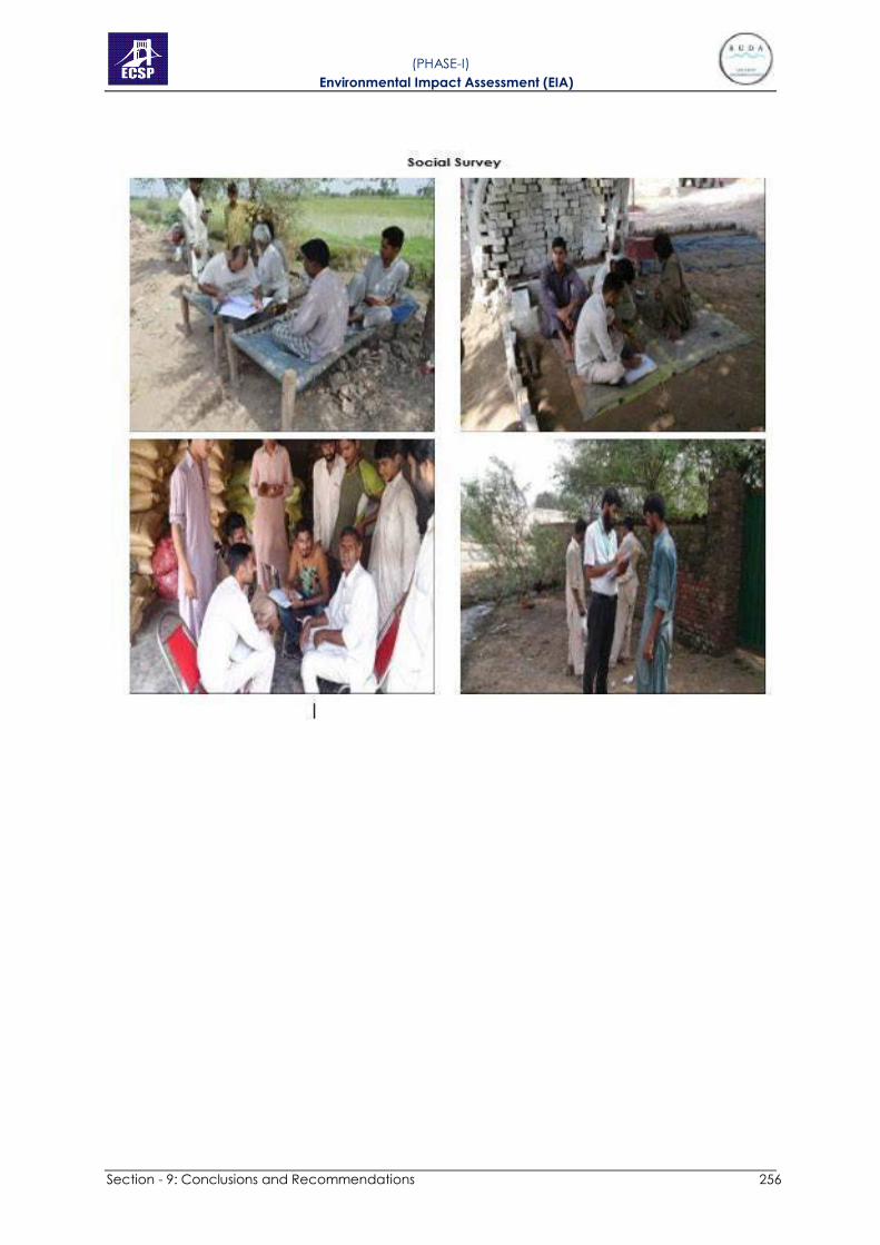
Section - 9: Conclusions and Recommendations 256
( PHASE-I) Environmental Impact Assessment (EIA)

Section - 9: Conclusions and Recommendations 257
( PHASE-I) Environmental Impact Assessment (EIA)

Section - 9: Conclusions and Recommendations 258
( PHASE-I) Environmental Impact Assessment (EIA)
APPENDIX 9:
ENVIRONMENTAL MONITORING REPORTS
(CONDUCTED BY EPA CERTIFIED LAB)
Section - 9: Conclusions and Recommendations 259
( PHASE-I) Environmental Impact Assessment (EIA)
APPENDIX 10:
ENVIRONMENTAL IMPACT MATRIX

Appendix 10 Project Impact Matrix Project Impact Matrix without Mitigation for Riverfront Ravi Urban Development Project
HA = High Adverse, MA = Medium Adverse, LA = Low Adverse, HB = High Beneficial, MB = Medium Beneficial, LB = Low Beneficial, O = None/Insignificance
Section - 9: Conclusions and Recommendations 253
( PHASE-I) Environmental Impact Assessment (EIA)

HA = High Adverse, MA = Medium Adverse, LA = Low Adverse, HB = High Beneficial, MB = Medium Beneficial, LB = Low Beneficial, O = None/Insignificance
Section - 9: Conclusions and Recommendations 254