environmental impact report kjm contractors pty ltd logistics support...
TRANSCRIPT

ENVIRONMENTAL IMPACT REPORT
KJM CONTRACTORS PTY LTD
LOGISTICS SUPPORT HUB, COOPER BASIN SA
Prepared for
KJM Contractors Pty Ltd
by
Fatchen Environmental Pty Ltd
Adelaide, September 2013
KJM-13-03
Author: TJ Fatchen
Rev. 4.3

KJM_Hub_EIR_v4-3.doc
K J M C o n t r a c t o r s L o g i s t i c s S u p p l y H u b E I R
CONTENTS
CONTENTS..................................................................................................................................................... 1
1. INTRODUCTION .................................................................................................................................. 1 1.1 SCOPE................................................................................................................................................ 1
1.1.1 KJM Contractors’ operations and general needs....................................................................... 1 1.1.2 Outline of proposed facility requirements................................................................................... 1 1.1.3 Location ..................................................................................................................................... 2
1.2 LEGISLATION....................................................................................................................................... 2 1.2.1 Petroleum and Geothermal Energy Act and Regulations 2000 ................................................. 2 1.2.2 Other Legislation........................................................................................................................ 4 1.2.3 Regional Reserves under the NPW Act..................................................................................... 4 1.2.4 Facility in relation to the EPBC Act ............................................................................................ 5 1.2.5 Facility in relation to the Native Vegetation Act.......................................................................... 5
2. SITE SELECTION ................................................................................................................................ 5 2.1 GENERAL SITE REQUIREMENTS ............................................................................................................ 5
2.1.1 Public road access..................................................................................................................... 5 2.1.2 Central to activities..................................................................................................................... 5 2.1.3 Air capable ................................................................................................................................. 5 2.1.4 Avoiding Innamincka as a Hub .................................................................................................. 6
2.2 LOCAL CONSTRAINTS ON SITE SELECTION............................................................................................. 6 2.2.1 Near-surface water available ..................................................................................................... 6 2.2.2 Not on an active floodplain......................................................................................................... 7 2.2.3 Not on gibber lands.................................................................................................................... 7 2.2.4 Good drainage ........................................................................................................................... 7 2.2.5 Minimising visual impact ............................................................................................................ 7 2.2.6 Entry and exit to public roads..................................................................................................... 7 2.2.7 “Brownfield” site preferences ..................................................................................................... 7
2.3 PRELIMINARY SURVEY LICENCE AREA .................................................................................................. 8 2.4 PREFERRED LOCATION ........................................................................................................................ 8
3. DESCRIPTION OF ACTIVITIES .......................................................................................................... 9 3.1 LOCATIONS ......................................................................................................................................... 9 3.2 EXISTING SPECIAL FACILITIES LICENCE ................................................................................................ 9 3.3 LOGISTICS SUPPORT HUB SUMMARY.................................................................................................. 10 3.4 CAMP ............................................................................................................................................... 11 3.5 TRANSPORTATION HUB AND SERVICE AREA......................................................................................... 12
3.5.1 Services provided .................................................................................................................... 12 3.5.2 Road and surface standard...................................................................................................... 12 3.5.3 Fuel, oil and chemical storage ................................................................................................. 12
3.6 LAYDOWN YARDS .............................................................................................................................. 13 3.7 ROADS ............................................................................................................................................. 13 3.8 WATER SUPPLY................................................................................................................................. 13 3.9 POWER SUPPLY ................................................................................................................................ 14 3.10 WASTEWATER DISPOSAL SYSTEM ...................................................................................................... 14 3.11 FENCING........................................................................................................................................... 15 3.12 BORROW SOURCES ........................................................................................................................... 15 3.13 AIRSTRIP .......................................................................................................................................... 16 3.14 VEHICLE MOVEMENTS........................................................................................................................ 16 3.15 MANNING .......................................................................................................................................... 17
4. SUMMARY OF ENVIRONMENT ....................................................................................................... 17 4.1 REGIONAL CONTEXT .......................................................................................................................... 17

KJM_Hub_EIR_v4-3.doc
K J M C o n t r a c t o r s L o g i s t i c s S u p p l y H u b E I R
4.1.1 Summary information sources ................................................................................................. 17 4.1.2 Regional land use .................................................................................................................... 17 4.1.3 Regional landform and soils..................................................................................................... 17 4.1.4 Regional vegetation and habitat............................................................................................... 18
4.2 PROPOSED SITE ................................................................................................................................ 18 4.2.1 Local landform, soils and surface hydrology............................................................................ 18 4.2.2 Vegetation and habitat ............................................................................................................. 19
4.3 FAUNA .............................................................................................................................................. 19 5. BIOLOGICAL SIGNIFICANCE........................................................................................................... 20
5.1 BIOPHYSICAL SIGNIFICANCE AND SENSITIVITY ..................................................................................... 20 5.2 ABSENCE OF RARE SPECIES............................................................................................................... 20 5.3 WILDERNESS .................................................................................................................................... 20
6. RISKS AND RISK MANAGEMENT ................................................................................................... 20 6.1 SUMMARY ......................................................................................................................................... 20 6.2 MAIN SOURCES OF RISK..................................................................................................................... 20
6.2.1 Risks to the biophysical environment....................................................................................... 20 6.2.2 Risks to the cultural environment............................................................................................. 21
6.3 ENVIRONMENTAL OBJECTIVES AND REPORTABLE INCIDENTS................................................................ 21 6.3.1 Environmental objectives ......................................................................................................... 21 6.3.2 Serious and reportable incidents ............................................................................................. 21
6.4 RISK MINIMISATION AND MANAGEMENT APPROACHES .......................................................................... 22 6.4.1 Codes, standards and regulations ........................................................................................... 22 6.4.2 Risk assessment procedures................................................................................................... 22 6.4.3 Emergency responses ............................................................................................................. 22 6.4.4 Responsibilities, inductions and training .................................................................................. 22
6.5 CONSULTATION ................................................................................................................................. 22 6.6 MANAGEMENT FOR SPECIFIC RISKS .................................................................................................... 23
6.6.1 Land clearance, alteration and vegetation removal ................................................................. 23 6.6.2 Pest plants and animals........................................................................................................... 24 6.6.3 Aboriginal heritage ................................................................................................................... 25 6.6.4 Non-indigenous heritage.......................................................................................................... 25 6.6.5 Visual impact............................................................................................................................ 25 6.6.6 Fuel storage and delivery failures ............................................................................................ 25 6.6.7 Fire protection and management ............................................................................................. 25 6.6.8 Waste handling ........................................................................................................................ 26 6.6.9 Community resources and safety ............................................................................................ 26 6.6.10 Wilderness values.................................................................................................................... 26 6.6.11 Native Vegetation Act application ............................................................................................ 27
6.7 GENERAL FIRE HAZARDS.................................................................................................................... 27 7. SITE CLEANUP AND REMEDIATION............................................................................................... 27
8. REFERENCES ................................................................................................................................... 28
9. FIGURES............................................................................................................................................ 43
10. APPENDIX: ENVIROFLOW WASTEWATER TREATMENT PLANT APPROVALS ....................... 67
11. APPENDIX: RESPONSES TO GOVERNMENT COMMENTS DURING CONSULTATION ON KJM LOGISTICS HUB EIR AND SEO, SEPTEMBER 2013................................................................................. 72

KJM_Hub_EIR_v4-3.doc
K J M C o n t r a c t o r s L o g i s t i c s S u p p l y H u b E I R
TABLES Table 1: Facility risks, impacts and management in relation to environmental objectives ............................29 Table 2: Species records from proposed Logistics Support Hub area, access and borrow … .....................41
FIGURES
Figure 1.1. Regional location of proposed Logistics Support Hub.................................................................43 Figure 1.2. Land systems map including the Cooper Basin ..........................................................................44 Figure 2.1 Spread and location of KJM Contractors client operations in SA Cooper Basin. .........................45 Figure 2.2 District topography and access. ...................................................................................................46 Figure 2.3. Physical constraints on site selection. .........................................................................................47 Figure 2.4 Detailed location of proposed logistic hub. ...................................................................................48 Figure 2.5 Aerial oblique of preferred site, looking south,. ............................................................................49 Figure 2.6 Aerial oblique of preferred site, looking west................................................................................50 Figure 2.7 Existing DPTI-controlled borrow pits and quarries near preferred site.........................................51 Figure 3.1 Indicative layout of Logistics Support Hub...................................................................................52 Figure 3.1a Detail of Stage 4 camp (maximum development). ...................................................................53 Figure 3.2. Standard transportable units in camp..........................................................................................54 Figure 3.3. Worrior oil haul road intersection with Moomba-Adelaide main road..........................................54 Figure 3.4. Existing clayed track crossing dune at entry to facility site. .........................................................55 Figure 3.5. Trailer mounted double-skinned avgas tank for aircraft refuelling ..............................................56 Figure 3.6. EnviroFlow sewerage treatment unit in operation .......................................................................56 Figure 3.7. Schematic of EnviroFlow sewerage treatment process. ..............................................................57 Figure 3.8. DPTI pits proposed for construction material subject to commercial arrangement. (May 2009) 58 Figure 3.9. Della Road quarry, a source for higher-quality road metal. (May 2009)......................................59 Figure 3.10. Della Airstrip as one of two possible strips for local access ......................................................59 Figure 4.1. Landform and vegetation at proposed site ...................................................................................60 Figure 4.2 Inundation map inferred from vegetation and surface drainage characteristics..........................61 Figure 4.3. General view of proposed site looking southerly (May 2009)......................................................62 Figure 4.4. Dead Limestone cassia Senna oligophylla. (May 2009).............................................................63 Figure 4.5. At lower western end of interdune and backslope, with more highly calcareous soil (May 2009)63 Figure 4.6. Local drainage channel on dune backslope. (May 2009) ...........................................................64 Figure 4.7. Broad wash on dune backslope/interdune at northern end of proposed facility area. ...............64 Figure 4.8. Looking westward on the edge of the dune footslope (May 2009) .............................................65 Figure 4.9. Drainage terminus for internally draining interdune to west of proposed site. (May 2009)..........65 Figure 4.10. 2012 growth on southern part of proposed site (KJM photo). ...................................................66 Figure 4.11. 2012 growth on main proposed camp area (KJM photo).. .......................................................66

KJM_Hub_EIR_v4-3.doc
K J M C o n t r a c t o r s L o g i s t i c s S u p p l y H u b E I R
ABBREVIATIONS ALRM Aboriginal Legal Rights Movement (pre-2010)
Bbl, bbl Barrel of oil, 1 Bbl=0.158987m3=158.987L
CAMBA China-Australia Migratory Bird Agreement
EIR Environmental Impact Report
DEWNR SA Department for Environment, Water and Natural Resources
DHA SA Department for Health and Ageing
DMITRE SA Department for Manufacturing, Innovation, Trade, Resources and Energy
DPTI Department of Planning, Transport and Infrastructure
SEO Statement of Environmental Objectives
DST Drill stem test (also IPT)
EIR Environmental Impact Report
EPA Environmental Protection Authority
EPBC (Act) Federal Environmental Protection and Biodiversity Conservation Act 1999
ERP Emergency Response Plan
HAZID Hazard identification process
HAZOP Hazardous operational procedure evaluation
HDPE High-density polyethylene
HS&E Health, Safety & Environmental
IPT Initial production test (also DST)
JAMBA Japan-Australia Migratory Bird Agreement
KJM KJM Contractors Pty Ltd
OH&S Occupational Health & Safety
PEL Petroleum Exploration Licence
PELA Petroleum Exploration Licence Application
PGE Petroleum & Geothermal Energy (Act)
PPL Petroleum Production Licence
PSL Preliminary Survey Licence
SANTS South Australian Native Title Services
SEB Significant Environmental Benefit (Native Vegetation Act)
SEO Statement of Environmental Objectives
SFL Special Facilities Licence

KJM_Hub_EIR_v4-3.doc
K J M C o n t r a c t o r s L o g i s t i c s S u p p l y H u b E I R
-1-
1. INTRODUCTION
1.1 Scope
This Environmental Impact Report (EIR) addresses the background, the environmental risks and the impacts associated with the proposed development of a Logistics Support Hub for contractor servicing of petroleum exploration, development, production and ancillary services in the Cooper Basin, SA. KJM Contractors Pty Ltd (KJM) proposes the development via Special Facilities Licence No. 2 (SFL2) under the Petroleum and Geothermal Energy Act 2000 and Petroleum and Geothermal Energy Regulations 2000, as amended May 2009.
Environmental site survey and preparation of earlier revisions of this EIR were undertaken in 2009, but the proposed development was not then further pursued, in a period of downturn in the SA Cooper Basin in a very wet period combined with the aftermath of the global financial crisis affecting most smaller oil, gas and geothermal exploration and operations. The earlier drafts have been updated here to meet changed legislation and regulatory requirements.
There have been no substantive changes in environmental issues since 2009: accordingly, no further survey has been warranted, and subsequent site checks both by KJM and Fatchen Environmental since 2009 have been informal only.
1.1.1 KJM Contractors’ operations and general needs
KJM is an established major provider of logistical and support services to petroleum and geothermal exploration and development industries in Australia, particularly in the Cooper Basin. Within the SA Cooper Basin it has provided logistics support, particularly in transport and camp provision: to explorers and producers including Acer Energy, Senex, Beach Petroleum, Santos, Holloman, Drill Search, Terex Seismic, Geodynamics, Western GECO, NACAP, AGL, Drillsearch; to drilling and other exploration contractors including Halliburton, Weatherford Drilling, Ensign; to other transport and haulage contractors as well as local transport for Innamincka township and local Stations
KJM requires a facility with a degree of permanency. KJM have been operating in the Cooper Basin for 14 years, and much of the client base has been dealing with KJM throughout. Whilst there continues to be exploration and development for conventional oil and gas, Coal Seam Methane (CSM), deep tight gas, geothermal exploration, and pipeline and other infrastructure, there will be a continuing demand for services.
KJM also requires a degree of control and certainty over its own base of operations. KJM’s general camp and base was initially associated with geothermal exploration at Habanero geothermal field (Geodynamics Ltd), and was operated under relevant SEOs governing Geodynamics’ general operations, with the ultimate control dependent on Geodynamics, not KJM. In May 2009, Geodynamics required the removal of KJM’s existing facilities.
From Geodynamics, KJM moved to the Senex Growler Field Facility, followed by a further shift to Tantanna, as a base camp for Senex and Beach Energy operations. With the completion of the Growler pipelines (2012), KJM has again been required to remove. The availability of Special Facilities Licence provisions of the Petroleum & Geothermal Energy Act allows a shift from this “grace and favour” situation for contractors who, whilst serving multiple exploration and production operators, have not previously been able to operate without provision by one or other of the existing operators under the preceding Petroleum Act 2000.
1.1.2 Outline of proposed facility requirements
The Logistics Support Hub is proposed with the following main requirements:
• Rational location in relation to spread of operations in the Cooper Basin
• All-weather access locally, to and from a major public road, engineered to accept road trains up to and including triples
KJM_Hub_EIR_v4-3.doc
K J M C o n t r a c t o r s L o g i s t i c s S u p p l y H u b E I R
-2-
• A camp to a maximum 150-bed size, and associated infrastructure including local water supply and power generation
• A transportation service hub including road train turnaround, parking, standing, refueling, maintenance, loading/unloading/transfer and goods temporary storage, with an associated fuel/oil/lubricant facility
• A general purposes workshop including a welding bay for repair work
• Waste management and transfer systems handling all of the preceding
• Laydown and storage yards capable of transportation storage, from spare camp buildings through larger plant up to major rig laydowns.
• Ancillary access roads and borrow pits will be required for the proposed facility (refer section 3.2).
The indicative total area actually developed, including the access road, would be some 15ha.
Not proposed as part of the Logistics Support Hub, but a factor in its proposed location, is close-proximity access to an airstrip in the district which can be used for both crew change flights and emergency flights: in the district, such strips exist near Della Satellite Plant and at Innamincka Township.
1.1.3 Location
The facility is proposed to be located between Della Satellite Plant and Innamincka Township (Figure 1.1), central to the spread of both petroleum/geothermal activities in the Cooper Basin other than those of Santos (centred around Moomba), and central to the spread of KJM’s client base, which includes the Queensland portion of the Cooper Basin. The Hub is proposed for a non-flooding portion of the Strzelecki Land System, utilizing an interdune in the Della dunefield (Figure 1.2). It lies outside the boundaries defining the areas of the Coongie Lakes Wetlands of International Importance under the 1971 Ramsar Convention. Parts of regional access lie within this area, in particular Innamincka township (Figure 1.1).
1.2 Legislation
1.2.1 Petroleum and Geothermal Energy Act and Regulations 2000
The Petroleum and Geothermal Energy Act 2000 governs petroleum production and related activities. Its key objectives are
• Protection of the natural, cultural, heritage and social aspects of the environment from risks associated with petroleum activities
• Providing for consultation with stakeholders and effective reporting of performance, and
• Providing security of title
Special Facilities Licence
A Special Facilities Licence under the Petroleum and Geothermal Energy Act 2000 is intended for situations where activities are sought and appropriate, without the licensee necessarily holding a Petroleum Exploration Licence (PEL) or Petroleum Production Licence (PPL). Under the prior Petroleum Act 2000, support contractors such as KJM had operated (and can still operate) within areas defined by exploration or production licence holders, and either under the Statements of Environmental Objectives (SEO) applying to those explorers/producers, or in the case of operations at Moomba and other long-established Santos Ltd areas, under prior arrangements.
Operations under a Special Facilities Licence, as with other Petroleum and Geothermal Energy Act licences, are activities which require an Environmental Impact Report (EIR) and the development of a Statement of Environmental Objectivities (SEO). An Environmental Impact Report (EIR) provides an environmental description, a risk assessment, the basis for

KJM_Hub_EIR_v4-3.doc
K J M C o n t r a c t o r s L o g i s t i c s S u p p l y H u b E I R
-3-
environmental compliance, and the basis for a Statement of Environmental Objectives (SEO), as required under Section 97 of the South Australian Petroleum and Geothermal Energy Act 2000 (“Petroleum and Geothermal Energy Act”) and Regulation 10 of the Petroleum and Geothermal Energy Regulations 2000.
Statement of Environmental Objectives
Part 12 of the Act requires that an approved Statement of Environmental Objectives (SEO) must be in place before a regulated activity can be conducted.
There is no EIR/SEO covering a stand-alone facility of the sort proposed. All existing SEOs assume a camp, workshop, roading, transport and storage as being integral with a petroleum operator’s exploration or production. Ancillary facilities at Moomba are a “previous arrangements” special case. KJM is producing a SEO on the basis of this EIR and consultations.
All present KJM activities are undertaken under various Cooper Basin SEOs, dependent on the nature of the associated petroleum activity (seismic, exploration drilling, petroleum production) and the holder of the particular exploration, retention or production licence. In all these situations, the licensee is ultimately responsible for contractors’ operations, including KJM where KJM is a contractor.
Under the proposed KJM SEO, KJM would carry direct responsibility both for fulfilling environmental objectives and meeting Petroleum and Geothermal Energy Act requirements.
Environmental Impact Report
Section 97 of the Act requires an EIR to:
• Take into account cultural, amenity and other values of Aboriginal and other Australians insofar as those values are relevant to the assessment [s97(2)(a)]
• Take into account risks inherent in the regulated activities to the health and safety of the public [s97(2)(b)]
• Contain sufficient information to make possible an informed assessment of the likely impact of activities on the environment [s97(2)(c)]
• A justified assessment of the consequences of the preceding, considering the extent to which they can be managed, actions proposed, and the duration [s97(2)(d)]
• Information on landowners [s97(2)(e)], and on consultation with landowners, Aboriginal groups or representatives, agency or instrumentality of the Crown, any interested parties. [s97(2)(f)]
Regulation 10 outlines the information to be provided in an EIR. In summary:
• Description and location of activities to be carried out under the licence
• Description of specific site features of the environment that can reasonably be expected to be affected by activities
• Assessment of the cultural values of Aboriginal and other Australians that can reasonably be expected to be affected by activities
• Identification and assessment of foreseeable environmental hazards potentially associated with construction, operation, abandonment and atypical events
• Assessment of potential consequences of hazards to the environment, their extent, duration and mitigation
• The basis on which consequences of hazards have been predicted
• Information on consultation undertaken during preparation of the EIR.

KJM_Hub_EIR_v4-3.doc
K J M C o n t r a c t o r s L o g i s t i c s S u p p l y H u b E I R
-4-
Assessment and Approval
SA Department for Manufacturing, Innovation, Trade, Resources and Energy (DMITRE) assesses the EIR and SEO to determine whether the activities are to be classified as low, medium or high impact. The level of consultation required prior to final approval of the SEO is then determined:
• Low impact activities: do not require public consultation, SEO approved after internal government approval
• Medium impact activities: public consultation process, including a 30-day comment period.
• High impact activities: assessed under Development Act 1993 provisions
1.2.2 Other Legislation
The following Acts may apply and require additional approvals.
Environment Protection and Biodiversity Conservation Act 1999
Commonwealth Assessment and approval needed if activities significantly impact:
Ramsar wetlands of international importance (see below)
Listed threatened species and communities
Listed migratory species
Native Title Act 1993 Commonwealth Intersection of registered Native Title claims
Environment Protection Act 1993
SA Environment Protection Authority General duty of avoidance of environmental harm
Landfill issues
Handling, transport of prescribed wastes
Storage of fuels
Aboriginal Heritage Act 1988 SA Aboriginal heritage Committee Aboriginal site clearance permissions
Heritage Places Act 1993 SA Department for Environment, Water and Natural Resources
Permissions to disturb archaeological sites
Mining Act 1971 SA Department for Manufacturing, Innovation, Trade, Resources and Energy
Quarries, extractive
Natural Resource Management Act 2004
SA Department for Environment, Water and Natural Resources
General natural resource management issues
Native Vegetation Act 1991 Clearing native vegetation
National Parks and Wildlife Act 1972
Regulated activities undertaken in Regional Reserves
Water Resources Act 1997
SA Department for Environment, Water and Natural Resources
Sourcing water, disposal of water
Public & Environmental Health Act 1987
SA Department for Health and Ageing General health issues. Camp operation is also governed by other Acts administered by SA Department for Health and Ageing (eg Food Act 2001)
Wilderness Protection Act 1992
SA Department for Environment, Water and Natural Resources
Direction to restore to wilderness condition
1.2.3 Regional Reserves under the NPW Act
As discussed in Section 2 (below), the preferred site for the facility will fall within the Innamincka Regional Reserve (Figure 1.1), a reserve under the National Parks and Wildlife Act 1972, with Section 43 providing for licensing of petroleum activities. The area is under domestic stocking: pastoral activities are provided for under leases issued pursuant to the Act.

KJM_Hub_EIR_v4-3.doc
K J M C o n t r a c t o r s L o g i s t i c s S u p p l y H u b E I R
-5-
1.2.4 Facility in relation to the EPBC Act
The preferred site lies outside the nominal boundaries of the Ramsar Wetlands of International Importance (Figure 1.1), and hence is unlikely to require any referral to or approval under the Federal Environmental Protection and Biodiversity Conservation Act 1999 (EPBC Act). Our opinion is that the SA Petroleum and Geothermal Energy Act EIR and SEO process meets the requirements of the EPBC Act in the event of other issues arising, for example presence of endangered species.
1.2.5 Facility in relation to the Native Vegetation Act
The proposed facility and its roads is effectively a permanent operation, in the same manner and on the same scale as, for example, a medium-sized petroleum production facility (eg Della, Worrior and their associated infrastructure). As such, a Significant Environmental Benefit (SEB) under Section 21(6) of the Native Vegetation Act must accrue.
As the region is all native vegetation other than developed sites such as Moomba township and main arterial roads, the removal of native vegetation for construction and operation of the facility will necessarily require work or payment to the Native Vegetation Fund to achieve an SEB.
2. SITE SELECTION
2.1 General site requirements
2.1.1 Public road access
The Logistics Support Hub needs to be immediately accessible from the main road system. This immediately reduces potential sites to areas along the Moomba-Adelaide road, the Moomba-Della-Daralingie road, Dillon’s Highway (all variously known incorrectly as the “Strzelecki Track”), which carry most of the incoming and outgoing traffic of the SA Cooper Basin. Minor alternative possibilities are along the Innamincka-Queensland road, or the southern portions of the Innamincka-Cordillo Downs road, both of which carry a much lesser traffic than the Strzelecki Track series.
Part of the purpose of the Hub is to provide alternatives for other road contractors using the through roads, as well as directly for KJM company activities. There is little point in placing a hub far away from the main traffic routes. Also, being close to the main access requires less new road construction or existing track expansion to service the Hub. Unlike an oil discovery, the Hub can move to the access, not the other way around.
2.1.2 Central to activities
The Hub needs to be placed central to the spread of KJM operations, South Australian examples of which are mapped in Figure 2.1, but which also extends into Queensland. It currently can take up to eight hours at 60-80km/hr on public roads to cross KJM’s current client base, and a relatively central location on main public access is significant in reducing travel time costs, both operating costs and environmental costs. The location does need to be south of the frequently interrupted Innamincka Causeway. Flooding over the causeway requires a detour of 160km to get from one side to the other. Although some of KJM’s client base is north of the causeway and would necessitate that detour, the major part of client base and petroleum and geothermal activities is currently east, south and west.
Moomba is further south than desirable but also is directly controlled by Santos and prevents autonomy of operation for KJM. We understand that KJM has sought but failed to get yard facilities in Moomba.
2.1.3 Air capable
Commuter aircraft are regularly used by KJM for crew changes and urgent equipment deliveries. The Logistics Support Hub as proposed does not require an airstrip, provided there exist district

KJM_Hub_EIR_v4-3.doc
K J M C o n t r a c t o r s L o g i s t i c s S u p p l y H u b E I R
-6-
airstrips which can be accessed reasonably quickly from the hub (for people ferrying, and refuelling commuter aircraft).
There are existing high quality airstrips at Della (unsealed, recently upgraded and resurfaced) and Moomba (main strip for the region, sealed, but well away from the central location sought for the Hub). Innamincka Station strip (unsealed) suffers from being cut off whenever the Cooper is flowing moderately over the ford. Innamincka township strip, south of the ford, is short where commuter planes are being used. We understand that there is the possibility of a strip eventually appearing for the geothermal development at Habanero.
Either the Della strip or a future strip near Habanero, or the strip at Innamincka for aircraft where strip length is not at issue, would reasonably fulfil proximity needs in a central location. Access to the strips would depend on commercial arrangements outside the operation of the Hub and not linked to the SFL.
2.1.4 Avoiding Innamincka as a Hub
KJM considers that the Hub, while needing a central location, should still be placed far enough from Innamincka not to threaten tourism, recognising the iconic status of Innamincka, with the multiple strands of the Burke and Will legend, Flynn of the Inland/Australian Inland Mission and the Flying Doctor heritage.
Innamincka township was considered in early planning but is not proposed for a multiple of reasons:
• The Logistics Support Hub would be a non-complying development in Innamincka township (Regulation 16, Development Regulations 2008).
• The strong industrial aspect of the Hub would conflict with the purposes of Innamincka under the management plan for the Innamincka Regional Reserve.
• Tourism is Innamincka’s main business: as KJM have their own camps for contractors and customers KJM may seem to be competing against them for the tourism dollar. KJM do not want to be perceived as taking business from the township.
• Innamincka is classified as a historical township and a Hub might impair either the significance or the historical experience of this region. This includes the Burke and Wills and AIM considerations above.
• The current township, not including its airstrip, occupies only some 20 ha. Less than half of this area is built, under road, or otherwise developed. Although there is minor industrial and transportation yarding associated with Innamincka earthmoving, a proposed facility of the size and nature of the Hub would be totally out of scale as well as out of keeping with the iconic nature of the town.
2.2 Local constraints on site selection
Within the preceding general constraints on where the Hub might be placed, are the following more local issues.
2.2.1 Near-surface water available
The maintenance of a large camp requires water. Cartage from remote locations (Moomba, various road bores), whilst always possible where local supplies fail during drought or where a top-up is needed in a peak period, becomes an unsatisfactory makeshift for a permanent operation. Accordingly, the site needs to be in an area with reasonable shallow groundwater (unconfined rainfall-recharge aquifers). Road bores along the Dillon’s Highway and some pastoral bores utilise such water sources, and ideally the Hub would be sited at one such source. There is no intention to sink a petroleum-standard deep well into GAB aquifers.
To access bore water, KJM would be required to apply for a water allocation though DEWNR under the Natural Resource Management Act 2004, as activities associated with a Special

KJM_Hub_EIR_v4-3.doc
K J M C o n t r a c t o r s L o g i s t i c s S u p p l y H u b E I R
-7-
Facilities Licence would be classified as production. A water licence is also required to drill a water well.
2.2.2 Not on an active floodplain
Much of the region is subject to intermittent stream-fed flooding. At its extreme, as in 1974 when all of Moomba was underwater, road access may be out for months and operations would necessarily shut down. Less extreme, however, is where heavy rains and/or major flows down Cooper Creek result in active floodplains temporarily flooding and roads being cut. Being out of an active floodplain allows the Hub to continue functioning, avoids flood damage and still allows road access to unflooded areas. The need to avoid active floodplains eliminates possible sites between the western edge of dunefields at Della and the Moomba area, most of this stretch being Strzelecki Creek.
This constraint, when combined with the more general requirements already discussed, effectively means that reasonable site options fall within the Innamincka Regional Reserve, rather than outside it.
2.2.3 Not on gibber lands
Gibber areas present some simplicity for siting but are highly visible, are very difficult to rehabilitate at the eventual end of the life of the Hub, and are highly susceptible to water erosion following any disturbance. Especially, disposal of stormwater from the Hub on a gibber landscape would carry major dangers of creating the accelerated erosion patterns so clearly evident along Dillon’s Highway approaching Innamincka township, where discharge drains are creating badlands.
2.2.4 Good drainage
A site needs to have good local drainage: not to be in an area with local inundation every time it rains, and also not to have issues of redirection of local water flows.
Generally, to avoid inundation especially from the normal summer thunderstorms, sandier sites are preferable to clay sites, as the latter are normally at the lowest interdune levels and generally the local water termini.
2.2.5 Minimising visual impact
Placement close to major public roads will detract from visitor experiences if the development is not by and large out of sight. The selected site needs to provide screening, whether by topography or vegetation or both, to reduce obtrusiveness.
2.2.6 Entry and exit to public roads
A transport hub means road trains slowing down and turning off, or turning onto a major road. Apart from immediate engineering of intersections, long sightlines at the intersections are necessary for safety. In dunefields, long stretches with uninterrupted sightlines are not present on all stretches of main roads, and this reduces the number of possible access points
2.2.7 “Brownfield” site preferences
The expansion of existing access, use of already disturbed camp or other facility areas, and of already existing borrow areas are all preferable to creating wholly new impacts. Although there are few strictly “brownfield” areas other than unrehabilitated borrow sites—former camps associated with the construction of Dillon’s Highway in the 1990s have largely self-rehabilitated or have been actively rehabilitated—nevertheless previous issues being equal, a site and access with prior impact is preferred to otherwise intact dunefield.

KJM_Hub_EIR_v4-3.doc
K J M C o n t r a c t o r s L o g i s t i c s S u p p l y H u b E I R
-8-
2.3 Preliminary Survey Licence area
All the preceding point to the dunefield or dunefield edges between Innamincka and Della. Accordingly, KJM applied for and was granted a Preliminary Survey Licence (PSL 20) extending south in a belt from Innamincka to Della Satellite Plant, which was part overflown and part inspected via existing roads on the ground in 2008/2009.
Constraints in relation to flooding and gibber landscapes are indicated in Figure 2.3. The PSL was not sought to extend west, as lands are floodouts or floodcourses of Strzelecki Creek, as discussed in Section 2.2 above.
2.4 Preferred location
Multiple interdunes adjoining Dillons Highway toward Della Satellite Station provide reasonable alternative siting for a Logistics Support Hub, particularly:
• Generally central to activities and clients
• Placement close to but out of sight of main roads
• With rain, access can remain open up to the point where all main roads are shut down anyway
• Absence of major flooding
• Absence of gibber areas
Interdune areas still have issues of local inundation following rain, especially thunderstorms, which was a major determinant in the detailed positioning of the Dillon’s Highway carriageway (TJ Fatchen pers. comm., from original detailed roadway selection).
Figures 2.4 and 2.5 show low-level aerial views of Site A. The proposed site is on a sandy interdune, has a large enough interdune to avoid inundating areas, with reasonable soil drainage. There is reasonable freedom to orient the proposed development even allowing for heritage and/or other environmental issues which might require local avoidance or mitigation. The sandy interdune will however require clay and road metal borrow to stabilise sandier surfaces.
Figure 2.7 shows DPTI-controlled borrow pits and quarries at Site B1 together with part of the clay interdune. This interdune was also considered as a possible Hub site, but would be inundated and impassable in rain. It is also not large enough to allow flexibility of placement to reduce the problem, even though its use would significantly reduce borrow requirements because of the clay substrate.
Further reasons for preference for Site A include
• Sufficiently distant from Innamincka to avoid interfering with the township operation
• Access already present: expansion but not new development
• Room for adequate intersection engineering, and long intersection sightlines to reduce public risk
• Part of the site has been used for camps, partially disturbed
• Known water supply with one bore present and used for construction of Dillon’s Highway
• Borrow availability without creating new quarry operations
•• Within close reach by main road of district airstrips at Della and Innamincka.
1 The DPTI-controlled pits are one preferred source for the bulk of road-sheeting and Hub construction road metal: it is understood that KJM Contractors will seek a commercial arrangement with the pit management for at least part borrow requirements for Site A.
KJM_Hub_EIR_v4-3.doc
K J M C o n t r a c t o r s L o g i s t i c s S u p p l y H u b E I R
-9-
3. DESCRIPTION OF ACTIVITIES
3.1 Locations
Site locations for the facility and ancillary areas including borrow are proposed as follows (Figures 2.2, 2.3):
Component (GDA) Easting Northing Comment
Logistics Support Hub 54J 472099 6901323 Point location given is the existing water well from previous camp operations
Gravel and clay borrow pits on 3 Queens road
54J 473174 6901267 Existing open pit to be included in an extended SFL (Section 3.2) to provide initial, interim and maintenance borrow
DPTI Dillons Highway pits and quarry
54J 473255 6899205 Central location for existing pits. These pits are proposed as the main borrow source for major construction
Della road quarry 54J 462508 6892531 Probable source of topdressing for roads, transport hardstands.
Airstrips are available at Della and at Innamincka township
All sites are within the Innamincka Regional Reserve but outside the nominal Ramsar Wetlands area (Figure 1.1), in dunefield without connection to the Strzelecki and Cooper Creek systems.
3.2 Existing Special Facilities Licence
KJM holds Special Facilities Licence SFL2 over 42ha (Figure 2.4), in which the transportation hub will be developed:
NW corner 28° 00’ 19’’S 140° 42’ 46”E
NE corner 28° 00’ 19”S 140° 43’ 01”E
SW corner 28° 00’ 52”S 140° 42’ 46” E
SE corner 28° 00’ 52”S 140° 43’ 01”E
The SFL licence area is intended to be extended, to permit direct Petroleum and Geothermal Energy Act regulation of the access road and a now-proposed ancillary borrow supply, which were not originally envisaged as part of the hub development.
The additional area which will be sought, of approximately 31ha, allows access road construction including the necessarily extensive T-junction with Dillons Highway, and a short access to nearby borrow and the borrow area itself (Figure 2.4). A large area is indicated about the maintenance borrow pit to ensure borrow can be taken >100m away from the existing track, in conformity with DMITRE guidelines and the proposed SEO, and that borrow can still be located within that area.

KJM_Hub_EIR_v4-3.doc
K J M C o n t r a c t o r s L o g i s t i c s S u p p l y H u b E I R
-10-
The current proposed co-ordinates, in linear order, are:
SE corner SFL2 28° 00’ 52”S 140° 43’ 01”E
Corridor start 28° 00’ 45”s 140° 43’ 01”E
Dillons Hwy Nth 28° 00’ 41”S 140° 43’ 22”E
North line peg 28° 00’ 41”S 140° 43’ 34”E
NE borrow corner 28° 00’ 41”S 140° 43’ 44”E
SE borrow corner 28° 00’ 57”S 140° 43’ 44”E
SW borrow corner 28° 00’ 57”S 140° 43’ 34”E
Corner 28° 00’ 47”S 140° 43’ 34’E
Dillons Hwy Sth 28° 00’ 47”S 140° 43’ 22”E
SE corner SFL2 28° 00’ 52”S 140° 43’ 01”E
3.3 Logistics Support Hub summary
An indicative layout of the Hub is given in Figure 3.1. The main components are:
• A camp, to an eventual 150-bed maximum
• A transportation hub including standing, refueling, servicing and a general fabricating workshop
• Lay-down yards capable of taking storage ranging from trailers and individual camp units to full size oil rig lay-ups.
Supporting infrastructure includes
• Main access road and internal roading
• Water supply
• Power supply
• Wastewater disposal system
• Perimeter stock-proof fencing
• Borrow source and local access
The total developed area occupied in a fully developed hub based on Figure 3.1 is some 15ha, with the area division approximately:
Roads including access from highway 4ha
Transportation area and workshop 2ha
Camp 1ha
Laydown yards 7ha
Sundry (water disposal, service easements)
1ha
Depending on detail of location of stock-proof fencing about the facility, and on detailed placement of individual components which itself may be affected by heritage clearance requirements, the enclosed area including land not developed would be approximately double or more the developed area. Heritage Work Area clearances on the current SFL2 licence were undertaken in 2013, and have not required modification of current designs.

KJM_Hub_EIR_v4-3.doc
K J M C o n t r a c t o r s L o g i s t i c s S u p p l y H u b E I R
-11-
The total developed area for using the existing local borrow source is some 5ha: including the existing road access and the existing pit:
Borrow development and service access
5ha
3.4 Camp
Camp facilities are proposed to cope with up to 150 persons, for use of KJM, clients and subcontractors associated with petroleum, geothermal and transport operations in the Cooper Basin. The size is set as a reasonable upper limit to foreseeable activity in the Basin, particularly increasing coal seam methane, deep tight gas and geothermal development but also a likely return to similarly intensive petroleum exploration as in the period 2003-2008. Inevitably, in a depressed period with minimal activity, as from 2009 to recently, the size is in excess of immediate requirements. Further, the full camp size may not be reached in the immediate future, but as the size of the camp significantly affects supporting infrastructure, the camp is planned on a not-unreasonable assumption of future growth in the basin.
The camp will be modular, using KJM Modular transportable units laid directly onto the ground surface, with raised transportable walkways (Figure 3.2). At least part of the accommodation units will contain en-suite or shared ablutions/WC, additional to ablutions facilities for unserviced rooms. Ablutions facilities will include a dedicated female ablution block.
The camp will also comprise:
• Offices
• Kitchen with associated refrigerated and non refrigerated stores
• Wet Mess
• Recreation room
• Laundry
Some 10 transportable units would be needed for messes, laundry, kitchen and other support. Accommodation units accommodate 4 people. The initial establishment would be some 20 units in total. For a full 150 person camp, between 50 and 60 units would be required: Figure 3.1 shows 50 units.
Pipes and conduits for services (communications, electricity, potable water and sewerage) can be surface-laid under units and walkways; some trenching however will be needed for under roadways and for delivery beyond the camp.
The total area of a 150-person camp and associated sheeted areas (roadways, parking) is approximately 1ha. The slope of the site generally is under 1%, and camp placement would require only minor earthworks for levelling: graded for removal of local bumps and irregularities, then watered and rolled to firm pack for camp erection. The modular nature of the camp allows some of the very gentle slope of the site to be kept for dispersal of stormwater.
Most of the area will not require clay or metal capping or sheeting, as the units can be placed on bearers and do not require strong foundations. Road access, vehicle parking and a perimeter will require clay or metal sheeting on the clayey sand ground surface, to take vehicle loads and constant foot traffic.
The modular nature of the camp allows some of the very gentle slope of the site to be kept for dispersal of stormwater. Stormwater from the site would be directed either to areas which flow in thunderstorms (Figure 3.1) or directly by drain to the western low points of the interdune which frequently inundate from local runoff.

KJM_Hub_EIR_v4-3.doc
K J M C o n t r a c t o r s L o g i s t i c s S u p p l y H u b E I R
-12-
As indicated in Figure 3.1, the campsite will be separated from all transportation operating areas, both for safety and for amenity of workers living in camp.
3.5 Transportation hub and service area
3.5.1 Services provided
An area of approximately 2ha is proposed for the transportation hub. The area is intended to allow
• road train standing
• sufficient room for turning up to triple road trains
• clear access vehicle refuelling
• maintenance workshop and store area providing
• approximately 1000m2 under shed cover (50m x 20m)
• palletised storage
• vehicle maintenance bays for prime movers including pits
• welding and fabrication workshop for maintenance (not for significant construction or fabrication)
3.5.2 Road and surface standard
Because of the heavy vehicle loading and constant use, the whole transportation hub area will need road-quality engineering. Construction will require some excavation of sand, for construction of hardstanding basement through imported clay and metal from the existing borrow pits, with thorough compaction. Surfacing over much of the area should be with road metal: the local pits are unlikely to provide the quality sought and material is intended to be sourced from the Della Road quarry (Figure 2.2).
The workshop and store area will be concrete floored, with concrete aprons as bunding for potential spills around the store.
3.5.3 Fuel, oil and chemical storage
Storage for fuel, oil, coolants etc will be in double-bunded areas. Bunds will be provided with tanks—as Individually Bunded Containers (IBCs)-- and perimeter bunding set up around storage areas as a secondary safeguard. Fuel storage (diesel) will be in a 100kL tank, provided with its own steel transportable bund of 120% capacity set on the sheeted pad. Installation and removal of individual tanks will be by crane movement, not skidded. Smaller units will use portable steel or HDPE bunds, depending on material.
Construction and operation of the storage tanks, tanker delivery, refilling, and fuelling provisions will be in accordance with AS1940 (The Storage and Handling of Flammable and Combustible Liquids). All installations will be earthed to earthing stakes in accordance with AS3000 (Wiring Rules). Truck refuelling will be on concreted pads with internal stormwater drainage to a sump provided with an oil trap. Oily water will be pumped out and, as with other oily wastes including sump oils, returned for disposal to Adelaide (current arrangements) or Moomba if facilities are available.
Aircraft refuelling, remotely at whichever airstrip is used to service the facility, will be from a double-skinned trailer-mounted tank (Figure 3.5), based at the facility and transported to the airstrip on an as-needed basis. This is the current mode for KJM refuelling at Innamincka town strip also.

KJM_Hub_EIR_v4-3.doc
K J M C o n t r a c t o r s L o g i s t i c s S u p p l y H u b E I R
-13-
3.6 Laydown yards
A variety of yards are indicated in Figure 3.1. The large 3ha yard is proposed for rig laydown, capable of taking one to three large petroleum rigs depending on size, or multiple small rigs. Very large rigs, such as those currently drilling the deep geothermal wells, need some 2 ha for storage. Other yards may be used for other storage, for example stored camp units of contractors or operators, machinery, trailers, large equipment. It is likely that individual yards will from time to time be actively occupied by other contractors, with minor office and workshop but not living accommodation. In these circumstances KJM would remain the responsible overall operator. Local yard office and workshop would connect with the overall facility infrastructure including power, water and sewage disposal.
Laydown yards will need areas of clay or metal sheeting, for internal access and for heavy use or heavy standing area. It is not proposed to sheet yards any more than is needed at any given time although over a span of decades it is possible that the entire area will end up with sheeting. Sheeting will be limited to that necessary, both in terms of sheeting depth and when sheeting is applied. It is not proposed to sheet the whole eventual area at the beginning of development.
Yards will be internally fenced to define and separate each from the other.
3.7 Roads
The main access from Dillons Highway to the facility needs to safely carry road trains up to triple unit combinations, allowing both safe passing on the access and safe entry to the main road. For crossing the dune, an easement of 25m batter to batter is proposed, with a 20m carriageway, partly because of sight lines associated with crossing the dune between Dillons Highway and the facility, but also to allow simple entry and exit of oversize loads, as in rig moves. The carriageway width is equivalent to that of Dillons Highway at the takeoff point, and the Adelaide Road at the similarly engineered intersection of the Worrior oil haul road, the most recent new heavy vehicle entry to public roads in the district (Figure 3.3).
The 20m carriageway for the dune crossing will require widening of the existing track (Figure 3.4). The main access will require some ramping to reduce gradients over the first dune.
The remainder of the existing access to the proposed facility site, and the internal link servicing the laydown bays, the camp and the vehicle hub and maintenance area can be a 15m easement, still allowing road train access to the laydowns without safety issues.
Roads will need a clay sub-base and preferably dolomite or composite top sheeting for the heavy vehicle loads envisaged: construction will be similar to that of Dillons Highway.
Internal roading, for example stub tracks and hardstand areas into laydown bays, can be constructed with a clay or clay and metal sheeting. An all-weather surface is sought between the transportation hub and the camp. Access to the Dillons Highway is intended to be at the same level of wet weather tolerance as the main road.
3.8 Water supply
For a camp at maximum size and full capacity, the 150 beds would require a daily water total of 35kL (approx. 220 Bbl, requiring one double road train/day). Water requirements are based on 230L/person/day, assuming shared en-suite facilities. Accordingly, the known presence of reachable water is one of the reasons for selecting the preferred site. There is an existing bore, sunk into near surface (rainfall recharged) unconfined aquifers for construction of Dillons Highway. Extended drought to 2009 lowered the water table and the bore is currently dry, but the intention is to reinstate and deepen it.
It is likely, however, that additional local bores on the SFL2 and/or the proposed extensions will be needed if the camp grows to the indicated maximum size. KJM would be required to apply for a water allocation though DEWNR under the Natural Resource Management Act 2004, as activities associated with a Special Facilities Licence would be classified as production. A water

KJM_Hub_EIR_v4-3.doc
K J M C o n t r a c t o r s L o g i s t i c s S u p p l y H u b E I R
-14-
licence is also required to drill a water well. Additional water bore licences will be sought through DEWNR. Aquifer monitoring and management requirements would be determined as part of the water licences and are accordingly not further examined in this EIR.
Bores would be driven by submersible electric pump to 30kL holding tanks. It is likely that bore water in this area will be of adequate quality for washing, ablutions and other uses not requiring potable water. In this case, only part of the bore water stream would be treated for the production of potable water. Bore water would be pumped to a central reverse osmosis (RO) plant to produce potable water for the camp and transportation hub. Brines from the potable water RO plant can be disposed diluted with the much larger wastewater stream.
Water delivery from bores to facilities and the RO potable water plant, and reticulation throughout the camp, transportation hub and any serviced laydowns will usually be through trenched water pipeline. Emergency water supplies, drought supplies if the aquifer management requires a temporary cessation of use, and initial supplies before the bore(s) comes into use, can be trucked from Moomba or other public bores.
3.9 Power supply
Power will be supplied by two 200kVA or 250kVA container mounted diesel-powered generators (gensets), one at the camp and the other at the maintenance area, feeding into a common grid. Although overhead power distribution may be used in places, the trunk cables between the transportation hub and the camp will be undergrounded to minimise the risk of overhead collision with large trucks and oversize loads.
3.10 Wastewater disposal system
Wastewater treatment and disposal will be via a product approved aerated wastewater treatment system and be disposed of in accordance with the South Australian Public Health (Wastewater) Regulations 2013, the SA Health On-site Wastewater Systems Code April 2013 and the Environmental Protection (Water Quality) Policy 2003.
KJM owns the proprietary Enviroflow water technologies, and KJM will be using their pre-approved plants for wastewater treatment, including sewage, in the proposed facility The equipment has been certified as meeting the above Regulations by the SA Minister for Health (see Appendix 1), and by authorities in other States. From black- and grey-water, the plant can produce water up to “B”, as required by DOHSA:
Wastewater treated to class “B”
Mean BOD <20 mg/L
Mean suspended solids <30 mg/L
Median total thermotolerant coliform bacteria (E. coli) <10 per 100 mL
Mean total chlorine >1 mg/L
Enviroflow treatment systems are hired to camps and operations in other States, and have been used in the SA portion of the Cooper Basin.
Units are 6m (20-ft) ISO-container-based, with associated sludge storage and treated effluent 30kL balance tanks (Figure 3.6). Power is applied through simple plug connection to a three-phase mains supply. The process is summarized in the schematic of Figure 3.7.
On an estimated 230L/day/person generated by the facility, a single unit would provide for approximately 80 persons’ and support effluent. The full-sized camp would require two units in operation.
Sludges collected in the purification process will require occasional pumping-out and disposal. Sludge disposal would be via “suck-truck” for disposal at EPA-approved disposal sites, currently Moomba.

KJM_Hub_EIR_v4-3.doc
K J M C o n t r a c t o r s L o g i s t i c s S u p p l y H u b E I R
-15-
Treated waste water (“effluent”) at “B” standard would then be disposed by drip irrigation through slotted or seeping pipes shallow-buried in the sandy substrate within a bunded-off irrigation area, in accordance with SAHC Standard for the construction, installation and operation of Septic Tank Systems in South Australia, Supplement B, Aerobic Wastewater Treatments and, for subsurface systems, Australian/New Zealand Standard for On-site domestic wastewater management, ASNZS 1547:2000. Evaporation ponds are not proposed.
It is planned at this stage to irrigate an area of between 0.6ha and 1ha, on the conservative basis of winter evaporation rates only, as follows:
Daily rate per person 230L
Monthly (30-day) rate per person 6900L
Monthly (30-day) rate, 150-person camp 1,035,000L (1800 m3)
Assuming 80% of effluent requiring disposal as wastewater 828 m3
Mid-winter monthly evaporation 125mm (0.125m)*
Area needed to evaporate from open water body 828/0.125m2 = 6624m2 (0.662ha)
*Marree Soil Conservation Board (1997)
There is likely to be an increase of adventitious plant growth, and certainly of the perennial tall shrubs present in the area, and this growth may need mowing or other maintenance. Given the issues that arise with alien introductions, gardens or lawn are not proposed. This area will need fencing both to keep stock and larger wildlife off and to keep camp residents away from wastewater disposal. It will also need continuous surveillance for pest species, and control where necessary. Fencing may need to be rabbit-proofed, given the decline in efficiency of the calicivirus in the region.
3.11 Fencing
External stock-proof fencing will be erected surrounding the Hub, including grids or gates on the through-track and access, to keep out stock and larger native wildlife and feral animals, and to define the limits of the facility for users. KJM does not intend to fence access or borrow areas. As already indicated, internal fencing will be needed around the wastewater disposal areas, and may be applied to secure individual laydown areas. Additional fencing may be applied for protection of indigenous and non-indigenous heritage items. Generally, plain and barbed wire stock-proof fences are proposed, but rabbit-proofing may be needed around the irrigated wastewater disposal area. Fencing will be inspected at minimum on a quarterly basis to ensure they are fit for purpose.
3.12 Borrow sources
As part of the proposed extension of the SFL to permit access development to be regulated under the Petroleum and Geothermal Energy Act, the SFL extension is proposed also to extend to a gravel and clay borrow source east of the Dillons Highway intersection on the Three Queens station track (Figure 2.4). There is a small existing and unrehabilitated pit in this area, meeting the criteria for borrow pit development defined in all regional SEOs under the Petroleum and Geothermal Energy Act, of the pit being more than 50m and preferably more than 100m distant from access, in this case the eastward station road to Three Queens and other areas. The primary intention of this proposed borrow development is the provision of maintenance borrow materials, particularly gravels, under the direct control and responsibility of KJM Contractors.
The Three Queens’ track pit area could potentially be used to source all material for construction of the Hub roads and hardstands, depending on the extent of stone within it. As well, there is the option of sourcing clay from within the area of SFL2.
However, there are other larger, already developed and more extensive, borrow sources nearby, the use of which would be preferable for the primary construction. The main such pit area is nearby: major pits and small quarries used for the construction of Dillons Highway (Figures 2.2, 2.7, 3.9). The area is currently controlled by Department of Planning, Transport and

KJM_Hub_EIR_v4-3.doc
K J M C o n t r a c t o r s L o g i s t i c s S u p p l y H u b E I R
-16-
Infrastructure (DPTI). Because it is still used from time to time for maintenance of Dillons Highway, it is unlikely that DPTI would surrender control. KJM will seek a commercial arrangement for access to materials with DPTI, since the use of the existing pit is seen as entirely preferable to major expansion of small pits elsewhere for the main Hub borrow materials, if such expansion can be minimised through a reasonable commercial agreement.
As is clear from the figures, the DPTI pits are extensive. KJM considers that there is sufficient available in terms of abandoned overburden and the general pit area to rework without requiring new pit opening or extension beyond already-worked areas. The DPTI borrow pit has a satisfactory road connection to Dillons Highway and its use avoids both public road mileage during construction and high visibility for visitors.
Finer metal will be needed for concreting, and for some road and vehicle hardstand. This is proposed to come from the Santos-operated Della Road quarry (Figure 2.2, 3.10), subject to commercial negotiation with Santos. The facility’s requirement will be only a small increment in the use of this large quarry provided coarser material can be sourced via commercial agreement from the DPTI pit or from extension of the pit in the proposed addition to the SFL area.
There exist rehabilitated borrow pits at the junction of the Hub proposed access and Dillons Highway. These pits, being with 50m of tracks, cannot be used for borrow without breaching normal SEO requirements under the Petroleum and Geothermal Act. Additional pits however may be dug for clay borrow particularly within the SFL and its proposed extensions, subject to environmental and heritage Work Area Clearances.
3.13 Airstrip
The existing Della Airstrip (Figures 2.2, 3.11) is proposed for use as the main access strip for the Logistics Support Hub, subject to appropriate commercial arrangement with Santos, with Innamincka township strip also available as an alternative.
3.14 Vehicle movements
The presence and location of the facility, of itself, does not change the amount or source or quantity of goods transported or services within the Cooper Basin, which will be controlled, as always, largely by the extent and tempo of petroleum and geothermal exploration and development, with tourism a minor variable. Hence development of the proposed hub differs significantly from that of a new oil field, or new petroleum production facility, where a new increment of traffic and movement is generated by the new production of oil.
The level of vehicle movement will be controlled, not by the development of the facility but by the general level of activity in the Cooper Basin. For the calendar year 2011-2012, movements of trucks (not including light vehicles—cars, utilities, 4WDs) were approximately:
• 1960 Road train movements (on charged jobs)
• 100 supply train movements Adelaide-site
The figures can be expected to wax and wane with general basin activity.
The facility will result in the addition of an engineered turnoff-entry point on the main Moomba-Della road (Dillon’s Highway). The new entry will be subject to road design requirements and regulations, and conform to Transport SA road requirements.
During construction, there will be multiple movements of trucks or road trains carrying borrow material. The proposed use of the nearby borrow pits for most borrow reduces the on-road distances travelled greatly, compared with sourcing all material from the Della road quarry. Top-sheeting road or pad material however may still come from this more distant source. Additional local movements will also apply to the shift of the present camp to be the nucleus of the proposed camp at the Logistics Support Hub. The latter will involve a one-off move entailing some 50-60 trailer moves. Subsequently, development and expansion up to the proposed

KJM_Hub_EIR_v4-3.doc
K J M C o n t r a c t o r s L o g i s t i c s S u p p l y H u b E I R
-17-
maximum camp and facility size would be piecemeal, and vehicle movements largely submerged in operational movements.
3.15 Manning
KJM’s nominated representatives will be responsible for supervision of the initial site preparation and for oversight of construction. Subsequently, KJM’s Site Manager as nominated representative will be responsible for general facility operation, including safe operation of camp and workshops, enforcement of vehicle movement limitations, tidiness and cleanliness of the site and access, and supervision and documentation of remediation works. The facility will be staffed on a continuous basis, with at least a caretaker presence.
4. SUMMARY OF ENVIRONMENT
4.1 Regional context
4.1.1 Summary information sources
Marree Soil Conservation Board (1997) provides good district summaries of landform, soils, vegetation and hydrology. A broader view is available from authors in Tyler et al (1990). Publicly available existing EIRs for the region provide further context (Santos 2003, Fatchen 2008).
4.1.2 Regional land use
The proposed Logistics Support Hub site lies within the Innamincka Regional Reserve but outside the boundaries defining the areas of the Coongie Lakes Wetlands of International Importance under the 1971 Ramsar Convention (Figure 1.1). The site is separated by a single major dune from the main north-south road access, both petroleum and visitor use, to Innamincka (Dillons Highway) (Figures 2.2, 2.3). The site is an area part of which has been used for camp purposes with the construction of the main road, and also for stock camp purposes, and has existing access in the form of a cut and sheeted petroleum road, currently used for pastoral access. The facility is close to dormant large borrow quarries and the active Della Road quarry fro construction materials. Della Satellite facility is a short distance south, and the developing geothermal field and power station complex of Habanero is a short distance north (Figure 2.1). The site is close to producing gasfields and surrounded by areas of petroleum exploration. It is also in an area used for extensive livestock (cattle) grazing.
4.1.3 Regional landform and soils
The locality is within the dunes of the Strzelecki Land System (Figure 1.2). The floodouts and floodplains associated with the Cooper Land System are further to the west, and not functionally connected with the site area. District landform is summarised in Figure 2.3.
Drainage at the locality is internal, within the same interdune (Figures 2.3, 2.4, 2.5). The absence of external drainage means operations do not impinge (via drainage) on the area defined as the Coongie Lakes Wetlands of International Importance.
Soils of Strzelecki LS dunefields vary depending on topographic location. The longitudinal sandridges are deep red siliceous sands, usually with a semi-mobile or occasionally fully mobile crest, and relatively stable slopes. Footslopes are clayey sands to red sandy clay loams. Narrow interdunes are massive (non-cracking) red sandy clay loams, usually with a veneer of loamy sand. In places including at the proposed site there may be calcareous inclusions from evaporites or root casts. Where interdunes are wider (>300m), there appear exposures of red self-mulching cracking clays, with frequent areas of claypan.
Dune slopes are steepest to the east, with a long western backslope. Clay exposures, usually subject to local run-on, appear at the base of the backslope, immediately at the foot of the next dune to the west, as in Figure 2.5.

KJM_Hub_EIR_v4-3.doc
K J M C o n t r a c t o r s L o g i s t i c s S u p p l y H u b E I R
-18-
4.1.4 Regional vegetation and habitat
Vegetation context is given in Marree Soil Conservation Board (1997), with a broader overview in Lange and Fatchen (1990). The red deep sands of dunefields in this district show a vegetation gradient from dune crest to interdune areas, depending on the amount of clay exposed in interdunes. Generally, crests are semi-mobile, with hummock grassland of sandhill canegrass, occasionally with porcupine grass also present. Backslopes and lower slip-faces of dunes support, variously, low open woodlands with whitewood Atalaya hemiglauca, beefwood Grevillea striata, and needlewood Hakea leucoptera prominent; tall shrubland or open shrubland of sandhill wattle Acacia ligulata, or a herbaceous ground cover of short-grasses Aristida holathera, Enneapogon spp, buck bush and copperburrs. As more clay appears in the interdunes, tree and tall shrub cover reduces or disappears, with massive sandy clay exposures in claypans largely unvegetated, and the main cover on shallow sand veneers over clay limited to shortgrasses with scattered shrubs. This is particularly clear in Figures 2.6 and 4.1, of the proposed site and surrounds with the tall shrubs and low trees tightly linked to dune ridges and upper slopes.
The concentration of tall shrub and tree species on the lower dune slopes is a consequence of soil water storage and availability provided by the dune. If a water subsidy is provided downslope on sandy substrates, these species will colonise the area.
Where interdunes are subject to frequent run-on, clay areas tend to have a mid-shrub cover, particularly of lignum Muehlenbeckia florulenta or cottonbush Maireana aphylla. Coolabah Eucalyptus coolabah may be present where major runoff occurs, as on fringes of dune and gibber areas with low open woodland of coolibah on swamp fringes: bloodwoods Corymbia tumescens may be present on claypan and swamp fringes also in the Della area dunes, although not near the proposed site.
In terms of faunal habitat, there are no peculiarities of landform or landcover which might suggest the potential for any unusual faunal assemblage. Nevertheless relative proximity to Coopers Creek means that the area may be visited, especially when wet, by migratory and other birds actually associated with the Coopers Creek habitats. The juxtaposition in the surrounding area of dunefield, gibber and floodplain (Figure 2.3) is likely to result in a higher general faunal species diversity than would be the case for an extended area of any one of the land systems.
4.2 Proposed site
4.2.1 Local landform, soils and surface hydrology
Figure 4.1 maps landform and vegetation, and Figure 4.2 shows drainage in the area of the proposed Logistics Support Hub. Aerial oblique views have been given in Figures 2.5 and 2.6.
The facility itself is on lower dune backslope and sandy interdune (Figure 4.3). Slopes are 1% or below, with a general westward slope to locally and temporarily inundating areas along the base of the next sandridge to the west. Soils are variably clayey sands overlying a red sandy clay loam (hard red earth) at depths varying from 20cm to 1m (on a limited field inspection without coring.) Towards the lowest points of the backslope, the red sandy clay loams are increasingly calcareous, with inclusions or root casts visible (Figure 4.5), and the calcareous nature of the underlying soils is suggested by the presence of the limestone cassia (Figure 4.3) and occurrences of low bluebush (Figure 4.5).
Local drainage termini, with catchments limited to the interdune in which the facility is proposed, have areas of exposure of a red self-mulching sandy clay or sandy clay loam (Figures 4.8, 4.9).
Erosion risks are slight. Minor gullying of the gentle slope can occur from water movement (Figure 4.6) but areas of major water movement tend to be difficult to discern, broad washes without clear boundaries (Figure 4.7).
Inundating areas, including drainage termini, can be discerned on aerial photography from the clay exposure colours and the darker signature of ephemeral vegetation (particularly Sclerolaena intricata) as shown “s” in Figure 4.1. However, the detail of areas of the interdune/

KJM_Hub_EIR_v4-3.doc
K J M C o n t r a c t o r s L o g i s t i c s S u p p l y H u b E I R
-19-
backslope, which may pose surface water hazards in major rainfall events, needs to be worked out on the ground, as features are unclear in aerial photographs. Hence the susceptibility to inundation shown in Figure 3.1 is largely based on field inspection.
Access to the facility crosses one major and one minor dune. Both are deep sands: the former has a mobile crest (Figure 4.1, Figure 3.4).
The proposed borrow area is in a clayey interdune. The surrounds are clayey sands to massive sandy clays, sealing when wet (Figure 2.7). The borrow development already in existence appears to have been set at the lowest point of the interdune; minor gullying on dune backslopes, similar to that at the facility site, is evident in Figure 2.7.
4.2.2 Vegetation and habitat
The proposed facility site occupies unit 3 of Figure 4.1. Vegetation records and observations were taken in initial field inspection on 8 May 2009, and accordingly are a snapshot of vegetation and identifiable species in a dry period with most material hayed off (Figures 4.3 to 4.9). Additional to the following notes, Figures 4.10 and 4.11 provide a current example of ephemeral ground cover as a result of continued rains between 2009 and 2012.
Cover in unit 3 of Figure 4.1 is primarily a shortgrass ephemeral grassland, at the time of inspection characterised by kerosene grass Aristida contorta with bottlewashers Enneapogon spp. Projective foliage cover of the ground layer was some 5%. This is currently (2012) in excess of 30% (Figure 4.10, 4.11) Emergent throughout are low shrubs (to a maximum 1m) of limestone cassia Senna ft oligophylla, almost all of which are dead (Figure 4.4). Including dead canopies, the shrub cover is some 2%. The shrubs appear to have died as a consequence of the extended 2002-2007 severe drought period, in common with other shrubs in the region particularly the ubiquitous sandhill wattle Acacia ligulata. Recent photos show no significant recovery of the former mature bushes: there appears however to be regeneration from seed and some rootstocks.
Depending on surface sand depths, other shrubs are sparsely present. Hopbush Dodonaea viscosa is present on windrows associated with the access track. Low bluebush Maireana astrotricha appears downslope in exposures of underlying hard red earths (Figure 4.5). There is no particular difference in species composition between waterways and surrounds on the sandy interdune/backslope areas. Species records taken in May 2009 are given in Table 2.
Inundating clay exposures immediately west of the site (unit 4 in Figure 4.1, also Figures 4.8, 4.9) have a different spectrum of species (Table 2). Relative cover is higher, at some 20%. Cover is grassland and herbland, with perennial and annual grasses Eragrostis spp, Sporobolus mitchellii and copperburrs Sclerolaena intricata, and Sclerolaena bicornis prominent. Very occasional cottonbush Maireana aphylla catch the eye but contribute little to the cover. Inundating areas show heavy past cattle grazing.
Adjoining the proposed site and crossed by access, the primary vegetation cover on the deep sands of dunes is typically hummock grassland of sandhill canegrass Zygochloa paradoxa on upper slopes of dunes and semi-mobile dune crests (Figures 4.1, 3.4). On mid slopes, the most common emergent tall shrub/low tree is whitewood Atalaya hemiglauca, but sandhill wattle Acacia ligulata, wattle Acacia murrayana and less commonly needlebush Hakea leucoptera and punty bush Senna artemisioides ssp. artemisioides are also present. Lobed spinifex Triodia basedowii hummock grassland appears patchily on lower dune slopes in places but the usual ground cover is ephemeral grasses and herbs (Table 2).
4.3 Fauna
Fauna normally are considered in terms of habitat replication. Generally, fauna in the dunefield about the proposed facility will be representative of the fauna of the Strzelecki Land System generally, given that there is no evidence of peculiar habitat. Specific issues can arise with special habitat needs, for example a limitation on trees for nesting for larger birds and raptors. The district however is relatively well wooded compared with (for example) Strzelecki LS

KJM_Hub_EIR_v4-3.doc
K J M C o n t r a c t o r s L o g i s t i c s S u p p l y H u b E I R
-20-
dunefields to the south, and there is no indication of shortage of raptor breeding sites; and no indication on site of special habitat areas.
As indicated in comments on regional context, above, inundating areas even though simply resulting from local catchment runon, will attract at least some migratory avifauna when inundated, including species subject to the JAMBA and CAMBA international treaties.
5. BIOLOGICAL SIGNIFICANCE
5.1 Biophysical significance and sensitivity
Generally, there are no specific characteristics indicating particular conservation significance at the preferred facility site, its access, or existing borrow sources proposed for use. Site constraints relate to inundation which affects the design of the facility, rather than vice versa. Care will be needed in construction to avoid permanently increasing mobility of the dunes crossed by the access, but otherwise to limit temporary erosion, drift and dusting from construction activities.
5.2 Absence of rare species
The facility site, access and borrow areas possess no characteristics indicating particular conservation significance, or the possibility of particular significance. The development represents a small area within extensive land units and land systems. Further impact significance and mitigation is a matter of “good housekeeping” and conformity with licence requirements, not to do with any single aspect of the biophysical environment.
On present information, there is no record in DEWNR databases of rare, vulnerable or endangered plant or animal species near the proposed activities. This does not mean they are necessarily absent, but given the absence of unusual habitat, if any scheduled species are in fact present, they would also be expected to be present in the extensive common habitat of the district. Similarly, the fauna of the area can be expected to be typical of the Strzelecki Land System and dry portions of the Cooper Land System, as outlined in Marree Soil Conservation Board (1997), as there are no unusual habitat characteristics in the area.
5.3 Wilderness
The proposed location is almost immediately adjacent the main transport road and visitor route, between an oil satellite station (Della) and a burgeoning industrial, power generation and geothermal wellfield development (Habanero), utilising existing secondary access and existing borrow areas, and under domestic stocking. There are no special wilderness or conservation attributes known for the area, other than those which apply throughout the region generally, and wilderness values generally must be reduced by the level of traffic on the main thoroughfare, the fact of evidence of past use at the site and its borrow, and the local level of development both current and proposed in gas and geothermal operations.
6. RISKS AND RISK MANAGEMENT
6.1 Summary
Table 1 tabulates possible risks, means for their avoidance or amelioration, and the proposed environmental objectives to be pursued following the SEO for the facility.
6.2 Main sources of risk
6.2.1 Risks to the biophysical environment
The primary risks to the natural environment from the facility concern:
• Reshaping of dunes and levelling of interdunes for construction of access and facility

KJM_Hub_EIR_v4-3.doc
K J M C o n t r a c t o r s L o g i s t i c s S u p p l y H u b E I R
-21-
• Clearance leading to permanent loss of vegetation and habitat
• Spills or soil contamination associated with catastrophic failure of fuel storage facilities, including fire issues
• Possibilities of oil (fuel, lubricants) spills associated with fuelling and vehicle maintenance
• Spills contaminating local runoff and inundation areas
• Waste handling errors resulting in local contamination of intermittent surface water pondages
• Sourcing of materials for construction of pads, road sheeting and long-term maintenance
• Limitations on (long-term) remediation of developed areas because of the presence of sheeting materials
• Possibilities of fire starting on the facility escaping into surrounding dunefields
• Possible introduction of pest species, particularly associated with incoming transportation, with buildings and with cleaned effluent disposal.
• Near-surface aquifer depletion from camp water usage in drought periods
Other risks to the natural environment are low. There are no unusual characteristics of landform, soil or surficial geology, or habitat which might suggest an increased likelihood for the presence of rare, threatened or vulnerable plant or animal species at the facility site compared to elsewhere within the Della dune areas.
6.2.2 Risks to the cultural environment
Risks to indigenous cultural heritage relate to
• the construction of access and facilities,
• the sourcing of materials for road maintenance, and to
• damage incurred in the cleanup of spills
Risks to non-indigenous cultural heritage concern
• Development adversely impinging on areas of significance, particularly Innamincka township and the Burke and Wills sites
• Areas with evidence of past local history, including Dillon’s Camp.
• Visual impacts detracting from visitors’ outback experience.
6.3 Environmental objectives and reportable incidents
6.3.1 Environmental objectives
KJM is developing a SEO for presentation under the Petroleum and Geothermal Energy Act, and risk assessments in this document (Table 1) are ordered following the Environmental Objectives of the SEO.
6.3.2 Serious and reportable incidents
Serious and reportable incidents under Section 85 (1) of the Petroleum and Geothermal Energy Act will be those listed as part of the Statements of Environmental Objectives. All listed incidents are potentially relevant for all components of the facility and its local access. Reporting formats and procedures will be provided in KJM’s Emergency Response Plan.

KJM_Hub_EIR_v4-3.doc
K J M C o n t r a c t o r s L o g i s t i c s S u p p l y H u b E I R
-22-
6.4 Risk minimisation and management approaches
6.4.1 Codes, standards and regulations
Facility design and construction incorporates the following specific standards relevant to managing the risks listed above, as well as meeting other relevant industry requirements including the Australian Dangerous Goods (ADG) Code where oil or chemical transportation is involved. The design of intersection with public roads would be undertaken in consultation with Transport SA (DPTI).
AS 1546 On-site domestic waste handling
AS 1547 On-site domestic wastewater management
AS 1940 The Storage and Handling of Flammable and Combustible Liquids
AS 2430 Classification of Hazardous Areas
AS 2790 Electricity generating sets (25 kW)
AS 3000 SAA Wiring Rules
AS 3833 Storage and handling of dangerous goods (mixed; packages and intermediate containers)
AS 4332 Storage and handling of gases in cylinders
AS 4360 Risk Management
SAHC (Septic Tank Systems) Supplement B, Aerobic wastewater treatment systems
6.4.2 Risk assessment procedures
KJM will be applying AS 4360 (Risk Management) procedures to operations at the facility.
6.4.3 Emergency responses
KJM will develop specific components for its Emergency Response Plan (ERP) to deal with the facility.
6.4.4 Responsibilities, inductions and training
KJM’s Operations Policy and Emergency Response Plan will contain the responsibilities and reporting requirements of KJM site operations. Specific site inductions and emergency response plan already exist for current camps, and will be appropriately modified for the changed geographical location, topography and identified risks for the proposed facility. Objectives of the relevant SEO will be covered as part of the site specific inductions.
Site inductions will be applied for employees and contractors, appropriate to use and access to parts of the Facility (camp and access; yards; transportation hub; workshops). KJM’s Site Manager as nominated representative will be responsible for general facility operation, including safe operation of camp and workshops, enforcement of vehicle movement limitations, tidiness and cleanliness of the site and access, and supervision and documentation of remediation works. The facility will be staffed on a continuous basis, with at least a caretaker presence. The KJM Site Manager or delegate will carry out any additional site- or program-specific inductions required for contractors and will ensure that on site training is carried out as for the Operations Policy and ERP requirements.
6.5 Consultation
Under the Petroleum and Geothermal Energy Act, the EIR and SEO process itself provides for formal consultation. Under the then PIRSA (now DMITRE) direction, KJM presented a workshop outlining the project and its general parameters at the start of investigations, 23 February 2009. Attendees included:

KJM_Hub_EIR_v4-3.doc
K J M C o n t r a c t o r s L o g i s t i c s S u p p l y H u b E I R
-23-
• Department of Environment and Heritage (SA) (now DEWNR), including National Parks and Wildlife
• SA Department of Health (now Department for Health and Ageing)
• SA Environment Protection Authority
• Planning SA (now Department of Planning, Transport and Infrastructure)
• Santos Ltd
• Primary Industries and Resources SA (now Department for Manufacturing, Innovation, Trade, Resources and Energy)
• Innamincka Station
As part of requirements for use of its Preliminary Survey Licence for site selection investigations, KJM provided Notices of Intended Entry (NOIE) to stakeholders:
• Department of Environment and Heritage including Park management
• SANTS, for the appropriate Native Title Claimant group
• Pastoral management of Innamincka Station
• Santos Ltd
• Innamincka Progress Association
In November 2012, KJM circulated via DMITRE discussion drafts, for preliminary consultation, for a future EIR and SEO, from which the current document has been derived.
6.6 Management for specific risks
The following provides some additional information not readily dealt with in the Risk and Avoidance columns of Table 1.
6.6.1 Land clearance, alteration and vegetation removal
The siting of the facility is intentionally
• Reached by at least partly existing access
• in a sandy interdune,
• in an area of dunefield with no connection to active floodplains
• in a local internal dune catchment
• out of locally inundating areas
• avoiding local water channelling areas or minimising crossings
• on a gently sloping dune backslope outside deep and mobile sand areas,
• in an area of ephemeral grassland with some largely dead low shrub cover
• avoiding dune areas of low trees and tall shrubs
• intended to use existing borrow sources and their existing access.
All of these minimise the impacts on landform, surface hydrology, vegetation and habitat. The one impact where any more than short-lived perennial plants may need removal is the widening of existing access to cross the dune between the Dillons Highway and the proposed site. Widening to a 20m carriageway over the dune will require the removal of eight mature whitewood (Atalaya hemiglauca, Santos Category 2 species – “avoid if possible”; see Wiltshire & Schmidt 2003) from the dune upper slopes.

KJM_Hub_EIR_v4-3.doc
K J M C o n t r a c t o r s L o g i s t i c s S u p p l y H u b E I R
-24-
Detail of final design, which may need to incorporate Aboriginal site protection or avoidance also, will not alter the above although it may require modified dispositions to those shown in the indicative Figure 3.1. The site selection process has picked an interdune where shifts are possible without increasing the level of impact.
Land clearance for actual development will be regarded as permanent under the meaning of the Native Vegetation Act, and will require a compensatory SEB (Section 6.6.11 below).
Subsurface disposal of wastewater--cleaned to “B” standard: surface water disposal--is likely to result in local growth of both ephemeral species and some shrub or tree species. Sandhill wattle Acacia ligulata and prickly wattle Acacia victoriae in particular are likely to vigorously grow as a self-maintaining local shrubby thicket over the life of the facility. Such thickets are also found through the dunefields associated with the edge of frequently inundating areas. Some alien species in the district, particularly the herb Malvastrum americanum, will also appear in response to subsurface water release. However, greater changes could be expected, and a potential for attraction of domestic stock, were wastewater to be disposed by surface evaporation. The subsurface disposal is the least impacting alternative.
6.6.2 Pest plants and animals
In all the following, we emphasise that the KJM operations proposed do not represent a new increment, nor will they of themselves generate, major new movement of vehicles and equipment. KJM operations are a service function which already exists in the SA portion of the Cooper Basin. Whereas a new petroleum or geothermal development does result in an increment in vehicle movement and service, this increment is generated by that development. A transport, service and storage service facility does not create new impacts if there is nothing to service.
Pest plants and animals may come into, indeed are known to have come into the SA portion of the Cooper Basin on vehicles or plant, including transportable camps. They will continue to do so whether or not this particular development goes ahead. There is no means available for ensuring that the thousands of tourist vehicles entering the district are themselves not introducing pest plants and animals.
Where KJM can act and control pest species is in the operation and management of their proposed facility, so that the facility itself does not provide a local focus for alien invasions. Approaches are twofold: encouraging or requiring cleanliness of transportation equipment and transported material, and monitoring and management of risks associated with the facility itself.
KJM can request that equipment be clean before entering the Cooper Basin but cannot require this. It is a physical impossibility to maintain equipment (trucks, machinery) in a totally clean condition when there are no sealed roads, and road maintenance works themselves ensure that transport will pick up earth and mud in transit. Particular issues arise with earthmoving machinery, which is the most likely means for spreading new alien plant introductions. Again, cleanliness can be requested but there is no means for enforcing this on vehicles transiting the regions roads.
But where machinery is brought in for storage, or maintenance, KJM will require that machinery is washed down in the washdown facility associated with the vehicle hub, where oil and seed catch sumps can be utilised and their contents removed to EPA licensed disposal. The intent is to ensure that whatever might come in, is neither given the opportunity to establish in the laydown yards, or to leave the facility.
For monitoring and management around the facility, KJM will employ on a regular basis an appropriately qualified pest plant and animal control expert for routine inspections of the facility, including the water disposal areas, to provide in-field training in recognition of pest species, and to actively manage the suite of alien species already present as well as develop an eradication programme for any new appearances.

KJM_Hub_EIR_v4-3.doc
K J M C o n t r a c t o r s L o g i s t i c s S u p p l y H u b E I R
-25-
The proposed location of the facility, outside active floodplains and in dunefield, provides a degree of protection against the spread of some pest animals, particularly the cane toad, which potentially can come into the Basin in camp buildings. Active rodent and other pest control will be applied to transported and stored buildings.
6.6.3 Aboriginal heritage
Risks to Aboriginal cultural heritage relate to the construction of access and facilities, the sourcing of materials for road maintenance, and to damage incurred in the cleanup of spills. All proposed installations and access would be subject to heritage clearance before any actions are taken: heritage Work Area Clearances have been carried out on the current SFL2. Final design of access and facilities will incorporate indigenous heritage requirements.
6.6.4 Non-indigenous heritage
The proposed siting avoids impinging on areas of major non-indigenous heritage items and relationships, particularly those associated with Innamincka Township and Cooper Creek, Burke and Wills, and associated history. However, the access and site pass or neighbour the remains of Dillon’s bush camp (hence “Dillon’s Highway”). Access is proposed to avoid the camp remnants, and the area to be barrier fenced to prevent vehicle access. Fencing will be inspected at minimum on a quarterly basis to ensure they are fit for purpose.
6.6.5 Visual impact
The site selection intentionally has sought topographic barriers between normal public view and the proposed facility. Both the facility and its proposed local borrow sources are blocked from public view by intervening sandridges.
The access road entering Dillon’s Highway cannot in any way be disguised, and in fact it must be clearly signposted both at the intersection and on approaches for road safety reasons.
Away from public view, the main visual impacts occur from structures, from land clearance and especially the necessary sheeting of roads, internal access, hard-standing and laydown areas. Given the paler sheeting and clay borrow available, there will be colour contrasts with the yellow-red siliceous sands of the Della area dunes.
Contrasts will be most pronounced where access crosses deep sands, at the initial dune crossing from Dillon’s Highway.
6.6.6 Fuel storage and delivery failures
The highest risks of spillages at the facility come from vehicle fuelling. The fuelling facilities will be designed and constructed to the relevant Australian Standards and operations all are to comply with AS1940 The Storage and Handling of Flammable and Combustible Liquids. The use of entirely above-ground tankage, double-bunded storage and prepared surfaces for storage and refuelling activities minimise risks in the event of a local failure. The central location of servicing and filling in the transportation hub component of the facility itself provides further protection of the surrounding environment.
6.6.7 Fire protection and management
The primary strategy for fires at the fuel storage and fuelling facility is containment and isolation. Separations between storage and fuelling will follow relevant Australian Standards to prevent an event from escalating as well as allow for the safe operation appropriate shutoff devices. All facilities will be provided with firefighting first attack fire extinguishers at the refuel and storage areas, and in service and workshop areas. If initial attacks are not successful, fires in these situations will also be allowed to burn out. Personnel will be evacuated as necessary. Specific procedures are developed as part of the ERP, with additional site-specific information where necessary.

KJM_Hub_EIR_v4-3.doc
K J M C o n t r a c t o r s L o g i s t i c s S u p p l y H u b E I R
-26-
Transportation fires may need to be left to burn out. The ERP provides for assistance and fire response, but as with any remote locality, the shortage of ready water sources and distance away of specialised firefighting equipment mean that, in real terms, a transportation fire which cannot be extinguished with initial attack equipment such as truck-mounted fire extinguishers may have progressed too far by the time major fire equipment can be brought to the scene. This is particularly the case where the transportation load is oil or other flammables.
Earthmoving equipment may be used to contain and extinguish any secondary fires starting from the facility or associated transportation fires. The use of such equipment is sometimes seen itself as a major impact, but given the potential for setting alight several hundred square kilometres in growth periods, containment by earthmoving will be the lesser impact.
6.6.8 Waste handling
KJM already operates domestic waste handling in accordance with EPA guidelines, using a waste hierarchy model separation, with procedures documented in an exiting KJM Environmental Policy. Waste handling includes transportation of wastes to offsite facilities, including in Adelaide. Oily wastes in particular—sump oils from vehicle servicing, oily water from oil traps in stormwater cleaning—are included in offsite disposal. Sludges from the RO and Enviroflow sewerage water cleaning systems are disposed to EPA-licensed facilities at Moomba. The only locally disposed waste expected at the site will be water cleaned and disposed of in accordance with the South Australian Public Health (Wastewater) Regulations 2013, the SA Health On-site Wastewater Systems Code April 2013and the Environmental Protection (Water Quality) Policy 2003.
6.6.9 Community resources and safety
The presence and location of the facility does not alter the amount or source or quantity of goods transported or services within the Cooper Basin. The facility simply shifts some of the halt points in goods shipments and support camps. In this respect, development of the proposed facility differs significantly from that of a new oil field, or new petroleum production facility, which does generate an increment of new traffic and movement due to the new production of oil.
The facility will result in the addition of a turnoff-entry point on the main Moomba-Della road (Dillon’s Highway). This is no different in principle from the development of any intersection, for example new oil haul roads, joining the public road system. The specifics of safety here is controlled by road design requirements and regulations, and the necessity for conforming to Transport SA road requirements.
6.6.10 Wilderness values
The proposed location is almost immediately adjacent the main transport road and visitor route, between an oil satellite station (Della) and a burgeoning industrial, power generation and geothermal wellfield development (Habanero), utilising existing secondary access and existing borrow areas, and under domestic stocking. Wilderness values in these circumstances reduce to visitor perceptions from a major and well-travelled road.
Nevertheless impact on these perceptions can be reduced by the project
• Avoiding a proliferation of access,
• Progressive development, with provision for expansion to the complete development indicated here but with areas brought into use only as needed
• The limiting of transportation and other vehicle movements to appropriately defined and engineered roads or tracks,
• Utilisation of existing borrow sources
• Initiating rehabilitation on cessation of activities.

KJM_Hub_EIR_v4-3.doc
K J M C o n t r a c t o r s L o g i s t i c s S u p p l y H u b E I R
-27-
6.6.11 Native Vegetation Act application
The proposed facility, its specific local access and part of its borrow development are effectively new, permanent developments. (Borrow sources under the control of DPTI and Santos on Dillons Highway and at Della are pre-existing large pits which the facility construction is unlikely to enlarge to any significant extent.) Hence the facility in its eventual configuration and its local access, any enlargement of existing access needed, and the development of proposed local borrow pits can be viewed as permanently removing native vegetation. It is impossible not to remove native vegetation, given that the whole area is native vegetation, other than Dillons Highway carriageway.
The Native Vegetation Act requires that any clearance must produce a Significant Environmental Benefit (SEB). Unlike in agricultural areas, it is not possible to produce a SEB by revegetating cleared areas in some agreed ratio to the clearance proposed by activities, because within the Cooper Basin, there is no area that is not already native vegetation.
. Accordingly, alternatives are needed to generate a SEB from the vegetation clearance. Direct payment by KJM of the required SEB into the Native Vegetation Fund is the most likely approach, although other suitable on ground works that are accompanied by an approved management plan may also be considered by KJM. The SEB would need approval from DMITRE where delegated authority applies, or the Native Vegetation Council.
The SEB requirement will be determined using the Native Vegetation Guidelines (DWLBC 2005).
6.7 General fire hazards
The dune vegetation surrounding the proposed facility is generally capable of carrying a fire under high temperature and high wind conditions after normal summer (grass) responses to moderate summer rains. Significant rains may promote growth on the interdune, including unused laydown areas, which is also capable of carrying a fire. The following fire protection approaches are necessary:
• Removing inflammable plant material from camp, access and transportation standing areas
• Maintaining a 5m clean mineral earth (vegetation free) fire break zone which surrounds the facility but lies within the SFL boundary
• Preventing build-up of unsafe fuel loads from plant growth in areas used for laydown or occasional storage, consonant with minimising dust nuisance and hazards
• Prohibiting routine vehicle movement off defined pads, parks, tracks and turnarounds with only essential off-road movement permitted (emergency, survey and remediation work)
• Fire response provided for in the ERP and site management procedures and inductions
• Provision of firefighting equipment including water knapsack sprays for rapid attack of grass fires at the camp and maintenance areas.
7. SITE CLEANUP AND REMEDIATION
In the event of closure, site cleanup and remediation is expected to be similar to that of a small Petroleum Production Facility which also has permanent facilities, structure and access at similar levels of engineering, and requires more than simple unaided or minimal-effort rehabilitation on conclusion of activities.
A detailed rehabilitation plan will be developed, maintained and costed during the operation of the facility. Any rehabilitation plan will require review and approval by relevant stakeholders. In outline, long-term rehabilitation of the facility requires:
• The removal of all structures, plant, tanks and above-ground service delivery systems

KJM_Hub_EIR_v4-3.doc
K J M C o n t r a c t o r s L o g i s t i c s S u p p l y H u b E I R
-28-
• Lifting and removal of concreted areas for disposal either to landfill or lapsed borrow areas, depending on regulatory requirements at the time
• Bioremediation of any contaminated soil surfaces
• Infilling of local pits, pondages, levelling of ramps and other earth structures
• Active rehabilitation of sheeted areas and roads
• An ultimate aim of a rehabilitated area which blends into the surrounds even though land contours, colour and vegetative cover may have been altered by the development and use of facilities.
The basic aims of rehabilitation are those detailed in Fatchen & Woodburn (2000):
• Terrain returned to its original configuration or to a reasonable resemblance of it
• Soil surfaces restored to their original state or a reasonable resemblance of it
• Rehabilitated soils not markedly at variance with their surrounds in colour or texture
• Plant species local to the area (i.e. native and naturally present in the local land unit) able to re-colonise or actively assisted to re-colonise.
• The rehabilitation lies between functional rehabilitation (stabilisation, but the landscape does not always resembling its former state) and environmental rehabilitation, where the landscape is returned to its previous state.
Road and hardstand sheeting will be the main cause of contrasting texture and colour. Given the proximity to Dillons Highway, and that the road and vehicle hardstand sheeting will effectively be road metal, salvage and re-use of this should be incorporated into rehabilitation plans both to reduce the amount of foreign material on the eventual site, and to provide locally additional road material and so reduce demands on borrow pits in the area.
8. REFERENCES
DWBLC (2005) “Guidelines for a native vegetation significant environmental benefit policy for the clearance of native vegetation associated with the minerals and petroleum industry” Prepared for the Native Vegetation Council, September 2005. SA Department of Water, Land and Biodiversity Conservation, Adelaide.
Fatchen TJ (2008) “Environmental impact report: Stuart Petroleum Ltd Cooper Basin petroleum production operations (dunefield and floodplain)”. Prepared for Stuart Petroleum Ltd by Fatchen Environmental Pty Ltd. Adelaide, August 2008
Lange, RT and Fatchen, TJ (1990) Vegetation. Ch 11 in Tyler, MJ, Twidale, CR, Davies M and Wells, CB “Natural history of the north east deserts” Royal Society of South Australia Inc., Adelaide. ISBN095966275 8
Marree Soil Conservation Board (1997) "Marree Soil Conservation Board District Plan" ISBN073084203 7
Santos Ltd (2003) “South Australian Cooper Operators Environmental Impact Report: Drilling and well operations”. Santos Ltd, Adelaide.
Tyler, MJ, Twidale, CR, Davies M and Wells, CB (eds) (1990) “Natural history of the north east deserts” Royal Society of South Australia Inc., Adelaide. ISBN095966275 8
Wiltshire D & Schmidt M (2003). “Field guide to the common plants of the Cooper Basin (South Australia and Queensland)”. Santos Ltd, Adelaide.
KJM_Hub_EIR_v4-3.doc - 29-
K J M C o n t r a c t o r s L o g i s t i c s S u p p l y H u b E I R
Table 1: Facility risks, impacts and management in relation to environmental objectives
Environmental objective Possible impact Main sources of risk Avoidance, management, mitigation
1 Minimise public and third partyrisks
Creation of new public andworkforce risks due to thedevelopment and operation ofthe facility:
public risks associated with anew frequently used road trainentry to a major public road;
local access being used by thepublic;
road train collisions, spills, fire
Risks arise where third parties--general public or otherauthorized or unauthorizedparties-- come in contact withconstruction, facilities, oroperational activities.
Specific local risks ariseassociated with the accesspoint on public roads, and theattraction of the facility itself.Some transportation risks arisethrough combination andpotential conflict of public androad train, special purposeoversize or rig moves enteringor leaving the main road.
Facility failures and industrialsafety issues can affect thirdparties if they result in eventsleaving the facility area (eg firesstarting in and leaving thearea).
Risks associated with generaltransportation activities on theexisting road system do notalter, since the facility of itselfdoes not increase or decreasetraffic, but rather relocatessome movements. Generaltransportation risks occurregardless of where the Facilitymight be placed.
Signage on access road/public road intersections prohibiting entry, warning againsttrespassing, and warning of danger associated with transportation, especially road trainmovements
Local signage on access facilities prohibiting entry, warning against trespassing, andwarning of truck movements.
Communication with DEWNR regional officers where third party access issues ariseaffecting the Innamincka Regional Reserve at the facility.
Construction of critical main road access and of access roads to required standards forsafe entry, exit and passing of road trains.
Development and application of procedural give way and safe driving rules for facilitytransport operators entering and exiting roads connected to the facility
Development of emergency procedures for the normal range of anticipated unplannedevents combined with trained and experienced personnel and appropriate equipmentand resourcing.
All storage facilities of dangerous or hazardous substances appropriately contained torelevant standards to remove third-party risks.

KJM_Hub_EIR_v4-3.doc - 30-
K J M C o n t r a c t o r s L o g i s t i c s S u p p l y H u b E I R
Table 1: Facility risks, impacts and management cont…
Environmental objective Possible impact Main sources of risk Avoidance, management, mitigation
2 Minimise fire risk at facility andprevent the spread of any firesto the surrounds
Loss of surrounding vegetationand habitat
Loss of surrounding pastoralutilisation
Risk to oil traffic and touristtraffic on adjacent main roads
Potential for extended impactsin the event of major firedeveloping; potential fordamage to oilfield resources indistrict
Transportation-associated firesin facility: vehicle movement,refuelling and servicingoperations
Fuel, dangerous goods andhazardous substances inunsatisfactorily containedsituations with an ignitionsource.
Fires associated with campfacilities, such as galley/kitchenfires, fires from smoking inrooms, electrical failures.
Other fire risks common to allbusiness operations.
Unplanned ignition sources:electrical failures, cigarettesmoking in inappropriate areas,campfires.
External wildfires enteringfacility.
Containment and isolation of fires.
Containment to required standards of all ignition sources.
Separation distances and containment facilities of all substances likely to respond toignition, including firewalls, bunding etc to relevant Australian Standards.
Maintain a 5m clean mineral earth (vegetation free) fire break which surrounds thefacility but lies within the SFL boundary.
Fuel or tanker fires where first attack has failed, allowed to burn out (approval will besought under AS1940)
Emergency response plan in place; including procedures for rapid communication withlocal and regional authorities (Park management, Police, Station management) in theevent of fires external to or fires escaping the Facility.
Fire prevention and fighting equipment in place with appropriate signage; employeesappropriately trained including periodic drills to ensure understanding and compliancewith procedures and equipment; emergency contact information clearly displayed at allrisk points.
Policy and procedures developed and applied for:
� use of ignition sources such as welders, grinders etc;
� smoking;
� test, tag and certification of firefighting and prevention equipment
3 Avoid disturbance to sites ofAboriginal heritage significance
Intrusion, disturbance orphysical site damage to areasof Aboriginal heritagesignificance
Greatest risks are associatedwith access and facilityconstruction, due toconstruction itself, and vehicleand people movement
In operation, risks are reducedas no significant activity isintended outside the boundsdesignated for the facility postconstruction.
There remains a general risk ofoff-road vehicle movementsand movements of people inthe surrounds.
Facility including camp, maintenance and transportation standing areas, laydown yards,all local and main access development camps , new or expanded borrow sourcesincluding along access roads, and water disposal areas, together with other areaswhich may require remediation, to be inspected and cleared for aboriginal heritage priorto construction and operations, with sites relocated where necessary. Inspections by orin association with signatories to indigenous heritage agreements for the licence area.
Control of vehicle and personnel movement off facilities, access and associatedinfrastructure. Induction procedures devised and implemented.
Heritage report forms completed and lodged for any sites or artefacts identified. Surveyrecords kept and available for audit.

KJM_Hub_EIR_v4-3.doc - 31-
K J M C o n t r a c t o r s L o g i s t i c s S u p p l y H u b E I R
Table 1: Facility risks, impacts and management cont…
Environmental objective Possible impact Main sources of risk Avoidance, management, mitigation
4 Minimise adverse impact onnon-indigenous culturallysignificant aspects of the area
Intrusion, physical or visual, onsites and areas of non-indigenous cultural significance
The Innamincka Region contains sites of non-indigenouscultural significance, primarily the “iconic” Burke & Wills andAIM relics, which carry not only associated communityvalues but also tangible economic benefits via tourism. Thetown of Innamincka, though in its present form a recentconstruct, is part of this. The Strzelecki Track is a lessfamous but still iconic name to go with the Birdsville Track.
Modern camp and semi-industrial operations, especially ona large scale, can jar with visitor expectations andperceptions.
Selection of site for development away from key locations(Cooper Creek, Innamincka, Burke and Wills sites).
Site the facility to utilise view-blocking components of thelandscape (eg dunes, vegetation) to screen from publicview.
Ensure all visible elements, such as aerials or higherbuildings, are as unobtrusive as is reasonably practicable
5 Avoid significant drainagealterations and minimise minoralterations
Blocking of channels andchanges to microtopography onfloodouts may result in majorredirection of water andconsequent redistribution ofvegetation and habitat.
Greatest risks are associated with access and facilityconstruction, including flowlines, crossing floodplain andchannels, and either impeding, blocking or redirecting waterflows.
Blocking or redirection of channels can have majorrepercussions on downstream habitat.
Even minor changes to microtopography on floodouts mayresult in major redirection of water films and consequentredistribution of vegetation and habitat.
Major active floodplains, active stream crossings andsecondary active channels avoided in site selection
Surface hydrology addressed in site-specific assessmentsand planning
Minimised new road construction for access to minimisepossibilities of hydrological interference
Diversions, through or around facilities, of minor channels,gutters or overland flow designed to minimise downslopeflow alterations

KJM_Hub_EIR_v4-3.doc - 32-
K J M C o n t r a c t o r s L o g i s t i c s S u p p l y H u b E I R
Table 1: Facility risks, impacts and management cont…
Environmental objective Possible impact Main sources of risk Avoidance, management, mitigation
6 Minimise soil impacts both ofconstruction and of routine use:maintain soil integrity
Water erosion and ponding
Bulldust and sand drift
Development of borrow areas.
Road formation creating waterinterception problems.
New access and facilityconstruction: hardstand, padconstruction including borrowdevelopment and clearing ortrenching can lead to expandingsoil erosion or alterationimpacts, particularly from watererosion and or ponding, sanddrift and dust generation
Access deterioration resulting industing, erosion, braiding oftracks
Drainage associated with roadformation
Off-road movement during andafter construction
Construction of road formations is needed for safe vehicle movements to minimize therisk of transportation spills, but also to limit dust generation and widening of the right ofway by vehicles avoiding dust.
Maintenance of the formation will be necessary to avoid recurrence of major dustformation.
New construction subject to route selection, heritage and environmental planning,clearances and procedures: use or expansion of existing construction where possible
Minimise scraped and sheeted/clayed access hardstand and other pad areas consonantwith engineering and safety requirements: staged development of secondary areas (eglaydown yards)
Topsoil and plant detritus from cleared areas, pads and borrow are used for remediationworks elsewhere in the case of ongoing construction. Simply stockpiling over the life ofthe facility will result in sterilization of the stockpiles.
Formation built on access to minimize dust generation: formation laid on dune crossings
Vehicles normally kept to prepared surfaces: procedures for off-road movement. Off-road driving on sand surfaces will lead to drift and on clay surfaces to dust nuisances:both have the capability of expanding while the source of disturbance remains andhence off-road driving needs minimising. Some off-road driving will always be necessary(eg for pipeline or bore maintenance) but roads/tracks should not be built for one-off orrare uses.
Borrow taken from level or near-level areas, using existing sources where possible.

KJM_Hub_EIR_v4-3.doc - 33-
K J M C o n t r a c t o r s L o g i s t i c s S u p p l y H u b E I R
Table 1: Facility risks, impacts and management …
Environmental objective Possible impact Main sources of risk Avoidance, management, mitigation
7 Minimise disturbance tovegetation and habitat
Physical damage to soils,vegetation and habitat generallythrough access and facilityconstruction.
Fire at facilities or in transitresulting in fire spread tosurrounds
Alterations or invasions
Access and facility newconstruction including roads,hardstand, trenching, waterdisposal, sheeting, fencing;
access maintenance;
natural limits on rehabilitation;
fire from facilities or in localtransit;
spillages and spread of spilledoil, fuel, chemicals;
Alterations brought about bydisposal of process water;
invasion of pest species
Environmental impacts of alternate routes and site placements considered during theplanning phase; specifics of location and development of facilities, new access andborrow sources subject to environmental inspection and evaluation as part of the siteselection process. Assessment records kept and available for auditing
Minimised route distances for new or upgraded access
No clearing of Cat. 1 trees, minimized removal of tall shrubs or small trees >1.5m bothon access and at facility. Flagging of tree groves for avoidance where appropriate
Existing borrow sources used where possible. Borrow pits in low erosion risk areas
Borrow pits, trenches and similar designed to minimize fauna entrapment
Borrow pits, trenches and similar designed to minimize water holding
Separate stockpiling of surface soil and debris from site levelling or borrow creation, foruse in subsequent rehabilitation not necessarily at the immediate site.
Maintenance of access to minimize dusting, gullying or collapse of dunes underadditional traffic, controls on vehicle movement off easement.
Sumps, ponds, facilities, water holding and disposal areas fenced as appropriate tominimize access of larger fauna, domestic stock and larger feral grazers. Fencing will beinspected at minimum on a quarterly basis to ensure they are fit for purpose.
Watch maintained for appearance of pest species
Inductions including minimization of damage to vegetation and surrounds, controls ofmovements of people and vehicles, site fire procedures in place.
For permanent native vegetation clearance, a Significant Environmental Benefit (SEB)approved by DMITRE (where delegated authority applies) or Native Vegetation Council(NVC); and SEB obligation satisfied.

KJM_Hub_EIR_v4-3.doc - 34-
K J M C o n t r a c t o r s L o g i s t i c s S u p p l y H u b E I R
Table 1: Facility risks, impacts and management …
Environmental objective Possible impact Main sources of risk Avoidance, management, mitigation
8 Avoid impacts on highbiological value or wildernessvalue areas; avoid disturbanceto rare, endangered, vulnerablespecies
Physical removal of rare,endangered, vulnerablespecies; oil contamination
Direct physical impact on highbiological or wilderness valueareas
Access and pad construction,upgrades;
oil loading spills;
transport spills;
off-road movement;
fires started at facility
Siting and local access is out of known high biological or high wilderness value areas, ona main public access, between Della Satellite and Habanero geothermal power stationproject, in an area of consistent pastoral use.
Siting and local access is outside the area of Ramsar wetlands.
Site has already been used and has pre-existing access.
Animal species of significance particularly birds normally are present intermittently in wetfloodout areas associated with regular flows of the Coopers Creek. These may penetratein wet periods to isolated floodout or swampy areas in the dunefield not normallyconnected to creek flows.
• Proposed facilities, new access and borrow areas assessed for rare, vulnerableand endangered species before construction
• New access and facilities are off the floodplain in more widespread dunefield
• Inductions emphasising minimisation of damage to vegetation and surrounds,controls of movements of people and vehicles, site fire procedures in place.
9 Prevent introduction of pestplants and animals
Establishment of further alienspecies in the locality
Importation on vehicles;
spread by earthmovingequipment;
importation with structures,buildings;
establishment in irrigated orartificially wet areas.
Activity associated with the construction and operation of the facility can provideopportunities for the transmission of undesirable plant, animal or disease vectors. Thesimplest control measure is adequate cleaning of vehicles and transported equipment,and minimising movement off construction sites and easements.
Vehicles and equipment to be stored on site to be cleaned in dedicated wash-downfacilities, with seed traps in the water cleaning system
No borrow pits developed or used in areas of observed weed infestation
Wastewater disposal has the potential to attract fauna, support pest animals particularlylocal rabbit populations, and provide a focus for weed invasion and growth. Anywastewater should be handled in such a way as to not attract fauna or weeds:subsurface dripper disposal preferred to open water evaporation disposal.
Food wastes need to be secured to avoid encouraging feral animals
Routine checks should be carried out for appearance of pest species
In-field training in detection and control of pest species; procedures and regularinspection by qualified pest control operators.

KJM_Hub_EIR_v4-3.doc - 35-
K J M C o n t r a c t o r s L o g i s t i c s S u p p l y H u b E I R
Table 1: Facility risks, impacts and management cont…
Environmental objective Possible impact Main sources of risk Avoidance, management, mitigation
10
11
Avoid spillage from any loading,unloading or refuellingoperations
Avoid transportation spills
Pollution through supply linebreaks, local oil/fuel spills, tankfailure, filling point spills,chemical spills, transportation
Facility spills from refuelling orservicing of vehicles and plant
Chemical transport, storage
Transportation of substanceseither for the constructionphase or during operation.
Generally, all fuel storage and fuelling facilities designed and constructed to relevantAustralian standards.
• All site fuel tanks to be double self-bunded.
• All other areas associated with servicing of vehicles to be appropriately bunded inaccordance with relevant EPA requirements: General compliance with theEnvironment Protection Act 1993
• All transportation of substances to be conducted in accordance with relevantregulations regarding load securing and containment
• Registered dangerous goods/hazardous substance transport vehicles to complywith relevant regulations and carry appropriate spill handling equipment
• Regular inspections of fuel and chemical storage loading and delivery facilities.
• Facilities protected from vehicle impact or damage Filling systems, storage tankoperation and tanker procedures in accordance with AS1940 The Storage andHandling of Flammable and Combustible Liquids
(Similar regulations to those required for this project exist in the ordinary transport ofdangerous goods, fuels and associated substances with which the company hassignificant experience.)

KJM_Hub_EIR_v4-3.doc - 36-
K J M C o n t r a c t o r s L o g i s t i c s S u p p l y H u b E I R
Table 1: Facility risks, impacts and management cont…
Environmental objective Possible impact Main sources of risk Avoidance, management, mitigation
12 Minimise the likelihood ofspread from any spills
Pollution where spill (oil orchemical) extends beyond initialrelease point via flow orassisted water flow, impacts onsurrounding soil, vegetation,faun.
Road crashes, movement inunsafe (eg wet) situations,spillage in periods or locationswhere oil can be easily spread,particularly wet areas andflowing watercourses.
Spillage during refuelling ofvehicles and equipment
Spillage during vehicleservicing.
Poor containment of storedmaterial
Appropriate bunding and containment of areas where storage, fuelling or servicing spillsmight occur;
• All site fuel tanks to be double self-bunded.
• All vehicle servicing areas are either contained hard pad or bunded concrete floor
• Measures are in place to contain escaped fluids within the facility boundary toprevent escape to surrounds
Policies and procedures are in place to deal with unplanned spills or substanceescaping.
• General compliance with the Environment Protection Act 1993
• All transportation of substances to be conducted in accordance with relevantregulations regarding load securing and containment
• Registered dangerous goods/hazardous substance transport vehicles to complywith relevant regulations and carry appropriate spill handling equipment
• Regular inspections of fuel and chemical storage loading and delivery facilities.
• Facilities protected from vehicle impact or damage Filling systems, storage tankoperation and tanker procedures in accordance with AS1940 The Storage andHandling of Flammable and Combustible Liquids
(Similar regulations to those required for this project exist in the ordinary transport ofdangerous goods, fuels and associated substances with which the company hassignificant experience.)
13 Minimise risks of fire from anytransportation spill
Secondary fires fromtransportation fire
Road crashes, load failures,spillages
All transportation vehicles to be registered appropriately for the transport of relevantsubstances
All transportation vehicles to be fitted with appropriate fire fighting and spill equipment asdefined by regulation
Emergency response plan and procedures to be in place, updated and communicated toemployees
(Similar regulations to those required for this project exist in the ordinary transport ofdangerous goods, fuels and associated substances with which the company hassignificant experience.)

KJM_Hub_EIR_v4-3.doc - 37-
K J M C o n t r a c t o r s L o g i s t i c s S u p p l y H u b E I R
Table 1: Facility risks, impacts and management cont…
Environmental objective Possible impact Main sources of risk Avoidance, management, mitigation
14 Undertake rapid cleanup andimpact amelioration followingspills
In the absence of cleanup,continuing spread of pollution
Preceding segments. Even inthe best of circumstancesunplanned events can occur:this objective explicitly requiresa plan in place and equipmentavailable to deal with events.
Spill containment and management equipment is in place and certified as in date ifrequired
Spill containment policy and procedure exist and are communicated to relevantemployees
Relevant employees are appropriately trained in spill management relating to theactivities of the facility
Disposal of contaminated soil to EPA-licensed facility or with reference to EPA.
15 Avoid contamination of surfacewaters and groundwater; Avoidover-extraction of local aquifersfor water supply.
Pollution of surface waters byspills, dirty water runoff andinfiltration; black and grey waterdisposal
Depletion of near-surfaceaquifers for facility use.
All preceding spill risks;
disposal of water contaminatedwith substances from thefacility;
disposal of sewage or treatedsewage.
Over-extraction of water fromunconfined or near-surfacesemi-confined aquifers resultingin aquifer depletion andreduction or loss of supply fornearby stock water bores.
All preceding spill avoidance measures
Preferably, no water other than clean storm runoff should escape the facility; all waterrequiring treatment should be re-used as far as possible within the facility. and that allwater will find re-use options within the system
Wastewater treatment and disposal will be via a product approved aerated wastewatertreatment system and be disposed of in accordance with the South Australian PublicHealth (Wastewaterwater) Regulations 2013, the SA Health On-site WastewaterSystems Code April 2013and the Environment Protection (Water Quality) Policy 2003.
Where specifically defined by regulation, contaminated water should be captured andstored for disposal outside the area: KJM is an approved carter of industrial wasterelevant to the project and can arrange for removal of water which cannot be cleaned togrey water standard on site.
Aquifer management plan and monitoring incorporated into water licensing, and nearbystock waters also monitored
Road transport capabilities available for water supply from other sources when near-surface aquifers deplete in drought
16 Minimise visual impacts Visual impacts throughobtrusive access, visibility offacility to publicly accessedareas, borrow pits in publiclyaccessed areas of facility andpad development and/or visiblelong-term persistence of padand access.
Access and facilityconstruction;
facility placement and design;
location of borrow pits
Siting of facility to minimise visibility from public access: use of topography andvegetation for screening.
Siting of borrow sources to minimise visibility from public access where feasible; use ofexisting borrow sources.

KJM_Hub_EIR_v4-3.doc - 38-
K J M C o n t r a c t o r s L o g i s t i c s S u p p l y H u b E I R
Table 1: Facility risks, impacts and management cont…
Environmental objective Possible impact Main sources of risk Avoidance, management, mitigation
17 Minimise air pollution andgreenhouse gas emissions
Mainly, pollution fromcombustion and internalcombustion exhausts
Combustion by-productsgenerated from construction,transport and operation of thefacility
All operations with the potential to create greenhouse gasses meet relevant AustralianStandards
General compliance with the Environment Protection Act 1993
Regular maintenance of motorised equipment
Fuel is sourced from approved suppliers
Measures where appropriate to minimize the use of fossil fuel powered vehicles andequipment ; exploration of alternative power sources with regard to emissions as well asfuel efficiency
18 Minimise adverse impact onRegional Reserve operations
Interference with reservemanagement; interference withvisitors
Associated with operations andvehicle movements
Liaison with Park management maintained.
Proposals to reduce public risk also minimise impact on visitors (see Public Risk, 1above).
Some local impact on visitor use inevitable due to entry and exit of transport to facility:compensated by reductions in entry/exit elsewhere..
Policies and procedures developed to regulate contact between the facility, itsemployees and visitors to the area
19
20
Minimise adverse impact onlivestock
Avoid contamination ofstockwaters with hydrocarbons
Interference with stock;pollution of stock water,reduction of near-surfaceaquifers shared with stockoperations
Disturbance to stock grazing
Spills or disposal of waters withother substances presentpolluting stock water
Over-extraction for facilitysupply from near-surfaceaquifers, particularly in droughtwhen aquifers may be naturallydepleted.
Stock proof fencing around facility and water disposal areas, including cattle grids onentries.
Timber fenceposts and flowline support sleepers may be creosoted but not CCA-treated,to comply with “green beef” certification requirements.
No substances released outside containment areas
Water releases not conducted near stock waters
Water management and monitoring plan in place for water use
Trucking of water from other sources as alternative drought supply

KJM_Hub_EIR_v4-3.doc - 39-
K J M C o n t r a c t o r s L o g i s t i c s S u p p l y H u b E I R
Table 1: Facility risks, impacts and management cont…
Environmental objective Possible impact Main sources of risk Avoidance, management, mitigation
21 Minimise waste handling anddisposal impact
Creation of wastes: sewerage,litter, overflow and spillage
Disposal of wastes Domestic wastes disposed of in accordance with relevant EPA guidelines wastehierarchy model separation; procedures in place and covered in inductions.Hydrocarbon contaminated wastes removed for disposal at EPA-licensed disposalfacilities.
Wastewater treatment and disposal will be via a product approved aerated wastewatertreatment system and be disposed of in accordance with the South Australian PublicHealth (Wastewater) Regulations 2013, the SA Health On-site Wastewater SystemsCode April 2013 and the Environment Protection (Water Quality) Policy 2003
Waste materials separated, confined by bins/skips or other appropriate management.Transportation to offsite EPA disposal facilities (Moomba, Adelaide, other major centres)as appropriate to regulation
Adequate storage facilities provided on site to contain oils, fuels and chemicals
Litter management and ongoing cleanups
22 Minimise dust creation dustfrom activities generally
Dusting within the facility andlocal access
Dust can be created fromordinary vehicle movementsboth during the constructionphase and during the operationof the facility
Road surfaces and vehicle standing clayed or metal sheeted to reduce dust generationin and around the facility
Slow speed requirements around facility (also a local safety requirement)
Watering and/or local sealing may be used to reduce dust
Inductions and procedures in place to encourage dust minimization
23 Remediate and rehabilitateconstruction impacts,abandoned surface facilitiesand access
Visual; wind and water erosionincreased
Ground cleared in constructionof permanent facilities which isnot itself finally underpermanent development
Impacts such as temporary batters, verges and turnarounds during construction can berehabilitated post construction while the facility is operating
No unnecessary vegetation clearance or land surfacing: staged clearing as areadevelops.
Waste associated with the construction phase to be treated in accordance with wasteprocedures; removal of construction debris

KJM_Hub_EIR_v4-3.doc - 40-
K J M C o n t r a c t o r s L o g i s t i c s S u p p l y H u b E I R
Table 1: Facility risks, impacts and management cont…
Environmental objective Possible impact Main sources of risk Avoidance, management, mitigation
24 Undertake long-term planningfor rehabilitation
Derelict site remaining whenoperation ceases
The facility ceases operationwithout provision for cleanup orrehabilitation
Although intended as long-term, the facility may shut down in the event ofpetroleum/geothermal exploration and development reducing or finishing. There is alsothe possibility of portions of the facility becoming redundant for other reasons.Development of rehabilitation plans should be included in ongoing management.Particular requirements must be:
� Approval of relevant stakeholders
� Removal of built facilities
� Removal of all concrete surfaces and above-ground posts, cabling etc
� Removal of including sewage treatment systems to EPA requirements
� General Rehabilitation of site and access
25 Maintain partnerships incommunity
Unresolved conflict with otherland uses
Lack of appropriatecommunication andmanagement modification
Affected parties notified and consulted on proposed activities.
EIR and SEO process in place
No unresolved reasonable complaints

KJM_Hub_EIR_v4-3.doc - 41-
K J M C o n t r a c t o r s L o g i s t i c s S u p p l y H u b E I R
Table 2. Species records from proposed Logistics Support Hub area, access and borrow
Records from initial field inspection 8 May 2009 under PSL20.
Species Common name Main area (dune backslope & interdune)
Dune upper slopes and crests
Clay exposures subject to inundation (includes borrow)
Alien species:
*Salsola kali Buckbush + + +
*Schismus barbatus Barbary grass +
Small trees and tall shrubs:
Acacia ligulata Sandhill wattle + +
Acacia murrayana +
Acacia oswaldii +
Atalaya hemiglauca Whitewood +
Dodonaea viscosa Hopbush + +
Eremophila glabra Tar bush +
Eremophila longifolia Emu bush +
Hakea leucoptera Needlebush + +
Senna artemisiodes ssp oligophylla Limestone cassia +
Senna artemisioides ssp artemisioides
Cassia + +
Perennial and short-lived perennial grasses and dwarf shrubs
Atriplex vesicaria Bladder saltbush +
Chenopodium aurantiacum Queensland bluebush +
Dissocarpus biflorus + +
Dissocarpus paradoxus Cannonball +
Enchylaena tomentosa Ruby saltbush + + +
Eragrostis eriopoda Neverfail +
Eragrostis setifolia Neverfail +
Eragrostis xerophila Neverfail + +
Maireana aphylla Cottonbush +
Maireana astrotricha Low bluebush +
Maireana georgei +
Ptilotus atriplicifolius +
Sclerolaena bicornis Goats-head burr +
Sclerolaena brachyptera Copperburr +
Sclerolaena decurrens Green copperburr + +
Sclerolaena diacantha group Grey bindyi + +
Sclerolaena divaricata Povertybush + +
Sclerolaena intricata Tangled povertybush +
Sclerolaena ventricosa Salt bindyi +
Sida ammophila Sand sida + + +
Sida corrugata +
Triodia basedowii Lobed spinifex +

KJM_Hub_EIR_v4-3.doc - 42-
K J M C o n t r a c t o r s L o g i s t i c s S u p p l y H u b E I R
Species Common name Main area (dune backslope & interdune)
Dune upper slopes and crests
Clay exposures subject to inundation (includes borrow)
Zygochloa paradoxa Sandhill canegrass +
Ephemeral grasses and herbs:
Abutilon ?halophilum +
Amaranthus grandiflorus Joyweed +
Aristida browniana Kerosene grass +
Aristida contorta Kerosene grass + +
Aristida holathera Kerosene grass +
Astrebla pectinata Mitchell grass +
Atriplex holocarpa Pop saltbush +
Atriplex lindleyi +
Atriplex spongiosa +
Boerhavia dominii Tar vine + +
Crotalaria cunninghamii Parrot bush +
Dactyloctenium radulans Button grass + +
Enneapogon avenaceus Bottlewashers + +
Enneapogon cylindricus Bottlewashers +
Eragrostis dielsii Mulka + + +
Euphorbia tannensis Bottle tree spurge +
Fimbristylis dichotoma + +
Gnephosis arachnoidea +
Goodenia pinnatifida +
Iseilima ?vaginiflorum Flinders grass +
Lemooria burkittii Wires and wool + +
Lepidium phlebopetalum +
Lotus cruentus +
Marsilea spp. Nardoo +
Osteocarpum acropterum +
Panicum decompositum Panic +
Plantago drummondii +
Pterocaulon sphacelatum Fruit salad plant +
Sporobolus actinocladus +
Sporobolus mitchellii Rats tail fescue +
Teucrium racemosum Grey germander +
Tragus australianus +
Trianthema triquetra Iceplant +
Tribulus hystrix +
Tripogon loliiformis Five minute grass + +

KJM_Hub_EIR_v4-3.doc - 43-
K J M C o n t r a c t o r s L o g i s t i c s S u p p l y H u b E I R
9. FIGURES
Figure 1.1. Regional location of proposed Logistics Support Hub in relation to existing infrastructure, Innamincka Regional Reserve and the Ramsar “triangle” defining the Ramsar wetlands of International Importance. (Map base: DENR Pastoral areas 1:250000, 1993)

KJM_Hub_EIR_v4-3.doc - 44-
K J M C o n t r a c t o r s L o g i s t i c s S u p p l y H u b E I R
Figure 1.2. Land systems map including the Cooper Basin with Logistics Support Hub location indicated in the Strzelecki Land System (primarily dunefield). Adjoining Land Systems are the Cooper Land System (primarily floodplain) and Merninie Land System (Gibber downs and hills). Regional Reserve boundaries shown green: IRR: Innamincka Regional Reserve; SRR: Strzelecki Regional Reserve. (Source: Marree Soil Conservation Board 1997).

KJM_Hub_EIR_v4-3.doc - 45-
K J M C o n t r a c t o r s L o g i s t i c s S u p p l y H u b E I R
Figure 2.1 Spread and location of KJM Contractors client operations in SA Cooper Basin. Dots are on indicative Petroleum Exploration Licences of clients. Cross is approximate position of the proposed hub. There are multiple operations also in the Queensland portion of the Cooper Basin. Map base: DMITRE tenement map..

KJM_Hub_EIR_v4-3.doc - 46-
K J M C o n t r a c t o r s L o g i s t i c s S u p p l y H u b E I R
Figure 2.2 District topography and access. A: preferred site. B: DPTI-controlled major borrow pits proposed for use. C: Della airstrip. D: Della road quarry for heavy road sheeting materials. E: Ancillary access/ borrow and water sources. I: Innamincka. NATMAP 1:250000 Innamincka and Strzelecki sheets. 10,000m grid squares (blue grid). Green line: approx. western boundary of Innamincka Regional Reserve.
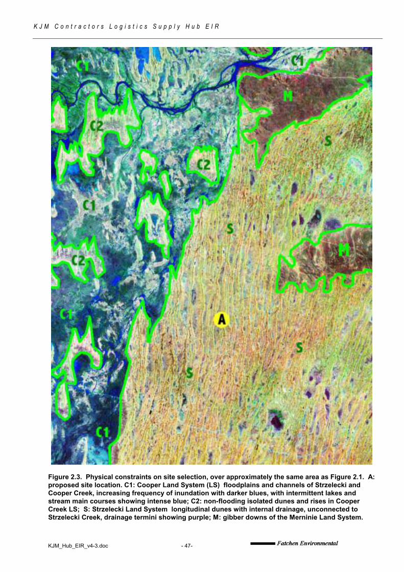
KJM_Hub_EIR_v4-3.doc - 47-
K J M C o n t r a c t o r s L o g i s t i c s S u p p l y H u b E I R
Figure 2.3. Physical constraints on site selection, over approximately the same area as Figure 2.1. A: proposed site location. C1: Cooper Land System (LS) floodplains and channels of Strzelecki and Cooper Creek, increasing frequency of inundation with darker blues, with intermittent lakes and stream main courses showing intense blue; C2: non-flooding isolated dunes and rises in Cooper Creek LS; S: Strzelecki Land System longitudinal dunes with internal drainage, unconnected to Strzelecki Creek, drainage termini showing purple; M: gibber downs of the Merninie Land System.

KJM_Hub_EIR_v4-3.doc - 48-
K J M C o n t r a c t o r s L o g i s t i c s S u p p l y H u b E I R
Figure 2.4 Detailed location of proposed logistic hub. Yellow boundary: existing SFL 2 as at June 2013. Green Boundary: proposed extension via SFL6 to allow the regulation of Hub access construction (west of main road) and access to local gravel borrow (east of main road). 1: main hub area—see subsequent diagrams. 2: approx 200m wide easement allowing construction of the hub access and entry triangle at junction with main road. 3: local borrow source for gravely borrow. The area indicated is necessary to both locate suitable borrow and keep pits >100m away from existing access in conformity with normal Cooper Basin SEO requirements. ‘a’: existing rehabilitated clay pits too close to access for use—these pits may be covered as part of triangle entry construction. ‘b’: existing gravely pit. (Photo source: Google Earth)

KJM_Hub_EIR_v4-3.doc - 49-
K J M C o n t r a c t o r s L o g i s t i c s S u p p l y H u b E I R
Figure 2.5 Aerial oblique of preferred Hub site, looking south, on dune backslope and sandy interdune out of locally inundating areas, with existing access (May 2009).

KJM_Hub_EIR_v4-3.doc - 50-
K J M C o n t r a c t o r s L o g i s t i c s S u p p l y H u b E I R
Figure 2.6 Aerial oblique of preferred Hub site, looking west (May 2009). Outline of general area is approximate only.

KJM_Hub_EIR_v4-3.doc - 51-
K J M C o n t r a c t o r s L o g i s t i c s S u p p l y H u b E I R
Figure 2.7 Existing DPTI-controlled borrow pits and quarries near preferred site, proposed for use subject to commercial arrangement between KJM Contractors and DPTI. Upper: Aerial oblique (May 2009). Lower: Vertical aerial photo (Google Earth, under licence).

KJM_Hub_EIR_v4-3.doc - 52-
K J M C o n t r a c t o r s L o g i s t i c s S u p p l y H u b E I R
Figure 3.1 Indicative layout of Logistics Support Hub. White boundaries indicate inundation frequency, using base map of Figure 4.2, below. Camp 2 is the transport service area. Up to 1ha of shallow subsurface water disposal area would be placed from the indicated water disposal point. Final site layout depends on modifications needed for heritage reasons and design detail. (sources: Google Earth photo; TJ Fatchen field records; KJM indicative design graphics; not exactly to scale)
See following page for enlargement of camp area.

KJM_Hub_EIR_v4-3.doc - 53-
K J M C o n t r a c t o r s L o g i s t i c s S u p p l y H u b E I R
Figure 3.1a Detail of Stage 4 camp (maximum development) on previous diagram.
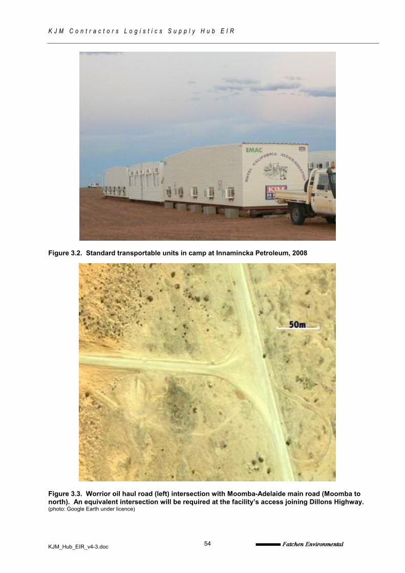
KJM_Hub_EIR_v4-3.doc
K J M C o n t r a c t o r s L o g i s t i c s S u p p l y H u b E I R
54
Figure 3.2. Standard transportable units in camp at Innamincka Petroleum, 2008
Figure 3.3. Worrior oil haul road (left) intersection with Moomba-Adelaide main road (Moomba to north). An equivalent intersection will be required at the facility’s access joining Dillons Highway. (photo: Google Earth under licence)

KJM_Hub_EIR_v4-3.doc
K J M C o n t r a c t o r s L o g i s t i c s S u p p l y H u b E I R
55
Figure 3.4. Existing clayed track crossing dune at entry to facility site. Final easement including batters approximately as indicated to provide for safe entry and exit of road trains. Eight whitewoods will be removed by the widened crossing. The rehabilitated borrow pit in right middle of frame cannot be used because of its closeness to the track, but may be filled by the necessary triangle construction at the intersection. Zygochloa paradoxa hummock grassland on dune mobile crest, emergent whitewood Atalaya hemiglauca over ephemeral grasses and herbs on mid-slopes. (May 2009)

KJM_Hub_EIR_v4-3.doc
K J M C o n t r a c t o r s L o g i s t i c s S u p p l y H u b E I R
56
Figure 3.5. Trailer mounted double-skinned avgas tank for aircraft refuelling at Innamincka
Figure 3.6. EnviroFlow sewerage treatment unit in operation (photo: KJM Contractors)

KJM_Hub_EIR_v4-3.doc
K J M C o n t r a c t o r s L o g i s t i c s S u p p l y H u b E I R
57
Figure 3.7. Schematic of EnviroFlow sewerage treatment process. Sludge and effluent tanks are separate from the container-based balance tank toclarifier system. (Source: KJM Contractors)

KJM_Hub_EIR_v4-3.doc
K J M C o n t r a c t o r s L o g i s t i c s S u p p l y H u b E I R
58
Figure 3.8. May 2009 panorama of DPTI pits proposed for construction material subject to commercial arrangement. Overburden material could be usedfor ramping, subsurface construction and light sheeting: stonier metal is appropriate for track surfacing. Small trees are whitewood Atalaya hemiglaucapredating pit development. Scattered small shrubs of sandhill wattle Acacia ligulata have established on pits, growth otherwise remains largelyephemeral, with the herb Pterocaulon sphacelatum showing as smaller dark clumps. (May 2009)

KJM_Hub_EIR_v4-3.doc
K J M C o n t r a c t o r s L o g i s t i c s S u p p l y H u b E I R
59
Figure 3.9. Della Road quarry, proposed (subject to commercial arrangement) as source for higher-quality road metal for sheeting access and vehicle hardstand. (May 2009)
Figure 3.10. Della Airstrip as one of two possible strips for local access (subject to appropriate commercial arrangement with Santos.)

KJM_Hub_EIR_v4-3.doc
K J M C o n t r a c t o r s L o g i s t i c s S u p p l y H u b E I R
60
Figure 4.1. Landform and vegetation atproposed site (see also following figurefor inundation map). 1: Longitudinalsandridge mobile or semi mobilecrests, deep red sands, sandhillcanegrass Zygochloa paradoxa veryopen hummock grassland. 2: Upperdune slopes, deep sand; tall shrublandto shrubland of whitewood Atalayahemiglauca with sandhill wattle Acacialigulata over mixed ephemeral grassesand herbs, with areas of porcupinegrass Triodia basedowii. 3: sandyinterdune and lower dune backslopes;very gently sloping clayey sand overred sandy clay loams; shortgrassAristida contorta – Enneapogon sppwith areas of low open shrubland(showing mottled) of limestone cassiaSenna oligophylla, largely dead, butlacking tall shrubs. 4: Clay exposuresand drainage sinks (‘s’) subject toregular inundation: neverfail grassesEragrostis spp, copperburrsSclerolaena spp with very scatteredemergent dwarf shrubs (mainlycottonbush Maireana aphylla). Existingwater well at star. (Photo: Google Earthunder licence)

KJM_Hub_EIR_v4-3.doc
K J M C o n t r a c t o r s L o g i s t i c s S u p p l y H u b E I R
61
Figure 4.2 Inundation map inferredfrom vegetation and surface drainagecharacteristics. Although thedrainage is internal and notconnected in any way to the CooperLand System, the clay content of thedunes is sufficiently high for water torun off readily in heavy falls, andcollect in the low points at the foot ofthe dunes’ eastern faces (slipslope).“Long term inundation”: water mayremain on surface for up to 2 months(winter) without further rain.
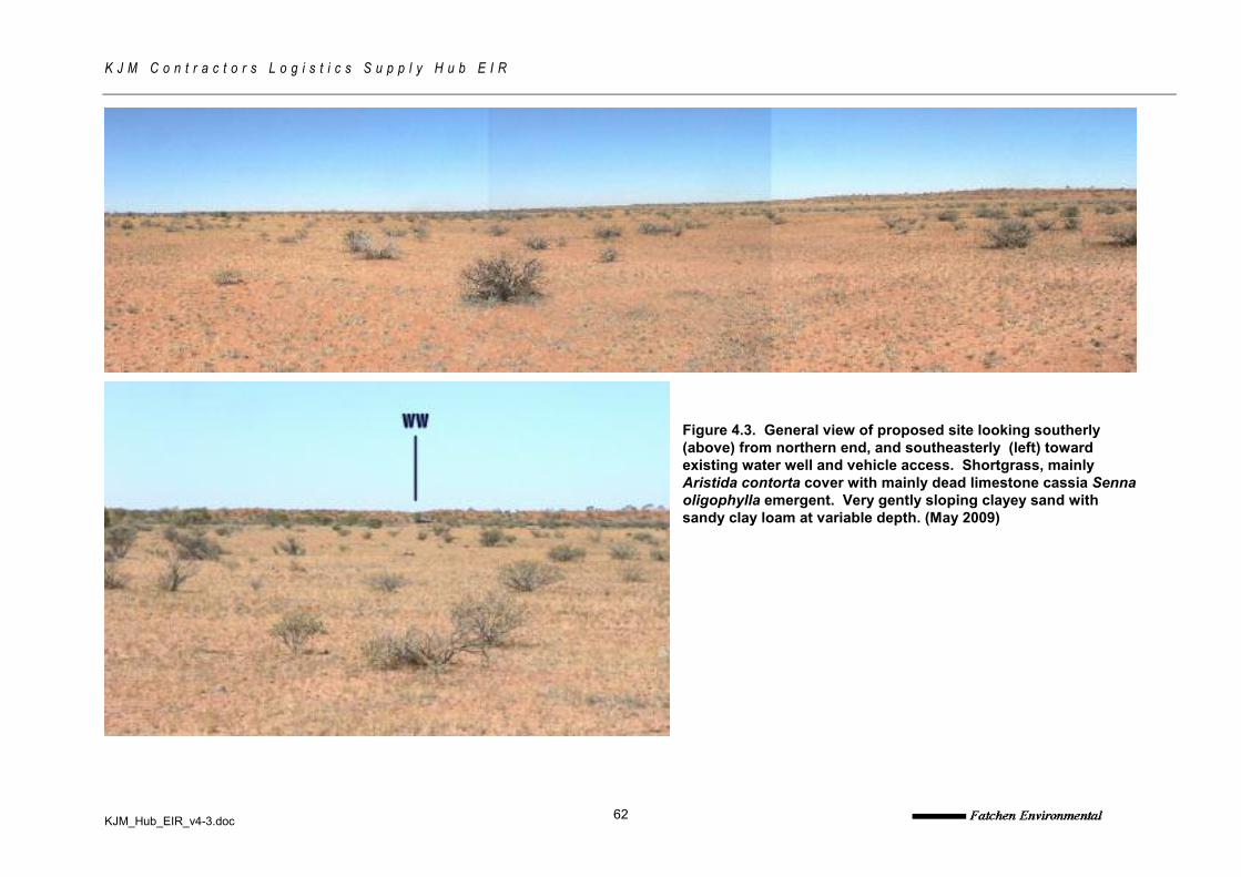
KJM_Hub_EIR_v4-3.doc
K J M C o n t r a c t o r s L o g i s t i c s S u p p l y H u b E I R
62
Figure 4.3. General view of proposed site looking southerly(above) from northern end, and southeasterly (left) towardexisting water well and vehicle access. Shortgrass, mainlyAristida contorta cover with mainly dead limestone cassia Sennaoligophylla emergent. Very gently sloping clayey sand withsandy clay loam at variable depth. (May 2009)

KJM_Hub_EIR_v4-3.doc
K J M C o n t r a c t o r s L o g i s t i c s S u p p l y H u b E I R
63
Figure 4.4. Dead Limestone cassia Senna oligophylla. These are presumed drought-killed, alternatively they may be yet another 1974 or 1989 cohort dying at the end of normal life spans, as has also been the case with Acacia ligulata throughout the Cooper Basin since 2000. (May 2009)
Figure 4.5. At lower western end of interdune and backslope, with more highly calcareous soil indicated by shrubs of low bluebush Maireana astrotricha (foreground). WW: existing water well and vehicles on access to southeast. (May 2009)

KJM_Hub_EIR_v4-3.doc
K J M C o n t r a c t o r s L o g i s t i c s S u p p l y H u b E I R
64
Figure 4.6. Local drainage channel on dune backslope. Channels such as these are present but uncommon: they can be managed either by culverting or spoon drains where crossed by access, with redirection as necessary, as applied on the adjoining Dillons Highway. (May 2009)
Figure 4.7. Broad wash on dune backslope/interdune at northern end of proposed facility area. These washes need to be avoided in placement of facilities such as laydown yards, camps and fuelling areas, because of the impact of the environment on the facility, not the reverse.

KJM_Hub_EIR_v4-3.doc
K J M C o n t r a c t o r s L o g i s t i c s S u p p l y H u b E I R
65
Figure 4.8. Looking westward on the edge of the dune footslope (sandy veneer over red sandy clay loam) to inundating clay exposures (showing grey) with dune slipface in the background. Scattered limestone cassia, ground cover of Aristida contorta in foreground. (May 2009)
Figure 4.9. Drainage terminus for internally draining interdune to west of proposed site. Red self-mulching sandy clay with obvious solution cavities. Large grass clumps are remnant panic Panicum decompositum, Sporobolus mitchelli, S actinocladus, Dactyloctenium radulans, Sclerolaena intricata, and Lemooria burkittii. Moderate to heavy domestic grazing on this land unit. (May 2009)

KJM_Hub_EIR_v4-3.doc
K J M C o n t r a c t o r s L o g i s t i c s S u p p l y H u b E I R
66
Figure 4.10. 2012 growth: grasses Aristida contorta and Enneapogon avenaceus along existing road on southern part of proposed site (KJM photo).
Figure 4.11. 2012 growth: grasses Aristida contorta, A. browniana, Enneapogon spp with Sclerolaena spp on main proposed camp area (KJM photo). Drought-killed Senna did not recover.

KJM_Hub_EIR_v4-3.doc
K J M C o n t r a c t o r s L o g i s t i c s S u p p l y H u b E I R
67
10. APPENDIX: ENVIROFLOW WASTEWATER TREATMENT PLANT APPROVALS

KJM_Hub_EIR_v4-3.doc
K J M C o n t r a c t o r s L o g i s t i c s S u p p l y H u b E I R
68

KJM_Hub_EIR_v4-3.doc
K J M C o n t r a c t o r s L o g i s t i c s S u p p l y H u b E I R
69
KJM_Hub_EIR_v4-3.doc
K J M C o n t r a c t o r s L o g i s t i c s S u p p l y H u b E I R
70

KJM_Hub_EIR_v4-3.doc
K J M C o n t r a c t o r s L o g i s t i c s S u p p l y H u b E I R
71

KJM_Hub_EIR_v4-3.doc
K J M C o n t r a c t o r s L o g i s t i c s S u p p l y H u b E I R
72
11. APPENDIX: RESPONSES TO GOVERNMENT COMMENTS DURING CONSULTATION ON KJM LOGISTICS HUB EIR AND SEO, SEPTEMBER 2013

KJM_Hub_EIR_v4-3.doc
K J M C o n t r a c t o r s L o g i s t i c s S u p p l y H u b E I R
73
Agency Issues Raised or Comments Made Section/Page Response
EPA The EPA has recently provided information/comments directly to KJMContractors Pty Ltd regarding above-ground diesel storage and re-fuelling facilityat the proposed logistics hub. The information provided was consistent with themeans for achieving the environmental objectives referred to in the documentsabove (particularly objectives 10-15).
General Noted
Dept Healthand AgeingSA
In their EIR KJM refer to......
"Sewage disposal will be via self-contained waste-water treatment systems inaccordance with
the Public and Environmental Health (Waste Control) Regulations 1995"
This should now state "Wastewater treatment and disposal will be via a productapproved aerated wastewater treatment system and be disposed of inaccordance with the 'South Australian Public Health (Wastewater) Regulations2013' and the 'SA Health On-site Wastewater Systems Code April 2013'
General All sections of EIR and SEO updatedaccordingly.
DPTI The Department of Planning, Transport and Infrastructure has advised DMITREthat the department wishes to maintain responsibility of a borrow pitapproximately 11kms north along the Dillions Highway from the Della Roadjunction.
Other than the above, the department has no further comments re: the proposedLogistics Hub south of lnnamincka.
General Acknowledged

KJM_Hub_EIR_v4-3.doc
K J M C o n t r a c t o r s L o g i s t i c s S u p p l y H u b E I R
74
Agency Issues Raised or Comments Made Section/Page Response
DEWNR 1) Regulation 10 outlines the information to be provided in an EIR,
including a 'description and location of activities to be carried out underlicence.' The EIR refers to the intention to extend the SFL to permit directaccess to the road and a now-proposed ancillary borrow supply(coordinates of this proposed area provided on page 10), which were notoriginally envisaged as part of the hub development. However, it doesnot appear that the EIR has considered the impacts on this additionalproposed area (the area that we know as SFL6). This is further reinforced byKJM's letter to DMITRE dated 3 July 2013 for the SFL6 application. Theletter states that the company needs to extend the boundaries of SFL2 toprovide corridors etc to sources of local borrow for construction andmaintenance. The letter further acknowledges that although the proposedadditional area has been inspected 'in the past for general environmental issues'it states that 'there will be an inspection in the immediate future, expectedto be performed by Fatchen Environmental Pty Ltd, results of which willbe incorporated into the Draft ElR and SEO where necessary.'
2) The current draft SEO and EIR are not clear as to what aspects theapplication covers. The fact that KJM intends to conduct further work on theproposed SFL6 site, which is intended to be incorporated into the SEO and EIRand combined as one SFL, DEWNR recommends that the documents arereviewed and updated to ensure consistency.
General 1) Broad risk and management measuresassociated with these proposed activitieshave been appropriately identified andcovered within EIR and SEO.
2) Existing SFL and requested extensionclearly explained in section 3.2 of EIR.

KJM_Hub_EIR_v4-3.doc
K J M C o n t r a c t o r s L o g i s t i c s S u p p l y H u b E I R
75
Agency Issues Raised or Comments Made Section/Page Response
DEWNR 1) This section states that have been no substantive changes in
environmental issues since 2009 and subsequent checks by both KJM andFatchen Environmental since 2009 have been informal only. However,Table 2 (pages 41-42), which shows the species recorded at the Initial fieldinspection of 8 May 2009 states that more ephemeral species will be evident in2013 as a result of multiple growth periods. There is no evidence that a formalassessment has occurred to confirm this assumption.
2) DEWNR recommends that the proponent conduct further assessments on site(SFL2 and SFL6) in order to update the species records and confirm that therehave indeed been no substantive changes in environmental issues since 2009.
EIR - Section 1.1
(page 1)
1) Assumption removed from table 2 of EIR.
2) Site specific environmental assessmentswill be undertaken in accordance withRegulation 20(1)(g) of the Petroleum andGeothermal Regulations 2013 (Regs) as partof the Activity Notification/Approval process.
DEWNR The outline of the proposed facility requirements does not mention the additionalarea for SFL6 (proposed access road to borrow pit).
DEWNR recommends that this section is amended to refer to the SFL6application.
EIR - Section1.1.2
dot points
(pages 1-2)
Included as dot point in section 1.1.2 – and isfurther covered in section 3.2 of the EIR
DEWNR DEWNR seeks clarity on what is meant by 'all-weather access to an
airstrip in the district'. 'All weather access' can only be achieved by bitumen. Allroads in this area with enough rain are not accessible, not matter how muchmetal, or clay sub-base and dolomite is used. Short of bituminising the DillonHighway, how does the proponent intend to achieve this? Any change inproposal would need to be reflected in the relevant sections of the SEO and EIR.
EIR - Section1.1.2
last paragraph
(page 2)
Noted and section 1.1.2 of EIR changed toreflect
DEWNR DEWNR recommends that the container mounted diesel power generators arealso bunded to reduce the risk of spillage.
EIR - Section 3.9
(page 14)
This is covered within Table 1, objective 10

KJM_Hub_EIR_v4-3.doc
K J M C o n t r a c t o r s L o g i s t i c s S u p p l y H u b E I R
76
Agency Issues Raised or Comments Made Section/Page Response
DEWNR DEWNR recommends that these sections are updated to state that fences will beinspected quarterly to ensure they are intact.
EIR - Section 3.11
(page 15);
Section 6.6.4
(page 25);
Table 1,
Environmental
Objectives 7
(page 33) and
19-20 (page 38)
All sections updated accordingly – fences tobe inspected quarterly
DEWNR The EIR states that KJM Contractors propose to employ a qualified pest plantand animal control expert for various purposes including in-field training.DEWNR strongly recommends that the word 'propose' be replaced with 'will'.DEWNR also recommends that weed identification be included as part of thestaff induction to the site (refer to section 6.4.4 on page 22).
EIR - Section6.6.2
(page 24)
Word replaced in section 6.6.2.
Section 6.4.4 updated to state that SEOObjectives will be covered in site specificinductions
DEWNR DEWNR requests that any weed data collected be provided to DEWNR in liaisonwith Senior Ranger.
EIR - Section6.6.2
(page 24)
Noted and this can be requested as part ofNotice of Entry stage.
DEWNR DEWNR recommends that the proponent update its EIR and SEO to include thepreparation of a clean mineral earth fire break around the site following siteclearance by the Yandruwandha I Yawarrawarrka. Having a planned cleanmineral earth fire break that has been site cleared now will prevent a rush gradewithout site clearance should a wildfire bear down on the site.
EIR - Section 6.7
(page 27)
Section 6.7 and Table 1 (objective 2) updatedto include fire break

KJM_Hub_EIR_v4-3.doc
K J M C o n t r a c t o r s L o g i s t i c s S u p p l y H u b E I R
77
Agency Issues Raised or Comments Made Section/Page Response
DEWNR DEWNR advises that unless the turn-off entry point is bituminised, there will stillbe some level of dust issues, no matter how good the metal, or clay/dolomitesheeting is in this area. DEWNR recommends that the design of the access pointshould be four lanes to enable trucks on either side of the road to pull over whileallowing visitor traffic to pass turning trucks safely. The relevant sections. Of theSEO and EIR will need to be updated if the proponent chooses to bituminise theturn-off entry point and/or widen the road.
EIR - Section6.6.9
(page 26)
Must comply with DPTI requirements.
DEWNR DEWNR disagrees with the third and fourth paragraphs of this
section and recommend amendment for accuracy:
• SEB offset requirements cannot be satisfied by sponsoring
independent research -the SEB can only be satisfied by payment
of money Into the Native Vegetation Fund, or suitable on ground
works that are accompanied by an approved Management Plan.
EIR - Section6.6.11,
third and fourth
paragraphs
(page 27)
Suggested comments incorporated in Section6.6.11
DEWNR DEWNR requests that the proponent clarify what is meant by 'Communicationwith DEWNR regional officers where third party access issues arise affecting theInnamincka Regional Reserve at the facility'? Does this mean that DEWNR isconsidered a Third party or Is this section referring to unauthorised access by thegeneral public?
DEWNR recommends that 'No public access signs' are located at all entry andexit points. Furthermore, DEWNR requests that it is consulted regarding this andother signs at entry and exit points.
EIR - Table 1,
Environmental
Objective 1
(Minimise
Public and third
party risk) (page
29)
Noted.
Specifics will be included in Notice of Entry asper Regulation 22 of the Regs.
DEWNR This figure only shows the proposed area for SFL2.
For consistency, DEWNR recommends that this figure is amended to show thearea for the SFL6 application (see Figure 2.4).
EIR - Figure 2.5
Page 49
Map to be altered accordingly

KJM_Hub_EIR_v4-3.doc
K J M C o n t r a c t o r s L o g i s t i c s S u p p l y H u b E I R
78
Agency Issues Raised or Comments Made Section/Page Response
DEWNR This figure only shows the proposed area for SFL2.
For consistency, DEWNR recommends that this figure is amended to show thearea for the SFL6 application (see Figure 2.4).
EIR - Figure 2.6
page 50
Map to be altered accordingly
DEWNR Regulation 10 outlines the information to be provided in an EIR, including a'description and location of activities to be carried out under licence'. DEWNRrequests that the SEO and EIR be updated to reflect the entire proposal (i.e.SFL2 and SFL6). Specific detail on how the proponent can achieve this isoutlined below.
SEO - General This is covered within the document byreferring to ‘minor additions to area may besought to allow appropriate regulation ofancillary access to borrow pits and watersources’.
DEWNR The SEO states that 'minor additions to the area may be sought to allow theappropriate regulation of ancillary access, borrow sources and water resources.'Although borrow pits are mentioned in the document, there is no reference to anaccess corridor to the borrow pit for construction and maintenance.
DEWNR recommends that this section is amended to refer to SFL6.
SEO - Section 1.1
(paragraph 3)
(page 3)
See above response.
Risk and management measures associatedwith access and borrow sourcing have beenthoroughly incorporated within SEO and EIR.
DEWNR Why is the DPTI road construction borrow pits shown in this Figure but not thelocation of SFL6?
DEWNR recommends that this figure is amended to refer to SFL6.
SEO - Figure 1
(page 4)
Figure 1 (SEO) amended to include access toborrow and water sources.
DEWNR DEWNR recommends that 'No public access signs' are located at all entry andexit points. Furthermore, DEWNR requests that it is consulted regarding this andother signs at entry and exit points.
SEO - Table 1,EnvironmentalObjective 1(Minimise Publicand third partyrisk)
Page 13
Noted and appropriately addressed in 1st dotpoint under means for achieving objective

KJM_Hub_EIR_v4-3.doc
K J M C o n t r a c t o r s L o g i s t i c s S u p p l y H u b E I R
79
Agency Issues Raised or Comments Made Section/Page Response
DEWNR DEWNR recommends that the proponent update its EIR and SEO to include thepreparation of a clean mineral earth fire break around the site following siteclearance by the Yandruwandha I Yawarrawarrka. Having a planned cleanmineral Earth fire break that has been site cleared now will prevent a rush gradewithout site clearance should a wildfire bear down on the site.
SEO - Table 1,EnvironmentalObjective 2(minimise fire riskat facility….)
Page 14
Noted.
This has been addressed in the SEO by theaddition of an extra (3rd) dot point under‘means for achieving objective’.
It has also been addressed under section 6.7of the EIR