envirothon soils dennis brezina usda-natural resources conservation service resource soil scientist...
TRANSCRIPT

Envirothon Soils
Dennis BrezinaUSDA-Natural Resources Conservation Service
Resource Soil Scientist – Bryan Area
Conservation…Our Purpose; Our Passion.
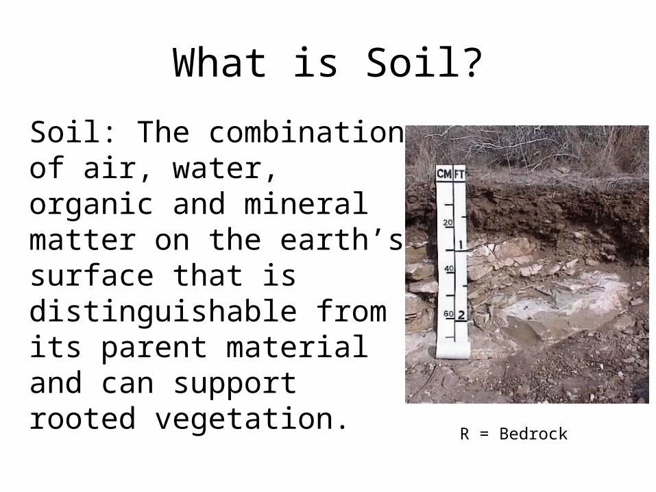
What is Soil?
Soil: The combination of air, water, organic and mineral matter on the earth’s surface that is distinguishable from its parent material and can support rooted vegetation.
R = Bedrock
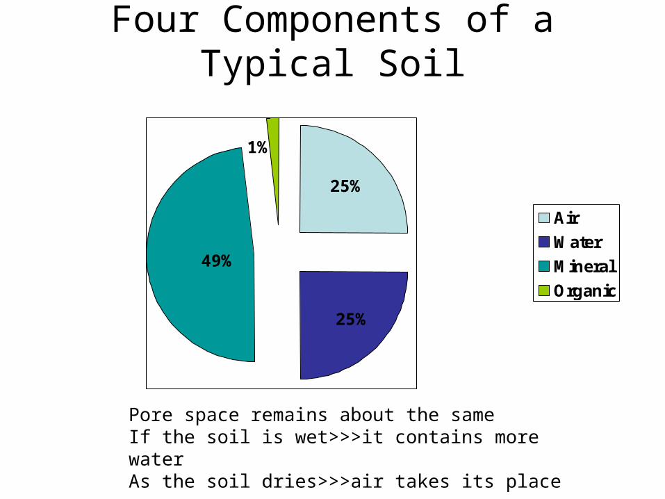
Four Components of a Typical Soil
Air
Water
Mineral
Organic
Pore space remains about the sameIf the soil is wet>>>it contains more waterAs the soil dries>>>air takes its place
1%
49%
25%
25%
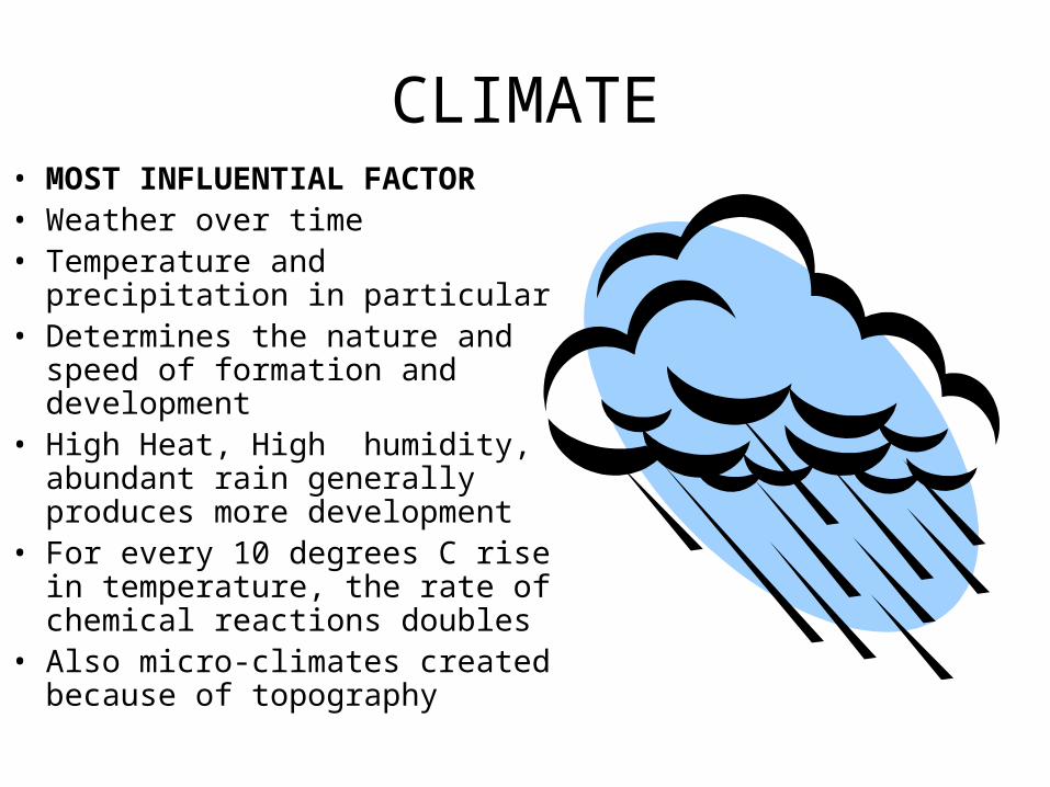
CLIMATE• MOST INFLUENTIAL FACTOR• Weather over time• Temperature and precipitation in
particular• Determines the nature and
speed of formation and development
• High Heat, High humidity, abundant rain generally produces more development
• For every 10 degrees C rise in temperature, the rate of chemical reactions doubles
• Also micro-climates created because of topography
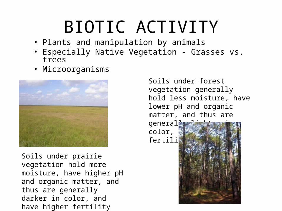
BIOTIC ACTIVITY• Plants and manipulation by animals• Especially Native Vegetation - Grasses vs. trees• Microorganisms
Soils under prairie vegetation hold more moisture, have higher pH and organic matter, and thus are generally darker in color, and have higher fertility
Soils under forest vegetation generally hold less moisture, have lower pH and organic matter, and thus are generally lighter in color, and have lower fertility
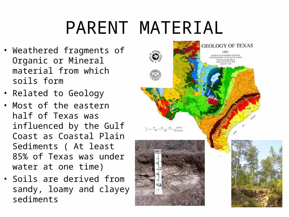
PARENT MATERIAL• Weathered fragments of
Organic or Mineral material from which soils form
• Related to Geology • Most of the eastern half of
Texas was influenced by the Gulf Coast as Coastal Plain Sediments ( At least 85% of Texas was under water at one time)
• Soils are derived from sandy, loamy and clayey sediments
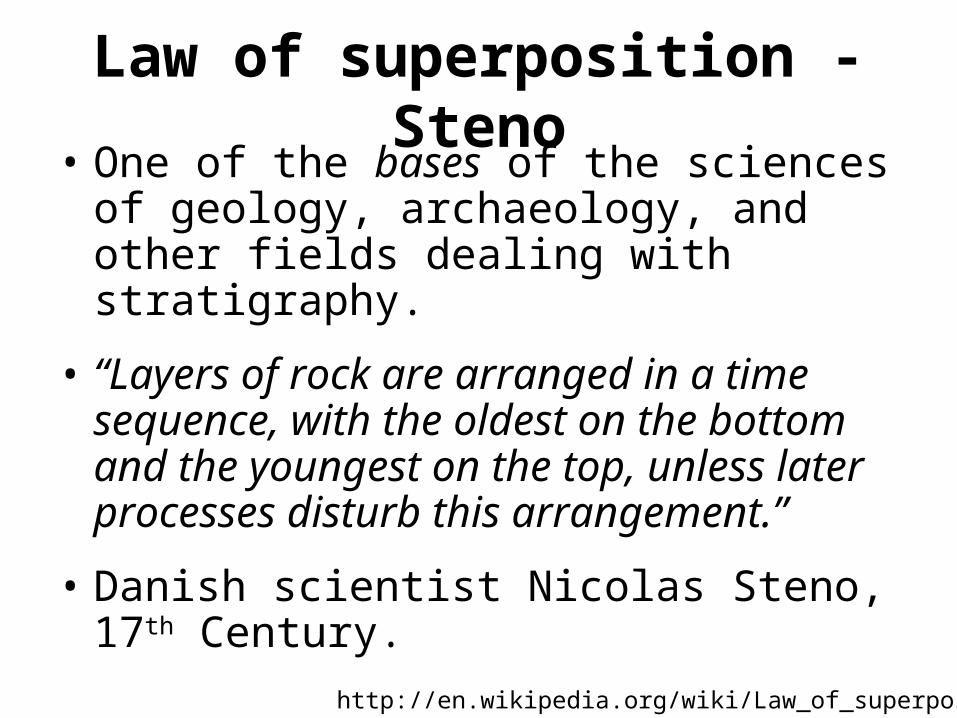
Law of superposition - Steno• One of the bases of the sciences of
geology, archaeology, and other fields dealing with stratigraphy.
• “Layers of rock are arranged in a time sequence, with the oldest on the bottom and the youngest on the top, unless later processes disturb this arrangement.”
• Danish scientist Nicolas Steno, 17th Century.
http://en.wikipedia.org/wiki/Law_of_superposition
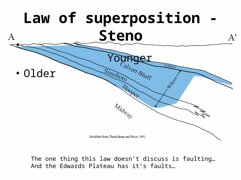
Law of superposition - Steno
• Younger
• Older
The one thing this law doesn’t discuss is faulting…And the Edwards Plateau has it’s faults…
P. 398, Brady
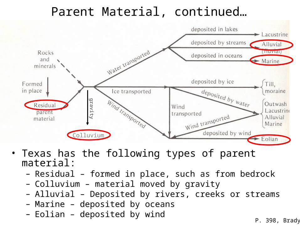
• Texas has the following types of parent material:– Residual – formed in place, such as from bedrock– Colluvium – material moved by gravity– Alluvial – Deposited by rivers, creeks or streams– Marine – deposited by oceans– Eolian – deposited by wind
Parent Material, continued…
Colluvium
gra
vity
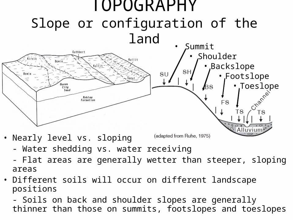
TOPOGRAPHYSlope or configuration of the land
• Nearly level vs. sloping- Water shedding vs. water receiving- Flat areas are generally wetter than steeper, sloping areas
• Different soils will occur on different landscape positions- Soils on back and shoulder slopes are generally thinner than those on summits, footslopes and toeslopes
• Summit• Shoulder
• Backslope• Footslope
• Toeslope
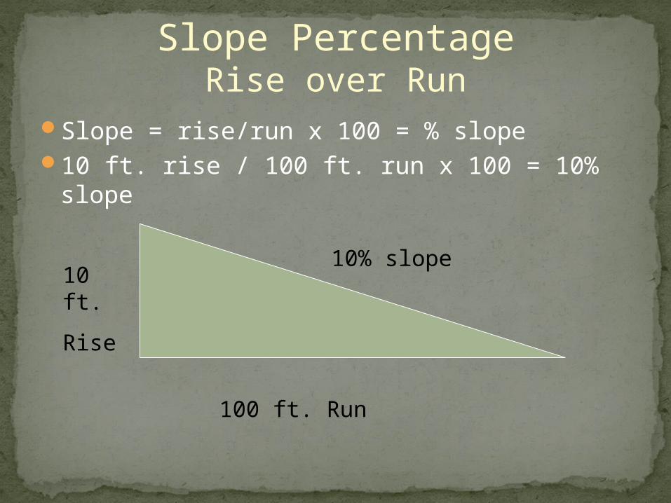
Slope = rise/run x 100 = % slope 10 ft. rise / 100 ft. run x 100 = 10% slope
10 ft.
Rise
100 ft. Run
10% slope
Slope PercentageRise over Run
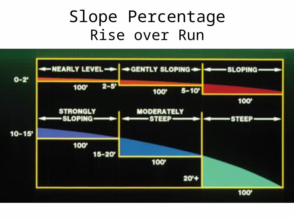
Slope PercentageRise over Run
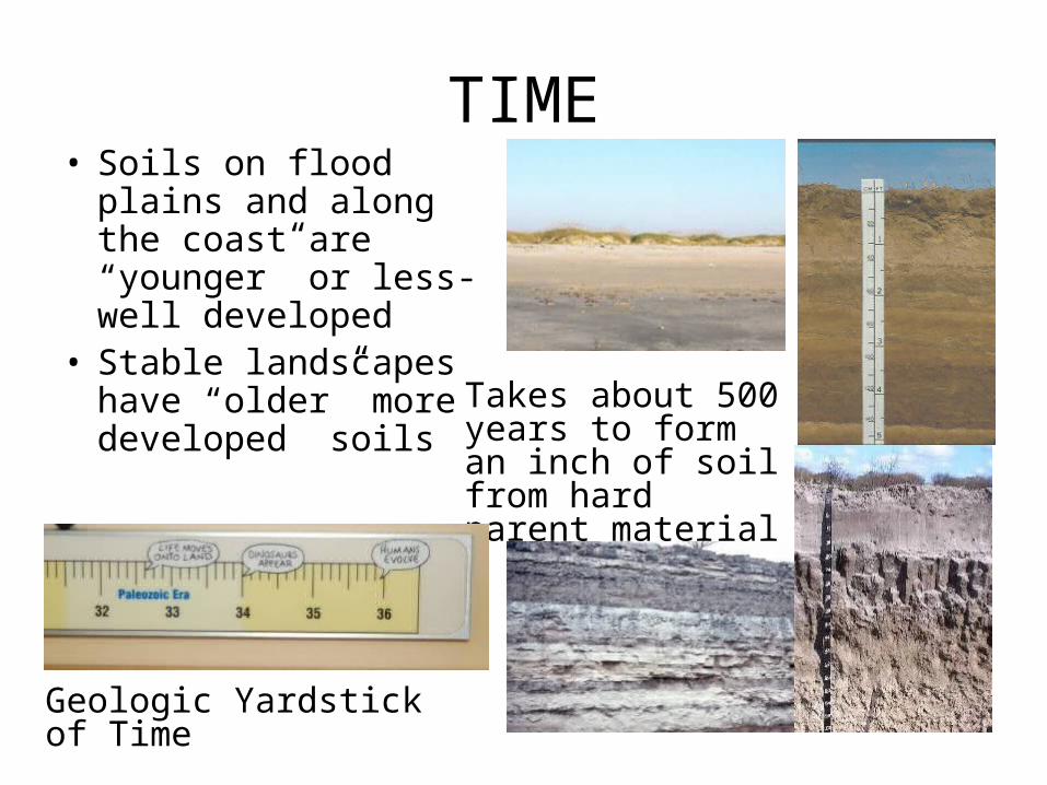
TIME• Soils on flood plains
and along the coast are “younger” or less-well developed
• Stable landscapes have “older” more developed soils
Takes about 500 years to form an inch of soil from hard parent material
Geologic Yardstick of Time
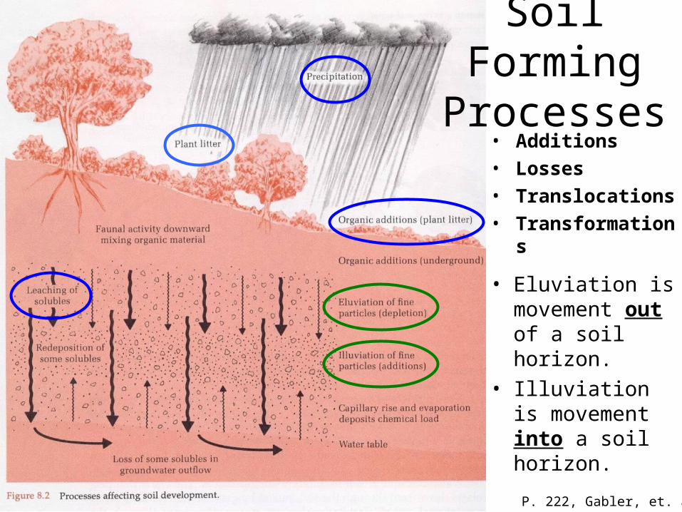
P. 222, Gabler, et. al.
• Additions• Losses• Translocations• Transformatio
ns
• Eluviation is movement out of a soil horizon.
• Illuviation is movement into a soil horizon.
Soil Forming Processes

http://www.tpwd.state.tx.us/landwater/land/maps/gis/map_downloads/
This is an excellent, broad Ecological Region Map of Texas separating the ten main ecoregions of the state:
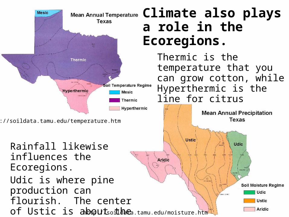
http://soildata.tamu.edu/moisture.htm
http://soildata.tamu.edu/temperature.htm
Climate also plays a role in the Ecoregions.
Thermic is the temperature that you can grow cotton, while Hyperthermic is the line for citrus
Rainfall likewise influences the Ecoregions.Udic is where pine production can flourish. The center of Ustic is about the line for dry-land corn.
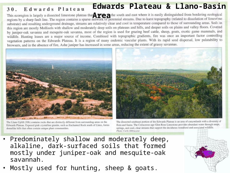
• Predominately shallow and moderately deep, alkaline, dark-surfaced soils that formed mostly under juniper-oak and mesquite-oak savannah.
• Mostly used for hunting, sheep & goats.
Edwards Plateau & Llano-Basin Area
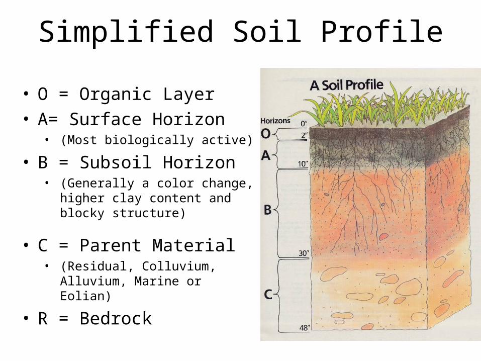
Simplified Soil Profile
• O = Organic Layer• A= Surface Horizon
• (Most biologically active)
• B = Subsoil Horizon• (Generally a color change,
higher clay content and blocky structure)
• C = Parent Material• (Residual, Colluvium, Alluvium,
Marine or Eolian)
• R = Bedrock
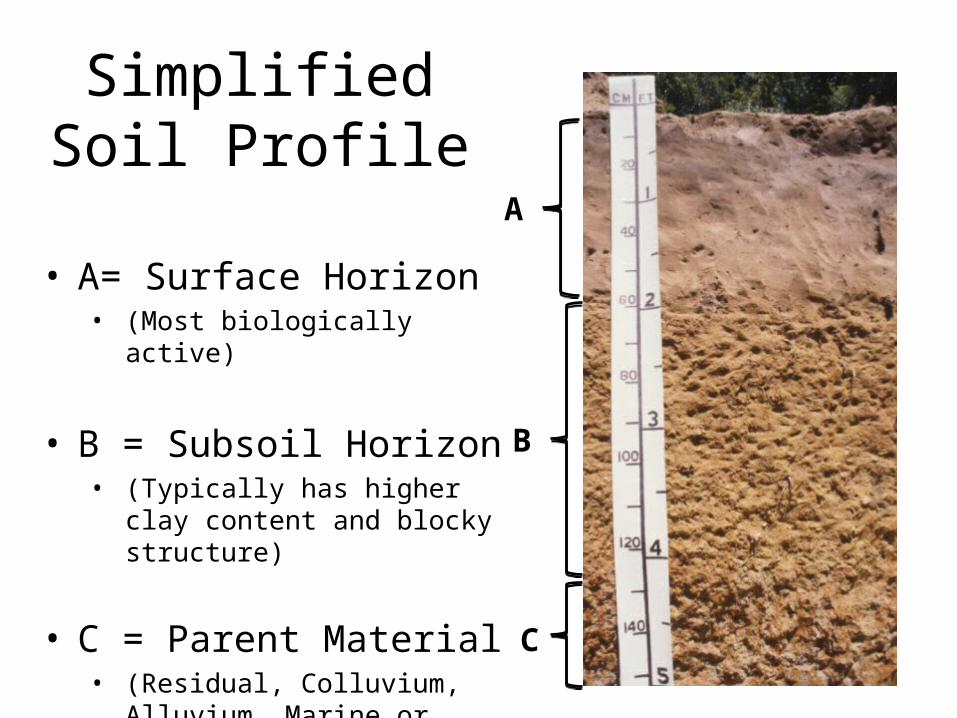
Simplified Soil Profile
• A= Surface Horizon• (Most biologically active)
• B = Subsoil Horizon• (Typically has higher clay
content and blocky structure)
• C = Parent Material• (Residual, Colluvium,
Alluvium, Marine or Eolian)
A
B
C
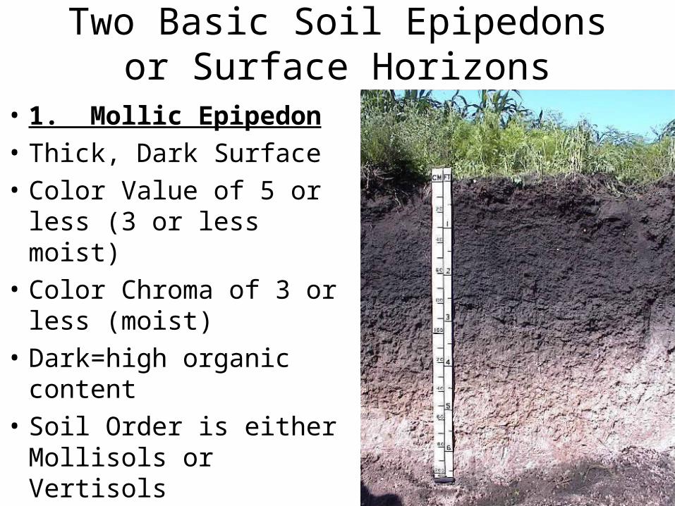
Two Basic Soil Epipedons or Surface Horizons
• 1. Mollic Epipedon
• Thick, Dark Surface
• Color Value of 5 or less (3 or less moist)
• Color Chroma of 3 or less (moist)
• Dark=high organic content
• Soil Order is either Mollisols or Vertisols
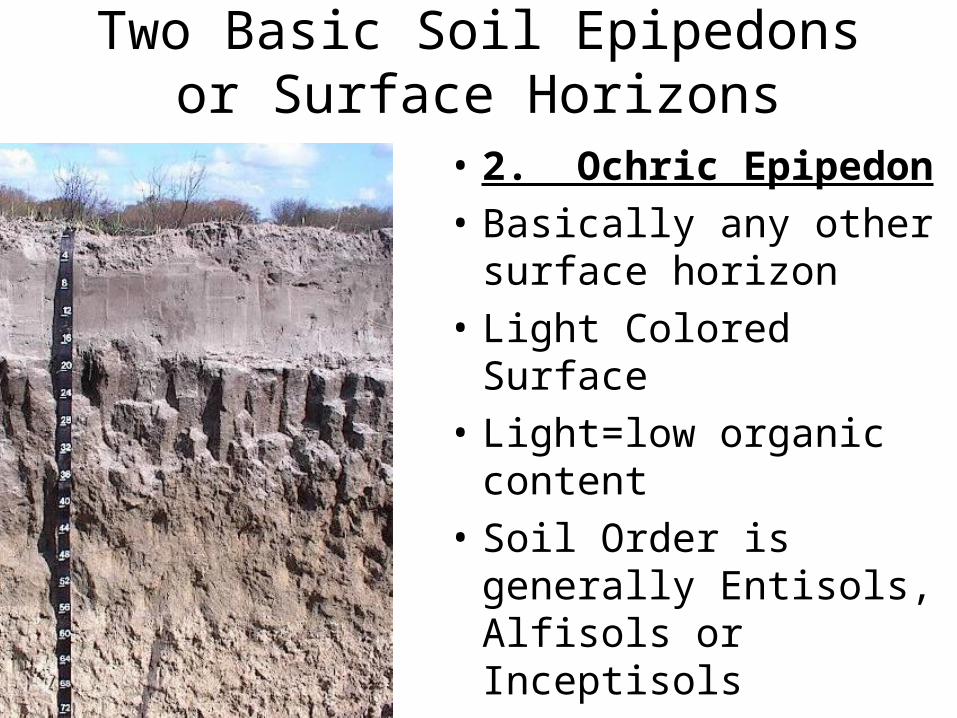
Two Basic Soil Epipedons or Surface Horizons
• 2. Ochric Epipedon
• Basically any other surface horizon
• Light Colored Surface
• Light=low organic content
• Soil Order is generally Entisols, Alfisols or Inceptisols
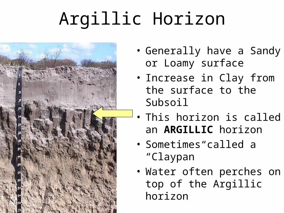
Argillic Horizon
• Generally have a Sandy or Loamy surface
• Increase in Clay from the surface to the Subsoil
• This horizon is called an ARGILLIC horizon
• Sometimes called a “Claypan”
• Water often perches on top of the Argillic horizon
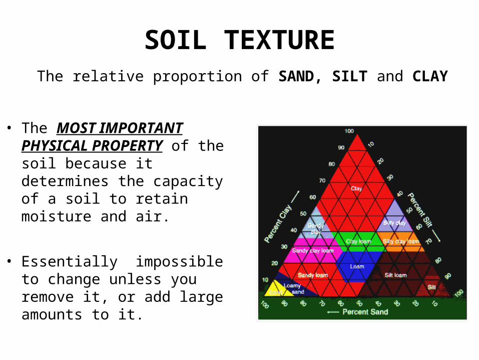
The relative proportion of SAND, SILT and CLAY
• The MOST IMPORTANT PHYSICAL PROPERTY of the soil because it determines the capacity of a soil to retain moisture and air.
• Essentially impossible to change unless you remove it, or add large amounts to it.
SOIL TEXTURE
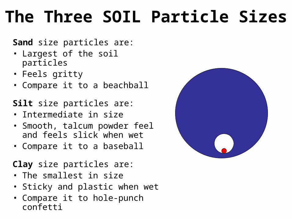
The Three SOIL Particle Sizes
Sand size particles are:• Largest of the soil particles• Feels gritty• Compare it to a beachball
Silt size particles are:• Intermediate in size• Smooth, talcum powder feel and
feels slick when wet• Compare it to a baseball
Clay size particles are:• The smallest in size• Sticky and plastic when wet• Compare it to hole-punch confetti
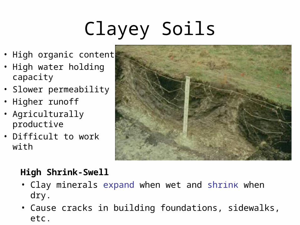
Clayey Soils
High Shrink-Swell • Clay minerals expand when wet and shrink when dry.• Cause cracks in building foundations, sidewalks, etc.
MoreWater
• High organic content• High water holding
capacity • Slower permeability• Higher runoff• Agriculturally
productive• Difficult to work with
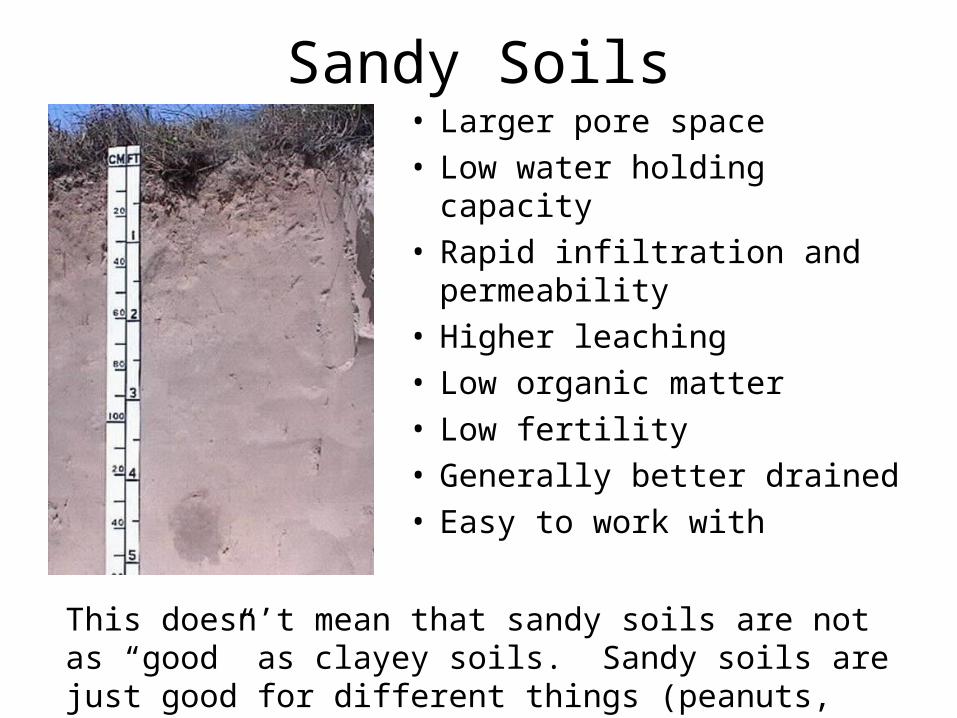
Sandy Soils• Larger pore space• Low water holding capacity• Rapid infiltration and
permeability• Higher leaching• Low organic matter• Low fertility• Generally better drained• Easy to work with
This doesn’t mean that sandy soils are not as “good” as clayey soils. Sandy soils are just good for different things (peanuts, timber production, etc.).
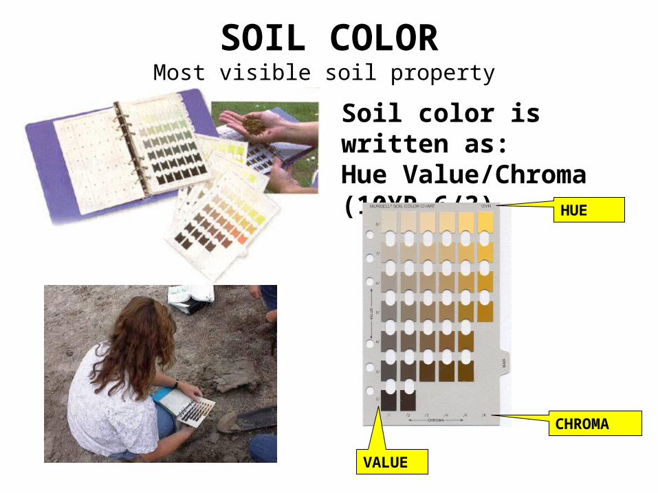
SOIL COLOR
Soil color is written as: Hue Value/Chroma (10YR 6/3)
HUE
CHROMA
VALUE
Most visible soil property
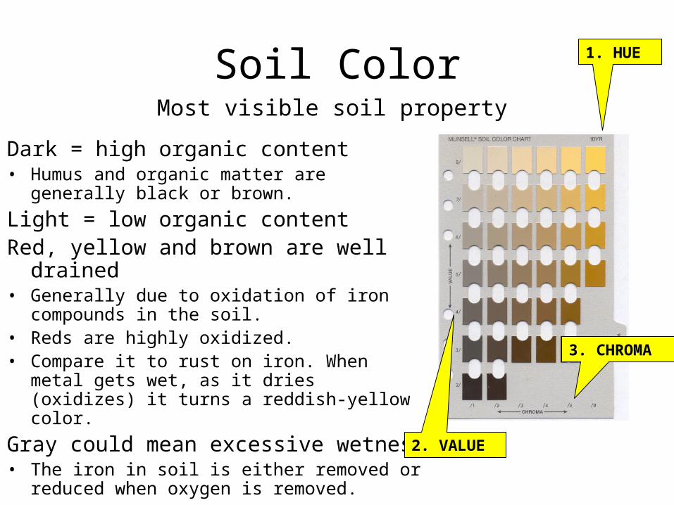
Soil Color
Dark = high organic content• Humus and organic matter are generally black
or brown.
Light = low organic contentRed, yellow and brown are well drained• Generally due to oxidation of iron compounds in
the soil.• Reds are highly oxidized. • Compare it to rust on iron. When metal gets
wet, as it dries (oxidizes) it turns a reddish-yellow color.
Gray could mean excessive wetness• The iron in soil is either removed or reduced
when oxygen is removed.
Most visible soil property
1. HUE
3. CHROMA
2. VALUE
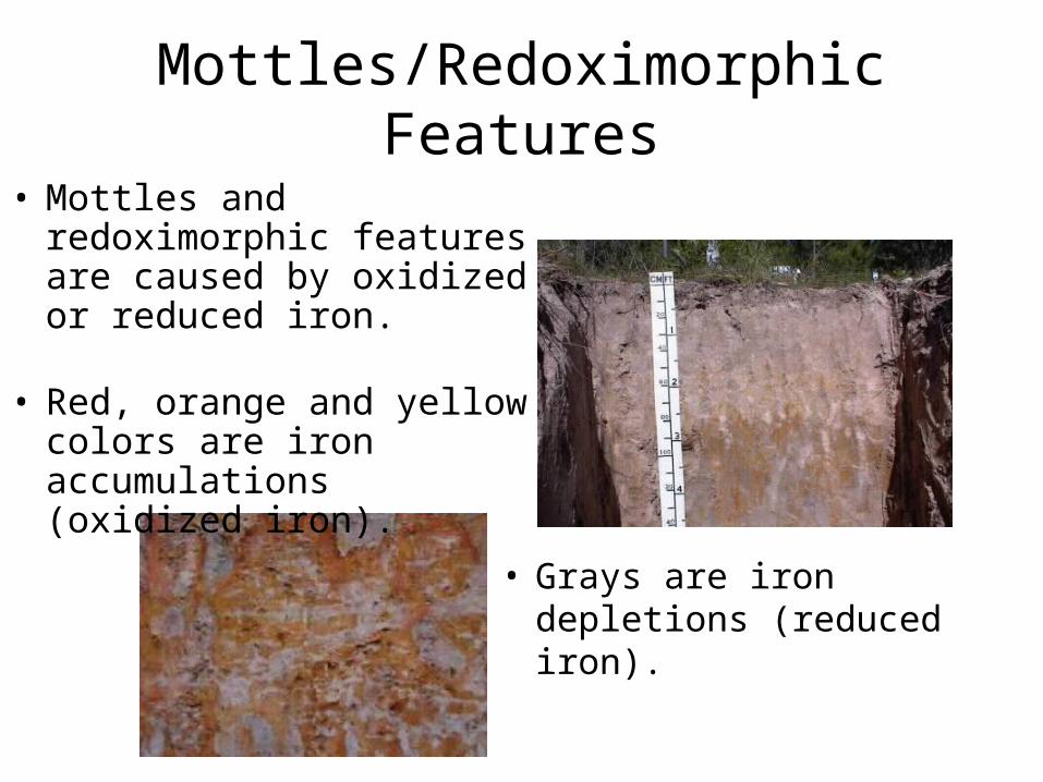
Mottles/Redoximorphic Features
• Grays are iron depletions (reduced iron).
• Mottles and redoximorphic features are caused by oxidized or reduced iron.
• Red, orange and yellow colors are iron accumulations (oxidized iron).
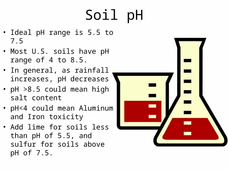
Soil pH• Ideal pH range is 5.5 to 7.5• Most U.S. soils have pH range
of 4 to 8.5.• In general, as rainfall
increases, pH decreases• pH >8.5 could mean high salt
content• pH<4 could mean Aluminum
and Iron toxicity• Add lime for soils less than pH
of 5.5, and sulfur for soils above pH of 7.5.
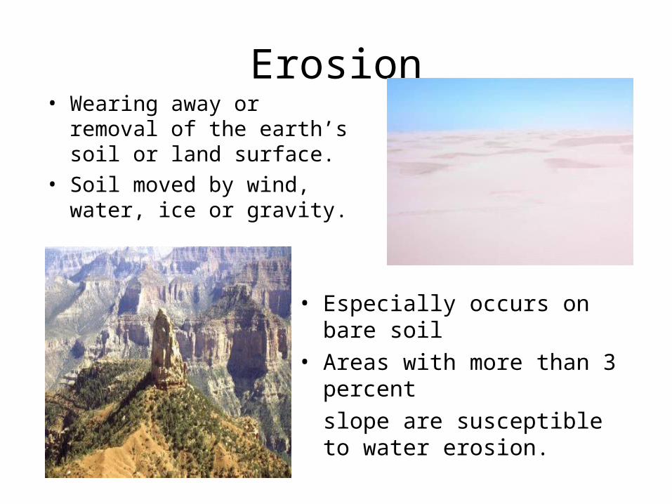
Erosion• Wearing away or removal of
the earth’s soil or land surface.
• Soil moved by wind, water, ice or gravity.
• Especially occurs on bare soil • Areas with more than 3 percent
slope are susceptible to water erosion.

Types of Erosion
• Wind Erosion • Gully Erosion
• Sheet and Rill Erosion• Raindrop Splash
http://www.public.asu.edu/~mschmeec/rainsplash.html
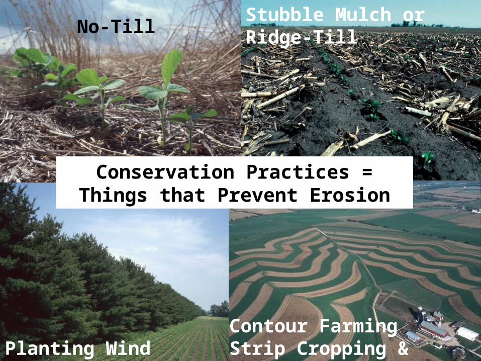
Planting Wind Breaks
No-TillStubble Mulch or Ridge-Till
Contour FarmingStrip Cropping & Terracing
Conservation Practices = Things that Prevent Erosion
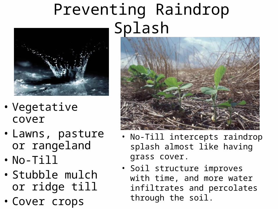
Preventing Raindrop Splash
• Vegetative cover • Lawns, pasture or
rangeland• No-Till• Stubble mulch or
ridge till• Cover crops
• No-Till intercepts raindrop splash almost like having grass cover.
• Soil structure improves with time, and more water infiltrates and percolates through the soil.
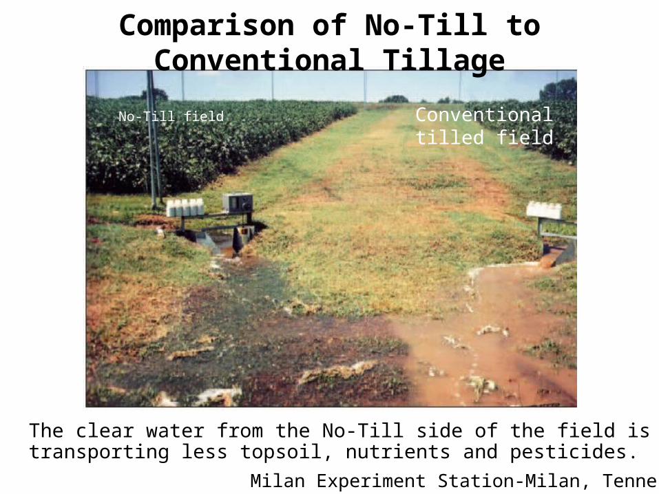
Comparison of No-Till to Conventional Tillage
The clear water from the No-Till side of the field is transporting less topsoil, nutrients and pesticides.
Milan Experiment Station-Milan, Tennessee
No-Till field Conventional tilled field
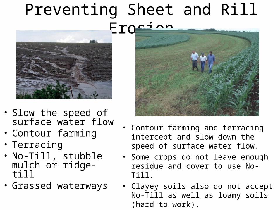
Preventing Sheet and Rill Erosion
• Slow the speed of surface water flow
• Contour farming• Terracing• No-Till, stubble
mulch or ridge-till• Grassed waterways
• Contour farming and terracing intercept and slow down the speed of surface water flow.
• Some crops do not leave enough residue and cover to use No-Till.
• Clayey soils also do not accept No-Till as well as loamy soils (hard to work).
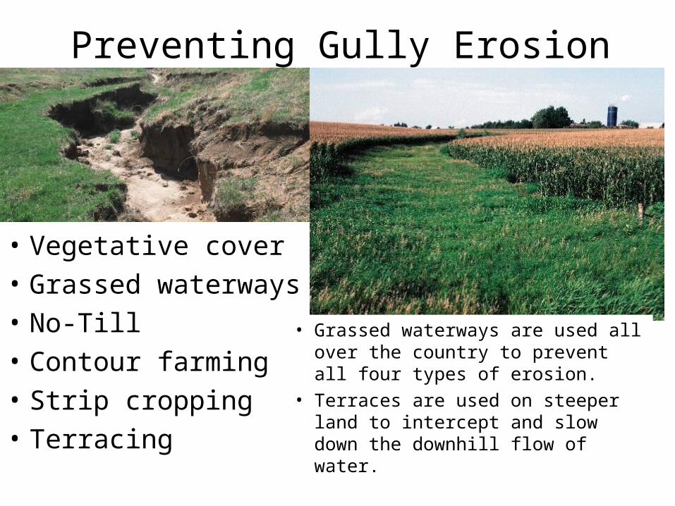
Preventing Gully Erosion
• Vegetative cover
• Grassed waterways
• No-Till
• Contour farming
• Strip cropping
• Terracing
• Grassed waterways are used all over the country to prevent all four types of erosion.
• Terraces are used on steeper land to intercept and slow down the downhill flow of water.
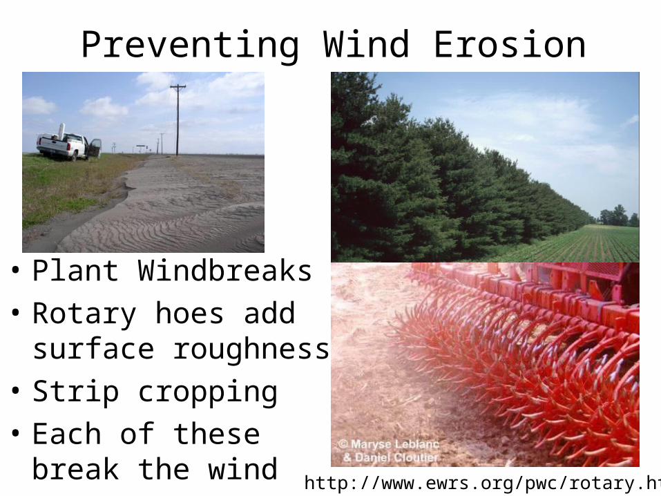
Preventing Wind Erosion
• Plant Windbreaks
• Rotary hoes add surface roughness
• Strip cropping
• Each of these break the wind http://www.ewrs.org/pwc/rotary.htm
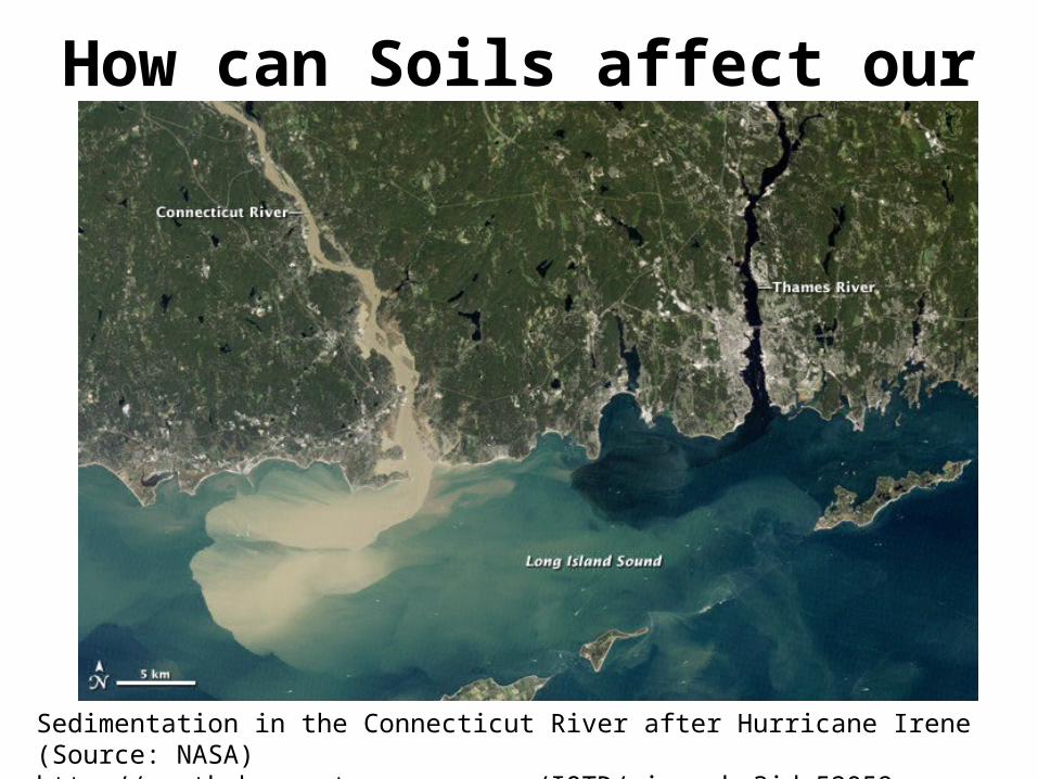
How can Soils affect our Water?
Sedimentation in the Connecticut River after Hurricane Irene (Source: NASA)http://earthobservatory.nasa.gov/IOTD/view.php?id=52059

How does Erosion affect water?
• Increases runoff
• Less infiltration
• Less uptake by plants
• Sediment in streams, rivers, lakes and oceansPrecipitation
Runoff
Infiltration

Soil Surveys
• An inventory of soils that includes maps, soil descriptions, photos and tables of soil properties and features.
• Used by farmers, real estate agents, land use planners, engineers and people wanting information on soil resources for land use planning.
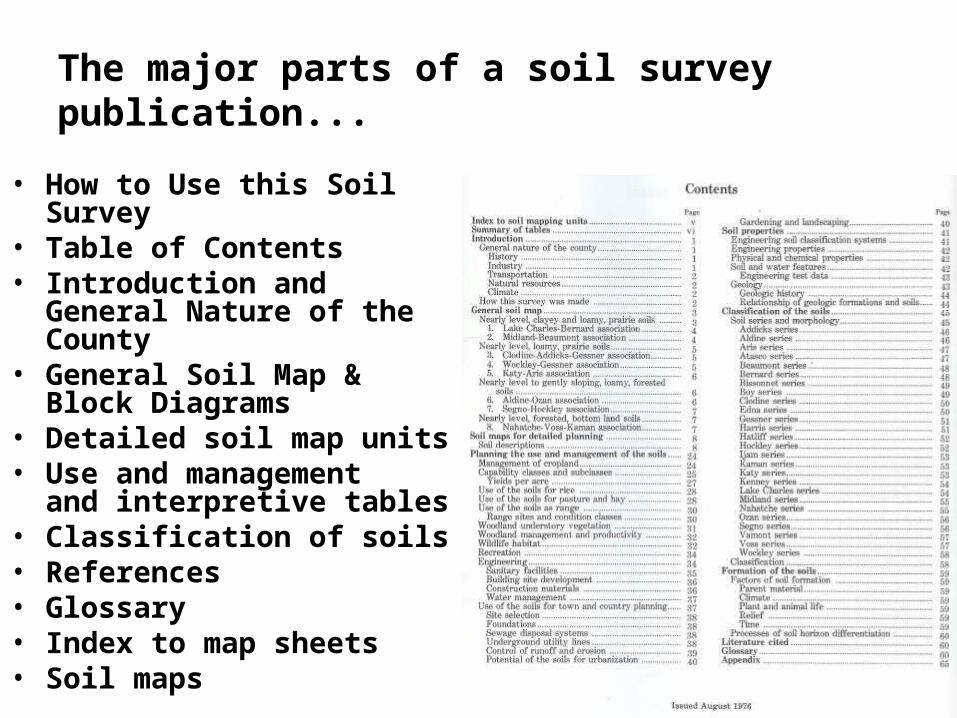
The major parts of a soil survey publication...
• How to Use this Soil Survey• Table of Contents• Introduction and General
Nature of the County• General Soil Map & Block
Diagrams• Detailed soil map units• Use and management
and interpretive tables• Classification of soils• References• Glossary• Index to map sheets• Soil maps
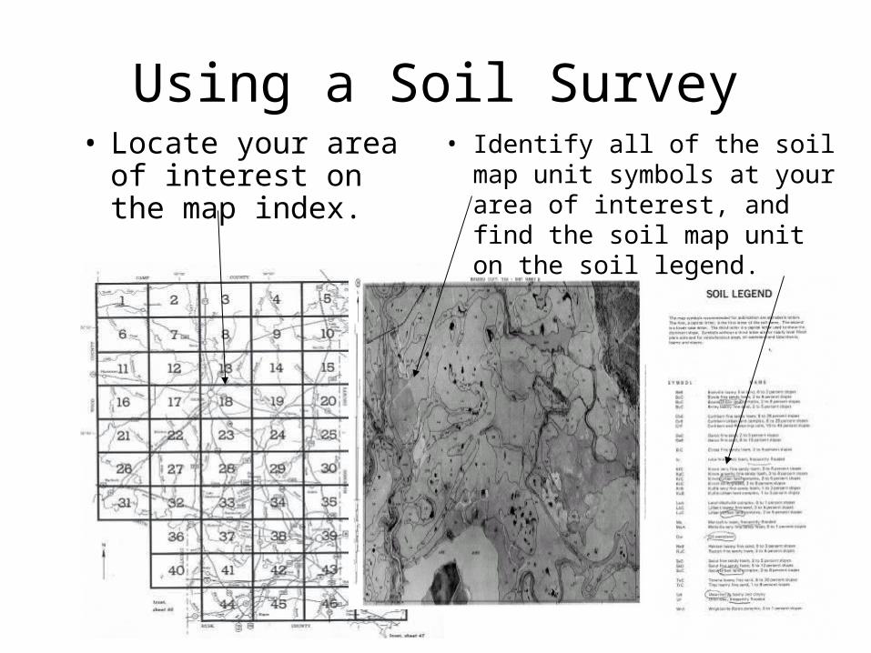
Using a Soil Survey• Locate your area of
interest on the map index.
• Identify all of the soil map unit symbols at your area of interest, and find the soil map unit on the soil legend.
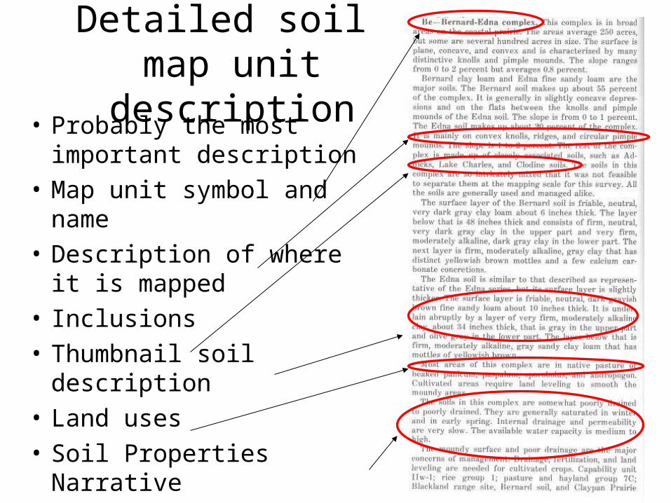
Detailed soil map unit description
• Probably the most important description
• Map unit symbol and name
• Description of where it is mapped
• Inclusions
• Thumbnail soil description
• Land uses
• Soil Properties Narrative
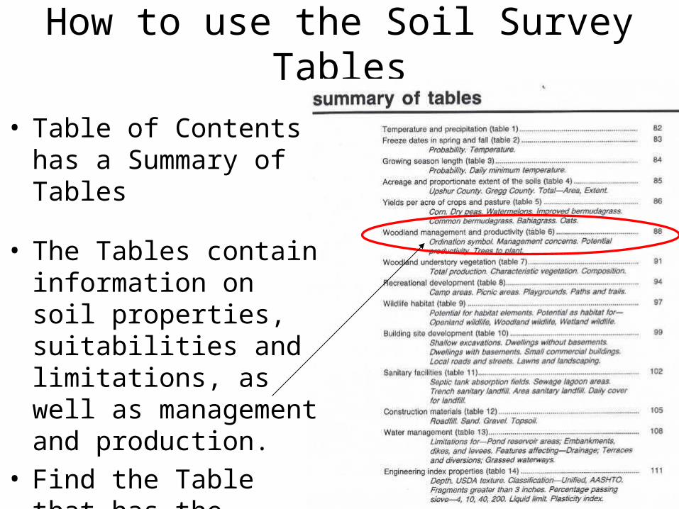
How to use the Soil Survey Tables
• Table of Contents has a Summary of Tables
• The Tables contain information on soil properties, suitabilities and limitations, as well as management and production.
• Find the Table that has the information that you are needing.
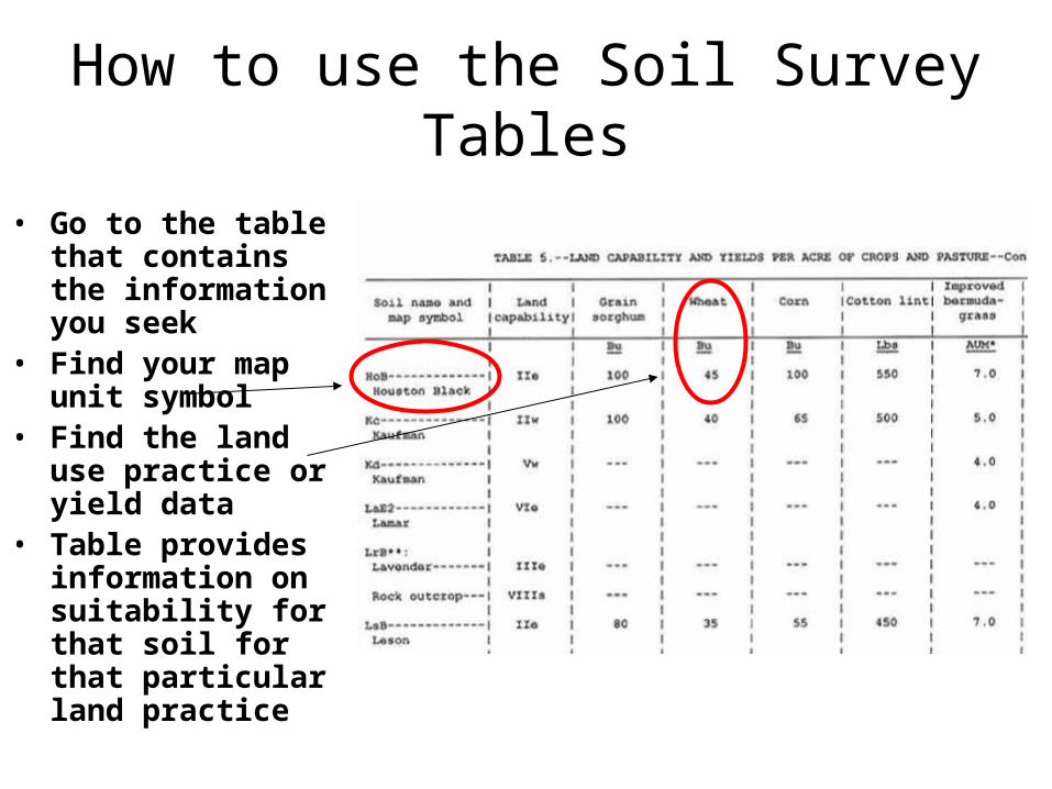
How to use the Soil Survey Tables
• Go to the table that contains the information you seek
• Find your map unit symbol
• Find the land use practice or yield data
• Table provides information on suitability for that soil for that particular land practice
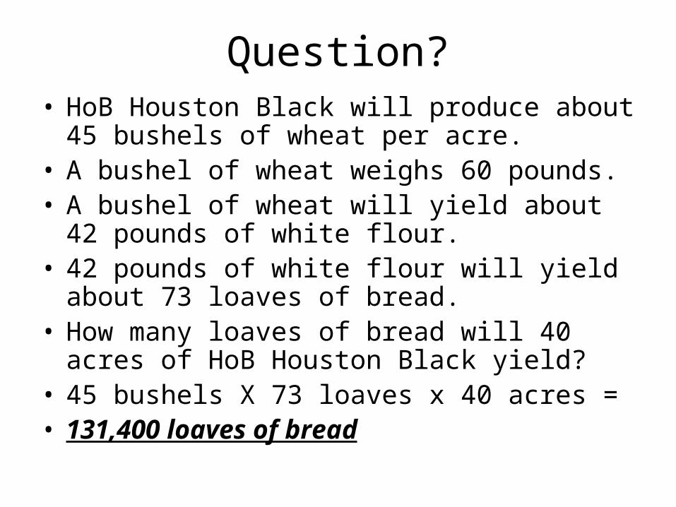
Question?• HoB Houston Black will produce about 45
bushels of wheat per acre. • A bushel of wheat weighs 60 pounds.• A bushel of wheat will yield about 42 pounds of
white flour.• 42 pounds of white flour will yield about 73
loaves of bread.• How many loaves of bread will 40 acres of HoB
Houston Black yield?• 45 bushels X 73 loaves x 40 acres = • 131,400 loaves of bread
ReferencesReferences► Ag Handbook 296, Land Resource Regions and Major Land Resource Ag Handbook 296, Land Resource Regions and Major Land Resource
Areas of the United States, USDA-NRCS (available at Areas of the United States, USDA-NRCS (available at http://soils.usda.gov/survey/geography/mlra/index.html http://soils.usda.gov/survey/geography/mlra/index.html ))
► Essentials of Physical Geography,Essentials of Physical Geography, by Gabler, Sager, Brazier and Wise by Gabler, Sager, Brazier and Wise► Field Book for Describing and Sampling SoilsField Book for Describing and Sampling Soils, by Schoeneberger, , by Schoeneberger,
Wysocki, Benham and BrodersonWysocki, Benham and Broderson► The Nature and Properties of SoilsThe Nature and Properties of Soils, by Brady, by Brady► http://milan.tennessee.edu/ http://milan.tennessee.edu/ ► http://munsell.com/http://munsell.com/► http://photogallery.nrcs.usda.gov/Index.asphttp://photogallery.nrcs.usda.gov/Index.asp► http://soilcrop.tamu.edu/http://soilcrop.tamu.edu/► http://soildatamart.nrcs.usda.gov/http://soildatamart.nrcs.usda.gov/► http://soils.usda.gov/http://soils.usda.gov/► http://tpwd.state.tx.us/http://tpwd.state.tx.us/► http://www.beg.utexas.edu/http://www.beg.utexas.edu/► http://www.epa.gov/http://www.epa.gov/► http://www.flickr.com/photos/http://www.flickr.com/photos/► http://www.lib.utexas.edu/http://www.lib.utexas.edu/► http://www.tx.nrcs.usda.gov/http://www.tx.nrcs.usda.gov/
• USDA-Natural Resources Conservation Service – Dennis Brezina, Resource Soil Scientist
Bryan Area Office=979-846-0757 ext. 31716 Briarcrest Drive, suite 510Bryan, TX [email protected]
– Temple State Soils Staff=254-742-9850
Contacts
USDA Nondiscriminatory USDA Nondiscriminatory Policy...Policy...The U.S. Department of Agriculture (USDA) prohibits
discrimination in all its programs and activities on the basis of race, color, national origin, age, disability, and where applicable, sex, marital status, familial status, parental status, religion, sexual orientation, genetic information, political beliefs, reprisal, or because all or a part of an individual's income is derived from any public assistance program. (Not all prohibited bases apply to all programs.) Persons with disabilities who require alternative means for communication of program information (Braille, large print, audiotape, etc.) should contact USDA's TARGET Center at (202) 720-2600 (voice and TDD).
To file a complaint of discrimination write to USDA, Assistant Secretary for Civil Rights, Office of the Assistant Secretary for Civil Rights, 1400 Independence Avenue, S.W., Stop 9410, Washington, D.C. 20250-9410 , or call toll free (866) 632-9992 (English) or (800) 877-8339 (TDD) or (866) 377-8642 (English Federal-relay) or (800) 845-6136 (Spanish Federal-relay). USDA is an equal opportunity provider and employer.